Town of Clinton. New Jersey Highlands Water Protection and Planning Council. January Prepared for the Town of Clinton by:
|
|
|
- Duane Powers
- 5 years ago
- Views:
Transcription
1 Clarke Caton Hintz Architecture Planning Landscape Architecture Town of Clinton Module 3: Addendum 100 Barrack Street Trenton NJ clarkecatonhintz.com Tel: Fax: New Jersey Highlands Water Protection and Planning Council January 2010 John Clarke, FAIA Philip Caton, FAICP Carl Hintz, AICP, ASLA John Hatch, AIA George Hibbs, AIA Brian Slaugh, AICP Michael Sullivan, AICP Prepared for the Town of Clinton by: Carl Hintz, PP, AICP, ASLA, CLA Lisa Y. Specca, PP, AICP, Clarke Caton Hintz Clarke Caton Hintz PP License # 1217 PP License #6026 Elizabeth McManus, PP, AICP, LEED AP Clarke Caton Hintz PP License # 5915
2 Clarke Caton Hintz Architecture Planning Landscape Architecture Town of Clinton Highlands Conformance: Module Barrack Street Trenton NJ clarkecatonhintz.com Tel: Fax: Addendum Prior Round Affordable Housing Sites Highlands Consistency Review John Clarke, FAIA Philip Caton, FAICP Carl Hintz, AICP, ASLA John Hatch, AIA George Hibbs, AIA Brian Slaugh, AICP Michael Sullivan, AICP Twin Ponds Site Block 1, Lots 60 and 60.02

3 Prior COAH Round Site Consistency Review- Twin Ponds The Town of Clinton will address a portion of its prior round affordable housing obligation with the development of Country View Builder s Twin Ponds Development Project. The Twin Ponds Development site consists of two parcels (Block 1, Lot 60 measuring 11.9 acres and Lot measuring 5.36 acres) located at the extreme western boundary of the Town adjacent to Union Township. The site is bounded by New Jersey State Highway Route 173 (Main Street) to the south and Rupell Road to the north. Village Road separates the two parcels. The applicant intends to develop only lot the southern and smaller lot and permanently preserve the remaining larger parcel, lot 60, to the north. Regional Context of the Site The Twin Ponds site as depicted in the aerial photograph below is nearly surrounded by residential or institutional development with one exception to the east the Dumont Pond Park (labeled Lingerts Pond) a municipally protected park with public parking for the pond s visitors. Twin Ponds Site Edna Mahon Correctional Facility Aerial Photograph of Twin Ponds Site Block 1 Lots 60 and Site History The Twin Ponds site was the subject of a Mt. Laurel Builder s Remedy lawsuit in The resulting Settlement Agreement required the site be rezoned to a Planned Unit development (PUD) zone district which provided for a variety of residential units and a moderate amount of 1
4 nonresidential floor area, as well as 18 on-site affordable units. Subsequently, the site was rezoned to the PRD-P zone district, to account for the environmental constraints present on the site, and was approved for 48 multifamily market units and a payment in lieu of constructing 10 affordable units in the amount of $200,000. Since that approval in 2002, the project s vested rights have expired. Subsequently, the Town adopted in 2007 a Reexamination Report and in 2008 a new Master Plan recommending increased density on the site to 3.60 dwelling units per acre with a 60 unit maximum and increased impervious coverage limitations to 65%. These Master Plan recommendations as well as all other recommended revisions to the municipal implementing ordinances were put on hold while the municipality was weighing the benefits of Highlands Conformance. On December 8, 2009, Clinton Town petitioned the Highlands Council for Conformance in both the Planning Area and the Preservation Area of the municipality. As a result, the applicant and the Town have been engaged in informal discussions to move the project forward. Currently, the applicant has informally agreed to provide 49 market rate residential units and 12 additional affordable units on-site in exchange for retention of the zoning density on the property. The Town views this development as a necessary and favorable means of meeting a portion of its affordable housing obligation as well as the terms of the Builder s Remedy. Utility Infrastructure and Capacity The Twin Ponds site is currently not listed as within the existing area served by either the Town of Clinton Highlands Domestic Sewerage Facility or the Town of Clinton Water Department; however, the site is adjacent to sites currently served and infrastructure extensions are readily available. The Highlands Council Utility Capacity Technical Report as well as the Highlands Conformance Module 2, Highlands Build-Out Report indicate the Town of Clinton has available potable water and sewer capacity to serve this site. The available wastewater capacity for Clinton Town is.135 MGD and potable water capacity is 5.42 MGM. Site Suitability: Council on Affordable Housing COAH Documentation of site suitability criterion and consistency with the State Development and Redevelopment Plan, State Plan, are found in COAH s Third Round Substantive Rules at N.J.A.C. 5: The Twin Ponds site Block 1, Lot is suitable to produce affordable housing as follows: There are no encumbrances which preclude the development of affordable housing on the property. The applicant has free and clear title. As noted above the site is adjacent to similar scale residential land uses and other compatible land uses and has access to appropriate streets. The site can be accessed by Rt. 173 (Main Street) and Village Road. A multi-family residential neighborhood is located to the west in Union Township and the east in Clinton Town is a single-family residential neighborhood, open space and commercial uses. 2
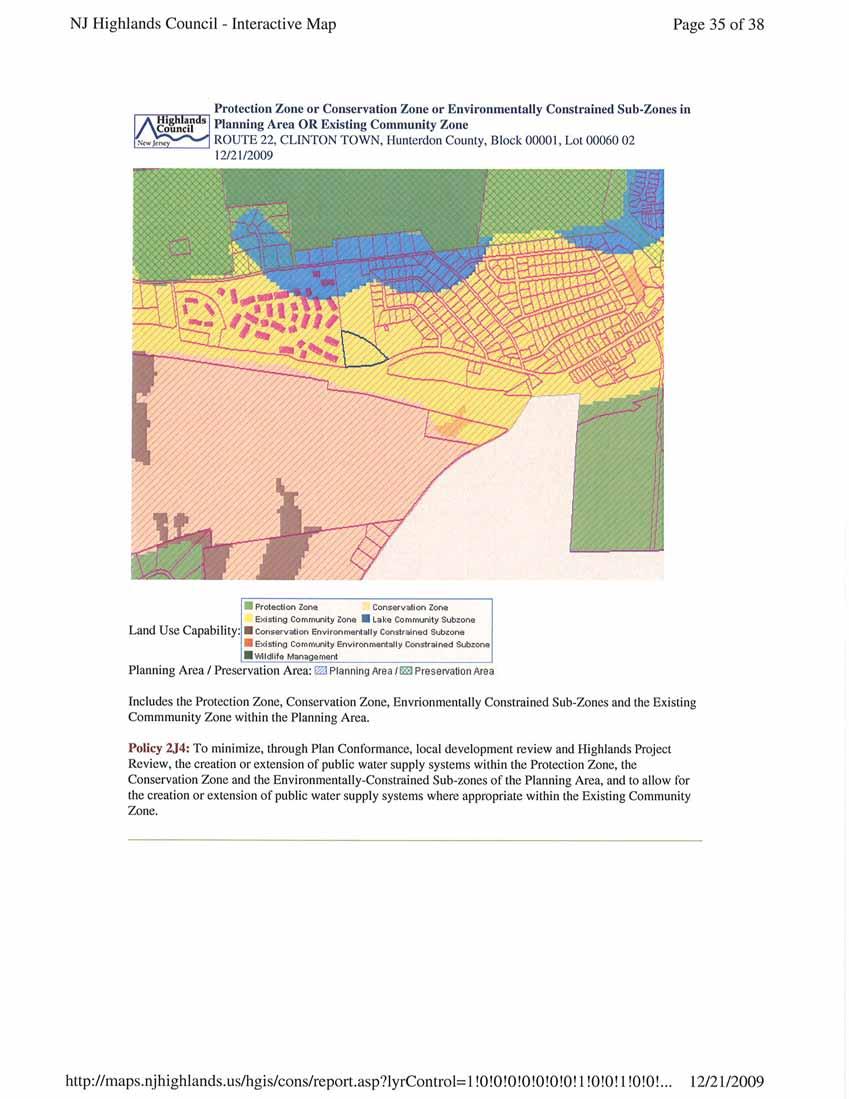
5 As noted above, the site can adequately be served with potable water and wastewater using available capacity from the Town of Clinton Water Department and Clinton Highlands Domestic Sewerage Facility # : the Clinton Water treatment Plant. The site can be developed consistent with the Residential Site Improvement Standards. The Site is located in Planning Area 2 of the adopted State Development and Redevelopment Plan Policy Map which is a preferred location for affordable housing. The site is therefore consistent with the State Plan. The site is located within the New Jersey Highlands Planning Area, Existing Community Sub-zone which is a preferred location for new development, utility extensions, and affordable housing. Further consistency discussion with the Highlands Water Protection and Planning Act will be provided in detail below. The site can be developed in accordance with all other state regulations such as those of the Department of Environmental Protection ( DEP ). There are no historically or architecturally important structures on the site, and the site is not part of an historic district. The development of the subject site will not have a negative impact on the Town s historic sites or district. Highlands Regional Master Plan Consistency Review The Highlands Council has generated a consistency analysis tool which can detail site specific Highland s environmental constraints as outlined in the Highlands Regional Master Plan, ( RMP ). This Highlands Consistency Review Report is attached in its entirety as Appendix A. The following outline will discuss site consistency issues identified in the consistency report and provide initial ideas for addressing them. During the Plan Conformance process, the Town looks forward to working cooperatively with the Highlands Council and its staff to facilitate the development of this and other affordable housing sites in order to completely address the municipality s obligation. Highlands Areas The Twin Ponds Development site is located within the Highlands Planning Area and Existing Community Sub-zone. A portion of the northern parcel, Lot 60 which is to be preserved, is also located in the Lake Community Sub-zone due to its proximity to the Spruce Run Reservoir. The Existing Community Sub-zone is defined in the RMP as areas of regionally significant concentration signifying existing communities. This zone is intended to allow the expansion of public water and wastewater systems to serve new areas of development. Affordable housing projects where affordable units exceed 10% of the project are intended to have priority for capacity and expansion of public utility service areas. The Twin Ponds project is proposed to have 20% affordable housing set-aside. 3
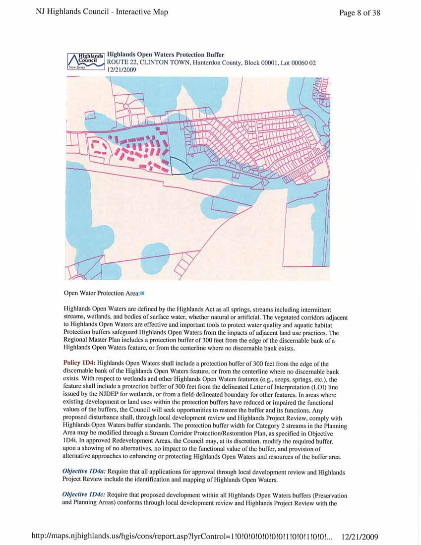
6 The Highlands Consistency Report cites RMP policies and objectives specific to the Twin Ponds Site. Policy 6F3 seeks to ensure new development incorporates smart growth principles and does not adversely affect natural resources. The Town will seek to ensure the site s sensitive environmental development as much as is practicable and that the construction adheres to smart growth principles such as compact design and proximity to transportation infrastructure. Policy 6F4 and 6F5 seek to ensure new development is adequately served by public utilities and community facilities and that existing community character is maintained. The Town and the applicant will demonstrate the adequacy of both utility infrastructure and existing community facilities. The neighboring multi-family residential development in Union Township is of a similar character and density as the proposed development. Many of the other adjacent land uses are similarly residential. The Town supports the Twin Ponds Development as consistent with the existing community character. Forest Resources The Portion of the Twin Ponds Development Site, Block 1 Lot 60.02, which is to be developed as an inclusionary housing project hereinafter known as the site is wooded but is not identified as a Highlands Forest Resource Area. In addition, no Highlands Forest Resource Areas are located on any parcel adjacent to the site. None of the RMP Objectives or Policies regarding Forest Resource Areas pose limitations to development of the site. However, the site is included in the larger region as part of the High Integrity Forest Subwatershed. The RMP recognizes these wooded lands as valuable to the overall subwatershed even if they do not meet the criterion for Highlands Forest Resource Areas. RMP Policy 1B3 does apply to the site and requires limitation to the greatest extent practicable on deforestation of forested lands within the High Integrity Forest Subwatershed within the Existing Community Sub-zone. Development of the Twin Ponds site will require significant deforestation to accommodate the necessary density of housing. The Town and the applicant propose to mitigate the impact on the High Integrity Forest Subwatershed area by planting additional trees on the parcel to be permanently preserved to the north, Lot 60. The Town looks forward to working with the Highlands Council in planning for the resource enhancement and preservation of this parcel. Highlands Open Waters Buffers and Riparian Areas The site is approximately 75% encumbered by both Highlands Open Waters Buffers and Riparian Areas of Moderate Integrity. It appears that the open water features are the twin ponds in the region and possibly a channelized portion of an existing unnamed tributary of the South Branch of the Raritan. The Town and the applicant propose to accurately map the subject Highlands Open Water features on site and to obtain a NJDEP Wetlands Letter of Interpretation as documentation. A mitigation plan for on site disturbance of the buffers reliant upon RMP Objective 1D4H will be proposed and implemented. In addition, enhancement of the functional value of the existing buffers, water quality of existing open waters, and habitat value of the riparian area on the preserved Lot 60 will be explored in cooperation with the Highlands Council and staff. 4
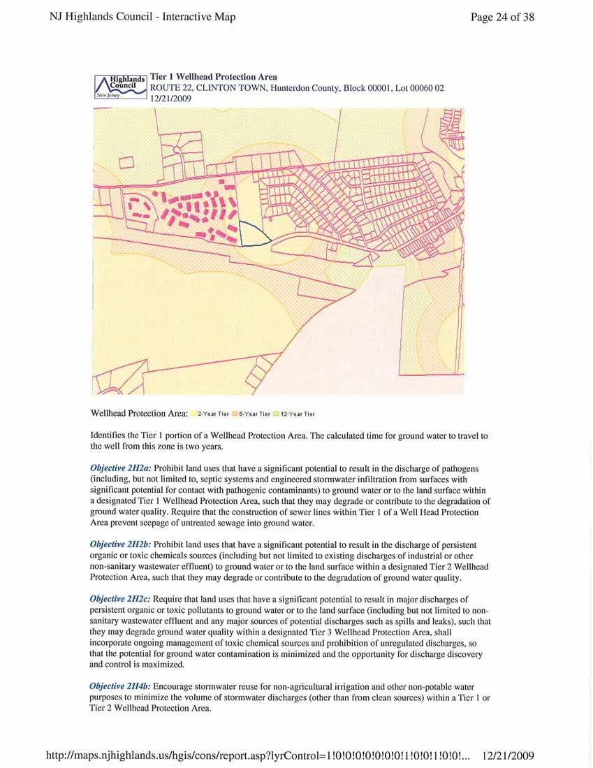
7 Net Water Availability The site is located in a water deficit area. The Net Water Availability by HUC 14 is identified as (-0.99) - (-0.10) MGD. The Town and the applicant propose to address the water deficit in concert with the municipality s Water Use and Conservation Plan, ( WUCP ). This Plan, a pilot program for the Highlands Area, is currently under development and will certainly be the first adopted in the region. If feasible and as directed by the WUCP, the inclusionary development on Lot and the preservation of Lot 60 will help to mitigate the existing deficit in the subwatershed. Well Head Protection Area The site is within a Tier 1 Well Head Protection Area which means there exists a two year time of travel for ground water within this area to reach a public water supply well. RMP Objective 2H2a prohibits land uses which have significant potential to result in discharge of pathogens to ground water or to land surfaces within a tier 1 Well Head Protection Area. This Objective also requires construction of sewer lines to prevent seepage of untreated sewage into ground water. The Town and the applicant will comply with the requirements of this Objective. Objective 2H4b encourages stormwater reuse to minimize stormwater discharge volume in a Tier 1 Well Head protection Area. The Town and the applicant will explore the reuse of stormwater from the development. Objective 2H5c ensures development activities implement best management practices to protect the quality of ground water within Well Head Protection Areas. The Town and the applicant will explore best management practices for ground water protection. Public Community Water Systems The site is currently not connected to the public water system, but existing capacity is available and connections are convenient on adjacent parcels. The RMP limits extension of public water utilities; however, the site is located in the Existing Community Sub-zone where development at higher densities served by public utilities is encouraged. In addition, RMP Policy 2B6 requires interagency coordination including a Water Use and Conservation Plan for new or extended water service areas to eliminate new water deficit and where feasible help to mitigate existing deficits. The Town and the applicant will rely upon the WUCP when water service is extended to the site. Agricultural Resource Area The site is not within a Highlands Agricultural Resource Area. Public Transit Sites The Highlands RMP Objective 5E1b promotes a reduction in vehicle miles traveled by locating new development within close proximity to rail stations and along bus routes. The site is adjacent 5
8 to a private bus route although it is unclear if a stop is within ½ mile of the site. The site is within a ½ mile of a park and ride site. W:\5000's\Town of Clinton\Highlands Conformance\MOD 3 COAH\Twin Ponds HCR\Final\Prior Round Site Consistency Review Twin Ponds.doc 6
9 Appendix A: Highlands Regional Master Plan Consistency Report Twin Ponds Inclusionary Housing Development Town of Clinton : Block 1, Lot 60 to be preserved and to be developed. 7
10
11
12
13
14
15
16
17
18
19
20
21
22
23
24
25
26
27
28
29
30
31
32
33
34
35
36
37
38
39
40
41
42
43
44
45
46
47
48
49
50
51
52
53
54
55
56
57
58
59
60
61
62
63
64
65
66
67
68
69
70
71
72
73
74
75
76
77
78
79
80
81
82
83
84
Re: Application Type: Proposed Highlands Redevelopment Area Designation
 CHRIS CHRISTIE Governor KIM GUADAGNO Lt. Governor State of New Jersey Highlands Water Protection and Planning Council 100 North Road (Route 513) Chester, New Jersey 07930-2322 (908) 879-6737 (908) 879-4205
BLOOMSBURY BOROUGH. Regional Master Plan Overlay Zone Designation. 1 inch = 0.28 miles. Zone. Sub-Zone FRANKLIN TOWNSHIP GREENWICH TOWNSHIP
 Regional Master Plan Overlay Zone Designation Zone Protection Lakes Greater Than 10 acres Conservation Existing Community Sub-Zone Existing Community Environmentally Constrained Conservation Environmentally
INTRODUCTION. b. The extent to which such problems and objectives have been reduced or have increased subsequent to such date.
 INTRODUCTION INTRODUCTION The Municipal Land Use Law directs a Planning Board to prepare a Periodic Reexamination Report every six years that identifies and describes the following: a. The major problems
Highlands Region Stormwater Management Program Guidance
 DRAFT Highlands Region Stormwater Management Program Guidance Release Date: January 2016 Abstract This guidance document provides an overview of the Highlands Stormwater Management Program. It is intended
Gold Line Bus Rapid Transit Transit Oriented Development (BRTOD) Helmo Station Area Plan
 Helmo Station Area Plan") Appendix F Gold Line Bus Rapid Transit Transit Oriented Development (BRTOD) Helmo Station Area Plan Introduction and Purpose of the Plan The Gold Line Bus Rapid Transit facility is an eleven-mile dedicated
Appendix F Gold Line Bus Rapid Transit Transit Oriented Development (BRTOD) Helmo Station Area Plan Introduction and Purpose of the Plan The Gold Line Bus Rapid Transit facility is an eleven-mile dedicated
IMPLEMENTING SOMERSET COUNTY S INVESTMENT FRAMEWORK
 IMPLEMENTING SOMERSET COUNTY S INVESTMENT FRAMEWORK SMART CONSERVATION THROUGH SMART GROWTH NJ LAND CONSERVATION RALLY March 22, 2014 Laurette Kratina, PP, AICP, Supervising Planner Somerset County Planning
LU Encourage schools, institutions, and other community facilities that serve rural residents to locate in neighboring cities and towns.
 Application No. 891627: Comprehensive Plan Text Amendment - Rural School Policies - Amend policies consistent with State Legislation allowing schools in the rural area and extension of sewer service to
SECTION 1 Introduction...1. SECTION 2 Regional Context Criteria for Planning Districts Description of Planning District...
 Table of Contents SECTION 1 Introduction...1 SECTION 2 Regional Context...2 2.1 - Criteria for Planning Districts...2 2.2 - Description of Planning District...2 SECTION 3 Goals & Objectives...5 SECTION
Baumgarten MPUD. Exhibit 3 Evaluation Criteria
 Pursuant to LDC subsections 10.02.13 B, 10.02.08 F and Chapter 3 G. of the Administrative Code, staff s analysis and recommendation to the Planning Commission, and the Planning Commission s recommendation
I. STAFF POLICY RECOMMENDATIONS. The following RMP policy strategies are proposed by staff in support of a Scenic Resource Protection Program:
 Policy Consideration: Scenic Resource Protection Program Status: For Consideration by the Highlands Council at September 14, 2006 Work session Date: September 12, 2006 I. STAFF POLICY RECOMMENDATIONS The
DRAFT SCOPE FOR THE DRAFT ENVIRONMENTAL IMPACT STATEMENT FOR HUDSON HIGHLANDS RESERVE TOWN OF PHILIPSTOWN, NEW YORK June 5, 2018
 DRAFT SCOPE FOR THE DRAFT ENVIRONMENTAL IMPACT STATEMENT FOR HUDSON HIGHLANDS RESERVE TOWN OF PHILIPSTOWN, NEW YORK June 5, 2018 Project Name: Project Location SEQRA Classification of Project: Lead Agency:
LAND USE PLAN ELEMENT UPDATE
 LAND USE PLAN ELEMENT UPDATE Township of Roxbury Morris County, New Jersey Adopted: September 16, 2009 Prepared by Roxbury Township Planning Board in consultation with Banisch Associates, Inc. 111 Main
Information for File # MVP MMJ; Elim Care
 Information for File # MVP-217-2628-MMJ; Elim Care Applicant: Elim Care of Maple Plain Corps Contact: Melissa Jenny Address: 18 Fifth Street East, Suite 7, St. Paul, MN 5511-168 E-Mail: Melissa.m.jenny@usace.army.mil
NEW CASTLE COUNTY S ZONING DISTRICTS
 NEW CASTLE COUNTY S ZONING DISTRICTS This is general information about New Castle County s zoning districts. The information included is by no means exhaustive or complete. Before designing plans to develop
AREASTRUCTURE PLAN AMENDMENT COCHRANE NORTH
 AREASTRUCTURE PLAN AMENDMENT COCHRANE NORTH In order to implement the vision outlined in the Conceptual Scheme, the following three amendments to the Cochrane North ASP are proposed: 1. Allow commercial
Appendix 1 Structure plan guidelines
 Appendix 1 Structure plan guidelines This appendix forms part of the regional policy statement [rps]. 1.1. Introduction Structure plans are an important method for establishing the pattern of land use
open public hearing and allow public comment request to continue LPA public hearing to January 16, 2014 at 10:30 am
 TODAY S AGENDA Work Session LPA Transmittal Public Hearing open public hearing and allow public comment request to continue LPA public hearing to January 16, 2014 at 10:30 am staff will issue a recommendation
CHAPTER 12 IMPLEMENTATION
 CHAPTER 12 IMPLEMENTATION The 2010 Town of Denton Comprehensive Plan is intended to capture a vision of the future of Denton. As such, it provides a basis for a wide variety of public and private actions
Planning Commission April 4, 2013 BOCC Workshop Page 1
 Planning Commission April 4, 2013 BOCC Workshop Page 1 Planning Commission April 4, 2013 BOCC Workshop Page 2 Planning Commission April 4, 2013 BOCC Workshop Page 3 Planning Commission April 4, 2013 BOCC
3.10 LAND USE SETTING PROJECT SITE EXISTING LAND USE DESIGNATIONS AND ZONING. General Plan Land Use Designations.
 This section of the Draft EIR addresses the existing land uses on and adjacent to the project site and discusses the potential impacts of the proposed project on existing land uses. Key issues addressed
TREASURE COAST REGIONAL PLANNING COUNCIL M E M O R A N D U M. To: Council Members AGENDA ITEM 5I
 TREASURE COAST REGIONAL PLANNING COUNCIL M E M O R A N D U M To: Council Members AGENDA ITEM 5I From: Date: Subject: Staff December 12, 2008 Council Meeting Local Government Comprehensive Plan Review Town
COUNTY COURT HOUSE REDEVELOPMENT AREA PLAN
 COUNTY COURT HOUSE REDEVELOPMENT AREA PLAN March 2005 CITY OF TRENTON DEPARTMENT OF HOUSING AND ECONOMIC DEVELOPMENT TABLE OF CONTENTS A. DESCRIPTION...3 1. BOUNDARIES OF PROJECT...3 2. REDEVELOPMENT PLAN
4. UTILITIES ELEMENT.
 4. UTILITIES ELEMENT. The purpose of this element is to provide for necessary public facilities and services correlated to future land use projections and population demand. Utilities Sub-Elements (A)
Chapter 10 IMPLEMENTATION RECOMMENDATIONS
 Chapter 10 IMPLEMENTATION RECOMMENDATIONS The recommended land use plan presented in the previous chapter provides a design for the attainment of the urban and rural development and open space preservation
Dwelling Units Max 12 dwelling units per acre/min 8 dwelling units per acre. Development Mix 80% non residential/20% residential
 13. OSTEEN LOCAL PLAN Background: The Osteen Local Plan area is located in southwest Volusia County along the SR 415 corridor between Lemon Bluff Road and Acorn Lake Road and includes 3,990 acres. The
4 Sustainability and Growth Management
 4 Sustainability and Growth Management Introduction Traditionally, has assumed growth and development with limited consideration for the long-term negative social, environmental or economic impacts on
General Reexamination of the Master Plan
 General Reexamination of the Master Plan Remington & Vernick Engineers, Inc. 232 Kings Highway East Haddonfield, New Jersey 08033 March 17, 2004 Adopted by Harrison Township Planning Board on April 7,
Transfer of Development Rights
 Transfer of Development Rights Chesterfield Township: A Case Study New Jersey Highlands Council March 5, 2009 Chesterfield Township s Old York Village Transfer of Development Rights and Traditional Neighborhood
3 Vision and Goals. Vision and Goals. Blueprint for Bloomsburg. Vision. Town of Bloomsburg Comprehensive Plan,
 Vision and Goals 3 Vision and Goals Citizens of the Town of Bloomsburg clearly value their natural and cultural heritage, the walkable, mixed use pattern of downtown, the access to education, and the community
Phoenixville Regional Planning Committee Edward A. Theurkauf, RLA, ASLA, APA, Theurkauf Design & Planning, LLC
 PHOENIXVILLE REGIONAL PLANNING COMMITTEE Phoenixville Borough, Charlestown Township, East Pikeland Township, Schuylkill Township, West Vincent Township TO: FROM: Erica Batdorf, Manager West Vincent Township
CITY OF PUYALLUP. Background. Development Services
 CITY OF PUYALLUP Development Services 333 South Meridian Puyallup WA 98371 To: City Council From: Katie Baker, AICP, Planning Division Re: South Hill Neighborhood Plan Adoption Date: (Meeting date: February
PART 1: PROJECT SUMMARY. The application is Attachment A. The site plan is Attachment B.
 Belleterre Subdivision Sketch Plan Town Board 8.7.17 Belleterre Subdivision Sketch Plan PART 1: PROJECT SUMMARY Applicant: Bowman Development Project Size: +/- 20.85 acres Parcel Number: 01115104 and 01115121
RECREATION AND OPEN SPACE ELEMENT GOALS, OBJECTIVES, AND POLICIES
 RECREATION AND OPEN SPACE ELEMENT GOALS, OBJECTIVES, AND POLICIES Goal 7 To provide park facilities, recreation programs, and open space resources that are safe, adequate, and accessible to all City residents,
CONSERVATION ELEMENT GOALS, OBJECTIVES, AND POLICIES
 CONSERVATION ELEMENT GOALS, OBJECTIVES, AND POLICIES Goal 4 To conserve, manage, appropriately use and protect the natural resources of the City ensuring continued resource availability and environmental
TOWNSHIP OF LOGAN SOIL & FILL IMPORTATION AND PLACEMENT APPLICATION SUBMITTAL CHECKLIST
 TOWNSHIP OF LOGAN SOIL & FILL IMPORTATION AND PLACEMENT APPLICATION SUBMITTAL CHECKLIST Applications: 5 copies of application - Applicant will reproduce the copies at his/her costs. The Township Clerk
One County s Success in Linking Watershed Protection and Land Use Planning
 One County s Success in Linking Watershed Protection and Land Use Planning Bob Thompson Porter County Plan Commission March 28, 2012 Indiana Watershed Leadership Academy Population 160,000 Approximately
Assembly Amendments to Anchorage 2040 Land Use Plan Adopted on September 26, 2017
 Assembly Amendments to Anchorage 2040 Land Use Plan Adopted on September 26, 2017 Contents: Constant Amendment 1 Constant Amendment 2 Constant Amendment 3 Constant Amendment 4 Constant Amendment 5 Constant
Major Subdivision Sketch Plan Checklist
 This checklist provides specific requirements that are apart of the Sketch process. The entire process is described by the Huntersville Subdivision Review Process which details all the submittal and resubmittal
STORMWATER UTILITY FREQUENTLY ASKED QUESTIONS
 STORMWATER UTILITY FREQUENTLY ASKED QUESTIONS What is Stormwater? Stormwater is water that falls to the ground during a precipitation event. When land is undeveloped or covered with vegetative surface,
Improve Neighborhood Design and Reduce Non Point Source Water Pollution
 HOW TO Planning Guide Improve Neighborhood Design and Reduce Non Point Source Water Pollution This document was funded by a grant from the New Hampshire Coastal Program with funding from the National Oceanic
2.7 ac park. TOTAL 5,403 DU 1,297,900 sf 1,105,450 sf 3.87 ac 5,563 DU 1,121,200 sf 1,105,450 sf 3.87 ac
 PLAN AMENDMENT 2013-I-B1: SEVEN CORNERS SPECIAL STUDY Summary of Pre-staffing Comments Planner: Bernard Suchicital bsuchi@fairfaxcounty.gov (703) 324-1254 Background On October 29, 2013, the Board of Supervisors
LAND USE ELEMENT. Purpose. General Goals & Policies
 LAND USE ELEMENT Purpose This Land Use Element contains the goals and policies necessary to support the City s responsibility for managing land resources and guiding development through implementing regulations,
Municipal Development Plan Update Urban Service Area and Hamlets
 ENCLOSURE 1 Municipal Development Plan Update Urban Service Area and Hamlets Priorities Committee January 24, 2017 MUNICIPAL DEVELOPMENT PLAN UPDATE SHAPING OUR FUTURE MDP Update - Agenda MDP Update Public
Leduc Industrial Outline Plan SE W4
 Leduc Industrial Outline Plan SE 1-50-25-W4 Within the North Leduc Industrial ASP Prepared for: Leduc Energy Park Ltd. Prepared by: Stantec Consulting Ltd. File No. 1161 104655 V5 Table of Contents 1.0
A Growing Community Rural Settlement Areas
 Town of Huntsville Official Plan Review - POLICY BACKGROUND PAPER A Growing Community Rural Settlement Areas BACKGROUND: In addition to the fully municipally-serviced Urban Settlement Area and the Hidden
General Location Annex, Rezone & Preliminary Plat Lansdowne Addition, Unit Three
 NEWFOUNDLAND I-5 Agricultural District Subject Site SUNDANCE ANDERSON Single Family Residential CHRISTY PUD Agricultural District Highway Business General Location Annex, Rezone & Preliminary Plat Lansdowne
Plan-It Greenville (2009) Comprehensive Plan 5-Year Update
 Comprehensive Plan 5-Year Update") Plan-It Greenville (2009) Comprehensive Plan 5-Year Update What is the comprehensive plan: Collecting communitywide data Projecting future population growth Setting communitywide goals Framing policies
Plan-It Greenville (2009) Comprehensive Plan 5-Year Update What is the comprehensive plan: Collecting communitywide data Projecting future population growth Setting communitywide goals Framing policies
CHAPTER 7: VISION AND ACTION STATEMENTS. Noble 2025 Vision Statement
 CHAPTER 7: VISION AND ACTION STATEMENTS This chapter presents the vision, policy and action statements that transform the comprehensive planning study, an analysis of Noble s past, future trends and community
COMMUNITY DESIGN. GOAL: Create livable and attractive communities. Intent
 COMMUNITY DESIGN Intent An attractive, well-designed County will attract quality development, instill civic pride, improve the visual character of the community, and create a strong, positive image for
Background Summary Report
 Background Summary Report May 2014 Submitted by Macaulay Shiomi Howson Ltd. In association with AMEC MMM Group Brook McIlroy Inc. Hemson Consulting Ltd. Table of Contents 1. Introduction... 1 2. Why is
Introduction. In the 1997 Master Plan, a strong emphasis was placed upon open space preservation and water quality protection.
 Township of Brick, Master Plan Introduction Introduction Brick Township s Master Plan is not only a road map for its future but a reflection of its past. Since 1955, when the Garden State Parkway made
FUTURE LAND USE PLAN 7
 FUTURE LAND USE PLAN 7 The recommendations of each of the preceding chapters can be combined to present an overall Future Land Use Plan for Wilton. The Future Land Use Plan, presented on the following
Southwest Fleetwood Enclave
 Southwest Fleetwood Enclave Development Concept Plan Southwest Fleetwood Enclave 1 st Land Owners Meeting April 30 th, 2012 Presentation Overview Why the Plan? ; Overview & Purpose of Study; Constraints
Mainstreaming Green Infrastructure. Township Council Byram Township April 19, 2016
 Mainstreaming Green Infrastructure Township Council Byram Township April 19, 2016 About New Jersey Future. www.njfuture.org Research Policy Advocacy Assistance The Growing Problem Heavier, more frequent
TERRESTRIAL NATURAL HERITAGE SYSTEM STRATEGY APPENDIX F: MODEL POLICIES FOR THE IMPLEMENTATION OF THE TARGET TERRESTRIAL NATURAL HERITAGE SYSTEM
 TERRESTRIAL NATURAL HERITAGE SYSTEM STRATEGY APPENDIX F: MODEL POLICIES FOR THE IMPLEMENTATION OF THE TARGET TERRESTRIAL NATURAL HERITAGE SYSTEM C H A P T E R 1 M O D E L P O L I C I E S F O R I M P L
Venice Pumping Plant Dual Force Main Project Draft EIR
 City of Los Angeles 5.9 LAND USE PLANS 5.9.1 Environmental Setting Venice Pumping Plant Dual Force Main Project Draft EIR The Project lies within the bounds of Los Angeles County and the City of Los Angeles.
TOWNSHIP OF MONTGOMERY MASTER PLAN MASTER PLAN AND DEVELOPMENT REGULATIONS PERIODIC REEXAMINATION REPORT December 5, 2008
 TOWNSHIP OF MONTGOMERY MASTER PLAN MASTER PLAN AND DEVELOPMENT REGULATIONS PERIODIC REEXAMINATION REPORT December 5, 2008 INTRODUCTION The Township of Montgomery is situated in the southeastern corner
PLANNED UNIT DEVELOPMENT & SUBDIVISION STAFF REPORT Date: May 18, 2017
 & PUD-0000102-2017 PLANNED UNIT DEVELOPMENT & SUBDIVISION STAFF REPORT Date: May 18, 2017 NAME SUBDIVISION NAME Dauphin Creek Estates Subdivision Dauphin Creek Estates Subdivision LOCATION CITY COUNCIL
Planned Development Review Revisions (Project No. PLNPCM )
") Planned Development Review Revisions (Project No. PLNPCM2014-00139) Standard residential development Planned Development Example: Smaller lot sizes than what is allowed to create open space amenity. What
Planned Development Review Revisions (Project No. PLNPCM2014-00139) Standard residential development Planned Development Example: Smaller lot sizes than what is allowed to create open space amenity. What
2. Would the proposed project comply with the Land Use map? 3. Would the proposed project require a rezoning? 4. What is the proposed zoning district?
 TOWN OF CHAPEL HILL Planning and Sustainability Department 405 Martin Luther King Jr. Blvd. Chapel Hill, NC 27514 www.townofchapelhill.org phone (919) 968 2728 Concept Plans are intended to be an opportunity
I403 Beachlands 1 Precinct
 I403. Beachlands 1 I403.1. Precinct Description Beachlands is a rural and coastal village located on the eastern side of Auckland, adjoining the Tamaki Strait coastline. The original Beachlands village
Waverley West B Secondary Planning Process. Open House South Pointe School April 25, 2018
 averley est B Secondary Planning Process South Pointe School April 25, 2018 averley est B Secondary planning process open house Please review the boards and provide your feedback. 1 The Role of a Secondary
Green Infrastructure Recommendations For Parks and Public Spaces
 Green Infrastructure Recommendations For Parks and Public Spaces Issued by the Jersey Water Works Green Infrastructure Committee And Prepared by Meliora Design This document recommends ways to integrate
MEMORANDUM AGENDA ITEM #6c
 South Florida Regional Planning Council MEMORANDUM AGENDA ITEM #6c DATE: FEBRUARY 1, 2010 TO: FROM: SUBJECT: COUNCIL MEMBERS STAFF CITY OF PARKLAND PROPOSED COMPREHENSIVE PLAN AMENDMENT (ALTERNATIVE REVIEW)
Mill Conversion Overlay District Zoning Bylaw Amendment
 Mill Conversion Overlay District Zoning Bylaw Amendment To see if the Town will vote to amend the Zoning By-Law by adding a new Section 13, Mill Conversion Overlay District, and by amending Sections 2.1,
USA Addition of South & East Side Residential Parcels. USA Deletion of a Town of Christiana Parcel. Conversion from USA to Limited Service Area
 Village of Rockdale Village of Rockdale 148 Water Street Cambridge, WI 53523 Phone 608.423.1497 Fax 608.423.9694 Urban Service Area (USA) Amendment USA Addition of South & East Side Residential Parcels
Northern Branch Corridor DEIS December 2011
 16 Floodplains 161 Chapter Overview 1611 Introduction The flowing chapter identifies floodplains found within the Northern Branch Corridor in accordance with Executive Order 11988, Floodplain Management
Note: Staff reports can be accessed at Zone: I-3. Tier:
 The Maryland-National Capital Park and Planning Commission Prince George s County Planning Department Development Review Division 301-952-3530 Note: Staff reports can be accessed at www.mncppc.org/pgco/planning/plan.htm.
Review Zone Application for D&R Canal Commission Decision
 Review Zone Application for D&R Canal Commission Decision MEETING DATE: July 20, 2016 DRCC #: 16-4803 Latest Submission Received: June 13, 2016 Applicant: Robert McCarthy, PE PSE&G 4000 Hadley Road, 2
New Jersey State Planning Commission Negotiations Worksheet Map Amendments
 Item No. 4606 NE # 46-7 OSG Quad Number 46, HIGH BRIDGE NJ Planning Area From: PA2 To: PA3 Agree Conditional / Mod Planning Area 5 to Planning Area 3 Falls within a public water service area: 1. Water
ARTICLE 6: Special and Planned Development Districts
 ARTICLE 6: Special and Planned Development Districts 6-10 Traditional Neighborhood Development (TND) District 6-10.10 Purpose and Intent The Traditional Neighborhood Development (TND) District provides
Chesapeake Bay Critical Area Conservation Plan
 The Maryland-National Capital Park and Planning Commission Prince George s County Planning Department Development Review Division 301-952-3530 Note: Staff reports can be accessed at www.mncppc.org/pgco/planning/plan.htm.
Gloucester County s Comprehensive Plan. The Community Connection
 Gloucester County s Comprehensive Plan The Community Connection Current Comp Plan Adopted in 1991 with a 20 year planning horizon Updated in 1995 with Part V- Implementation Recommendations and Appendix
Ten Mile Creek Planning Area
 PLANNING AREA POLICIES TEN MILE CREEK Ten Mile Creek Planning Area Location and Context The Ten Mile Creek Planning Area ( Ten Mile Creek area ) is located south of the current Boise AOCI, generally south
Section 3: Land Use M C H E N R Y K A N E. Figure 3.1: Potential Future Municipal Boundaries. Future Municipal Boundaries. County Land Use Plans
 Section 3: Land Use Figure 3.1: Potential Future Municipal Boundaries Land use and transportation are intertwined; yet, land use and transpor- tation planning are often undertaken as separate disciplines.
Proposed Comprehensive Plan Strategies DRAFT for discussion June 28, 2017
 Proposed Comprehensive Plan Strategies DRAFT for discussion June 28, 2017 Land Use Rural Areas Refine the Farm and Forest area (FF) Update FF boundaries to account for existing lots less than five acres
SECTION 4(f) DE MINIMIS DOCUMENTATION
 DE MINIMIS DOCUMENTATION") SECTION 4(f) DE MINIMIS DOCUMENTATION Illinois Route 60/83 IL 176 to the intersection of IL 60 (Townline Road) Lake County P-91-084-07 Mundelein Park and Recreation District Project Limit SECTION 4(f)
SECTION 4(f) DE MINIMIS DOCUMENTATION Illinois Route 60/83 IL 176 to the intersection of IL 60 (Townline Road) Lake County P-91-084-07 Mundelein Park and Recreation District Project Limit SECTION 4(f)
RECREATION, OPEN SPACE AND GREENWAYS ELEMENT GOALS, OBJECTIVES, AND POLICIES
 RECREATION, OPEN SPACE AND GREENWAYS ELEMENT GOALS, OBJECTIVES, AND POLICIES GOAL R-1: DEVELOP A RECREATION, OPEN SPACE AND GREENWAYS SYSTEM AS AN INTEGRAL COMPONENT OF AN OVERALL, COUNTY-WIDE ECONOMIC
Descriptive Summary of the Comprehensive Plan Amendment
 Applicant City of Virginia Beach Public Hearing October 12, 2016 2016 Comprehensive Plan Amendment Establishing the Historic Seatack & Vicinity Suburban Focus Area (SFA) in Chapter 1, Section 1.3 Agenda
ADMINISTRATION RECOMMENDATION(S) 2017 February 09. That Calgary Planning Commission recommends APPROVAL of the proposed Land Use Amendment.
 2017 February 09. That Calgary Planning Commission recommends APPROVAL of the proposed Land Use Amendment.") Page 1 of 10 EXECUTIVE SUMMARY This land use amendment application is to accommodate changes to the location of a stormwater retention pond and land use boundaries adjacent to Environmental Reserve in
Page 1 of 10 EXECUTIVE SUMMARY This land use amendment application is to accommodate changes to the location of a stormwater retention pond and land use boundaries adjacent to Environmental Reserve in
Town of Rico Three Mile Plan for Annexation
 Town of Rico Three Mile Plan for Annexation 10.20.2010 Adopted by Resolution 2010-2 Produced with funding support from the Colorado Department of Local Affairs 2 Content Guide Introduction. 3 Annexation
MASTER PLAN REEXAMINATION REPORT TOWNSHIP OF MIDDLE CAPE MAY COUNTY, NEW JERSEY
 MASTER PLAN REEXAMINATION REPORT TOWNSHIP OF MIDDLE CAPE MAY COUNTY, NEW JERSEY May 2010 Adopted by the Middle Township Planning Board on: JULY 22, 2010 Prepared by: Marcia R. Shiffman, PP, AICP, LLA NJ
SECTION UNIFIED DEVELOPMENT ORDINANCE SECTION Part 1 Ordinance. ARTICLE 1 Zoning Districts
 SECTION 1-100 UNIFIED DEVELOPMENT ORDINANCE SECTION 1-300 Part 1 Ordinance SECTION 1-100. Introduction. ARTICLE 1 Zoning Districts Crystal Lake strives to maintain a balance of various land uses for a
VILLAGE OF CLEMMONS PLANNING BOARD DRAFT STAFF REPORT. Single Family Residential, Townhomes
 VILLAGE OF CLEMMONS PLANNING BOARD DRAFT STAFF REPORT PETITION INFORMATION Docket # C-212 Staff Megan Ledbetter Petitioner(s) Peacehaven Development LLC Owner(s) Larry Jarvis, William Alexander and Peacehaven
ALBEMARLE COUNTY CODE CHAPTER 18 ZONING SECTION 20A NEIGHBORHOOD MODEL - NMD
 CHAPTER 18 ZONING SECTION 20A NEIGHBORHOOD MODEL - NMD Sections: 20A.1 PURPOSE AND INTENT 20A.2 STATUS AS A PLANNED DEVELOPMENT DISTRICT 20A.5 CODES OF DEVELOPMENT 20A.6 PERMITTED USES 20A.7 RESIDENTIAL
SUSSEX COUNTY COMPREHENSIVE PLAN COUNTY PLANNING AND ZONING COMMISSION WORKSHOP
 SUSSEX COUNTY COMPREHENSIVE PLAN COUNTY PLANNING AND ZONING COMMISSION WORKSHOP August 21, 2017 TODAY S WORKSHOP Public Comment Utilities Update Economic Development Update Future Land Use Discussion Public
12 January 12, 2011 Public Hearing APPLICANT: TAILWIND DEVELOPMENT GROUP,LLC PROPERTY OWNER: CITY OF VIRGINIA BEACH
 12 January 12, 2011 Public Hearing APPLICANT: TAILWIND DEVELOPMENT GROUP,LLC PROPERTY OWNER: CITY OF VIRGINIA BEACH STAFF PLANNER: Faith Christie REQUEST: Conditional Change of Zoning (from PD-H1 Planned
Municipal Comprehensive and Open Space Plans
 Appendix 13-A Local Historic Policy Municipal Comprehensive and Open Space Plans Oxford Regional Comprehensive Plan (1969) The Oxford Regional Comprehensive Plan serves as the Comprehensive Plan for Oxford
HOUSING ELEMENT GOALS, OBJECTIVES, AND POLICIES
 HOUSING ELEMENT GOALS, OBJECTIVES, AND POLICIES Goal 6 Maintain and enhance the supply of decent, safe, energy efficient and affordable housing and maximize viable options and opportunities for present
BROOKHILL NEIGHBORHOOD MODEL ZONING MAP AMENDMENT PREFACE TO APPLICATION
 BROOKHILL NEIGHBORHOOD MODEL ZONING MAP AMENDMENT PREFACE TO APPLICATION June 15, 2015 Revised: August 1, 2016 I. VISION Brookhill is a proposed community based upon the principles of Albemarle County
Goal 1: To Encourage the Orderly, Harmonious and Judicious Use of University Resources in the Development of University Land.
 2.0 Future Land Use Goal 1: To Encourage the Orderly, Harmonious and Judicious Use of University Resources in the Development of University Land. Objective 1.1: Make available future building sites that
Northern Branch Corridor SDEIS March 2017
 14. Water Quality 14.1. Chapter Overview 14.1.1. Introduction This section discusses changes to the potential for activities associated with the development and operation of the Preferred Alternative to
GENERAL PLAN UPDATE ISSUES MEETING. January 21, 2010 City Hall Mitchell Room 6:00 pm 9:00 pm
 GENERAL PLAN UPDATE ISSUES MEETING January 21, 2010 City Hall Mitchell Room 6:00 pm 9:00 pm WELCOME! Introductory Comments Continued Review of Quality of Life Standards, Growth Management, Proposition
Appendix C: Interim Mixed-Use Evaluation Criteria
 Appendix C: Interim Mixed-Use Evaluation Criteria C-1 Appendix C: Interim Mixed-Use Evaluation Criteria PURPOSE: The implementation of numerous policies contained within the Master Plan hinges on the creation
WEST WESTFIELD AVENUE REDEVELOPMENT PLAN I BOROUGH OF ROSELLE PARK
 Prepared For: DRAFT Borough of Roselle Park 110 East Westfield Avenue Roselle Park, New Jersey 07204 2016 WEST WESTFIELD AVENUE REDEVELOPMENT PLAN I BOROUGH OF ROSELLE PARK Prepared By: Neglia Engineering
Township of Lopatcong Redevelopment Plan Lot 44 in Block 2
 Planning Report Township of Lopatcong Redevelopment Plan Lot 44 in Block 2 Prepared for: LOPATCONG TOWNSHIP PLANNING BOARD under the supervision of: George A. Ritter, AICP Professional Planner NJ License
ROAD CLOSURE AND LAND USE AMENDMENT SILVER SPRINGS (WARD 1) NORTHEAST OF NOSEHILL DRIVE NW AND SILVER SPRINGS ROAD NW BYLAWS 2C2018 AND 29D2018
 NORTHEAST OF NOSEHILL DRIVE NW AND SILVER SPRINGS ROAD NW BYLAWS 2C2018 AND 29D2018") Page 1 of 19 EXECUTIVE SUMMARY This application proposes redesignating two parcels in the community of Silver Springs from Special Purpose Future Urban Development (S-FUD) District and undesignated road
Page 1 of 19 EXECUTIVE SUMMARY This application proposes redesignating two parcels in the community of Silver Springs from Special Purpose Future Urban Development (S-FUD) District and undesignated road
9 th Street Sub Area Plan
 9 th Street Sub Area Plan In the 1990 s, when the Township prepared the last Master Plan, the 9 th Street corridor was studied as part of a larger 9 th Street Focus Area that included the West Main Street
CHARLES PUTMAN CHARLES PUTMAN AND ASSOCIATES, INC
 MEMORANDUM CHARLES PUTMAN & ASSOCIATES, INC. LAND DEVELOPMENT CONSULTANTS PLANNING ZONING PERMITTING 4722 NW Boca Raton Boulevard, Suite C-106 Boca Raton, Florida 33431 Phone: 561/994-6411 FAX: 561/994-0447
PORT UNION VILLAGE COMMUNITY SECONDARY PLAN
 4 PORT UNION VILLAGE COMMUNITY SECONDARY PLAN 4. PORT UNION VILLAGE COMMUNITY SECONDARY PLAN The following policies and principles apply to the area herein referred to as Port Union Village, as outlined