North Lougheed Land Use Study
|
|
|
- Coleen Phelps
- 5 years ago
- Views:
Transcription
1 City of Pitt Meadows North Lougheed Land Use Study i
2 City of Pitt Meadows North Lougheed Land Use Study Prepared By: AECOM 3292 Production Way, Floor tel Burnaby, BC V5A 4R fax Project Number: Date: June 23 rd, 2011 ii
3 TABLE OF CONTENTS Table of Contents... i List of Figures... ii List of Tables... iii Executive Summary... iv 1. Introduction Area Description and Context Study Objectives and Methodology Policy Context Pitt Meadows OCP Pitt Meadows Agricultural Plan Pitt Meadows Economic Development Strategic Plan North Lougheed Connector and Harris Interchange North Lougheed Highway Commercial Area Study Agricultural Land Commission Metro Vancouver Draft Regional Growth Strategy Agricultural Inventory Current Land Use in the Study Area Agricultural Capability of Parcels in the ALR Market Assessment Guiding Principles and Evaluation Criteria Stakeholder Consultation Summary of Process and Key Findings Preliminary Land Use Concepts Land Use Categories Draft Concepts Evaluation Matrix Recommended Land Use Concept Recommended Land Use Concept Financial Evaluation Highlights Agricultural Impact and Benefits Transportation and Transit Considerations Urban Design Building Form and Character / Streetscape Gateway Features Circulation and Access Landscape Strategy Transitional Plantings and Buffer Zones Gathering Places i
4 10. Summary Recommendations Appendices Survey Results/Public Open House Comments ALC Decisions Detailed Evaluation Matrix Land Use Market Review LIST OF FIGURES Figure 1.a. North Lougheed Study Area Boundary... 4 Figure 1.b. Study Area Context... 4 Figure 1.c. North Lougheed Corridor Potential Road Network... 5 Figure 1.d. Site Pictures... 6 Figure 1.e. Schedule of Work for North Lougheed Land Use Study Figure 2.a. Existing OCP Designation Figure 2.b. Map Showing Metro Vancouver Special Study Areas Figure 6.a. Summary of Stakeholder Input Presented at the Public Open House Figure 6.b. Public Open House Figure 7.a. Examples of Mixed Employment Uses Figure 7.b. Examples of Retail Commercial Uses Figure 7.c. Examples of Agricultural and Agri business Uses Figure 7.d. Kerr Avenue Business Park, Chilliwack, BC Figure 7.e. Concept A Figure 7.f. Concept B Figure 7.g. Concept C Figure 7.h. Evaluation Matrix Figure 8.a. Recommended Land Use Concept ii
5 Figure 9.a. Banners contribute to a sense of place Figure 9.b. Example of Pedestrian Crossing/Gateway Feature Figure 9.c. Pedestrian and Cycling Overpass, Central Valley Greenway, Burnaby Figure 9.d. Raised Planted Buffer Zone Figure 9.e. Example of an Urban Farmers Market LIST OF TABLES Table 6.a. North Lougheed Land Use Study Meeting Log of External Stakeholders Table 8.a. Estimated Inbound and Outbound Trips Table 8.b. Vehicle Trips To and From the Site iii
6 EXECUTIVE SUMMARY 1. The City of Pitt Meadows has undertaken this land use study to better assess the economic, agricultural, transportation and urban design opportunities presented by development of a 50 hectare study area north of Lougheed Highway, between Harris Road and Meadow Gardens Way. 2. The key objective of the study was to identify a preferred land use mix which would take into consideration the area s location, community goals, OCP policies, proximity to the ALR and development permit area guidelines. 3. The study considered several city wide and regional objectives, including: Creation and retention of jobs and viable commercial activity within Pitt Meadows as part of a complete community; Protection of agricultural land; The need to address commuter and agricultural traffic in the city/region specifically along Old Dewdney Trunk Road.; and Support for pedestrian and cycling connections. 4. These objectives were framed as five guiding principles, shown below, and were used to evaluate draft land use concepts: Long term financial sustainability; Benefit to agriculture; Employment generation; Transportation; and Robust urban design. 5. A comprehensive consultation process was undertaken as part of the study. The process included Council committees, property owners, agencies and the general public. iv
7 6. Three general land use concepts were prepared and evaluated, based on consideration of the above objectives. The concepts varied primarily by land use mix and internal road layout. 7. Mixed employment land uses were proposed in each concept. Such uses may include commercial/hotel, meeting space and/or business park uses. Retail commercial uses would take advantage of highway exposure and may include destination and lifestyle retail with retail anchor uses, as well as some highway commercial uses. Two concepts identified the potential for flex areas where the amount of retail commercial or mixed employment uses may expand to take advantage of market opportunities. Agriculture or agri processing uses were considered on two concepts. Each concept identified pedestrian and cycling improvements, gateway features and landscape buffers. 8. The three land use concepts were taken to an Open House on April 18, Participants were asked to consider the draft evaluation criteria and identify a preferred concept. Key comments at the Open House were: Long term financial sustainability and benefit to agriculture were cited as very important by participants who completed an on line comment form after the Open House; Concept A was preferred by more survey respondents, due to the retention of agricultural land; Concept C was least preferred. 9. A more in depth financial evaluation was conducted in order to understand which option would be able to generate a sufficient contribution to pay for the North Lougheed Connector. Only Concept C, with its more extensive mixed employment and retail commercial land uses, was shown to have the capacity to generate sufficient revenue to offset the capital costs for the North Lougheed Connector. 10. A recommended land use concept, based on Concept C, was identified. The concept was modified to include a larger gathering space at the eastern edge of the study area, to benefit nearby residents and future employees/visitors to the area. 11. The recommended land use concept includes the use of the entire study area for mixed employment and retail commercial uses, together with public gathering places in key locations. 12. The concept is acknowledged to have a significant impact on agriculture in that no land is proposed to be retained for either farming or agri processing. Several benefits to v
8 agriculture, however, are expected and may include reduction of traffic on Old Dewdney Trunk Road, land consolidation and covenants on the north side of the North Lougheed Connector, and financial contributions used to improve agriculture in other parts of the City. 13. It is recommended that a comprehensive area plan be created either before or concurrently with a development application. This is to protect against uncoordinated development patterns that may affect the overall quality of the site. vi
9 1. INTRODUCTION In late 2010, the City of Pitt Meadows initiated a land use study for a 50.5 hectare (125 acre) area along the north side of Lougheed Highway, between Harris Road and Meadow Gardens Way. The North Lougheed Land Use Study includes a market analysis, agricultural assessment and high level urban design review. AECOM Canada Ltd., in partnership with Colliers International Ltd. and Zbeetnoff Agro Environmental Consulting, formed a multidisciplinary team with expertise in urban planning and design, retail market analysis, and agrology to undertake the study. This report outlines the objectives of the study and work methodology, input received from consultation, findings of the area inventory and analysis, and recommendations for a preferred land use concept for the study area AREA DESCRIPTION AND CONTEXT Community Context Located in the Lower Fraser Valley, Pitt Meadows is approximately35 kilometres east of Vancouver in south western British Columbia. Offering residents a small town feel with accessibility to big city comforts, Pitt Meadows is one of the fastest growing urban areas in British Columbia. The City is blessed with significant natural assets that contribute to an abundance of green space, recreational opportunities and a desirable quality of life. It is made up primarily of a low lying agricultural area with access to several bodies of water (Fraser River, Pitt River, Alouette River, and other sloughs and waterways), and the Thompson Mountain Range on the north eastern edge of the City. Agriculture characterizes a significant part of the City s character as well as economic output. With 86% of the City s land base comprised of agricultural land within the Agricultural Land Reserve, Pitt Meadows is the 6 th largest agricultural area in the province in terms of economic significance. In spite of this, census data show that only 4% (the smallest share) of Pitt Meadow s total labour force work in agriculture or other resource based industries 1. The 1 Statistics Canada Pitt Meadows, British Columbia (table) Community Profiles.2006 Census. Statistics Canada Catalogue no XWE. Ottawa. Released March 13, recensement/2006/dp pd/prof/92 591/index.cfm?Lang=E (accessed November 5, 2010). 1
10 majority (85%) of the labour force works in other communities 2, mostly in business and other services 3. Pitt Meadows is surrounded by other rapidly developing municipalities, including Coquitlam, Port Coquitlam, Surrey, Langley and Maple Ridge. Port Coquitlam, and to a lesser degree, Maple Ridge, are Pitt Meadow s biggest competitors for retail and related commercial businesses 4. A 2003 study of commercial development opportunities in Pitt Meadows stated that there is evidence of continued demand among retailers for sites within the City to serve it as well as adjacent markets, especially those accommodating larger format retail stores. The opening of the new Golden Ears Bridge, connecting Pitt Meadows to Surrey and Langley, along with the redesign of the Pitt River Bridge, has positioned Pitt Meadows as the new gateway between the Lower Mainland and the north side of the Fraser Valley. It has further enhanced the area s appeal to new residents and businesses by improving the region s transportation network and creating better access to and from Pitt Meadows. These recent transportation improvements are expected to further stimulate economic opportunities and increase demand for industrial, commercial and retail development within the City. With these improvements, the City is presented with the opportunity to create places to shop and work locally, decrease commuting outside of the community (and thus GHG emissions), and move the City away from being a bedroom suburban community. Study Area The North Lougheed Land Use Study area consists of approximately 50.5 hectares of land south of Old Dewdney Trunk road in the City of Pitt Meadows. The study area is bounded by Harris Road Pitt Meadow s central commercial spine to the west, Lougheed Highway to the south, and Meadow Gardens Way to the east. The eastern boundary abuts the Meadow Gardens Golf Course, agricultural land use, and residential development. The northern boundary of the site approximately parallels the northern boundary of the Meadow Gardens Golf Centre (see Figures 1.a and 1.c) and the proposed North Lougheed Connector. 2 December 2008 Pitt Meadows Community Profile 3 Statistics Canada Pitt Meadows, British Columbia (table) Community Profiles.2006 Census. Statistics Canada Catalogue no XWE. Ottawa. Released March 13, recensement/2006/dp pd/prof/92 591/index.cfm?Lang=E (accessed November 5, 2010). 4 Harris Consulting Inc et al.., North Lougheed Highway Commercial Area Study: District of Pitt Meadows. 2
11 This places it in an important strategic location relative to the upgraded 7 lane Pitt River Bridge roughly 3.2 km to the northwest, and the new 6 lane Golden Ears bridge 3 km to the south east as it enjoys strong connections to other locations within the Lower Mainland. The study area is the last large tract of potential commercial land in the City. It is currently designated as highway commercial and agricultural under the City s 2008 Official Community Plan and is a Special Study Area 5 within Metro Vancouver s Draft Regional Growth Strategy (see section 6.10). The study area is largely vacant with the exception of small offices and the Ramada hotel complex near Harris Road, and an automobile dealership off Meadow Gardens Way. The OCP supports commercial development in this area and identifies it as suitable for highwayoriented retail and service commercial uses, including automotive, accommodation, food service and hospitality uses. Arising out of a 2003 study, the depth of the urban Highway Commercial designation was widened to achieve an intensive, pedestrian oriented building form. The North Lougheed Connector (NLC), a proposed road alignment linking Lougheed Highway to the Golden Ears Way, aims to relieve congestion on Old Dewdney Trunk Road, benefiting of local agricultural traffic. The NLC is a key infrastructure project for the City and for the region. The Connector physically frames the northern boundary of the Study Area (aligning with the northern edge of the golf course) and is one of the key drivers behind this land use study. Figure 1.c depicts the study area boundary as well as a road network proposed within the 2008 Official Community Plan. 5 Special Study Areas identify locations where, prior to the adoption of the Regional Growth Strategy, a municipality has expressed an intention to alter the existing land use, and is anticipating a future regional land use designation amendment. 3


12 Figure 1.a. North Lougheed Study Area Boundary Figure 1.b. Study Area Context 4

13 Figure 1.c. North Lougheed Corridor Potential Road Network 5
14 Figure 1.d. Site Pictures 6
15 1.2. STUDY OBJECTIVES AND METHODOLOGY The objectives of the land use study were to: Identify an optimal land use mix for the North Lougheed Study Area that considers and balances market demands, transportation demands, protection of agricultural land, community/landowner aspirations, and other city and regional objectives. Establish options for strengthening pedestrian connections and access for public transit; Establish solutions for supporting agriculture within the study area as well as within the City as a whole; Create an iconic entry point and identity for the City by establishing meaningful design guidelines; and Ensure the plan is supported by stakeholders and is grounded in technical, market and financial reality. Study Methodology The North Lougheed Land Use Study was conducted from December 2010 to May 2011 and consisted of four phases: Phase 1 Technical Review and Area Inventory Analysis; Phase 2 Land Use Option Preparation; Phase 3 Consultation and Evaluation of Options; and Phase 4 Final Plan Preparation. The first phase of the project focused on developing a genuine and comprehensive understanding of the study area, its issues and opportunities, and the policy context. This included: A tour of the study area; Review of plans, policies, and relevant background materials; and An area inventory and analysis. A summary of relevant plans and policies that guide development of the study area is found in Section 2. 7
16 The inventory and analysis of the area involved two key components of the study, an Agricultural Impact Assessment (Section 3) and a Land Use Market Review (Section 4), both of which served as a base of information from which land use concepts were developed and evaluated. The Agricultural Impact Assessment was prepared by Zbeetnoff Agro Environmental Consulting and provided an inventory of the existing agricultural land in the study area. It also provided an analysis of the potential impacts of various development scenarios on agriculture in the community as well as examined the viability of agricultural activity in the study area. The Land Use Market Review was prepared by Colliers International Ltd., and provided marketbased rationale for supportable major land uses within the study area (Industrial/Business Park, Retail Commercial and Residential). As part of a robust and meaningful stakeholder engagement and consultation process, a Communication and Consultation Strategy was developed during Phase 1 of the study. The strategy identified the stakeholders to be contacted and indicated the method of consultation, which varied from meetings, workshops, to a community wide public open house. Consultation took place throughout the period of the study. The following groups were consulted: Study area property owners; Local developers; City staff and Council; City of Pitt Meadows Economic Development Corporation; Pitt Meadows/Maple Ridge Chamber of Commerce; City of Pitt Meadows Bicycle Advisory Committee; City of Pitt Meadows Agricultural Advisory Committee; Agricultural Land Commission; TransLink; Ministry of Transportation and Infrastructure; and Pitt Meadows residents. A Public Open House was held on April 18, 2011 at the Pitt Meadows Community Recreation Centre to present the three draft land use concepts and obtain feedback from the public. Comment sheets were made available at the open house as well as online. The results of the survey are presented in Appendix 1. Section 5 provides a summary of the consultation process and all stakeholder input received. 8
17 Guiding Principles were developed to provide direction for land use concept development. These principles were vetted with City staff, Council, and the public, and form a broad framework against which the land use concepts were evaluated. These principles are outlined in Section 6. Three land use concepts were drafted based on the guiding principles, agricultural and market analyses, and input received from stakeholders. Each concept is summarized in Section 7. Following the initial development of the three land use concepts, a financial evaluation of the proposed land uses was undertaken (Section 8.2) to provide added assessment of their economic feasibility. A high level development proforma was undertaken by Colliers International Ltd. A recommended land use concept is identified which is based on all input gathered, as well as more in depth analysis (e.g. financial evaluation). It is described in Sections 8 and 9 along with transportation and urban design recommendations. Section 10 summarizes the key recommendations arising out of this study. 9
18 Task PHASE 1: PROJECT INITIATION & RESEARCH Part A: Project Initiation & Technical Review Meet with City staff Tour the study area Review available information Prepare a communication & consultation strategy Check-in with AAC Check-in with Council Part B: Area Inventory & Analysis Conduct site analysis Conduct market analysis Conduct agricultural analysis Contact external agencies/stakeholders Check-in with Council (February 22, 2011) Dec 2010 January 2011 February 2011 March 2011 April 2011 May PHASE 2: LAND USE OPTION PREPARATION & EVALUATION Create criteria to guide & assess land use options Draft land use concepts Check-in with ALC PHASE 3: Consultation & Evaluation of Options Present Land Use Concepts to Council (April 5, 2011) Conduct a Public Open House (April 18, 2011) PHASE 4: Final Plan Preparation Finalize Preferred Option Prepare Policies and Implementation Measures Present to Council Figure 1.e. Schedule of Work for North Lougheed Land Use Study 10
19 2. POLICY CONTEXT The following subsections provide an overview of the policy context related to the North Lougheed Land Use Study PITT MEADOWS OCP 2008 The City of Pitt Meadows Official Community Plan (2008) identifies two land use designations for the study area; Highway Commercial and Agricultural (Figure 2.a). Highway Commercial: The area adjacent to Lougheed Highway stretching from Harris Road to Meadow Gardens. This designation permits highway oriented retail and service commercial uses, including automotive, accommodation, food service and hospitality uses. This area is depicted in dark pink in Figure 2.a below; Agricultural: The area north of the commercially designated area and generally corresponding to lands located within the Agricultural Land Reserve (ALR). This area is shown in white in Figure 2.a below; The study area also lies within the Official Community Plan Development Permit (DP) Area No. 10: North Lougheed Commercial. This permit area was established to provide guidelines for the form and character of development in this area. The OCP also shows a proposed road network (Figure 1.c) for the study area consisting of the North Lougheed Connector (NLC), the Harris Interchange, and an internal site road system connecting to the NLC and Meadow Gardens Way. While no decision has been made at this point, the City may in the future, depending on the final location of the proposed North Lougheed Connector, choose to amend Schedules 1 (ALR), 2 (Green Zone), and 3A (Urban Land Use) to make the land between this corridor and the Lougheed Highway available for non residential urban uses, subject to the amendment of the LRSP if necessary. 11

20 Figure 2.a. Existing OCP Designation 12
21 2.2. PITT MEADOWS AGRICULTURAL PLAN The Pitt Meadows Agricultural Plan 6, completed in 2000, recognizes the prominence of the agricultural industry in Pitt Meadows and supports the long term viability of agriculture in the District and the further development of a well integrated agriculture industry. In the plan, key issues identified as critical to the future survival of agriculture, and relevant to the study area, include: Need for a focused agricultural transportation plan, that includes short term transportation options to relieve immediate traffic problems; Water management strategy for agricultural drainage and irrigation; Need for an agricultural industrial park, to complement on farm value added activities in the Agricultural and Farm Enterprise (AFE) zone; and Need to follow ALC buffering guidelines to ensure proper buffering in future development areas abutting the ALR. The vision for agriculture, articulated in the plan, is: The District of Pitt Meadows supports a viable and progressive agriculture industry and will strive to optimize the use of all designated agricultural lands within the Agricultural Land Reserve. The District will be proactive in fostering a strong and progressive agriculture industry by supporting farmers in cooperation with the Farm Practices Protection Act (Right To Farm) Legislation, by seeking provincial regulatory reform to ensure fair and equitable taxation, and by establishing policies that encourage farmers to maintain a healthy, prosperous, and sustainable agriculture industry." 2.3. PITT MEADOWS ECONOMIC DEVELOPMENT STRATEGIC PLAN 2008 The Pitt Meadows Economic Development Strategic Plan (2008) has as one of its objectives to attract new destination retail to the Lougheed Corridor in Pitt Meadows. This plan provided 6 Jack Reams Agri Business Consulting The Future of Agriculture: The District of Pitt Meadows. 13
22 one of the rationales for undertaking the Pitt Meadows North Lougheed Highway Commercial Area Study. It further identifies key economic goals and actions. Elements of the plan that pertain to the North Lougheed Land Use Study area include: Capitalize on new transportation infrastructure being developed; Maintain a supply of employment lands within the community in order to create new opportunities for new and expanding industry; Create strategies and rationale for non residential development in key highway corridors in partnership with Metro Vancouver to maximize the benefits of these key locations; Support the growth of the agriculture industry; Work with the agriculture industry,the ALC (Agricultural Land Commission) and the City of Pitt Meadows planning department to identify lands within the community to stimulate attraction, retention and expansion of agriculture processing; Increase the awareness of Pitt Meadows; Install signage at the gateway entrance to the City; and Recognize opportunity for agri industrial uses NORTH LOUGHEED CONNECTOR AND HARRIS INTERCHANGE The North Lougheed Connector (NLC) is proposed to provide a link from Lougheed Highway to the Golden Ears Way and presents several advantages. It is expected to relieve congestion on Old Dewdney Trunk Road to the benefit of local agricultural traffic. It is also expected to reduce traffic volumes on Lougheed Highway. Notwithstanding the outcomes of the study area, the NLC could also serve as a boundary between agricultural uses north of the connector and nonagricultural uses on the south side. The NLC has been supported by the Agricultural Land Commission, local farming organizations, and the previous OCP Steering Committee, provided that ALR impacts are minimized and traffic on Old Dewdney Trunk Road is reduced. The ALC attached a number of conditions to their support of the NLC. These include requirements that restrictive covenants be placed on land 14
23 parcels north and south of the new road, that topsoil be transferred to neighbouring farms under agrologist supervision and that the August 2013 completion date be met. Primary funding for the NLC is expected to be derived from the land lift generated by development of the North Lougheed Study Area and associated Development Cost Charges. As such, proposed land uses for the site need to consider the ability to financially support construction of the NLC. The Harris interchange is designed to improve circulation at Lougheed Highway and Harris Road and provide good east west continuity between the North Lougheed Connector and Lougheed Highway. Currently, the intersection operates at a Level of Service (LOS) E or F, which translates into a congested or failing condition. In general, according to accepted Ministry of Transportation guidelines, capacity or intersection improvements are required if any intersection is approaching LOS E or F. The construction of the Harris Interchange will be affected by the establishment and feasibility of the North Lougheed Connector. As such, the NLC is an important consideration for the City of Pitt Meadows and the North Lougheed Land Use Study. For a conceptual diagram of the NLC and Harris Interchange, refer to Figure 1.c NORTH LOUGHEED HIGHWAY COMMERCIAL AREA STUDY The North Lougheed Highway Commercial Area Study was conducted in 2003 to review and assess commercial development opportunities along the north side of Lougheed Highway, between Harris Road and Meadow Gardens Way. The objectives of the study were to: establish a strategy to assist the community in optimizing the potential for growth while recognizing community quality of life issues; and Establish fundamental development and design principles for any commercial development that may occur along the portion of Lougheed Highway. The study resulted in amendments to the area s OCP designations and Development Permit Area guidelines. Despite these changes, the area had not developed in accordance with the revised provisions of the OCP. The City decided in 2010 that further study was required in order to consider the interest of farming in and around the area, the challenge of ensuring an adequate supply of commercial lands, the highest and best use of land in the area and opportunities to strengthen pedestrian and transit opportunities in the study area. 15
24 2.6. AGRICULTURAL LAND COMMISSION The Agricultural Land Commission has rendered several decisions related to the study area since The ALC Commissioners weigh their decisions against the purposes of the Commission. These purposes are: 7 Purpose #1: To preserve agricultural land; Purpose #2: To encourage farming on agricultural land in collaboration with other communities of interest; and Purpose #3: To encourage local governments, First Nations, the government and its agents to enable and accommodate farm use of agricultural land and uses compatible with agriculture in their plans, bylaws and policies. The key ALC decisions are summarized below: June1985 ALC approved exclusion of 7.26 ha of ALR land in study area for commercial designation, subject to conditions, including: commitment by City to rezone for commercial use only; consolidation of some lots still in the ALR; fencing & drainage be constructed; and The NLC will take 7.4 ha of farmland and 0.3 ha at the junction of 2 watercourses various exclusion applications received but not approved, except for one parcel of 1.6 ha at the east end; March 2004 ALC approves exclusion for widened commercial designation in study area, increasing total exclusion to 8.9 ha; Early 2006 City begins to consider options for North Lougheed Connector (NLC); August 2010 ALC approves exclusion for NLC alignment: 7 Agricultural Land Commission. ALR & Community Planning Guidelines. 16
25 The ALC has consistently approved in principle the exclusion of the proposed commercial development area. Additional detail related to ALC decisions in the study area is provided in Appendix 2. In order to ensure that the ALC was fully apprised of the objectives and preliminary findings of this current study, meetings were held with ALC staff in March and April METRO VANCOUVER DRAFT REGIONAL GROWTH STRATEGY 2011 The area south of the proposed North Lougheed Connector is identified as a Special Study Area in the draft Regional Growth Strategy. Special Study Areas are locations where, prior to the adoption of the Regional Growth Strategy, a municipality has expressed an intention to alter the existing land use, and is anticipating a future regional land use designation amendment. The City of Pitt Meadows expressed this interest to Metro Vancouver in March 2010, in anticipation of the important role the study area lands play within the city and in recognition of the impact future road infrastructure will have on the area. Amending a regional land use within a Special Study Area is a minor amendment under section of the RGS, which will require a 50% plus 1 weighted vote of the Metro Vancouver Board. It does not require a public hearing. The draft Regional Growth Strategy identifies two land use designations and other overlays that pertain to the North Lougheed Land Study Area: 1. General Urban (corresponds generally to the lands designated as highway commercial in the OCP): Intended for residential neighbourhoods and centres and are supported by shopping, services, institutions, recreational facilities and parks; Within general urban areas, higher density trip generating development to be directed to Urban Centres the primary focal points for concentrated growth and transit Pitt Meadows urban centre is located south of Lougheed Highway on Harris Road; Emphasizes place making, an enriched public realm and promote transit oriented communities, where cycling and walking are preferred modes of transportation. 17
26 2. Agricultural (generally corresponding to lands with the OCP s agricultural designation. Intended primarily for agricultural uses, facilities and supporting services with an emphasis on food production where appropriate; Strategy 2.3: Protect the region s supply of agricultural land and promote agricultural viability with an emphasis on food production. o Work with the Agricultural Land Commission to protect the region s agricultural land base and not amend the Agricultural land use designation of a site if it is still part of the ALR, except to change it to an Agricultural land use designation. 3. Frequent Transit Development Area Lougheed Highway Additional priority locations to accommodate concentrated growth in higher density forms of development; Based on TransLink s Frequent Transit Network (e.g. proposed rapid transit (bus/rail) along Lougheed Highway); Designed to be transit, pedestrian and cycle friendly Section of the Draft RGS emphasizes the importance and support for the ALR. Metro Vancouver has indicated that the Region would not want to act (in relation to amended land uses in the study area) if the land is in the ALR. The Metro Vancouver Board will want to know what land is being changed to. In their view, most commercial uses should be in urban centre. The City will thus need to make a case regarding potential land use change of a commercial nature within the study area. 18

27 Source: Metro Vancouver Figure 2.b. Map Showing Metro Vancouver Special Study Areas 19
28 3. AGRICULTURAL INVENTORY 3.1. CURRENT LAND USE IN THE STUDY AREA In the ALR Agricultural Land Use Five of the properties in the study area have fields of agricultural use. Crops grown include corn for silage, forage, and blueberries. A dairy farm, with older buildings, is no longer in dairy production. The corn and forage production is produced under lease by a farmer located adjacent to the study area. In the ALR Idle and Non Farm Land Use Outside the Proposed Commercial Development Area Four of the properties in the study area and outside the designated commercial development area have portions that are idle from an agricultural perspective. In one case, the area suffers from extremely poor drainage and consists of a wetland. In another case, the property on which the blueberry acreage is situated contains a pond and various other human altered landscape features and is used for storage in a non farm business. A third property is a service area to the Meadow Gardens Golf Course. The fourth property has a small remnant strip that is outside the proposed commercial development area and kept in an agriculturally nonproductive state. In the ALR Land Use in the Proposed Commercial Development Area Nine parcels in the ALR are partially or wholly within the designated commercial development area. Several of these parcels have received fill materials in anticipation of development. Outside the ALR Land Use in the Proposed Commercial Development Area Seven properties, outside of the ALR, are in commercial uses in the southwest corner of the Study Area, north of Lougheed Highway and east of Harris Road. There are 9 parcels, wholly or partially in the study area with ALR designation. Remnants of three ALR parcels in the study area are located immediately north of the proposed North Lougheed Connector (NLC). In addition, the road allowance for Bonson Road extends north of the proposed NLC. 20
29 3.2. AGRICULTURAL CAPABILITY OF PARCELS IN THE ALR SOILS The agricultural capability of ALR lands in the study area are reported in unimproved state as Class 4 in the Canada Land Inventory Classification. The primary subclass constraints consist of excess water (W) due to poor drainage and undesirable soil structure/low perviousness (D). With improvements, these soils increase in capability to Class 2 and represent highly productive land in Pitt Meadows and BC DRAINAGE AND IRRIGATION Drainage has been allowed to deteriorate in the study area. Some areas that have received fill are above the grade of adjacent agricultural properties causing water to pool on farmland. Drainage ditches have not been regularly maintained and regional drainage does not effectively remove stormwater. On farm drainage improvements, such as sub drainage, have not been installed. Even with improvements, the study area experiences excess water due to other factors, such as poor draining soils, high water tables, seepage, and/or runoff from surrounding areas. As such, irrigation is not presently utilized and the area does not have a source of surface water for irrigation. The quality and quantity of groundwater supply in the area is not known. Greenhouses in the general area are on municipal water ACCESS Farmland on the north side of Lougheed Highway has experienced worsening access from Lougheed Highway as the highway had been widened and traffic has increased. Leased parcels in the study area are currently farmed by operators located south of Old Dewdney Trunk Road and immediately adjacent north of the parcels. Access to the farmland in the study area is possible off Harris Road but increasingly difficult due to the traffic congestion on Harris Road. 8 Class 2 lands have minor limitations that require good ongoing management practices or slightly restrict the range of crops, or both. Land in Class 2 has limitation which constitute a continuous minor management problem or may cause lower crop yields compared to Class 1 land but which do not pose a threat of crop loss under good management. The soils in Class 2 are deep, hold moisture well and can be managed and cropped with little difficulty (Source: Canada Land Inventory, Land capability for Agriculture, Explanatory notes). 21
30 4. MARKET ASSESSMENT Colliers International Consulting conducted a land use market review to examine potential market support for potential development within the North Lougheed Study Area. This marketdriven review which was completed in early March, 2011, was intended as one key input into the larger North Lougheed Land Use Study process. Study findings are summarized as follows (the full report is available in Appendix 3): Strategic Position: The North Lougheed Study Area occupies a strategic commercial location which is central not only to the larger Lower Mainland region, but also relative to the two major transportation infrastructure upgrades which have generated a significant increase in market and development interest: the 7 lane Pitt River Bridge and the tolled 6 lane Golden Ears Bridge. Advantages from a potential retail commercial development perspective include easy regional accessibility and high exposure to growing traffic volumes (in excess of 88,000 vehicles per day) along Lougheed Highway. Advantages from a potential retail industrial/mixed employment perspective include ease of regional access, relative proximity to the US Canada border and significant Lougheed Highway exposure. The location also ties in directly to the larger Gateway Project (North and South Fraser Perimeter Roads, Port Mann Highway 1), whose highway upgrades are intended to facilitate goods movement for the economic region; Commercial Gateway Potential: The North Lougheed Study Area, from both market and commercial planning perspectives, also offers the potential to create more of a gateway feature for the City of Pitt Meadows, focused mainly on the important Lougheed Highway Harris Road intersection; Importance of North Lougheed Connector: The proposed North Lougheed Connector (NLC) offers an opportunity to divert traffic from the relatively congested Old Dewdney Trunk Road, with the intention of supporting the long term sustainability of local agricultural production but also the creation of a defined study area with a hard northern urban development boundary. The additional accessibility and visibility that the proposed NLC will provide is expected to elevate interest from both prospective business operators and developers, as it offers both market support and site planning advantages; Industrial/Business Park Market Review: Colliers market review resulted in the following findings: 22
31 The Metro Vancouver wide vacancy for industrial property stood at 4.7% for 4 th Quarter 2010, while the combined Maple Ridge/Pitt Meadows rate stood at 1.4%. Port Coquitlam s rate was 2.9%. A healthy market range tends to be 4% to 5%, as this tends to provide an adequate balance between range and quality of supply and demand from a range of user types; Market supply has been constrained since 2006 and has since increased only by the 80,000 square feet first building at Golden Ears Business Park; Golden Ears Business Park Supply This important project is ultimately planned to accommodate a range of small bay to large build to suit users and total building area of roughly 1.5 million sf. Given historical and recent activity (absorption) patterns in Maple Ridge/Pitt Meadows and in surrounding municipalities (such as Port Coquitlam), Colliers expects build out in roughly years; Latent demand for product as a result of overly constrained local supply conditions. While Port Coquitlam saw an increase in inventory of 1.99 million sf (194,000 sf/year) over the period, the entire Maple Ridge/Pitt Meadows market only recorded growth of 520,000 sf (45,000 sf/year). Latent demand for high exposure business park/retail industrial property. There is a lack of high exposure property, which a project like Golden Ears Business Park cannot provide, particularly to uses requiring both showroom and warehousing/distribution space. Lougheed Highway and the North Lougheed Study area offer an important opportunity to meet both latent and future demand for such property. Particularly relevant comparables include Retail Industrial uses such as those found along United Boulevard in Coquitlam and in Port Coquitlam, catering to custom manufacturers and showrooms; Strata titled Industrial Sales. There has been clear growth in market interest for strata titled light industrial product across the Metro Vancouver market which, when combined with constrained supply conditions, has created difficult conditions for prospective users actively looking to establish business operations; Agri Business Park Potential. Kerr Avenue Business Park in Chilliwack is an example of this type of development, which offers specialized zoning on ALR land focused on growth and attraction of food related production businesses. While two major tenants currently occupy this park (Vantage Foods and Sandel 23
32 Foods), there has been no activity in 24 months and build out is likely to take roughly five years. The market challenge with agri business is that the focus is on a small slice of the overall market and buyers in that market pool are typically not interested in high exposure property and the higher land costs that accompany such parcels; Retail Market Review: As retail commercial uses are being actively proposed for parcels within the North Lougheed Study Area, Colliers investigated market conditions for retail, with highlights of this analysis provided below: Existing Competitive Supply: Meadowtown Centre, opened in 2004, a 420,000 sf open format shopping centre, is the closest regional serving retail project, anchored by Real Canadian Superstore and a Cineplex movie theatre complex. While a successful project, most stakeholders engaged throughout the North Lougheed Land Use study process indicated a desire for a denser, more pedestrian friendly environment for potential future retail commercial uses within the study area. Meadowvale Shopping Centre is a smaller, communityoriented shopping centre of just under 108,000 square feet that underwent a major renovation in In terms of look and feel, stakeholders tend to be more complimentary on this project s aesthetics; Future Competition: The major proposed competitor having the greatest relevance for the North Lougheed Study Area is Fremont Village, a 500,000 square foot Wal Mart Supercentre anchored hybrid project that includes major anchor uses as well as a significant pedestrian friendly retail district. While a Wal Mart Supercentre will not likely locate an additional store within the study area due to market overlap issues, there are a growing number of anchor worthy tenants already operating in Canada or who are exploring Canadian markets for entry; Market Support: Based on trade area market analysis, and accounting for competitive influences both existing and planned, there is nevertheless support for a centre of roughly 300,000 square feet over the short term, with expansion potential to allow for accommodation of additional anchors and supporting retail in future. This would require land area of roughly 25 acres over the short term, with future expansion area of an additional 10 to 25 acres, depending on market and retail anchor interest; 24
33 Residential Market Review: While residential uses are not being actively considered for potential inclusion in the North Lougheed Study Area, it is nonetheless expected that there will be market support and developer interest in the possibility of residential development along the study area s eastern flank in proximity to Meadow Gardens Way; Stakeholder Interviews: Colliers met with representatives from the Pitt Meadows Economic Development Corporation and the Maple Ridge Pitt Meadows Chamber of Commerce to discuss the potential role of North Lougheed Study Area in Pitt Meadows stated economic and business development objectives. Brief summary highlights of comments are included in Section 6 Stakeholder Consultation. 25
34 5. GUIDING PRINCIPLES AND EVALUATION CRITERIA A set of guiding principles were used to develop three proposed land use concept plans. The guiding principles reflect community values and objectives for the North Lougheed Study Area. These principles, which were reviewed City Council, stakeholders and the public, are listed below, together with more detailed considerations or objectives related to each: Long Term Financial Sustainability Diversify tax base Ability to pay for needed road infrastructure Benefit to Agriculture Land retention Encourage farming Enable supporting land uses Impact compensation Overall impact Employment Generation Employment intensification Quality jobs Community based employment Transportation Access, integration Supports a safe walking and cycling environment Supports transit Robust Urban Design Gateway plus other features such as gathering spaces and pedestrian improvements. 26
35 6. STAKEHOLDER CONSULTATION 6.1. SUMMARY OF PROCESS AND KEY FINDINGS Stakeholder consultations related to the North Lougheed Land Use Study took place from January through to April The consultation program included a variety of elements to ensure a comprehensive, transparent and iterative process: Meetings with stakeholders and external agencies to identify key issues; Council presentations and workshops; A public open house; A paper and online survey to solicit public feedback; and Several check in meetings with City staff and Council and key agencies, such the Agricultural Land Commission, throughout the entire process. The comments received during the consultation are summarized in this section. Table 6.a below lists the stakeholders and the method with which they were consulted. 27
36 Table 6.a. North Lougheed Land Use Study Meeting Log of External Stakeholders Stakeholder/ Participant Meeting Details Maple Ridge Pitt Meadows Chamber of Commerce January 17, 2011 In person Economic Development Corporation (EDC) January 17, 2011 In person Agricultural Advisory Committee (AAC) January 13, 2011 In person Ministry of Transportation and Infrastructure (MoTI) March 8, 2011 Telephone April 6, 2011 In person TransLink March 17, 2011 In person Agricultural Land Commission (ALC Staff) March 04, 2011 In person April 4, 2011 In person June 13, 2011 In person Bicycle Advisory Committee (BAC) February 21, 2011 In person Metro Vancouver January 20, 2011 Telephone City Council (presentation to introduce scope of project) Jan 25, 2011 In person meeting Land Owners February 16, 2011 In person City Council (workshop on evaluation criteria, preliminary market and agricultural review findings, considerations for options) February 22, 2011 Review of preliminary land use concepts. April 5, 2011 Public Open House April 18, 2011 Open house at Pitt Meadows Community Recreation Centre City Council (preliminary findings and recommendations) May 24,
37 Summary of Comments from Consultation with External Agencies 1. Agricultural Advisory Committee North Lougheed Connector (NLC) is expected to benefit farming in that it will remove traffic from Old Dewdney Trunk Road (ODTR); The NLC may make an appropriate boundary for agriculture (to the north); Lands to the south will be difficult to access for farming purposes; an underpass (under the NLC) may be needed if lands in the study continue for farming; Any development in the study area would need to provide a net benefit to farming ; This might take the form of a monetary contribution to an agricultural trust fund (e.g. Abbotsford model); Net benefit must be clear; removing traffic from ODTR is not sufficient on its own; AAC will want to see a comprehensive development plan for the study area. 2. Agricultural Land Commission (ALC) The ALC wishes to see a comprehensive plan for the study area; Provision for covenants placed on remnant parcels associated with the approval of the North Lougheed Connector (NLC) are intended to convey the position that the ALC does not see conversion of ALR land south of the NLC as inevitable; ALC wishes to see the following principles employed: o Locate agri industrial where soil and/or site condition is lower; o Maneuver access to benefit agriculture; o Consider transitional land use issues to protect the ALR boundary; o Emphasize agri centric land use that contributes to agricultural development; o Work on the principle of deriving benefits from development not extracting them. The ALC is not supportive of the net benefit to agriculture criterion for evaluating the acceptability of agricultural impacts because of the potential to manipulate ALR land conversion. 3. Pitt Meadows Economic Development Corporation: While a vital addition to Pitt Meadows industrial supply, Golden Ears Business Park cannot meet the needs of all interested parties, particularly those seeking higher exposure locations (preferably Lougheed Highway) and those seeking strata titled ownership rather than a lease arrangement; 29
38 There is unmet demand for high exposure business locations which Golden Ears Business Park cannot provide. In particular, national and regional businesses requiring both showroom and warehousing operations have few local options and must look elsewhere in the Lower Mainland for locations; In terms of unmet retail potential, Pitt Meadows is seen to be under represented in higher quality restaurants. As residents and workers are seeking out lunch and dining opportunities outside of Pitt Meadows, there is likely opportunity to stem this outflow with quality new establishments in a future North Lougheed development; Given that Walmart is developing its Supercentre concept in ONNI s planned Fremont Village on the Port Coquitlam side of the Pitt River bridge, and given the proximity of both Meadowvale and Meadowtown shopping centres, any planned retailcommercial uses within the North Lougheed study area will need to be carefully and creatively considered in order to generate interest; Potential hotel/conference meeting facilities are being explored for Pitt Meadows, with potential locations being along the waterfront near the airport or along Lougheed Highway near Harris Road; Pitt Meadows strategic position central to the Lower Mainland offers an opportunity for the City to accommodate a mix of much needed land uses, both to round out the appeal of Pitt Meadows as a resident and employment location option, and also in terms of achieving better fiscal balance. 4. Maple Ridge Pitt Meadows Chamber of Commerce The business community would like to see a higher standard of retail commercial development quality in Pitt Meadows one that signals the City s coming of age as a more complete community. From their perspective, this means, for example, retail development that does more than the existing Meadowtown Centre to create an attractive and pedestrian friendly environment and makes better (more intensive) use of the land area; The need for retail anchor uses is recognized, but there is a strong desire to move away from the big box style power centre development of the 1990s, which was focused mainly on facilitation of auto accessibility; High quality restaurants are viewed by both residents and business owners as being in short supply in Pitt Meadows, resulting in outflow of related spending to other surrounding municipalities; From business owners perspective, the top two priorities for Pitt Meadows are: 1) increase in quality employment opportunities; and 2) better quality and range of local shopping options; Exploration of a potential hotel/conference/meeting facility is strongly supported by the business community, with a preferred location along the Lougheed Highway corridor, due to improved visibility, accessibility, and profile relative to other potential locations (e.g. South waterfront, near airport); 30
39 Labour and spending outflow: Pitt Meadows does tend to serve as a classic bedroom community, with the vast majority of local residents commuting to work in other municipalities in the Lower Mainland. That being said, it is felt that Pitt Meadows can and should become more of a complete community by leveraging its strategic location in the region to provide an improved balance of both jobs and shopping opportunities to reduce both worker and spending outflow. 5. Local Developers Note: David Bell of Colliers had informal conversations with representatives from local developers, including Magusta, Mosaic Homes, Smart Centres, and GEB in order to gain a broader understanding of local trends/perspectives. However, as they were not included as part of the original Communication and Consultation Strategy for the North Lougheed Study, their conversations were not officially recorded and have not been summarized here; The outcome of these conversations are reflected and referenced as sources in the Market Review report by Colliers, highlighting relevant market trends and implications for the North Lougheed study area. 6. Metro Vancouver Special Study Area is not a land use designation but an area descriptor (over the agricultural area only); Special Study Area extends to the west side of Harris Road; Section of Draft RGS indicates support for ALR; Region does not want to act if land is still in the ALR; Metro Vancouver Board will want to know what land is being changed to; commercial uses should be in Centres; City will need to make a case; Timing of discussion with ALC on the North Lougheed Land Use Study is up to City; if and when the matter comes forward, Region will ask if ALC (Tony Pellett) was involved; Regional interest is to support the ALR; out of centre commercial uses are not supported; Area may be within a Frequent Transit Development Area ; as such, area should be designed to be pedestrian friendly. 31
40 7. Land Owners A meeting was held at Pitt Meadows City Hall where property owners within the Study Area were invited to attend a discussion facilitated by AECOM. The objective of the meeting was to present the objectives. The meeting was attended by 12 people; Ensure that long term interests of land owners are represented, with consideration for opportunities for land owners to benefit; Consider the effects of increased regional connectivity on the site and City (e.g. from opening of Golden Ears Bridge, Abernethy Connector, and new Pitt River Bridge); Importance of job creation for the City, especially quality jobs for the young; Importance of North Lougheed Connector; it has to happen; o Several long term and strategic benefits for agriculture (traffic relief from Old Dewdney Trunk) and retail; The role of development in financing of infrastructure (North Lougheed Connector and Harris Interchange); Ensuring a true net benefit to agriculture; Plan will have to look at the whole agricultural piece, not just individual parcels; Justify why and what kind of agri business uses should locate here (e.g. large processing site, agricultural servicing, research, farm gate retail); Importance of diversifying Pitt Meadow s tax base; Both Metro Vancouver and ALC will have to agree to the plan; Metro Van currently doesn t prioritize commercial development. An exclusion application will need to be approved by Metro Vancouver as well; What will the impact of different types of development be on rent factors; Summary of landowners visions for their property/site: o Shopping centre; o High quality design; o Not another Meadowtown; o Mix of uses that create jobs while creating net benefit to agriculture; 32
41 o Light industrial; o Conference centre with an agricultural trade exhibition space. 8. Bicycle Advisory Committee Preference for an off road bike connection on north side of Lougheed, similar to south side; Need for a connection to Harris Road; could be an overpass in the vicinity of Harris Road or in the middle part of the study area; Do not want to see a Meadowtown type development not pedestrian or bike friendly. 9. Ministry of Transportation As part of the Lougheed Highway widening, a two metre wide shoulder in the right ofway will be provided to accommodate cyclists and pedestrians; Funding sources for a pedestrian overpass are uncertain. Development community would likely have to play a role in achieving this; o Important constraint to consider for the study area is the existence of a BC Hydro transmission line on the south side of Lougheed Highway. This will have an implication if, for instance, a pedestrian overpass were being considered. 33

42 Figure 6.a. Summary of Stakeholder Input Presented at the Public Open House 34
43 10. TransLink Translink and SNC Lavalin are currently doing a study of the Major Road Network (MRN) in Pitt Meadows for completion in September 2011; Gateway is also doing a study of the Harris Intersection with Tetratech; AECOM should consider these other studies in developing options; There is currently no transit service on the portion of the Lougheed Highway fronting the proposed development site. The 701 and 791 buses bypass this section of the highway in order to serve Pitt Meadow s city centre; There are no current plans to implement service on this section of Lougheed Highway; Transport 2040, TransLink s long term transportation plan, does show a Proposed Rapid Transit (Bus/Rail) service along this corridor, connecting to Coquitlam. However, this map in Transport 2040 is not intended to represent specific routes and service levels. It is simply a conceptual map; TransLink s preference and mandate is to expand existing services rather than create new services. Land use options selected should be cognizant of this; e.g. don t try to create new demand along future North Lougheed Connector; The Province is building a new priority lane on Lougheed Highway in Pitt Meadows. Only a westbound lane (no eastbound lane) is being built. Westbound bus stops are being designed and constructed, but TransLink currently has no resources to implement service to take advantage of these lanes and stops. They are being built in anticipation of future service; TransLink s policies and preferences align with that of Metro Vancouver s Regional Growth Strategy (RGS); land use developments should coincide with the RGS. 11. City of Pitt Meadows Council Workshop #1 Must consider the site in the context of its surrounding uses and its contribution in creating a sense of place or gateway into the community; The entire length of the North Lougheed Connector has to be considered. No auto sales type uses within the study area; Walkability, accessibility and a retaining a small town feel are essential to maintain a Pitt Meadow s character; Priorities include: employment generation; fiscal sustainability; provision of quality and a range of shopping options; 35
; agri industrial businesses; Interest in uses that are economically viable and can support cost of future roads; Do not consider remnant parcels")

44 Interest in understanding AAC s ideas (area will be under a lot of stress; could lead to conflict between uses and be used to support agriculture elsewhere); Ideas for possible agricultural uses: museum farms; teaching farms (educational facilities); agri industrial businesses; Interest in uses that are economically viable and can support cost of future roads; Do not consider remnant parcels north of the North Lougheed Connector within the scope of the study; area is preserved for agriculture. Public Open House A public Open House was held April 18 th, 2011, at the Pitt Meadows Recreation Centre to present information and invite public feedback on three proposed concept plans for the study area. This was attended by approximately 60 members of the public. A public comments survey was available (both hard copy and on line). Forty six completed surveys were received, in addition to two letters. Through the online and paper surveys, the public identified long term financial sustainability, benefit to agriculture as the most important criteria in evaluating the land use concepts. Below are some sample comments from the survey which capture the diverse and often competing interests related to the study area: Leave valuable farmland alone; Forget agriculture in this area; Figure 6.b. Public Open House 36
45 Generate sufficient funds to pay for the road so taxpayers are not dinged again; Keep shopping dollars at home; Maintain small town, agri based feel to whatever concept flies; Create a unique area; no big box stores; and Farming, trees, bird habitat, park for picnic and perhaps a nice café to sit and enjoy the surroundings. The results of the paper and online comment form/survey are summarized in Appendix 1. 37


46 7. PRELIMINARY LAND USE CONCEPTS 7.1. LAND USE CATEGORIES This section describes the land use designations proposed in each of the concepts: mixed employment, retail commercial, and agricultural or agri business. Mixed Employment Land classified as Mixed Employment could include a range of employment facilities such as commercial and light industrial development, business hotels, meeting space facilities, business parks and mixed use retail/industrial development. Figure 7.a. Examples of Mixed Employment Uses 38

, Highway Commercial (car oriented retail)")

47 Retail Commercial Land classified as Retail Commercial may include Destination Retail (e.g. anchor stores and restaurants), Lifestyle Retail (typically open air, main street like development), Highway Commercial (car oriented retail) or Hybrid projects which involve some combination of retail styles. Figure 7.b. Examples of Retail Commercial Uses : (top row) destination retail; (middle row) lifestyle retail; and (left) highway commercial 39


48 Agriculture or Agri business Possible agricultural and agricultural supporting activities/uses include the growing of crops, community assisted agriculture, artisan products (e.g. cheese, jams, baked goods), agricultural learning or teaching facility, museum farm, agri processing, and agri servicing. This also includes the distribution of agricultural products. Figure 7.c. Examples of Agricultural and Agri business Uses 40

49 Figure 7.d. Kerr Avenue Business Park, Chilliwack, BC 7.2. DRAFT CONCEPTS Three draft concept plans were developed for the study area. These were drafted with consideration of the established guiding principles, stakeholder input, market and agricultural analyses, as well as existing policies. The land use concepts depict a range of amount of development, i.e. from near status quo (most of the agricultural land remaining) to complete exclusion of agricultural land. 41
50 The concepts are shown in Figures 7.e. to 7.g. and include additional notes. All three concepts contain some consistent elements. These are: Pedestrian and cycling improvements along Harris Road and Lougheed Highway; Community gathering space; Gateway features; and Buffer to the existing residential area (i.e. the Dorado) on the west of the study area. All three concepts suggest the need for access into the site from Lougheed Highway, as depicted by a traffic signal. The exact location for transportation infrastructure is subject to further detailed review. Transportation is further discussed in Section 8. Mixed employment land use designation is shown at the western edge of the study area (by the Harris Road and Lougheed Highway intersection and Harris Road and NLC intersection) on each of the land use concepts. It capitalizes on the high visibility of this location. Further, all three concepts suggest that the internal road structure need not necessarily follow the original concept proposed in the 2008 OCP in order accommodate varying site layouts and/or to maximize the potential of proposed land uses. Concept A Land use mix: Mixed Employment: 19% Retail commercial: 20% Agriculture: 32% Retail Commercial or Mixed Employment: 29% Concept A retains the most amount of agricultural land (16 ha) of the three concepts, and is thus most similar to the status quo. This concept takes advantage of and preserves the existing high quality agricultural land in the northern central portion of the study area. Alignment of the agricultural area builds upon the agricultural uses already in place. It is further suggested that the agricultural lots be consolidated in order to maximize the area and benefit to farming or agricultural use. The internal road network shown in Concept A differs slightly from the existing system shown in the 2008 OCP (see Figure 1.c). Instead of three internal roads connecting to 42
51 the NLC, only two are shown here in order to minimize interruption to agricultural activity. The roads further act as a buffer around the entire perimeter of the agricultural area. Concept A builds in flexibility for development in the south eastern area of the site. This 15 ha area may accommodate expanded retail commercial or mixed employment uses. Flexibility would afford the opportunity to capitalize on future changing market forces that are difficult to predict at this time. Absorption and build out of the site is further expected to occur from west to east, according to the Market Review completed by Colliers. The lots by the Harris Road and Lougheed Highway intersection are likely to be developed first. Concept B Land use mix: Mixed Employment: 35% Retail commercial: 33% Agri business: 24% Retail Commercial or Mixed Employment: 8% The agricultural or agri business uses in Concept B is aligned with the areas of lower soil quality on the site, which includes the existing golf course works yard and the man made pond on the Dream Valley property. This acknowledges that agri business uses typically do not require high quality soil to operate. The retail commercial area in Concept B is expanded to take advantage of Lougheed Highway and NLC frontage along the northern and southern perimeters of the site. A smaller amount of flexible retail commercial or mixed employment lands (4 ha), relative to Concepts A and C, is retained in the south eastern corner of the site. A total of 18 ha of mixed employment lands are proposed. A community gathering space is proposed at a unique space within the site where the differing land uses meet, bringing together agricultural and non agricultural uses and an opportunity for the different users of the site to interact and appreciate the study area s varying built environment. 43
52 Concept C Land use mix: Mixed Employment: 43% Retail Commercial: 34% Retail Commercial or Mixed Employment: 23% Contrary to the previous concepts, this concept shows the future NLC to be fronted only by non agricultural uses. This alternative focuses on the ability of land development to financially compensate for the future NLC. It is the most aggressive with respect to amount of development proposed. No agricultural land remains in this concept. It is assumed that all existing agricultural land will have to be taken out of the Agricultural Land Reserve (ALR), subject to approval from the Agricultural Land Commission following an exclusion application by the City. This concept focuses the site as an intensive employment centre, with a total of 30 ha available for mixed employment uses. In between the two nodes of mixed employment lands, the retailcommercial area remains at 17 ha as in Concept B. Also similar to Concept B is the 4 ha of flexible retail commercial or mixed employment land in the south eastern corner of the site adjacent to Meadow Gardens Way. 44
53 Figure 7.e. Concept A 45
54 Figure 7.f. Concept B 46

55 Figure 7.g. Concept C 47


56 7.3. EVALUATION MATRIX A matrix was developed that evaluated each land use concept against the guiding principles developed earlier in the study (Figure 7.h below). The matrix was designed to depict how well each concept responded to each criterion relative to one another (e.g. the more tick marks shown, the better the concept was able to satisfy the criterion, while more crosses indicated that the concept performed more poorly than the other concepts (see note in Figure 7.h below)). Figure 7.h. Evaluation Matrix The results depicted in the matrix were derived from a more detailed qualitative assessment of the land use concepts, as shown in Appendix 4. The following section provides a summary of this assessment. 1. Long term financial sustainability. Concept C was considered the best overall in its ability to assist the City of Pitt Meadows in diversifying its tax base as well as helping to fund desired road infrastructure (e.g. the North Lougheed Connector) through land development. As Concept A contained the most amount of agricultural land, or in other words, the least amount of land development, it was considered the least able to help fund future road infrastructure. However, 48
57 it is recognized that agricultural activity is an important contributor to a diversified economy and tax base in Pitt Meadows, and therefore Concept A was given one check mark. In Concept B, a longer take up period was assumed for land allocated for agri business (as evidenced by other agri business areas in the Lower Mainland). This therefore may affect its overall financial viability, and has thus been rated less positively than Concept C. 2. Benefit to agriculture. While varying amounts of agricultural land are lost in each of the concepts, Concept A retained the most amount of agricultural land and therefore performed the best, relative to the other concepts with respect to its ability to encourage or sustain farming activity within the study area. The agricultural land preserved in Concept A is also considered to be of high quality. On the other hand, Concept C retains no agricultural land and therefore does not support agricultural activity in this area. 3. Employment Generation. Concepts B and C were considered to perform relatively better than Concept A under the Quality jobs sub criterion (this relates primarily to the potential for higher salaries from mixed employment or light industrial jobs). Agri business, however, provides opportunities to support community based employment (e.g. jobs based on local agricultural products). Concepts A and B perform better than Concept C in this regard. However, as Concept C introduces the most amount of mixed employment (two thirds of the site) and retail commercial land (one third of the site), it is considered to perform the best with regards to employment intensification. 4. Transportation. The ability to help fund pedestrian or cycling infrastructure is potentially more limited in Concepts A and B as less area is dedicated to development. Transit is however, likely to be better supported in Concepts A and B as development (and therefore more people with potential transit demand) is concentrated more toward Lougheed Highway where transit infrastructure (bus stops) is already being built by the Ministry of Transportation and Infrastructure for future use. Concept C, however, would spread potential transit users and transit demand out towards the North Lougheed Connector. It was noted from consultation with TransLink that concepts that support or build upon existing transit service and routes are preferred to those that would require adding new service. 5. Robust Urban Design. For all three concepts, gateway features have been included at key points. Concepts A and B identify the need for buffers (e.g. landscaping, berms, roads) along agricultural and residential uses. Buffering of agricultural land is not as critical in Concept C given that no agricultural interface is present within the study area. Concepts A and B offer the opportunity to create a public gathering space that integrates an agricultural element (e.g. teaching farm or museum farm). Concept C, however, with its higher amounts of future development, offers the potential to fund more design components and amenities. Urban design recommendations for the site are discussed in more detail in Section 9. 49
58 8. RECOMMENDED LAND USE CONCEPT 8.1. RECOMMENDED LAND USE CONCEPT The three land use concepts described in Section 7 were taken to an Open House on April 18, As noted above, the two evaluation criteria that were identified as very important to survey respondents were long term financial sustainability and benefit to agriculture. Respondents also expressed a preference for Concept A. Given this strong focus on both long term financial responsibility and preserving agriculture, it was determined that a more detailed fiscal evaluation was required in order to help understand if and how the two criteria could be reconciled. Such an analysis would help to shed light on how specific land use concepts may contribute to funding for a range of important off site requirements including the North Lougheed Connector. The methodology and highlights of the financial evaluation are described in Section 8.2, below. The financial evaluation concluded that only Concept C, with its more extensive mixed employment and retail commercial land uses, could be expected to generate sufficient revenue to pay for the a range of important off site improvements (including signalized intersections). Despite the general interest for agri business uses, both from a community and economic development perspective there was deemed to be little market demand for these uses. A benefit to agriculture, however, could be achieved through a number of mechanisms including traffic reductions on Old Dewdney Trunk Road, and improvements to agriculture in other parts of the city (possible through financial contributions secured at the time of development). These potential benefits are further described in section 8.3. Figure 8.a, below, identifies a recommended land use concept for the North Lougheed Study Area. This recommendation is based on the suite of objectives identified by the City, feedback from the broad consultation process and the desire for financial sustainability. In order to ensure adequate traffic flow associated with the proposed land use mix, an all turn signalized intersection on Lougheed Highway between Harris Road and Meadow Gardens Way is recommended. Transportation opportunities related to this land use concept, which also include pedestrian and cycling improvements, are provided in section 8.4. Urban design opportunities, including gateway features and a public gathering space on the eastern side of the study area, are described in Section 9. 50

59 Figure 8.a. Recommended Land Use Concept 51
60 8.2. FINANCIAL EVALUATION HIGHLIGHTS As part of this planning exercise a high level development proforma was undertaken in order to model the potential viability of Land Use Concept C. Concept C was used as the starting point for evaluation to determine whether the most aggressive of the land use concepts, in terms of amount of development proposed, was enough to meet the Financial Sustainability criteria, i.e. help pay for needed road infrastructure. A Net Present Value (NPV) model was utilized to determine the present value of future cash flow upon full build out of the overall development of this 126 acre (51 ha) site. Approximately 20 acres of the site was allocated for internal roads as well as parks and open space dedications, leaving a net developable area of approximately 106 acres. The retail commercial component was modeled utilizing a 0.40 FAR yielding 607,800 square feet of leasable area. The mixed employment component was modeled utilizing a 0.60 FAR yielding 1,851,000 square feet of leasable area. This FAR ratio allowed for suitable on site parking requirements to be made assuming single level retail development with at grade parking and 40% of the mixed employment buildings being multi level with at grade parking. All approval fees, DCC s and other development costs were assumed to be consistent with those typically expected through the approvals process in Pitt Meadows. In addition, a $9.5 Million off site requirement allowance for two signalized intersections, an overpass on Lougheed as well as the construction of the North Lougheed Connector to Harris was included in the modeling. Given the significant scale of the development, a ten year build out and absorption period was utilized. While reasonable, this absorption period is aggressive and assumes the retail component to be fully built out over five years with the mixed employment component built out over ten years at approximately 185,000 square feet per year. The two critical factors impacting the viability of the model was the absorption period as well as the initial land costs. Any changes in these factors significantly impacted the overall financial performance of the development. Any reduction to the absorption period increased the overall financial viability, and hence, ability to pay for additional off site requirements. The model was not overly sensitive to the $9.5 Million requirement and as such, it is reasonable to assume that the construction of the North Lougheed Connector can be accommodated under Concept C. Concept C represents the best opportunity for the City of Pitt Meadows to avoid paying any development costs associated with the North Lougheed Connector and other offsite 52
61 improvements. The fundamental challenge with Concept A & Concept B is that there is currently little market support for additional agri business lands inventory in the short term. As such, this component of any development precinct would be modeled on the basis of zero absorption and hence zero revenue over the first years of development. Essentially, this would require modeling this land use as a subsidized use by other streams of revenue as it would still incur the same off site expenditures modeled in Concept C. The key outcomes of the financial modeling are briefly outlined below: 1. At 2.4 million square feet of gross buildable area, this development precinct represents a significant introduction of new mixed employment and retail inventory to the regional marketplace (let alone the Pitt Meadows market); 2. There is already significant retail inventory and industrial inventory under construction (Pitt Meadows Airport lands & Freemont Village) and as such, adding additional density is unlikely to improve the overall financial performance of the development precinct due to the overall rate of absorption; 3. The key variables in the model were the overall absorption period as well as land costs. As such, if flexibility is allowed for in the form of development as well as types of uses within the mixed employment lands a shorter absorption period is a reasonable expectation leading to better overall financial performance of the development precinct; 4. Any agri business/ park component would be assumed to provide zero income/ absorption over the short term and as such, the introduction of this use would require a form of subsidy from the other development components within the precinct to pay for both onsite and offsite servicing requirements; and, 5. While greater density and a high quality built form is desired, there is limited ability to introduce additional density to the financial model without significantly altering the assumed built form outlined above. Overall, the financial modeling still remains at a high level with more detail required for the mixed employment component of the development concept. If greater flexibility (in form of development, type of uses, ratio of use within a specific category, setbacks, etc.) can be provided for this component of the development concept leading to a shorter absorption period it is reasonable to assume a greater financial performance in the development of the entire precinct. 53
62 8.3. AGRICULTURAL IMPACT AND BENEFITS It is recognized that the land use concept presented in figure 8.a. has a significant impact on agriculture in that no land is proposed to be retained for agriculture, either for growing of crops, or for agri business uses. A number of benefits to agriculture, however, are associated with this concept. These are described below. 1. Reduced traffic on Old Dewdney Trunk Road Upon completion of the North Lougheed Connector, traffic on Old Dewdney Trunk Road (ODTR) would be reduced. This has been cited as a key objective of the City s AAC as it would facilitate current farm traffic movements on ODTR. The recommended land use concept was the only one of three preliminary concepts that was demonstrated to have the ability to pay for the NLC. 2. Consolidation of agricultural land on north side of the North Lougheed Connector The three parcel remnants that are in the study area and north of the proposed NLC could be consolidated as a condition of future development approval. This would result in a larger site for farming. 3. Covenants to protect agricultural land on the north side of the North Lougheed Connector Covenants to restrict the use of remnant parcels north of the future NLC to agriculture, could also be made a requirement of future development in the study area. It is recognized that the ALC s provision for covenants placed on remnant parcels associated with the approval of the North Lougheed Connector on both the north and south sides was intended to convey the position that the ALC does not see conversion of ALR land south of the NLC as inevitable; 4. Agricultural character associated with future development in the study area This may be achieved through the integration of specific urban design elements into future development patterns of the study area. This may include landscaping and gathering places that have an agricultural or food focus, building character, streetscape features, buffers and other transitional features. The opportunity for a museum farm integrated with future public open space is not precluded with the recommended land use concept. 54
63 5. Financial contribution to improve agriculture in other parts of the study Lands removed from the ALR could be required to provide a financial contribution (e.g. price per hectare) that would be used to improve agriculture in others parts of the City. (e.g. drainage improvements). The City s Agricultural Advisory Committee has expressed their interest in this approach. Despite its application in other areas, the ALC has indicated their declining interest n the net benefit to agriculture criterion for evaluating the acceptability of agricultural impacts (because of the potential to manipulate ALR land conversion). However, there remains an opportunity associated with development in the study area to secure a tangible benefit to agriculture within the City of Pitt Meadows. 6. Potential inclusion of other City owned lands into the ALR Although Pitt Meadows does not have a policy for replacement lands, the City has noted the possibility of including other lands into the ALR (e.g. specific lands south of Lougheed Highway, near Bonson Road). This could be a possible compensation for lands removed from the ALR in the study area and warrants further exploration. The preliminary concepts developed for the study area considered key principles identified through discussion with the ALC. These included: o Locating agri industrial where soil and/or site condition is lower; (e.g. Concept B); o Maneuvering access to benefit agriculture (e.g. road pattern proposed in Concepts A and B); o Considering transitional land use issues to protect the ALR boundary; o Emphasizing agri centric land use that contributes to agricultural development; o Working on the principle of deriving benefits from development not extracting them. While not all of these principles continue to be fully expressed in the recommended land use concept for the study area, solutions for supporting agriculture within the study area as well as within the City as a whole, have been identified. Further, the interests of farming and the protection of agricultural land have been considered and balanced with the other stated objectives of the study. The findings of this study also point to the need for a more detailed comprehensive area plan. 55
64 8.4 TRANSPORTATION AND TRANSIT CONSIDERATIONS Transportation issues related to this recommended land use concept that need to be addressed include: Road access; Internal circulation; Transit service; Pedestrian and cycling access; and Staging of development and road network ROAD ACCESS The site is bounded by Lougheed Highway to the south, Harris Road to the west, the proposed alignment of the North Lougheed Connector to the north and undeveloped land and residential development at Meadow Gardens Way to the east. The site currently includes the Ramada Inn which is accessed by a right in right out (RIRO) driveway on Lougheed Highway. The remainder of the land is currently agricultural and in accessed primarily from Dewdney Trunk Road located north of the proposed North Lougheed Connector. When fully developed, under the recommended land use concept, the site will generate approximately 2000 vehicles trips in the AM peak hour and approximately 4500 trips in the PM peak hour. Estimated inbound and outbound trips based on average trip rates by land use category documented Institute of Transportation Engineers Trip Generation Manual for each development option are shown in Table 8.a. Table 8.a. Estimated Inbound and Outbound Trips Development Option Mixed Employment (Existing) Hotel Retail Commercial Total Peak Hour Vehicle Trips AM Peak Hour PM Peak Hour In Out In Out
65 Based on Vancouver Regional Model 2031 forecast trip distribution for the site location, vehicle trips to and from the site will be broken down by direction as shown in Table 8.b. Table 8.b. Vehicle Trips To and From the Site Peak Hour AM PM Origins and Destinations of Forecast Vehicle (Driver) Trips Direction City of Pitt Maple Ridge and West of Pitt River Meadows Fraser Valley Inbound Outbound Inbound Outbound Potential access/egress locations for the site include: Lougheed Highway retain existing RIRO hotel access and one additional access (signalised or RIRO); Harris Road one access, likely RIRO because of proximity to Harris Road/Lougheed Highway intersection; Meadow Gardens Way extension of the existing right of way would provide indirect all turn access to Lougheed Highway at the existing signalised intersection of Meadow Gardens Way and Lougheed Highway; and North Lougheed Connector the eventual construction of this roadway could provide for up to three all turn intersections (probably signalised) between the connector and the proposed developments internal road system. Ministry of Transportation and Infrastructure (MOTI) staff have indicated that they will not support an additional signalised intersection on Lougheed Highway between Harris Road and Meadow Gardens Way. Staff will only endorse additional access provided that it was restricted to RIRO. Until construction of the North Lougheed Connector, access/egress to the development would be restricted to RIRO on Lougheed Highway and Harris Road and to the signalised intersection at Meadow Gardens Way and Lougheed Highway. Traffic inbound to the development from the west would be restricted to Harris Road and Meadow Gardens Way. Outbound traffic to the east would be restricted to Meadow Gardens Way and Harris Road. The construction of the North Lougheed Connector appears to be contingent on the development of the northern part of the site. Consequently, it is possible that the development will be completed and operational before the Connector is completely constructed. This means that up to 2000 vehicles could be exiting the site via Meadow Gardens Way during the PM peak 57
66 hour. This volume is likely to create operational problems at the Lougheed/Meadows Garden intersection. It appears desirable that, despite the opposition of MOTI staff, the City of Pitt Meadows should petition the Ministry for an additional all turn signalised intersection on Lougheed Highway approximately midway between Harris Road and Meadow Garden Way. It should also be noted that provision of a signalised intersection at the recommended location would improve pedestrian access to the site, including access to bus stops of the north side of Lougheed Highway. It would also eliminate the need for a midblock pedestrian/bicycle overpass to serve the development INTERNAL CIRCULATION The design of internal road system will be undertaken as part of the design of the overall site and will depend on the layout of the various parcels for development. However, because of the access/egress restrictions it is important that all parts of the site should be connected by the internal road system to all external access/egress locations TRANSIT SERVICE Currently the site is not served directly by transit service. Bus routes C41, 701 and 791 provide service close to the boundaries of the proposed development. The section of Lougheed Highway through Pitt Meadows is defined as part of the proposed Frequent Transit Network. This could lead to improved transit service to the proposed development s Lougheed Highway frontage network. A possible future location for a bus stop would be mid way between Harris Road and Meadow Gardens Way. However, TransLink staff have indicated that it is unlikely that direct transit service will be provided to the development even when fully developed. The attractiveness of transit for access/egress to the site is likely significantly affected by the distance from potential bus stop locations from much of the site and limited opportunities for pedestrians to cross Lougheed Highway. Long term, there could be further improvements in the transit service in the Lougheed Highway Corridor it has been identified as a potential rapid transit corridor by However, given the anticipated dispersed distribution of origins and destinations of site generated trips, it is unlikely that transit will replace private vehicles as the major mode of access/egress to the development within any foreseeable timeframe. 58
67 8.4.4 PEDESTRIAN AND CYCLING ACCESS It is important that the development is designed and constructed to provide safe and efficient pedestrian and bicycle circulation. However, access and egress for pedestrians and cyclists to and from the development is likely to be somewhat impeded by the limited opportunities for at grade crossing of Lougheed Highway. This problem will be somewhat alleviated if the City can gain approval from MOTI for an additional signalised crossing of the Highway approximately midway between Harris Road and Meadow Garden Way. Pedestrian and cycling access may also be provided by a grade separated overpass. Although a mid block location may be desirable, it is likely that an overpass would be situated closer to Harris Road in order to avoid conflicts with utility infrastructure (in the vicinity of Bonson Road) STAGING OF DEVELOPMENT AND ROAD NETWORK The completion of the North Lougheed Connector between Lougheed Highway and Abernathy Way may not occur within the timeframe for the development of the northern part of the proposed development. It is, however, important that as the development proceeds, alternative access/egress be provided in order to relieve Meadow Garden Way. It will be desirable to construct a minimum 2 lane section of the proposed Connector from Harris Road to Abernathy Way in conjunction with the first stage of the proposed development. The completion of the Connector between the proposed interchange at Lougheed Highway and Harris Road and the upgrading to a basic 4 lane cross section will be desirable as the development approaches full build out TRAFFIC IMPACT STUDY It is recommended that the issues associated with the impact of site generated traffic on the existing road network, including Meadow Garden Way be addressed at an early stage of the site development through a detailed Site Traffic Impact Study. Although the usual timetable for such studies would be at the rezoning stage, because of the complexity of the issues involved and the potential for significant site traffic use of Meadow Garden Way, it is recommended the Traffic Impact Study be initiated once approval has been received to remove lands within the site from the Agricultural Land Reserve. 59
68 9. URBAN DESIGN Redevelopment of the North Lougheed Study Area provides the opportunity to achieve a high standard of urban design in a highly visual location. A range of key design elements are proposed and described below. It is recommended that the urban design directions arising out of this study be further refined in a comprehensive plan for the study area. These directions would thus form the basis of amendments to existing Development Permit guidelines (DP Area No. 10 North Lougheed Commercial). The proposed urban design elements described below are presented in a format that generally corresponds to the structure of the current DP Area. These amendments may include, for example, an additional objective that acknowledges the key corridor location of the site BUILDING FORM AND CHARACTER / STREETSCAPE The site s building form and character, as well as the overall quality of the streetscape should reflect a cohesive and well coordinated design effort. The massing and style of buildings, as well as public realm qualities should be compatible and complimentary to the surrounding neighbourhood context. Examples of items to be considered include: o Building height; o Architectural style; o Materiality; o Setbacks and street frontage articulation; o Street corridor widths (building face to building face); and o Street planting and furniture. Corner sites are an important dimension within the overall site layout of any plan. The buildings and public spaces that occupy these strategic locations often play an important role in the overall readability of a place. Therefore attention should be given to how these particular sites may help in the context of framing views, acting as informal gateways, or terminating streetscapes; There is an opportunity here to take full advantage of the great views afforded by the local scenery. With the backdrop of the Coastal Mountain Range not far away, it would be a lost opportunity if development did not ultimately take full advantage of that existing natural amenity. It is therefore highly recommended that the street layout and 60
69 orientation, along with massing and siting guidelines, work towards achieving maximum views toward the mountains; It is recommended that all development sitting along the perimeter of the site where an external road sits adjacent that the buildings are oriented outward. That is to say the face' of the development is presented to the surrounding streets rather than having the backs of buildings and lots facing those streets. In the case of buildings that face Lougheed Highway, and in order to accommodate this physical arrangement along with access and parking, further study is needed into how such an arrangement could work (e.g. possible perimeter blocks with internal courtyard parking); This study identifies the need for at least one access point into the site from Lougheed Highway. If included, this road access will help tremendously to alleviate induced traffic flow into and out of the development at the new North Lougheed Connector. Lougheed Highway will also be the primary face of the development, and as such, provides an important gateway access into the site GATEWAY FEATURES Gateway features are urban design elements which are used to create a sense of arrival. They are used to strengthen the sense of identity and provide an enhanced sense of place. They may also be used to mark a transition from one land use type to another. The recommended concept identifies gateway features be incorporated at the four main entry points to the study area: Northeast corner of Lougheed Highway and Harris Road; Southeast corner of Harris Road and the future North Lougheed Connector; Along the future North Lougheed Connector, at the southeast corner of the study area; and At the intersection of Lougheed Highway and Meadow Gardens Way. It is acknowledge that this proposed gateway feature is not within the study area and may require alternate funding mechanisms. Two other gateway opportunities exist within the study area: 61


70 New access on Lougheed Highway: It is strongly recommended that the main gateway of the project should be at this location; and Southeast corner of study area: It is also strongly recommended that the existing large stand of evergreen trees in the S/E corner of the study area be further assessed to determine if they can be retained and used as a major gateway feature. The stand is very well positioned to demarcate the site and would make a wonderful entry point from Meadow Gardens Way. Gateway features may be designed to reflect the character of the community and may include new signage, landscaping, lighting, road narrowing, changes to paving or an architectural feature such as a monument or sculpture to mark a threshold. Examples of gateway features were displayed at the Public Open House. Figure 9.a. Banners Contribute to a Sense of Place Figure 9.b. Example of Pedestrian Crossing/Gateway Feature 62

71 9.3. CIRCULATION AND ACCESS The proposed internal road network includes three roads that provide access to the North Lougheed Connector. The central of these roads will provide access to the southern portion of the site and will connect to an extension of Meadow Gardens Way. All internal roads should be public rights of way. The circulation and access framework arising out of this study will prompt a number of amendments to the existing DP Area guidelines: A road parallel to Lougheed Highway will no longer be required along the entire length of the study area. While an extension of Meadow Gardens Way into the site is required, it is anticipated that this road will move northward in order to facilitate land development for mixed employment and retail commercial uses; A new full access, signalized intersection mid way between Meadow Gardens Way and Harris Road is recommended. This will allow for a more distributed flow of traffic, facilitate pedestrian and cycling movements in and out of the site, and serve as perhaps the key gateway into the site. The language in the existing guidelines should be strengthened to reflect the need for a full movement intersection; A comprehensive design of parking and access areas is required as part of a more detailed area plan. This would include policies related to joint or shared access between adjoining developments (to minimize disruption to pedestrian movement) and the location of parking away from Lougheed Highway and North Lougheed Connector. The development should be designed to provide safe and efficient pedestrian and bicycle circulation across the entire site. Recommended elements include: An off road bike path on the north side of Lougheed Highway across the length of the study area. This may be similar to the existing pathway on the south side of Figure 9.c. Pedestrian and Cycling Overpass, Central Valley Greenway, Burnaby 63
72 Lougheed Highway. Further details on pathway width and alignment would be determined in conjunction with a more detailed area plan; Pedestrian and cycling connections to the south side of Lougheed Highway and westward to Harris Road. Preference is for a grade level crossing on Lougheed Highway (e.g. in conjunction with a full intersection midway between Harris Road and Meadow Gardens Way); o If an overpass is shown to be desirable, the overpass will be designed to accommodate both cyclists and pedestrians, and be both interesting and contextual; Safe and comfortable pedestrian circulation routes that link all developments and sites within the study area as well as pedestrian access points along all four edges of the site to adjacent roads; o This should include stronger language to require crosswalks to be clearly designated where the public realm (e.g. sidewalks, open space, gathering areas) intersects with service or access roads LANDSCAPE STRATEGY It is important to acknowledge the natural history of area, particularly the presence of large evergreen trees, a number of which continue to grow on site. It is also recognized that many of these trees (e.g. cluster at the southeast corner of the site) may be difficult to retain, not only due to the lack of a tree retention bylaw, but also due to drainage issues in the area. It should be noted that the drainage issue in that location could be made worse with the felling of this large group of trees. Further recommendations include: Utilize a mix of native species, especially evergreen trees, as much as possible within the site planting scheme in open space situations (e.g. pocket parks and buffer areas). Using native species Western Red Cedar, Western Hemlock and Douglas Fir will help alleviate the strain on natural systems such as site drainage and soil disturbance. Local wildlife, particularly local bird populations, will also benefit from the re establishment of their native plant habitat; 64
73 Consider including edible plants as part of the planting strategy across the site. Many native species of deciduous trees and shrubs are fruit producing, benefiting both the local human population and local wildlife; Consider the inclusion of a small dedicated park space within the development to benefit the on site working population. Ideally this park space would be centrally located, and perhaps 1 ha in size. Using a retention pond (Best Management Practice) as a central water feature within the park has a number of benefits. The primary role of the pond would be to capture local run off and drainage which would otherwise get shunted into an expensive underground drainage sewer. These ponds reduce the costs associated with local sewer infrastructure. Furthermore, the pond acts as a valuable resource for local wildlife, particularly bird and amphibious species when edge planted appropriately. And of course the pond becomes an attractive visual feature for people within the park setting TRANSITIONAL PLANTINGS AND BUFFER ZONES Buffer zones act as an attractive physical or visual barrier between different land uses. They are used to minimize issues which may arise from conflicting land use activities (e.g. to shield unsightly views, block noise, wind, odours etc). Buffers are created by dedicating a strip of land along the perimeter of each land use type, where a combination of grading and Figure 9.d. Raised Planted Buffer Zone planting can be used to hide or separate out incompatible adjacent activities.. Buffer zones are recommended in the study area to separate residential land uses from mixed use employment centres. In other areas, such as along the shared boundary of the golf course for example, or along the edge of a parking lot, a transitional landscape should be employed. Rather than physically blocking or separating out land uses, transitional planting is simply meant to soften the interface of adjoining land uses. 65
74 Buffer Zones: A buffer zone is needed along the shared boundary between the site and existing residential neighbourhood next to Meadow Gardens Way, in the S/E corner of the site. The north end of this buffer would connect directly to the south end of the transitional planting running the length of the golf course, along the shared eastern boundary (see Transitional Planting list below); and Ideally a buffer zone would be located along the length of the western boundary of the site. This would be to alleviate the negative effects of the proposed interchange across Harris Road. This new traffic pattern has the potential to be busy, noisy and unsightly. Transitional Planting: Transitional planting is needed along the shared boundary with the golf course on the east side of the study area. This green strip of land should range from metres in width and planted with a mix of native conifers and deciduous trees. A meandering pedestrian path should be incorporated into this linear green space, turning the strip into an attractive and usable green amenity for local workers as well as local residents in the surrounding neighbourhoods; Transitional planting would be beneficial in all locations where parking lots are located. Transitional planting is recommended along both Lougheed Highway and the proposed North Lougheed Connector. This planting would help to moderate the effects of traffic flow (e.g. exhaust fumes and visual intrusion) and at times extremely heavy. The planting along these corridors should be largely ornamental (visually attractive), while also carefully designed in such a way as not to block views to retail and commercial businesses from the road GATHERING PLACES Gathering places play a significant role in building community life. In the study area a central gathering place could provide a forum for public events, community markets, festivals and local gatherings. It is recommended that development proposals for the area include provision for public spaces which are attractive, safe, comfortable and welcoming to all members of the community. 66

75 Separate to the dedicated park space recommended earlier (See Landscape Strategy), a number of smaller more urban types of gathering spaces are recommended within the development. These urban squares would provide a place for residents and employees to gather and enjoy the outdoors as well as each other s company. A number of spaces, perhaps in the range of three to four should be allocated across the site. They would be small in scale, anywhere from approximately 500 square feet, up to a larger square of 3 4,000 square feet. Ideally the largest of these would be built as part of, and adjacent to, the park space. Activities like a farmers market or other civic/community gatherings would be an ideal way to activate these spaces. This would also help to create activity and energy in the area on weekends and during times when business areas tend to be quiet and inactive.. Designs that celebrate or acknowledge the agricultural character of Pitt Meadows are encouraged. This central gathering space may consist primarily of hard surface landscaping with appropriate seating and rest areas, coupled with public art opportunities. Figure 9.e. Example of an Urban Farmers Market 67
76 10. SUMMARY RECOMMENDATIONS 1. The land use concept shown in Figure 8.a. is considered to respond most favourably to the range of objectives for the North Lougheed Study Area. This recommendation is based on discussion, analysis and feedback undertaken during this study. 2. It is recommended that a comprehensive plan for the study area be prepared either before or concurrently with the first development application in the study area. This will allow for refinement of the urban design framework provided in this study. It will also help to protect against uncoordinated development patterns that may affect the overall quality of the site. 3. In order to offset the potential loss of agricultural land associated with future development within the study area, a number of directions are recommended. These directions are aimed at securing a benefit to agriculture within Pitt Meadows and could be conditions of development of agricultural lands within the study area: a. Consolidation of the remnant parcels between the north side of the future North Lougheed Connector and Old Dewdney Trunk Road; b. Registration of Restrictive Covenants on the remnant parcels north of the North Lougheed Connector; c. A financial contribution associated with the potential removal of lands from the ALR that would be dedicated to improving agriculture in other parts of the City (e.g. drainage improvements); d. The possible of inclusion of other lands within Pitt Meadows into the ALR (e.g. to offset any removal of lands from the ALR). 6. The City should lobby the Ministry of Transportation and Infrastructure (MOTI) for an all turn signalized intersection along Lougheed Highway, midway between Harris Road and Meadow Gardens Way; 7. As development proceeds, alternative access/egress should be provided in order to relieve Meadow Gardens Way. It will be desirable to construct a minimum 2 lane section of the proposed North Lougheed Connector from Harris Road to Abernathy Way in conjunction with the first stage of the proposed development; 68
77 8. It is recommended that the issues associated with the impact of site generated traffic on the existing road network, including Meadow Gardens Way be addressed at an early stage of the site development through a detailed Site Traffic Impact Study. Although the usual timetable for such studies would be at the rezoning stage, because of the complexity of the issues involved and the potential for significant site traffic use of Meadow Gardens Way, it is recommended the Traffic Impact Study be initiated once approval has been received to remove lands within the site from the Agricultural Land Reserve; 9. It is anticipated that construction of the North Lougheed Connector will significantly reduce traffic on Old Dewdney Trunk Road (ODTR), to the benefit of local farmers. Additional traffic calming on ODTR may be required and should be explored. This may include a review of various traffic calming devices such as curb bulges, plantings, visual indicators and pavement markings and narrower lanes; and 10. It is recommended that the existing large stand of evergreen trees in the southeast corner of the study area be assessed to determine if they can be retained and incorporated into future development plans. If retention is not feasible, due to filling and flood control issues, any loss of trees should be reasonably compensated for with replacement evergreen trees. 69


78 APPENDICES 1. SURVEY RESULTS/PUBLIC OPEN HOUSE COMMENTS Question 2.1: How important are the following principles to consider in evaluating options for development in the Study Area? Please rank them in order of importance to you. Total respondents: 26 Total respondents: 29 Total respondents: 28 Total respondents: 25 70
79 Total respondents: 32 Question 2.2: If applicable, please specify your interpretation of Other in the previous questions. Because there are no "other" suggestions I don't have an interpretation. Creating a walkable centre, focus on pedestrian not the car. This would include better bus service to the site. I prefer the option of forgetting a Lougheed Connector and thereby not having to pay for it. The previously paved mall areas such as the plaza anchored by the "7 11" could be redeveloped to provide office space. Greenhouses to grow vegetables or more community garden space for the apartment dwellers on the north side of the highway would be acceptable. An agricultural college would have been good but I believe Coquitlam is already building one. We would be better served by increasing transit options especially with the new bus/hov lane. This would reduce the number of cars on the road therefore negating the need for the new road. This option should be tried first; at least until the new tolled Port Mann bridge is opened. Once that toll bridge is opened we will see whole new patterns of commuting emerge since drivers will start using the Golden Ears bridge more since they have to pay a toll in either case. Pedestrian and cycling access to all facilities in order to limit the necessity for vehicle traffic in the area. 1. Keep area unique to Pitt/MR, not turn it into urban disaster like Poco, Coq & Burnaby. NO highrises or condos! 71

80 2. Interesting only one choice per principal, benifit to agriculture and employment at very important, but I can not mark as such thus the other 3. Katzie Heritage and Culturally significant sites 4. Keeping farm land farm land protect farm land 5. NO BIG BOX STORES. PITT MEADOWS IS BECOMING A CITY WITHOUT A PERSONALITY OR THEME. WE MOVED HERE BECAUSE OF ITS NATURAL BEAUTY NATURE, FARMING, VIEWS ETC. 6. It is very important to enforcer that anything built here is unique and can create a reason for outsiders to come visit our town. Another boring box mall or strip mall is a waste of time. This must be a destination with architecture that inspires (that does not mean calling it Frank Loyd Wright inspired becasue he built some boring buildings too). We should pick a concept which will make people want to come visit. Shopping choice Question 2.3: How important is the protection of agricultural land in the Study Area? Total respondents: 44 Not Important Somewhat 16% unimporta nt 9% Neutral 7% Somewhat important 18% Very important 50% Question 2.4: In your opinion, how important is the development of commercial/retail in the Study Area? 72

81 How important is the development of commercial/retail in the Study Area? Somewhat unimporta nt 13% Not Important 20% Very important 38% Neutral 9% Somewhat important 20% Question 2.5: What kind of development, in your opinion, is needed/best for the community? According to the news article 2nd and 3rd options would generate sufficient funds to build the proposed 3.6 km North Lougheed Connector, So they will build it not matter what so lets generate "sufficient funds" so tax payers are not dinged again. Business Park, Retail Combo Residential/Retail/Professional Large Retail Keep shoping dollars at home; Employment Generation: jobs for young people; jobs that people who live in Pitt Meadows don't need to drive their cars too; Provide funding for new road golden Ears Way to Lougheed west of Harris Road. One that permits community gathering such as with small scale agriculture for residents and a walkable, inviting place to eat, shop and gather. AIt seems to me there has always been excess available retail space in Pitt Meadows. I do not support the option of adding more people to support more retail space. I support the option of learning to live a balanced life with our current population. A nursing care facility for seniors should be built within the community so seniors can age in place. Where I grew up we had a couple of private fitness facilities that included swimming pools and people could pay for memberships. Banks are always good steady businesses and 73
82 they give back to the community. Look for banks that don't already have outlets in the area. Getting businesses into the Osprey Village complex should be a priority. Maybe do a survey at the High School to find out what sorts of occupations graduating seniors aspire to and whether they would like to stay in Pitt Meadows if they could find satisfying employment opportunities here. shopping, suitable mix of shopping and retail/commercial development commercial retail Stay with the existing commercial strip along Lougheed as shown in the current OCP and leave the rest in the ALR. We do not need more strip malls that include underutilized office and retail space. We do not need big box stores Coquitlam has them all! We do need community shopping opportunities that are street fronted and accessible by foot or bicycle. I would support agri business along with majority agricultural land none Unique to area, no big box stores! Create jobs for locals. Diversified employment generator and preserving?enhancing our agriculture base A mixed use, mixture of agriculturual usage, biggest concern is that we do not want a huge heat sink, with the other large mall already in place the amount of heat generated by two large parking areas is of extreme concern, more grass and tree's less black top and roofs Expansion of Ramada Inn even better with a small to medium sized conference centre. Hope they are encouraged to do this. transportation local jobs support of tax base Instead of choosing box stores focus on increasing the airport development. These have the opportunity to bring higher paying jobs. 74
83 Mixed Maple Ridge has a strong agricultural background that we should continue to focus on and develop further. I think a farm school or opportunity for willing young farmers to input healthy, local food into the economy will contribute to a stable, strong community. I think that development should be encouraged on the South side of the Lougheed and farming should be encouraged on the North side of the Lougheed. If more commercial and retail are needed look to the South side. Commercial, residential mixed use Mixed use, residential, retail/commercial and business. Whatever brings in the most for the long term Financial stability of Pitt Meadows. Especially if it lowers the personal taxes of the home owners, brings shoppers to our area and offers employment opportunities closer to home. Availability of major shopping center to keep the money in our own community FARMING, TREES, BIRD HABITAT, PARK FOR PICNIC & PERHAPS A NICE CAFE TO SIT AND ENJOY THE SURROUNDINGS. NO STRIP MALLS OR BIG BOX STORES. In that spot, agriculture. Elsewhere, public recreation (e.g. community facility for seniors, pool, arts center) My ideal vision would be a European village concept with squares and walkable paths between stores so that once you arrive you may leave your car and still visit all the stores. The squares could be used for events, to sit out in a restaurant talking and joking with friends, and as part time community markets (just as they are used in Europe after 1500 years of perfecting). The open paths between stores and the squares should be covered just as the Denver Airport, Canada Place and many malls in sunny locations around Australia and the US which are covered (those roofs let light in for plants, keep the area open and airy, yet protect against rain). This is an inexpensive weather proofing which is easy to maintain but allows for year round shopping. Commercial Development Shopping 75
84 Retail Commercial so that we may shop local. I think that there should be a lifestyle, village concept with 1 2 larger anchor stores. I think there is the ability to make it a very pleasant shopping experience w/ plaza areas and open spaces along with a strong mix of retail tenants high paying jobs Question 3.1: What do you like about Concept A? Nothing DON'T The large component of agriculture, retail commercial bordering the existing residential homes with mixed employment on the west periphery This has the highest percentage of agriculture teaching farm varied plan many different ideas Agriculture shopping it has a little bit of everything, a good mix. It has the most agricultural land. The improvements to the pedestrian/cycling routes along Lougheed. Community oriented gathering space. saving farm land Hopefully the land left for agriculture will be left for use by local farmers and not set aside for "ag reserch" or farm 76
85 museum! It's the best farmland in Pitt Meadows! Has significant agriculture identified But not enough preserves majority of agriculture at northern edge of development/ gathering place for community Iy offers all items that appeal to us, employment opportunities, retail and agri, but I stress that we can not afford to have a huge heat generation area that blows over the close by residential areas, Pitt Meadows needs to be cognisent of the amount of blacktop we have covering our communitee Largest (32%) area for agriculture of the plans. Hope that this would be mostly or all crops. Road alignment creates largest area of contiguous farm land, especially if N.L. Connector doesn't happen. Also slows down traffic on N..L. Connector if it does happen. (Dorado, apartments, and golf course would need traffic lights here!) not sure we need that much retail..shopping centre across the street. Provides a variety of employment opportunities Nothing Potential community oriented/gathering space for employees/residents. Community garden proposal, cyclist route, Not enough agriculture bigger agri aerea More retail commercial Mixed employment & retail commercial I like that it contains a variety of uses. CYCLE/WALK WAY ALONG LOUGHEED. I COULD LIVE WITH THE 16 ha GREEN ZONE 77
86 not too much, the agriculture part is too small This has a mix of concepts which I like. The agricultural section will be cut off from anything to do with agricutlrure by the road though. You could use the farm section as a tourism draw which focusses on farming (pumpkin farm, corn maze, educational section) I am not in support of Concept A as there is not enough developable area to offset the cost of the North Lougheed Connector. The whole point of the study is to bring further employment/commercial lands to Pitt Meadows along w/ the Connector. So, why consider something that is not going to provide those 2 important 'wants'? Question 3.2: What could be improved in Concept A? Forget AG component No mixed employment bordering the existing residential homes. With light industrial comes large trucks and that would not permit an inviting, walkable centre. Scrap the remainder. Remove Hotel & business park as we have too many in Pitt Meadows less agriculture less agriculture The agricultural land should stretch along the whole south side of the proposed NLC. The covenants required by the ALC should be then put on these parcels and those north of the proposed NLC. Cultural venues: art gallery, theatre etc. MORE FARM LAND Harris road and lougheed hwy is so congested now what is going to be like and with the trains being longer now how are we suppose to get out on to the hwy. with on the lights on Harris Rd. does anybody care do we really need big box stores 78
87 Leave all that is in ag land in ag land and only develope the land zoned for commercial.there is enough unused land and unused and undeveloped properties in Pitt meadows that could be used for retail other than this land. And perhaps council should start charging land owners commercial tax rates for ag land that is being unutilized and made unavailable for local farmers to benefit from, such as the land at the end of Old Dewdney and Harris Road and the land on the North side of Old Dewdney and Harris Road. This would smarten up land owners waiting to apply for re zoning of ag land Increase the agriculture component and delete the north lougheed connector Ensure ther is no housing allowed, in mixed development areas as there is no transportation alternatives avaiable More green space is essential The 15 ha of Retail Commercial or Mixed Employment rather vague. Could be good or awful (tractor repair?) Next to Dorado needs tough control of noise and lights. I am not qualified to really do that Could use more retail commercial Strengthening the agricultural businesses which have been the back bone of many of the features of Pitt Meadows. Developing this area with more lights will only slow morning/afternoon rush hour congestion. There are enough retail shops at Meadowtown Centre It should all be left agriculture roundebout harris road make the agriculture component smaller More agriculture Include residential as well no point in creating commercial space if there are no residents to work there. Split the 16 ha. of agriculture to include residential or use some of the commercial/retail/ employment for 79
88 residential again, no point in creating amenities without people to use them. Let's see how the Golden Ears Business Park is used before building more... NO ADDITIONAL "ROAD RE ALIGHMENT" THAT'S JUST A FANCY NAME FOR A NEW HIGHWAY! shrink down the size of retail and commercial I had hoped that some of the farm land could be cut back to allow better access to the other sections. Could we offer other land for farming to help with taking this part out of the ALC? Question 4.1: What do you like about Concept B? Seems the one that comes closest to meeting all points of views. Pleases no one, info is extreme, but could be economically viable. Large amount of retail commercial Agriculture still maintains farmland commercial and retail less agriculture It has at least some agricultural component. Same as Concept A not sure if I like this or not Nothing! Don't like 80
89 Like the addition of agribusiness Agri business I like, make it bigger The division of the 8 ha into Mixed Employment & Retail Commercial much better use of the space and of possible direct highway access. Provides more direct access to Nissan with careful development of area above could give better privacy to Dorado. I like the increase in mixed employment I am infavour of a convention type concept it will bring people into the comunity.. Nice mix of employment opportunities Nothing Not enough agriculature good mix much larger retail Not much Again good mix of uses CYCLE/WALK WAY ALONG LOUGHEED. NOT MUCH ELSE. the trees along the road would be nice This is my favourite plan. I love it! We could still use the agricultural land for agri tourism or agri education. I hope this plan wins. I think Concept B is headed in the right direction w/ respect to land use distribution and the mix of proposed uses. However, I still question whether or not this option would actually be able to deliver the North Lougheed Connector based on the size/cost of such a lengthy roadway. 81
90 Question 4.2: What could be improved about Concept B? Forget AG component Move the mixed employment away from the existing residential area. Scrap the rest less agriculture more retail The agricultural land should stretch along the whole south side of the proposed NLC. The covenants required by the ALC should be then put on these parcels and those north of the proposed NLC. As above MORE FARM LAND Leave more in Ag land Does not allow for just agriculture maintained. Too much commercial and don't need N. Lougheed connector reduce retail commercial Increase agricultural area by changing the "Mixed Employment part of the 8ha to agriculture only. There again am I qualified. to make those suggestions. We pay people to do that. No additional comments at this time 82
91 I know that the tax base comes from commercial development but this is just another drive to increase consumption not promoting the out of the box innovative creative thought processes which have been on going in Pitt Meadows for years. Think of Churchill and the polar bears. If the surrounding region is going to grow why would they want to come to Pitt Meadows. Shopping is not the answer. more agricultural land More agriculture this is prime farming property don't lose the little we have roudebout harrisroad need to make the retail commercial section run along the lougheed More agriculture or Agri business zoning Needs some residential MAINTAIN AGRICULTURE. NO EXTENSION OF MEADOW GARDENS WAY. no mixed employment, commercial or retail should be here The only improvement I could think of does not exist yet. We need to create the best design for the actual structures which will go here by creating a concept plan ourselves (ie what the buildings and layout should look like) to ensure the best possible outcome and not just another strip mall or box mall. If we think ahead the builders will follow but if they decide then square stucko with little design embellishments is the cheapest to build. You are doing a wonderful job. I believe that words such as 'agro industrial', etc are 'buzz words' right now at the ALC level; however, there are few examples of such initiatives in play that are successful. I believe one of the consultants last night referenced Kerr Farms and the fact that there has just not been the demand for such uses in that location. Why would it be any different here? Would the land not be further sterilized? Question 5.1: What do you like about Concept C? Nothing 83
92 Probably the most economically feasible. Nothing Nothing. This is the worst. pays for infrastructure Nothing no agriculture no agriculture Nothing. Nothing NO FARM LAND LEFT I GUESS WE CAN EAT THE PAVEMENT Nothing! Don't like Pdesestrian consideration, and Cycling, opportunity to develop the harris road clover leaf Nothing good about Concept C, No agricultural uses at all. (See Other Comments and Suggestions) We need to save some farmland. This concept does not seem to take that into consideration Provides numerous employment opportunities Nothing Worst concept around 84
93 no agriculture maximizes employment best option so far Nothing Consistency of vision Allows for more potential in development which gives more tax dollars for the City and the Community and provides for employment opportunities. PATH/CYCLEWAY ALONG LOUGHEED HIGHWAY nothing, except the trees shown This looks good too. North Lougheed Connector will be a hard strong seperation between the farm lands to the north and developement. I believe this Concept delivers everything that the City and the community wanted out of the NLC Study more employment, more shopping, and most importantly, the North Lougheed Connector. Question 5.2: What could be improved about Concept C? We need some agriculture area. Unlikely that all land would be removed from the ALR. Way too much mixed employment. Business parks bring larger trucks and create a sterile uninviting space for residents. If there were more office spaces this area would benefit more. Scrap the Lougheed Connector. Encourage local employers, including the City, to hire local labour. I read last year in the local paper that a large portion of Maple Ridge residents work withing 7 km. of their homes. Find out what people leave their communities to do and develop those things here. 85
94 keep some farmland Add Agricultural areas it's a good mix of retail/commercial enclosed shopping centre See Concept A and B Agricultural component WHAT HAPPEN TO FARM LAND JUST PAVE OVER EVERYTHINGTHAT WILL SURE FEED US No Ag land whatsoever! Doesn't include any agriculture at all. the addition of an agribusiness area as in Concept B reduce the blacktop I am not qualified only to make the observation that the farm land is not there. We are a farming community Could use some agricultural component This is this the worst of all the choices. It lacks any kind of innovation. They typical bring the people more stores to shop at and watch them fail because the consumer debt increases while their disposable income decreases. More agricultural land This is ALR land the Land Commission already stated to keep it agriculture run the retail commercial along the lougheed 86
95 No agriculture or agri business It will get alot of resistance from agricultural interests, and still no residential use. LEAVE IT ALONE. CONSOLIDATE ALL THE RETAIL/COMMERCIAL AREAS TOGETHER INSTEAD OF FRACTURING PITT MEADOWS. EXTEND EXISTING AREAS OF RETAIL & COMMERCIAL. TRY TO MAKE IT SO RESIDENTS CAN ON STOP SHOP INSTEAD OF HAVING TO GET IN CARS AND TRAVEL FROM ONE SHOPPING CENTRE TO ANOTHER AND ONE INDUSTRIAL AREA TO ANOTHER. STOP TRYING TO PUT LITTLE POCKETS OF DEVELOPMENT HERE, THERE AND EVERYWHERE. I ABSOLUTELY OPPOSE THE ABERNETHY CONNECTOR. needs agricultural preserved I like this but it would be nice to keep that piece of green space for esthetics and to promote agri tourism. Question 6.1: Which concept do you prefer? Which Concept do you Prefer? Concept A Concept B Concept C Question 6.2: Why do you prefer the Concept you chose in the last question? [insert] Question 6.3: Are there alternatives to the Concepts we have not considered? 87
96 Develop from Harris Road > EAST Yes, keep the mixed employment away from the existing residential area. Provide more of a patchwork of agri business and retail to create greater number of green zones and places for community members to learn about agriculture. Scrap the Lougheed connector. Get Translink to lower the Golden Ears Bridge toll to $2.00 and encouage traffic to use the roads already built. Working Farms, training institutions relating to this area not that I know of. not really Yes, leave the OCP designated commercial strip the size it is and hold off on the proposed NLC until the tolled Port Mann bridge is opened. Traveling patterns will change once drivers realize they will be paying a toll either way. Also, increase transit frequency, taking advantage of the new bus/hov lane. Cultural component. need retail that will bring in customers with out having a big box store that will only take away from the little shops You have your mind set and nothing is going to change it! Leave the Ag land alone it's the best farmable land in the area! Yes more agricultural component along with agri business for the majority of the area. No N. Lougheed connector required. Keep commercial to the strip along the Lougheed only. More greenspace that is not agriculture. Focus on Agri business and get away from blacktop and movie theatres Yes Councillor Becker's Concept D do nothing, keep all (or most) in ALR. Only remove what is necessary for traffic along Lougheed. 88
97 probably I think there is lack of thinking towards what type of draw that Pitt Meadows can have that surrounding areas do not. What features of Pitt Meadows can be enhanced through small business opportunities or co ops which increases the destination traffic. More land aside for sustainable smaller scale farms with diversified crops. Keep it as farm land Assists the farm community to take traffic off old dewdney run the retail commercial portion along the highway More agriculture & agri business Add some residential uses! People need somewhere to live if they're going to work here! YES PUT THE BUSINESSES YOU WANT ALONGSIDE EXISTING RETAIL COMMERCIAL BUSINESSES. KEEP ALL THE LAND IN THE ALR AND QUIT TRYING TO MAKE PITT MEADOWS AN UNATRACTIVE & UNDESIRABLE PLACE TO LIVE. THERE HAVE BEEN MISTAKES MADE IN THE PAST AN EXAMPLE MIGHT BE "DORADO" BUT DON'T PUNISH THE "DORADO" RESIDENTS & OTHER PITT MEADOW RESIDENTS WITH FURTHER MISTAKES. LEARN FROM YOUR MISTAKES AND PROVIDE THE RESIDENTIAL RESIDENTS WITH APPROPRIATE NEIGHBOURS. RESIDENTS DO NOT WANT TO LIVE NEXT DOOR TO INDUSTRIAL DEVELOPMENT THEY WANT THEIR NEIGHBOURHOOD TO BE COMPATIBLE THAT'S WHY THEY MOVED HERE! Pitt Meadows already has a bunch of flat retail and commercial space. try building upwards adn not encourage so much sprawl I like the concepts you have presented. Question 6.4: Do you have any other comments, questions, or suggestions on any part of the North Lougheed Land Use Concepts or Guiding Principles? 89
98 Forget Agriculture in this area it's a commercial retail area Don't knock yourself out trying. TAXES increase to muni Agriculture decrease taxes to muni = no road Thank you to staff & Council for doing this study (money well spent) This is a once in a liftime chance for the City of Pitt Meadows to become a "whole" community. Let's do it right!! Leave farmable land alone. none should be used for a big enclosed mall Council has to think long term (not just the next few elections) before trying to take more land out of the ALR. Rising energy prices and climate change will make our ability to grow our own food very critical to our region's future viability. We have enough undeveloped industrial land adjacent to the airport. All concepts look to me like more of the same unappealing retail/commercial spaces that line Lougheed Highway already. If we want to provide community access, then let's create a community environment. fixing the congestion at Harris and Lougheed If you keep eating up farmland you will destroy the ag community that created this city! There's enough retail and big box stores in Coquitlam and Langley to serve our area! Find your tax money elsewhere! Ensure ther is no further encroachment into the ALR. The road must remain as a solid division Only that I live right across the street and I hope that we try to maintain a small town, agri based feel to shatever concept flys, lets keep away from huge tracks of blacktop, as heat biuld up in the area is already reaching extreme levels with the other mall down the road. It seems to me that the importance of this relatively small area of agricultural land has only been considered in this study as a place for development and change. However, it does have current use for the Pitt Meadows environment. The trees are a sound buffer for Dorado and, along with the other vegetation, help lower the local air pollution. This is very likely to become a serious problem in the future for Pitt Meadows because of increased traffic. Also, in the past few years, there has been use of these fields as a foraging area for Sandhill Cranes (possibly because of the disruption of their habitat by the South Perimeter Road construction). Dorado residents have heard them and seen them fairly often, including this spring. As the Fraser Valley gets more and more filled up, the consideration and planning for the preservation and protection of what wild life we have left in Pitt Meadows should be included in municipal planning not treated as an after thought, or as the concern of a few 90
99 devoted naturalists. It is necessary to get the cars off of Old dewdney we need employment.. local...we need to encourage people to work, play and live in c ommunity The potential for archaeological sites is very high and the cost of investigation like to site at Golden Ears Way should have unaffordable. The heritage site there was a world class site deserving of UNESCO protection and what did the bureaucracy choose, a paved road and now you are looking at putting a paved parking on known sites. traffic in the morning for commuters heading west get's really bottle necked before harris road, I fear that more commercial/retail development will add even more intersections and make traffic worse for people trying to get to work in the morning. If you want a road so badly then why aren't you taking it as close to the golf course as possible and saving the rest for farming these concepts show that saving the farm land is not important at all. Once we lose this valuable farm land it is lost forever so think this through don't try short term quick solutions which take away from our food sources When, also when will there be an overp[ass // interchange at the harris rd lougheed intersection Pitt Meadows has plenty of blueberry farms. We should encourage more of a variety of crops, especially with our warm summers. A permanent year round farmer's market would encourage citizens to buy local, thus reducing each person's carbon footprint. Make sure you design it with some green space people like to get outside even where they work big slabs of concrete and asphalt are ugly not 'modern'. IT WOULD SEEM THAT YOUR PROPOSALS WOULD HAVE TO GO HAND IN HAND WITH THE (PROPOSED) ABERNETHY CONNECTOR. I AM OPPOSED TO TO PUTTING IN A NEW MAIN ROAD NORTH OF LOUGHEED. THE NOISE FROM SPEEDING MOTOR BIKES AND REVVED UP CARS ALONG OLD DEWDNEY IN THE MIDDLE OF THE NIGHT IS ALREADY A PROBLEM IF YOU GIVE THOSE INDIVIDUALS ARE NICE NEW HIGHWAY TO RACE ON, IT WILL BE AS NOISY AS LOUGHEED HIGHWAY HAS BECOME. How do you expect to keep agriculture at all if council keeps letting unneeded retail and commercial development sprawl over it all. It would be nice to have a conference facility in this area with a trade ex style floor to be used for tractor auctions, tradeshows, adventure tourism and other uses. The conference facility could also house the ED office, Tourism, Educational institutions or satellite campuses, the Chamber of Commerce, etc. 91
100 Timing is very important and we believe is now as stores like Walmart will move to neighbouring communities where we will loose the development which we need to pay for infrastructure and roads. 92
101 2. ALC DECISIONS 1. Early correspondence between the City and ALC concerns a block exclusion of the commercially designated properties in This application and subsequent applications are denied by the ALC until June, 1985, when the ALC approved in principle to formally exclude 7.26 ha subject to: 9 A clear commitment being made by CPM to rezone for commercial use only Location of a proposed service road to be adjacent to Lougheed Hwy ALR remainders of specific lots be consolidated with adjacent property in the ALR That the properties be subdivided along the proposed ALR boundary That fencing and drainage be constructed paralleling the new boundary of the ALR. The terms of the approval and pre agreement with the City provide for an as needed development approach permitting phased exclusion of the subject parcels so as minimize disruption to existing agriculture. In addition, the provisions are considered to establish a clear and defensible ALR boundary. 2. Subsequent to the approval, CPM indicates that the conditions attached to the exclusion were not conducive to development of the property. The ALC reconsiders the application and relaxed its requirements regarding the location of the service road, allowing the service road to be located along the south side of the new ALR boundary. 10 Exclusion is granted subject to meeting the ALC s conditions. 3. Exclusion applications arre received from time to time between 1990 and 2002 from individual owners of parcels within the commercial development area. These applications are not coordinated with an overall commercial plan and created some difficulty for the ALC as prescribed conditions were not being met. Nevertheless, one parcel of 1.6 ha is excluded at the east end of the proposed commercial strip. 9 Agricultural Land Commission to City of Pitt Meadows. June 03, Re: exclusion application #01 K ALC to Pitt Meadows. Oct 22, Exclusion Application #01 K
102 4. In August, 2003, the North Lougheed Commercial Area Study (NLCAS) is completed for CPM. Three potential locations for a ha (25 ac) commercial centre are examined. These options supported additional exclusions of the ALR while vouching for maintenance of net agricultural productivity within Pitt Meadows by consolidating small agricultural holdings into more efficient parcels, additions to the ALR, and also, possibly, by permanently retaining the lands within the ALR that were earlier approved for phased exclusion. The NLCAS envisions a commercial area access route parallel to Lougheed Hwy. 5. In Sep 2003, the CPM indicates to the ALC that a more northerly alignment of the Meadow Gardens Way along an existing farm drainage ditch is required to provide more width for commercial development than was contemplated in The ALC is willing to consider, preferring the Central Option in the NLCAS.. At the same time, the impact of the proposed Abernethy Connector in Maple Ridge also comes to the ALC s attention. Talk also emerge about exclusion beyond the ditch to provide an even firmer urban/agricultural boundary, tied to providing significant benefits to agriculture by the inclusion of organic soils into the ALR (Columbia Bithulithic Quarry property) and consolidation of Aquilini properties in conjunction with subdivision of non ALR lands In Nov. 2003, CPM formally applies for a block exclusion of ALR land along the north boundary of the original commercial development area to accommodate widened commercial development, increasing the total exclusion area for commercial development to 8.9 ha. In Mar, 2004, the ALC approves this amendment to relocate the north boundary of the commercial development area subject to: Commercial zoning of the excluded areas A number of more specific consolidations of ALR remainders to each other and preferably with appropriate parts of the Bonson Road allowance (to be closed) Construction of a Schedule D.6 fence along the south side of the drainage ditch Registration of a covenant to ensure that the fence is maintained and not removed and that the ditch will not be moved without prior Commission approval. 11 Pellett, T. ALC Memo. Sep 18,
103 7. By early 2006, ALC staff is anticipating the impact on the ALR of Abernethy Way and Translink s plans to provide an efficient, continuous route between Queensborough Bridge in New Westminster and The Golden Ears Bridge. In a staff report, need is recognized to plan for a connector from the west end of Abernethy Way to Lougheed Hwy to alleviate rural congestion in Pitt Meadows specifically on Old Dewdney Trunk Road (ODTR). Three options for the location of the North Lougheed Connector (NLC) and accommodation of agriculture are examined by ALC staff. These are: Option 1: NLC immediately north of Meadow Garden Golf Course, dipping downward to form the ALR boundary with the commercial development, with exclusion of all ALR south of the NLC, and consolidation of remnants north of the NLC with other ALR land north of the connector (Figure 2) Option 2: A straight NCS immediately north of the golf course, with agricultural underpass to ALR lands south of the NLC, and consolidation of ALR remnants north and south of the NLC with other ALR land north of the NLC (Figure 3) Option 3: NLC through the golf course and dipping south to form the ALR boundary with the commercial development, reconfiguration of the golf course using ALR lands south of the NLC and consolidation of ALR remnants with other ALR land north of the connector (Figure 4) Also noted, the Pitt Meadows Farmers Institute (PMFI) is pressing the need to have ODTR traffic congestion alleviated. Delisting ODTR as a regional arterial would allow changes to be made but that was only possible if another parallel road was created to serve the regional arterial purpose. The anticipated benefits included: The NLC is anticipated to reduce traffic on ODTR significantly, specifically commuter traffic coming from Maple Ridge and Mission to the east. Delisting from arterial status would enable traffic calming and other measures that would benefit agriculture Possibility of raising taxes that could be used to assist drainage funding. 8. On Mar 08, 2007, the AAC discusses an application to exclude land from the ALR for commercial development in the North Lougheed Area in concert with a proposal by proponent to construct an east/west connector road at the north boundary of the excluded lands. By resolution, the PMFI does not support the ALR exclusion on the 95
104 grounds that the application was premature, in view of questions about phasing, funding, land use and the impact of the new Golden Ears Bridge opening in In August, 2007, the CPM decides to proceed with an application to the ALC for the NLC transportation corridor through the ALR. CPM reports having contacted property owners in the study area and receiving a favourable response to the proposed NLC, provided that adverse impacts to the ALR are minimized. At the same time, CPM indicated intent to include NLC in the City s Major Road Network Plan and that the road be designed to have the least impact possible on the ALR while meeting transportation needs. Recognized challenges include: Funding for the road not secured Need for minimum 70 km design speed Routing of the road to minimize loss of agricultural land and/or functionality of the road Need for access to the North Lougheed Commercial Area from the NLC 10. In late 2007, the Official Community Plan Review process begins. The NLC is included in the review. 11. In Sep, 2007, Pitt Meadows Shopping Centres Ltd. makes application to the ALC to import subgrade structural fill as preload, available from the Golden Ears Bridge construction. 12. In Sep, 2007, the AAC indicates its support for a 70 km/h design road aligned as far south as possible and to be competed in its entirety to be acceptable 13. In Oct, 207, CPM retains an Engineering consultant to assess and refine the alignment of the NLC. The study provides support for a straight line alignment through the ALR and forecasts substantial reduction in vehicle trips on ODTR. The proposal includes provision for a farm access to connect the ALR lands south of the NLC with those north of the NLC using the existing road right of way (Bonson Road) 14. In Feb 2008, an ALC Staff Report discusses issues related to : ALC Staff Report. Nov 15,
105 The proposed NLC and impact on ODTR Changing traffic patterns related to the impending opening of Pitt River Bridge and the Golden Ears Bridge Need for the NLC to provide a substantial overall benefit to agriculture Developer of shopping malls buying up ALR south of the proposed NLC A need to decouple the NLC approval in principle from potential exclusion of lands south of the NLC 15. Jan and Mar, 2008, Pitt Meadows Shopping Centres Ltd. (PMSC) requests reconsideration for the partial exclusion of two properties located in the North Lougheed commercial development area. This application asks for reconsideration to redefine the ALR boundary to follow the northern legal lot lines of the affected properties. The rationale includes: Legal lot lines or, at minimum, the NLC should form the boundary with the ALR Large retail cannot be accommodated under current size and configuration of parcels designated for commercial development Consolidation of isolated remnants of the ALR south of the NLC is not practical or obtainable Early approval would allow the PMSC to accept fill/preload over the entire lot area as it becomes available from Golden Ears Bridge construction 16. On Aug 25, 2010, ALC informs CPM of decision on the exclusion application in favour of the NLC has been successful Although the proposal would impact existing or potential agricultural uses of the affected lands, in balance it would increase the ability of farmers in a significant area of Pitt Meadows to make more effective use of their lands Points noted: Downgrading of ODT as a regional arterial road, as requested by PMFI Traffic levels on ODT have not declined below levels that lead farmers to first request downgrading 97
106 Ongoing growth of Maple Ridge will continue to increase traffic in Pitt Meadows PMFI continues to support ODT downgrading Downgrading ODT will have less impact west of Harris Road The connector will take 7.4 ha of farmland and 0.3 ha at the junction of 2 watercourses The connector would sever six parcels, of which 4 are actively farmed Severed portions of parcels south of the new connector and west of Meadows Golf Course would be under pressure for conversion to non farm use One farmer is firmly opposed to the connector because of the waste of farmland Subject to the following conditions: Registration of a covenant on each affected parcel for the purpose of: i. Restricting the use of the land north of the road to farm use ii. Restricting the use of the land south of the road to farm use or any other use which may be specified by an existing Commission order Supervision by an agrologist of the disposition of topsoil to adjoining farms Completion of the road within 3 years A request for reconsideration must be received within one year 17. Subsequent events Press coverage of positions for and against the NLC Local MLA Sather against the project o Questioning the level of diligence taken by the ALC o Questioning the premise that supporting the NLC would significantly improve the movement of traffic between Abernethy Way and the Lougheed Hwy west of Harris Road 98

107 3. DETAILED EVALUATION MATRIX 99

108 100

109 101

110 4. LAND USE MARKET REVIEW COLLIERS INTERNATIONAL CONSULTING 102
111
112
113
114
115


116


117


118


119


120


121


122
123


124
125 MAPLE RIDGE/PITT MEADOWS HISTORICAL ANNUAL INDUSTRIAL MARKET ACTIVITY (Year-End) Period Avg. Inventory (sf) 1,370,950 1,370,950 1,370,950 1,625,968 1,687,540 1,753,112 1,810,984 1,810,984 1,810,984 1,810,984 Annual New Supply (sf) ,018 61,572 65,572 57, ,003 Annual Absorption (sf) -85,316 80,056-66, ,751 31,717 52,761 58,869 7,142 19,474 15,903 45,423 Vacancy Rate (%) 9.1% 3.3% 8.1% 1.6% 3.3% 3.9% 3.8% 3.4% 2.3% 1.4% Vacant Space (sf) 124,756 45, ,047 26,015 55,689 68,371 68,817 61,573 41,503 25,600 Source: Colliers Industrial Market Reviews, PORT COQUITLAM HISTORICAL ANNUAL INDUSTRIAL MARKET ACTIVITY (Year-End) Period Avg. Inventory (sf) 5,494,800 5,710,800 6,154,300 6,337,300 6,447,105 6,499,786 6,669,786 6,763,140 7,277,140 7,482,408 Annual New Supply (sf) 215, , , , ,805 52, , , ,734 Annual Absorption (sf) 72, , ,922 77, ,901 85,272 74,382 73, , , ,722 Vacancy Rate (%) 5.0% 2.4% 1.5% 3.1% 2.7% 2.2% 1.0% 1.3% 1.8% 2.9% Vacant Space (sf) 274, ,059 92, , , ,851 67,469 84, , ,340 Source: Colliers Industrial Market Reviews, Industrial Market Comparison Industrial Market Indicator MR/PM PC Increase in Inventory (sf) 520,034 1,987,608 Avg. Annual Absorption (sf) 45, ,722


126


127


128 1 Please note that, for 2010, ttd means total to date.


129


130


131


132


133


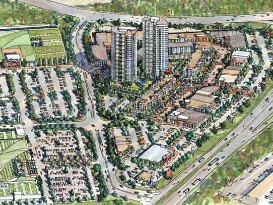

134


135
136 RETAIL EXPENDITURE POTENTIAL North Lougheed Shopping Centre - Primary Trade Area POPULATION 51,291 57,789 INCOME (PDI) $ 29,085 $ 30,569 TOTAL INCOME POTENTIAL $1,491,820,470 $1,766,560,660 RETAIL SALES / INCOME 44.2% 44.2% TOTAL RETAIL POTENTIAL $659,701,200 $781,194,600 Grocery stores (4451) $ 128,663,272 $ 152,358,451 Specialty food stores (4452) $ 8,689,785 $ 10,290,134 Beer, wine and liquor stores (4453) $ 37,980,989 $ 44,975,731 Health and personal care stores (446) $ 43,971,300 $ 52,069,243 General merchandise stores (452) $ 77,380,031 $ 91,630,669 Clothing stores (4481) $ 28,902,158 $ 34,224,903 Shoe stores (4482) $ 4,225,236 $ 5,003,374 Jewellery, luggage and leather goods stores (4483) $ 4,129,024 $ 4,889,442 Electronics and appliance stores (443) $ 24,487,449 $ 28,997,163 Furniture stores (4421) $ 13,536,818 $ 16,029,817 Home furnishings stores $ 9,086,918 $ 10,760,403 Building material & garden equipment/supply dealers $ 39,815,323 $ 47,147,883 Sporting goods, hobby, music and book stores (451) $ 19,242,440 $ 22,786,211 Miscellaneous store retailers (453) $ 18,592,120 $ 22,016,125 Motor Vehicle & Parts Dealers (441) $ 128,144,860 $ 151,744,566 Gasoline stations (447) $ 72,853,477 $ 86,270,485 TOTAL RETAIL EXPENDITURES $ 659,701,200 $ 781,194,600 Source: Colliers International Realty Advisors, Figures in brackets after Retail Category descriptions are North American Industry Classification (NAICS) codes, as reported to Statistics Canada.
137 Detailed Restaurant Spending Breakdown Pitt Meadows Total Trade Food Service Sub-Category (BC Avg.) Area Potential Full-service restaurants [7221] $ 834 $ 48,213,079 Limited-service eating places [7222] $ 676 $ 39,092,195 Special food services [7223] $ 135 $ 7,783,583 Drinking places (alcoholic beverages) [7224] $ 147 $ 8,505,428 Total, food services and drinking places $ 1,793 $ 103,594,286
138 Detailed Restaurant Spending Breakdown Total Trade Potential Mkt. Study Area With Inflow of: Food Service Sub-Category Area Potential Capture Resident Sales 15% Full-service restaurants [7221] $ 48,213,079 10% $ 4,821,308 $ 5,672,127 Limited-service eating places [7222] $ 39,092,195 10% $ 3,909,220 $ 4,599,082 Special food services [7223] $ 7,783,583 10% $ 778,358 $ 915,716 Drinking places (alcoholic beverages) [7224] $ 8,505,428 10% $ 850,543 $ 1,000,639 Total, food services and drinking places $ 103,594,286 $ 10,359,429 $ 12,187,563 NET RETAIL EXPENDITURES, 2020 North Lougheed Shopping Centre - Primary Trade Area Market Capture Grocery stores (4451) 20% $25,732,654 $30,471,690 Specialty food stores (4452) 15% $1,303,468 $1,543,520 Beer, wine and liquor stores (4453) 15% $5,697,148 $6,746,360 Health and personal care stores (446) 15% $6,595,695 $7,810,386 General merchandise stores (452) 20% $15,476,006 $18,326,134 Clothing stores (4481) 15% $4,335,324 $5,133,735 Shoe stores (4482) 15% $633,785 $750,506 Jewellery, luggage and leather goods stores (4483) 15% $619,354 $733,416 Electronics and appliance stores (443) 15% $3,673,117 $4,349,574 Furniture stores (4421) 20% $2,707,364 $3,205,963 Home furnishings stores 20% $1,817,384 $2,152,081 Building material & garden equipment/supply dealers 20% $7,963,065 $9,429,577 Sporting goods, hobby, music and book stores (451) 15% $2,886,366 $3,417,932 Miscellaneous store retailers (453) 15% $2,788,818 $3,302,419 Motor Vehicle & Parts Dealers (441) 15% $19,221,729 $22,761,685 TOTAL COMMERCIAL $101,451,277 $120,134,978 Source: Colliers International Realty Advisors, 2010 (%) 3 Please note that these sales potential figures are illustrative of what could be achieved on-site given reasonable assumptions of continued spending outflow and continued support of other existing trade area commercial facilities. If quoted, these figures should be rounded and described as such.
139 Potentially Supportable Floor Area Estimates By Category - N. Lougheed North Lougheed Shopping Centre - Primary Trade Area Sales Reqm't ($/Sq. Ft.) Grocery stores (4451) $650 46,575 55,152 Specialty food stores (4452) $700 2,191 2,594 Beer, wine and liquor stores (4453) $1,000 6,703 7,937 Health and personal care stores (446) $750 10,346 12,252 General merchandise stores (452) $300 60,690 71,867 Clothing stores (4481) $350 14,573 17,256 Shoe stores (4482) $400 1,864 2,207 Jewellery, luggage and leather goods stores (4483) $400 1,822 2,157 Electronics and appliance stores (443) $1,000 4,321 5,117 Furniture stores (4421) $400 7,963 9,429 Home furnishings stores $500 4,276 5,064 Building material & garden equipment/supply dealers $250 37,473 44,374 Sporting goods, hobby, music and book stores (451) $500 6,791 8,042 Miscellaneous store retailers (453) $400 8,202 9,713 Food Services/Restaurants $600 18,029 20,313 Service Commercial/Professional Services Offices 25% 53,448 63,291 TOTAL COMMERCIAL 285, ,766 Associated Land Area at FSR of Associated Land Area at FSR of Source: Colliers International Realty Advisors, 2010 Note: Inflow factor of: 15% of total sales volume
140


141


142


143


144
145
146 4 ONNI s Golden Ears Business Park has a later phase planned which can accommodate built-to-suit needs for 80,000 sf to as much as 300,000 sf.
147
148


149 5 Please note that these estimates were based on conversations with these individuals. Actual Statistics Canada data indicate commuter outflow of roughly 50% for Maple Ridge and 70% for Pitt Meadows.
Regional Context Statement
 Regional Context Statement REGIONAL CONTEXT STATEMENT 3. REGIONAL CONTEXT STATEMENT In 1995, the Provincial Government passed into law the Growth Strategies Act. The purpose of this provincial initiative
Planning and Public Consultation Process for the Preparation of a General Land Use Plan for South Port Kells TERMS OF REFERENCE
 APPENDIX "B" Planning and Public Consultation Process for the Preparation of a General Land Use Plan for South Port Kells TERMS OF REFERENCE PURPOSE South Port Kells is located in the northeastern quadrant
THAT the attached Terms of Reference for the Thornhill Centre Street Study be approved.
 COMMITTEE OF THE WHOLE AUGUST 18, 2003 THORNHILL CENTRE STREET STUDY PLANNING FILE: 15.92 Recommendation The Commissioner of Planning recommends: THAT the attached Terms of Reference for the Thornhill
SCARBOROUGH SUBWAY EXTENSION. Scarborough Subway Extension. Final Terms of Reference
 Scarborough Subway Extension Final Terms of Reference 1 1.0 Introduction and Background 1.1 Introduction Toronto City Council recently confirmed support for an extension of the Bloor-Danforth Subway from
CITY OF LANGLEY OFFICIAL COMMUNITY PLAN BYLAW, 2005, NO APPENDIX II - REGIONAL CONTEXT MAP
 CITY OF LANGLEY OFFICIAL COMMUNITY PLAN BYLAW, 2005, NO. 2600 APPENDIX II - REGIONAL CONTEXT MAP ± Legend Agricultural Mixed Employment Industrial Conservation & Recreation Regional City Centre Urban Containment
1.0 Purpose of a Secondary Plan for the Masonville Transit Village
 Report to Planning and Environment Committee To: Chair and Members Planning & Environment Committee From: John M. Fleming Managing Director, Planning and City Planner Subject: Masonville Transit Village
STUDY AREA LOCATION & CONTEXT:
 UNLOCKING THE POTENTIAL OF THE KEATING CROSS ROAD BUSINESS CORRIDOR A PLAN TO CREATE + RETAIN JOB-GENERATING BUSINESSES AND TO GUIDE INFRASTRUCTURE INVESTMENT The Keating Cross Road Corridor (the Keating
6 Growth Management Challenges and Opportunities
 6 Growth Management Challenges and Opportunities The Town has established a goal of attaining a 50% participation rate with respect to employment opportunities versus residential population. The Town s
NO: R035 COUNCIL DATE: FEBRUARY 24, 2014
 CORPORATE REPORT NO: R035 COUNCIL DATE: FEBRUARY 24, 2014 REGULAR COUNCIL TO: Mayor & Council DATE: February 24, 2014 FROM: General Manager, Planning and Development FILE: 6520-01 SUBJECT: Town Centre
TO: Mayor & Council DATE: April 12, The Planning and Development Department and the Engineering Department recommend that Council:
 CORPORATE REPORT NO: R080 COUNCIL DATE: April 12, 2010 REGULAR COUNCIL TO: Mayor & Council DATE: April 12, 2010 FROM: SUBJECT: General Manager, Planning and Development General Manager, Engineering Neighbourhood
9 CITY OF VAUGHAN OFFICIAL PLAN AMENDMENT NO BOCA EAST INVESTMENTS LIMITED
 9 CITY OF VAUGHAN OFFICIAL PLAN AMENDMENT NO. 631 - BOCA EAST INVESTMENTS LIMITED The Planning and Economic Development Committee recommends the adoption of the recommendations contained in the following
Welcome to the Oakridge Centre Open House
 Welcome to the Oakridge Centre Open House Why is the City hosting this event? This open house is to inform you of a rezoning application submitted to the City of Vancouver to amend the existing CD-1 (Comprehensive
Welcome. Walk Around. Talk to Us. Write Down Your Comments
 Welcome This is an information meeting introducing the applications for proposed redevelopment of the Yorkdale Shopping Centre site at 3401 Dufferin Street and 1 Yorkdale Road over the next 20+ years,
SUBJECT: Waterfront Hotel Planning Study Update TO: Planning and Development Committee FROM: Department of City Building. Recommendation: Purpose:
 Page 1 of Report PB-23-18 SUBJECT: Waterfront Hotel Planning Study Update TO: Planning and Development Committee FROM: Department of City Building Report Number: PB-23-18 Wards Affected: 2 File Numbers:
CITY CLERK. Parkland Acquisition Strategic Directions Report (All Wards)
") CITY CLERK Clause embodied in Report No. 10 of the, as adopted by the Council of the City of Toronto at its meeting held on November 6, 7 and 8, 2001. 10 Parkland Acquisition Strategic Directions Report
CITY CLERK Clause embodied in Report No. 10 of the, as adopted by the Council of the City of Toronto at its meeting held on November 6, 7 and 8, 2001. 10 Parkland Acquisition Strategic Directions Report
3. Endorse the LRT vision in transforming Surrey into Connected-Complete-Livable communities, and more specifically, the official vision statement:
 CORPORATE REPORT NO: R038 COUNCIL DATE: February 20, 2017 REGULAR COUNCIL TO: Mayor & Council DATE: February 16, 2017 FROM: General Manager, Engineering FILE: 8740-01 SUBJECT: Surrey Light Rail Transit
EXECUTIVE SUMMARY DRAFT CHAPTER 1 INTRODUCTION EXECUTIVE SUMMARY
 CHAPTER 1 EXECUTIVE SUMMARY INTRODUCTION Through the joint efforts of the City of Tulsa planning staff and the Land Services division of Indian Nations Council of Governments (INCOG), the Berryhill Land
Town of Cobourg Heritage Master Plan. Statutory Public Meeting
 Town of Cobourg Heritage Master Plan Statutory Public Meeting April 25 th 2016 Presentation Overview 1. Introduction 2. Project background and schedule overview 3. Review of strategic direction content
Chapter 1. Community Context. Vision Statement Population and Housing Trends Legislative Context Regional Context Statement
 Chapter 1 Community Context Vision Statement Population and Housing Trends Legislative Context Regional Context Statement 1.1 VISION STATEMENT CORPORATE MISSION STATEMENT To promote a safe and livable
PART 1. Background to the Study. Avenue Study. The Danforth
 The Danforth 1.1/ Study Purpose & Key Municipal Goals 1.2/ The Local Advisory Committee 1.3/ The Project Team 1.4/ Study Process/Summary of Method 1.5/ Summary of Consultation 1.1 Study Purpose and Key
SUBJECT: GO Station Mobility Hubs Preferred Concepts: Aldershot GO, Burlington GO and Appleby GO. Planning and Development Committee - Public Meeting
 Page 1 of Report PB-76-17 SUBJECT: GO Station Mobility Hubs Preferred Concepts: Aldershot GO, Burlington GO and Appleby GO TO: FROM: Planning and Development Committee - Public Meeting Planning and Building
13 THORNHILL YONGE STREET STUDY IMPLEMENTATION CITY OF VAUGHAN OPA 669 AND TOWN OF MARKHAM OPA 154
 13 THORNHILL YONGE STREET STUDY IMPLEMENTATION CITY OF VAUGHAN OPA 669 AND TOWN OF MARKHAM OPA 154 The Planning and Economic Development Committee recommends the adoption of the recommendations contained
Employment and Commercial Review Analysis of Policy Directions
 Employment and Commercial Review Analysis of Policy Directions Appendix A The following analysis is town staff s response to the policy directions provided by the consultants who prepared the Employment
CITY OF CHARLOTTESVILLE, VIRGINIA CITY COUNCIL AGENDA
 CITY OF CHARLOTTESVILLE, VIRGINIA CITY COUNCIL AGENDA Agenda Date: December 16, 2013 Action Required: Adoption of Resolution Presenter: Staff Contacts: Title: James E. Tolbert, AICP, Director of NDS James
Scope of Services. River Oaks Boulevard (SH 183) Corridor Master Plan
 Corridor Master Plan") Scope of Services River Oaks Boulevard (SH 183) Corridor Master Plan PROJECT AREA The project area consists of the River Oaks Boulevard (SH 183) corridor bounded by SH 199 at the northern end and the Trinity
Scope of Services River Oaks Boulevard (SH 183) Corridor Master Plan PROJECT AREA The project area consists of the River Oaks Boulevard (SH 183) corridor bounded by SH 199 at the northern end and the Trinity
The Corporation of the TOWN OF MILTON
 Report to: From: Chair & Members of the Administration & Planning Standing Committee W.F. Mann, Director of Planning and Development Date: April 16, 2012 PD 022-12 (Z19/11) Subject: Technical Report Proposed
Report to: Development Services Committee Report Date: April 24, 2017
 SUBJECT: Cornell Rouge National Urban Park Gateway - Report on Design Charrette and Next Steps PREPARED BY: Lilli Duoba, MES, MCIP, RPP, Manager, Natural Heritage (ext. 7925) REVIEWED BY: Marg Wouters,
Executive Summary. NY 7 / NY 2 Corridor
 Executive Summary NY 7 / NY 2 Corridor Transportation and Land Use Study December 2005 Prepared for: Town of Colonie Capital District Transportation Committee Prepared by: Introduction: Land use decisions
LAND USE AMENDMENT CORNERSTONE (WARD 3) 60 STREET NE AND COUNTRY HILLS BOULEVARD NE MAP 26NE BYLAW 22D2017
 60 STREET NE AND COUNTRY HILLS BOULEVARD NE MAP 26NE BYLAW 22D2017") Page 1 of 14 EXECUTIVE SUMMARY This Land Use Amendment application covers an area of 43.76 hectares ± (108.14 acres ±) located in northeast Calgary, bound by Country Hills Boulevard NE to the south and
Page 1 of 14 EXECUTIVE SUMMARY This Land Use Amendment application covers an area of 43.76 hectares ± (108.14 acres ±) located in northeast Calgary, bound by Country Hills Boulevard NE to the south and
CITY COUNCIL AGENDA REPORT
 CITY COUNCIL AGENDA REPORT Subject: COUNCIL MOTION LRT ALIGNMENT REMOVAL FROM THE TRANSPORTATION MASTER PLAN On February 10, 2016 Councillor Hughes provided notice in accordance with Section 23 of Procedure
KANATA CENTRUM 255 KANATA AVENUE OFFICIAL PLAN AMENDMENT ZONING BY-LAW AMENDMENT
 KANATA CENTRUM 255 KANATA AVENUE OFFICIAL PLAN AMENDMENT ZONING BY-LAW AMENDMENT JUNE 2015 PREPARED BY: FOTENN Consultants Inc. 223 Mcleod Street Ottawa, ON K2P OZ8 (613) 730-5709 PREPARED FOR: Kanata
Land Use Amendment in Southwood (Ward 11) at and Elbow Drive SW, LOC
 at and Elbow Drive SW, LOC") 2018 November 15 Page 1 of 10 EXECUTIVE SUMMARY This land use amendment application was submitted by Rick Balbi Architect on 2017 August 31 on behalf of Sable Developments Ltd, and with authorization from
2018 November 15 Page 1 of 10 EXECUTIVE SUMMARY This land use amendment application was submitted by Rick Balbi Architect on 2017 August 31 on behalf of Sable Developments Ltd, and with authorization from
MAYFIELD WEST SECONDARY PLAN PHASE 2
 MAYFIELD WEST SECONDARY PLAN PHASE 2 Public Open House #3 February 25, 2010 Draft Preferred Land Use Scenario TOWN OF CALEDON PLANNING & DEVELOPMENT DEPARTMENT Open House Agenda TOWN OF CALEDON 1. Welcome
ELMVALE ACRES SHOPPING CENTRE MASTER PLAN
 ELMVALE ACRES SHOPPING CENTRE MASTER PLAN Contents 1.0 INTRODUCTION... 2 2.0 LOCATION... 2 3.0 EXISTING CONTEXT... 2 4.0 VISION & GUIDING PRINCIPLES... 2 5.0 LAND USE AND BUILT FORM... 4 5.1 St. Laurent
CONSULTING SERVICES FOR THE WHITEBELT VISIONING EXERCISE ADDENDUM TO THE GTA WEST LAND USE STUDY WORK PROGRAM
 CONSULTING SERVICES FOR THE WHITEBELT VISIONING EXERCISE ADDENDUM TO THE GTA WEST LAND USE STUDY 1. Introduction WORK PROGRAM The Town of Caledon is a large, local municipality located in the Greater Toronto
NEW REGIONAL OFFICIAL PLAN HIGH LEVEL PROCESS & FRAMEWORK
 NEW REGIONAL OFFICIAL PLAN HIGH LEVEL PROCESS & FRAMEWORK Why A New Official Plan Originally the role of Regionally Planning and content of Regional Official Plan (1970s) primarily focused on protecting
YONGE STEELES CORRIDOR SECONDARY PLAN. Young + Wright / IBI Group Architects Dillon Consulting Ltd. GHK International (Canada) Ltd.
 Ltd.") PART A: PREAMBLE 1.0 PURPOSE The purpose of this Secondary Plan is to provide a development framework for intensification of the Yonge/ Steeles corridor including the north side of Steeles Avenue West
PART A: PREAMBLE 1.0 PURPOSE The purpose of this Secondary Plan is to provide a development framework for intensification of the Yonge/ Steeles corridor including the north side of Steeles Avenue West
COLVER ROAD INDUSTRIAL CONCEPT PLAN
 COLVER ROAD INDUSTRIAL CONCEPT PLAN A CONCEPTUAL LAND USE AND TRANSPORTATION PLAN FOR TA-4 AN URBAN RESERVE AREA OF THE CITY TALENT City of Talent Adopted by City Council Resolution No., June, 2015 PART
12 AMENDMENT NO. 149, TOWN OF MARKHAM HIGHWAY 404 NORTH SECONDARY PLAN
 12 AMENDMENT NO. 149, TOWN OF MARKHAM HIGHWAY 404 NORTH SECONDARY PLAN The Planning and Economic Development Committee recommends the adoption of the recommendation contained in the following report August
The transportation system in a community is an
 7 TRANSPORTATION The transportation system in a community is an important factor contributing to the quality of life of the residents. Without a sound transportation system to bring both goods and patrons
GEORGE DERBY COMMUNITY PLAN
 Planning and Building Department GEORGE DERBY COMMUNITY PLAN The following Council Report constitutes the George Derby Community Plan as adopted by Council in 1989. TO: MUNICIPAL MANAGER 1989 OCTOBER 17
A. WHAT IS A GENERAL PLAN?
 I. Introduction A. WHAT IS A GENERAL PLAN? A general plan is the planning guideline for the future of a city. It contains goals and policies which regulate urban development, the protection of the natural
City of Grande Prairie Development Services Department KENNEDY DEVELOPMENTS LTD. OUTLINE PLAN OP-09-01
 City of Grande Prairie Development Services Department KENNEDY DEVELOPMENTS LTD. OUTLINE PLAN OP-09-01 July 27, 2009 TABLE OF CONTENTS 1.0 Introduction... 1 1.1 Plan Area Location & Context... 1 1.2 Ownership
Town of Peru Comprehensive Plan Executive Summary
 Town of Peru Comprehensive Plan Executive Communities that plan grow by choice, not by chance. A plan makes growth thoughtful, understandable, and predictable. A plan shows that a community is managing
The Corporation of the Town of Milton
 Report To: From: Council Barbara Koopmans, Commissioner, Planning and Development Date: May 7, 2018 Report No: Subject: Making it Possible Positioning the Town s Strategy for Growth and Economic Development
Queensborough Eastern Neighbourhood Node. Community Open House
 Queensborough Eastern Community Open House The Vision The Queensborough Eastern will become the heart of eastern Queensborough. Through a sensitive mix of viable commercial and residential areas, the neighbourhood
CITY OF VAUGHAN EXTRACT FROM COUNCIL MEETING MINUTES OF NOVEMBER 15, 2016
 Item 11, Report No. 38, of the Committee of the Whole, which was adopted without amendment by the Council of the City of Vaughan on November 15, 2016. Regional Councillor Di Biase declared an interest
This page has been intentionally left blank.
 This page has been intentionally left blank. Chapter 3 3-2 3. Employment 3.A Niagara Economic Gateway 3.A.1 General The Niagara Economic Gateway comprises: a) The Gateway Economic Zone which includes all
implementation r expression in landscape
 6 ubc okanagan implementation campus plan r expression in landscape 68 6 implementation campus plan sections The Campus Plan supports the academic mission, values and commitments of the University by providing
Create Policy Options Draft Plan Plan Approval. Public Consultation Events. Phase 2
 Background Grandview-Woodland Community Plan In the spring of 2012, the City of Vancouver embarked on a comprehensive community planning program in the Grandview-Woodland neighbourhood. The process has
1 Introduction. Chapter. In this chapter:
 Chapter 1 Introduction In this chapter: 1.1 A Snapshot of the Region 1.2 Towards a Sustainable Region 1.3 The Provincial Context 1.4 Purpose and Organization The Regional Municipality of York Official
Official Plan Review: Draft Built Form Policies
 PG.30.1 REPORT FOR ACTION Official Plan Review: Draft Built Form Policies Date: May 15, 2018 To: Planning and Growth Management Committee From: Chief Planner and Executive Director, City Planning Division
SECTION D. Citywide Policies
 SECTION D Citywide Policies 24 25 PART A - CITYWIDE PLAN - CITYWIDE POLICIES SECTION D Citywide Policies THIS SECTION PROVIDES POLICY DIRECTION BY TOPIC AREA: D1: Regional Context D2: Environment D3: Transportation
~!VAUGHAN NOV Z November 21, Mr. Denis Kelly, Regional Clerk The Regional Municipality of York Yonge Street Newmarket, ON L3Y 6Z1
 ~!VAUGHAN NOV Z 5 2016 November 21, 2016 Mr. Denis Kelly, Regional Clerk The Regional Municipality of York 17250 Yonge Street Newmarket, ON L3Y 6Z1 Dear Mr. Kelly: RE: NEW KIRBY GO STATION IN BLOCK 27
Public Information Centre #1
 and Highway 401 Interchange Improvements WELCOME Public Information Centre #1 Veterans Memorial Parkway Extension and Highway 401 Interchange Improvements Study May 23, 2012 4 p.m. to 7 p.m. Brief Overview
2 STATUTORY PUBLIC MEETING AND INFORMATION REPORT FOR PUBLIC MEETING ON AMENDMENT NO. 62 TO THE YORK REGION OFFICIAL PLAN
 2 STATUTORY PUBLIC MEETING AND INFORMATION REPORT FOR PUBLIC MEETING ON AMENDMENT NO. 62 TO THE YORK REGION OFFICIAL PLAN Pursuant to Section 17(15) of the Planning Act, as amended, the Regional Planning
SECTION ONE: INTRODUCTION. introduction
 introduction 1 INTRODUCTION Since it was first established in 1843 as a trading post for the Hudson s Bay Company, Victoria has evolved into a Provincial capital city that is recognized across Canada and
178 Carruthers Properties Inc.
 178 Carruthers Properties Inc. Planning Rationale for 178 Carruthers Avenue Site Plan Control Application June 2014 Table of Contents 1.0 Introduction 2.0 Overview of Subject Property 3.0 Current Zoning
Staff Report and Recommendation
 Community Planning and Development Planning Services 201 W. Colfax Ave., Dept. 205 Denver, CO 80202 p: 720.865.2915 f: 720.865.3052 www.denvergov.org/cpd TO: City Council Neighborhoods and Planning Committee
Local Growth Planning in North Central Green Line Communities
 2018 April 30 Page 1 of 6 EXECUTIVE SUMMARY This report outlines a high-level scope for local growth planning for north central Green Line communities. The catalyst for this review is the significant investments
1.0 PLANNING MARKHAM S FUTURE CONTENTS
 1-1 Planning Markham s Future 1.0 PLANNING MARKHAM S FUTURE CONTENTS 1.1 THE PURPOSE OF THE OFFICIAL PLAN 1.2 THE MARKHAM CONTEXT 1.3 THE REGULATORY CONTEXT 1.3.1 Province of Ontario 1.3.2 York Region
Second Line West Pedestrian/Cyclist Crossing of Highway 401 Class EA. Second Line West Pedestrian/Cyclist Crossing of Highway 401 Class EA
 1 1 Purpose of Public Information Centre #2 To provide interested and/or potentially affected stakeholders with an opportunity to participate in the planning and decision-making process for this Municipal
Planning and Growth Management Committee. Chief Planner and Executive Director, City Planning Division. Pg12013 (File No NNY 34 OZ)
") 865 York Mills Road Official Plan Amendment Application Preliminary Report STAFF REPORT ACTION REQUIRED Date: February 28, 2012 To: From: Wards: Reference Number: Planning and Growth Management Committee
865 York Mills Road Official Plan Amendment Application Preliminary Report STAFF REPORT ACTION REQUIRED Date: February 28, 2012 To: From: Wards: Reference Number: Planning and Growth Management Committee
K. SMART ASSOCIATES LIMITED
 Planning Justification Report Zoning By-Law Amendment 185 King Street North Waterloo, Ontario April 7th, 2017 Project Reference Number 16-245 K. SMART ASSOCIATES LIMITED CONSULTING ENGINEERS AND PLANNERS
Small Area Plan. South Gateway
 Small Area Plan Adopted May 12, 2008 South Gateway Purpose. The South Gateway Small Area Plan defines the City s expectations for the future of the southern entrance to the City at Interstate 85 and Highway
10.0 Open Space and Public Realm
 10.0 Open Space and Public Realm 10.0 Open Space and Public Realm The Public Open Space System is comprised of: outdoor spaces available for public use that are either publicly owned (e.g., parks and
Chapter 1.0 Introduction
 Chapter 1.0 Introduction 1.1 Background The North Metro commuter rail line is part of the RTD FasTracks regional transit system expansion program to build more than 100 miles of rail transit throughout
Sustainable Growth. Sustainable Growth
 2 Sustainable Growth Sustainable Growth SUSTAINABLE GROWTH 2.1 COMMUNITY VISION... 2-5 2.2 THE CITY SYSTEM... 2-7 2.2.1 AREAS... 2-7 2.2.2 CITY-WIDE SYSTEMS... 2-8 2.2.3 PROVINCIAL PLAN BOUNDARIES AND
Streets for People, Place-Making and Prosperity. #TOcompletestreets
 COMPLETE STREETS FOR TORONTO Streets for People, Place-Making and Prosperity COMPLETE STREETS: A NEW APPROACH A Complete Streets design approach considers the needs of all users people who walk, bicycle,
VILLAGE OF BOLTON HERITAGE CONSERVATION DISTRICT PLAN
 Page 1 1. INTRODUCTION AND BACKGROUND 1.1 THE PROJECT VILLAGE OF BOLTON HERITAGE CONSERVATION DISTRICT PLAN TERMS OF REFERENCE The Town of Caledon (Town) is a large, predominantly rural municipality with
URBAN DESIGN BRIEF URBAN DESIGN BRIEF 721 FRANKLIN BLVD, CAMBRIDGE August 2018
 URBAN DESIGN BRIEF URBAN DESIGN BRIEF 721 FRANKLIN BLVD, CAMBRIDGE August 2018 DESIGN BRIEF CONTENTS PART A 1.0 INTRODUCTION 2.0 DESCRIPTION & ANALYSIS OF SITE CONTEXT 3.0 DESIGN CONSTRAINTS AND OPPORTUNITIES
Official Plan Review
 Official Plan Review Summary Report - The Built Environment August 2014 Part 1: Introduction Planning for a healthy, prosperous and sustainable community is an important goal for our municipality. From
North Fair Oaks Community Plan Summary and Information
 North Fair Oaks Community Plan Summary and Information WHAT IS THE NORTH FAIR OAKS COMMUNITY PLAN? The North Fair Oaks Community Plan is part of the San Mateo County General Plan, and establishes policies
Gold Line Bus Rapid Transit Transit Oriented Development (BRTOD) Helmo Station Area Plan
 Helmo Station Area Plan") Appendix F Gold Line Bus Rapid Transit Transit Oriented Development (BRTOD) Helmo Station Area Plan Introduction and Purpose of the Plan The Gold Line Bus Rapid Transit facility is an eleven-mile dedicated
Appendix F Gold Line Bus Rapid Transit Transit Oriented Development (BRTOD) Helmo Station Area Plan Introduction and Purpose of the Plan The Gold Line Bus Rapid Transit facility is an eleven-mile dedicated
A Growing Community Rural Settlement Areas
 Town of Huntsville Official Plan Review - POLICY BACKGROUND PAPER A Growing Community Rural Settlement Areas BACKGROUND: In addition to the fully municipally-serviced Urban Settlement Area and the Hidden
FORMER CANADIAN FORCES BASE (CFB) ROCKCLIFFE SECONDARY PLAN. Official Plan Amendment XX to the Official Plan for the City of Ottawa
 ROCKCLIFFE SECONDARY PLAN. Official Plan Amendment XX to the Official Plan for the City of Ottawa") FORMER CANADIAN FORCES BASE (CFB) ROCKCLIFFE SECONDARY PLAN Official Plan Amendment XX to the Official Plan for the City of Ottawa 1 INDEX THE STATEMENT OF COMPONENTS PART A THE PREAMBLE PAGE Purpose...
FORMER CANADIAN FORCES BASE (CFB) ROCKCLIFFE SECONDARY PLAN Official Plan Amendment XX to the Official Plan for the City of Ottawa 1 INDEX THE STATEMENT OF COMPONENTS PART A THE PREAMBLE PAGE Purpose...
Study Process / Planning Policy Issues
 Memorandum Date: March 13 th, 2009 To: From: Reference: Subject: Murray Thompson, URS Canada Tyler Drygas, Senior Environmental Planner, URS Canada Detroit River International Crossing Study Response to
Plan Overview. Manhattan Area 2035 Reflections and Progress. Chapter 1: Introduction. Background
 Plan Overview The Manhattan Urban Area Comprehensive Plan (the Comprehensive Plan) is a joint planning initiative of the City of Manhattan, Pottawatomie County, and Riley County. The 2014 Comprehensive
[PLANNING RATIONALE] For Site Plan Control and Lifting of Holding Zone By-Law 101 Champagne Avenue. May 23, 2014
![[PLANNING RATIONALE] For Site Plan Control and Lifting of Holding Zone By-Law 101 Champagne Avenue. May 23, 2014](/thumbs/75/71599615.jpg "[PLANNING RATIONALE] For Site Plan Control and Lifting of Holding Zone By-Law 101 Champagne Avenue. May 23, 2014") [PLANNING RATIONALE] For Site Plan Control and Lifting of Holding Zone By-Law 101 Champagne Avenue May 23, 2014 Contents 1.0 Introduction... 2 2.0 Site Context... 2 2.1 Adjacent Uses... 2 Figure 1: Site
[PLANNING RATIONALE] For Site Plan Control and Lifting of Holding Zone By-Law 101 Champagne Avenue May 23, 2014 Contents 1.0 Introduction... 2 2.0 Site Context... 2 2.1 Adjacent Uses... 2 Figure 1: Site
Complete Neighbourhood Guidelines Review Tool
 Complete Neighbourhood Guidelines Review Tool Prepared By: City of Regina Planning Department October 2014 Page 1 of 14 Community Development Review Checklist for Secondary Plans and Concept Plans The
PUBLIC OPEN HOUSE SEPTEMBER 8 TH, 2010 CITY OF LETHBRIDGE DEVELOPMENT SERVICES
 PUBLIC OPEN HOUSE SEPTEMBER 8 TH, 2010 CITY OF LETHBRIDGE DEVELOPMENT SERVICES INTRODUCTION Why is the City creating the West Lethbridge Employment Centre Area Structure Plan? West Lethbridge Urbanization
S A C R A M E N T O C O U N T Y JACKSON HIGHWAY & GRANT LINE EAST VISIONING STUDY
 JACKSON HIGHWAY & GRANT LINE EAST S A C R A M E N T O C O U N T Y P L A N N I N G D E P A R T M E N T SUMMARY AND WORKBOOK November 19, 2008 History of the Visioning Study Sacramento County has two growth
MAYFIELD WEST SECONDARY PLAN PHASE 2
 MAYFIELD WEST SECONDARY PLAN PHASE 2 Council Information Workshop February 16, 2010 Draft Preferred Land Use Plan TOWN OF CALEDON PLANNING & DEVELOPMENT DEPARTMENT Workshop Agenda TOWN OF CALEDON 1. Welcome
A BLUEPRINT FOR BROCKTON A CITY-WIDE COMPREHENSIVE PLAN
 A BLUEPRINT FOR BROCKTON A CITY-WIDE COMPREHENSIVE PLAN Public Meeting October 2016 1 Plan Summary and Discussion Public Meeting May 4 2017 City of Brockton Bill Carpenter, Mayor Department of Planning
The West Vaughan Employment Area Secondary Plan Policies
 Part 2: The West Vaughan Employment Area Secondary Plan Policies 2.1 General Policies It is the policy of Council: 2.1.1. That the West Vaughan Employment Area (the WVEA), identified on Schedule 1, will
GREENBANK DEVELOPMENT MASTERPLAN
 DEVELOPMENT MASTERPLAN POTENTIAL TRAIN STATION COMMUNITY CENTRE Greenbank will be a connected masterplanned community providing easy access to local and surrounding amenity. Affordable quality homes, green
Downtown Streetscape Manual & Built Form Standards
 City of Guelph Downtown Streetscape Manual & Built Form Standards July 2014 Prepared by Brook McIlroy Inc. in association with Unterman McPhail Associates and McCormick Rankin Inc. City of Guelph Downtown
LAND USE AMENDMENT DOWNTOWN COMMERCIAL CORE (WARD 7) MACLEOD TRAIL SE AND 5 AVENUE SE BYLAW 254D2017
 MACLEOD TRAIL SE AND 5 AVENUE SE BYLAW 254D2017") Page 1 of 10 EXECUTIVE SUMMARY This Land Use Amendment application seeks to redesignate a full downtown block (currently the YWCA site) from a Direct Control based on the CM-2 District (Land Use Bylaw
Page 1 of 10 EXECUTIVE SUMMARY This Land Use Amendment application seeks to redesignate a full downtown block (currently the YWCA site) from a Direct Control based on the CM-2 District (Land Use Bylaw
Southwest Fleetwood Enclave
 Southwest Fleetwood Enclave Development Concept Plan Southwest Fleetwood Enclave 1 st Land Owners Meeting April 30 th, 2012 Presentation Overview Why the Plan? ; Overview & Purpose of Study; Constraints
City of Farmington. Downtown Plan. Amendment to the 1998 Master Plan Adopted October 11, 2004
 City of Farmington Amendment to the 1998 Master Plan Adopted October 11, 2004 Introduction Planning Background 1 Scope and Components of the Plan Amendment 2 Concept Introduction 3 Plan Concepts 3 Conceptual
KAMPLAN City of Kamloops. Section D. Land Use Policies D-1
 KAMPLAN City of Kamloops Section D Land Use Policies D-1 City of Kamloops KAMPLAN D 1 Land Management and Development This section links to the following Community Values: D-2 develop complete neighbourhoods
2. Shaping Waterloo Region s Urban Communities
 2. Much of the region s growth over the past several decades has occurred in suburban areas that separated where people live from where they work and shop. This pattern of growth has increased the need
TOWN OF BRUDERHEIM Report to the capital region board
 TOWN OF BRUDERHEIM Report to the capital region board Introduction to the Town of Bruderheim Municipal Development Plan amendment and Relation to the CRB Evaluation Criteria 02 march 2017 1 Introduction
20 & 30 Frank Nighbor Place
 Engineering Land / Site Development Municipal Infrastructure Environmental / Water Resources Traffic / Transportation Structural Recreational Planning Land / Site Development Planning Application Management
John M. Fleming Managing Director, Planning and City Planner. Old East Village Dundas Street Corridor Secondary Plan Draft Terms of Reference
 Report to Planning and Environment Committee To: From: Subject: Chair and Members Planning & Environment Committee John M. Fleming Managing Director, Planning and City Planner Old East Village Dundas Street
and services The protection and conservation of environmentally significant and sensitive natural heritage features and functions.
 6. Land Use 6.0 Preamble A healthy and livable city is one in which people can enjoy a vibrant economy and a sustainable healthy environment in safe, caring and diverse neighbourhoods. In order to ensure
POLICY AMENDMENT AND LAND USE AMENDMENT TUXEDO PARK (WARD 9) CENTRE STREET N AND 26 AVENUE NE BYLAWS 36P2017 AND 234D2017
 CENTRE STREET N AND 26 AVENUE NE BYLAWS 36P2017 AND 234D2017") Page 1 of 11 EXECUTIVE SUMMARY This application proposes to redesignate a single parcel of land in the Community of Tuxedo Park from Commercial Corridor 2 (C-COR2 f1h10) District to Mixed Use Active Frontage
Page 1 of 11 EXECUTIVE SUMMARY This application proposes to redesignate a single parcel of land in the Community of Tuxedo Park from Commercial Corridor 2 (C-COR2 f1h10) District to Mixed Use Active Frontage
CONTENTS 2.0 A FRAMEWORK FOR SUSTAINABLE GROWTH 2.1 MANAGING SUSTAINABLE GROWTH THE VISION TO GOALS AND OBJECTIVES 2.3 MARKHAM STRUCTURE
 2 A Framework for Sustainable Growth 2.0 A FRAMEWORK FOR SUSTAINABLE GROWTH CONTENTS 2.1 MANAGING SUSTAINABLE GROWTH THE VISION TO 2031 2.2 GOALS AND OBJECTIVES 2.2.1 Protecting the Natural Environment
Parks Master Plan Implementation: Phase I Waterfront Use and Design REPORT #: September 7, 2016 File #
 0 'O DI Lan-171-14 1 - THE CORPORATION OF THE TOWN OF COBOURG..,. STAFF REPORT TO: FROM: Mayor and Members of Council Dean A. Hustwick, Director of Recreation and Culture DATE OF MEETING: Committee of
ADMINISTRATIVE REPORT
 ADMINISTRATIVE REPORT TO: FROM: Board of Directors B. Newell, Chief Administrative Officer DATE: July 6, 2017 RE: Official Community Plan (OCP) Bylaw Amendment Electoral Area C Administrative Recommendation: