Southern and Western Urban Neighborhoods Master Plan
|
|
|
- Magdalen Rogers
- 5 years ago
- Views:
Transcription


1 Southern and Western Urban Neighborhoods Master Plan S+W. 1
2 Page intentionally left blank S+W. 2
3 Southern and Western Urban Neighborhoods Table of Contents Introduction 5 Figure 1: The Development Areas Map.. 7 Existing Conditions 9 Area B. 9 Figure 2: Area A and B...11 Figure 3: Areas A and B in Southern and Western Neighborhoods...13 Environmental Chracteristics 15 Existing Land Uses.15 Existing Community Facilities and Services.16 Figure 4: Southern Urban Neighborhood Environmental Features...17 Figure 5: Western Neighborhood Environmental Features Existing Parks and Green Systems...21 Figure 6: Southern Urban Neighborhood Parks and green Systems Plan.23 Figure 7: Western Urban Neighborhood Parks and Green Systems Plan..25 Future Land Use Figure 8: Southern Urban Neighborhood Future Land Use Plan Figure 9: Western Urban Neighborhood Future Land Use Plan. 31 Figure 10: Land Use Categories and Guidelines Figure 11: Boar s Head Area Figure 12: Ivy Road Shopping Center. 35 Figure 13: The Grounds at the University of Virginia Figure 14: Morey Creek Center Figure 15: Fontaine Research Park Figure 16: Rt 29 and I-64 Area Figure 17: Granger Center Figure 18: County Office Building...39 Figure 19: Southwood Mobile Home Park.. 39 Figure 20: Avon Street Extended.39 Figure 21: Biscuit Run State Park.40 Figure 22: Fifth and Avon Streets 41 Figure 23: Mill Creek Drive Center..41 Figure 24: PVCC...42 Figure 25: Former Blue Ridge Hospital Site 42 Figure 26: Woolen Mills Center...43 Figure 27: Birdwood Gold Course Property...44 Figure 28: Rt. 20 South & Avon St. Ext.. 45 S+W. 3
4 Figure 29: Mosby Mountain & Whittington 45 Figure 30: Foxhaven farm Area..46 Figure 31: Southpointe Property..46 Figure 32: Westover..46 Figure 33: Galaxy Farm Property 47 Priority Areas..47 Figure 34: Priority Areas for Southern Urban Neighborhood.49 Figure 35: Prioroty Areas for Western Urban Neighborhood.51 Plan for Future Community facilities and Services.. 53 Figure 36: Transportation Plan for Southern Urban Neighborhood Figure 37: Transportation Plan for Western Urban Neighborhood...57 Figure 38: Fifth Street Avon Street Connector Road Figure 39: Galaxy Farm Lane Figure 40: Whittington Property Roads Figure 41: Southern Parkway Connector Road Figure 42: Wintergreen Land Trust Property Figure 43: Sunset Fontaine Connector Road 61 Figure 44: Stadium Road Multimodal Connection..62 Successful Implementation and Updates to this Plan Traffic Modeling Information for Connector Road Ivy Road Improvement Stud: PACC Report...91 S+W. 4
5 Southern and Western Urban Neighborhoods Introduction Albemarle County has a longstanding commitment to growth management. Since the adoption of the first Comprehensive Plan in 1971, County policy has been to direct growth into the 11 designated Development Areas. Directing this growth into the Development Areas conserves the balance of the County as Rural Areas and enables the County to protect the agricultural and scenic resources found there. It also allows the County to focus on creating livable neighborhoods and vibrant mixed-use centers that are supported by services and infrastructure. Concentrating growth in the Development Areas is fiscally responsible and helps prevent sprawl. In 2001, the County adopted the Neighborhood Model which was reaffirmed in 2015 as the preferred form of development. The Neighborhood Model principles reflect the importance of creating compact, pedestrian oriented neighborhoods near parks, schools, employment and shopping. Each Development Area Master Plan describes how the principles are applied to make healthy and attractive areas where residents want to live work and play. More information on the Neighborhood Model can be found in the Development Areas Chapter and Appendix of the Comprehensive Plan. The Southern and Western urban neighborhoods represent 4 of the 11 designated Development Areas. They include areas designated in previous Comprehensive Plans as Neighborhoods 4, 5, 6, and 7. Figure 1 shows all of the Development Areas and the location of the Southern and Western neighborhoods. As with all of the Development Areas, the numbered neighborhood designations are retained for internal statistical measurement purposes. Like the rest of the master plans, this Master Plan is located in the Appendix of the Comprehensive Plan. The Appendix carries the weight of the Comprehensive Plan because it is part of the Comprehensive Plan Recommendations for the Development Areas, natural, cultural, scenic, and historic resources, parks and recreation, transportation, housing, economic development and community facilities. These Recommendations, which are in the larger Comprehensive Plan document, also apply to the master plans. The Southern and Western Neighborhoods Master Plan was developed in conjunction with the Comprehensive Plan update process. Largely based on the land use and transportation plan recommendations in effect in 2012, the Plan briefly describes where and how new residential and nonresidential uses should develop. It makes initial recommendations on the future transportation improvements and capital projects. A more detailed master planning process for these neighborhoods will take place in the first update of the Plan, approximately four years from the adoption date of this Master Plan. S+W. 5
6 Page intentionally left blank. S+W. 6

7 S+W. 7
8 Page intentionally left blank. S+W. 8
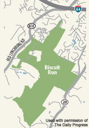
9 Existing Conditions The Southern and Western Neighborhoods are located adjacent to the City of Charlottesville and adjacent to the University of Virginia. They extend south of I-64 and encompass areas along Route 29 South, Fifth Street Extended, Avon Street Extended, and Route 20 South. Along the western border, they are on both sides of the Route 250 Bypass and extend north of Barracks Road almost to Hydraulic Road. The Southern Neighborhood is bounded on the east by Route 20, Route 53 and the eastern portion of the Blue Ridge Hospital property, on the south by a stream tributary along the southern portion of the Biscuit Run site, to the southwest parcel boundary of the Whittington Planned Development District, on the west by the parcel boundary of the Whittington Planned Development District, a ridge line separating the Mosby Mountain subdivision and the Mountain Valley subdivision, the 700 foot contour, Route 29 and the Interstate 64 interchange; and on the north by Moore s Creek and the City of Charlottesville boundary. The Southern Neighborhood also includes an adjacent, but not contiguous area bounded by the City s corporate limits, the Rivanna River, and Interstate 64. This includes the Woolen Mills and the Moores Creek Wastewater Treatment Plant. The Western Neighborhood is bounded on the east by the City of Charlottesville limits, on the south by Moores Creek and I-64, on the west by the South Fork Rivanna River watershed boundary, and on the north by the Bennington Woods subdivision just south of Hydraulic Road. Area B Area B is an area for cooperative planning with the City of Charlottesville and the University of Virginia (UVA) because of the County s adjacency of the Southern and Western Neighborhoods to the City and UVA. This joint planning takes place through the Planning & Coordination Council (PACC) which was established in More information on Area B is found in Chapter 1 of the Comprehensive Plan. The information below is repeated from that chapter: The three-party agreement creating PACC established areas where collaborative planning would take place Areas A, B, and C. These areas are shown on Figure 2 and are defined as follows: Area A: All properties now owned by the UVA and its related foundations that are used for educational purposes as designated on the Map. Area B: Land which lies at the boundaries of the UVA in either the City or the County, or has otherwise been designated as part of Area B, and on which the activities of any, or all three, of the parties might have a significant effect, as designated on the Map. Development in these areas continues to be guided by the current City and County Comprehensive Plan and the current University of Virginia Plan. Area C: All land on the Map not included in Areas A and B. The relationship of Area B properties to the Southern and Western Neighborhoods is shown on Figure 3. Land use recommendations for lands in Area B are found within this Master Plan. S+W. 9
10 Page intentionally left blank. S+W. 10

11 S+W. 11
12 Page intentionally left blank. S+W. 12

13 S+W. 13
14 Page intentionally left blank S+W. 14
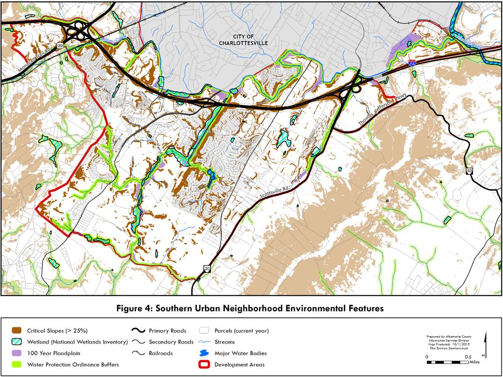
15 Environmental Characteristics Environmental features are shown on Figures 4 and 5. Streams, critical slopes (as both managed and preserved slopes), wetlands, and floodplain exist within both neighborhoods. Moore s Creek acts as the boundary between the City and the Southern Neighborhoods. The Southern Neighborhood has two major streams--biscuit Run and Moore s Creek. Floodplains exist along both waterways. Several other perennial streams are present in the Neighborhood on which stream buffers are required. Critical slopes are also found near Biscuit Run, Moore s Creek and the other perennial streams. Other critical slopes are associated with I-64. The quality of life expected by many residents corresponds directly to the availability of parks and green systems that are available to residents. Green systems refer to undeveloped land or open space with important environmental features. Green system areas are identified on the Land Use Plan in a green color. A large portion of the land area within the Southern Neighborhood is forested as seen in Figure 4. The green colors reflect deciduous and evergreen trees. Wooded areas along I-64 are important aesthetic features for the Entrance Corridors. (Information on the Entrance Corridors may be found in the Comprehensive Plan.) Wooded areas are also important within the viewshed of Monticello. The Western Neighborhoods share Morey Creek with the City and the headwaters of Meadow Creek with UVA. Designated floodplains exist along both waterways. Only one perennial stream appears in the Neighborhood, although future stream assessments may reveal others. The most prominent environmental features are the wooded areas and steep slopes on all sides of Lewis Mountain. Other important wooded areas exist along the Route 250 Bypass. Existing Land Uses Residential The Southern Neighborhood contains 3,979 dwelling units, and an estimated population of 8,700 people (2012). Of these units, 1,493 are single-family detached, 574 are single-family attached or townhouses, 1,500 are multi-family, and there are 411 mobile homes. The major residential areas are Mill Creek, Mill Creek South, Lake Reynovia, Willow Lake, Lakeside Apartments, Redfields, Southwood Mobile Home Park, Mountainside, Mosby Mountain, Country Greene Apartments, Sherwood Manor and Commons, and Oak Hill Subdivision. The Western Neighborhood contains 2,861dwelling units, and an estimated population of 6,265 people (2012). Of those units, 850 are single-family detached, 401 are single-family attached or townhouses, and 1,600 are multi-family. There are no mobile homes. The major residential areas are University Heights Apartments, Huntington Village, Ednam Forest, Ednam, Ednam Village, Bellair, Buckingham Circle, Canterbury Hills, Hessian Hills, Queens Charlotte, University Village, Colonnades Retirement Community, Hunting Village, and Ivy Apartments. Commercial and Office Commercial areas are limited in the Southern Neighborhood to a small shopping center at the corner of Mill Creek Drive and Avon Street Extended. Office uses exist on Avon Street Extended and Fifth Street Extended. S+W. 15
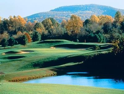
16 In the Western Neighborhood, retail and office uses can be found along Ivy Road and Old Ivy Road. Some of these uses include the Ednam office area, the Boars Head resort, and the Townside shopping center. Industrial In the Southern Neighborhood, small industrial uses can be found on Avon Street and Avon Street Extended, in the Woolen Mills neighborhood, in the Mill Creek Industrial Park, and on the west side of Route 20 South. UVA operates the only industrial uses within the Western Neighborhood. They are the Food Service Center and the University Print Shop, both located on Old Ivy Road. Institutional The most prominent land uses in the Southern Neighborhood are institutional uses. Institutional uses include the Piedmont Virginia Community College, Monticello High School, the Regional Joint Security Complex, the National Guard Armory, and several churches. The Tandem School, a private school, is located in the eastern part of this Neighborhood. UVA represents the largest institutional use in the Western Neighborhood. In addition, there are several large office complexes related to UVA that include the Fontaine Research Park, the University Health Sciences Foundation, the Kluge Children s Rehabilitation Center, and the University Development offices. The County s southern office building is located on Fifth Street Extended (COB- 5 th ). Some State offices are also located in this same area such as the Department of Forestry and the Department of Mines, Minerals, and Energy. St. Anne s Belfield private school is located in the western part of this Neighborhood. Other Uses In the Western Neighborhood, other uses include the McCormick Observatory (north of Fontaine Avenue) and Camp Holiday Trails, which is located in a wooded, hilly area immediately north of I- 64. Existing Community Facilities and Services Existing community facilities and services are described below. More information on each community facility type listed below can be found in the Community Facilities and Services Chapter of the Comprehensive Plan. Police and Fire Rescue The County s Police Department and Fire Rescue Department are housed at the Albemarle County Office Building on Fifth Street Extended (COB-5 th ). Geographic policing service is provided from this facility. Fire Rescue service is provided from the Monticello Fire Rescue Station located on Mill Creek Drive. The Regional Emergency Communications Center (ECC), located on Ivy Road in the Western Neighborhoods, dispatches all emergency calls to County fire departments, rescue squads, and the region s police departments. S+W. 16
17 S+W. 17
18 Page intentionally left blank S+W. 18

19 S+W. 19
20 Page intentionally left blank. S+W. 20
21 Schools There are two public schools located in the Southern Neighborhood: Cale Elementary on Avon Street Extended and Monticello High School on Mill Creek Drive. There are no existing public schools in the Western Neighborhoods. School district boundaries change with growth in the County and are therefore not permanent. At present, Cale Elementary currently serves most of the Southern Neighborhoods while Murray and Greer Elementary Schools serve most of the Western Neighborhoods. Burley Middle School currently serves part of the Southern Neighborhood closest to the City of Charlottesville. Walton Middle School serves the rest of the Southern Neighborhood while Henley and Jouett Middle Schools serve parts of the Western Neighborhoods. Monticello High School currently serves all of the Southern Neighborhood. Western Albemarle and Albemarle High Schools serve parts of the Western Neighborhoods. Library Services Library service is provided by the downtown branch of the Jefferson-Madison Regional Library (JMRL). There are currently no branches of the JRML system in the Southern or Western Neighborhoods. County Government Buildings The Southern Neighborhood houses the County Office Building (COB) on 5 th Street Extended. This facility houses the Charlottesville-Albemarle Commission on Children and Families, Fire Rescue, Housing, Police, Social Services, Virginia Cooperative Extension, and Voter Registration. Water and Sewer Service Water and sewer service is provided from the Albemarle County Service Authority (ACSA) which retails water and wastewater services to residents and business. The Rivanna Water and Sewer Authority (RWSA) provides impoundment, treatment, storage, and transmission of potable water as well as transport and treatment of wastewater to the County and City. Upgrades that are planned for the Southern Neighborhood include constructing portions of the eastern branch of the southern loop to improve water delivery to the area. An expansion of the Rugged Mountain Reservoir is currently underway. This expansion will increase the height of the Ragged Mountain Reservoir dam to increase storage capacity. A water supply pipeline between the South Fork Rivanna and Ragged Mountain reservoirs to increase water supply storage is also planned. Solid Waste Management Solid waste management addresses collection and disposal of domestic solid waste for residences, institutions, businesses, and industries, and also includes inert construction debris, brush, yard waste and vegetative debris. It does not include wastewater treatment or hazardous waste facilities. Hazardous waste is a solid waste management issue that is addressed through the TJPDC Regional Solid Waste Management Plan, the policies of the Rivanna Solid Waste Authority, and the County s Environmental Management Policy. Solid waste collection service to all County residents, including in the Southern and Western Neighborhoods, is provided by private haulers. Existing Parks and Green Systems Figures 6 and 7 provide the Parks and Green Systems Map for the Southern and Western Neighborhoods. Areas shown on that Plan are parks, greenways and other preserved open space, schools (which act as public park sites), water bodies, streams, and critical slopes. More information on Parks and Green Systems can be found in the Parks and Recreation, Greenways, Blueways, and Green Systems Chapter of the Comprehensive Plan. S+W. 21
22 Page intentionally left blank. S+W. 22
23 S+W. 23
24 Page intentionally left blank. S+W. 24

25 S+W. 25
26 Page intentionally left blank. S+W. 26
27 Environmental features include streams, stream buffers, floodplains, wetlands, and systems of steep slopes. Preservation of these features is expected. Parks and Greenways include public parks, such as the future Biscuit Run State Park, common areas owned by homeowners associations, dedicated areas for greenways as well as expected greenways which help to make connections between places. Screening Buffers Screening buffers are heavily wooded and vegetated areas that exist along Entrance Corridors and especially along I-64 and Route 250 East. These buffers help to mitigate visual and noise impacts between the roads and nearby residences and businesses. Retention of these features is expected. Wooded Areas In general, wooded areas help to break up the expanse of buildings and parking in an area. They are especially important for the Monticello Viewshed. The wooded areas on Lewis Mountain are in Area B and are areas of importance to the community because they are mostly on critical slopes and are highly visible. Greenway Trails Existing and proposed trails are shown on the Parks and Green Systems Map (Figure 5). These trails include public trails, trails owned by the Rivanna Trails Foundation, and some privately owned trails. Existing Transportation Systems The primary roads in the Southern Neighborhood are I-64, Route 20 South, Route 53, Avon Street Extended, Fifth Street Extended/Old Lynchburg Road, Mill Creek Drive, and Route 29 South. Route 20 and Route 53 are rural section roads which are narrow. As of 2012, both roadways are in good condition as classified by the Virginia Department of Transportation (VDOT) based on pavement condition and ride quality. VDOT s long range plans include horizontal and vertical curvature improvements of Route 20 which may require some realignment. Route 53 is the immediate approach to Monticello. It is narrow and winding. A parkway has been constructed to Monticello along the existing Route 53 alignment. The parkway includes a walking trail and a bicycle facility that connects two small parking areas on Route 20 to the Monticello Visitors Center and to Monticello. Avon Street Extended is a two-lane rural section road which extends from the City of Charlottesville south across I-64 until it intersects with Route 20 South. The bridge over I-64 has limited roadway capacity. There are no sidewalks along Avon Street Extended which is especially problematic for persons walking from the Regional Jail or employees who want to walk to and from the Regional Jail. Fifth Street Extended - Old Lynchburg Road extends from the City of Charlottesville south and passes the southern Albemarle County office building. Mill Creek Drive is a four-lane street which was built by the County to provide access to Monticello High School and other County-owned properties. Sidewalks are present along both sides. S+W. 27
28 A Park and Ride facility is located on Avon Street Extended at the City Public Works Yard. The portion of Route 631 (Old Lynchburg Road) south of Sunset Avenue Extended has a narrow pavement width and poor horizontal and vertical curves which make access from some local roads difficult. Walkways exist along one side of the improved portion of Route 631. The primary roads in the Western Neighborhoods are the Route 250 Bypass, Ivy Road, Old Ivy Road, and Fontaine Avenue Extended. The Bypass bisects the Neighborhood and carries approximately 50,000 vehicle trips per day. It is a limited access road which is a 4-lane divided highway. These trips reflect the average annual daily traffic (AADT.) Route 250 West is heavily traveled and it is projected that traffic volumes along this roadway will double by The road is used by commuters, students and visitors to the University of Virginia. This road is also heavily used by bicyclists traveling into the University. Flooding occurs periodically on Route 250 West near its intersection with Old Ivy Road. Walkways are constructed on both sides of Route 250 West from Route 29 to Old Ivy Road. Fontaine Avenue is also heavily traveled. Walkways and a bicycle facility exist along Fontaine Avenue in front of the Fontaine Avenue Research Park. Also, the Route 250/29 Bypass intersects the Neighborhood. Route 250 West is heavily traveled and it is projected that traffic volumes will double by Walkways are constructed on both sides of Route 250 West, from Route 29 to Old Ivy Road. Old Ivy Road has a narrow pavement width and poor horizontal and vertical curvature, and is heavily used by the student population. Georgetown Road is also heavily traveled, providing access into Charlottesville and to Albemarle County High School. A narrow asphalt pathway is located along Georgetown Road. Barracks Road is also located in the Western Neighborhood. Future Land Use Future Land Use Plan The Future Land Use Plan for the Southern and Western Neighborhoods has been developed in conjunction with the community and is similar to the 1996 Land Use Plan, although some changes have been made. The Plan shows areas designated for development, the type of development that is desired, and green systems that should be preserved. The Future Land Use Plan and the Future Land Use Categories Guidelines Chart are found in Figures 8 and 9 respectively. Centers As described in the Neighborhood Model Design section of the Comprehensive Plan, centers are focal points or places where people congregate. A center may be a school or a park. It may be a major employment area or a shopping area. It may be a mixed-use area. It is a place to which people want to walk. Centers provide definition to an area and personalize it. They should be located within a half to one quarter mile walk zone from residences, and one third to one half mile from transit stops. Centers are denoted on the Land Use Plan with a large "C." There are 16 Centers in the Southern and Western Neighborhoods. Individual snapshots of portions of the Future Land Use Plan Map highlight each Center in the following figures. S+W. 28

29 S+W. 29
30 Page intentionally left blank. S+W. 30

31 S+W. 31
32 Page intentionally left blank. S+W. 32

33 S+W. 33

34 S+W. 34


 world heritage site. The Grounds comprise a large educational and employment Center.")
35 1. The Boar s Head Center (Figure 11) is an existing Center of neighborhood scale mixed use with residential, office, commercial and recreational uses which serve the neighborhood. A resort and conference center are also located in this area. It is recommended for Neighborhood Mixed Use. Figure 11: Boar s Head Area Figure 12: Ivy Road Shopping Center 2. The Ivy Road Shopping Center (Figure 12) is an existing Center of mixed use, made up of retail, office, higher density residential, and educational uses. Redevelopment is anticipated as market needs change. This area is part of Area C. The shopping center is recommended for Community Mixed Use. 3. The Grounds of the University of Virginia (UVA, Figure 13) are designated for Institutional use. UVA and Monticello form a United Nations Educational, Scientific, and Cultural (UNESCO) world heritage site. The Grounds comprise a large educational and employment Center. The area has high residential density, mostly catering to the student population. As previously defined, the University Grounds make up a large portion of Area C. Figure 13: The Grounds at the University of Virginia The Grounds at the University of Virginia W. Main St. Figure 11: Morey Creek S+W. 35


36 4. The Center located at Morey Creek is a future Center located in Area C (Figure 14). It will be a major employment center which is affiliated with UVA. Although it is shown for Office/R&D/Flex/Light Industrial use, it is recommended that the uses be limited to office uses and commercial uses in conjunction with those offices. No industrial use is recommended. Design of buildings on this property should include architectural features such as stepbacks in the horizontal and vertical planes to break up building massing. Pedestrian access should be provided between this site and the Fontaine Research Park. Figure 14: Morey Creek Center Fontaine Ave. Ext. Rt. 250 Bypass Figure 15: Fontaine Research Park Rt. 250 Bypass Fontaine Research Park 5. Fontaine Research Park is also located in Area C (Figure 15). It is an existing employment Center affiliated with UVA. Although it is shown for Office/R&D/Flex/Light industrial use, it is recommended for office use and commercial use which can serve the park and the immediate area. No industrial use is recommended. In addition to significant office space, public walking trails are located in the area. This area is part of the proposed Sunset- Fontaine Connector road project, discussed in the Transportation Section of this Master Plan. Infill and expansion of the Fontaine Research Park is expected. However, the level of expansion permitted on-site should be limited to that which can be supported by the planned road network. Expansion should be timed with the construction of the planned improvements to the road network which provide an adequate level of service (LOS) to support development in this area. Adequate level of service is considered D or better (or the LOS acceptable to VDOT) for network roads in the County and City, including Fontaine Avenue in the County and City, the Fontaine Avenue/U.S. 29 Bypass interchange, Sunset Avenue, Old Lynchburg Road and Fifth Street. Any future development should minimize the visual impacts to the Entrance Corridor through maintenance of vegetated buffers, careful site grading, and careful treatment of building locations, heights, massing and clustering on the site. Green building and site design concepts should be incorporated into the project s development. S+W. 36

37 Water quality impacts will be an important consideration for any future development of this site. Measures should be put in place to not only minimize stream impacts, but also to help improve the current condition of Moore s Creek and its tributaries. 6. The southwest quadrant of the Route 29 South and I-64 interchange (Figure 16) contains a future Center which is shown for I-64 Regional Mixed Use, land with an Industrial designation, and areas shown for Parks and Green Systems. At present, part of the Center contains a beverage distribution business. Commercial and residential uses are allowed on the property shown for Regional Mixed Use, although this area may also be used for industrial uses. The Industrially designated area is expected to support the County s target industries that need a location near an interstate interchange and/or close proximity to downtown Charlottesville and/or the University of Virginia, but are not adaptable to a mixed-use environment. This location is particularly suited for the following industries and employment activities, and development activities should be in keeping with advancement of the County s overall economic development goals: Figure 16: Rt. 29 and I-64 Area Research and development with associated light assembly Specialty food production and distribution Adult beverage production and distribution Other small distribution facilities ancillary to a production operation Business and financial processing operations. The terrain in this area is hilly and, at present, is covered mostly in deciduous forest. Moore s Creek crosses the front of the properties designated for Regional Mixed Use along Route 29 South. Some of the area shown as Parks and Green Systems contains environmentally sensitive systems including steep slopes, streams, and vegetation that forms a stream buffer. Protection of these features is important for habitat protection within Hedgerow Park and the Ragged Mountain Natural Area. Passive recreation and trails may be appropriate in areas designated for Parks and Green Systems and a public greenway is proposed to extend from the Redfields neighborhood across Route 29 South, through the Regional Mixed Use Area, westward to Hedgerow Park. The Parks and Green Systems designation also includes forested buffer to the Rural Area on the southwestern edge of the Development Area and along the Entrance Corridors of Route 29 South and I-64. These forested buffers should be preserved and maintained to protect the quality and character of these roads and to help minimize the visual impacts to the Entrance Corridors. Because of the terrain and this area s location along two Entrance Corridors, building and site appearance are important. Creativity in building design is desirable. To the extent possible, buildings should be designed to fit into the terrain rather than require extensive grading. Tall retaining walls are discouraged. Minimal removal of tree cover is expected. S+W. 37
.")
38 Industrial uses have the potential to produce noise and odors; however, the proximity to nearby residential and employment areas requires that new uses at this location have minimal noise and odor impacts. Improvements to the Route 29 South/I-64 interchange are called for in this region s Long Range Transportation Plan (LRTP). While the project has the highest priority in the LRTP, the scope and timing of the improvements have not yet been determined. Timing for the improvements may affect or be affected by development of land in this quadrant. Ensuring the safety of residential, commuting, shopping, and employment traffic is essential. Any future improvements to the interchange could physically impact some of the properties at the interchange and developers should coordinate with the Virginia Department of Transportation (VDOT) on future plans for interchange improvements. When improving route 29 to support development at this quadrant, consideration should be given to the importance of the following: Preserving left turn movements from the residential areas served by Teel Lane onto Route 29 going south, Preventing left turn movement from the Regional Mixed Use area served by Gold Eagle Drive onto Route 29 going north towards I-64, Improving the ability of truck traffic to make left turns to travel west on I-64, and Finding alternatives to accommodate truck movements onto Route 29. It is preferred that truck movements going both north and south are safe and convenient without the need for a traffic signal. Vehicular, pedestrian, and bicycle connections should be made between the Regional Mixed Use area and the Industrially designated area to help create a vibrant, active Center. These connections will help to minimize conflicts with local traffic on Route 29 South between employment areas, commercial services, and residential areas. Entrances to the properties will need to be sufficiently spaced from I-64 to meet VDOT safety standards. Depending on site distance and access management requirements, slopes designated for preservation may need to be disturbed to build entrance roads to the properties. Extension of public water and sewer lines to this area will be needed. Along with these utilities, infrastructure improvements should be provided concurrent with or in advance of development of the Industrial and Regional Mixed Use areas. Figure 17: Granger Center Fontaine Research Park 7. The Granger Center and site (Figure 17) is located in Area B near the Fontaine Research Park. Neighborhood Density Residential land use and Parks and Green Systems areas recommended for the Granger tract. The density and intensity of development permitted on this site should be limited to that which can be supported by the planned road network. Development of the site should be timed with roadway improvements to ensure an adequate level of service. I-64 Sunset Ave. Extended S+W. 38


 Center contains the existing Southwood Mobile Home Park which contains approximately 1500 residents, 342 mobile homes of various ages and states of repair, a Boys and Girls")
39 A new Center may be located on the site. If built, it should provide supporting commercial services of a Neighborhood Mixed Use scale that can serve nearby multi-family residential development. This area is part of the proposed Sunset-Fontaine Connector road project, discussed in the Transportation Section of this Master Plan. Figure 18: County Office Building I-64 Fifth Street 8. The County Office Building at 5 th Street (COB 5 th ) (Figure 18) is an existing Center for County services. The County Police Department, Department of Social Services, and Office of Housing are located here. The building also has facilities utilized for community meetings. A transit stop is located on Old Lynchburg Road directly in front of the building. Figure 19: Southwood Mobile Home Park I The Southwood (Figure 19) Center contains the existing Southwood Mobile Home Park which contains approximately 1500 residents, 342 mobile homes of various ages and states of repair, a Boys and Girls Club facility, and many children. It is recommended for Urban Density Residential development. Redevelopment of the Southwood Mobile Home Park should be as a mixed-income, mixed use community. A mixture of housing types for different income levels is expected. A retail and/or services area should be provided for the neighborhood. The proposed Southern Figure 20: Avon Street Extended I-64 Avon Street Extended Fifth Street Southwood Mobile Home Park Connector road project is also a part of the planned future development. At this time, Habitat for Humanity is planning for the redevelopment of the mobile home park as a mixed-income, mixed-use community. During the planning stage, opportunities may exist for the County to partner with Habitat for Humanity to help request grant money, significantly improve and expand the regional inventory of affordable housing, tie into the transportation network throughout the area, and if Habitat for Humanity is able to exchange land owned by the State for Biscuit Run State Park, obtain land to add to the County inventory of playing fields. 10. Avon Street Extended Center (Figure 20) is an area of existing mixed use, which includes industrial, mixed residential density, retail, and educational uses across S+W. 39

40 from the Mill Creek residential development. The Mill Creek Industrial Park as well as the shopping area are Centers. Several bicycle and pedestrian improvements are proposed for this area and are discussed in the pedestrian and bicycle recommendations of this Master Plan. Several land use designations are recommended near this Center including Community Mixed Use, Urban Density Residential, Industrial, and Institutional. Land north of Mill Creek Drive and east of Avon Street Extended is located in Area B. 11. The future Biscuit Run State Park (Figure 21) site is a future Center for the Southern and Western Neighborhoods, as well as the adjacent Rural Area. Planning for this future park is occurring between the County and the State. The property is retained in the Development Areas because of any future needs for public water and sewer. Environmentally sensitive features such as streams, floodplain, wetlands, and steep slopes should be preserved with any building activity that occurs in the park. These sensitive areas along with the rest of the park are designated for Parks and Green Systems. State legislation was approved which would allow for small area land exchanges with both the Breeden parcel and Southwood Mobile Home Park. The Breeden parcel is a 36 acre privately owned property that is surrounded by State parkland. It is recommended for Neighborhood Density residential use to accommodate 100 dwellings which were approved with the Biscuit Run rezoning in Use of the property will likely require rezoning. If agreeable to the State, the area for development could be moved to a different location through a property exchange with the State Residential uses should be west of the Biscuit Run stream and closer to Old Lynchburg Road than where the Breeden parcel is currently located. Figure 21: Biscuit Run State Park Breeden Parcel Southwood MHP Biscuit Run State Park Biscuit Run State Park The 36 acre parcel s unique location surrounded by parkland lends itself to several different types of uses including, residential use, artisan and craft activities, outdoor recreation, lodging in association with the park, a location for events, and agribusiness uses. Any use should be compatible with the park use. The intensity of use would be dependent on the capacity of the roads to handle future traffic. Breeden Parcel 12. The area north of I- 64 between Fifth and Avon Streets (Figure 22) is a regional retail Center designated for Regional Mixed Use that is S+W. 40

41 Figure 22: Fifth and Avon Streets Avon St. currently under development. When developed, the Fifth Street center should primarily provide retail and employment opportunities without precluding other uses Avon Street such as commercial, professional office, light industrial, residential, open space and parkland, public amenities and spaces appropriate for such a commercial center. Development of the area will include a connector street from Fifth Street to Avon Street with street trees, sidewalks, bike lanes, and pedestrian connections to adjoining properties. Areas of environmental sensitivity should be avoided, except where necessary to Figure 23: Mill Creek Drive Center cross Moore s Creek. 13. The Mill Creek Drive Center (Figure 23) includes Monticello Fire the Monticello Fire Rescue Station Monticello High Station School, the fire rescue station, and several large undeveloped parcels owned by the County. Civic uses are expected on the County-owned properties in the future; however, a collaborative community process is needed before the County decides on the uses for the Galaxy Farm Drive properties. The process should result in a small area plan for the Center. Pedestrian and bicycle access will be essential in any future development. Attention will be needed to size, scale, and massing of buildings to create a pedestrian-oriented place for civic activities. Preservation of important environmental features such as streams, stream buffers, and preserved slopes is expected. Mill Creek Drive Rt. 20 South S+W. 41


42 Figure 24: PVCC I-64 PVCC 14. The Piedmont Virginia Community College (PVCC) (Figure 24) is another large Institutional use site in Area B. It is currently a Center that provides for education and employment. It has significant greenspace and opportunities for future greenways which can be easily accessible to the surrounding community. Rt. 20 Property owned by PVCC along Avon Street Extended is not intended for educational use and is shown for Urban Density Residential use. Potentially, it could provide housing for employees of nearby businesses, industries, schools, and offices as well as for students. 15. The former Blue Ridge Hospital Site (Figure 25) in Area B is a new Center on property located at the Route 20 South interchange with I-64. While it is mainly designated for Institutional uses which include schools, libraries, parks, recreational facilities, utilities, universities, colleges and ancillary facilities, it may also be suitable for Office/R&D/Flex/Light Industrial use due to its proximity to the Interstate and Piedmont Virginia Community College. Existing trees along Rt. 53 act as a buffer to the site and should remain unless replaced for reasons of disease or vegetative safety hazard, or replaced to enhance the effect of the buffer. Figure 25: Former Blue Ridge Hospital Site Figure 25: Former I-64 Blue Ridge Hospital Site Rt. 20 Rt. 20 South I-64 Rt. 53 Along Routes 20 and 53, a screened buffer should be retained with the use of existing berming, topography and vegetation. Buildings as viewed from Route 53 should not exceed four stories, or alternatively, not rise above 10 of screening. Setbacks from buffers and/or additional screening should be considered when the land is developed. S+W. 42

43 Woolen Mills Area New buildings and exterior materials and colors should be compatible with the wooded setting and rural surroundings. Existing environmental resources, such as streams, critical slopes, and trees, should be retained to the greatest extent possible. With future development, the main entrance to the site must comply with VDOT standards to assure safe access from Route 20. Access from Route 53 should be limited to emergency and service access only. Plans for development in the Entrance Corridor Overlay District should be submitted for non-binding review and comment pursuant to the requirements of the entrance corridor district. A safe and efficient bicycle and pedestrian system should be provided on the site which will connect to the transportation system in the wider area. Broadway St. 16. Woolen Mills (Figure 26) is an existing Center that is not immediately adjacent to the rest of the Southern Neighborhood. An important industrial area is located on Broadway Street. To the east and extending into the City of Charlottesville north of the railroad tracks is the Woolen Mills National Register Historic District. The area has an existing mixture of industrial, residential, green-space, and community recreational uses. Broadway St. Figure 26: Woolen Mills Center Old Woolen Mills Site Portions of the area are recommended for Office/R&D/Flex/Light Industrial use. The property on which the historic former mill buildings are located is recommended for Community Mixed Use. Environmentally sensitive areas are designated as Parks and Green Systems. The Moore s Creek wastewater treatment plant is an Institutional use. This neighborhood has been identified by the City and the County for future joint planning efforts for the Rivanna River corridor where employment, tourism, and recreational activities are expected along with improvement of water quality and stream buffers. The floodplain of Moore s Creek is extensive near this Center and several existing buildings in the Woolen Mills area are in the floodplain. Three of these buildings were part of the former mill whose operation spurred the development of the neighborhood. They are contributing structures to and key features of the historic district. Capitalizing on the historic district and proximity to the City, the mill property has potential to become a new vibrant center that serves some of the economic needs of both the County and the City. Preservation of the historic property is desirable; however, the ability to intensify the existing use may be affected by the presence of the floodplain. If grading and fill in the floodplain can be done without increasing flood elevations or flood potential, then intensification of use may be appropriate to preserve the architectural and historic integrity of the mill buildings. I-64 S+W. 43

44 Residential use of a portion of the historic former mill buildings as part of a mixed-use development may be appropriate if the buildings are removed from the floodplain and provided that at least 45% of the total built square footage and leased outdoor area of the mill property is used nonresidentially in employment-generating and commercial uses. Although formerly recommended for industrial use, several residential parcels near the center on Market Street are now recommended as Neighborhood Density Residential. These properties provide homes to Albemarle County residents and the depth of the lots would not easily support redevelopment to industrial uses. Continued residential use is expected; however, in the future the houses could be redeveloped for non-residential uses, such as offices. It is the County s intent that the development of this area should respect its historic designation including the City of Charlottesville s local designation and should maintain its identity as both a historic link between the City and the County and as a cultural and historic link between the community and the Rivanna River. A primary consideration in the review of proposed development will be a commitment to the preservation and adaptive reuse of the historic structures and site. This includes attention to both the architectural and the archeological integrity of the site, specifically the documentation and protection of identified cultural and historic resources. Other Areas of Importance In addition to specific Centers, there are several areas within the Southern and Western Neighborhoods that are important due to significant development potential. These areas are described on the following pages. Figure 27: Birdwood Golf Course Property Birdwood Golf Course 250 Bypass 1. The Birdwood property (Figure 27), currently owned by the UVA Foundation, is the University s golf course. It is shown for Institutional uses. It is affiliated with the adjacent Boar s Head Resort, which is also owned by the UVA Foundation. Encompassing over 500 acres, the property is in Area B and includes an 18- hole golf course as well as a historic mansion. Dependencies are present near the entrance to the property. The golf course is available to students, faculty, and the general public. The mansion provides a venue for small University related events. In the future, this large property may serve a more intensive function than it does presently. Possible considerations include, but are not limited to, a mixed-use area near the entrance and residential uses for other parts of the property not designated as a part of the Parks and Green Systems. Before further development of the property occurs, an amendment to the Future Land Use Plan for the Southern and Western Neighborhoods will be needed. S+W. 44


45 The historic mansion and important dependencies should be retained in any future development. An interconnection to the Boar s Head property should be provided. Pedestrian connections to nearby residential developments should also be considered. 2. The area between Rt. 20 South and Avon Street Extended (Figure 28), just north of where the two roadways intersect is near the southern boundary with the Rural Area. A large area of land designated for Office/R&D/Flex/Light Industrial use is bounded on the north by Urban Density Residentially designated land. The Office/R&D/Flex/Light Industrial designated land is expected to be an area for further development, especially to provide for light industrial uses and employment. South of that area is land designated for Community Mixed Use (Spring Hill Village), which will help provide a transition between the Office/R&D/Flex/ Light Industrial area and the residential designations to the south. Residential, retail, service, office, and light industrial employment uses are appropriate in this area of Community Mixed Use. Figure 28: Rt. 20 South & Avon St. Ext. Spring Hill Village Avon St. Extended Rt. 20 Figure 29: Mosby Mountain & Whittington Whittington Mosby Mtn. Mosby Mtn. Subdivision Biscuit Run State Park Development should include a pedestrian orientation, building and spaces of human scale, relegated parking, and site planning that respects terrain. It is especially important that adjacent residential parcels be used when developing this parcel. Attention must be paid to building massing, scale, lighting, location of loading bays, and other aspects which might have negative impacts on adjoining properties and properties in the area. Architectural features, screening, and landscaping techniques should be used to help mitigate impacts. 3. The southern portion of the Mosby Mountain subdivision and the approved Whittington (Figure 29) development are located in the southwestern part of the Southern Neighborhood. These properties were recently added to the Development Area to reflect existing zoning and the status in the Jurisdictional Area where water and sewer are provided. While the land use designation is for Neighborhood Density residential, development of the property should be kept at a density of 1 unit per 2 acres. S+W. 45


46 4. The Foxhaven Farm (Figure 30) is in Area B and is located south of the Birdwood Golf Course and north of I- 64. A portion of the property is under a conservation easement. Designated for Neighborhood Density Residential use, this property may also be used for educational uses, including but not limited to, a research station. Figure 30: Foxhaven Farm Area Birdwood Golf Course 5. The Southpointe property (Figure 31) is located south of the interchange of I- 64 and Fifth Street Extended. This property is designated for Community Mixed Use; however, it may also be used by industry looking to take advantage of the interstate interchange location. Figure 31: Southpointe property I-64 Foxhaven Farm 250 Bypass Fifth Street I-64 Southpointe Figure 32: Westover I-64 Westover Ivy Road 6. The Westover property (Figure 32) is in Area B. This property of over 200 is located west of the Route 250 Bypass acres and is bisected by the Development Area boundary. Approximately 2/3 of the Westover property is located in the Rural Area. Environmental features include several small streams with buffers established through the Water Protection ordinance and some associated steep slope behind the historic home. Future development of the property should retain environmental features and historic buildings. S+W. 46
47 Property located inside the Development Area boundary is recommended for Neighborhood Density residential development. When this occurs, road connections to Faulkner Drive should be provided. Where practicable, pedestrian connections should be provided to the Colhurst Farms subdivision to the north and St. Anne Bellfield School to the east. Development of the portion in the Rural Area should be in keeping with Rural Area Chapter recommendations. Figure 33: Galaxy Farm Property Monticello HS 7. The Galaxy Farm Property (Figure 33) is the location of a proposed connector road emphasizing the expectation that interconnections will be a part of future neighborhood block and street design. It is also anticipated that all new streets should have two lanes and be built with the features of an urban street. Galaxy Farm Property Rt. 20 South Priority Areas Priority areas are places where significant development is currently underway, future development is to be directed, and investment in public improvements is programmed or recommended. They have been established to help guide the locations for public investments and other decision making. These priority areas are especially important in providing guidance on land use decisions. While decisions regarding private development proposals and investment should not be based solely on these priority areas, decisions on development proposals should be made with an understanding of where public investments are being focused. Land use decisions should be consistent with priority areas established in the Development Area Master Plans. The County may find it inappropriate to approve new rezoning or special use permit requests outside of the designated priority areas if planned facilities are not in place to support the proposed project and the existing neighborhoods. To be approved, projects outside of priority areas will need to provide significantly higher levels of improvements to ensure that adequate infrastructure and services are available to the area. The Southern and Western Neighborhood Priority Areas are as follows (see Figures 34 and 35): 1. Avon Street to Route 20 South and Fifth Street to Avon Street The area located south of Interstate 64, between Avon Street and Route 20 South has several large areas of undeveloped land, including some properties owned by the County, areas for Office/R&D/Flex/Light Industrial use, and potential for redevelopment opportunities, especially in the industrial areas. In addition, the connection of the 5 th Street to Avon Street area to the Avon Street to Route 20 South area through an improved multi-modal transportation network has been identified as a future high priority project. The area located south of the Willoughby residential development S+W. 47
48 and north of Interstate 64 between Fifth Street Extended and Avon Street Extended, accessed via Bent Creek Road is the site of a large mixed-use development which includes public improvements, and provides for future multi-modal improvements to provide access to and from the site. Southwood Site site is the existing Southwood Mobile Home Park. This area contains mobile homes of various ages and states of repair, a Boys and Girls Club facility, and many children. It is recommended for Urban Density Residential development with a neighborhood Center. Redevelopment of the Southwood Mobile Home Park should be as a mixed-income, mixed use community. A mixture of housing types for different income levels is expected. The neighborhood center should be provided for neighborhood supporting commercial uses. The proposed Southern Connector road project is also a part of the planned future development. 2. Ivy Road Ivy Road is a heavily traveled road into the City that has a number of businesses and apartment complexes. Several needed improvements have been identified in the 1994 Ivy Road Design Study which can be found in the Reference documents. These improvements should include a boulevard concept that incorporates four-laning with a landscaped median, other enhanced landscaping, bike lanes, sidewalks, and a reduced number of curb cuts. Redevelopment of the area with transportation improvements is seen as a high priority. S+W. 48
49 S+W. 49
50 Page intentionally left blank. S+W. 50

51 S+W. 51
52 Page intentionally left blank. S+W. 52
53 Plan for Future Community Facilities and Services The following are goals related to Community Facilities specifically for the Southern and Western Neighborhoods. Park facilities and transportation facilities are describes in separate sections. Water and Sewer Service Particular improvements proposed for the public water and sewer system for the Southern and Western Neighborhoods may be found in the Community Facilities and Services Chapter of the Comprehensive Plan where public water and sewer are discussed. Police and Fire Rescue No new police or fire rescue facilities are currently planned for the Southern and Western Neighborhoods. The Police Department s existing headquarters at the Fifth Street County Office Building serve the Blue Ridge District which includes both the Southern and Western Neighborhoods. More information on Police and Fire rescue is in the Community Facilities Chapter of the Plan. Library Service There is currently no public library in the Southern or Western Neighborhoods. It is recommended that the feasibility of constructing a new library facility to serve the Southern Development Areas be evaluated. A County-owned site near Monticello High School and the Monticello Fire Rescue Station may provide sufficient area and an appropriate location. Plan for Future Parks and Green Systems The following recommendations relate to Parks and Green Systems specifically for the Southern and Western Neighborhoods. Natural Resource Protection Recommendations: Preserve environmental features include streams, stream buffers, floodplains, wetlands, and systems of steep slopes. Special attention is needed for the following: The stream buffers, systems of steep slopes, floodplain, and wetlands adjacent to the Rivanna River, Moore s Creek, and Biscuit Run should be preserved. Establish greenways to protect the resources of these areas. Minimize stream impacts and improve the health/quality of Moore s Creek, Biscuit Run, and Morey Creek; and Except as streets may be needed to serve the site, preserve the steep natural drainage swales in the Regional Mixed Use area of the southwest corner of the property located near I-64 along Route 29 South. Cultural and Scenic Resource Protection Recommendations: Consider preservation needs of the viewshed from the Monticello mountaintop for tourists who visit Monticello; Preserve and maintain the vegetation that exist along Entrance Corridors and especially along I-64 and Route 250 East to protect the quality and character of these roads and help to provide a visual and sound buffer to developments; Provide a vegetative buffer along Rt. 20 South of I-64; S+W. 53
54 Provide a vegetative buffer along 5th Street/Old Lynchburg Road south from the southernmost edge of the Southwood Mobile Home Park property to the southern Development Area boundary on both sides of the street; and Retain the vegetative buffer along Rt. 29 South on the west side in the Development Area. Any future property development that occurs on Lewis Mountain should minimize the disturbance of wooded areas and critical slopes found there. Parks and Green Systems Recommendations: Maintain and improve parks facilities associated with the Monticello High School and Cale Elementary School; Continue to work with the State to develop a plan for the Future Biscuit Run State Park and ensure active recreation facilities are included in the State Park Master Plan for Biscuit Run; and Work with the State to develop an interim plan for the future Biscuit Run State Park to ensure that residents have access to trails and other natural areas. Ensure that active recreation uses are permitted on the property until the State Park Master Plan is completed. Trails Recommendations: Secure continuous greenways along Moore s Creek, Morey Creek, and Biscuit Run as well as along streams shown on the Greenway Plan which lead to these larger streams; Provide a greenway trail to the Ragged Mountain Natural Area; Potentially build a trail from the east side of Route 29 South, west of Redfields to the Hedgerow Park. Continue to provide connections to City parks and trails located in Charlottesville; and Develop a plan for the Three Notched Trail to connect Crozet, the Western Neighborhood, and Charlottesville for bicycles and pedestrians. S+W. 54
55 S+W. 55
56 Page intentionally left blank S+W. 56

57 S+W. 57
58 Page intentionally left blank. S+W. 58

: Connect Fifth Street and Avon Street north of I-64 (through the Fifth St.")
: Galaxy Farm Lane is an existing private street which is accessed from Rt. 20 South. This street should be upgraded and connect Rt.")
59 Plan for Future Transportation Network The Future Land Use Plan identifies the desired land use designations. Achieving the desired land use plan depends, in large part, on the success of the transportation system. The Future Transportation Network Plan is found in Figures 36 and 37. Recommended transportation improvements for the Southern and Western Neighborhoods are as follows: 1. Fifth Street - Avon Street Connector Road/Bent Creek Drive Recommendations (Figure 38): Connect Fifth Street and Avon Street north of I-64 (through the Fifth St.- Avon property) with a street that contains street trees, sidewalks, bike lanes, and pedestrian connections to adjoining properties. 2. Galaxy Farm Lane Property Recommendations (Figure 39): Galaxy Farm Lane is an existing private street which is accessed from Rt. 20 South. This street should be upgraded and connect Rt. 20 South to Mill Creek Drive. Figure 39 shows a conceptual location of this connector road. When constructed the street should have curb, gutter, street trees, sidewalks, and bike lanes. Figure 38: Fifth Street Avon Street Connector Road I-64 Fifth St. Bent Creek Drive Avon St. Avon St. Figure 39: Galaxy Farm Lane Figure 40: Whittington Property Roads 3. Whittington Property Road Recommendations (Figure 40): The approved road layout on the proposed Whittington residential development is shown in Figure 35. This layout is expected in the new development. A connection to Ridgetop Road in the adjoining Mosby Mountain development is also expected. S+W. 59


60 4. Southern Parkway Connector Road Recommendations (Figure 41): The Southern Parkway Connector Road (the Southern Connector) is a planned street for which right-ofway was secured on the east side of Biscuit Run Creek with the Mill Creek development. Right-of-way does not exist across Biscuit Run creek. Accommodations for this connecting street have been made in some new developments west of Biscuit Run and east of Fifth Street Extended. Figure 41: Southern Parkway Connector Road Southern Parkway Connector Biscuit Run Creek Avon St. Ext. A bridge over Biscuit Run Creek will be needed to make the future interconnection; however, construction is expected to involve substantial investment. Traffic modeling for this street was extensively with the latest Area B work for this Plan. Modeling indicates that for the foreseeable future, existing and future traffic do not warrant the full connection from Avon Street Extended to Old Lynchburg Road (Fifth Street Extended) to serve a regional transportation need until sometime after A detailed explanation of the Area B traffic modeling I-64 and maps are provided in the Reference documents. From that modeling, the following recommendations have been made: Secure and retain right of way for the Southern Connector. In areas where the street is not built, use the right-of-way for pedestrian and bicycle access. Build the portion of the Southern Connector through Southwood Mobile Home Park. The ultimate roadway section for the Southern Connector through Southwood Mobile Home Park will be built out as two lanes with street trees, sidewalks and bike lanes. The alignment and construction of this section of the road will be coordinated with the owners plan for redevelopment; and When constructed the remaining parts of the Southern Connector should have street trees, sidewalks and bike lanes. Figure 42: Wintergreen Land Trust Property 10. Wintergreen Land Trust Property Recommendations (Figure 42): The Wintergreen Land Trust property is an undeveloped parcel south of the Redfields development. It is recommended for Neighborhood Density Residential uses. New streets which are shown in a conceptual location on the plan to the right should be two-lane urban streets with curb, gutter, sidewalks and street trees. They should provide interconnections to existing developments near Fifth Street Extended/Old Lynchburg Road. Redfields Subdivision Wintergreen Land Trust Property S+W. 60
 is street planned for additional access and interconnections south of Fontaine Avenue and north of I-64.")
61 11. Sunset-Fontaine Connector Road Recommendations (Figure 43): The Sunset Ave.-Fontaine Ave. Connector Road (Sunset-Fontaine Connector) is street planned for additional access and interconnections south of Fontaine Avenue and north of I-64. This street has been modeled extensively as part of Area B work. An explanation of the Area B traffic modeling and maps are provided in the Reference documents. Figure 43: Sunset-Fontaine Connector Road Rt. 250 Bypass Fontaine Ave. When constructed, the Sunset-Fontaine Connector should be a two-lane urban street with curb, gutter, sidewalks, street trees, and bicycle lanes. Portions of the Sunset-Fontaine Connector which can be built without the need to build the bridge over the railroad should provide for connectivity. It should be recognized that the capacity to carry a large volume of traffic will not be in place until the railroad bridge is built. As part of an improvement project, the alignment of Sunset Avenue Extended from the Sunset-Fontaine Connector to Fifth Street Extended should be improved. I-64 Sunset- Fontaine Connector The locations of other recommended road improvements are shown on Figure 43 and include: Route 20 South Improvements: Improve Rt. 20 South with curb, gutter, sidewalks or pedestrian paths and bikeways on the western side within the Development Area boundary. Avon Street Improvements: Provide curb, gutter, sidewalks, street trees and bike lanes along Avon Street to the intersection with Rt. 20. Fifth Street Extended Improvements: Provide curb and gutter, sidewalks, street trees, and bike lanes along Fifth Street Extended from the City limits to the southernmost border of the Southwood Mobile Home Park. From the Southwood property south to Development Area boundary, retain the rural road section with vegetative buffers on both sides of Old Lynchburg Road. Fifth Street & I-64 Interchange Improvements: Upgrade interchange to help with traffic movements from I-64. Improve for traffic flow and accommodate bicycles and pedestrians. Stadium Road Multimodal Connection: The potential Stadium Road extended is an existing pedestrian and bicycle interconnection from Stadium Road on the University Grounds to Fontaine Avenue. This would be a managed use not envisioned for regular vehicular traffic, but intended for pedestrian and bicycle travel that could allow for University Transit Service vehicles during special events. S+W. 61

62 Figure 44: Stadium Road Multimodal Connection Route 250 West Recommendations: Route 250 West and the Route 29/250 Bypass will be affected by future growth in the community. The following recommendations are made for improvements: Improve Route 250 West from the City limits to the Route 29/250 Bypass. This section is covered by the 1994 Ivy Road Design Study (see Reference Documents) conducted by the City, County and University of Virginia and originally recognized for improvement in the Lewis Mountain Neighborhood/University Heights (Area B) Study. Improvements should include a boulevard concept that incorporates four-laning with a landscaped median, other enhanced landscaping, bike lanes, sidewalks and a reduced number of curb cuts. Planting should be subordinate to sidewalk and bike lanes. Widening of Route 250 West, west of the Route 29/ 250 Bypass is not desired. Actual conceptual designs and cross-sections for the improvement of this section of Route 250 West need to be coordinated and developed among the City, County and University in conjunction with the Virginia Department of Transportation at an early stage. Relocate Old Ivy Road/Ivy Road eastern intersection as a T-intersection and/or improve railroad underpass. Design with sidewalks and bike lanes. Coordinate all improvements among City, County, and VDOT staff. Construct turn lanes as deemed necessary in design review. Provide safety improvements for Route 250 West from the City limits to the end of the Development Area. Develop alternatives to provide for safe and convenient access to and through the Lewis Mountain/University Heights area by: o Improving and extending the sidewalk network along the south side of Ivy Road to the Kluge Children s Rehabilitation Center, from the north side of Ivy Road along Old Ivy Road to Huntington Village, and completing the remaining sidewalk gap adjacent to 2120 Ivy Road; o Installing street lights along pedestrian sections of Ivy and Old Ivy Roads. Incorporating appropriate street lighting in any sidewalk construction along these roads; and o Providing for a multi-purpose path in the railroad right-of-way if the railroad (CSX) abandons the track and right-of-way. S+W. 62
63 The Ivy Road Design Study [Technical Manual] September, 1994 Prepared by: Lardner/Klein Landscape Architects, P.C. with DeLeuw Cather & Company of Virginia prepared for the University of Virginia and Albemarle County along with a subsequent PACC memorandum in 2008 are provided in the Transportation Reference documents of the County's Comprehensive Plan to help guide future improvements. Widening of the Rt. 29 Business/Rt. 250 Bypass near this area is recommended as part of the Long Range Transportation Plan. Street Lighting Recommendations: As the Southern and Western Neighborhoods develop further and sidewalks are added to streets, street lighting will be needed. This will be especially important along major street corridors that provide pedestrian connections between Centers. The Comprehensive Plan recommends that a comprehensive study for street light needs be conducted. This study will provide guidance for future street light plans. Transit Recommendations: Transit service throughout the County is described in the Transportation section of the Comprehensive Plan. Recommendations for the Southern and Western Neighborhoods are as follows: Consider a multimodal transit connection of Stadium Road to Fontaine Avenue near the Research Park; Provide transit service on Fontaine Ave. Extended to connect Morey Creek Office Park to other University-related uses; Continue to provide transit service to Piedmont Virginia Community College; Provide transit service to the Regional Jail. Provide transit service to the Fifth Street-Avon project; and Consider expanding transit services south of I-64 on Avon Street Extended. Bicycle and Pedestrian Facilities Recommendations: Sidewalks, bikeways, and walkways are needed throughout the County s Development Areas. Specific locations for future improvements in the Southern and Western Neighborhoods are provided below: Construct bicycle and pedestrian facilities along Avon Street Extended; Construct bicycle and pedestrian facilities along Route 20 to provide access to schools and accommodate increased development in that area; and Provide pedestrian connections to Fontaine Research Park and adjacent or nearby residential neighborhoods. S+W. 63
64 Page intentionally left blank S+W. 64
65 Successful Implementation and Updates to this Plan The County has prepared this Master Plan to help guide public investment and development in the Southern and Western Development Areas. The Plan should be updated every five years following significant public input. The Community Advisory Councils that were appointed by the Board of Supervisors will help oversee implementation of this plan as well as assist with its update. Development of a Small Area Plan for the Mill Creek Drive Center may need to precede the update or be part of the fist update to the Master Plan. Evaluating performance on achievement of Master Plan goals will enable the County and the neighborhoods to assess the plan s success. S+W. 65
66 Page intentionally left blank S+W. 66
67 SOUTHERN & WESTERN NEIGHBORHOODS IMPLEMENTATION PROJECTS Implementation Strategy Monacan Trail Road - US Route 29 I-64 at US Rt. 29 (exit 118) - interchange improvements for traffic Avon Street Extended - Route 742 Improve for bike access and stormwater control (curb and gutter) from City to Rt. 20 Improve and expand existing pedestrian connectivity from City to Rt. 20 Estimated Cost / Funding Responsible TRANSPORTATION Issues to be Addressed; Actions Required TBD VDOT Improve capacity maintain adequate levels of service $ 32,542,000 Developer / County/ VDOT Provide curb and gutter, sidewalks, bike lanes and street trees on both sides of road provide crosswalks to Cale Elem. $ 1,200,000 County Provide and improve existing sidewalks and asphalt paths along Avon St. & Avon St. Ext. FY 13 CIP includes request (Phase 1) to extend existing sidewalk from Mill Ck. Drive north to Peregory La. (1950 ft) and from Stoney Ck. Dr. to Arden Dr. (1000 ft.) and construct crosswalks to Cale Elem. Currently funded at $70K of 400K needed the next phase (Phase 2) would propose to construct 1.13 miles sidewalk from the Southern Parkway to the City Limits (not including the I-64 bridge). Provide street trees from City Limits to Rt. 20. TBD County improve visual quality along the corridor Milestones Design Construct Design Construct Design Construct Design Construct Timing Short-term (1-5 YRS. FY 14 to FY 18) Mid-term (6-10 YRS. FY 19 to FY 23) Long-term (10 + YRS. FY 24 AND OUT) Mid-term to long-term Mid-term to long-term Short-term to Mid-term Mid-term to long-term S+W. 67
68 I-64 Overpass improvements for pedestrian and bike connectivity Expand transit service south of I-64 Fifth Street - Route 631 Improve for better bike connectivity and storm water management (curb and gutter) from City to Old Lynchburg Rd. Improve and expand existing pedestrian connectivity from City to Old Lynchburg Rd. Provide street trees from City to Old Lynchburg Rd. $ 11,760,000 VDOT Bicycle and pedestrian accommodations should be made when this overpass is improved in the future. Improved bridge over I-64 with two 12' wide lanes travel lanes with 4' bike lane on each side and 6' sidewalk $134,700 per year County / City / CAT $ 11,911,600 Developer / County/ VDOT Expanded service on Avon Street Extended to include service to regional jail and continue service to PVCC Route would start at downtown transit center and head heading south on Avon St. turning left onto Mill Creek Dr. and doing a loop at Rt.. 20 and returning the way it came Studied in 2013 as part of Nelson-Nyggard transit study by City. Mon.- Sat. service 7 am - 6pm Provide bike lanes on both side of road curb and gutter on both sides (storm water management) $ 700,000 County install connecting sidewalk from existing sidewalk in City to existing asphalt path south of I-64 (2600 ft). Repair and replace the existing asphalt walkway from south of the I-64 interchange to Old Lynchburg Rd. (2600 ft) in FY 2013 CIP Design Construct start service Design Construct Design Construct TBD County improve visual quality of corridor Design Construct Long-term Short-term to mid-term Short-term to mid-term Short-term Mid-term to long-term S+W. 68
69 I-64 at Rt. 631 (exit 120) - interchange improvements for traffic and pedestrian and bicycle connectivity Ivy Road - US Route 250 West Improve Route 250 West from the City limits to the Route 29/250 Bypass. $ 24,640,000 VDOT upgrade interchange and bridge to help with traffic movements from I-64 as well as better accommodate bicyclists and pedestrians. Cost est. is just for improved bridge over I-64 with 3 12' lanes each direction each side with 4' bike lane and 6' sidewalk. $ 8,817,600 Developer / County/ VDOT covered by the 1994 Ivy Road Design Study conducted by the City, County & UVA Improvements should include landscaping, bike lanes, and sidewalks. Planting should be subordinate to sidewalk and bike lanes. Coordinate all improvements among City, County, and VDOT staff. Construct turn lanes as deemed necessary in design review. Design Construct Design Construct Mid-term to long-term Short-term to mid-term Improve and expand existing pedestrian connectivity west of Rt. 29 / 250 bypass Install street lights on Ivy and Old Ivy Roads. TBD VDOT / County Improve and expand existing pedestrian and bicycle connectivity and stormwater management (curb and gutter) from City to former Kluge rehab center area $ 200,000 County Install 700 feet of sidewalk or asphalt walkway along the north side of US 250 west from the Kenridge residential development to the commercial area near the Rt. 29/ 250 bypass interchange and Old Ivy Rd. $ 1,100,000 VDOT / County Install street lights along pedestrian sections of Ivy and Old Ivy Roads. install sidewalks, bike lanes curb and gutter and pedestrian lighting from the former Kluge Rehab Center site/ UVA police office area to the City line. Design Construct Design Construct Design Construct Short-term to mid-term Mid-term to long-term short-term to mid-term Relocate Old Ivy Road/Ivy Road eastern intersection TBD VDOT / Railroad / County relocate as a T-intersection and /or improve railroad underpass. Design Construct Long-term S+W. 69
70 Build a multiuse path from Rt. 29 / 250 bypass to end of DA Scottsville Road - Route 20 Improve for better bike, pedestrian connectivity and storm water management (curb and gutter) from City to end of DA $ 2,575,800 VDOT / County / Railroad $ 21,221,200 Developer / County/ VDOT Provide a multi-purpose path in the railroad right-of-way (if ever abandoned) or adjacent to 250 to end of DA on one side Provide curb and gutter, sidewalks, bike lanes and street trees on western side of Rt. 20 Design Construct Design Construct Mid-term to long-term Short-term to Mid-term I-64 at Rt. 20 (exit 121) - interchange improvements for traffic TBD VDOT Improve capacity maintain adequate levels of service Design Construct Mid-term to long-term Old Lynchburg Road - Routes 780 & 631 Correct curves retaining vegetative buffers on Old Lynchburg Road (where possible) from Hickory Street to the end of the Development Area $ 15,808,000 VDOT correct sharp curves in existing roadway Design Construct Mid-term to long-term Improve for pedestrian and bike access and stormwater control (curb and gutter) from end of 5th Street Ext. to Sunset Ave. Ext. $ 7,080,800 VDOT / County / Developers Provide curb & gutter, sidewalks, and bike lanes. Design Construct Mid-term to long-term Provide street trees from end of 5th Street Ext. to Sunset Ave. Ext. Improve existing pedestrian connectivity on Rt. 780 portion from 5th Street to Region 10 Bldg Fontaine Avenue Extended Provide sidewalks from City Limits to the Stribling Ave. intersection Provide transit service on Fontaine Ave. Extended. TBD County improve visual quality of corridor Design Construct $ 100,000 County repair and replace existing asphalt path (750 ft) and portion of existing asphalt path on 5th St. $ 87,525 County Install sidewalks from the end of existing sidewalks at the City Limits to the Stribling Ave. intersection where the FRP asphalt path ends. (170 feet) TBD City/ County/ UVA/ UTS necessary to connect Morey Creek Office Park to other Universityrelated uses; Design Construct Design Construct Service Provided Mid-term to long-term Short-term Short-term Short-term to mid-term S+W. 70
71 Service could also be provided by UTS Provide pedestrian connections to Fontaine Research Park and adjacent or nearby residential neighborhoods. TBD VDOT/ County/ Developers Improve connectivity between employment centers and neighborhoods Design Construct Mid-term to long-term Other Roadways Improve pedestrian and bike connectivity on Sunset Ave. Extended (Rt. 781) - from City Limits north of I-64 to Old Lynchburg Road $ 2,605,800 County Provide sidewalk on 1 side and bike lanes on both sides for 1.29 mi. Design Construct short-term to Mid-term Improve pedestrian and bike connectivity on Barracks Rd. (Rt. 654) from the Barrack Rd. West Apts. on the north side of Barrack Rd. to the existing sidewalk near the Georgetown Rd. Intersection Improve pedestrian and bike connectivity on Country Green Rd. (Rt. 875) - from Sunset Ave. Ext. to Old Lynchburg Rd. $ 400,000 County / VDOT Construct a sidewalk, crosswalks, and provide pedestrian lighting from the Barracks Rd. West Apts. On the north side of Barracks Rd. to the existing sidewalk near the Georgetown Rd. Intersection (1675 ft). Also construct crosswalks and short segments of sidewalks at strategic locations on the south side of Barrack Rd. between Georgetown Rd. intersection and the City limits. $ 650,000 County Sidewalks on one side and bike lanes on both..40 mi. Construct Design Construct short-term to mid-term short-term to Mid-term Provide a managed-use connection from Fontaine Ave. Ext. to Stadium Rd. Fifth Street and Avon Street north of I-64 Connection TBD UVA See recommendations in transportation section of Southern & Western Neighborhoods Master Plan Design Construct TBD Developer Part of the Fifth St. -- Avon Project Design Construct Long-term Short-term S+W. 71
72 Galaxy Farm Lane / Mill Creek Dr. Connection to Rt. 20 TBD Developer Upgrade Galaxy Farm Lane to have curb & gutter, street trees, sidewalks, and bike lanes. ROW obtained Design Construct Mid-term to long-term Street Lighting Complete a streetlighting study for the Southern and Western Neighborhoods TBD VDOT/ County/ Developers Further development with streets and sidewalks will necessitate street lighting. Will be especially important along major street corridors that provide pedestrian connections between Centers. comprehensive study for street light needs be conducted to provide guidance for future street light plans. Sunset Ave. Ext. - Fontaine Ave. Ext. Connector Road Improve alignment of Sunset Ave. Ext. $ 9,120,000 VDOT consider as part of an improvement project improve the alignment of Sunset Avenue Extended from the Sunset- Fontaine Connector Road to Fifth Street Ext. Secure and retain ROW TBD Developer In areas where the street is not built, use the right-of-way for pedestrian and bicycle access. Study completed Design Construct ROW obtained Mid-term to long-term Long-term Short-term to mid-term Connect to Stribling Ave. from the Granger Property Build roadway with bike lanes, sidewalks, curb & gutter and street trees. TBD Developer As VDOT allows, a connection to the existing Stribling Avenue from the Granger Property should be made to provide for connectivity in the short term. TBD Developer When constructed road should be a two-lane urban street with curb & gutter, sidewalks, street trees, and bicycle lanes. Connection made Design Construct Short-term Mid-term to Long-term S+W. 72
73 Bridge over railroad $ 11,760,000 Developer bridge will be needed over the railroad should recognize that the capacity to carry a large volume of traffic will not be in place until bridge is built. Southern Parkway Connector Road Build road portion through Southwood Mobile Home Park TBD Developer Part of redevelopment of Southwood Mobile Home Park ROW obtained Design Construct ROW obtained Design Construct Long-term Short-term to Mid-term Secure and retain ROW TBD Developer / County Build portions of roadway outside of Southwood property In areas where the road is not built, use the right-of-way for pedestrian and bicycle access. TBD County When constructed the remaining sections should have street trees, sidewalks, bike lanes and curb and gutter. Build a bridge over Biscuit Run $ 11,760,000 County 2 lane bridge with bike lanes and sidewalks on either side. Secure ROW Design Construct Design Construct Short-term to mid-term Long-term Long-term PARKS & REC. GREENWAYS, BLUEWAYS, AND GREEN SYSTEMS Work with DCR on the Biscuit Run State Park Master Plan to include trail connections and active rec. facilities Secure continuous greenways along key waterways in the Southern & Western Neighborhoods TBD DCR/ County Ensure active recreation facilities are included in the State Park Master Plan for Biscuit Run; and Work with the State to develop an interim plan for the future Biscuit Run State Park to ensure that residents have access to trails and other natural areas. Ensure active recreation uses are permitted on the property until the State Park Master Plan is completed. TBD Developer / County Key waterways include along Moore s Creek, Morey Creek, and Biscuit Run as well as along streams shown on the Greenway Plan leading to these larger streams Final Plan Approved by State Additional easements obtained Construct Short-term to mid-term Short-term to mid-term S+W. 73
74 Provide a greenway trail to the Ragged Mountain Natural Area. Continue to provide connections to City parks and trails located in Charlottesville. TBD City / County Additional easements obtained TBD City / County Connections are not decreased Mid-term to long-term Short-term Develop a plan for the Three Notched Trail to connect Crozet, the Western Neighborhood, and Charlottesville for bicycles and pedestrians TBD County Study completed Design construct Long-term Study the feasibility of a new library in the southern and western neighborhoods COMMUNITY FACILITIES TBD County; JMRL Study Design Mid-term to long-term S+W. 74
75 Traffic Modeling Information for Connector Roads In the Southern Urban Neighborhood The need for better road connections in the southwest part of the urban area near Jefferson Park Ave. and Fontaine Ave. has been expressed for a number of years. At present, drivers use neighborhood streets to get to and from the University which puts a burden on the neighborhoods. To help improve this situation, the City, County, and UVA proposed a Sunset Ave. to Fontaine Ave. Connector Road connection which was identified as Alternative 4 in the 2004 Southern Urban Area B Study. Using VDOT s cost estimating tool (based on 2015 dollars), staff of the Charlottesville-Albemarle Metropolitan Planning Organization (MPO) estimated the Sunset-Fontaine Connector Road would cost $26.8 million including right-of-way costs and a 560 foot bridge to cross the RR tracks and streams. That cost does not include powerline/utility costs and also does not include cost for improvements on Sunset Ave. Extended south of the intersection with the Sunset-Fontaine Connector Road A cost estimate to build this road in 2008 was $16 million. The full benefit of building the road was never modeled. When the Regional Long Range Transportation Plan (LRTP) was scoped for updating, City and County staff asked that traffic modeling for the Sunset-Fontaine Connector Road be completed so that they could be informed about the traffic benefit of this road. In addition, City and County staff requested that the model be used to assess traffic changes on roads near the Sunset-Fontaine Connector, Bent Creek Dr. and the Southern Parkway Connector Road Road both now and in the future. In its modeling work, MPO staff compared existing traffic to expected traffic in Roads which are expected to be built between now and 2040, such as Western Bypass (no longer in the LRTP), Hillsdale Drive and Meadowcreek Parkway were included. Information on existing residential and commercial uses as well as on new developments of all types was included to account for both existing and future traffic levels. The MPO travel demand model (traffic model) was designed to accurately reproduce 2009 Annual Average Daily Traffic (AADT) volumes reported by VDOT and was extensively tested to insure that it reflected the current conditions. For example, in the case of Old Lynchburg Rd., there is one VDOT traffic count available between Jefferson Park Ave. and the Charlottesville city limits (SCL). At that location, the VDOT Average Annual Weekday Traffic (AAWDT) count was 4,600 in 2009, 2010 and The MPO traffic model calculated that the traffic count on Old Lynchburg Rd. at the same location should be 4,610 for This is an error rate of 0.22%, which is a very small error rate and shows that the model is doing a very good job of predicting traffic at that location. Key Findings of 2040 Traffic Modeling for Southern Urban Area B: With just the existing approved but unbuilt developments, traffic at the intersection of 5 th St. and Bent Creek Dr. (just south of the City limits) will be at a Level of Service (LOS) F. This situation is projected to occur with or without the proposed development occurring on the 5 th St. Avon St. project project. LOS F means that the amount of traffic flow on these roads exceeds what can be served. In such conditions drivers will not be able to get through intersections in one cycle of the traffic signals, the roadway is heavily congested and motorists are unable to drive at the posted speed limit. S+W. 75
76 If the Sunset-Fontaine connector is built it will lead to increased traffic congestion and safety issues on Fontaine Ave between Mimosa Drive and the Route 29 interchange, with traffic conditions declining from LOS E to LOS F. By 2040 traffic volumes on most roads in or near to the City (such as Preston Ave., McIntire Rd., Monticello Ave., and 5 th St. at Bent Creek Dr.) will have a LOS F regardless of development scenarios. One of the roadway improvement concepts studied by the MPO is to widen Route 29 to six lanes between I-64 and Barracks Rd. When Route 29 is widened to 6-lanes, traffic modeling shows that there is some traffic improvement on 5 th St south of Elliot St. and Cherry St. This demonstrates that although you might expect higher traffic volumes on 5 th St with the new development may be expected, by that point 5 th St will be so congested that the street is unable to handle additional traffic. As a result, drivers are likely choose to shift their route to Route 29 because of the additional lane (each direction) and higher speed limit. Although this might be a longer route in terms of distance, it is a faster route in terms of time. Sunset Ave.- Fontaine Ave. Connector Road There are four main reasons that staff from Charlottesville, Albemarle County and UVA are recommending that Sunset-Fontaine Connector not be a priority before 2040: 1) Limited traffic reductions on Old Lynchburg Rd., 2) Increases in traffic congestion on Fontaine Ave., 3) High cost-benefit ratio and 4) Sunset-Fontaine Connector is not eligible for federal funding. There is no collector road which provides a direct connection of the southern Development Areas to the Fontaine Avenue and University grounds area. This requires travelers to use city neighborhood streets to reach these locations. The Fontaine Ave. Sunset Ave. Connector Road would provide a more direct connection of these areas, reducing traffic impacts to neighborhood streets. At the request of staff from Albemarle County, City of Charlottesville and UVA, MPO staff used the travel demand model to analyze the traffic patterns that would result from the addition of the Sunset-Fontaine Connector Road. As noted above, the traffic forecasts in the MPO traffic model are based on growth in residential and commercial development resulting from approved projects and anticipated future projects based on the City and County s adopted Comprehensive Plans. As a result, the travel demand model does a good job of anticipating the growth in traffic volume on area roadways. Based on the development projects that have been approved or are anticipated in Charlottesville and Albemarle County Comprehensive Plans the travel model forecasts relatively small increases in traffic in the area. The 2040 Existing and Committed traffic model results for 2040 reveal less traffic along Old Lynchburg Rd. south of Stribling Ave. than its designed capacity (16,000 trips). This means that congestion is not expected to be S+W. 76
77 an issue on this road by Traveling south on Old Lynchburg Rd. from Fontaine Ave. to Stribling Ave. the volume was the same as its capacity meaning that limited congestion was present on this short section of roadway. The addition of the Sunset-Fontaine Connector lessens traffic on Old Lynchburg Rd. in 2040 to a limited extent. The travel demand model shows that traffic on Old Lynchburg Rd. decreased by about 2,700 vehicle trips per day. At the same time the Sunset-Fontaine Connector served between 6,000 and 10,000 vehicle trips per day. In addition, the Sunset-Fontaine Connector resulted in additional traffic on Fontaine Ave., resulting in heavy congestion from Mimosa Drive west to Route 29. What this all means is that the Sunset-Fontaine Connector will result in a minor reduction in traffic congestion on Old Lynchburg Rd. while significantly increasing traffic on Fontaine Ave. One of the methods that the Charlottesville-Albemarle MPO is using to evaluate the cost-benefit value of a road. project compared with other projects is to determine the total cost of the roadway per person mile traveled over the course of 20 years. The total cost of a roadway includes the cost for constructing the improvement, as well as the cost for maintenance of that roadway for 20 years. The standard measure of roadway use is Person Mile Traveled (PMT) which literally represents one mile of travel by one person on the roadway. The total number of person miles traveled on a roadway per day is the length of the road x the number of vehicles per day x the number of people in each vehicle. The number of person miles traveled per day is multiplied by the number of days in the year and then by 20 years to get the total number of person miles traveled on the roadway over the course of 20 years. For the Sunset-Fontaine Connector, total cost for construction was estimated in a previous study as $30 million. The Charlottesville-Albemarle MPO has estimated the maintenance cost for the Sunset-Fontaine Connector over 20 years to be $204,069. Based on these estimates, the total cost of the Sunset-Fontaine Connector over 20 years will be $30,204,069. The Charlottesville-Albemarle MPO estimates that total use of the Sunset-Fontaine Connector over the course of 20 years will be 55,200,000 person miles traveled. Dividing the 20 year cost ($30,204,069) by the 20 year expected use (55,200,000 person miles traveled) shows that the roadway will cost $0.55 per person mile traveled. This is a very high cost for a roadway. For comparison, a similar analysis showed that the cost-benefit to widen Route 29 from Barracks Rd. to I- 64 interchange was $0.04 per person mile traveled and widening Route 250 in Pantops from Free Bridge to I-64 was $0.06 per person mile. When reviewing the cost-benefit for the Sunset-Fontaine Connector, it should be remembered that the road will not be eligible for federal funding. This means that the cost of building the project will be paid by the tax payers of the City of Charlottesville and Albemarle County out of local funding. This analysis shows that the Sunset-Fontaine Connector is very expensive road. which will provide relatively little traffic benefit on surrounding roads. It also shows that the Sunset-Fontaine Connector will be very expensive with a high cost-benefit ratio. This indicates that other proposed Roadway projects will provide more benefit for the region. Finally, because the Sunset-Fontaine Connector will be a local road, it will not be eligible for federal funding, and the cost of the project will be paid by Charlottesville and Albemarle County tax payers. Therefore, as stated earlier, given the very high cost to construct the road, given the amount of traffic projected to use it in 2040, the Sunset-Fontaine Connector Road while important to retain for ROW for future connections, is not recommended to be constructed within the 30 year planning horizon to S+W. 77
78 Southern Parkway/Connector Road A similar situation exists for the Southern Parkway Connector Road Road. At the request of staff from Albemarle County, Charlottesville and UVA, staff from the Charlottesville-Albemarle MPO used the travel demand model to compare the traffic benefits of the proposed Southern Parkway with the Bent Creek Dr. Connector Road between 5 th St. and Avon St. The traffic model results for the Southern Parkway revealed that with the development of Bent Creek Dr. (the Connector Road north of I-64 connecting 5 th St. to Avon St.), traffic was traveling along Bent Creek Dr. as opposed to the Southern Parkway Connector Road. While the Southern Parkway Connector Road Road still had trips utilizing the road, both Bent Creek Dr. and the Southern Parkway Connector Road were expected to use less than half their capacity (16,000 trips) in 2040 if both were constructed with the majority of trips being on Bent Creek Dr. and the Southern Parkway Connector Road was utilizing less than ¼ its designed capacity (3,572 trips). Built without Bent Creek Dr., the Southern Parkway Connector Road used less than one-third the traffic volume it was intended to carry (5,177 trips). In contrast, Bent Creek Dr. alone would carry over half its designed volume in 2040 without becoming congested. Based on this modeling, it was apparent that Bent Creek Dr. was pulling vehicle trips off of the Southern Parkway Connector Road and providing the east-west connection needed between 5 th St. and Avon St. without becoming congested or reaching capacity. Unlike the Sunset-Fontaine Connector Road, the Southern Parkway Connector Road has never been in the MPO s list of fiscallyconstrained projects. At their May 2012 meeting, the MPO Policy Board voted not to move the Southern Parkway Connector Road project forward for possible inclusion in the fiscally-constrained project list. While the MPO recognized the local value of the Southern Parkway Connector Road project, they did not feel the project would provide sufficient benefit to merit inclusion of the fiscally-constrained project list. Conclusion In conclusion, although the Sunset-Fontaine Connector and Southern Parkway would provide alternative routes for traffic in 2040, traffic modeling shows that there will not be significant traffic volumes utilizing either Roadway. In addition, traffic conditions on adjacent roads did not experience substantial improvement with their construction. As a result, the staff cannot recommend that these projects be included as priorities prior to Additional information on Albernative 4 of the 2004 Southern Urban Area B Study, as well as the maps prepared for the traffic modeling follow. S+W. 78


79 Source of information: Southern Urban Area B Final Report September 10, 2004, Pages 23 and 25. S+W. 79

80 S+W. 80

81 Explanation of Traffic Modeling Maps Text in the Map Title: E+C: On all of the traffic modeling maps, this refers to the traffic that is existing plus what is already expected by way of development that has been approved, but not yet constructed. Route 29 6-Lanes: On all the traffic modeling maps, traffic was modeled under the assumption that Route 29 from I-64 to Barracks Road will be widened with an additional lane in each direction. With Wegmans/ Costco: On all the traffic modeling maps, traffic was modeled with traffic expected from the development of Avon 5th Street project to include proposed retail merchants as indicated by the developer of the project in late Text in the Map Legends: On all maps, there are labels listed that contain expected traffic counts (in vehicles per day) under two scenarios. The upper number (in the example above, 18,029) is the expected traffic on that segment of road with the inclusion of the connector roads listed in the title (in the example above, this example includes the Sunset-Set Fontaine Connector Road and the Bent Creek Drive Connector Road). The lower number (16,818 in the example above) is the expected traffic on that same road segment without the addition of the connector roads listed in the map title. When the lower number is zero, that indicates that no traffic is using the road (such as modeling the existing and committed traffic on roadways without a particular connector road. The legend below shows what the traffic impact that the proposed connector roads would have on the roadway segment shown on by the color and thickness of the line. For example, in the traffic count above, the upper count is 18,029 for the existing and committed with the connector roads shown on that particular map. The lower number (16,818) indicates an increase in traffic by 1,211 vehicles which correspond to the thinnest red line shown in the legend. S+W. 81
82 Page intentionally left blank S+W. 82
83 S+W. 83
84 S+W. 84

85 S+W. 85
Southern and Western Neighborhoods
 Southern and Western Neighborhoods Introduction Albemarle County has a longstanding commitment to growth management. Since the adoption of the first Comprehensive Plan in 1971, County policy has been to
Southern and Western Neighborhoods
 Albemarle envisions a thriving County, anchored by a strong economy and excellent education system that honors its rural heritage, scenic beauty and natural and historic resources while fostering attractive
ADOPTED AT NOVEMBER 15, 2012 PACC MEETING
 ADOPTED AT NOVEMBER 15, 2012 PACC MEETING STAFF MEMORANDUM TO PACC-TECH TO: PACC-Tech FROM: Elaine K. Echols, AICP, Missy Creasy, AICP, and Julia Monteith, AICP TOPIC: Review of Area B Recommendations
Neighborhood Four. Location. Existing Land Use. Environmental Characteristics
 Neighborhood Four Location Neighborhood Four is bounded on the east by Route 20, Route 53 and the eastern portion of the Blue Ridge Hospital property, on the south by a stream tributary to Biscuit Run
BROOKHILL NEIGHBORHOOD MODEL ZONING MAP AMENDMENT PREFACE TO APPLICATION
 BROOKHILL NEIGHBORHOOD MODEL ZONING MAP AMENDMENT PREFACE TO APPLICATION June 15, 2015 Revised: August 1, 2016 I. VISION Brookhill is a proposed community based upon the principles of Albemarle County
Neighborhood One. Location. Existing Land Use
 Neighborhood One Location Neighborhood One is bounded by Route 29 North on the east, Hydraulic Road on the south, (and a small area to the south of Hydraulic Road), the South Fork Rivanna River reservoir
2.0 AREA PLANS. Lakeside Business District. Lakeside Business District Land Use Categories:
 Lakeside Business District Lakeside Business District Land Use Categories: Campus Commercial Campus Commercial means a mixture of uses which includes corporate offices, office parks, hotels, commercial,
Section 4 BUILDING THE MASTER PLAN
 The Master Plan 33 Section 4 BUILDING THE MASTER PLAN Figure 4:1. A collaborative effort characterized the two design workshops sponsored by DISC to create hypothetical Master Plans for the Towers Property
BISCUIT RUN PARK MASTER PLAN
 BOARD OF SUPERVISORS November 14, 2018 BISCUIT RUN PARK MASTER PLAN COUNTY OF ALBEMARLE ANHOLD ASSOCIATES Contents Project Introduction Property Background County Park Planning Process Existing Site &
COMMUNITY DESIGN. GOAL: Create livable and attractive communities. Intent
 COMMUNITY DESIGN Intent An attractive, well-designed County will attract quality development, instill civic pride, improve the visual character of the community, and create a strong, positive image for
The transportation system in a community is an
 7 TRANSPORTATION The transportation system in a community is an important factor contributing to the quality of life of the residents. Without a sound transportation system to bring both goods and patrons
CHAPTER 7: Transportation, Mobility and Circulation
 AGLE AREA COMMUNITY Plan CHAPTER 7 CHAPTER 7: Transportation, Mobility and Circulation Transportation, Mobility and Circulation The purpose of the Transportation, Mobility and Circulation Chapter is to
Urban Development Areas Bedford County
 5 Urban Development Areas Bedford County UDA Needs Profile: All UDAs Bedford County has designated two UDAs: areas just outside the Bedford City Limits (generally to the south and east of the city) and
Biscuit Run Gateway. TJPDC staff recommends combining the following projects:
 Biscuit Run Gateway I. Summary: The Thomas Jefferson Planning District Commission recommends that the Metropolitan Planning Organization Policy Board vote to combine several existing projects on the Long
Living in Albemarle County s Urban Places
 Living in Albemarle County s Urban Places ALBEMARLE COUNTY, VIRGINIA A Closer Look at Albemarle s Approach to Managing Growth and Creating Quality Urban Environments www.albemarle.org Page 2 Living in
Chapter 5: Recreation
 Chapter 5: Recreation Introduction and Setting Recreational opportunities within Nevada County are varied, ranging from public parks with intensively used active recreational facilities, to vast tracts
Ten Mile Creek Planning Area
 PLANNING AREA POLICIES TEN MILE CREEK Ten Mile Creek Planning Area Location and Context The Ten Mile Creek Planning Area ( Ten Mile Creek area ) is located south of the current Boise AOCI, generally south
Planning Districts INTRODUCTION
 INTRODUCTION To facilitate detailed examination of development prospects for all areas of the community, Delano has been divided into 14 planning districts. The location of these planning districts is
ALBEMARLE COUNTY CODE CHAPTER 18 ZONING SECTION 20A NEIGHBORHOOD MODEL - NMD
 CHAPTER 18 ZONING SECTION 20A NEIGHBORHOOD MODEL - NMD Sections: 20A.1 PURPOSE AND INTENT 20A.2 STATUS AS A PLANNED DEVELOPMENT DISTRICT 20A.5 CODES OF DEVELOPMENT 20A.6 PERMITTED USES 20A.7 RESIDENTIAL
Planning Academy MARCH 8, 2015
 Planning Academy MARCH 8, 2015 Overview of Growth Management in Albemarle County Comprehensive Plans, Planning Initiatives Major Milestones Key Policies History Comprehensive Plan should precede Zoning
Gold Line Bus Rapid Transit Transit Oriented Development (BRTOD) Helmo Station Area Plan
 Helmo Station Area Plan") Appendix F Gold Line Bus Rapid Transit Transit Oriented Development (BRTOD) Helmo Station Area Plan Introduction and Purpose of the Plan The Gold Line Bus Rapid Transit facility is an eleven-mile dedicated
Appendix F Gold Line Bus Rapid Transit Transit Oriented Development (BRTOD) Helmo Station Area Plan Introduction and Purpose of the Plan The Gold Line Bus Rapid Transit facility is an eleven-mile dedicated
LAND USE ELEMENT. Purpose. General Goals & Policies
 LAND USE ELEMENT Purpose This Land Use Element contains the goals and policies necessary to support the City s responsibility for managing land resources and guiding development through implementing regulations,
UNIVERSITY OF MICHIGAN:
 Chapter Eight UNIVERSITY OF MICHIGAN: North Campus I. Introduction The University of Michigan currently owns approximately 800 acres of land in the northeast section of Ann Arbor. North Campus refers to
Draft Stillwater 2030 Comprehensive Plan- Goals and Policies
 Draft Stillwater 2030 Comprehensive Plan- Goals and Policies Instructions- Review each goal and policy and discuss with group any changes, deletions for additions to the list using your groups pen. Keep
Improve Neighborhood Design and Reduce Non Point Source Water Pollution
 HOW TO Planning Guide Improve Neighborhood Design and Reduce Non Point Source Water Pollution This document was funded by a grant from the New Hampshire Coastal Program with funding from the National Oceanic
CHAPTER 3 VISION, GOALS, & PLANNING PRINCIPLES. City of Greensburg Comprehensive Plan. Introduction. Vision Statement. Growth Management Goals.
 CHAPTER 3 VISION, GOALS, & PLANNING PRINCIPLES Introduction The Greensburg Comprehensive Plan is intended as a working community document. A combination of long and short-term goals, this document is intended
Urban Development Areas Frederick County
 18 Urban Development Areas Frederick County UDA Needs Profile: All UDAs Frederick County, Virginia's northernmost county has two UDA s, surrounded by the City of Winchester and located adjacent to the
INTRODUCTION PLANNING HISTORY
 INTRODUCTION The Upper Rock Creek Master Plan Area lies in the east central part of Montgomery County. The Master Plan Area is adjacent to the City of Rockville to the south, the Olney Planning Area to
This page intentionally blank.
 This page intentionally blank. Parks, Recreation, and Open Space Chapter Relationship to Vision Vision Parks, Recreation and Open Space Chapter Concepts County Government. County government that is accountable
Chapter 6: Community Character
 Chapter 6: Community Character The term "community character" covers a broad spectrum of concerns. First and foremost, community character is a visual concept. In Long Grove, however, community character
3. VISION AND GOALS. Vision Statement. Goals, Objectives and Policies
 Vision Statement Queen Creek s interconnected network of parks, trails, open spaces and recreation opportunities provide safe and diverse activities and programs that sustain its unique, small town, equestrian
LAND USE OVERVIEW WHAT YOU WILL FIND IN THIS CHAPTER
 LAND USE WHAT YOU WILL FIND IN THIS CHAPTER Information about the City s expected population and employment growth. Description and capacity of existing and future land use designations. Policies that
ARTICLE 6: Special and Planned Development Districts
 ARTICLE 6: Special and Planned Development Districts 6-10 Traditional Neighborhood Development (TND) District 6-10.10 Purpose and Intent The Traditional Neighborhood Development (TND) District provides
Vision Statement for the Town of Flower Mound Master Plan The Town of Flower Mound Master Plan furthers the established community based vision to:
 Vision Statement for the The furthers the established community based vision to: Preserve the country atmosphere and natural environment that makes Flower Mound a unique and desirable community; Mitigate
Exhibit A. 8:9 Scuffletown Rural Conservation District
 Exhibit A 8:9 Scuffletown Rural Conservation District 8:9.1 Intent and Purpose The Scuffletown Rural Conservation (SRC) District is intended to provide for residential development that supports the development
SHEFFIELD PARK Paulding County, GA DRI #588
 SHEFFIELD PARK Paulding County, GA DRI #588 Supplemental Information for RDC s DRI (Form 2) Review August 16, 2004 Prepared for: Mr. David Howerin Coosa Valley RDC 1 Jackson Hill Drive Rome, GA 30161 P.O.
CHAPTER 4 FUTURE LAND USE AND URBAN SERVICES DISTRICTS
 CHAPTER 4 FUTURE LAND USE AND URBAN SERVICES DISTRICTS Introduction This chapter discusses how Benzie County should grow and change in the future. A community can grow and change in many different ways.
4-Town Comprehensive Plan DRAFT 7/30/07
 4-Town Comprehensive Plan DRAFT 7/30/07 Acknowledgements ning Committee Town of Harrisburg Norman Roof Randy Nicol Town of Martinsburg Terry Thisse Paul Kelly Town of Montague Jan Bagdanowicz Wendy Perry
Additional information about land use types is given in Chapter 5. Design guidelines for Centers and Neighborhoods are given in Chapter 7.
 4. Place Types Introduction In Albemarle County s Development Areas, the Neighborhood is the fundamental unit of community planning. The County s Neighborhood Model, an adopted part of the Comprehensive
The West Vaughan Employment Area Secondary Plan Policies
 Part 2: The West Vaughan Employment Area Secondary Plan Policies 2.1 General Policies It is the policy of Council: 2.1.1. That the West Vaughan Employment Area (the WVEA), identified on Schedule 1, will
3.10 LAND USE SETTING PROJECT SITE EXISTING LAND USE DESIGNATIONS AND ZONING. General Plan Land Use Designations.
 This section of the Draft EIR addresses the existing land uses on and adjacent to the project site and discusses the potential impacts of the proposed project on existing land uses. Key issues addressed
Transportation. Strategies for Action
 Transportation A major priority for the Overlake Neighborhood is to develop a multimodal transportation system. To achieve this system, a balance has to be found among travel, circulation and access needs;
CHARLES PUTMAN CHARLES PUTMAN AND ASSOCIATES, INC
 MEMORANDUM CHARLES PUTMAN & ASSOCIATES, INC. LAND DEVELOPMENT CONSULTANTS PLANNING ZONING PERMITTING 4722 NW Boca Raton Boulevard, Suite C-106 Boca Raton, Florida 33431 Phone: 561/994-6411 FAX: 561/994-0447
Source: Albemarle County Community Development 2011
 Source: Albemarle County Community Development 2011 DEVELOPMENT AREAS GOAL: Albemarle s Development Areas will be vibrant active places with attractive neighborhoods, high quality, mixed-use areas, thriving
Mendota Heights 2040 Comprehensive Plan Draft Vers
 4 Parks and Trails The City of Mendota Heights boasts a variety of recreational and open space opportunities. Few cities can claim access to regional trails, riverside and lakeside parks, scenic bluffs
AWH REPORT OF THE PLANNING AND DEVELOPMENT DEPARTMENT FOR APPLICATION FOR REZONING ORDINANCE TO PLANNED UNIT DEVELOPMENT
 AWH REPORT OF THE PLANNING AND DEVELOPMENT DEPARTMENT FOR APPLICATION FOR REZONING ORDINANCE TO PLANNED UNIT DEVELOPMENT MAY 8, 2014 The Planning and Development Department hereby forwards to the Planning
Major Subdivision Sketch Plan Checklist
 This checklist provides specific requirements that are apart of the Sketch process. The entire process is described by the Huntersville Subdivision Review Process which details all the submittal and resubmittal
Rural Land Use Designations Kittitas County December 6, 2007 Draft
 KITTITAS COUNTY COMMUNITY DEVELOPMENT SERVICES 411 N. Ruby St., Suite 2, Ellensburg, WA 98926 CDS@CO.KITTITAS.WA.US Office (509) 962-7506 Fax (509) 962-7682 Rural Land Use Designations Kittitas County
Asbury Chapel Subdivision Sketch Plan
 Asbury Chapel Subdivision Sketch Plan PART 1: PROJECT SUMMARY Applicant: NVR Inc. Project Size: +/- 76.13 acres Parcel Numbers: 02101112,02116101,02116112, 02116113 Current Zoning: Transitional Residential
Mark-up of the effect of the proposed Bronte Village Growth Area OPA No.18 on the text of section 24, Bronte Village, of the Livable Oakville Plan
 Mark-up of the effect of the proposed Bronte Village Growth Area OPA No.18 on the text of section 24, Bronte Village, of the Livable Oakville Plan Notes: This document is provided for information purposes
Chapter 5: Natural Resources and Environment
 NATURAL RESOURCES AND ENVIRONMENT 5-1 5 Chapter 5: Natural Resources and Environment BACKGROUND AND INTENT Urban expansion represents the greatest risk for the future degradation of existing natural areas,
Guiding Principles, Objectives, Strategies and Policies
 Guiding Principles, Objectives, Strategies and Policies Section 1 Introduction These Guiding Principles were adopted as part of the 1999 Athens-Clarke County Comprehensive Plan and are carried over, in
Secrest Short Cut and Monroe Expressway Small Area Plan AUGUST 29, 2018
 Secrest Short Cut and Monroe Expressway Small Area Plan AUGUST 29, 2018 Background and Process Monroe Expressway will be open by the end of 2018 Union County and Indian Trail identified a need to revisit
E. RURAL COMMERCIAL/INDUSTRIAL PARK MODEL
 E. RURAL COMMERCIAL/INDUSTRIAL PARK MODEL 1. PURPOSE The purpose of the Rural Commerce/Industrial Park Model is to provide parameters within which a grouping of business buildings with parking, loading
PART 1: PROJECT SUMMARY. The application is Attachment A. The site plan is Attachment B.
 Belleterre Subdivision Sketch Plan Town Board 8.7.17 Belleterre Subdivision Sketch Plan PART 1: PROJECT SUMMARY Applicant: Bowman Development Project Size: +/- 20.85 acres Parcel Number: 01115104 and 01115121
Description of Preferred Alternative
 Chapter 2 Description of Preferred Alternative 2.1 Introduction This chapter of the programmatic Sammamish Town Center Sub-area Plan Final EIS provides a more detailed description of the Preferred Alternative
Proposed Comprehensive Plan Strategies DRAFT for discussion June 28, 2017
 Proposed Comprehensive Plan Strategies DRAFT for discussion June 28, 2017 Land Use Rural Areas Refine the Farm and Forest area (FF) Update FF boundaries to account for existing lots less than five acres
COUNTY OF ALBEMARLE PLANNING STAFF REPORT SUMMARY
 COUNTY OF ALBEMARLE PLANNING STAFF REPORT SUMMARY Project Name: SP2006-43 Field School Planning Commission Public Hearing: April 4, 2007 Owners: Claudius Crozet Park, Inc. (Robert A. Maupin, President)
Planning Board Briefing
 Planning Board Briefing Why Now? The Sector Plan Implementation Chapter States: Before Stage 1 begins, the following must occur: Approval of the Sectional Map Amendment. Approval of the Greater Lyttonsville
Places29: List of Implementation Projects
 Important Points to Keep in Mind When Using This List Places29: List of s Each of the projects in this List represents an action needed to implement the Places29 Master Plan. The projects are grouped first
BUILDER LOTS FOR SALE
 BUILDER LOTS FOR SALE NORTHERN CULPEPER - 135 ACRES RESIDENTIAL DEVELOPMENT 1256 Old Bridge Road, Amissville, VA 20106 SALE PRICE: $995,000 LOT SIZE: 135+ Acres APN #: Tax Map 2 Parcel 23 ZONING: R-1 ACCESS:
IMPLEMENTATION STRATEGIES. In This Chapter. Goals & Strategies 182 Project List 183 Future Land Use 186 CHAPTER 11 IMPLEMENTATION STRATEGIES
 In This Chapter Goals & Strategies 182 Project List 183 Future Land Use 186 11 IMPLEMENTATION STRATEGIES NORTH AUGUSTA, SC 2017 COMPREHENSIVE PLAN 179 Individual commitment to a group effort that is what
The Vision. Photo provided by The Minervini Group. 46 Vision, Objectives & Strategies
 Vision, Objectives & Strategies The is the public framework and guide for future development of the Grand Traverse Commons. The establishes public polices for infrastructure, the preservation of natural
Chapter 10 IMPLEMENTATION RECOMMENDATIONS
 Chapter 10 IMPLEMENTATION RECOMMENDATIONS The recommended land use plan presented in the previous chapter provides a design for the attainment of the urban and rural development and open space preservation
STAFF SUMMARY FOR S17-02 SPECIAL USE PERMIT APPLICATION
 APPLICATION SUMMARY Case Number: S17-02 Request: STAFF SUMMARY FOR S17-02 SPECIAL USE PERMIT APPLICATION SUP application in order to develop a convenience food store. Applicant: Property Owner(s): Cindee
TABLE OF CONTENTS. Transportation Chapter 1 - Introduction and Purpose of Planning to 1-3. Utilities
 Chapter 1 - Introduction and Purpose of Planning... 1-1 to 1-3 Pennsylvania Municipalities Planning Code (Act 247)...1-1 Previous County Planning Activities...1-1 Objectives of the Plan...1-2 Elements
APPENDIX C SPECIAL PLANNING AREAS
 SPECIAL PLANNING AREAS There are five Special Planning Areas (SPAs) on the Land Use Diagram (Figure LU-2). The SPAs are areas with significant new growth potential that require more detailed subsequent
Source: Albemarle County Community Development 2010
 Source: Albemarle County Community Development 2010 GROWTH MANAGEMENT GOAL: Albemarle County s Development Areas will be attractive, vibrant areas for residents and businesses, supported by services, facilities,
Chapter IV: Development Pattern
 Chapter IV: Development Pattern Introduction The 2002 Prince George s County Approved General Plan designates three growth policy tiers Developed, Developing, and Rural as well as three center designations
2025 COMPREHENSIVE PLAN PASCO COUNTY, FLORIDA
 GOAL FLU 6: PASADENA HILLS FUTURE LAND USE: PASADENA HILLS AREA PLAN GOALS, OBJECTIVES, AND POLICIES PASADENA HILLS AREA PLAN: OVERVIEW The Pasadena Hills Area Plan Goals, Objectives, and Policies are
CHAPTER 1. Ms. Guajardo s Class - Central Elementary CH 1 1
 INTRODUCTION CHAPTER 1 Ms. Guajardo s Class - Central Elementary CH 1 1 1.1 SETTING South Centre City is a linear corridor south of Downtown Escondido paralleling Centre City Parkway and South Escondido
APPENDIX D: Visual and Aesthetic Conditions for NCCU Station Refinement. Durham-Orange Light Rail Transit Project
 APPENDIX D: Visual and Aesthetic Conditions for NCCU Station Refinement Durham-Orange Light Rail Transit Project October 2016 1. Introduction The Combined FEIS/ROD summarizes the effects of the D-O LRT
STATEMENT OF JUSTIFICATION CLARKSBURG PREMIUM OUTLETS AT CABIN BRANCH NORTH DISTRICT, PHASE
 STATEMENT OF JUSTIFICATION CLARKSBURG PREMIUM OUTLETS AT CABIN BRANCH NORTH DISTRICT, PHASE 1 Southwest Corner of Clarksburg Road and Interstate-270 Clarksburg, Maryland Application for Site Plan #820140160
Developer s Program. The Station at East 54
 Developer s Program The Station at East 54 Existing Conditions The Station at East 54 is proposed for a 1.12 acre site at the northeast corner of Hamilton Road and Prestwick Road, tucked between the East
SEFUAP BOARD OF SUPERVISORS APPROVED ON JUNE 13, 2012 PLANNING COMMISSION FACILITATOR GROUP
 SENSENY/EASTERN FREDERICK URBAN AREA PLAN SEFUAP BOARD OF SUPERVISORS APPROVED ON JUNE 13, 2012 PLANNING COMMISSION RECOMMENDED APPROVAL MAY 16, 2012 ENDORSED BY THE FACILITATOR GROUP FEBRUARY 1, 2012
Policies and Code Intent Sections Related to Town Center
 Policies and Code Intent Sections Related to Town Center The Town Center Vision is scattered throughout the Comprehensive Plan, development code and the 1994 Town Center Plan. What follows are sections
CITY OF TIGARD EXPECTED SERVICE AREA
 CITY OF TIGARD EXPECTED SERVICE AREA City overview / Background Incorporated in 1961, the has experienced rapid growth over the years. This growth can be attributed to many factors, primarily the close
Land Use Amendment in Southwood (Ward 11) at and Elbow Drive SW, LOC
 at and Elbow Drive SW, LOC") 2018 November 15 Page 1 of 10 EXECUTIVE SUMMARY This land use amendment application was submitted by Rick Balbi Architect on 2017 August 31 on behalf of Sable Developments Ltd, and with authorization from
2018 November 15 Page 1 of 10 EXECUTIVE SUMMARY This land use amendment application was submitted by Rick Balbi Architect on 2017 August 31 on behalf of Sable Developments Ltd, and with authorization from
Neighborhood Districts
 NEIGHBORHOOD DISTRICTS SEVEN MAIN DISTRICTS Neighborhood Districts While the Development Plan provides a broad-scale overview of the neighborhood, this section focuses on uses and relationships at the
Regional Context Statement
 Regional Context Statement REGIONAL CONTEXT STATEMENT 3. REGIONAL CONTEXT STATEMENT In 1995, the Provincial Government passed into law the Growth Strategies Act. The purpose of this provincial initiative
4 C OMMUNITY D ISTRICTS
 4 C OMMUNITY D ISTRICTS N ew development in the Area will include many different types of land uses, including a destination retail area that attracts people from all over the region; recreation opportunities
Request Conditional Rezoning (R-15 Residential to Conditional A-24 Apartment) Staff Recommendation Approval. Staff Planner Jimmy McNamara
 Staff Recommendation Approval. Staff Planner Jimmy McNamara") Applicant Franklin Johnston Group Management & Development, LLC Property Owner Virginia Wesleyan College Public Hearing July 12, 2017 City Council Election District Bayside Agenda Item 3 Request Conditional
Applicant Franklin Johnston Group Management & Development, LLC Property Owner Virginia Wesleyan College Public Hearing July 12, 2017 City Council Election District Bayside Agenda Item 3 Request Conditional
Warren County/Bowling Green Focus 2030 Comprehensive Plan VOLUME 1 INDEX
 Appendix 5: Index VOLUME 1 INDEX A Aesthetics ES-6, FLU-15, FLU-17, FLU-24, NCR-7 Agricultural Base FLU-18, FLU-20 Agricultural Centers, Rural FLU-11 Agricultural District NCR-17-NCR-18 Agricultural Economy
CITY OF COLWICH COMPREHENSIVE PLAN LAND USE LAND USE 1
 LAND USE LAND USE 1 WHAT YOU WILL FIND IN THIS CHAPTER: Discussion of today s conditions and tomorrow s projections Discussion of challenges and opportunities Discussion of the environmental quality goals,
Yadkin River Greenway Feasibility Study Fact Sheet Village of Clemmons, Town of Lewisville, Town of Bermuda Run
 Fact Sheet Village of Clemmons, Town of Lewisville, Town of Bermuda Run Project Background The Yadkin River Greenway Feasibility Study is a joint project with the Village of Clemmons, the Town of Bermuda
VILLAGE OF CLEMMONS PLANNING BOARD DRAFT STAFF REPORT
 VILLAGE OF CLEMMONS PLANNING BOARD DRAFT STAFF REPORT PETITION INFORMATION Docket # C-226 Staff Megan Ledbetter Petitioner(s) JBJH Properties, LLC Owner(s) JBJH Properties, LLC Subject Property 5892-49-1766
QUEEN-RIVER SECONDARY PLAN
 34 QUEEN-RIVER SECONDARY PLAN 34. QUEEN RIVER SECONDARY PLAN 1. INTRODUCTION The Queen-River area is approximately 6.4 hectares and is located at the eastern edge of the Downtown as shown on Map 34-1.
Gloucester County s Comprehensive Plan. The Community Connection
 Gloucester County s Comprehensive Plan The Community Connection Current Comp Plan Adopted in 1991 with a 20 year planning horizon Updated in 1995 with Part V- Implementation Recommendations and Appendix
EXECUTIVE SUMMARY DRAFT CHAPTER 1 INTRODUCTION EXECUTIVE SUMMARY
 CHAPTER 1 EXECUTIVE SUMMARY INTRODUCTION Through the joint efforts of the City of Tulsa planning staff and the Land Services division of Indian Nations Council of Governments (INCOG), the Berryhill Land
Woodburn Comprehensive Plan Growth Management Goals and Policies
 Goal Woodburn Comprehensive Plan Growth Management Goals and Policies G-1. The City's goal is to manage growth in a balanced, orderly and efficient manner, consistent with the City s coordinated population
Chapter 4. Linking Land Use with Transportation. Chapter 4
 Chapter 4 Linking Land Use with Transportation Chapter 4 59 Chapter 4 Linking Land Use with Transportation Community Design and Transportation Program Introduction Since the 1950s, the predominant development
Appendix I-A3 DENAIR COMMUNITY PLAN
 Appendix I-A3 DENAIR COMMUNITY PLAN Adopted by the Stanislaus County Board of Supervisors DECEMBER 15, 1998* *A technical update removing reference to the former Stanislaus County Redevelopment Agency
Former Rockcliffe Airbase Community Design Plan Guiding Design Vision and Principles December 4, 2013
 APPENDIX 5 - Guiding Design Vision and Principles Former Rockcliffe Airbase Community Design Plan Guiding Design Vision and Principles December 4, 2013 Vision Statement The redevelopment of the former
Section 9 NEIGHBORHOOD DESIGN
 Section 9 NEIGHBORHOOD DESIGN City of Lancaster Comprehensive Plan D u n k i n, S e f k o & A s s o c i a t e s, I n c. NEIGHBORHOOD DESIGN INTRODUCTION There are many ways in which a neighborhood can
FUTURE LAND USE ELEMENT
 FUTURE LAND USE ELEMENT GOAL I: To create and sustain a great place to live, play, and prosper Objective 1: The City of Ocala shall incorporate the principles and strategies of the Ocala 2035 Vision into
PORT WHITBY COMMUNITY
 PORT WHITBY COMMUNITY SECONDARY PLAN UPDATE COMMUNITY IMPROVEMENT PLAN URBAN DESIGN GUIDELINES September 2015 DRAFT PROPOSED AMENDMENT NUMBER # to the Whitby Official Plan PURPOSE: The intent of this Amendment
LAND USE AMENDMENT DOWNTOWN COMMERCIAL CORE (WARD 7) MACLEOD TRAIL SE AND 5 AVENUE SE BYLAW 254D2017
 MACLEOD TRAIL SE AND 5 AVENUE SE BYLAW 254D2017") Page 1 of 10 EXECUTIVE SUMMARY This Land Use Amendment application seeks to redesignate a full downtown block (currently the YWCA site) from a Direct Control based on the CM-2 District (Land Use Bylaw
Page 1 of 10 EXECUTIVE SUMMARY This Land Use Amendment application seeks to redesignate a full downtown block (currently the YWCA site) from a Direct Control based on the CM-2 District (Land Use Bylaw
MODEL ACCESS MANAGEMENT PLAN MINNESOTA TRUNK HIGHWAY 7 COMPREHENSIVE PLAN AMENDMENT (HUTCHINSON SEGMENT)
") MODEL ACCESS MANAGEMENT PLAN MINNESOTA TRUNK HIGHWAY 7 (HUTCHINSON SEGMENT) COMPREHENSIVE PLAN AMENDMENT INTRODUCTION. The purpose of this plan is to provide consistent access management in the Trunk
MODEL ACCESS MANAGEMENT PLAN MINNESOTA TRUNK HIGHWAY 7 (HUTCHINSON SEGMENT) COMPREHENSIVE PLAN AMENDMENT INTRODUCTION. The purpose of this plan is to provide consistent access management in the Trunk
Micco Park Village Development
 FOR SALE Call For Pricing Micco Park Village Development Proposed Project Property Details Micco Park Village Development PRICE Call For Pricing A monumental development opportunity of a lifetime! The
SECTION II SECTION II STATEMENT OF GOALS, OBJECTIVES, PRINCIPLES, ASSUMPTIONS, POLICIES AND STANDARDS
 STATEMENT OF GOALS, OBJECTIVES, PRINCIPLES, ASSUMPTIONS, POLICIES AND STANDARDS 1 2 STATEMENT OF GOALS, OBJECTIVES, PRINCIPLES, ASSUMPTIONS, POLICIES AND STANDARDS INTRODUCTION The New Jersey Municipal