MEMORANDUM. Gene Poveromo and Kay Pearlstein on behalf of the Town Review Team
|
|
|
- Beryl Ellis
- 5 years ago
- Views:
Transcription
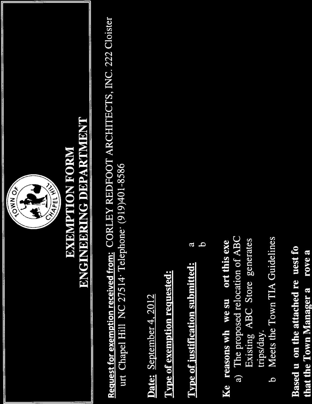
1 MEMORANDUM TO: FROM: Advisory Boards and Commissions Gene Poveromo and Kay Pearlstein on behalf of the Town Review Team SUBJECT: Application for Special Use Permit The Orange County ABC Retail Store, 251 Perkins Drive (Project No ) DATE: February 19, 2013 Planning Board February 20, 2013 Community Design Commission February 26, 2013 Bicycle and Pedestrian Advisory Board March 5, 2013 Transportation Board DESCRIPTION OF THE APPLICATION: This memorandum describes the request for a Special Use Permit for the Orange County ABC Retail Store at 251 Perkins Drive in Chapel Hill North Shopping Center. The application proposes to relocate their current store in Chapel Hill North and develop a new building on a Chapel Hill North undeveloped lot. The Special Use Permit proposes to construct a 5,000 square foot retail building on a 2.7-acre vacant lot. Parking for 19 vehicles, an additional Perkins Drive turn lane, and a pedestrian cross access easement are also proposed. The zoning district is Mixed Use-OfficeInstitutional-1 (MU- OI-1). We recommend that advisory boards and commissions make recommendations to Council on the attached Special Use Permit application. This application is proposed to be considered at the Council s public hearing, tentatively scheduled for Monday, April 15, HIGHLIGHTED ISSUE: Evaluation of traffic at the northern Perkins Drive driveway. ATTACHMENTS: 1. Town Review Team Report on a Special Use Permit application with attachments
 DATE : February 19, 2013 INTRODUCTION This Special Use Permit application, submitted by Corley Redfoot, would develop the 2.")
2 TOWN REVIEW TEAM REPORT SUBJECT: Application for Special Use Permit The Orange County ABC Retail Store, 251 Perkins Drive (Project No ) DATE : February 19, 2013 INTRODUCTION This Special Use Permit application, submitted by Corley Redfoot, would develop the 2.7-acre undeveloped outparcel in Chapel Hill North Shopping Center with: Construction of a 5,000 square feet retail store for Orange County ABC, Parking for 19 vehicles, and New left turn lane and dedication of additional Perkins Drive right-of-way. The property is identified as Orange County Parcel Identifier Number


3 PROCESS ORANGE COUNTY ABC RETAIL STORE CHECK LIST OF REGULATIONS AND STANDARDS Special Use Permit Application Project Fact Sheet Requirements STAFF EVALUATION BASED ON MU-OI-1 ZONING COMPLIANCE NONCOMPLIANCE MODIFICATION REQUESTED Use Permitted Gross Land Area 9.1 acres Minimum Lot Width Maximum Floor Area Maximum # Dwelling Units N/A Minimum Recreation Space N/A Impervious Surface Limits Land Disturbance Minimized Minimum # Vehicular Parking Spaces Minimum # Bicycle Parking Spaces Minimum Setbacks Maximum Primary Height Limits Maximum Secondary Height Limits Minimum Landscape Bufferyards Minimum Land Disturbance in the Resource Conservation District N/A Steep Slopes Compliance Stormwater Management (Including New Jordan Nutrient Loading Regs) Parking Lot Screening (with stipulations) Public Water and Sewer Adequate Public Schools Facilities N/A N/A = Not Applicable Prepared: February 19, 2013 The chart shows that the application does not propose modifications to the regulations and is compliant with the regulations.
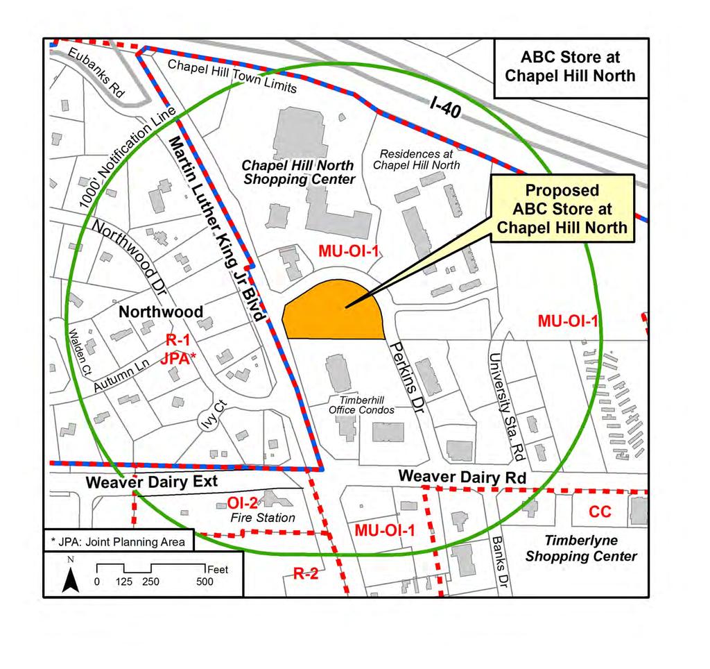
4 SITE HISTORY January 23, 1990 The Chapel Hill North Master Land Use Plan was approved by the Town Council (attached). The site was initially identified as a Park and Ride lot. Subsequent modifications resulted in designation as commercial parcel (see Background Memo, attached). HIGHLIGHTS Traffic at the northern Perkins Drive The applicant is proposing to install a new left turn/through lane on Perkins Drive from Martin Luther King Jr. Blvd. to the proposed driveway to the gas station/retail area north of Perkins Drive. At the proposed northern driveway into the site, the applicant is proposing turning movements to be full service with both left and right turns in and out of the site. Staff has evaluated the driveway intersection and does not support left turns out of the site or left turns in to the site due to potential traffic conflicts with the driveway entrance into the gas station and retail stores and traffic to and from Martin Luther King Jr. Blvd. Perkins Drive is steeply sloped to Martin Luther King Jr. Blvd, further complicating traffic safety. A second access into the site on Perkins Drive further to the south is proposed with full service turning movements. We support full turning movements at this location and limiting turning movements at the second northern driveway as right -in/ right-out only.. RECOMMENDATION Preliminary Staff Recommendation: We recommend that the advisory boards review the Special Use Permit application and make a recommendation to the Town Council. We recommend that the advisory boards recommend that the Council adopt Special Use Permit Resolution A, approving the Special Use Permit for development of the Orange County ABC Store, with conditions.
5 STAFF ANALYSIS OF THE APPLICATION The applicant is proposing development of a vacant parcel within the boundary of the Chapel Hill North Master Land Use Plan. The existing Orange County ABC Retail Store proposes to relocate to a vacant Chapel Hill North parcel and construct a new retail store, closing the present location. The existing surroundings are a mix of retail, office, and multi-family development, all part of the Chapel Hill North Master Land Use Plan. The Town staff has reviewed this application for compliance with the themes from the 2020 Comprehensive Plan, 1 the standards of the Land Use Management Ordinance, 2 and the Design Manual, 3 and offers the following evaluation: Comprehensive Plan: The following are themes from the 2020 Comprehensive Plan, adopted June 25, 2012: Conforms No Comprehensive Plan Themes 1 A Place for Everyone 2 Community Prosperity and Engagement 3 Getting Around 4 Good Places, New Spaces 5 Nurturing Our Community 6 Town and Gown Collaboration We believe the Orange County ABC Retail Store development proposal complies with one of the themes of the 2020 Comprehensive Plan. For information on how this proposed development addresses these themes and goals of the Comprehensive Plan, please refer to the attached applicant s Statement of Justification. Land Use Plan: The 2020 Land Use Plan, 4 a component of the 2020 Comprehensive Plan 5 designates the Chapel Hill North site as a small portion of a larger Development Opportunity Site. More specifically, The Northern Area Task Force Report adopted by the Council January 14, 2008, further described the development opportunities and constraints of the Chapel Hill North site, identified as Focus Area 2 (North of Weaver Dairy Road). The Report noted that: The northern part of the area is constrained by noise, power lines, and the highway right-of-way requirements. The existing configuration of the Chapel Hill North Shopping Center makes it quite difficult to incorporate into any redesign for the area
6 Comparison of Concept Plan and Special Use Permit Proposals 06/20/2012 CDC Concept Plan Council Concept Plan Special Use Permit Application Floor Area Proposed 4,000 s.f. 5,000 s.f. Impervious Surface Area 26,968 s.f. No change Maximum Building 1 story No change Height Buildings 1 Did not meet the No change Parking threshold 19 spaces requiring Council No change review Vehicular Access Plans show access from 2 existing curb cuts on Perkins Drive with a new left turn lane from Martin Luther King Jr. Blvd. to the northernmost existing curb cut. Plans show an existing curb cut on the eastern portion of Perkins Drive closed and a new curb cut across from Adair Drive. Proposed left turn lane and existing northern curb cut on Perkins Drive unchanged. Items recommended in this technical section may be stipulated in the resolution of approval. Transportation Traffic Impact: A Traffic Impact Exemption was granted to the applicant. New trips expected to be generated by the new Orange County ABC Store is 49 trips, totaling 182 trips per day, meeting the Traffic Impact Analysis Guidelines 6 for an Exemption. Access and Circulation Left Turn Lane: The applicant is proposing to widen Perkins Drive to create four 11-foot lanes between Martin Luther King Jr. Blvd. and the gas station/retail area north of Perkins Drive. The existing 4-lane Perkins Drive configuration includes two left turn lanes onto Martin Luther King Jr. Blvd., a right turn only lane onto Martin Luther King Jr. Blvd., and an inbound lane into Chapel Hill North. The applicant is proposing a new left turn/through lane from Martin Luther King Jr. Blvd. to the gas station/retail entrance. NCDOT proposes to finalize the lane 6
7 configurations and striping to define the turning movements. The new lane will allow for right turns into the site. Dedication of additional public right-of-way to the Town to provide for the installation of the roadway improvements is also proposed. Right-of-way is needed at one foot behind the relocated 5-foot sidewalk. We have included a stipulation in Resolution A for a new 12-foot left/through lane on Perkins Drive and dedication of right-of-way to install roadway improvements with approval by NCDOT and the Town Manager. Northern Driveway: The applicant is proposing a northern driveway at the location of the existing curb cut. We support this location. The applicant is proposing a full access driveway (right-in/right-out & left-in/left-out) at this location. We do not support a full access driveway at this location. We believe that the steep slope of Perkins Drive as it approaches the northern driveway and the level of existing traffic inbound and outbound would not be safe for vehicles turning left in or out of the site. A second site access point is proposed on Perkins Drive further to the south with full service turning movements. We support full turning movements at this second driveway. We have included a stipulation in Resolution A for the northern driveway to be right-in/right-out only. Cross Access Easement: Foot traffic from the retail area and apartments is provided by an informal path that connects to the Timberhill office complex parking lot that further connects to Martin Luther King Jr. Blvd. and Weaver Dairy Road. We recommend that the applicant formalize the path with pavement and provide a public pedestrian cross access easement over the existing informal path that runs north-south through the site. We have included a stipulation in Resolution A for the applicant to formalize the path with pavement and provide a cross access easement for the path, prior to issuance of a Certificate of Occupancy. Perkins Drive High Visibility Cross Walk: We recommend that the applicant construct a high visibility pedestrian crosswalk at the Perkins Drive and Adair Drive intersection. A high volume of foot traffic from the Chapel Hill North Apartments crosses Perkins Drive at this location. We have included a stipulation in Resolution A for a high visibility cross walk at Perkins Drive and Adair Drive prior to issuance of a Certificate of Occupancy. Landscape and Architecture Landscape Buffers: The Chapel Hill North Master Land Use Plan did not require buffers interior to the site. The applicant is not proposing any changes to the existing buffers. Loading Space Screening: The applicant is proposing a loading area on the south side of the building. The application is not showing screening as required by the Land Use Management Ordinance. We have included a stipulation in Resolution A for the loading area to be screened from adjacent streets and adjacent properties by means of an effective screening device which is at least six feet in height above the grade of the loading area in accordance with 5.9.8(f) of the Land Use Management Ordinance. Duke Energy Easement Vegetation Removal: We recommend that the applicant remove all tall growing saplings from the Duke Energy easement so that appropriate species can become
8 established that will not be subject to Duke Energy s herbicide applications. We have included a stipulation to this effect in Resolution A. Environment / Stormwater Management Impervious Surface: Existing impervious surface area on the site is approximately 1,000 s.f. (.86%) of impervious surface. Existing impervious surface on the site include a 130 s.f. cell tower building, gravel drives for maintenance of Duke Energy equipment, and an informal gravel path. Following construction and development of the site, the applicant proposes a postconstruction impervious surface total of 26,968 s.f. (23.3%). The approved Chapel Hill North Phasing Plan provided for this site, allows up to 32,080 s.f. of impervious surface, more than proposed. The applicant s Stormwater Management Plan is proposing to meet the performance standards for the post-development condition with 3 bio-retention basins. Energy Management Plan: This application is not proposing a rezoning and therefore an Energy Management Plan is not required, however the applicant is proposing to provide day lighting on the north-facing elevation in order to augment artificial lighting. Utilities and Services Duke Energy Easement: A 128-foot Duke Energy easement exists across the upper western half of the site. The easement contains two sets of power lines: a distribution line and transmission line. A transmission tower for distribution lines and a 130 s. f. transmission tower building are also located within the easement. An existing gravel drive provides access for Duke Energy maintenance. An existing footpath runs within the easement to the transmission tower building. Miscellaneous Standard Stipulations are included on Resolution A. SPECIAL USE PERMIT FINDINGS The applicant s materials are included as attachments to this memorandum. All information submitted at the advisory board meetings will be included in the record of the hearing. Based on the evidence that is submitted, the Council will consider whether or not it can make each of four required findings for the approval of the Special Use Permit for the Orange County ABC Retail Store. The four findings are: Finding #1: That the use or development is located, designed, and proposed to be operated so as to maintain or promote the public health, safety, and general welfare; Finding #2: That the use or development would comply with all required regulations ad standards of the Land Use Management Ordinance; Finding #3: That the use or development is located, designated, and proposed to be operated so as to maintain or enhance the value of contiguous property, or that the use or development is a public necessity; and
9 Finding #4: That the use or development conforms to the general plans for the physical development of the Town as embodied in the Land Use Management Ordinance and in the Comprehensive Plan. Following the public hearing, we will prepare an evaluation of the evidence submitted in support of and in opposition to this application. ATTACHMENTS 1. Resolution A Special Use Permit Resolution of Approval 2. Resolution B Special Use Permit Resolution of Denial 3. Applicant s Combined Materials. 4. Traffic Impact Exemption 5. Area Map 6. Background memo on development history
10 RESOLUTION A (Approving the Special Use Permit Application) A RESOLUTION APPROVING AN APPLICATION FOR SPECIAL USE PERMIT FOR THE ORANGE COUNTY ABC RETAIL STORE (PIN ; PROJECT #12-030) BE IT RESOLVED by the Council of the Town of Chapel Hill that it finds that a Special Use Permit Application, proposed by Corley Redfoot Architects, Inc. for the Orange county ABC Retail Store, located at 251 Perkins Drive on property identified as Orange County Property Identifier Number , if developed according to the Site Plan dated November 19, 2012 and the conditions listed below would: 1. Be located, designed, and proposed to be operated so as to maintain or promote the public health, safety, and general welfare; 2. Comply with all required regulations and standards of the Land Use Management Ordinance; 3. Be located, designed, and operated so as to maintain or enhance the value of contiguous property; and 4. Conform with the general plans for the physical development of the Town as embodied in the Land Use Management Ordinance and in the 2020 Comprehensive Plan. BE IT FURTHER RESOLVED that the Town Council hereby approves the application for a Special Use Permit for the Orange County ABC Retail Store in accordance with the plans listed above and with the conditions listed below: Stipulations Specific to the Development 1. Construction Deadline: That construction begin by (2 years from date of approval), to be completed by (4 years from date of approval). 2. Land Use Intensity: This Special Use Permit authorizes the following: Use: Retail Floor Area 5,000 s.f. Vehicular Parking Spaces 19 Bicycle Parking Spaces 5 Class I and 1 Class II spaces Access 3. Eastern Driveway: That the eastern driveway be aligned with Adair Drive and be located outside of the Duke Energy easement. The existing curb cut shall be closed with curb, gutter, and sidewalk and the existing driveway apron shall be removed prior to issuance of a Certificate of Occupancy.
11 2 4. Northern Driveway: That the turning movements at the northern driveway be right-in/rightout only. 5. Left Turn Lane: That Perkins Drive be widened for a 11-foot left turn lane from Martin Luther King Jr. Blvd. to the driveway entrance to the gas station/retail area. Dedication of additional public right-of-way to the Town to shall be provided 1-foot behind the proposed relocated sidewalk for roadway improvements. 6. Vehicular Parking: That the applicant provides 19 on-site vehicular parking spaces. 7. Site Distances and Easements: That the applicant provide Town standard driver sight distances and easement for the proposed driveways on Perkins Drive and complete all necessary clearing or grading to ensure adequate driver sight lines. 8. Driveway Crosswalks: Prior to issuance of a Zoning Compliance Permit, the applicant shall provide striped pedestrian crosswalks across the driveway entrances to connect to the Perkins Drive sidewalk. 9. Public Cross-Access Easements: Prior to the issuance of a Zoning Compliance Permit, the applicant shall record a public pedestrian cross-access easement across the proposed pedestrian path that runs north-south through the site, providing access for pedestrians crossing the site from retail and residential areas to Martin Luther King Jr. to improve connectivity. Notes to this effect shall be placed on final plans. The applicant shall also formalize the existing gravel path with a paved surface. 10. Perkins Drive High Visibility Cross Walk: Prior to issuance of a Certificate of Occupancy, the applicant shall construct a high visibility pedestrian crosswalk on Perkins Drive at the Adair Drive intersection to allow safe pedestrian crossing from the residential apartments. 11. Accessibility Requirements: That prior to issuance of a Certificate of Occupancy, the applicant shall provide the minimum required handicapped parking spaces and design all handicapped parking spaces, ramps, and crosswalks, and associated infrastructure according to Americans With Disabilities Act standards, North Carolina Building Code, American National Standards Institute (ANSI) Code, and Town standard. 12. Performance Bond: Prior to commencing construction activity for the improvements in the public right-of-way, a performance bond shall be provided to the Town Manager to insure the construction and installation of the improvements in accordance with the standards and provisions approved by the Town as part of the project. Transportation 13. Repairs in Public Right-of-Way: Prior to a Certificate of Occupancy it will be necessary to repair all damage for work in the public right-of-way related to the construction of this
12 3 project, including road widening. The design must be reviewed and approved by the Town Manager prior to a Zoning Compliance Permit. 14. Work Zone Traffic Control Plan: Prior to a Zoning Compliance Permit it will be necessary to provide a Work Zone Traffic Control Plan and a Construction Management Plan for approval by the Town Manager. The Work Zone Traffic Control Plan shall comply with the Manual on Uniform Traffic Control Devices. The Construction Management Plan shall provide staging, construction worker parking, construction vehicle routes, and hours of construction. 15. Bicycle Parking: That prior to the issuance of a Zoning Compliance Permit, the applicant shall provide dimensioned details for at least 5 outdoor and 1 indoor bicycle parking spaces that comply with Town parking standards. The bicycle parking design must comply with the spring 2010 Association of Pedestrian and Bicycle Professionals Guidelines, and the Class I and Class II bicycle parking standards required by the Town Design Manual. Landscaping and Elevations 16. Tree Canopy Coverage: That canopy coverage of the developed site must contain at least 30% of the site with canopy coverage at the time of issuance of a Certificate of Occupancy. 17. Landscape Protection: Prior to issuance of a Zoning Compliance Permit a detailed Landscape Protection Plan shall be approved. The plan shall include which trees will be removed and which will be preserved, critical root zones of all rare and specimen trees, and clearly indicate names and species. 18. Tree Protection Fencing Prior to Construction: Prior to issuance of a Zoning Compliance Permit the applicant shall provide a note on the Final Plans indicating that tree protection fencing will be installed prior to land-disturbing activity on the site. Tree protection fencing shall be provided around construction limits and indicated construction parking and materials staging/storage areas, and Town standard landscaping protection notes, subject to Town Manager approval. 19. Landscape Planting Plan: Prior to issuance of a Zoning Compliance Permit the applicant shall provide a detailed Landscape Planting Plan with a detailed planting list, subject to Town Manager approval. The Plan shall include canopy trees to shade surface parking areas and plantings within the 5-foot planting area between the building and parking areas. Trees and shrubs proposed within the bio-retention basin and at the driveway entrances shall also be included in the Landscape Planting Plan and approved by the Town Manager prior to issuance of a Zoning Compliance Permit. A maintenance schedule and shading plan shall also be approved by the Town Manager prior to issuance of a Zoning Compliance Permit. 20. Parking Landscape Screening and Shading: That the landscaping shall adhere to the standards for Section (a-d) of the Land Use Management Ordinance.
13 4 21. Loading Space Screening: That the loading space be screened from the adjacent streets and properties in accordance with Section (f) of the Land Use Management Ordinance. 22. Landscape Buffers: That the Chapel Hill Master Plan requires that this site have a Type D 30-foot buffer along Martin Luther King Jr. Blvd. and a Type C buffer along the Timber Hill Office boundary and that these existing buffers be maintained. 23. Duke Energy Easement Vegetation Removal: That the applicant remove all tall growing saplings from the Duke Energy easement in order that appropriate species can become established and will not be subject to Duke Energy s herbicide applications. 24. Retaining Wall Detail: Prior to issuance of a Zoning Compliance Permit, details of the retaining walls must be approved. Public Art 25. Public Art: That prior to issuance of a Zoning Compliance Permit the applicant shall obtain approval of a public arts plan from the Town Public Arts Officer. Stormwater Management 26. Stormwater Management Plan: That prior to the issuance of a Zoning Compliance Permit, the applicant shall submit a Stormwater Management Plan for review and approval by the Town Manager. This project must comply with the stormwater management requirements of the Land Use Management Ordinance to provide for 85 percent total suspended solids removal from the increased impervious area, retention for 2-5 days of the increased volume of stormwater runoff from the 2-year, 24-hour storm, and control of the stormwater runoff rate for the 1-year, 2-year, and 25-year storms, if necessary. No stormwater management structures are permitted in the rights-of-way or building setbacks. This includes the outlet structure and stabilization, any underdrains, and the downgradient toe of french drains. Further, the discharge must be in a sheet flow condition, unless otherwise approved to discharge to the town's stormwater system. 27. Stormwater Facilities, Easements, and Operations and Maintenance Plans: If necessary, all stormwater detention, treatment and conveyance facilities located on and below the ground shall be wholly contained within an easement entitled: Reserved Stormwater Facility Easement Hereby Dedicated and shall be reserved from any development which would obstruct or constrict the effective management, control, and conveyance of stormwater from or across the property, other than the approved design and operation functions. A copy of the final plat or easement exhibit, signed and sealed by a North Carolina-registered Land Surveyor and recorded by the County Register of Deeds, and containing the following notes shall be submitted prior to issuance of the Certificate of Occupancy. A suitable maintenance access (minimum 20 wide) to accommodate heavy equipment from the nearest public right-of-way to the Reserved Stormwater Facility Easement must be provided and shown on the plans.
14 5 The "Reserved Stormwater Facility Easement(s)" and the facilities it/they protect are considered to be private, with the sole responsibility of the owner to provide for all required maintenance and operations as approved by the Town Manager. The Reserved Stormwater Facility Easement and the Operations and Maintenance Plan are binding on the owner, heirs, successors, and assigns. 28. Stormwater Operations and Maintenance Plan Recordation: Prior to issuance of a Certificate of Occupancy (C/O), a Stormwater Operations and Maintenance Plan, signed by the owner and recorded by the Orange County Register of Deeds, shall be provided for the proposed stormwater management facilities and submitted to the Stormwater Management Engineer for approval. A schedule of inspection and maintenance tasks shall be included. The operation and maintenance plan shall require the owner of structural BMP s to perform and maintain a record of annual inspections to be performed by a qualified professional. 29. Silt Control: That the applicant takes appropriate measures to prevent and remove the deposit of wet or dry silt on adjacent paved roadways. 30. Land Disturbance Survey: That prior to beginning land disturbance, a survey shall be submitted that shows the calculated limits of disturbance for the development including offsite disturbance associated with the development. 31. Erosion Control Bond: If one (1) acre or more is uncovered by land-disturbing activities for this project, then a performance guarantee in accordance with Section Bonds of the Town Code of Ordinances shall be required prior to final authorization to begin landdisturbing activities. This financial guarantee is intended to cover the costs of restoration of failed or failing soil erosion and sedimentation controls, and/or to remedy damages resulting from land-disturbing activities, should the responsible party or parties fail to provide prompt and effective remedies acceptable to the Town. 32. Curb Inlets: The applicant shall provide pre-cast curb inlet hoods and covers stating, "Dump No Waste! Drains to Jordan Lake", in accordance with the specifications of the Town Standard Detail SD-5A, for all new curb inlets for private, Town and State rights-of-way. 33. On-Site/Adjacent Stormwater Features: Prior to issuance of a Zoning Compliance Permit, existing site conditions and features shall be located on plans, including all on-site and adjacent stormwater drainage features. The final plans must provide proper inlet protection for the stormwater drainage inlets on or adjacent to the site to ensure the stormwater drainage system will not be obstructed with construction debris. 34. P.E. Certification: That prior to the issuance of a Certificate of Occupancy for any phase, the applicant shall provide a certification, signed and sealed by a North Carolina-licensed Professional Engineer, that the stormwater management facilities are constructed in accordance with the approved plans and specifications.
15 6 35. Repair/Replacement of Damaged Stormwater Infrastructure: Existing stormwater infrastructure that is damaged as a result the project construction, must be repaired or replaced, as specified by the Stormwater Management Engineer, prior to requesting a Certificate of Occupancy. Water, Sewer, and Other Utilities 36. Utility/Lighting Plan Approval: That the final utility/lighting plan shall be approved by Orange Water and Sewer Authority, Duke Energy Company, and other local utility service providers, and the Town Manager before issuance of a Zoning Compliance Permit. The property owner shall be responsible for assuring that these utilities can continue to serve the development. In addition, detailed construction drawings shall be submitted to OWASA for review/approval prior to issuance of a Zoning Compliance Permit. 37. Lighting Plan: That prior to issuance of a Zoning Compliance Permit, the applicant shall submit site plans and other required documents to satisfy the lighting requirements of Section 5.11 of the Land Use Management Ordinance including submission of a lighting plan, demonstrating compliance with Town standards, sealed by a Professional Engineer, for Town Manager approval. 38. Relocation of Overhead Utilities Underground: Prior to a Certificate of Occupancy it will be necessary to provide for the underground installation of all public utilities that are currently located overhead on the site except for 3 phase or greater electric lines. 39. Water/Sewer Line Construction: That all public water and sewer plans be approved by OWASA and constructed according to their standards. Where sewer lines are located beneath drive aisles and parking areas construction methods approved by OWASA shall be employed, to ensure that sewer lines will not be damaged by heavy service vehicles. That prior to issuance of a Zoning Compliance Permit, final plans shall be approved by OWASA and the Town Manager. 40. OWASA Approval: That prior to issuance of a Zoning Compliance Permit, easement plats and documentation as required by OWASA and the Town Manager, shall be recorded. 41. Duke Energy Easement: That no buildings or driveways are permitted within the easement. Fire Safety 42. Fire Sprinklers: Any required fire sprinklers shall be installed under the NCFC prior to a Certificate of Occupancy. Prior to issuance of a Zoning Compliance Permit, the plans shall show all proposed fire department connections to such systems. 43. Hydrants Active: The applicant shall provide active fire hydrant coverage, acceptable to the Fire Department, for any areas where combustible construction materials will be stored or installed, prior to having such materials delivered to the site. All required fire hydrants must be installed, active, and accessible for the Fire Department use prior to the arrival of
16 7 combustible materials on site. That fire protection systems shall be installed according to Town Ordinance, the NC Fire Code, and NFPA Fire Hydrant and FDC Locations: That the Final Plans shall indicate the locations of existing and proposed fire hydrants and Fire Department Connections (FDC). Fire Department Connections shall be located on the street side of the building within 100 feet of a hydrant. Hydrant spacing shall comply with the Town Design Manual. Design shall be reviewed and approved by the Town Manager prior to issuance of a Zoning Compliance Permit. 45. Firefighting Access during Construction: That as required by NC Fire Code (Section Required Access), vehicle access for firefighting shall be provided to all construction or demolition sites including vehicle access to within 100 feet of temporary or permanent fire department connections and hydrants. Vehicle access shall be provided by either temporary or permanent roads capable of supporting vehicle loading under all weather conditions. 46. Fire Flow Report: That the Final Plan application shall include a fire flow report sealed by an Engineer registered in the State of North Carolina. An OWASA flow test must be provided with the report. Fire flow shall meet exceed the requirements set forth in the Town Design Manual. The Fire Flow Report shall be reviewed and approved by the Town Manager prior to issuance of a Zoning Compliance Permit. 47. Heavy-Duty Paving: That prior to issuance of a Certificate of Occupancy the applicant shall provide heavy duty paving designed and built to withstand fire apparatus weighing at least 75,000 pounds. 48. Fire Lane: Prior to issuance of a Certificate of Occupancy, the fire lane must be marked and signed in accordance with Town standards, with the associated plans approved by the Town Manager prior to issuance of a Zoning Compliance Permit. Solid Waste Management and Recycling 49. Solid Waste Management Plan: That prior to issuance of a Zoning Compliance Permit a detailed Solid Waste Management Plan, including a recycling plan and a plan for managing and minimizing construction debris, shall be approved by the Town Manager. The plan shall include dimensioned, scaled details of any proposed refuse/recycling collection areas, associated screening, and protective bollards, if applicable. Each bulk waste container shall be labeled as to type of material to be collected. Prior to issuance of a Zoning Compliance Permit, the developer shall provide documentation of an agreement for solid waste collection by a private provider. 50. Construction Waste: By Orange County Ordinance, clean wood waste, scrap metal and corrugated cardboard, all present in construction waste, must be recycled. By Orange County Ordinance, all haulers of construction waste must be properly licensed. The developer shall provide the name of the permitted waste disposal facility to which any land clearing or demolition waste will be delivered.
17 8 State and Federal Approvals 51. State or Federal Approvals: Prior to issuance of a Zoning Compliance Permit, any required State or federal permits or encroachment agreements be approved and copies provided to the Town of Chapel Hill. Miscellaneous 52. Construction Management Plan: That a Construction Management Plan, be approved by the Town Manager prior to issuance of a Zoning Compliance Permit. The construction management plan shall: 1) indicate how construction vehicle traffic will be managed, 2) identify parking areas for on-site construction workers including plans to prohibit parking in residential neighborhoods, 3) indicate construction staging and material storage areas, 4) identify construction trailers and other associated temporary construction management structures, and 5) indicate how the project construction will comply with the Town s Noise Ordinance. 53. Traffic and Pedestrian Control Plan: That the applicant shall provide a Work Zone Traffic Control Plan for movement of motorized and non-motorized vehicles on any public street that will be disrupted during construction. The plan must include a pedestrian management plan indicating how pedestrian movements will be safely maintained. The plan must be reviewed and approved by the Town Manager prior to the issuance of a Zoning Compliance Permit. At least 5 working days prior to any proposed lane or street closure the applicant must apply to the Town Manager for a lane or street closure permit. 54. Parking Lot Construction: That the applicant constructs the parking lot to Town standard for dimensions and pavement design. 55. Accessibility Requirements: Prior to issuance of a Certificate of Occupancy, the applicant shall provide the minimum required handicapped facilities and infrastructure required for the Americans with Disabilities Codes and Standards. 56. Community Design Commission Approval: That the applicant obtain Community Design Commission approval of building elevations and lighting, including the location and screening of all HVAC/Air Handling Units for this project, prior to issuance of a Zoning Compliance Permit. That prior to issuance of a Zoning Compliance Permit the Commission shall approve a lighting plan for this site and shall take additional care during review to ensure that the proposed lighting plan will minimize 1) upward light pollution and 2) offsite spillage of light. 57. Construction Sign Required: That the applicant shall post a construction sign at the development site that lists the property owner s representative and telephone number, the contractor s representative and telephone number, and a telephone number for regulatory information at the time of issuance of a Building Permit, prior to the commencement of any land disturbing activities. The construction sign may have a maximum of 32 square feet of display area and maximum height of 8 feet. ( (g) of LUMO). The sign shall be non-
18 9 illuminated, and shall consist of light letters on a dark background. That prior to the issuance of a Zoning Compliance Permit a detail of the sign shall be reviewed and approved by the Town Manager. 58. Open Burning: That the open burning of trees, limbs, stumps, and construction debris associated with this development is prohibited. 59. Detailed Plans: That prior to the issuance of a Zoning Compliance Permit final detailed site plans, grading plans, utility/lighting plans, stormwater management plans (with hydrologic calculations), landscape plans, and landscape maintenance plans shall be approved by the Town Manager. Such plans shall conform to plans approved by this application and demonstrate compliance with all applicable regulations and the design standards of the Land Use Management Ordinance and the Design Manual. 60. As-Built Plans: That prior to occupancy, the applicant shall provide certified as-built plans for building footprints, parking lots, street improvements, storm drainage systems and stormwater management structures, and all other impervious surfaces. The as-built plans should be in DXF binary format using State plane coordinates and NAVD 88. The applicant shall also contact the Town s Engineering and Design Services Division for address assignment of each unit. 61. Vested Right: This Special Use Permit constitutes a site specific development plan establishing a vested right as provided by N.C.G.S. Section 160A and Appendix A of the Chapel Hill Land Use Management Ordinance. 62. Continued Validity: That continued validity and effectiveness of this approval shall be expressly conditioned on the continued compliance with the plans and conditions listed above. 63. Non-Severability: That if any of the above conditions is held to be invalid, approval in its entirety shall be void. BE IT FURTHER RESOLVED that the Council hereby approves the application for a Special Use Permit for the Orange County ABC Store, located at 251 Perkins Drive. This the day of, 2013.
19 RESOLUTION B (Denying the Special Use Permit Application) A RESOLUTION DENYING AN APPLICATION FOR SPECIAL USE PERMIT FOR THE ORANGE COUNTY ABC STORE (PIN , PROJECT #12-030) BE IT RESOLVED by the Council of the Town of Chapel Hill that it finds that a Special Use Permit Application, proposed by Corley Redfoot Architects, Inc. for the Orange County ABC Store, located at 251 Perkins Drive on property identified as Orange County Property Identifier Number , if developed according to the Site Plan dated November 19, 2012 and the conditions listed below would not: 1. Be located, designed, and proposed to be operated so as to maintain or promote the public health, safety, and general welfare; 2. Comply with all required regulations and standards of the Land Use Management Ordinance; 3. Be located, designed, and operated so as to maintain or enhance the value of contiguous property, or be a use or development that is a public necessity; and 4. Conform with the general plans for the physical development of the Town as embodied in the Land Use Management Ordinance and in the 2020 Comprehensive Plan. BE IT FURTHER RESOLVED that the Council hereby denies the application for a Special Use Permit for the Orange county ABC Store, located at 251 Perkins Drive. This the day of, 2013.
20 SPECIAL USE PERMIT APPLICATION TOWN OF CHAPEL HILL Planning Department 405 Martin Luther King Jr. Blvd Chapel Hill, NC phone (919) fax (919) Parcel Identifier Number (PIN): Date: 11/13/12 Section A: Project Information Section A: Project Information Project Name: ABC Store at Chapel Hill North Shopping Center Property Address: Perkins Drive Zip Code: Use Groups (A, B, and/or C): C Existing Zoning District: MU-OI-1 Project Description: New retail store of aproximately 5000 sf. Section B: Applicant, Owner and/or Contract Purchaser Information Applicant Information (to whom correspondence will be mailed) Name: Corley Redfoot Architects, Inc. Address: 222 Cloister Court City: Chapel Hill State: NC Zip Code: Phone: mhammer@corleyredfootarchitects.com The undersigned applicant hereby certifies that, to the best of his knowledge and belief, all information supplied with this application is true and accurate. Signature: Date: Owner/Contract Purchaser Information: Owner Contract Purchaser Name: Address: Orange County ABC 122 Hwy 70 East City: Hillsborough State: NC Zip Code: Phone: ext.22 OCABC@mindspring.com The undersigned applicant hereby certifies that, to the best of his knowledge and belief, all information supplied with this application is true and accurate. Signature: Date: Revised Permit Number:
21 PROJECT FACT SHEET TOWN OF CHAPEL HILL Planning Department Section A: Project Information Application type: Special Use permit Modification Date: 11/13/12 Project Name: ABC store at Chapel hill north Shopping Center Use Type: (check/list all that apply) Office/Institutional Residential Mixed-Use Other: Retail (business) Overlay District: (check all those that apply) Historic District Neighborhood Conservation District Airport Hazard Zone Section B: Land Area Net Land Area (NLA): Area within zoning lot boundaries NLA= 105,023 sq. ft. Choose one, or both, of the following (a or b,) not to exceed 10% of NLA a) Credited Street Area (total adjacent frontage) x ½ width of public rightof-way b) Credited Permanent Open Space (total adjacent frontage) x ½ public or dedicated open space CSA= sq. ft. TOTAL: NLA + CSA and/or COS = Gross Land Area (not to exceed NLA + 10%) GLA= 115,525 sq. ft. COS= sq. ft. Section C: Special Protection Areas, Land Disturbance, and Impervious Area Special Protection Areas: (check all those that apply) Jordan Buffer Resource Conservation District 100 Year Floodplain Watershed Protection District Land Disturbance Total (sq ft) Area of Land Disturbance (Includes: Footprint of proposed activity plus work area envelope, staging area for materials, access/equipment paths, 56,822 all grading, including off-site clearing) Area of Land Disturbance within RCD 0 Area of Land Disturbance within Jordan Buffer 56,822 Impervious Areas Existing (sq ft) Demolition (sq ft) Proposed (sq ft) Total (sq ft) Impervious Surface Area (ISA) ,508 23,508 Impervious Surface Ratio: Percent Impervious Surface Area of Gross Land Area (ISA/GLA) % 2.9% 20.3% 20.3% If located in Watershed Protection District, % of impervious surface on 7/1/1993 Revised Page 2 of 10 Permit Number:
22 PROJECT FACT SHEET TOWN OF CHAPEL HILL Planning Department Section D: Dimensions Dimensional Unit (sq ft) Existing (sq ft) Demolition (sq ft) Proposed (sq ft) Total (sq ft) Number of Buildings Number of Floors Recreational Space Residential Space Dimensional Unit (sq ft) Existing (sq ft) Demolition (sq ft) Proposed (sq ft) Total (sq ft) Floor Area (all floors heated and unheated) Total Square Footage of All Units Total Square Footage of Affordable Units Total Residential Density Number of Dwelling Units Number of Affordable Dwelling Units Number of Single Bedroom Units Number of Two Bedroom Units Number of Three Bedroom Units Non-Residential Space (Gross Floor Area in Square Feet) Use Type Existing Proposed Uses Existing Proposed Commercial 5000 Restaurant # of Seats Government Institutional Medical Office Hotel # of Rooms Industrial Place of Worship # of Seats Other Section E: Dimensional Requirements] Setbacks (minimum) Height (maximum) Streets Dimensional Requirements Required by Ordinance Existing Proposed Street 0 75' Interior (neighboring property lines) 0 135' Solar (northern property line) 0 75' Primary 44' 21' Secondary 90' 35' Frontages - 750' 750' Widths - 60' 60' Revised Page 3 of 10 Permit Number:
23 PROJECT FACT SHEET TOWN OF CHAPEL HILL Planning Department Section F: Adjoining or Connecting Streets and Sidewalks (Note: For approval of proposed street names, contact the Engineering Department) Right-of-way Pavement Street Name Width Width Number of Lanes Existing Sidewalk* Existing curb/gutter Perkins Drive 60' 37' 2 Yes Yes List Proposed Points of Access (Ex: Number, Street Name): *If existing sidewalks do not exist and the applicant is adding sidewalks, please provide the following information: Sidewalk Information Street Names Dimensions Surface Handicapped Ramps Yes No N/A Yes Yes Yes No N/A Section G: Parking Information Parking Spaces Minimum Maximum Proposed Regular Spaces Handicap Spaces Total Spaces Loading Spaces Bicycle Spaces Surface Type Asphalt paving H: Section H: Landscape Buffers Location (North, South, Street, Etc.) Minimum Width Proposed Width Alternate Buffer Modify Buffer North 15' Yes Yes West 30' Yes Yes South 20' Yes Yes Yes Yes Revised Page 4 of 10 Permit Number:
24 PROJECT FACT SHEET TOWN OF CHAPEL HILL Planning Department Section I: Land Use Intensity Existing Zoning District: MU-OI-1 Proposed Zoning Change (if any): none Note: Refer to Table (Dimensional Matrix) in the Land Use Management Ordinance for help completing this table. Minimum and Maximum Zoning Area Ratio Impervious Surface Thresholds Limitations Maximum Minimum Recreation Low Density High Density Non- Zoning Floor Area Floor Area Recreation Space Ratio Residential Residential Residential District(s) Ratio (FAR) (MFA) = FAR Space (MSR) (RSR) (0.24) (0.50) (0.70) x GLA = RSR x GLA MU-OI ,499 sf TOTAL RCD Streamside RCD Managed RCD Upland ,499 sf Section J: Utility Service Check all that apply Water OWASA Individual Well Community Well Other Sewer OWASA Individual Septic Tank Community Package Plant Other Electrical Underground Above Ground Telephone Underground Above Ground Solid Waste Town Private Revised Page 5 of 10 Permit Number:
25 SPECIAL USE PERMIT APPLICATION SUBMITTAL REQUIREMENTS TOWN OF CHAPEL HILL Planning Department The following must accompany your application. Failure to do so will result in your application being considered incomplete. For assistance with this application, please contact the Chapel Hill Planning Department (Planning) at (919) or at For detailed information, please refer to the Description of Detailed Information handout. Application fee (including Engineering Review fee) (refer to fee schedule) Amount Paid $ Pre-application meeting with appropriate staff Digital Files - provide digital files of all plans and documents Recorded Plat or Deed of Property Project Fact Sheet Traffic Impact Statement completed by Town s consultant (or exemption) Description of Public Art Proposal Statement of Justification Response to Community Design Commission and Town Council Concept Plan comments Affordable Housing Proposal, if applicable Provide existing Special Use Permit, if Modification Mailing list of owners of property within 1,000 feet perimeter of subject property (see GIS notification tool) Mailing fee for above mailing list (mailing fee is double due to 2 mailing) Amount Paid $ Written Narrative describing the proposal Resource Conservation District, Floodplain, & Jordan Buffers Determination - necessary for all submittals Jurisdictional Wetland Determination if applicable Resource Conservation District Encroachment Exemption or Variance (determined by Planning) Jordan Buffer Authorization Certificate or Mitigation Plan Approval (determined by Planning) Reduced Site Plan Set (reduced to 8.5"x11") Stormwater Impact Statement (2 copies to be submitted) a) Written narrative describing existing & proposed conditions, anticipated stormwater impacts and management structures and strategies to mitigate impacts b) Description of land uses and area (in square footage) c) Existing and proposed Impervious surface area in square feet for all subareas and project area d) Ground cover and uses information e) Soil information (classification, infiltration rates, depth to groundwater and bedrock) f) Time of concentration calculations and assumptions g) Topography (2-foot contours) h) Pertinent on-site and off-site drainage conditions i) Upstream and/or downstream volumes j) Discharges and velocities k) Backwater elevations and effects on existing drainage conveyance facilities l) Location of jurisdictional wetlands and regulatory FEMA Special Flood Hazard Areas Revised Page 6 of 10 Permit Number:
26 SPECIAL USE PERMIT APPLICATION SUBMITTAL REQUIREMENTS TOWN OF CHAPEL HILL Planning Department m) Water quality volume calculations n) Drainage areas and sub-areas delineated o) Peak discharge calculations and rates (1, 2, and 25-year storms) p) Hydrographs for pre- & post-development without mitigation, post-development with mitigation q) Volume calculations and documentation of retention for 2-year storm r) 85% TSS removal for post-development stormwater run-off s) Nutrient loading calculations t) BMP sizing calculations u) Pipe sizing calculations and schedule (include HGL & EGL calculations and profiles) Plan Sets (8 copies to be submitted no larger than 24 x36 ) Sets (8 Plans should be legible and clearly drawn. All plan sets sheets should include the following: Project Name Cover Sheet Legend Labels North Arrow (North oriented toward top of page) Property Boundaries with bearing and distances Scale (Engineering), denoted graphically and numerically Setbacks Streams, RCD Boundary, Jordan Riparian Buffer Boundary, Floodplain, and Wetlands Boundary, where applicable Revision dates and professional seals and signatures, as applicable a) Include Project Name, Project fact information, PIN, Design team Area Map a) Project name, applicant, contact information, location, PIN, & legend b) Dedicated open space, parks, greenways c) Overlay Districts, if applicable d) Property lines, zoning district boundaries, land uses, project names of site and surrounding properties, significant buildings, corporate limit lines e) Existing roads (public & private), rights-of-way, sidewalks, driveways, vehicular parking areas, bicycle parking, handicapped parking, street names. f) 1,000 notification boundary Existing Conditions Plan a) Slopes, soils, environmental constraints, existing vegetation, and any existing land features b) Location of all existing structures and uses c) Existing property line and right-of-way lines Page 7 of 10 Revised Permit Number:
27 SPECIAL USE PERMIT APPLICATION SUBMITTAL REQUIREMENTS TOWN OF CHAPEL HILL Planning Department Detailed Site Plan d) Existing utilities & easements including location & sizes of water, sewer, electrical, & drainage lines e) Nearest fire hydrants f) Nearest bus shelters and transit facilities g) Existing topography at minimum 2-foot intervals and finished grade h) Natural drainage features & water bodies, floodways, floodplain, RCD, Jordan Buffers & Watershed boundaries a) Existing and proposed building locations b) Description & analysis of adjacent land uses, roads, topography, soils, drainage patterns, environmental constraints, features, existing vegetation, vistas (on & off-site) c) Location, arrangement, & dimension of vehicular parking, width of aisles and bays, angle of parking, number of spaces, handicapped parking, bicycle parking. Typical pavement sections & surface type d) Location of existing and proposed fire hydrants e) Location and dimension of all vehicle entrances, exits, and drives f) Dimensioned street cross-sections and rights-of-way widths g) Pavement and curb & gutter construction details h) Dimensioned sidewalk and tree lawn cross-sections i) Proposed transit improvements including bus pull-off and/or bus shelter j) Required landscape buffers (or proposed alternate/modified buffers) k) Required recreation area/space (including written statement of recreation plans) l) Refuse collection facilities (existing and proposed) or shared dumpster agreement m) Construction parking, staging, storage area, and construction trailer location n) Sight distance triangles at intersections o) Proposed location of street lights and underground utility lines and/or conduit lines to be installed p) Easements q) Clearing and construction limits r) Traffic Calming Plan detailed construction designs of devices proposed & associated sign & marking plan Stormwater Management Plan a) Topography (2-foot contours) b) Existing drainage conditions c) RCD and Jordan Riparian Buffer delineation and boundary (perennial & intermittent streams, note ephemeral streams on site) d) Proposed drainage and stormwater conditions e) Drainage conveyance system (piping) f) Roof drains g) Easements h) BMP plans, dimensions, details, and cross-sections i) Planting and stabilization plans and specifications Revised Page 8 of 10 Permit Number:
28 SPECIAL USE PERMIT APPLICATION SUBMITTAL REQUIREMENTS TOWN OF CHAPEL HILL Planning Department Landscape Protection Plan Planting Plan Steep Slope Plan a) Rare, specimen, and significant tree survey within 50 feet of construction area b) Rare and specimen tree critical root zones c) Rare and specimen trees proposed to be removed d) Certified arborist tree evaluation, if applicable e) Significant tree stand survey f) Clearing limit line g) Proposed tree protection /silt fence location h) Pre-construction/demolition conference note j) Landscape protection supervisor note k) Existing and proposed tree canopy calculations, if applicable a) Dimensioned and labeled perimeter landscape bufferyard b) Off-site buffer c) Landscape buffer and parking lot planting plan (including planting strip between parking and building, entryway planting, and 35% shading requirement a) Classify and quantify slopes 0-10%, 10-15%, 15-25% and 25% and greater b) Show and quantify areas of disturbance in each slope category c) Provide/show specialized site design and construction techniques Grading and Erosion Control Plan a) Topography (2-foot contours) b) Limits of Disturbance c) Pertinent off-site drainage features d) Existing and proposed impervious surface tallies Streetscape Plan, if applicable a) Public right-of-way existing conditions plan b) Streetscape demolition plan c) Streetscape proposed improvement plan d) Streetscape proposed utility plan and details e) Streetscape proposed pavement/sidewalk details f) Streetscape proposed furnishing details g) Streetscape proposed lighting details Revised Page 9 of 10 Permit Number:
 Proposed heavy duty pavement locations and pavement construction detail e) Preliminary Shared dumpster agreement, if applicable Construction Management Plan a)")
29 SPECIAL USE PERMIT APPLICATION SUBMITTAL REQUIREMENTS TOWN OF CHAPEL HILL Planning Department Solid Waste Plan a) Preliminary Solid Waste Management Plan b) Existing and proposed dumpster pads c) Proposed dumpster pad layout design d) Proposed heavy duty pavement locations and pavement construction detail e) Preliminary Shared dumpster agreement, if applicable Construction Management Plan a) Construction trailer location b) Location of construction personnel parking and construction equipment parking c) Location and size of staging and materials storage area d) Description of emergency vehicle access to and around project site during construction e) Delivery truck routes shown or noted on plan sheets Energy Management Plan Exterior Elevations a) Description of how project will be 20% more energy efficient than ASHRAE Standards b) Description of utilization of sustainable forms of energy (Solar, Wind, Hydroelectric, and Biofuels) c) Participation in NC GreenPower program d) Description of how project will ensure indoor air quality, adequate access to natural lighting, and allow for proposed utilization of sustainable energy e) Description of how project will maintain commitment to energy efficiency and reduced carbon footprint over time f) Description of how the project s Transportation Management Plan will support efforts to reduce energy consumption as it affects the community a) An outline of each elevation of the building, including the finished grade line along the foundation (height of building measured from mean natural grade). Revised Page 10 of 10 Permit Number:
30 Statement of Justification for the Orange County ABC Store at Chapel Hill North The Orange County ABC board is planning a new one story 5000 sf retail building for the existing outparcel at Chapel Hill North. This new store would replace the lease space that they now have in the Chapel Hill North shopping center. Vehicular and bike parking will be provided as well as a loading dock and pedestrian walkways. It is anticipated that the construction of the new facility would begin construction in This outparcel was shown on the 1995 phasing plan for the Special Use Permit as a retail use which is consistent with this projected ABC store plan. FINDING #1: That the use or development is located, designed, and proposed to be operated so as to maintain or promote the public health, safety, and general welfare. The retail use is proposed on an existing outparcel as a part of a mixed use development. It allows the general public to make one stop for multiple retail items and restaurants at the same location. The project will provide pedestrian access from the surrounding properties so that it promotes walking trips. It would provide direct pedestrian access through the site from the office buildings located south of the main retail center allowing daily non vehicular trips. Access to the site is off existing public street curb cuts. A new turn lane is being proposed at the traffic signal on Martin Luther King Blvd. to help alleviate existing left turn lane movements from the shopping center. New site lighting for safety and security will be added on the project. FINDING #2: That the use or development complies with all required regulations and standards of this Chapter, including all applicable provisions of Article 3 and 5, the applicable specific standards contained in the Supplemental Use regulations (Article 6) and with all other application regulations: The project will comply with all applicable provisions and regulations of Articles 3 and 5 as well as the Supplemental Use regulations and all other application requirements. FINDING #3: That the use or development is located, designed, and proposed to be operated so as to maintain or enhance the value of contiguous property, or that the use is a public necessity: This project will clean up a vacant lot and provide an attractive building with adequate site lighting and security. A building located on the property will increase the value of the parcel and so any other property in the vicinity. This property is located along the main entrance to the center which now will have completed buildings on both sides of Perkins Drive. An existing gravel path through the site will be formalized with pavement and adequate lighting and visibility. The path provides a direct pedestrian connection to other points within the mixed use development.
31 FINDING #4: That the use or development conforms with the general plans for the physical development of the Town as embodied in this Chapter and in the Comprehensive Plan: 1) The project complies with the overall community character in that it adds retail space to a designated mixed use site. This allows multiple services in one location. 2) This retail project is located adjacent to major roadways in an existing mixed use shopping center. 3) The site is properly zoned for a retail use. 4) The original Special Use Permit and it s phasing plan had a retail use at this location. 5) The project proposes an additional left turn lane for the main shopping center s main drive. This will help mitigate existing traffic congestion to the shopping center. 6) The project enhances the Town wide transportation system by adding additional pedestrian walkways, bike parking facilities as well as easy access to transit stops, all promoting alternative modes of transportation. 7) This store will promote the general well being of the Town by adding retail services and new employment opportunities. 8) The project will comply with the latest stormwater management techniques and design to mitigate the environmental effects of the new construction on the receiving watershed. 9) The proposed building will be of appropriate scale and appearance to meet the Chapel Hill Character. 10) The project will utilize sustainable practices to promote and protect Natural Resources. 11) The project will include new landscape materials which enhance the building and site with screening and shade. 12) The project will include an element of public art by incorporating an artistic design on site with stamped and/or colored concrete. The applicant will continue to work with Jeff York, Public and Cultural Arts Administrator, on this design. 13) The proposed ABC store complies with the themes of the 2020 Comprehensive plan by providing good places,new spaces in a new attractive state of the art building which incorporates energy saving and sustainable building practices along with the latest storm water management techniques including the treatment for phosphorus and nitrogen removal. The store is located on a transit route with pedestrian connections to other spaces throughout the center for getting around. The store is a part of the existing mixed use development which allows for one stop community shopping to meet everyone s local needs.
32 Responses to CDC comments on ABC store on date June 20, 2012: 1) As stated at the meeting, the ABC organization cannot allow any other tenants in their building. This eliminates any chance of adding a second story. 2) We acknowledge Commissioner John Gualtieri s comments on using existing curb cuts and adding a turn lane. 3) As discussed we will look at improvements to the walking trail that cuts through the site. We will work with Duke Power on what they allow in their easements. 4) A final landscape plan will be prepared for the project prior to the ZCP and include all new plantings. The ABC board agrees that security is important to this building and so will work with designers to select appropriate materials. The applicant will review multiple choices in sustainable and energy efficient features to add to the building. 5) It was noted that due to the loading dock area on the east end of the building, the applicant should provide adequate screening. 6) We will review ways to improve the path and look into sustainable features for the building. 7) The final plans will have a full landscape area around the paths as allowable by Duke Power easement agreements. 8) The building design will incorporate various sustainable items including day-lighting. The applicant will consider the summary of comments moving forward.
33
34
35
36
37
38
39
40
41
42
43 Stormwater Narrative for ABC Store at Chapel Hill North Shopping Center (Revised November 8, 2012) A new 5000 sf ABC store is being proposed for an existing outparcel in the Chapel Hill North Shopping Center. This outparcel was approved as a part of an earlier Special Use Permit application with a restaurant and associated parking and walkways. The existing site has areas of existing trees and meadow vegetation under a large Duke Energy easement which bisects the site. A gravel path provides access across the property to an existing transmission tower. The site plan for this proposed store includes a parking lot of 19 cars, a loading dock and dumpster, and related pedestrian and bike paths. This proposed footprint has approximately 23,500 sf of impervious surface which is less than the approved version of 32,080 sf as shown on attached phasing The phasing plan was used to size the storm water impoundment at the rear of the Harris Teeter store. This smaller on site footprint that we propose will allow this plan to meet any and all post development water quantity rates and flows. The water quality aspect of the project will comply with the Jordan Lake rules for removal of Nitrogen and Phosphorus to acceptable post development levels as well as release of the water quality volumes post development. A worksheet is provided to analyze the watershed characteristics for the site. We are proposing three bioretention cells in order to fulfill these requirements. A color coded plan is provided showing the drainage areas to each of the cells. Final plan details will include all sections, specifications, plantings, and maintenance schedules to properly implement these devises. All required calculations and analysis will be provided as a part of the final zoning compliance permit process.


44
45
46
47
48
49
50
ZONING COMPLIANCE PERMIT APPLICATION
 ZONING COMPLIANCE PERMIT APPLICATION 405 Martin Luther King Jr. Blvd phone (919) 968-2728 fax (919) 969-2014 www.townofchapelhill.org Parcel Identifier Number (PIN): Date: Section A: Project Information
Net Land Area (NLA): Area within zoning lot boundaries NLA= sq. ft. a) Credited Street Area (total adjacent frontage) x ½ width of public rightof-way
: Area within zoning lot boundaries NLA= sq. ft. a) Credited Street Area (total adjacent frontage) x ½ width of public rightof-way") PROJECT FACT SHEET Section A: Project Information Application type: Date: Project Name: Use Type: (check/list all that apply) Office/Institutional Residential Mixed-Use Other: Overlay District: (check
PROJECT FACT SHEET Section A: Project Information Application type: Date: Project Name: Use Type: (check/list all that apply) Office/Institutional Residential Mixed-Use Other: Overlay District: (check
Net Land Area (NLA): Area within zoning lot boundaries NLA= 1,076,181 sq. ft.
: Area within zoning lot boundaries NLA= 1,076,181 sq. ft.") PROJECT FACT SHEET Section A: Project Information Application type: Project Name: Special Use Permit Date: June 29, 215 Merin Road Community Use Type: (check/list all that apply) Office/Institutional x
PROJECT FACT SHEET Section A: Project Information Application type: Project Name: Special Use Permit Date: June 29, 215 Merin Road Community Use Type: (check/list all that apply) Office/Institutional x
5. Would the proposed project require modifications to the existing regulations?
 TOWN OF CHAPEL HILL Planning and Sustainability Department 405 Martin Luther King Jr. Blvd. Chapel Hill, NC 27514 www.townofchapelhill.org phone (919) 968-2728 Concept Plans are intended to be an opportunity
CONCEPT PLAN APPLICATION
 CONCEPT PLAN APPLICATION TOWN OF CHAPEL HILL Planning Department 405 Martin Luther King Jr. Blvd phone (919) 968-2728 fa (919) 969-2014 www.townofchapelhill.org Parcel Identifier Number (PIN): 9880267455
STAFF REPORT INTRODUCTION
 STAFF REPORT SUBJECT: DATE: Application for Master Land Use Plan Modification Southern Village Master Land Use Plan (Project No. 12-101) May 22, 2013 (Community Design Commission) May 23, 2013 (Transportation
2. Would the proposed project comply with the Land Use map? 3. Would the proposed project require a rezoning? 4. What is the proposed zoning district?
 TOWN OF CHAPEL HILL Planning and Sustainability Department 405 Martin Luther King Jr. Blvd. Chapel Hill, NC 27514 www.townofchapelhill.org phone (919) 968 2728 Concept Plans are intended to be an opportunity
MEMORANDUM. The Arc Orange Apartments at Meadowmont, 150 West Barbee Chapel Road: Application for Special Use Permit (Case )
") MEMORANDUM TO: FROM: SUBJECT: DATE: Chapel Hill Planning Board Chapel Hill Transportation Board Chapel Hill Bicycle and Pedestrian Advisory Board Chapel Hill Community Design Commission Gene Poveromo,
MEMORANDUM TO: FROM: SUBJECT: DATE: Chapel Hill Planning Board Chapel Hill Transportation Board Chapel Hill Bicycle and Pedestrian Advisory Board Chapel Hill Community Design Commission Gene Poveromo,
MEMORANDUM. Application for Site Plan Review Goodwill at 1115 Weaver Dairy Road (Project No ) INTRODUCTION
 INTRODUCTION") MEMORANDUM TO: FROM: SUBJECT: Chapel Hill Planning Board Gene Poveromo, Development Manager Kendal Brown, Principal Planner Application for Site Plan Review Goodwill at 1115 Weaver Dairy Road (Project
MEMORANDUM TO: FROM: SUBJECT: Chapel Hill Planning Board Gene Poveromo, Development Manager Kendal Brown, Principal Planner Application for Site Plan Review Goodwill at 1115 Weaver Dairy Road (Project
2. Would the proposed project comply with the Land Use map? 3. Would the proposed project require a rezoning? 4. What is the proposed zoning district?
 TOWN OF CHAPEL HILL Planning and Sustainability Department 405 Martin Luther King Jr. Blvd. Chapel Hill, NC 27514 www.townofchapelhill.org phone (919) 9682728 Concept Plans are intended to be an opportunity
UNIVERSITY PRESBYTERIAN CHURCH - RENOVATION & ADDITION 209 EAST FRANKLIN ST., CHAPEL HILL, NC 27514
 UNIVERSITY PRESBYTERIAN CHURCH - RENOVATION & ADDITION 209 EAST FRANKLIN ST., CHAPEL HILL, NC 27514 PROJECT DATA OVERALL SITE MAP HDC CONCEPT PLAN SUBMITTAL: OCT. 8, 2012 SUP SUBMITTAL: MAY 28, 2013 SUP
GRACE CHURCH EXPANSION
 GRACE CHURCH EXPANSION REVIEW: NOVEMBER 24, 2014 200 SAGE ROAD, CHAPEL HILL NORTH CAROLINA PROJECT DATA OVERALL SITE MAP SITE INFORMATION OWNER PIN ACREAGE VICINITY MAP GRACE CHURCH 9890503171 271,600
SITE PLAN REVIEW APPLICATION AND CHECKLIST
 SITE PLAN REVIEW APPLICATION AND CHECKLIST PROJECT SUMMARY: Project Name: City/ETA Location: City ETA (Application fee & number of copies needed are based on location) Property Location (Legal Description
Appendix I. Checklists
 Appendix I Checklists Town of Greenwich Drainage Manual Department of Public Works - Engineering Division Town Hall - 101 Field Point Road, Greenwich, CT 06836-2540 Phone 203-622-7767 - Fax 203-622-7747
Application for Site Plan Review
 Application for Site Plan Review City of Pontiac Office of Land Use and Strategic Planning 47450 Woodward Ave, Pontiac, MI 48342 T: 248.758.2800 F: 248.758.2827 Property/Project Address: Sidwell Number:
SITE PLAN REVIEW ITEMS - REFERENCE CHECKLIST
 City of Seminole 9199 113 th Street N. Seminole, FL 33772 Ph: (727) 392-1966 Fx: (727) 319-6583 SITE PLAN REVIEW ITEMS - REFERENCE CHECKLIST Note: This checklist is designed to aid designers in the review
Project phasing plan (if applicable) 12 copies of site plan
 12 copies of site plan") SITE PLAN REVIEW PERMIT APPLICATION City of Grand Haven, 11 N. Sixth Street, Grand Haven, MI 49417 Phone: (616) 847-3490 Fax: (616) 844-2051 Website: www.grandhaven.org 1. Project Information Address/location
SITE PLAN REVIEW PERMIT APPLICATION City of Grand Haven, 11 N. Sixth Street, Grand Haven, MI 49417 Phone: (616) 847-3490 Fax: (616) 844-2051 Website: www.grandhaven.org 1. Project Information Address/location
LONDONDERRY PLANNING BOARD MINOR SITE PLAN APPLICATION & CHECKLIST
 LONDONDERRY PLANNING BOARD MINOR SITE PLAN APPLICATION & CHECKLIST Planning Department Date Stamp Design Review Formal Application Change of Use (No Site Improvements)* All information provided and submitted
ARTICLE 17 SITE PLAN REVIEW
 ARTICLE 17 SITE PLAN REVIEW 17.01 INTENT AND PURPOSE The intent of this section is to provide for consultation and cooperation between the applicant and the township planning commission so that the applicant
PLANNED UNIT DEVELOPMENT APPLICATION
 PLANNED UNIT DEVELOPMENT APPLICATION CITY OF THE DALLES Community Development Department 313 Court Street The Dalles, OR 97058 (541) 296-5481, ext. 1125 Fax (541) 298-5490 www.ci.the-dalles.or.us Date
LONDONDERRY PLANNING BOARD SITE PLAN APPLICATION & CHECKLIST
 LONDONDERRY PLANNING BOARD SITE PLAN APPLICATION & CHECKLIST Planning Department Date Stamp Design Review Formal Application All information provided and submitted with this Application Checklist shall
Offering Memorandum Commercial Opportunity Acre Parcel Zoned MU-OI-1/R-3
 Offering Memorandum Commercial Opportunity 44.78-Acre Parcel Zoned MU-OI-1/R-3 North Chapel Hill off Weaver Dairy Road CH North Shopping Center Perkins Dr Chapel Hill North Apartments ABC Store Synergy
PLANNED UNIT DEVELOPMENT & SUBDIVISION STAFF REPORT Date: May 18, 2017
 & PUD-0000102-2017 PLANNED UNIT DEVELOPMENT & SUBDIVISION STAFF REPORT Date: May 18, 2017 NAME SUBDIVISION NAME Dauphin Creek Estates Subdivision Dauphin Creek Estates Subdivision LOCATION CITY COUNCIL
PLANNED DEVELOPMENT (MASTER PLAN & UNIT PLAN)
") Central Permit Center 555 Santa Clara Street Vallejo CA 94590 Business License Building Fire Prevention Planning Public Works 707.648.4310 707.648.4374 707.648.4565 707.648.4326 707.651.7151 PLANNED DEVELOPMENT
Central Permit Center 555 Santa Clara Street Vallejo CA 94590 Business License Building Fire Prevention Planning Public Works 707.648.4310 707.648.4374 707.648.4565 707.648.4326 707.651.7151 PLANNED DEVELOPMENT
CITY OF ZEELAND PLANNING COMMISSION
 APPLICATION FOR SITE PLAN REVIEW AND SPECIAL LAND USE Date City Official App. Filing Fee Rec'd ($350) NOTE TO APPLICANT: Please submit this application for Site Plan Review along with twenty (20) copies
SECTION 1 CLEARING /GRADING PERMIT APPLICATION:
 PLEASE REFER TO THE CLEARING & GRADING PERMIT CHECKLIST BELOW FOR SUBMITTAL REQUIREMENTS. SECTION 1 CLEARING /GRADING PERMIT APPLICATION: PROJECT ADDRESS (Street, Suite #): Parcel(s) #: Total Site Area
Huntington Stormwater Utility
 Huntington Stormwater Utility Stormwater Management & Sediment and Erosion Control Requirements for Construction Sites Authorized by Huntington City Code Articles: 971, 970, 930, 935, 955, Revised April
City of Mt. Juliet Planning & Zoning Department. Site Plan Checklist. Site plan cklist v1.18
 City of Mt. Juliet Planning & Zoning Department Site Plan Checklist Site Plan approval is required for all specified community facilities, all commercial, industrial, and multi-family residential activities
Gloucester County PLAN SUBMITTER'S CHECKLIST
 Page 1 of 9 Gloucester County PLAN SUBMITTER'S CHECKLIST FOR EROSION AND SEDIMENT CONTROL PLANS Please fill in all blanks and please reference the plan sheets/pages where the information may be found,
APPLICATION FORM SITE PLAN REVIEW REGULATIONS TOWN OF CONWAY, NH
 February 25, 2010 INSTRUCTIONS APPLICATION FORM SITE PLAN REVIEW REGULATIONS TOWN OF CONWAY, NH Please complete each section of this application from and submit it with all required application material
APPLICATION FOR REZONING PROPERTY CITY OF HOLLAND, MICHIGAN. Name of Applicant. Address, and Phone # of Applicant
 APPLICATION FOR REZONING PROPERTY CITY OF HOLLAND, MICHIGAN Name of Applicant Address, Email and Phone # of Applicant Name and Address of Owner (if other than applicant) Ownership Interest of Applicant
TOWNSHIP OF LOGAN SOIL & FILL IMPORTATION AND PLACEMENT APPLICATION SUBMITTAL CHECKLIST
 TOWNSHIP OF LOGAN SOIL & FILL IMPORTATION AND PLACEMENT APPLICATION SUBMITTAL CHECKLIST Applications: 5 copies of application - Applicant will reproduce the copies at his/her costs. The Township Clerk
CITY OF CYPRESS 5275 Orange Avenue Cypress, California (714) DESIGN REVIEW COMMITTEE PERMIT PROCESS
 DESIGN REVIEW COMMITTEE PERMIT PROCESS") CITY OF CYPRESS 5275 Orange Avenue Cypress, California 90630 (714) 229-6720 DESIGN REVIEW COMMITTEE PERMIT PROCESS 1. Discuss project with Planning staff to determine zoning regulations, any unusual characteristics
CITY OF CYPRESS 5275 Orange Avenue Cypress, California 90630 (714) 229-6720 DESIGN REVIEW COMMITTEE PERMIT PROCESS 1. Discuss project with Planning staff to determine zoning regulations, any unusual characteristics
Rezoning Transportation Analysis Petition Number: General Location Identifier:
 From: Kelsie Anderson, PE Kelsie.Anderson@charlottenc.gov 704-432-5492 Staff Reviewer: Kory Hedrick, PE, PMP Khedrick@charlottenc.gov 704-432-6511 CDOT s review of this rezoning petition is intended to
SITE PLAN REVIEW APPLICATION
 SITE PLAN REVIEW APPLICATION CITY OF THE DALLES Community Development Department 313 Court Street The Dalles, OR 97058 (541) 296-5481, ext. 1125 Fax (541) 298-5490 www.ci.the-dalles.or.us Date Filed File#
Chapter 4 - Preparation of Stormwater Site Plans
 Chapter 4 - Preparation of Stormwater Site Plans The Stormwater Site Plan is the comprehensive report containing all of the technical information and analysis necessary for the City to evaluate a proposed
Michael D, Harvey, Current Planning Supervisor. This project was originally approved in 2012 by the BOCC and is summarized as follows:
 PLANNING & INSPECTIONS DEPARTMENT Craig N. Benedict, AICP, Director Current Planning (919) 245-2575 (919) 644-3002 (FAX) www.orangecountync.gov 131 W. Margaret Lane Suite 201 P. O. Box 8181 Hillsborough,
Erosion & Sediment Control Plan Application Form & Checklist
 Erosion & Sediment Control Plan Application Form & Checklist GENERAL INFORMATION Application Date: Project Address: Tax Map / Parcel Number(s): PROPERTY OWNER / DEVELOPER Firm Name: Contact Person: Title:
PROJECT NARRATIVE STATEMENT OF JUSTIFICATION. Special Use Permit Modification Application
 PROJECT NARRATIVE AND STATEMENT OF JUSTIFICATION Special Use Permit Modification Application For: Facility Expansion 1602 East Franklin Street Chapel Hill, NC PIN #9799-14-1643 Applicant: SHC Construction
Design Review Application *Please call prior to submittal meeting to determine applicable fees*
 CITY OF EAGLE 660 E. Civic Lane, Eagle, ID 83616 Phone#: (208) 939-0227 Fax: (208) 938-3854 Design Review Application *Please call prior to submittal meeting to determine applicable fees* FILE NO.: CROSS
At Your Disposal CUP Amendment, Lot 20, Village Service Commercial, at 128 Bastille Dr. (PLN17-208)
") MEMORANDUM Archuleta County Development Services Planning Department 1122 HWY 84 P. O. Box 1507 Pagosa Springs, Colorado 81147 970-264-1390 Fax 970-264-3338 TO: Archuleta County Planning Commission FROM:
MEMORANDUM Archuleta County Development Services Planning Department 1122 HWY 84 P. O. Box 1507 Pagosa Springs, Colorado 81147 970-264-1390 Fax 970-264-3338 TO: Archuleta County Planning Commission FROM:
Sanford/Lee County Technical Review Committee (TRC) DEADLINES & MEETING DATES
 DEADLINES & MEETING DATES") Sanford/Lee County Technical Review Committee (TRC) DEADLINES & MEETING DATES The following 2019 information is based on the information available to staff at the time of creation. Dates & time may change
Sanford/Lee County Technical Review Committee (TRC) DEADLINES & MEETING DATES The following 2019 information is based on the information available to staff at the time of creation. Dates & time may change
Town of Windham. Planning Department 8 School Road Windham, ME voice fax
 Town of Windham Planning Department 8 School Road Windham, ME 04062 voice 207.864-5960 fax 207.892.1916 MEMO DATE: TO: Staff Review Committee FROM: Amanda Lessard, Planner Cc: Ellen Rathbone, St. Germain
DRIVEWAY LOCATION APPROVAL RULES AND REGULATIONS
 TOWN OF SUDBURY DRIVEWAY LOCATION APPROVAL RULES AND REGULATIONS 1. Driveway Location Approval Application Procedure 2. Form of Application 3. Form of Driveway Location Plan 4. Consideration by Town Engineer
Checklists. Project Name: Location: File Number: Date of Submittal: Reviewer: Date: Applicant: Contact Name: Phone Number:
 Applicant: Contact Name: Phone Number: Email: Project Name: Location: File Number: Date of Submittal: Reviewer: Date: Concept Plan Requirements: I. General Project Information 1. Address or parcel number
Site Development Plan (SDP) Checklist
 Checklist") Development Services Department 100 N. Wilcox Street, Castle Rock CO 80104 303-660-1393 or CRGov.com Site Development Plan (SDP) Checklist A complete Site Development Plan (SDP) submittal will contain
Development Services Department 100 N. Wilcox Street, Castle Rock CO 80104 303-660-1393 or CRGov.com Site Development Plan (SDP) Checklist A complete Site Development Plan (SDP) submittal will contain
SUBDIVISION, PLANNED UNIT DEVELOPMENT, PLANNING APPROVAL, REZONING & SIDEWALK WAIVER STAFF REPORT Date: February 7, 2013
 SUBDIVISION, PLANNED UNIT DEVELOPMENT, PLANNING APPROVAL, REZONING & SIDEWALK WAIVER STAFF REPORT Date: February 7, 2013 APPLICANT NAME SUBDIVISION NAME DEVELOPMENT NAME LOCATION S. E. Cemeteries of AL
CITY OF ST. AUGUSTA STEARNS COUNTY MINNESOTA ORDIANCE NO AN ORDINANCE ESTABLISHING REGULATIONS FOR STORMWATER MANAGEMENT
 CITY OF ST. AUGUSTA STEARNS COUNTY MINNESOTA ORDIANCE NO. 2017-05 AN ORDINANCE ESTABLISHING REGULATIONS FOR STORMWATER MANAGEMENT In the interest of the health, safety, and welfare of its citizens, the
Developer s Program. The Station at East 54
 Developer s Program The Station at East 54 Existing Conditions The Station at East 54 is proposed for a 1.12 acre site at the northeast corner of Hamilton Road and Prestwick Road, tucked between the East
TENTATIVE MAP CHECKLIST
 Business License 707.648.4357 www.cityofvallejo.net Central Permit Center 555 Santa Clara Street Vallejo CA 94590 Building 707.648.4374 Planning 707.648.4326 TENTATIVE MAP CHECKLIST Public Works/Engineering
R E S O L U T I O N. Single-Family Residence/ Church. 2,488 sq. ft. 2,488 sq. ft. Area Parking Required: Church
 R E S O L U T I O N WHEREAS, the Prince George s County Planning Board is charged with the approval of Detailed Site Plans pursuant to Part 3, Division 9 of the Zoning Ordinance of the Prince George s
Zoning Ordinance Chapter 10
 CHAPTER 10 - WASHES SECTION 10.0 GENERAL: A. The purpose of this Ordinance is to establish standards for development in or near Major and Minor Washes as defined in Appendix A Glossary of Terms and Definitions
R E S O L U T I O N. Designation: Section 2, Block 17, Lot 20.G-1 ( ) R-2A (1-Family, 2-acre Minimum Lot Size) 46 North Greenwich Road
 R-2A (1-Family, 2-acre Minimum Lot Size) 46 North Greenwich Road") PLANNING BOARD Arthur Adelman, Chair TOWN OF NORTH CASTLE WESTCHESTER COUNTY 17 Bedford Road Armonk, New York 10504-1898 R E S O L U T I O N Telephone: (914) 273-3542 Fax: (914) 273-3554 www.northcastleny.com
PLANNING BOARD Arthur Adelman, Chair TOWN OF NORTH CASTLE WESTCHESTER COUNTY 17 Bedford Road Armonk, New York 10504-1898 R E S O L U T I O N Telephone: (914) 273-3542 Fax: (914) 273-3554 www.northcastleny.com
Rezoning Transportation Analysis Petition Number: General Location Identifier: , ,
 From: Kelsie Anderson, PE Kelsie.Anderson@charlottenc.gov 704-432-5492 Staff Reviewer: Rick Grochoske, PE rgrochoske@charlottenc.gov 704-432-1556 CDOT s review of this rezoning petition is intended to
When planning stormwater management facilities, the following principles shall be applied where possible.
 2.0 Principles When planning stormwater management facilities, the following principles shall be applied where possible. 2.0.1 Drainage is a regional phenomenon that does not respect the boundaries between
CHECKLIST FOR PHASE II DRAINAGE REPORT
 I. COVER SHEET CHECKLIST FOR PHASE II DRAINAGE REPORT A. Name of Project B. Address C. Owner D. Developer E. Engineer F. Submittal date and revision dates as applicable II. GENERAL LOCATION AND DESCRIPTION
PRELIMINARY STAFF PLANNING REPORT TO THE WALWORTH COUNTY ZONING AGENCY X CONDITIONAL USE
 This report was prepared prior to the public hearing. This report may be supplemented or amended to reflect the review of additional information presented at the public hearing and written material submitted
R E S O L U T I O N. Designation: R-2A (1-Family, 2-acre Minimum Lot Size)
") PLANNING BOARD Arthur Adelman, Chair TOWN OF NORTH CASTLE WESTCHESTER COUNTY 17 Bedford Road Armonk, New York 10504-1898 R E S O L U T I O N Telephone: (914) 273-3542 Fax: (914) 273-3554 www.northcastleny.com
PLANNING BOARD Arthur Adelman, Chair TOWN OF NORTH CASTLE WESTCHESTER COUNTY 17 Bedford Road Armonk, New York 10504-1898 R E S O L U T I O N Telephone: (914) 273-3542 Fax: (914) 273-3554 www.northcastleny.com
CRESCENT RESOURCES INC.
 CRESCENT RESOURCES INC. Due Diligence Checklist Project Name: Client: Project No. Date: 1 Survey Review survey for compliance with Crescent Resources, Inc. s Instructions to Surveyors (see below): All
SITE PLAN REVIEW PROCESS
 BOWNE TOWNSHIP PO Box 35, 8240 Alden Nash Road, Alto, Michigan 49302 Ph. 616-868-6846 Fax 616-868-0110 http://www.bownetwp.org SITE PLAN REVIEW PROCESS 1. Application Form and Fee Schedule Site Plan Review
MAJOR SITE PLAN APPLICATION COVER SHEET
 MAJOR SITE PLAN APPLICATION COVER SHEET TOWN OF CLAYTON Planning Department 111 E. Second St., P.O. Box 879 Clayton, NC 27528 Phone: 919-553-5002 Fax: 919-553-1720 Name of Project: Date: Applicant Name:
VILLAGE OF CLEMMONS PLANNING BOARD DRAFT STAFF REPORT
 VILLAGE OF CLEMMONS PLANNING BOARD DRAFT STAFF REPORT PETITION INFORMATION Docket # C-226 Staff Megan Ledbetter Petitioner(s) JBJH Properties, LLC Owner(s) JBJH Properties, LLC Subject Property 5892-49-1766
Town of West Point Plan of Development
 Town of West Point Plan of Development Plan Submission In accordance with Section 70-51(b) of the Town Code, the Zoning Administrator shall establish a written policy for the form, format, content and
DRIVEWAY REGULATIONS
 TOWN OF NEW LONDON PLANNING BOARD DRIVEWAY REGULATIONS INSTRUCTIONS TO APPLICANTS FOR THE CONSTRUCTION OR ALTERATION OF DRIVEWAYS IMPORTANT: READ CAREFULLY BEFORE FILLING OUT ATTACHED APPLICATION Revised
SUBMITTAL REQUIREMENTS
 WHEN PROCESS TYPE III IS USED References to Process Type III applications are found in several places in the Milton Municipal Code (MMC), indicating that the development, activity, or use, is permitted
Asbury Chapel Subdivision Sketch Plan
 Asbury Chapel Subdivision Sketch Plan PART 1: PROJECT SUMMARY Applicant: NVR Inc. Project Size: +/- 76.13 acres Parcel Numbers: 02101112,02116101,02116112, 02116113 Current Zoning: Transitional Residential
Commercial Site Plan Review Checklist
 Commercial Site Plan Review Checklist Updated 1/5/2015 Project Name: EPM #: _ Street: Contact: Phone: Date Submitted: _ Fax: Reviewer: Email: First Review: Second Review: _ Third Review: Reviews Required
CONCEPTUAL SITE PLAN APPLICATION
 CONCEPTUAL SITE PLAN APPLICATION City of Peachtree City Planning, Zoning and Engineering 153 Willowbend Road Peachtree City, Georgia 30269 DEVELOPMENT PROCESS FLOW CHART 153 Willowbend Rd, Peachtree City,
Draft Rhode Island Stormwater Design and Installation Standards Manual
 Draft Rhode Island Stormwater Design and Installation Standards Manual Summary The May 2009 Public Review Draft version of the RI Stormwater Design and Installation Standards Manual consists of approximately
Department of Planning & Development Planning Unit
 May 20, 2005 Department of Planning & Development Planning Unit Website: www.cityofmadison.com Madison Municipal Building 215 Martin Luther King, Jr. Boulevard P.O. Box 2985 Madison, Wisconsin 53701-2985
The subject site plan amendment proposes the following revisions to the approved site plan:
 PROPOSED AMENDMENT The subject site plan amendment proposes the following revisions to the approved site plan: 1. The building footprint was modified to accommodate the revised architectural design. 2.
Florence County Small Commercial Land Disturbance Permit Application
 Florence County Small Commercial Land Disturbance Permit Application Florence County Engineering Division 518 South Irby Street Florence, S.C. 29501 Phone (843) 676-8600 Fax (843) 676-8667 Tax Map Number:
Plat Requirements CHECKLIST FOR SITE PLAN REVIEW
 This checklist is to be used as a guide for complying with the Town of Hollis Site Plan Regulations. It is to be used for each individual site plan review application submitted. Applicants are encouraged
PARISH OF ASCENSION OFFICE OF PLANNING AND DEVELOPMENT PLANNING DEPARTMENT. Joint Planning and Zoning Meeting
 1. Call To Order 2. Roll Call of Members 3. Chairman's Comments PARISH OF ASCENSION OFFICE OF PLANNING AND DEVELOPMENT PLANNING DEPARTMENT Joint Planning and Zoning Meeting January 11, 2017 6:00 PM Courthouse
Mitchell Ranch South MPUD Application for Master Planned Unit Development Approval Project Narrative. Introduction
 Mitchell Ranch South MPUD Application for Master Planned Unit Development Approval Project Narrative Introduction Mitchell Ranch South is a proposed single family (detached) residential development on
GENERAL INFORMATIONaaaaaaaaaaaaaaaaaaaaaaaaaaaaaaaa
 To: Planning and Zoning Commission From: City Staff Date: November 15, 2016 Re: Case #16026 Raymore Activity Center Site Plan GENERAL INFORMATIONaaaaaaaaaaaaaaaaaaaaaaaaaaaaaaaa Applicant/ Property Owner:
VILLAGE OF CLEMMONS PLANNING BOARD DRAFT STAFF REPORT. Single Family Residential, Townhomes
 VILLAGE OF CLEMMONS PLANNING BOARD DRAFT STAFF REPORT PETITION INFORMATION Docket # C-212 Staff Megan Ledbetter Petitioner(s) Peacehaven Development LLC Owner(s) Larry Jarvis, William Alexander and Peacehaven
ARTICLE 6: Special and Planned Development Districts
 ARTICLE 6: Special and Planned Development Districts 6-10 Traditional Neighborhood Development (TND) District 6-10.10 Purpose and Intent The Traditional Neighborhood Development (TND) District provides
FIRE PREVENTION OFFICE Placer Hills Fire Protection District NEW PROJECT GUIDELINES
 Established 1949 FIRE PREVENTION OFFICE Placer Hills Fire Protection District NEW PROJECT GUIDELINES The following are guidelines for new development. Any submitted plans must comply with these guidelines,
PLANNED UNIT DEVELOPMENT Date: April 5, 2018
 PLANNED UNIT DEVELOPMENT Date: April 5, 2018 DEVELOPMENT NAME SUBDIVISION NAME LOCATION Robert Myers Robert Myers 2955 and 2989 Dauphin Street (Southeast corner of Dauphin Street and Sage Avenue) CITY
PLAN SUBMITTER'S CHECKLIST
 Page 1 of 8 PLAN SUBMITTER'S CHECKLIST FOR EROSION AND SEDIMENT CONTROL PLANS Please fill in all blanks and reference the plan sheets/pages where the information may be found, where appropriate, or write
PLANNED UNIT DEVELOPMENT & SUBDIVISION STAFF REPORT Date: March 15, 2012
 PLANNED UNIT DEVELOPMENT & SUBDIVISION STAFF REPORT Date: March 15, 2012 DEVELOPMENT NAME SUBDIVISION NAME LOCATION OSR Subdivision OSR Subdivision 5559 Old Shell Road (South side of Old Shell Road, 570
STORMWATER MANAGEMENT CODES ANALYSIS RICHLAND COUNTY, SC SITE PLANNING ROUNDTABLE
 STORMWATER MANAGEMENT CODES ANALYSIS RICHLAND COUNTY, SC SITE PLANNING ROUNDTABLE Codes analyses for each subcommittee were completed to assist participants of the Richland County Site Planning Roundtable.
MONTGOMERY COUNTY PLANNING DEPARTMENT THE MARYLAND-NATIONAL CAPITAL PARK AND PLANNING COMMISSION
 MONTGOMERY COUNTY PLANNING DEPARTMENT THE MARYLAND-NATIONAL CAPITAL PARK AND PLANNING COMMISSION MCPB Item No. Date: 06-12-14 King of the Nations Christian Fellowship Church: Limited Site Plan Amendment
Major Subdivision Sketch Plan Checklist
 This checklist provides specific requirements that are apart of the Sketch process. The entire process is described by the Huntersville Subdivision Review Process which details all the submittal and resubmittal
Essential Skills: Reading and Interpreting Maps and Plans
 Essential Skills: Reading and Interpreting Maps and Plans Prepared for: NYS Tug Hill Commission Local Government Conference March 31, 2016 Prepared by: Peter G. Vars, P.E. BME ASSOCIATES Stages of Plan
COMMERCIAL SITE PLAN SUMMARY & DEVELOPMENT GUIDE
 COMMERCIAL SITE PLAN SUMMARY & DEVELOPMENT GUIDE DEPARTMENT CONTACT: York County Development Coordinating Center (c/o Bea McCarter) 1070 Heckle Boulevard, Suite 107 Rock Hill, South Carolina 29732 Phone
CITY OF TUMWATER 555 ISRAEL RD. SW, TUMWATER, WA (360) (360) (FAX)
 (360) (FAX)") CITY OF TUMWATER 555 ISRAEL RD. SW, TUMWATER, WA 98501 (360) 754-4180 (360) 754-4126 (FAX) Email: cdd@ci.tumwater.wa.us APPENDIX II-C SHORT FORM CONSTRUCTION STORMWATER POLLUTION PREVENTION PLAN (SWPPP)
CITY OF TUMWATER 555 ISRAEL RD. SW, TUMWATER, WA 98501 (360) 754-4180 (360) 754-4126 (FAX) Email: cdd@ci.tumwater.wa.us APPENDIX II-C SHORT FORM CONSTRUCTION STORMWATER POLLUTION PREVENTION PLAN (SWPPP)
12 January 12, 2011 Public Hearing APPLICANT: TAILWIND DEVELOPMENT GROUP,LLC PROPERTY OWNER: CITY OF VIRGINIA BEACH
 12 January 12, 2011 Public Hearing APPLICANT: TAILWIND DEVELOPMENT GROUP,LLC PROPERTY OWNER: CITY OF VIRGINIA BEACH STAFF PLANNER: Faith Christie REQUEST: Conditional Change of Zoning (from PD-H1 Planned
5. LOW IMPACT DEVELOPMENT DESIGN STANDARDS
 5. LOW IMPACT DEVELOPMENT DESIGN STANDARDS Low Impact Development (LID) requires a shift in stormwater management away from conveying runoff to a small number of downstream points through hydraulically
SANTA CRUZ COUNTY REGULATORY IMPEDIMENT GAP ANALYSIS TOOL
 SANTA CRUZ COUNTY REGULATORY IMPEDIMENT GAP ANALYSIS TOOL BENCHMARK/OBJECTIVE Street Width Is the minimum pavement width allowed for streets in low density residential developments that have less than
CITY OF DEERFIELD BEACH Request for City Commission Agenda
 Item: CITY OF DEERFIELD BEACH Request for City Commission Agenda Agenda Date Requested: April 2, 2013 Contact Person: Gerald R. Ferguson, Director of Planning & Development Services Description: 3317,
PLANNING COMMISSION. Agenda Item # 3.
 PLANNING COMMISSION Agenda Item # 3. CASE SUMMARY Conditional District Rezoning Planning Commission February 4, 2015 CD-9-215 Jeff Walton, 341-3260, jeff.walton@wilmingtonnc.gov Staff recommendation CONDITIONAL
Note: Staff reports can be accessed at Zone: I-3. Tier:
 The Maryland-National Capital Park and Planning Commission Prince George s County Planning Department Development Review Division 301-952-3530 Note: Staff reports can be accessed at www.mncppc.org/pgco/planning/plan.htm.
6 August 11, 2010 Public Hearing APPLICANT AND PROPERTY OWNER: CAVALIER GOLF AND YACHT CLUB
 6 August 11, 2010 Public Hearing APPLICANT AND PROPERTY OWNER: CAVALIER GOLF AND YACHT CLUB REQUEST: Conditional Use Permit (outdoor recreational facility) STAFF PLANNER: Faith Christie ADDRESS / DESCRIPTION:
AWH REPORT OF THE PLANNING AND DEVELOPMENT DEPARTMENT FOR APPLICATION FOR REZONING ORDINANCE TO PLANNED UNIT DEVELOPMENT
 AWH REPORT OF THE PLANNING AND DEVELOPMENT DEPARTMENT FOR APPLICATION FOR REZONING ORDINANCE TO PLANNED UNIT DEVELOPMENT MAY 8, 2014 The Planning and Development Department hereby forwards to the Planning
KEIZER STATION PLAN INTRODUCTION
 KEIZER STATION PLAN INTRODUCTION Planning for this area began in 1987 when the Keizer Comprehensive Plan established the Chemawa Activity Center and McNary Activity Center. The first Chemawa Activity Center
CITY PLANNING COMMISSION AGENDA. ITEM NO(s): C.1 C.3 STAFF: STEVE TUCK
: C.1 C.3 STAFF: STEVE TUCK") Page 34 CITY PLANNING COMMISSION AGENDA ITEM NO(s): C.1 C.3 STAFF: STEVE TUCK FILE NOS: CPC ZC 12-00035 QUASI-JUDICIAL CPC NV 12-00036 QUASI-JUDICIAL AR DP 12-00039 QUASI-JUDICIAL PROJECT: APPLICANT: OWNER:
Page 34 CITY PLANNING COMMISSION AGENDA ITEM NO(s): C.1 C.3 STAFF: STEVE TUCK FILE NOS: CPC ZC 12-00035 QUASI-JUDICIAL CPC NV 12-00036 QUASI-JUDICIAL AR DP 12-00039 QUASI-JUDICIAL PROJECT: APPLICANT: OWNER:
F. Driveways. Driveways which provide access to off-street parking or loading from public streets shall comply with the following:
 Section 20.945.040 General Design Standards for Surface Parking Areas. A. Review Authority. Parking lot design and drainage shall be subject to review and approval of the City Transportation Manager. B.
County of Fairfax, Virginia
 County of Fairfax, Virginia To protect and enrich the quality of life for the people, neighborhoods, and diverse communities of Fairfax County DATE: July 16, 2007 TO: SUBJECT: All Architects, Attorneys,