Planning, Taxi Licensing and Rights of Way Committee Report. JR, RM & JPR Andrews, C/O Roger Parry and Partners
|
|
|
- Avice Barnett
- 5 years ago
- Views:
Transcription
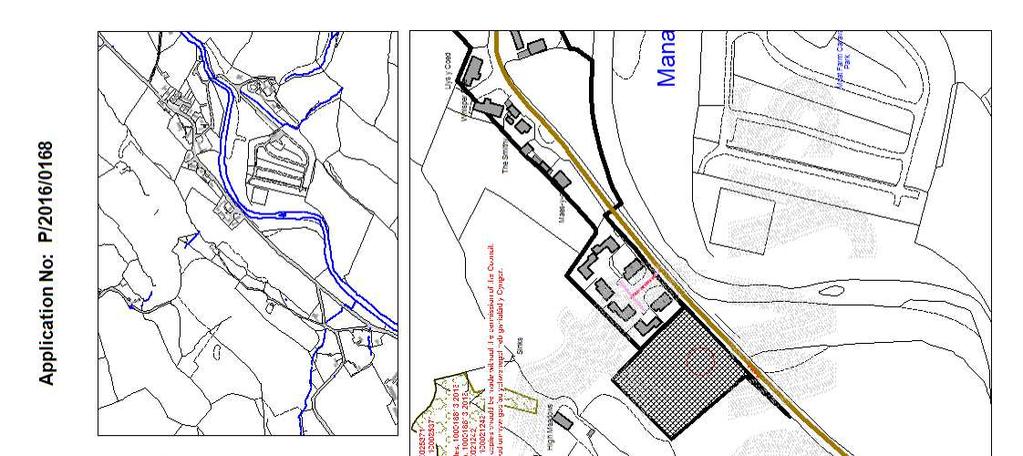
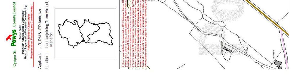
1 Planning, Taxi Licensing and Rights of Way Committee Report Application No: P/2016/0168 Grid Ref: Community Council: Manafon Valid Date: 08/02/2016 Officer: Eddie Hrustanovic Applicant: Location: Proposal: Application Type: JR, RM & JPR Andrews, C/O Roger Parry and Partners Land adjoining Trem Hirnant Manafon Welshpool Powys Outline permission for 5 residential dwellings Application for Outline Planning Permission The reason for Committee determination The proposal is a departure from the development plan and is recommended for approval. Site Location and Description The proposed development is for five detached dwellings with associated garages, a shared private access road, private gardens and public open space. The application is submitted in outline with access to be considered at the outline stage. The indicative layout indicates that access would be gained off the B4390 highway with an adoptable road leading to a private drive providing access, turning and parking facilities. The layout also sets out public open space areas. The application site has an area of 0.66 hectares. The site is bordered by residential properties (Trem Hirnant) to the north-east, the B4390 road to the south-east, agricultural land to the south-west and woodland to the north-west. Consultee Response Manafon CC Council met last night and this matter was discussed fully. As with the previous application (P/2015/0761), in principal there are no real objections to the application however, there are 2 points Council thought they must draw to Planning Department s attention. The main concern is again the impact of additional properties on the presently overloaded sewerage system in the village; a number of residents had raised concerns to Councillors that the Trem Hirnant development (which is adjacent to the proposed development) currently has their sewage "extraction" going into piping that runs under private properties adjacent to Trem Hirnant, we understand this then connects to the main STW sewerage system somewhere. The specifics are not known by Council and thus are not aware of the responsibilities for maintaining / operating the existing system but residents are concerned about the impact on their properties and the potential for issues emanating from an already 1
2 overloaded system. They also have concerns in respect of any disruption that might occur during the development if the sewerage system plans are to link to the existing system and that has to be increased. As previously, Council draw attention to the fact that should consent be given, the pavement should be extended from Trem Hirnant along the front of the proposed new development for safety reasons. PCC Highways Recommended conditions. Wales and West Utilities No comments received. NRW 1 st response (02 March 2016): Thank you for referring the above application. NRW responded to a previous planning application at this site P/2015/0761 for which we objected on flood risk in our planning consultation response Ref: CAS X9W5. Natural Resources Wales brings together the work of the Countryside Council for Wales, Environment Agency Wales and Forestry Commission Wales, as well as some functions of Welsh Government. Our purpose is to ensure that the natural resources of Wales are sustainably maintained, used and enhanced, now and in the future. Natural Resources Wales objects to the above application as submitted and we recommend that it is refused. Flood Risk: Natural Resources Wales note that the revised layout of this proposal aims to avoid locating built development or access within the DAM2 flood zone shown on the current published map. However, the published map does not take account of the detail of the site and it is still necessary to carry out the Flood Consequences Assessment that we advised in our letter of 22 September Without that assessment of the detailed circumstances of this site, we cannot give any assurance on the level of flood risk associated with this site. The advice we gave in our letter of 22 September 2015 applies to this application also. 2 nd response (29/07/2016) Thank you for consulting Natural Resources Wales (NRW) about the above, which was received on 15/07/2016 We are now in a position to remove our previous objection. However, we recommend that you should only grant planning permission for the scheme if it can meet the following requirements, to address significant concerns that we have identified. Provided these requirements are met, we would not object to the scheme. Summary of requirements Requirement 1: Condition - Finished floor levels of the proposed dwellings should be set 300mm above the adjacent ground level. 2
3 Requirement 2: Condition - No development approved by this permission shall be commenced until a scheme for the provision and implementation of a surface water regulation system has been submitted to and approved in writing by the Local Planning authority. Requirement 3: Condition Bats Light spillage scheme Flood risk With reference to our letters dated 22 nd September 2015 and 2nd March 2016, we have now received a FCA (Ref w fca dated June 2016, compiled by Waterco) which has addressed, in the main, the issues we raised in the aforementioned letters. The FCA, has not, however, used detailed hydraulic modelling to quantify precisely the level of flood risk to the site but we are able to give more assurance regarding the level of flood risk as a result of the information within the submitted FCA. Part of the site will, however, remain in DAM C2, so our previous advice relating to application of policy of highly vulnerable development in C2 is still relevant. We acknowledge that the theoretical fluvial flood risk extent within the site is confined to the proposed public open space area and therefore probability of fluvial flood risk to built development is considered very low. The FCA has highlighted a potential risk to part of the site from surface water flooding as defined on the Risk of Flooding from Surface Water map. It is proposed to mitigate for this risk by raising finished floor levels at least 300mm above adjacent ground level. Plots 1, 2 and 3 and land between could be considered to be at risk. We acknowledge that any surface water flooding is likely to be shallow in depth. We advise that the Lead Local Flood Authority is consulted with regards to any historic records of overland flooding but, as a minimum mitigation requirement we advise that finished floor levels being set at least 300mm above adjacent ground level is conditioned as part of any approval, as advised in the FCA. Requirement 1: Condition - Finished floor levels of the proposed dwellings should be set 300mm above the adjacent ground level. REASON: To protect the development from residual flood risk events, including surface water flooding. With regards to safe access/egress to and from the site, whilst we acknowledge that there are no records of the B4390 being affected by fluvial flooding, we reiterate that NRW is not the appropriate body to comment upon the operational effectiveness of access routes. It is for the Planning Authority, in consultation with other appropriate bodies, to satisfy themselves that evacuation is possible if required. Surface water will be discharged to soakaway where feasible. If not, discharge to River Rhiw at a controlled rate may be necessary. We would encourage alternative methods which control run-off at source which are discussed within the FCA. As part of any formal approval, we advise; 3
4 Requirement 2: Condition - No development approved by this permission shall be commenced until a scheme for the provision and implementation of a surface water regulation system has been submitted to and approved in writing by the Local Planning authority. Surface water generated from the site shall be limited to the equivalent greenfield runoff rate for the site. The scheme shall be implemented in accordance with the approved details, unless otherwise agreed in writing by the LPA. REASON: To prevent the increased risk of flooding and provide water quality benefits by ensuring the provision of a satisfactory means of surface water disposal. As part of any final design, as the application is for outline, we advise that a detailed layout plan of the plots and surrounding land, including infrastructure kerb levels etc is submitted to the Planning Authority and Lead Local Flood Authority before discharge of conditions. This will help ensure that any perceived overland surface water flow routes can be accommodated within the development and freely drain without impacting on the built development. Protected Species: We note that there is no information about protected species with the application and, therefore, are assuming that: Your Authority has screened the application and concluded that there is not a reasonable likelihood of protected species being present; Bats: Bats are protected under the Wildlife and Countryside act 1981 (as amended) and the Conservation of Habitats and Species Regulations 2010 (as amended). Requirement 3: Condition - Bats Light spillage scheme Care should also be taken in the type and location of any external lighting within the new development, to ensure that the hedgerows and trees identified on the site are not illuminated. We advise that a light spillage scheme from the development should be agreed to the satisfaction of the local authority. If any mature trees will need to be felled as part of the scheme. All trees that need to be felled should be checked for features that may be used by bats (i.e. cavities, cracks, holes & ivy cover). Where impacts on bats are considered likely, then those trees should be subject to emergence surveys at an appropriate time of year. Should bats be found to be using the trees as roosting sites then we would expect you to propose and deliver appropriate mitigation and/or compensation schemes, along with Reasonable Avoidance Measures, to ensure the favourable conservation status of the species is maintained. Pollution prevention: The activity of importing waste into the site for use as, for example hardcore, must be registered with Natural Resources Wales as an exempt/permitable activity under Environmental Permitting Regulations The developer should contact Natural 4
5 Resources Wales to discuss the necessity for an exemption/permit for any material imported to and exported from the site. Any facilities for the storage of oils, fuels or chemicals shall be sited on impervious bases and surrounded by impervious bund walls. The volume of the bunded compound should be 110% of the capacity of the tank, all filling points, gauges, vents and sight glasses must be located within the bund. Associated pipe-work should be located above ground and protected from accidental damage. All filling points and tank overflow pipe outlets should be detailed to discharge downwards into the bund, refuelling should be supervised at all times - and preferably done on an impermeable surface. If during construction/excavation works any contaminated material is revealed, then the movement of such material either on or off site should be done in consultation with Natural Resources Wales. Any waste excavation material or building waste generated in the course of the development must be disposed of satisfactorily and in accordance with Section 34 of the Environmental Protection Act Carriers transporting waste from the site must be registered waste carriers and movement of any Hazardous Waste from the site must be accompanied by Hazardous waste consignment notes. Environmental management: Government policy states that, where practicable, foul drainage should be discharged to the mains sewer. Where this is not possible and private sewage treatment / disposal facilities are utilised, they must be installed and maintained in accordance with British Standard 6297 and Approved Document H of the Building Regulations You should also have regard to Welsh Office Circular 10/99 in respect of planning requirements for non mains sewerage. The written consent of NRW or registration for exemption by the developer will be required for any discharge e.g. foul drainage to a watercourse/ditch etc, from the site and may also be required for certain categories of discharges to land. All necessary NRW consents, or exemptions must be obtained prior to works progressing on site. Cllr Joy Shearer No reply received PCC Affordable Housing I approve of the proposal below of including one unit under a S106 agreement as part of this development. PCC Land Drainage No reply received Severn Trent Water I can confirm we have no objections to the proposals subject to the inclusion of the following condition: The development hereby permitted should not commence until drainage plans for the disposal of foul and surface water flows have been submitted to and approved by the 5
6 Local Planning Authority. Disability Powys No reply received PCC Schools Services No reply received PCC Outdoor Leisure Outdoor Recreation Services would ask for a Section 106 contribution. Powys County Council does not have a play area with fixed play equipment near to the proposed development, if the developer decided not to provide adequate play space on their land, then Outdoor Recreation would recommend that a monetary package to upgrade an existing playground be offered to the Town Council. As part of the 106 planning gain, Outdoor Recreation Service s usually apply the following terms All social housing, size or number of bedrooms is not a factor is per property. All private housing up to three bedrooms is per property. All private housing over three bedrooms is per property. PPC Ecologist No reply received Representations None received Planning History P/2015/ Erection of 3 detached dwellings with detached garages, formation of vehicular access and associated works. REFUSED. Principal Planning Constraints Flood Zone Principal Planning Policies National Planning Policy Planning Policy Wales (Edition 8, 2016) TAN 1: Joint Housing Land Availability Studies (2015) TAN 2: Planning and Affordable Housing (2006) TAN 5: Nature Conservation and Planning (2009) TAN 6: Planning for Sustainable Rural Communities (2010) 6
7 TAN 12: Design (2016) TAN 15: Development and Flood Risk (2004) TAN 18: Transport (2007) TAN 23: Economic Development (2014) Welsh Government Circular 016/2014 The Use of Planning Conditions for Development Management Welsh Office Circular 13/97 - Planning Obligations Welsh Office Circular 10/99 - Planning requirements in respect of the use of non-mains sewerage incorporating septic tanks in new development Welsh Office Circular 61/96 Planning and the Historic Environment: Historic Buildings and Conservation Areas Local Planning Policy Powys Unitary Development Plan (2010) UDP SP1 Social, Community and Cultural Sustainability UDP SP2 - Strategic Settlement Hierarchy UDP SP5 Housing Developments UDP SP6 Development and Transport UDP GP1 Development Control UDP GP2 Planning Obligations UDP GP3 Design and Energy Conservation UDP GP4 Highway and Parking Requirements UDP ENV1 Agricultural Land UDP ENV2 Safeguarding the Landscape UDP ENV3 Safeguarding Biodiversity and Natural Habitats UDP ENV7 Protected Species UDP CS3 Additional Demand for Community Facilities UDP HP3 Housing Land Availability UDP HP4 Settlement Development Boundaries and Capacities UDP HP5 Residential Developments UDP HP6 Dwellings in the Open Countryside UDP HP7 Affordable Housing within Settlements UDP HP8 Affordable Housing Adjoining Settlements with Development Boundaries UDP HP10 Affordability Criteria UDP TR2 Tourist Attractions and Development Areas UDP DC10 Mains Sewerage Treatment UDP DC13 Surface Water Drainage UDP RL2 Provision of Outdoor Playing and Recreation Space Affordable Housing for Local Needs Supplementary Planning Guidance (SPG) Approved September 2010 Updated July 2011 Powys Residential Design Guide (2004) 7
8 RDG=Powys Residential Design Guide NAW=National Assembly for Wales TAN= Technical Advice Note UDP=Powys Unitary Development Plan, MIPPS=Ministerial Interim Planning Policy Statement Officer Appraisal Section 38 (6) of the Planning and Compulsory Purchase Act 2004 Members are advised to consider this application in accordance with Section 38 (6) of the Planning and Compulsory Purchase Act 2004, which requires that, if regard is to be had to the development plan for the purpose of any determination to be made under the Planning Acts, the determination must be made in accordance with the plan unless material considerations indicate otherwise Principle of development The proposed development lies wholly outside the development boundary of Manafon as detailed on Unitary Development Plan (2010) inset map M173 and would result in five dwellings being constructed outside the settlement boundary. The site is located opposite the existing housing estate within the western part of the settlement boundary which is known as Trem Hirnant. Outside of settlement boundaries, UDP Policy HP4 applies and states that outside settlement boundaries, proposals for new residential development will only be approved where they comply with UDP Policies HP6, HP8 or HP9. Policy HP6 relates to rural enterprise dwellings, policy HP8 relates to affordable dwellings adjoining a settlement boundary and Policy HP9 relates to affordable dwellings within rural settlements. It is considered that the proposed development does not comply with UDP Policy HP6, HP8 or HP9. The proposed development is therefore not in accordance with the UDP and should be considered a departure. Housing land supply The departure is being justified by the applicant on the basis that Powys County Council does not have a 5 year housing land supply. Paragraph of Planning Policy Wales states that Local planning authorities must ensure that sufficient land is genuinely available or will become available to provide a 5 year supply of land for housing judged against the general objectives and the scale and location of development provided for in the development plan. The Powys Joint Housing Land Availability Study (JHLAS) 2016 states that there is 2.2 years supply of housing land in the Powys Local Planning Authority (LPA) area. Failure to have a 5- year housing land supply is an important material consideration that should be taken into account when determining this scheme. Technical Advice Note 1: Joint Housing Land Availability Studies (2015) states as follows: The housing land supply should also be treated as a material consideration in determining planning applications for housing. Where the current study shows a land supply below the 5 year requirement or where the local planning authority has been unable to undertake a study, the need to increase supply should be given considerable weight when dealing with planning 8
9 applications provided that the development would otherwise comply with development plan and national planning policies. The JHLAS identified a significant undersupply of housing land within Powys. As mentioned above, TAN 1 confirms that the need to increase supply should be given considerable weight but only where the development would otherwise comply with development plan and national planning policies. In light of the above, whilst acknowledging that the proposal does constitute a departure from the development plan, Members are advised that the lack of a five year housing supply in Powys needs to be given considerable weight in the determination of this application. Sustainable location When providing additional housing it is important to consider whether the scheme can be considered to be sustainable development. This can relate to a wide range of matters including public transport provision and access to education, employment opportunities and other services. Manafon is classified as a large village in the UDP where it was considered that 20 dwellings would be an appropriate level of growth for the plan period. This plan period has come to an end but the circumstances of the village have not altered significantly and it is considered that the site is relatively well connected to the surrounding larger settlements, such as Berriew or Tregynon. It is noted that there is an opportunity for the provision of a footpath link between the application site and the rest of the village. The community council has requested this provision to link into the existing footpath which finishes at Trem Hirnant and would allow safe access to the rest of the village. The provision of a pedestrian footpath is considered a benefit and would assist in sustainability terms and as such it is recommended that any consent includes a condition requiring a pedestrian link to be provided. The site is considered to be within a sustainable location due to the services provided locally and the submission also suggests further improvement in sustainability in terms of the provision of a pedestrian link between the two settlement boundaries. Therefore, it is considered that additional residential development in this location would accord with the provisions of Planning Policy Wales in so far as it is a sustainable location. Affordable housing provision Given that the proposal is for more than five dwellings, the UDP requires a proportion of affordable housing. The applicant has offered to provide on-site provision of a single affordable dwelling in this instance. This equates to a 20% provision. Given evidence produced to support the LDP suggests that 20% is the viable level at this location, it is considered that the proposed level of affordable housing (a single unit) is acceptable in this instance. A condition is recommended to be attached to restrict the floor space of the dwellings to that set out within the UDP (130 square metres) as well as removing permitted development rights. 9
10 Design and layout and impact upon surrounding area landscape and visual impacts Guidance contained within UDP policy HP5 indicates that residential development will be permitted where the development is of an appropriate scale, form and design and general character, to reflect the overall character and appearance of the settlement and surrounding area. Whilst design and layout are reserved and will be dealt with at the reserved matters stage, it is relevant to consider whether the number of dwellings proposed could be appropriately developed on the site. The site is an edge of settlement location which adjoins open countryside and therefore the locality is considered to be sensitive to visual change. The indicative layout and scale indicates five dwellings, with garages sited off the adoptable and private road. The layout demonstrates that the site can accommodate five dwellings. The immediate surrounding properties consist of a mixture of one and two storey detached properties with a mixed palette of materials; including brick and render. Therefore, the proposed scale of two storeys is not considered to be out of character with the locality. The indicative layout provides a layout which loops-around the indicated flood area boundary. In terms of landscaping, the submission indicates that the proposal would provide an opportunity to provide additional native landscaping which would assist in mitigating visual impact. Landscaping is a reserved matter and therefore detailed proposals would be considered at a later date. Whilst the site would be visible from public vantage points, including the public highway and public rights of way, and that the proposal would result in a visual change in comparison to the current agricultural use, taking into account the location opposite the cluster dwellings at Trem Hirnant and along the approach road to Manafon if traveling from Tregynon/Adfa direction, the development is considered to be acceptable. Furthermore, taking into account the character of existing development in the locality, and that landscaping measures would reduce the visual impact, the proposed scale of five dwellings is considered to reflect the character of the development that has occurred along the highway at Manafon, it is considered that a satisfactory detailed design could come forward to reflect the overall character and appearance of the settlement and surrounding area. Impact on neighbour amenity Policy GP1 states that development proposals will only be permitted where the amenities enjoyed by the occupants of nearby or proposed properties will not be unacceptably affected. The Powys Residential Design Guide provides guidance on overshadowing and privacy The site is bounded to the west by existing properties on Trim Hirnant estate. No concerns have been expressed by any residents regarding the proposed development and the impact on their amenity. Plot 2 located at Trem Hirnant is located at a distance of approximately 8.5 metres from the eastern boundary of the closest dwelling of Plot 5 (as shown on the indicative layout), however they are not directly facing each other. Given the separation of the site by the existing mature hedge from the cluster of dwellings at Trem Hirnant and in particular consideration of the effect upon Plot 2 at Trem Hirnant, it is considered that there is sufficient distance to ensure the protection of amenities enjoyed by 10
11 the existing and proposed occupants. In addition, further consideration can be given to this element when the detailed design is considered. In terms of overshadowing, the Residential Design Guide advises that where new development is less than 40 metres from the nearest habitable room and where the main front or rear (not flank) elevations of existing development is affected, the height of new development should generally be set below a line of 25 degrees taken from the nearest habitable room of adjoining existing property at a height of 2 metres. Whilst this distance is less than 40 metres in relation to plot 5 of the proposed site and plot 2 at Trem Hrnant in particular, the detailed design could take account of the overshadowing guidelines and as such would be considered at reserved matters stage. Taking into account the character of existing development in the locality and the highway, it is considered that the indicative layout demonstrates that residential development can be provided at this location without unacceptably adversely affecting the amenities enjoyed by occupants of existing residential properties and that of the proposed dwellings in accordance with UDP Policy GP1 and the Council s Residential Design Guide. Impact on biodiversity and suitability of landscaping The proposed development would result in the loss of an area of approximately 0.6ha of agricultural land. The land is grazed and considered of low ecological value. No negative comments were made by NRW with respect to the ecology of the site. As well as public open space which is indicated in the south eastern corner of the site, private amenity spaces are also shown for each dwelling. The applicant has identified there to be potential to strengthen local landscape character and to soften views of the development through the use of boundary hedgerows, with occasional planting of trees and the strengthening and retention of existing boundary hedges and trees. Existing wildlife corridors can be enhanced through the creation of habitats and by joining existing hedgerows and trees through the planting of new hedges and trees. The wider area is characterised by the existing landform, woodlands and existing hedgerow trees. The incorporation of trees and hedges within the development layout will help to blend the development into the existing surroundings. It is considered that through the introduction of appropriate planting, landscape impacts would be minimised and biodiversity enhanced. Natural Resources Wales has recommended that a lighting scheme should be conditioned. Therefore, on the basis of this advice, it is recommended that any consent should include a condition requiring the submission of a lighting plan with the reserved matters submission to maintain and increase site biodiversity in accordance with UDP Policy ENV3. Having taken the above into account it considered that, subject to conditions, the ecological impacts of the proposed development are considered acceptable and are therefore in accordance with relevant planning policy. Foul Water Disposal 11
12 It is proposed to connect to the public sewerage system which is the preferred method of disposal. Severn Trent Water has advised that they have no objection to the development and therefore Development Management is satisfied that the sewage disposal system has sufficient capacity to accommodate the additional flows generated as a result of the development. Severn Trent Water has advised that a condition should be attached to any consent granted to require the details of the foul drainage and as such it is recommended that such a condition should be attached to any consent granted to ensure a satisfactory means of drainage in accordance with UDP Policy DC10. Discharge of surface water run off It is proposed to drain all of the sites surface water to soakaways maintaining the neutral surface water impact to the area. Individual units are to have separate soakaways set 5m from all buildings. Severn Trent Water require that sewerage and surface water run-off drain separately from the site and a drainage scheme be agreed prior to commencement of development. It is considered that subject to conditions securing the above the arrangements for surface water run-off are acceptable. Development and flood risk The submission includes a Flood Consequence Report (FCA) which notes that the eastern corner of the site (approximately 17.6% of the site area) is located within Flood Zone C2 an area considered at flood risk, without significant defence infrastructure, with a 0.1% (1 in 1000) or greater annual probability of flooding from rivers. The remainder of the site is located in Flood Zone A an area considered to be at little or no risk of fluvial or tidal flooding, with a less than 0.1% (1 in 1000) annual probability of flooding. All developable areas (buildings, private gardens and the access road) will be located within Flood Zone A and the development is therefore considered compliant with TAN15. NRW mapping identifies a surface water flow route through the site. The associated risk will be mitigated by raising finished floor levels and by retaining the flow rate from west to east through the site, thereby directing any potential overland flow to the area designated as public open space. Safe access / egress is available via the B4390 road to the south-west. It is also considered safe for site users to remain within the buildings which will be situated outside of the 0.1% annual probability fluvial flood extent. The site is in an area which is served by NRW flood alerts. No buildings or roads will be located within the 0.1% annual probability flood extent. No ground level changes are proposed within the flood extent and the development will not remove flood storage space from the floodplain. Surface water runoff will be discharged to soakaways where feasible. Where soakaways are not feasible, surface water will be discharged to the River Rhiw at a controlled rate of 5 l/s with attenuation storage provided up to the 1 in 100 year plus 30% climate change storm event. 12
13 Following submission of a Flood Consequence Report (FCA), NRW notes that FCA has not used detailed hydraulic modelling to quantify precisely the level of flood risk to the site but has provided more assurance regarding the level of flood risk at the site. They also note that part of the site will, however remain in DAM C2, so their previous advice relating to application of policy of highly vulnerable development in C2 is still relevant. NRW acknowledge that the theoretical fluvial flood risk extent within the site is confined to the proposed public open space area and therefore probability of fluvial flood risk to built development is considered very low. The FCA has highlighted a potential risk to part of the site from surface water flooding as defined on the Risk of Flooding from Surface Water map. It is proposed to mitigate for this risk by raising finished floor levels at least 300mm above adjacent ground level. Plots 1, 2 and 3 and land between could be considered to be at risk. NRW also acknowledge that any surface water flooding is likely to be shallow in depth. Therefore, on the basis of the comments from the applicant s agent and NRW, it is considered that the recommendations from the NRW should be attached as conditions to any consent granted to in respect of finished floor levels and that no built form development shall be contained within the designated flood area. Outdoor Recreation Requirement Comments received from Outdoor Recreation Services are acknowelaged, however it is important to note that provision of outdoor playing and recreation space is only required for developments of 10 or more dwellings. This requirement is stated within Powys UDP Policy RL2, and as such it is considered not to be applicable in this particualr instance as the proposal is only for 5 dwellings. Therefore the Authority is not in position to request such provision or to seek sugested finacial contribution. Loss of agricultural land UDP Policy ENV1 provides safeguarding for the best and most versatile land. The land is not known to fall within grades 1, 2 and 3a and therefore is not considered to be of the best and most versatile agricultural land or of particular value to agriculture within the locality in accordance with the advice provided within UDP Policy ENV1 and Technical Advice Note 6. RECOMMENDATION Whilst the proposal is a departure from the development plan, the Council s current lack of housing land supply carries significant weight in favour of this development and given that the proposal would otherwise fundamentally comply with development plan and national planning policies, the recommendation is one of conditional consent subject to a section 106 agreement securing an affordable dwelling in perpetuity. It is also recommended that a time limit of two months is given for the legal agreement to be completed and in the event that it is not concluded within such time period, delegation is given to the Professional Lead for Development Management, in consultation with the Chair and Vice Chair, to refuse the application, unless satisfied that the delay is unavoidable and that there is sufficient evidence to conclude that the matter will be concluded within a further reasonable time period. 13
14 Conditions: 1. Details of the appearance, landscaping, layout, and scale, (hereinafter called ""the reserved matters"") shall be submitted to and approved in writing by the local planning authority before any development begins and the development shall be carried out as approved. 2. Any application for approval of the reserved matters shall be made to the local planning authority not later than three years from the date of this permission. 3. The development shall begin either before the expiration of five years from the date of this permission or before the expiration of two years from the date of approval of the last of the reserved matters to be approved, whichever is the later. 4. The access shall be carried out in accordance with the plans stamped as approved on xxxx (drawing no: RPP/RC-JOB7-03 dated June 2015). 5. No development approved by this permission shall be commenced until a scheme for the provision and implementation of a surface water regulation system has been submitted to and approved in writing by the Local Planning authority. Surface water generated from the site shall be limited to the equivalent greenfield runoff rate for the site. The scheme shall be implemented in accordance with the approved details, unless otherwise agreed in writing by the LPA. 6. A scaled plan showing the location of the affordable residential unit shall be submitted to the Local Planning Authority at the same time as the other reserved matters referred to in Condition No An affordable housing phasing statement detailing the precise phasing (completion details) of the affordable unit proposed shall be submitted for approval at the same time as the other reserved matters referred to in Condition No. 1. The development shall be implemented in full accordance with the approved scheme. 8. Any entrance gates shall be constructed so as to be incapable of opening towards the highway. 9. The gradient of the shared private drive access shall not exceed 1 in 30 for the first 9 metres measured from edge of the adjoining carriageway along the centre line of the access. 10. The centre line of the first 9 metres of the shared private drive access measured from the edge of the adjoining carriageway shall be at right angles to that edge of the said carriageway. 11. Within 5 days from the commencement of the development the access shall be constructed so that there is clear visibility from a point 1.05 metres above ground level at the centre of the access and 2.4 metres distant from the edge of the adjoining carriageway, to points 0.26 metres above ground level at the edge of the adjoining carriageway and 90 metres distant in each direction measured from the centre of the access along the edge of the adjoining carriageway and 10 metres distant from the edge of the adjoining carriageway 14
15 and 10 metres in each direction. Nothing shall be planted, erected or allowed to grow on the areas of land so formed that would obstruct the visibility and the visibility shall be maintained free from obstruction for as long as the development hereby permitted remains in existence. 12. Nothing shall be planted, erected or allowed to grow on the areas of land so formed which would obstruct the visibility. 13. The area of the proposed vehicular/pedestrian shared private drive access to be used by vehicles is to be constructed to a minimum of 450mm depth, comprising of 250mm of sub-base material, 100mm of bituminous macadam course material and 60mm of bituminous macadam binder course material for a distance of 6 metres from the edge of the adjoining carriageway within the site. Any use of alternative materials to be agreed in writing with the Local Planning Authority prior to the commencements of any works on site. 14. The area of the shared private access drive to be used by vehicles shall be completed to base course level, as specified in the above mentioned condition, prior to the commencement of any other works on site, and fully completed prior to the occupation of the development. 15. Prior to the occupation of the dwellings, provision shall be made within the curtilage of the site for the parking of not less than 3 cars per dwelling excluding any garage space provided together with a turning space such that all vehicles serving the site may both enter and leave the site in a forward gear. The parking areas shall be retained thereafter and the turning areas shall be maintained at all times free from obstruction. 16. Within 5 days from the commencement of the development provision shall be made within the curtilage of the site for the parking of all construction vehicles together with a vehicle turning area. This parking and turning area shall be constructed to a depth of 0.3 metres in crusher run or sub-base and maintained free from obstruction at all times such that all vehicles serving the -site may park within the site and both enter and leave the site in a forward gear. 17. The width of the proposed shared private drive entrance access shall be not less than 5.5 metres wide for a distance of 9 metres minimum along the shared private drive access measured from the adjoining edge of the carriageway of the County Highway. 18. A radius of 6 metres shall be provided from the carriageway of the County Highway on each side of the proposed shard private drive access to the development site. 19. The centre line of any new or relocated hedgerow should be positioned not less than 1 metre to the rear of the visibility splay line in both directions. 20. Prior to the occupation of any of the dwellings a public footpath shall be constructed to a minimum width of 2 metres wide from Trem Hirniant cul-de-sac to the frontage of the new development into the proposed entrance road of the site. 21. Prior to the occupation of any dwelling street lighting columns shall be installed to the new footpath along the frontage of the development. 15
16 22. Existing public footpath to be extended to a minimum width of 2 metres wide from Trem Hirniant cul-de-sac to the frontage of the new development into the proposed entrance road of the site. 23. Proposed street lighting columns to be installed to the new footpath along the frontage of the development. 24. There shall only be a single vehicular and pedestrian access to serve the development hereby permitted. 25. Prior to any works commencing on site detailed engineering drawings for the Traffic calming works along the B4390 shall be submitted to and approved in writing by the Local Planning Authority. 26. A lighting plan showing the location and specification for any proposed lights on the site shall be submitted at the same time as the reserved matters referred to within Condition 1. The plan will include directing lighting away from retained and proposed trees and hedgerows around the application site and the use of down lighting to ensure suitable foraging and commuting habitats to remain unlit. The approved plan shall be implemented prior to the occupation of any of the dwellings. 27. All landscape works shall be carried out in accordance with the details approved at the reserved matters stage. The works shall be carried out prior to the occupation of any part of the development or in accordance with the programme agreed with the Local Planning Authority. 28. The affordable dwellings shall have a maximum gross floor area of 130 square metres (measured internally and including garages where designed as an integral part of the dwelling) and notwithstanding the provisions of schedule 2, part 1, classes A, B, C and E of the Town and Country Planning (General Permitted Development) Order 1995 (as amended for Wales) (or any order revoking and re-enacting that order with or without modification), the affordable dwelling shall not be subject to extensions, roof alterations and buildings other than those expressly authorised by the reserved matters approval. 29. Finished floor levels of the proposed dwellings should be set 300mm above the adjacent ground level. 30. No development shall commence until details of a scheme for the disposal of foul and surface water has been submitted to and agreed in writing by the local planning authority. The scheme shall be implemented in accordance with the approved details prior to the first occupation of the dwellings hereby permitted and retained in perpetuity. 31. No residential dwellings or residential curtilage of the dwellings hereby approved shall be located within the extent of the designated C2 flood zone as identified on approved site plan. Reasons 1. To enable the Local Planning Authority to exercise proper control over the development in accordance with Section 92 of the Town and Country Planning Act
17 2. Required to be imposed by Section 92 of the Town and Country Planning Act Required to be imposed by Section 92 of the Town and Country Planning Act In the interests of highway safety and in accordance with the provisions of Powys 5. To prevent the increased risk of flooding and provide water quality benefits by ensuring the provision of a satisfactory means of surface water disposal in accordance with provisions of Technical Advice Note In order to identify the affordable residential unit, in accordance with Policy HP7 of the Unitary Development Plan (2010). 7. In order to ensure the provision of affordable housing in accordance with Policy HP7 of the Powys Unitary Development Plan (2010) and the Affordable Housing for Local Needs Supplementary Planning Guidance (2011). 8. In the interests of highway safety and in accordance with the provisions of Powys 9. In the interests of highway safety and in accordance with the provisions of Powys 10. In the interests of highway safety and in accordance with the provisions of Powys 11. In the interests of highway safety and in accordance with the provisions of Powys 12. In the interests of highway safety and in accordance with the provisions of Powys 13. In the interests of highway safety and in accordance with the provisions of Powys 14. In the interests of highway safety and in accordance with the provisions of Powys 15. In the interests of highway safety and in accordance with the provisions of Powys 16. In the interests of highway safety and in accordance with the provisions of Powys 17. In the interests of highway safety and in accordance with the provisions of Powys 18. In the interests of highway safety and in accordance with the provisions of Powys 19. In the interests of highway safety and in accordance with the provisions of Powys 20. In the interests of highway safety and in accordance with the provisions of Powys 21. In the interests of highway safety and in accordance with the provisions of Powys 22. In the interests of highway safety and in accordance with the provisions of Powys 23. In the interests of highway safety and in accordance with the provisions of Powys 24. In the interests of highway safety and in accordance with the provisions of Powys 25. In the interests of highway safety and in accordance with the provisions of Powys 17
18 26. To comply with Policies SP3, ENV3 and ENV7 of the Powys Unitary Development Plan (2010) in relation to The Natural Environment and to meet the requirements of Planning Policy Wales (Edition 8, January 2016), TAN 5: Nature Conservation and Planning. 27. To ensure a satisfactory and well planned development and to preserve and enhance the quality of the natural environment, visual amenity and privacy in accordance with Policies GP1, ENV2, ENV3 and SP3 of the Powys Unitary Development Plan (2010), Technical Advice Note 5: Nature Conservation and Planning (2009) and Planning Policy Wales (Edition 8, 2016). 28. In order to ensure that the dwellings serve an affordable need in perpetuity in accordance with the Affordable Housing for Local Needs Supplementary Planning Guidance (SPG) (July 2011), Policies HP7 and HP10 of the Powys Unitary Development Plan (2010) and Planning Policy Wales (2016). 29. To protect the development from residual flood risk events, including surface water flooding in accordance with the provisions of Technical Advice Note In order to ensure that the proposal would not give rise to unacceptable on or off site flooding in accordance with Policy DC13 of the Powys Unitary Development Plan (2010). 31. In to safeguard highly vulnerable development from flooding in accordance with provisions of Powys UDP Policy SP14 and Technical Advice Note 15. Case Officer: Eddie Hrustanovic- Swyddog Cynllunio / Planning Officer Tel: edin@powys.gov.uk 18
19
Planning, Taxi Licensing and Rights of Way Committee Report. Application No: P/2017/1489 Grid Ref: ,
 Planning, Taxi Licensing and Rights of Way Committee Report Application No: P/2017/1489 Grid Ref: 320433.6, 290788.45 Community Council: Kerry Valid Date: 21/12/2017 Officer: Bryn Pryce Applicant: Powys
Planning, Taxi Licensing and Rights of Way Committee Report. Application No: P/2017/1289 Grid Ref:
 Planning, Taxi Licensing and Rights of Way Committee Report Application No: P/2017/1289 Grid Ref: 321657.35 298063.15 Community Council: Montgomery Valid Date: 03/11/2017 Officer: Gemma Bufton Applicant:
Planning, Taxi Licensing and Rights of Way Committee Report. Application No: P/2018/0725 Grid Ref:
 Planning, Taxi Licensing and Rights of Way Committee Report Application No: P/2018/0725 Grid Ref: 310683.45 291656.14 Community Council: Newtown and Llanllwchaiarn Valid Date: 18/07/2018 Officer: Gemma
Planning, Taxi Licensing and Rights of Way Committee Report. Valid Date: 29/06/2016
 Planning, Taxi Licensing and Rights of Way Committee Report Application No: P/2016/0686 Grid Ref: 296587.2 267871.39 Community Council: Rhayader Valid Date: 29/06/2016 Officer: Karen Probert Applicant:
Planning, Taxi Licensing and Rights of Way Committee Report. Application No: P/2017/1389 Grid Ref:
 Planning, Taxi Licensing and Rights of Way Committee Report Application No: P/2017/1389 Grid Ref: 315794.7 267391.68 Community Council: Llanfihang Valid Date: 24/11/2017 Officer: Holly-ann Hobbs Applicant:
Planning, Taxi Licensing and Rights of Way Committee Report. Application No: P/2017/1184 Grid Ref: ,
 Planning, Taxi Licensing and Rights of Way Committee Report Application No: P/2017/1184 Grid Ref: 321547.42, 298114.85 Community Council: Montgomery Valid Date: 13/10/2017 Officer: Bryn Pryce Applicant:
SOUTH CAMBRIDGESHIRE DISTRICT COUNCIL. Executive Director (Operational Services) Corporate Manager (Planning and New Communities)
 Corporate Manager (Planning and New Communities)") SOUTH CAMBRIDGESHIRE DISTRICT COUNCIL REPORT TO: Planning Committee 12 January 2011 AUTHOR/S: Executive Director (Operational Services) Corporate Manager (Planning and New Communities) Notes: S/1848/10
SOUTH CAMBRIDGESHIRE DISTRICT COUNCIL REPORT TO: Planning Committee 12 January 2011 AUTHOR/S: Executive Director (Operational Services) Corporate Manager (Planning and New Communities) Notes: S/1848/10
Application Recommended for Approval Hapton with Park Ward
 Application Recommended for Approval Hapton with Park Ward APP/2017/0036 Outline Planning Application Outline application for the construction of a new 3 bedroom dwelling (with all matters reserved for
Planning, Taxi Licensing and Rights of Way Committee Report. Land at Three Cocks,Brecon, Powys, LD3 0SD. Application for Outline Planning Permission
 Planning, Taxi Licensing and Rights of Way Committee Report Application No: P/2016/0786 Grid Ref: 316849.78 236996.2 Community Council: Gwernyfed Valid Date: 28/07/2016 Officer: Tamsin Law Applicant: Location:
PLANNING COMMITTEE DATE: 07/09/2015 REPORT OF THE SENIOR MANAGER PLANNING AND ENVIRONMENT SERVICE CAERNARFON. Number: 4
 Number: 4 Application Number: C15/0034/37/LL Date Registered: 21/05/2015 Application Type: Full - Planning Community: Llanaelhaearn Ward: Llanaelhaearn Proposal: Location: Summary of the Recommendation:
Case Officer: Sarah Kay File No: CHE/14/00515/REM Tel. No: (01246) Plot No: 2/6132 Ctte Date: 15 th September 2014 ITEM 1
 Plot No: 2/6132 Ctte Date: 15 th September 2014 ITEM 1") Case Officer: Sarah Kay File No: CHE/14/00515/REM Tel. No: (01246) 345786 Plot No: 2/6132 Ctte Date: 15 th September 2014 ITEM 1 APPROVAL OF RESERVED MATTERS FROM APPLICATION CHE/12/00234/OUT (1) LAYOUT,
Case Officer: Sarah Kay File No: CHE/14/00515/REM Tel. No: (01246) 345786 Plot No: 2/6132 Ctte Date: 15 th September 2014 ITEM 1 APPROVAL OF RESERVED MATTERS FROM APPLICATION CHE/12/00234/OUT (1) LAYOUT,
DONCASTER METROPOLITAN BOROUGH COUNCIL. PLANNING COMMITTEE - 15th October Expiry Date:
 DONCASTER METROPOLITAN BOROUGH COUNCIL PLANNING COMMITTEE - 15th October 2013 Application 3 Application Number: 13/01158/FUL Application Expiry Date: 31st July 2013 Application Type: Full Application Proposal
REPORT OF THE HEAD OF COMMUNITY WELLBEING AND DEVELOPMENT - 1 September 2014 LOCATION: LAND AT WREXHAM ROAD HOLT WREXHAM LL13 9TS
 APPLICATION NO: P/2013 /0823 COMMUNITY: Holt WARD: Holt LOCATION: LAND AT WREXHAM ROAD HOLT WREXHAM LL13 9TS DESCRIPTION: OUTLINE APPLICATION FOR RESIDENTIAL DEVELOPMENT INCLUDING FORMATION OF MULTI- USER
SOUTH CAMBRIDGESHIRE DISTRICT COUNCIL. REPORT TO: Planning Committee 1 April 2015 Planning and New Communities Director
 SOUTH CAMBRIDGESHIRE DISTRICT COUNCIL REPORT TO: Planning Committee 1 April 2015 AUTHOR/S: Planning and New Communities Director Application Number: Parish(es): Proposal: Site address: Applicant(s): Recommendation:
Site north of Hattersley Road West (east of Fields Farm Road), Hattersley
, Hattersley") Application Number 17/00982/REM Proposal Site Applicant Recommendation Reason for report Application for the approval of reserved matters (means of access, landscaping, layout, scale and appearance) relating
Application Number 17/00982/REM Proposal Site Applicant Recommendation Reason for report Application for the approval of reserved matters (means of access, landscaping, layout, scale and appearance) relating
UTT/17/2075/FUL - (BERDEN) (Referred to Committee by Councillor Janice Loughlin. Reason: In the Public Interest)
 (Referred to Committee by Councillor Janice Loughlin. Reason: In the Public Interest)") UTT/17/2075/FUL - (BERDEN) (Referred to Committee by Councillor Janice Loughlin. Reason: In the Public Interest) PROPOSAL: LOCATION: APPLICANT: Amendments to the design of a scheme for a 49.99MW battery
UTT/17/2075/FUL - (BERDEN) (Referred to Committee by Councillor Janice Loughlin. Reason: In the Public Interest) PROPOSAL: LOCATION: APPLICANT: Amendments to the design of a scheme for a 49.99MW battery
Planning Area Committee 25 June 2018 Addendum to Officers Report RESTRICTION OF PERMITTED DEVELOPMENT RIGHTS - EXTENSIONS
 Planning Area Committee 25 June 2018 Addendum to Officers Report 17/8150/RMA West Hendon Regeneration Area (Phase 6) Pages 11 54 The conditions section shall be changed as follows: RESTRICTION OF PERMITTED
CA//16/00504/FUL. Canterbury City Council Military Road Canterbury Kent CT1 1YW. Crown copyright and database rights 2016 Ordnance Survey
 O Scale 1:1,250 Map Dated: 09/05/2016 CA//16/00504/FUL Crown copyright and database rights 2016 Ordnance Survey 100019614 Canterbury City Council Military Road Canterbury Kent CT1 1YW AGENDA ITEM NO 13
Mr & Mrs Connolly per Pump House Designs Pump House Yard The Green SEDLESCOMBE, East Sussex. TN33 0QA
 AGENDA ITEM NO: 5 (c) Report to: PLANNING COMMITTEE Date: 03 June 2015 Report from: Head of Housing and Planning Services Application Address: Proposal: Application No: Recommendation: Ward: File No: Applicant:
Derry City and Strabane District Council Planning Committee Report
 Derry City and Strabane District Council Planning Committee Report COMMITTEE DATE: 23rd March 2016 APPLICATION No: APPLICATION TYPE: PROPOSAL: LOCATION: APPLICANT: AGENT: LA11/2015/0263/O Outline Planning
Outh SOUTH CAMBRIDGESHIRE DISTRICT COUNCIL. Joint Director for Planning and Economic Development S/0179/18/OL. Histon. Approval.
 Outh SOUTH CAMBRIDGESHIRE DISTRICT COUNCIL REPORT TO: Planning Committee 4 April 2018 AUTHOR/S: Joint Director for Planning and Economic Development Application Number: Parish(es): Proposal: Site address:
Mid Suffolk District Council Planning Control Department 131 High Street Needham Market IP6 8DL
 Mid Suffolk District Council Planning Control Department 131 High Street Needham Market IP6 8DL OUTLINE PLANNING PERMISSION Town and Country Planning Act 1990 THE TOWN AND COUNTRY PLANNING (DEVELOPMENT
The Town and Country Planning (Environmental Impact Assessment) (Wales) Regulations 2016, Regulation 13 Scoping Opinion
 (Wales) Regulations 2016, Regulation 13 Scoping Opinion") Mr Graham Clark Berrys Newchurch Farm Kinnersley Hereford HR3 6QQ BY EMAIL The Town and Country Planning (Environmental Impact Assessment) (Wales) Regulations 2016, Regulation 13 Scoping Opinion SC/2017/0001
Mr Graham Clark Berrys Newchurch Farm Kinnersley Hereford HR3 6QQ BY EMAIL The Town and Country Planning (Environmental Impact Assessment) (Wales) Regulations 2016, Regulation 13 Scoping Opinion SC/2017/0001
Derry City and Strabane District Council Planning Committee Report. Amended layout from approval A/2004/0462/F with reduction from 166 units
 Derry City and Strabane District Council Planning Committee Report COMMITTEE DATE: 1 st February 2017 APPLICATION No: APPLICATION TYPE: PROPOSAL: LOCATION: APPLICANT: AGENT: Full Planning application Amended
26 September 2014 CONSULTATION EXPIRY : APPLICATION EXPIRY : 22 July 2014 SUMMARY RECOMMENDATION: PERMISSION
 Item No.: 5 The information, recommendations and advice contained in this report are correct as at the date of preparation, which is more than one week in advance of the Committee meeting. Because of the
Derry City and Strabane District Council Planning Committee Report
 Derry City and Strabane District Council Planning Committee Report COMMITTEE DATE: 23 rd March 2016 APPLICATION No: APPLICATION TYPE: PROPOSAL: LOCATION: APPLICANT: LA11/2015/0395/F Residential Development
Schedule of Planning Applications Committee Date: 23 May Reference: 06/17/0726/F Parish: Hemsby Officer: Mr J Beck Expiry Date:
 Schedule of Planning Applications Committee Date: 23 May 2018 Reference: 06/17/0726/F Parish: Hemsby Officer: Mr J Beck Expiry Date: 22-05-2018 Applicant: Proposal: Site: Mr Gillett Change of use to the
SOUTH CAMBRIDGESHIRE DISTRICT COUNCIL. Planning and New Communities Director
 SOUTH CAMBRIDGESHIRE DISTRICT COUNCIL REPORT TO: Planning Committee 5 June 2013 AUTHOR/S: Planning and New Communities Director S/0747/13/FL HISTON Construction of Car Park at Histon Baptist Church, Station
Planning, Design and Access Statement
 Planning, Design and Access Statement November 2018 Demolition of Lansdowne House and garage, and part of the existing adjacent William Ainge Court development, and redevelopment and reconfiguration of
CA//17/02777/FUL. Scale 1:1,250. Planning Services Canterbury City Council Military Road Canterbury Kent CT1 1YW
 O CA//17/02777/FUL Scale 1:1,250 Map Dated: 15/03/2018 Planning Services Canterbury City Council Military Road Canterbury Kent CT1 1YW AGENDA ITEM NO 16 PLANNING COMMITTEE APPLICATION NUMBER: SITE LOCATION:
CAERNARFON DEPENDENCY CATCHMENT AREA
 CAERNARFON DEPENDENCY CATCHMENT AREA GWYNEDD UNITARY DEVELOPMENT PLAN - HOUSING Map not to scale Dependency Catchment Area Location 2 Caernarfon Topic Housing To the rear of Bro Eglwys, Bethel. Grid Ref.
1 The development hereby permitted shall be carried out in accordance with the following approved plans:
 Location The Avenue Tennis Club The Avenue London N3 2LE Reference: 16/6509/FUL Received: 10th October 2016 Accepted: 10th October 2016 Ward: Finchley Church End Expiry 5th December 2016 Applicant: Mrs
Construction of 9 dwellings and associated infrastructure.
 Application Number 16/00653/FUL Proposal Site Applicant Recommendation Construction of 9 dwellings and associated infrastructure. Land at Grange Road South, Hyde McDermott Developments Ltd Approve REPORT
Derry City and Strabane District Council Planning Committee Report
 Derry City and Strabane District Council Planning Committee Report COMMITTEE DATE: 20.12.2017 APPLICATION No: APPLICATION TYPE: PROPOSAL: LOCATION: APPLICANT: AGENT: A/2014/0495/F Full Construction of
SOUTH EAST LINCOLNSHIRE LOCAL PLAN: HOUSING PAPER DONINGTON (JUNE 2016)
") SOUTH EAST LINCOLNSHIRE LOCAL PLAN: HOUSING PAPER DONINGTON (JUNE 2016) 1 DONINGTON S PLACE IN THE SPATIAL STRATEGY 1.1 Policy 2 of the South East Lincolnshire Local Plan 2011-2036 Draft for Public Consultation
SOUTH EAST LINCOLNSHIRE LOCAL PLAN: HOUSING PAPER DONINGTON (JUNE 2016) 1 DONINGTON S PLACE IN THE SPATIAL STRATEGY 1.1 Policy 2 of the South East Lincolnshire Local Plan 2011-2036 Draft for Public Consultation
SOUTH CAMBRIDGESHIRE DISTRICT COUNCIL. Director of Development Services
 SOUTH CAMBRIDGESHIRE DISTRICT COUNCIL REPORT TO: Development and Conservation Control Committee 5 th April 2006 AUTHOR/S: Director of Development Services S/2290/05/F Haslingfield House (Revised Design)
an Inspector appointed by the Secretary of State for Communities and Local Government
 Appeal Decision Site visit made on 14 July 2015 by I Radcliffe BSc(Hons) MCIEH DMS an Inspector appointed by the Secretary of State for Communities and Local Government Decision date: 18 August 2015 Appeal
Departure from the Development Plan. Town Council objection to a major application. DETERMINE
 Item No. 9 APPLICATION NUMBER CB/17/01642/OUT LOCATION Land rear of 43 to 91 Silver Birch Avenue South of Alder Green and Aspen Gardens, Aspen Gardens, Stotfold PROPOSAL Outline application for up to 95
Ground Floor Flat 15 Redbourne Avenue London N3 2BP
 Location Ground Floor Flat 15 Redbourne Avenue London N3 2BP Reference: 17/4160/FUL Received: 28th June 2017 Accepted: 29th June 2017 Ward: West Finchley Expiry 24th August 2017 Applicant: Proposal: Mr
SOUTH CAMBRIDGESHIRE DISTRICT COUNCIL. Planning and New Communities Director
 SOUTH CAMBRIDGESHIRE DISTRICT COUNCIL REPORT TO: Planning Committee 9 January 2013 AUTHOR/S: Planning and New Communities Director S/2064/12/FL WATERBEACH Demolition of existing 35 no. shared amenity apartments
2014/0590 Reg Date 26/06/2014 Chobham
 2014/0590 Reg Date 26/06/2014 Chobham LOCATION: PROPOSAL: TYPE: APPLICANT: OFFICER: ASCOT PARK POLO CLUB, WESTCROFT PARK FARM, WINDLESHAM ROAD, CHOBHAM, WOKING, GU24 8SN Erection of a two storey detached
Persimmon Homes Thames Valley Date received: 2 nd April week date(major): 2 nd July 2014 Ward: Nascot
: 2 nd July 2014 Ward: Nascot") PART A Report of: DEVELOPMENT MANAGEMENT SECTION HEAD Date of Committee: 26 th June 2014 Site address: Rounton, 28, Nascot Wood Road Reference Number: 14/00497/REM Description of Development: Reserved
PART A Report of: DEVELOPMENT MANAGEMENT SECTION HEAD Date of Committee: 26 th June 2014 Site address: Rounton, 28, Nascot Wood Road Reference Number: 14/00497/REM Description of Development: Reserved
Report Author/Case Officer: Joanne Horner Contact Details:
 APP 04 Application Number: 16/00140/FUL Other Two storey side extension to existing dwelling and formation of hard standing to provide parking for number 54 (Resubmission of withdrawn application 15/02852/FUL)
Planning, Taxi Licensing and Rights of Way Committee Report. Application No: P/2013/0239 Grid Ref:
 Planning, Taxi Licensing and Rights of Way Committee Report Application No: P/2013/0239 Grid Ref: 329462.56 269584.05 Community Council: Knighton Town Council Valid Date: 05/03/2013 Officer: Holly-ann
DEVELOPMENT MANAGEMENT REPORT
 ITEM A08-1 DEVELOPMENT MANAGEMENT REPORT TO: BY: DATE: DEVELOPMENT: SITE: WARD: APPLICATION: APPLICANT: Development Management Committee Development Manager Proposed live/work unit in connection with existing
SOUTH CAMBRIDGESHIRE DISTRICT COUNCIL. Planning and New Communities Director
 SOUTH CAMBRIDGESHIRE DISTRICT COUNCIL REPORT TO: Planning Committee 9 January 2013 AUTHOR/S: Planning and New Communities Director S/2270/12/FL FEN DRAYTON 850m long flood defence embankment ranging in
SUBJECT TO ATTACHED SCHEDULE OF THIRTY SIX CONDITIONS
 Stratton House 58/60 High West Street Dorchester Dorset DT1 1UZ Duchy of Cornwall Poundbury Farmhouse Poundbury Farm Way Poundbury Dorchester DT1 3RT Tel: (01305) 251010 Fax: (01305) 251481 Minicom: (01305)
3 Abbey View Mill Hill London NW7 4PB
 Location 3 Abbey View Mill Hill London NW7 4PB Reference: 15/03203/HSE Received: 26th May 2015 Accepted: 16th June 2015 Ward: Mill Hill Expiry 11th August 2015 Applicant: Proposal: Mr Richard Benson Alterations
DESIGN & ACCESS STATEMENT
 DESIGN & ACCESS STATEMENT Demolition of Detached Dwellinghouse and Construction of 11 Dwellinghouses with Access Road & Associated Infrastructure, Ystradgynlais, Powys On Behalf of Watree Homes Limited
DESIGN & ACCESS STATEMENT
 DESIGN & ACCESS STATEMENT Land to the South East of the A495, Bronington Erection of 31 Dwellings (27 dwellings and 4 bungalows including 4 Affordable Dwellings), Realignment and Improvements to A495 (including
80 residential units with associated garages, roads and sewers. Land off South Meadow Road, Northampton,
 PLANNING COMMITTEE: 30 September 2010 DIRECTORATE: Planning and Regeneration HEAD OF PLANNING: Susan Bridge N/2010/0301: WARD: APPLICANT: AGENT: REFERRED BY: REASON: DEPARTURE: 80 residential units with
Report Author/Case Officer: Paul Keen Senior Planning Officer (Dev Control) Contact Details:
 Contact Details:") APP 03 Application Number: 17/02060/FUL Description A full planning application for the demolition of an existing bungalow (C3 use class) and associated out buildings and the erection of two, two storey
APP 03 Application Number: 17/02060/FUL Description A full planning application for the demolition of an existing bungalow (C3 use class) and associated out buildings and the erection of two, two storey
It is recommended that the Committee resolve to APPROVE the application and grant planning permission subject to the following conditions:
 LOCATION: Phase 2A Millbrook Park (Site of Former Inglis Barracks), Mill Hill East, London, NW7 1PZ REFERENCE: H/04606/12 Received: 04 December 2012 Accepted: 17 December 2012 WARD: Mill Hill Expiry: 18
REPORT OF THE HEAD OF COMMUNITY WELLBEING AND DEVELOPMENT - 1 September 2014 LOCATION: PLAS DRAIN PLAS DRAIN ROAD PENYCAE WREXHAM LL14 1UH
 APPLICATION NO: P/2013 /0740 COMMUNITY: Rhos WARD: Ponciau LOCATION: PLAS DRAIN PLAS DRAIN ROAD PENYCAE WREXHAM LL14 1UH DESCRIPTION: CONVERSION OF OUTBUILDINGS TO SINGLE DWELLING APPLICANT(S) NAME: MR
Perth and Kinross Council Development Management Committee 20 February 2013 Report of Handling by Development Quality Manager
 Perth and Kinross Council Development Management Committee 20 February 2013 Report of Handling by Development Quality Manager 4(4)(iii) 13/81 Erection of sports hall, associated changing facilities, offices
Test Valley Borough Council Southern Area Planning Committee 8 January 2019
 ITEM 11 APPLICATION NO. 18/02218/FULLS APPLICATION TYPE FULL APPLICATION - SOUTH REGISTERED 23.08.2018 APPLICANT Rugby Football Union SITE The Trojans Club, Stoneham Lane, Eastleigh, SO50 9HT, CHILWORTH
2015/0141 Reg Date 17/02/2015 Bagshot
 2015/0141 Reg Date 17/02/2015 Bagshot LOCATION: WESTON PADDOCKS (LAND ADJACENT TO 1) WHITMOOR ROAD, BAGSHOT, GU19 5QE PROPOSAL: Outline application for the erection of 10 dwelling houses following the
APPLICATION ITEM LW/17/0325 NUMBER: NUMBER: 8 APPLICANTS. PARISH / Peacehaven / P L Projects NAME(S):
:") APPLICATION ITEM LW/17/0325 NUMBER: NUMBER: 8 APPLICANTS PARISH / Peacehaven / P L Projects NAME(S): WARD: Peacehaven North Planning Application for Demolition of the existing bungalow and PROPOSAL: erection
APPLICATION ITEM LW/17/0325 NUMBER: NUMBER: 8 APPLICANTS PARISH / Peacehaven / P L Projects NAME(S): WARD: Peacehaven North Planning Application for Demolition of the existing bungalow and PROPOSAL: erection
LAND OFF WELHAM CROFT SHIRLEY SOLIHULL
 2010/670 LAND OFF WELHAM CROFT SHIRLEY Application No: Ward/Area: Location: 2010/670/S BLYTHE LAND OFF WELHAM CROFT SHIRLEY SOLIHULL Date Registered: 30/04/2010 Applicant: Proposal: CAMERON HOMES LTD OUTLINE
Ward: West Wittering. Proposal Change of use from public highway pavement to residential garden use.
 Parish: West Wittering Ward: West Wittering WW/17/03295/FUL Proposal Change of use from public highway pavement to residential garden use. Site Izora 1 Watersedge Gardens West Wittering PO20 8RA Map Ref
Site: Essex Police & La Plata House London Road Brentwood Essex CM14 4QJ
 Reference: 16/01805/OUT Ward: Brentwood West Site: Essex Police & La Plata House London Road Brentwood Essex CM14 4QJ Proposal: Outline application for demolition of existing police station buildings,
PWYLLGOR CYNLLUNIO DYDDIAD: 23/03/2015 ADRODDIAD UWCH REOLWR GWASANAETH CYNLLUNIO AC AMGYLCHEDD CAERNARFON. Number: 1
 Number: 1 Application Number: C14/1218/33/LL Date Registered: 12/01/2015 Application Type: Full - Planning Community: Buan Ward: Efailnewydd/Buan Proposal: CHANGE OF USE OF A FIELD TO FORM A TOURING CARAVAN
SOUTH CAMBRIDGESHIRE DISTRICT COUNCIL. Planning and New Communities Director. Linton. Yes
 SOUTH CAMBRIDGESHIRE DISTRICT COUNCIL REPORT TO: Planning Committee 2 July 2014 AUTHOR/S: Planning and New Communities Director Application Number: Parish(es): Proposal: Site address: Applicant(s): Recommendation:
SOUTH CAMBRIDGESHIRE DISTRICT COUNCIL. Planning and New Communities Director
 SOUTH CAMBRIDGESHIRE DISTRICT COUNCIL REPORT TO: Planning Committee 3 October 2012 AUTHOR/S: Planning and New Communities Director S/1723/12/OL CAXTON AND ELSWORTH OUTLINE APPLICATION FOR ERECTION OF RESTAURANT/TAKEAWAY
PLANNING, DESIGN AND ACCESS STATEMENT
 PLANNING, DESIGN AND ACCESS STATEMENT PROPOSED FREE RANGE CHICKEN SHED AT LAND NORTH OF GLANMYDDYFI, PENTREFELIN, LLANDEILO On behalf of Our Ref: 0161.a Date: February 2018 Prepared by: JDE 1.0 INTRODUCTION...3
PLANNING COMMITTEE REPORT
 PLANNING COMMITTEE REPORT TO: BY: Planning Committee South Head of Development DATE: 19 December 2017 DEVELOPMENT: SITE: WARD: APPLICATION: APPLICANT: Conversion of existing water storage reservoir to
Planning, Taxi Licensing and Rights of Way Committee Report. Application No: P/2018/0103 Grid Ref:
 Planning, Taxi Licensing and Rights of Way Committee Report Application No: P/2018/0103 Grid Ref: 291873.94 251225.81 Community Council: Treflys Valid Date: 25/01/2018 Officer: Thomas Goodman Applicant:
Site off Hattersley Road West (bound by Hattersley Road West to the north west and Sandy Bank Avenue to the south and west), Hattersley
, Hattersley") Application Number 17/00984/REM Proposal Site Applicant Recommendation Reason for report Application for the approval of reserved matters (means of access, landscaping, layout, scale and appearance) relating
Application Number 17/00984/REM Proposal Site Applicant Recommendation Reason for report Application for the approval of reserved matters (means of access, landscaping, layout, scale and appearance) relating
SOUTH CAMBRIDGESHIRE DISTRICT COUNCIL. Executive Director / Corporate Manager - Planning and Sustainable Communities
 SOUTH CAMBRIDGESHIRE DISTRICT COUNCIL REPORT TO: Planning Committee 4 th July 2007 AUTHOR/S: Executive Director / Corporate Manager - Planning and Sustainable Communities S/0520/07/F - STAPLEFORD Erection
DONCASTER METROPOLITAN BOROUGH COUNCIL. PLANNING COMMITTEE 3 rd May Expiry Date:
 DONCASTER METROPOLITAN BOROUGH COUNCIL PLANNING COMMITTEE 3 rd May 2016 Application 7 Application Number: 16/00741/FUL Application Expiry Date: 3 rd May 2016 Application Type: Full application Proposal
1 The development hereby permitted shall be carried out in accordance with the following approved plans:
 Location 59 Greenway Close London N20 8ES Reference: 16/00011/HSE Received: 30th December 2015 Accepted: 7th January 2016 Ward: Totteridge Expiry 3rd March 2016 Applicant: Mr Ankit Shah Proposal: Part
DELEGATED DECISION on 1st September 2015
 Application N o : 14/04810/OUT LONDON BOROUGH OF BROMLEY TOWN PLANNING RENEWAL AND RECREATION DEPARTMENT DELEGATED DECISION on 1st September 2015 14/04810/OUT Claire Harris 4 Oaklands Road Bromley BR1
Planning Application S.08/0408/FUL Proposed Development at Bath Road, Leonard Stanley. Response from Leonard Stanley Parish Council.
 Planning Application S.08/0408/FUL Proposed Development at Bath Road, Leonard Stanley Response from Leonard Stanley Parish Council Objection The Parish Council and the community of Leonard Stanley accept
Outline planning permission including means of access (all other matters reserved) for the erection of 14 new dwellings
 for the erection of 14 new dwellings") APP 02 Application Number: 16/01630/OUT Major Outline planning permission including means of access (all other matters reserved) for the erection of 14 new dwellings AT Land East of Castle Road And North
APP 02 Application Number: 16/01630/OUT Major Outline planning permission including means of access (all other matters reserved) for the erection of 14 new dwellings AT Land East of Castle Road And North
Application Number 16/00085/FUL
 Application Number 16/00085/FUL Proposal Site Applicant Recommendation To erect 24 family homes with associated landscaping and parking. Mix includes: eight, 2-bed, 3-person apartments; two, 3-bed, 5-person
Derry City and Strabane District Council Planning Committee Report
 Derry City and Strabane District Council Planning Committee Report COMMITTEE DATE: 29 th November 2017 APPLICATION No: APPLICATION TYPE: PROPOSAL: LOCATION: APPLICANT: AGENT: LA11/2016/0854/O Outline Shared
St Michaels C of E Junior & Infant School, Nantmel Grove, Bartley Green, Birmingham, B32 3JS
 Committee Date: 06/03/2014 Application Number: 2013/08595/PA Accepted: 19/11/2013 Application Type: Full Planning Target Date: 14/01/2014 Ward: Bartley Green St Michaels C of E Junior & Infant School,
Land Adj. 63 Sunny Bank Road, Sutton Coldfield, Birmingham, B73 5RJ
 Committee Date: 11/07/2013 Application Number: 2013/03520/PA Accepted: 20/05/2013 Application Type: Full Planning Target Date: 15/07/2013 Ward: Sutton Vesey Land Adj. 63 Sunny Bank Road, Sutton Coldfield,
Town Council. Report Author/Case Officer: Alex Harrison Contact Details:
 Application Number: 09/00330/FUL ERECTION OF TWO STOREY SIDE EXTENSION AT The Pink Punters, 2 Watling Street, Fenny Stratford FOR Mr F McMahon Target: 27th April 2009 Ward: Bletchley And Fenny Stratford
SOUTH CAMBRIDGESHIRE DISTRICT COUNCIL. Director of Development Services
 SOUTH CAMBRIDGESHIRE DISTRICT COUNCIL REPORT TO: Development and Conservation Control Committee 1 st June 2005 AUTHOR/S: Director of Development Services S/0743/05/F - Great Shelford Extension and Conversion
Site Address: Site Accessed off Bondfield Close, Bondfield Crescent, Wombwell, Barnsley, S73 8TX
 2017/0155 Applicant: Craig Hawley, Gleeson Regeneration Ltd Description: Residential development of 49 no dwelling houses. Site Address: Site Accessed off Bondfield Close, Bondfield Crescent, Wombwell,
Final Revisions: Reason: For the avoidance of doubt and in the interests of proper planning.
 LOCATION: Totteridge Village Hall, Badgers Croft, London, N20 8AH REFERENCE: B/01780/12 Received: 11 May 2012 Accepted: 25 May 2012 WARD(S): Totteridge Expiry: 20 July 2012 Final Revisions: APPLICANT:
PART 1 EAST HAMPSHIRE DISTRICT COUNCIL SECTION 1 SCHEDULE OF APPLICATION RECOMMENDATIONS
 PART 1 EAST HAMPSHIRE DISTRICT COUNCIL PLANNING COMMITTEE REPORT OF THE HEAD OF PLANNING Applications to be determined by the Council as the Local Planning Authority SECTION 1 SCHEDULE OF APPLICATION RECOMMENDATIONS
DUNSFOLD NEIGHBOURHOOD PLAN Site Selection Policies
 DUNSFOLD NEIGHBOURHOOD PLAN Site Selection Policies The criteria for assessing sites for future housing and business development in Dunsfold are set out below. (Development criteria, covering what it is
Welcome. Site/11/04. Site/11/03. Proposed Site. 11,400 new homes needed in east Cambs
 Welcome Welcome to our consultation on our proposals for new homes on land north east of Soham Road, Fordham. Members of the project team are available to answer any questions you have and listen to feedback.
Reference: 16/1447/FUL Received: 7th March 2016 Accepted: 7th March 2016 Ward: East Finchley Expiry 2nd May 2016
 Location 374B Long Lane London N2 8JX Reference: 16/1447/FUL Received: 7th March 2016 Accepted: 7th March 2016 Ward: East Finchley Expiry 2nd May 2016 Applicant: Ms Katrin Hirsig Proposal: Single storey
SCOTTISH BORDERS COUNCIL PLANNING AND BUILDING STANDARDS COMMITTEE 25 APRIL 2016 APPLICATION FOR PLANNING PERMISSION IN PRINCIPLE
 SCOTTISH BORDERS COUNCIL PLANNING AND BUILDING STANDARDS COMMITTEE 25 APRIL 2016 APPLICATION FOR PLANNING PERMISSION IN PRINCIPLE ITEM: OFFICER: WARD: PROPOSAL: SITE: APPLICANT: AGENT: REFERENCE NUMBER:
Parish of Repton NEIGHBOURHOOD DEVELOPMENT PLAN
 Parish of Repton NEIGHBOURHOOD DEVELOPMENT PLAN BASIC CONDITIONS STATEMENT December 2018 CEF 4 Legal Requirements This statement has been produced by the NDP Working Group on behalf of Repton Parish Council
Mortimer NDP, Principles, Vision and Policies
 The Three Principles Mortimer NDP, Principles, Vision and Policies 1. The NDP must make it possible for people to live the whole of their lives in the parish if they so wish 2. 2. The NDP will ensure that
Development of land adjacent to Braggs Farm Lane and Rumbush Lane, Dickens Heath. Welcome. Today s exhibition. The proposal site
 Welcome Welcome to this event to discuss the development of land adjacent to Braggs Farm Lane. is currently in the preliminary stages of designing proposals to sensitively develop this site with high-quality
25 Clarry Drive, Sutton Coldfield, Birmingham, B74 2QT
 Committee Date: 04/09/2014 Application Number: 2014/02480/PA Accepted: 09/04/2014 Application Type: Full Planning Target Date: 04/06/2014 Ward: Sutton Four Oaks 25 Clarry Drive, Sutton Coldfield, Birmingham,
3(iv)(b) TCP/11/16(29)
(b) TCP/11/16(29)") 3(iv)(b) TCP/11/16(29) TCP/11/16(29) Planning Application 09/02229/AML Erection of a dwellinghouse, garage with upper floor accommodation and stables (Approval of Matters Specified by Conditions) at land
3(iv)(b) TCP/11/16(29) TCP/11/16(29) Planning Application 09/02229/AML Erection of a dwellinghouse, garage with upper floor accommodation and stables (Approval of Matters Specified by Conditions) at land
200,000. Building Plot Adjacent The Willows Old Stowmarket Road Woolpit Bury St. Edmunds Suffolk. IP30 9QS
 This individual building plot offers the opportunity for the owner to build their dream home. The plot is set in the large established gardens of the neighbouring property and is particularly well screened.
LETTER OF OBJECTION LAND TO THE SOUTH WEST OF FORGE GARAGE, HIGH STREET, PENSHURST, KENT, TN11 8BU
 Senior Planning Officer Andrew Byrne Sevenoaks District Council Community & Planning Services PO Box 183 Argyle Road Sevenoaks Kent TN13 1GN 04 November 2011 Your Ref: 11/02258/FUL For the attention of
PART 2 SOUTH DOWNS NATIONAL PARK AUTHORITY SECTION 1 SCHEDULE OF APPLICATION RECOMMENDATIONS
 42 PART 2 SOUTH DOWNS NATIONAL PARK AUTHORITY PLANNING COMMITTEE REPORT OF THE SERVICE MANAGER PLANNING DEVELOPMENT Applications to be determined by the council on behalf of the South Downs National Park
Harrow Lane, St Leonards-on-Sea, East Sussex, TN37 7JZ ERECTION OF 113 DWELLINGS TOGETHER WITH ESTATE ROADS (DETAILED SUBMISSION)
") AGENDA ITEM NO: Report to: PLANNING BOARD Date: 10 September, 2003 Report from: Borough Planning Officer Application Address: Proposal: Application No: Recommendation: Ward: File No: Applicant: Interest:
AGENDA ITEM NO: Report to: PLANNING BOARD Date: 10 September, 2003 Report from: Borough Planning Officer Application Address: Proposal: Application No: Recommendation: Ward: File No: Applicant: Interest:
REFERENCE: B/00601/12 Received: 11 February 2012 Accepted: 21 February 2012 WARD(S): High Barnet Expiry: 17 April 2012
: High Barnet Expiry: 17 April 2012") LOCATION: 37 Kings Road, Barnet, Herts, EN5 4EG REFERENCE: B/00601/12 Received: 11 February 2012 Accepted: 21 February 2012 WARD(S): High Barnet Expiry: 17 April 2012 Final Revisions: APPLICANT: PROPOSAL:
LOCATION: 37 Kings Road, Barnet, Herts, EN5 4EG REFERENCE: B/00601/12 Received: 11 February 2012 Accepted: 21 February 2012 WARD(S): High Barnet Expiry: 17 April 2012 Final Revisions: APPLICANT: PROPOSAL:
Land fronting Spring Gardens and Opposite Carrfield Mills, Newton Street, Hyde
 Application Number 15/01110/FUL Proposal Site Applicant Recommendation Development for 3 bungalows, 3 terraced houses, 4 semi-detached houses and 21 apartments (in 2 blocks) on 3 parcels of land with associated
DEVELOPMENT MANAGEMENT REPORT
 ITEM A07-1 DEVELOPMENT MANAGEMENT REPORT TO: BY: Development Management Committee (South) Development Manager DATE: 21 June 2016 DEVELOPMENT: SITE: WARD: APPLICATION: APPLICANT: Outline application for
Derry City and Strabane District Council Planning Committee Report. Environmental Improvement Scheme. Derry City & Strabane District Council
 Derry City and Strabane District Council Planning Committee Report COMMITTEE DATE: 7 th September 2016 APPLICATION No: APPLICATION TYPE: PROPOSAL: LA11/2015/0776/F Environmental Improvement Scheme Provision