Invasive Plant Mapping in Stanley Park
|
|
|
- Shana Lyons
- 5 years ago
- Views:
Transcription


1 Submitted to: Alan Duncan, Vancouver Park Board Submitted by: Robyn Worcester and Greg Ferguson, Stanley Park Ecology Society Date: 24 January
2 Table of Contents Project Background... 3 Project Summary... 3 Project Goal... 4 Project Objectives... 4 Project Work Plan... 4 Key Staff and Project Partners... 4 Methodology... 5 Field Data Collection... 5 Restoration Site Data Collection... 6 Data Entry and Geographic Information Systems Mapping... 6 Results... 7 Integrating Invasive Plant Maps into VanMap... 7 Appendix 1: Invasive Plants Mapped... 8 Appendix 2: Invasive Plant Mapping by Species... 9 Appendix 3: Restoration Site Maps Appendix 4: Blowdown Area Maps
3 Project Background On May 6, 2010, the Vancouver Park Board (VPB) directed staff to form a working group with the Stanley Park Ecology Society (SPES) to prioritize previously identified short-term restoration and enhancement activities to benefit the ecological health and biodiversity of Stanley Park. On January 17, 2011, the VPB approved a series of recommended actions to improve the ecological integrity of Stanley Park with the SPES in the following five priority areas of concern: Beaver Lake s rapid infilling; Lost Lagoon s water quality; invasive plant species; fragmentation of habitat; and species of significance. In June 2011, the VPB and SPES finalized contracts to update its invasive plant species mapping and integrate this information into the VPB s Geographic Information System (GIS). Funding specified the mapping of several invasive plant species along edges in Stanley Park, four of which were also mapped in the 2006 windstorm blow down areas (Appendix 1). Invasive plant species are one of the leading threats to the conservation of biodiversity globally, in addition to posing significant economic costs to society. In Stanley Park, a total of seventy two invasive plant species have been identified (Zevit, 2011*). Species such as English ivy (Hedera helix) and Himalayan blackberry (Rubus armeniacus) have been in Stanley Park for many years, while other species are more recent introductions (e.g., knotweed species (Fallopia spp. and Polygonacea sp.), giant hogweed (Heracleum mantegazzianum)). A common theme among invasive plant species in Stanley Park is their continued spread and negative impact on native biodiversity. SPES is the only Park Partner working in Stanley Park with the VPB and undertakes all the invasive plant species management. SPES wrote the Best Management Practices for invasive plant species, which are included in the Stanley Park Forest Management Plan (VBPR, 2009**). SPES has an agreement to address issues, such as liability, concerning the use of volunteers in park operations related to invasive plant species control and the restoration of habitat. Project Summary This report is for the second phase of the invasive plant species strategy between the VPB and SPES. _ This second phase updated the mapping of invasive plant species throughout Stanley Park, documented and tracked the success of restoration measures to date, and identified priority areas for further controls. This second phase also includes the development of operational systems in continuing collaboration with VPB staff. This will allow consistent updating of mapping by both SPES and VPB staff to ensure effective, ongoing management and monitoring of invasive plant species. It will also provide the basis to evaluate the success of restoration programs throughout Stanley Park. Data collected from this mapping project will be integrated into SPES s forthcoming invasive species management plan for Stanley Park and used by SPES and the VPB to track the occurrence, distribution and abundance of invasive plant species and employ future management strategies for their control and eradication. * Zevit, P Stanley Park BioBlitz: Summary Report for Partners. **[VBPR] 2009 Vancouver Board of Parks and Recreation Stanley Park forest management plan. 3
4 Project Goal Undertake proactive measures to map invasive plant species in Stanley Park and to ensure that mapping remains up-to-date for ongoing management operations and to evaluate the success of restoration programs. Project Objectives 1. Create and update invasive plant species maps to obtain the locations and extent of invasive plant species in Stanley Park for management purposes and prioritization of areas for removal by VPB staff, SPES and volunteers. 2. Map habitat restoration areas for use as visual indicators of VPB/SPES programs progress. 3. Leverage project funding from other sources for the betterment of Stanley Park. 4. Create a process and mechanism for providing convenient access to invasive plant species maps for VPB staff. Project Work Plan Deliverable Completion Deadline 1. Up-to-date maps of invasive plant species listed in Appendix B September 30, Maps indicating the extent of habitat restoration work to date December 31, On-line accessibility for VPB staff and the public to map layers December 31, 2011 Key Staff and Project Partners SPES Robyn Worcester, SPES Conservation Programs Manager. Robyn is a Registered Professional Biologist, a graduate of BCIT s Resource Management Fish, Wildlife, and Recreation program, and received a B.Sc. in Biology from SFU. Having begun her work with SPES in 2004, Robyn is responsible for designing and delivering wildlife and habitat monitoring, GIS mapping and research programs, while also overseeing the urban wildlife and environmental stewardship programs of SPES in Stanley Park. 4

5 Greg Ferguson, SPES Stewardship Coordinator. Greg has over seven years experience working in the fields of environmental conservation, education and research, with specialization in natural resource assessment and community environmental stewardship. A Registered Professional Biologist, he has an advanced certificate in Habitat Restoration from Douglas College and a B.Sc. from UBC in Natural Resources Conservation. VPB Alan Duncan, Environmental Planner (Project Supervisor) Bill Stephen, (act) Supervisor Arboriculture (Project Advisor) Methodology Field Data Collection SPES Stewardship Coordinator recruited volunteers with experience in natural sciences to assist with mapping in June of SPES staff and volunteers involved in the project were trained in field safety, invasive plant species identification, field mapping methodology and data entry processes. Stanley Park was divided into six mapping zones and blow down area maps were printed to guide and track the progress of field mapping. Field crews consisted of two or more staff /volunteers who worked together to map the occurrence and abundance of invasive plant species along edges (e.g., trails, unnatural openings, fields) and in the 2006 windstorm blow down areas. A standard data form, map of Stanley Park and each blow down area, invasive species identification guide and Garmin Map 60CSx Global Positioning System (GPS) was used to map invasive plants detected. Field crews recorded the following information for each invasive plant species detected: the species name; the area the species covered in meters squared; and the abundance of the species in the area it was detected (i.e., percent ground cover). Points, lines and polygons were used to differentiate the various sizes and shapes of plant species coverage. Points were recorded for species that covered an area of less than 10m 2, with Universal Transverse Mercator (UTM) coordinates collected at the center of such areas. Lines were used to record a species coverage over a linear area (e.g., along a natural or non-natural edge), with UTM coordinates collected at the junctions and ends of where the species occurred and the lines width and direction recorded to map its area. Polygons were used to map species that covered and area greater than 10m 2, with surveyors walking the perimeter of the area covered by the species and collecting UTM coordinates at applicable junctions. 5
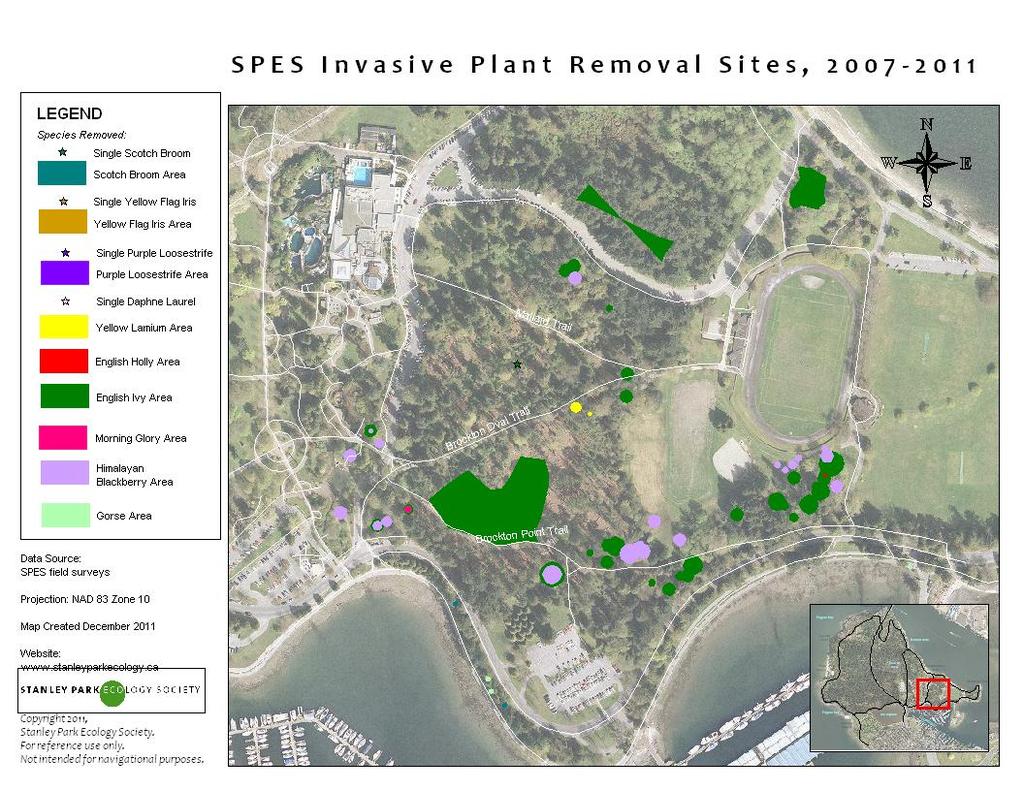
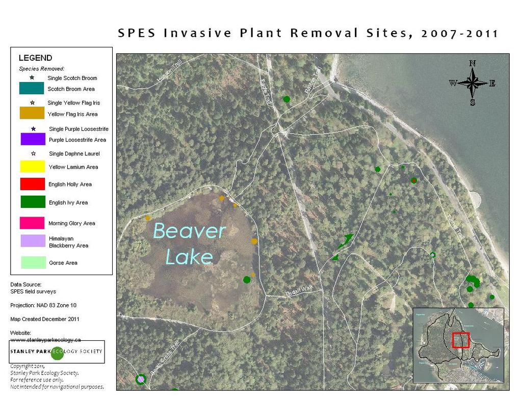
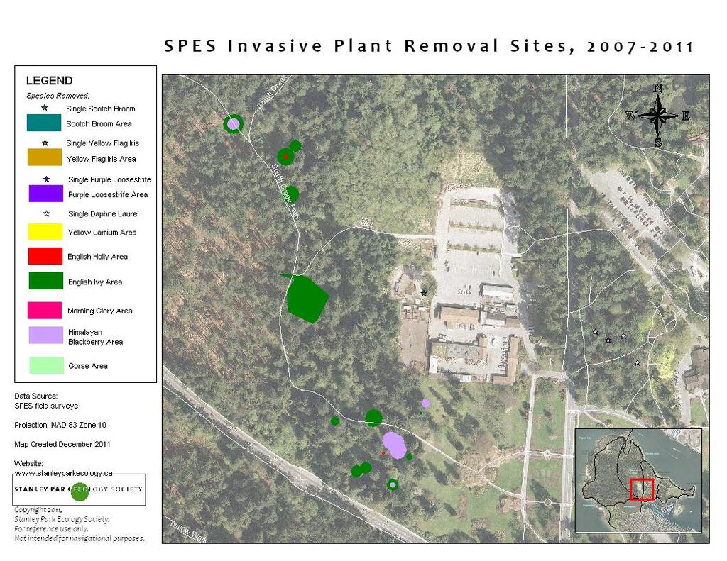
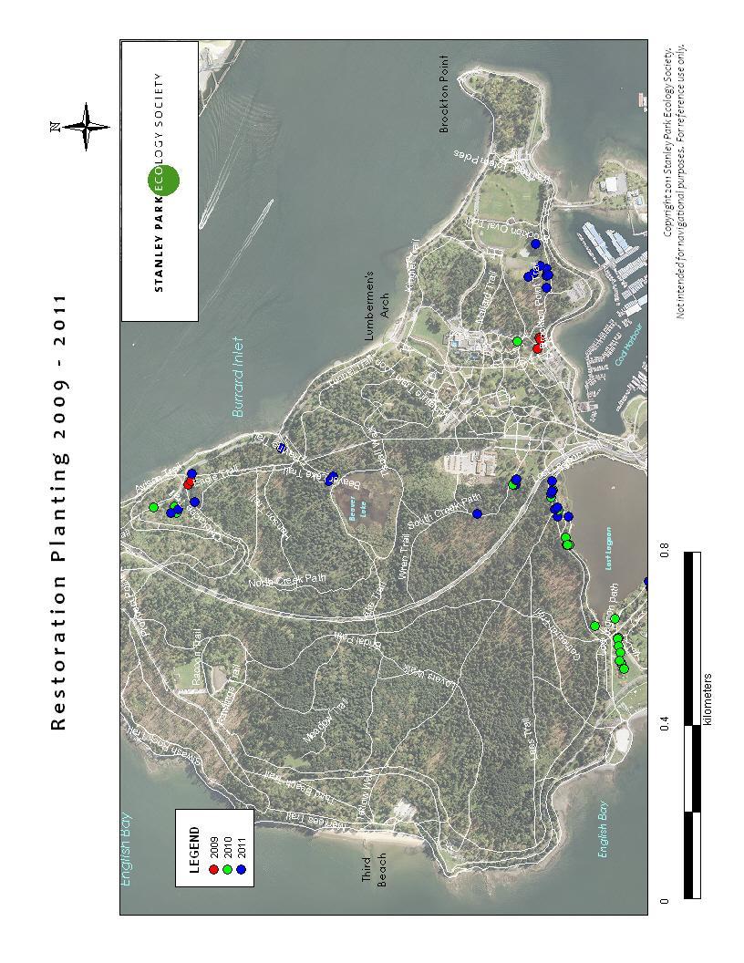
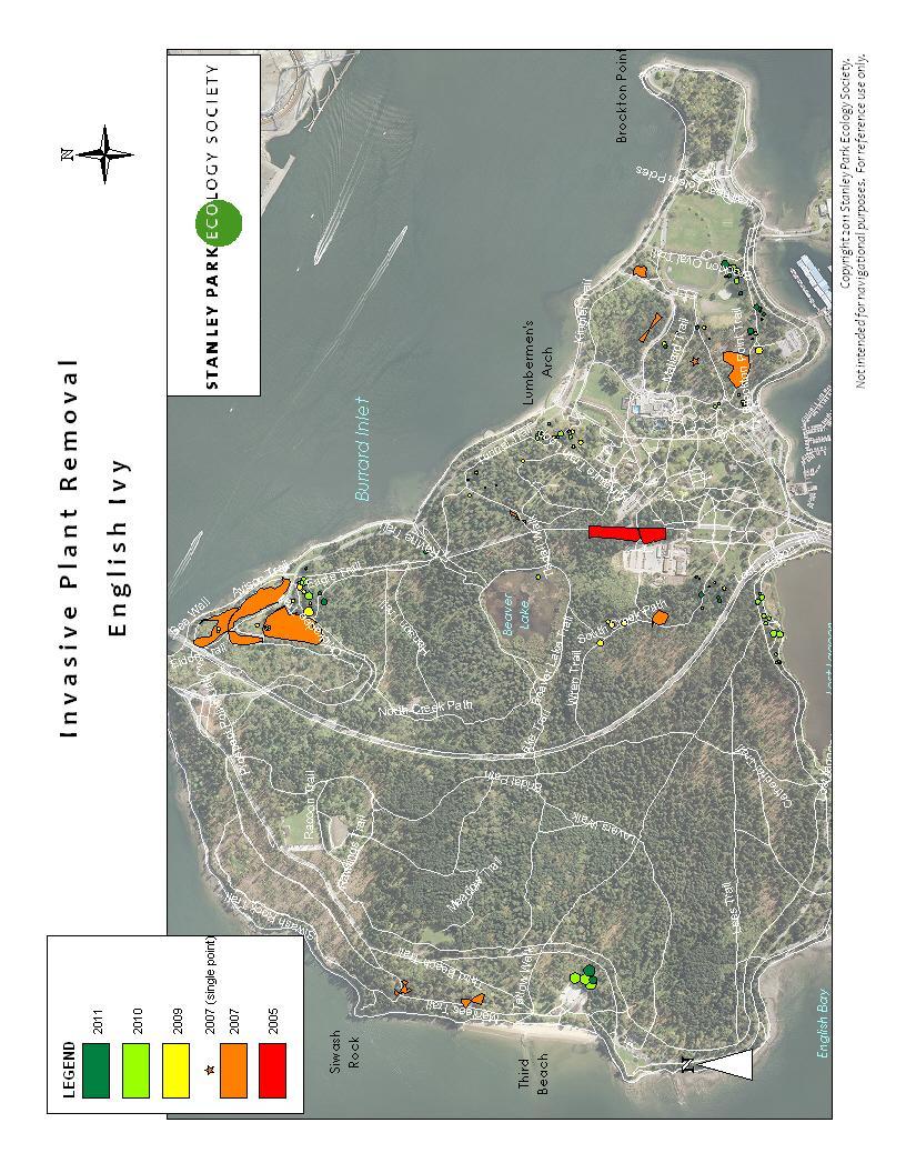
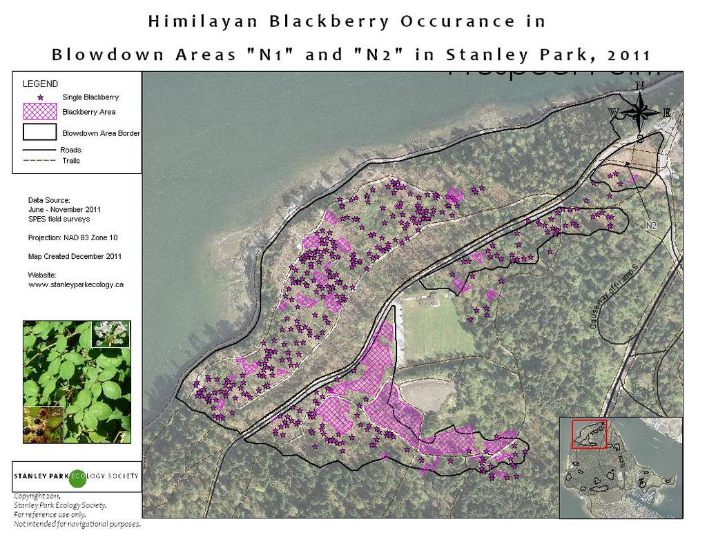
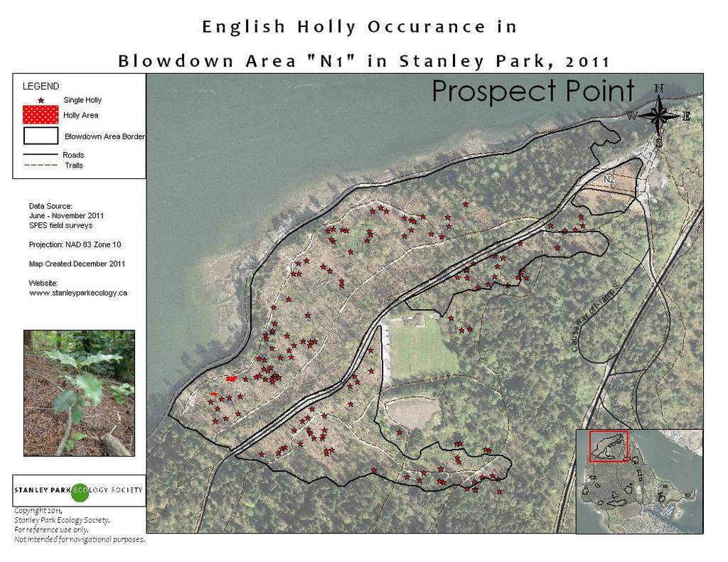
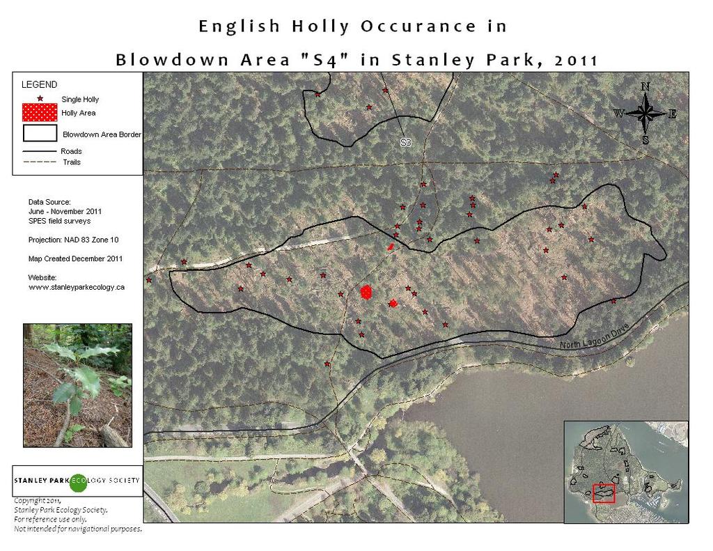
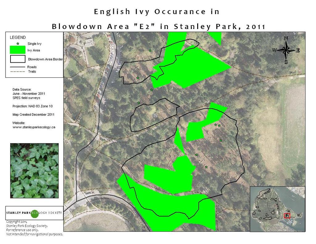
6 Additional information recorded included the accuracy of the UTM coordinate collected and the number of stems and height of invasive trees and shrubs detected. If a plant was unidentifiable in the field, key features were recorded and photos and samples were taken for later identification. If plants were unidentifiable to species, they were grouped by family. Restoration Site Data Collection Since 2004, SPES has been undertaking invasive species removal programs in Stanley Park, in collaboration with the VPB. Between 2004 and 2006, removal sites were tracked and data was collected on the size of the restoration area. Unfortunately this data was lost. In 2007, SPES s new Conservation Programs began and the invasive species management program expanded with the addition of a full-time program coordinator and better methodologies for habitat restoration. Since this time, GPS coordinates and areas of all invasive species removal sites have been documented as well as other details, such as the species removed, volunteer group size, etc. This information can be found in the maps associated table. Data used in the creation of the up-to-date SPES restoration site maps was collected during the events held between September 2007 and November Data are organized on separate layers by species. The English ivy layer is organized by year and there is a separate map showing the areas where tree ivy has been removed. There is also a separate layer for planting events. The data associated with these layers, such as species planted and area of planting, can be found in the map tables. Data Entry and Geographic Information Systems Mapping All field data collected were entered into Microsoft Excel and UTM coordinates were downloaded following each day of field work. All field data was amalgamated in Excel and sorted by species to create species specific layers in MapInfo 9.0, SPES s Geographic Information Systems (GIS) software. All UTM data was projected in MapInfo using North American Datum 83 for zone 10. Points, lines and polygons were created using the easting and northing coordinates collected. Lines and polygons were manually drawn, with MapInfo s buffering feature used to map applicable line widths. Each invasive species was saved as its own layer, with corresponding.tab file, and combined with existing SPES base layers (e.g., orthophoto, infrastructure) to make final species maps for edges and the blow downs. Restoration sites were mapped in a similar fashion. For some of the updated map layers, additional data collected between 2007 and 2010 and map layers () were added to the 2011 survey data. For example, English holly in blowdown area S4 was mapped in 2007, not 2011; the English ivy layer is made up of data collected in 1996, 2009 and Additional points collected in previous years were added to species layers if the locations were missed in the more recent surveys. Dates and surveyor identity is recorded in the tables for all layers, but in cases where older data were used, certain details have been skipped (i.e. % cover). 6
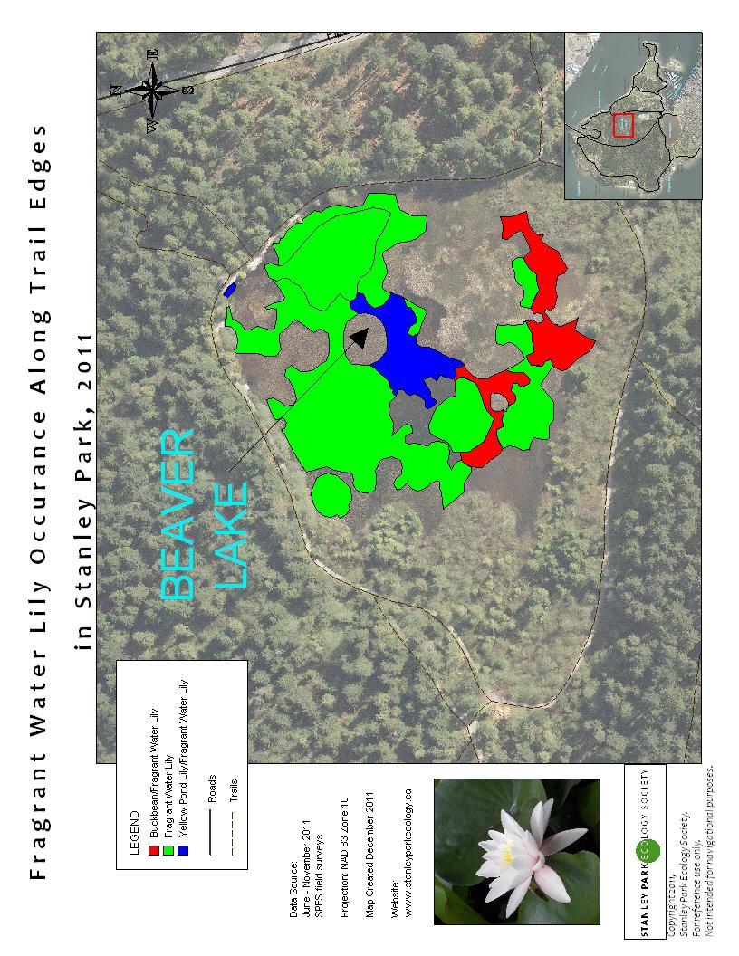
7 Results Map layers were created for all species listed in Appendix 1, except for purple loosestrife (Lythrum salicaria) and Reed Canary Grass (Phalaris arundinacea). The timing for the mapping project did not allow for accurate data to be collected for these species. Since there were several unidentified laurel species (Prunus spp.) found during field surveys, we combined the two species outlined in the contract into Laurel spp.. All of the maps were made from GPS coordinates collected in the field, with the exception of a few points that were added during the GIS mapping process and for fragrant water lily (Nymphaea odorata), which was mapped entirely by digitizing vegetation from orthophotos. The results of the invasive plant species mapping along edges (e.g., roads and trails) can be found in Appendix 2. The results of the invasive plant species mapping in blowdown areas can be found in Appendix 3. The results of restoration site mapping, including planting sites, invasive pull sites, and tree ivy areas, can be found in Appendix 4. Integrating Invasive Plant Maps into VanMap In December 2011, SPES began conversations with VPB staff and the GIS Manager for the City of Vancouver to determine the feasibility of integrating these updated invasive plant maps into VanMap ( Work is in progress to transfer all of the maps created during this project to the private section of the VanMap website so that they can be viewed and used by Park and City staff. The files must first be converted from.tab files (used by SPES and the VPB MapInfo software) to.shp files (used by City of Vancouver AutoDesk mapping software). The second step will be to determine the colour and style of the symbols for the invasive species map layers. This style will need to be compatible with other VanMap layers (i.e. different colours and symbols must be used for the new invasive plant layers, so that they stand out from existing layers). Additional information that will need to be determined by Park Board staff and discussed with City of Vancouver GIS staff is: 1. How often will the data need be updated? 2. Will some or all of the map layers to be displayed on the public VanMap site? 3. Will some or all of the map layer data to be made publicly available on the City of Vancouver Open Data website ( 7
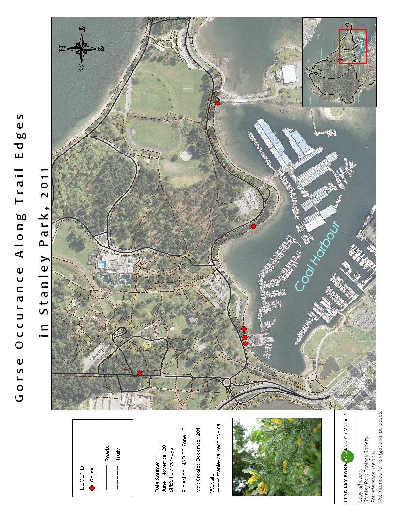
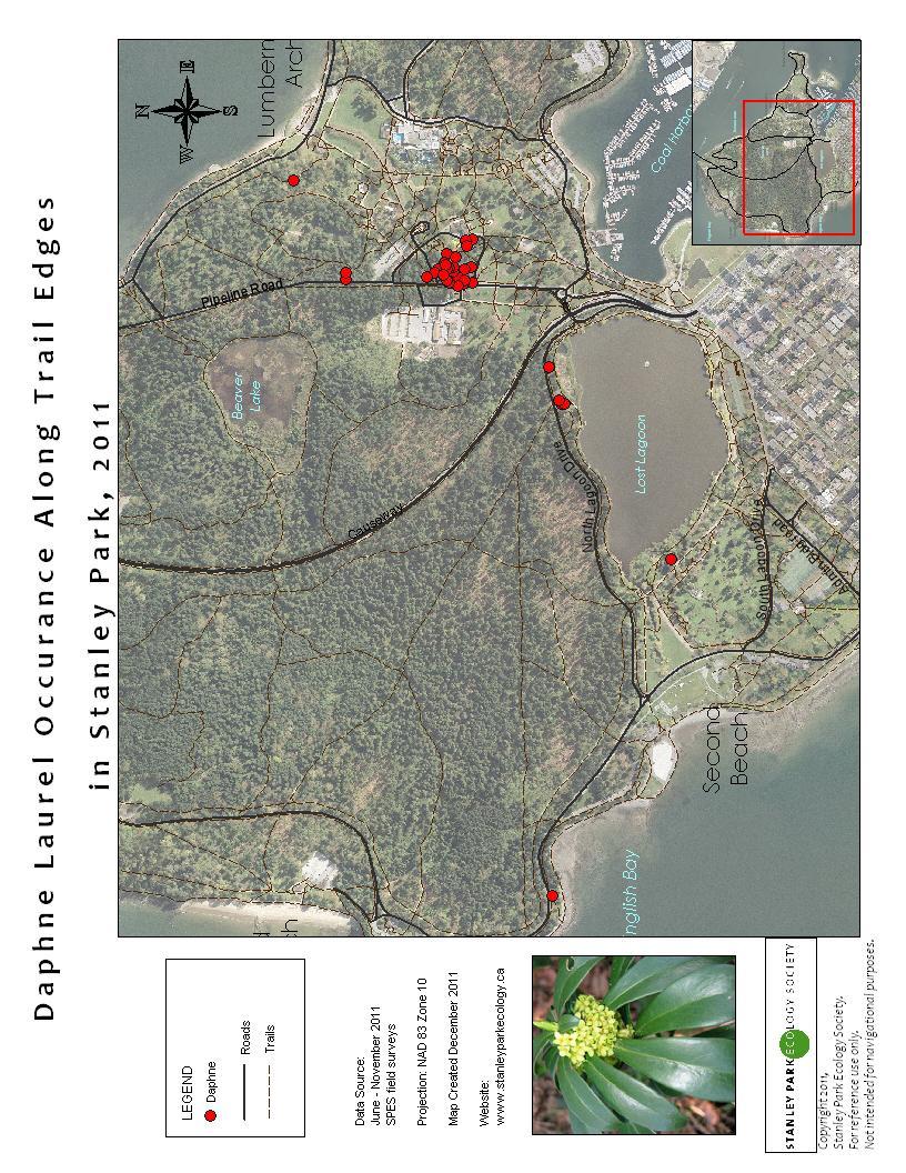
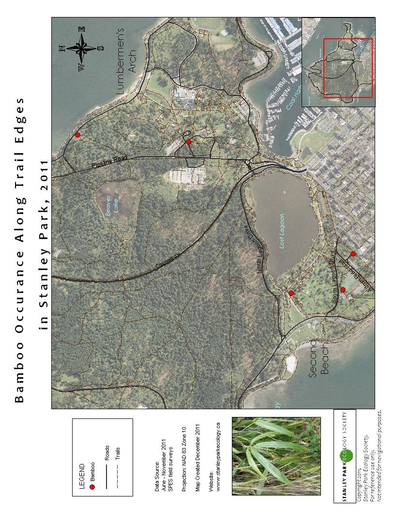
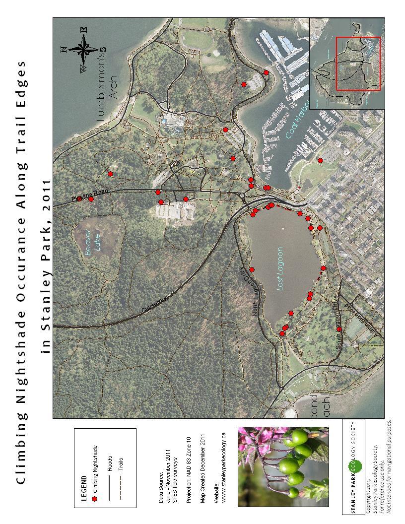
8 Appendix 1: Invasive Plants Mapped Species Gorse (Ulex europaeus) Butterfly Bush (Buddleja davidii) Bamboo spp. Morning Glory (Convolvulus sepium) St John s Wort (Hypericum calycinum) Lesser periwinkle (Vinca minor) Giant Hogweed (Heracleum mantegazzianum) English Laurel (Prunus laurocerasus) Portugal Laurel (Prunus lusitanica) Spurge Laurel (Daphne) (Daphne laureola) Yellow Lamium (Lamiastrum galeobdolon) Climbing Nightshade (Solanum dulcamara) Scotch Broom (Cytisus scoparius) English Holly (Ilex aquifolium) Himalayan Blackberry (Rubus armeniacus) Japanese Knotweed (Polygonum cuspidatum) English Ivy (Hedera helix) Fragrant Water Lily (Nymphaea odorata) Yellow Flag Iris (Iris pseudacorus) Locations to be mapped From all roads and trails From all roads and trails From all roads and trails From all roads and trails From all roads and trails From all roads and trails From all roads and trails From all roads and trails ** combined into Laurel spp. From all roads and trails ** combined into Laurel spp. From all roads and trails From all roads and trails From all roads and trails From all roads and trails From all roads and trails and in blowdown areas From all roads and trails and in blowdown areas From all roads and trails and in blowdown areas From all roads and trails and in blowdown areas in the parks major wetlands in the parks major wetlands European Ash Species (Sorbus spp.) From all roads and trails ** added to the list 8

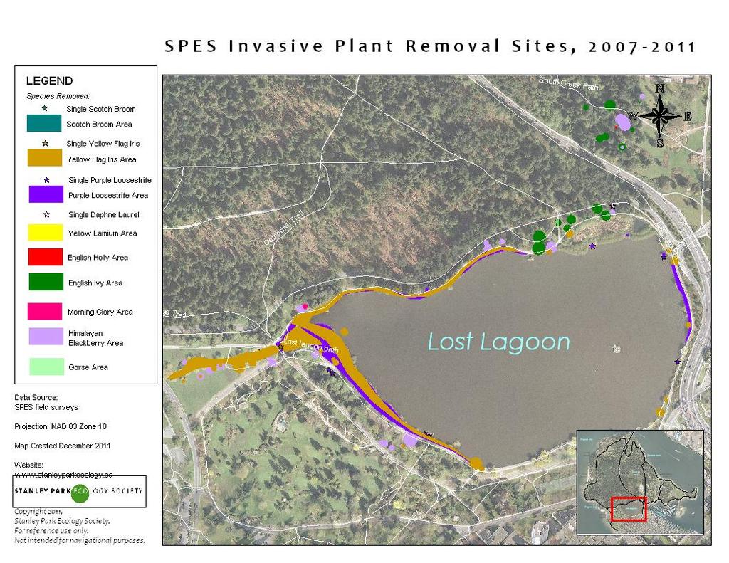
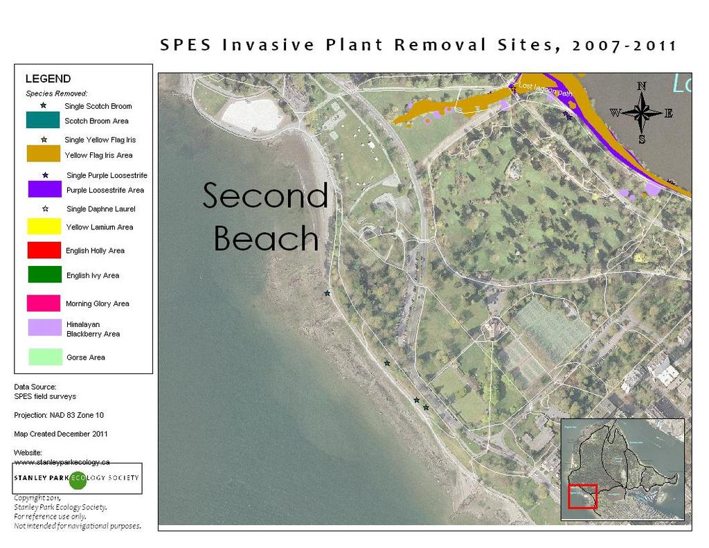
9 Appendix 2: Invasive Plant Mapping by Species 9
10 10
11 11
12 12
13 13
14 14
15 15

16 16
17 17
18 18
19 19

20 20
21 21
22 22
23 23
24 24

25 25
26 26
27 27

28 Appendix 3: Restoration Site Maps 28
29 29
30 30

31 31

32 32
33 33
34 34

35 35
36 Appendix 4: Blowdown Area Maps 36
37 37
38 38
39 39
40 40

41 41
DRAFT Tualatin Basin Weed Management Calendar Adapted from King County, WA (Version 12/31/08)
") Note: This weed management calendar is meant as a summary of general guidelines for use by restoration or vegetation management professionals who are working to limit the impact of invasives on natural
Note: This weed management calendar is meant as a summary of general guidelines for use by restoration or vegetation management professionals who are working to limit the impact of invasives on natural
Bird s-foot trefoil (Lotus corniculatus L.) Canada thistle (Cirsium arvense)
 Canada thistle (Cirsium arvense)") Bird s-foot trefoil (Lotus corniculatus L.) Description: Bird s-foot trefoil is an invasive species that creates tangled mats of dense growth that can choke out other plants. The hardy perennial has a
Bird s-foot trefoil (Lotus corniculatus L.) Description: Bird s-foot trefoil is an invasive species that creates tangled mats of dense growth that can choke out other plants. The hardy perennial has a
Utilizing Ecological Principles of Weed Management in Wetland and Stream Restoration Design. Sarah Spear Cooke, Ph.D. Seattle, Washington
 Utilizing Ecological Principles of Weed Management in Wetland and Stream Restoration Design Sarah Spear Cooke, Ph.D. Seattle, Washington Presentation Outline What special issues do weeds post in restoration?
Coquitlam River Riparian Planting
 Coquitlam River Riparian Planting Year Four Year Four Report, March 2016 Prepared for: Fish and Wildlife Compensation Program Prepared by: Watershed Watch Salmon Society and the Kwikwetlem First Nation
District of Saanich Environmental Services 770 Vernon Avenue Victoria, BC V8X 2W7. Controlling Invasive Plants on your property
 District of Saanich Environmental Services 770 Vernon Avenue Victoria, BC V8X 2W7 Controlling Invasive Plants on your property This brochure provides information for Saanich residents to identify and control
NORTH SHORE COMMUNITY GARDEN SOCIETY. Garden Guidelines
 Garden Guidelines PRINCIPLES The purpose of the North Shore Community Garden Society (NSCGS) is to oversee the use and management of community gardens on the North Shore. Our aim is to: Promote a diversity
Section C. Landscape Design Guidelines
 Section C. Landscape Design Guidelines Mature and varied landscaping in the Queen s Park neighbourhood, including a combination of grass, flowering plants, bushes and mature trees. The residential landscapes
North Carolina Sandhills Weed Management Area. Tracy Rush Program Coordinator
 North Carolina Sandhills Weed Management Area Tracy Rush Program Coordinator Weed Management Area Partnership of federal, state and local government agencies; conservation organizations; individuals and
PlantWise Industry Partnership Program
 PlantWise Industry Partnership Program A Guide for Garden Centers, Landscape Architects, Growers, Suppliers and Specifiers COMPANY NAME: ADDRESS: PREPARED BY: DATE: TABLE OF CONTENTS PLANTWISE INDUSTRY
Riparian Restoration Plan for the Quiet Waters Homeowners Association Reach of the Yachats River. Site Overview
 Walama Restoration Project Community Supported Rehabilitation And Native Re-vegetation of our Watersheds PO Box 894 Eugene, OR 97440 541.484.3939 info@walamarestoration.org www.walamarestoration.org Riparian
Invasive Plants and Noxious Weeds: Identification and Management
 Invasive Plants and Noxious Weeds: Identification and Management Sasha Shaw King County Noxious Weed Control Program www.kingcounty.gov/weeds Agenda Brief review of definitions, lists and impacts Biology
Alien plant species along watercourses in the Natura 2000 network. Arnaud Monty, Hélène Aimont, Gregory Mahy
 Alien plant species along watercourses in the Natura 2000 network Arnaud Monty, Hélène Aimont, Gregory Mahy Rivers: the core of Natura 2000 in Wallonia Natura 2000 is an ecological network of protected
20. Appendix J: Summary of Management Resources for Pioneer Park
 20. Appendix J: Summary of Management Resources for Pioneer Park Management resources are the people, funds and tools that are dedicated to the park on an ongoing basis. The tools are not so much hardware
UNIVERSITY OF EXETER SCRUB MANAGMENT PLAN
 UNIVERSITY OF EXETER SCRUB MANAGMENT PLAN As part of the University of Exeter s commitment to delivery of biodiversity and its Sustainability Action Plan, a schedule of scrub management has been derived.
Restoration of Richmond Beach Saltwater Park, Shoreline, WA
 Restoration Highlights Society for Ecological Restoration Northwest Chapter RH No.9, October 2015 Restoration of Richmond Beach Saltwater Park, Shoreline, WA By Tony Sharrah Project Team Members from the
systems is available on the Colorado Wetland Information Center (CWIC) website.
 website.") Colorado Natural Heritage Program Wetland Program Plan -- Dec 2015 Status Update and Addendum -- The Colorado Natural Heritage Program (CNHP) developed a Wetland Program Plan (WPP) in 2010 for the planning
Colorado Natural Heritage Program Wetland Program Plan -- Dec 2015 Status Update and Addendum -- The Colorado Natural Heritage Program (CNHP) developed a Wetland Program Plan (WPP) in 2010 for the planning
Heron Glen Wetland Buffer Enhancement Project. Progress Report. August 10, 2004 (resent October 19, 2004)
") Heron Glen Wetland Buffer Enhancement Project Progress Report August 10, 2004 (resent October 19, 2004) Summary of Activity Since Last Report (July 2003) Weed Control Himalayan blackberry (Rubus discolor)
Heron Glen Wetland Buffer Enhancement Project Progress Report August 10, 2004 (resent October 19, 2004) Summary of Activity Since Last Report (July 2003) Weed Control Himalayan blackberry (Rubus discolor)
April 11, 2016 Park Board Chair and Commissioners General Manager Vancouver Board of Parks and Recreation New Brighton Salt Marsh - Preferred Concept
 TO: FROM: SUBJECT: April 11, 2016 Park Board Chair and Commissioners General Manager Vancouver Board of Parks and Recreation New Brighton Salt Marsh - Preferred Concept RECOMMENDATION A. THAT the Vancouver
2016 Vegetation Monitoring Report ERA Project # Prepared for: Downers Grove Park District
 Lyman Woods Streambank Stabilization Project Site Area II, Phase III Downers Grove, Illinois 2016 Vegetation Monitoring Report ERA Project #100301 Prepared for: Downers Grove Park District December 2016
APPENDIX 1: SCOPED ENVIRONMENTAL IMPACT STATEMENT (EIS) FORM
 FORM") APPENDIX 1: SCOPED ENVIRONMENTAL IMPACT STATEMENT (EIS) FORM This form is intended for use by applicants (primarily private landowners) who need to conduct a Scoped EIS in support of minor development
APPENDIX 1: SCOPED ENVIRONMENTAL IMPACT STATEMENT (EIS) FORM This form is intended for use by applicants (primarily private landowners) who need to conduct a Scoped EIS in support of minor development
Countywide Green Infrastructure
 Montgomery County s Countywide Green Infrastructure F U N C T I O N A L M A S T E R P L A N The Maryland National Capital Park and Planning Commission INFRASTRUCTURE An underlying base or foundation especially
Green Design Principles
 Green Design Principles restoration planting Ecosystem restoration, including preserving and enhancing existing vegetation and where feasible, introducing new vegetative communities, benefits the stream
Invasive Alien Plants on Gabriola Island and throughout BC s South
 Invasive Alien Plants on Gabriola Island and throughout BC s South Coast Presented by: Pamela Wesley Extension & Outreach Coordinator Coastal Invasive Plant Committee February 4, 2009 Outline 1. Introduction
NRA Conference Threat of non-native invasive plants on National road schemes
 NRA Conference 2013 Threat of non-native invasive plants on National road schemes Pádraig Whelan, Environmental Research Institute and School of Biological, Earth and Environmental Sciences, University
Donaldson Run Tributary B Stream Restoration Project Update. February 23, 2011 Taylor Elementary School
 Donaldson Run Tributary B Stream Restoration Project Update February 23, 2011 Taylor Elementary School Big picture concepts Past land use and drainage decisions have severely impacted County streams Watershed
Invasive Aquatic Plants
 Invasive Plants / Homeowners BMP Guide / 52 Invasive Plants An invasive plant is a species that is often, but not always, a non-native plant that is introduced into an area and then grows so aggressively
Weeds & Wildlings. Created by Pat Patterson. Weeds? What Is a Weed? Is This a Weed?
 Weeds & Wildlings Created by Pat Patterson Nature knows no plants as weeds.- Liberty Hyde Bailey What is a weed? A plant whose virtues have not yet been discovered Weeds? Theirs is a long and complicated
Master Plan Objectives and Policies
 Master Plan Objectives and Policies Introduction This chapter identifies the Park issues and recommended policies established by this Master Plan. The issues were identified through meetings with staff,
Western Pennsylvania Conservancy Clairton & Harrison Community Greening Assessment Projects Request for Proposals July 2018
 Western Pennsylvania Conservancy Clairton & Harrison Community Greening Assessment Projects Request for Proposals July 2018 Proposal Information The Western Pennsylvania Conservancy (WPC) is seeking proposals
Salix Coir Rolls. Building with Nature
 Salix Coir Rolls Building with Nature Description Salix produce a wide range of preestablished Coir Rolls planted with high quality native plant species. We plant our Coir Rolls at a high density and grow
Stormwater Standards. Clackamas County Service District No. 1. Planting Guide for Buffers
 Stormwater Standards Clackamas County Service District No. 1 APPENDIX B Planting Guide for Buffers Table of Contents Appendix B - Planting Guide for Buffers... Page B.1 General... 1 B.1.1 Introduction...
Huron Pines AmeriCorps
 POSITION TITLE: PRIMARY SERVICE LOCATION: RESPONSIBLE TO: Grand Traverse Regional Land Conservancy Huron Pines AmeriCorps Position Description Stewardship Technician Traverse City, Michigan Jon Throop,
RECREATION, OPEN SPACE AND GREENWAYS ELEMENT GOALS, OBJECTIVES, AND POLICIES
 RECREATION, OPEN SPACE AND GREENWAYS ELEMENT GOALS, OBJECTIVES, AND POLICIES GOAL R-1: DEVELOP A RECREATION, OPEN SPACE AND GREENWAYS SYSTEM AS AN INTEGRAL COMPONENT OF AN OVERALL, COUNTY-WIDE ECONOMIC
Presentation August 20, 2013
 Presentation August 20, 2013 St. Vital Transmission Complex Stakeholder Workshop WELCOME! Manitoba Hydro 9:00am to 1:50pm Purpose of Workshop Share current project information Including outcomes of the
Comox Valley Naturalists Society Wetland Restoration Project Report 2011
 Comox Valley Naturalists Society Wetland Restoration Project Report 2011 Prepared by Frank Hovenden Comox Valley Naturalists Society Table of Contents 1 Acknowledgements 3 2 Introduction 4 3 Background
Invasive alien plants on Irish roads an overview of the biological challenges. P. Whelan, ERI, BEES, University College Cork
 Invasive alien plants on Irish roads an overview of the biological challenges P. Whelan, ERI, BEES, University College Cork Context Pressures to respond to invasive alien species legislative, economic,
Rocky Areas Project Guidance HABITAT
 Rocky Areas Project Guidance HABITAT Introduction Rocky habitats are surface areas dominated by exposed rock, such as mountain peaks, inland cliffs, buttes and rocky outcrops. In many cases, rocky areas
Kazoo school students are presenting a research project on Japanese Knotweed in collaboration with researcher, Joe Dauer, from MSU.
 AmeriCorps NCCC is a government-funded national service program consisting of young adults, ages 18 to 24. Their main areas of focus include, urban and rural development, infrastructure improvement, energy
BEST MANAGEMENT PRACTICES Spurge Laurel(Daphne laureola) (Family Thymelaeaceae Daphne Family)
 (Family Thymelaeaceae Daphne Family)") JEFFERSON COUNTY NOXIOUS WEED CONTROL BOARD 380 Jefferson Street, Port Townsend WA 98368 360 379-5610 Ext. 205 noxiousweeds@co.jefferson.wa.us BEST MANAGEMENT PRACTICES Spurge Laurel(Daphne laureola) (Family
JEFFERSON COUNTY NOXIOUS WEED CONTROL BOARD 380 Jefferson Street, Port Townsend WA 98368 360 379-5610 Ext. 205 noxiousweeds@co.jefferson.wa.us BEST MANAGEMENT PRACTICES Spurge Laurel(Daphne laureola) (Family
Great Lakes Conservation Blueprint for Terrestrial Biodiversity on the Canadian Shield
 Great Lakes Conservation Blueprint for Terrestrial Biodiversity on the Canadian Shield Bonnie L. Henson 1, Kara E. Brodribb 2 and John L. Riley 3 1 Ontario Ministry of Natural Resources 2,3 The Nature
Incorporating Traditional Ecological Knowledge and Cultural Information Into Wetland Protection, Management, and Restoration - Tulalip Reservation
 Incorporating Traditional Ecological Knowledge and Cultural Information Into Wetland Protection, Management, and Restoration - Tulalip Reservation By Jonathan Hall, Wetland Biologist, Tulalip Tribes Weallup
Preface. Erie. Scranton. Allentown. Pittsburgh. Harrisburg. Philadelphia
 The Southern Alleghenies Region The Southern Alleghenies Region spans the Laurel Highlands and Allegheny Front in the west across the Appalachians to the east. It is comprised of Blair, Bedford, Cambria,
The Nature Conservancy relies on volunteers to manage invasive shrubs at the Snake Mountain South Natural Area in Bridport.
 The Nature Conservancy relies on volunteers to manage invasive shrubs at the Snake Mountain South Natural Area in Bridport. A new tool for volunteer citizen scientists and land managers imapinvasives is
The scope of the plan will focus on the Prospect Heights Slough and Hillcrest Lake as one entity.
 Plan for Prospect Heights Natural Resources Commission Plan for Improved Public Access and Enjoyment of the Prospect Heights Slough and Hillcrest Lake July 23, 2018 The City Council has requested the Natural
Syfeld Keene Associates
 Syfeld Keene Associates File No.: 198100675 City and State: Keene, NH General Impacts: 9.8 acres PSS/PFO/PEM (permit states most of 13 acre site ) Functions and Values Lost: Floodflow alteration (only
Conservation Commissions & Invasive Plants
 Conservation Commissions & Invasive Plants Photo from A Landowner s Guide to Invasive Plan Management, Westfield River Watershed Invasive Species Partnership Fall 2015 MA Envirothon Coach & Team Workshop
Member Service Plan Sierra Nevada AmeriCorps Partnership
 Member Service Plan Sierra Nevada AmeriCorps Partnership Service plans lay the framework for what each Member will be doing during their service. Service plans detail the major projects and expected results
SUSTAINABILITY PLAN OTTAWA COUNTY PARKS AND RECREATION COMMISSION FALL 2017
 SUSTAINABILITY PLAN OTTAWA COUNTY PARKS AND RECREATION COMMISSION FALL 2017 Table of Contents Introduction Natural Resources Quality of Life Community Continuing the Mission Sustainability Measuring Sustainability
TRCA Field Staking Protocol December 2016
 Page 1 of 6 TRCA Field Staking Protocol December 2016 This Protocol describes TRCA staff s current practice for field staking the physical top of bank, the physical toe of slope, and the limit of existing
Heritage Assessment and Considerations. Tamara Anson-Cartwright Pourya Nazemi City of Toronto Urban Land Institute, November 24, 2017
 Heritage Assessment and Considerations Tamara Anson-Cartwright Pourya Nazemi City of Toronto Urban Land Institute, November 24, 2017 HERITAGE INVENTORY HERITAGE REGISTER DANFORTH AVENUE More than 45 years
Lake Nokomis Shoreline Enhancement Project
 Lake Nokomis Shoreline Enhancement Project Community Meeting 2 February 13, 2018 Agenda Current Problems Project Goals Project Status Existing Conditions Community Input Draft Schematic Design Long-term
AVONDALE ESTATES GREENSPACE AD-HOC COMMITTEE
 AVONDALE ESTATES GREENSPACE AD-HOC COMMITTEE INVENTORY AND RECOMMENDATIONS REPORT November 7, 2018 Our Mission Statement: To provide assistance and support, through professional expertise in matters of
Middle Mississippi River. Regional Corridor
 Middle Mississippi River St. Louis District Regional Corridor Lessons Learned from a Collaborative Planning Study Brian Johnson US Army Corps of Engineers 12 th Biennial Governor s Conference on the Management
Park Board Strategic Framework. (Mission, Vision, Directions, Goals and Objectives) June 27, 2012
 June 27, 2012") Park Board Strategic Framework (Mission, Vision, Directions, Goals and Objectives) June 27, 2012 Planning Process Overview Phase 1: Renewed Strategic Framework Phase 2: Objectives Phase 3: Prioritization
Park Board Strategic Framework (Mission, Vision, Directions, Goals and Objectives) June 27, 2012 Planning Process Overview Phase 1: Renewed Strategic Framework Phase 2: Objectives Phase 3: Prioritization
Texas AgriLife Extension Service
 I. Abstract Texas AgriLife Extension Service Sheldon Lake State Park Prairie Wetland Restoration FY 10 CWA 319(h) TSSWCB Project 10 05 Quarter no. _9 From 10 1 12 Through 12 31 12 The quarter was marked
2018 AMENDMENT TO THE COMPREHENSIVE PLAN
 2018 AMENDMENT TO THE COMPREHENSIVE PLAN AND LAND USE REGULATORY CODE Summary of Proposed Amendments A Plan or Code Amendment is the process through which the City considers changes, additions, and updates
Strategies for Control Based on Life Cycle of Invasive Plants
 Strategies for Control Based on Life Cycle of Invasive Plants Courtney LeClair Invasive Plant Specialist Wisconsin DNR Courtney.leclair@wisconsin.gov Weed Increase Over Time and Control Potential (1) (2)
STEWARDSHIP OF LONG ISLAND SOUND S ECOLOGICAL AND RECREATIONAL RESOURCES
 STEWARDSHIP OF LONG ISLAND SOUND S ECOLOGICAL AND RECREATIONAL RESOURCES Robin Kriesberg, Save the Sound, Inc. Thomas Halavik, US Fish and Wildlife Service Coastal Program An Initiative to Identify, Protect
Management of Invasive Plant Species in Jericho Beach Park, Vancouver
 Management of Invasive Plant Species in Jericho Beach Park, Vancouver Photo: Janusz Kruszewski Submitted to: Danny Catt Recreational Land Management Instructor Fish, Wildlife, and Recreation Program British
Managing our Landscapes Conversations for Change
 Managing our Landscapes Conversations for Change Frequently Asked Questions The new State Government is committed to a significant reform program that will change the way natural resources are managed.
User Awareness & Training: Use of Copernicus data for land monitoring and environmental reporting in Italy Lisbon, Portugal 14 th February 2014 ISPRA
 User Awareness & Training: Use of Copernicus data for land monitoring and environmental reporting in Italy Lisbon, Portugal 14 th February 2014 ISPRA Contents Introduction to land take, urban sprawl and
Minnesota Department of Natural Resource - Natural Resource Guidance Checklist Conserving Natural Resources through Density Bonuses
 Minnesota Department of Natural Resource - Natural Resource Guidance Checklist Conserving Natural Resources through Density Bonuses NRDB Why Use Density Bonuses & This Checklist Local units of government
Polpis Bike Path. General Impacts: 1.47 acres forested, marsh, shrub swamp
 Polpis Bike Path File No.: 199201570 City and State: Nantucket, MA General Impacts: 1.47 acres forested, marsh, shrub swamp Functions and Values Lost: (from EA/SOF) Floodflow Alteration Groundwater Discharge
Annex D: Project Logframe Matrix
 Annex D: Project Logframe Matrix OVERALL OBJECTIVE: Protect the unique ecosystems and biodiversity along the Sava River through supporting Croatia and Bosnia-Herzegovina in a) improving transborder cooperation
Landscaping for Biodiversity
 Landscaping for Biodiversity Ecological Landscape Design Consultants Lisa M. J. Dolan BSc. Lisarow Ardmore Co. Waterford Ecolandscapedesign@eircom.net CONTENTS Three Stages of Process Pre-planning & Landscape
Community Conservation Workshop. Lake Placid
 Community Conservation Workshop Lake Placid 2 Community Conservation Program Welcome! We have designed a Community Conservation Program that listens to the needs of community members. We are conducting
APPENDIX C NATURAL RESOURCES MANAGEMENT PLAN: ACTIONS AND PRIORITIES
 APPENDIX C NATURAL RESOURCES MANAGEMENT PLAN: ACTIONS AND PRIORITIES TABLE C-1: Resource Actions and Priorities GOAL NRM-4 Objective 4.1: Restore Natural floodplain functions. Objective 4.2: Define and
Mercer EducationalGardens. Meadow (3/4 acre)
") Mercer EducationalGardens Meadow (3/4 acre) Photo courtesy of Hopewell Township engineer June 2008 2007-2010 Wetland Meadow Restoration At Meadow Restoration Mercer Educational Gardens Meadow in 2007 Reed
Mercer EducationalGardens Meadow (3/4 acre) Photo courtesy of Hopewell Township engineer June 2008 2007-2010 Wetland Meadow Restoration At Meadow Restoration Mercer Educational Gardens Meadow in 2007 Reed
BUSHLAND WEEDS OF MOUNT WILSON & MOUNT IRVINE
 BUSHLAND WEEDS OF MOUNT WILSON & MOUNT IRVINE A Guide to Identification, Prevention and by Libby Raines This booklet is dedicated to Bill Smart CONTENTS INTRODUCTION 2 ACKNOWLEDGEMENTS.. 3 WEEDS ON MOUNT
Ilex cornuta 'Needlepoint' -- Georgia
 Plant Risk Evaluator -- PRE Evaluation Report Ilex cornuta 'Needlepoint' -- Georgia 2017 Farm Bill PRE Project PRE Score: 16 -- Reject (high risk of invasiveness) Confidence: 62 / 100 Questions answered:
POLICY The Trillium Park Master Plan was approved by the Board on April 4, 2012.
 TO: FROM: SUBJECT: Date: June 2, 2014 Board Members Vancouver Park Board General Manager Parks and Recreation Proposed Trillium North Park Artists Garden RECOMMENDATION THAT the Board approve the new arts-focused
memo Project Name Spider Lake Point Intercept Survey 2017 Date 9/5/17 To / Contact info Jerry Spetzman Cc / Contact info Greg Graske, PE
 memo Project Name Spider Lake Point Intercept Survey 2017 Date 9/5/17 To / Contact info Cc / Contact info From / Contact info Regarding Jerry Spetzman Greg Graske, PE Joe Pallardy, Mike Majeski Spider
Client #: Dawson /91. NRCS Tract #(s): Location: Fleming Memorial Park Field #(s): Program(s): Urban Project Name: Date:
: Location: Fleming Memorial Park Field #(s): Program(s): Urban Project Name: Date:") Natural Resource Stewardship Plan Jackson Soil and Water Conservation District 89 Alder Street Central Point, Oregon 97502 Ph. (541) 664-1070 www.jswcd.org Client Name: Elisa Dawson, City of Rogue River
Natural Resource Stewardship Plan Jackson Soil and Water Conservation District 89 Alder Street Central Point, Oregon 97502 Ph. (541) 664-1070 www.jswcd.org Client Name: Elisa Dawson, City of Rogue River
Chapter 5: Natural Resources and Environment
 NATURAL RESOURCES AND ENVIRONMENT 5-1 5 Chapter 5: Natural Resources and Environment BACKGROUND AND INTENT Urban expansion represents the greatest risk for the future degradation of existing natural areas,
National Association of Conservation Districts. Kris Hoellen Vice President, Sustainable Programs The Conservation Fund September 19, 2013
 National Association of Conservation Districts Kris Hoellen Vice President, Sustainable Programs The Conservation Fund September 19, 2013 Our Mission The Conservation Fund forges partnerships to conserve
RFP REQUEST FOR PROPOSALS CITY OF PORTSMOUTH, NH. DESIGN ENGINEERING SERVICES North Mill Pond Trail and Greenway
 RFP 61-18 REQUEST FOR PROPOSALS CITY OF PORTSMOUTH, NH DESIGN ENGINEERING SERVICES North Mill Pond Trail and Greenway Sealed Requests for Proposals, plainly marked RFP 61-18 Design Engineering Services
Outline MANAGING INVASIVE PLANTS ON YOUR LAND. Invasive Species. Definitions 1/12/2015
 Outline General Invasive Plant Ecology Identification of New Invasive Plants Management Principles MANAGING INVASIVE PLANTS ON YOUR LAND Chris Evans, Illinois Invasive Species Campaign Invasive Species
Creating ponds for water voles
 Creating ponds for water voles A 50-YEAR PROJECT TO CREATE A NETWORK OF CLEAN WATER PONDS FOR FRESHWATER WILDLIFE 1. Introduction Water voles have suffered a catastrophic decline in Britain over the last
The Development of Riparian Stream Buffers in Greensboro, NC
 The Development of Riparian Stream Buffers in Greensboro, NC Why our stream banks have grown up? Presented by: Peter Schneider, Water Quality Supervisor City of Greensboro Stormwater Management Division
Wisconsin Dept. of Transportation November 2017
 Wisconsin Dept. of Transportation November 2017 Jennifer Gibson WisDOT Environmental Coordinator Mike Helmrick WisDOT Environmental Coordinator Background on compensatory wetland mitigation Site purpose
Board Members Vancouver Park Board General Manager Parks and Recreation
 TO: FROM: SUBJECT: Board Members Vancouver Park Board General Manager Parks and Recreation Date: February 6, 2014 Proposed Community Garden at Creekside Community Centre RECOMMENDATION THAT the Board support
Alternative Routes. St. Vital to La Verendrye Station - Southern Loop Transmission Corridor. 20 different segments 4 segments common to all routes
 Alternative Routes St. Vital to La Verendrye Station - Southern Loop Transmission Corridor In a fixed right-of-way St. Vital to Letellier Station 20 different segments 4 segments common to all routes Goal
Wisconsin NRCS Direct Volume Method Bank Recession Rate Categorizations
 2 Executive Summary The City of Ramsey contracted the Anoka Conservation District to complete an inventory of riverbank condition along the entire 5.8 miles of City that border the Mississippi River. The
Chalk, Cherries and Chairs Central Chilterns Landscape Partnership Scheme LANDSCAPE PARTNERSHIP DEVELOPMENT OFFICER JOB INFORMATION PACK
 Chalk, Cherries and Chairs Central Chilterns Landscape Partnership Scheme LANDSCAPE PARTNERSHIP DEVELOPMENT OFFICER JOB INFORMATION PACK How to apply Please complete our application form, together with
Stormwater Standards. Clackamas County Service District No. 1. Planting Guide for Vegetated Stormwater Facilities
 Stormwater Standards Clackamas County Service District No. 1 APPENDIX A Planting Guide for Vegetated Stormwater Facilities CCSD#1 Stormwater Standards - Appendix A Table of Contents Appendix A - Planting
Position Description
 Position Description Position Description Report Run Date Dec 6 2011 2:31PM Position Number: 02013464 Dept: UNIVERSITY ARBORETUM - 030087 Position: GATEways Horticulturist Approved Payroll Title Code:
5/18/2012. Valley Woods wetlands before. Rouge Park prairie before
 GLRI Grant Transforming the Rouge from Mowed Down to Grown Up Controlled Burns at: Valley Woods Nature Preserve, Southfield River Rouge Park and Eliza Howell Park, Detroit Why Do Controlled Burn? Maintain
Green Infrastructure Policies and Ordinances
 Green Infrastructure Policies and Ordinances October 23, 2013 By Karen Firehock, Green Infrastructure Center 2013 Georgia Urban Forest Council s 23 rd Annual Conference The mission of the nonprofit Green
Monitoring for Ecological Integrity and State of the Parks Reporting
 Monitoring for Ecological Integrity and State of the Parks Reporting Donald McLennan 1 and Paul Zorn 1 National Monitoring Biologist Parks Canada, Ecological Integrity Branch 25 Eddy Street Gatineau, Québec,
Biodiversity: My Hotel in Action
 Biodiversity: My Hotel in Action Hotel Manager s Checklist This checklist is designed to guide you in evaluating how many of the practices recommended in this guide have been implemented in your hotel.
building with nature - a new benchmark for green infrastructure
 building with nature - a new benchmark for green infrastructure Danielle Sinnett, Gemma Jerome, Sarah Burgess, Nick Smith and Roger Mortlock outline the aims, development and proposed operation of Building
A Guide to Techniques for Removing Bay Area Invasive Plants The Watershed Project California Invasive Plant Council
 THE WEED WORKERS HANDBOOK A Guide to Techniques for Removing Bay Area Invasive Plants m The Watershed Project California Invasive Plant Council Authors Pete Holloran (chapters 1-5) Anouk Mackenzie (chapter
SUPPORTING DOCUMENT POST-CONSTRUCTION SOIL QUALITY AND DEPTH WORKSHEET
 SUPPTING DOCUMENT POST-CONSTRUCTION SOIL QUALITY AND DEPTH WKSHEET For Department of Ecology Stormwater BMP T5.13 This submittal worksheet will help determine what soil amendments are needed to meet the
RECREATION AND OPEN SPACE ELEMENT GOALS, OBJECTIVES, AND POLICIES
 RECREATION AND OPEN SPACE ELEMENT GOALS, OBJECTIVES, AND POLICIES Goal 7 To provide park facilities, recreation programs, and open space resources that are safe, adequate, and accessible to all City residents,
Integrated Pest Management Program Department of Plant Science and Landscape Architecture UConn Extension
 Integrated Pest Management Program Department of Plant Science and Landscape Architecture UConn Extension Homegrown Beetles: Backyard Biocontrol Donna Ellis, Senior Extension Educator UConn Department
Flat Lake, Highway 103, HADD Compensation Project (DFO HADD Authorization 03-G8-068): 2010 Vegetation Monitoring
: 2010 Vegetation Monitoring") Flat Lake, Highway 103, HADD Compensation Project (DFO HADD Authorization 03-G8-068): 2010 Vegetation Monitoring Year 5 Final Diane LaRue, Vegetation Consultant Environmental Services, NSTIR Monitored
Flat Lake, Highway 103, HADD Compensation Project (DFO HADD Authorization 03-G8-068): 2010 Vegetation Monitoring Year 5 Final Diane LaRue, Vegetation Consultant Environmental Services, NSTIR Monitored
Forest Preserves of Cook County Species Treatment List
 Woody Plants Common Name Scientific Name Treatment Options Treatment Season Tree of Heaven Alianthus altissima Basal bark application, use 20% Element 4 (better option) Cut and treat stems with a 20% Element
UBC Social Ecological Economic Development Studies (SEEDS) Sustainability Program Student Research Report
 Sustainability Program Student Research Report") UBC Social Ecological Economic Development Studies (SEEDS) Sustainability Program Student Research Report Mapping Resilience and Biodiversity in the UBC Botanical Gardens Vivian Hau and Rachel Siu University
UBC Social Ecological Economic Development Studies (SEEDS) Sustainability Program Student Research Report Mapping Resilience and Biodiversity in the UBC Botanical Gardens Vivian Hau and Rachel Siu University
COASTAL CONSERVANCY. Staff Recommendation March 25, 2004 LOS ANGELES GREEN VISION PLAN. File No.: Project Manager: Marc Beyeler
 COASTAL CONSERVANCY Staff Recommendation March 25, 2004 File No.: 04-014 Project Manager: Marc Beyeler RECOMMENDED ACTION: Authorization to disburse up to $50,000 to the University of Southern California
Arkansas River Corridor
 Planning for Access Welcome to the Access Project. This project is a recreational planning effort in response to an interest by regional communities along the Arkansas River corridor. The project plan