Sustainability Appraisal (SA) for the New Milton Neighbourhood Plan
|
|
|
- Jesse Austin
- 5 years ago
- Views:
Transcription

1 Sustainability Appraisal (SA) for the New Milton Neighbourhood Plan New Working Group March 2018
2 Quality information Prepared by Checked by Approved by Rosie Cox Assistant Consultant Nick Chisholm-Batten Associate Nick Chisholm-Batten Associate Revision History Revision Revision date Details Authorized Name Position V1.0 23rd March 2018 Draft for Working Group comment V th March 2018 Consultation version 23rd March 2018 Nick Chisholm- Batten 29 th March Nick Chisholm- Batten Associate Associate Prepared for: New Milton Town Council Prepared by: Infrastructure & Environment UK Limited 3rd Floor, Portwall Place Portwall Lane Bristol BS1 6NA United Kingdom T: aecom.com 2018 Limited. All Rights Reserved. This document has been prepared by Limited ( ) for use of Locality (the Client ) in accordance with generally accepted consultancy principles, the budget for fees and the terms of reference agreed between and the Client. Any information provided by third parties and referred to herein has not been checked or verified by, unless otherwise expressly stated in the document. No third party may rely upon this document without the prior and express written agreement of.
3 Table of Contents Non-Technical Summary... NTS1 1. Introduction... 1 Background... 1 Sustainability Appraisal (SA) explained... 2 Structure of this SA Report Local Plan context and vision for the NMNP... 4 Local Plan context for the NMNP... 4 Vision for the NMNP The Scope of the SA... 6 SA Scoping Report... 6 Key Sustainability Issues SA Framework What has plan making / SA involved to this point? Introduction Overview of plan making / SA work undertaken since (date) Assessment of reasonable alternatives for the Neighbourhood Plan Current approach in the Neighbourhood Plan and the development of Neighbourhood Plan policies 24 Choice of sites taken forward for the purposes of the Neighbourhood Plan Neighbourhood Plan policies What are the appraisal findings at this current stage? Introduction Approach to this appraisal Air Quality Biodiversity and Geodiversity Climate Change Landscape and Historic Environment Land, Soil and Water Resources Population and Community Health and Wellbeing Transportation Conclusions at this current stage Recommendations at this current stage What are the next steps? Appendix A: Context Review and baseline... 41
4 4
5 Non-Technical Summary What is a Sustainability Appraisal? A sustainability appraisal (SA) has been undertaken to inform the New (NMNP). This process is required by the Strategic Environmental Assessment Regulations. Neighbourhood Plan groups use SA to assess Neighbourhood Plans against a set of sustainability objectives developed in consultation with interested parties. The purpose of the assessment is to avoid adverse environmental and socio-economic effects through the Neighbourhood Plan, and identify opportunities to improve the environmental quality of the area covered by the Neighbourhood Plan and the quality of life of residents. What is the New? The NMNP presents a plan for the administrative area of New Milton parish for the period to Prepared to be in conformity with the current and emerging Local Plan for the New Forest district, it sets out a vision and a range of policies for the Neighbourhood Plan area. These relate to a range of topics, including the rejuvenating New Milton town centre, supporting a more balanced population, protecting and enhancing the natural environment, and improving townscape quality and the quality of the public realm. It is currently anticipated that the NMNP will undergo referendum in Purpose of this SA Report This SA Report, which accompanies the Regulation 14 version of the NMNP, is the latest document to be produced as part of the SA process. The first document was the SA Scoping Report (June 2017), which includes information about the Neighbourhood Plan area s environment and community. The purpose of this SA Report is to: Identify, describe and evaluate the likely significant effects of the NMNP and alternatives; and Provide an opportunity for consultees to offer views on any aspect of the SA process which has been carried out to date. The SA Report contains: An outline of the contents and main objectives of the NMNP and its relationship with other relevant policies, plans and programmes; Relevant aspects of the current and future state of the environment and key sustainability issues; The SA Framework of objectives against which the NMNP has been assessed; The appraisal of alternative approaches for the NMNP; The likely significant environmental effects of the NMNP; The measures envisaged to prevent, reduce and as fully as possible offset any significant adverse effects as a result of the NMNP; and The next steps for the NMNP and accompanying SA process. Assessment of alternative approaches for the NMNP A key aim of the Neighbourhood Plan is to ensure that housing delivered in the Neighbourhood Plan area is appropriately located for local needs. To support decision making on this element of the plan, the SA process has considered NTS1
6 The Neighbourhood Plan has been prepared in conjunction with the provisions of the current and emerging New Forest District Local Plan. This incorporates the release of Green Belt land in two locations for a total of 290 homes (SS10 Brockhills Lane and SS11 South of Gore Road) and a need for an additional 200 homes to be planned for by the NMNP. In recognition of the need to be in general conformity with the Local Plan, the Neighbourhood Plan will facilitate the development of 130 homes at Brockhills Lane and 160 homes at Gore Road. As such this leaves an additional 200 homes to be planned for by the Neighbourhood Plan. To support the development of a spatial strategy to deliver these indicative numbers, the Neighbourhood Plan Working Group was keen to consider alternative locations for delivering housing in the Neighbourhood Plan area. In light of this, the Neighbourhood Plan Steering Group considered where broadly in the parish such development should go. To support decision making on this element of the plan, the SA process has considered two sets of options, with a view to exploring the sustainability implications of delivering housing in alternative locations in the Neighbourhood Plan area. The first set of options explored the sustainability implications of delivering housing in alternative broad locations in the parish. Corresponding with the two principal settlements of the Neighbourhood Plan area, the options considered were as follows: Option 1: Facilitate the delivery of homes through the Neighbourhood Plan through a focus on New Milton Option 2: Facilitate the delivery of homes through the Neighbourhood Plan through a focus on Barton-on-Sea Option 3: Facilitate the delivery of homes through the Neighbourhood Plan in locations outside of New Milton and Barton-on-Sea The second set of options sought to consider whether the Neighbourhood Plan should focus development on existing previously developed brownfield sites in New Milton or widen the scope of the Neighbourhood Plan to consider development on previously undeveloped greenfield sites in the vicinity of New Milton. This was with a view to delivering allocations for the remaining 200 homes as required by NFDC. The two options considered were as follows: Option 1: Facilitate the development of greenfield sites around New Milton Option 2: Focus development on previously developed sites in New Milton These two sets of options were then appraised as reasonable alternatives against both the baseline and relatively (i.e. against each other). The findings of the appraisal are presented in Table 4.1 and Table 4.2 in the main body of the SA Report. The current Neighbourhood Plan allocates land for in the region of 200 homes to meet the remaining housing requirement for the Neighbourhood Plan area. These allocations are on previously developed sites, including the available brownfield sites located in the town centre and previously developed land associated with the former minerals workings at Caird Avenue. These are in addition to the sites proposed to be allocated in the vicinity of New Milton through the New Forest Local Plan Review (i.e. Land East of Brockhills Lane and Land South of Gore Road), In this context the proposed housing allocations include: 100 homes at the Land off Caird Avenue site as part of a residential-led, mixed-use development; and Five sites allocated for mixed use development (incorporating an element of residential) in New Milton town centre, as follows: Site A: New Milton station and Heritage/Information Centre Site B: North of Osbourne Road Site C: Station Road North NTS2
7 Site D: Station Road/Spencer Road Site E: Station Road/Elm Avenue The choice of these sites reflects the findings of evidence base studies undertaken for the NMNP and the outcomes of Neighbourhood Plan community consultation. This highlighted that there is a strong desire within the community to rejuvenate underutilised parts of the town centre and improve its offer and vitality. This is coupled with a desire to enhance the quality of the public realm and townscape within the town, and protect landscape character in the wider Neighbourhood Plan area. Assessment of the current version of the NMNP The current consultation version of the NMNP presents 17 planning policies for guiding development in the Neighbourhood Plan area. Utilising the SA Framework of objectives and assessment questions developed during the earlier scoping stage of the SA, the SA process has assessed the policies put forward through the current version of the NMNP. The SA Report has presented the findings of the assessment under the following SA themes: Air Quality Land, Soil and Water Resources Biodiversity and Geodiversity; Population and Community; Climate Change; Health and Wellbeing; and Landscape and Historic Environment; Transportation The assessment has concluded that the current version of the NMNP is likely to lead to significant long term positive effects in relation to the population and community, health and wellbeing and transportation SA themes. These benefits largely relate to the NMNP s focus on enhancing the quality of life of residents through the regeneration of the town centre, seeking to deliver a range of housing types and tenures, including prioritising housing to attract a younger demographic profile, and improving accessibility to enhanced services and facilities. The NMNP will further support accessibility for residents and visitors through the protection and enhancement of green infrastructure networks in the Neighbourhood Plan area, an expansion of high quality local pedestrian/cycle networks, and enhancements to the public realm. The NMNP plans positively for the creation, protection, enhancement and management of networks of biodiversity and green infrastructure, with particular focus placed on the European and national designations in the New Forest. In addition to supporting the natural environment, this will have benefits for residents and the visitor economy. In relation to the Neighbourhood Plan allocations at the Land at Caird Avenue and in the town centre, it is expected that potential effects will be mitigated through the detailed design provisions identified through Policy NM5 (Land at Caird Avenue) and other relevant policies identified within the NMNP. These set out a range of provisions for facilitating biodiversity enhancements. In relation to the Local Plan Review allocations in the Neighbourhood Plan area, the NMNP provides additional provisions for protecting and enhancing ecological networks in these areas. As such overall long term minor positive effects in relation to the biodiversity SA theme are anticipated as a result of the Neighbourhood Plan. It is recognised that improvements in green infrastructure networks and ecological networks through the NMNP will lead to indirect positive effects on the climate change and land, soil and water themes, through effective water management, pollution and climate control. However it is noted that a recommendation has been made in relation to climate change, discussed below. The NMNP has the potential to lead to residual minor positive effects in relation to the landscape and historic environment SA theme. Whilst it is recognised that the strategic site allocations may lead to adverse effects upon the setting of the New Forest National Park, it is anticipated that these elements will be considered through the Local Plan Review, including its accompanying SA process, and mitigation measures delivered. In the case of Land at Caird Avenue, it is expected that adverse effects have the potential to be mitigated through the detailed masterplanning proposed through Policy NM5. It is also recognised that the Neighbourhood Plan policies focus on the protection of landscape character and local distinctiveness may further address adverse effects where they may NTS3
8 arise, and secure enhancements. A further key element in relation to this SA theme is that the redevelopment of underutilised sites in New Milton town centre has significant potential to lead to enhancements in the quality of the public realm, townscape character and local distinctiveness in the town centre. Recommendations at this current stage To improve the sustainability performance of the NMNP, it is recommended that Policy NM16 (Design Quality) be strengthened by more explicitly promoting energy efficiency and renewable energy. The policy could further be improved by requiring that development considers the incorporation of features such as Electric Vehicle charging points, passive solar design and low carbon construction methods. Next steps Subsequent to the current consultation on the NMNP, the Neighbourhood Plan will be updated by the Neighbourhood Plan Working Group to reflect comments received. This SA Report will be updated to reflect the changes made to the plan. The NMNP and SA Report will then be submitted to New Forest District Council for their consideration. New Forest District Council will consider whether the plan is suitable to go forward to Independent Examination in terms of the NMNP meeting legal requirements and its compatibility with the emerging Local Plan. If the subsequent Independent Examination is favourable, the NMNP will be subject to a referendum, organised by New Milton Town Council and New Forest District Council. If more than 50% of those who vote agree with the NMNP, then the Neighbourhood Plan will be made. Once made, the NMNP will become part of the Development Plan for New Milton parish. NTS4
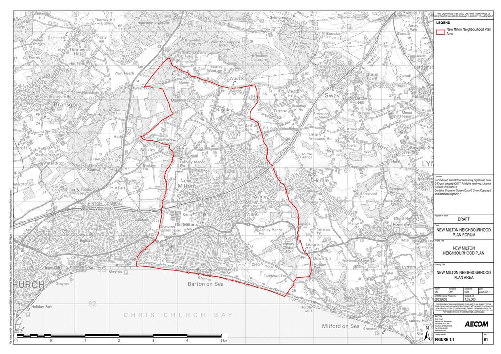
9 1. Introduction Background 1.1 has been commissioned to undertake an independent Sustainability Appraisal in support of New Milton s emerging Neighbourhood Plan. 1.2 The New (NMNP) is currently being prepared as a Neighbourhood Development Plan under the Localism Act 2011 and the Neighbourhood Planning (General) Regulations The New is being prepared in the context of New Forest District Council s emerging Local Plan Review. It is currently anticipated that the New will be submitted to New Forest District Council in Key information relating to the New is presented in Table 1.1. Table 1.1: Key facts relating to New Name of Responsible Authority Title of Plan Subject Purpose New Milton Town Council New Neighbourhood Plan The New is being prepared as a Neighbourhood Development Plan under the Localism Act 2011 and Neighbourhood Planning (General) Regulations The plan will be in general conformity with the New Forest District Council s emerging Local Plan Review The Neighbourhood Plan will be used to guide and shape development within the New area. Timescale To 2036 Area covered by the plan Summary of content Plan contact point The Neighbourhood Plan area covers the parish of New Milton in Hampshire (Figure 1.1). The New will set out a vision, strategy and range of policies for the Neighbourhood Plan area. Graham Flexman Town Clerk New Milton Town Council clerk@newmiltontowncouncil.gov.uk Tel:
10 Sustainability Appraisal (SA) explained 1.4 SA is a mechanism for considering and communicating the impacts of an emerging plan, and potential alternatives in terms of key sustainability issues. The aim of SA is to inform and influence the plan-making process with a view to avoiding and mitigating negative impacts. Through this approach, the SA for the NMNP seeks to maximise the developing plan s contribution to sustainable development. 1.5 SA is undertaken to address the procedures prescribed by the Environmental Assessment of Plans and Programmes Regulations 2004 (the SEA Regulations) which transpose into national law the EU Strategic Environmental Assessment (SEA) Directive 1. It also widens the scope of the assessment from focussing on environmental issues to further consider social and economic issues. SA is a legal requirement for Local Plans; however a Neighbourhood Plan is not a Local Plan and SA is not therefore legally required. 1.6 The NMNP has been screened in by New Forest District Council and the New Forest National Park Authority as requiring a Strategic Environmental Assessment (SA). To meet this requirement, the NMNP is undergoing an SA process which incorporates the requirements of the SA Directive. This mirrors the approach currently being taken for the emerging New Forest District Local Plan Review, and reflects the significant socio-economic issues which the Neighbourhood Plan seeks to address. 1.7 The SA has been undertaken to meet specific requirements prescribed by the Environmental Assessment of Plans and Programmes Regulations 2004 (the SEA Regulations). 1.8 Two key procedural requirements of the SEA Regulations are that: 1) When deciding on the scope and level of detail of the information which must be included in the Environmental Report there is a consultation with nationally designated authorities concerned with environmental issues; and 2) A report (the Environmental Report ) is published for consultation alongside the Draft Plan (i.e. the draft New ) that presents outcomes from the SA (i.e. discusses likely significant effects that would result from plan implementation) and reasonable alternatives. 1.9 This SA Report therefore addresses the requirements of 2) above. Chapter 4 discusses the scope of the SA process. Structure of this SA Report 1.10 This document is the SA Report for the NMNP and hence needs to answer all four of the questions listed above with a view to providing the information required by the SEA Regulations Each of the four questions is answered in turn within this report, as follows: 1 Directive 2001/42/EC 2
11 Table 1.2: Questions that must be answered by the SA Report in order to meet regulatory 2 requirements SA Report question In line with the SEA Regulations, the report must include 3 What is the plan seeking to achieve? An outline of the contents, main objectives of the plan and relationship with other relevant plans and programmes What is the sustainability context? The relevant environmental protection objectives, established at international or national level Any existing environmental problems which are relevant to the plan including those relating to any areas of a particular environmental importance What s the scope of the SA? What is the sustainability baseline? The relevant aspects of the current state of the environment and the likely evolution thereof without implementation of the plan The environmental characteristics of areas likely to be significantly affected Any existing environmental problems which are relevant to the plan including those relating to any areas of a particular environmental importance What are the key issues & objectives? Key problems/issues and objectives that should be a focus of (i.e. provide a framework for) assessment What has plan-making/sa involved up to this point? What are the assessment findings at this stage? Outline reasons for selecting the alternatives dealt with (and thus an explanation of the reasonableness of the approach) The likely significant effects associated with alternatives Outline reasons for selecting the preferred approach inlight of alternatives appraisal/a description of how environmental objectives and considerations are reflected in the draft plan. The likely significant effects associated with the Submission version of the plan The measures envisaged to prevent, reduce and as fully as possible offset any significant adverse effects of implementing the Submission version of the plan What happens next? The next steps for plan making/sa process. 2 Environmental Assessment of Plans and Programmes Regulations NB this column does not quote directly from Schedule II of the Regulations. Rather, it reflects a degree of interpretation. 3
12 2. Local Plan context and vision for the NMNP Local Plan context for the NMNP 2.1 The NMNP is being prepared in the context of the emerging New Forest District Local Plan Review The current New Forest District Local Plan 4 is split into two parts: Part 1: The Core Strategy was adopted in October 2009 and Part 2: Sites and Development Management was adopted in April Part 1 of the Local Plan sets out the strategic policies and objectives for all areas of the district which are outside of the New Forest National Park boundaries, up until the year 2026, with Part 2 outlining the detailed proposals required to implement the planning strategy 5. In order to ensure that the planning polices for the district were fully in-line with the National Planning Policy Framework, the district are in the process of completing a review of the Local Plan. In this context, the Local Plan Review Part 1: Planning Strategy 6 was published in July 2016, outlining the initial proposals for public consultation. 2.3 Given the National Planning Policy Framework was published shortly before the Local Plan Part 2: Sites and Development Management was finalised and submitted for examination, New Forest District Council have committed to undertake an early review of the Local Plan. As such the preparation of the Local Plan Part One: Strategy and Strategic Allocations is underway and will update and replace the Local Plan Part 1: Core Strategy and a small number of strategic or cross-cutting policies in the Local Plan Part 2. Part One of the revised Local Plan will include strategic allocations for new development, generally sites for 100 or more homes or employment/commercial uses of five or more hectares. It is important to note that the current New Forest Local Plan: Core Strategy will remain as the main development plan document for the district until the emerging Local Plan is adopted. In this context, it is anticipated that the emerging Local Plan will be submitted to the Planning Inspectorate in the summer of 2018, and subsequently adopted by mid The key provisions of the emerging Local Plan Review relating to the New Milton Neighbourhood Plan area 7 are as follows: The release of Green Belt land in two locations for a total of 290 homes (SS10 Brockhills Lane for 130 homes and SS11 South of Gore Road for 160 homes). The need for an additional 200 homes to be planned for by the New Milton Neighbourhood Plan, including either the saving of the Local Plan Part 2 sites policies or their replacement and/or addition by the Neighbourhood Plan All open market housing to include at least 20% of non-standard types/tenures Affordable housing to be delivered at 50%. Of these, the greater number need to be smaller: 1-2 bed 2.5 Neighbourhood plans will form part of the development plan for the district, alongside, but not as a replacement for the Local Plan. The Local Plan Review seeks to give communities a solid framework within which appropriate community-led planning policy documents, including neighbourhood plans, can be brought forward. Neighbourhood plans are required to be in general conformity with the strategic policies of the Local Plan and can develop policies and 4 New Forest District Council (2018): New Forest District Local Plan Part 1: Core Strategy, [online] available to download via: < last accessed [02/03/18] 5 New Forest District Council (2018): Local Plan Part 2: Sites and Development Management, [online] available to download via: < last accessed [02/03/18] 6 New Forest District Council (2018): Local Plan Review , [online] available to download via: < last accessed [02/03/18] 7 Based on communication between New Forest District Council and New Milton Town Council as at September
13 proposals to address local place-based issues. In this way it is intended for the Local Plan to provide a clear overall strategic direction for development in New Forest District, whilst enabling finer detail to be determined through the neighbourhood planning process where appropriate. 2.6 In this context the NMNP seeks to shape new development in the Neighbourhood Plan area through taking a proactive approach to site allocations in the Neighbourhood Plan area. This is with a view to supporting the vitality of the Neighbourhood Plan area, including through delivering housing of a range of types and tenures which encourages and facilitates a diversification of the age profile of the community. Vision for the NMNP 2.7 The vision for the NMNP, which was developed during earlier stages of plan development, is as follows: New Milton has changed for the better. The influx of younger people, many using our improved rail services for commuting, has led to a wider range of shops and services in the town centre and more employment opportunities through the retention of key local employers. There are now more school places and extra childcare facilities, and we have a more vibrant arts and cultural scene. Our roads remain very busy, but more people now use our local bus services or cycle or walk to work or to the town centre. Barton-on-Sea has retained its local character and remains a popular place to live for our older residents. Some small infill housing schemes have fitted in well. The seafront, although continually challenged by the effects of erosion, remains a popular attraction for local people and visitors alike. Our part of the National Park, around Bashley, has maintained its special landscape character, with little change other than through the provision of appropriate small scale rural affordable housing. 2.8 In order to achieve this vision, the following objectives are outlined in the Neighbourhood Plan: To reduce the difference in population numbers between the age group and 65+ age group To widen the role of the Town Centre in its range of the retail and service sector uses, in its cultural function and as a vital housing location To increase the capacity of the early years and education sector To reduce the number of visits by local people to the New Forest for short recreation trips To increase the number of commuting trips by rail, bus, cycling and walking To Increase the capacity of the arts and cultural sectors 2.9 To support the Neighbourhood Plan s vision and objectives, the NMNP sets out 17 Neighbourhood Plan policies. The latest iteration of these policies has been appraised in Chapter 5. 5
14 3. The Scope of the SA SA Scoping Report 3.1 The SEA Regulations require that: When deciding on the scope and level of detail of the information that must be included in the report, the responsible authority shall consult the consultation bodies. In England, the consultation bodies are Natural England, the Environment Agency and Historic England. 8 These authorities were consulted on the scope of the NMNP SA in June The purpose of scoping was to outline the scope of the SA through setting out: A context review of the key environmental and sustainability objectives of national, regional and local plans and strategies relevant to the Neighbourhood Plan; Baseline data against which the Neighbourhood Plan can be assessed; The key sustainability issues for the Neighbourhood Plan; and An SA Framework of objectives against which the Neighbourhood Plan can be assessed. 3.3 Baseline information (including the context review and baseline data) is presented in Appendix A. 3.4 Comments received on the Scoping Report, and how they have been considered and addressed, are presented in Table 3.1. Table 3.1: Consultation responses received on the SA Scoping Report Consultation response Natural England Sharon Jenkins, Consultation Team Screening Request: Strategic Environmental Assessment / Sustainability Appraisal It is our advice, on the basis of the material supplied with the consultation, that, in so far as our strategic environmental interests are concerned (including but not limited to statutory designated sites, landscapes and protected species, geology and soils) are concerned, that there are unlikely to be significant environmental effects from the proposed plan. Comment noted How the response was considered and addressed 8 In-line with Article 6(3).of the SA Directive, these consultation bodies were selected because by reason of their specific environmental responsibilities,[they] are likely to be concerned by the environmental effects of implementing plans and programme. 6
15 Consultation response Neighbourhood Plan Guidance on the assessment of Neighbourhood Plans in light of the SA Directive is contained within the National Planning Practice Guidance. The guidance highlights three triggers that may require the production of an SA, for instance where: a neighbourhood plan allocates sites for development the neighbourhood area contains sensitive natural or heritage assets that may be affected by the proposals in the plan the neighbourhood plan may have significant environmental effects that have not already been considered and dealt with through a sustainability appraisal of the Local Plan. We have checked our records and based on the information provided, we can confirm that in our view the proposals contained within the plan will not have significant effects on sensitive sites that Natural England has a statutory duty to protect. We are not aware of significant populations of protected species which are likely to be affected by the policies / proposals within the plan. It remains the case, however, that the responsible authority should provide information supporting this screening decision, sufficient to assess whether protected species are likely to be affected. Notwithstanding this advice, Natural England does not routinely maintain locally specific data on all potential environmental assets. As a result the responsible authority should raise environmental issues that we have not identified on local or national biodiversity action plan species and/or habitats, local wildlife sites or local landscape character, with its own ecological and/or landscape advisers, local record centre, recording society or wildlife body on the local landscape and biodiversity receptors that may be affected by this plan, before determining whether an SA/SA is necessary. Please note that Natural England reserves the right to provide further comments on the environmental assessment of the plan beyond this SA/SA screening stage, should the responsible authority seek our views on the scoping or environmental report stages. This includes any third party appeal against any screening decision you may make. Comment noted How the response was considered and addressed The SA process has considered the European, national and locally important sites for biodiversity in the context of the emerging Neighbourhood Plan. Comment noted Comment noted 7
16 Consultation response Historic England Robert Lloyd-Sweet, Historic Places Adviser We are pleased to see that the scoping report identifies the local distinctiveness study for New Milton and the Old Milton Conservation Area Appraisal as important sources of evidence for the Neighbourhood Plan. The review of key features of the conservation area is of particular help. We would like to see this reflected in more locally specific criteria for assessing the impact of options on the sustainability objectives to Protect, maintain, enhance the cultural heritage of the area. For example, the view of the Conservation Area along Southern Lane is picked out as particularly sensitive and its conservation should therefore, perhaps, be identified as a criterion. Unfortunately, we note that the scoping report does not reference the County Historic Environment Record as a key source of information regarding the presence of non-designated heritage assets. The HER is available via an online searchable database and we expect SA scoping reports to identify this as a matter of course where the plan proposes to allocated sites for development. The HER is identified in the PPG as an important source of information on the historic environment for neighbourhood plans. As such we would, at present consider the scoping report to be deficient. We recommend the report is amended to identify the HER and to include a brief review of the evidence it contains with regard to the recorded presence and distribution of recorded archaeological remains and consideration for any areas of particularly high potential for remains of archaeological interest. This may also include consideration of the previous loss of any sites of particular archaeological interest, which may be identified as an issue to which future development might make a cumulative impact. We note the brief reference to the purpose of the Green Belt on page 26 and would suggest this would be improved by reference to the five purposes of the green belt, which, helpfully, are set out in the NPPF as: to check the unrestricted sprawl of large builtup areas; to prevent neighbouring towns merging into one another; to assist in safeguarding the countryside from encroachment; to preserve the setting and special character of historic towns; and to assist in urban regeneration, by encouraging the recycling of derelict and other urban land. How the response was considered and addressed The assessment questions within the Landscape and Historic Environment section of the SA Framework have been reviewed and updated to state the following: Conserve and enhance the significance of buildings and structures of architectural or historic interest, both designated and nondesignated, and their setting? Support the setting and special qualities of the Old Milton Green Conservation Area? The sensitivity of the view of the Conservation Area along Southern Lane has been included as a headline sustainability issue within the Landscape and Historic Environment SA Theme. The summary of current baseline for the Landscape and Historic Environment SA theme has been updated to reference the Historic Environmental Record (HER) for Hampshire (presented in Appendix A of this SA Report). The assessment questions within the Landscape and Historic Environment section of the SA Framework have been reviewed and updated to state the following: Conserve and enhance the significance of buildings and structures of architectural or historic interest, both designated and nondesignated, and their setting? Support the undertaking of archaeological investigations and, where appropriate, recommend mitigation strategies. Conserve and enhance archaeological remains, including historic landscapes? The summary of current baseline in the Landscape and Historic Environment SA theme has been updated to reference the five purposes of the Green Belt, as set out in the NPPF. Additionally, the assessment questions within the Landscape and Historic Environment section of the SA Framework have been reviewed and updated to state the following: Support the green belt designation present in the area, in accordance with its five purposes as set out in the NPPF? 8
17 Consultation response Environment Agency Charlotte Lines, Senior Planning Adviser General Comments The Environment Agency is a statutory consultee in the planning process providing advice to Local Authorities and developers on pre-application enquiries, planning applications, appeals and strategic plans. We recommend an objective is included to protect and enhance the environment. Indicators should relate to the environmental constraints in your local area. This may include water quality, and biodiversity. We also recommend your SA takes account of relevant policies, plans and strategies including your local Strategic Flood Risk Assessment, flood risk strategies ( and the South East River Basin Management Plan ( Together with Natural England, English Heritage and Forestry Commission we have published joint advice on neighbourhood planning which sets out sources of environmental information and ideas on incorporating the environment into plans. This is available at: / Specific Comments Page 22 under SA objective support the resilience of the NP area to the potential effects of climate change including flooding you have stated that the option will ensure inappropriate development takes place in areas at higher risk of flooding. We would suggest that the wording is amended as it contradicts National Planning Policy. Wording along the lines of opportunities to reduce flood risk and put the most vulnerable development in lower flood risk area would be more appropriate. New Forest District Council and the New Forest National Park Authority are currently in the process of producing a joint Level 2 Strategic Flood Risk Assessment (SFRA) and this should be used to inform the emerging SA, ensuring that flood risk and climate change is fully taken into account when considering allocation options and in the preparation of plan policies, including policies for flood risk management to ensure that flood risk is not increased. How the response was considered and addressed The following plans and policies have been added to the context review and baseline data presented in Appendix A of this SA Report: Strategic Flood Risk Assessment (SFRA) for the New Forest (Climate Change chapter); and South East River Basin Management Plan (Land, Soil and Water Resources chapter). The Neighbourhood Planning advice has been considered through the SA process. The assessment questions within the Climate Change section of the SA Framework have been reviewed and updated to state the following: Ensure that no inappropriate development takes place in areas at higher risk of flooding, taking into account the likely future effects of climate change? Comment noted 9
18 Key Sustainability Issues 3.5 Drawing on the review of the sustainability context and baseline, the SA Scoping Report was able to identify a range of sustainability issues that should be a particular focus of SA. These issues are as follows, presented by eight SA Themes. 3.6 Air Quality Air quality in the NMNP area is good, with no significant issues identified There are no Air Quality Management Areas and no Air Quality Action Plans in place within the Neighbourhood Plan area. Housing and employment growth s impacts on traffic and congestion in the Neighbourhood Plan area have the potential to increase emissions and reduce air quality. 3.7 Biodiversity and Geodiversity Internationally, nationally and locally designated sites are present in the NMNP area. The majority of the built up area of the NMNP area is within SSSI Impact Risk Zones for either the New Forest SSSI or the Highcliffe to Milford Cliffs SSSI The NMNP area has a rich geodiversity resource which should be protected and enhanced. Biodiversity Action Plan Habitats are present through the NMNP area supporting a range of species, including protected species. Key issues relating to European designated sites have been considered through the Habitats Regulations Assessment currently being undertaken for the Neighbourhood Plan. 3.8 Climate Change An increase in the built footprint of the NMNP area (associated with the delivery of new housing and employment land) has the potential to increase overall greenhouse gas emissions. New Forest District has had slightly higher per capita emissions total than that of both the South East of England and England as a whole since However New Forest District has also seen a greater reduction in emissions when compared with 19.3% the South East and England. The potential effects of climate change on the NMNP area are varied. AS such there is a need to improve the resilience of the Neighbourhood Plan area by supporting and encouraging adaptation strategies. 3.9 Landscape and Historic Environment The New Forest National Park covers the northern part of the NMNP area. Green Belt covers a significant proportion of the NMNP area. The NMNP area has 33 Grade II Listed buildings. 13 distinct landscape character areas have been identified within the NMNP area New development has the potential to lead to beneficial and adverse effects on the historic environment, including through affecting the setting of cultural heritage assets and landscape/townscape quality. New development could lead to pressures on non-designated sites and townscapes, including from the loss of key built and natural features. Improvement in access to and enhancement of, historic environment assets and enhancements to local distinctiveness through high quality development has potential for positive benefits for tourism. As stated within the Old Milton Conservation Area Appraisal, the view of the conservation area along Southern Lane is particularly sensitive to change. 10
19 3.10 Land, Soil and Water Resources A detailed agricultural land classification assessment has been undertaken in the NMNP area, with a number of areas of land classified as Grade 2 and Grade 3a agricultural land, noted for being the best and most versatile for agricultural purposes. There are three watercourses within the NMNP area An area in the north of the NMNP area is within a Nitrate Vulnerable Zone, as is a large area adjacent to the NMNP area Population and Community A significantly higher proportion of residents are over 65 years of age when compared to regional and national averages. The Neighbourhood Plan area has an ageing population. An ageing population has implications for community and service provision in the Neighbourhood Plan area. A more balanced profile is required to ensure viability and sustainability for New Milton to ensure a thriving economy and working age people to provide essential local services. The current gap between lower incomes and high house and rental prices means there is a need for affordable homes that corresponds with the 930 homes proposed through the New Forest Local Plan. However, this need is unlikely to be met due to economic viability for development. To support existing businesses and attract new businesses into New Milton a pool of younger and technically qualified young people is needed. This will help support higher salaries. New Milton town centre currently lacks vitality. An ageing population is unlikely to enhance the viability and economic vitality of the area Health and Wellbeing The majority of residents within the NMNP area report their health to be very good, or good. However the level of reported very good health is below local, regional and national averages. Comparatively more residents report bad health or very bad health than district, South East or national averages. Community consultation highlights that the quality of the environment and opportunities for leisure and recreation are a key influence on physical and mental health. An ageing population has the potential to increase pressures on healthcare services Transportation New Milton railway station is located within the NMNP area, with services to local, regional and national destinations, including direct to London Waterloo. The rail link is a key contributor to the quality of life of residents and economic vitality. A limitation of traffic congestion and adequate parking are important to the quality of life of local residents. There are a number of bus services running in the area. There is, however, inadequate service within the town with the result of reliance on cars. Relevant in particular to older age groups, there are limited affordable options for transport for which driving is no longer a practical option. There is also an inadequate evening bus service which is limiting a night time economy in the town. Increased commuter traffic through Bashley is a great concern to the village, as well as problems with speeding. 11
20 There is a need for continued enhancements to public transport and walking and cycling networks in the Neighbourhood Plan area. There is a lack of a comprehensive and co-ordinated walking and cycling network in New Milton. The town centre experiences significant congestion issues, particularly during peak summer periods. SA Framework 3.14 The issues were then translated into an SA Framework. This SA Framework provides a methodological framework for the appraisal of likely significant effects on the baseline. The SA framework for the NMNP is presented below. Table 3.2: SA Framework for the South SA Objective Assessment questions Air Quality Improve air quality in Will the option/proposal help to: the Neighbourhood Plan area and minimise Promote the use of sustainable modes of transport, including walking, cycling and public transport? and/or mitigate against all sources of environmental pollution. Implement measures (such as appropriate planting and provision of green infrastructure) which will help support air quality in the Neighbourhood Plan area? Biodiversity and Geodiversity Protect and enhance all Will the option/proposal help to: biodiversity and geological features. Support continued improvements to the status of the European designated sites of significance within and/or adjacent to the Neighbourhood Plan area boundary, including The New Forest SPA and SAC? Support the status of the nationally designated sites of significance within and/or adjacent to the Neighbourhood Plan area boundary, including the Highcliffe to Milford Cliffs SSSI and the New Forest SSSI? Protect and enhance semi-natural habitats? Protect and enhance priority habitats, and the habitat of priority species? Achieve a net gain in biodiversity? Support enhancements to multifunctional green infrastructure networks? Climate Change Reduce the level of contribution to climate change made by activities within the Neighbourhood Plan area Protect and enhance sites of geodiversity interest? Support access to, interpretation and understanding of biodiversity and geodiversity? Will the option/proposal help to: Reduce the number of journeys made? Reduce the need to travel? Promote the use of sustainable modes of transport, including walking, cycling and public transport? Increase the number of new developments meeting or exceeding sustainable design criteria? Generate energy from low or zero carbon sources? Reduce energy consumption from non-renewable resources? Encourage and facilitate energy efficient and sustainable design within new development? 12
21 SA Objective Assessment questions Support the resilience Will the option/proposal help to: of the Neighbourhood Plan area to the potential effects of Ensure that no inappropriate development takes place in areas at higher risk of flooding, taking into account the likely future effects of climate change? climate change, including flooding Improve and extend green infrastructure networks in the plan area to support adaptation to the potential effects of climate change? Sustainably manage water run-off, reducing surface water runoff (either within the plan area or downstream)? Ensure the potential risks associated with climate change are considered through new development in the Neighbourhood Plan area? Increase the resilience of biodiversity in the plan area to the effects of climate change, including enhancements to ecological networks? Landscape and Historic Environment Protect, maintain and Will the option/proposal help to: enhance the cultural heritage resource within the Conserve and enhance the significance of buildings and structures of architectural or historic interest, both designated and nondesignated, and their setting? Neighbourhood Plan area, including the Support the setting and special qualities of the Old Milton Green Conservation Area? historic environment Support the integrity of the historic setting of key buildings of and archaeological cultural heritage interest? assets. Conserve and enhance local diversity and character? Support access to, interpretation and understanding of the historic environment? Protect and enhance the integrity of the Old Milton Green Conservation Area? Support the undertaking of archaeological investigations and, where appropriate, recommend mitigation strategies. Conserve and enhance archaeological remains, including historic Protect and enhance the character and quality of landscapes and townscapes. landscapes? Will the option/proposal help to: Support the integrity of the local landscape character? Conserve and enhance landscape and townscape features? Protect and enhance the integrity of the Old Milton Green Conservation Area? Support the green belt designation present in the area, in accordance with its five purposes as set out in the NPPF? Land, Soil and Water Resources Ensure the efficient and Will the option/proposal help to: effective use of land. Promote the use of previously developed land? Avoid the development of the best and most versatile agricultural land, which in the parish may comprise Grade 2 and 3a agricultural land? Promote sustainable Will the option/proposal help to: waste management Reduce the amount of waste produced? solutions that Support the minimisation, reuse and recycling of waste? encourage the Maximise opportunities for local management of waste in order to reduction, re-use and minimise export of waste to areas outside? recycling of waste. Encourage recycling of materials and minimise consumption of resources during construction? Use and manage water Will the option/proposal help to: resources in a Support improvements to water quality? sustainable manner. Minimise water consumption? Protect groundwater resources Provide adequate infrastructure provision for water supply and sewerage? 13
22 SA Objective Assessment questions Population and Community Create a more Will the option/proposal help to: balanced age profile by 2036 Enable enough working age people to live and work in New Milton to balance the age profile? Encourage younger people and families to stay in the area to help balance the age profile? Cater for existing and Will the option/proposal help to: future residents needs as well as the needs of Promote the development of a range of high quality, accessible community facilities? different groups in the community, and Encourage and promote social cohesion and encourage active involvement of local people in community activities? improve access to Minimise fuel poverty? local, high-quality Improve the availability and accessibility of key local facilities, community services including specialist services for disabled and older people? and facilities. Support the provision of land for allotments and cemeteries? Provide everyone with Will the option/proposal help to: the opportunity to live in good quality, secure Provide housing which is affordable and attractive to younger people and families and meet the identified need? affordable housing, and Support the provision of a range of house types and sizes? ensure an appropriate Promote the provision of affordable housing which provide the security mix of dwelling sizes, of meeting longer term needs? types and tenures. Support enhancements to the current housing stock? Meet the housing needs of an increasing population of over 65s Encourage older age groups to down size to meet their changing needs while freeing up larger family homes? Provide quality and flexible homes that meet people s needs? Promote the use of sustainable building techniques, including use of sustainable building materials in construction? Provide housing in sustainable locations that allow easy access to a range of local services and facilities? Regenerate the local Will the option/proposal help to: economy with knowledge-based Enable and encourage key local business and employment opportunities to stay and grow in New Milton? businesses, support existing and developing Provide appropriate accommodation and support services for knowledge-based businesses? businesses to increase Ensure a suitably qualified talent pool in New Milton? efficiency and Enhance high quality employment opportunities? profitability and raise qualification levels. Support the future Will the option/proposal help to: adaptation and Provide a greater quality and variety of retail and leisure opportunities? evolution of New Milton Support the evening economy? town centre to create a Support the visitor economy of the Neighbourhood Plan area? thriving social, retail and leisure centre for all? Enhance educational Will the option/proposal help to: attainment in the Neighbourhood Plan Provide enough school and pre-school places for increased population area to support Raise qualification levels to provide pool of qualified workers to attract economic vitality? business Link educational opportunities to new knowledge-based businesses for young people here and to attract young people to move here 14
23 SA Objective Health and Wellbeing Improve the health and wellbeing of residents within the New Milton Neighbourhood Plan area. Transportation Promote sustainable transport use and reduce the need to travel. Assessment questions Will the option/proposal help to: Promote accessibility to a range of leisure, health and community facilities, for all age groups? Align to the priority areas outlined in the Joint Strategic Needs Assessment? Provide and enhance the provision of community access to green infrastructure, in accordance with Accessible Natural Greenspace Standards? Reduce noise pollution? Promote the use of healthier modes of travel? Improve access to the countryside for recreational use? Provide safe accessibility around the town (with the Green Loop and Rail Trail), to the station, New Forest, coast and employment sites by foot? Respond to an increase in the Neighbourhood Plan s older population through attracting younger people to the area? Will the option/proposal help to Encourage modal shift to more sustainable forms of travel? Help reduce congestion in the town centre and other key hotspots, including Bashley village? Help reduce congestion on key through routes, such as Bashley village? Enable sustainable transport infrastructure enhancements? Facilitate working from home and remote working? Improve road safety? Reduce the impact on residents from the road network? 15
24 4. What has plan making / SA involved to this point? Introduction 4.1 In accordance with the SEA Regulations the SA Report must include An outline of the reasons for selecting the alternatives dealt with; and The likely significant effects on the environment associated with alternatives / an outline of the reasons for selecting the preferred approach in light of alternatives appraised. 4.2 The narrative of plan-making / SA up to this point is told within this part of the SA Report. Specifically, this section explains how preparation of the current version of the NMNP has been informed by an assessment of alternative locations for non-strategic scale development in the Neighbourhood Plan area. Overview of plan making / SA work undertaken since (date) 4.3 Plan-making for the NMNP has been underway since February Initial work incorporated the inauguration of a Neighbourhood Plan Working Party and engagement with New Forest District Council. A range of consultation events have since been carried out for the Neighbourhood Plan to engage the community and enable their input into the plan making process. This has included community questionnaires, drop in sessions and workshops. 4.4 The following sections discuss the evolution of the NMNP in association with the SA process. Assessment of reasonable alternatives for the Neighbourhood Plan 4.5 A key element of the SA process is the appraisal of reasonable alternatives for the NMNP. The SEA Regulations 9 are not prescriptive as to what constitutes a reasonable alternative, stating only that the Environmental Report (i.e. SA Report) should present an appraisal of the plan and reasonable alternatives taking into account the objectives and geographical scope of the plan. 4.6 As discussed in Section 2.1, the Neighbourhood Plan has been prepared in conjunction with the provisions of the emerging New Forest District Local Plan. This incorporates the release of Green Belt land in two locations for a total of 290 homes (SS10 Brockhills Lane and SS11 South of Gore Road) and a need for an additional 200 homes to be planned for by the NMNP. 4.7 In recognition of the need to be in general conformity with the Local Plan, the Neighbourhood Plan will facilitate the development of 130 homes at Brockhills Lane and 160 homes at Gore Road. As such this leaves an additional 200 homes to be planned for by the Neighbourhood Plan. 4.8 To support the development of a spatial strategy to deliver these indicative numbers, the Neighbourhood Plan Working Group was keen to consider alternative locations for delivering housing in the Neighbourhood Plan area. In light of this, the Neighbourhood Plan Steering Group considered where broadly in the parish such development should go. 4.9 To support decision making on this element of the plan, the SA process has considered two sets of options, with a view to exploring the sustainability implications of delivering housing in alternative locations in the Neighbourhood Plan area The following sections therefore present the assessment of these sets of options. 9 Environmental Assessment of Plans and Programmes Regulations
25 Assessment of broad locations for housing 4.11 To support the development of a spatial strategy to deliver the indicative number of 200 homes, the Neighbourhood Plan Working Group was keen to consider alternative locations for delivering housing in the parish The SA process has considered three options, with a view to exploring the sustainability implications of delivering housing in alternative broad locations in the parish. Corresponding with the two principal settlements of the Neighbourhood Plan area, the options are as follows: Option 1: Facilitate the delivery of homes through the Neighbourhood Plan through a focus on New Milton Option 2: Facilitate the delivery of homes through the Neighbourhood Plan through a focus on Barton-on-Sea Option 3: Facilitate the delivery of homes through the Neighbourhood Plan in locations outside of New Milton and Barton-on-Sea With regard to Option 3, it is noted that the areas outside of New Milton and Barton-on-Sea are within designated Green Belt, with the exception of the area to the north of New Milton, which is located within the New Forest National Park. The current NPPF does not allow Neighbourhood Plans to change Green Belt boundaries and Green Belt boundaries can only be altered in exceptional circumstances through the preparation or review of a Local Plan. In March 2018 the Ministry of Housing, Communities and Local Government launched a consultation on a revised NPPF which consolidates a number of recent proposed changes and additions. Paragraph 135 of the draft revised NPPF notes that where a Local Plan identifies a need for Green Belt release then detailed amendments to those boundaries may be made through local policies, including Neighbourhood Plans. It is noted though that the revised NPPF remains in draft and at the consultation stage, and the current provisions of the NPPF will remain in place in the short term. However, it was viewed worth considering Option 3 as an alternative to be considered through the SA process given it would help provide context to decisions made on the Neighbourhood Plan and help highlight the relative sustainability merits of alternative approaches The SA team appraised these three broad options as reasonable alternatives against both the baseline and relatively (i.e. against each other). These were considered through the SA Framework of objectives and assessment questions developed during scoping and the three options have been ranked in terms of their sustainability performance against the relevant SA Theme The following table presents appraisal findings in relation to the three options introduced above. These are organised by the eight SA Themes For each SA Theme, a commentary on the likely effects is presented. Options are also ranked numerically reflecting their relative sustainability performance, with 1 the most favourable ranking and 3 the least favourable ranking The findings of the appraisal are presented in Table 4.1 below. 17
26 Table 4.1: Appraisal findings: reasonable alternatives for broad locations of development Option 1: Facilitate the delivery of homes through the Neighbourhood Plan through a focus on New Milton Option 2: Facilitate the delivery of homes through the Neighbourhood Plan through a focus on Barton-on-Sea Option 3: Facilitate the delivery of homes through the Neighbourhood Plan in locations outside of New Milton and Barton-on-Sea. SA Theme Air Quality Biodiversity and geodiversity Discussion of potential effects and relative merits of options Through directing new development to the more rural parts of the Neighbourhood Plan area, which have fewer services and facilities, Option 3 would do the most of the options to lead to increased car dependency and a more limited use of sustainable modes of transport. This has the potential to lead to increases in emissions from transport through increasing the need to travel for key services and facilities. In a similar context, Option 1, through locating development in the settlement with the broadest range of services, facilities and amenities (New Milton) has the most potential of the options to limit emissions from transport. Option 2, through directing housing to Barton-on-Sea, which has fewer amenities than New Milton, is however less likely to support a limitation of emissions. The delivery of housing in the rural parts of the Neighbourhood Plan area has increased potential to lead to impacts on sites internationally and nationally designated for their nature conservation value. For example the area north of New Milton within the National Park is within a number of SSSI Impact Risk Zones (IRZ) for residential development, including IRZs for all planning applications and residential development of 25 units or more. These impacts relate to the New Forest SSSI. This is significant given the area covered by the SSSI is also internationally designated as the New Forest Ramsar site, New Forest SAC and New Forest SPA. In relation to the rural areas outside of Barton-on-Sea, the area to the west of the settlement is within an SSSI IRZ relating to the New Forest SSSI for all planning applications (except householder) outside or extending outside existing settlements/urban areas affecting greenspace, farmland, semi natural habitats or landscape features such as trees, hedges, streams, rural buildings/structures. Alongside, areas to the east of the settlement are within an SSSI IRZ relating to the Highcliffe to Milford Cliffs SSSI for all planning applications. Whilst parts of both New Milton and Barton-on-Sea are within IRZs for the two SSSIs, these areas are less sensitive given their more urban context. This is reflected by the categories of IRZs in these areas being less restrictive. Overall therefore, Option 3 has increased potential of the three options to lead to adverse impacts on internationally and nationally designated sites. In terms of key biodiversity habitats, both New Milton and Bartonon-Sea have significant areas of Biodiversity Action Plan (BAP) Priority Habitat located within or adjacent to the settlements. This includes significant areas of deciduous woodland BAP Priority Habitat in the vicinity of New Milton (a number of which are also Ancient Woodland) and Woodpasture and Parkland BAP Priority Habitat located to the east of Barton-on-Sea. Rank of preference Opt 1 Opt 2 Opt
27 Option 1: Facilitate the delivery of homes through the Neighbourhood Plan through a focus on New Milton Option 2: Facilitate the delivery of homes through the Neighbourhood Plan through a focus on Barton-on-Sea Option 3: Facilitate the delivery of homes through the Neighbourhood Plan in locations outside of New Milton and Barton-on-Sea. SA Theme Climate change Landscape and historic environment Discussion of potential effects and relative merits of options In terms of greenhouse gas emissions, road transport is an increasingly significant contributor to emissions in the Neighbourhood Plan area. The extent to which the three options have the potential to support climate change mitigation through facilitating a reduced level of car dependency is therefore a key element. Through directing new development to the more rural parts of the Neighbourhood Plan area, which have fewer services and facilities, Option 3 would do the most of the options to lead to increased car dependency and a more limited use of sustainable modes of transport. This has the potential to lead to increases in greenhouse gas emissions from transport through increasing the need to travel for key services and facilities. In a similar context, Option 1, through locating development in the settlement with the broadest range of services, facilities and amenities (New Milton) has the most potential of the options to limit emissions from transport. Option 2, through directing housing to Barton-on-Sea, which has fewer amenities than New Milton, is however less likely to support a limitation of emissions. In relation to flood risk, all three areas covered by the options have flood risk issues in some limited locations, with historic flooding experienced. No existing properties are at risk of coastal flooding. Whilst the three options have the potential to lead to development in areas of elevated levels of flood risk, it is considered that the provisions of the NPPF and national policy in relation to flooding will help guide development away from flood risk areas and ensure that appropriate mitigation measures are implemented. For example, the NPPF does not permit development within flood risk areas or where the effect would be to increase flood risk elsewhere without appropriate mitigation measures. Likewise, adherence to the recommendations and guidance presented in the Strategic Flood Risk Assessment (SFRA) undertaken for the wider district will help limit effects. In relation to landscape designations, rural areas in the north of the Neighbourhood Plan area are within the New Forest National Park, which is a nationally designated landscape. In this context development to the north of New Milton has the potential to have impacts on the setting of the National Park. It should be noted however that development taken forward through all three options has the potential to have impacts on landscape character with inappropriate location, design and layout of development, including relating to the existing setting of the settlements in the Neighbourhood Plan area. New Milton and Barton-on-Sea do not have a rich historic environment (with the exception of the Old Milton Green Conservation Area, which covers a small part of New Milton). A number of nationally designated listed buildings are however present in rural areas in the vicinities of these settlements. In this context, Option 1 and 2 have the potential to lead to impacts on the historic environment and landscape character through facilitating growth in the vicinities of New Milton and Barton-on-Sea. However, Option 3, through directing development to the more sensitive areas of the Neighbourhood Plan area, has the most potential of the options to lead to impacts on historic environment assets and their settings and landscape character. Rank of preference Opt 1 Opt 2 Opt
28 Option 1: Facilitate the delivery of homes through the Neighbourhood Plan through a focus on New Milton Option 2: Facilitate the delivery of homes through the Neighbourhood Plan through a focus on Barton-on-Sea Option 3: Facilitate the delivery of homes through the Neighbourhood Plan in locations outside of New Milton and Barton-on-Sea. SA Theme Land, Soil and Water Resources Population and community Health and Wellbeing Transportation Discussion of potential effects and relative merits of options A significant area of Grade 2 agricultural land is present to the north east of Barton-on-Sea. As such development in the vicinity of the settlement through Option 2 and Option 3 has increased potential to lead to the loss of land classified as the Best and Most Versatile Agricultural Land. There are also some more limited areas of land classified as the Best and Most Versatile Agricultural Land (Grade 3a land) north of New Milton, which have the potential to be lost to development through Option 1. In relation to water supply, the NPPF states that local plans should plan positively to ensure the provision of infrastructure for water supply, including an assessment of its quality and capacity. In the context of the current assessment, it is anticipated that the Water Resources Management Plans prepared by water supply companies will be expected to address long-term water supply issues associated with growth in the Neighbourhood Plan area. Accessibility to services and facilities is a key influence on the quality of life of residents and community cohesion. New Milton has by far the broadest range of services and facilities in the Neighbourhood Plan area. Barton-on-Sea has a more limited range, with other areas of the Neighbourhood Plan area dependent on the two main settlements and settlements outside of the Neighbourhood Plan area. In this context Option 1, through focusing housing in the settlement (New Milton) with the broadest range of amenities, will do more to promote the location of new housing in accessible locations. This will help limit the need for residents to travel for day-to-day services and facilities, supporting their quality of life. It will also help promote the vitality of New Milton town centre through supporting the variety of local shops and services. In terms of housing numbers, all of the options will meet the relevant Local Plan requirement for the Neighbourhood Plan area, and will, given the size of the likely allocations, facilitate affordable housing within allocations. Directing development to New Milton through Option 1 will enhance accessibility through directing housing to the settlement with the broadest range of services and facilities. It will also enhance accessibility to local medical facilities in New Milton and in the north of Barton-on-Sea. This will have benefits for the health and wellbeing of residents. Locating more housing in closer proximity to the facilities available will also support quality of life and wellbeing through promoting walking and cycling and active lifestyles. Option 1, through focusing housing in the settlement (New Milton) with the broadest range of amenities, will do more to promote the location of new housing in accessible locations. This will help limit the need for residents to travel for day-to-day services and facilities and support sustainable modes of travel, including walking and cycling. The settlement also has the most frequent and broadest range of public transport services, including rail and bus services. Option 2 (and particularly) 3, through focusing housing in the locations with a limited range of services and amenities, will do less to promote the location of new housing in accessible locations. This will increase the need for residents to travel for day-to-day services and facilities. Rank of preference Opt 1 Opt 2 Opt
29 New Milton: Development on previously developed land vs greenfield development 4.18 Following the consideration of where broadly new development should go in the Neighbourhood Plan area, and the outcomes of consultation events undertaken for the NMNP, it was decided that New Milton was the most appropriate location to direct new development. This is given the broader range of services and facilities available in the town, and a desire to both reconfigure the demographic profile of the town and support the vitality of the town centre In light of this, the Neighbourhood Plan Working Group was also keen to explore further options for directing the location of new development within New Milton town. In this context two potential options were considered, namely whether to 1) focus development on existing previously developed brownfield sites in New Milton or 2) widen the scope of the Neighbourhood Plan to consider development on previously undeveloped greenfield sites in the vicinity of New Milton. This was with a view to delivering allocations for the remaining 200 homes as required by NFDC To support decision making on this element of the NMNP, two options were considered as reasonable alternatives through the SA process. The two options were as follows: 1) Option 1: Facilitate the development of greenfield sites around New Milton; and 2) Option 2: Focus development on previously developed sites in New Milton Table 4.2 presents the findings of the appraisal of Option 1 and Option 2 outlined above. To support the assessment findings, the options have been ranked in terms of their sustainability performance against the relevant theme. Table 4.2: Appraisal findings: options for broad locations of development Option 1: Facilitate the development of greenfield sites around New Milton Option 2: Focus development on previously developed sites in New Milton SA theme Air Quality Biodiversity and geodiversity Discussion of potential effects and relative merits of options Option 2, through promoting development on previously developed land, has increased potential to facilitate the development of new housing at locations which are more integrated within the built up area of New Milton. This has the potential to allow at some locations easier access to town centre services and facilities by sustainable modes of transport such as walking and cycling. Through encouraging residents to travel by active modes of transport for shorter trips, this option has increased potential to limit contributions to air pollution private vehicles. Potential effects on biodiversity have the potential to take place on both previously developed and greenfield land. Whilst greenfield development has the potential to lead to the loss of key landscape features of biodiversity value and impact on ecological corridors, previously developed land can also support a biological diversity. In this context previously developed land can provide habitat for Priority Species and contribute to wider ecological networks, as well as the provision of ecosystem services such as pollination. All allocations have the potential to have impacts on biodiversity assets if located inappropriately and have poor design and layout. Likewise all allocations have the potential to promote net gains in biodiversity value. In this context, for all sites, potential effects on biodiversity depend on elements such as the provision of green infrastructure to accompany new development areas and the retention and incorporation of biodiversity features. Rank of preference Opt 1 Opt
30 Option 1: Facilitate the development of greenfield sites around New Milton Option 2: Focus development on previously developed sites in New Milton SA theme Climate change Landscape and historic environment Land, Soil and Water Resources Discussion of potential effects and relative merits of options In terms of greenhouse gas emissions, road transport is a significant contributor to emissions in the area. The extent to which the two options have the potential to support climate change mitigation through facilitating a reduced level of car dependency is therefore a key element. In this context, Option 2, through focusing development on previously developed land has increased potential to promote development in locations which are more integrated with the existing built up area of the town. This has the potential to allow at some locations easier access to services and facilities by sustainable modes of transport such as walking and cycling. However, the option does not preclude the development of brownfield land in less accessible locations. In terms of climate change adaptation, the redevelopment of previously developed land provides opportunities for enhancing the resilience of brownfield sites and surrounding area to the effects of climate change. This includes through green infrastructure enhancements and design and layout which helps regulate the effects of extreme weather events in the town, including through regulating surface water run-off. In this context, whilst the direct provision of green infrastructure improvements to accompany new development areas should be achievable through both options, including through mechanisms such as the community infrastructure levy, the redevelopment of brownfield land increases scope for direct improvements to climate change resilience. Option 1, through facilitating greenfield development around New Milton, increases the scope for impacts on landscape character, including from visual impact and impacts on noise quality. The potential significance of such effects is increased given the presence of the National Park to the north of the town. In regard to this, greenfield development, by virtue of being less well integrated with the current built up area of New Milton has increased potential to have impacts on views from the National Park. Whilst Option 2 has the potential to have direct impacts on historic environment assets located on brownfield sites, high quality development sensitive to the historic environment resource has the potential to support enhancements to townscape character and the rejuvenation of disused or underutilised historic environment assets. This will support New Milton s historic environment resource, if high quality design and layout is incorporated within new provision. Similarly Option 2 provides opportunities for enhancing local character and distinctiveness if high quality design is incorporated within new provision. Option 2 therefore increases opportunities to rejuvenate existing underutilised heritage assets whilst protecting landscape character, and offering opportunities to enhance visual amenity and the setting of the historic environment. Option 1 will lead to the loss of greenfield land in the vicinity of New Milton. The option also has increased potential to lead to the loss of areas of the Best and Most Versatile Agricultural Land. In contrast, Option 2 will support the efficient use of land through the reuse of existing structures and rejuvenating previously developed land. In terms of water quality, it is difficult to come to a conclusion regarding the potential for development at any given location to result in negative effects without an understanding of the design measures that will be put in place. For example, sustainable drainage systems SuDS are an effective means of minimising surface water runoff and hence pollution. However, given the potential for development on previously developed land to reduce land contamination, Option 2 has the potential to lead to medium and long term improvements to water quality. Rank of preference Opt 1 Opt
31 Option 1: Facilitate the development of greenfield sites around New Milton Option 2: Focus development on previously developed sites in New Milton SA theme Population and community Health and Wellbeing Transportation Discussion of potential effects and relative merits of options In terms of affordable housing, such provision may be easier to deliver through the larger allocations which may be more deliverable through Option 1. Whilst all new developments involving one or more dwellings are liable for the community infrastructure levy, concentrating the delivery of housing at larger sites may help enable the securing of additional contributions to site specific mitigation through Section 106 planning agreements (it should be noted however that such contributions are typically required to make a development proposal acceptable in planning terms that would not otherwise be acceptable). Recent legislation has introduced a 10 unit threshold for affordable housing contributions. As such Option 1 may have increased opportunity for delivering affordable housing in the vicinity of the town. In terms of the provision of services and facilities, the delivery of CIL monies and similar mechanisms are likely to be more achievable through the allocations facilitated through Option 1. The rejuvenation of previously developed sites in New Milton town centre has the potential to support the vitality and vibrancy of the town centre, and offer opportunities for improving local offer and enhancing amenities. Given the existing issues relating to the town centre s vitality and offer, this has the potential to provide significant opportunities for the town centre in this regard. The delivery of housing provision through larger scale allocations potentially enabled by Option 1 has the potential to concentrate effects on road safety and noise quality from increased traffic flows at certain locations. This may have effects on the health and wellbeing of residents. Effects however depend on the location of new development areas and the integration of elements such as sustainable transport linkages and green infrastructure provision. Option 2 has the potential to support health and wellbeing through improvements to the quality of the built environment in certain locations in the town. This includes through enhancing the quality of the public realm and improving the satisfaction of residents with their neighbourhoods as a place to live. It also increases opportunities for delivering development in town centre locations more easily accessible to services, facilities and amenities, (although it should be noted that the option does not preclude brownfield development in less accessible locations). Option 2, through promoting development on previously developed land, has increased potential to facilitate the development of new housing at locations which are more integrated within the built up area of the town. This has the potential to allow at some locations easier access to town centre services and facilities by sustainable modes of transport such as walking and cycling. The option does not however preclude brownfield development in less accessible locations. However, the provision of new and improved sustainable transport infrastructure to accompany new housing development, including pedestrian/cycle and public transport links may be more feasible with the larger scale of development enabled by Option 1. Rank of preference Opt 1 Opt
32 Current approach in the Neighbourhood Plan and the development of Neighbourhood Plan policies Choice of sites taken forward for the purposes of the Neighbourhood Plan 4.22 In addition to the supporting the sites proposed to be allocated in the vicinity of New Milton through the New Forest Local Plan Review (i.e. Land East of Brockhills Lane and Land South of Gore Road), the current Neighbourhood Plan allocates land for in the region of 200 homes. These allocations are on previously developed sites, including the available brownfield sites located in the town centre and previously developed land associated with the former minerals workings at Caird Avenue In this context the proposed housing allocations include: 100 homes at the Land off Caird Avenue site as part of a residential-led, mixed-use development; and Five sites allocated for mixed use development (incorporating an element of residential) in New Milton town centre, as follows: Site A: New Milton station and Heritage/Information Centre Site B: North of Osbourne Road Site C: Station Road North Site D: Station Road/Spencer Road Site E: Station Road/Elm Avenue 4.24 The choice of these sites reflects the findings of evidence base studies undertaken for the NMNP and the outcomes of Neighbourhood Plan community consultation. This highlighted that there is a strong desire within the community to rejuvenate underutilised parts of the town centre and improve its offer and vitality. This is coupled with a desire to enhance the quality of the public realm and townscape within the town, and protect landscape character in the wider Neighbourhood Plan area. Neighbourhood Plan policies 4.25 To support the implementation of the vision for the Neighbourhood Plan discussed in Section 2.2, the current version of the NMNP puts forward 17 policies to guide development in the Neighbourhood Plan area The policies, which were developed following extensive community consultation and evidence gathering, are as follows: 24
33 Table 4.3: New policies Policy NM1 NM2 NM3 NM4 NM5 NM6 NM7 NM8 NM9 NM10 NM11 NM12 NM13 NM14 NM15 NM16 NM17 A Spatial Plan for New Milton Diversifying Housing Land at Brockhills Lane Land South of Gore Road Land at Caird Avenue Education New Milton Town Centre Transport and Accessibility The Greenway Network Walking and Cycling Barton-on-Sea The Rural Area in the National Park Employment Tourism Early Years Facilities Design Quality Connecting the Town 25
34 5. What are the appraisal findings at this current stage? Introduction 5.1 The aim of this chapter is to present appraisal findings and recommendations in relation to the current Regulation 14 version of the NMNP. This chapter presents: An appraisal of the current version of the NMNP under the eight SA Theme headings; and The overall conclusions at this current stage and recommendations for the next stage of plan-making. Approach to this appraisal 5.2 The appraisal is structured under the eight SA Themes taken forward for the purposes of the SA. 5.3 For each theme significant effects of the current version of the plan on the baseline are predicted and evaluated. Account is taken of the criteria presented within Schedule 2 of the Regulations. So, for example, account is taken of the probability, duration, frequency and reversibility of effects as far as possible. These effect characteristics are described within the assessment as appropriate. 5.4 Every effort is made to identify / evaluate effects accurately; however, this is inherently challenging given the high level nature of the plan. The ability to predict effects accurately is also limited by understanding of the baseline and the nature of future planning applications. Because of the uncertainties involved, there is a need to exercise caution when identifying and evaluating significant effects and ensure all assumptions are explained. In many instances it is not possible to predict significant effects, but it is possible to comment on merits (or otherwise) in more general terms. Air Quality 5.5 There are no AQMAs within the Neighbourhood Plan area. However, while air quality within the Neighbourhood Plan area is relatively good, the delivery of mixed-use development has the potential to lead to adverse effects, particularly where this coincides with key routes through the town experiencing congestion. The NMNP highlights that the main patterns of movement generated from within the town are car-based, comprising mostly one of three types of trip; outcommuting from across the town to Southampton and Dorset, shopping trips from suburbs to the town centre, and the school run. Traffic passes through the town on the east-west A337, and there is already considerable congestion at peak hours on the road system, especially on roads heading north to the A35 and Gore Road/A337 heading west. The congestion on Station Road/Ashley Road through the town centre is common across the day. 5.6 It is recognised that there is no specific policy on air quality within the NMNP. Indirectly however, a number of policies are seen to address this issue; particularly the transport and design polices (Policy NM8 Transport and Accessibility, Policy NM10 Walking and Cycling, Policy NM1 A Spatial Plan for New Milton, and Policy NM16 Design Quality). These policies refer to promoting pedestrian spaces, particularly around public transport facilities, which will promote walking and may contribute to a reduction in vehicle-based trips, leading to air quality benefits. In this context, significant focus is placed on the rail station as a major role in attracting new commuting households, with Policy NM8 (Transport and Accessibility) seeking to improve its connectivity to all parts of the town by walking, cycling and bus services. 5.7 The NMNP proposes significant growth on the edges of the town, which may increase congestion in the town centre and on roads heading north and west. As such, the site allocation policy NM5 (Land at Caird Avenue) and New Local Plan strategic site allocation policies (NM3 26
35 Land at Brockhills Lane and NM4 Land South of Gore Road) set out infrastructure requirements to accompany development, mitigating/offsetting predicted adverse effects on the road network. This is in accordance with the Hampshire Local Transport Plan ( ), which seeks to improve accessibility through the three initiatives to reduce, manage and invest. 5.8 It is also recognised that the promotion of mixed use development, including in the town centre may contribute to reducing the need to travel; minimising vehicle trips through providing improved access to day-to-day services and facilities. This will better connect communities and contribute positively towards reducing the reliance on the car for shorter journeys, with benefits for air quality and greenhouse gas emissions. 5.9 Policies NM3-5 also require new development to provide a measure of green space, and an overall net gain in biodiversity for the sites. In this context the provision of new green space and planting and landscaping through these policies will support the dissipation and absorption of pollutants. Policy NM9 (The Greenway Network) further promotes enhancements to the green infrastructure network, requiring that development proposals demonstrate how they sustain or enhance the function of the Greenway. This is expected to cover air quality issues The NMNP is predicted to have a residual neutral effect on air quality. There is the potential for some minor long term positive effects but these are uncertain at this stage and dependent on the implementation of proposed measures and growth. Biodiversity and Geodiversity 5.11 In terms of European Designated Sites, a small area at the northern extent of the Neighbourhood Plan area is within the New Forest Ramsar site, and includes the New Forest Special Area for Conservation (SAC) and New Forest Special Protection Area (SPA) Policy NM7E (Mitigating Effects on the New Forest Special Protection Area) states that proposals for residential schemes will only be supported if they include proposals for mitigating their effects on the New Forest Special Protection Area through off-site financial contributions to projects. Policy NM7E will protect the European nature conservation sites through enhancing and promoting the existing green space and PRoW network in the area. A fundamental role of the Neighbourhood Plan s Greenway network is to mitigate the effects of new residential development on the New Forest SPA. Policy NM9 (The Greenway Network) provides further protection for the New Forest SPA, requiring that new development does not undermine the ability of the Greenway to contribute to implementing the provisions of the Mitigation Strategy for European Sites (Recreational Pressure from Residential Development) Supplementary Planning Document In this context, the mixed-use site allocation Land at Caird Avenue is required (through Policy NM5) to include a green infrastructure scheme, including the provision of an area, location and type that meets the minimum requirements of a Suitable Alternative Natural Greenspace, together with the provision of a financial contribution towards Strategic Access Management and Monitoring; and any other measures that are required to satisfy the Habitat Regulations and the adopted New Forest Special Protection Area Mitigation Strategy or future requirements. The green infrastructure scheme for Land at Caird also requires the provision of a safe pedestrian route through the site forming part of the Greenway route, and the retention of existing trees on the southern boundary Improving the multifunctionality of green infrastructure associated with existing open spaces will likely encourage the use of local recreational sites for new and existing residents and visitors, limiting recreational pressueres on the European sites. The provision of alternative recreational opportunities away from the European nature conservation sites is also identified as a key objective within the Countryside Access Plan, and will provide long-term protection for the site, reducing opportunities for adverse effects on the designated sites, for example through recreational disturbance and/or habitat loss/fragmentation In terms of nationally designated sites, the northern part of the Neighbourhood Plan area lies within the New Forest National Park/ Site of Special Scientific Interest (SSSI) which extends north beyond the Neighbourhood Plan boundary. Additionally, the Highcliffe to Milford Cliffs 27
36 SSSI is located at the south of the Neighbourhood Plan area, extending along the coast. SSSI Impact Risk Zones (IRZs) are a GIS tool/dataset which maps zones around each SSSI according to the particular sensitivities of the features for which it is notified. They specify the types of development that have the potential to have adverse impacts at a given location. Natural England is a statutory consultee on development proposals that might impact on SSSIs The entirety of the Neighbourhood Plan area is located within a SSSI IRZ. New Local Plan strategic site allocations Brockhills Lane (Policy NM3) and Stem Lane (Policy NM4) are within an IRZ for the New Forest SSSI for residential development of 50 units or more. As each of these sites are proposed within the emerging New Local Plan for in excess of 50 residential units, it is considered that development has the potential to adversely impact upon the site. All other sites are not within an IRZ for the type and scale of development proposed Policies NM3 (Land at Brockhills Lane) and NM4 (Land South of Gore Road) require that development proposals at these sites include green infrastructure schemes which include land of an area, location and type that meets the minimum requirements of a Suitable Alternative Natural Greenspace. Development is also required to improve the provision of a village green, landscape buffers, and/or allotments, all of which are likely to support local biodiversity, providing net gain, whilst also reducing potential adverse effects on the New Forest SSSI Carrick Way Woodland is a Site of Importance for Nature Conservation (SINC), located adjacent to site allocation Land at Caird Avenue. Policy NM5 (Land at Caird Avenue) requires proposals for this site be accompanied by a green infrastructure scheme which includes an effective landscape buffer to screen the adjoining minerals operations, the employment land from residential development and to screen Carrick Way Woodland SINC. It is thought that this, along with other mitigation measures proposed through policy NM5 should contribute positively towards minimising adverse effects on the SINC and the surrounding nationally designated landscape Policy NM16 (Design Quality) provides an overarching requirement for new development to be of high quality design and layout. Additionally, new development must include appropriate landscaping and well-connected greenspace integrated with existing landscape features. Further to this, Policy NM16 requires that existing open spaces are protected, along with trees and gardens that contribute to the character of the area. The protection and enhancement of local green infrastructure will have a long term positive effect on biodiversity, increasing the value of the area, providing important habitats and green corridors for plants and wildlife In terms of the Town Centre Opportunity Area sites, policies NM7 (The New Milton Town Centre Opportunity Area) and Policy NM7C (Town Centre Environmental Improvement Area) highlight how proposals will improve public realm quality and amenity, providing new open spaces and improving the setting of the street scene. The proposed greening of the Town Centre area will also support ecological networks and connectivity throughout the Neighbourhood Plan area, providing a range of benefits for new and existing habitats and species, and increasing enjoyment of the natural environment Overall, the current version of the NMNP is predicted to have uncertain minor positive effects on biodiversity. Residual adverse effects are identified in relation to the Strategic Site allocations at Brockhills and Stem Lane which are located within SSSI IRZs for the New Forest. However, these are anticipated to be addressed through the Local Plan Review, including mitigation measures proposed through the Local Plan SA and HRA. In relation to potential adverse effects as a result of the site allocation Land at Caird Avenue, it is expected that these will be mitigated through detailed design identified through Policy NM5 (Land at Caird Avenue) and other relevant policies identified within the NMNP. However there is currently some uncertainty relating to the implementation and phasing of growth, which may impact upon the significance of effects In addition, the NMNP has a strong focus on protecting and enhancing biodiversity in and around the town centre, providing net gain where possible. The NMNP plans positively for the creation, protection, enhancement and management of networks of biodiversity and green infrastructure, with particular focus placed on the European Designated New Forest. 28
37 Climate Change 5.23 In terms of climate change mitigation, road transport is a notable contributor to greenhouse gas emissions in the Neighbourhood Plan area. Emissions are discussed under the Air Quality SA theme The NMNP further supports climate change mitigation through Policy NM16 (Design Quality) which requires new development to positively address sustainability considerations in the layout and the building design. However, this policy could be strengthened by specifically promoting energy efficiency and renewable energy. For example, the policy wording could be updated to promote development which supports principles of sustainable design with a high level of resource efficiency and resilience to climate change. Additionally, the policy could include requiring that development considers the incorporation of energy efficient features such as Electric Vehicle charging points, passive solar design and zero carbon buildings Enhancements to green infrastructure networks promote climate change mitigation through supporting carbon sequestration and promoting walking and cycling, and climate change adaptation through helping to limit the effects of extreme weather events and regulating surface water run-off. In this context Policies NM9 (The Greenway Network), NM7C (Town Centre Environmental Improvement Areas) and NM7E (Mitigating Effects on the New Forest Special Protection Area) and NE05 (Wildlife Corridors) will support the ongoing development of high quality multifunctional green infrastructure networks throughout the Neighbourhood Plan area With regard to flood risk in the Neighbourhood Plan area, the New Forest Catchment Flood Management Plan (2009) states that the main risk to the NMNP area is from river flooding, with areas of risk associated principally with Walkford Brook, Becton Bunny and Danes Stream. There is also low to medium risk from surface water flooding. The addressing of issues linked to flooding are likely to be supported by the provisions of the NPPF, in addition to those within the Catchment Flood Management Plan. Additionally, the policies relating to flood risk, SuDS and surface water flooding proposed by the emerging Local Plan Review are expected to further help limit adverse effects in this regard Whilst the above approaches will contribute positively towards addressing climate change, these are not seen to be significant in the context of the SA process. As such, the NMNP is predicted to have a residual neutral effect on climate change. There is the potential for some minor long term positive effects but these are uncertain at this stage and dependent on the implementation of proposed measures. Landscape and Historic Environment 5.28 In relation to landscape designations, rural areas in the north of the Neighbourhood Plan area are within the New Forest National Park, which is a nationally designated landscape. Policy NM1 (A Spatial Plan for New Milton ) highlights that the countryside around Bashley, which lies in the New Forest National Park, and to the east of Barton-on-Sea, which lies in the Green Belt, will be protected from development. In line with Policy NM12 (The Rural Areas in the National Park) development will only be supported in these locations where it accords with the development plan policies relating to the Green Belt or the New Forest National Park. This will ensure that development does not detract from the established landscape character of the area Barton-on-Sea is identified through the NMNP as a distinct location, characterised by its views of the sea, and to the Isle of Wight, and the wide open cliff-top green space in front of a varied line of residential buildings. Policy NM11 (Barton-on-Sea) further requires that development proposals have regard to the seafront and gardens, maintaining the coastal landscape and built heritage features. This will support landscape and townscape character in the village It is recognised that New Milton can only grow by utilising Green Belt land. At present, Neighbourhood Plans are not able to modify Green Belt boundaries to release land for development; this remains the responsibility of local planning authorities. The Town and District Councils have worked closely together to make a series of site-specific proposals in both this Neighbourhood Plan and the emerging Local Plan Review. The new Local Plan Review 29
38 proposes to release land on the north eastern and south western edges of the town where the technical evidence indicates the land makes only a modest contribution to the purposes of the Green Belt. The NMNP sets out the key development principles for the respective sites (in its policies NM3 and NM4) In terms of Policy NM3 Land at Brockhills Lane, the policy seeks to ensure existing site features are incorporated into the scheme culminating in a landscape-led design that comprises a number of small, green areas radiating out from a larger central village green. Policy NM3 further identifies that to the west of the development, the housing mix, typology and landscape infrastructure will most closely reflect the adjacent built up area at Hollands Wood Drive, minimising adverse effects on the local townscape character. The policy seeks to ensure that development at this location is designed to create a sense of being in a rural village, with a focus on the community, extending from the central green heart towards Sway Road. Further to this, the development character will increasingly incorporate significant trees and fragmented urban fabric to more comfortably assimilate with the character of the New Forest to the north A similar approach is adopted within Policy NM4, requiring that development incorporate land of an area, location and type that meets the all or part of the minimum requirements of a Suitable Alternative Natural Greenspace, and provide an effective landscape buffer on the western edge of the site. This is expected to ensure that growth and the delivery of mixed-use development at his location does not harm the essential character of the countryside area, including the New Forest National Park The setting and character of the Neighbourhood Plan area will be further supported through Policy NM16 (Design Quality). Policy NM16 requires all new development to be of a high quality design which complements and enhances the local character and identity of the Neighbourhood Plan area. Specifically, Policy NM16 requires development to include appropriate landscaping and well-connected greenspace integrated with the existing landscape, and to create a sense of place while addressing the character and scale of the surrounding buildings and landscape. This is further supported through policy NM5 (Land at Caird Avenue) which requires development proposals to include a comprehensive masterplan to ensure the layout of the scheme does not compromise the wider landscape character (and adjoining minerals operation). This will reinforce the protection and enhancement of the area s landscape and townscape setting, promoting development only where it is in keeping with the existing character New Milton does not have a rich historic environment (with the exception of the Old Milton Green Conservation Area, which covers only a small part of New Milton). A number of nationally designated listed buildings are however present in rural areas in the vicinities of these settlements. The town centre is a predominately mid to late 20 th Century urban environment, with no designated heritage assets. However Policy NM7D (Buildings of Local Heritage & Townscape Value) identifies five buildings and structures as having local heritage and townscape value, and seeks to ensure that redevelopment schemes acknowledge and take into account that value in their design proposals. In line with Policy NM7D, development proposals that will result in the loss or substantial harm to a Building of Local Heritage & Townscape Value will not be supported, unless it can be demonstrated that the harm outweighs its significance. This provides a robust basis for the protection and enhancement of the local townscape character and the historic environment In this context, looking specifically at the Town Centre Opportunity Area redevelopment sites, Policy NM7 (The New Milton Town Centre Opportunity Area) requires that development protect, conserve and enhance the built and historic environment. For example, proposals for Site C: Station Road North should improve the setting of the water tower as a local landmark and heritage asset. Similarly, in terms of Site E: Bradbeers Department Store, Policy NM7 recognises the heritage value of the Post Office building, requiring that new development should ensure the historic pattern of development, considering the nature of more recent developments which have done little to redefine this structure or improve connectivity between the different parts of the town Improved connectivity is a key objective for the regeneration of the town, highlighted through Policy NM1 (A Spatial Plan for New Milton) and Policy NM7 (The New Milton Town Centre 30
39 Opportunity Area). The opportunity is to develop New Milton town centre as a social, economic and cultural hub. In this context, development proposals at Site F: Memorial Centre will be supported for a redevelopment of the current community and ancillary buildings to create new multi-purpose cultural facility for the town and improvement of the War Memorial Recreation Ground as the main town park. This will further engage residents with the cultural heritage of the town, providing opportunity for learning, promoting a greater understanding of the local character and history The NMNP has the potential to lead to residual minor positive effects on landscape and historic environment. Whilst it is recognised that the strategic site allocations may lead to adverse effects upon the setting of the New Forest National Park, it is anticipated that these elements will be considered through the Local Plan Review, including its SA process, and mitigation measures delivered. As such the Neighbourhood Plan will not itself lead to these effects. In the case of Land at Caird Avenue, it is expected that adverse effects may be mitigated through detailed masterplanning proposed through Policy NM5. It is also recognised that the Neighbourhood Plan policies focus on the protection of landscape character and local distinctiveness may further address adverse effects where they may arise, and the redevelopment of underutilised sites in the town centre will lead to enhancements in the quality of the public realm, townscape character and local distinctiveness in the town centre. Land, Soil and Water Resources 5.38 As the second largest settlement in the District, New Milton is an especially sustainable location to accommodate proposals for mixed-use development, either on brownfield land within the settlement or on land at its edges to be released from the Green Belt. Reusing land that has been previously developed will promote the efficient use of land. Where land is being released from the Green Belt, this is due to the technical evidence indicating that the land makes only a modest contribution to the purposes of the Green Belt. This issue has been considered through the New Forest Local Plan Review The allocations put forward through the Neighbourhood Plan which are not proposed through the Local Plan Review are on previously developed land. This will support the reuse of underutilised land, supporting the efficient use of land The focus placed on greenspace, i.e. the Greenway (policies NM9 and NM7E) and enhancements to green infrastructure provision in the Neighbourhood Plan area will support the quality of land and water resources, including through promoting the ability of natural processes to support soil and water quality. In this respect Policy NM9 (The Greenway Network) in particular recognises the importance of green infrastructure for its numerous functions; providing assets of biodiversity value, important habitats and green corridors for plants and wildlife, and for providing natural drainage. Policy NM16 (Design Quality) further supports development which protects open spaces, and includes well-connected greenspace, having a positive effect on natural resources It is recognised that the proposed mixed-use development Land at Caird Avenue adjoins existing minerals operations. Policy NM5 (Land at Caird Avenue) identifies the importance of the proposed scheme not undermining the ongoing minerals operations of the adjoining land but cannot seek to modify those operations, as this is defined as excluded development for a Neighbourhood Plan Overall, the NMNP is predicted to have a neutral effect in relation to this SA theme. Population and Community 5.43 The NMNP reserves land at Brockhills Lane and land South of Gore Road, pending their release from the Green Belt, for residential development (at least 130 dwellings) and mixed-use development (at least 160 dwellings, a youth centre facility, land for a convenience food store, and a green infrastructure scheme). These strategic sites are currently allocated through the New Local Plan Review. 31
40 5.44 Allocated within the NMNP itself is Land at Caird Avenue for mixed-use development (100 dwellings, 1,800 sq.m GEA of B1 floorspace, 1,800 sq.m A1 floorspace and green infrastructure scheme). Policy NM5 (land at Caird Avenue) updates and carries forward policies NMT4 and NMT5 of the adopted Local Plan by allocating land at Caird Avenue on the south-eastern edge of the town for a residential-led, mixed use development scheme The NMNP has a close focus on regenerating the Town Centre, and identifies New Milton Town Centre Opportunity Area for the purpose of supporting the following redevelopment opportunities to deliver residential, retail, cultural and health uses: Site A: New Milton Station and Heritage Centre a residential scheme of high density apartments of up to four storeys, with underground car parking; Site B: North of Osbourne Road a mix of redevelopment schemes to increase the range of commercial, night time, community and health uses and events; Site C; South of Manor Road a mix of redevelopment schemes to increase the range of commercial, night time, community and health uses and events; Site D: Station Road/Spencer Road redevelopment of the frontage to Station Road and car parking/servicing land to the rear to provide additional retail floorspace on the ground and first floors of Station Road with residential development provided above on two upper floors, the extent to which will be determined through the planning application process; Site E: Bradbeers Department Store (Station Road/Elm Avenue) redevelopment of Bradbeers Department Store to provide replacement retail floorspace at ground floor (and first floor, if required) with residential development provided above; Site F: Memorial Centre redevelopment of the current community and ancillary buildings to create new multi-purpose cultural facility for the town and the improvement of the War Memorial Recreation Ground as the main town park; Site G: Old Milton Road Vintage Quarter redevelopment of some older industrial, office and retail uses and the car parking areas to create a distinctive, affordable and diverse independent retail and café/restaurant area; and Site H: Health & Wellbeing Centre co-location of health and well-being services and for an expanded facility to serve a larger and more diverse local community The NMNP has an overarching ambition to attract a younger demographic profile (individuals, couples and families) to live and work in the town. This reflects the District Council s Spatial Strategy as described in the Core Strategy 10. Policy NM2 (Diversifying Housing) will make a major contribution to attracting households aged under 40 to live in New Milton through supporting a mix of housing in the town centre. Policy NM2 states that proposals for housing development of more than 10 dwellings in New Milton will be required to provide at least 20% of the number of open market homes in the form of either Starter Homes or private rented homes. This is expected to support an in-migration of younger residents, considering Stater Homes are tailored to younger households and private rented homes are broadly more attractive to younger rather than older households Policy NM2 further promotes intermediate types of affordable homes, with policy NM7B (Housing Types and Tenures in the Opportunity Area) stating that proposals for residential schemes of more than 10 net dwellings in the Opportunity Area shall provide at least 35% of the dwellings as affordable homes in line with Local Plan policy. In this context, policies NM3 (Land at Brockhills Lane) and NM4 (Land South of Gore Road) require that the residential schemes comprise at least 130, and 160 dwellings respectively, of a variety of types of which at least 50% are affordable housing. This will positively contribute towards meeting local housing needs Policy NM1 (A Spatial Plan for New Milton) directs all major development to the town of New Milton, responding to the Town Council s Retail Study (2017), which recognises that to attract households aged under 40 to live in the town (and to reduce their dependence on other towns) 10 NFDC Core Strategy 32
41 a corresponding shift in the provision of retail, leisure, recreation, education/early years, health and cultural facilities and services is required. In this context, Policy NM6 (Education) encourages an intensification of education uses at the current school site to make the best use of the land to serve a growing school-age population. Additionally, policy NM15 (Early Years Facilities) supports proposals to develop new day nursery or similar forms of early years education, or to change the use of other buildings for this purpose. This is in response to the fewer current childcare places as a proportion of its adult population than is normal for this size of town. Improved access to childcare, education and other key services in the town is also expected to deliver long term significant positive effects on the community The Town Centre Retail Study (2017) highlights that a revamped Memorial Centre (Site F) could provide a key public realm function and focal point and plays an enhanced role in developing the social interaction in the town centre. Increasing proximity to essential social infrastructure will appeal to young people and families, increasing the attractiveness of the town to the under 40 age group. In this context, Policy NM16 (Design Quality) requires that new development take the opportunity to encourage community interaction by creating layouts with a focus on community promoting an inclusive, connected residential and retail offer. This will support the quality of life of residents in the NMNP area Site G: Old Milton Road Vintage Quarter will further promote social engagement in a less thriving location through proposing to redevelop some older industrial, office and retail uses, and car parking and creating a distinct area. Old Milton Road is currently within the town centre boundary but is poorly connected to the high street. The NMNP seeks to utilise the independent nature and character of this area, providing a different offer to that of the high street, based on independent lower rent craft, food, interest shop/business model Station Road is also identified as a distinct opportunity area for mixed use development. Sites C, D and E seek to increase the range of commercial, night time, community and health uses and events in the area, in line with Policy NM7 (The New Milton Town Centre Opportunity Area). The regeneration of Old Milton Road and Station road will increase community cohesion, leading to significant positive effects on population and community Policy NM13 (Employment) seeks to prevent the unnecessary loss of existing employment land beyond the proposals contained in the NMNP. In this context, Policy NM5 (Land at Caird Avenue) seeks to deliver employment land in a competitive location for the town, generating approximately 150 new jobs in addition to retaining almost 100 jobs currently available on site. This will maintain and enhance local employment opportunities for residents, contributing towards a thriving economy All development proposed for New Milton through the Neighbourhood Plan (and the New Local Plan) is supported by specific policies which seek to deliver improved access for residents to employment and services (e.g. health facilities and the railway station). This includes through public realm enhancements and infrastructure provision. In this context, Policy NM10 (Walking and Cycling) encourages the provision of new cycleways and footpaths to connect the new residential and employment developments on the edges of the town with the town centre. This will facilitate enhanced and safe sustainable access, reducing congestion in the centre, and delivering long term significant positive effects on the community through supporting the vitality of the area New Milton s existing leisure amenities are extensive. In particular, being near the New Forest, the town is a good location to be based for walking, cycling and riding. Site A: New Milton station and Heritage Information seeks to encourage and serve tourism including bike hire and equipment sales. Sites B and C further seek to improve the gateway and arrival into the town from the north, providing for commercial uses (such as a hotel) which would benefit the local economy without being in conflict with the high street itself. Site D: Station Road/Spencer Road takes the same approach, establishing a southern anchor to the High Street; seeking to provide a use that will help improve footfall and enhance the attractiveness of Station Road. Improving the northern and southern extent of the town will likely increase the tourism attraction of the area. This is supported through Policy NM14 (Tourism) which supports proposals for the development of new visitor accommodation in New Milton and Barton-on-Sea. 33
42 5.55 Policy NM14 recognises that new visitor accommodation will enable the local economy to capture more of the spending power of visitors than it does at present. Policy NM11 (Barton-on- Sea) seeks to ensure the key design characteristics of the coast are maintained and enhanced, placing particular focus on the seafront and the gardens. Protection of features such as the openness of frontage, views and skyline will have a long-term significant positive effect on the population (and the local economy) by ensuring the coastal tourism offer is maintained and enhanced, preserving the central focus on the sea front with its café/shop The NMNP is therefore predicted to have a residual long term significant positive effect in relation to the population and community them. This includes through supporting the regeneration of the town centre, promoting the quality of life of residents, and improving the viability and vitality of the Neighbourhood Plan area s economy and service offer. Health and Wellbeing 5.57 The health and wellbeing of residents will be supported by the NMNP policies which seek to deliver a high quality public realm. There is an extensive Public Right of Way (PRoW) and green space network in the Neighbourhood Plan area, however currently, a number of the areas PRoW suffer from a lack of signage and thus public awareness of the network is low. Their use could be enhanced by improving the condition and signage of these routes and by interlinking these existing rights of way with green spaces. In this context, Policy NM7E (Mitigating Effects on the New Forest Special Protection Area) seeks to enhance the network by improving the infrastructure associated with it, for example providing information/interpretation boards and benches, and improving connections between parts of the PRoW network. These improvements will make the use of these routes more attractive and encourage more frequent use by new (and existing) residents, having a long term significant positive effect on mental and physical health of residents and visitors alike. Taking advantage of local recreational opportunities will improve ease of access to the countryside, while also secure alternatives to visiting the European Nature Conservation Sites, in line with the Countryside Access Plan Policy NM16 (Design Quality) requires that new development create a pedestrian-friendly layout that is safe, well connected, legible and accessible. This is reinforced through Policy NM10 (Walking and Cycling) which supports proposals which seek to create new walking and cycling routes, connecting the existing and new residential areas on the edge of the town with the town centre. The delivery of high quality pedestrian and cycle links in and around the town centre will support the uptake of cycling and reduce car use, leading to improved overall physical health for residents and visitors alike Policy NM9 (The Greenway Network) further seeks to improve sustainable travel, identifying the Greenway network, which is formed by a connected sequence of natural, amenity, PRoW and public open spaces. In line with policy NM9, development proposals on land that lies within proximity of the Greenway will be supported only where they sustain or enhance the function of the Greenway. This will maintain/improve the network of green infrastructure assets, providing an important community function, giving a countryside feel to the more urban parts of the town. This will lead to long term significant positive effects on health and wellbeing, contributing to the satisfaction of residents with their neighbourhood as a place to live There are many holiday and caravan parks in the surrounding area, likely as a result of the coastal offer of Barton-on-Sea. Policy NM11 (Barton-on-Sea) seeks to ensure the key design characteristics of the coast are maintained and enhanced, placing particular focus on the seafront and the gardens. Protection of features such as the openness of frontage, views and skyline, and the grassed plateau, will have a long term significant positive effect on the health and wellbeing of residents by ensuring the recreational offer is maintained and enhanced. The grassed plateau in particular is public open space and mostly utilised for walking, sitting and peaceful enjoyment, providing numerous health benefits for residents and visitors Although the town has a large green space at its centre - the War Memorial Recreation Ground - it is hidden behind the high street and does not have the public realm functions that might be expected of a space of this scale in this location. Site F (Memorial Centre) has the potential to change this and make a significant improvement to the town centre. In this context policy NM7 34
43 (The New Milton Town Centre Opportunity Area) states that proposals will be supported for a redevelopment of the current community and ancillary buildings to create new multi-purpose cultural facility for the town and improvement of the War Memorial Recreation Ground as the main town park. Policy NM7 also highlights that it will also be essential that an appropriate connection is made between Station Road and the recreation ground area if they are to play a full part in the life of the town centre. This will be a key element in delivering improvements in connectivity across the town centre, promoting community cohesion and uptake of sustainable travel The promotion of healthy, sustainable travel in the area will be further supported through Policy NM7C (Town Centre Environmental Improvement Area), which seeks to create livelier and more active street frontage and improved public realm along Station Road, Ashley Road and Old Milton Road. Such proposals might include widened footpaths, attractive pedestrian and cycle crossings, the introduction of areas of shared space, street planting and junction improvements. This will promote use of the train station as a sustainable mode of travel, improving footfall and enhancing the attractiveness of Station Road and the station itself The New Local Plan strategic site allocations (Policy NM3 Land at Brockhills Lane and Policy NM4 Land South of Gore Road) and site allocation (Policy NM5 Land at Caird Avenue) are required to include Illustrative masterplans which have been influenced by garden suburb principles, which aims to provide high quality housing and environment enhancements and shared infrastructure to encourage healthy living and community spirit. Masterplans include a green infrastructure scheme that comprises, among other criteria, the provision of a green at the centre of the site, land laid out as open space, children s play facilities, the provision of communal garden land, and a means by which existing PRoW are incorporated into the layout without deviation. This is supported by Policy NM16 (Design Quality) which requires development to protect open spaces, trees and gardens, leading to improved overall physical and mental health through enhanced access to green space and recreation NM4 (Land South of Gore Road) is further required to comprise a youth centre facility/hub in the north east corner of the site. This will serve the needs of young people on the new development, and it is also highlighted through the NMNP that this will replace facilities at the Phoenix Centre, the town s main youth facility that recently closed at the Eaglewood School. This may attract young residents to the Town Centre, and minimise levels of anti-social behaviour and crime, by providing high quality community facilities for young residents to socialise. This will contribute towards improved neighbourhood satisfaction and community wellbeing All Town Centre Opportunity Area redevelopment sites will provide improvements to the public realm and amenity, and improve pedestrian connections and accessibility to the town centre. This will be in line with Policy NM16 (Design Quality) which requires new development to take the opportunity to encourage community interaction by creating layouts with a focus on community. Site C: Station Road North in particular will provide new public open space as part of improvements to the wider station environment, while Site D: Station Road/Spencer Road seeks to enhance the attractiveness of Station Road. Further to this, Site G: Old Milton Road Vintage Quarter provides an opportunity for improvements to the street scene and for footway widening to enhance the pedestrian experience and to create spill out space. This will contribute positively to the public realm, improving the aesthetic value of the area and encouraging residents to interact In terms of health facilities in the area, Site H: Health & Wellbeing Centre has been proposed for the co-location of health and well-being services and for an expanded facility to serve a larger and more diverse local community. This will function as part of a co-ordinated development/masterplan with Site B: North of Osborne Road. Development at Site B will be supported where it increase the range of community and health uses that contribute to the vibrancy and footfall, supporting the predicted growth in residents throughout the Plan period. This will support the health and wellbeing of residents by enhancing access to health facilities and services with capacity for new patients. 35
44 5.67 The NMNP is predicted to have a residual long term significant positive effect on health and wellbeing. It is thought that the regeneration of the town centre will support the overall health and wellbeing of residents, improving the viability and vitality of the Neighbourhood Plan area. Transportation 5.68 The existing main patterns of movement generated from within the town are car-based, comprising mostly one of three types of trip; out-commuting from across the town to Southampton and Dorset, shopping trips from suburbs to the town centre, and the school run. In addition, there is traffic passing through the town on the east-west A337, with considerable congestion at peak hours on the road system, especially on roads heading north to the A35 and Gore Road/A337 heading west. The congestion on Station Road/Ashley Road through the town centre is common across the day In light of the proposed housing, employment and retail growth for the area, the Town and Retail Study (2017) stresses that improved access via foot/cycle/bus will be needed to relieve the anticipated added pressure to the road network. In addition, the recent report High Street UK 2020 confirms that improving the quality and visual appearance of a town centre is second in a list of 25 priorities that should be actioned locally to increase footfall. This is addressed through Policy NM10 (Walking and Cycling) which seeks to create new walking and cycling routes to connect the existing and new residential areas on the outskirts of the town with the town centre. To this effect, Policy NM16 (Design Quality) requires development to demonstrate the creation of a pedestrian-friendly layout that is safe, well connected, legible and accessible. This will lead to long term significant positive effects on transport, enhancing opportunities for walking and cycling within/around the town centre, and ensuring residents and visitors have continued access to the area s sustainable transport networks In this context, the New Local Plan strategic site allocation Land at Brockhills Lane (Policy NM3) is required to provide infrastructure delivery including a comprehensive package of on and off-site transport and movement measures to satisfactorily mitigate the effect of the comprehensive scheme on Brockhills Lane, and to encourage the use of sustainable modes of transport, including improved accessibility to the town centre and the National Park Policy NM8 (Transport and Accessibility) states that Proposals for development or for a change of an established use should offer maximum flexibility in the choice of travel modes, including walking and cycling, improve accessibility to services and support the transition to a low carbon future. The town centre redevelopment sites therefore propose measures such as infrastructure delivery, local transport network enhancements, and improvements in the public realm. This will help to minimise the need to travel, and provide greater scope for people to have a choice of modes of transport, including non-car modes. For example, the provision of convenience retail within close proximity to residential developments can encourage walking and cycling and reduce trips by car Overall accessibility is further prioritised through Policy NM7C (Town Centre Environmental Improvement Area) which requires that development/redevelopment proposals, where adjoining an established route, must ensure that the needs of pedestrians, cyclists and public transport users are fully taken into account and that commercial uses can continue to be serviced. This will improve accessibility and journey reliability, encouraging the uptake of sustainable travel. To this effect, Policy NM7C will support proposed development which seeks to create livelier and more active street frontage and improved public realm along Station Road, Ashley Road and Old Milton Road. Such proposals might include widened footpaths, attractive pedestrian and cycle crossings, the introduction of areas of shared space, street planting and junction improvements In this context, Site C: Station Road North seeks to provide improvements to the frontage to the station in terms of scale and use, supporting the station activities, leading to greater uptake of sustainable travel. In light of these improvements (and policy requirements proposed through the Neighbourhood Plan) it is expected that the network will be capable of handling significantly higher levels of use for commuting. This will help provide a realistic alternative to car trips, limiting levels of congestion in the town centre. 36
45 5.74 Further to this, Site A: New Milton station and Heritage/Information Centre will include uses to serve visitors and regular rail users including secure cycle; storage, retail uses and transport links; and will also improve pedestrian connections and accessibility to the town centre Car parking is a key issue highlighted by the Town and Retail Study (2017), which states that Smart Parking in New Milton could improve convenience, costs and congestion. In this context, Policy NM7 highlights that proposals for Site D: Station Road/Spencer Road will be supported for the redevelopment of the car park and servicing land to the rear of the site, providing replacement car parking, whether in the form of underground or decked parking. This will support the retail offer proposed at the site, while also ensuring improved traffic flow in the town centre, minimising the need for on street parking, and improving levels of safety. It is noted that parking may also be provided in the form of underground parking at Site E: Bradbeers Department Store, delivering similar benefits to the Neighbourhood Plan area There is also potential for the number of people working from home to increase due to modern working patterns such as agile and flexible working, and through the provision of high-speed broadband proposed through Policy NM17 (Connecting the Town). This would lead to reduced vehicular use, and therefore reduced congestion, particularly at key commuter times Overall, the NMNP is predicted to have significant long term positive effect on transportation. This is considering the localised transport measures proposed, alongside the potential for anticipated housing, employment and retail growth in the area to facilitate enhancements. Conclusions at this current stage 5.78 The assessment has concluded that the current version of the NMNP is likely to lead to significant long term positive effects in relation to the population and community, health and wellbeing and transportation SA themes. These benefits largely relate to the NMNP s focus on enhancing the quality of life of residents through the regeneration of the town centre, seeking to deliver a range of housing types and tenures, including prioritising housing to attract a younger demographic profile, and improving accessibility to enhanced services and facilities. The NMNP will further support accessibility for residents and visitors through the protection and enhancement of green infrastructure networks in the Neighbourhood Plan area, an expansion of high quality local pedestrian/cycle networks, and enhancements to the public realm The NMNP plans positively for the creation, protection, enhancement and management of networks of biodiversity and green infrastructure, with particular focus placed on the European and national designations in the New Forest. In addition to supporting the natural environment, this will have benefits for residents and the visitor economy. In relation to the Neighbourhood Plan allocations at the Land at Caird Avenue and in the town centre, it is expected that potential effects will be mitigated through the detailed design provisions identified through Policy NM5 (Land at Caird Avenue) and other relevant policies identified within the NMNP. These set out a range of provisions for facilitating biodiversity enhancements. In relation to the Local Plan Review allocations in the Neighbourhood Plan area, the NMNP provides additional provisions for protecting and enhancing ecological networks in these areas. As such overall long term minor positive effects in relation to the biodiversity SA theme are anticipated as a result of the Neighbourhood Plan It is recognised that improvements in green infrastructure networks and ecological networks through the NMNP will lead to indirect positive effects on the climate change and land, soil and water themes, through effective water management, pollution and climate control. However it is noted that a recommendation has been made in relation to climate change, discussed below The NMNP has the potential to lead to residual minor positive effects in relation to the landscape and historic environment SA theme. Whilst it is recognised that the strategic site allocations may lead to adverse effects upon the setting of the New Forest National Park, it is anticipated that these elements will be considered through the Local Plan Review, including its accompanying SA process, and mitigation measures delivered. In the case of Land at Caird Avenue, it is expected that adverse effects have the potential to be mitigated through the 37
46 detailed masterplanning proposed through Policy NM5. It is also recognised that the Neighbourhood Plan policies focus on the protection of landscape character and local distinctiveness may further address adverse effects where they may arise, and secure enhancements. A further key element in relation to this SA theme is that the redevelopment of underutilised sites in New Milton town centre has significant potential to lead to enhancements in the quality of the public realm, townscape character and local distinctiveness in the town centre. Recommendations at this current stage 5.82 To improve the sustainability performance of the NMNP, it is recommended that Policy NM16 (Design Quality) be strengthened by more explicitly promoting energy efficiency and renewable energy. The policy could further be improved by requiring that development considers the incorporation of features such as Electric Vehicle charging points, passive solar design and low carbon construction methods. 38
47 6. What are the next steps? 6.1 Subsequent to the current consultation on the NMNP, the plan will be updated by the Neighbourhood Plan Working Group to reflect comments received. This SA Report will be updated to reflect the changes made to the plan. 6.2 The NMNP and SA Report will then be submitted to New Forest District Council for their consideration. New Forest District Council will consider whether the plan is suitable to go forward to Independent Examination in terms of the NMNP meeting legal requirements and its compatibility with the emerging Local Plan. 6.3 If the subsequent Independent Examination is favourable, the NMNP will be subject to a referendum, organised by New Milton Town Council and New Forest District Council. If more than 50% of those who vote agree with the NMNP, then the Neighbourhood Plan will be made. Once made, the NMNP will become part of the Development Plan for New Milton parish. 39
48 This page is intentionally blank. 40
49 Appendix A: Context Review and baseline Air Quality Context Review Key messages from the National Planning Policy Framework (NPPF) include: Planning policies should sustain compliance with and contribute towards EU limit values or national objectives for pollutants, taking into account the presence of Air Quality Management Areas and the cumulative impacts on air quality from individual sites in local areas. Planning decisions should ensure that any new development in Air Quality Management Areas is consistent with the local air quality action plan. New and existing developments should be prevented from contributing to, being put at unacceptable risk from, or being adversely affected by unacceptable levels of air pollution. In terms of the local context, New Forest District Council is required to monitor air quality across the county under Section 82 of the Environment Act (1995), report regularly to Defra and take action where nationally set levels are likely to be exceeded. Monitoring is undertaken to assess levels of nitrogen dioxide (NO 2 ), sulphur dioxide, ozone, benzene and particulates. Where exceedances exist, areas are declared as Air Quality Management Areas (AQMAs) and local authorities are required to produce an Air Quality Action Plan (AQAP) to improve air quality in the area. Summary of Current Baseline There are no AQMAs within the NMNP area. The closest AQMA is approximately 11km to the northeast in Lyndhurst. The area covers part of the A35 (High Street) and has been designated for nitrogen dioxide. Whilst air quality within the NMNP area is good, there are existing air quality issues in other areas of New Forest District due in the majority to road transport and industry. For example an AQMA has been declared in Lyndhurst. The Totton AQMA has recently been revoked. Summary of Future Baseline Whilst no significant air quality issues currently exist within the NMNP area, new employment and or housing provision within the Neighbourhood area has the potential to have adverse effects on air quality through increasing traffic flows and associated levels of pollutants such as nitrogen dioxide. Areas of particular sensitivity to increased traffic flows are likely to be town and village centres and the routes with the largest congestion issues. However these effects may be offset in part by factors such as measures implemented through actions to reduce air quality issues by New Forest District Council and Hampshire County Council. Biodiversity and Geodiversity Context Review The Fourth Ramsar Strategic Plan 11 ( ) aims to be congruent with the 2015 Sustainable Development Goals (SDGs) implemented by the United Nations, since wetlands contribute towards a very broad range of the aspirations set out in the SDGs. The vision for the plan is as follows, with three strategic goals and one operational goal seeking to achieve this vision: Wetlands are conserved, widely used, restored and their benefits are recognised and valued by all Goal 1 (Strategic): Addressing the drivers of wetland loss and degradation; Goal 2 (Strategic): Effectively conserving and managing the Ramsar Site network; Goal 3 (Strategic): Wisely using all wetlands; and 11 Ramsar Convention (2016): The Fourth Ramsar Strategic Plan , [online] available to download via: < last accessed [27/02/17] 41
50 Goal 4 (Operational): Enhancing implementation. At the European level, the EU Biodiversity Strategy 12 was adopted in May 2011 in order to deliver an established new Europe-wide target to halt the loss of biodiversity and the degradation of ecosystem services in the EU by Key messages from the National Planning Policy Framework (NPPF) include: Contribute to the Government s commitment to halt the overall decline in biodiversity by minimising impacts and achieving net gains in biodiversity wherever possible. Promote the preservation, restoration and re-creation of priority habitats, ecological networks and the protection and recovery of priority species. Plan for biodiversity at a landscape-scale across local authority boundaries. Set criteria based policies for the protection of internationally, nationally and locally designated sites, giving weight to their importance not just individually but as a part of a wider ecological network. Take account of the effects of climate change in the long term. Adopt proactive strategies to adaptation and manage risks through adaptation measures including green infrastructure (i.e. a network of multi-functional green space, urban and rural, which is capable of delivering a wide range of environmental and quality of life benefits for local communities ). Plan positively for green infrastructure as part of planning for ecological networks. High quality open spaces should be protected or their loss mitigated, unless a lack of need is established. A Site Improvement Plan (SIP) was developed for the New Forest SAC and New Forest SPA. Within the SIP there are a range of policy/plan objectives which aim to improve the quality of the Nature 2000 sites within the New Forest. The Natural Environment White Paper (NEWP) 13 sets out the importance of a healthy, functioning natural environment to sustained economic growth, prospering communities and personal well-being. It was in part a response to the UK s failure to halt and reverse the decline in biodiversity by 2010 and it signalled a move away from the traditional approach of protecting biodiversity in nature reserves to adopting a landscape approach to protecting and enhancing biodiversity. The NEWP also aims to create a green economy in which economic growth and the health of our natural resources sustain each other and markets, business and Government better reflect the value of nature. It includes commitments to: Halt biodiversity loss, support functioning ecosystems and establish coherent ecological networks by 2020; Establish a new voluntary approach to biodiversity offsetting to be tested in pilot areas; Enable partnerships of local authorities, local communities and landowners, the private sector and conservation organisations to establish new Nature Improvement Areas; and Address barriers to using green infrastructure to promote sustainable growth. Reflecting the commitments within the Natural Environment White Paper and the EU Biodiversity Strategy, Biodiversity 2020: A strategy for England s wildlife and ecosystem services aims to halt overall biodiversity loss, support healthy well-functioning ecosystems and establish coherent ecological networks, with more and better places for nature for the benefit of wildlife and people 14. Policy CS3 of the New Forest Core Strategy, for New Forest District outside the National Park, is titled Protecting and enhancing our special environment (Heritage and Nature Conservation). The Policy 12 European Commission (2011) Our life insurance, our natural capital: an EU biodiversity strategy to 2020 [online] available at: < last accessed [30/01/17] 13 Defra (2012) The Natural Choice: securing the value of nature (Natural Environment White Paper) [online] available at: < last accessed [30/03/17] 14 DEFRA (2011): Biodiversity 2020: A strategy for England s wildlife and ecosystem services, [online] Available to download from: < last accessed [03/04/17] 42
51 supports ongoing surveys of habitats and species, as well as the designation of Sites of Importance for Nature Conservation. The Policy also seeks to enhance the special characteristics of the area, including through encouraging land management practices to restore or enhance sites of biodiversity value, and ensuring development contributes where possible to biodiversity by designing in wildlife, and ensuring any unavoidable impacts are appropriately mitigated for. Summary of Current Baseline European Designated Sites (Ramsar Sites/SPA/SAC) The Convention on Wetlands of International Importance (the Ramsar Convention) is the intergovernmental treaty that provides the framework for the conservation and wise use of wetlands and their resources. The convention was adopted in 1971 and came into force in In the UK, the initial emphasis was on selecting sites of importance to waterbirds, and consequently, many Ramsar Sites were also designated as Special Protection Areas (SPA) under the European Birds Directive (79/409/EEC). A small area at the northern extent of the NMNP area sits within the New Forest Ramsar site, New Forest SAC and New Forest SPA. The northern edge of the NMNP area sits within the New Forest Site Improvement Plan (SIP) area, this area extends north to cover a large area adjacent to the NMNP area. The SIP was developed for the New Forest SPA and New Forest SAC. There are 15 issues targeted with specific actions, these include drainage, scrub clearance and transport, each of the 15 issues have actions ongoing, with some up to Key issues relating to European designated sites have been considered through the Habitats Regulations Assessment currently being undertaken for the Neighbourhood Plan. Nationally Designated Sites (SSSIs/NNRs) The coastline at New Milton has an exceptionally rich and interesting geological area and the Highcliffe Milford stretch of coastline within the NMNP area is recommended by Natural England as a Geological Place to Visit. The Highcliffe to Milford Cliffs SSSI is located at the south of the NMNP area, and runs along the coast. The SSSI is 9km in total, and covers steep coastal slopes and cliffs which are locally dissected b deeply incised ravines. The cliffs were notified under the Wildlife and Countryside Act 1981 in 1991, for their geological and biological interest. The cliffs provide excellent access to fossil rich beds, with fossils found from reptiles and plants. There are a range of biological interests in the SSSI including vegetation and invertebrates. The Citation for the SSSI states: This coastal site provides access to the standard succession of the fossil rich Barton Beds and Headon Beds. Various exposures within the Site are considered important both in a national and international context. The principal features of interest are described below. The oldest rocks are described first. These rocks lie in the western part of the site, younger rocks being found progressing eastward. and In addition to the geological interest the cliffs and coastal slopes of this site are of contemporary biological interest. Within the coastal slopes and broad cliff terraces there are runnels and pools partially vegetated by plants such as willow Salix species, reed mace Typha latifolia, coltsfoot Tussilago farfara and cross-leaved heath Erica tetralix. These areas of open vegetation are the habitat of a range of invertebrates strongly associated with soft cliffs. There is a particularly rich assemblage of beetles including Drypta dentata and Colon serripes. The rare cranefly Eonomyia conoviensis is also present within the undercliff vegetation. 15 Natural England (2014) Site Improvement Plan: New Forest (SIP147) [online database] available to access via: < last accessed 19/04/17 43
52 The Highcliffe to Milford Cliffs SSSI is split into seven units, with a range of the conditions, which were assessed in Four of the units are unfavourable due to poor/inappropriate coastal management and the remaining three units were classified as favourable. The most northerly part of the NMNP area sits within the New Forest SSSI which extends north beyond the NMNP boundary, and covers almost 30 hectares. 54% of the areas are favourable and 43% were designated as unfavourable but recovering. The New Forest SSSI was notified under the Wildlife and Countryside Act 1981 in 1987 and was last revised in The NMNP extends into units 528 Wotton Lawns which is favourable, 229 Malbrorough Deeps which is unfavourable recovering and 538 Little Wootton which is also unfavourable and recovering but classified under high threat level 17. The Citation for the SSSI states; The New Forest embraces the largest area of unsown vegetation in lowland England and includes the representation on a large scale of habitat formations formerly common but now fragmented and rare in lowland Western Europe. They include lowland heath, valley and seepage step mire, or fen, and ancient pasture woodland, including riparian and bog woodland. Nowhere else do these habitats occur in combination and on so large a scale. There are about 4,600 hectares of pasture woodland and scrub dominated by oak, beech and holly; 11,800 hectares of heathland and associated grassland; 3,300 hectares of wet heath and valley mire-fen and also 8,400 hectares of plantations dating from various periods since the early 18th century. Within this matrix of habitats are a range of acid to neutral grasslands where the vegetation owes much to the local geology and continuous grazing, a situation which is uncommon in lowland England. Scattered around the New Forest and throughout the small pockets of enclosed farmland are a series of unimproved meadows which have similarities with these open Forest grasslands. Nearby are also the Burton Common SSSI and the Hurst Castle and Lymington River Estuary SSSI. SSSI Impact Risk Zones (IRZ) are a GIS tool/dataset which maps zones around each SSSI according to the particular sensitivities of the features for which it is notified. They specify the types of development that have the potential to have adverse impacts at a given location. Natural England is a statutory consultee on development proposals that might impact on SSSIs. The entirety of the NMNP area sits within an IRZ for one or more of the previously mentioned SSSIs, either within the NMNP area or within the vicinity of the NMNP area. As such, planning applications for residential development exceeding certain thresholds may need to be assessed against the potential impact to the SSSIs. Locally Designated Sites (LNRs/LWS/County Wildlife Sites) Sites of Importance for Nature Conservation (SINCs) are a local designated site used in Hampshire to conserve important and distinctive habitat and species which fall outside of European and national conservation designations 18. Over 3,800 sites within Hampshire have been designated as SINCs, covering 9% of the county. There are 11 SINCs within the NMNP area, and are listed as follows: Chewton Glen Farm Meadow (1.9ha) designated for grassland and wetlands; Walkford Moor Copse and Castleford Copse (11.1ha) designated for woodland; Great Woar Copse South (1.5ha) designated for woodland; Great Woar Copse (0.4ha) designated for woodland; Lake Grove Road Meadowland (2.9ha) designated for grassland and wetlands; Barton Common (12.16ha) designated for heathland; 16 Natural England Designated Sites View: Highcliffe to Milford Cliffs SSSI Unit List. [online database] available to access via: < Person=&unitId=&SeaArea=&IFCAArea=> last accessed 12/04/17 17 Natural England Designated Sites View: The New Forest SSSI Unit List. [online database] available to access via: < Person=&unitId=&SeaArea=&IFCAArea=> last accessed 12/04/
53 Barton Common North (3.2ha) designated for woodland and notable species; Becton Bunny (7.07ha) designated for heathland; Stanley s Copse (4.78ha) designated for woodland; Carrick Way Woodland (22.3ha) designated for woodland; and Ashley Meadows (3.48ha) designated for grassland and wetland. Biodiversity Action Plan Priority Habitats Priority Habitats are those which are characteristic of Hampshire and for which Hampshire makes a significant contribution to the UK aims of the Biodiversity Action Plan 19. Key areas of BAP Priority Habitat in the NMNP area include: Lowland dry acid grassland, to the south east of the NMNP area, adjacent to the Barton-on-Sea Golf Club; Ancient and semi natural woodland, in six small areas spread across the north of the NMNP area; and Wood pasture and parkland, in two areas, adjacent to the Barton-on-Sea Golf Club and another area also in the south east, near Ashley Manor Farm. As highlighted above, the designated sites of interest within the NMNP area supports populations of a number of internationally important species listed in Annex II of the European Habitats Directive (92/43/EEC) and Annex I of the European Birds Directive. The Neighbourhood Plan area has a strong geological interest, with Palaeogenic deposits exposed along the coast, revealing internationally recognised fossil fauna. These fossils are overlain by gravels which produce acidic soils, which in turn support the habitats and species which have been designated under Natura 2000, and is one of the most important and extensive habitats of this type in lowland Europe. Summary of Future Baseline Habitats and species have the potential to come under increasing pressures from housing and infrastructure development in the Neighbourhood Plan Area, including European and nationally designated sites. This includes a loss of habitats and impacts on biodiversity networks. This may be exacerbated by the effects of climate change, which has the potential to lead to changes in the distribution and abundance of species and changes to the composition and character of habitats. Benefits for biodiversity have the potential to arise from the increasing integration of biodiversity considerations within decision making, including sub-regional green infrastructure work being undertaken by Natural England, New Forest District Council, New Forest National Park Authority, Hampshire County Council and other organisations 19 MAGIC (2017): Interactive Map Habitats and Species [online database] available to access via: < last accessed [04/04/17] 45
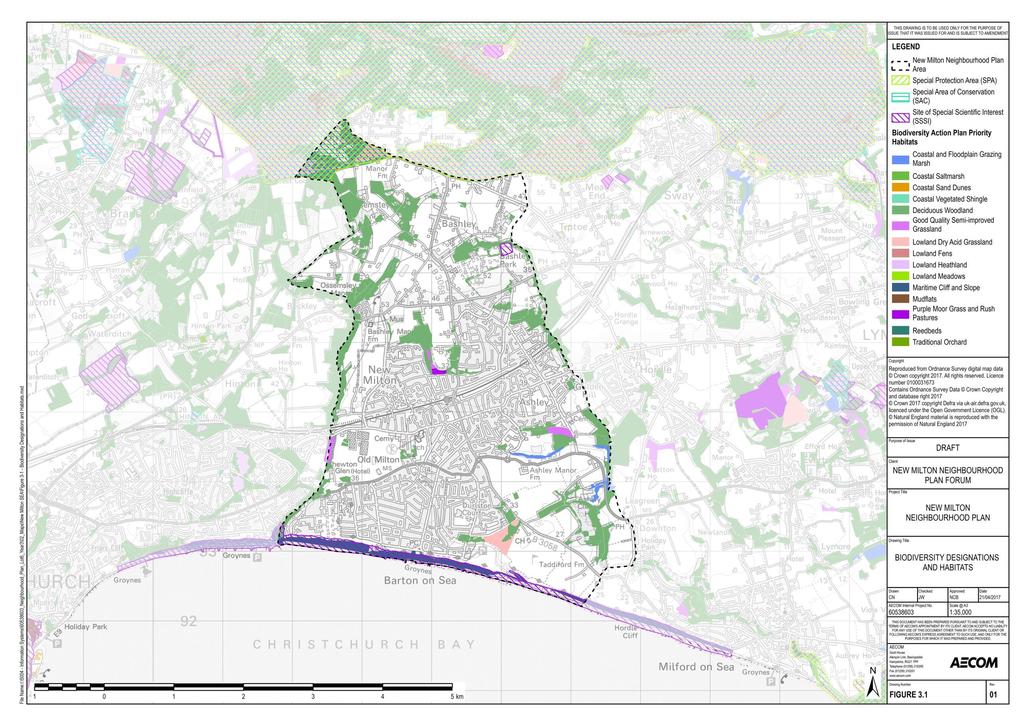
54 46
55 Climate Change Context Review The UK Climate Change Risk Assessment is published on a 5-yearly cycle in accordance with the requirements of the Climate Change Act It required the Government to compile an assessment of the risks for the UK arising from climate change, and then to develop an adaptation programme to address those risks and deliver resilience to climate change on the ground. For both the 2012 and the 2017 UK Climate Change Risk Assessment, the Adaptation Sub-Committee commissioned an evidence report to achieve the following: Based on the latest understanding of current, and future, climate risks and opportunities, vulnerability and adaptation, what should the priorities be for the next UK National Adaptation Programme? 20 The evidence report contains six priority risk areas requiring additional action in the next five years, see below: Flooding and coastal change risks to communities, businesses and infrastructure; Risks to health, well-being and productivity from high temperatures; Risk of shortages in the public water supply, and for agriculture, energy generation and industry; Risks to natural capital, including terrestrial, coastal, marine and freshwater ecosystems, soils and biodiversity; Risks to domestic and international food production and trade; and New and emerging pests and diseases, and invasive non-native species, affecting people, plants and animals The UK Climate Change Act 21 was passed in 2008 and established a framework to develop an economically credible emissions reduction path. It also highlighted the role it would take in contributing to collective action to tackle climate change under the Kyoto Protocol, and more recently as part of the UN-led Paris Agreement. The Climate Change Act includes the following: 2050 Target. The Act commits the UK to reducing emissions by at least 80% in 2050 from 1990 levels. Carbon Budgets. The Act requires the Government to set legally binding carbon budgets. A carbon budget is a cap on the amount of greenhouse gases emitted in the UK over a five-year period. The carbon budgets are designed to reflect the cost-effective path to achieving the UK s long-term objectives. The first five carbon budgets have been put into legislation and run up to The Committee on Climate Change was set up to advise the Government on emissions targets, and report to Parliament on progress made in reducing greenhouse gas emissions. The National Adaptation Programme requires the Government to assess the risks to the UK from climate change, prepare a strategy to address them, and encourage key organisations to do the same. For more detail, visit the UK adaptation policy page 22. Key messages from the National Planning Policy Framework (NPPF) include: Support the transition to a low carbon future in a changing climate as a core planning principle'. There is a key role for planning in securing radical reductions in greenhouse gas (GHG) emissions, including in terms of meeting the targets set out in the Climate Change Act Specifically, planning policy should support the move to a low carbon future through: 20 GOV UK: UK Climate Change Risk Assessment Report January 2017, [online] available to download from: < last accessed [27/01/17] 21 GOV.UK (2008): Climate Change Act 2008, [online] accessible via < last accessed [21/02/17] 22 Committee on Climate Change (2017): UK Adaptation Policy [online] accessible via < last accessed [21/02/17] 47
56 Planning for new development in locations and ways which reduce GHG emissions; Actively supporting energy efficiency improvements to existing buildings; Setting local requirements for building's sustainability in a way that is consistent with the Government's zero carbon buildings policy; Positively promoting renewable energy technologies and considering identifying suitable areas for their construction; and Encouraging those transport solutions that support reductions in GHG emissions and reduce congestion. Direct development away from areas highest at risk of flooding, with development not to be allocated if there are reasonably available sites appropriate for the proposed development in areas with a lower probability of flooding. Where development is necessary, it should be made safe without increasing levels of flood risk elsewhere. Take account of the effects of climate change in the long term, taking into account a range of factors including flooding. Adopt proactive strategies to adaptation and manage risks through adaptation measures including well planned green infrastructure. The Flood and Water Management Act 24 highlights that alternatives to traditional engineering approaches to flood risk management include: Incorporating greater resilience measures into the design of new buildings, and retro-fitting properties at risk (including historic buildings); Utilising the environment in order to reduce flooding, for example through the management of land to reduce runoff and through harnessing the ability of wetlands to store water; Identifying areas suitable for inundation and water storage to reduce the risk of flooding elsewhere; Planning to roll back development in coastal areas to avoid damage from flooding or coastal erosion; and Creating sustainable drainage systems (SuDS) 25 Further guidance is provided in the document Planning for SuDs. 26 This report calls for greater recognition of the multiple benefits that water management can present. It suggests that successful SuDS are capable of contributing to local quality of life and green infrastructure. A Strategic Flood Risk Assessment was produced in 2007 for the New Forest District. This included the assessment of potential flood risk in a climate change scenario. The assessment covers current planning context at all levels EU, national, regional and local. The assessment investigates historical flooding from waterbodies, ground water and sea flooding to examine current flood risk in the area. Also included in the assessment are flood management measures and guidance for the preparation of flood risk assessments with regard to proposed developments. Additionally, the Hampshire Local Flood Risk Management Strategy ( ) 27 aims to reduce and manage flood risk in a way that will benefit people, property and the local environment. This report calls for considering flooding in a wider context including the downstream effects of decisions made in specific locations and wider catchment effects. It also aims to secure multiple benefits and deliver sustainability and Water Framework Directive benefits wherever possible in the decision making process for delivering flood risk management infrastructure. One of the Local Plan Core Strategy Objectives for the Plan Area is related to Climate change, and is as follows; 23 The Climate Change Act 2008 sets targets for greenhouse gas (GHG) emission reductions through action in the UK of at least 80% by 2050, and reductions in CO 2 emissions of at least 26% by 2020, against a 1990 baseline. 24 Flood and Water Management Act (2010) [online] available at: 25 N.B. The provision of Schedule 3 to the Flood and Water Management Act 2010 came into force on the 1st of October 2012 and makes it mandatory for any development in England or Wales to incorporate SuDs. 26 CIRIA (2010) Planning for SuDs making it happen [online] available to access via < last accessed [04/04/17] 27 Hampshire County Council (2013): Local Flood Risk Management Strategy,:[online] available to download via: < > last accessed [30/01/18] 48
57 2. Climate Change and Environmental Sustainability: To minimise the impact of local factors contributing to climate change, including minimising the use of non-renewable energy and natural resources; and to assess the implications on the plan area of climate change and develop appropriate local responses than minimise any harmful local impacts. Summary of Current Baseline Contribution to Climate Change In relation to GhG emissions, source data from the Department of Energy and Climate Change suggests that New Forest District has had slightly higher per capita emissions total than that of both the South East of England and England as a whole since 2005 (see Table 4.1). New Forest District has also seen a 19.3% decrease the percentage of total emissions per capita between 2005 and 2012, higher than the reductions for the South East (15.9%) and England (16.7%). Potential effects of climate change The outcome of research on the probable effects of climate change in the UK was released in 2009 by the UK Climate Projections (UKCP09) team 28. UKCP09 gives climate information for the UK up to the end of this century and projections of future changes to the climate are provided, based on simulations from climate models. Projections are broken down to a regional level across the UK and are shown in probabilistic form, which illustrate the potential range of changes and the level of confidence in each prediction. As highlighted by the research, the effects of climate change for the South East of England by 2050 for a medium emissions scenario 29 are likely to be as follows: The central estimate of increase in winter mean temperature is 2.2ºC and an increase in summer mean temperature of 2.8ºC; and The central estimate of change in winter mean precipitation is 16% and summer mean precipitation is 19%. Resulting from these changes, a range of risks may exist for the Neighbourhood Plan area. These include: Effects on water resources from climate change; Reduction in availability of groundwater for abstraction; Adverse effect on water quality from low stream levels and turbulent stream flow after heavy rain; Increased risk of flooding, including increased vulnerability to 1:100 year floods; A need to increase the capacity of wastewater treatment plants and sewers; A need to upgrade flood defences; Soil erosion due to flash flooding; Loss of species that are at the edge of their southerly distribution; Spread of species at the northern edge of their distribution; Increased demand for air-conditioning; Increased drought and flood related problems such as soil shrinkages and subsidence; Risk of road surfaces melting more frequently due to increased temperature; and Flooding of roads. Flood Risk 28 The data was released on 18th June 2009: See: < last accessed [04/02/17] 29 UK Climate Projections (2009) South East 2050s Medium Emissions Scenario [online] available at: < last accessed [28/03/17] 49
58 There are several areas in Flood Zone 3 in the NMNP area. Some sections of the coastline are in flood zone 3, to the east and west, and the central section of the coastline is categorised as flood zone 2. Whilst the areas adjoining the coast are at risk of flooding these areas of flood risk do not cover any existing properties. The New Forest Catchment Flood Management Plan (2009) states that the main risk to the NMNP area is from river flooding. The NMNP area sits within Milton/Milford sub area; in 2009 when the report was prepared, 77 properties were at risk of flooding, with a predicted 244 properties at risk of flooding by Surface water flooding is a low to medium risk for some locations within the NMNP area. The areas at a medium to low risk in the areas tend to be those which are more urbanised. Sewer flooding is also a risk for some parts of the Neighbourhood Plan area, with sections of low-medium risk in the north western and south western parts of the area. Summary of Future Baseline Climate change has the potential to increase the occurrence of extreme weather events in the NMNP area. This is likely to increase risks associated with climate change (including fluvial, coastal and drainage related flooding) with an increased need for resilience and adaptation. Additional future development has the potential to exacerbate flood risks. A Critical Drainage Area (CDA) is a discrete geographic area where multiple and interlinked sources of flood risk causes flooding in one or more Local Flood Risk Zones (LFRZ) during severe weather, impacting people, property and/or local infrastructure. The New Forest District Council may wish to designate their own CDAs (in the absence of any designations from the Environment Agency) 30 within the Neighbourhood Plan area within the future, for reasons such as surface water capacity issues. In terms of climate change mitigation, GhG emissions generated in the NMNP area may decrease with wider adoption of energy efficiency measures, renewable energy production and new technologies. However, increases in the built footprint of the NMNP area would contribute to increases in absolute levels of GhG emissions. Landscape and Historic Environment Context Review Key messages from the National Planning Policy Framework (NPPF) include: Protect and enhance valued landscapes, giving particular weight to those identified as being of national importance. Heritage assets should be recognised as an irreplaceable resource that should be conserved in a manner appropriate to their significance, taking account of the wider social, cultural, economic and environmental benefits of conservation, whilst also recognising the positive contribution new development can make to local character and distinctiveness. Set out a positive strategy for the conservation and enjoyment of the historic environment, including those heritage assets that are most at risk. Develop robust and comprehensive policies that set out the quality of development that will be expected for the area. Such policies should be based on stated objectives for the future of the area and an understanding and evaluation of its defining characteristics. Consider the effects of climate change in the long term, including in terms of landscape. Adopt proactive strategies to adaptation and manage risks through adaptation measures including well planned green infrastructure. 30 GOV.UK (2017): Flood Risk Assessment in Flood Zone 1 and Critical Drainage Areas, [online] available to view via: < last accessed [06/04/17] 50
59 The Government s Statement on the Historic Environment for England 31 sets out its vision for the historic environment. It calls for those who have the power to shape the historic environment to recognise its value and to manage it in an intelligent manner in light of the contribution that it can make to social, economic and cultural life. Policy CS1: Sustainable Development Principles of the New Forest District Council Core Strategy stipulates that all new developments will be expected to contribute positively towards the sustainability of communities and to protecting and enhancing the environment within the Neighbourhood Plan area by minimising the risk of damage to areas of importance for nature conservation and/or landscape value, both directly and indirectly. Summary of Current Baseline Landscape The northern boundary of the NMNP area borders the New Forest National Park, with a small area of the NMNP area lying within the National Park. The New Forest National Park was designated in 2005 and covers an area of approximately 566km 2. The National Park was designated in part due to the range of rare and distinctive landscapes in the area, including ancient and ornamental woodland, heathlands and historic villages. National Character Areas (NCAs) are landscape areas which share similar characteristics, following natural lines in the landscape rather than administrative boundaries. Developed by Natural England, NCA profiles describe the natural and cultural features that shape each of these landscapes, providing a broad context to its character. The Neighbourhood Plan area is located within NCA Profile: 131 New Forest 32. This NCA, of which 75% comprises the New Forest National Park, is described as a plateau, averaging m above sea level, comprised of Palaeogenic deposits. These deposits are exposed along the coast, as internationally recognised fossil fauna, overlain by Quaternary gravels. The gravels produce acidic soils, which support the habitats and species which have been designated under Natura 2000, and is one of the most important and extensive habitats of this type in lowland Europe. A Landscape Character Assessment has been undertaken for the NMNP area, and has been presented in the New Milton Local Distinctiveness Supplementary Planning Document, which was adopted in 2010 and produced by New Forest District Council. In this assessment, 13 character areas within the NMNP area have been defined. These areas are; Town Centre Great Woar (North West New Milton) The Lanes (North East New Milton) Ashley South and East New Milton Caird Avenue Becton Bunny Valley Barton Sea Front Barton Gardens Old Milton Barton Court Avenue West Garden (The Pinetum) West Town 31 HM Government (2010) The Government s Statement on the Historic Environment for England [online] available at: < last accessed [30/03/17] 32 Natural England (2013) National Character Area New Forest. Available at: < last accessed [16/04/17] 51
60 A detailed analysis of each character area within the town was set out identifying the defining characteristics of each area. It focusses on the positive elements of each area, which should be used to inform new development proposals. Guidance is also given for each specific area which enables recognition of local distinctiveness and for its protection and enhancement when development proposals are considered. Historic Environment Historic England is the statutory consultee for certain categories of listed building consent and all applications for scheduled monument consent. The historic environment is protected through the planning system, via conditions imposed on developers and other mechanisms. The Neighbourhood Plan area contains no Grade I, or Grade II* listed buildings; however there are 33 Grade II listed buildings in the NMNP area. There are no scheduled monuments, registered battlefields or registered historic parks and gardens within the Neighbourhood Plan area. Conservation Areas are designated because of their special architectural and historic interest 33. Conservation area appraisals are a tool to demonstrate the area s special interest, explaining the reasons for designation and providing a greater understanding and articulation of its character - mentioned within the Conservation Area Designation, Appraisal and Management advice note by Historic England34. Ideally, appraisals should be regularly reviewed as part of the management of the Conservation Area, and can be developed into a management plan. One conservation area is located in the NMNP area, the Old Milton Green Conservation Area. This covers a small area in the vicinity of St Mary Magdalene Church and Church Lane. The conservation area was designated in June 1993, to protect the remaining parts of the original village. Milton grew up around the Church and Green as a stopping point on the coast road from Lymington to Poole, which was the main town before the growth of Bournemouth in the 1800s. The present road and property boundaries follow the historic pattern and can be traced on early maps. Two inns, the school, the smithy and other village shops were clustered round the Green to the north and east, but many services moved away as the town of New Milton grew following development nearer the railway. The Green is the focus of the area, but its historic character is at present marred by traffic and a clutter of signs and posts. Church Lane still retains a rural feel, with some old hedgelines surviving. There are important trees on the Green and nearby in the George car park. The extensive Rectory grounds contain valuable trees protected by a tree preservation order. Groups of trees in the churchyard and to the east of the Green are also significant. The key features of the conservation area are as follows: The earliest reference to a chapel is in 1270 but the present Church of St Mary Magdalene has an ashlar tower dated to The remainder, in red brick, being an 1830 rebuilding of the medieval church which was further extended in It is the only listed building in the conservation area. Its 19th century churchyard walls are still largely intact. The George Inn, dated 1905, is an original, purpose-built inn which replaces an earlier building. The most attractive approach to the Green is from the south along Southern Lane. One thatched cob cottage survives at the southern end, along with other buildings of modest scale, such as Myrtle Cottage. The buildings opposite the Church lychgate establish the scale and character of Church Lane. The Victorian Rectory dated 1876 stands in secluded grounds with mature trees which provide a haven for wildlife. 33 Historic England (2017): Conservation Areas, [online] available to access via: < last accessed [27/03/17] 34 Historic England (2016): Conservation Area Designation, Appraisal and Management Advice Note 1, [online] available to download from: < last accessed [27/03/17] 52
61 The view from the west over Fawcetts Field to the Rectory grounds and Church tower is important to the setting of the conservation area. 35 A Conservation Area Appraisal or Management Plan has not been prepared for the Old Milton Green Conservation Area. Since 2008, Historic England has released an annual Heritage at Risk Register. The Heritage at Risk Register highlights the Grade I, Grade II and Grade II* listed buildings, scheduled monuments, historic parks and gardens, registered battlefields, wreck sites and conservation areas deemed to be at risk. The 2016 Heritage at Risk Register for South East England 36 only highlights Grade I and Grade II* listed buildings outside of London, unless they are Grade II listed places of worship. As none of the listed buildings are places of worship it is uncertain whether any of the listed buildings within the NMNP area are likely to be at risk. It should be noted that not all of the area s historic environment features are subject to statutory designations, and non-designated features comprise a large part of what people have contact with as part of daily life whether at home, work or leisure. Although not designated, many buildings and areas are of historic interest and are seen as important by local communities. For example, open spaces and key distinctive buildings in the area are likely to be of value for local people. Additionally, the Historic Environmental Record (HER) 37 for Hampshire contains 146 records within the parish of New Milton of both designated and non-designated heritage assets. Notable are the amount of find spots where Bronze Age and Iron Age artefacts have been uncovered. Additionally, some finds date back to the Neolithic and Palaeolithic eras. The South West Green Belt covers much of the Neighbourhood Plan area. It was originally designated in The South West Hampshire Green Belt joins the South East Dorset Green Belt to provide a green belt surrounding the Christchurch/Bournemouth/Poole conurbation. As per the provisions of the NPPF, the five key purposes of the Green Belt are as follows: to check the unrestricted sprawl of large built-up areas; to prevent neighbouring towns merging into one another; to assist in safeguarding the countryside from encroachment; to preserve the setting and special character of historic towns; and to assist in urban regeneration, by encouraging the recycling of derelict and other urban land. Whilst the green belt is not designated for landscape character, and is instead designated to prevent urban sprawl, it has provided a strong contribution to landscape character since designation. Summary of Future Baseline New development in the Town Centre area, incorporating a mix of retail, residential (to increase footfall) and social meeting places such as cafes, restaurants and leisure amenities has the potential to transform New Milton s High Street, where many businesses suffer with the effects of online sales, into a vibrant Town Centre with an evening economy. This has the potential to bring benefits to the quality of the public realm. New development outside of the town centre has the potential to lead to incremental but small changes in landscape and townscape character and quality in and around the NMNP area. This includes from the loss of landscape features and visual impact including through inappropriate design and layout. There is also the potential for effects on landscape/townscape character and quality in the vicinity of the road network due to an incremental growth in traffic flows. There are likely to be small scale and incremental changes in tranquillity in and around the Neighbourhood Plan area, affected by changes in the levels of light and noise pollution. However new development need not be detrimental to the landscape and visual character of the NMNP area if designed sensitively Historic England (2016): Heritage at Risk 2016 Register South East, [online] available to download via: < last accessed [29/03/17] 37 Hampshire County Council (2018): Historic Environmental Record Search, [online] available to access via: < last accessed [01/03/18] 53
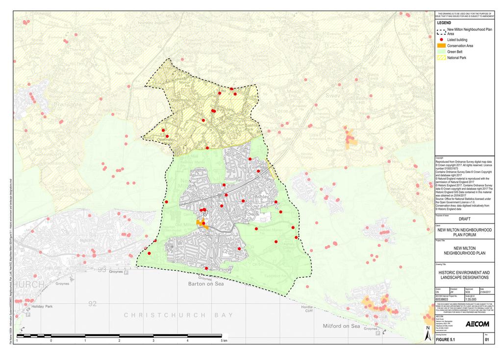
62 54
ROCHFORD LOCAL DEVELOPMENT FRAMEWORK: Sustainability Appraisal/ Strategic Environmental Assessment. Rochford Core Strategy Preferred Options Document
 ROCHFORD LOCAL DEVELOPMENT FRAMEWORK: Sustainability Appraisal/ Strategic Environmental Assessment Non Technical Summary Rochford Core Strategy Preferred Options Document October 2008 SUSTAINABILITY APPRAISAL
Parish of Repton NEIGHBOURHOOD DEVELOPMENT PLAN
 Parish of Repton NEIGHBOURHOOD DEVELOPMENT PLAN BASIC CONDITIONS STATEMENT December 2018 CEF 4 Legal Requirements This statement has been produced by the NDP Working Group on behalf of Repton Parish Council
Great Easton Neighbourhood Plan Statement of Basic Conditions
 Great Easton Neighbourhood Plan 2017-2031 Statement of Basic Conditions OCTOBER 2016 GREAT EASTON PARISH COUNCIL Contents 1.0 Introduction....Page 2 2.0 Summary of Submission Documents and Supporting Evidence..
Sustainability Statement. Whitby Business Park Area Action Plan
 Sustainability Statement Whitby Business Park Area Action Plan November 2014 Contents Page 1. Introduction 1 2. Scoping 3 3. Sustainability Appraisal of Options 6 4. Assessment of Draft Area Action Plan
Oxford Green Belt Study. Summary of Final Report Prepared by LUC October 2015
 Oxford Green Belt Study Summary of Final Report Prepared by LUC October 2015 Project Title: Oxford Green Belt Study Client: Oxfordshire County Council Version Date Version Details Prepared by Checked by
Ticehurst Neighbourhood Plan
 Ticehurst Neighbourhood Plan Strategic Environmental Assessment Environmental Report to accompany Regulation 14 consultation Ticehurst Neighbourhood Plan Steering Group December 2017 Quality information
Hastings Town Centre and Bohemia Area Action Plan
 Hastings Town Centre and Bohemia Sustainability Appraisal (SA) consultation Hastings Borough Council July 2018 Hastings Borough Council Quality information Prepared by Checked by Approved by Cheryl Beattie
3. Neighbourhood Plans and Strategic Environmental Assessment
 1. Introduction This report sets out a draft Screening Determination for the Preston Parish Council s Neighbourhood Plan and has been prepared by rth Hertfordshire District Council. The purpose of the
Site Assessment Technical Document Appendix A: Glossary
 Central Bedfordshire Council www.centralbedfordshire.gov.uk Site Assessment Technical Document Appendix A: Glossary July 2017 1.1.11-1 - ii Appendix A: Glossary Term Agricultural Land Classification AONB
DRAFT STRATEGIC ENVIRONMENTAL ASSESSMENT REPORT
 DRAFT STRATEGIC ENVIRONMENTAL ASSESSMENT REPORT Published by Limpsfield Parish Council in accordance with EU Directive 2001/42 on Strategic Environmental Assessment and with the Environmental Assessment
Neighbourhood Planning Local Green Spaces
 Neighbourhood Planning Local Green Spaces Introduction... 2 1. Why green space is important... 4 2. Neighbourhood plans and green space... 6 3. Evidence... 8 Statutory designations... 9 Green space audit...
Strategic environmental assessment for the Lenham Neighbourhood Plan
 Strategic environmental assessment for the Environmental Report to accompany Regulation 14 consultation on the Neighbourhood Plan September 2018 Quality information Prepared by Checked by Approved by Ryan
Rochford District Council Allocations Development Plan Document: Discussion and Consultation Document Sustainability Appraisal
 Option SWH1 Balanced Communities Option SWH1 1 To ensure the delivery of high quality sustainable communities where people want to live and work Will it ensure the phasing of infrastructure, including
The Gwennap Parish Vision Statement
 QUICK GUIDE What is a Neighbourhood Development Plan? Ultimately it is a document used by developers or anyone wishing to submit a planning application that describes the vision, strategy, plans, regeneration,
Effingham Neighbourhood Plan 1. Basic Conditions Statement
 Effingham Neighbourhood Plan 1 Basic Conditions Statement Effingham Neighbourhood Plan 2016: Basic Conditions Statement 2 Contents This statement has been prepared by Effingham Parish Council to accompany
Cotswolds AONB Landscape Strategy and Guidelines. June 2016
 Cotswolds AONB Landscape Strategy and Guidelines June 2016 Cotswolds AONB Landscape Strategy and Guidelines Introduction The evolution of the landscape of the Cotswolds AONB is a result of the interaction
Ipswich Issues and Options for the Ipswich Local Plan Review, August 2017, Public Consultation
 Ipswich Issues and Options for the Ipswich Local Plan Review, August 2017, Public Consultation Having reviewed the issues and options documents, the Society has made the following response: Part 1 Strategic
Plumpton Neighbourhood Development Plan Revised Pre Submission Document - Regulation 14 Consultation
 REPRESENTATIONS... Plumpton Parish Council Plumpton Neighbourhood Development Plan Revised Pre Submission Document - Regulation 14 Consultation Representations submitted on behalf of: Cala Homes (South
OKEFORD FITZPAINE NEIGHBOURHOOD PLAN
 OKEFORD FITZPAINE NEIGHBOURHOOD PLAN Dear Parishioner, The Neighbourhood Plan Project Team have prepared this leaflet to summarise the full Neighbourhood Plan document. It provides a summary of the Vision,
Strategic Environmental Assessment Screening Report. Dublin Port Masterplan Review 2017
 Strategic Environmental Assessment Screening Report Dublin Port Masterplan Review 2017 Table of Contents 1 Introduction... 1 2 Purpose of the Masterplan... 2 3 Task 1.1 Pre-Screening Check... 5 4 Task
WINCHESTER TOWN 3.1 LOCATION, CHARACTERISTICS & SETTING
 WINCHESTER TOWN 3.1 LOCATION, CHARACTERISTICS & SETTING 3.1.1 The area referred to by the City Council, as Winchester Town, consists of the Winchester Wards plus the adjoining built up areas of Badger
INTRODUCTION NORTH HEYBRIDGE GARDEN SUBURB
 INTRODUCTION This event is being hosted by the promoters of the proposed North Heybridge Garden Suburb who are working with Maldon District Council and other key stakeholders on the preparation of a comprehensive
Schedule of Planning Applications Committee Date: 23 May Reference: 06/17/0726/F Parish: Hemsby Officer: Mr J Beck Expiry Date:
 Schedule of Planning Applications Committee Date: 23 May 2018 Reference: 06/17/0726/F Parish: Hemsby Officer: Mr J Beck Expiry Date: 22-05-2018 Applicant: Proposal: Site: Mr Gillett Change of use to the
DUNSFOLD NEIGHBOURHOOD PLAN Site Selection Policies
 DUNSFOLD NEIGHBOURHOOD PLAN Site Selection Policies The criteria for assessing sites for future housing and business development in Dunsfold are set out below. (Development criteria, covering what it is
Our City Centre is a vibrant, creative and welcoming destination, with a modern business, cultural, shopping, leisure and residential offer
 3. Sheffield in 2034 Our City sits at the heart of a strong, distinctive and internationally successful City Region economy which supports innovation and enterprise Our City Centre is a vibrant, creative
Settlement Boundaries Methodology North Northumberland Coast Neighbourhood Plan (August 2016)
") Introduction This background paper sets out a methodology for the definition of settlement boundaries in the North Northumberland Coast Neighbourhood Plan. The neighbourhood plan is planning positively
Introduction This background paper sets out a methodology for the definition of settlement boundaries in the North Northumberland Coast Neighbourhood Plan. The neighbourhood plan is planning positively
Stantonbury Neighbourhood Plan
 Stantonbury Neighbourhood Plan 2018-2031 Basic Conditions Statement October 2018 Intentionally blank 1.0 Basic Conditions Statement Introduction 1.1 This statement has been prepared by Stantonbury Parish
Longbridge Town Centre Phase 2 Planning Application
 Longbridge Town Centre Phase 2 Planning Application Non-Technical Summary of the Environmental Statement December 2013 Introduction A full application for Planning Permission has been submitted to Birmingham
Brighton Marina Neighbourhood Forum AGM. City Plan Part Two - Draft Plan
 Brighton Marina Neighbourhood Forum AGM City Plan Part Two - Draft Plan 16 May 2018 Sandra Rogers Planning Manager Carly Dockerill & Robert Davidson Principal Planning Officers Presentation outline: Context
1.3 The following table presents a Statement of Compliance demonstrating how the Standish Neighbourhood Plan meets those requirements.
 1. Introduction 1.1 This Basic Condition Statement was prepared to accompany the draft Standish Neighbourhood Plan (2018). 1.2 Paragraph 8 of Schedule 4B of the Town and Country Planning Act 1990 requires
WELCOME GYPSY LANE. Wider Site Location plan. Proposals for the development of LAND OFF FOXLYDIATE LANE WEBHEATH. Proposals for the development of
 WELCOME The developers are preparing an outline planning application for a residential led development and need the community s views in order to develop the proposals further WHAT IS PROPOSED? A high
Droitwich Spa 6. Reasoned Justification
 87 Droitwich Spa 6 Reasoned Justification 6.1 Droitwich Spa is identified in the settlement hierarchy (Policy SWDP1) as a main town being the largest settlement in Wychavon District with an estimated population
Basic Conditions Statement Exmouth Neighbourhood Plan
 Exmouth Neighbourhood Plan 2018-2031. On behalf Exmouth Neighbourhood Plan Steering Group July 2018 Table of Contents 1. Introduction... 4 2. Legal Requirements... 5 3. Why there is a need for a Neighbourhood
WETHERBY TOWN COUNCIL. Neighbourhood Development Plan Basic Conditions Statement
 WETHERBY TOWN COUNCIL Neighbourhood Development Plan Basic Conditions Statement SEPTEMBER 2017 WETHERBY NEIGHBOURHOOD DEVELOPMENT PLAN: BASIC CONDITIONS STATEMENT 1. Legal Requirements 1.1 This Statement
Cottenham Civil Parish. Neighbourhood Development Plan to 2031
 Cottenham Civil Parish Neighbourhood Development Plan 2017 to 2031 Cottenham Parish Council Basic Conditions Statement December 2018 In 2031 Cottenham will still be an attractive safe rural village, proud
LAVANT NEIGHBOURHOOD DEVELOPMENT PLAN
 LAVANT NEIGHBOURHOOD DEVELOPMENT PLAN 2016-2032 PRE-SUBMISSION NEIGHBOURHOOD PLAN SUSTAINABILITY APPRAISAL Lavant Parish Council March 2016 2 INTRODUCTION TABLE OF CONTENTS INTRODUCTION... 4 What is a
Copyright Nigel Deeley and licensed for reuse under this Creative Commons Licence
 1 Copyright Nigel Deeley and licensed for reuse under this Creative Commons Licence Prepared by the Neighbourhood Plan Steering Group on behalf of Garway Parish Council with assistance from 2 Table of
Briefing Document of CNP. June 2017
 Cholsey Parish Council Cholsey Neighbourhood Plan Briefing Document of CNP June 2017 Cholsey Neighbourhood Plan Page! 1 of! 8 Cholsey Plan Briefing v1.4 Page Left Intentionally Blank Cholsey Neighbourhood
Wildlife and Planning Guidance: Local Plans
 Wildlife and Planning Guidance: Local Plans This Leaflet is one of a series of 4 Wildlife and Planning Guidance Leaflets and is intended to provide useful information to assist you to campaign effectively
South Worcestershire Development Plan. South Worcestershire Design Guide Supplementary Planning Document
 South Worcestershire Development Plan South Worcestershire Design Guide Supplementary Planning Document Statement of Consultation: Early Engagement Scoping Paper February 2017 1. Introduction 1.1 This
BLEWBURY NEIGHBOURHOOD DEVELOPMENT PLAN STATEMENT OF BASIC CONDITIONS
 BLEWBURY NEIGHBOURHOOD DEVELOPMENT PLAN STATEMENT OF BASIC CONDITIONS Introduction 1.1 This statement has been prepared to accompany the submission of the Blewbury Neighbourhood Development Plan ( the
Suffolk Coastal Local Plan Review Issues and Options, August 2017, Public Consultation
 Suffolk Coastal Local Plan Review Issues and Options, August 2017, Public Consultation Having reviewed the issues and options documents, the Society has made the following response: Part 1 - Strategic
Plumpton Neighbourhood Plan Site Assessment Report
 Plumpton Neighbourhood Plan Site Assessment Report May 2016 1 Contents 1. Introduction 3 2. Methodology 4 2.1 Identification of Potential Sites 4 2.2 Assessment Process 5 2.3 Assessment Criteria 6 2.4
BRE Strategic Ecological Framework LI Technical Information Note 03/2016
 BRE Strategic Ecological Framework Technical Information Note 03/2016 September 2016 Contents 1. Introduction 2. Aims of BRE s Strategic Ecological Framework 3. How SEF is different from previous approaches
Local Development Scheme
 Local Development Scheme 2012 2016 The Local Development Scheme (LDS) is a project plan that outlines how and when the Authority will update its planning policies and other associated documents. It ensures
Balcombe Neighbourhood Plan. Habitats Regulations Assessment Screening Report
 Balcombe Neighbourhood Plan Habitats Regulations Assessment Screening Report Produced for Regulation 14 of the Neighbourhood Planning (General) Regulations 2012 17 th July 2015 1.0 Introduction 1.1 This
Newcourt Masterplan. November Exeter Local Development Framework
 Newcourt Masterplan November 2010 Exeter Local Development Framework Background The Exeter Core Strategy Proposed Submission sets out the vision, objectives and strategy for the development of Exeter up
Vigo Neighbourhood Plan Basic Conditions Statement
 Vigo Neighbourhood Plan Basic Conditions Statement Plan Period: 2016 to 2028 Status: Submission Version Qualifying Body: Vigo Parish Council Glossary of Some Terms & Abbreviations Used in this Document
Neighbourhood Plan Representation
 Date: 10 th November 2017 Neighbourhood Plan Representation Land to the east of Callow Hill Road, Alvechurch Introduction This representation has been prepared by RPS Planning and Development on behalf
Basic Conditions Statement
 Basic Conditions Statement Our Community Our Plan Document: WNDP 2 Watlington Parish Council October 2017 Watlington Town Hall Page 2 of 25 WNDP 2 Contents 1. INTRODUCTION AND BASIC CONDITIONS... 5 1.1
Scottish Natural Heritage. Better places for people and nature
 Scottish Natural Heritage Better places for people and nature Contents Summary... 3 SNH approach... 5 Place-making in policy and practice... 6 Developing the contribution of the natural heritage to place-making...
Kibworth Harcourt. Introduction. Introduction
 Introduction Introduction Welcome to this public exhibition on the proposals for the delivery of new homes on land at The Kibworths. The purpose of today s exhibition is to give you the opportunity to
Northern Territory Compact Urban Growth Policy
 Northern Territory Compact Urban Growth Policy A Reference Policy Document to clause 2.7 (Reference to Policy) of the NT Planning Scheme May 2015 Table of Contents 1 Policy Setting... 3 1.1 Context for
BEDFORD BOROUGH COUNCIL PLAN IMPLEMENTATION MONITORING REPORT
 BEDFORD BOROUGH COUNCIL PLAN IMPLEMENTATION MONITORING REPORT 2017-18 Summary 1 Progress on local development documents 1 Local development documents adopted in the monitoring period 1st April 2017 31st
Policy DM19: Development and Nature Conservation
 Avonmouth Wetland Habitat Project October 2010 and December 2011 (the Cresswell study). Policy Links Bristol Local Plan Core Strategy Lead Policy BCS4: Avonmouth and Bristol Port BCS9: Green Infrastructure
Policy and Resources Committee 10 th October Green Infrastructure Supplementary Planning Document (SPD) Summary. Title
 Summary. Title") Policy and Resources Committee 10 th October 2017 Title Report of Wards Status Urgent Key Enclosures Officer Contact Details Green Infrastructure Supplementary Planning Document (SPD) Deputy Chief Executive
Policy and Resources Committee 10 th October 2017 Title Report of Wards Status Urgent Key Enclosures Officer Contact Details Green Infrastructure Supplementary Planning Document (SPD) Deputy Chief Executive
2. Spatial Portrait, Vision and Objectives
 VISION & OBJECTIVES 2. Spatial Portrait, Vision and Objectives Introduction 2.1 This section sets out the spatial portrait of Uttlesford, the vision we have for the future of the area and the objectives
WOKING DESIGN SUPPLEMENTARY PLANNING DOCUMENT (SPD)
") Agenda Item No. 5 EECUTIVE - 15 JANUARY 2015 Executive Summary WOKING DESIGN SUPPLEMENTARY PLANNING DOCUMENT (SPD) The report outlines the various responses to the consultation on the Design Supplementary
Agenda Item No. 5 EECUTIVE - 15 JANUARY 2015 Executive Summary WOKING DESIGN SUPPLEMENTARY PLANNING DOCUMENT (SPD) The report outlines the various responses to the consultation on the Design Supplementary
EXTRACT FROM THE CUDDINGTON NEIGHBOURHOOD PLAN The Policies
 EXTRACT FROM THE CUDDINGTON NEIGHBOURHOOD PLAN The Policies Environment and Landscape Policy 1 - Landscape Setting Development should respect and wherever possible enhance the landscape setting of Cuddington
The Town and Country Planning (Environmental Impact Assessment) (Wales) Regulations 2016, Regulation 13 Scoping Opinion
 (Wales) Regulations 2016, Regulation 13 Scoping Opinion") Mr Graham Clark Berrys Newchurch Farm Kinnersley Hereford HR3 6QQ BY EMAIL The Town and Country Planning (Environmental Impact Assessment) (Wales) Regulations 2016, Regulation 13 Scoping Opinion SC/2017/0001
Mr Graham Clark Berrys Newchurch Farm Kinnersley Hereford HR3 6QQ BY EMAIL The Town and Country Planning (Environmental Impact Assessment) (Wales) Regulations 2016, Regulation 13 Scoping Opinion SC/2017/0001
Tāhuhu whakaruruhau ā-taone The sheltering ridge pole
 B2. Tāhuhu whakaruruhau ā-taone - Urban growth and form B2.1. Issues Tāhuhu whakaruruhau ā-taone The sheltering ridge pole Auckland s growing population increases demand for housing, employment, business,
Planning and Regulatory Committee 20 May Applicant Local Councillor Purpose of Report
 Planning and Regulatory Committee 20 May 2014 7. APPLICATION FOR PLANNING PERMISSION FOR THE CARRYING-OUT OF DEVELOPMENT PURSUANT TO PLANNING PERMISSION REFERENCE NUMBER 603451 DATED 28 FEBRUARY 2007 WITHOUT
Interim Advice Note 76 / 06 ASSESSMENT PART 1 AIMS AND OBJECTIVES OF ENVIRONMENTAL ASSESSMENT. Contents
 Interim Advice Note 76 / 06 VOLUME 11 SECTION 1: ENVIRONMENTAL ASSESSMENT INTRODUCTION PART 1 AIMS AND OBJECTIVES OF ENVIRONMENTAL ASSESSMENT Contents 1. Introduction and Application 2. Aims and Objectives
EVALUATION OF MASTER PLAN ALTERNATIVES
 7 The Environmental Report is required to identify, describe and evaluate reasonable alternatives, taking into account the objectives and geographical scope of the Master Plan 2008. Three plan alternatives
LONGDEN VILLAGE DEVELOPMENT STATEMENT
 LONGDEN VILLAGE DEVELOPMENT STATEMENT 2017-2027 1 Longden Development Statement 2017-2027 15/01/18 1. Background 1.1 Longden Village Longden village is a very rural and traditional community first mentioned
Wildlife and Planning Guidance: Neighbourhood Plans
 Wildlife and Planning Guidance: Neighbourhood Plans This Leaflet is one of a series of 4 Wildlife and Planning Guidance Leaflets and is intended to provide useful information to assist you to campaign
HISTORIC ENVIRONMENT SCOTLAND
 HISTORIC ENVIRONMENT SCOTLAND HISTORIC ENVIRONMENT POLICY Strategic Environmental Assessment Environmental Report 10 September 2018 We are committed to ensuring this publication is accessible to everyone.
Green Infrastructure planning must be evidence led, thus the importance of this stage in collating your information and responses.
 Green Infrastructure Consultation Proforma Recipients: Andy Maginnis (Countryside Services) regarding access, recreation and tourism Ed Dursley (Transport) regarding access and movement Steve Bloomfield
Enclosures Appendix 1: Draft Golders Green Station Planning Brief. Summary
 Policy and Resources Committee 23 February 2017 Title Report of Wards Status Urgent Key Golders Green Station Draft Planning Brief Cath Shaw Commissioning Director - Growth & Development Interim Deputy
Appendix 1 Structure plan guidelines
 Appendix 1 Structure plan guidelines This appendix forms part of the regional policy statement [rps]. 1.1. Introduction Structure plans are an important method for establishing the pattern of land use
Basic Conditions Statement
 POTTON NEIGHBOURHOOD DEVELOPMENT PLAN Basic Conditions Statement Date: 19/10/2018 Version: 1 Status: draft Table of Contents 1 INTRODUCTION... 3 1.1 POTTON NEIGHBOURHOOD PLAN DESIGNATED AREA... 3 1.2 PREPARATION
2.0 Strategic Context 4
 2.0 Strategic Context 4 2.1 The Area Action Plan is a non-statutory plan, which forms a corporate policy document, expressing particular issues and areas of concern while also providing a vision for the
Welcome to our exhibition
 Welcome to our exhibition The Homes & Communities Agency (HCA) welcomes you to this public exhibition explaining our proposals for the redevelopment of the former Lea Castle Hospital site. About the Homes
Strategic Environmental Assessment of the Stratford-upon-Avon Neighbourhood Plan
 Strategic Environmental Assessment of the Stratford-upon-Avon Neighbourhood Plan Screening Document September 2013 LEPUS CONSULTING LANDSCAPE ECOLOGY, PLANNING AND URBAN SUSTAINABILITY Strategic Environmental
CORRECTIONS WITHIN DESIGN MANUAL FOR ROADS AND BRIDGES AUGUST 2009
 DESIGN MANUAL FOR ROADS AND BRIDGES CORRECTIONS WITHIN DESIGN MANUAL FOR ROADS AND BRIDGES AUGUST 2009 SUMMARY OF CORRECTION HA 200/08 VOLUME 11, SECTION 1, PART 1 AIMS AND OBJECTIVES OF ENVIRONMENTAL
elbridge Core Strategy
 C elbridge Core Strategy Celbridge is designated as a Moderate Growth Town in the RPGs. The County Development Plan reinforces this designation in its settlement strategy. Moderate Growth Towns within
DEVELOPMENT MANAGEMENT REPORT
 ITEM A08-1 DEVELOPMENT MANAGEMENT REPORT TO: BY: DATE: DEVELOPMENT: SITE: WARD: APPLICATION: APPLICANT: Development Management Committee Development Manager Proposed live/work unit in connection with existing
WHITELEY TOWN COUNCIL NORTH WHITELEY DEVELOPMENT SEPTEMBER 2014
 WHITELEY TOWN COUNCIL NORTH WHITELEY DEVELOPMENT SEPTEMBER 2014 Dear Resident This Special Edition of the Whiteley Voice which has been prepared in conjunction with the North Whiteley Consortium is to
volume 11 environmental assessment section 2 environmental impact assessment Part 7 ha 218/08
 DESIGN MANUAL FOR ROADS AND BRIDGES volume 11 environmental assessment section 2 environmental impact assessment Part 7 ha 218/08 glossary of terms Used in DMRB Volume 11, Sections 1 and 2 SUMMARY This
University Park, Worcester Non Technical Summary December 2011
 University Park, Worcester Non Technical Summary December 2011 Introduction UW Wrenbridge LLP, a Joint Venture Company of the University of Worcester and Wrenbridge Land Ltd (the Applicants ) intend to
Development in the setting of the Cotswolds AONB
 COTSWOLDS CONSERVATION BOARD POSITION STATEMENT Development in the setting of the Cotswolds AONB.1. Introduction Areas of Outstanding Natural Beauty (AONBs) are designated by the Government for the purpose
Ebbsfleet Development Corporation
 Title of Paper Planning and Housing Delivery Report September 2018 Presented by Sub-Committee Mark Pullin, Chief Planning Officer Planning Committee Purpose of Paper and Executive Summary This paper provides
Plaistow and Ifold Neighbourhood Plan Pre-Submission Consultation Draft
 Mrs Beverley Weddell Clerk to Plaistow And Ifold Parish Council Lock House Lodge Knightons Lane Dunsfold, GU8 4NU. Dear Mrs Weddell, Our ref: Your ref: Telephone Fax HD/P5402/ 01483 252040 18 th October
Rochford District Council. Adopted 16 December Local Development Framework. Development Management Plan LDF.
 Rochford District Council Adopted 16 December 2014 Local Development Framework Development Management LDF www.rochford.gov.uk Contents Page 1 Introduction... 3 The Role of the Development Management...
Town of Cobourg Heritage Master Plan. Statutory Public Meeting
 Town of Cobourg Heritage Master Plan Statutory Public Meeting April 25 th 2016 Presentation Overview 1. Introduction 2. Project background and schedule overview 3. Review of strategic direction content
Circular L8/08 2 September Water Services Investment and Rural Water Programmes Protection of Natural Heritage and National Monuments
 Circular L8/08 2 September 2008 Water Services Investment and Rural Water Programmes Protection of Natural Heritage and National Monuments 1. The purpose of this Circular is to provide local authorities
Wallingford Neighbourhood Plan
 Wallingford Neighbourhood Plan Introduction What is neighbourhood planning? Neighbourhood planning was introduced by the Localism Act 2011 to give local people more influence over how development comes
Sustainability. Calverton Neighbourhood Plan. SEA Screening Statement & HRA
 Sustainability Calverton Neighbourhood Plan SEA Screening Statement & HRA November 2016 Calverton Neighbourhood Plan 2016-2028 Submission Plan Submitted to Gedling Borough Council in accordance with Regulation
HISTORIC ENVIRONMENT SCOTLAND
 HISTORIC ENVIRONMENT SCOTLAND DRAFT CORPORATE PLAN 2019-22 Strategic Environmental Assessment Environmental Report 31 August 2018 We are committed to ensuring this publication is accessible to everyone.
Official Plan Review
 Official Plan Review Summary Report - The Built Environment August 2014 Part 1: Introduction Planning for a healthy, prosperous and sustainable community is an important goal for our municipality. From
Guide. Guide to Regional Planning Policies. Background
 Guide Guide to Regional Planning Policies January 2017 Background The Strategic Planning Policy Statement for NI - Planning for Sustainable Development - sets out the Department s regional planning policies
Perth and Kinross Council Development Management Committee 8 June Pre-Application Report by Development Quality Manager
 Perth and Kinross Council Development Management Committee 8 June 2016 5(3)(i) 16/259 Pre-Application Report by Development Quality Manager Residential development at St Martins Road, Land 120 metres West
Local Plan Committee
 Local Plan Committee 8 June 2015 Item 8 Report of Head of Commercial Services Author Chris Downes 01206 282476 Title Update on the new Local Plan Call for Sites process Wards affected All The Local Plan
Cranfield University Masterplan
 Central Bedfordshire Council EXECUTIVE Tuesday, 5 December 2017 Cranfield University Masterplan Report of: Cllr Nigel Young, Executive Member for Regeneration, (nigel.young@centralbedfordshire.gov.uk )
STATEMENT OF OBJECTION TO THE PROPOSED DEVELOPMENT OF LAND AT CHURCH CLIFF DRIVE FILEY
 STATEMENT OF OBJECTION TO THE PROPOSED DEVELOPMENT OF LAND AT CHURCH CLIFF DRIVE FILEY You will be aware that Scarborough borough council have adopted a new local plan that includes land at Church Cliff
Babergh and Mid Suffolk Joint Draft Local Plan Consultation, August 2017, Public Consultation
 Babergh and Mid Suffolk Joint Draft Local Plan Consultation, August 2017, Public Consultation Having reviewed the documents, the Society has made the following response: Housing Delivery Q 7. Do you agree
Appendix A. Planning Processes. Introduction
 1 Planning Processes Introduction This appendix outlines a number of planning processes which are used in the Auckland Region to support the effective management of development in the region s rural and
Draft Hailey Neighbourhood Plan
 Persimmon Homes (Wessex) Draft Hailey Neighbourhood Plan Representations to West Oxfordshire District Council s Regulation 16 Consultation December 2018 2 Copyright 2018 Persimmon Homes Ltd. All rights
Plan Modification to Chapter B2 of the Auckland Unitary Plan(AUP) Operative in part (15 November 2016)
 Operative in part (15 November 2016)") UNITARY PLAN UPDATE REQUEST MEMORANDUM TO FROM Phill Reid Linley Wilkinson DATE 25 September 2018 SUBJECT Plan Modification to Chapter B2 of the Auckland Unitary Plan(AUP) Operative in part (15 November
UNITARY PLAN UPDATE REQUEST MEMORANDUM TO FROM Phill Reid Linley Wilkinson DATE 25 September 2018 SUBJECT Plan Modification to Chapter B2 of the Auckland Unitary Plan(AUP) Operative in part (15 November
Mid Coquetdale Neighbourhood Plan - Vision and Objectives Consultation
 Neighbourhood Planning came into force in 2011, through the Localism Bill. It gives us a unique opportunity to produce our own Neighbourhood Development Plan for our own area. Rothbury Parish Council,