WATERSHED RESTORATION PLAN
|
|
|
- Britney Dora Lucas
- 5 years ago
- Views:
Transcription


1 WHITTEN BROOK WATERSHED RESTORATION PLAN Appendices March 2011 Skowhegan Conservation Commission 1
2 APPENDICES Appendix 1. Watershed Maps...49 Map 1. Topography...49 Map 2. Soils...50 Map 3. Soil Erodibility...51 Map 4. Surficial Geology...52 Map 5. Water Resources...53 Map 6. Land Use...54 Map 7. Conservation Lands...55 Map 8. RRI Sites (Upper Madison Avenue Catchment)...56 Map 9. RRI Sites (Lower Madison Ave Catchment)...57 Map 10. Road Jurisdiction...58 Appendix 2. Stormwater BMPs for Urban Watersheds...59 Appendix 3. List of Prioritized Stormwater Retrofit Sites...61 Appendix 4. RRI Site Characteristics for Whitten Brook...63 Appendix 5. Methods for Calculating Percent of IC Treated and Nutrient Reductions...64 Appendix 6. Estimated Pollutant Loading and Reduction Calculations for RRI Sites in the Whitten Brook Watershed
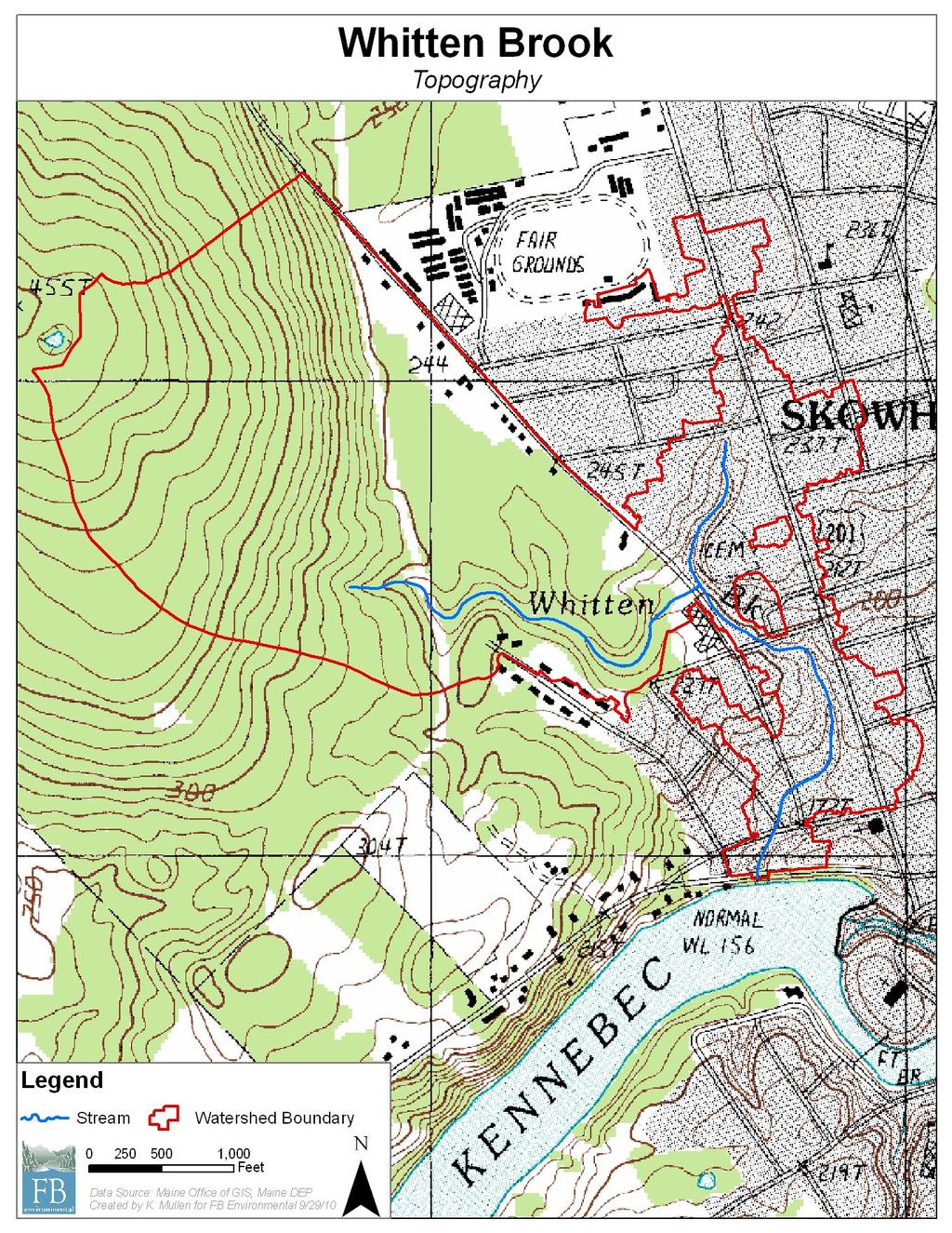
3 Map 1 49
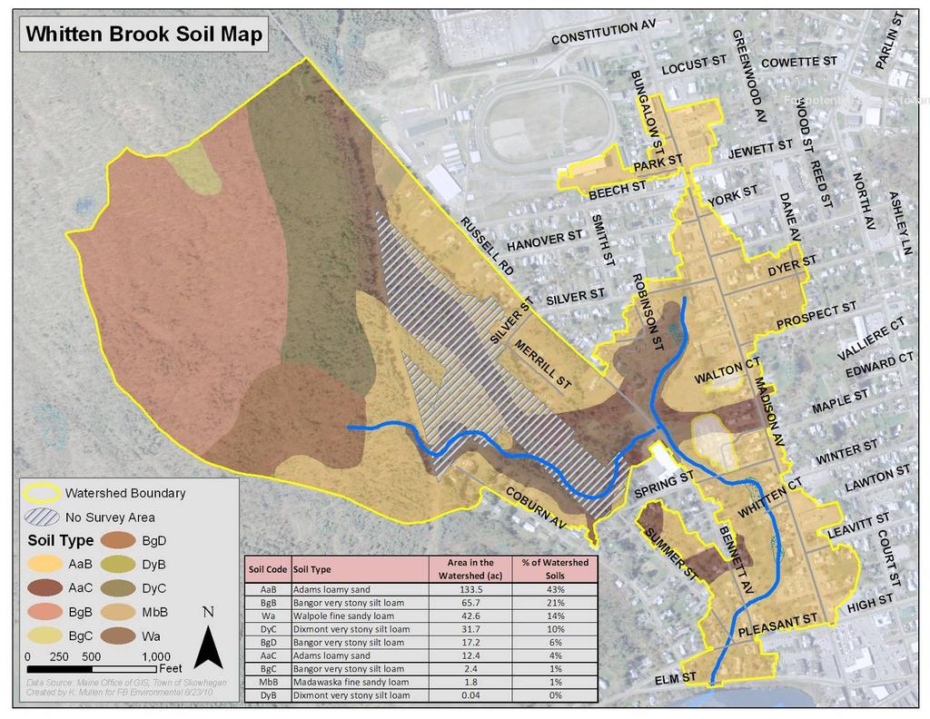
4 Map 2 50
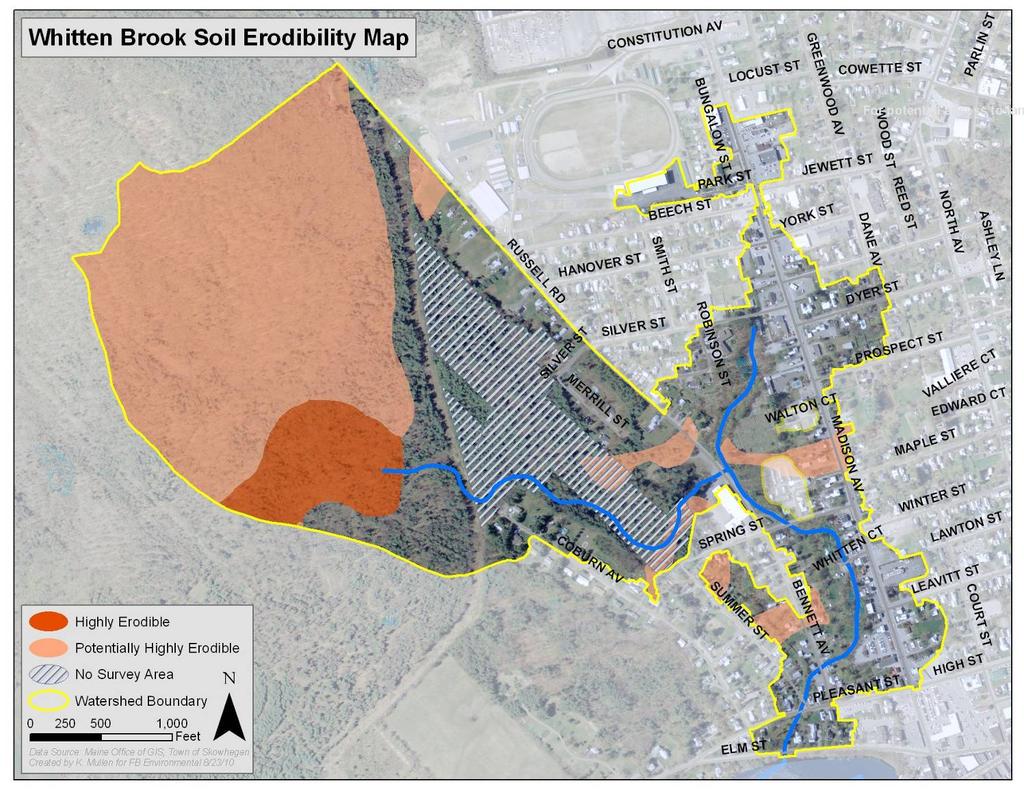
5 Map 3 51
6 Map 4 52
7 Map 5 53

8 Map 6 54
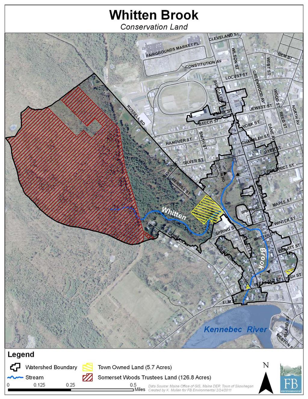
9 Map 7 55
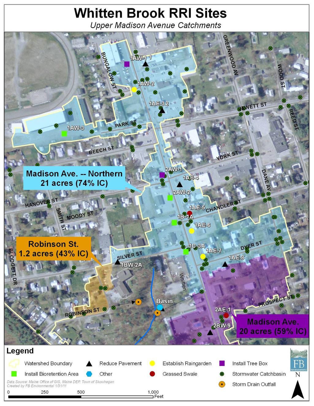
10 Map 8 56
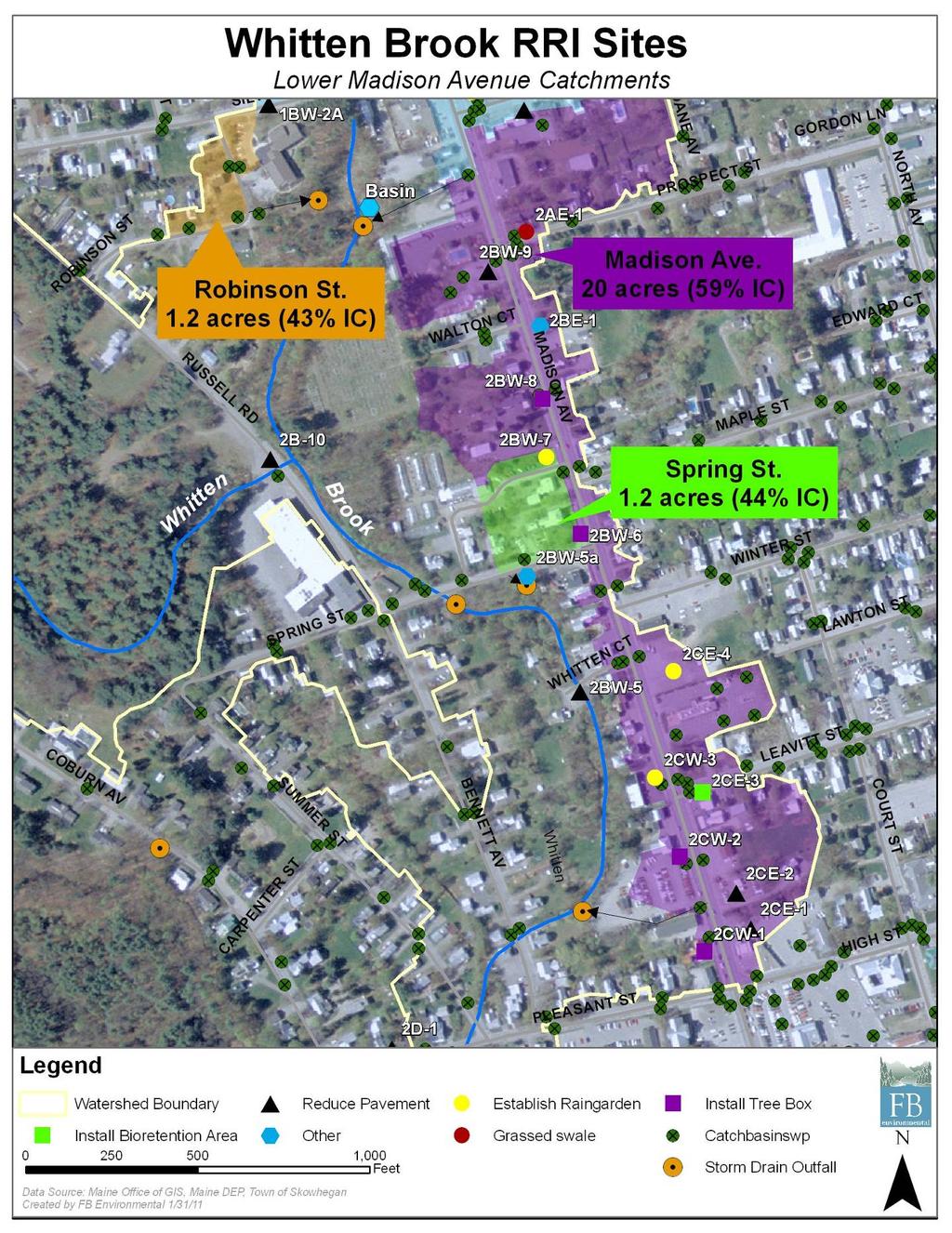
11 Map 9 57
12 Map 10 58


 or grassed-lined to reduce the potential for ditch erosion.")

13 Appendix 2: Stormwater Best Management Practices (BMPs) for Urban Watersheds Bioretention/Biofilter: These shallow vegetated areas retain and filter stormwater runoff from impervious surfaces. Once stormwater infiltrates through the bioretention area, the water can be directed back into an existing storm drain, or back to the stream through a perforated pipe, allowing for additional subsurface treatment. Stormwater reaches the stream at a slower rate when bioretention is used thereby reducing pollutants and erosion along the stream bank. Culvert/Outfall Armoring: If not properly installed, erosion can occur around the openings of culverts and stormwater outfall pipes. This erosion poses a threat to stream water quality because the sediments and nutrients in the soil (such as phosphorus) go directly into the stream. The term armoring refers to the placement of rip-rap, or large angular stones, around the opening of a culvert or pipe. Rip-rap protects the water by holding soil in its place, even during severe storm events. Ditch Maintenance: Ditches should be lined with rip-rap (angular stones) or grassed-lined to reduce the potential for ditch erosion. Check dams, which are essentially piles of larger rocks creating a small dam across the ditch in varying intervals, are useful to prevent ditch erosion because they slow down the velocity of the water and trap sediment. Dry Extended Detention Basin: These are large excavated depressions with raised outlet structures that are generally grass lined. The basins are constructed to withhold runoff from a specific catchment area, for a set period of time (e.g., 24 hours). Typically, a large area of impervious surface will have runoff collected in catchbasins, storm pipes will then carry the water into the dry extended detention basin, instead of sending it directly to a stream. When sized and constructed properly, dry extended detention basins can provide valuable peak flow volume reduction for urban streams, but must be designed properly in order to provide adequate reduction of high runoff temperatures. Bioretention Area (Source: Urban Subwatershed Restoration manual 3, CWP, 2007.) Armored Culvert (Source: Tribal Habitat Conference Blog, blogs.nwifc.org.) Rock-lined Ditch with Check Dams (Source: lakecountyohio.gov) Permeable Pavers: Permeable pavers can serve as a replacement for concrete in walkways and patios as well as pavement in driveways and parking lots. These blocks reduce stormwater runoff by allowing rainwater to pass through them into the underlying soil. Pavers offer the same functional capabilities as typical impervious surfaces such as pavement or concrete, while reducing the negative impact that stormwater has on stream health. 59 Permeable Pavers on a Walkway (Source: pavingstonesupply.com )


 Remove Pavement: If pavement is never or very rarely used, removing it will have a positive effect on the water quality of the stream.")
14 Appendix 2: Stormwater Best Management Practices (BMPs) for Urban Watersheds, cont. Rain Garden: These man-made shallow depressions in the soil are designed to capture and infiltrate stormwater flowing off impervious surfaces. Rain gardens are typically planted with native plants. Rain gardens are aesthetically and functionally appealing. By capturing and infiltrating runoff these gardens help to remove pollutants from stormwater and reduce stormwater runoff volume. Regrade Pavement: Regrading pavement in parking lots or driveways redirects stormwater into vegetated areas or other stormwater treatment alternatives rather than running down adjacent roads, storm drains, or nearby ditches, all of which lead to the stream. This BMP is a good option for paved areas because it reduces overall pollutant load and volume of stormwater reaching the stream during storm events. Rain Garden (Source: Herring Run Watershed Association, baywatersheds.org.) Remove Pavement: If pavement is never or very rarely used, removing it will have a positive effect on the water quality of the stream. By replacing pavement with vegetation the potential pollutants being washed off the pavement would infiltrate into the soil, rather than washing into the stream. Tree Box Filter: These are manufactured concrete structures that are installed along a parking lot or street. They are designed to control stormwater runoff and filter pollutants and are typically connected to existing stormwater pipes. Water from the impervious area enters the filter base, much like a catch basin. The roots and filter media in the base help to remove pollutants from stormwater before it reaches the stream. Vegetative Buffer: Having a buffer, or naturally vegetated area along the stream corridor, is a simple and effective means of protecting stream water quality. Native plants, shrubs and trees growing along the stream help reduce bank erosion, increase stormwater infiltration, and offer shade to the stream which moderates temperature in runoff. Buffers can be created by planting native trees and shrubs along the stream corridor. These plants can be found at most local nurseries. Pavement Removal (Source: OregonLive.com) Tree Box Filter (Source: Bohler Engineering, bohlereng.com). Water Diverters: Stormwater running directly off an impervious surface into a catch basin or ditch receives minimal treatment before reaching the stream. Water diverters force stormwater into a treatment system before entering the stream allowing for pollutant removal as well as flow and volume control. Examples of water diverters include appropriately placed speed bumps, sand filled fire hoses or pavement curbs. 60 Vegetated Buffer (Source: treevitalize.net).
15 Appendix 3: List of Prioritized Stormwater Retrofit Sites for the Whitten Brook Watershed Site ID Proposed BMPs Value to Stream (1 High, 5 Low) 1 Ease of Implementation (A high, E Low) Overall Priority (HH=Highest) Basin Divert pipe from CB to existing pond, reconstruct outlet structure, dredge pond 1 A HH 2B 10 Define parking for 6 7 cars; remove asphalt from beside north end of building & re vegetate w/conservation mix. Install diverter to rain garden. 1 A HH Fence seeded area to limit compaction. 2BW 8 Install tree boxes to capture runoff from 201 and adjacent res/com homes & driveways 1? HH Tree Install tree boxes to capture runoff from 201 and Boxes/201 2 adjacent res/com homes & driveways 1? HH 2CW 1 Two tree boxes one on each side of storm drain 1? HH 1AE 6 2BW 7 1BW 2A 2AW 2 2BW 5 Hotspot no containment for spills. Install small rain garden or vegetative planter near road. Drop inlet or curb cut to rain garden where Boynton's sign is located or tree box filter w/underdrain pipe to storm drain Remove pavement and re vegetate area in front of parking between road & spots 300 sq. ft Install diverter to bioretention in grassy front and behind where new pavement will be 1. Remove pavement (broken) on south east corner of Whitten Ct along cement retaining wall. Design would require engineering not to destabilize existing culvert that connects Whitten Bk. 2. For gas station catch basin. 3. For storm drain on road tree b 1 E H 1? H 2 A H 2 B H 2 C H 2CW 3 Rain garden in area adjacent to sign; tree box filter above storm drain on Madison Ave. 2 C? H 2CE 1 Install bioretention / grass swale islands to define A town/ parking areas and breakup pavement; not to reduce 2 D business parking area. H 2CE 4 Install rain garden in the center to define parking areas better. 2 D M/H 1A 2 Remove pavement, replace with vegetation or permeable pavers. 3 D M 1AE 3 Vegetate no parking area; reduce parking or use permeable pavers. 3 C M 1AE 7 Remove composted grass and install rain garden. 3 C M 1C 3A Install vegetative buffers at entrance and exits on both sides of building 3 D M 2AE 1 Install a grassed swale at end of road 3 C M 2BW 6 Install tree box above storm drain 3 C M
16 Appendix 3: List of Prioritized Stormwater Retrofit Sites for the Whitten Brook Watershed Site ID 2BW 9 Proposed BMPs Reduce impervious area by creating vegetated area in center along east side where current designated parking spots are located. Grade such that runoff flow to vegetated area (no curb). Value to Stream (1 High, 5 Low) 1 Ease of Implementation (A high, E Low) Overall Priority (HH=Highest) 3 D M 2BE 1 Install drip line trench & plants between buildings and paved parking 3 D M 2CE 3 Extend garden feature to collect all roof drainage 3 A M 2D 1 Remove pavement adjacent to the stream and install buffer. Remove 30 x 40' of pavement adjacent to white garage. Rototill to loosen packed soil. 3 B M 1AW 1 1. Install Tree box edge of lot length of lot. 2. Underground storage w/use of isolator row (50% removal) 4 B M 1AE 4 Separate parking with veg. plantings/beds; reduce paved area; about 200 sq ft to remediate. 4 C L 1AE 5 Install grassed swale in ROW. 4 C L 1AE 8 Remove parking pavement at side of building 6,000 sq ft treatment area; re vegetate 4 D L 1AW 2 1. Install rain garden in eastern corner remove 2nd drive. 2. Permeable pavers 3. Install swale in pavement to drain to bioretention 4? L areas 4. Alt tree box filter 1B 1A Biofilter along southern edge of pavement 4 D L 2BW 5a Repair eroding culvert/protect outlet & stream; find source of black water pipe. 4? L 2CW 2 Install tree box filter above storm drain 4 C? L 2AW 1 Install Tree Box Filter 5? L 1A 1 Utilize existing grassy area. Regrade pavement towards treatment area. 5 E L 1AW 3 Use bioretention around storm drains infiltrating bioretention cell w/underdrain 5 D L 2CE 2 Remove pavement or replace with permeable pavers in area periodically for overflow parking Not Feasible Not Feasible L 1 Ratings assume that the Dry Extended Detention Basin (Basin) will be installed. 2 GIS analysis depicts a total of 30 catch basins within the watershed along Rt There are a total of 10 TB filters in the RRI survey. Three of these 10 are NOT along Rt Therefore, 7 TB filters were subtracted from the total number of catch basins along Rt Therefore, 23 TB filters were used for these calculations.
17 Appendix 4: RRI Site Characteristics for Whitten Brook Site ID Impervious Area (sq ft) Estimated Runoff Treated on Site (%) Estimated Low Cost Per Site Estimated High Cost Per Site 1A 1 5, $2,870 $2,870 1A 2 10, $8,552 $10,157 1AE 3 26, $20,972 $24,904 1AE 4 3, $1,600 $1,900 1AE 5 3, $1,500 $2,500 1AE 6 21, $32,400 $38,880 1AE 7 2, $4,000 $4,800 1AE 8 13, $16,500 $25,500 1AW 1 17, $63,025 $81,745 1AW $9,761 $16,161 1AW 3 125, $112,000 $170,000 1B 1A 25, $43,543 $82,085 1BW 2A 10, $2,400 $2,850 1C 3A 40, $8,000 $9,500 2AW 1 11, $6,000 $12,000 2AW 2 15, $28,125 $45,000 2AE $1,500 $2,500 2BW 5 15, $33,225 $39,225 2BW 5a N/A N/A $3,200 $3,200 2BW 6 5, $6,000 $12,000 2BW 7 9, $21,000 $29,700 2BW 8 TBD 90 $12,000 $24,000 2BW 9 8, $8,000 $9,500 2B 10 49, $79,000 $94,000 2BE 1 5, $3,630 $4,155 2CW 1 3, $6,000 $12,000 2CW 2 11, $6,000 $12,000 2CW 3 9, $19,000 $28,200 2CE 1 11, $1,500 $2,500 2CE 2 1, $2,722 $2,722 2CE 3 2, $600 $825 2CE 4 12, $18,000 $21,600 2D 1 4, $9,600 $10,500 Basin 1 358, $70,000 $100,000 Tree Boxes 2 TBD 90 $138,000 $276,000 1 There are 15.5 acres of impervious draining to the No. Madison Ave outfall, where the proposed extended detention basin is located. The sq ft of IC sent to this BMP accounts for the 7.27 acres of IC within this catchment already being treated by other BMPs. The number 358,499 is the 8.23 acres of IC that would go untreated within this catchment without the extended detention basin. 2 GIS analysis depicts a total of 30 catch basins within the watershed along Rt There are a total of 10 TB filters in the RRI survey. Three of these 10 are NOT along Rt Therefore, 7 TB filters were subtracted from the total number of catch basins along 201. Therefore, 23 TB filters were used for these calculations.
18 Appendix 5: Methods for Calculating Percent of IC Treated and Nutrient Reductions The methodology employed by FB Environmental to calculate the estimated annual runoff volume treated and nutrient reductions at the 35 RRI sites in the Whitten Brook watershed is described below. SOIL SUITABILITY The Whitten Brook watershed is dominated by Madawaska soils (type B). Research into the infiltration rate for Madawaska soils found that the Ksat was estimated at 0.6 inches / hour in the upper horizon to as much as 20.0 inches / hour in the lower horizon. This is a fairly well drained soil. 1 The medium high to high infiltration rate for this soil was taken into account when assigning a percentage of runoff volume treated to the BMPs. RESEARCH FLOW REDUCTION Literature research provided information on the estimated annual percentage of runoff volume treated by BMPs recommended for the RRI sites, the following BMP types were researched; bioretention/filtration pervious pavers/ pavement tree box filters rain gardens sending runoff to vegetated areas Attachment 1 documents the findings from this research, while Attachment 2 lists the sources. The literature research provided the numbers that would be used to calculate the percentage of IC each BMP treated on its site. For example, one source estimated that properly sized rain gardens in well drained soils (such as Madawaska soils) could treat the runoff on a site by 90%, while another estimated this rate to be 85-94%, and another estimated the rate to be 99%. Therefore, the number that was applied to rain gardens, when sized properly, was 92%, an average of all these rates. For several of the BMPs where there was a range of values within the research, in these cases an average of the values was used. The numbers used in the calculations are provided below. Bioretention 81% Pervious Pavers / Pavement 72% 1 The Society of Soil Scientists of Northern New England "Ksat Values for New Hampshire Soils" SSSNNE Special Publication No. 5, September, 2009 available online at: Accessed online on October 7,
19 Tree Box Filters 90% Rain Gardens 92% Vegetation 50 75% depending on vegetation / IC ratio Much of this research also suggested optimum BMP size to IC drainage area ratios. For example, a rain garden s surface area should be 20% of its drainage area for optimum runoff volume treated. 2 These numbers were taken into account when calculating the cost for each BMP, since most BMP cost estimates were based off of sq ft of rain garden constructed etc. CALCULATING PERCENTAGE OF IC TREATED 1. The estimated sq ft of IC at each treatment site was determined. 2. The BMP(s) recommended at the site was / were considered and an estimate for area of IC treated on each site was calculated. a. If there was only one BMP on the site, the percentage of runoff treated by the BMP (taken from the literature research) was multiplied by the IC area. This provided an area of IC treated annually on the site. b. If there was more than one BMP, the cumulative percentage of runoff treated by all BMPs on the site (taken from the literature research) was multiplied by the IC area. This provided an area of IC annually treated on site. 3. The estimated IC from all of the sites was summed in sq ft and then converted to acres. 4. The estimated IC annually treated on all sites was summed and converted to acres. 5. Using these numbers, the estimated annual percentage of IC treated on all of the sites was determined. (IC treated/ic total) * 100 = % of IC treated from all sites CALCULATING NUTRIENT REDUCTIONS: BMP PERFORMANCE EXTRAPOLATION TOOL The nutrient reductions were calculated with the aid of the BMP Performance Extrapolation Tool (BMP- PET) for New England. This was provided to FBE by EPA. To use the tool: 1. Select the source area where your BMP will be installed: a. Commercial, Industrial, High Density Residential, Low Density Residential, Medium Density Residential 2. Select the BMP type you will be installing: 2 Hinman, C. and Beyerlein, D "Modeling Assumptions and Results for the Western Washington Rain Garden Handbook" Technical Memorandum, Washington State University, Tacoma, WA, 2007 available online at: accessed online on October 25,
20 a. Bio-retention, Dry Pond, Glass swale, Gravel wetland, Infiltration basin-static method, Infiltration trench, porous pavement, or wet pond 3. Select the pollutant you would like to get the removal efficiency for: a. Total Phosphorous (TP), Total Suspended Solids (TSS), or Total Zinc (Zn) 4. For the infiltration basin-static method and infiltration trench you can select the infiltration rate in inches / hour), this does not apply to any other BMP types in this tool. 5. For the porous pavement you can select the depth (in inches) of your filter course, this does not apply to any other BMP types in this tool 6. You then specify A or B: a. The specific size of BMP; by selecting the depth of runoff it will be built to treat (between 0 and 2 inches). b. Specific target BMP removal efficiency for the pollutant (between 0 100%) 7. Click the button extrapolate from curves 8. If you chose category A (size of BMP) then you will receive a number corresponding to the BMP removal efficiency for the specific nutrient you chose. 9. If you chose category B (target removal efficiency) you will receive the corresponding BMP size (in depth of runoff it should be built to treat). This was done for all of the BMPs located in the RRI sites, except for Tree Box Filters (because they were not included in the tool). The source area for each BMP on every site was selected as commercial. The tool was run three times for each BMP to extrapolate the removal efficiency for; TP, TSS, and Zn. The tool was run for each BMP using category A with a depth of one inch. The following assumptions were made: Removal efficiencies for porous pavement were equivalent to pervious pavers and when pervious pavers were recommended the tool was used based off of porous pavement. Removal efficiencies for bio-retention were equivalent to rain gardens and when rain gardens were recommended the tool was used based off of bio-retention. Removal efficiencies for grass swales were equivalent to vegetation and when vegetation was recommended the tool was used based off of grass swales. CALCULATING NUTRIENT REDUCTIONS: FOR EACH SITE AND ALL SITES The removal efficiencies generated for each BMP were then placed into a spreadsheet in a row corresponding to the BMP or site and the removal efficiencies in a column under the corresponding pollutant type. 66
21 If there was more than one BMP recommended for a site the highest removal efficiency generated for each pollutant type was used in the calculation. The removal efficiencies for Tree Box Filters came from the same source as the annual percentage of runoff treated (UDT, information provided in Attachment 2). The numbers were; TSS: 85%, TP: 74%, and Zn: 82% Annual loads (in lb/acre-year) of the three pollutants considered were gathered from a document prepared for EPA by Tetra Tech titled Stormwater Best Management Practices (BMP) Performance Analysis. The numbers used for each site were from a commercial source; TSS: lb/acre-year, TP: 1.66 lb/acre-year, and Zn: 2.33 lb/acre-year 1. These numbers were then multiplied by the overall acreage of IC on each site to get an estimated load for each pollutant from each site in lb/acre-year. 2. The load for each site was then multiplied by the corresponding removal efficiency for each pollutant type to obtain an estimated reduction from each site in lb/acre-year. 3. The estimated loads on each site were summed for each pollutant type. 4. The estimated load reduction on each site was summed for each pollutant type. 5. An estimated percent reduction in each pollutant was then calculated. a. Ex. (SUM TSS Reduction / SUM TSS Load) * 100 = % Reduction in TSS from all Sites. 67
22 Attachment 1: Annual Percentage of Runoff Volume Treated Proposed BMP Bioretention / Filtration Pervious Pavers / Pavement % of Annual Runoff Treated 82 (1) 80 (4) 52 to 56 (5) 75 (4) 72 (7) 68 (2) (Source) Notes This number is based on a specific system built at the UNH Stormwater Center. The bioretention's total area was 272 square feet and the catchment area was 1 acre. Based on designs that rely of full infiltration. Given the type B soils in the watershed, bioretention would be designed for full infiltration. If an underdrain was necessary the subsequent runoff treated would be significantly lower. Based on a bioretention system installed in poorly drained soils where an underdrain was needed to transport runoff that was unable to infiltrate into soils. Based on designs that rely of full infiltration. Given the type B soils in the watershed, pervious pavement would be designed for full infiltration. If an underdrain was necessary the subsequent runoff treated would be around 45%. Based on pervious paver driveway. The infiltration rate for the pervious pavers was measured at 11.2 cm/hour. Based on porous asphalt installation at UNH Stormwater Center. The system is installed over clay soils will naturally poor infiltration. Surface area is 5,200 square feet and catchment area is 5,500 square feet. Tree Box Filters 90 (3) Based on a 6 X6 Filterra tree box filter system. When sized to treat ¼ acre it will treat around 90% of the annual runoff volume. Rain Gardens 99 (6) Rain garden designed to treat 2.54 cm or 1in of runoff in well drained soils. If an underdrain is necessary to transport water off site runoff reduction would be much less. 85 to 94 (10) When rain garden surface area is 20% of the impervious area. 90 (9) When conditions are initially dry and rain gardens are between 100 and 300 square feet. Sending Runoff to Vegetated Area: Pavement Regrading Water Diverter 50 to 75 (4) Any of the associated BMPs that send runoff to a vegetated area could expect a runoff reduction. The less concentrated the runoff (such as sheet flow), less runoff volume and the higher the infiltration rate of the soil, will lead to a greater runoff reduction. Whitten Brook's watershed is dominated by Madawaska soils. Madawaska soils are in Hydrologic Soil Group B. These soil types have moderately low runoff potential when thoroughly wet. (8) 68
23 Attachment 2: Annual Percentage Treated - Sources Source ID Reference University of New Hampshire Stormwater Center, Bioretention System (Bio II), Durham, NH, 2008 available online at: Accessed online on October 18, University of New Hampshire Stormwater Center, Porous Asphalt, Durham, NH, 2008 available online at: Accessed online on October 18, Urban Design Tools, Low Impact Development Techniques, Tree Box Filter Summary Table available online at: Accessed online on October 24, Hirschman, D. Collins, K. and Schueler, T., Technical Memorandum: The Runoff Reduction Method, Appendix A, The Center For Watershed Protection, Ellicot City, ME. 18 April, B1-B11. Hunt, W. A. Jarret, J. Smith and L. Sharkey Evaluating bioretention hydrology and nutrient removal at three field sites in North Carolina. Journal of Irrigation and Drainage Engineering. 6: Dietz, M. and J. Clausen Saturation to improve pollutant retention in a rain garden. Environmental Science and Technology. 40(4): Gilbert, J. and J. Clausen Stormwater runoff quality and quantity from asphalt, paver and crushed stone driveways in Connecticut. Water Research 40: The Society of Soil Scientists of Northern New England "Ksat Values for New Hampshire Soils" SSSNNE Special Publication No. 5, September, 2009 available online at: Accessed online on October 7, Charles River Watershed Association, Low Impact Best Management Practice (BMP) Information Sheet: Rain Gardens, Weston, MA, 2008 available online at: Accessed online on October 25, Hinman, C. and Beyerlein, D "Modeling Assumptions and Results for the Western Washington Rain Garden Handbook" Technical Memorandum, Washington State University, Tacoma, WA, 2007 available online at: accessed online on October 25,
24 Appendix 6: Estimated Pollutant Loading and Reduction Calculations for RRI Sites in the Whitten Brook Watershed Site ID Est. IC (Acres) % Reduction TSS % Reduction TP % Reduction Zn TSS Load (lb/acre year) TP Load (lb/acre year) Zn Load (lb/acre year) Reduction TSS (lb/acre year) Reduction TP (lb/acre year) Reduction Zn (lb/acre year) 1A A AE AE AE AE AE AE AW AW AW B 1A BW 2A C 3A AW AW AE BW BW 5a N/A N/A N/A N/A N/A N/A N/A N/A N/A N/A 2BW BW BW 8 TBD TBD TBD TBD TBD TBD TBD 2BW B BE CW CW CW CE CE CE CE D Basin Calculation of pollutant load entering the extended detention basin from the entire catchment. The pollutant load from all of the sites after treatment was taken into account, as well as the pollutant load from the 8.23ac that are untreated in the catchment.
Appendices: Glossary. General Terms. Specific Terms. Low Impact Development Approaches Handbook
 67 67 General Terms Specific Terms 66 Low Impact Development Approaches Handbook The vocabulary of low impact development is evolving, and many terms are used interchangeably and to describe the same or
Post Construction BMPs
 Post Construction BMPs Why are Post Construction BMPs important? With increased development brings the increase of impervious cover Parking lots, rooftops, driveways Storm water runoff volume increases
Appendix D - Technical Design Criteria for BMPs
 Appendix D - Technical Design Criteria for BMPs City of Wayzata Page 3 On-site infiltration features Definitions and Scope: Infiltration facilities are constructed basins or depressions located in permeable
County of Prince Edward. Stormwater Management Plan. Agreement in lieu of a Stormwater Management Plan
 County of Prince Edward Stormwater Management Program Date: E-Permitting Number: This stormwater management plan (Agreement) is hereby submitted by the Owner to specify the methods that will be implemented
Moon Brook FRP BMP Summary Sheet. Ownership of Land where BMP is Located
 Outlet Retrofit Hitzel Terrace The town owned parcel along Hitzel Terrace is a natural wetland area which currently provides some level of stormwater detention and peak-flow attenuation. The proposed project
Homeowners Guide to Stormwater BMP Maintenance
 Homeowners Guide to Stormwater BMP Maintenance What You Need to Know to Take Care of Your Property Rain Barrel Dry Well Rain Garden Pervious Asphalt Porous Pavers City of El Monte Stormwater BMP Management
EROSION PREVENTION BMP SUGGESTED USES MATRIX
 EROSION PREVENTION SUGGESTED USES MATRIX Processed Based Tools Software Aids Slope Waterway Surface Concentrated Flows Large Flat Stock Pile Borrow Adjacent Property Impacts Erosion Prevention Measures
Structural Stormwater Best Management Practices
 Structural Stormwater Best Management Practices for Small Commercial and Residential Applications Timothy Bruno Watershed Manager PA Department of Environmental Protection What are STRUCTURAL BMPs? Physical
Draft Impervious Cover Reduction Action Plan for West New York, Hudson County, New Jersey
 Draft Impervious Cover Reduction Action Plan for West New York, Hudson County, New Jersey Prepared for the Town of West New York by the Rutgers Cooperative Extension Water Resources Program March 29, 2017
DEALING WITH STORM WATER MANAGEMENT
 December 2012 DEALING WITH STORM WATER MANAGEMENT This fact sheet provides information on the guiding principles of storm water management practices, explains the difference between structural and non-structural
Use of Best Management Practices
 Use of Best Management Practices Presented at the ANJEC Flood Hazard Workshop Bordentown, NJ March 13, 2008 Stormwater BMPs "a technique, measure or structural control that is used for a given set of conditions
East Montpelier SWMP Preliminary BMP Summary Sheet BMP ID #: 1 Site name: U-32 High School. Current site type
 East Montpelier SWMP Preliminary BMP Summary Sheet BMP ID #: 1 Site name: U-32 High School 930 Gallison Hill Rd, East Montpelier, VT Filter Berm, Sand Filter, Cistern / Rain Barrel, Gravel Wetland, Check
5. LOW IMPACT DEVELOPMENT DESIGN STANDARDS
 5. LOW IMPACT DEVELOPMENT DESIGN STANDARDS Low Impact Development (LID) requires a shift in stormwater management away from conveying runoff to a small number of downstream points through hydraulically
4. CONCEPT PLAN DEVELOPMENT
 4. CONCEPT PLAN DEVELOPMENT Concept Plan Step 1: Identify Site Constraints and Opportunities Review the existing site to identify constraints and opportunities for GI Practices to meet the RRv. Constraints
Low Impact Development for your homes, businesses & streets
 Low Impact Development for your homes, businesses & streets What s the problem anyways? - Development Impacts the Water Cycle In the past, our main pollution concern was Point Source Pollution Our current
Map Reading 201: Where Does the Water Go?? Map Reading Map Reading 201. Interconnected Systems
 Map Reading 201: Where Does the Water Go?? Today s Presenters: John Rozum, NEMO Program Paula Stahl, Green Valley Institute A Key Skill for Land Use Commissioners As the map is rolled out at the P&Z meeting...
12/7/2007. Christopher B. Burke Engineering West, Ltd Aux Sable Creek Watershed Plan Update 1
 The ABC s of BMP s Aux Sable Watershed Plan St. Charles, IL Why are BMP s Important Best Management Practices (BMPs) developed as a set of practices which help to achieve goals of the Clean Water Act and
Draft. Impervious Cover Reduction Action Plan for Dunellen Borough, Middlesex County, New Jersey
 Draft Impervious Cover Reduction Action Plan for Dunellen Borough, Middlesex County, New Jersey Prepared for Dunellen Borough by the Rutgers Cooperative Extension Water Resources Program September 22,
4.6. Low Impact and Retentive Grading
 4.6. Low Impact and Retentive Grading Low Impact Grading techniques focus on utilizing existing topography during Site layout to minimize cost. Proposing structures, roads, and other impervious surfaces
Draft Impervious Cover Reduction Action Plan for West Long Branch Borough, Monmouth County, New Jersey
 Draft Impervious Cover Reduction Action Plan for West Long Branch Borough, Monmouth County, New Jersey Prepared for West Long Branch Borough by the Rutgers Cooperative Extension Water Resources Program
HIGHLAND LAKES WATERSHED ORDINANCE WATER QUALITY MANAGEMENT TECHNICAL MANUAL
 Effective July 1, 2007 HIGHLAND LAKES WATERSHED ORDINANCE WATER QUALITY MANAGEMENT TECHNICAL MANUAL EFFECTIVE JULY 1, 2007 FIFTH EDITION Lower Colorado River Authority TABLE OF CONTENTS DESIGN SPREADHEET
SEATTLE PUBLIC UTILITIES Drainage Design Options for street right of ways.
 SEATTLE PUBLIC UTILITIES Drainage Design Options for street right of ways. Numerous ecosystem-based functional stormwater quantity and quality design alternatives are possible within the street ROW. Several
Slow it, Spread it, Sink it using Green Stormwater Infrastructure
 Milly Archer Water Resources Coordinator Becky Tharp Green Infrastructure Collaborative Slow it, Spread it, Sink it using Green Stormwater Infrastructure Overview Defining LID and GSI Hydrology and impacts
Urban Water Management and Soils (ESRM 311 & SEFS 507)
") Urban Water Management and Soils (ESRM 311 & SEFS 507) Cougar Mtn Regional Wildland Park & Lakemont Blvd, Bellevue WA Lecture Today Some Urban Water management terms Examples of water management in urban
Urban Water Management and Soils (ESRM 311 & SEFS 507) Cougar Mtn Regional Wildland Park & Lakemont Blvd, Bellevue WA Lecture Today Some Urban Water management terms Examples of water management in urban
Draft Impervious Cover Reduction Action Plan for Newark, Essex County, New Jersey Volume 3
 Draft Impervious Cover Reduction Action Plan for Newark, Essex County, New Jersey Volume 3 Prepared for the City of Newark by the Rutgers Cooperative Extension Water Resources Program April 16, 2018 Table
Low Impact Development (LID) Techniques. Associate BD Presentation, October 7, 2014
 Techniques. Associate BD Presentation, October 7, 2014") Low Impact Development (LID) Techniques Associate BD Presentation, October 7, 2014 Low Impact Development (LID) Techniques What are LIDs? Why are they used? Where are they used? How are they designed or
Low Impact Development (LID) Techniques Associate BD Presentation, October 7, 2014 Low Impact Development (LID) Techniques What are LIDs? Why are they used? Where are they used? How are they designed or
Impervious Cover Assessment for Netcong Borough, Morris County, New Jersey
 Impervious Cover Assessment for Netcong Borough, Morris County, New Jersey Prepared for Netcong Borough by the Rutgers Cooperative Extension Water Resources Program August 12, 2016 Introduction Pervious
Impervious Cover Reduction Action Plan for City of Vineland, Cumberland County, New Jersey
 Impervious Cover Reduction Action Plan for City of Vineland, Cumberland County, New Jersey Prepared for the City of Vineland by the Rutgers Cooperative Extension Water Resources Program May 23, 2016 Table
Stormwater Management Techniques WMPF LAND USE TRAINING INSTITUTE MARCH 14, 2018
 Stormwater Management Techniques WMPF LAND USE TRAINING INSTITUTE MARCH 14, 2018 Potential Impacts of New Development Urban development can significantly increase stormwater runoff Water quality considerations
Green Infrastructure and Low-Impact Development Technologies
 Green Infrastructure and Low-Impact Development Technologies The guiding principles of these technologies is to manage stormwater at their sources using natural means, and establish conditions so that
Case Study: Dallas Green Infrastructure for Stormwater
 Case Study: Dallas Green Infrastructure for Stormwater Extension and Research Sandhya Mohan Fouad H. Jaber, PhD Biological and Agricultural Engineering Texas Agrilife, Texas A&M University System Urban
Draft Impervious Cover Assessment for North Plainfield Borough, Somerset County, New Jersey
 Draft Impervious Cover Assessment for North Plainfield Borough, Somerset County, New Jersey Prepared for North Plainfield Borough by the Rutgers Cooperative Extension Water Resources Program February 4,
STORMWATER MANAGEMENT CODES ANALYSIS RICHLAND COUNTY, SC SITE PLANNING ROUNDTABLE
 STORMWATER MANAGEMENT CODES ANALYSIS RICHLAND COUNTY, SC SITE PLANNING ROUNDTABLE Codes analyses for each subcommittee were completed to assist participants of the Richland County Site Planning Roundtable.
Key elements : Filter Strips must be designed within parameters required by the Fort Wayne s Development Standards/Criteria Manual.
 4.4. Filter Strips Filter Strips are densely vegetated lands that treat sheet flow storm water from adjacent pervious and impervious areas. They function by slowing runoff, trapping sediment and pollutants,
Lesson 2: Stormwater Best Management Practices (BMPs)
") Lesson 2: Stormwater Best Management Practices (BMPs) Environmental Stewards Class Christopher C. Obropta, Ph.D., P.E. Extension Specialist in Water Resources 732-932-9800 ext. 6209 obropta@envsci.rutgers.edu
Lesson 2: Stormwater Best Management Practices (BMPs) Environmental Stewards Class Christopher C. Obropta, Ph.D., P.E. Extension Specialist in Water Resources 732-932-9800 ext. 6209 obropta@envsci.rutgers.edu
CHAPTER 11 SITE DESIGN AND LOW IMPACT DEVELOPMENT
 CHAPTER 11 SITE DESIGN AND LOW IMPACT DEVELOPMENT Source: City of Bend Chapter Organization 11.1 Purpose... 11-1 11.2 Applicability... 11-1 11.3 Low Impact Development Overview... 11-2 11.3.1 Key Strategies...
FACT SHEET: Pervious Pavement with Infiltration
 FACT SHEET: Pervious Pavement with Infiltration DESCRIPTION Pervious pavement is a Green Infrastructure (GI) technique that combines stormwater infiltration, storage, and structural pavement consisting
What is YOUR biggest challenge in stormwater control measure accounting/planning?
 Introduction Name Affiliation What is YOUR biggest challenge in stormwater control measure accounting/planning? 1 Opti-Tool Outreach Workshop Part 1 Research Based Stormwater System Accounting November,
Planning, Design, and Construction of Green Infrastructure.
 Planning, Design, and Construction of Green Infrastructure www.water.rutgers.edu What is Green Infrastructure? an approach to stormwater management that is costeffective, sustainable, and environmentally
Kittson Parkway / Watershed Park Parking Lot
 Kittson Parkway / Watershed Park Parking Lot Date Constructed: Summer 2005 Site Location / Description: Kittson Parkway, North Delta, British Columbia. Permeable parking lot adjacent to Watershed Park;
Introduction to Low Impact Development. Fred Milch. East Central Florida Regional Planning Council
 Introduction to Low Impact Development Fred Milch East Central Florida Regional Planning Council Low Impact Development (LID) Low impact development (LID) is a term used to describe a land planning and
Stormwater Prevention and Control
 Stormwater Prevention and Control Principles of Stormwater Management Stormwater Fact Sheet No. 4 This fact sheet is No. 4 of a eight-part series focused on stormwater runoff problems and control strategies.
Draft Impervious Cover Assessment for Millstone Township, Monmouth County, New Jersey
 Draft Impervious Cover Assessment for Millstone Township, Monmouth County, New Jersey Prepared for Millstone Township by the Rutgers Cooperative Extension Water Resources Program February 4, 2015 Introduction
Impervious Cover Reduction Action Plan for Hampton Township, Sussex County, New Jersey
 Impervious Cover Reduction Action Plan for Hampton Township, Sussex County, New Jersey Prepared for Hampton Township by the Rutgers Cooperative Extension Water Resources Program November 8, 2016 Table
A Review of Green Infrastructure Projects Implemented in the Grand Traverse Region
 A Review of Green Infrastructure Projects Implemented in the Grand Traverse Region Sarah U Ren Program Director The Watershed Center of Grand Traverse Bay 231-935-1514, suren@gtbay.org Our Mission: The
Impervious Cover Assessment for Berlin Township, Camden County, New Jersey
 Impervious Cover Assessment for Berlin Township, Camden County, New Jersey Prepared for Berlin Township by the Rutgers Cooperative Extension Water Resources Program September 28, 2016 Introduction Pervious
NEORSD Green Infrastructure Grant (GIG) Program Opening Remarks
 Program Opening Remarks") NEORSD Green Infrastructure Grant (GIG) Program Opening Remarks 2019 NEORSD GIG Eligibility and Technical Requirements Project must be located in the Sewer District s combined sewer area Location Applicant
NEORSD Green Infrastructure Grant (GIG) Program Opening Remarks 2019 NEORSD GIG Eligibility and Technical Requirements Project must be located in the Sewer District s combined sewer area Location Applicant
Green Infrastructure Overview
 Green Infrastructure Overview Christopher C. Obropta, Ph.D., P.E. obropta@envsci.rutgers.edu Jeremiah Bergstrom, LLA, ASLA jbergstrom@envsci.rutgers.edu February 26, 2016 Water Resources Program NJDEP
Glencoe Elementary School Parking Lot Retrofit 825 SE 51 st Street
 Glencoe Elementary School Parking Lot Retrofit 825 SE 51 st Street Project Summary Project Type: Technologies: Institutional parking lot retrofit demonstration project Vegetated infiltration swale with
Draft Impervious Cover Assessment for Fair Haven Borough, Monmouth County, New Jersey
 Draft Impervious Cover Assessment for Fair Haven Borough, Monmouth County, New Jersey Prepared for Fair Haven Borough by the Rutgers Cooperative Extension Water Resources Program March 15, 2016 Introduction
Cost Effective Low Impact Development
 Cost Effective Low Impact Development An Introductory Guide to Conserve Land, Restore Resources, Protect Water, and Save Money in Massachusetts Stefanie Covino Shaping the Future of Your Community Program
Impervious Cover Assessment for Edison Township, Middlesex County, New Jersey
 Impervious Cover Assessment for Edison Township, Middlesex County, New Jersey Prepared for Edison Township by the Rutgers Cooperative Extension Water Resources Program February 1, 2015 Introduction Pervious
Sustainable Stormwater Retrofit Best Practices
 Sustainable Stormwater Retrofit Best Practices Presenter Zach Sample, PE Stormwater Products Manager XP Solutions XP Solutions has a long history of Providing original, high-performing software solutions
Impervious Cover Assessment for Salem City, Salem County, New Jersey
 Impervious Cover Assessment for Salem City, Salem County, New Jersey Prepared for Salem City by the Rutgers Cooperative Extension Water Resources Program August 10, 2016 Introduction Pervious and impervious
Urban Water Management (ESRM 311 & SEFS 507) Cougar Mtn Regional Wildland Park & Lakemont Blvd, Bellevue WA
 Cougar Mtn Regional Wildland Park & Lakemont Blvd, Bellevue WA") Urban Water Management (ESRM 311 & SEFS 507) Cougar Mtn Regional Wildland Park & Lakemont Blvd, Bellevue WA Lecture Today Urban Water management terms Examples of water management in urban areas Field
Urban Water Management (ESRM 311 & SEFS 507) Cougar Mtn Regional Wildland Park & Lakemont Blvd, Bellevue WA Lecture Today Urban Water management terms Examples of water management in urban areas Field
Draft Impervious Cover Assessment for West New York, Hudson County, New Jersey
 Draft Impervious Cover Assessment for West New York, Hudson County, New Jersey Prepared for the Town of West New York by the Rutgers Cooperative Extension Water Resources Program March 30, 2017 Introduction
CAPE ELIZABETH, MAINE TOWN CENTER STORMWATER MANAGEMENT PLAN UPDATE
 CAPE ELIZABETH, MAINE TOWN CENTER STORMWATER MANAGEMENT PLAN UPDATE September 2015 This report was prepared by The Town of Cape Elizabeth under award CZM NA14NOS4190066 to the Maine Coastal Program from
Evaluating Urban Stormwater Retrofits in the SE US Coastal Plain
 Evaluating Urban Stormwater Retrofits in the SE US Coastal Plain 2017 Florida Stormwater Association June 14-17, 2017 Eban Z. Bean, PhD, PE Assistant Professor & Extension Specialist Agricultural and Biological
Low Impact Development. Charlene LeBleu Auburn University Landscape Architecture (334)
") Low Impact Development Charlene LeBleu Auburn University Landscape Architecture leblecm@auburn.edu (334) 844-0192 What is Low Impact Development? Infiltrate Filter Store Evaporate Detain An innovative
Low Impact Development Charlene LeBleu Auburn University Landscape Architecture leblecm@auburn.edu (334) 844-0192 What is Low Impact Development? Infiltrate Filter Store Evaporate Detain An innovative
Best Development Practices
 Town of Winchendon E. Himlan, Mass. Watershed Coalition Berkshire Design Group Best Development Practices Version 1, March 2010 Guidebook Table of Contents INTRODUCTION... 1 I. CHECKLIST FOR DESIGNERS...
Draft Impervious Cover Assessment for Mountainside Borough, Union County, New Jersey
 Draft Impervious Cover Assessment for Mountainside Borough, Union County, New Jersey Prepared for Mountainside Borough by the Rutgers Cooperative Extension Water Resources Program February 5, 2015 Introduction
Old Mill Community Association Bioretention Facility
 Project Overview This project will install a bioretention facility in a community recreation area owned by the Old Mill Community Association, Inc. Drainage from the area is currently unmanaged and has
Local Stormwater Retrofit Case Studies. Westmoreland County Conservation District Updated 11/2011
 Local Stormwater Retrofit Case Studies Westmoreland County Conservation District Updated 11/2011 WCD 2010 Why we do Sustainable Stormwater Management Retrofits To reduce flooding events and combined sewer
Small Town Sustainable Stormwater Solutions
 Small Town Sustainable Stormwater Solutions Kathryn Hamilton, RLA, ASLA Westmoreland Conservation District PA/DE ASLA Annual Meeting April 8-9, 8 2011 Urban, Industrial, Residential, Agricultural Flooding,
Butchers Hill. Greening Feasibility FINAL REPORT MAY 2009 N PORT ST N WOLFE ST S MADEIRA ST. Submitted To: Submitted By:
 S WOLFE ST N CASTLE ST N WASHINGTON ST S WASHINGTON ST S CHAPEL ST S DURHAM ST S DUNCAN ST N MADEIRA ST N MONTFORD AVE Butchers Hill Greening Feasibility N DUNCAN ST MULLIKIN ST N PORT ST N WOLFE ST E
APPENDIX G: TOWN ORDINANCE REVIEW
 APPENDIX G: TOWN ORDINANCE REVIEW TYLin (225740) Woodard & Curran SWMP January 2013 Stormwater LID strategies, ranked for Zoning Bylaw and Site Plan Review Standards Dimensional Requirements Permit the
Draft Impervious Cover Reduction Action Plan for Newark, Essex County, New Jersey Volume 2
 Draft Impervious Cover Reduction Action Plan for Newark, Essex County, New Jersey Volume 2 Prepared for the City of Newark by the Rutgers Cooperative Extension Water Resources Program April 16, 2018 Table
6.1 Bioretention Areas
 SAN MATEO COUNTYWIDE WATER POLLUTION PREVENTION PROGRAM 6.1 Bioretention Areas Figure 6-1. Bioretention Area. Source: City of Brisbane Bioretention areas 1, or rain gardens, are concave landscaped areas
What is stormwater runoff? Why is it a problem? Available Financial Incentives for Stormwater BMP s Downspout Disconnection - up to $20
 What is stormwater runoff? Stormwater is any form of natural precipitation (including ice and snow melt) that flows across undeveloped or developed land. In a natural setting, a majority of the water seeps
Zoning Regulation Amendments Adopted December 19, 2018 effective date January 7, 2019
 Zoning Regulation Amendments Adopted December 19, 2018 effective date January 7, 2019 Article 2 General Provisions Section 2.2 Definitions Definitions- FIRE LANE The aisle immediately adjacent to a building
Municipal Guide to. Storm Water Management Techniques
 Municipal Guide to Storm Water Management Techniques Municipal Guide to Storm Water Management Techniques This Municipal Guide to Storm Water Management Techniques has been developed to assist the City
SIMPLIFIED APPROACH TO STORMWATER MANAGEMENT FOR SMALL PROJECTS
 SIMPLIFIED APPROACH TO STORMWATER MANAGEMENT FOR SMALL PROJECTS Introduction As required by federal and state law, the Borough of Swarthmore has adopted regulations that affect stormwater runoff and surface
Draft Impervious Cover Assessment for Branchburg Township, Somerset County, New Jersey
 Draft Impervious Cover Assessment for Branchburg Township, Somerset County, New Jersey Prepared for Branchburg Township by the Rutgers Cooperative Extension Water Resources Program February 4, 2015 Introduction
Contents. Adapted/abbreviated from GSWMM Coastal Stormwater Supplement, August
 CH. 3 STORMWATER MANAGEMENT PRACTICES Contents Soil Restoration... 30 Site Reforestation/Revegetation... 32 Green Roofs... 35 Permeable Pavements... 37 Undisturbed Pervious Areas... 44 Vegetated Filter
Subsurface Infiltration Bed
 Subsurface Infiltration Bed The Subsurface Infiltration Bed BMP consists of a storage bed underlying either a vegetated or hardscaped surface for the purpose of temporary storage and infiltration of stormwater
Final Impervious Cover Assessment for Upper Deerfield Township, Cumberland County, New Jersey
 Final Impervious Cover Assessment for Upper Deerfield Township, Cumberland County, New Jersey Prepared for Upper Deerfield Township by the Rutgers Cooperative Extension Water Resources Program September
The following general requirements will be met for all planter box installations:
 Greenville County Technical Specification for: WQ-25 PLANTER BOX 1.0 Planter Box 1.1 Description Planter boxes are designed to capture and temporarily store stormwater runoff. Planter Boxes are intended
Evaluating Low Impact Development Practices for Stormwater Management on an Industrial Site in Mississippi
 Evaluating Low Impact Development Practices for Stormwater Management on an Industrial Site in Mississippi Dennis S. Painter, Tennessee Valley Authority, Nashville, Tennessee Donald Becker, Tennessee Valley
12/31/2014 County of Mendocino s Low Impact Design Standards Manual v1.0 A P P E N D I X 8. Site Design Measures. 32 P a g e
 12/31/2014 County of Mendocino s Low Impact Design Standards Manual v1.0 A P P E N D I X 8 Site Design Measures 32 P a g e Rooftop and Impervious Area Disconnection (Self-retaining areas) Description Disconnection
West Virginia Stormwater Management Manual: Methods.
 West Virginia Stormwater Management Manual: Methods Created to deliver targeted training on new tools and practices to improve the quality of stormwater runoff. www.cbstp.org www.chesapeakestormwater.net
Inspection and Maintenance of Stormwater Best Management Practices
 FAC T S H E E T Inspection and Maintenance of Stormwater Best Management Practices is a general term that refers to vegetated stormwater best management practices (BMPs) that temporarily store rainwater
Using Runoff Reduction Practices to Shrink the Water Quality Volume (WQv) September 18, 2018 Jay Dorsey
 September 18, 2018 Jay Dorsey") Using Runoff Reduction Practices to Shrink the Water Quality Volume (WQv) September 18, 2018 Jay Dorsey This Presentation Ohio EPA Post-Construction Criteria/Guidance Runoff Reduction Accounting Green
Using Runoff Reduction Practices to Shrink the Water Quality Volume (WQv) September 18, 2018 Jay Dorsey This Presentation Ohio EPA Post-Construction Criteria/Guidance Runoff Reduction Accounting Green
C.3 STORMWATER TECHNICAL GUIDANCE. Table of Contents. Glossary... viii. Chapter 1 Introduction/How to Use this Handbook
 C.3 STORMWATER TECHNICAL GUIDANCE Table of Contents Glossary... viii Chapter 1 Introduction/How to Use this Handbook... 1-1 1.1 Purpose of this Handbook... 1-1 1.2 What is the Countywide Program?... 1-2
2008 SWMM, 2010 Revision City of Tacoma
 2008 SWMM, 2010 Revision City of Tacoma 2.2.3.1 BMP L630 Rain Gardens Purpose and Definition Bioretention areas are shallow stormwater retention facilities designed to mimic forested systems by controlling
Draft. Impervious Cover Reduction Action Plan for Fair Haven, Monmouth County, New Jersey
 Draft Impervious Cover Reduction Action Plan for Fair Haven, Monmouth County, New Jersey Prepared for Fair Haven by the Rutgers Cooperative Extension Water Resources Program June 10, 2016 Table of Contents
NON-PRIORITY PROJECT WATER QUALITY PLAN (NPP)
") NON-PRIORITY PROJECT WATER QUALITY PLAN (NPP) For: (Insert Project Name) (Site Address or Tract/Lot Number) Prepared for: (Insert Owner/Developer Name) (Insert Address) (Insert City, State, ZIP) (Insert
NON-PRIORITY PROJECT WATER QUALITY PLAN (NPP) For: (Insert Project Name) (Site Address or Tract/Lot Number) Prepared for: (Insert Owner/Developer Name) (Insert Address) (Insert City, State, ZIP) (Insert
CITY OF TUMWATER 555 ISRAEL RD. SW, TUMWATER, WA (360) (360) (FAX)
 (360) (FAX)") CITY OF TUMWATER 555 ISRAEL RD. SW, TUMWATER, WA 98501 (360) 754-4180 (360) 754-4126 (FAX) Email: cdd@ci.tumwater.wa.us APPENDIX II-C SHORT FORM CONSTRUCTION STORMWATER POLLUTION PREVENTION PLAN (SWPPP)
CITY OF TUMWATER 555 ISRAEL RD. SW, TUMWATER, WA 98501 (360) 754-4180 (360) 754-4126 (FAX) Email: cdd@ci.tumwater.wa.us APPENDIX II-C SHORT FORM CONSTRUCTION STORMWATER POLLUTION PREVENTION PLAN (SWPPP)
Bioretention cell schematic key
 Bioretention Cells Bioretention cell schematic key 1 3 Hardwood mulch 2 Curb cut 3 18-30 Modified soil 4 Stone aggregate choker layer 5 Stone aggregate base layer 6 Subdrain 7 Undisturbed soil 8 Overflow/Cleanout
Figure 1. Bioswale along roadside. Photo courtesy of CalTrans. Figure 2. Diagram of typical bioswale (adapted from UDFCD 1999)
") Design Manual: Biological Filtration Canal (Bioswale) Dayna Yocum, Bren School of Environmental Science and Management, University of California, Santa Barbara Figure 1. Bioswale along roadside. Photo
Design Manual: Biological Filtration Canal (Bioswale) Dayna Yocum, Bren School of Environmental Science and Management, University of California, Santa Barbara Figure 1. Bioswale along roadside. Photo
5/15/2013. Basin Area. Vegetation. Rainfall & Runoff. Soil Type. Topics. Factors Influencing Erosion. Factors Influencing Erosion
 Topics Erosion, TESC and Construction sequencing Procedures and timing Remedies for failing sites Curtis Hinman WSU Extension and Bio Systems Eng. Faculty Low Impact Development Specialist chinman@wsu.edu
MANUAL OF DESIGN, INSTALLATION, AND MAINTENANCE REQUIREMENTS FOR STORMWATER MANAGEMENT PLANS
 MANUAL OF DESIGN, INSTALLATION, AND MAINTENANCE REQUIREMENTS FOR STORMWATER MANAGEMENT PLANS May 2007 SECTION 1 Responsibility of Applicant TABLE OF CONTENTS A. Stormwater Management Plan Required Information
Planning the BMP. Region 2000 Planning District Commission Lynchburg, VA December 13, 20013
 Planning the BMP Region 2000 Planning District Commission Lynchburg, VA December 13, 20013 PLANNING THE BMP AGENDA BMP Selection BMP Design SWM Plan Preparation 2 BMP SELECTION Types of BMPs Structural
Draft Impervious Cover Assessment for East Amwell Township, Hunterdon County, New Jersey
 Draft Impervious Cover Assessment for East Amwell Township, Hunterdon County, New Jersey Prepared for East Amwell Township by the Rutgers Cooperative Extension Water Resources Program February 2, 2015
Impervious Cover Assessment for Byram Township, Sussex County, New Jersey
 Impervious Cover Assessment for Byram Township, Sussex County, New Jersey Prepared for Byram Township by the Rutgers Cooperative Extension Water Resources Program December 9, 2016 *Funding provided by:
GREEN ON THE HORIZON. Challenges of Integrating LID into New Development. Southeast Stormwater Association
 GREEN ON THE HORIZON Challenges of Integrating LID into New Development Southeast Stormwater Association Annual Seminar, Charleston SC October 9, 2014 JENNIFER A. NUNN, PE THE BALMORAL GROUP Acknowledgments
BIORETENTION FACILITY
 ILLINOIS URBAN MANUAL PRACTICE STANDARD BIORETENTION FACILITY (feet) CODE 800 Source: Jessica Cocroft, Winnebago Soil and Water Conservation District DEFINITION Facility that utilizes a soil media, mulch,
John F. Kennedy STEM High School Green Infrastructure Information Sheet
 John F. Kennedy STEM High School Green Infrastructure Information Sheet Location: 127 Preakness Avenue Paterson, NJ 07522 Ward: 2 Green Infrastructure Description: Bioswale and bioretention system series
Low Impact Development in Northern Nevada: Bioretention
 Nonpoint Education for Municipal Officials www.unce.unr.edu/nemo Protecting water quality through community planning Low Impact Development in Northern Nevada: Bioretention Fact Sheet FS-09-25 Benefits
4.5 City of Indianapolis Stormwater Green Infrastructure Guidance: Bioretention (rain gardens) Bioretention Fact Sheet Bioretention Technical Design
 Bioretention Fact Sheet Bioretention Technical Design") 4.5 City of Indianapolis Stormwater Green Infrastructure Guidance: Bioretention (rain gardens) Bioretention Fact Sheet Bioretention Technical Design Specification Bioretention O & M Manual Draft Green
4.5 City of Indianapolis Stormwater Green Infrastructure Guidance: Bioretention (rain gardens) Bioretention Fact Sheet Bioretention Technical Design Specification Bioretention O & M Manual Draft Green
J. Paul Guyer, P.E., R.A.
 J. Paul Guyer, P.E., R.A. Paul Guyer is a registered civil engineer, mechanical engineer, fire protection engineer, and architect with over 35 years experience in the design of buildings and related infrastructure.