National Register of Historic Places Registration Form
|
|
|
- Rodney McGee
- 6 years ago
- Views:
Transcription
1 NPS Form OMB No (Oct. 1990) United States Department of the Interior Registration Form 1. historic name Barboursville Historic District other names/site number Village of Barboursville 2. Location street & number Multiple Addresses not for publication city or town Barboursville vicinity state WV code WV county Cabell code 011 zip code 3. State/Federal Agency Certification As the designated authority under the National Historic Preservation Act, as amended, I hereby certify that this nomination request for determination of eligibility meets the documentation standards for registering properties in the National Register of Historic Places and meets the procedural and professional requirements set for in 36 CFR Part 60. In my opinion, the property meets does not meet the National Register criteria. I recommend that this property be considered significant nationally statewide locally. (See continuation sheet for additional comments.) Signature of certifying official/title Date State or Federal agency and bureau In my opinion, the property meets does not meet the National Register criteria. ( See Continuation sheet for additional comments.) Signature of certifying official/title Date State or Federal agency and bureau 4. Certification I hereby certify that the property is: entered in the National Register. See continuation sheet determined eligible for the National Register. See continuation sheet determined not eligible for the National Register. removed from the National Register. other, (explain:) Signature of the Keeper Date of Action
2 Barboursville Historic District Cabell, WV 5. Classification Ownership of Property Category of Property Number of Resources within Property private building(s) Contributing Noncontributing public-local district public-state site 20 1 buildings public-federal structure sites object structures objects 20 1 Total Name of related multiple property listing N/A 6. Function or Use Number of Contributing resources previously listed in the National Register N/A Historic Functions COMMERCE/business, professional, financial institution, restaurant, specialty store Current Functions COMMERCE/business, professional, financial institution, restaurant, specialty store 7. Description Architectural Classification LATE 19 th AND 20 th CENTURY REVIVALS/Classical Revival LATE 19 TH AND 20 TH CENTURY AMERICAN MOVEMENTS/Commercial Style Materials foundation BRICK,CONCRETE walls BRICK, STUCCO,VINYL,WOOD, STONE roof ASPHALT other WOOD;CONCRETE; STONE; METAL Narrative Description See s
3 Barboursville Historic District Cabell, WV 8. Statement of Significance Applicable National Register Criteria Levels of Significance (local, state, national) LOCAL A Property is associated with events that have made a significant contribution to the broad patterns of our history. B Property is associated with the lives of persons significant in our past. C Property embodies the distinctive characteristics of a type, period, or method of construction or represents the work of a master, or possesses high artistic values, or represents a significant and distinguishable entity whose components lack individual distinction. Areas of Significance COMMERCE COMMUNITY PLANNING AND DEVELOPMENT ARCHITECTURE Period of Significance 1854-c.1955 D Property has yielded, or is likely to yield, information important in prehistory or history. Criteria Considerations Property is: A owned by a religious institution or used for religious purposes. Significant Dates N/A Significant Person B. removed from its original location. N/A C. birthplace or grave of a historical figure of outstanding importance. D a cemetery. Cultural Affiliation N/A E a reconstructed building, object, or structure. F a commemorative property G less than 50 years of age or achieved significance within the past 50 years. Architect/Builder N/A Narrative Statement of Significance See Continuation sheets 9. Major Bibliographical References Bibliography Previous documentation on file (NPS): preliminary determination of individual listing (36 CFR 67) has been requested previously listed in the National Register Previously determined eligible by the National Register designated a National Historic Landmark recorded by Historic American Buildings Survey # recorded by Historic American Engineering Record # Primary location of additional data: State Historic Preservation Office Other State Agency Federal Agency Local Government University Other Name of repository:
4 Barboursville Historic District Cabell, WV 10. Geographical Data Acreage of Property Approximately 2 acres UTM References: Barboursville Quad Zone Easting Northing Verbal Boundary Description See s Boundary Justification See s 11. Form Prepared By name/title Aubrey Von Lindern, Intern organization WV SHPO date July 2008 street & number 1900 Kanawha Blvd. East telephone city or town Charleston state WV zip code Property Owner name Multiple Property Owners street & number telephone city or town state zip code
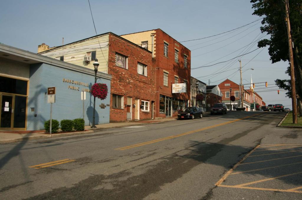
5 Barboursville Historic District United States Department of the Interior Section number 7 Page 1 LOCATION and SETTING The City of Barboursville is situated along the Guyandotte River and near the mouth of the Mud River in the southwest portion of the state and is included in the Greater Ohio River Valley. Its location is important to the town s development as an early agricultural community and later as a commercial and transportation center. Barboursville today expands well beyond the boundaries of the original settlement and the one time county seat of Cabell County has become a bedroom community to the larger city of Huntington, which is located just twelve miles to the west. Despite a change in its identity, Barboursville s historic district has maintained a sense of history relating to its varied past. Although the City of Barboursville includes a large area with residential, education and industry related districts the focus of the nomination will include approximately a two-block radius commonly referred to as the village or the commercial district. The historic district is laid out in a grid pattern with Central Avenue and Water and Main Streets as the principal commercial arteries. Central Avenue and Water Street are parallel to one another and both intersect with Main Street. The pattern is the same as laid out on a map of Barboursville in These three streets encompass the main area of commerce in Barboursville during the period of significance. The district is comprised of 20 buildings with 17 contributing to the historic integrity of the village. The village contains several good examples of late 19 th and early 20 th century commercial architecture along its main thoroughfares. The buildings within the district exhibit a definite cohesiveness in style, massing and layout. Most of the resources are two part commercial block buildings with very little detailing except for decorative cornice work indicative of styles popular in the late 1800s and the early 1900s. Main Street and Central Avenue today are reminiscent of what the district looked like during the period of significance and contain the densest population of contributing buildings. In 1854 the district contained mostly frame buildings with only one or two buildings being constructed of brick. One of those brick buildings still remains today and sits on the corner of Central and Main streets. None of the frame buildings exist because as the century progressed, fire prevention came to the forefront and it was more prudent to build in brick. Today several brick commercial buildings still exist from the 1870s and although some have been clad in stucco or painted their contribution to the district has not diminished. During the early 20 th century larger buildings were built along the district and housed not only the shop on the first story but housed office space for doctors, lawyers and other offices in the upper stories. Changing times in Barboursville prompted business owners to make changes to their buildings. Many of the contributing buildings have undergone extensive alterations on their first story front facades. This is the case for many buildings in any downtown area. As the needs of the public change and styles come in and out of fashion the owners of such buildings find it necessary to give their shop front a new look in order to attract customers. In Barboursville this has definitely been the case, however the second story front facades have remained untouched on most of the buildings and their overall massing has not changed therefore leaving their historic footprint intact. Barboursville Historic District
6 United States Department of the Interior Section number 7 Page 2 INDIVIDUAL DESCRIPTIONS Water Street 1) 615 Water Street c.1925 contributing First United Methodist Church Parsonage Two-story, two bay brick home with a hipped roof and wide overhanging eaves. Although the style of the home cannot be distinguished, its form can be categorized as an American foursquare. There are hipped dormers on both the front and south elevations and the front façade features a one-story porch with a hipped roof. Three substantial brick piers and porch wall, both capped with rough faced stone support the porch. All windows are one-over-one sash, double hung with wooden casements. There are three windows on the first story of the front facade, and a glazed and paneled door. The second story front façade has two one-overone metal windows. There is also a rear modern addition, faced with siding and new windows. Main Street 2) 614 Main Street 1924 contributing First United Methodist Church The church has a front gable roof with vinyl tympanum and wide vinyl entablature. There is an octagonal wood and metal steeple. Brick pilasters, capped with concrete, paired at the corners, and central pilasters flank the entrance. Tuscan wooden columns support the front gabled porch. The first story has a double metal door with a concrete surround featuring scroll-shaped consoles and decorative crown. There is a central stained glass window on the second story flanked by two sets of coupled arched ecclesiastical stained glass windows. Each of the paired windows sits below a concrete panel and brick arched surround. All windows have concrete sills. The front gabled portico, columns and steeple were added in the 1960s. 3) Main Street c contributing Wysongs Drug Store and the Chevrolet Agency (Stuff N Such and Vacant) This is a two story, three bay brick traditional two part commercial building with a flat roof. The first story of the main elevation features three full story windows, one central door, and two doors adjacent to the windows. There is a central door with a wooden pediment above and is flanked by fluted pilasters which provides access to the second story. On each side of the central door are separate retail spaces. The shop front located at the west end of the building has three bays, two large windows with metal sashes that flank a metal door. On the east end of the building there is more traditional shop front with a recessed door and windows on each side that begin as flush with the façade but angle inward towards the entryway. Each bay of the first story has a brick soldier course lintel and concrete sill. The original windows appear to have been replaced, with the more recent windows. Originally each window was had a transom above which has now been replaced with signage for the current function of each space. The second story features four paired windows, double hung with one over one sashes. The sills and lintels are rough faced stone. The first story of the west
7 Barboursville Historic District United States Department of the Interior Section number 7 Page 3 elevation has three deeply inset windows, double hung with one over one sashes, as well as rough faced stone sills and lintels. The window closest to the main elevation features two single panes divided by a vertical metal sash. The windows of the second story repeat the second story windows of the main elevation. The roofline is capped with rough faced stone 4) 642 Main Street (Photos 4, 6) 1906 contributing Brady Hardware Building This building with four bays, is a two part brick commercial block with a flat roof. Ornamental masonry brackets and decorative brickwork adorn the roof line. The first story has one window with three large panes divided by vinyl sashes and another window with two large panes divided by a metal sash. These two windows are associated with retail space located at the west end of the building. There is a deeply inset entryway for access to the retail area and the second story. The additional two bays are comprised of one traditional shop front with large windows, divided by a metal sash curved inward on both sides of the entryway and another window flush with the facade with two large panes once again divided by a metal sash. Large awnings with scalloped edges cover each of the bays. There are six twelve-over- twelve double hung sash windows with rough faced stone sills and lintels. There is a stringcourse of rough faced stone placed just under the ornamental masonry brackets that run the full length of the building. Slightly off center, in between the first and second stories, is a stone block etched with the name of the original company housed in the building and the date of construction 5) 650 & 652 Main Street (Photos 1, 6, 7) 1870 contributing First National Bank (Attorney s Office) This building is two-part brick commercial block with decorative brick and concrete parapet executed in Italianate detailing forming a false front that extends slightly above the roofline. At the foundation level there are two glass block windows, one with 24 panes and the other with 18. The window originally had 24 panes; however it has been filled in with brick near the metal after hours depository. Each of the windows on the foundation level has a rough faced lintel. On the first story a small concrete stairway with a metal railing up the center leads to deeply inset entryway with one door for access to the first story and the other for second story access. The double doors are wooden and contain an oval glazing. There are two windows on the first story, one is a paired double hung one-over-one with vinyl sashes and the other is a large single pane window. Each window contains single pane transoms above them and a continuous rough faced stone sill and each has a rough faced stone lintel. The second story has four symmetrical twelve over twelve double hung windows with rough faced stone sills and each is capped with decorative smooth faced stone bracketed crowns 6) 652 ½ Main Street (Photos 2, 6, 7) 1870 contributing First State Bank (Vacant- Rental Space) Barboursville Historic District
8 United States Department of the Interior Section number 7 Page 4 Two-part brick commercial building with a flat roof and decorative stepped brickwork that runs continuous along roof wall junction. There are four multi-pane windows on the first story with vinyl sashes, fluted pilaster surrounds, and concrete sills. There are two windows on each side of a centrally located deeply inset entryway. The second story has three double hung, twelve over twelve windows with wooden sashes, each with rough faced stone sill and lintel. Courses of header bricks lay above the lintels. There is a course of rough faced soldier brick between the second story windows and the roofline. 7) 714 Main Street (Photo 5) c contributing Main Street Barber Shop Three bay, stucco clad, one part commercial building with one section of the building dedicated to the barbershop and another section that has been converted to residential space. The barbershop façade features a large storefront window that runs the length of the barber shop and eventually angles inward towards the entrance. At one time the windows and door had transom windows above however they have now been covered with plywood. Just below the window and roofline of the barbershop space there is painted detailing made to look like cornice dental work. The residential section of the building is also 1 story with stucco cladding. It includes one large picture window and a paneled door. There is evidence of a transom above the door that has been filled in with plywood. 8) 718 Main Street (Photo 5) 1950 contributing Adams Building Three story, two bay L shaped brick building with to front facades, one on Main Street and one on Central Avenue. The Main Street façade has two display windows with metal sashes one on each side of a glass double door. Each of the display windows features a smooth faced stone sill. There is another door on the front façade providing access to the upper stories. The second and third stories each have three twelve-pane casement windows with a fixed sash transom above. All of the windows on the upper stories have rough faced stone sills and smooth faced stone lintels. 9) 724 Main Street (Photo 5) c.1955 contributing Two story, two bay multi-colored brick building with a flat roof. The building looks like a traditional commercial block that has been converted into residential space with two apartments downstairs and two possibly four upstairs The front façade has two paneled doors for each of the apartments downstairs and one paneled door for access to the apartments upstairs. Each of the doors for the first apartments are flanked by windows, one is a paired one-over-one sash double hung window with a cement sill and the other is a sliding glass window with a cement sill. There are two fixed pane windows on the second each with a stone sill. 10) 728 Main Street (Photo 5) 1968 noncontributing Barboursville Public Library A modern brick building with a massive brick wall on the front façade that is interrupted by an recessed entrance bay with one glass door with a metal frame and metal framed transom and sidelights. The interruption of the brick continues with large vertical fixed sash windows with metal frames. At the corner Barboursville Historic District
9 United States Department of the Interior Section number 7 Page 5 the brick continues in the form of a large brick pier that wraps around to the east façade. Half the east façade is taken up by five larger vertical fixed sash windows and then there are five brick piers with narrow fixed sash windows between each one. Central Avenue 11) 602 Central Avenue (Photos 3, 6, 7) 1854 contributing Miller/Thornburg Store (Edward Jones) Two story, three bay Flemish bond brick commercial building with stepped or corbelled parapet on the west elevation and a triangular parapet on the Central Avenue (front) elevation. The brick foundation is veneered with poured concrete. The first story of the Main Street (N/NE) elevation and Central Street elevation have been dramatically altered with ornate Colonial Revival detailing. There are four paired fluted Corinthian pilasters, with simple wide entablature running the length of the building. A wide eave with a standing seam metal roof, evident at the base of the second story, has a modillion course and egg-and-dart detailing at the cornice line. The second story features five double hung, twelve over twelve wooden sash windows. Four of these windows flank a central window with twelve pane fixed sash sidelights. All windows have smooth faced stone sills and lentils. The central bay on the first story of the front elevation has two fixed wooden twenty-four pane sash windows on each side of an inset entryway. Two sixteen pane splayed fixed wooden sash windows lead up to a central door. The fluted Corinthian pilasters of the side elevation are repeated on the front facade, with two on each side of the central bay. The eave of the side elevation wraps around to this facade as well. Three symmetrical twelve over twelve double hung wooden sash windows are on the second story, with smooth face stone sills and lentils. 12) 606 Central Avenue (Photos 3, 7, 8) 1928 contributing MC Drugstore (R. Stephan Jarrell, Attorney, Village Dance Theatre) This structure is a two bay, two part brick commercial building with two large display windows flanking a centrally located inset entryway with double wooden doors. There is another double wooden door entryway for access to the second floor. The second floor has two paired twelve-over-twelve windows with rough faced stone lintels and sills. There is a decorative bracketed parapet along the roof wall junction that was a later addition to the building ) 646 Central Avenue (Photo 3, 7, 8) c contributing Ossie Mills General Store, Barber Shop (Blackhawk Grille) This stucco clad commercial block is now listed under one address, however historically it housed several different businesses. The first building is a small one story building with a flat roof. It has one paneled door and a large single pane window. The next building is also stucco clad with roof with three gables and a large traditional storefront with an inset entryway under the first two gables. The first story of the third front gable Barboursville Historic District
10 United States Department of the Interior Section number 7 Page 6 has been altered with colonial style detailing and frosted decorative glass. The second story features eightover-eight double hung windows and two single pane windows. All of the windows have green shutters. The third and last building is one story with stucco cladding and a flat roof. It has a traditional storefront with a three large cylindrical awning as covering. 16) 650 Central Avenue (Photos 8, 9) 1914 contributing M.C. Johnson Building (Vacant) This commercial building sits on the northwest corner of Central Avenue and Brady Street. It is a two story, two bay brick building with a flat roof. There are two entrance bays on the first story front façade flanking a large metal framed picture window. One entryway is recessed with double glass doors and a metal frame. The other entryway is a single glass pane door and leads to the second story. It is evident that transoms were above each of bays on the front façade and have since been in filled with brick. Just above each brick infill there are stone lintels. The second story has two five vertical pane windows and the third story windows are copies of those on the second story in shape, however the window sashes and frames have been replaced by sheets of corrugated metal. The stone sills and lintels remain. The only adornment left on the building is a course of corbelled brick that stretches across the front façade of the building just below the roof line. 17) 691 Central Avenue c.1955 contributing (Village Barber Shop) This is a simple brick two part commercial block with two bays and a flat roof. There is a large shop front and one glass panel door on the first story front façade. On the second story there a two horizontal pane triple hung metal windows each with stone sills. 18) 611 Central Avenue 1950 contributing Adams Building This building is an L shaped brick commercial block and has two front facades, one on Main Street and one on Central Avenue. The front façade facing Central Ave exhibits a more traditional shop front appearance. There are two different shops with in this block, each with an inset entryway flanked by large display windows. The second story has three casement windows with a stone sills and lintels. 19) 601 Central Avenue c contributing (Designer Dogs) This is a one story, three bay brick building with a side gable roof. It has two windows on the front façade flanking a central door. On window is a large single pane window and the other is an eight-pane casement window Barboursville Historic District
11 United States Department of the Interior Section number 7 Page 7 Brady Street 20) Brady Street c contributing (Presently owned by Blackhawk Grill on Central Avenue) This small one story, two bay brick building has a front gable roof and historically housed a jail and fire department for downtown Barboursville. It has a double door which is flanked by pilasters and topped with a traditional broken pediment. There is also a single pane window on the front façade with a decorative wood panel below and it is capped with a simple wooden board. The wooden board is also visible on the other side of the entryway and is possible evidence that this entryway was, at one time, larger perhaps garage opening for fire trucks. 21) Brady Street c.1925 contributing Garage for Parsonage This is a concrete block one car garage located directly behind the parsonage for the First United Methodist Church.
12 Barboursville Historic District United States Department of the Interior Section number 8 Page 8 STATEMENT of SIGNIFICANCE The Barboursville Historic District is locally significant under National Register Criterion A: Commerce and Community Planning and Development and Criterion C: Architecture. Under Criterion A, Barboursville is significant because of its early development as a commercial center and its subsequent position along transportation corridors. It is also significant under Criterion A for community planning and development due to its status as one of the earliest towns in Cabell County and its evolution from an early frontier town to its position as the county seat and finally to its standing as bedroom community to the now larger city of Huntington. It is significant under Criterion C for architecture because of the density of notable buildings located in the commercial core. Most of the buildings were built in the late 19 th century and early 20 th century and exhibit styles popular during these time periods. The period of significance dates from 1854, coinciding with construction of the earliest building, to c.1955, when building construction in the district waned. HISTORY In 1772 John Savage was granted 28,000 acres of land along the Ohio River Valley by King George III as part of what would become known as the Savage Land Grant. The grant, an attempt to recruit for the French and Indian War, promised soldiers a certain amount of acreage in this unknown wilderness in return for their service. Many soldiers sold off their property; however a few, like John Savage, decided to stay and settle the land along the Ohio River. Barboursville became one of the early settlements in the area formerly part of the Land Grants. In 1802 two men, William C. Merritt and Jeremiah Ward, surveyed the area and each decided to buy one parcel of land on each side of the Guyandotte River. Jeremiah Ward bought land on the north side and William C. Merritt purchased land on the south side of the river, the latter of which became Merritt s Mill and later, in 1813, became Barboursville, so named for Governor James Barbour of Virginia. In 1809 Cabell County was formed and became primarily an agricultural community. In 1813, Barboursville was established and early plans for the village called for 34 plots of land to be parceled out along three streets, Water, Central and Main streets. Two of the streets, Water and Central would run parallel to the river and be intersected by Main Street. With a well established town plan, Barboursville, in 1814, was named the county seat which helped with the town s progress, making it a central place of business for those citizens living in surrounding areas. Also contributing to Barboursville s growth was the completion of the James River and Kanawha Turnpike, an early stagecoach route that opened up the western territories for further settlement as well as providing a way for farmers to transport their goods. The James River and Kanawha Turnpike spurred a new era for the small town of Barboursville. Known previously as an agricultural center, the town adapted to its new role as stop along a major transportation corridor. New businesses, such as hotels, restaurants and saloons were constructed specifically catering to the passengers that would come through on their way west.
13 Barboursville Historic District United States Department of the Interior Section number 8 Page 9 As transporting goods got easier, Barboursville quickly transitioned from a town supported primarily by agriculture to a manufacturing town. In the 1840s the small town could boast of being the center of industry in Cabell County with the establishment of factories producing everything from furniture, wagons, fan mills, to a tannery and a lumber mill. In the 1850s Barboursville received another boost to its economy when the New York Navigational Company built a series of locks and dams along the Guyandotte River, allowing steamboats to carry both passengers and freight easily to the Ohio River or back to the Kanawha and James Rivers. The lumber mill in Barboursville capitalized on the popularity of the steamboat and began producing hulls, made of a clear oak timber, to be shipped to Jeffersonville, Indiana. In 1854 the Thornburg General Store was built and still stands on the southwest corner of Central Avenue. Here customers could purchase their daily grocery needs or a ticket on the steamboat or stagecoach. In 1860, like many communities, Barboursville became divided on the issues surrounding the Civil War. Families were driven apart by divided loyalties, some deciding to fight for the Confederacy while others for the Union. The issues came to a head on Fortification Hill overlooking the town of Barboursville. The Battle of Barboursville began on July 11, The battle involved Colonel Ferguson s Confederate militia from Wayne and Cabell counties and Colonel Woodruff s Second Kentucky Union regiment, with the battle ending in a Union Victory. A second smaller battle commenced in Barboursville in September of 1862 between General Jenkins Eighth Virginia regiment and Colonel Powell s Ohio cavalry regiment. This skirmish took place in the village itself. After the Civil War had ended, the economy of many towns in the new state of West Virginia suffered and Barboursville was no exception. The small village tried to reestablish itself, once again, as an agricultural center and though it had some success with grain farms it would never be as successful as in its early days. In 1873 there was some hope for the local economy when the Chesapeake and Ohio Railroad company extended its tracks into Huntington. The rail company decided to build shops in Barboursville; however despite providing jobs for the locals, it did little for reviving the village to its former glory. The railroad actually began to hurt Barboursville more than it helped. It caused the once smaller town of Huntington to grow larger and more prosperous, so much so that in 1887 the county seat was moved there from Barboursville. The people of Barboursville fought hard to have the county seat returned but were unsuccessful and their goals now shifted on what would become of the old courthouse and the village itself. In 1888 a group of men came together for the purpose of establishing a school in Barboursville. By 1889 Barboursville Seminary was established and the committee decided to use the old courthouse and its grounds for the school. The courthouse became the college main, the county jail was converted into a boy s dormitory and the Blume Hotel was used as the girl s. It was the hope of the schools founders that it would become the center of life for Barboursville and in order for this to happen the town would have to be made into a college town, meaning all saloons should be removed from the area and businesses should be brought in to cater to this new population. There were 25 students enrolled by the first day and by the end of the year that number had increased to 130. The schools success was short lived; by 1890 the school was
14 Barboursville Historic District United States Department of the Interior Section number 8 Page 10 already having financial difficulties and was forced to reorganize as Barboursville College under the leadership of the General Board of Education of the Methodist Episcopal Church. The reorganization was unsuccessful overall and the college began having further financial troubles until Mr. Morris Harvey, a coal baron from southern West Virginia stepped in with an endowment of $10, The college was renamed Morris Harvey College and the small school began to grow, and with new buildings, new academic and sports programs enrollment steadily increased well into the 1920s. The success of the Twenties was met with the economic struggles of the 1930s and the depression hit the school hard. Enrollment began to decrease and competition from Marshall College in Huntington proved too much for the school and in 1935 it was moved to Charleston, West Virginia. Many of the businesses that flourished in Barboursville because of the college began to fail and Barboursville, once again, had to reinvent itself. While the college became the main focus of the town in the late 19 th and early 20 th centuries, other industries were developing in Barboursville. In 1904 Barboursville Clay Manufacturing was established and was said to produce some of the best bricks and tile in the nation. In 1921 the company was hired to produce tile for the remodeling of the White House. Brick manufacturing was not new to Barboursville, in years leading up to the Civil War, Barboursville became well known for its brick making. Both brickyards can be attributed to supplying bricks for buildings in and around the village. Barboursville, from its inception, experienced a number of evolutionary developments relating to transportation. The town is presently located off of historic U.S. Route 60, a highway stretching from the coast of Virginia to Arizona. Historically, Route 60 was known as the Midland Trail, an early cross-country autoroute planned in the early 20 th century. Barboursville s main street is also part of the James River and Kanawha Turnpike, an early route to open up expansion to the west that allowed the small settlement to play host to many travelers making their way on the stagecoach to western territories. In addition to these two important roads, Barboursville has also flourished because of it location on the Guyandotte River. In 1814 the New York Navigation Company constructed a series of locks an dams along the Guyandotte that would allow those traveling on the James River and Kanawha Turnpike the opportunity to board a steamboat in Barboursville and continue westward via the river. The C&O railroad came through in 1873 and contributed to Barboursville s status as a junction town; however the railroad benefited, at the time, the smaller city of Huntington, so much so that the county seat was moved there in After 1887, the town experienced a quieter period with little new development. It was not until the 1920s, with the advent of the automobile, the building of new roads, electricity, and a chamber of commerce, that Barboursville began to reinvent itself in a manner that embraces its past, yet looks to its future. This reinvention included the construction of new modern buildings and renovation of some older buildings in hopes of encouraging new business owners and new residents to come to the small town.
15 Barboursville Historic District United States Department of the Interior Section number 8 Page 11 Criterion A: Commerce and Community Planning and Development The Barboursville Historic District is significant under Criterion A for its development as an early commercial center in Cabell County and for its continued success with maintaining a vibrant commercial center in the face of multiple events that tested the small town s ability to thrive. In 1813 the Town of Barboursville was established by an Act of the Virginia Assembly and in 1814 the plan of the town of Barboursville was laid out with 34 lots, a public square and three principal roads, Water, Center and Main Streets. With this well-established plan Barboursville was made the county seat which initiated much of town s growth and development during this period. There are no buildings still standing from this period, however the layout of the town still remains the same and this early development is what spurred many of the activities that make Barboursville what it is today. During the late 19 th Century and early 20 th Century Barboursville had some of its most challenging times yet it still continued to grow and flourish into a well-maintained and prosperous commercial district. After the Civil War, Barboursville would continue to evolve as a commercial center, first based on its status as county seat and transportation center, later as a center of education and in the 1930s and 1940s as a smaller yet thriving Main Street community. Much of Barboursville s early growth can be attributed to its location along a major stagecoach route. The town flourished with hotels, shops and restaurants. In the 1870s the C&O railroad began building tracks that would go through Barboursville and continue on to Huntington. The people of Barboursville were against the building of the railroad, believing it would negatively impact the stagecoach travel that the town so depended on. The C&O continued its track expansion and with its completion Barboursville became a junction town while Huntington became the major stop along the route. Huntington began to develop at a fast rate and was eventually chosen to be the new county seat leaving Barboursville with an empty courthouse and an uncertain future. Despite this setback, new businesses were established in Barboursville during the 1870s and 1880s. In 1870, George Miller, Jr. opened up the First National Bank at 650 Main Street, in a building that still stands today. Despite the county seat moving to Huntington there were an abundance of attorneys who remained in town and occupied many of the second and third stories of the buildings in Barboursville. In 1888, Barboursville Seminary was established and it became an impetus for many new businesses in the village. General Stores, Ice creams parlors and Barber Shops became popular establishments with students. During the early 20 th Century Barboursville Seminary became Morris Harvey College and still contributed to the town s vitality up until the day the school moved to Charleston in During the early 20 th century Barboursville experienced a sort of renaissance attributed to new technology. The city first got electricity, the automobile spurred new businesses and a new auto route called the Midland Trail passed through on the town s Main Street. Electricity allowed businesses to stay open later and increase their profits. More General stores opened up on both Main Street and Central Avenue in buildings that still exist today. Some of the frame buildings of earlier periods were torn down in order to build a new commercial block on Main Street. One such block was 620 Main Street which became a Chevrolet dealer and garage. Another garage opened up at Barboursville Historic District
16 United States Department of the Interior Section number 8 Page Central Ave sometime in the late 1920s or early 1930s. The Midland Trail promised to bring tourists through the small town and prompted the development of new hotels like the Hotel Edgar located above the shops at 642 Main Street. All of these buildings are still in use today albeit with new functions. Criterion C: Architecture Barboursville Historic District is eligible under Criterion C because of the density of contributing buildings that exhibit a variety of styles popular from the mid 19 th century into the early 20 th century. Despite the variety of styles there is still cohesiveness about the district that permits the village of the past to be envisioned. The majority of the buildings in the district are traditional, one and two part commercial blocks with detailing indicative to the trends popular at the time of their construction. The earliest building in the commercial core was built in It initially housed the Thornburg/Miller General Store and later a Kroger Grocery store. The current owners have altered the first story with colonial style detailing, however the second story has remained intact. The brick building contains a triangular parapet gable on the Central Avenue façade and a parapet gable at the other end. The second story windows are replacements however they are good replications of the originals. They are twelve-over-twelve sash double hung windows all with smooth faced stone sills and lintels. In a rendering of the town of Barboursville circa 1861 the building and its parapet gable can be seen surrounded by frame buildings, serving as proof that this was one of the Barboursville s earliest brick buildings. There are two buildings dating from 1870s that exhibit Italianate detailing which became popular in the mid to late 19 th century. The First Bank building and the First National Bank sit side by side on Main street and both have corbelled brick work along their cornices lines. The First State bank has more dramatic Italianate detailing with heavy decorative hoods that cap the second story windows, while the First National Bank building has simple rough faced stone lintels and sills. The next construction wave in Barboursville began in the early 20 th century when some of the existing frame buildings were torn down. The buildings of the 1920s and 1930s are simple and less ornate than the buildings from the 18 th century; however there appears to have been an attempt to match the more modern buildings to their older neighbors. Many of the buildings from the twenties and thirties have some type of decorative cornice work and all have sills and lintels made of stone or cement. These trends mimic some of the decorative work on the older buildings. Many of the buildings from both periods have been somewhat altered, especially the first story storefronts but this is not an unusual phenomenon for any downtown or Main Street community. As new architectural elements were introduced store owners were usually quick to make changes that they believed were less expensive or would help attract business. What sustains Barboursville as historically significant under Criterion C is the district s cohesiveness and that there is such a dense accumulation of historic buildings in the village core. It is a showcase of commercial architecture stretching across several different eras of history. Barboursville Historic District
17 United States Department of the Interior Section number 8 Page 13 Summary The Barboursville Historic District is significant for its early development as a manufacturing, commercial and transportation center and how over the years since the period of significance the historic architecture still exhibits a feeling suggestive of a time and place of the past. Barboursville like many communities has faced development pressures that can test a small community s ability to thrive and the small village has succeeded in retaining most of its historic buildings and the vitality of commercial center. In the past, the village has struggled with maintaining some of its historic resources however, today, there s a sense that citizens recognize the importance of the town s history and how the buildings are important resources that tell the story of Barboursville s past. In recent years a walking tour of Barboursville has been established that highlights some of the town s most historic buildings. It sparked the interest of the public and now almost any citizen on can relay the historic functions of any given building in the district. There are efforts underway by several owners of contributing buildings to restore them to their original state. These are just two ways that show the historic district with all its current integrity can only improve and that the commercial district will continue to survive as a wonderful example of late 19 th and early 20 th century commercial architecture.
18 Barboursville Historic District United States Department of the Interior Section number 9 Page 14 BIBLIOGRAPHY Charleston Daily Mail, State s Biggest Regional Mall Just A Shadow Of Future Self, sec. B, January 05, Gunter, Frances, Barboursville. Barboursville, WV: By author,1986 Huntington Advertiser, Town of Barboursville had an early start, July 07, Huntington Herald-Advertiser, Barboursville To Join In Remodeling Toll House, July 01, Huntington Herald-Advertiser, Village of Barboursville Is Resigned To Removal of Morris Harvey College, date unknown. Huntington Herald-Dispatch, Barboursville Arouses From Dreams To Face Busy Years Busiest City in the Guyan Valley is Hope of Ancient Village, August 12, Huntington Herald-Dispatch, History of Barboursville as Told by M.C. Johnson in Fine Memorial Address, August 12, Logan Banner, To Set Marker of Civil War Battle, sec. unknown, October 08, Miller, J.W. History of Barboursville Community (Cabell Co., WV). Morgantown: Agricultural Extension Division, Sanborn Map Company. Barboursville,. New York: Sanborn Map Company 1922 Sanborn Map Company. Barboursville,. New York: Sanborn Map Company 1934 Wallace, George S. Cabell County Annals and Families. Richmond: Garrett and Massie Publishers, 1935
19 Barboursville Historic District United States Department of the Interior Section number 10 Page 15 VERBAL BOUNDARY DESCRIPTION The Boundary begins at the north corner at the center point of Water and Main Streets. It continues southeast along the centerline of Main Street to the center point of Main and Musgrave Court. From here it continues southwest on Musgrave Court to the rear lot line of resource #10 where the boundary turns northwest along the rear lines of resource #9 and #10 and the side lot of resource #17 to the center line of Central Avenue. The boundaries continue southwest along the center line of Central Avenue to the center point of Central Avenue and Brady Alley. From here the boundary turns northwest and continues along the center line of Brady Alley to the center point of Brady Alley and Water Street before continuing northeast along the center line of Water Street to the point of beginning. BOUNDARY JUSTIFICATION The boundaries of the Barboursville Historic District encompass a small area with a dense gathering of historic buildings that retain their historic integrity as established during the period of significance.
20 Barboursville Historic District United States Department of the Interior Section number Photos Page 16 Photo 1 of 9: Photographer: Kelly Wilson Date: 6/15/08 Barboursville Historic District First National Bank Building 001 Southwest View Photo 2 of 9 Photographer: Kelly Wilson Date: 6/15/08 Barboursville Historic District First State Bank Building 002 Southwest view Photo 3 of 9 Photographer: Kelly Wilson Date: 6/15/08 Barboursville Historic District Central Avenue looking North 003 Photo 4 of 9 Photographer: Kelly Wilson Date: 6/15/08 Barboursville Historic District Brady Hardware Building Southwest View 004
21 Barboursville Historic District United States Department of the Interior Section number Photos Page 17 Photo 5 of 9 Photographer: Kelly Wilson Date: 6/15/08 Barboursville Historic District West view looking up Main Street 005 Photo 6 of 9 Photographer: Kelly Wilson Date: 6/15/08 Barboursville Historic District South view looking down Main Street 006 Photo 7 of 9 Photographer: Kelly Wilson Date: 6/15/08 Barboursville Historic District Thornburg Miller Store West view of the corner of Central Avenue and Main Street 007 Photo 8 of 9 Photographer: Kelly Wilson Date: 6/15/08 Barboursville Historic District West view looking down Central Avenue 008
22 Barboursville Historic District United States Department of the Interior Section number Photos Page 18 Photo 9 of 9 Photographer: Kelly Wilson Date: 6/15/08 Barboursville Historic District M.C. Johnson Building Northwest view 009

23
24

25

26

27

28
29

30

31

32

33
NPS Form OMB No (Oct. 1990)
") NPS Form 10-900 OMB No. 10024-0018 (Oct. 1990) United States Department of the Interior National Park Service NATIONAL REGISTER OF HISTORIC PLACES REGISTRATION FORM 1. historic name: other name/site number:
NPS Form 10-900 OMB No. 10024-0018 (Oct. 1990) United States Department of the Interior National Park Service NATIONAL REGISTER OF HISTORIC PLACES REGISTRATION FORM 1. historic name: other name/site number:
- buildings. (Rev. 8-86) NATIONAL REGISTER OF HISTORIC PLACES REGISTRATION FORM. other name/site number: not for publication:
 NATIONAL REGISTER OF HISTORIC PLACES REGISTRATION FORM. other name/site number: not for publication:") NPS Form 10-900 (Rev. 8-86) OMB No. 1024-0018 f United States Department of the Interior National Park Service NATIONAL REGISTER OF HISTORIC PLACES REGISTRATION FORM other name/site number: not for publication:
NPS Form 10-900 (Rev. 8-86) OMB No. 1024-0018 f United States Department of the Interior National Park Service NATIONAL REGISTER OF HISTORIC PLACES REGISTRATION FORM other name/site number: not for publication:
1. Name of Property. historic name Lowe Building. other names/site number Iowa State Extension Office (current) 2. Location
 2. Location") Site Inventory Form State Inventory No. 61-03173 New Supplemental State Historical Society of Iowa Part of a district with known boundaries (enter inventory no.) 61-00001 (November 2005) Relationship:
Site Inventory Form State Inventory No. 61-03173 New Supplemental State Historical Society of Iowa Part of a district with known boundaries (enter inventory no.) 61-00001 (November 2005) Relationship:
- As the designated authority under the National Historic Preservation Act
 - As the designated authority under the National Historic Preservation Act of 1986, as amended, I hereby certify that this )C nomination - request for determination of eligibility meets the documentation
Architectural Inventory Form
 COLORADO CULTURAL RESOURCE SURVEY Page 1 of 8 Official Eligibility Determination (OAHP use only) Rev. 9/98 OAHP1403 Date Initials Determined Eligible National Register Determined Not Eligible National
historic name: STARR MILL ROAD BRIDGE other name/site number: Beverly Heights Bridge. Bridge No. 4541
 NFS Form 10-900 < (Rev. 8-86)! REGISTRATION FORM RECEIVED OCT 2 8 1993 NATIONAL REGISTER *! 0 2 4 0 0 1 8 =============================================$======================= === 1. Name of Property '
Ottawa Historic Resources Inventory: Commercial Historic District Building Information. Significance and Potential Eligibility
 C 01 1 Address: address 1 PIN: 21 11 218 001 Plan: Rectangular Stories: 2 Original Owner: Roof Type: Flat Building Names: Marquette School Foundation: Important Dates: ca 1955 Walls: BRICK Architect /
Architectural Inventory Form (page 1 of 5)
") OAHP1403 Rev. 9/98 COLORADO CULTURAL RESOURCE SURVEY (page 1 of 5) Official eligibility determination (OAHP use only) Date Initials Determined Eligible- NR Determined Not Eligible- NR Determined Eligible-
OAHP1403 Rev. 9/98 COLORADO CULTURAL RESOURCE SURVEY (page 1 of 5) Official eligibility determination (OAHP use only) Date Initials Determined Eligible- NR Determined Not Eligible- NR Determined Eligible-
buildings sites structures objects 0 Total Number of contributing resources previously listed in the National Register : 0
 NPS Form 10-900 (Rev. 8-86) OMB No. 1024-0018 United States Department of the Interior National Park Service NATIONAL REGISTER OF HISTORIC PLACES REGISTRATION FORM other name/site number: 2. Location street
Architectural Inventory Form
 COLORADO CULTURAL RESOURCE SURVEY Page 1 of 3 Official Eligibility Determination (OAHP use only) Rev. 9/98 OAHP1403 Date Initials Determined Eligible National Register Determined Not Eligible National
Morgan s Subdivision Historic District Character-defining Features
 Morgan s Subdivision Historic District Character-defining Features DISTRICT DESCRIPTION This small addition, designed as a neighborhood for those wishing to move east from Capitol Hill, was predominantly
Baker Historic District
 DISTRICT DESCRIPTION This is a historically middle-class neighborhood in the South Side, an area annexed by Denver in 1883, consisting of more than 20 tightly interwoven residential subdivisions. The earliest
Architectural Inventory Form
 COLORADO CULTURAL RESOURCE SURVEY Page 1 of 8 Official Eligibility Determination (OAHP use only) Rev. 9/98 OAHP1403 Date Initials Determined Eligible National Register Determined Not Eligible National
Lincoln Mill and Mill Village Historic District. National Register Nomination. 25 May 2009 SCHNEIDER. Historic Preservation, LLC
 Lincoln Mill and Mill Village Historic District National Register Nomination 25 May 2009 SCHNEIDER Historic Preservation, LLC 411 E. 6th Street, Anniston, Alabama 36207 Phone: 256-310-6320 e-mail: dbschneider@bellsouth.net
M E M O R A N D U M PLANNING AND COMMUNITY DEVELOPMENT DEPARTMENT CITY OF SANTA MONICA PLANNING DIVISION
 M E M O R A N D U M 10-B PLANNING AND COMMUNITY DEVELOPMENT DEPARTMENT CITY OF SANTA MONICA PLANNING DIVISION DATE: April 9, 2018 TO: FROM: SUBJECT: The Honorable Landmarks Commission Planning Staff 133
Address: 302 West Main Street PIN: Plan: Rectangular Stories: 2 Original Owner: Roof Type: Flat
 D 01 1 Address: 302 West Main Street PIN: 21 11 400 014 Plan: Rectangular Stories: 2 Building Names: Important Dates: ca 1920 Walls: BRICK Architectural Style: American, Late 19th / Early 20th C: Commercial
HOMEWOOD. Architectural Style Guide
 HOMEWOOD Architectural Style Guide HOMEWOOD Architectural Style Guide Homewood Architectural Style Guide 2016 Sponsors: Operation Better Block Neighborhood Allies Carnegie Mellon University To the residents
Lenoir Downtown National Register Historic District Christmas Ornament Series
 Lenoir Downtown National Register Historic District Christmas Ornament Series 828-757-2177 www.cityoflenoir.com 2008 The Clock on the Square The prominence of street clocks parallels the growth of American
Architectural Inventory Form
 OAHP1403 Rev. 9/98 COLORADO CULTURAL RESOURCE SURVEY Architectural Inventory Form Official eligibility determination (OAHP use only) Date Initials Determined Eligible- NR Determined Not Eligible- NR Determined
OMB v*m? No
 NPS Form 10-900 (Rev. 10-90) OMB v*m? No. 1024-001 United States Department of the Interior National Park Service NATIONAL REGISTER OF HISTORIC PLACES REGISTRATION FORW - -- - -- - 1. STOUTS MILL BRIDGE
IMPORTANT NOTICE. Architectural Inventory Form COLORADO CULTURAL RESOURCE SURVEY I. IDENTIFICATION th Street 5WL.5601
 IMPORTANT NOTICE OAHP1403 Rev. 9/98 COLORADO CULTURAL RESOURCE SURVEY Architectural Inventory Form Page 1 This survey form represents an UNOFFICIAL COPY and is provided for informational purposes only.
Architectural Inventory Form
 OAHP1403 Rev. 9/98 COLORADO CULTURAL RESOURCE SURVEY Architectural Inventory Form Official eligibility determination (OAHP use only) Date Initials Determined Eligible- NR Determined Not Eligible- NR Determined
CHAPTER 6 DESIGN GUIDELINES FOR INDIVIDUAL BUILDING ELEMENTS. Commercial Facades
 Design Guidelines for Historic Resources CHAPTER 6 DESIGN GUIDELINES FOR INDIVIDUAL BUILDING ELEMENTS This chapter presents design guidelines for the preservation of individual historic building elements
Architectural Inventory Form (page 1 of 5)
") OAHP1403 Rev. 9/98 COLORADO CULTURAL RESOURCE SURVEY (page 1 of 5) I. IDENTIFICATION 1. Resource number 5RT-2050 2. Temporary resource number: 145008005 3. County: Routt County 4. City: Steamboat Springs
OAHP1403 Rev. 9/98 COLORADO CULTURAL RESOURCE SURVEY (page 1 of 5) I. IDENTIFICATION 1. Resource number 5RT-2050 2. Temporary resource number: 145008005 3. County: Routt County 4. City: Steamboat Springs
N~ l)s'f1jd l2/ l?~ I qjt OMB No
s'f1jd l2/ l?~ I qjt OMB No") NPS Form 10-900 (Rev. 8-86) N~ l)s'f1jd l2/ l?~ I qjt OMB No. 1024-0018 United States Department of the Interior National Park Service NATIONAL REGISTER OF HISTORIC PLACES REGISTRATION FORM 1. Name of
NPS Form 10-900 (Rev. 8-86) N~ l)s'f1jd l2/ l?~ I qjt OMB No. 1024-0018 United States Department of the Interior National Park Service NATIONAL REGISTER OF HISTORIC PLACES REGISTRATION FORM 1. Name of
EXCELSIOR SPRINGS HISTORIC RESOURCES 10
 EXCELSIOR SPRINGS HISTORIC RESOURCES 10 Resource No. 1. Property name, present Springdale Apartments 6. Location Map Property name, historic Arlington Hotel; Excelsior Club; Excelsior Springs Sanitarium
Part 3 TYPE: BUNGALOW. 1910s 1930s
 RESIDENTIAL TYPES & STYLES Part 3 TYPE: BUNGALOW 1910s 1930s The bungalow is a twentieth-century residential type that arrived in New Orleans in the 1910s via California and the Arts and Crafts movement.
Street & Number: Kerrville-Rosemark Road; , 8736 Rosemark Road
 National Park Service National Register of Historic Places Registration Form This form is for use in nominating or requesting determinations for individual properties and districts. See instructions in
CHAPTER 2: HISTORIC BACKGROUND
 CHAPTER 2: HISTORIC BACKGROUND The historic town of Eastlake was created on June 22, 1911 when the Eastlake Subdivision was recorded at the Adams County Clerk and Recorder s Office. The Eastlake Investment
Chapter 6.2: Commercial Architectural Styles
 Chapter 6.2: Commercial Architectural Styles In this chapter you will find: Commercial, Civic, and Religious Styles Vernacular Commercial Victorian Commercial Moderne Gothic Revival COMMERCIAL ARCHITECTURAL
DRAFT APPENDIX C. COMMON RESIDENTIAL STYLES IN THE SNOHOMISH HISTORIC DISTRICT Era of construction and architectural characteristics
 COMMON RESIDENTIAL STYLES IN THE SNOHOMISH HISTORIC DISTRICT Era of construction and architectural characteristics Gothic Revival (1840 1880) Steeply pitched roof Cross gables common Round turret Bay windows
Architectural Inventory Form
 COLORADO CULTURAL RESOURCE SURVEY Page 1 of 8 Official Eligibility Determination (OAHP use only) Rev. 9/98 OAHP1403 Date Initials Determined Eligible National Register Determined Not Eligible National
FAÇADE DESIGN GUIDE. A Placemaking Initiative of the City of Richmond Department of Planning & Development Review
 FAÇADE DESIGN GUIDE A Placemaking Initiative of the City of Richmond Department of Planning & Development Review December 2013 arts DISTRICT Facade Improvement Target Area N Belvidere W Broad Brook Leigh
CHAPTER 3 DOWNTOWN COMMERCIAL DISTRICT CHARACTER AREA
 CHAPTER 3 DOWNTOWN COMMERCIAL DISTRICT CHARACTER AREA 3.1 INTRODUCTION The Downtown Commercial District Character Area of Grass Valley comprises all of the city's core historic commercial district, including
National Register of Historic Places Continuation Sheet
 NM Form 104004 OKU Appmtl No, Section number Page SUPPLEMENTARY LISTING RECORD NRIS Reference Number: 89001847 Date Listed: 11/6/89 Queens Avenue Bridge Hennepin MN Property Name County State Reinforced-Concrete
m2s,p!=s 1. Name of Property Number of Resources within Property: NATIONAL REGXSTER OF HISTORIC PLACES
 i. NPS Foxm 10-900 (Rev. 8-86) Ynited States Department of the Interior Iational Park Service NATIONAL REGXSTER OF HISTORIC PLACES REGfSTBATION FORM... m2s,p!=s 1. Name of Property... ----------- --------------+-------------------------------------------
National Register of Historic Places Registration Form
 NPS Fom 10-9Oo (Rw. 1O'9O) United States Department of the Interior Registration Form ThisJormistoruseinnominatingorrequestingdeterminationsforindividUa Propertiesanddistricts.Sesinst'uctionsinHowtocomPletetheNationa
National Register of Historic Places Registration Form
 NPS Form 10-900 OMB No. 1024-0018 (Expires 5/31/2012) United States Department of the Interior National Park Service National Register of Historic Places Registration Form This form is for use in nominating
Chapter 8: BEACH SOUTH OF ATLANTIC AVENUE NEIGHBORHOOD PLANNING AREA ANALYSIS
 Chapter 8: BEACH SOUTH OF ATLANTIC AVENUE NEIGHBORHOOD PLANNING AREA ANALYSIS The Beach South of Atlantic Avenue Neighborhood Planning Area includes the parcels adjacent to S Fletcher Avenue from Atlantic
MINNESOTA ARCHITECTURE-HISTORY INVENTORY FORM
 MINNESOTA ARCHITECTURE-HISTORY INVENTORY FORM Property Location Property Name: Brown Block Inventory No. ME-LTC-0138 Address: 202 Sibley Avenue North County: Meeker City/Twp: Litchfield PIN 27-0728000
Appendix 1: Site Inventory Form
 Appendix 1: Site Inventory Form Wapsi Valley Archaeology, Inc. Anamosa, IA 56 X Cemetery Washington 83 24 2 NE X 1 5 approx. 200 approx. 201 unknown unknown Historic Resources Evaluation: 07A: Cemetery
THE CITY OF LAKE FOREST HISTORIC PRESERVATION COMMISSION LOCAL LANDMARK NOMINATION INSTRUCTIONS
 THE CITY OF LAKE FOREST HISTORIC PRESERVATION COMMISSION LOCAL LANDMARK NOMINATION INSTRUCTIONS This application is for the nomination of individual properties as Local Historic Landmarks within the City
Historic Preservation DESIGN GUIDELINES
 CITY OF GRANBURY Historic Preservation DESIGN GUIDELINES 4. DEFINITIONS Adam (Adamesque, Adam style) Architrave Ashlar Awnings Baluster Balustrade Bargeboard (1780-1820) An architectural style most commonly
ADDENDUMS CRAFTSMAN The Craftsman style of Architecture was influenced by the English Arts and Crafts movement and East Asia, particularly Japan. In t
 ADDENDUMS CRAFTSMAN The Craftsman style of Architecture was influenced by the English Arts and Crafts movement and East Asia, particularly Japan. In the beginning Craftsman homes were a workman s bungalow
DOWNTOWN FACADE GUIDELINES COMMUNITY DEVELOPMENT DEPARTMENT
 DOWNTOWN FACADE GUIDELINES COMMUNITY DEVELOPMENT DEPARTMENT DOWNTOWN FAÇADE DESIGN GUIDELINES The following design guidelines should be used by any owner of a building or an applicant of the Village s
FINAL DRAFT. Building 77
 Building 77 LOCATION North Side of Ruckman Road Fort Monroe Hampton, Va. MANAGEMENT ZONE Zone D McNair, Ingalls, Fenwick Corridor CLASSIFICATION Contributing Structure CONDITION Good 5 4 8-A D E PRESERVATION
2.6 City Centre District Site Specific Design Recommendations
 20 2.6 City Centre District Site Specific Design Recommendations The following section identifies specific design recommendations for every storefront and façade: 67 King Street East 21 Benton Street Introduce
Barber Shop Or Hair Salon; Commercial Block; Hotel or Inn; Market or Grocery Store
 Inventory No: Historic Name: Common Name: Address: NWB.1685 Smith, Justin and Rufus Grocery Store - Adams Hous Hennessy, Thomas Fruit Market 36-38 Market Sq City/Town: Village/Neighborhood: Local No: 4-40
Gateway Corridor Standards
 Gateway Corridor Standards Building design and construction: Bungalow Classical Revival Colonial Revival Frame Vernacular Gothic Revival Italianate Mediterranean Revival Queen Anne Shingle architectural
Architectural Inventory Form
 COLORADO CULTURAL RESOURCE SURVEY Page 1 of 7 Official Eligibility Determination (OAHP use only) Rev. 9/98 OAHP1403 Date Initials Determined Eligible National Register Determined Not Eligible National
Resolution : Exhibit A. Downtown District Design Guidelines March 2003
 Resolution 03-011: Exhibit A Downtown District Design Guidelines March 2003 DOWNTOWN DISTRICT DESIGN GUIDELINES CITY OF SOUTHLAKE, TEXAS Adopted March 2003 1 DOWNTOWN DISTRICT DESIGN GUIDELINES Adopted
206 N. Colorado. 322 and 330 N. Colorado. 101 S. Colorado. The Country Rose, 121 S. Colorado. Municipal Power Plant
 This streetscape shows the west side of Colorado Ave. around 1905. The Drake Mercantile building is the only building still standing. Haxtun s early commercial buildings were primarily simple wood frame,
City of Madison Landmarks Commission LANDMARKS AND LANDMARK SITES NOMINATION FORM (1)
") City of Madison Landmarks Commission LANDMARKS AND LANDMARK SITES NOMINATION FORM (1) Name of Building or Site Common Name Judith and Damien Wilson House Historic Name (if applicable) Loyle and Hilda Boutell
City of Madison Landmarks Commission LANDMARKS AND LANDMARK SITES NOMINATION FORM (1) Name of Building or Site Common Name Judith and Damien Wilson House Historic Name (if applicable) Loyle and Hilda Boutell
Ordnance Street 110 Plan OS Lot 413 B202; parts of Lot 412 and portion of Lot 413
 Ordnance Street 110 Plan OS Lot 413 B202; parts of Lot 412 and portion of Lot 413 110 Ordnance Street has cultural heritage value under 3 categories Physical built in 1886, it is an example of late 19
BACKGROUND PROJECT DESCRIPTION. Memo
 DATE: March 9, 2016 TO: Architectural Review Committee (ARC) of the Historic Preservation Commission FROM: Pilar LaValley, Preservation Planner, (415) 575 9084 REVIEWED BY: RE: Tim Frye, Preservation Coordinator
The NWX Colonial Revival Style
 The NWX Colonial Revival Style History and Character The NorthWest Crossing Colonial Revival style home takes it cues from the rebirth of interest in the early English and Dutch houses of the Atlantic
Los Angeles Department of City Planning RECOMMENDATION REPORT
 Los Angeles Department of City Planning RECOMMENDATION REPORT CULTURAL HERITAGE COMMISSION DATE: November 3, 2011 TIME: 10:00 AM PLACE: City Hall, Room 1010 200 N. Spring Street Los Angeles, CA 90012 CASE
Atkins Hall (Building 31)
") Atkins Hall (Building 31) Masonry detailing: brick segmental arches over window and door openings, continuous water table at top of foundation Sheet metal string course to define entablature at sheet metal
Atkins Hall (Building 31) Masonry detailing: brick segmental arches over window and door openings, continuous water table at top of foundation Sheet metal string course to define entablature at sheet metal
REPORT TO THE HISTORIC DISTRICT COMMISSION
 Agenda Number: HDC 14-15 MEETING DATE: August 21, 2014 REPORT TO THE HISTORIC DISTRICT COMMISSION SUBJECT: 196 E. Poplar Avenue - Certificate of Appropriateness for exterior alterations INTRODUCTION: Mike
West Virginia Historic Preservation Office
 Scavenger Hunt! See how many of these architectural features you can find in your town or neighborhood and then write down where you found them. For an added challenge, try to find as many as you can.
Analysis of Environs of 1000 New York Street, German Methodist Episcopal Church
 Item No. 3: L-14-00028 p.1 Analysis of Environs of New York Street, German Methodist Episcopal Church Step One Historical Significance and Context According to the application for Historic Landmark Designation,
Storefront. Cornice. Frieze. Awning. Transom. Recessed entrance. Pier. Display window. Base panel or bulkhead
 Cornice Frieze Awning Transom Recessed entrance Pier Display window Base panel or bulkhead The storefronts in the Ridgewood Village Center Historic District are important features contributing to the downtown
Architectural Inventory Form
 IMPORTANT NOTICE OAHP1403 Rev. 9/98 COLORADO CULTURAL RESOURCE SURVEY Page 1 This survey form represents a only. All information, particularly determinations of eligibility for the National Register, the
V141S90' NATIONAL REGISTER. NPS Form (Rev. 8-86) OMB No
 OMB No") NPS Form 10-900 (Rev. 8-86) United States Departaent of tha Interior National Park Service NATIONAL REGISTER OF HISTORIC PLACES REGISTRATION FORM OMB No. 1024-0018 V141S90' NATIONAL REGISTER 1. Name of
NPS Form 10-900 (Rev. 8-86) United States Departaent of tha Interior National Park Service NATIONAL REGISTER OF HISTORIC PLACES REGISTRATION FORM OMB No. 1024-0018 V141S90' NATIONAL REGISTER 1. Name of
Architectural Inventory Form
 COLORADO CULTURAL RESOURCE SURVEY Page 1 of 8 Official Eligibility Determination (OAHP use only) Rev. 9/98 OAHP1403 Date Initials Determined Eligible National Register Determined Not Eligible National
aitea Btatas Department of the Interior
 NPS Form 10-900.. OMB No. 1024-0018 (Rev. 8-86) aitea Btatas Department of the Interior.+ational Park Service NATIONAL REGISTER OF HISTORIC PLACES REGISTRATION FORH --------... - ------ -------------...
Standards Compliance Review 303 Baldwin Avenue, San Mateo, California
 303 Baldwin Avenue, San Mateo, California Prepared for City of San Mateo Prepared by 6 April 2018 SAN FRANCISCO Pier 9, The Embarcadero, Suite 107, San Francisco, California 94111 T: 415.421.1680 F: 415.421.0127
National Register of Historic Places Registration Form
 NPS Form 10-900 OMB No. 10024-0018 (Oct. 1990) National Register of Historic Places Registration Form This form is for use in nominating or requesting determinations for individual properties and districts.
M E M O R A N D U M PLANNING AND COMMUNITY DEVELOPMENT DEPARTMENT CITY OF SANTA MONICA PLANNING DIVISION
 M E M O R A N D U M 10-A PLANNING AND COMMUNITY DEVELOPMENT DEPARTMENT CITY OF SANTA MONICA PLANNING DIVISION DATE: October 8, 2018 TO: FROM: SUBJECT: The Honorable Landmarks Commission Planning Staff
Look. Using Pictures in Research. >> By Kenneth T. Mills, LS
 Look Closer Using Pictures in Research >> By Kenneth T. Mills, LS number of months ago I began a personal search for the two meridian monuments set in Marshall, North Carolina in 1898 by the U. S. Coast
FINAL DRAFT. Building 59
 Building 59 LOCATION Patch Road behind Building 135 Fort Monroe Hampton, Va. 7 MANAGEMENT ZONE Zone C North Gate/Stilwell Road CLASSIFICATION Contributing Structure CONDITION Good 6 E F PRESERVATION CONSIDERATIONS
HISTORIC SITE FORM - HISTORIC SITES INVENTORY PARK CITY MUNICIPAL CORPORATION (10-08) 1 IDENTIFICATION
 1 IDENTIFICATION") HISTORIC SITE FORM - HISTORIC SITES INVENTORY PARK CITY MUNICIPAL CORPORATION (10-08) 1 IDENTIFICATION Name of Property: Address: 158 Main Street City, County: Park City, Summit County, Utah AKA: Tax Number:
HISTORIC SITE FORM - HISTORIC SITES INVENTORY PARK CITY MUNICIPAL CORPORATION (10-08) 1 IDENTIFICATION Name of Property: Address: 158 Main Street City, County: Park City, Summit County, Utah AKA: Tax Number:
What Style is My House?
 What Style is My House? -A Guide to Common House Styles in Decatur, GA- Contents American Small House.. p.2 Colonial Revival....p.3 Craftsman Cottage...p.4 English Vernacular Revival Cottage...p.5 American
Iowa Department of Cultural Affairs State Historical Society of Iowa Iowa Site Inventory Form Continuation Sheet. Related District Number.
 Page 1 SITE DESCRIPTION The Ferd Haak Victor Animatograph Co. building is located on Lot 8, Block 18 of the Original Town of Davenport. The structure is sited on the southeast corner of the intersection
Gateway Corridor Standards
 Gateway Corridor Standards Building design and construction: Bungalow Classical Revival Colonial Revival Frame Vernacular Gothic Revival Italianate Mediterranean Revival Queen Anne Shingle architectural
Cottage City (68-096)
") Cottage City (68-096) Cottage City is one of the smallest incorporated towns in Maryland and was established as a latenineteenth-century railroad suburb. The community is located between the Town of Mount
Cottage City (68-096) Cottage City is one of the smallest incorporated towns in Maryland and was established as a latenineteenth-century railroad suburb. The community is located between the Town of Mount
National Register of Historic Places Inventory Nomination Form
 NPS Form 10.900-a OMB No. 1024-0018 (3.82) Exp. 10-31-84 United States Department of the Interior National Park Service National Register of Historic Places Inventory Nomination Form received date entered
=-=========================================================================
 NPS Form 10-900 (Rev. 8-86) United States Department of the Interior N~tional Park Service IONAL REGISTER OF HISTORIC PLACES REGISTRATION FORM [\ l r~ LISTED JUr J O 3 1998,,.,-)p fu d OMB No. 1024-0028
The NWX American Foursquare
 The NWX American Foursquare History and Character Known by a variety of names, including Edwardian, American Basic, and the Basic Box, the American Foursquare made its appearance just after the turn of
National Register of Historic Places inventory Nomination Form
 NPS Form 10-900-a OMB No. 1024-0018 (3-82) Exp. 10-31-84 United States Department of the Interior National Park Service National Register of Historic Places inventory Nomination Form F
Chapel Hill Historic District Commission MILES RESIDENCE. Request for a Certificate of Appropriateness 240 Glandon Drive PIN
 Chapel Hill Historic District Commission MILES RESIDENCE Request for a Certificate of Appropriateness 240 Glandon Drive PIN 9788871387 The Miles residence is a Cape Cod Revival structure located at 240
National Register of Historic Places Registration Form
 United States Department of the Interior National Park Service National Register of Historic Places Registration Form This form is for use in nominating or requesting determinations for individual properties
211 Turner St. before rehabilitation
 Rehabilitation Tax Credits used to Restore Unusual Gothic Revival-Style House in Beaufort By John P. Wood Preservation/Restoration Specialist, HPO Eastern Office Last fall restoration work was completed
FIRST COCONUT GROVE SCHOOLHOUSE
 FIRST COCONUT GROVE SCHOOLHOUSE 3429 DEVON ROAD Designation Report City of Miami REPORT OF THE CITY OF MIAMI PLANNING DEPARTMENT TO THE HERITAGE CONSERVATION BOARD ON THE POTENTIAL DESIGNATION OF THE FIRST
CHAPTER 20 THE RAILROAD CHARACTER AREA. The Railroad Character Area contains the railroad tracks and those lands flanking them.
 CHAPTER 20 THE RAILROAD CHARACTER AREA The Railroad Character Area contains the railroad tracks and those lands flanking them. The Railroad Character Area contains the railroad tracks and those lands flanking
REPORT FOR ACTION SUMMARY
 REPORT FOR ACTION Inclusion on the City of Toronto's Heritage Register 778, 782-792, 812-814, 817, 822-826, 846-850, 849, 883, 895-97, 905, 929-931, 1216-1220 Broadview Avenue Date: March 15, 2018 To:
2154 Dundas Street West Intention to Designate under Part IV, Section 29 of the Ontario Heritage Act
 STAFF REPORT ACTION REQUIRED 2154 Dundas Street West Intention to Designate under Part IV, Section 29 of the Ontario Heritage Act Date: February 2, 2009 To: From: Toronto Preservation Board Toronto and
Demolition of a Designated Heritage Property Roncesvalles Avenue
 REPORT FOR ACTION Demolition of a Designated Heritage Property - 421 Roncesvalles Avenue Date: March 8, 2018 To: Toronto Preservation Board Toronto and East York Community Council From: Acting Chief Planner
Chapter 6.0: Architectural Styles
 Chapter 6.0: Architectural Styles In this chapter you will find: Residential Architectural Styles Commercial Architectural Styles The following chapter identifies those architectural styles most frequently
Rehabilitation vs Restoration A COMPARISON OF METHODS TO PRESERVE HISTORIC PROPERTIES
 Rehabilitation vs Restoration A COMPARISON OF METHODS TO PRESERVE HISTORIC PROPERTIES What does it mean? Rehabilitation- the process that makes it possible to create a compatible use for the property through
NOT FOR PUBLICATION: N/A VICINITY: N/A STATE:Texas CODE: TX COUNTY: Bexar CODE: 029 ZIP CODE: 78205
 (Oct. 1990) United States Department of the Interior National Park Service NATIONAL REGISTER OF HISTORIC PLACES REGISTRATION FORM 1. NAME OF PROPERTY HISTORIC NAME: Chinese Sunken Garden Gate OTHER NAME/SITE
Chapter 11. Exterior Design Factors. Introduction. House design does not stop once room arrangements are determined
 Chapter 11 Exterior Design Factors Introduction House design does not stop once room arrangements are determined Exterior must also be considered Often a client has a certain style in mind that dictates
----- Applicable National Register Criteria
 Lakin, James S., House Name of Property Preston Co., West Virqinia County and State ----_--- - --------------------- - - - - - - - - - - - - - - - - - - - - - - - - - - - - - - -,, _ 8. Statement of Significance
ARLINGTON COUNTY REGISTER OF HISTORIC PLACES HISTORIC DISTRICT DESIGNATION FORM
 ARLINGTON COUNTY REGISTER OF HISTORIC PLACES HISTORIC DISTRICT DESIGNATION FORM 1. NAME OF PROPERTY Historic Name: Other names: Dawson House Rio Vista, Dawson Bailey House 2. LOCATION OF PROPERTY Street
Design Guidelines for
 Chapter 6 Design Guidelines for Historic Resources Design Guidelines for Individual Building Elements This chapter presents design guidelines for the preservation of individual historic building elements
VIRGINIA BEACH HISTORICAL REGISTER NOMINATION/APPLICATION FORM
 VIRGINIA BEACH HISTORICAL REGISTER NOMINATION/APPLICATION FORM The completion and submittal of this form constitutes the formal nomination and application of a property to the Virginia Beach Historical
1. Name of Property historic name Lake Bemidli State Park CCC/NY A/Rustic Style Historic Resources other names/site number Lake Bemidli State Park
 I NFS Form 10-900 (Rev. (WW) United States Department of the Interior National Park Service National Register of Historic Places Registration Form ltt
HAHN BUILDING 140 N.E. 1 ST AVENUE
 HAHN BUILDING 140 N.E. 1 ST AVENUE Designation Report City of Miami REPORT OF THE CITY OF MIAMI PLANNING DEPARTMENT TO THE HERITAGE CONSERVATION BOARD ON THE POTENTIAL DESIGNATION OF THE HAHN BUILDING
PRIMARY RECORD Trinomial # NRHP Status Code 3S, 3CS, 5S3 Other Listings Review Code Reviewer Date
 PRIMARY RECORD # NRHP Status Code 3S, 3CS, 5S3 Other Listings Review Code Reviewer Date Page 1 of 6 1252 *Resource Name or # (Assigned by recorder) Old Topanga Canyon Road P1. Other Identifier: *P2. Location:
Architectural Inventory Form
 COLORADO CULTURAL RESOURCE SURVEY Page 1 Official eligibility determination (OAHP use only) Date Initials Determined Eligible- NR Determined Not Eligible- NR Determined Eligible- SR Determined Not Eligible-