Bryton Corporate Center Subdivision Sketch Plan
|
|
|
- Katherine Cox
- 5 years ago
- Views:
Transcription

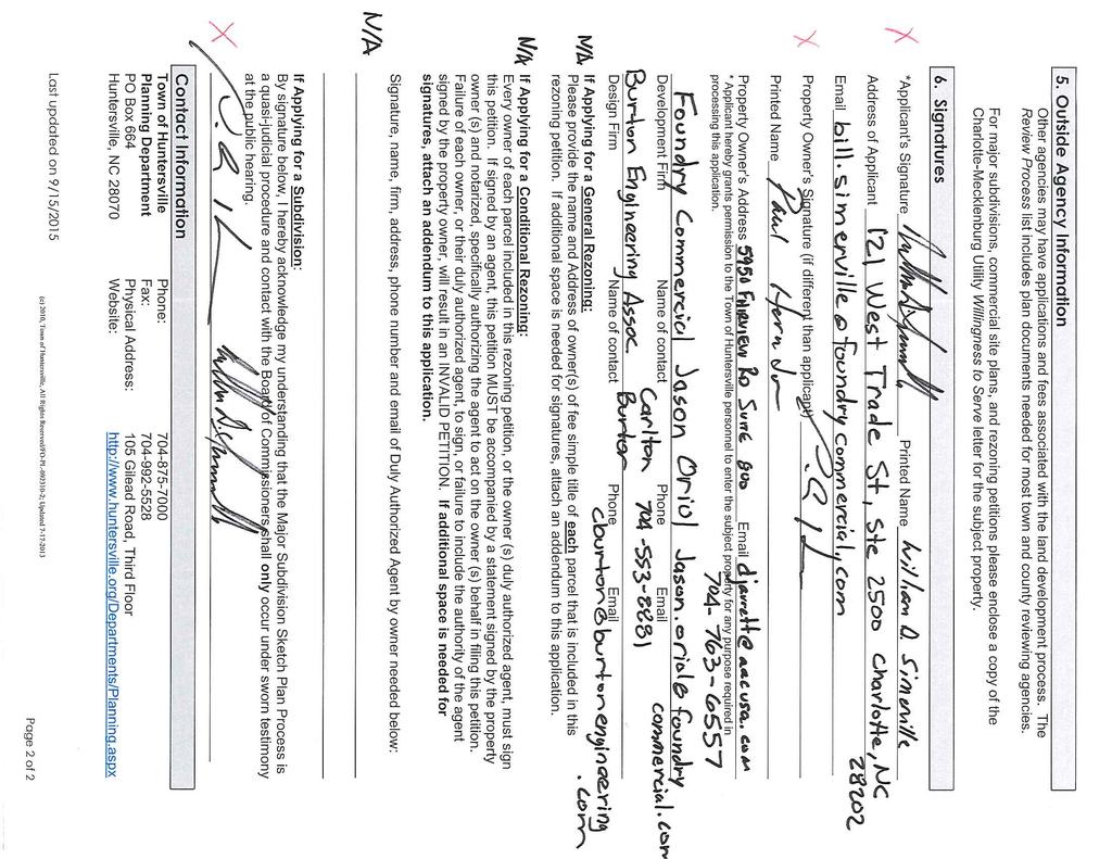
1 PART 1: PROJECT SUMMARY Bryton Corporate Center Subdivision Sketch Plan Bryton Corporate Center Subdivision Sketch Plan Staff Report Town Board Applicant: Foundry Commercial. Application is Attachment A and Site Plan is Attachment B. Property Owner: American Asset Corp. Property Address: Abuts Corporate Center Drive, Hambright Road & Everette Keith Road. Project Size: acres Parcel Number: Current Zoning: Special Purpose Conditional District (SP-CD) Current Land Use: vacant. PART 2: SITE PLAN DESCRIPTION AND ISSUES 1. The proposed subdivision sketch plan has 5 lots on acres, as shown in the hatched area above. The subdivision sketch plan also includes an existing 13.4-acre lot south of Savoy Drive, which is an existing lot of record, created in 2012 when the two (2) new streets were platted. The new lots range in size from 6.4-acres to 7.8-acres. 2. This subdivision sketch plan is a proposal to create five (5) new lots, one (1) new street, add additional area into public right-of-way and dedicate land for a (section) of public greenway. The buildings, vehicle loading areas, parking lots and other aspects of the site will be reviewed based on all applicable regulations and is not a part of this action. 3. Adjoining Zoning and Land Uses North: Transit Oriented Development-R Conditional District (TOD-R-CD) vacant property. South: Highway Commercial Conditional District (HC-CD) & Neighborhood Residential (NR) vacant. East: Transitional Residential (TR) several large-lot, single-family homes & vacant. Page 1 of 5
2 Bryton Corporate Center Subdivision Sketch Plan Staff Report Town Board West: Special Purpose Conditional District (SP-CD commercial (Frankie s Fun Park) & vacant. 4. A neighborhood meeting was held on October 5, The meeting summary is provided (Attachment C). 5. In 2005, an illustrative plan for this property was approved as part of the overall Bryton Conditional District rezoning. The rezoning plan allows for 1,104,000 square feet of (light) industrial and this subdivision will not exceed the permitted amount. 6. In addition, in December 2012, a sketch plan was approved for two (2) new roads to serve the Special Purpose (SP) portion of Bryton. This Sketch Plan created both Bryton Corporate Center Drive and Savoy Drive., The creation of these two (2) public roads created 3 lots for the area zoned SP. 7. There are 41 specimen trees on the site and 5 are proposed to be saved (see Attachment B, Sheet SUB 5.0). Bryton is permitted to mitigate trees on a project-wide basis, rather than for each individual site, therefore, greater tree removal may occur on some sites. 8. A water quality concept plan is being reviewed by Mecklenburg County Engineering (LUESA), and their approval is required. The applicant is proposing several sand filters (a water quality measure) throughout the subdivision. 9. A Willingness to Serve letter from Charlotte Water is required and has not been provided. 10. To address Urban Open Space, two (2) plazas were proposed and are shown on Sheet SUB 2.0 (see Attachment B). However, continued discussion between the Applicant and Staff has led to the applicant looking to build a section of Carolina Thread Trail greenway (from the adopted Greenway Master Plan) which will run along the railroad right-of-way on the southern boundary of Lot 1 (south of Savoy Drive). This section of greenway will be built to Mecklenburg County standards and dedicated for their maintenance. The details of the greenway will be required as part of the Preliminary Plan set. 11. A buffer is required along both Hambright Road and Everette Keith Road since Hambright Road is a thoroughfare and Everette Keith Road separates non-residential uses from residential uses. The applicants have requested to use the Alternate Buffer Yard Plan option, as outlined in Article of the Zoning Ordinance. As stated in Article 7.5.7, unusual topography or elevation of a development site, soil or other sub-surface condition on the site, or the presence of existing vegetation, the Zoning Administrator may alter the buffer yard requirements as long as the existing features of the development site comply with the spirit and intent if this Article. The Applicant and Staff have been working on an alternate buffer yard plan and will approve such plan prior to the Planning Board meeting. 12. The block length between Savoy Drive and the proposed new street is greater than 1,500 ft.; therefore a block length waiver would be required to approve the new street alignment. Article 5 allows for greater blocks lengths where longer blocks will result in an arrangement of street connections, lots and public space more consistent with this Article and Article 7 of these regulations Since an off-set street connection may one-day result, the proposed street location is located in a location that will avoid intersection lock-up. PART 3: TRANSPORTATION ISSUES A Traffic Impact Analysis (TIA) was prepared by Kimley-Horn Associates as part of the overall Bryton Development in Nearby Improvements. Numerous road improvements have been completed. Improvements with an impact on this proposed subdivision include the construction of Hambright Road, Bryton Corporate Center Drive and Savoy Lane. Cross Sections and Future Road Connections. One new road is proposed between proposed lots 5 and 6 and its cross-section is required for this subdivision. The proposed new road will be similar to Savoy Drive, with the exception that the right-of-way will be slightly wider, due to grading issues. The adjoining public streets are fully constructed, however, only Everette Keith Road is 100% public. The other three (3) roads are in process of becoming public via Town of Huntersville or NCDOT. No additional off-site road improvements are required for this proposed Sketch Plan. Page 2 of 5
3 Bryton Corporate Center Subdivision Sketch Plan Staff Report Town Board PART 4: PLANNING STAFF ANALYSIS Section of the Subdivision Ordinance outlines the general requirements and policies to be used in the design, review, and approval of subdivisions in the Town of Huntersville. The following staff findings are provided for the Board s consideration of the Bryton Corporate Center Drive Subdivision Sketch Plan. 1. Consistency with adopted public plans and policies. There is no small area plan to reference for this subdivision, however, due to its size; the Bryton Conditional District Rezoning Plan represents a comprehensive, long-term guide for development of this acreage. The proposed subdivision sketch plan is consistent with the approved conceptual plan. In addition, the following sections of the 2030 Huntersville Community Plan apply to this request: Policy E-2: Location of New Development. Avoid locating new development in areas of significant environmental, scenic or cultural resources. Comment: The site does not have any significant environmental, scenic or cultural resources present, as far as staff can determine. Policy T-6: Pedestrian Connections. Support the installation of sidewalks, bikeways and greenway trails connecting residential, commercial, employment, recreational and institutional uses. Comment: All existing public streets have sidewalks on both sides and the proposed new street will also provide sidewalks on both sides. Along Everette Keith Road, a sidewalk will be installed on the west side of the right-ofway. A section of Master Plan greenway will be constructed just north of the railroad right-of-way as part of this subdivision to serve as Urban Open Space. Policy T-8: Street Connectivity. Promote and require street connectivity in the Town of Huntersville among residential, commercial, employment, recreational and institutional uses. Comment: The proposed subdivision is surrounded on three (3) sides by existing public streets and one (1) new public street will be constructed to provide another connection to Everette Keith Road. Policy PF-2: Adequate Public Facilities Ordinance (APFO). Continue use of Adequate Public Facilities Ordinance (APFO) to ensure that demand generated by existing and future growth and development for police, fire and parks & recreation capital facilities can be met by available supply of facilities. Comment: An APFO application was not required, as all of Bryton as originally approved in 2005 / 2006, was accounted for in the original baseline APFO level of service for the Town. In addition to the above, the Lake Norman Economic Development Commission (LKNEDC) has expressed support for this project as a means to provide much-needed light industrial flex space that is in high demand and will support both business incubator sectors of the local economy, but will also provide allied-business opportunities for Huntersville s existing light-industrial base. 2. Conformity. The proposed Special Purpose (SP) lots will be adjacent to other SP-zoned parcels along the west. However, the proposed lots are on the eastern boundary of the Bryton development and therefore require the creation of a buffer along Everette Keith Road to separate the light industrial use from the adjoining low-density residential.. 3. Access between Adjoining Properties. The proposed subdivision will create one (1) new street and will have curb-cuts along the new street, as well as on existing Bryton Corporate Center Drive and Savoy Drive. No curb-cuts will be permitted from Hambright Road or Everette Keith Road. Page 3 of 5
4 Bryton Corporate Center Subdivision Sketch Plan Staff Report Town Board Relation to topography. Some grading has occurred in the middle of the site, as it was used by Frankie s Fun Park to level their site. Additional grading will be required on this site in order to accommodate the large building footprints, truck-loading areas and associated parking lots. 5. Mature trees and natural vegetation. The proposed project is not required to save tree canopy, as Bryton has 100 percent coverage ability, but must over the entire project save the required percentage of trees. This requirement is being met. 6. Access to parks, schools, etc. Not Applicable. 7. Discourage through traffic. Bryton Corporate Center Drive, Hambright Road, Savoy Drive and the proposed new street will be appropriately-sized for light-industrial traffic. None of this traffic is intended to use Everette Keith Road. 8. Relationship to railroad rights-of-way. Not Applicable. 9. Half streets. Not Applicable. 10. Parallel streets along thoroughfares. Not Applicable. 11. Public School and Public Park Sites The parcels associated with Bryton Corporate Center Drive Subdivision Sketch Plan have not been identified for a school or park site. 12. Public Facilities The parcels associated with Bryton Corporate Center Drive Subdivision Sketch Plan have not been identified for a public facility. 13. Proposed street names One (1) new street is proposed, to be located between Bryton Corporate Center Drive and Everette Keith Road. No street name has been approved at this stage. A Mecklenburg County -approved street name will be required as part of Preliminary Plan. 14. Easements. Easements have been identified and the plans have been sent to the respective Engineering and Utility Departments. 15. Proposed water and sewerage system. Water and sewer will need to be extended to the development. A Willingness to Serve letter from Charlotte Water is required and has not been provided. 16. Restrictions on the subdivision of land subject to flooding. No floodplain has been identified on this site. 17. Reserved. Page 4 of 5
5 18. Open Space The proposed development complies with open space requirements for Bryton. Bryton Corporate Center Subdivision Sketch Plan Staff Report Town Board Impact of Development on Public Facilities Under the provisions of the APF Ordinance, all residential development greater than twenty (20) lots are required to receive a Determination of Adequacy (DOA) for the following public facilities: fire vehicles, fire station, police station, police vehicles, indoor park and recreation facilities, parks acreage. An APFO application was not required, as all of Bryton as originally approved in 2005 / 2006, was accounted for in the original baseline APFO level of service for the Town. PART 5: STAFF RECOMMENDATION Town Staff has reviewed the proposed Sketch plan and finds: 1. The Subdivision Sketch Plan Application is complete. 2. Compliance with applicable requirements has been satisfied, with the following exceptions: Incorporate Town Staff-approved Alternate Buffer Yard Plan; A block-length waiver is required for new road placement, which can be supported by staff; A note and graphic depiction of the section of greenway that will be provided; Provide Willingness to Serve letter from Charlotte Water; Address all remaining redline comments on the subdivision sketch plan. Once the above items are addressed, staff can recommend approval of the proposed Subdivision Sketch plan. PART 6: PLANNING BOARD RECOMMENDATION Planning Board meeting was held on October 24, 2017 and the Planning Board recommended approval by unanimous (9-0) vote to recommend approval of the subdivision sketch plan, as presented, subject to the conditions listed in Staff s recommendation (Part 5, above) and with the additional condition that a storm water plan would be provided for LUESA s review and approval. PART 7: ATTACHMENTS AND ENCLOSURES Attachments A - Application B - Bryton Corporate Center Drive Sketch Plan C - Neighborhood Meeting Summary PART 8: DECISION STATEMENTS In considering whether to approve an application for a subdivision sketch plan, the Planning and Town Board must complete the following (a full version can be found in Section of the Subdivision Ordinance). Is the application complete (lacking any particular requirement)? If no member of the Board moves that the application is incomplete, then this inaction is taken as an affirmative finding that the application is complete. Does the application comply with all the applicable requirements? A statement must be made that the application complies or does not comply that includes the support documentation of the particular motion. Lastly, the Board must make a motion to approve or deny based on the previous statements. Page 5 of 5

6
7

 SHALL MEET THE REQUIREMENTS OF THE MCSBC CHAPTER 17 - SPECIAL INSPECTIONS AS DETAILED PER THE")
8 PE CERTIFICATION STATEMENT: "THE TOWN OF HUNTERSVILLE REQUIRES THAT ALL STREETS PROPOSED TO BE TAKEN OVER BY THE TOWN FOR MAINTENANCE BE REVIEWED, INSPECTED, AND CERTIFIED BY A LICENSED PROFESSIONAL ENGINEER REGISTERED IN THE STATE OF NORTH CAROLINA FOR ADEQUATE CONSTRUCTION. REVIEW OF STREET CONSTRUCTION BY THE CERTIFYING ENGINEER IS REQUIRED THROUGHOUT THE CONSTRUCTION PROCESS. REFER TO THE TOWN OF HUNTERSVILLE ENGINEERING STANDARDS AND PROCEDURES MANUAL FOR ADDITIONAL INFORMATION INCLUDING THE REQUIRED CERTIFICATION FORM." SUBDIVISION SKETCH PLAN PROJECT SITE "ALL RETAINING WALLS REQUIRING SPECIAL INSPECTIONS (>5' IN HEIGHT) SHALL MEET THE REQUIREMENTS OF THE MCSBC CHAPTER 17 - SPECIAL INSPECTIONS AS DETAILED PER THE MECKLENBURG COUNTY CODE ENFORCEMENT SPECIAL INSPECTIONS PROCESS. ADDITIONALLY, COPIES OF THE RETAINING WALL PLANS SHALL BE SUBMITTED TO THE HUNTERSVILLE ENGINEERING DEPARTMENT FOR REVIEW AND APPROVAL. THE TOWN OF HUNTERSVILLE SHALL BE COPIED ON ALL STATEMENTS OF SPECIAL INSPECTIONS, SPECIAL INSPECTIONS FINAL REPORTS, AND DESIGN PRINCIPAL IN RESPONSIBLE CHARGE (DPIRC) LETTERS." "RETAINING WALLS THAT ARE IN AND /OR AFFECT THE PUBLIC RIGHT-OF-WAY MUST BE REVIEWED AND APPROVED BY THE TOWN." BRYTON CORPORATE CENTER TOWN OF HUNTERSVILLE, NORTH CAROLINA 5950 FAIRVIEW RD STE 100 CHARLOTTE NC (T) burtonengineering.com FIRM #C-1157 EPM # /27/2017 PROJECT CONTACT INFORMATION ENGINEER: Burton Engineering Associates Carlton Burton Bryan Linton & Glenn Morris 5950 Fairview Road, Suite 100 Charlotte, NC P: (704) glenn@burtonengineering.com blinton@burtonengineering.com OWNER Foundry Commercial Bill Simmerville Jason Oriol 121 West Trdae St Ste Charlotte, NC M: NORFOLK-SOUTHERN RAILROAD EXISTING SAVOY LANE 57' PUBLIC R/W EXISTING BRYTON CORPORATE CENTER DRIVE 73' PUBLIC R/W EVERETTE KEITH ROAD SR # ' BUFFER 30 MPH POSTED SPEED 68' DUKE POWER EASEMENT ARCHITECT: MSA Craig Flemming 610 East Morehead St. Charlotte, NC Phone: BRYTON CORPORATE CENTER BRYTON CORPORATE CENTER DRIVE HUNTERSVILLE, MECKLENBURG COUNTY, NORTH CAROLINA COVER SHEET 57' R/W (MINIMUM) C L R/W 28'-9"' (MIN) 28'-9" (MIN) R/W (MIN) 1'-0" 3'-0" 8'-0" 8'-0" TREE PLANTER 2'-6" 12'-6" 10'-0" 12'-6" 10'-0" 2'-6" 8'-0" TREE PLANTER 8'-0" 3'-0" (MIN) 1'-0" 1/4" FT SLOPE 3/8" PER FT. 1/4"/FT. P:\DWG\ BRYTON\ BRYTON - RE-SUB.DWG COVER 10/27/2017 9:13:20 AM HP02.CTB CHASE COMMERCIAL STREET (MIN) 1'-0" R/W 1'-6" 2:1 CUT MAX. 3:1 FILL MAX. 80' BUFFER 10' PLANTER 1' 8'-0" VARIES (3:1MAX) 1/4" FT 8'-0" TREE PLANTER 36.5' (MIN) 2'-6" 20'-6" 18'-0" PROJECT SIDE 10' 40' PROP. ROW ADJACENT TO FUTURE THOROUGHFARE 5' SIDEWALK 8' S/W ESM'T 2:1 1' 2' MIN 3:1 73' R/W (MINIMUM) C L 18'-0" COMMERCIAL STREET 25' EXIST. ROW 6' SHOULDER 10' 20'-6" SLOPE 3/8" PER FT. C L 36.5' (MIN) 10' 2'-6" 8'-0" TREE PLANTER 25' 1/4"/FT. 8'-0" R/W (MIN) 1'-0" 2:1 CUT MAX. 3:1 FILL MAX. THIS PROJECT WILL REFERENCE THE ORIGINAL BRYTON TIA FOR THIS SUBDIVISION SHEET SHEET TITLE 1.0 COVER SHEET 2.0 SITE & UTILITY PLAN 3.0 GRADING AND DRAINAGE PLAN 4.0 STORMWATER MANAGEMENT CONCEPT PLAN 5.0 TREE INVENTORY PLAN 6.0 TYPICAL FIRE TRUCK TURNING PATHS 7.0 BUFFER PLAN ORIGINAL DATE LATEST REV. REVISIONS PM CTB ENG DRAWN BY PROJECT NUMBER Sheet 1of 7 09/20/2017 DATE THIS DRAWING IS THE PROPERTY OF BURTON ENGINEERING ASSOCIATES AND IS NOT TO BE REPRODUCED OR COPIED IN WHOLE OR IN PART. IT IS NOT TO BE USED ON ANY OTHER PROJECT AND IS TO BE RETURNED UPON REQUEST. SUB1.0
: INDUSTRIAL/FLEX BUILDING TYPE : URBAN WORKPLACE ZONING DISTRICT: SP (CD) OVERLAY DISTRICT: BRYTON ZONING OVERLAY PERCENT IMPERVIOUS ALLOWED:")


9 SITE PLAN DATA TABLE GENERAL NOTES TOTAL ACREAGE: TOTAL SITE SQUARE FEET: 1,565,927 PRINCIPLE USE(S): INDUSTRIAL/FLEX BUILDING TYPE : URBAN WORKPLACE ZONING DISTRICT: SP (CD) OVERLAY DISTRICT: BRYTON ZONING OVERLAY PERCENT IMPERVIOUS ALLOWED: 100% PERCENT IMPERVIOUS SHOWN: 85% LOT COUNT: 6 TOTAL SQUARE FEET OF NON RESIDENTIAL: 703,200 SF LOT SIZE RANGE: 6.9 TO 11.5 ACRES NUMBER OF LOTS WITHIN EACH RANGE: 6 LOTS LOT WIDTH RANGE: LF NUMBER OF LOTS WITH EACH WIDTH: 6 LOTS LF SETBACKS AND BUILD-TO-LINES FRONT BUILD TO RANGE : 0'-25- BTR CORNER SETBACKS: N/A REAR SETBACKS: N/A RIGHT SIDE SETBACK: N/A LEFT SIDE SETBACK: N/A WATERSHED INFORMATION IS THE PROPERTY IN A REGULATED WATERSHED DISTRICT? NO WATERSHED DISTRICT: HUNTERSVILLE LOW DENSITY/HIGH DENSITY: HIGH DENSITY ALL DEVELOPMENT AND CONSTRUCTION SHALL COMPLY WITH ALL ZONING AND SUBDIVISION STANDARDS OF THETOWN OF HUNTERSVILLE, MECKLENBURG COUNTY, AND NCDOT, AS APPLICABLE. THIS PROPERTY MAY BE SUBJECT TO ANY EASEMENTS AND/OR RIGHT-OF-WAY OF RECORD. ALL AREAS DESIGNATED AS COMMON AND/OR URBAN OPEN SPACE SHALL BE OWNED AND MAINTAINED BY THE HOMEOWNERS ASSOCIATION AND DEDICATED FOR PERPETUITY. ACCESS (INGRESS/EGRESS) LOCATION AND DESIGN SHOWN ON THIS SKETCH PLAN AREA SUBJECT TO ACHIEVING VERTICAL AND HORIZONTAL SIGHT DISTANCES, TURN LANE IMPROVEMENTS (INCLUDING) RIGHT-OFWAY) AND INTERSECTION WITH ADJACENT AND OPPOSING ACCESS POINTS. MODIFICATIONS TO PLAN MAY RESULT. LARGE MATURING TREES WILL BE PLANTED 40' O/C WITHIN THE REQUIRED PLANTING STRIP ALONG ALL STREETS WITH THE EXCEPTION OF RURAL PARKWAYS WHERE EXISTING TREES CAN SATISFY THE STREET TREE REQUIREMENT. SMALL MATURING TREES ARE TO BE USED WHERE OVERHEAD POWER LINES EXIST. MAIL DELIVERY TO BE TO A COMMUNIAL BOX FOR THE ENTIRE PORJECT. GARBAGE TO BE COLLECTED FROM COMMON SCREENED ENCLOSURES EVENLY SPACED WITHIN THE TRUCK COURTS. POTENTIAL AREA FOR URBAN OPEN SPACE (WITHIN APPROX. 2,000 LF OF EACH LOT) 5950 FAIRVIEW RD STE 100 CHARLOTTE NC (T) burtonengineering.com FIRM #C /27/2017 BUFFERS & SCREENING TO BE ACCORDING TO THE APPROVED REZONING PETITION: R PAGE TDS1.1B. THE 80' BUFFER ALONG EVERETTE KEITH ROAD MAY BE GRADED TO ACCOMODATE WALLS, BERMS & SIDEWALK. DISTURBED AREAS TO BE REPLANTED AT 4 TREES PER 1,000 SF OF BUFFER AREA (75% LARGE MATURING, 50% EVERGREEN, 25% SMALL MATURING). TOP OF BANK HUNTERSVILLE PLANNING DEPARTMENT APPROVED MODIFICATIONS 1. MODIFICATIONS TO 80' HAMBRIGHT ROAD BUFFER. REDUCTION OF 80' UNDISTURBED BUFFER TO 40' UNDISTURBED BUFFER FROM HAMBRIGHT RD. DUE TO SEVERE TOPOGRAPHY CHANGE BETWEEN PROPERTY LINE AND FINISHED FLOOR ELEVATION. (ALTERNATIVE BUFFER YARD PLAN SECTION 7.5.7) 2. MODIFICATIONS TO 80' EVERETTE KEITH RD BUFFER. REDUCTION OF 80' UNDISTURBED BUFFER TO 60' UNDISTURBED BUFFER EXTENDING WIDTH OF BUILDING + 20 LF ON EACH SIDE OF BUILDINGS B, C, D, E & F. REMAINDER OF BUFFER REMAINS 80' AND UNDISTURBED EXCEPT WHERE INSTALLATION OF RETAINING WALL IS REQUIRED. AREA DISTURBED DURING INSTALLATION OF RETAINING WALLS WILL BE LANDSCAPED AND PLANTED TO RESTORE OR ENHANCE BUFFER PER TOWN OF HUNTERSVILLE UDO AND BRYTON MASTER PLAN LANDSCAPING REQUIREMENTS. (ALTERNATIVE BUFFER YARD PLAN SECTION 7.5.7) LOT TYPE/URBAN WORKPLACE 3. ALTERNATIVE OFFSET FROM THE BUILD-TO-LINE BRYTON CORPORATE CENTER DRIVE. BUILDINGS PLACED BETWEEN 0' AND 10' BEHIND STREET ROW AS NEEDED GIVEN TOPOGRAPHY AND ELEVATION CHANGE BETWEEN PEDESTRIAN SIDEWALK AND BUILDING FLOOR ELEVATION. INCREASED SETBACK WILL BE ATTRACTIVELY LANDSCAPED PER TOWN OF HUNTERSVILLE UDO AND BRYTON MASTER PLAN LANDSCAPING REQUIREMENTS. (LOT AND BUILDING TYPES - URBAN WORKPLACE / BUILDING PLACEMENT - SECTION 4.1) REQUESTED CHANGES TO BE APPROVED BY THE TOWN COUNCIL 1. APPLICANT IS REQUESTING A 210' VARIANCE TO EXCEED THE 1,500 LF BLOCK LENGTH REQUIREMENT UNDER SECTION 5A STREET REGULATIONS, BLOCK LENGTH. 100' 130' NORFOLK SOUTHERN RAIL ROAD 6" SEWER LAT EXIST 8" PUBLIC WATER MAIN 6" SEWER LAT 8" FIRE SERVICE 2" DOM 1.5" IRR EXIST 6" SEWER LAT. (TYP.) 180' 6" SEWER LAT BUILDING PLACEMENT/PARKING/VEHICLE ACCESS 8" FIRE SERVICE 2" DOM 1.5" IRR EXIST 12" PUBLIC WATER MAIN ENCROACHMENT/PEDESTRIAN ACCESS TO BUILDING 6" SEWER LAT 180' EXIST 8" PUBLIC SANITARY SEWER 6" SEWER LAT 6" SEWER LAT 8" FIRE SERVICE 2" DOM 1.5" IRR 8" FIRE SERVICE 2" DOM 1.5" IRR BRYTON CORPORATE CENTER BRYTON CORPORATE CENTER DRIVE HUNTERSVILLE, MECKLENBURG COUNTY, NORTH CAROLINA SITE & UTILITY PLAN 20' 20' EASEMENT RESERVED FOR CONSTRUCTION OF GREENWAY. DEVELOPER SHALL CONSTRUCT GREENWAY AS A PART OF PHASE I CONSTRUCTION THIS SHALL SATISFY URBAN OPEN SPACE REQUIREMENTS. SEE DETAIL THIS SHEET. 20' TYP. 68' DUKE POWER ESM'T 40' R/W FROM C/L ADJACENT TO FUTURE THOROUGHFARE EVERETTE KEITH ROAD 35 MPH POSTED SPEED SR # 2458 P:\DWG\ BRYTON\ BRYTON - RE-SUB.DWG SITE LAYOUT 10/27/2017 9:13:24 AM HP02.CTB CHASE PROPOSED SIDEWALK ALONG EVERETTE KEITH ROAD PROPOSED EVERETTE KEITH ALIGNMENT (FROM TOWN OF HUNTERSVILLE) TENANT LEASE LINE (TYPICAL) DRAWING INFORMATION TRUE NORTH ( IN FEET ) 1 inch = 100 ft. REVISIONS PM CTB ENG DRAWN BY PROJECT NUMBER Sheet 2 of 7 09/20/2017 DATE THIS DRAWING IS THE PROPERTY OF BURTON ENGINEERING ASSOCIATES AND IS NOT TO BE REPRODUCED OR COPIED IN WHOLE OR IN PART. IT IS NOT TO BE USED ON ANY OTHER PROJECT AND IS TO BE RETURNED UPON REQUEST. SUB2.0
10 P:\DWG\ BRYTON\ BRYTON - RE-SUB.DWG GRADING DRAINAGE 10/27/2017 9:13:29 AM HP02.CTB CHASE OFFSITE BYPASS STORM DRAINAGE 650 LF 24" RCP (TO BE ABANDONED) (REMOVED) OFFSITE BYPASS STORM DRAINAGE PROPOSED RETAINING WALL PROPOSED EVERETTE KEITH ALIGNMENT EX CULVERT PROPOSED RETAINING WALL EX CULVERT OFFSITE BYPASS STORM DRAINAGE PROPOSED RETAINING WALL DRAWING INFORMATION TRUE NORTH ( IN FEET ) 1 inch = 100 ft. 10/27/ FAIRVIEW RD STE 100 CHARLOTTE NC (T) burtonengineering.com FIRM #C-1157 THIS DRAWING IS THE PROPERTY OF BURTON ENGINEERING ASSOCIATES AND IS NOT TO BE REPRODUCED OR COPIED IN WHOLE OR IN PART. IT IS NOT TO BE USED ON ANY OTHER PROJECT AND IS TO BE RETURNED UPON REQUEST. PROJECT NUMBER SUB3.0 Sheet 3 of 7 REVISIONS PM ENG DRAWN BY DATE CTB 09/20/2017 BRYTON CORPORATE CENTER BRYTON CORPORATE CENTER DRIVE HUNTERSVILLE, MECKLENBURG COUNTY, NORTH CAROLINA GRADING & DRAINAGE PLAN
11 PRE-POST RIDGELINE 5950 FAIRVIEW RD STE 100 CHARLOTTE NC (T) burtonengineering.com FIRM #C-1157 EXISTING REGIONAL DRY STORMWATER DETENTION POND, PORTION OF 1 YEAR VOLUME, 10 & 25 YEAR PEAK DETENTION 10/27/2017 EXISTING REGIONAL DRY STORMWATER DETENTION POND, PORTION OF 1 YEAR VOLUME, 10 & 25 YEAR PEAK DETENTION 650 LF 24" RCP (TO BE ABANDONED) (REMOVED) EXISTING RAIN GARDEN W/ FOREBAY & PORTION OF 1 YEAR VOLUME (STREETS ONLY) HYBRID DRY-WELL SYSTEM EXISTING RAIN GARDEN W/ FOREBAY & PORTION OF 1 YEAR VOLUME (STREETS ONLY) HYBRID DRY-WELL SYSTEM (REMOVED) 170 LF 24" RCP (TO BE ABANDONED) 260 LF 15" RCP (TO BE ABANDONED) (REMOVED / FLOWABLE FILL) BRYTON CORPORATE CENTER BRYTON CORPORATE CENTER DRIVE HUNTERSVILLE, MECKLENBURG COUNTY, NORTH CAROLINA STORMWATER MANAGEMENT CONCEPT PLAN P:\DWG\ BRYTON\ BRYTON - RE-SUB.DWG SWM 10/27/2017 9:13:32 AM HP02.CTB CHASE POUROUS LIGHT DUTY ASPHALT EXISTING OFFSITE BYPASS STORM DRAINAGE POUROUS LIGHT DUTY ASPHALT POUROUS LIGHT DUTY ASPHALT POUROUS LIGHT DUTY ASPHALT OFFSITE BYPASS STORM DRAINAGE DRAWING INFORMATION TRUE NORTH TRUE NORTH ( IN FEET ) 1 inch = 100 ft. REVISIONS PM CTB ENG DRAWN BY PROJECT NUMBER Sheet 4 of 7 09/27/2017 DATE THIS DRAWING IS THE PROPERTY OF BURTON ENGINEERING ASSOCIATES AND IS NOT TO BE REPRODUCED OR COPIED IN WHOLE OR IN PART. IT IS NOT TO BE USED ON ANY OTHER PROJECT AND IS TO BE RETURNED UPON REQUEST. SUB4.0
12 TREE LEGEND EXISTING TREE PREVIOUSLY REMOVED = 87 EXISTING TREE TO REMAIN THIS PROJECT = 3 EXISTING TREE TO BE REMOVED THIS PROJECT = FAIRVIEW RD STE 100 CHARLOTTE NC (T) burtonengineering.com FIRM #C-1157 TREE INVENTORY PLAN 09/20/2017 DATE DRAWN BY THIS DRAWING IS THE PROPERTY OF BURTON ENGINEERING ASSOCIATES AND IS NOT TO BE REPRODUCED OR COPIED IN WHOLE OR IN PART. IT IS NOT TO BE USED ON ANY OTHER PROJECT AND IS TO BE RETURNED UPON REQUEST. TRUE NORTH PROJECT NUMBER TRUE NORTH 0 ENG CTB BRYTON CORPORATE CENTER DRIVE HUNTERSVILLE, MECKLENBURG COUNTY, NORTH CAROLINA PM DRAWING INFORMATION 100 /17 REVISIONS P:\DWG\ BRYTON\ BRYTON - RE-SUB.DWG TREE 10/27/2017 9:13:36 AM HP02.CTB CHASE BRYTON CORPORATE CENTER 09 10/ ( IN FEET ) 1 inch = 100 ft SUB5.0 Sheet 5 of 7
13 P:\DWG\ BRYTON\ BRYTON - RE-SUB.DWG TURNING 10/27/2017 9:13:38 AM HP02.CTB CHASE 35 MPH POSTED SPEED SR # 2458 EVERETTE KEITH ROAD DRAWING INFORMATION TRUE NORTH 10/27/ FAIRVIEW RD STE 100 CHARLOTTE NC (T) burtonengineering.com FIRM #C-1157 THIS DRAWING IS THE PROPERTY OF BURTON ENGINEERING ASSOCIATES AND IS NOT TO BE REPRODUCED OR COPIED IN WHOLE OR IN PART. IT IS NOT TO BE USED ON ANY OTHER PROJECT AND IS TO BE RETURNED UPON REQUEST. PROJECT NUMBER SUB6.0 Sheet 6 of 7 REVISIONS PM ENG DRAWN BY DATE CTB 09/21/2017 BRYTON CORPORATE CENTER BRYTON CORPORATE CENTER DRIVE HUNTERSVILLE, MECKLENBURG COUNTY, NORTH CAROLINA TYPICAL FIRE TRUCK TURNING PATHS


14 5950 FAIRVIEW RD STE 100 CHARLOTTE NC (T) burtonengineering.com FIRM #C /2 /27 10 NOTES BUFFERS & SCREENING TO BE ACCORDING TO THE APPROVED REZONING PETITION: R PAGE TDS1.1B. LANDSCAPE SPECIES THE 80' BUFFER ALONG EVERETTE KEITH ROAD MAY BE GRADED TO ACCOMODATE WALLS, BERMS & SIDEWALK. DISTURBED AREAS TO BE REPLANTED AT 4 TREES PER 1,000 SF OF BUFFER AREA (75% LARGE MATURING, 50% EVERGREEN, 25% SMALL MATURING) PER SECTION 7.5 OF THE ZONING ORDINANCE. ALL TREES SHOWN ON CROSS SECTIONS ARE AT APPROXIMATELY 40%-60% MATURITY. LK O RF O N RN E TH U SO I RA AD O LR 68' D UKE POW ER ESM ' T 10 0' BUFFER PLAN BRYTON CORPORATE CENTER ALTERNATIVE BUFFER SECTIONS SHALL MEET THE REQUIREMENTS OF THE BUFFER ORDINANCE SECTION UTILIZING APPROVED SPECIES AS LISTED ON THIS SHEET AND EXISTING VEGETATION WHERE ABLE BRYTON CORPORATE CENTER DRIVE HUNTERSVILLE, MECKLENBURG COUNTY, NORTH CAROLINA EXISTING VEGETATION WITIHIN BUFFERS TO BE PRESERVED TO THE MAXIMUM EXTENT POSSIBLE WITH REGARDS TO GRADING. 180' 130' 20' TYP. 09/20/2017 DATE EXISTING VEGETATION SHALL BE PRESERVED TO THE FULLEST EXTENT POSSIBLE. ADDITIONAL GRADING MAY BE REQUIRED AND SHALL BE REVIEWED BY STAFF AT THE PRELIMINARY STAGE OF REVIEW. OS 35 MPH P# 2458 SR DRAWING INFORMATION EXISTING VEGETATION SHALL BE PRESERVED TO THE FULLEST EXTENT POSSIBLE. ADDITIONAL GRADING MAY BE REQUIRED AND SHALL BE REVIEWED BY STAFF AT THE PRELIMINARY STAGE OF REVIEW. DRAWN BY ARE ROM C/L ROUGHF 40' R/W F TO FUTURE THO T ADJACEN D TH ROA I E K E T T D EVERE TED SPEE PROPOSED SIDEWALK ALONG EVERETTE KEITH ROAD. SIDEWALK SHALL MEANDER INSIDE BUFFER IN A MANNER TO PRESERVE EXISTING VEGETATION WHERE POSSIBLE. ENG PM 20' EASEMENT RESERVED FOR CONSTRUCTION OF GREENWAY. DEVELOPER SHALL CONSTRUCT GREENWAY AS A PART OF PHASE I CONSTRUCTION THIS SHALL SATISFY URBAN OPEN SPACE REQUIREMENTS REVISIONS P:\DWG\ BRYTON\ BRYTON - RE-SUB.DWG BUFFER 10/27/2017 9:13:55 AM HP02.CTB CHASE 20' CTB 180' THIS DRAWING IS THE PROPERTY OF BURTON ENGINEERING ASSOCIATES AND IS NOT TO BE REPRODUCED OR COPIED IN WHOLE OR IN PART. IT IS NOT TO BE USED ON ANY OTHER PROJECT AND IS TO BE RETURNED UPON REQUEST. TRUE NORTH PROPOSED EVERETTE KEITH ALIGNMENT (FROM TOWN OF HUNTERSVILLE) PROJECT NUMBER ( IN FEET ) 1 inch = 100 ft SUB7.0 Sheet 7 of 7
15 Bryton Neighborhood Meeting October 5, 2017 Huntersville Professional Building, 6:00pm Attendees from Foundry Commercial: Bill Simerville Fermin Deoca Casey Mulhern Kenlie Berry Lauren Kalaw See additional attendee sign up sheet Summary of Applicant s items to address: Explore possibility of advancing Everett Keith improvements earlier in the construction process to provide desired sidewalks on Everett Keith Insure visual and sound buffer along Everett Keith either through existing woods or constructed landscaped berm, make as high as possible for benefit of residents Within security contract have Foundry include the roving patrol to include the end of Everett Keith to try and minimize further dumping MEETING NOTES Review of proposed land use. David Peete asked about the orange border in site plans vs. orange shading on site plans. Bill explained that the orange border just indicated our portion of the development. On the Master Plan, Bill explained that residential is north of Hambright in the overall Bryton plan, and that American Asset Corporation (AAC) is the owner of the overall Bryton development. New road tied into Everett State Road, which is the reason we re meeting tonight. Bill pointed out where Hambright, the railroad, Bryton Corporate Center (our development), the proposed new road, Everett Keith Rd, and Savoy Rd were on the map so that all attendees could orient themselves with the maps and site plans. Bill pointed out that 10 buildings were originally planned, but there are now only 6 with 30 high/clear ceiling, 20 30% office space (which will be non warehouse/lighting showroom space most likely). We have already received interest from a granite supplier. The buildings will be concrete wall tilt panels,
16 higher end tenants, no or little visibility to buildings from the east, glass wraps around corners and sides of buildings on the west with attractive curb appeal from Bryton Corporate Center Drive. David Peete added that we are creating more lots 2 lots originally being made into 6, which is the reason for this meeting, this was not a rezoning and Foundry can develop this product by right. We are here to go through the details of this change. Bill agreed. Bill explained the Everette Keith improvements were DOT requirements Foundry would clean up the shoulder, add a ditch, sidewalk, and street trees along Everett Keith Road, with clear of road, per DOT regulations. Also constructing a landscaped berm where existing dense trees can t be preserved. We will retain as much of the existing, dense trees as possible. Question: What will remain on the end of Everett Keith/Keith Hill? What is the plan for storm water treatment? Do you know what business will be right there? Bill answered that the buildings will be speculative we are expecting NASCAR or homebuilder vendors/suppliers, or Lowes vendors as ideal tenants of the space. Peete commented that a large list of permitted uses are available via the Town of Huntersville, on their website of at their office. Question: (asked before Bill could further answer previous question): Will there be noise? Bill responded that yes, during construction, but no heavy industrial use should be anticipated (as far as noise cause by everyday tenant) we won t lease to tenants who use heavy equipment outside. All tenants will be required to comply with the Huntersville noise ordinance. Question: How far will railroad tracks be from first building? Bill answered that he can get back with them on that, but doesn t have the exact specifications on hand a couple hundred feet, best guess. As soon as our plans are uploaded on EPM they are public and can be reviewed by anyone. Question: Will there be any trees left? Bill answered yes, that s the plan. We ll clear about 15 feet of trees and leave everything after that. Someone commented: please take out the trees near the stoplight (because it causes an obstructed view). Question: You mentioned a sandbar... what is that? And the storm water... where does it go? Bill answered that storm water will be treated onsite the first inch of water collected is a requirement. The sandbar is a sand filter, essentially a dry retention pond that catches water, sends it under ground, under the street, and through to the rain garden. Water is treated onsite. We will not be constructing a massive deep wetpond like across the street at Frankies and on the corner of Hambright, our water flows there after we treat it in the sand filters. David Peete added that this is expected to be a landscaped rain garden, which can be made to look aesthetically pleasing in general.
17 Question: Will the storm water cross the railroad tracks? Bill answered that no, it shouldn t, and explain the drain pattern through the development. The individual who asked the question stated that the water crosses the railroad tracks now, and Bill further noted that our drain pattern should be taking water in from Everett Keith, and that he s not sure where that water comes from. Follow up discussion with Mr. Dixon and his son who detailed that after AAC, DOT on Everett Keith and DOT on 485 took all their land they re left with nothing worth anything and a bunch of water flows under the railroad onto their property. Question: Will there be any late night deliveries? The individual who asked the question further expressed their concern for 2am deliveries, and the lights generated by overnight working? Bill answered that the location of the truck courts versus the location of the residential homes is roughly 200, the to be preserved thick stand of trees provides a natural sound buffer and we are required to construct a natural landscaped berm where the existing visual buffer was lost resulting from the Everett Keith Road improvements required by NCDOT. We would be willing to insure that where applicable, the berm would be raised to the maximum height possible. Further, zoning limits the available uses within the development as well as the Town of Huntersville noise ordinance which both owner and tenants are required to comply. We discussed there would be no heavy manufacturing of any kind (not permitted) and any business that operated with any level of noise emission would be limited to business hours. David Peete added that the noise ordinance will apply. Police will investigate if there are any violations to Town of Huntersville laws. Question: How will you light the parking lot at night? Bill answered that we will work with Town of Huntersville to do what is allowed and appropriate. We expect LED, not ballpark lights. Attendee Brian Richards mentioned that they would be a zero footcandle to the buffer. These lights are designed and typically installed by Duke Power and are non glare, non reflective shining down and under hoods to prevent visibility from offsite. Question: When will they stop building? Bill answered that it will take Foundry days to get permitted, then we will proceed with clearing in March, expecting a January 2019 delivery. We will complete the first three buildings, then once they are halfway leased, we will commence Phase Two. Question: When will we get sidewalks? We need (are excited about) sidewalks! Bill answered that Foundry may be able to help facilitate getting these added sooner rather than later, if it s a strong preference. It may depend on the flow of construction and where equipment will need to be, but we may be able to stage it where the sidewalks are added fairly early. While no construction schedule has been determined at this stage as we don t even have assurance our plan will be approved, we would be willing to explore advancing the timing of the Everett Keith road improvements earlier in the schedule.
18 Concern voiced to David Peete by attendee: People started dumping refrigerators off of Everett Keith. David said that AAC has been notified and are monitoring that more closely. Fermin added that hopefully once we start construction it will deter the folks dumping. Bill added that our development may be able to provide more security once established as we will have roving 24 hour security and we would include driving Everett Keith in their route of roving patrols. Bill commented that the development should increase the value of neighboring properties, and that Foundry is open to hearing any further questions or concerns, because we are committed to being good neighbors. We are going before the planning board and then the town board. The Carolina Thread Trail will be going alongside the development and there will be noise buffer at the corner. Question: Where will the trucks come in? What road will they use? Fermin answered that likely the trucks will use 115, Hambright, or the road behind Walmart. The individual who asked the question (Hal Chairman of the Planning Board) voiced concern about traffic circulation and any smells from garbage trucks or dumpsters. Bill said that vehicular circulation maps can be provided. Bill also mentioned that the truck court is required to be screened. Fermin added that the truck court will be landscaped and more visibly appealing than chain link fence style. Lastly, Bill said that we believe there is demand for a product like this, and this will be an excellent addition to Huntersville, and will bring jobs.
Bryton Corporate Center Subdivision Sketch Plan
 PART 1: PROJECT SUMMARY Bryton Corporate Center Subdivision Sketch Plan Bryton Corporate Center Subdivision Sketch Plan Staff Report Planning Board 10-24-17 Applicant: Foundry Commercial. Application is
Asbury Chapel Subdivision Sketch Plan
 Asbury Chapel Subdivision Sketch Plan PART 1: PROJECT SUMMARY Applicant: NVR Inc. Project Size: +/- 76.13 acres Parcel Numbers: 02101112,02116101,02116112, 02116113 Current Zoning: Transitional Residential
PART 1: PROJECT SUMMARY. The application is Attachment A. The site plan is Attachment B.
 Belleterre Subdivision Sketch Plan Town Board 8.7.17 Belleterre Subdivision Sketch Plan PART 1: PROJECT SUMMARY Applicant: Bowman Development Project Size: +/- 20.85 acres Parcel Number: 01115104 and 01115121
PART 1: PROJECT SUMMARY. Proposed Land Use: 120 single-family lots. The application is Attachment A. The site plan is Attachment B.
 PART 1: PROJECT SUMMARY Applicant: JBH Development, LLC and Hopper Communities, INC Project Size: +/- 80.48 acres Parcel Number: 01513107, 01513108, 01513109, 01513113, 01513120, 01513121, 01513122, 01513124,
Major Subdivision Sketch Plan Checklist
 This checklist provides specific requirements that are apart of the Sketch process. The entire process is described by the Huntersville Subdivision Review Process which details all the submittal and resubmittal
2. Would the proposed project comply with the Land Use map? 3. Would the proposed project require a rezoning? 4. What is the proposed zoning district?
 TOWN OF CHAPEL HILL Planning and Sustainability Department 405 Martin Luther King Jr. Blvd. Chapel Hill, NC 27514 www.townofchapelhill.org phone (919) 968 2728 Concept Plans are intended to be an opportunity
Commercial Site Plan Review Checklist
 Commercial Site Plan Review Checklist Updated 1/5/2015 Project Name: EPM #: _ Street: Contact: Phone: Date Submitted: _ Fax: Reviewer: Email: First Review: Second Review: _ Third Review: Reviews Required
ARTICLE 6: Special and Planned Development Districts
 ARTICLE 6: Special and Planned Development Districts 6-10 Traditional Neighborhood Development (TND) District 6-10.10 Purpose and Intent The Traditional Neighborhood Development (TND) District provides
CITY OF ZEELAND PLANNING COMMISSION
 APPLICATION FOR SITE PLAN REVIEW AND SPECIAL LAND USE Date City Official App. Filing Fee Rec'd ($350) NOTE TO APPLICANT: Please submit this application for Site Plan Review along with twenty (20) copies
Major Subdivision Preliminary Plan Checklist
 This checklist provides specific requirements that are apart of the Major process. The entire process is described by the Huntersville Review Process which details all the submittal and resubmittal requirements.
2. Would the proposed project comply with the Land Use map? 3. Would the proposed project require a rezoning? 4. What is the proposed zoning district?
 TOWN OF CHAPEL HILL Planning and Sustainability Department 405 Martin Luther King Jr. Blvd. Chapel Hill, NC 27514 www.townofchapelhill.org phone (919) 9682728 Concept Plans are intended to be an opportunity
VILLAGE OF CLEMMONS PLANNING BOARD DRAFT STAFF REPORT
 VILLAGE OF CLEMMONS PLANNING BOARD DRAFT STAFF REPORT PETITION INFORMATION Docket # C-226 Staff Megan Ledbetter Petitioner(s) JBJH Properties, LLC Owner(s) JBJH Properties, LLC Subject Property 5892-49-1766
CONCEPT PLAN APPLICATION
 CONCEPT PLAN APPLICATION TOWN OF CHAPEL HILL Planning Department 405 Martin Luther King Jr. Blvd phone (919) 968-2728 fa (919) 969-2014 www.townofchapelhill.org Parcel Identifier Number (PIN): 9880267455
VILLAGE OF CLEMMONS PLANNING BOARD DRAFT STAFF REPORT. Single Family Residential, Townhomes
 VILLAGE OF CLEMMONS PLANNING BOARD DRAFT STAFF REPORT PETITION INFORMATION Docket # C-212 Staff Megan Ledbetter Petitioner(s) Peacehaven Development LLC Owner(s) Larry Jarvis, William Alexander and Peacehaven
5. Would the proposed project require modifications to the existing regulations?
 TOWN OF CHAPEL HILL Planning and Sustainability Department 405 Martin Luther King Jr. Blvd. Chapel Hill, NC 27514 www.townofchapelhill.org phone (919) 968-2728 Concept Plans are intended to be an opportunity
CITY OF KEIZER MASTER PLAN APPLICATION & INFORMATION SHEET
 CITY OF KEIZER MASTER PLAN APPLICATION & INFORMATION SHEET PRE-APPLICATION CONFERENCE Prior to the actual filing of a Master Plan application, it is strongly recommended that the applicant contact Planning
Site Plan Review Residential Accessory Building
 COMMUNITY DEVELOPMENT DEPARTMENT Planning Division P.O. Box 490 333 Broadalbin Street SW Albany, OR 97321 Phone (541) 917-7550 Fax (541) 917-7598 www.cityofalbany.net Site Plan Review Residential Accessory
ARTICLE VI: SITE PLAN REVIEW
 Section 6.01 - Site Plan Review (All Districts) ARTICLE VI: SITE PLAN REVIEW Site plans give the Planning commission an opportunity to review development proposals in a concise and consistent manner. The
ARTICLE 17 SITE PLAN REVIEW
 ARTICLE 17 SITE PLAN REVIEW 17.01 INTENT AND PURPOSE The intent of this section is to provide for consultation and cooperation between the applicant and the township planning commission so that the applicant
Sanford/Lee County Technical Review Committee (TRC) DEADLINES & MEETING DATES
 DEADLINES & MEETING DATES") Sanford/Lee County Technical Review Committee (TRC) DEADLINES & MEETING DATES The following 2019 information is based on the information available to staff at the time of creation. Dates & time may change
Sanford/Lee County Technical Review Committee (TRC) DEADLINES & MEETING DATES The following 2019 information is based on the information available to staff at the time of creation. Dates & time may change
GENERAL INFORMATIONaaaaaaaaaaaaaaaaaaaaaaaaaaaaaaaa
 To: Planning and Zoning Commission From: City Staff Date: November 15, 2016 Re: Case #16026 Raymore Activity Center Site Plan GENERAL INFORMATIONaaaaaaaaaaaaaaaaaaaaaaaaaaaaaaaa Applicant/ Property Owner:
Project phasing plan (if applicable) 12 copies of site plan
 12 copies of site plan") SITE PLAN REVIEW PERMIT APPLICATION City of Grand Haven, 11 N. Sixth Street, Grand Haven, MI 49417 Phone: (616) 847-3490 Fax: (616) 844-2051 Website: www.grandhaven.org 1. Project Information Address/location
SITE PLAN REVIEW PERMIT APPLICATION City of Grand Haven, 11 N. Sixth Street, Grand Haven, MI 49417 Phone: (616) 847-3490 Fax: (616) 844-2051 Website: www.grandhaven.org 1. Project Information Address/location
5.1.1 The streetscape along US Highway 64 (Brevard Road); and, The built environment within new residential developments; and,
; and, The built environment within new residential developments; and,") Article 5. Landscaping 5.1 Purpose The Town of Laurel Park s landscape standards are designed to create a beautiful, aesthetically pleasing built environment that will complement and enhance community
Article 5. Landscaping 5.1 Purpose The Town of Laurel Park s landscape standards are designed to create a beautiful, aesthetically pleasing built environment that will complement and enhance community
ARTICLE 9: Landscaping
 ARTICLE 9: Landscaping 9-10 Legislative Intent The purpose of this Article is to regulate the planting and preservation of landscape materials; to facilitate the creation of an attractive and healthy environment;
R E S O L U T I O N. Single-Family Residence/ Church. 2,488 sq. ft. 2,488 sq. ft. Area Parking Required: Church
 R E S O L U T I O N WHEREAS, the Prince George s County Planning Board is charged with the approval of Detailed Site Plans pursuant to Part 3, Division 9 of the Zoning Ordinance of the Prince George s
SITE PLAN (REVISED 8/13/18) l. Development Data Table
 l. Development Data Table") SITE PLAN (REVISED 8/13/18) l. Development Data Table a. Site Acreage: 9.25 b. Tax Parcels included in rezoning: #108-081-07 and #108-081-23 c. Existing Zoning (including overlays and vesting): R-3 (see
SITE PLAN (REVISED 8/13/18) l. Development Data Table a. Site Acreage: 9.25 b. Tax Parcels included in rezoning: #108-081-07 and #108-081-23 c. Existing Zoning (including overlays and vesting): R-3 (see
REQUEST Current Zoning: O-15(CD) (office) Proposed Zoning: TOD-M(CD) (transit oriented development mixed-use, conditional)
 (office) Proposed Zoning: TOD-M(CD) (transit oriented development mixed-use, conditional)") Rezoning Petition 2016-117 Zoning Committee Recommendation January 4, 2017 REQUEST Current Zoning: O-15(CD) (office) Proposed Zoning: TOD-M(CD) (transit oriented development mixed-use, conditional) LOCATION
Rezoning Petition 2016-117 Zoning Committee Recommendation January 4, 2017 REQUEST Current Zoning: O-15(CD) (office) Proposed Zoning: TOD-M(CD) (transit oriented development mixed-use, conditional) LOCATION
PLANNED UNIT DEVELOPMENT & SUBDIVISION STAFF REPORT Date: May 18, 2017
 & PUD-0000102-2017 PLANNED UNIT DEVELOPMENT & SUBDIVISION STAFF REPORT Date: May 18, 2017 NAME SUBDIVISION NAME Dauphin Creek Estates Subdivision Dauphin Creek Estates Subdivision LOCATION CITY COUNCIL
SUBDIVISION, PLANNED UNIT DEVELOPMENT, PLANNING APPROVAL, REZONING & SIDEWALK WAIVER STAFF REPORT Date: February 7, 2013
 SUBDIVISION, PLANNED UNIT DEVELOPMENT, PLANNING APPROVAL, REZONING & SIDEWALK WAIVER STAFF REPORT Date: February 7, 2013 APPLICANT NAME SUBDIVISION NAME DEVELOPMENT NAME LOCATION S. E. Cemeteries of AL
Neo-Traditional Overlay Application
 MAYOR AND CITY COUNCIL OF LAUREL DEPARTMENT OF ECONOMIC AND COMMUNITY DEVELOPMENT 8103 Sandy Spring Road Laurel, Maryland 20707 (301) 725-5300 Internet Address http://www.cityoflaurel.org E-mail: ecd@laurel.md.us
PLANNED UNIT DEVELOPMENT STAFF REPORT Date: June 2, 2016
 # 9 ZON2016-01032 PLANNED UNIT DEVELOPMENT STAFF REPORT Date: June 2, 2016 DEVELOPMENT NAME JJT Properties LLC LOCATION 1147 & 1151 East I-65 Service Road South and 1180 Sledge Drive (Southeast corner
Rezoning Transportation Analysis Petition Number: General Location Identifier:
 From: Kelsie Anderson, PE Kelsie.Anderson@charlottenc.gov 704-432-5492 Staff Reviewer: Kory Hedrick, PE, PMP Khedrick@charlottenc.gov 704-432-6511 CDOT s review of this rezoning petition is intended to
Design Review Application *Please call prior to submittal meeting to determine applicable fees*
 CITY OF EAGLE 660 E. Civic Lane, Eagle, ID 83616 Phone#: (208) 939-0227 Fax: (208) 938-3854 Design Review Application *Please call prior to submittal meeting to determine applicable fees* FILE NO.: CROSS
PLANNED UNIT DEVELOPMENT Date: April 5, 2018
 PLANNED UNIT DEVELOPMENT Date: April 5, 2018 DEVELOPMENT NAME SUBDIVISION NAME LOCATION Robert Myers Robert Myers 2955 and 2989 Dauphin Street (Southeast corner of Dauphin Street and Sage Avenue) CITY
APPENDIX J PERFORMANCE STANDARDS FOR GRAVEL MINE, PIT MINE, OR QUARRY
 APPENDIX J PERFORMANCE STANDARDS FOR GRAVEL MINE, PIT MINE, OR QUARRY A. Purpose: 1. Regulatory Requirement and Use Mitigation: The purpose of this appendix is to provide a regulatory context (standards)
ARTICLE 13 STREETS General
 ARTICLE 13 STREETS 13.1 General Streets shall be designed to suit their functions. Many streets have purposes other than vehicular traffic. As an alternative to current N.C. Department of Transportation
PLANNED UNIT DEVELOPMENT & SUBDIVISION STAFF REPORT Date: March 15, 2012
 PLANNED UNIT DEVELOPMENT & SUBDIVISION STAFF REPORT Date: March 15, 2012 DEVELOPMENT NAME SUBDIVISION NAME LOCATION OSR Subdivision OSR Subdivision 5559 Old Shell Road (South side of Old Shell Road, 570
Site Development Plan (SDP) Checklist
 Checklist") Development Services Department 100 N. Wilcox Street, Castle Rock CO 80104 303-660-1393 or CRGov.com Site Development Plan (SDP) Checklist A complete Site Development Plan (SDP) submittal will contain
Development Services Department 100 N. Wilcox Street, Castle Rock CO 80104 303-660-1393 or CRGov.com Site Development Plan (SDP) Checklist A complete Site Development Plan (SDP) submittal will contain
City of Fort Lupton Administrative Site Plan Process
 City of Fort Lupton Administrative Site Plan Process Purpose The Site Plan process is meant to promote orderly and sound development standards as they apply to the City. These site development standards
Landscaping Standards
 CHAPTER 29 ARTICLE 403 29.403 Landscaping Standards Purpose: The purpose of this section is to protect and promote the public health, safety and general welfare by requiring landscaping in relation to
CITY-COUNTY PLANNING BOARD DRAFT STAFF REPORT
 CITY-COUNTY PLANNING BOARD DRAFT STAFF REPORT PETITION INFORMATION Docket # W-3174 Staff Aaron King Petitioner(s) O Reilly Auto Parts Owner(s) Glenn Crossing Associates, LLC Subject Property Portion of
COUNTY COUNCIL OF PRINCE GEORGE'S COUNTY, MARYLAND SITTING AS THE DISTRICT COUNCIL 2010 Legislative Session. Council Members Dernoga and Olson
 DR- COUNTY COUNCIL OF PRINCE GEORGE'S COUNTY, MARYLAND SITTING AS THE DISTRICT COUNCIL 00 Legislative Session Bill No. CB--00 Chapter No. Proposed and Presented by Introduced by Co-Sponsors The Chairman
ARTICLE 3 LANDSCAPING AND SCREENING REQUIREMENTS
 ARTICLE 3 CHAPTER 4 LANDSCAPING AND SCREENING REQUIREMENTS SEC 3.401 SEC 3.402 (D) (E) PURPOSE: The purpose of this Chapter is to establish minimum standards for the design, installation, and maintenance
SUBMITTAL REQUIREMENTS
 WHEN PROCESS TYPE III IS USED References to Process Type III applications are found in several places in the Milton Municipal Code (MMC), indicating that the development, activity, or use, is permitted
USA Addition of South & East Side Residential Parcels. USA Deletion of a Town of Christiana Parcel. Conversion from USA to Limited Service Area
 Village of Rockdale Village of Rockdale 148 Water Street Cambridge, WI 53523 Phone 608.423.1497 Fax 608.423.9694 Urban Service Area (USA) Amendment USA Addition of South & East Side Residential Parcels
MASTER DEVELOPMENT DRAINAGE PLAN FOR MONUMENT HEIGHTS
 MASTER DEVELOPMENT DRAINAGE PLAN FOR MONUMENT HEIGHTS DRAINAGE REPORT STATEMENT ENGINEER'S STATEMENT: The attached drainage plan and report were prepared under my direction and supervision and are correct
City of Yelm. Tahoma Terra Final Master Plan Development Guidelines. Table of Contents
 City of Yelm Tahoma Terra Final Master Plan Development Guidelines Table of Contents Table of Contents... 1 Purpose... 2 Low Density Residential (R4-6)... 3 Moderate Density Residential (R6-10)... 5 Neighborhood
EXHIBIT B PROJECT NARRATIVE POULSBO MEADOWS
 EXHIBIT B PROJECT NARRATIVE POULSBO MEADOWS Name of Project: Poulsbo Meadows; A Planned Residential Development (PRD)/Plat Applicants Name: PBH Group LLC/Byron Harris PO Box 1010 Silverdale, WA 98038 Description
Checklists. Project Name: Location: File Number: Date of Submittal: Reviewer: Date: Applicant: Contact Name: Phone Number:
 Applicant: Contact Name: Phone Number: Email: Project Name: Location: File Number: Date of Submittal: Reviewer: Date: Concept Plan Requirements: I. General Project Information 1. Address or parcel number
ZONING AMENDMENT, PLANNED UNIT DEVELOPMENT & SUBDIVISION STAFF REPORT Date: March 20, 2008
 ZONING AMENDMENT, PLANNED UNIT DEVELOPMENT & SUBDIVISION STAFF REPORT Date: March 20, 2008 NAME SUBDIVISION NAME LOCATION Joseph Mramor Mramor s Addition to Weinacker Avenue Subdivision 900 Weinacker Avenue
THE CITY OF MOBILE, ALABAMA
 THE CITY OF MOBILE, ALABAMA LETTER OF DECISION Ark of Safety, Inc. Mobile, AL 36617 Re: (Northwest corner of Main Street and First Avenue, extending to the Southwest corner of Esau Avenue and Main Street.)
D1 September 11, 2013 Public Hearing APPLICANT:
 D1 September 11, 2013 Public Hearing APPLICANT: BEACH MUNICIPAL FEDERAL CREDIT UNION PROPERTY OWNER: SISTERS II, LLC STAFF PLANNER: Karen Prochilo REQUEST: Conditional Change of Zoning (AG-2 Agriculture
CASE NUMBER: 16SN0701 APPLICANT: Hanky, LLC
 STAFF S ANALYSIS AND RECOMMENDATION Planning Commission (CPC) Public Hearing Date: MAY 17, 2016 CPC Time Remaining: 100 DAYS Applicant s Agent: DANIEL L. CASKIE (804-569-7060) Applicant s Contact: MICHAEL
4 January 11, 2012 Public Hearing APPLICANT:
 . 4 January 11, 2012 Public Hearing APPLICANT: MID-ATLANTIC AUTO PROPERTY OWNER: DZR, LLC STAFF PLANNER: Leslie Bonilla REQUEST: Conditional Use Permit (truck rental, automobile service, and automotive/bulk
STAFF SUMMARY FOR S17-02 SPECIAL USE PERMIT APPLICATION
 APPLICATION SUMMARY Case Number: S17-02 Request: STAFF SUMMARY FOR S17-02 SPECIAL USE PERMIT APPLICATION SUP application in order to develop a convenience food store. Applicant: Property Owner(s): Cindee
Drexel, Barrell & Co.
 Drexel, Barrell & Co. December 21, 2018 Engineers/Surveyors Boulder Colorado Springs Greeley 3 South 7 th Street Colorado Springs, Colorado 80905-1501 719 260-0887 719 260-8352 Fax El Paso County Planning
Preliminary Subdivision Plan
 Preliminary Subdivision Plan 704-525-8000 Suite 1200 Executive Summary the east huntersville area development plan provides a series of development initiatives and public improvements for land east of
Application Number: SD Project Name: Walton Farms Preliminary Subdivision (acting as Master Plan)
") STAFF REPORT Town of Clayton Planning Department 111 E. Second Street, Clayton, NC 27520 P.O. Box 879, Clayton, NC 27528 Phone: 919-553-5002 Fax: 919-553-1720 Planning Board May 22, 2017 Application Number:
STAFF REPORT Town of Clayton Planning Department 111 E. Second Street, Clayton, NC 27520 P.O. Box 879, Clayton, NC 27528 Phone: 919-553-5002 Fax: 919-553-1720 Planning Board May 22, 2017 Application Number:
REZONING APPLICATION MPD SUPPLEMENT
 REZONING APPLICATION MPD SUPPLEMENT For Staff Use Only: DATE/TIMESTAMP: ZA# RECEIVED BY: The intent of the Master Planned District (MPD) designation is to allow flexibility in the design and construction
The petition proposes the development of five townhomes on a vacant parcel between Charlotte Latin School and Providence Presbyterian Church.
 Rezoning Petition 2017-202 Final Staff Analysis June 18, 2018 REQUEST LOCATION Current Zoning: R-3 (single family residential) Proposed Zoning: UR-2(CD) (urban residential, conditional) with five-year
Drexel, Barrell & Co.
 Drexel, Barrell & Co. June 18, 2018 Engineers/Surveyors Boulder Colorado Springs Greeley 3 South 7 th Street Colorado Springs, Colorado 80905-1501 719 260-0887 719 260-8352 Fax El Paso County Planning
SITE PLAN REVIEW ITEMS - REFERENCE CHECKLIST
 City of Seminole 9199 113 th Street N. Seminole, FL 33772 Ph: (727) 392-1966 Fx: (727) 319-6583 SITE PLAN REVIEW ITEMS - REFERENCE CHECKLIST Note: This checklist is designed to aid designers in the review
TOWNSHIP OF LOGAN SOIL & FILL IMPORTATION AND PLACEMENT APPLICATION SUBMITTAL CHECKLIST
 TOWNSHIP OF LOGAN SOIL & FILL IMPORTATION AND PLACEMENT APPLICATION SUBMITTAL CHECKLIST Applications: 5 copies of application - Applicant will reproduce the copies at his/her costs. The Township Clerk
GRACE CHURCH EXPANSION
 GRACE CHURCH EXPANSION REVIEW: NOVEMBER 24, 2014 200 SAGE ROAD, CHAPEL HILL NORTH CAROLINA PROJECT DATA OVERALL SITE MAP SITE INFORMATION OWNER PIN ACREAGE VICINITY MAP GRACE CHURCH 9890503171 271,600
ARTICLE RRCO RED ROCK CORRIDOR OVERLAY DISTRICT
 ARTICLE 11.10 RRCO RED ROCK CORRIDOR OVERLAY DISTRICT (adopted 11/22/2011 MC16-116-11) SECTIONS: 11.10.01 Intent 11.10.02 Boundaries of District 11.10.03 Development Standards 11.10.04 Variance 11.10.01
COMMUNITY DESIGN. GOAL: Create livable and attractive communities. Intent
 COMMUNITY DESIGN Intent An attractive, well-designed County will attract quality development, instill civic pride, improve the visual character of the community, and create a strong, positive image for
PRELIMINARY PLAT DESIGN REQUIREMENTS Updated 4/8/2016
 PRELIMINARY PLAT DESIGN REQUIREMENTS Updated 4/8/2016 The following items are required for the preliminary plat. Numbers correspond with those on the example preliminary plat. RENO COUNTY SUBDIVISION REQUIREMENTS
VILLAGE OF CLEMMONS PLANNING BOARD DRAFT STAFF REPORT
 VILLAGE OF CLEMMONS PLANNING BOARD DRAFT STAFF REPORT PETITION INFORMATION Docket # C-214 Staff Megan Ledbetter Petitioner(s) Summit Healthcare Group Owner(s) Wake Forest University Health Services Subject
McDonald s Restaurant - Purcellville Town of Purcellville Special Use Permit Statement of Justification July 24, 2014
 Introduction / Written Statement McDonald s Restaurant - Purcellville McDonald s Corporation is proposing to redevelop the existing McDonald s eating establishment with a drive-through located at 121 N
ARTICLE 13 STREETS General
 ARTICLE 13 STREETS 13.1 General Streets shall be designed to suit their functions. Many streets have purposes other than vehicular traffic. As an alternative to current N.C. Department of Transportation
Urban Planning and Land Use
 Urban Planning and Land Use 701 North 7 th Street, Room 423 Phone: (913) 573-5750 Kansas City, Kansas 66101 Fax: (913) 573-5796 Email: planninginfo@wycokck.org www.wycokck.org/planning To: From: City Planning
PLANNED DEVELOPMENT (MASTER PLAN & UNIT PLAN)
") Central Permit Center 555 Santa Clara Street Vallejo CA 94590 Business License Building Fire Prevention Planning Public Works 707.648.4310 707.648.4374 707.648.4565 707.648.4326 707.651.7151 PLANNED DEVELOPMENT
Central Permit Center 555 Santa Clara Street Vallejo CA 94590 Business License Building Fire Prevention Planning Public Works 707.648.4310 707.648.4374 707.648.4565 707.648.4326 707.651.7151 PLANNED DEVELOPMENT
Rezoning Petition Pre-Hearing Staff Analysis April 16, 2018
 Rezoning Petition 2018-015 Pre-Hearing Staff Analysis April 16, 2018 REQUEST LOCATION Current Zoning: R-4 (single family residential) and UR-2(CD) (urban residential, conditional) Proposed Zoning: UR-2(CD)
A. Reducing noise pollution, air pollution, and visual pollution;
 A well designed landscape, when made an integral part of a development plan, provides aesthetic appeal and makes an important contribution to the health, safety, and general welfare of the community by:
CITY PLANNING COMMISSION AGENDA. ITEM NO: 6.a 6.b STAFF: LONNA THELEN
 Page 156 CITY PLANNING COMMISSION AGENDA ITEM NO: 6.a 6.b STAFF: LONNA THELEN FILE NO(S): A. - CPC ZC 08-00069 QUASI-JUDICIAL B. - CPC CU 08-00070 QUASI-JUDICIAL PROJECT: APPLICANT: OWNER: PHIL LONG VALUCAR
Major Development Plan
 Major Development Plan Application number: MDP2016.03 Nixon Road Subdivision Request: The applicant request that the City Council receive the planning board recommendation to approve with conditions a
Michael D, Harvey, Current Planning Supervisor. This project was originally approved in 2012 by the BOCC and is summarized as follows:
 PLANNING & INSPECTIONS DEPARTMENT Craig N. Benedict, AICP, Director Current Planning (919) 245-2575 (919) 644-3002 (FAX) www.orangecountync.gov 131 W. Margaret Lane Suite 201 P. O. Box 8181 Hillsborough,
Request Alternative Compliance to the prescribed criteria of the Oceanfront Resort District Form-Based Code. Staff Recommendation Approval
 Applicant & Property Owner Public Hearing February 8, 2017 City Council Election District Beach Agenda Item D1 Request Alternative Compliance to the prescribed criteria of the Oceanfront Resort District
Urban Planning and Land Use
 Urban Planning and Land Use 701 North 7 th Street, Room 423 Phone: (913) 573-5750 Kansas City, Kansas 66101 Fax: (913) 573-5796 Email: planninginfo@wycokck.org www.wycokck.org/planning To: From: City Planning
DEPARTMENT OF PLANNING JEFFERSON PARISH, LOUISIANA
 DEPARTMENT OF PLANNING JEFFERSON PARISH, LOUISIANA DESIGN REVIEW REPORT : CPZ-3-1 : (S) Cynthia Lee-Sheng AT LARGE: A Chris Roberts B Elton M. Lagasse ADVERTISING DATES: 06/03/1 06/10/1 06/17/1 PAB PUBLIC
ARTICLE IV: DEVELOPMENT STANDARDS 404 MASTER PLANNING
 IV 13 404 MASTER PLANNING Master Planning through the Site Analysis (Master Planning Site Analysis) or Planned Development (Master Planning Planned Development) is provided to encourage development which
UNIVERSITY PRESBYTERIAN CHURCH - RENOVATION & ADDITION 209 EAST FRANKLIN ST., CHAPEL HILL, NC 27514
 UNIVERSITY PRESBYTERIAN CHURCH - RENOVATION & ADDITION 209 EAST FRANKLIN ST., CHAPEL HILL, NC 27514 PROJECT DATA OVERALL SITE MAP HDC CONCEPT PLAN SUBMITTAL: OCT. 8, 2012 SUP SUBMITTAL: MAY 28, 2013 SUP
SITE PLAN REVIEW PROCESS
 BOWNE TOWNSHIP PO Box 35, 8240 Alden Nash Road, Alto, Michigan 49302 Ph. 616-868-6846 Fax 616-868-0110 http://www.bownetwp.org SITE PLAN REVIEW PROCESS 1. Application Form and Fee Schedule Site Plan Review
GRAND COUNTY Planning Commission April 27, :00 P.M. Regular Meeting GRAND CENTER North End Meeting Room 182 No. 500 W.
 Type of Meeting: Facilitator: Attendees: Regular Meeting Dave Tubbs, Chair GRAND COUNTY Planning Commission April 27, 2016 6:00 P.M. Regular Meeting GRAND CENTER North End Meeting Room 182 No. 500 W.,
Mitchell Ranch South MPUD Application for Master Planned Unit Development Approval Project Narrative. Introduction
 Mitchell Ranch South MPUD Application for Master Planned Unit Development Approval Project Narrative Introduction Mitchell Ranch South is a proposed single family (detached) residential development on
Rezoning Petition Post-Hearing Staff Analysis July 31, 2018
 Rezoning Petition 2018-044 Post-Hearing Staff Analysis July 31, 2018 REQUEST Current Zoning: R-3 (single family residential) Proposed Zoning: UR-2(CD) (urban residential, conditional) LOCATION Approximately
Request Alternative Compliance to the prescribed criteria of the Oceanfront Resort District Form-Based Code. Staff Planner Kristine Gay
 Applicant/Owner Ocean Rental Properties, LLC Public Hearing April 13, 2016 City Council Election District Beach Agenda Item 1 Request Alternative Compliance to the prescribed criteria of the Oceanfront
Urban Planning and Land Use
 Urban Planning and Land Use 701 North 7 th Street, Room 423 Phone: (913) 573-5750 Kansas City, Kansas 66101 Fax: (913) 573-5796 Email: planninginfo@wycokck.org www.wycokck.org/planning To: From: City Planning
STAFF REPORT INTRODUCTION
 STAFF REPORT SUBJECT: DATE: Application for Master Land Use Plan Modification Southern Village Master Land Use Plan (Project No. 12-101) May 22, 2013 (Community Design Commission) May 23, 2013 (Transportation
ROLL CALL Member Anthony, Member Avdoulos, Member Greco, Member Lynch, Member Maday, Chair Pehrson
 CALL TO ORDER The meeting was called to order at 7:00 PM. PLANNING COMMISSION ACTION SUMMARY CITY OF NOVI Regular Meeting July 11, 2018 7:00 PM Council Chambers Novi Civic Center 45175 W. Ten Mile (248)
(APN: );
;") Gardnerville Town Board AGENDA ACTION SHEET 1. For Possible Action: Discussion to approve, approve with modifications or deny a project review application for Chase Bank located South of Lampe Drive, East
Gardnerville Town Board AGENDA ACTION SHEET 1. For Possible Action: Discussion to approve, approve with modifications or deny a project review application for Chase Bank located South of Lampe Drive, East
CITY PLANNING COMMISSION AGENDA ITEM: C STAFF: ROBERT TEGLER FILE NO: CPC PUD QUASI-JUDICIAL
 CPC AGENDA June 8, 2006 Page 37 CITY PLANNING COMMISSION AGENDA ITEM: C STAFF: ROBERT TEGLER FILE NO: CPC PUD 05-294 - QUASI-JUDICIAL PROJECT: APPLICANT: OWNER: PARKWOOD AT WOLF RANCH NASS DESIGN ASSOCIATES
SUBMITTAL REQUIREMENTS: FINAL PLAN REVIEW- PROJECT DEVELOPMENT PLAN (PDP)
") 1) Application form and filing fee. Application Form.pdf Development Review Guide STEP 6 of 8 SUBMITTAL REQUIREMENTS: FINAL PLAN REVIEW- PROJECT DEVELOPMENT PLAN (PDP) 2) Transportation Development Review
1) Application form and filing fee. Application Form.pdf Development Review Guide STEP 6 of 8 SUBMITTAL REQUIREMENTS: FINAL PLAN REVIEW- PROJECT DEVELOPMENT PLAN (PDP) 2) Transportation Development Review
BUFFERS, TREE PROTECTION AND LANDSCAPING. Sec Purpose and Intent.
 ARTICLE 20 BUFFERS, TREE PROTECTION AND LANDSCAPING Sec. 20.1. Purpose and Intent. Trees improve air and water quality, reduce soil erosion, reduce noise and glare, provide habitat for desirable wildlife,
SECTION UNIFIED DEVELOPMENT ORDINANCE SECTION Part 1 Ordinance. ARTICLE 1 Zoning Districts
 SECTION 1-100 UNIFIED DEVELOPMENT ORDINANCE SECTION 1-300 Part 1 Ordinance SECTION 1-100. Introduction. ARTICLE 1 Zoning Districts Crystal Lake strives to maintain a balance of various land uses for a
*/ * ELIZABETH AVE AC AC NS O-2 MUDD(O) MUDD(O) COMMERCIAL INSTITUTIONAL INSTITUTIONAL
 MUDD(O) COMMERCIAL INSTITUTIONAL INSTITUTIONAL") 8'-0" 8'-0" DEVELOPMENT DATA TAX PARCEL PARCEL ADDRESS SITE ACREAGE EXISTING ZONING PROPOSED ZONING EXISTING USE PROPOSED USE BUILDING AREA OPEN SPACE 080-94-0 4 CHARLOTTETOWNE 0.49 AC B- OFFICE 080-94-03
8'-0" 8'-0" DEVELOPMENT DATA TAX PARCEL PARCEL ADDRESS SITE ACREAGE EXISTING ZONING PROPOSED ZONING EXISTING USE PROPOSED USE BUILDING AREA OPEN SPACE 080-94-0 4 CHARLOTTETOWNE 0.49 AC B- OFFICE 080-94-03
SITE PLAN REVIEW APPLICATION AND CHECKLIST
 SITE PLAN REVIEW APPLICATION AND CHECKLIST PROJECT SUMMARY: Project Name: City/ETA Location: City ETA (Application fee & number of copies needed are based on location) Property Location (Legal Description
12 January 12, 2011 Public Hearing APPLICANT: TAILWIND DEVELOPMENT GROUP,LLC PROPERTY OWNER: CITY OF VIRGINIA BEACH
 12 January 12, 2011 Public Hearing APPLICANT: TAILWIND DEVELOPMENT GROUP,LLC PROPERTY OWNER: CITY OF VIRGINIA BEACH STAFF PLANNER: Faith Christie REQUEST: Conditional Change of Zoning (from PD-H1 Planned
I. Introduction. Prior Approvals
 Statement of Justification First National Bank 19790 Crystal Rock Drive, Germantown, Maryland Application for Site Plan and Limited Preliminary Plan Amendment I. Introduction DPH Architecture, for First
Catawba Area Plan Advisory Group
 Catawba Area Plan Advisory Group Meeting #3 Natural Environment, Part I September 23, 2008 Advisory Group Meeting #3 Welcome and Introductions Review Handouts Vision Statement GDP - Environment Draft Vision