North-South 400 kv Interconnection Development. Identification and Resolution of Conflicts with Existing Overhead Line Infrastructure (2015)
|
|
|
- Helen George
- 5 years ago
- Views:
Transcription


 May 2015 TOBIN")
1 North-South 400 kv Interconnection Development Identification and Resolution of Conflicts with Existing Overhead Line Infrastructure (2015) May 2015 TOBIN CONSULTING ENGINEERS
2 TABLE OF CONTENTS 1 INTRODUCTION PURPOSE OF REPORT ELECTRICITY TRANSMISSION LINE CROSSINGS IDENTIFICATION OF LINE CROSSINGS MODIFICATIONS AND EVALUATION Lisdrum Louth 110 kv Line (conflict with 400 kv span from Tower 130 to Tower 131) Louth Rathrussan 110 kv Line (conflict with 400 kv span from Tower 180 to Tower 181) Arva Navan 110 kv Line (conflict with 400 kv span from Tower 307 to Tower 308) 11 3 ELECTRICITY DISTRIBUTION OVERHEAD LINES IDENTIFICATION OF LINE CROSSINGS AND OUTLINE CONSTRUCTION METHODOLOGY PROPOSED MODIFICATIONS AND ASSESSMENT Conflict at proposed location of 400 kv Tower No Conflict at proposed location of 400 kv Tower Conflict at proposed location of 400 kv Tower Conflict at proposed location of 400 kv Tower Conflict at proposed location of 400 kv Tower Conflict at proposed location of 400 kv Tower No Conflict at proposed location of 400 kv Tower Conflict at proposed location of 400 kv Tower No Conflict at proposed location of 400 kv Tower Conflict at proposed location of 400 kv Tower Conflict at proposed location of 400 kv Tower OVERHEAD TELECOMMUNICATIONS LINE CROSSINGS CONSTRUCTION METHODOLOGY LINE CROSSING LOCATIONS AND EVALUATION CONCLUSIONS i
3 LIST OF FIGURES Figure 2-1: Example of existing 110 kv poleset being replaced with new and, in this instance, taller poleset (old poles still to be removed)... 4 Figure 2-2: Lisdrum Louth (400 kv span conflict)... 5 Figure 2-3: Louth Rathrussan (400 kv span conflict)... 8 Figure 2-4: Example of a typical 110 kv Intermediate Lattice Steel Tower... 9 Figure 2-5: Arva Navan 110 kv (400 kv span conflict) Figure 3-1: A typical MV line/cable interface pole Figure 3-2: 400 kv Tower 114 conflict Figure 3-3: 400 kv Tower 136 conflict Figure 3-4: 400 kv Tower 144 conflict Figure 3-5: 400 kv Tower 169 conflict Figure 3-6: 400 kv Tower 177 conflict Figure 3-7: 400 kv Tower 190 conflict Figure 3-8: 400 kv Tower 195 conflict Figure 3-9: 400 kv Tower 212 conflict Figure 3-10: 400 kv Tower 306 conflict Figure 3-11: 400 kv Tower 313 conflict Figure 3-12: 400 kv Tower 334 conflict Figure 4-1: Illustration of Eircom undergrounding practice at a transmission line crossings ii
4 ANNEXES ANNEX A-1: ESBN S 110 KV LIVE WORKING PROCEDURE (LWP 11008) ANNEX A-2: ESBN S STANDARD SPECIFICATIONS FOR ESB LV / MV DUCTING ANNEX A-3: ESBN S STANDARD SPECIFICATIONS FOR ESB 38 KV DUCTING / CABLING iii
5 1 INTRODUCTION 1.1 PURPOSE OF REPORT The proposed interconnector, of which this application for planning approval forms part, has been designated a Project of Common Interest (PCI) pursuant to the European Union (EU) Regulation 347/2013, which requires that: Projects of common interest should be given priority status at national level to ensure rapid administrative treatment. Projects of common interest should be considered by competent authorities as being in the public interest. An Bord Pleanála (the Board ) in its capacity as competent authority for PCI in Ireland has examined the draft application file under Article 10.4(c) of Regulation 347/2013 and requested that certain specified missing information be submitted. Included in the list of information to be provided is the following request relating to existing overhead lines (OHLs): Confirm where, if any, re-routing of existing overhead lines will be required. The purpose of this report is to address the above request. However in addition to identifying those lines which need to be diverted, we have also identified those lines that need to be modified (that is lowered) but not diverted; and furthermore we assess the impact of the associated works. The report identifies the locations where advance OHL modification / diversion works will be required at points where the proposed 400 kv line route traverses the following three categories of overhead line infrastructure, namely: Electricity Transmission Lines (220 kv, 110 kv); Electricity Distribution Lines (38 kv, 20 kv, 10 kv and LV (Low Voltage) lines); and Overhead Telecommunication Lines. The modifications / diversions are required where a conflict has been identified between the existing infrastructure and the proposed development and which conflicts will be resolved by implementing the modifications / diversions in advance of the proposed development. In the case of the electricity transmission and distribution lines the conflicts arise when there is insufficient electrical clearance between the existing lines and the proposed new line or towers at their points of intersection. In the case of overhead telecommunications lines all such lines that are traversed by the proposed development are deemed to be in conflict as it is a requirement of Eircom that all overhead telecommunications lines that are traversed by electricity transmission lines be diverted using underground cable (UGC), for a specified distance, either side of the point of intersection with the transmission line. 1
6 The proposed specific advance works for each of the three categories of OHL infrastructure are detailed and an environmental evaluation of the proposed advance works is undertaken. Therefore in the event that approval is granted for the proposed 400 kv line, the re-routing or modifications works will be carried out in advance of the construction of the proposed 400 kv line. With respect to the first category, modifications to three 110 kv electricity transmission lines are required to ensure that there is sufficient electrical safety clearances between the 110 kv conductor and the 400 kv conductor at the point of crossing. The modification works are required to lower the height of the three number existing 110 kv electricity transmission lines that are in conflict with the 400 kv electricity transmission line. These modifications will require excavation work, which will be carried out as part of the overall works contract and form part of this proposed development. As regards the second category, Electricity Distribution Lines, conflicts have been identified at the proposed location of eleven 400 kv towers. The conflicts need to be resolved in order to ensure that the 400 kv towers in question can be safely constructed and to ensure that the 400 kv circuit, once energised, maintains adequate electrical safety clearances from the lower line crossing. It is important that the new line can be constructed without any health and safety risks to construction workers involved in the project. It is also important that a safe and secure supply is maintained on both circuits at each conflict site once the proposed 400 kv circuit is energised. These works will be undertaken by ESB Networks in advance of the proposed development and as such do not form part of this proposed development. The proposed works are however assessed and evaluated from an environmental perspective, in the context of the appraisal of the project. As regards the third category of works, the report also identifies and considers the telecommunications crossings along the proposed development. It is a requirement of Eircom that where a proposed overhead transmission line passes over existing overhead telecommunication lines the existing telecommunication line shall be undergrounded in accordance with their specification. The required works will be undertaken by Eircom in advance of the commencement of the proposed development and as such do not form part of this proposed development. The proposed works are however assessed and evaluated from an environmental perspective. The types and methods of alteration works required to existing lines crossed by the proposed development vary according to the type of utility infrastructure involved and system voltage for electricity line crossings. The locations of the diversions and modifications required for the three OHL categories, the specific proposed works and the requisite environmental considerations are outlined for each separate line category in the following sections. 2
7 2 ELECTRICITY TRANSMISSION LINE CROSSINGS 2.1 IDENTIFICATION OF LINE CROSSINGS The proposed 400 kv overhead line (OHL) will cross a number of existing 220 kv and 110 kv overhead electricity transmission lines and of these, three 110 kv lines will need to be modified at the following locations. Lisdrum Louth 110 kv Line (conflict with 400 kv span from Tower 130 to Tower 131); Louth Rathrussan 110 kv Line (conflict with 400 kv span from Tower 180 to Tower 181); and Arva Navan 110 kv Line (conflict with 400 kv span from Tower 307 to Tower 308). These three electricity transmission line crossings have been identified as conflicts as there will not be sufficient separation distance between the existing 110 kv electricity wires and the proposed 400 kv wires at the point of crossing under all operating conditions. Modifications to the 110 kv lines are therefore necessary to resolve the conflicts and the required works have been environmentally assessed. 2.2 MODIFICATIONS AND EVALUATION The advance works proposed at each of the three locations and the associated environmental assessments are outlined in the following sections. These works, which will be undertaken in advance of the proposed development at the relevant locations, will be in accordance with approved ESBN work procedures, 110 kv Live Working Procedure (LWP 11008), a copy of which is included in Annex A-1 herein. Where new polesets are required, as with the majority of current electricity and telecommunications infrastructure within Ireland, creosote treated timber poles would be used. The environmental impact arising from creosote from in-service poles is not considered to be significant. Poles are only treated in premises permitted by the Environmental Protection Agency (EPA) in Ireland or by the appropriate regulator for treated poles imported from elsewhere. At manufacturers facilities poles are kept in a negative vacuum for several hours (depending on pole size) following treatment to remove excess creosote. Industry best practice is that all poles are dry before leaving the manufacturer s facility Lisdrum Louth 110 kv Line (conflict with 400 kv span from Tower 130 to Tower 131) Structure alterations will be required on the Lisdrum Louth 110 kv transmission OHL, to ensure there are adequate electrical safety clearances maintained between the proposed 400 kv circuit and the existing Lisdrum - Louth 110 kv transmission OHL. It is proposed to replace existing 110 kv poleset 56 with a new wood poleset six metres lower in height than the existing structure which is 17.7 m in height 3

8 above ground level. The new structure will therefore be 11.7 m in height above ground level. It is also proposed to erect two new polesets in the existing spans either side of the 400 kv crossing to ensure minimum 110 kv ground clearances are maintained. They will have heights above ground level of 15.7 m and 13.7 m respectively. Small variances in structure heights will naturally arise with uneven ground conditions. The new wood poleset structure at position IMP56 will be erected immediately adjacent to the existing structure (refer to Figure 2-1 for an example of an existing poleset replacement). New excavations of approximately 2.3 m depth and approximately 0.5 m width will be made at each pole. Figure 2-1: Example of existing 110 kv poleset being replaced with new and, in this instance, taller poleset (old poles still to be removed) The poles are installed to a minimum depth below ground of 2.3m. The excavation for each hole will be carried out using a wheeled or tracked excavator. Each of the two poles are lined up with the excavated holes and the machine operator then drives forward pushing the pole up until the pole is in an almost vertical position. The pole never passes through the point of balance in the vertical position. The pole is supported at all times and the holes manually backfilled initially to a minimum depth of 1.0m to ensure temporary stability prior to installing the sleepers. Following the initial backfilling, a strip approximately 2.7m long is excavated to a depth of 0.8m parallel to the line. This is necessary to install the rectangular wooden sleepers which add additional stability to the poleset and are attached to the 4
9 poles using U-bolts. The two installed poles are connected near the top by a steel crossarm from which insulators are attached. The existing conductor is then attached to these insulators. The location and extent of the proposed works, in the townland of Drumroosk in County Monaghan, is shown on Figure 2-2. Further details of the existing and proposed arrangements are shown on the Plan and Profile Drawings, MT and MT , included in Volume 1B Planning Drawings of the EIS. Figure 2-2: Lisdrum Louth (400 kv span conflict) Existing poleset IMP55 is located in improved grassland of low ecological value. The alignment crosses one managed hedgerow between existing poleset IMP55 and proposed new poleset IMP55A. No impacts are likely to this hedgerow. Proposed poleset IMP55A is located in improved grassland of low ecological value. Existing poleset IMP56 is located in improved grassland of low ecological value at the end of a hedgerow beside a house. Replacement poles for IMP56 will be located immediately adjacent to the current pole location. No additional hedgerow loss or trimming is required for these works. These areas 5
10 will be reinstated post works and standard pollution controls will be implemented. The impact is considered a temporary imperceptible negative impact based on the low ecological value of the site. The alignment crosses one managed hedgerow between poleset 56 and the proposed new location at 56A. No impacts are likely to this hedgerow. Existing poleset 57 is located in improved grassland of low ecological value. New polesets IMP55A and IMP56A and replacement poleset IMP56 will not impact any habitats of ecological value. There are no significant potential impacts to soils, geology, hydrogeology and water which will arise from these construction works. There will be three additional work sites along the existing 110 kv Line - similar in scale to guarding locations. The minimum ground clearance for a 110 kv conductor of 7 m will be maintained for the Lisdrum Louth 110 kv transmission line. From an agronomy perspective, the combined impact of the modification to the existing 110 kv Line and the construction of the 400 kv line will result in a moderate adverse impact on LCT-064 and a slight adverse impact on LCT-065. The receiving landscape character in this location is sensitive due to the proximity to a number of lakes and the potential for cumulative impact arising from existing and proposed electricity infrastructure has been identified in the EIS. There will be short term visual impacts locally during the construction period arising from the movements of people, materials and machinery. The physical landscape effects are not significant considering the relatively small excavations required and bearing in mind that no hedgerows will be affected. The reduction in size of one poleset is a positive impact, but the addition of two new polesets will slightly increase the cumulative landscape impacts arising from transmission infrastructure locally. One of the new polesets is likely to be partly and distantly visible from the local road to the northwest of the line route, however given the distance from public viewpoints and the current existence of polesets in the landscape the additional visual impact is not significant. The works area is of low archaeological potential and the works will have no direct impacts on the known cultural heritage resource. The nearest geo-directory point (dwelling) is approximately 70 m north of the proposed 400 kv line and approximately 20 m north-east of the 110 kv poleset 56 which will be replaced. The access roads are located approximately 40 m north-west and 30 m west of both polesets. According to the Monaghan Landscape Character Assessment (2008), the area is located on the edge of two landscape types; these are the 'Drumlin Foothills' and the 'Upland Plateau' and the Landscape Character Area is classified as the Monaghan Drumlin Uplands. The hinterland has poorly drained shallow soils; subsoil classification is a mixture of rock close to surface and shale and sandstone till (Lower Palaeozoic) with no major stream in the vicinity of the proposed crossing point. The visual effects as a result of the modification is believed to be neutral, the overall height of poleset 56 is reduced by 6 m, however there are two additional polesets constructed along the line arrangement. 6
11 Given the minor nature and scale of the works proposed as outlined above, which entails replacing an existing poleset with a new and shorter poleset immediately adjacent to the existing poleset and the insertion of two new polesets into the existing span; all of which work will take place within the area evaluated, which is of low ecological value, with no greater visual impact, nor impact on the landscape character, removed from natural surface waters and known sites or monuments, there will be no significant impacts on the receiving environment Louth Rathrussan 110 kv Line (conflict with 400 kv span from Tower 180 to Tower 181) Structure alterations will be required on the Louth Rathrussan 110 kv transmission line, to ensure there are adequate electrical safety clearances maintained between the proposed 400 kv circuit and the existing Louth Rathrussan 110 kv transmission line. The location and extent of the proposed works, in the townlands of Corrinenty and Corbane in County Monaghan, is shown on Figure 2-3. Further details of the existing and proposed arrangements are shown on the Plan and Profile Drawings, MT and MT , included in Volume 1B Planning Drawings of the EIS. It is proposed to replace existing 110 kv poleset IMP100, with a new wood poleset one metre lower in height than the existing structure, which is 19.7 m above ground level. The new structure will be 18.7 m above ground level. It is also proposed to replace existing intermediate Tower 101, with a new wood poleset approximately 0.9 m lower in height, which is 19.6 m above ground level. The new structure will be 18.7 m above ground level. Small variances in structure heights will naturally arise with uneven ground conditions. 7
12 Figure 2-3: Louth Rathrussan (400 kv span conflict) At poleset IMP100, the new poleset will be placed in an excavation immediately adjacent to the butt of the old wood poles. When the new poleset is erected, the existing structure will then be retired. At intermediate Tower 101, the existing steel structure will be retired, an example of a typical 110 kv Intermediate Lattice Steel Tower is shown on Figure 2-4. The new wood poleset at position INT101 will be erected at the same location as the old intermediate tower. The poles are installed to a minimum depth below ground of 2.3m. The excavation for each hole will be carried out using a wheeled or tracked excavator. Each of the two poles are lined up with the excavated holes and the machine operator then drives forward pushing the pole up until the pole is in an almost vertical position. The pole never passes through the point of balance in the vertical position. The pole is supported at all times and the holes manually backfilled initially to a minimum depth of 1.0m to ensure temporary stability prior to installing the sleepers. Following the initial backfilling, a strip approximately 2.7m long is excavated to a depth of 0.8m parallel to the line. This is necessary to install the rectangular wooden sleepers which add additional stability to the poleset and are attached to the poles using U-bolts. The two installed poles are connected near the top by a steel crossarm from which insulators are attached. The existing conductor is then attached to these insulators. The average duration of poleset installation works is a half a day per poleset with a crew of three personnel. 8

13 Figure 2-4: Example of a typical 110 kv Intermediate Lattice Steel Tower Existing poleset IMP100 is located in gorse scrub that occurs adjacent to a hedgerow. This habitat is likely to be of low ecological value. The risk of disturbance to mammal breeding sites is likely to be low as this is an existing development. Ecological impacts and risks of disturbance to fauna can be further minimised by accessing and replacing the poleset from the south. No additional hedgerow loss or trimming is required for proposed works. Work areas will be reinstated post works and standard pollution controls as detailed below will be implemented. The impact is considered likely to be a temporary imperceptible negative impact based on the low ecological value of the site, the presence of the existing development, and the very limited scale of impacts. Tower 101 is located in improved grassland of low ecological value. Two managed hedgerows, scrub and an indeterminate wetland is crossed between existing poleset IMP100 and INT101. This area will be avoided and no impacts are likely. The works area for INT101 is an area of low archaeological potential, approximately 225 m from the nearest archaeological monument. However the works area for IMP 100 is located less than 20 m from the upstanding remains of an enclosure (SMR No. M ), which is oversailed by the existing 110 kv transmission line. There is potential that groundworks associated with replacing the existing poleset could have a permanent, negative impact on archaeological deposits associated with the enclosure. A suitably qualified archaeologist will monitor all groundworks associated with the replacement of Intermediate poleset IMP100 at the crossing of the Louth - Rathrussan 110 kv transmission OHL. The upstanding remains of the nearby enclosure (SMR No. MO ) will be clearly demarcated by the archaeologist during on-site works, to ensure that it is not inadvertently impacted upon. In the event that 9
14 archaeological deposits are discovered then the National Monuments Service will be notified immediately and time allocated within the construction schedule to allow for excavation of any archaeological material in full consultation with the National Monuments Service of the DAHG and the National Museum of Ireland. There are no significant potential impacts to soils, geology, hydrogeology and water which will arise from these construction works. There will be two additional work sites along the existing 110 kv transmission line - similar in scale to guarding locations. The minimum ground clearance for a 110 kv conductor of 7 m will be maintained for the Louth Rathrussan 110 kv transmission line. The combined impact of the modification to the existing 110 kv Line and the construction of the 400 kv line will result in imperceptible impacts on three land parcels (LCT-146A & 147A, LCT-147B and LCT-147C) and a slight adverse impact on one land parcel (LCT-147). There will be short term visual impacts locally during the construction period arising from excavation and the movements of people, materials and machinery. After the construction period the reduction in height of the polesets will have a very slightly, and generally imperceptible, positive impact on landscape character locally. The nearest geo-directory point (dwelling) is approximately 250 m east of the line. The nearest local roads are located approximately 250 m east and 325 m south-west of the proposed tower location. According to the Monaghan Landscape Character Assessment (2008), the area is located on the edge of the Landscape Character Type 'Farmed Foothills' and the Landscape Character Area 'Drumlin and Upland Farmland of South Monaghan'. The polesets are located approximately 2.7 km away from VP 22 as defined in Monaghan County Development Plan The hinterland has poorly drained shallow soils; subsoil classification a mixture of rock close to surface and shale and sandstone till (Lower Palaeozoic) with no major stream in the vicinity of the proposed crossing point. As the works will involve replacing the existing polesets with new poles which are lower in height at the same location, there will be no impact on landscape or views. Given the minor nature and scale of the works proposed works as outlined above, which entails replacing existing structures with new and shorter polesets immediately adjacent to the existing structures within the area evaluated, which is of low ecological value, with no greater visual impact, nor impact on the landscape character, removed from natural surface waters, there will be no significant impacts on the receiving environment once the specific mitigation measures in relation to the enclosure as outlined above are implemented. Should archaeological deposits be encountered they will be dealt with in line with professional best practice, in full consultation with the National Monuments Service of the Department of the Arts, Heritage and the Gaeltacht, and the National Museum of Ireland. 10
15 2.2.3 Arva Navan 110 kv Line (conflict with 400 kv span from Tower 307 to Tower 308) Structure alterations will be required on the Arva - Navan transmission 110 kv OHL, to ensure there are adequate electrical safety clearances maintained between the proposed 400 kv circuit and the existing Arva Navan 110 kv transmission line. It is proposed to replace existing 110 kv poleset IMP314, with a new poleset one metre lower in height than the existing structure, which is 14.7 m in height above ground level. It is also proposed to replace existing 110 kv poleset IMP315, with a new poleset two metres lower in height than the existing structure, which is 15.7 m in height above ground level resulting in two new polesets 13.7 m above ground level. Small variances in structure heights will naturally arise with uneven ground conditions. Both new structures will be placed in an excavation immediately adjacent to the butt of the old wood poles. When the new poleset is erected, the existing structure will then be retired. The poles are installed to a minimum depth below ground of 2.3m. The excavation for each hole will be carried out using a wheeled or tracked excavator. Each of the two poles are lined up with the excavated holes and the machine operator then drives forward pushing the pole up until the pole is in an almost vertical position. The pole never passes through the point of balance in the vertical position. The pole is supported at all times and the holes manually backfilled initially to a minimum depth of 1.0m to ensure temporary stability prior to installing the sleepers. Following the initial backfilling, a strip approximately 2.7m long is excavated to a depth of 0.8m parallel to the line. This is necessary to install the rectangular wooden sleepers which add additional stability to the poleset and are attached to the poles using U-bolts. The two installed poles are connected near the top by a steel crossarm from which insulators are attached. The existing conductor is then attached to these insulators.. The average duration of poleset installation works is a half a day per poleset with a crew of three. The location and extent of the proposed works, in the townlands of Teltown and Gibstown Demesne in County Meath, is shown on Figure 2-5. Further details of the existing and proposed arrangements are shown on the Plan and Profile Drawings, MT and MT , included in Volume 1B Planning Drawings of the EIS. 11
16 Figure 2-5: Arva Navan 110 kv (400 kv span conflict) The River Boyne and Blackwater SAC/ SPA is located approximately 350 m and 330 m south of Polesets IMP314 and IMP315 respectively. No significant risks are likely to the SAC/ SPA as the nature, construction timeframe and scale of development are very limited and standard pollution controls will remove any potential risk to these sites. These poles are located in grassland habitats of low ecological value. New poles will be located immediately adjacent to current pole locations. No additional hedgerow loss/ trimming is required. These areas will be reinstated post works and standard pollution controls will be implemented. The impact is considered a temporary imperceptible negative impact based on the low ecological value of the site. Existing poleset IMP315 is located in improved grassland of low ecological value. Existing poleset IMP314 is located in heavily grazed pasture consisting of relatively unimproved drier grassland habitat of low ecological value. Replacement of polesets IMP314 and IMP315 poleset will lead to negligible impacts to habitats. Between poleset IMP315 and IMP314 the heights of the two hedgerows crossed are maintained (<2m) and therefore no additional trimming impacts are required. Although there are no archaeological monuments noted within the vicinity of the works, the work area is located within the Teltown Zone of Archaeological Amenity ZAA, highlighted by the National Monuments 12
17 Service as a region of high archaeological potential due to its historical, mythological and folkloric associations with the ancient region of Tailtiú. The work also takes place in the western extent of Gibstown Demesne, however there are no demesne features noted in the vicinity of the works area. A suitably qualified archaeologist will monitor all groundworks associated with the replacement of polesets at the crossing of the Arva Navan 110 kv transmission OHL. In the event that archaeological deposits are discovered then the National Monuments Service will be notified immediately and time allocated within the construction schedule to allow for excavation of any archaeological material in full consultation with the National Monuments Service of the DAHG and the National Museum of Ireland. There are no significant potential impacts to soils, geology, hydrogeology and water which will arise from these construction works. There will be two additional work sites along the existing 110 kv Line - similar in scale to guarding locations. The minimum ground clearance for a 110 kv conductor of 7 m will be maintained for the Arva - Navan 110 kv Line. From an agronomy perspective, the combined impact of the modification to the existing 110 kv Line and the construction of the 400 kv line will result in a slight adverse impact on LMC-098 and an imperceptible impact on LCT-099. The receiving landscape character in this location is sensitive due to the proximity to a number of heritage features and the Blackwater valley, and the potential for cumulative impact arising from existing and proposed electricity infrastructure has been identified in the EIS. There will be short term visual impacts locally during the construction period arising from excavation and the movements of people, materials and machinery. Poleset IMP314 located to the west and poleset IMP315 located to the east of the local road will both be visible due to gaps in the roadside vegetation. After the construction period the reduction in height of the polesets will have a very slight, and generally imperceptible, positive impact on landscape character locally. The nearest geo-directory point (dwelling) is approximately 70 m north-west of the proposed 400 kv line and approximately 70 m north of the existing 110 kv line. The proposed works on the 110 kv line cross an existing road. The works will have no effect on traffic flow along this road as all that will be altered at the road crossing is the height of the conductors above the road and this height will remain sufficiently high, even during the course of the works, to permit traffic to flow. According to the Meath Landscape Character Assessment (2007), the UGC area is located in the 'Blackwater Valley Landscape Character Area' within the 'River Corridors and Estuaries Landscape Character Type'. This Landscape Character Area had been classified as Very High Landscape Value, Regional Importance and High Sensitivity. The area is located approximately 10 km away from the 'Tower at Kells' - Protected View of National Significance and approximately 2.5 km away from Protected View 80, as indicated in the Meath County Development Plan As the works will involve replacing the existing polesets with new poles which are lower in height at the same location, there will be no impact on landscape or views. The hinterland has dry deep acidic soils; subsoil 13
18 classification shale and sandstone till (Lower Palaeozoic) with no major stream in the vicinity of the proposed crossing point. Given the minor nature and scale of the works proposed as outlined above, which entails replacing existing polesets with new and shorter polesets immediately adjacent to the existing polesets within the area evaluated, which is of low ecological value, with no greater visual impact, nor impact on the landscape character and removed from natural surface waters, there will be no significant impacts on the receiving environment. Should archaeological deposits be encountered they will be dealt with in line with professional best practice, in full consultation with the National Monuments Service of the Department of the Arts, Heritage and the Gaeltacht, and the National Museum of Ireland. 14
19 3 ELECTRICITY DISTRIBUTION OVERHEAD LINES 3.1 IDENTIFICATION OF LINE CROSSINGS AND OUTLINE CONSTRUCTION METHODOLOGY The electricity distribution overhead line crossings where there is a conflict between a 400 kv structure and a lower voltage crossing have been identified and the proposed modification to resolve the conflict has been environmentally assessed. Existing medium and lower voltage overhead lines (OHLs) that cross the route of the proposed OHL have been assessed to calculate the dimensional clearance between these existing lines and the position of the proposed 400 kv conductors associated with the proposed OHL. In circumstances where this clearance has been deemed sufficient to permit both overhead lines to operate safely together then these lines will be guarded during construction, and if deemed necessary, switched off during construction and then re-energised afterwards. Where a conflict is identified it will be resolved by undergrounding the distribution line. Conflicts have been identified where existing distribution lines pass through, or too close to, the proposed location of eleven 400 kv towers. The construction methodology which will be employed for the proposed existing OHL diversions will entail the placement of an underground cable (UGC) in place of the existing OHL, with the existing poles and overhead electricity wires over the requisite length being removed. New line / cable interface poles (see example of an MV line / cable interface pole in Figure 3-1) will also be necessary to join the underground cable with the existing OHL. These works, which will be undertaken in advance of the proposed development, will be in accordance with the ESBN s Standard Specifications for ESB LV / MV Ducting and ESBN s Standard Specifications for ESB 38 kv Ducting / Cabling. Copies of both these standard specifications are included in Annex A. The location of the line / cable interface structures and route of the UGC from one structure to the other will be determined by ESBN in consultation with the owner of the landholdings concerned. 15

20 Figure 3-1: A typical MV line/cable interface pole The start and end points of the UGC route will be a minimum distance of 10 m from the outer phase either side of the proposed 400 kv line. This is the minimum distance that ESB Networks require any new lower voltage structure to be from the proposed 400 kv circuit. For example, on the proposed 400 kv single circuit section, the UGC route would extend to a minimum of 19.5 m either side of the 400 kv route resulting in a minimum overall distance of 39 m. For the purposes of the environmental evaluation, for all 38 kv lines a cable trench of 600 mm width and 1,220 mm depth, similar to that shown in Figure 1A of Annex A-3 is considered. A woodpole structure, similar to that shown in Figure 3B of Annex A-3 will be constructed at both ends of the 38 kv UGC route. For all 20 kv, 10 kv and low voltage (LV) lines a cable trench of 360 mm width and a maximum of 1,000 mm depth is considered and it is assumed that a single wood pole structure with two stays will be constructed at both ends of the 20 kv, 10 kv or LV UGC route. Where new polesets are required, as with the majority of current electricity distribution infrastructure within Ireland, creosote treated timber poles would be used. The environmental impact arising from creosote from in-service poles is not considered to be significant. Poles are only treated in premises permitted by the Environmental Protection Agency (EPA) in Ireland or by the appropriate regulator for treated poles imported from elsewhere. At manufacturers facilities poles are kept in a negative vacuum for several hours (depending on pole size) following treatment to remove excess creosote. Industry best practice is that all poles are dry before leaving the manufacturers facility. 16
21 The excavation for each line / cable interface pole will be carried out using a wheeled or tracked excavator. Each line / cable interface pole are lined up with the excavated holes and the machine operator then drives forward pushing the pole up until the pole is in an almost vertical position. The pole never passes through the point of balance in the vertical position. The pole is supported at all times and the holes manually backfilled to a minimum depth of 1 m. The line / cable interface poles installed with a steel crossarm from which the insulators are attached. The conductor and cables are then attached to these insulators during the stringing process. In order to minimise the construction impacts, thrust boring will be used under any significant watercourses. This process will not involve an open trench as it will be done by micro-tunnelling and so will avoid any likely significant effects. 3.2 PROPOSED MODIFICATIONS AND ASSESSMENT The advance works proposed at each of the eleven locations and the associated environmental assessments are outlined in the following sections Conflict at proposed location of 400 kv Tower No. 114 An environmental assessment and an evaluation has been carried out on an area around Tower 114 in which a UGC will be routed to resolve the conflict between the proposed location of Tower 114 and the existing OHL supplying a building located to the north of the proposed 400 kv line. The area evaluated is detailed on Figure 3-2 below. This area is situated in the townland of Latnakelly, County Monaghan. The UGC route starts at a line / cable interface structure position south of Tower 114 and will be routed either east or west of the proposed 400 kv structure to line / cable interface structure north of the proposed 400 kv structure. 17

22 Figure 3-2: 400 kv Tower 114 conflict The area in the immediate vicinity of Tower 114 consists of improved grassland of low ecological value. The cable routes will start to the south of Tower 114 and will potentially pass through a maximum of two managed hedgerows and improved grassland. Final cable routes will be informed by a site ecologist. They will avoid key ecological receptors e.g. badger setts. Any hedgerows will be replanted/ reinstated resulting in negligible/ imperceptible impacts. There are no designated archaeological or architectural heritage sites noted in close proximity to the proposed 400 kv line in this area. The undergrounding of the cable is to take place in undisturbed greenfield areas and previously unrecorded archaeological deposits could be encountered. Professional best practice dictates that groundworks should be monitored by a suitably qualified archaeologist. In the event that archaeological deposits are discovered then the National Monuments Service will be notified immediately and time allocated within the construction schedule to allow for excavation of any archaeological material in full consultation with the National Monuments Service of the DAHG and the National Museum of Ireland. The underground zone is located on a lower slope of a drumlin with the nearest local road approximately 250 m south from the proposed structure location. Views of the line / cable interface structures from the local road to the south will have no greater visual impact than a standard single pole. 18
23 According to the Monaghan Landscape Character Assessment (2008), the route is located within the Landscape Character Type 'Upland Plateau' and within the Landscape Character Area 'Mullyash Uplands'. There are no major streams or known sites or monuments recorded in the vicinity of the route. A desk survey showed the ground conditions as poorly drained soils - subsoil classification - Shale and Sandstone Till (Lower Palaeozoic). The hinterland around Tower 114 consists of no key constraints or ancillary works with the nearest geo-directory point (dwelling) approximately 155 m southeast of Tower 114. Given the minor nature and scale of the works proposed within the area evaluated, which is improved grassland of low ecological value, with no greater visual impact, nor impact on the landscape character and removed from natural surface waters and known sites or monuments, there will be no significant impacts on the receiving environment. In the event that archaeological deposits are discovered during construction, they will be dealt with in line with professional best practice and in full consultation with the relevant authorities Conflict at proposed location of 400 kv Tower 136 An environmental assessment and an evaluation has been carried out on an area around Tower 136 in which an UGC will be routed to resolve the conflict between the proposed location of Tower 136 and the existing 10 kv OHL. The area evaluated is detailed on Figure 3-3 below. This area is situated in the townland of Cornanure, County Monaghan. The UGC route will start at a line / cable interface structure position to the west of Tower 136 and will be routed either north or south of the proposed structure location to connect to a line / cable interface structure east of the proposed 400 kv structure. 19
24 Figure 3-3: 400 kv Tower 136 conflict The area in the immediate vicinity of Tower 136 consists of semi-improved wet grassland of low ecological value. The underground cable route will start to the west of Tower 136. It potentially passes through a maximum of two hedgerows and the edge of an area of scrub/ wet grassland. The final cable route will be informed by a site ecologist. It will avoid key ecological receptors e.g. badger setts. Any hedgerows will be replanted/ reinstated resulting in negligible/ imperceptible impacts. There are no designated archaeological or architectural heritage sites noted in close proximity to the proposed 400 kv line in this area. The first edition Ordnance Survey map indicates a lime kiln, located approximately 60 m to the east of Tower 136 along the proposed cable route. A suitably qualified archaeologist will monitor all groundworks associated with the works. In the event that archaeological deposits are discovered then the National Monuments Service will be notified immediately and time allocated within the construction schedule to allow for excavation of any archaeological material in full consultation with the National Monuments Service of the DAHG and the National Museum of Ireland. The two closest geo-directory points (dwellings) are approximately 100 m south-west and 100 m northeast of Tower 136. The cable zone is of low archaeological potential and there will be no direct impacts on the known cultural heritage resource. 20
25 The existing 10 kv line runs east to west with the line approximately 75 m north of a local road and approximately 60 m east of another local road within a network of fields and hedgerows with small trees. Views of the line / cable interface structures from the local road network will have no greater visual impact than the current standard single pole. According to the Monaghan Landscape Character Assessment (2008), the area is located within the Landscape Character Type 'Drumlin Foothills' and within the Landscape Character Area 'Monaghan Drumlin Uplands'. The hinterland has poorly drained shallow soils; subsoil classification - rock close to surface. There are no major streams in the vicinity of the underground route. Given the minor nature and scale of the works proposed within the area evaluated, which is semiimproved grassland of low ecological value, with no greater visual impact, nor impact on the landscape character and removed from natural surface waters and known sites or monuments, there will be no significant impacts on the receiving environment. In the event that archaeological deposits are discovered during construction, they will be dealt with in line with professional best practice and in full consultation with the relevant authorities Conflict at proposed location of 400 kv Tower 144 An environmental assessment and an evaluation has been carried out on an area around Tower 144 in which a UGC will be routed to resolve the conflict between the proposed location of Tower 144 and the existing 38 kv OHL. The area evaluated is detailed on Figure 3-4 below. This area is situated in the townland of Cornamucklagh South, County Monaghan. The UGC route starts at a line / cable interface structure position south-west of Tower 144 and will be routed either north or south of the proposed 400 kv structure to a line / cable interface structure east of the proposed 400 kv structure. 21

26 Figure 3-4: 400 kv Tower 144 conflict The area in the immediate vicinity of Tower 144 consists of improved grassland of low ecological value. The tower is located in close proximity to managed hedgerows in the south west corner of the field. The cable route will potentially pass through a minimum of three managed hedgerows and improved grassland. The final cable route will be informed by a site ecologist. It will avoid key ecological receptors e.g. badger setts. Any hedgerows will be replanted/ reinstated resulting in negligible/ imperceptible impacts. There is a ringfort (SMR No. MO ) located approximately 90 m from the proposed cable route. There is the potential that groundworks associated with the construction of the underground cable could negatively impact on associated archaeological deposits. A suitably qualified archaeologist will monitor all groundworks associated with the works. In the event that archaeological deposits are discovered then the National Monuments Service will be notified immediately and time allocated within the construction schedule to allow for excavation of any archaeological material in full consultation with the National Monuments Service of the DAHG and the National Museum of Ireland. The area is located on a lower slope of a drumlin with the nearest local road approximately 400 m west from the proposed tower location. Other roads in the vicinity are a local road approximately 400 m to 22
27 the south of the proposed tower and local access lane approximately 150 m to the north-east. Views of the line / cable interface structures from the local road network will have no greater visual impact than the current standard single pole. The two closest geo-directory points (dwellings) are approximately 73 m and 145 m to the north-east of Tower 144. The area is of low archaeological potential and there will be no direct impacts on the known cultural heritage resource, with the nearest known site or monument recorded within 135 m, south-east of Tower 144. Given the minor nature and scale of the works proposed within the area evaluated, which is improved grassland of low ecological value, with no greater visual impact, nor impact on the landscape character and removed from natural surface waters, there will likely be no significant impacts on the receiving environment. In the event that archaeological deposits are discovered during construction, they will be dealt with in line with professional best practice and in full consultation with the relevant authorities Conflict at proposed location of 400 kv Tower 169 An environmental assessment and an evaluation has been carried out on an area around Tower 169 in which UGCs will be routed to resolve the conflict between the proposed location of Tower 169 and the three existing OHLs. The area evaluated is detailed on Figure 3-5 below. This area is situated in the townland of Drumillard, County Monaghan. Three separate UGC routes will be required commencing and terminating at line / cable interface structures, routed either north or south of the proposed 400 kv structure (Tower 169). These will pass through at least one hedgerow and possibly two hedgerows. 23

28 Figure 3-5: 400 kv Tower 169 conflict The area in the immediate vicinity of Tower 169 consists of semi-improved grassland and wet grassland of low ecological value. One of the cable routes passes north of Tower 169 through two hedgerows, one of which is un-managed with trees. A second cable route passes north west of Tower 169 through one unmanaged hedgerow with trees. A further 4 cable routes fan out from tower 169 in a east, west south and south easterly direction. These cable routes will potentially pass through four managed hedgerows. Final cable routes will be informed by a site ecologist. They will avoid key ecological receptors e.g. badger setts. Any hedgerows will be replanted/ reinstated resulting in negligible/ imperceptible impacts. There are no designated archaeological or architectural heritage sites noted in close proximity to the proposed 400 kv line in this area. The undergrounding of the cable is to take place in undisturbed greenfield areas and previously unrecorded archaeological deposits could be encountered. Professional best practice dictates that groundworks should be monitored by a suitably qualified archaeologist. In the event that archaeological deposits are discovered then the National Monuments Service will be notified immediately and time allocated within the construction schedule to allow for excavation of any archaeological material in full consultation with the National Monuments Service of the DAHG and the National Museum of Ireland. 24
29 The two closest geo-directory points (dwellings) are approximately 95 m west and 125 m east of Tower 169. The cable routes are located in a field, on the lower slope of a drumlin, located close to a road; R181 is located approximately 75 m south of Tower 169. There is a local road located approximately 600 m west and a scenic route located approximately 900 m south-west from Tower 169. Views of the line / cable interface structures from the local road network will have no greater visual impact than the current standard single pole. There will be no views from the scenic route due to topography and existing vegetation. According to the Monaghan Landscape Character Assessment (2008), the UGC zone is located within the Landscape Character Type Drumlin Foothills' and within the Landscape Character Area 'Drumlin and Upland Farmland of South Monaghan'. The cable zone is located approximately 0.8 km away from VP 22 as defined in Monaghan County Development Plan The area assessed is of low archaeological potential and there will be no direct impacts on the known cultural heritage resource. The hinterland has poorly drained soils; subsoil classification - shale and sandstone till (Lower Palaeozoic). There are no major streams in the vicinity of the underground zone. Given the minor nature and scale of the works proposed within the area evaluated, which is semiimproved grassland and wet grassland of low ecological value, with no greater visual impact, nor impact on the landscape character and removed from natural surface waters and known sites or monuments, there will be no significant impacts on the receiving environment. In the event that archaeological deposits are discovered during construction, they will be dealt with in line with professional best practice and in full consultation with the relevant authorities Conflict at proposed location of 400 kv Tower 177 An environmental assessment and an evaluation has been carried out on an area around Tower 177 in which a UGC will be routed to resolve the conflict between the proposed location of Tower 177 and the existing LV overhead line. The area evaluated is detailed on Figure 3-6 below. 25

30 Figure 3-6: 400 kv Tower 177 conflict This area is situated in the townland of Cornasassonagh, County Monaghan. The UGC route starts at a line / cable interface structure position south-west of Tower 177 and will be routed to a line / cable interface structure north-east of the proposed 400 kv structure. The area in the immediate vicinity of Tower 177 consists of improved grassland of low ecological value. The route connecting the two line / cable interface structures will potentially pass through a maximum of two managed hedgerows. The final cable route will be informed by a site ecologist. It will avoid key ecological receptors e.g. badger setts. Any hedgerows will be replanted/ reinstated resulting in negligible/ imperceptible impacts. There are no designated archaeological or architectural heritage sites noted in close proximity to the proposed 400 kv line in this area, the nearest a ringfort (SMR No. MO ) is located approximately 180 m to the west of the cable route. The undergrounding of the cable is to take place in undisturbed greenfield areas and previously unrecorded archaeological deposits could be encountered. Professional best practice dictates that groundworks should be monitored by a suitably qualified archaeologist. In the event that archaeological deposits are discovered then the National Monuments Service will be notified immediately and time allocated within the construction schedule to allow for excavation of any archaeological material in full consultation with the National Monuments Service of the DAHG and the National Museum of Ireland. 26
31 There are two geo-directory points (dwellings) approximately 185 m and 125 m from Tower 177 (approximately 91 m and 121 m from the line). Views of the line / cable interface structures from the local road network will have no greater visual impact than the current standard single pole. The UGC zone is of low archaeological potential and there will be no direct impacts on the known cultural heritage resource. A desk survey showed the ground conditions as poorly drained soils - subsoil classification - Shale and Sandstone Till (Lower Palaeozoic). According to the Monaghan Landscape Character Assessment (2008), the underground zone is located within the Landscape Character Type 'Farmed Foothills' and within the Landscape Character Area 'Drumlin and Upland Farmland of South Monaghan'. The 400 kv tower is located approximately 2.2 km away from VP 22 as defined in Monaghan County Development Plan Given the minor nature and scale of the works proposed within the area evaluated, which is improved grassland of low ecological value, with no greater visual impact, nor impact on the landscape character and removed from natural surface waters and known sites or monuments, there will be no significant impacts on the receiving environment. In the event that archaeological deposits are discovered during construction, they will be dealt with in line with professional best practice and in full consultation with the relevant authorities Conflict at proposed location of 400 kv Tower No. 190 An environmental assessment and an evaluation has been carried out on an area around Tower 190 in which a UGC will be routed to resolve the conflict between the proposed location of Tower 190 and the existing 10 kv OHL. The area evaluated is detailed on Figure 3-7 below. This area is situated in the townland of Ardragh, County Monaghan. The UGC route starts at a line / cable interface structure position south-west of Tower 190 and will be routed to a line / cable interface structure north-east of the proposed 400 kv structure. 27

32 Figure 3-7: 400 kv Tower 190 conflict The area in the immediate vicinity of Tower 190 consists of improved grassland of low ecological value. The route will start to the north-west and finish to the south-west of Tower 190, the route will potentially pass through a maximum of two managed hedgerows. Final cable routes will be informed by a site ecologist. They will avoid key ecological receptors e.g. badger setts. Any hedgerows will be replanted/ reinstated resulting in negligible/ imperceptible impacts. There are no designated archaeological or architectural heritage sites noted in close proximity to the proposed 400 kv line in this area. The undergrounding of the cable is to take place in undisturbed greenfield areas and previously unrecorded archaeological deposits could be encountered. Professional best practice dictates that groundworks should be monitored by a suitably qualified archaeologist. In the event that archaeological deposits are discovered then the National Monuments Service will be notified immediately and time allocated within the construction schedule to allow for excavation of any archaeological material in full consultation with the National Monuments Service of the DAHG and the National Museum of Ireland. There is a geo-directory point (dwelling) approximately 130 m to the south-west, with no known key constraints or ancillary works in close proximity. Views of the line / cable interface structures from the local road network will have no greater visual impact than the current standard single pole. 28
33 The hinterland has poorly drained shallow soils; subsoil classification - rock close to surface. No major stream in the vicinity of the underground route. According to the Monaghan Landscape Character Assessment (2008), the route is located within the Landscape Character Type 'Farmed Foothills' and within the Landscape Character Area 'Drumlin and Upland Farmland of South Monaghan'. Given the minor nature and scale of the works proposed within the area evaluated, which is improved grassland of low ecological value, with no greater visual impact, nor impact on the landscape character and removed from natural surface waters and known sites or monuments, there will be no significant impacts on the receiving environment. In the event that archaeological deposits are discovered during construction, they will be dealt with in line with professional best practice and in full consultation with the relevant authorities Conflict at proposed location of 400 kv Tower 195 An environmental assessment and an evaluation has been carried out on an area around Tower 195 in which a UGC will be routed to resolve the conflict between the proposed location of Tower 195 and the existing 10 kv OHL. The area evaluated is detailed on Figure 3-8 below. This area is situated in the townland of Corvally, County Monaghan. The UGC route starts at a line / cable interface structure position south of Tower 195 and will be routed to a line / cable interface structure north-east of the proposed 400 kv structure. Figure 3-8: 400 kv Tower 195 conflict 29
34 The area in the immediate vicinity of Tower 195 consists of improved grassland of low ecological value. The route is unlikely to affect any hedgerows on an upper slope of a drumlin, approximately 300 m south from R178. The final cable route will be informed by a site ecologist. It will avoid key ecological receptors e.g. badger setts. Another nearby road is a local road located approximately 400 m away to the west. Views from both of the roads will be generally screened due to topography of the terrain and existing vegetation. According to the Monaghan Landscape Character Assessment, (2008). The UGC zone is located within the Landscape Character Type 'Farmed Foothills' and within the Landscape Character Area 'Drumlin and Upland Farmland of South Monaghan'. The hinterland has poorly drained soils; subsoil classification - shale and sandstone till (Lower Palaeozoic). No major stream in the vicinity of the underground route. There are no designated archaeological or architectural heritage sites noted in close proximity to the proposed 400 kv line in this area. There is a house noted in the National Inventory of Architectural Heritage (NIAH No ) approximately 80 m to the north of the cable route. The undergrounding of the cable is to take place in undisturbed greenfield areas and previously unrecorded archaeological deposits could be encountered. Professional best practice dictates that groundworks should be monitored by a suitably qualified archaeologist. In the event that archaeological deposits are discovered then the National Monuments Service will be notified immediately and time allocated within the construction schedule to allow for excavation of any archaeological material in full consultation with the National Monuments Service of the DAHG and the National Museum of Ireland. Given the minor nature and scale of the works proposed within the area evaluated, which is improved grassland of low ecological value, with no greater visual impact, nor impact on the landscape character and removed from natural surface waters and known sites or monuments, there will be no significant impacts on the receiving environment. In the event that archaeological deposits are discovered during construction, they will be dealt with in line with professional best practice and in full consultation with the relevant authorities Conflict at proposed location of 400 kv Tower No. 212 An environmental assessment and an evaluation has been carried out on an area around Tower 212 in which a UGC will be routed to resolve the conflict between the proposed location of Tower 212 and the existing distribution lines. The area evaluated is detailed on Figure 3-9. This area is situated in the townland of Lisagoan, County Cavan. Three separate UGC routes will be required commencing and terminating at line / cable interface structures, routed either north or south of the proposed 400 kv structure (Tower 212). These will pass through at least one hedgerow and possibly two hedgerows. 30

35 Figure 3-9: 400 kv Tower 212 conflict The area in the immediate vicinity of Tower 212 consists of improved grassland of low ecological value. The route will start to the south-east of Tower 212, to the east of the roadway. The tower is located in close proximity to a roadway in the south west corner of the field. The cable route will potentially pass through a maximum of three managed hedgerows. Final cable routes will be informed by a site ecologist. They will avoid key ecological receptors e.g. badger setts. Any hedgerows will be replanted/ reinstated resulting in negligible/ imperceptible impacts. There are no designated archaeological or architectural heritage sites noted in close proximity to the proposed 400 kv line in this area. The undergrounding of the cable is to take place in undisturbed greenfield areas and previously unrecorded archaeological deposits could be encountered. Professional best practice dictates that groundworks should be monitored by a suitably qualified archaeologist. In the event that archaeological deposits are discovered then the National Monuments Service will be notified immediately and time allocated within the construction schedule to allow for excavation of any archaeological material in full consultation with the National Monuments Service of the DAHG and the National Museum of Ireland. The nearest geo-directory point (dwelling) is approximately 75 m away from the line and 125 m from the tower. The line / cable interface tower to the east will be located in close proximity to the minor road 31
36 network. Views of the line / cable interface structures from the local road will have no greater visual impact than the current standard single pole. According to the Cavan Landscape Categorisation, the routes are located within the 'Highlands of East Cavan' Landscape Character Area. The hinterland has poorly drained soils; subsoil classification - shale and sandstone till (Lower Palaeozoic). There are no major streams in the vicinity of the underground routes. Given the minor nature and scale of the works proposed within the area evaluated, which is semiimproved grassland of low ecological value, with no greater visual impact, nor impact on the landscape character and removed from natural surface waters and known sites or monuments, there will be no significant impacts on the receiving environment. In the event that archaeological deposits are discovered during construction, they will be dealt with in line with professional best practice and in full consultation with the relevant authorities Conflict at proposed location of 400 kv Tower 306 An environmental assessment and an evaluation has been carried out on an area around Tower 306 in which a UGC will be routed to resolve the conflict between the proposed location of Tower 306 and the existing 20 kv OHL. The area evaluated is detailed on Figure 3-10 below. This area is situated in the townland of Gibstown Demesne, County Meath. The UGC route starts at a line / cable interface structure position west of Tower 306 and will be routed either north or south of the proposed 400 kv structure to a line / cable interface structure east of the proposed 400 kv structure. 32
 though no collision mortalities have been observed under existing overhead lines during surveys in this area")
37 Figure 3-10: 400 kv Tower 306 conflict The area in the vicinity of Tower 306 consists of improved grassland of low ecological value. It is unlikely hedgerows will be affected. This location is regularly flown over by Whooper Swans (listed Annex 1Birds Directive) though no collision mortalities have been observed under existing overhead lines during surveys in this area conducted every year since The final cable route will be informed by a site ecologist. It will avoid key ecological receptors e.g. badger setts. Any hedgerows will be replanted/ reinstated resulting in negligible/ imperceptible impacts. The proposed cable route is located within the Teltown ZAA, highlighted by the National Monuments Service as a region of high archaeological potential due to its historical, mythological and folkloric associations with the ancient region of Tailtiú. The proposed cable routes are located within Gibstown Demesne, in the vicinity of circular feature that appeared between the time of the first and second surveys completed by the Ordnance Survey. The feature is likely associated with the demesne itself. Despite the lack of archaeological monuments in the vicinity of the cable routes the region is of high archaeological potential and as such there is potential that previously unrecorded archaeological deposits could be encountered during groundworks. A suitably qualified archaeologist will monitor all groundworks associated with the works. In the event that archaeological deposits are discovered then the National Monuments Service will be notified immediately and time allocated within the construction schedule to allow for excavation of any archaeological material in full consultation with the National Monuments Service of the DAHG and the National Museum of Ireland. 33
38 Tower 306 is located approximately 250 m from a road to the east and approximately 300 m from a road to the west within a network of fields and hedgerows. Views of the line / cable interface structures from the local road network will have no greater visual impact than the current standard single pole. According to the Meath Landscape Character Assessment (2007), the route is located in the 'Blackwater Valley Landscape Character Area' within the 'River Corridors and Estuaries Landscape Character Type'. This Landscape Character Area had been classified as Very High Landscape Value, Regional Importance and High Sensitivity. The location is approximately 10 km away from the 'Tower at Kells' - Protected View of National Significance and approximately 2.5 km away from Protected View 80, as indicated in the Meath County Development Plan The hinterland has dry deep acidic soils. Subsoil classification - shale and sandstone till (Lower Palaeozoic). There are no major streams in the vicinity of the underground route. Given the minor nature and scale of the works proposed within the area evaluated, which is improved grassland of low ecological value, with no greater visual impact, nor impact on the landscape character nor on any swan flight lines and removed from natural surface waters and known sites or monuments, there will likely be no significant impacts on the receiving environment. In the event that archaeological deposits are discovered during construction, they will be dealt with in line with professional best practice and in full consultation with the relevant authorities Conflict at proposed location of 400 kv Tower 313 An environmental assessment and an evaluation has been carried out on an area around Tower 313 in which a UGC will be routed to resolve the conflict between the proposed location of Tower 313 and the existing 10 kv OHL. The area evaluated is detailed on Figure 3-11 below. This area is situated in the townland of Castlemartin, County Meath. The UGC route starts at a line / cable interface structure position north-west of Tower 313 and will be routed to a line / cable interface structure east of the proposed 400 kv structure. 34

39 Figure 3-11: 400 kv Tower 313 conflict The area in the immediate vicinity of Tower 313 consists of improved grassland of low ecological value. The route will start to the north west of Tower 313 and it may potentially pass through one unmanaged hedgerow on route to a line/cable interface structure to the south-east. The final cable route will be informed by a site ecologist. It will avoid key ecological receptors e.g. badger setts. Any hedgerows will be replanted/ reinstated resulting in negligible/ imperceptible impacts. There are no designated archaeological or architectural heritage sites noted in close proximity to the proposed 400 kv line in this area. The undergrounding of the cable is to take place in undisturbed greenfield areas and previously unrecorded archaeological deposits could be encountered. Professional best practice dictates that groundworks should be monitored by a suitably qualified archaeologist. In the event that archaeological deposits are discovered then the National Monuments Service will be notified immediately and time allocated within the construction schedule to allow for excavation of any archaeological material in full consultation with the National Monuments Service of the DAHG and the National Museum of Ireland. Tower 313 is located approximately 135 m and 190 m from the road network which is to the south and east of the proposed structure. Views of the line / cable interface structures from the local road network will have no greater visual impact than the current standard single pole. 35
40 The area in which the underground cable zone is located has been described in the Meath Landscape Character Assessment (2007) as West Navan Lowlands Landscape Character Area within Lowland Landscapes. This Landscape Character Area is of moderate landscape value, local importance and of medium sensitivity as described in the Meath Landscape Character Assessment (2007). The cable zone is located approximately 3 km away from Protected View 80, as indicated in the Meath County Development Plan The hinterland has dry deep acidic soils, subsoil classification - shale and sandstone till Palaeozoic). There are no major streams in the vicinity of the underground route. (Lower Given the minor nature and scale of the works proposed within the area evaluated, which is improved grassland of low ecological value, with no greater visual impact, nor impact on the landscape character and removed from natural surface waters and known sites or monuments, there will be no significant impacts on the receiving environment. In the event that archaeological deposits are discovered during construction, they will be dealt with in line with professional best practice and in full consultation with the relevant authorities Conflict at proposed location of 400 kv Tower 334 An environmental assessment and an evaluation has been carried out on an area around Tower 334 in which a UGC will be routed to resolve the conflict between the proposed location of Tower 334 and the two existing 10 kv OHLs. The area evaluated is detailed on Figure 3-12 below. This area is situated in the townland of Irishtown, County Meath. 36

41 Figure 3-12: 400 kv Tower 334 conflict The area in the immediate vicinity of Tower 334 consists of improved grassland of low ecological value and the UGC will potentially pass through a maximum of three hedgerows. Two of these hedgerows are managed and one is less managed with mature trees, one tree of which will require cutting. Final cable routes will be informed by a site ecologist. They will avoid key ecological receptors e.g. badger setts. Any hedgerows will be replanted/ reinstated resulting in negligible/ imperceptible impacts. There are no designated archaeological or architectural heritage sites noted in close proximity to the proposed 400 kv line in this area. The undergrounding of the cable is to take place in undisturbed greenfield areas and previously unrecorded archaeological deposits could be encountered. The zone is of low archaeological potential and there will be no direct impacts on the known cultural heritage resource. Professional best practice dictates that groundworks should be monitored by a suitably qualified archaeologist. In the event that archaeological deposits are discovered then the National Monuments Service will be notified immediately and time allocated within the construction schedule to allow for excavation of any archaeological material in full consultation with the National Monuments Service of the DAHG and the National Museum of Ireland. The nearest geo-directory points (dwellings) are approximately 135 m south and south-west from Tower 334. A road runs approximately 150 m to the south and the views of the line / cable interface structures will have no greater visual impact than the current standard single pole. 37
42 The area in which the UGC zone is located has been described in the Meath Landscape Character Assessment (2007) as West Navan Lowlands Landscape Character Area within Lowland Landscapes. This Landscape Character Area is of moderate landscape value, local importance and of medium sensitivity as described in the Meath Landscape Character Assessment (2007). The hinterland has poorly drained deep basic soils, subsoil classification - limestone till. There are no major streams in the vicinity of the underground route. Given the minor nature and scale of the works proposed within the area evaluated, which is improved grassland of low ecological value, with no greater visual impact, nor impact on the landscape character and removed from natural surface waters and known sites or monuments, there will be no significant impacts on the receiving environment. In the event that archaeological deposits are discovered during construction, they will be dealt with in line with professional best practice and in full consultation with the relevant authorities. 38
43 4 OVERHEAD TELECOMMUNICATIONS LINE CROSSINGS 4.1 CONSTRUCTION METHODOLOGY There are 59 roadside locations where the proposed overhead line (OHL) crosses existing telecommunication lines. The telecommunication lines will be undergrounded by Eircom and placed under public roads before the 400 kv OHL construction takes place at the relevant locations. All telecommunications lines traversing a transmission line route are undergrounded to a minimum distance of the highest adjacent 400 kv structure plus 1.0 m either side of the 400 kv route. Figure 4-1 below is an excerpt from Eircom design instructions which illustrates the distance requirements they apply when undergrounding their infrastructure under an existing or proposed transmission line route. Taking a tower height of 43 m, this would require an Eircom line traversing an adjoining span to be undergrounded a minimum of 44 m either side of the 400 kv route resulting in an overall undergrounding distance of a minimum of 88 m. For the purposes of the environmental impact evaluation, a 100 mm duct trench width and 600 mm depth is considered. In a significant number of instances the proposed cabling will run along existing roads. A single woodpole structure with one stay is to be considered at either end of the undergrounded Eircom line. H Figure 4-1: Illustration of Eircom undergrounding practice at a transmission line crossings All telecommunications line alterations will be completed, by Eircom, in advance of the relevant 400 kv structures being constructed and as such these works do not form part of the overall planning application. 39
44 4.2 LINE CROSSING LOCATIONS AND EVALUATION As outlined above there are 59 roadside locations where the proposed 400 kv route crosses existing overhead telecommunications lines. These lines will be undergrounded by Eircom to a set distance either side of the 400 kv route prior to the 400 kv circuit being energised. These works may result in temporary lane or road closures, but will be scheduled to be undertaken in advance of the proposed 400 kv construction stage. There are therefore no potential cumulative traffic impacts. The affected sections are located where the proposed 400 kv route traverses public roads and are identified in the follow locations: Span adjacent to roadway in townland of Lisdrumgormly, Co. Monaghan; Span adjacent to roadway in townland of Tassan, Co. Monaghan; Span adjacent to roadway in townland of Annagh (Cremorne By), Co. Monaghan; Span adjacent to roadway in townland of Drumroosk, Co. Monaghan; Span adjacent to L3403 roadway in townland of Cornanure, Co. Monaghan; Span adjacent to roadway in townland of Cornmucklagh South, Co. Monaghan; Span adjacent to roadway in townland of Drumhawan, Co. Monaghan; Span adjacent to roadway in townland of Greagh (Cremorne By), Co. Monaghan; Span adjacent to R180 roadway in townland of Brackly (Cremorne By), Co. Monaghan; Span adjacent to roadway in townland of Boraghy, Co. Monaghan; Span adjacent to roadway in townland of Drumillard, Co. Monaghan; Span adjacent to R181 roadway in townland of Tooa, Co. Monaghan; Span adjacent to roadway in townland of Cornasassonagh, Co. Monaghan; Span adjacent to roadway in townland of Ummerafree, Co. Monaghan; Span adjacent to roadway in townland of Ummerafree, Co. Monaghan; Span adjacent to roadway in townland of Ummerafree, Co. Monaghan; Span adjacent to roadway in townland of Sreenty, Co. Monaghan; 40
45 Span adjacent to roadway in townland of Ardragh, Co. Monaghan; Span adjacent to R178 roadway in townland of Corvally (Farney By), Co. Monaghan; Span adjacent to roadway in townland of Raferagh, Co. Monaghan; Span adjacent to roadway in townland of Raferagh, Co. Monaghan; Span adjacent to roadway in townland of Corlea (Clankee By), Co. Cavan; Span adjacent to roadway in townland of Corglass (ED Lisnagoan), Co. Cavan; Span adjacent to R165 roadway in townland of Corrycholman, Co. Cavan; Span adjacent to roadway in townland of Leiter (ED Lisagoan), Co. Cavan; Span adjacent to roadway in townland of Cordoagh (ED Enniskeen), Co. Cavan; Span adjacent to roadway in townland of Cordoagh (ED Enniskeen), Co. Cavan; Span adjacent to roadway in townland of Cordoagh, Co. Cavan; Span adjacent to roadway in townland of Boherlea, Co. Meath; Span adjacent to roadway in townland of Tullyweel, Co. Meath; Span adjacent to roadway in townland of Aghamore, Co. Meath; Span adjacent to roadway in townland of Aghamore, Co. Meath; Span adjacent to roadway in townland of Towas, Co. Meath; Span adjacent to roadway in townland of Cruicetown, Co. Meath; Span adjacent to roadway in townland of Altmush (E.D. Cruicetown), Co. Meath; Span adjacent to roadway in townland of Brittas, Co. Meath; Span adjacent to roadway in townland of Rahood, Co. Meath; Span adjacent to roadway in townland of Clooney, Co. Meath; Span adjacent to roadway in townland of Drakerath, Co. Meath; Span adjacent to roadway in townland of Fletcherstown, Co. Meath; Span adjacent to roadway in townland of Baile Órthaí (Oristown), Co. Meath; 41
46 Span adjacent to R163 roadway in townland of Baile Órthaí (Oristown), Co. Meath; Span adjacent to roadway in townland of Tailtin (Teltown), Co. Meath; Span adjacent to R147 roadway in townland of Castlemartin, Co. Meath; Span adjacent to roadway in townland of Castlemartin, Co. Meath; Span adjacent to roadway in townland of Tankardstown (E.D. Ardbraccan), Co. Meath; Span adjacent to roadway in townland of Neillstown (E.D. Ardbraccan), Co. Meath; Span adjacent to roadway in townland of Neillstown (E.D. Ardbraccan) Co. Meath; Span adjacent to N51 roadway in townland of Irishtown (E.D. Ardbraccan), Co. Meath; Span adjacent to roadway in townland of Churchtown, Co. Meath; Span adjacent to R161 roadway in townland of Dunganny, Co. Meath; Span adjacent to roadway in townland of Trubley, Co. Meath; Span adjacent to roadway in townland of Knockstown (E.D. Kilcooly), Co. Meath; Span adjacent to roadway in townland of Crumpstown or Marshallstown (E.D. Galtrim), Co. Meath; Span adjacent to roadway in townland of Martinstown (E.D. Galtrim), Co. Meath; Span adjacent to roadway in townland of Derrypatrick, Co. Meath; and Span adjacent to R125 roadway in townland of Woodtown, Co. Meath. The undergrounding works will be undertaken by Eircom in accordance with their standard construction methodologies and the effects of the proposed line crossings works on the environmental aspects of the areas identified will therefore not result in significant adverse effects. Residual effects would therefore be minor adverse or negligible. As a result there are no potential adverse cumulative impacts. 42
47 5 CONCLUSIONS As requested by An Bord Pleanála (the Board ) the report identifies the locations where re-routing of existing overhead lines (OHLs) will be required at points where the proposed 400 kv line route traverses the following three categories of OHL infrastructure, namely: Electricity Transmission Lines (220 kv, 110 kv); Electricity Distribution Lines (38 kv, 20 kv, 10 kv and LV (Low Voltage) lines); and Overhead Telecommunication Lines. The proposed specific works for each of those three separate line types are detailed and an environmental evaluation of the proposed works is undertaken. The requirement for works to the existing transmission OHLs and distribution OHLs and telecom lines would not be expected to give rise to significant adverse effects on the environment of the area. The line crossing works will be undertaken in accordance with the mitigation measures proposed for the construction of the overhead lines generally, in so far as these would be applicable to these smaller elements of construction (refer to Table 11.1 of Volume 3B of the EIS). Given the nature and scale of the proposed works, these line crossings works would not be expected to give rise to significant adverse effects on the environment of the area. Furthermore, these works would not result in any adverse effects to the integrity of any European Sites, as defined by the conservation objectives and status of those sites. 43
48 ANNEXES ANNEX A-1: ANNEX A-2: ANNEX A-3: ESBN S 110 KV LIVE WORKING PROCEDURE (LWP 11008) ESBN S STANDARD SPECIFICATIONS FOR ESB LV / MV DUCTING ESBN S STANDARD SPECIFICATIONS FOR ESB 38 KV DUCTING / CABLING
49 ANNEX A-1: ESBN S 110 KV LIVE WORKING PROCEDURE (LWP 11008)
50
51 How to Install a Pole in a 110kV Circuit Using a Pole Erector (Circuit Energized) 110kV LIVE WORKING PROCEDURE LWP (Cir- TITLE How to Install a Pole in a 110kV Circuit Using a Pole Erector cuit Energized) Approved: Review Date: Manager, Distribution Department March 2001 Date: Contents 1. Safety Summary Identified Hazards Tools and Equipment Procedure 3.1 Preliminary Work New Hole Installation Existing Hole Installation using Platform Method Existing Hole Installation using Pole Erector to move Pole to Existing Hole... 8 Revision 1 March 1996, Page 1 of 8
52 How to Install a Pole in a 110kV Circuit Using a Pole Erector (Circuit Energized) Page 2 of 8, Revision 1 March 1996
53 1. Safety Summary How to Install a Pole in a 110kV Circuit Using a Pole Erector (Circuit Energized) The following hazards and precautions are emphasised to highlight some of the safety considerations related to this job. Other hazards which are site specific and of a general nature must be identified during the tailboard conference before the work begins. 1.1 Identified Hazards Associated with Live Line Work Precautions For Electrical Hazards Confirm that the auto recloser has been rendered inoperative. Maintain limits of approach for personnel on 110kV circuit. Temporarily earth the Pole Erector to best available ground. All personnel must remain clear of the Pole Erector while the pole is being installed. The operator of the Pole Erector must remain on the vehicle and maintain positive control at all times. Take protective measures against inadvertent voltages while handling ropes. The signal person must have clear field of view to the operator and the pole being installed. Precautions for Mechanical Hazards The signal person must stand out of the falling distance of the pole being installed. All non-essential personnel and public must be kept clear of the work area. The Pole Erector must be capable of installing new poles of 20 metres or less in good ground conditions. Where the new pole being installed is greater than 20 metres long, or where site conditions dictate otherwise, use a Tractor Winch and Excavator to raise the pole. (See procedure LWP-11001). Working Aloft Use approved fall protection while working aloft. Communications Good verbal communication is required of all crew members. 2. Tools and Equipment 1 - Excavator fitted with Pole Erector (capable of installing the new Revision 1 March 1996, Page 3 of 8
54 How to Install a Pole in a 110kV Circuit Using a Pole Erector (Circuit Energized) pole up to 20 metres long) - Temporary anchors or holdfasts for temporary staying 1 - Power chain saw and associated safety equipment - Timbers as required for the temporary base if the pole is to be cut off and moved - Assortment of ropes for temporary stays, lashing and directing the butt of the new pole 3. Procedure 3.1 Preliminary Work Step Action 1 Conduct a tailboard conference. 2 Inspect the work structure and the adjacent structures and secure poles using temporary stays as required. 3 Confirm that the auto recloser has been rendered inoperative on the circuit. 4 When not using the original hole location, set up the excavator to dig a new hole in line with the existing structure. 5 If the new pole is to be set in the existing location, the old pole will have to be moved and its butt pulled out of the original hole. (See item 3.3. Platform Method and 3.4 Pole Erector Method). 3.2 New Hole Installation Step Action 1 Pick up the new pole at balance point and fit the safety chains to the pole Page 4 of 8, Revision 1 March 1996
55 How to Install a Pole in a 110kV Circuit Using a Pole Erector (Circuit Energized) clamping arms. Park the pole over the cab of the Pole Erector in the horizontal position. (Fig. 1). 2 Drive the Pole Erector into position in line with the existing pole. Set up and temporarily earth the machine. 3 Raise the new pole slowly while being directed by a signal person. Maintain Fig. 1 approximately equal clearance from the energised conductors on either side. (Fig. 2). Revision 1 March 1996, Page 5 of 8
56 How to Install a Pole in a 110kV Circuit Using a Pole Erector (Circuit Energized) 4 Set the pole in the hole. 5 Turn the pole to face the same direction as the old pole. 6 After straghtening the pole, secure temporarily to old pole, backfill and tamp. Fig. 2 7 Lash the new and old poles together until the attachments are transferred. After transfers are made prepare to remove old pole. 8 Cut off the top of the pole in sections that can be easily handled with ropes until it is below the conductor level. Cut remainder of pole down. Remove the pole butt with the excavator. 3.3 Existing Hole Installation using Platform Method Step Action 1 If the other pole of the structure and the crossarm are in good condition, side stays are not required. Page 6 of 8, Revision 1 March 1996
57 How to Install a Pole in a 110kV Circuit Using a Pole Erector (Circuit Energized) 2 Lash timbers together for a temporary base and locate it immediately adjacent to the existing pole. (Fig. 3) 3 Attach three or four rope stays to the existing pole above the ground line. These stays will be used to steady the existing pole on the base. 4 Set up and temporarily earth the Pole Erector in a position to hold the existing pole and to allow moving the butt onto the temporary base. Fig. 3 5 Cut off the old pole while holding it with the Pole Erector and the rope stays. (Fig. 4) 6 Move the old pole onto the temporary base using the Pole Erector and the rope stays attached near the ground line. 7 Tighten the rope stays on the butt and remove the Pole Erector from the old Fig. 4 pole. 8 Remove the old butt and clean out the hole to allow setting of the new pole. 9 Install the new pole as per the installation in Section 3.2 above. 10 Confirm the auto recloser may be restored on the circuit. 3.4 Existing Hole Installation using Pole Erector to move Pole to Existing Hole Revision 1 March 1996, Page 7 of 8
58 How to Install a Pole in a 110kV Circuit Using a Pole Erector (Circuit Energized) Step Action 1 If the other pole of the structure and the crossarm are in good condition, side stays are not required. 2 Excavate hole in line beside existing pole. 3 Pick up the new pole at balance point and fit the safety chains to the pole clamping arms. Park the pole over the cab of the Pole Erector in the horizontal position. (Fig. 1) 4 Drive the Pole Erector into position in line with the existing pole. Set up and temporarily earth the machine. 5 Raise the new pole slowly while being directed by a signal person. Maintain approximately equal clearance from the energised conductors on either side (Fig. 2) 6 Set the pole in the hole. 7 Turn the pole to face the same direction as the old pole. 8 After straightening the pole, secure temporarily to old pole, and temporarily stay new pole in 3 directions. 9 Lash the new and old poles together and transfer crossarm to new pole, remove lashing. New pole temporary stays must remain. 10 Cut off top of old pole in sections that can be easily handled with ropes until it is below the conductor level. Cut the remainder of pole down. Remove the pole butt with the excavator. 11 Pick up the new pole with pole erector and place in existing hole. (Fig. 5) 12 Backfill hole and remove temporary stays from new pole. Fig. 5 Page 8 of 8, Revision 1 March 1996
59 ANNEX A-2: ESBN S STANDARD SPECIFICATIONS FOR ESB LV / MV DUCTING
60


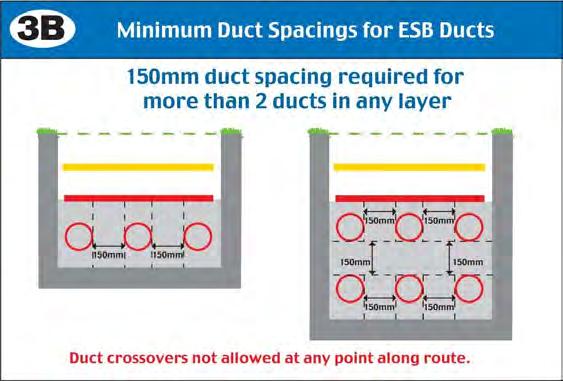

61


62


63


64

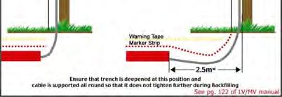


65
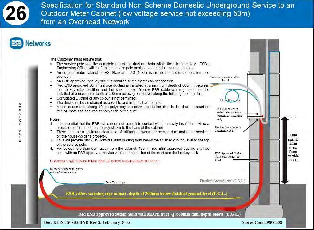

66
67 ANNEX A-3: ESBN S STANDARD SPECIFICATIONS FOR ESB 38 KV DUCTING / CABLING
68

69

70

71
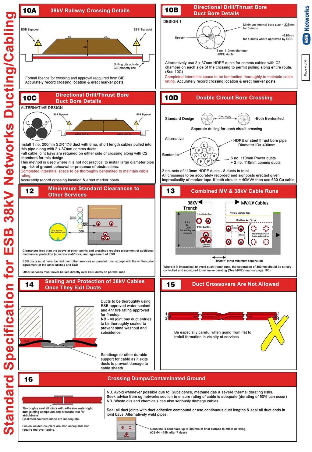
72
An Bord Pleanála. Eirgrid Plc. Meath County Council Cavan County Council Monaghan County Council
 An Bord Pleanála Ref: PL02.VS0002 Prospective Applicant: Eirgrid Plc. Local Authorities: Meath County Council Cavan County Council Monaghan County Council Nature of Application: Written opinion on information
Identify matters regarding the project which inform the preparation of the Environmental Impact Statement (EIS);
;") 3 SCOPING THE EIS 3.1 INTRODUCTION 1 Consultation is an important part of the Environmental Impact Assessment (EIA) process; in this context, consultation with statutory agencies, interested parties, the
3 SCOPING THE EIS 3.1 INTRODUCTION 1 Consultation is an important part of the Environmental Impact Assessment (EIA) process; in this context, consultation with statutory agencies, interested parties, the
(a) a description of the project, together with any available information on its possible transboundary impact;
 a description of the project, together with any available information on its possible transboundary impact;") 9 TRANSBOUNDARY 9.1 INTRODUCTION 1 The issue of likely significant transboundary effects is of importance in the context of this proposed development, as it comprises part of an overall interconnection
9 TRANSBOUNDARY 9.1 INTRODUCTION 1 The issue of likely significant transboundary effects is of importance in the context of this proposed development, as it comprises part of an overall interconnection
Circular L8/08 2 September Water Services Investment and Rural Water Programmes Protection of Natural Heritage and National Monuments
 Circular L8/08 2 September 2008 Water Services Investment and Rural Water Programmes Protection of Natural Heritage and National Monuments 1. The purpose of this Circular is to provide local authorities
HRA PLANNING Chartered Town Planning and Environmental Consultants
 HRA PLANNING Chartered Town Planning and Environmental Consultants Screening Statement for the Purposes of Determining the need for Appropriate Assessment Proposed development of 74 no. residential units
Route Alignment Options Summary Report
 Brechfa Forest Connection Project February 2014 Summary report 1. RSK Environment Ltd (RSK) was commissioned by Western Power Distribution (WPD) to provide environmental consultancy support services for
Genex Kidston Connection Project: Draf t Environmental Assessment Report Powerlink Queensland
 : Draf t Environmental Assessment Report Powerlink Queensland Chapter 14 \\autsv1fp001\projects\605x\60577456\6. Draft Docs\6.1 Reports\4. Compiled draft 17 September\Covers\Chapters\Ch 14.docx Rev ision
7. The Landscape. 7.1 Introduction. Environmental Impact Statement (EIS) Scoping Report
 Scoping Report") 7. The Landscape 7.1 Introduction The purpose of this section of the EIS Scoping Report is to describe the scope of work and methods to be applied in the identification and assessment of landscape and
7. The Landscape 7.1 Introduction The purpose of this section of the EIS Scoping Report is to describe the scope of work and methods to be applied in the identification and assessment of landscape and
NON-TECHNICAL SUMMARY
 Proposed Sand and Gravel Extraction and Associated Processing Operations with Restoration to a Mixture of Agriculture and Nature Conservation including Areas of Shallow Water at Hedgeley, Northumberland
Grantham Southern Quadrant Link Road Environmental Statement
 Grantham Southern Quadrant Link Road Environmental Statement Non Technical Summary Introduction Lincolnshire County Council (LCC) is submitting a planning application for the proposed implementation of
BREEDON NORTHERN LIMITED
 Non Technical Summary CONTENTS 1 INTRODUCTION... 1 2 SITE DESCRIPTION... 1 3 DESCRIPTION OF THE DEVELOPMENT... 6 4 NEED FOR THE DEVELOPMENT... 8 5 KEY ISSUES CONSIDERED IN THE ENVIRONMENTAL IMPACT ASSESSMENT...
14 Introduction 14.2 Study area 14.3 Impact assessment methodology Magnitude Significance 14.4 Impact assessment 14.4.
 14 14.1 Material Assets: Agronomy Introduction 14.2 Study area 14.3 Impact assessment methodology 14.3.1 Magnitude 14.3.2 Significance 14.4 Impact assessment 14.4.1 Impact identification 14.4.2 Mitigation
NON-TECHNICAL SUMMARY
 NON-TECHNICAL SUMMARY THE HIDE, BISHOP AUCKLAND PROPOSED ECO CHALET DEVELOPMENT NON-TECHNICAL SUMMARY 1 Introduction 1.1.1 This non-technical summary for the (ES) prepared in relation to the proposed eco-chalet
Report To An Bord Pleanála. Potential Significant Effects on the Environment /European Sites
 S I M O N C L E A R & A S S O C I A T E S P L A N N I N G A N D D E V E L O P M E N T C O N S U L T A N T S h Report To An Bord Pleanála Potential Significant Effects on the Environment /European Sites
Rannoch 132 / 33 kv Substation Extension
 Who we are Scottish and Southern Energy Power Distribution is part of the SSE plc group of companies. We own, maintain and invest in the networks in the north of Scotland the electricity transmission network
16 LANDSCAPE AND VISUAL IMPACT
 16 LANDSCAPE AND VISUAL IMPACT 16.1 Introduction The term landscape refers primarily to the visual appearance of an area, including its shape, form and colour and the interaction of these elements to create
3.1 This evidence is based on the landscape and visual impact assessment included in Chapter 10 and Appendix I of the EIS.
 LANDSCAPE & VISUAL 1 QUALIFICATIONS AND EXPERIENCE 1.1 My name is Raymond Holbeach and I am a Regional Director for RPS Planning & Environment with full responsibility for management of the RPS Belfast
Annex F FBIS-C Tier 1 Tranche 1 Fencing Specification and installation guidelines
 Annex F FBIS-C Tier 1 Tranche 1 Fencing Specification and installation guidelines Minimum expenditure on all fencing types in FBIS - C The minimum expenditure on each eligible fencing item is 2500, within
I539. Smales 2 Precinct
 I539. Smales 2 Precinct I539.1. Precinct Description The Smales 2 Precinct applies to a 4.8 hectare block of land located on the southern side of Northcote Road and fronting Lake Pupuke, Takapuna. The
Wyvern Park Skipton Environmental Statement. Non-technical Summary - April 2015
 Wyvern Park Skipton Environmental Statement Non-technical Summary - April 2015 BWB Consulting Ltd Whitehall Waterfront 2 Riverside Way Leeds LS1 4EH Telephone: +44(0)113 233 8000 Copyright This Report
Neighbourhood Planning Site Assessment Pro-forma and Guide Version 2
 Neighbourhood Planning Site Assessment Pro-forma and Guide Version 2 September 2014 Site HNP 006 Land East of Stanbridge Road and North of Lower Road 1. Background information Site location and use Site
Strategic Environmental Assessment Screening Report. Dublin Port Masterplan Review 2017
 Strategic Environmental Assessment Screening Report Dublin Port Masterplan Review 2017 Table of Contents 1 Introduction... 1 2 Purpose of the Masterplan... 2 3 Task 1.1 Pre-Screening Check... 5 4 Task
Plumpton Neighbourhood Development Plan Revised Pre Submission Document - Regulation 14 Consultation
 REPRESENTATIONS... Plumpton Parish Council Plumpton Neighbourhood Development Plan Revised Pre Submission Document - Regulation 14 Consultation Representations submitted on behalf of: Cala Homes (South
University Park, Worcester Non Technical Summary December 2011
 University Park, Worcester Non Technical Summary December 2011 Introduction UW Wrenbridge LLP, a Joint Venture Company of the University of Worcester and Wrenbridge Land Ltd (the Applicants ) intend to
APPROPRIATE ASSESSMENT SCREENING IN ACCORDANCE WITH THE REQUIREMENTS OF ARTICLE 6(3) OF THE EU HABITATS DIRECTIVE FOR THE PROPOSED VARIATION OF THE
 OF THE EU HABITATS DIRECTIVE FOR THE PROPOSED VARIATION OF THE") APPROPRIATE ASSESSMENT SCREENING IN ACCORDANCE WITH THE REQUIREMENTS OF ARTICLE 6(3) OF THE EU HABITATS DIRECTIVE FOR THE PROPOSED VARIATION OF THE DUBLIN CITY DEVELOPMENT PLAN 2011-2017 RANELAGH AVENUE,
APPROPRIATE ASSESSMENT SCREENING IN ACCORDANCE WITH THE REQUIREMENTS OF ARTICLE 6(3) OF THE EU HABITATS DIRECTIVE FOR THE PROPOSED VARIATION OF THE DUBLIN CITY DEVELOPMENT PLAN 2011-2017 RANELAGH AVENUE,
McKay Road Interchange and Salem / Lockhart Crossing
 McKay Road Interchange and Salem / Lockhart Crossing The McKay Road Interchange Class EA has two components: 1. A new MacKay Road Interchange at Highway 400; and 2. A new bridge crossing of Highway 400
9 Archaeology & Cultural Heritage
 High Clachaig Wind Farm Scoping Report Page 56 9 Archaeology & Cultural Heritage 9.1 Introduction Cultural heritage in this context means the above- and below-ground archaeological resources, built heritage,
Proposed Southland District Plan 2012 Appeal Version October 2016
 S e c t i o n 3. 5 - F i o r d l a n d / R a k i u r a Z o n e The Fiordland/Rakiura Zone encompasses the Fiordland and Rakiura National Parks and part of Mt Aspiring National Park. It also includes areas
Cardiff International Sports Village Waterfront Development Volume IV : Non-Technical Summary of the Environmental Statement
 Greenbank Partnerships Ltd October 2012 Cardiff International Sports Village Waterfront Development Volume IV : Non-Technical Summary of the Environmental Statement Environmental Statement - Non Technical
NON-TECHNICAL SUMMARY
 Hybrid outline/detailed planning application comprising an outline planning application for 196 residential dwellings, landscaping, open space, estate roads and infrastructure, plus 4 permanent gypsy and
ARTICLE VI: SITE PLAN REVIEW
 Section 6.01 - Site Plan Review (All Districts) ARTICLE VI: SITE PLAN REVIEW Site plans give the Planning commission an opportunity to review development proposals in a concise and consistent manner. The
MONITORING REPORT: No. 276
 MONITORING REPORT: No. 276 Between 51 and 53 Castor Bay Road Lurgan Co. Armagh AE/13/214 Dermot Redmond Site Specific Information Site Name: Between 51 and 53 Castor Bay Road, Lurgan, Co. Armagh Townland:
ENBRIDGE GAS DISTRIBUTION INC. Proposed Relocation for Ninth Line, Markham and Whitchurch-Stouffville. Environmental Screening Report
 Page 1 of 18 ENBRIDGE GAS DISTRIBUTION INC. Proposed Relocation for Ninth Line, Markham and Whitchurch-Stouffville Environmental Screening Report July 2011 Page 2 of 18 Table of Contents 1.0 INTRODUCTION
MARBLE RIVER WIND POWER PROJECT Agricultural Protection Measures
 MARBLE RIVER WIND POWER PROJECT Siting Considerations 1. Locate access roads and, to the extent allowed by local laws, wetlands and topography, individual wind turbines and other structures along field
Assessing the impact of smallscale wind energy proposals on the natural heritage
 Scottish Natural Heritage Assessing the impact of smallscale wind energy proposals on the natural heritage Guidance March 2016 Version 3 1 Contents 1. Introduction. 3 2. Encouraging a spatial approach
LAND USE SHEET 3 LOWER THAMES CROSSING LOWER THAMES CROSSING STATUTORY CONSULTATION. Main works construction compound
 1 19 1 Sheet 19 19 Sheet 19 Sheet 13 Sheet 13 Sheet 11 Sheet 11 Sheet Sheet 10 11 Sheet Sheet 10 11 a a Sheet 10 Sheet 10 a a a Sheet a5 Sheet 1 Sheet 1 HE540039-CJV-GEN-SZP_GN000000_Z-DR-CX-00304.dwg
Section 6A 6A Purpose of the Natural Features and Landscapes Provisions
 Section 6A 6A Purpose of the Natural Features and Landscapes Provisions This Chapter addresses the protection and management of natural features and landscapes within the City. The City has a number of
Oweninny Wind Farm. Oweninny Environmental Impact Statement Appendix 13. Cultural Heritage Correspondence
 Oweninny Wind Farm Oweninny Environmental Impact Statement Appendix 13 Cultural Heritage Correspondence Copyright ESB International Limited, all rights reserved. Farm Document Number File Reference: Oweninny
High Speed Rail (London- West Midlands)
") High Speed Rail (London- West Midlands) Draft Environmental Minimum Requirements Annex 3: Draft Heritage Memorandum November 2013 ESA 4.4 High Speed Rail (London- West Midlands) Draft Environmental Minimum
High Speed Rail (London- West Midlands) Draft Environmental Minimum Requirements Annex 3: Draft Heritage Memorandum November 2013 ESA 4.4 High Speed Rail (London- West Midlands) Draft Environmental Minimum
Landscape Character Assessment
 Landscape Character Assessment What Is It? Survey of the county landscapes For what purpose? To analyse and define character Says Who? Planning and Development Act 2000 Applications To provide a basis
London Road, Derker. Non Technical Summary. Introduction
 London Road, Derker Non Technical Summary Introduction The Oldham Rochdale Housing Market Pathfinder was set up to tackle longstanding problems of poor quality housing and to provide the framework for
Zoning Ordinance Article 3
 Article 3 Natural Resources Protection Section 301 Natural Resources Protection 301.1. Purpose - The following natural resources protection standards are established to protect the public health, safety
Guidance for Developers on the Management of Biodiversity issues in the Planning Process
 Biodiversity and the Planning Process Guidance for Developers on the Management of Biodiversity issues in the Planning Process 1.0 March 2017 Table of Contents: Page What is biodiversity and why is it
Land at BROOK STREET PROPERTIES TENCREEK FARM, LISKEARD. Environmental Statement: Non-Technical Summary
 BROOK STREET PROPERTIES TENCREEK FARM, LISKEARD Land at Environmental Statement: Non-Technical Summary Introduction Brook Street Properties is applying to Cornwall Council for outline planning permission
CA//16/00504/FUL. Canterbury City Council Military Road Canterbury Kent CT1 1YW. Crown copyright and database rights 2016 Ordnance Survey
 O Scale 1:1,250 Map Dated: 09/05/2016 CA//16/00504/FUL Crown copyright and database rights 2016 Ordnance Survey 100019614 Canterbury City Council Military Road Canterbury Kent CT1 1YW AGENDA ITEM NO 13
Form to Submit Land for Residential Evidence Gathering Shepway Strategic Housing Land Availability Assessment (SHLAA) Partial Review
 Partial Review") Form to Submit Land for Residential Evidence Gathering Shepway Strategic Housing Land Availability Assessment (SHLAA) Partial Review All organisations and individuals who wish to put forward land for consideration
Form to Submit Land for Residential Evidence Gathering Shepway Strategic Housing Land Availability Assessment (SHLAA) Partial Review All organisations and individuals who wish to put forward land for consideration
EVALUATION REPORT No. 300
 EVALUATION REPORT No. 300 Southwest of 2A Cloughey Road, Portaferry, Co. Down Licence No.: AE/135/85E Sapphire Mussen Report Date: 14 th May 2015 Site Specific Information Site Name: [Southwest of 2a]
4.1 LAND USE AND HOUSING
 4.1 This section provides a project-level analysis of potential impacts to land use, Shorelines of the State (shorelines), and housing. The study area for the land use and housing analysis in the Final
Wind energy development in the South Pennines landscape
 Wind energy development in the South Pennines landscape Programme for today Background Policy context South Pennines landscape Impacts of wind energy development The South Pennines Wind Energy Landscape
Methods, approaches, and procedures to minimize active agricultural land impacts during pipeline construction, surface restoration, and pipeline
 Agricultural Impact Minimization Plan Methods, approaches, and procedures to minimize active agricultural land impacts during pipeline construction, surface restoration, and pipeline operation. PennEast
LONDON BRIDGE STATION ENVIRONMENTAL STATEMENT NON-TECHNICAL SUMMARY
 LONDON BRIDGE STATION ENVIRONMENTAL STATEMENT NON-TECHNICAL SUMMARY June 2011 1 EXECUTIVE SUMMARY 2 INTRODUCTION CONTENTS Page 2.1 Introduction 4 2.2 The Site 4 3 THE DEVELOPMENT 3.1 What is it? 5 3.2
A737/A738 Trunk Road (Dalry Bypass)
") IN ASSOCIATION WITH DRAWING STATUS A737/A738 Trunk Road (Dalry Bypass) Environmental Statement July 2013 Introduction The A737 trunk road forms a strategic link from the M8 motorway, at Paisley, to Ayrshire.
IN ASSOCIATION WITH DRAWING STATUS A737/A738 Trunk Road (Dalry Bypass) Environmental Statement July 2013 Introduction The A737 trunk road forms a strategic link from the M8 motorway, at Paisley, to Ayrshire.
Lower Sensitivity. VS Classification Level 2: Exposed Upland/Plateau
 S04 Moel Hebog Reproduced from the Ordnance Survey map with the permission of Ordnance Survey on behalf of the Controller of Her Majesty s Stationery Office, Crown copyright Licence No. 100023387 Location
Replacement Golf Course Facilities and Residential Development, Churston. Environmental Statement Non-Technical Summary
 Replacement Golf Course Facilities and Residential Development, Churston Environmental Statement Non-Technical Summary July 2011 Reproduced from the Ordnance Survey s map with the permission of the Controller
Chapter 8: Cultural Heritage Assessment
 Chapter 8: Cultural Heritage Assessment Cultural Heritage Assessment 8. Cultural Heritage Assessment... 2 8.1 Introduction... 2 8.2 Baseline Assessment... 2 8.3 Results / Assessment Findings... 3 8.4 Mitigation...
South Whitehaven, Cumbria EIA
 South Whitehaven, Cumbria EIA Environmental Statement - Non Technical Summary June 2013 in association with 1. Introduction Story Homes is applying to Copeland Borough Council (CBC) for a new residential
M7 Naas to Newbridge Bypass Upgrade Scheme. Landscape and Visual Impact Assessment Brief of Evidence
 M7 Naas to Newbridge Bypass Upgrade Scheme Landscape and Visual Impact Assessment Brief of Evidence Presented by Richard Butler, Cunnane Stratton Reynolds Landscape Architect: BL Arch (University of Pretoria,
E&JW Glendinning Ltd.
 Proposed extension and deepening of quarry for extraction of minerals for high specification aggregate and other products, and construction of spoil tip at Pigsdon Quarry Non Technical Summary of Environmental
List of Policies. SESPlan. None applicable. Consolidated Scottish Borders Local Plan 2011: POLICY G1 - QUALITY STANDARDS FOR NEW DEVELOPMENT
 List of Policies Local Review Reference: 15/00021/RREF Planning Application Reference: 15/00616/FUL Development Proposal: Installation of 16no solar photovoltaic (PV) panels to roof Location: Raebank,
Cultural Heritage Guidelines for Electricity Transmission Projects
 Cultural Heritage Guidelines for Electricity Transmission Projects A Standard Approach to Archaeological, Architectural and Cultural Heritage Impact Assessment of High Voltage Transmission Projects TABLE
Kier Infrastructure and Overseas Limited Greenburn Surface Mine, Dalgig Farm Site
 Kier Infrastructure and Overseas Limited Greenburn Surface Mine, Dalgig Farm Site Planning application pursuant to s.42 Town and Country Planning (Scotland) Act 1997 to amend the restoration scheme Volume
THE ENVIRONMENTAL PROTECTION IN THE URBANISTICPLANNING AND LAND DEVELOPMENT IN EUROPEAN UNION LAW
 THE ENVIRONMENTAL PROTECTION IN THE URBANISTICPLANNING AND LAND DEVELOPMENT IN EUROPEAN UNION LAW The answes must be sent, imperatively in English or in French, before the 15th August 2011 to Ms. Anna
M4 Corridor around Newport Environmental Statement Volume 3: Appendices
 Environmental Statement Volume 3: Appendices Environmental Statement Volume 3: Appendices At Issue March 2016 CVJV/AAR 3 rd Floor Longross Court, 47 Newport Road, Cardiff CF24 0AD Volume 3: Contents 1
Derry City and Strabane District Council Planning Committee Report. Amended layout from approval A/2004/0462/F with reduction from 166 units
 Derry City and Strabane District Council Planning Committee Report COMMITTEE DATE: 1 st February 2017 APPLICATION No: APPLICATION TYPE: PROPOSAL: LOCATION: APPLICANT: AGENT: Full Planning application Amended
Response by the Wiltshire Archaeological and Natural History Society
 Highways England Consultation A303 Stonehenge Response by the Wiltshire Archaeological and Natural History Society Background About the Society Founded in 1853 to educate the public by promoting, fostering
AMENDMENT NO. 30 TO THE OFFICIAL PLAN OF THE TOWN OF MILTON
 AMENDMENT NO. 30 TO THE OFFICIAL PLAN OF THE TOWN OF MILTON Subject: Boyne Survey Secondary Plan and Related Official Plan Amendments The following text and schedules constitute Amendment No. 30 to the
Bridge House, Ham Island, Old Windsor, Berkshire
 Bridge House, Ham Island, Old Windsor, Berkshire An Archaeological Watching Brief for Mr A Chadwick by Alan Ford Thames Valley Archaeological Services Site Code BHHI98/55 August 1998 Bridge House, Ham
COLVER ROAD INDUSTRIAL CONCEPT PLAN
 COLVER ROAD INDUSTRIAL CONCEPT PLAN A CONCEPTUAL LAND USE AND TRANSPORTATION PLAN FOR TA-4 AN URBAN RESERVE AREA OF THE CITY TALENT City of Talent Adopted by City Council Resolution No., June, 2015 PART
Methods, approaches, and procedures to minimize active agricultural land impacts during pipeline construction, surface restoration, and pipeline
 Agricultural Impact Minimization Plan Methods, approaches, and procedures to minimize active agricultural land impacts during pipeline construction, surface restoration, and pipeline operation. PennEast
Meridian Water Phase 1 Application
 Meridian Water Phase 1 Application MW11 Environmental Statement Non-Technical Summary London Borough of Enfield March 2016 Contents 1 Introduction 1 2 The proposed development 2 3 Evolution of the proposed
Application for Certificate of Environmental Compatibility and Public Need
 Application for Certificate of Environmental Compatibility and Public Need Central Hudson Gas & Electric A and C Lines Towns of Pleasant Valley, LaGrange, Wappinger, and East Fishkill Dutchess County,
Chapter 10 Route window W17 Middlegreen Road, St Mary s Road and Trenches bridges. Transport for London
 Chapter 10 Route window W17 Middlegreen Road, St Mary s Road and Trenches bridges Transport for London MIDDLEGREEN ROAD, ST MARY S ROAD AND TRENCHES BRIDGES 10 Route window W17 Middlegreen Road, St Mary
HeritageCollectiveLLP
 Appendix C, Review of Archaeology and Cultural Heritage Assessment Introduction 1. This information (SEI) addresses the likely significant impacts of a six-turbine development in which T6 is removed from
Environmental Assessment (Scotland) Act 2005: Clackmannanshire Council Sustainability Strategy Scoping Request
 Act 2005: Clackmannanshire Council Sustainability Strategy Scoping Request") TAYSIDE & CLACKMANNANSHIRE Tel: 01738 458582(direct line) Fax: 01738 458616 e-mail addresses: denise.reed@snh.gov.uk Niall Urquhart Team Leader Sustainability Clackmannanshire Council Kilncraigs Greenside
TAYSIDE & CLACKMANNANSHIRE Tel: 01738 458582(direct line) Fax: 01738 458616 e-mail addresses: denise.reed@snh.gov.uk Niall Urquhart Team Leader Sustainability Clackmannanshire Council Kilncraigs Greenside
NON TECHNICAL SUMMARY
 NON TECHNICAL SUMMARY INTRODUCTION NTS.1 CEMEX UK Properties Limited is applying for planning permission to South Cambridgeshire District Council (SCDC) for the redevelopment of the former CEMEX cement
PERSIMMON HOMES (SW) LIMITED LAND AT ADDINGTON, LISKEARD ENVIRONMENTAL STATEMENT NON-TECHNICAL SUMMARY
 LIMITED LAND AT ADDINGTON, LISKEARD ENVIRONMENTAL STATEMENT NON-TECHNICAL SUMMARY") PERSIMMON HOMES (SW) LIMITED LAND AT ADDINGTON, LISKEARD ENVIRONMENTAL STATEMENT NON-TECHNICAL SUMMARY APRIL 2010 INTRODUCTION This document is the Non-Technical Summary (NTS) of an Environmental Statement
PERSIMMON HOMES (SW) LIMITED LAND AT ADDINGTON, LISKEARD ENVIRONMENTAL STATEMENT NON-TECHNICAL SUMMARY APRIL 2010 INTRODUCTION This document is the Non-Technical Summary (NTS) of an Environmental Statement
Bradleys Both Parish Council
 Bradleys Both Parish Council Bradleys Both Housing Site Assessments April 2015 Contents 1.0 Introduction... 2 2.0 BR001 Health Lea and Land to Rear, Skipton Road... 2 3.0 BR002 Holly Tree House and Land
Everton s Neighbourhood Plan. Site Allocation - Assessment Criteria
 Everton s Neighbourhood Plan Site llocation - ssessment Criteria Introduction 1.1 This report assesses all the sites identified through the emerging Neighbourhood Plan for Everton and their potential for
LAND AT WEST YELLAND. Environmental Statement Non-Technical Summary Welbeck Strategic Land LLP
 LAND AT WEST YELLAND Environmental Statement Non-Technical Summary Welbeck Strategic Land LLP May 2014 Quality Management Issue/revision Issue 1 Revision 1 Revision 2 Revision 3 Remarks Draft FINAL Date
PLANNING FOR THE SUPPLY OF BUILDING AND ROOFING STONE The Planning Officers Society 2008
 PLANNING FOR THE SUPPLY OF BUILDING AND ROOFING STONE The Planning Officers Society 2008 Extraction of minerals, including building and roofing stone, from the land requires planning permission under the
Developer, new connection and infrastructure charges
 Ends of duct to be sealed Pipe clips mounted off to allow for insulation Pipe insulated in accordance with B.S. 6700 against damage from frost Drain Tap Double check valve Copper to Polyethylene fitting
APPENDIX 9: Archaeological Assessment by Ken Phillips
 APPENDIX 9: Archaeological Assessment by Ken Phillips ARCHAEOLOGICAL ASSESSMENT PROPOSED SERVICE STATION DEVELOPMENT BRUCE ROAD, PAPAMOA TAURANGA Prepared by KEN PHILLIPS (MA HONS) MARCH 2016 ARCHAEOLOGY
EAST OF ENGLAND OFFICE
 Mr Philip Isbell Direct Dial: 01223 582751 Mid Suffolk District Council 131 high Street Our ref: P00524468 Needham Market Ipswich Suffolk IP6 8DL 18 January 2017 Dear Mr Isbell T&CP (Development Management
i.6 Under this Key Area of Change the Daresbury Strategic Site will deliver:
 I.0 NON-TECHNICAL SUMMARY Introduction i.1 Redrow Homes NW Ltd is applying to Halton Borough Council for planning permission for the development of up to 300 high quality residential dwellings, including
Dorenell Wind Farm 132 kv Grid Connection
 Who We Are Scottish and Southern Energy Power Distribution is part of the SSE plc group of companies. We own, maintain and invest in the electricity networks in the north of Scotland the electricity transmission
4.0 AFFECTED ENVIRONMENT AND ENVIRONMENTAL CONSEQUENCES
 4.0 AFFECTED ENVIRONMENT AND ENVIRONMENTAL CONSEQUENCES The following sections discuss the impacts associated with environmental resources for the tunneling method Alternatives A and B. The construction
ABBEY MANOR GROUP/SAINSBURY S SUPERMARKETS LTD
 ABBEY MANOR GROUP/SAINSBURY S SUPERMARKETS LTD Mixed Use Development including Business Park and Foodstore Land at Bunford Park, Bunford Lane, Yeovil Environmental Statement: Non-Technical Report June
Guide to Transmission Equipment Maintenance
 Guide to Transmission Equipment Maintenance March 2018 Revision History Issue Date Update 1 September 2013 First Issue 2 March 2016 Updated in response to SEM-15-071 Decision Paper Outturn Availability.
METHODOLOGY FOR IMPACT ASSESSMENT ON HERITAGE ASSETS IDENTIFICATION OF THE RECEPTOR ASSESSMENT OF THE RECEPTOR S IMPORTANCE
 METHODOLOGY FOR IMPACT ASSESSMENT ON HERITAGE ASSETS The determination of impacts on heritage assets follows the standard procedures applied to all Environmental Impact Assessment. This entails the identification
Habitat Regulations Assessment (HRA) Screening Determination. May 2017
 Screening Determination. May 2017") Cholsey Parish Council Cholsey Neighbourhood Plan Habitat Regulations Assessment (HRA) Screening Determination May 2017 Cholsey Neighbourhood Plan Page! 1 of! 10 SASR - HRA v1.1 Page Left Intentionally
Cholsey Parish Council Cholsey Neighbourhood Plan Habitat Regulations Assessment (HRA) Screening Determination May 2017 Cholsey Neighbourhood Plan Page! 1 of! 10 SASR - HRA v1.1 Page Left Intentionally
Digital Terrestrial Television Infrastructure Rollout. Environmental Impact Assessment - Corridor -
 Digital Terrestrial Television Infrastructure Rollout Environmental Impact Assessment - Corridor - 1 1 ENVIRONMENTAL IMPACT ASSESSMENT (EIA): CORRIDOR 1.1 INTRODUCTION Corridor is a small farming community
Exhibit A. 8:9 Scuffletown Rural Conservation District
 Exhibit A 8:9 Scuffletown Rural Conservation District 8:9.1 Intent and Purpose The Scuffletown Rural Conservation (SRC) District is intended to provide for residential development that supports the development
Longbridge Town Centre Phase 2 Planning Application
 Longbridge Town Centre Phase 2 Planning Application Non-Technical Summary of the Environmental Statement December 2013 Introduction A full application for Planning Permission has been submitted to Birmingham
Schedule of Standard Charges for Distribution Services and Third Party Damage
 Schedule of Standard Charges for Distribution Services and Third Party Damage ESB Nets May 06 Schedule of Standard Charges for Distribution Services and Third Party Damage Status: May 2006 Commercial and
Request for a Scoping Opinion by Provectus. Proposed Surface Mining of Coal on Land west off the A61, Hill Top Farm, Clay Cross, Derbyshire
 Request for a Scoping Opinion by Provectus Proposed Surface Mining of Coal on Land west off the A61, Hill Top Farm, Clay Cross, Derbyshire January 2012 Contents 1 Introduction & Background... 1 2 Site
Barvills Solar Farm Environmental Statement Non-Technical Summary
 Barvills Solar Farm Environmental Statement Non-Technical Summary 13 March 2015 Produced for Prepared by St John s House Queen Street, Manchester M2 5JB Contents Contents... 2 1 Introduction... 3 1.1 Development
Visual and Aesthetic Resources
 Visual and Aesthetic Resources 7.1 INTRODUCTION This chapter evaluates the effects of the Modified Design on visual and aesthetic resources, in comparison to the effects of 2004 FEIS Design. The 2004 FEIS
The Illinois Department of Transportation and Lake County Division of Transportation. Route 173, including the Millburn Bypass
 The Illinois Department of Transportation and Lake County Division of Transportation welcome you to this Public Hearing for U.S. Route 45 from Illinois Route 132 to Illinois Route 173, including the Millburn
Town and Country Planning (Environmental Impact Assessment Regulations) 2011 SCOPING OPINION
 2011 SCOPING OPINION") Town and Country Planning (Environmental Impact Assessment Regulations) 2011 SCOPING OPINION Application Site and Description of Development Proposed new quarry at Culham, Oxfordshire Land and Mineral
Town and Country Planning (Environmental Impact Assessment Regulations) 2011 SCOPING OPINION Application Site and Description of Development Proposed new quarry at Culham, Oxfordshire Land and Mineral
HERITAGE POLICY...Safeguarding the Built Heritage. Conservation Plans. A Guide to the Preparation of Conservation Plans
 HERITAGE POLICY...Safeguarding the Built Heritage Conservation Plans A Guide to the Preparation of Conservation Plans 1 2 1.0 INTRODUCTION 1.1 Scotland has a diverse built heritage: ancient monuments and