CHARTER TOWNSHIP OF VAN BUREN PLANNING COMMISSION AGENDA Wednesday, September 26, :30 PM, Board of Trustees Room
|
|
|
- Maximilian Stevens
- 5 years ago
- Views:
Transcription
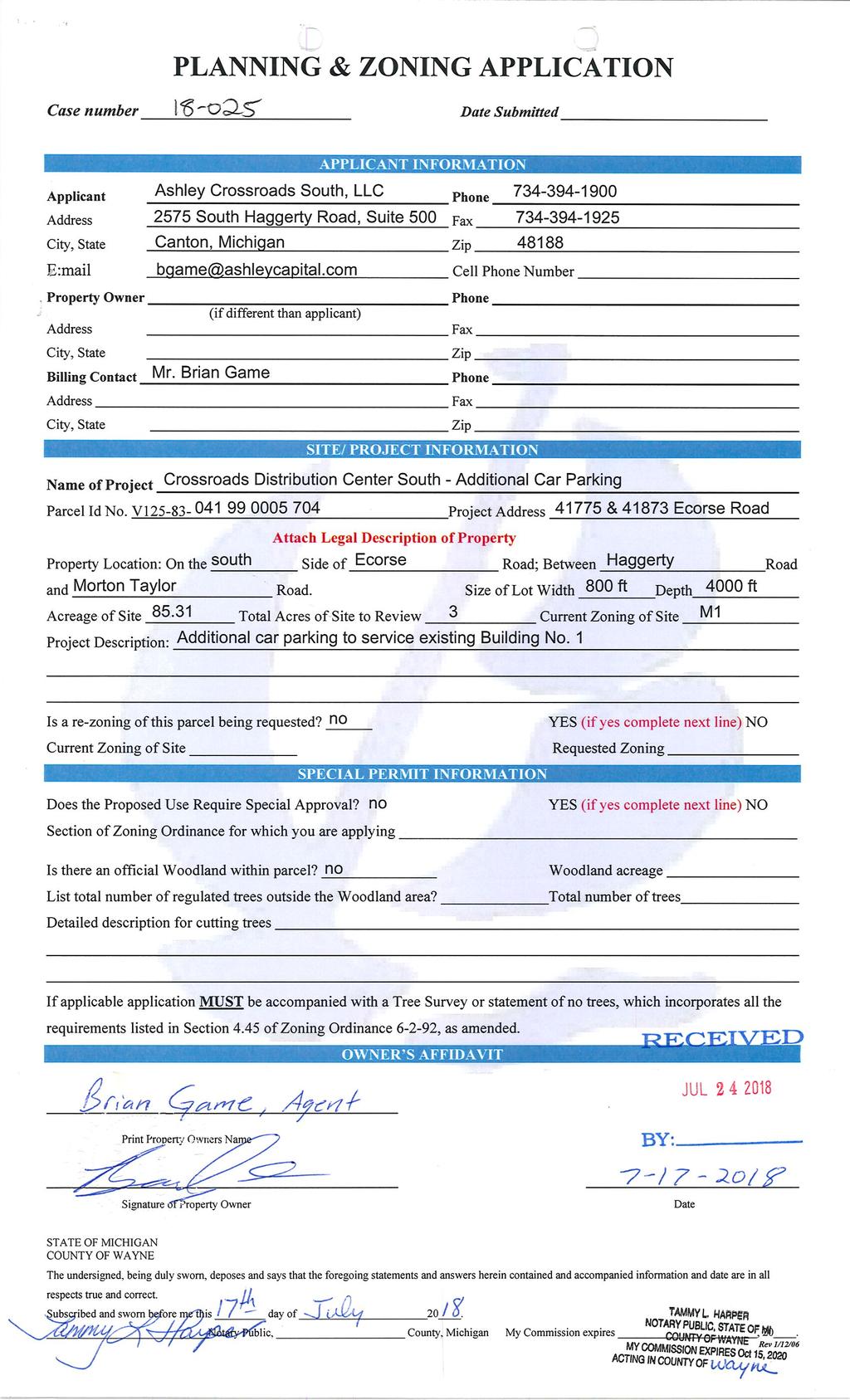
1 CALL TO ORDER: ROLL CALL: APPROVAL OF AGENDA: MINUTES: CHARTER TOWNSHIP OF VAN BUREN PLANNING COMMISSION AGENDA Wednesday, September 26, :30 PM, Board of Trustees Room ITEM #1: Approval of minutes from the regular meeting of September 12, CORRESPONDENCE: PUBLIC HEARING: UNFINISHED BUSINESS: NEW BUSINESS: ITEM #1: TITLE: LOCATION: ACTION ITEMS: ITEM #2: TITLE: LOCATION: ACTION ITEMS: ITEM #3: TITLE: CASE PHASE TWO (2) PRELIMINARY SITE PLAN APPROVAL THE APPLICANT, ACS MICHIGAN, IS REQUESTING PHASE TWO (2) PRELIMINARY SITE PLAN APPROVAL (PER THE APPROVED DEVELOPMENT AGREEMENT) TO CONSTRUCT AN AUTOMOTIVE RESEARCH AND DEVELOPMENT FACILITY. SUBJECT PROPERTY IS LOCATED AT MICHIGAN AVENUE, OTHERWISE KNOWN AS THE HAROLD SMITH FARM. A. Presentation by the applicant. B. Presentation by Township staff. C. Planning Commission discussion. D. Planning Commission considers phase 2 preliminary site plan approval. CASE FINAL SITE PLAN APPROVAL THE APPLICANT, ASHLEY CROSSROADS SOUTH, LLC, IS REQUESTING SITE PLAN APPROVAL TO ADD ADDITIONAL CAR PARKING TO SERVICE THE EXISTING BUILDING 1. SUBJECT PROPERTY IS LOCATED AT THE CROSSROADS SOUTH DEVELOPMENT WHOSE ADDRESS IS & ECORSE ROAD. A. Presentation by the applicant. B. Presentation by Township staff. C. Planning Commission discussion. D. Planning Commission considers site plan approval. CASE PRELIMINARY SITE PLAN APPROVAL. THE APPLICANT, TIMOTHY SHAMMAS, IS REQUESTING PRELIMINARY SITE PLAN
2 APPROVAL TO ADD A GASOLINE FILLING STATION TO AN EXISTING SHOPPING CENTER. LOCATION: ACTION ITEMS: E. Huron River Drive. The property is located at the southwest corner of Haggerty Road and E. Huron River Drive. A. Presentation by the applicant B. Presentation by Township staff. C. Planning Commission discussion. D. Planning Commission considers preliminary site plan approval. GENERAL DISCUSSION: ITEM #1: PUBLIC PARTICIPATION PLAN LARGE PROJECT DEFINITION ADJOURNMENT:
3 CHARTER TOWNSHIP OF VAN BUREN PLANNING COMMISSION SEPTEMBER 12, 2018 MINUTES - DRAFT Chairperson Thompson called the meeting to order at 7:30 p.m. ROLL CALL: Present: Atchinson, Budd, Kelley, Boynton, Franzoi and Thompson. Excused: Jahr. Staff: Director Akers and Secretary Harman. Planning Representatives: Fishbeck Associates, David Potter and Paul Kammer. Audience: Five (5). APPROVAL OF AGENDA: Motion Kelley, Atchinson second to approve the agenda of September 12, 2018 as amended, removing Item #1 under New Business. Motion Carried. APPROVAL OF MINUTES: Motion Franzoi, Budd second to approve the regular meeting minutes of August 22, 2018 as presented. Motion Carried. NEW BUSINESS: ITEM # 1 TITLE: LOCATION: FINAL SITE PLAN APPROVAL THE APPLICANT, THE VAN BUREN TOWNSHIP DOWNTOWN DEVELOPMENT AUTHORITY, IS REQUESTING FINAL SITE PLAN APPROVAL TO CONSTRUCT AN OFFICE BUILDING AND A PARK AT THEIR PROPERTY ON BELLEVILLE ROAD , 10065, AND BELLEVILLE ROAD ARE THE SUBJECT OF THE AGENDA ITEM. THE PROPERTY IS LOCATED ON THE EAST SIDE OF BELLEVILLE ROAD, NORTH OF THE I-94 SERVICE DRIVE AND SOUTH OF TYLER ROAD. Susan Ireland, Downtown Development Authority (DDA) Director gave the presentation. Ms. Ireland gave a brief recap of how the project began. The project site is approximately 1.6 acres, the DDA acquired two additional parcels to increase the property size, had the existing structures removed and has submitted the lot combination. The new facility includes a storage building, walking paths, parking and site lighting. The preliminary site plan review was in 2017, many of the comments by staff and engineers have been addressed including: trash disposal, property maintenance, brick to cover 50% of the building, monument signs to have red brick and there will be only one out building. Director Ireland presented samples of the exterior façade materials. There is a shared parking easement agreement with the neighboring real estate office and the gate at the southerly access point will be kept open during operating hours and special events. The Township attorney is reviewing the agreement for three (3) easements with the Westlake property to tie into the water main and sanitary sewer system.
4 PC Minutes Page 2 of 3 Director Akers presented his final site plan review letter dated recommending final site plan approval for case # for the DDA Placemaking Project, based on the analysis and findings in the Township staff review letter with final site plan approval conditioned upon the following: 1. The applicant shall keep the gate between the real estate office and the additional parking area for the DDA building open during business hours, public meetings and DDA events. 2. The applicant shall provide a copy of the executed shared parking agreement between the real estate office and the DDA. 3. The applicant shall update their parking lot landscaping calculations to depict the correct number of trees in the parking lot landscaping. 4. The applicant shall combine all of the parcels into one (1) parcel. 5. The applicant shall provide markings or signage to indicate to traffic in the parking lot that the access lane is one-way. This is to be provided to and approved by the Planning Director. 6. The applicant will need to provide executed pedestrian cross access agreements to the Township. 7. The applicant will need to provide a set of plans which include the photometric plans for the site. David Potter of Fishbeck Associates presented his site plan review letter dated recommending approval of the construction plans and final site plan approval subject to the following comments and requirements: 1. The note on sheet C-5 states the owner s permission is required for this proposed storm connection. An easement agreement is being developed with the adjacent owner. 2. A proposed 20-foot easement is shown centered on the property line and is located on and off site. 3. Minimum size for storm sewer must be 12 inches in diameter. We understand that Wayne County Department of Public Services has required that the outlet pipes downstream of the outlet structure be 6-inch and 8-inch respectively. A letter reflecting this requirement shall be provided to the Engineer. 4. Hydraulic grade line for ten-year storm event shall be indicated at each manhole and catch basin on storm sewer profile. 5. The water table depths must be determined to verify potential impacts to the underground detention system. Soil borings indicating the existing ground water elevation must still be provided. This requirement must be noted on the issued for construction set of construction documents. 6. The proposed storm water treatment structure has different invert elevations on sheets C-5 and C-8. Invert elevations must match. We understand the inverts on sheet C-5 are correct. This requirement must be noted on the issued for construction set of construction documents. Donald Boynton presented the Fire Department review letter dated granting approval. Commissioners inquired if the water and sewer lines were original to the house and what type of events would take place at the facility? There are existing water and sewer leads that will be removed when the building is connected to Westlake Apartment s water and sewer through an easement. The
5 PC Minutes Page 3 of 3 building will host training for local businesses and entrepreneurs, DDA meetings, Recreation meetings and special events. No comments from the audience. Motion Kelley, Boynton second to grant final site plan approval to the Downtown Development Authority based on the analysis and subject to the findings in the staff review letter dated , Fishbeck Associates review letter dated and Fire Department review letter dated Motion Carried. (Letters Attached) GENERAL DISCUSSION: ADJOURNMENT: Motion Boynton, Atchinson second to adjourn at 8:14 p.m. Motion Carried. Respectfully submitted, Christina Harman Recording Secretary
6
7
8
9
10
11
12
13
14
15
16
17
18
19
20
21
22
23
24
25
26
27
28
29
30
31
32
33
34
35
36
37
38
39
40
41
42

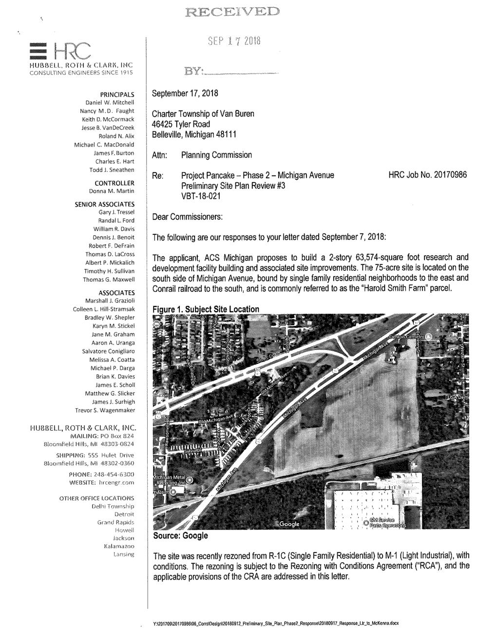
43 September 20, 2018 Planning Commission Charter Township of Van Buren Tyler Road Belleville, Michigan Subject: VBT ; Project Pancake Phase 2/Michigan Avenue; Preliminary Site Plan Review #4; Revised Site Plans Dated September 17, Dear Commissioners: The applicant, ACS Michigan proposes to build a 2-story 63,574-square foot research and development facility building and associated site improvements. The 75-acre site is located on the south side of Michigan Avenue, bound by single family residential neighborhoods to the east and Conrail railroad to the south, and is commonly referred to as the Harold Smith Farm parcel. Figure 1. Subject Site Location Source: Google The site was recently rezoned from R-1C (Single Family Residential) to M-1 (Light Industrial), with conditions. The rezoning is subject to the Rezoning with Conditions Agreement ( RCA ), and the applicable provisions of the CRA are addressed in this letter.
44 A Development Agreement ( DA ) for the subject site was approved by the Township Board of Trustees on July 17, The DA calls for the development of the site in two (2) phases as follows: Phase 1 The applicant appeared before the Planning Commission on August 8 th, 2018, and received site plan approval with conditions for Phase 1, which included site grading, and construction of the stormwater detention pond, the building footprint and shell, the parking lot, and the berms. Phase 2, which is addressed in this letter, consists of all other remaining items including, but not limited to, landscaping and screening, signage, woodland and tree preservation, exterior lighting, loading and unloading, site engineering, and utilities. At its meeting on August 8, 2018, the Planning Commission approved the Phase 1 site plan, subject to conditions. At its meeting on August 22, 2018, the Planning Commission reviewed the Phase 2 site plan and deferred action on the Phase 2 site plan and recommended plan modifications to be compliant with the Zoning Ordinance. The applicants have resubmitted the Phase 2 site plans, which are accompanied by a response letter (dated 9/17/18) to our most recent site plan review letter of September 7, We have reviewed the site plan for compliance with the conditions of Phase 1 approval, Zoning Ordinance standards, terms of the CRA and DA, and sound planning and design principles. We offer the following comments for your consideration: (Any items that require changes or additional information are underlined. COMMENTS 1. Zoning and Use. The site is zoned M-1 (Light Industrial) district with conditions. The surrounding zoning includes M-2 (General Industrial) to the south, R-1C (Single Family Residential), C-1 (General Business) and RMH (Mobile Home Park) to the north across Michigan Avenue, R-1C (Single Family Residential) to the east and RMH (Mobile Home Park) and M-1 (Light Industrial) to the west. The proposed use is a research and development facility with laboratories. Laboratories, major and minor are permitted as principal land use in the M-1 district per Section of the Zoning Ordinance. The tire/vehicle storage structure is minor enough to be considered accessory to the principal permitted use and is permitted by right, subject to compliance with Zoning Ordinance standards accessory buildings. The revised site plan includes a general use statement and phasing plan for the project, as required under conditions of approval for Phase Dimensional Requirements. The revised site plan notes the size of the proposed building as 63,574 square feet. The proposed height of the 2-story building was previously noted as 28 feet, which was within the maximum permitted height of 30 feet for the buildings in the M-1 district. The revised architectural elevations submitted indicate a building height of 36 feet, 10 inches to the highest parapet of the building, with height of 30 feet in many other areas of the building. Per Section of the Zoning Ordinance, buildings of greater than the maximum height allowed in Section may be allowed in the M-1 district provided front, side, and rear yards are increased by one (1) foot for each additional foot of building height that exceeds the maximum height allowed. The M-1 district has a minimum required front yard setback of 50 feet, a minimum side yard setback of 40 feet, and a minimum rear yard setback of 40 feet, which would correspondingly be increased to 56-10, and 46-10, respectively. The site plan has been revised to note the setbacks as 57 feet, 47 feet, and 47 feet respectively and complies with the Zoning Ordinance. Charter Township of Van Buren Project Pancake Phase 2 SPR#4 2 September 20, 2018
45 The maximum lot coverage is 35%. Proposed lot coverage is 1.36% with parking lots and other impervious surfaces occupying an additional 8.15%. The 2000 Ecorse and Haggerty Road Corridor Plan added Residential Protection Areas to many areas of the township, including industrial areas that abutted residential areas in the northwest part of the township. The subject site was not part of that consideration at that time because it was zoned R-1C; however, a change of the zoning to M-1 with conditions placed an industrial use on the site next to residential areas to the east. As part of the CRA, the applicant is required to maintain the 400-foot residential buffer along the east and west property lines. The site plan indicates the required residential buffer zones. 3. Required Information. The revised site plan at this time includes all of the site plan information required per Section of the Zoning Ordinance. The proposed hours of operation are noted as 6 am 11 pm, Monday through Friday. The plan notes that the hours of operation may extend to 24 hours a day/7 days a week; however any such operation will conform to the noise ordinance established in the Township. Such a notation is acceptable to ensure that any noise related nuisance issues can be addressed by the Township. 4. Detention Pond. The site plan proposes a large detention pond along the east side of the site, located within the 400-foot residential buffer zone. We defer to the Township Engineer s regarding the proposed design and capacity of the pond. At the Planning Commission meeting on August 8 th, 2018, there was some discussion on location of the berm on the west side of the pond, rather than east side abutting the single-family residential boundary. The Planning Commission found the proposed berm location acceptable. The site plan shows the slope of the detention pond is shown extending up to the east property line and appears to be separated from the abutting parcels by a chain link fence only. Section (K) includes specific standards for landscaping around storm water detention ponds; however, Wayne County regulates much of planting around detention ponds, so we will defer to Wayne County requirements. The revised landscape plan at this time indicates grouping of Viburnum, Red Twig Dogwood, and Gray Dogwood shrubs around the main detention pond and grouping of Red Maple and Swamp White Oak trees around the forebay area. Once Wayne County approval of the stormwater permit and detention pond landscaping is obtained, the final landscaping information must be provided to the Township. Section 8.107(D)(2) requires chain link fence to be vinyl-coated black. The site plan and landscape plans has been revised to note the provision of a 6-foot high black vinyl coated chain link fence around the detention pond and perimeter of the site. 5. Access and Circulation. There is one (1) proposed entrance to the site from Michigan Avenue. The applicant has stated that the approach is still pending MDOT approval. The access drive branches off to provide access to a parking lot on the north side of the building, while the main access drive continues south and forks into 2, allowing access to the vehicle evaluation area and parking lot on the east side of the building. The drive aisles within the parking lot areas are 24 feet wide while the main internal circulation drives through the site vary in width from 30 feet to 32 feet. The south side of the access drive on the south side of the building is missing curbing, which is required by Section 9.104(I) of the Zoning Charter Township of Van Buren Project Pancake Phase 2 SPR#4 3 September 20, 2018
46 Ordinance. However, the Planning Commission may approve an alternative design when opportunity exists to substantially improve the water quality of the site. Per the applicant, the curb has been eliminated to allow for sheet flow drainage into the swale to its south. We defer to the Township Engineer regarding sheet flow drainage in the uncurbed portion of the interior access drive. The following items regrading access must be addressed: a. Delineate with pavement striping lanes for ingress and egress. Pages OS 02 and 03 identify a driveway width of 28 feet and directional signage; however, no pavement striping is shown to delineate ingress and egress. The applicant has stated that the information will be provided final site plan submittal, which is acceptable. b. The plan indicates a cantilever gate mid-way through the access drive. Per the applicant, details of the gate, including its operation will be provided with final site plan submittal, which is acceptable. c. The plan notes that signage will be installed in the access drive, at the fork to the vehicle evaluation area. The applicant has stated that the information will be provided final site plan submittal, which is acceptable. Per the applicant s presentation at the August 8, 2018 Planning Commission meeting, the proposed research and development facility receives very limited traffic, and the maximum number of employees at the present time is 100. Although the site is large, the facility is of limited size and has frontage and accesses onto a State Trunk line (pending MDOT approval). The applicant has submitted copy of a traffic impact study conducted by their consultants HRC, dated July 13, The study includes trip generation data, condition of existing roadways, improvements, access management, turn movements etc. The recommendations of the study include a modification to signal timing and addition of a righthand turn lane (deceleration lane) on east bund Michigan Avenue. The improvements proposed are under the jurisdiction and review authority of MDOT. 6. Sidewalks. Section of the Zoning Ordinance requires the provision of a sidewalk long all public streets and major thoroughfares. The site plan does not indicate any sidewalk along Michigan Avenue frontage. The Planning Commission has the ability to modify the location of interior sidewalks only. The site plan also indicates 7-foot wide sidewalks next to the parking lots on the north and west side of the building and location of barrier free access ramps. The following items must be addressed: a. A 5-foot wide concrete sidewalk is required along the site s Michigan Avenue frontage. It is our understanding that the applicant has submitted a plan to MDOT requesting approval for placement of the sidewalk along Michigan Avenue, which is under MDOT s jurisdiction. The applicant has concerns that the placement of the sidewalk will result in its termination at the railroad intersection, and has asked to defer it till final site plan submittal. While the issue can be further discussed and deferred for approval prior to final site plan approval, at this time we believe a sidewalk should be installed as required as it would provide significant pedestrian connectivity in the whole area. Although a sidewalk along the frontage of Michigan Avenue would not currently connect to any sidewalks, it would encourage future connections to the subdivision to the east as well as a possible connection to Michigan Ave. and Ecorse Road to the west. Further, several communities have rails to trails programs that actually include sidewalks and trails located within the railroad right-of-way. While a deviation from this standard cannot be granted by the Planning Commission, a variance can be considered by the Zoning Board of Appeals. Additionally, the Planning Commission can authorize a phased plan for installation of the sidewalk or a plan requiring a sidewalk from the entrance of the Charter Township of Van Buren Project Pancake Phase 2 SPR#4 4 September 20, 2018
47 development to the east to connect to the Denton Village neighborhood. This issue can be further discussed at the Planning Commission meeting. b. The site plan includes 52 parking spaces on the east side of the building. The area is clearly identified as test vehicle parking only on the revised plans. Therefore, crosswalks and other pedestrian connections are not required. A note must be added stating that all vehicles in this area shall be fully operable and not junk or dismantled vehicles. 7. Parking and Loading. a. Number of Parking Spaces. Per Section 9.102(E) of the Zoning Ordinance, parking requirements for research and development and testing facilities are five (5) spaces plus four (4) spaces per 1,000 square feet of gross floor area plus one (1) per employee in peak shift. Per the applicant s representation at the August 8, 2018 Planning Commission meeting, the proposed building has a gross floor area of 63,500 sq. ft. and a total of 100 employees in a peak shift (as represented by applicant s engineer HRC). Based on the information provided, the site requires 359 spaces (i.e., 259 spaces for the floor area and 100 spaces for the employees). The site plan indicates a total of 204 (previously 194) parking spaces. Of the proposed parking, 152 spaces are intended for employees and an additional 52 spaces are test vehicle parking spaces. Per the applicant the spaces proposed are more than adequate to meet the needs of the facility at least for the anticipated future. The proposed parking is deficient by 155 (previously deficient by165) spaces. As allowed by Section 9.101(J) of the Zoning Ordinance, the Planning Commission granted a deviation for the minimum required parking spaces at the August 8, 2018 Planning Commission meeting, as presented by the applicant. The parking calculations have been noted on the cover sheet as required. While the applicant previously stated to the Planning Commission that the maximum number of employees on the site will be 100; the traffic study submitted noted the number of proposed employees as starting with 120 to 140 employees up to a maximum of 180. Per the applicant, the facility is intended to start with less than 100 employees, and eventually grow to the number anticipated. Should the need for additional parking arise, it will be accommodated through the land banked future parking expansion area shown. The site plan also proposes two (2) future building expansion areas and future parking expansion area with 51 spaces (previously 80 spaces). Section 9.101(H) of the Zoning Ordinance allows for parking deferment where a property owner can demonstrate that the required number of parking spaces is excessive. We recommend that the deferment request be addressed at the time the future building expansions are reviewed by the Township. b. Space Dimensions. All the proposed parking spaces are 9.5 feet wide and 20 feet deep. The spaces are also shown with double striping, as required by Section 9.104(C) of the Zoning Ordinance. Section (B)(2) of the Zoning Ordinance requires the provision of an interior landscape island for every 20 spaces. The site plan and landscape plan have been revised to include landscape islands to comply with this standard. Charter Township of Van Buren Project Pancake Phase 2 SPR#4 5 September 20, 2018
48 c. Barrier Free Spaces. For parking lots between spaces, the ADA requires six (6) barrier free spaces. The revised site plan indicates the required number of spaces. The dimensions of barrier free spaces have been noted and are ADA complaint. The future parking area indicates 55 spaces for which the applicant is seeking a deferment. Because the layout approval is being sought at this time, the total number of spaces on the site will eventually exceed 200, which would require one (1) additional barrier free space. The additional barrier free space is shown in the western parking lot. d. Loading. Per Section of the Zoning Ordinance, the proposed building will require a total of two (2) 10-foot by 50-foot loadings spaces. The revised site plan indicates two (2) 10 x 50 spaces placed side-by-side on the east side of the building. 8. Architecture and Building Details. The applicant presented elevations for the building shell at the August 8, 2018 Planning Commission meeting and received approval for the same; however, the approval was subject to detailed elevations being provided. At this time, the submittal includes elevations and an artistic rendering that indicates the structure will be constructed in shades of silver and black with glass panels and metal panel wall assembly A and B. The site plan identifies the only ground mounted mechanical equipment to be a transformer pad located on the east side of the building and concealed from view of any public right-of-way by a landscaped berm and fencing. The roof mounted mechanical equipment is shown on sheet A-103, placed centrally on the roof, and concealed from view by the building parapet and screen walls around it. The plan refers to sheet A-511 for screen wall details; however the sheet is not in the submittal package. The detail sheet must be included for final site plan review. At the August 8, 2018 Planning Commission meeting the applicant also noted that the tire/vehicle storage shown along the southeast corner of the east parking lot area is a structure and not merely a parking surface. Sheet APC-01 of the revised plan submittal includes elevations of the structure to be constructed of wall system B, which is also a metal panel system. Proposed colors are designed to match the principal building. 9. Landscaping. Landscaping is subject to the provisions of Section of the Zoning Ordinance. Sheets L-0 through L-11 of the site plan submission includes details of proposed landscaping for the site. The Zoning Ordinance describes the landscaping requirements that must be met individually. Our comments are as follows: a. Frontage Landscaping. Section (A) states that when a site abuts a public right-of-way, frontage landscaping shall include 1 deciduous or evergreen tree per 40 lineal feet of road frontage + 1 ornamental tree per 100 feet of lineal frontage + 8 shrubs per 40 lineal feet of frontage. Based on a frontage of 1,100 feet on Michigan Avenue, the site requires a total of 28 deciduous or evergreen trees + 11 ornamental trees shrubs. The plan proposes a total of 33 deciduous trees + 14 ornamental trees shrubs to meet this requirement. The ornamental and deciduous trees are placed almost entirely with the greenbelt area on the north side of the proposed building and near the main access drive off Michigan Avenue. The northwest frontage of the site along Michigan Avenue has no vegetation; however, the applicant is proposing the installation of a 60-foot wide, 10-foot high berm landscaped with evergreen trees, placed between 50 feet 360 feet away from the front property line. The area between the berm and the right-of-way line is to be maintained as nonirrigated seeded lawn. The applicant has stated that the lawn area will be warrantied to have no Charter Township of Van Buren Project Pancake Phase 2 SPR#4 6 September 20, 2018
49 weeds prior to acceptance by the owner. Sheet L-10 states that all landscaped areas will be irrigated with an automatic irrigation system, and the limits of irrigation are shown on the preceding landscaping sheets. b. Parking Lot Landscaping. Screening. Section (B)(1) requires parking lots to be screened from public rights-of-way by landscaping. The parking lots located on the north and west sides of the building are to be screened by the landscaping noted in comment a above. Additionally, 229 Hicks Yew shrubs will be planted on the north sides of these parking lots to screen the lots from the road. The shrubs will be planted at 30 inches in height, so they should attain the required height of 3 feet within 1-2 years. The frontage is also to be planted by a variety of perennials, which enhance the appearance of the frontage. The easternmost parking lot will be screened by the berm. Interior Lot Landscaping. Section (B)(2) requires parking lot landscaped areas to be at least 5% of all the paved areas. The site plan shows vehicular surface area as 86,044 square feet, thus requiring 4,302 square feet of landscaped area. The revised plans include calculations of all interior landscape areas, which provide a total interior landscaping of 5,019 square feet, eliminating the previous shortfall. Each landscaped island must be at least 360 square feet and shall have at least one (1) tree. Also, there must be at least 1 tree per 300 square feet of vehicular surface landscaped area. The parking lots include several islands which meet the minimum size requirement, and each is planted with 2 deciduous trees. Based on the interior lot landscaping standards, a total of 17 trees are required and 18 are proposed. The Zoning Ordinance does not allow for more than 20 spaces in an uninterrupted row without a landscape island. The landscape plans have been revised to correspond with the site plan and show the required islands with plantings. c. Loading Area Landscaping. Section (C) requires loading areas to be screened from view of any adjacent residential district by a fence and/or landscaping. The loading dock area appears to be located on the east side of the proposed building and is screened from view of the residential district to the east by a 60-foot wide, 10-foot high berm to be planted with a double staggered row of evergreen trees placed 15 feet on center. d. Greenbelt Buffering. Section (E) requires screening between a use on an M-1 zoned property and abutting single family residential districts. The Zoning Ordinance requires a 60-foot wide buffer with a double staggered row of evergreens placed 15 feet on center, with a flat horizontal crest area of at least 3 feet. The landscape plan proposes a 60-foot wide, 10-foot high berm on the east side of the building and parking lot, set 320 feet away from the east property line abutting the residential district. The berm is to be planted with a mix of White Spruce, White Pine and Norway Spruce trees placed 15 feet on center with a minimum height of 8 feet at the time of planting. e. Open Space Landscaping. Per Section (G), all open areas of the site that are not required landscaping areas must be planted with one tree per 3,000 square feet of open area. The site has a total open area of 1,219,484 square feet, which translates to 406 trees, of which 35% (142 trees) are required to be deciduous. Per the applicant the landscaping within the open space will likely be Charter Township of Van Buren Project Pancake Phase 2 SPR#4 7 September 20, 2018
50 removed as this site develops due to the need to elevate the site due to ground water levels and existing contours requiring extensive changes in order for the site to be expanded and fully utilized. The site has been a farm absent of trees for over 100 years The applicant is seeking a waiver from this Zoning Ordinance provision. We had previously recommended that the area be recalculated to deduct structures (including future expansion areas), ponds, and required landscaping areas, and show the required trees. The revised plan includes these calculations and notes that the trees provided within the detention pond area and the trees included within the berm to the north and, south and east would total 406 trees. Although part of the greenbelt and detention pond landscaping, which are required, we believe the installation of greenbelt and detention pond trees provides adequate justification for the Planning Commission to revise the open space landscaping requirements. f. Other Requirements. Sheet L-10 notes that all landscape areas will be irrigated with an automatic irrigation system. The limits of irrigation are shown on Sheet L-0 and include the main entrance area and building frontage on Michigan Avenue only. The applicant requests a waiver to provide irrigation in a very limited area only, with the justification that the cost of an irrigation system along the Michigan Avenue frontage would be $35,000-$45,000 and would cost more to use and maintain. We had previously recommended that at a minimum, irrigation be provided for the berm and plantings along the site s entire Michigan Avenue frontage since it would be critical to the appearance of the site. We acknowledge that irrigation along the other berms would be excessive. Section (C) of the Zoning Ordinance allows the Planning Commission to waive or modify the irrigation requirements if irrigation is not necessary for keeping the landscaping in good condition. The applicant has added a note to the landscape plan stating that the plants will be kept in a living condition by the contractor for a period of 2 years, and the Zoning Ordinance requires replacement of any dead trees. A response letter from the applicant notes that the plantings will be deep watered after that by the applicant. We recommend that this note be added to the plans and that a specific watering schedule be included. g. Residential Buffer. Per the DA, the plans submitted include 400-foot wide residential buffer zones along the east and west property boundaries. The parcel is triangle-shaped and the narrow corner at the southwest end is covered by existing vegetation. The plan also indicates a berm along a part of the south property line for screening. h. Stormwater Pond. Section (K) requires a buffer around the detention pond. As noted previously, the detention pond is graded to the east property line with the entire vegetative buffer located along its west boundary. It is our understanding that planting in and around the basin is regulated by the County. The applicant has stated that no mechanical equipment is proposed for the pond. 10. Tree Removal Permit. The site was previously farmed and as a result does not have a significant vegetation cover, except for a few trees on the southwest side and a grouping along the site s Michigan Avenue frontage. A tree removal permit is required if the applicant proposes to remove any trees of 5 caliper or larger per Section of the Zoning Ordinance (Woodland and Tree Preservation). Per the plans only one 8 tree is to be removed from the entire site for the berm construction. The proposed landscaping for the site exceeds the requirement and some of the excess trees can be counted towards the required replacement. Charter Township of Van Buren Project Pancake Phase 2 SPR#4 8 September 20, 2018
51 11. Fencing. The revised site plan notes the provision of a 6-foot high black vinyl coated chain link fence around the entire property as required by Section 8.107(D)(2) of the Zoning Ordinance. We had previously recommended that the fence be replaced with a decorative fence along the site s Michigan Avenue frontage. The revised plan notes the provision of a short stretch of screen fence along the main entrance drive, and west and east parking lot areas. Details of the fence are noted on Sheet C 06A, and are not considered decorative. The fence material has not been labeled, but appears like flat metal panels with steel frames. We recommend the use of an alternate fence design that is functional to meet the applicant s security needs, but also decorative. As proposed, the fence does not present an attractive appearance from Michigan Avenue. 12. Trash Disposal. The site plan indicates a dual dumpster with gates at the southeast corner of the proposed building. Typical dumpster enclosure details have been noted on Sheet C 06A, but are incomplete. The details only indicate an 8-foot high enclosure with wooden slat gates. Section of the Zoning Ordinance requires the enclosure to be constructed of decorative masonry, and provided with steel reinforced wooden gates. The enclosure should be provided with bollards outside the gates to protect them. 13. Lighting. The site plan package includes proposed lighting plans on Sheets E01 and E02. The plan indicates single- and dual-head light poles placed in the parking lots and along the drive aisles within the site. A photometric plan noted on sheet FC01 indicates illumination in areas of vehicular traffic on site in compliance with the standards noted in Section 8.105(B)(2) of the Zoning Ordinance. Section 8.105(C) allows for a maximum height of 25 feet to the top of the fixture from grade. In industrial Districts, the Planning Commission may approve lighting fixtures up to a maximum height of thirty-five (35) feet if the proposed lighting over twenty-five (25) feet in height has no adverse impacts on the surrounding land uses and on the natural environment. The revised plans note the mounting height to the bottom of the fixture as 35 feet (raised from 22 feet). The actual pole height from grade to top of fixture will likely be taller. The pole height must be reduced to show compliance with this standard. We previously noted that wall mounted light fixtures will be required to illuminate entrances and the loading dock areas. The revised elevations and photometric plan identify the locations of the all mounted fixtures and sheet EBL01 includes cut sheet details of shielded wall mounted fixtures for the building exterior. Information regarding any proposed ground mounted fixtures to enhance landscaping on the site must be provided with final site plan submission. 14. Signs. A ground-mounted sign is shown on the site plan. Information regarding proposed ground sign and wall mounted signage, if any, must be provided to determine if it meets the Zoning Ordinance requirements for area, height, setbacks, and design. The applicant notes that the information will be provided with final site plan submission. 15. Other. Additional information about the following site plan items must be provided: a. Refrigerated Storage. At the August 8, 2018 Planning Commission meeting, the applicant stated that the refrigerated storage unit would appear like a shipping container. The revised plan at this time includes a picture of a prefabricated cold soak chamber on Sheet C 60A, which appears like a large metal freight container. While the unit is placed on the east parking lot, south of the proposed building and concealed from the public right-of-way, it is an unattractive structure, with no screening Charter Township of Van Buren Project Pancake Phase 2 SPR#4 9 September 20, 2018
52 of any type around it. We recommend that the be screened by placement of upright evergreen shrubs around it. b. Vehicle Evaluation Area. The site plan notes that no outdoor parking of vehicles or storage will take place in this area. c. Notes. Information required for compliance to site plan requirements, has been noted on the site plan as required instead of being included in a response letter only. RECOMMENDATION At the August 8, 2018 Planning Commission meeting, the applicant received approval for Phase 1 subject to conditions, which allows for them to proceed with engineering and site grading. However, Phase 2 calls for a more detailed review of the plans and with an intention of coverings all the items that were not included as part of Phase 1 or were conditions of approval of Phase 1. Since then, we have worked with the applicant to get all of the information required to determine compliance with standards of the Zoning Ordinance. At this time, the revised plans include most of the required information, with a few exceptions. Therefore, we recommend that the Planning Commission grant preliminary site plan approval for the above project, subject to the following items being addressed on revised and dated plans submitted for final site plan review and approval: 1. Once Wayne County approval of the stormwater permit and detention pond landscaping is obtained, the final landscaping information must be provided to the Township. 2. That the Township Engineer determine whether the sheet flow drainage in the uncurbed portion of the interior access drive is appropriate. 3. That the plans include the pavement striping lanes for ingress and egress. 4. That the details of the cantilever gate mid-way through the access drive, including its operation, be provided. 5. That all signage information be included. 6. That a recommendation on the sidewalk be deferred until MDOT decides whether a sidewalk will be approved. 7. That a note be added stating that all vehicles parked in the test vehicle parking only area shall be fully operable and not junk or dismantled vehicles. 8. That the detail sheet of the screen wall on the building must be included. 9. That no open space trees required by Section (G) be required because the berm trees and storm water pond trees provide a sufficient number of trees on the site. 10. Per Section (C) of the Zoning Ordinance, that the irrigation requirements be modified but that the plans include a specific watering schedule for the berm trees. 11. That an alternate fence design to the steel panels be submitted that is functional to meet the applicant s security needs, but also decorative. 12. That the dumpster enclosure include the required bollards. 13. That the light fixture heights be lowered so that they do not exceed 35 feet from the grade to the top of the fixture. 14. Information regarding any proposed ground mounted fixtures to enhance landscaping on the site must be provided. 15. That the prefabricated cold soak chamber be screened by upright evergreen shrubs. Charter Township of Van Buren Project Pancake Phase 2 SPR#4 10 September 20, 2018
53 Respectfully submitted, McKENNA Patrick J. Sloan, AICP Senior Principal Planner Vidya Krishnan Senior Planner c: Ron Akers, Van Buren Township Director of Planning & Economic Development Matt Best, Van Buren Township Director of Public Services David Potter, FTCH, Township Engineers David McInally, Van Buren Township Fire Marshal Charter Township of Van Buren Project Pancake Phase 2 SPR#4 11 September 20, 2018
54 September 21, 2018 FTCH Project No VBT Project No Ms. Carol Thompson, Chairperson Van Buren Township Planning Commission Tyler Road Van Buren Township, MI Re: Project Pancake Preliminary Plan Review (Phase 2) Van Buren Township (VBT), Michigan Dear Ms. Thompson: Fishbeck, Thompson, Carr & Huber, Inc. (FTCH) has completed Preliminary Plan Review (Phase 2). Please recall that Phase 1 is the mass grading portion only, which was previously approved by the Planning Commission (refer to FTCH approval letter dated August 3, 2018). We have reviewed three (3) separate sets of plans submitted by the applicant for the Proposed Pancake Phase 2 Project, subsequent to the mass grading plans that were initially reviewed as follows: Applicant Plan Submittal Dated: 07/20/18 Refer to FTCH Review Letter Dated: 08/10/18 Applicant Plan Submittal Dated: 08/03/18 Refer to FTCH Review Letter Dated: 08/20/18 Applicant Plan Submittal Dated: 08/24/18 Refer to FTCH Review Letter Dated: 09/07/18 The last set of plans noted above that FTCH reviewed for preliminary plan approval were conditionally recommended for approval by FTCH with our letter dated September 7, 2018, previously forwarded to VBT Planning Commission for consideration. FTCH received a revised set of preliminary plans and a response letter from the applicant addressing previous FTCH review comments, both dated September 17, Recommendation FTCH completed the review of the September 17, 2018 preliminary plans and find that there are no significant changes to the August 24, 2018 preliminary plans. The Applicant has indicated many of FTCH s review comments noted in the September 7, 2018 letter will be addressed prior to or during the preparation of the Engineering Plan Review set of plans. Accordingly, FTCH is satisfied the previous FTCH review letter, dated September 7, 2018, along with the applicant s response letter, suffices for the purpose of Preliminary Plan Review Approval recommendation. FTCH recommends the Planning Commission grant Project Pancake Phase 2 Preliminary Site Plan approval, subject to the FTCH review comments, previously noted, are addressed by the applicant prior to or during the preparation of the Engineering Plan Review plans and in accordance with the VBT Engineering Standards Manual. If you have any questions regarding this review letter, please contact me at (dpotter@ftch.com) or Paul Kammer at (pjkammer@ftch.com). Sincerely, FISHBECK, THOMPSON, CARR & HUBER, INC. David L. Potter, PE, CSI-CCCA Paul J. Kammer, PE ag2 By cc: Mr. Ron Akers Township Mr. Gary Tressel HRC

55 September 7, 2018 FTCH Project No VBT Project No Ms. Carol Thompson, Chairperson Van Buren Township Planning Commission Tyler Road Van Buren Township, MI Re: Project Pancake Phase 2 Van Buren Township, Michigan Dear Ms. Thompson: Fishbeck, Thompson, Carr & Huber, Inc. (FTCH) has completed the third review of the Preliminary Plans, dated August 24, 2018, for the proposed Project Pancake Phase 2. FTCH has reviewed and forwarded the two (2) previous review letters, dated August 10, 2018 and August 20, 2018, to the applicant for their review and response prior to submitting the Preliminary Plans to be reviewed for approval. The previous letters were never submitted to the Planning Commission because the applicant was in the process of updating the plans. The most up to date plans, dated August 24, 2018, are the version of the Preliminary Plans used for this review. In this letter, any previous comments from the second review that have not been completed will remain. The applicant s response to each comment, as documented in a letter to Ms. Carol Thompson, Chairperson on August 24, 2018, will be listed and any additional action items required by the Engineering Standards Manual, Charter Township of Van Buren (VBT) (April 2014) that were not completed in this submittal will be listed. The proposed project is part of a multi-phased construction project. The overall proposed project entails constructing a Research and Development Facility which includes a 2-story 63,500 square foot building, parking lots with 194 spaces, a separate paved low speed vehicle evaluation area, and room for future building and evaluation area expansion. The proposed site utility layout includes a 12-inch water main loop which crosses Michigan Avenue (US-12) northwest of the site and ties into the existing 8-inch system to the east at Cross Street; a proposed 10-inch sanitary system extension; and a storm sewer system to accommodate building, parking lot, and site runoff with a dual forebay detention basin system, with no water surface. Below, responses from the Applicant and additional action items will be listed as: - R) Applicant Response - C) Additional Comment Phase 1 Review Compliance The items listed below are items that were listed as part of the Phase 1 review, which were not completed with the updated plan set dated August 3, It is our understanding the plans were produced prior to receiving the Phase 1 Plan Review Letter, thus they are listed for reference and shall be included in the next submittal.
56 Ms. Thompson Page 2 September 7, 2018 Comments: 1. Site Drainage, Storm Sewer, and Storm Water Storage Comment No. 1: The updated plans have addressed the trapped water issue flowing south to north by adding culverts through the berms; however, the overall flow route once it hits the berm is still not displayed. Add flow arrows indicating the concentrated flow from each district as it hits the berms. - R) Flow arrows have been added to the plans. - C) The Applicant has indicated flow arrows for surrounding areas, but additional arrows must also be indicated along the berms to show concentrated flow towards the proposed cross culverts. 2. Site Drainage, Storm Sewer, Storm Water Storage Comment No. 5: There has been no official documentation received from the Federal Aviation Administration (FAA) by the Township regarding the requirement for No Permanent Pools within the vicinity of the airport. The applicant is to forward on correspondence to the Township for their records. - R) Correspondence with the FAA at Detroit Metro Airport is being submitted by ACS, and will be forwarded to all parties when received. - C) Correspondence has been received indicating the WCAA requirement for dry basin (8/30/18). 3. Paving and Grading Comment No. 1: For land balancing operations, is there a truck haul route established? - R) If off site fill is required to bring the site to the proposed elevations, the access for all traffic will be from Michigan Avenue only. HRC has applied to MDOT for both the temporary and permanent connection to Michigan Avenue. Following is a summary of our Phase 2 review comments for plans dated August 3, General The following items are general requirements established as part of the VBT Engineering Standards Manual, which the applicant must include as part of the preliminary plans. 1. The following items must be included on the project title sheet: a. Provide a list of private utility contacts with facilities within the project limits. - R) HRC will provide this at the time of Final Site Plan approvals. b. Provide a listing of permits required. - R) See attached list for permits and status, and list will be provided on cover sheet in Final Site Plan approval. - C) No list was attached. Include in Final Site Plan review set. 2. Existing utility information must be included on the plans. Provide existing information including pipe diameter and material for all utility types, including the force mains within the Michigan Avenue right-of-way (ROW). Update legend to show all utility types (i.e. force mains). - R) The legend has been updated for force main. HRC has been researching the existing utilities along Michigan Avenue to add to the documents. If the Township has this information available, please provide so we can add to the drawings. - C) Township will look for information on force mains. 3. Indicate and label all existing and proposed easements; those anticipated to be abandoned shall be labeled as such (i.e. the Denton Drain easement). - R) Existing easements are shown on Sheet C05 Alta Survey. HRC will add proposed easement to the Final Engineering documents once the reviews are completed for utility alignments and any adjustments are made. Z:\2018\181273\WORK\CORR\2018_0810 PRELIM PLAN REVIEW - PHASE 2\LT_PRELIMINARY PLAN PHASE 2 REVIEW 3_2018_0907.DOCX
57 Ms. Thompson Page 3 September 7, Basis for design flow computations for sanitary sewers and storm sewers shall be submitted for both phases and total development. Calculations for total development shall include all development phases, present and future, and existing and future offsite areas tributary to the system. - R) Basis of design of total development for sanitary and storm have been provided on plans. HRC is developing the phasing information and will provide it on the Final Site Plan submission package. - C) Basis of Design shows feasibility. Indicate all equations as listed in the VBT Engineering Standards Manual. Peaking Factor equation should be PF = 18 + sqrt(p) / 4 + sqrt(p). 5. Soil borings indicating the ground water elevation must be provided. - R) The soil borings will be contained within the contract documents that address ground water elevations, and as these fluctuate, we prefer to leave the soil reports to address this issue. - C) The fluctuating depth of the ground water in the area of the proposed detention basin is critical. The applicant shall make this information known at this time. 6. The following required notes must be added to the plans: a. A statement that all construction shall conform to the current standards, specifications, and general conditions to the Township. - R) The note has been added to the cover sheet. b. The Developer is responsible for resolving any drainage problems on adjacent properties which are the result of the Developer s actions. - R) Understood none anticipated. - C) The Applicant needs to add this note to the plans, whether or not there are anticipated drainage problems. 7. Show and label underground utilities (existing to remain and proposed) on grading plans and all other sheets that have potential earth disturbance. - R) The proposed utility structures are referenced on the grading plans. - C) The Applicant must show underground utility lines on grading sheets. The lines can be weighted differently or shaded to be less prominent, but the plans must show underground features anywhere that excavation and earth disturbance is anticipated. 8. The final location of perimeter fencing relative to the proposed alignment of public utilities will be determined during final engineering plan review by the Township. - R) Understood. Water Main Service Existing: The Township water main records indicate an existing asbestos cement (AC) 8-inch water main running east to west along Cross Street on the east side of the property. In addition, there is a 12-inch Township water main located northwest of the property, on the north side of Michigan Avenue (US-12) at Old Michigan Avenue. Proposed: The applicant s plan shows a proposed 12-inch water main loop connection to the existing 12-inch water main near Old Michigan Avenue. The proposed 12-inch main then extends southeasterly, crosses Michigan Avenue (US-12), and enters the proposed site near the proposed main driveway entrance, loops around the proposed building, connecting to onsite fire hydrants and the building service taps, before continuing through the site to the east side of the property where it ties into the existing 8-inch water main on Cross Street. Z:\2018\181273\WORK\CORR\2018_0810 PRELIM PLAN REVIEW - PHASE 2\LT_PRELIMINARY PLAN PHASE 2 REVIEW 3_2018_0907.DOCX
58 Ms. Thompson Page 4 September 7, 2018 Comments: 1. The proposed water main profile indicates the entire 12-inch water main being encased in a 20-inch steel casing. What is the reasoning behind the encasement? Any unnecessary encasement makes maintenance and repair very difficult. Eliminate the unnecessary casing or provide explanation for its need. - R) Casing has been eliminated. - C) The Applicant must update the profile line type to indicate and distinguish between the two (2) types of installation. 2. Label all water main fittings in both plan and profile views. Indicate description of each fitting and give rim elevations for any water structure. - R) HRC will provide this at the time of Final Site Plan approvals. 3. Indicate connection type to the existing mains: tee (cut-in or tapping sleeve) or direct connection with reducer. - R) HRC will provide this at the time of Final Site Plan approvals. 4. Label all existing water main sizes and clearly indicate removal limits for any existing pipe and features to be removed. - R) HRC will provide this at the time of Final Site Plan approvals. 5. Label proposed water main material, where encasement begins and ends, and any other items associated with the water main construction (plan and profile). - R) HRC will provide this at the time of Final Site Plan approvals. 6. Prior to Engineering Plan Approval, the Township Water & Sewer Department will review and determine final hydrant and valve needs and locations. - R) Understood. 7. Verify and indicate how the existing Smith Farm building and the building located in the separate lot northeast of the Smith Farm building is being currently serviced by water. In addition, the applicant must show how these two buildings will be serviced via connections to the proposed water main. - R) Water services to these structures already exist and will not be impacted by this development. - C) The Applicant needs to show the location of the lines relative to the proposed water main and sanitary work. Based on existing plans we have reviewed, the service lines connect in close proximity of the 12 watermain connection. 8. Final required water main easements will be determined by the Township during the final engineering plan review phase. - R) Understood. Water Demand Analysis During the previous review process, the applicant requested that FTCH model the water system without the proposed Michigan Avenue (US-12) crossing being installed as part of this project. Instead, they wanted to see the available flows from the existing 8-inch AC water main along Cross Street. Based on the current water main system and planned pressure reducing valve (PRV) settings for the inclusion of the Project Pancake site, the available flows are as follows: VB-6 PRV Setting Available Fire Flow (existing system) Available Fire Flow (Proposed US-12 loop) 53 psi (Current) 950 gpm 3,300 gpm 58 psi (Future) 970 gpm 3,500 gpm Z:\2018\181273\WORK\CORR\2018_0810 PRELIM PLAN REVIEW - PHASE 2\LT_PRELIMINARY PLAN PHASE 2 REVIEW 3_2018_0907.DOCX
59 Ms. Thompson Page 5 September 7, 2018 In discussions with the Township, any additional normal demand that may be proposed to be placed on the existing Cross Street water main without the proposed US-12 water main loop will first need to be discussed with the Water and Sewer Department. There are concerns with the age and condition of the AC pipe if the applicant requests to add in its own pump station or fire flow booster pumps for fire flows. Further discussion will be necessary. - R) 12 water main crossing Michigan Avenue will be installed as part of this project. Site Drainage, Storm Sewer, and Storm Water Storage Existing: Existing topography shows drainage flowing predominately north toward the center and north side of the property, into a regulated Michigan Department of Environmental Quality (MDEQ) wetland. The wetland discharges into the enclosed existing Denton Drain, a Wayne County legally-established county drain established in the early 1900s. It is believed the enclosed drain is an 8-inch drain. The Denton Drain flows easterly. Proposed: The applicant s proposed plan indicates a combination of overland flow through swales, earthen berms, and open-ended culverts; an underground storm drainage collection system that intercepts flow from paved areas; and a detention basin system that collects all flow through two separate forebays. A new pipe run is proposed to replace the existing enclosed Denton Drain from the wetland, which outlets into the detention basin system as well. The culvert and sewer sizes within the proposed drainage system range from 12-inch to 36-inch. The overall detention for the site is controlled by a single 36-inch riser with a restricted 8-inch outlet. The outlet taps and discharges into the existing 12-inch storm system (enclosed Denton Drain) that also collects runoff from Cemetery Road. Comments: 1. The restricted discharge from the proposed detention basin is flowing into the existing 12-inch Denton Drain. It is assumed the applicant has investigated and received approval from the Wayne County Drain Commissioner to connect and discharge into the Denton Drain. - R) Approvals are being reviewed by Wayne County and are anticipated shortly. 2. The detention basin overflow in excess of the 100-year storm is shown to discharge easterly, to flow toward the existing Denton Drain via overland surface flow through private properties also located to the east. The applicant must show that concentrated flow is not being directed to the property immediately east of the discharge point. A stormwater mitigation measure, such as a level spreader, may be considered and must be addressed during engineering plan level drawings. - R) Will be addressed at Final Site Plan submission. 3. No flow is accounted for from MH28 (future development) for any downstream features in the sewer calculations. Based on capacity checks for storm sewer, the outlet pipe between MH22 and ES-21 does not have capacity as currently designed and does not include future expansion. How is this pipe going to handle future capacity? - R) Will be addressed at Final Site Plan submission. 4. Clarify the asterisk within the storm drain calculations for the wetland inlet (IN-10). The area contributing to the wetland inlet is in excess of 22 acres, but not accounted for within the applicant s calculations. Does this storm drain have capacity? What impacts does the apparent lack of capacity have on Michigan Avenue, when large storm events occur. Does Michigan Avenue drain to this wetland as well? - R) The note was revised to provide clarification. Details will be addressed at Final Site Plan submission. Z:\2018\181273\WORK\CORR\2018_0810 PRELIM PLAN REVIEW - PHASE 2\LT_PRELIMINARY PLAN PHASE 2 REVIEW 3_2018_0907.DOCX
60 Ms. Thompson Page 6 September 7, Applicant must provide certified documentation that the Denton Drain easement has been successfully vacated in its current alignment and location. - R) August 22, 2018 the Township Board passed a resolution to vacate the drain, which will be finalized at the Wayne County Commissioner s meeting of September 5, C) The Applicant must provide the Township with verification that the easement has been finalized by Wayne County. 6. The applicant must include culvert location markers to indicate the location of the culvert inlet, so in the event the culvert is plugged, it can be readily located and cleared by the applicant. - R) Understood. Sanitary Sewer Existing: The existing property is serviced by a 10-inch gravity sewer which extends westerly from Cross Street and terminates at the applicant s noted structure as MH1. The Smith Farm building are currently serviced via two 6- inch sanitary service leads. Proposed: The applicant s proposed plan is to tie into the existing 10-inch sewer onsite, via a sanitary sewer system consisting of 10-inch PVC pipe discharging from the north side of the proposed building. The proposed sanitary sewer service lead is shown to tap directly into the existing sanitary manhole, noted as MH1, in the northeast corner of the property, where flow then heads easterly to the Cross Street sanitary sewer main. No additional improvements to the onsite sanitary line are shown on the plans. Comments: 1. See Note No. 6 under General Comments. A basis of design must be included. - R) Basis of design is shown on Sheet C) The Applicant shall show calculations that follow the VBT Engineering Standards Manual, Chapter Indicate the existing sanitary service lead tap locations on the profile. - R) Understood will be submitted as a part of Final Site Plan package. 3. All service leads must be connected via a wye connection to the proposed sanitary sewer downstream of the final upstream manhole. No direct connection of a sanitary sewer service lead directly to a sanitary manhole will be permitted. - R) Understood will be submitted as a part of Final Site Plan package. 4. Label sanitary sewer material type, lengths, and slope for each segment on all utility sheets. - R) Understood will be submitted as a part of Final Site Plan package. 5. Final required sanitary sewer easements will be determined by the Township during final engineering plan review phase. - R) Understood. Paving and Grading 1. Clarify the location of curb types vs. detail names. The plans show Type A and Type B curb, but only indicate Type B in the legend. Plans do not make it clear where one curb type begins and one curb type ends. The typical section for Michigan Avenue calls out DET F4 curb, but shows a DET D type curb. Clarify all curb locations and types. - R) Understood will be submitted as a part of Final Site Plan package. Z:\2018\181273\WORK\CORR\2018_0810 PRELIM PLAN REVIEW - PHASE 2\LT_PRELIMINARY PLAN PHASE 2 REVIEW 3_2018_0907.DOCX
61 Ms. Thompson Page 7 September 7, All driveways and all sides of parking lots must have concrete curb and gutter to delineate the drive aisles and to direct storm runoff to the stormwater management system. - R) The plans show areas along driveways and the evaluation area will not be curbed to allow runoff to filtrate thru the vegetation before draining to the forebay for water quality. - C) Further discussion with the Township will be required during Final Plan review. 3. Grading plans need to show proposed flow arrows and have proposed contours to clearly indicate the overland flow route. Proposed flow arrows along the berms must show high/low points and reflect the overall drainage flow to the cross culverts. - R) Understood will be submitted as a part of Final Site Plan package. 4. Show limits of disturbance around all proposed earthwork on any sheet that shows Approximate limits of grading." Berm edges indicate grading out to match existing; however, it is only indicated on some sheets. - R) Understood will be submitted as a part of Final Site Plan package. Soil Erosion and Sedimentation Control (SESC) 1. An SESC Plan shall be provided in accordance with the VBT Engineering Standards Manual, Chapter II, Plan Requirements, Paragraph D, SESC Plan Requirements, and in accordance with Wayne County SESC standards. A permit must be acquired from the Wayne County SESC County Enforcing Agency (CEA). - R) Permit has been approved and is awaiting the storm water approvals from Wayne County prior to issuance. General Plan Sheet Comments 1. All Sheets Label section lines with type and section number, carrying this through to all locations. - R) Understood will add at time of Final Site Plan approval. 2. Sheet C02 Indicate Section, Township, Range info for each section within the property. Indicate proposed utility lines to give overall site reference to all utilities. - R) Understood will add at time of Final Site Plan approval. 3. Sheet C03 Provide Bench Mark and Control Point numbers and provide soil boring locations (when available). - R) Bench marks have been added to the covers sheets. Do you want to use NAV88 instead of NGVD29? The rest of the information will be provided at Final Site Plan approval. 4. Sheet C04 Provide aerial photo date captured for future reference. - R) Understood. 5. Sheet C18 Label manhole numbers on plan view. - R) This information has been added. - C) Labels for the manholes have been added, however, there are no numbers on the labels. Include the manhole numbers on the plan view labels so the plan view manholes can easily be found in profile view. Z:\2018\181273\WORK\CORR\2018_0810 PRELIM PLAN REVIEW - PHASE 2\LT_PRELIMINARY PLAN PHASE 2 REVIEW 3_2018_0907.DOCX

62 Ms. Thompson Page 8 September 7, 2018 Recommendation The Applicant has indicated that many of the items requested will be addressed prior to or during the Engineering Review and Final Site Plan approval process, which is acceptable at this time. Accordingly, we are recommending the Planning Commission grant Project Pancake Phase 2 Preliminary Site Plan approval, subject to the review comments noted above and in accordance with the VBT Engineering Standards Manual. If you have any questions regarding this project, please contact me at or dpotter@ftch.com. Sincerely, FISHBECK, THOMPSON, CARR & HUBER, INC. David L. Potter, PE, CSI-CCCA Paul J. Kammer, PE ag2 By cc: Mr. Ron Akers Township Mr. Gary Tressel HRC Z:\2018\181273\WORK\CORR\2018_0810 PRELIM PLAN REVIEW - PHASE 2\LT_PRELIMINARY PLAN PHASE 2 REVIEW 3_2018_0907.DOCX
63
64
65
66
67
68
69 September 20, 2018 Planning Commission Charter Township of Van Buren Tyler Road Van Buren Township, Michigan Subject: PC: # (SPR); Ashley Crossroads South Parking Lot Expansion; Site Plan Review #2; & Ecorse Road; Site plans dated September 5, Dear Commissioners: The applicant, Ashley Crossroads South, LLC, proposes to expand its passenger vehicle parking lot in the southwest corner of Building #1 (i.e., the southern building) by 59 spaces. The parcel (V ) is acres, and the proposed area subject to change is approximately 3 acres. The site is part of a larger parcel occupied by large industrial warehouse buildings ( Building #1 and Building #2 ) that extends from Ecorse Road, almost to Tyler Road to the south. Specifically, the portion of the site under review is located southwest of Building #1 and just north of the Post Drain. Because additional parking and layout changes are proposed, site plan review is required by the Planning Commission. In addition to the proposed 59 parking spaces, changes also include replacing a driveway, replacing removed trees, and installing additional parking lot landscaping. Because the site changes are limited to these changes within an interior 3-acre area of the site, our review is mostly confined to this 3-acre area only and will only include other site elements as needed. The 59 parking spaces are for passenger vehicles only. No truck parking spaces will be added to the site. At its August 22, 2018 meeting, the Planning Commission reviewed the previous plans and postponed action on the site plan until the conditions and recommendations of McKenna and FTCH have been addressed on revised plans. We have reviewed the revises plans in accordance with the standards of the Van Buren Township Zoning Ordinance and sound planning principles. Our comments are as follows (items requiring additional information are underlined): COMMENTS 1. Zoning and Use. The parcel at & Ecorse Road is zoned M-1 on the north side and R-1C on the south side. The area where the parking lot changes are proposed is located in the M-1 district. The site is used for warehousing. Warehousing is a permitted use in the M-1 district. There are no changes proposed to the uses or buildings. 2. Setbacks and Dimensional Requirements. The dimensional requirements of the Zoning Ordinance are as follows:
70 Subject Dimensional Requirement Proposed Dimension (Parking Lot Expansion Only) Front Yard Setback 50 feet minimum >50 feet from Ecorse Rd. Right-of-Way Side Yard Setback 40 feet minimum ±100 feet from western lot line Rear Yard Setback 40 feet minimum ±140 feet from southern lot line, and 70.6 feet from the R-1C zoning district to the south. Sheet C1 has been revised to show the correct minimum setback requirements. 3. Parking and Loading. a. Number of Passenger Vehicle Parking Spaces. Per Section 9.102(E) of the Zoning Ordinance, parking requirements for the warehousing facility is five (5) spaces plus one (1) space per 1,500 square feet of gross floor area of warehouse plus one (1) space per 350 square feet of usable office area. Based on the floor area of Building #1 (535,200 sq. ft. of warehouse and 20,000 sq. ft. of office), 418 parking spaces are required. There are currently 266 parking spaces servicing Building #1, and the proposed 59 parking spaces will raise the total number of parking spaces to 325. Therefore, the addition of 59 spaces will make the parking lot more conforming. b. Space Dimensions and Striping. The proposed spaces are 9.5 feet wide by 18 feet deep, and the aisles are 24 feet wide. Although the Zoning Ordinance requires a minimum parking stall depth of 20 feet, the stall depth may be lowered to 18 feet where the stall abuts a sodded area in front of the stall to allow for vehicle overhang. The areas in front of the 59 parking spaces will be grass, so a stall depth of 18 feet is acceptable. The revised plans show that all of the proposed parking spaces are double striped as required by Section 9.104(C) of the Zoning Ordinance. Additionally, Note 18 on revised Sheet C1 states, At the time that existing parking lots are re-striped (painted) they are to be double striped per Van Buren Township requirements; Ordinance Sect (C). A detail of the double striping is on Sheet C4. c. Barrier Free Spaces. The revised plans show a total of nine (9) barrier free parking spaces for Building #1. For parking lots between spaces, the ADA requires at least eight (8) barrier free spaces. d. Other Parking Items. The applicant has recently submitted an application to rezone, with conditions, the acre area on the south side of the site from R-1C to M-1 to allow for truck parking. The original site plan approved in 2003 for this 13,79-acre portion of the site included an area to locate 117 parking spaces, and a detention pond south of it. The approved 117 spaces were constructed. Subsequently, at some point after, the applicant filled in the pond with asphalt millings, paved over it and created an extended parking area for trucks and trailers, as part of the industrial warehouse use of the parcel. Such a modification did not receive any approval from the Township Planning Commission or, to our knowledge, Wayne County at that time. This issue came to light in 2015 when the applicant applied for an electrical permit to install new light poles for this truck parking area. Since becoming aware of the violation, the Township has attempted to work with the applicant to correct the violation. The current site plan application is accompanied by a letter from Wayne County, dated June 29, 2017, approving plans submitted to Wayne County insofar as the interest of Wayne County is concerned. To the best of our knowledge, the area where the pond was filled in and replaced with additional truck parking remains in violation with the Township s Zoning Ordinance and Charter Township of Van Buren Ashley Crossroads South SPR#2 2 September 20, 2018
71 the 2003 site plan. Because it will take time for the outcome rezoning application for this acre portion of the site to be complete, we previously recommend that the plans include a note that the filling and parking in the southern part of the property was not approved by the Township. Note 19 on revised Sheet C1 states, The filling and truck parking at the southern most end of the site was not approved by the Township. Additionally, Note 20 on Sheet C1 states, Proposed changes to the site outside of the subject 3-acre review area (proposed 59 car parking spaces at SW corner of bldg. #1) are excluded from this site plan approval submittal. Finally, the additional truck parking areas that were illustrated in light gray lines on the previous plans have been removed from the revised plans. 4. Lighting. Per Section of the Zoning Ordinance, all parking areas, driveways, and walkways shall be illuminated to ensure the security of property and the safety of persons using those areas. Section also requires the light intensity of parking areas to average at least 1.0 footcandle and the light intensity of pedestrian areas to average at least 2.0 footcandles. The revised plans included a lighting plan and photometric plan, which meets requirements of Section Landscaping and Screening. Landscaping is subject to the provisions of Section of the Zoning Ordinance. Sheet L-1 of the site plan submission includes details of proposed landscaping for the site. The Zoning Ordinance describes the landscaping requirements that must be met individually, and our comments on the applicable requirements (Interior Parking Lot Landscaping, Greenbelt Buffering, and Tree Replacement) are as follows: a. Interior Parking Lot Landscaping. Section (B)(2) of the Zoning Ordinance requires parking lot landscaped areas to be at least 5% of all the paved areas. The site plan shows new vehicular surface area as 29,479 square feet, thus requiring 1,474 square feet of landscaped area. There is more that 1,474 sq. ft. of interior landscape area added, so this requirement is met. Each landscaped island must be at least 360 square feet and shall have at least one (1) tree. Also, there must be at least 1 tree per 300 square feet of vehicular surface landscaped area. The parking lot islands comply with this requirement and 18 trees are proposed for interior parking. The height of the evergreen trees have been increased to 8 feet no the revised plans, which meets the requirements of Section (B) of the Zoning Ordinance. b. Greenbelt Buffering. Section (E) requires screening between a use on an M-1 zoned property and abutting single family residential districts. The Zoning Ordinance requires a 60-foot wide buffer with a double staggered row of evergreens placed 15 feet on center, with a flat horizontal crest area of at least 3 feet. Although the existing greenbelt to the south is outside of the project area and pre-dates the current greenbelt buffering requirement of the Zoning Ordinance, we previously recommend that the existing greenbelt area be illustrated on the plans and supplemented with additional evergreen trees. The revised plans show this greenbelt area and include 37 new evergreen trees to supplement the existing trees. We recommend that the supplemental landscaping on the berm be approved. c. Tree Replacement. Sheet C-2 shows the removal of 9 trees, and Sheet L1 shows the planting of 9 replacement trees. While the sizes and species of the 9 trees to be removed are not included on the plans, these trees are assumed to be protected trees that require replacement pursuant to Section of the Zoning Ordinance. Therefore, this requirement is met. Charter Township of Van Buren Ashley Crossroads South SPR#2 3 September 20, 2018
72 RECOMMENDATION The revised site plan complies with the technical requirements of the Zoning Ordinance. Our previous site plan review letter (dated August 3, 2018) identified several areas that required correction, and the revised plan includes all of the recommended corrections. Therefore, we recommend site plan approval, subject to the review of the Township Engineer, Fire Marshal, and Wayne County. We look forward to reviewing these findings and recommendations with you. Respectfully submitted, Patrick Sloan, AICP Patrick J. Sloan, AICP Senior Principal Planner c: Ron Akers, Van Buren Township Director of Planning & Economic Development Matt Best, Van Buren Township Director of Public Services David Potter, FTCH, Township Engineers David McInally, Van Buren Township Fire Marshal Charter Township of Van Buren Ashley Crossroads South SPR#2 4 September 20, 2018
73 September 25, 2018 VBT Project No FTCH Project No Ms. Carol Thompson Planning Commission Chairperson Van Buren Township Tyler Road Van Buren Township, MI Re: Crossroads Distribution Center South Building No. 1 Parking Lot Expansion South Side of Ecorse Road, West of Haggerty Road, Section 2 Final Site Plan Review No. 1 Dear Ms. Thompson: Fishbeck, Thompson, Carr & Huber, Inc. (FTCH) previously reviewed the applicant s plans dated June 22, Please recall, FTCH recommended preliminary site plan approval in our letter dated August 7, 2018, during the August 22, 2018, Planning Commission meeting. The proposed project being reviewed is for the construction of an additional car parking area at the Crossroads Distribution Center South Building No. 1 Project, which is located at Ecorse Road, Van Buren Township, MI. The project entails constructing a new 59-space, bituminous pavement parking lot; removing and replacing an existing bituminous driveway including the concrete curb and gutter; and adding to the existing underground drainage system to accommodate the parking lot runoff with catch basins and a storm sewer that will tie into the existing storm water system. North Basin Issue During the August 22, 2018, Planning Commission meeting a storm water detention issue was discussed. The issue was relative to a previously approved storm water detention basin that was constructed as part of the original Crossroads Distribution Center South Building development project. The basin is the one located between the General Electric building and north of Building No. 2 and is referred to as Basin A. FTCH noted that the applicant had provided a copy of a letter issued by Wayne County, dated June 29, 2017, noting additional plans would have to be prepared and submitted by the applicant, addressing the Wayne County s concern for work to be performed within the Ecorse Road Right-of-Way (ROW). During the initial review and preparation of our preliminary site plan approval letter, it was noted Wayne County had required modification of the existing detention basin located north of the proposed improvements. The modification basically required the construction of a water quality forebay to be incorporated within the existing detention basin. West Basin The onsite detention basin (referred to as Basin B ), located west of Buildings No. 1 and No. 2, is a storm water detention basin that together with Basin A, provide the required storage requirements for the previously approved development plans for Crossroads Distribution Center South development.
74 Ms. Carol Thompson Page 2 September 25, 2018 South Basin Issue There was also another stated concern that a certain area of a previously existing onsite detention basin (referred to as Detention Basin 3, in the previously approved development plans for Crossroads Distribution Center South development), had been filled in resulting in a reduction of the originally approved storm water storage volumes for the development. On September 12, 2018, FTCH received a copy of the applicant s response letter dated September 6, 2018 and a revised plan set dated September 5, In addition to addressing FTCH s previous plan review comments, the applicant also provided plans and calculations for the modifications required by Wayne County to Basin A. In order to address the Wayne County water quality requirements, the applicant rerouted the storm water conveyance outlet pipes in Basin A, into a proposed integrated forebay and outlet control structure. FTCH concurs with the Wayne County requirements. Additionally, on August 23, 2018, Van Buren Township forwarded to FTCH a copy of a Wayne County M-Permit (No ), which requires Van Buren Township to execute the maintenance agreement and perform monitoring, maintenance, remedial and other responsibilities required by the Wayne County Ordinance Administrative Rules, the Plans, and the Permit in perpetuity at its sole cost expense. The documents appear to be in order, however FTCH will require a detailed review during the preparation of the engineering plans to assure that the easements reflect the location of the final storm water facilities. FTCH will require field located as-built plans to be submitted relative to the Crossroads Distribution Center South Building development project referenced in the M-Permit noted above. The M-Permit requirements are relative to the entire site, including the proposed modifications of the north detention basin and all other existing on-site storm water basins and storm water conveyance system. On September 21, 2018, FTCH requested a copy of the Wayne County Construction Permit. A copy of the Permit (Permit No. C-50483, dated August 13, 2018), was received by FTCH on September 23, The permit holder is listed as Ashley Crossroads South, LLC. Our review comments relative the revised plans dated September 5, 2018, are as follows: General The following items are general requirements established as part of the Engineering Standards Manual, Charter Township of Van Buren (April 2014), which the applicant must include as part of the construction plans. 1. Soil borings indicating ground water elevations must be provided. The applicant has indicated the soil borings have been contracted to a sub-consultant and will be provided as part of the Engineering Review set, as addressed in the applicant s response letter dated September 6, Storm Sewer Existing: Existing topography (lawn area) indicates the proposed project (paved parking lot) area drains south, via sheet flow, into the Post Drain, a legally established Wayne County Drain. The adjacent existing parking lots, driveways, and buildings also drain to an underground drainage conveyance system. The existing drainage system includes a storm water detention facility to detain runoff onsite. Z:\2018\181304\WORK\CORR\2018_0912 PRELIMINARY SITE PLAN REVIEW\LT_VBT_FINAL SITE PLAN REVIEW_2018_0925.DOCX
75 Ms. Carol Thompson Page 3 September 25, 2018 Proposed: For the proposed project (paved parking lot), the applicant is proposing to connect two 12-inch storm pipes and two catch basins, to the existing storm drainage system at manhole No. 67, as shown on sheet no. C2. In addition, the applicant is proposing to modify the existing detention basin (Basin A) near Ecorse Road south of the General Electric building. Modifications to the existing basin include updates to the outlet structure and redirecting flow from the existing inlet structures. The redesigned detention basin now contains a first flush forebay with four existing and two proposed end section inlets, all of which are conveyed by an outlet structure and spillway prior to entering the rest of the detention basin, as indicated on sheet no. C3. Comments: 1. As noted in the Webb Engineering letter dated September 6, 2018, the applicant has submitted storm water conveyance and detention plans to Wayne County and has received approval for a construction permit (Permit No. C-50483). The applicant has provided calculations on drawing no. C3, that indicate the existing storm water basins (Basin A and B) provide the 100-year storm water volume as required by the Wayne County Storm Water Ordinance, with Van Buren Township restricted flow requirements. We have reviewed these calculations and find the applicant has satisfactorily provided the required calculations to show that the currently required 100-year storm water detention volume and Van Buren Township restricted outlet rate is being provided, when compared to the originally provided storm water storage volume for a 10-year design storm, plus the excess storage volume provided at that time, combined with the current outlet modifications. In other words, the current storm water storage volume required by current Van Buren design standards is being provided. 2. On September 24, 2018, FTCH received from Van Buren Township, a copy of a letter dated June 2000 from then Township Engineer OHM, indicating the required work was in substantial compliance associated with OHM s field review/site approval. In addition, a letter dated August 20, 2003, from Powell and Associates Engineers, Inc., the Project Engineer-of-Record, was attached and it was noted the Engineer-of-Record certifies the storm water basins for the Crossroads Distribution Center South are sufficient to detain a 10-year storm event for the existing site conditions and the proposed 114 trailer staging spaces. In addition, it is noted Detention Basin No. 3, which was located south of the proposed trailer staging area, was not necessary to meet the site development requirements at the time. 3. It is our understanding that Van Buren Township has issued a letter of violation associated with the filling of the area previously called Detention Basin No. 3. As such, we defer final disposition of this issue to Van Buren Township. Paving and Grading 1. Plans must include concrete thicknesses on the proposed sidewalk detail on sheet C4. 2. Plans should clearly indicate limits of the proposed bituminous surfaces (light and heavy) on sheet C2. 3. Plans should clarify whether the existing gravel clean stone entrance will be removed or protected in place on sheet C2. 4. Plans should clarify what is proposed for the approximately 4 feet of curb removal near building No. 1 on sheet C2. Z:\2018\181304\WORK\CORR\2018_0912 PRELIMINARY SITE PLAN REVIEW\LT_VBT_FINAL SITE PLAN REVIEW_2018_0925.DOCX
, including the Wayne County permit approvals, we are recommending the Planning Commission grant conditional Final Site Plan approval at")
76 Ms. Carol Thompson Page 4 September 25, 2018 Recommendation Based upon our previous preliminary site plan approval letter (date August 7, 2018), the revised plans (dated September 5, 2018), and the response letter from the applicant (dated September 6, 2018), including the Wayne County permit approvals, we are recommending the Planning Commission grant conditional Final Site Plan approval at this time, subject to the applicant addressing the concerns and comments listed above. If you have any questions regarding this project, please contact me at or dpotter@ftch.com. Sincerely, FISHBECK, THOMPSON, CARR & HUBER, INC. David L. Potter, PE, CSI-CCCA Paul J. Kammer, PE ag2 By cc: Mr. Ron Akers Director of Planning and Economic Development Mr. Joseph Webb, PE Webb Engineering, Inc. Z:\2018\181304\WORK\CORR\2018_0912 PRELIMINARY SITE PLAN REVIEW\LT_VBT_FINAL SITE PLAN REVIEW_2018_0925.DOCX


77 David C. McInally II Van Buren Fire Department Fire Marshal Tyler Rd O: ext9416 Van Buren Twp., MI September 22, 2018 Ron Akers Director of Building and Planning Tyler Road Van Buren Twp, MI Re: Ashley Crossroads Distribution Center I have reviewed the plans provided for the above project. I did not find any obstructions for the fire department or see anything indicating that the already established water main was being moved. With this in mind I have no issues with this project at this time. At this time, the plan set is approved. The fire department requires involvement in the continuing plan review and inspection process. We will require an inspection during the construction phase to verify compliance with the appropriate codes. One set of as built construction drawings, schedules, and details, as it relates to construction, fire protection and response, will be required, as well as a digital cad layout of the building by this department. Review and approval by the Authority Having Jurisdiction shall not relieve the applicant of the responsibility of compliance with these codes. Respectfully Submitted, David C. McInally Fire Marshal Van Buren Fire Department Our Mission: The members of the Van Buren Fire Department shall work together in a professional and caring way to protect life and property from the adverse effects of fire, trauma, illness and dangerous conditions. Our services will be provided in a fair, honest, and ethical manner with the highest respect and dignity to all.
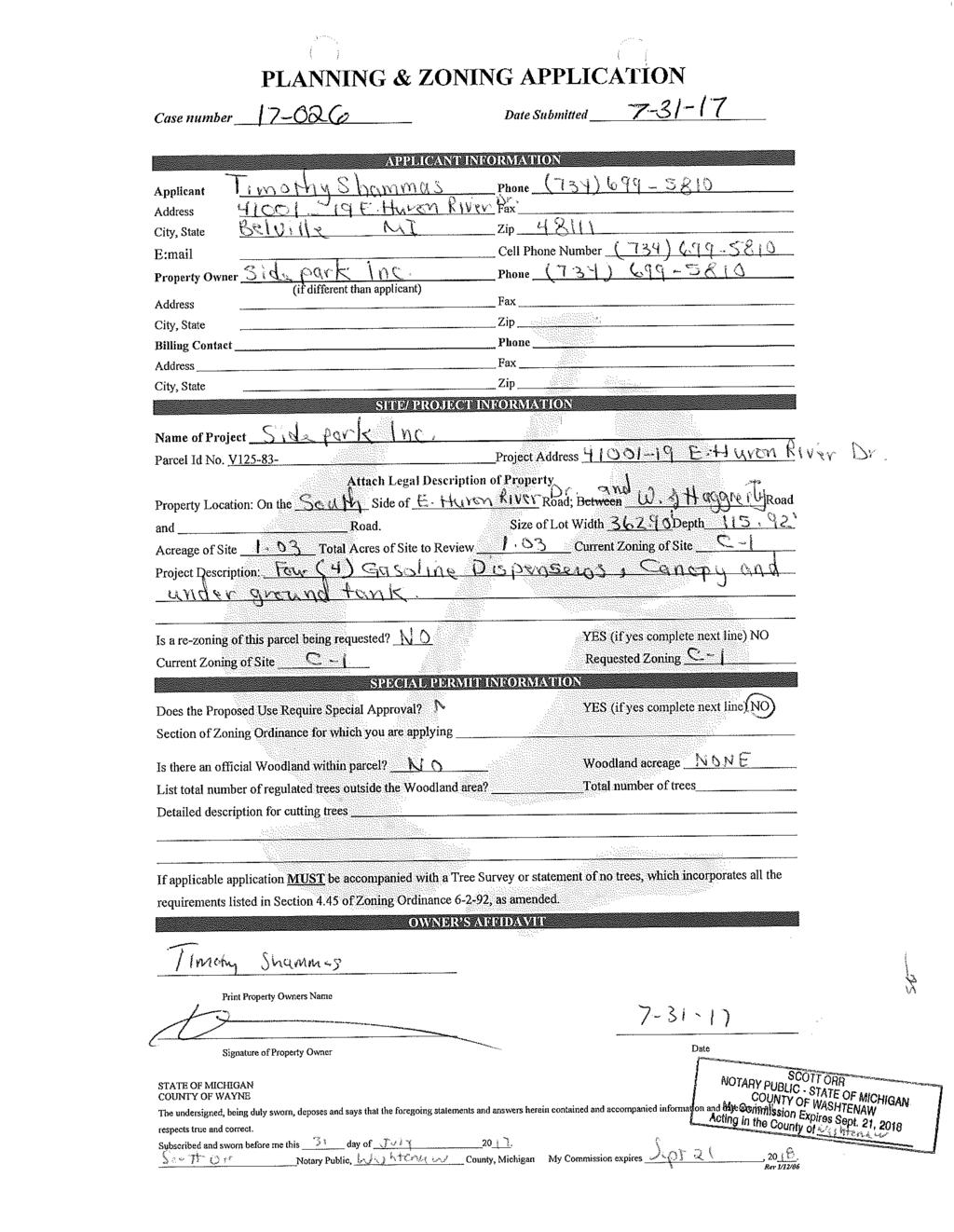
78
79
80
81
82

83 September 19, 2018 Planning Commission Charter Township of Van Buren Tyler Road Van Buren Township, MI Subject: Location: Metro Park Party Store Gas Station (Sidepark)/41001 E. Huron River Dr.; Site Plan Review #5 Southwest corner of E. Huron River Drive and Haggerty Road Dear Planning Commissioners: Plans have been received from Timothy Shammas, to construct four (4) gasoline pumps with a canopy on a site located at the southwest corner of Haggerty Road and E. Huron River Drive. The parcel has an area of 1.03 acres and has an existing 7,975 square foot building that is currently used as a party store and other retail and office uses. Source: Google Images We have reviewed the site plan application in accordance with the regulations of the Van Buren Township Zoning Ordinance and sound planning and zoning principles.
84 COMMENTS 1. Zoning and Use. The site is zoned C-1, General Business District. Per Section of the Zoning Ordinance, gas stations are permitted uses in the C-1 district. There are no specific development standards associated with gas station uses, though all of the requirements of the C-1 district apply. 2. Required Information. Most of the site plan information required per Section of the Zoning Ordinance has been provided at this time with the following exception: a. The fire lane is labeled between the parallel and the perpendicular parking spaces, and must be clearly delineated and/or identified through pavement striping. 3. Dimensional Requirements. The C-1 district requires a minimum front yard setback of 75 feet, a minimum side yard setback of 15 feet, and a minimum rear yard setback of 25 feet. The applicant appeared before the BZA on June 12, 2018 and was granted a 23-foot front yard setback variance and a 5-foot rear yard setback variance to have front and rear yard setbacks of 52 feet and 20 feet, respectively. Sheet SP-1 indicates a /8 front yard setback and a 20 foot rear yard setback, which complies with the variances granted. South of the proposed canopy, there is an area labeled Fuel Pump Above near the catch basin. We had previously requested that the applicant clarify or correct the notation, but it is still on the plan. Based on the plan submitted, at this time we assume that the notation is a typographical error and no pumps shall be located elsewhere on the site, other than the 4 shown below the canopy. 4. Access and Circulation. The site has two (2) existing curb cuts: one each at Haggerty Road and E. Huron River Drive. It appears the applicant is expanding the access drives to 30 feet in width to accommodate truck turning movements. Refueling trucks are proposed to enter the site from Huron Rover Drive and exit onto Haggerty. The location of the underground tanks will result in access to several parking spaces being cut-off during refueling times. The hours of delivery are stated to be 2 a.m. to 6 a.m., so the impact on these parking spaces will likely be minimal. Consistent with Township policy, the site has a cross access connection with the abutting property to the west, which provides a secondary means of access to the restaurant s parking lot. The site plan notes a 20 open access easement; however, the applicant has not provided us with clarification if the crossaccess agreement is a recorded legal easement between the properties. 5. Sidewalks. The site plan indicates new 5-foot wide concrete sidewalks along both street frontages. The sidewalks appear to be located well within the right-of-way to avoid existing utility mains. Approval of sidewalk location and design is subject to review and approval by the Township Engineer and Wayne County. The plan also indicates an existing 5-foot wide sidewalk on the north side of the existing building. Recent photos of the retail store show a freezer and propane tank storage on this sidewalk, which blocks pedestrian access, making barrier-free access is much more difficult. The revised plan notes that no ice maker or outside display is proposed. The sidewalk area must be maintained clear and open to allow for adequate pedestrian and barrier free access. 6. Parking and Loading. a. Number of Parking Spaces. Parking requirement for the shopping center is 4.5 spaces per 1,000 square feet of gross floor area plus parking requirement for gasoline stations is one (1) space per Charter Township of Van Buren Metro Park Gas Station SPR #5 2 September 19, 2018
85 pump and one (1) per employee in the largest shift. Based on the above standard, the site would require a total of 36 spaces plus 8 spaces at the pumps plus 1 for the employee proposed, for a total of 45 spaces. While Sheet SP-1 includes this calculation, Sheet SP-1 also includes an alternate calculation based on part of the building used as office space, which requires 39 spaces. The site plan indicates a total of 43 spaces, which is 2 spaces less than the requirement if the entire building is retail. Article 9 of the Zoning Ordinance allows the Planning Commission to reduce the number of parking spaces based on evidence that another standard is more reasonable based on the current and/or future parking levels. Because some of the building has a history of office use, we recommend that the proposed 43 spaces be acceptable for the site. b. Space Dimensions. The perpendicular parking spaces on the north side of the parking lot are dimensioned at 9.5 feet wide by 20 feet long, which are the minimum dimensions for perpendicular spaces. The parallel parking spaces on the south side of the parking lot (i.e., just north of the building) are dimensioned at 8 feet wide by 23 feet long, which are the minimum dimensions for parallel spaces. The spaces are double striped as required per Section 9.104(C). The actual parking spaces have been dimensioned at each pump and allow for maneuvering on vehicles in the abutting drive aisles. c. Barrier Free Spaces. The site plan notes the provision of two (2) required barrier free spaces. d. Loading. A loading area (10 feet x 50 feet) is shown on the west side of the building. 7. Landscaping. The site plan indicates a narrow landscape area along the Huron River Drive frontage, the width of which is about 5 feet based on the existing location of the parking lot. The plan also indicates a small landscape area along Haggerty Road frontage, and a landscape island at the northwest corner of the site. Landscaping is an integral part of site design, and new development and redevelopment sites are required to comply with Ordinance minimums for landscaping, site design, and building appearance among others. Our comments on individual landscaping requirements are reflected in the following: a. Frontage Landscaping. Section (A) requires a site s public road frontage (exclusive of driveway openings) to be landscaped with 1 deciduous tree per 40 lineal feet of frontage plus 1 ornamental tree per 100 lineal feet of frontage plus 8 shrubs per 40 lineal feet of frontage. With a frontage of feet on Huron River Drive and approximately 80 feet on Haggerty Road, the total plantings required for Huron River Drive frontage are: 8 deciduous trees plus 3 ornamental trees plus 67 shrubs. For Haggerty Road, required plantings are: 2 deciduous trees plus 1 ornamental tree plus 20 shrubs. The revised plan proposes 8 deciduous trees, over 67 shrubs and 4 ornamental trees along Huron River Drive. The frontage along Haggerty Road indicates 2 deciduous trees, 21 shrubs, and 1 ornamental tree. Therefore, the frontage landscaping requirements are met. b. Parking Lot Landscaping. Section (B)(1) requires all parking lots to be landscape and screened from adjoining public or private rights-of-way. The Zoning Ordinance recommends a combination of landscaping, berm, and screen wall to achieve this goal. A row of 30 tall evergreen shrubs (Juniper) are proposed with spacing of 3 feet. Interior parking lot landscaping. Section (B)(2) requires the provision of landscaping within islands in a parking lot. At a minimum, interior landscaping must account for a minimum of 5% of all paved parking areas, each interior landscaped area must be at least 360 sq. ft., and 1 tree per 300 sq. Charter Township of Van Buren Metro Park Gas Station SPR #5 3 September 19, 2018
86 ft. of interior landscape area is required, including 1 tree per landscape island. Three (3) new landscape islands are shown and it appears that four (4) trees are required. There are four (4) trees (Red Maple) proposed. c. Loading Area Landscaping. The loading area is screened by an existing 6-foot high brick wall along a portion of the west property line. d. Display Area Buffering. This requirement is not applicable. e. Greenbelt Buffering. The site abuts M-2 zoning to the west and south. Section (E) requires a 20-foot wide greenbelt planted with 1 tree per 20 linear feet or a 6-foot high opaque masonry screen wall. The site has a partial wall along its west and south boundaries. The wall along the west property line appears to be adequate. The revised site plan notes a new 6 tall masonry block wall with a limestone cap extending from the southeast corner of the building to the east property line, designed to match and connect to the existing partial wall. Typical wall details have been provided and meet Ordinance standards. The wall must be painted to match the building color, and we recommend a condition that the entire south boundary include the 6-foot high wall. f. Specific Landscaping Requirements for Zoning Districts. Section (F)(3) requires parcels in the C districts to provide usable outdoor space on the site and incorporate amenities in said spaces. The site and landscape plan previously proposed 2 brick walls in the northeast corner of the site with a note brick pavers at bench area; however no other details were provided. The plan at this time includes only the note (within the corner right-of-way) and the brick walls and pavers are no longer shown. The applicant must clarify what type of usable open space is being proposed at this time to meet the Ordinance requirement. g. Open Space Landscaping. The Ordinance requires 1 tree per 3,000 square feet of open space area not occupied by buildings or parking. The area must also be provided with ground cover. The site is almost entirely occupied by building and parking, with the remaining areas located within required landscape greenbelt; therefore, this standard is not applicable. h. Irrigation. The landscape plan notes that the owner to provide underground sprinkler system for the landscaped areas. i. Other Landscaping Items. Previous incorrect reference to the Ordinance has now been deleted. 8. Tree Removal Permit. A tree removal permit is required if the applicant proposes to remove any trees of 5-inch caliper or larger per Section of the Zoning Ordinance (Woodland and Tree Preservation). The site appears to have a single overgrown twin-stem tree on its southeast corner. 9. Signs. The site has an existing pylon sign on the northeast corner. The site plan notes a new ground sign in this location and the pylon sign is no longer shown. Therefore, we assume the nonconforming pylon sign is to be removed since two (2) freestanding identifications signs would not be permitted. Section (B) regulates various signs permitted on the subject site as follows: a. Wall Signs. The Zoning Ordinance allows 3 square feet of wall sign area per linear foot of building frontage, not to exceed 200 square feet. Since the building has multiple tenants, each tenant is allowed signage based on their frontage. Sheet A2 indicates 5 wall signs with an area of 20 square Charter Township of Van Buren Metro Park Gas Station SPR #5 4 September 19, 2018
87 feet each. The applicant should clarify if the building has 5 tenant spaces, and if all of them are evenly sized. b. Monument Sign. The Zoning Ordinance allows for 1 monument sign for a corner lot oriented towards both abutting streets, not to exceed 8 feet in height, which may be 60 sq. ft. for lots with a frontage of between feet. The site plan indicates a new monument sign along the site s Haggerty Road frontage. The monument sign detail noted includes a brick base 24 inches high, with a maximum sign height of 8 feet from grade and sign area of 54 square feet, and meets the Zoning Ordinance standards. c. Canopy Sign. The Zoning Ordinance allows 1 square feet per linear foot of freestanding canopy, not to exceed 40 sq. ft. The plan notes that signage of canopy to be special permit, which is not acceptable. The site plan includes a note that no additional signage information is being submitted at this time and will be submitted for separate permit approval. 10. Lighting. The applicant has submitted a photometric plan sheet SP-6. The plan indicates 3 existing light poles along the site s Huron River drive frontage and 2 poles located at the northwest and southeast corners of the site within the public right of way. The revised plan notes that 2 additional lights will be installed at each pole. The applicant must clarify if this would result in 4 fixtures on each pole. As requested previously, typical details of existing poles or photographs with heights noted must be provided to ensure compliance with Zoning Ordinance standards for height (25 feet max.) and shielding. The plan also indicates 3 wall pack fixtures on the north side of the building. Manufacturer s cut sheet detail must be provided for all fixtures, and we recommend the addition of a fixture on the west and south sides of the building for safety and security near the dumpster and along the rear yard. All fixtures must be fully shielded on the sides, and wall pack fixtures are often not shielded. Per the photometric plan, the illumination intensity under the canopy is within limits, but the illumination of the sidewalk areas along Haggerty Road frontage is inadequate. Section 8.105(B)(2) of the Zoning Ordinance requires a minimum intensity of 1.0 footcandles at public sidewalks. Further, Section (B)(3) requires light trespass not to exceed 0.5 footcandles at property lines, The plan indicates an intensity of 0.7 footcandles along the southeast property line. This must be corrected. 11. Architecture and Building Details. The site plan includes a partial canopy elevation detail. a. Building Materials. Section 3.111(D) requires brick or another material of similar architectural quality and appearance to be the principal material for exterior building surfaces. The elevations presented indicate that the existing block building will be maintained and provided with a tower feature constructed of brick to create individual tenant space identity and break up the flat roof. The material used for the cornice details must be labeled and a clarification on what color brick will be used and if the existing block will be painted or stained to match. Materials and color samples must be presented for Planning Commission review. b. Roof Articulation, Projection, and Relief. Section 3.111(D) requires buildings to incorporate roof articulation, projection and relief, covered walkways into facades which include entrances or display windows. The gas pump canopy proposed is a flat roof structure. The material of which the canopy is to be constructed must be noted. We recommend that the canopy installed include some details to make it architecturally appealing rather than the standard flat roof structure proposed. An example of a more appealing roof is the new Speedway gas station at the corner of Belleville Rd. and Tyler Rd. Charter Township of Van Buren Metro Park Gas Station SPR #5 5 September 19, 2018
88 c. Building Façade. The plan at this time includes proposed renovations to the existing party store building. The plan proposes a new standing seam metal roof over the existing block building. The plan also indicates the creation of 4 arched features evenly spaced on the building frontage to be constructed of brick (previously stone face ). 12. Dumpster. The site plan indicates a new dumpster enclosure on the west side of the site. Typical enclosure details have been noted and meet Zoning Ordinance standards noted in Section of the Zoning Ordinance. The enclosure will be 6 feet high, with brick on 3 sides and a solid wood gate on the other side. Two bollards have been added at the front of the enclosure to protect the enclosure from trucks backing up. The plan states that the gate will be steel-reinforced and the wood will be pressure treated or wolmanized. The brick for the enclosure is to match the tower, which we assume is the building elevation arched feature. RECOMMENDATION While several items of required information have been provided and other issues corrected, some additional information remains to be addressed. However, such information can be provided at the time of final site plan review. Therefore, we recommend that the Planning Commission grant preliminary site plan approval for the proposed gas station use at the above address, subject to the following conditions being satisfactorily addressed at final site plan review: 1. Delineation and/or striping of fire lane, as noted in Comment 2 above. 2. Deletion of the incorrect note regarding additional pump outside the canopy, as noted in Comment 3 above. 3. Copy of the recorded cross access easement with the property to the west, as noted in Comment 4, above. 4. The wall must be painted to match the building color, and the entire south boundary must include the 6- foot high wall, as noted in Comment 7.e, above. 5. Provision of usable open space area with landscaping, as noted in Comment 7.f, above. 6. Information regarding all on-site signage, as noted in Comment 9 above. 7. Information regarding existing and proposed light fixtures and correction to photometric plan, as noted in Comment 10, above. 8. Correct labeling and approval of appropriate building materials and colors proposed, as noted in Comment 11, above, including a pitch on the gas pump canopy roof instead of a flat roof. Respectfully submitted, McKENNA Patrick J. Sloan, AICP Senior Principal Planner Vidya Krishnan Senior Planner Charter Township of Van Buren Metro Park Gas Station SPR #5 6 September 19, 2018
89 September 21, 2018 Ms. Carol Thompson Planning Commission Chairperson Charter Township of Van Buren Tyler Road Van Buren, MI Re: Metro Party Store Gas Pumps Project Preliminary Site Plan Review No. 5 Van Buren Township Case No Dear Ms. Thompson: At the request of the Charter Township of Van Buren (Township), Fishbeck, Thompson, Carr & Huber, Inc. (FTCH) has performed a fifth review of the preliminary site plan (Sheets SP-0 through SP-6 and A-1 through A-2), dated July 28, 2018, for the proposed Metro Party Store Gas Pumps project, located at Huron River Drive. FTCH received these plans on September 11, 2018, as well as a supplemental plan sheet showing additional truck movements on Friday, September 21, The proposed project includes the construction of four gasoline dispensers, a canopy, two underground storage tanks, sidewalk, and various other site improvements. General Requirements Listing of all permits required shall be on the plans. The applicant has indicated the necessary permit requirements, but has not listed them on the plans. Soil borings indication the ground water elevation shall be provided. The property identification numbers shall be included on the plans. Title Sheet Requirements A separate Title Sheet shall be included with all the required information, per the Township Engineering Standards Manual. A separate title sheet will help alleviate the crowded first sheet and eliminate the overlap occurring with some of the information. The title sheet shall include, but is not limited to Project Title, Location Map, Site Layout, Project Sponsor information, Revision Block, Permit requirement list, and a Sheet Index. Water Main Service The drawing indicates the location of the existing watermain on Huron River Drive and the existing 2-inch water service to the main building and the existing water service shutoff valve. No other water main service modifications or extensions are indicated on the drawings. The developer shall indicate the location of the water service line and shutoff valve on sheets SP-0 and SP-1, as shown on SP-2. Contact the Township s Water and Sewer Department for assistance. Sanitary Sewer Service The drawings show the location of the existing sanitary sewer service on Haggerty Road and the existing sanitary service lead to the existing building. No other sanitary sewer service modifications or extensions are indicated on the drawings. The sanitary system shown on sheet SP-0 does not match the existing system in the VBT GIS. Sheet SP-0 shows 2 sanitary sewers on top of each other. The existing system only shows one sewer running north/south along Haggerty. Verify existing systems layout. Contact the Township s Water and Sewer Department for assistance.
90 Ms. Carol Thompson Page 2 September 21, 2018 The drawings indicate, with a note, that the developer will field verify the existing sanitary sewer location and depth for a possible relocation, due to the service lines proximity to the canopy. The applicant will determine the need for relocation during construction plan development. Storm Water Management The proposed activities consist of the construction of four (4) gasoline dispensers, a canopy, and two (2) underground storage tanks, in addition to other site improvements. Drawing No. SP-2 indicates that a new Storm Septor is to be provided. Please correct label to Stormceptor, if this is what is intended to be used. All proposed improvements shall be bold lines. The overall acreage of earth disturbance is listed on the plans, however, the limits of earth disruption relative to the site shall be depicted on the Soil Erosion and Sedimentation Control (SESC) plan, drawing No. SP-4. Show the extent of earth disturbance area around sidewalk construction locations and move the silt fence to intercept runoff from these areas (north or east of sidewalks). The drawing shall indicate how the canopy drainage is being directed into the existing storm drainage system. All catch basins in the gas filling service area that receive rain water runoff directly from the fuel filling slab will need to be environmental catch basins and the storm drainage structures shall comply with the Wayne County Storm Water Management Ordinance and Michigan Department of Environmental Quality (MDEQ) water quality requirements. Applicant must submit to Wayne County for stormwater plan approval and receive a permit before completion of the Township construction plan review, including water quality best management practices (BMPs). Site Access The site has two existing access driveways, one from Huron River Drive and one from Haggerty Road. The applicant is now indicating both driveways are to be modified to provide for wider entrances. Drawing No. SP-1 now includes a detail indicating the bottom height of the canopy as 16 feet, however, the overall truck route around the canopy has changed and no longer indicates the turning movements of the truck relative to the canopy. Indicate with truck movements how they will maneuver around site (as previously shown in the 04/28/18 plans). Details shall be shown how the proposed curb and gutter will be formed and placed next to the existing HMA pavement. Any additional HMA patching must be shown and a proposed pavement section indicated. Sidewalk A 5-foot wide concrete sidewalk is indicated to be constructed on Huron River Drive and Haggerty Road. The owner shall coordinate with Wayne County to acquire the necessary rights-of-way (ROW) and construction permits, including Americans with Disabilities Act of 2010 (ADA) design standard requirements at the corner of the intersection of Haggerty Road and Huron River Drive. Plans must indicate all needed removals of trees, bushes, and other vegetation due to the site sidewalk construction. General Plan Sheet Comments Sheet SP-1 Truck wheel tracking shall clearly indicate that the truck vehicle can safely maneuver the proposed property improvements, without the truck s wheels driving over the non-paved areas. Truck Z:\2017\171556\WORK\CORR\2018_0912 PRELIM SITE PLAN 5\LT_PRELIMINARY_SITE_PLAN_REVIEW_NO_5_2018_0912.DOCX
91 Ms. Carol Thompson Page 3 September 21, 2018 movements do not show realistic maneuvers when entering or exiting the site. Turns should be established from current roadway lanes. Adjustment to curb radii may be needed. The applicant supplied an additional reference drawing showing a new truck wheel base (WB-40), closer to that used for fueling, however, the truck movements don t show full site maneuvers and shall be reworked during Engineering Plan development. Sheet SP-0, SP-1 Show the existing water shutoff valve. Sheet SP-5 Label Stormceptor as proposed on profile view, not existing. Recommendation At this time, the proposed site plans show feasibility and we are recommending the Planning Commission grant preliminary site plan approval, subject to the following conditions: The applicant shall submit detailed engineering plans that are prepared in accordance with the VBT Engineering Standards Manual and address the comments listed above. In addition, accurate truck wheel path plans showing full site movements around the site will be required. Wayne County approval for storm water management must also be obtained prior to final review of engineering plans. If you have any questions regarding this project, please contact me at or dpotter@ftch.com. Sincerely, FISHBECK, THOMPSON, CARR & HUBER, INC. David L. Potter, PE, CSI-CCCA Paul J. Kammer, PE ag2 By cc: Mr. Ron Akers, Director of Planning and Economic Development Township Mr. Matthew Best, Deputy Director of Planning and Economic Development Township Z:\2017\171556\WORK\CORR\2018_0912 PRELIM SITE PLAN 5\LT_PRELIMINARY_SITE_PLAN_REVIEW_NO_5_2018_0912.DOCX
92 David C. McInally II Van Buren Fire Department Fire Marshal Tyler Rd O: ext 9416 Van Buren Twp, MI Department Building and Planning Tyler Road Van Buren Twp, MI Re: Metro Party Store Gas Pumps To whom it may concern: Project Overview: The proposal is to install gas pumps at the current location I have reviewed the site plan drawing and have approved them without exceptions. 1. A readily visible, durable sign in letters not less than 1 in. high on contrasting background that reads as follows is located on or adjacent to the door leaf: THIS DOOR TO REMAIN UNLOCKED WHEN THE BUILDINGINS OCCUPIED. NFPA (2) Shall be placed on both front and back exit doors. 2. Emergency lighting NFPA Venting of pizza oven NFPA If grease cooking equipment is used, NFPA 96 requirements must be met. 5. Portable fire extinguishers shall be provided in accordance with NFPA Addresses for all occupancies shall be above the front door and back doors. Please note that all applicable NFPA codes NFPA 1, and 101 apply as adopted by the Township of Van Buren. These should be referenced when moving forward with this project. Review and approval by the Authority Having Jurisdiction shall not relieve the applicant of the responsibility of compliance with these codes. If you have any questions about this plan review report, please feel free to contact me Respectfully submitted, David McInally Fire Marshal Van Buren Fire Department Our Mission: The members of the Van Buren Fire Department shall work together in a professional and caring way to protect life and property from the adverse effects of fire, trauma, illness and dangerous conditions. Our services will be provided in a fair, honest, and ethical manner with the highest respect and dignity to all.

93 . Memo TO: FROM: RE: Planning Commission Grace Moore Planning and Economic Development Intern Large Development Project Definition DATE: September 13, 2018 One element of the public participation plan is a step-by-step guide of how to engage the public throughout the development process for large projects. For example, Traverse City requires a preapplication meeting with staff, documentation of public participation methods and feedback with the site plan submittal, and a project briefing to address the community s concerns before the formal public hearing. Van Buren Township s step-by-step guide is yet to be determined but would likely require an informational meeting like Project Pancake had. In order to create and follow this guide, the Township needs to decide how to define a large development project. I ask the Planning Commission to discuss the following recommendation and decide how it wants to define a large development project in the public participation plan. A large development project in Van Buren Township would be defined as: a) A commercial/industrial development of 40,000 or more square feet b) A residential development of 20 or more units The agreed upon definition would be subject to the discretion of the Planning Director on a case-by-case basis. Location, primarily proximity to residential areas, may influence whether a project is subject to the step-by-step guide in the plan. I look forward to your discussion.
CHARTER TOWNSHIP OF VAN BUREN PLANNING COMMISSION AGENDA Wednesday, August 22, :30 PM, Board of Trustees Room
 CHARTER TOWNSHIP OF VAN BUREN PLANNING COMMISSION AGENDA Wednesday, August 22, 2018 7:30 PM, Board of Trustees Room CALL TO ORDER: ROLL CALL: APPROVAL OF AGENDA: MINUTES: ITEM #1: Approval of minutes from
CHARTER TOWNSHIP OF VAN BUREN PLANNING COMMISSION November 12, 2014 MINUTES
 CHARTER TOWNSHIP OF VAN BUREN PLANNING COMMISSION November 12, 2014 MINUTES Chairperson Thompson called the meeting to order at 7:32 p.m. ROLL CALL: Present: Johnson, Boynton, Kelley, McKenna, Budd, Franzoi
Subject: VBT ; Project Pancake Phase 2/Michigan Avenue; Final Site Plan Review #5; Revised Site Plans Dated October 26, 2018.
 November 9, 2018 Planning Commission Charter Township of Van Buren 46425 Tyler Road Belleville, Michigan 48111 Subject: VBT-18-021; Project Pancake Phase 2/Michigan Avenue; Final Site Plan Review #5; Revised
CHARTER TOWNSHIP OF VAN BUREN PLANNING COMMISSION June 24, 2015 MINUTES
 CHARTER TOWNSHIP OF VAN BUREN PLANNING COMMISSION June 24, 2015 MINUTES Vice-Chairperson Boynton called the meeting to order at 7:32 p.m. ROLL CALL: Present: Franzoi, Johnson, Kelley, McKenna, Budd and
CHARTER TOWNSHIP OF VAN BUREN PLANNING COMMISSION AGENDA Wednesday, November 14, :30 PM, Board of Trustees Room
 CHARTER TOWNSHIP OF VAN BUREN PLANNING COMMISSION AGENDA Wednesday, November 14, 2018 7:30 PM, Board of Trustees Room CALL TO ORDER: ROLL CALL: APPROVAL OF AGENDA: MINUTES: ITEM #1: Approval of minutes
CHARTER TOWNSHIP OF VAN BUREN PLANNING COMMISSION AGENDA Wednesday, January 9, :30 PM, Board of Trustees Room
 CHARTER TOWNSHIP OF VAN BUREN PLANNING COMMISSION AGENDA Wednesday, January 9, 2019 7:30 PM, Board of Trustees Room CALL TO ORDER: ROLL CALL: APPROVAL OF AGENDA: MINUTES: ITEM #1: Approval of minutes from
CHARTER TOWNSHIP OF VAN BUREN PLANNING COMMISSION NOVEMBER 9, 2016 MINUTES
 CHARTER TOWNSHIP OF VAN BUREN PLANNING COMMISSION NOVEMBER 9, 2016 MINUTES Chairperson Thompson called the meeting to order at 7:31 p.m. ROLL CALL: Present: Franzoi, Jackson, Boynton, Kelley, Atchinson
November 21, Planning Commission Charter Township of Lyon Grand River Ave. New Hudson, MI 48165
 Planning Commission Charter Township of Lyon 58000 Grand River Ave. New Hudson, MI 48165 Subject: AP-18-68; 11 Mile and Milford Road Park, Site Plan Review #1 Based on site plan dated 11/12/18 Location:
CHARTER TOWNSHIP OF VAN BUREN PLANNING COMMISSION July 23, 2014 MINUTES
 CHARTER TOWNSHIP OF VAN BUREN PLANNING COMMISSION July 23, 2014 MINUTES Chairperson Boynton called the meeting to order at 7:32 p.m. ROLL CALL: Present: Franzoi, Johnson, Kelley, McKenna, Budd and Boynton.
CHARTER TOWNSHIP OF VAN BUREN PLANNING COMMISSION MAY 25, 2016 MINUTES
 CHARTER TOWNSHIP OF VAN BUREN PLANNING COMMISSION MAY 25, 2016 MINUTES Chairperson Boynton called the meeting to order at 7:30 p.m. ROLL CALL: Present: Franzoi, Boynton, Kelley, Atchinson and Budd. Excused:
Application for Site Plan Review
 Application for Site Plan Review City of Pontiac Office of Land Use and Strategic Planning 47450 Woodward Ave, Pontiac, MI 48342 T: 248.758.2800 F: 248.758.2827 Property/Project Address: Sidwell Number:
CITY OF ZEELAND PLANNING COMMISSION
 APPLICATION FOR SITE PLAN REVIEW AND SPECIAL LAND USE Date City Official App. Filing Fee Rec'd ($350) NOTE TO APPLICANT: Please submit this application for Site Plan Review along with twenty (20) copies
PLANNED UNIT DEVELOPMENT & SUBDIVISION STAFF REPORT Date: March 15, 2012
 PLANNED UNIT DEVELOPMENT & SUBDIVISION STAFF REPORT Date: March 15, 2012 DEVELOPMENT NAME SUBDIVISION NAME LOCATION OSR Subdivision OSR Subdivision 5559 Old Shell Road (South side of Old Shell Road, 570
SITE PLAN REVIEW APPLICATION AND CHECKLIST
 SITE PLAN REVIEW APPLICATION AND CHECKLIST PROJECT SUMMARY: Project Name: City/ETA Location: City ETA (Application fee & number of copies needed are based on location) Property Location (Legal Description
PLANNED UNIT DEVELOPMENT & SUBDIVISION STAFF REPORT Date: May 18, 2017
 & PUD-0000102-2017 PLANNED UNIT DEVELOPMENT & SUBDIVISION STAFF REPORT Date: May 18, 2017 NAME SUBDIVISION NAME Dauphin Creek Estates Subdivision Dauphin Creek Estates Subdivision LOCATION CITY COUNCIL
PRELIMINARY CONDITIONAL USE SUBMITTAL CHECKLIST REQUIREMENTS
 This checklist must accompany your submittal as the cover page. CONDITIONAL USE Application Submittal Checklist for PRELIMINARY AND FINAL APPROVAL Per Winter Park Land Development Code Sec. 58-90 PRELIMINARY
Deerfield Township Community Development Department
 STAFF REVIEW Deerfield Township Community Development Department To: From: Hayfaa Wadih, AICP Lois McKnight, AICP Meeting Date: April 13, 2015 Re: Stage 2, Final Detailed Plan for Lot #41 at Arbor Square
ROLL CALL Member Anthony, Member Avdoulos, Member Greco, Member Lynch, Member Maday, Chair Pehrson
 CALL TO ORDER The meeting was called to order at 7:00 PM. PLANNING COMMISSION ACTION SUMMARY CITY OF NOVI Regular Meeting July 11, 2018 7:00 PM Council Chambers Novi Civic Center 45175 W. Ten Mile (248)
At Your Disposal CUP Amendment, Lot 20, Village Service Commercial, at 128 Bastille Dr. (PLN17-208)
") MEMORANDUM Archuleta County Development Services Planning Department 1122 HWY 84 P. O. Box 1507 Pagosa Springs, Colorado 81147 970-264-1390 Fax 970-264-3338 TO: Archuleta County Planning Commission FROM:
MEMORANDUM Archuleta County Development Services Planning Department 1122 HWY 84 P. O. Box 1507 Pagosa Springs, Colorado 81147 970-264-1390 Fax 970-264-3338 TO: Archuleta County Planning Commission FROM:
APPLICATION FOR REZONING PROPERTY CITY OF HOLLAND, MICHIGAN. Name of Applicant. Address, and Phone # of Applicant
 APPLICATION FOR REZONING PROPERTY CITY OF HOLLAND, MICHIGAN Name of Applicant Address, Email and Phone # of Applicant Name and Address of Owner (if other than applicant) Ownership Interest of Applicant
SAGINAW CHARTER TOWNSHIP PLANNING COMMISSION SAGINAW CHARTER TOWNSHIP HALL SEPTEMBER 19, Members Present Members Absent Others Present
 SAGINAW CHARTER TOWNSHIP PLANNING COMMISSION SAGINAW CHARTER TOWNSHIP HALL SEPTEMBER 19, 2018 Members Present Members Absent Others Present C. Nolan S. King, Dir. of Community Dev. G. Fahndrich M. Mahlberg,
12 January 12, 2011 Public Hearing APPLICANT: TAILWIND DEVELOPMENT GROUP,LLC PROPERTY OWNER: CITY OF VIRGINIA BEACH
 12 January 12, 2011 Public Hearing APPLICANT: TAILWIND DEVELOPMENT GROUP,LLC PROPERTY OWNER: CITY OF VIRGINIA BEACH STAFF PLANNER: Faith Christie REQUEST: Conditional Change of Zoning (from PD-H1 Planned
THE CITY OF MOBILE, ALABAMA
 THE CITY OF MOBILE, ALABAMA LETTER OF DECISION Ark of Safety, Inc. Mobile, AL 36617 Re: (Northwest corner of Main Street and First Avenue, extending to the Southwest corner of Esau Avenue and Main Street.)
F. Driveways. Driveways which provide access to off-street parking or loading from public streets shall comply with the following:
 Section 20.945.040 General Design Standards for Surface Parking Areas. A. Review Authority. Parking lot design and drainage shall be subject to review and approval of the City Transportation Manager. B.
PLANNED UNIT DEVELOPMENT Date: April 5, 2018
 PLANNED UNIT DEVELOPMENT Date: April 5, 2018 DEVELOPMENT NAME SUBDIVISION NAME LOCATION Robert Myers Robert Myers 2955 and 2989 Dauphin Street (Southeast corner of Dauphin Street and Sage Avenue) CITY
GENERAL INFORMATIONaaaaaaaaaaaaaaaaaaaaaaaaaaaaaaaa
 To: Planning and Zoning Commission From: City Staff Date: November 15, 2016 Re: Case #16026 Raymore Activity Center Site Plan GENERAL INFORMATIONaaaaaaaaaaaaaaaaaaaaaaaaaaaaaaaa Applicant/ Property Owner:
Approved: CITY OF ARDEN HILLS, MINNESOTA PLANNING COMMISSION WEDNESDAY, AUGUST 5, :30 P.M. - ARDEN HILLS CITY HALL
 Approved: CITY OF ARDEN HILLS, MINNESOTA PLANNING COMMISSION WEDNESDAY, AUGUST 5, 2015 6:30 P.M. - ARDEN HILLS CITY HALL PLANNING CASES A. Planning Case 15-016; Final Planned Unit Development Arden Plaza;
SITE PLAN REVIEW APPLICATION
 SITE PLAN REVIEW APPLICATION CITY OF THE DALLES Community Development Department 313 Court Street The Dalles, OR 97058 (541) 296-5481, ext. 1125 Fax (541) 298-5490 www.ci.the-dalles.or.us Date Filed File#
City of Mt. Juliet Planning & Zoning Department. Site Plan Checklist. Site plan cklist v1.18
 City of Mt. Juliet Planning & Zoning Department Site Plan Checklist Site Plan approval is required for all specified community facilities, all commercial, industrial, and multi-family residential activities
Improve the appearance of off-street parking areas, vehicular use areas, and property abutting public and private roads;
 Bedford Township, MI (Monroe Co.) 2012 http://library.municode.com/index.aspx?clientid=02123 400.1907 - Landscaping and screening. Se 1907. 1. Intent. Landscaping, greenbelts, and screening are necessary
PARISH OF ASCENSION OFFICE OF PLANNING AND DEVELOPMENT PLANNING DEPARTMENT. Joint Planning and Zoning Meeting
 1. Call To Order 2. Roll Call of Members 3. Chairman's Comments PARISH OF ASCENSION OFFICE OF PLANNING AND DEVELOPMENT PLANNING DEPARTMENT Joint Planning and Zoning Meeting January 11, 2017 6:00 PM Courthouse
Project phasing plan (if applicable) 12 copies of site plan
 12 copies of site plan") SITE PLAN REVIEW PERMIT APPLICATION City of Grand Haven, 11 N. Sixth Street, Grand Haven, MI 49417 Phone: (616) 847-3490 Fax: (616) 844-2051 Website: www.grandhaven.org 1. Project Information Address/location
SITE PLAN REVIEW PERMIT APPLICATION City of Grand Haven, 11 N. Sixth Street, Grand Haven, MI 49417 Phone: (616) 847-3490 Fax: (616) 844-2051 Website: www.grandhaven.org 1. Project Information Address/location
Section 511: 11 th Street Overlay District 1. Intent: 11 th Street is the primary entrance route into the city from the south, providing direct
 Section 511: 11 th Street Overlay District 1. Intent: 11 th Street is the primary entrance route into the city from the south, providing direct access from US Highway 12. As such, the community has identified
SITE PLAN REVIEW PROCESS
 BOWNE TOWNSHIP PO Box 35, 8240 Alden Nash Road, Alto, Michigan 49302 Ph. 616-868-6846 Fax 616-868-0110 http://www.bownetwp.org SITE PLAN REVIEW PROCESS 1. Application Form and Fee Schedule Site Plan Review
CHEBOYGAN COUNTY PLANNING COMMISSION
 CHEBOYGAN COUNTY PLANNING COMMISSION 870 SOUTH MAIN ST. PO BOX 70 CHEBOYGAN, MI 49721 PHONE: (231)627-8489 FAX: (231)627-3646 CHEBOYGAN COUNTY PLANNING COMMISSION MEETING & PUBLIC HEARING WEDNESDAY, NOVEMBER
D1 September 11, 2013 Public Hearing APPLICANT:
 D1 September 11, 2013 Public Hearing APPLICANT: BEACH MUNICIPAL FEDERAL CREDIT UNION PROPERTY OWNER: SISTERS II, LLC STAFF PLANNER: Karen Prochilo REQUEST: Conditional Change of Zoning (AG-2 Agriculture
Landscaping Standards
 CHAPTER 29 ARTICLE 403 29.403 Landscaping Standards Purpose: The purpose of this section is to protect and promote the public health, safety and general welfare by requiring landscaping in relation to
4 January 11, 2012 Public Hearing APPLICANT:
 . 4 January 11, 2012 Public Hearing APPLICANT: MID-ATLANTIC AUTO PROPERTY OWNER: DZR, LLC STAFF PLANNER: Leslie Bonilla REQUEST: Conditional Use Permit (truck rental, automobile service, and automotive/bulk
PLANNED UNIT DEVELOPMENT APPLICATION
 PLANNED UNIT DEVELOPMENT APPLICATION CITY OF THE DALLES Community Development Department 313 Court Street The Dalles, OR 97058 (541) 296-5481, ext. 1125 Fax (541) 298-5490 www.ci.the-dalles.or.us Date
SITE PLAN REVIEW ITEMS - REFERENCE CHECKLIST
 City of Seminole 9199 113 th Street N. Seminole, FL 33772 Ph: (727) 392-1966 Fx: (727) 319-6583 SITE PLAN REVIEW ITEMS - REFERENCE CHECKLIST Note: This checklist is designed to aid designers in the review
STATUS OF REVIEW: ENGINEER WILL COMPLY
 OCTOBER 8, 2013 PROJECT NAME: UHAUL SELF-STORAGE @ S HWY 441 - MAJOR SITE PLAN PROJECT NUMBER: 1999007762 APPLICATION: #11903 Met with staff 10/24/13, DRC on 11/4/13 1. DEPARTMENT: ENGDRN - STORMWATER
PLANNED UNIT DEVELOPMENT STAFF REPORT Date: June 2, 2016
 # 9 ZON2016-01032 PLANNED UNIT DEVELOPMENT STAFF REPORT Date: June 2, 2016 DEVELOPMENT NAME JJT Properties LLC LOCATION 1147 & 1151 East I-65 Service Road South and 1180 Sledge Drive (Southeast corner
Staff Report Bourbon County Joint Planning Office SPECIAL MEETING September 4, 2018
 Staff Report Bourbon County Joint Planning Office SPECIAL MEETING September 4, 2018 Case Number: DVP 18-05 FINAL Applicant: Josh Cummins Location: Arlington Drive. Request: Car Dealer Parking Lot Zoning:
ZONING AMENDMENT & PLANNED UNIT DEVELOPMENT STAFF REPORT Date: April 4, 2013
 ZONING AMENDMENT & PLANNED UNIT DEVELOPMENT STAFF REPORT Date: April 4, 2013 NAME DEVELOPMENT NAME LOCATION DIP Exchange, LLC DIP Exchange, LLC 93 Sidney Phillips Drive (West side of Sidney Phillips Drive,
14 October 10, 2012 Public Hearing APPLICANT: MPB, INC
 14 October 10, 2012 Public Hearing APPLICANT: MPB, INC PROPERTY OWNER: MUNDEN & ASSOCIATES, LP STAFF PLANNER: Karen Prochilo REQUEST: Conditional Change of Zoning (AG-1 & AG-2 to Conditional O-2) ADDRESS
Watertown City Council
 City of Watertown Watertown City Council April 14 th, 2015 Agenda Item: City Comment on Sun Share CUP Application Request for Action: Motion to Approve City Comments regarding CUP Application Department:
MONTGOMERY COUNTY PLANNING DEPARTMENT THE MARYLAND-NATIONAL CAPITAL PARK AND PLANNING COMMISSION
 MONTGOMERY COUNTY PLANNING DEPARTMENT THE MARYLAND-NATIONAL CAPITAL PARK AND PLANNING COMMISSION MCPB Item No. Date: 12-10-15 Leisure World Clubhouse II Addition Fitness Center, Limited Site Plan Amendment
ARLINGTON COUNTY, VIRGINIA
 ARLINGTON COUNTY, VIRGINIA County Board Agenda Item Meeting of January 27, 2007 DATE: January 12, 2007 SUBJECT: U-3101-04-2 Use Permit Review for drive-through facilities; premises known as 5222 Lee Highway
s t a f f r e p o r t
 Colerain Township Board of Trustees August 10, 2010 8:30 p.m. Major Amendment to Final Development Plan: Case No.: ZA2005-09, Springdale Retail s t a f f r e p o r t Report Prepared By: Amy Bancroft, Land
CITY OF IONIA Planning Commission August 12, 2015 Regular Meeting Minutes
 CITY OF IONIA Planning Commission August 12, 2015 Regular Meeting Minutes The Regular Meeting of the City of Ionia Planning Commission for August 12, 2015 was called to order by Chairperson Chris Young
COLERAIN TOWNSHIP ZONING COMMISSION Regular Meeting Tuesday, October 18, :00 p.m.
 COLERAIN TOWNSHIP ZONING COMMISSION Regular Meeting Tuesday, October 18, 2016-6:00 p.m. Colerain Township Government Complex 4200 Springdale Road - Cincinnati, OH 45251 1. Meeting called to order. Pledge
The purpose of the requirements in this Article is to provide for landscaping and screening of parking and other outdoor areas that will:
 XIII. LANDSCAPING & SCREENING A. Purpose The purpose of the requirements in this Article is to provide for landscaping and screening of parking and other outdoor areas that will: 1. Protect residential
ARTICLE 9: LANDSCAPING AND FENCING REQUIREMENTS
 ARTICLE 9: LANDSCAPING AND FENCING REQUIREMENTS Section 9.01 Intent The intent of the landscaping requirements are to improve the appearance of lot areas and soften paved areas and buildings; to provide
CITY PLANNING COMMISSION AGENDA. ITEM NO: 6.a 6.b STAFF: LONNA THELEN
 Page 156 CITY PLANNING COMMISSION AGENDA ITEM NO: 6.a 6.b STAFF: LONNA THELEN FILE NO(S): A. - CPC ZC 08-00069 QUASI-JUDICIAL B. - CPC CU 08-00070 QUASI-JUDICIAL PROJECT: APPLICANT: OWNER: PHIL LONG VALUCAR
Article 7.05 Manufactured Home Park Districts
 Article Manufactured Home Park Districts.01 Intent The purpose of the MHP Manufactured Home Park District is to give recognition to the fact that manufactured homes can provide satisfactory living conditions
ARTICLE 17 SITE PLAN REVIEW
 ARTICLE 17 SITE PLAN REVIEW 17.01 INTENT AND PURPOSE The intent of this section is to provide for consultation and cooperation between the applicant and the township planning commission so that the applicant
CHAPTER 26 LANDSCAPING (Chapter added in its entirety 05-08)
") CHAPTER 26 LANDSCAPING (Chapter added in its entirety 05-08) 26.01 DESCRIPTION AND PURPOSE. Landscaping is an important element of the use, development and preservation of land, and a significant factor
CHAPTER 26 LANDSCAPING (Chapter added in its entirety 05-08) 26.01 DESCRIPTION AND PURPOSE. Landscaping is an important element of the use, development and preservation of land, and a significant factor
TOWNSHIP OF LOGAN SOIL & FILL IMPORTATION AND PLACEMENT APPLICATION SUBMITTAL CHECKLIST
 TOWNSHIP OF LOGAN SOIL & FILL IMPORTATION AND PLACEMENT APPLICATION SUBMITTAL CHECKLIST Applications: 5 copies of application - Applicant will reproduce the copies at his/her costs. The Township Clerk
M E M O R A N D U M. Consider a recommendation of a site plan for Sherwin Williams, a proposed approximately 4,500 square-foot paint store.
 M E M O R A N D U M Meeting Date: February 10, 2014 Item No. E- 8 To: From: Subject: Planning and Zoning Commission Cassie Harashe, Planner I Consider a recommendation of a Site Plan for Sherwin Williams,
PLANNING COMMISSION REPORT Public Hearing Item FINAL DEVELOPMENT PLAN FOR BAUER FARM; XPRESS WELLNESS URGENT CARE; 4700 OVERLAND DR (MKM)
") PC Staff Report 06/22/15 FDP-15-00108 Item No. 6-1 PC Staff Report 06/22/2015 ITEM NO. 6 PLANNING COMMISSION REPORT Public Hearing Item FINAL DEVELOPMENT PLAN FOR BAUER FARM; XPRESS WELLNESS URGENT CARE;
PC Staff Report 06/22/15 FDP-15-00108 Item No. 6-1 PC Staff Report 06/22/2015 ITEM NO. 6 PLANNING COMMISSION REPORT Public Hearing Item FINAL DEVELOPMENT PLAN FOR BAUER FARM; XPRESS WELLNESS URGENT CARE;
MOBILE CITY PLANNING COMMISSION LETTER OF DECISION. October 22, 2010
 MOBILE CITY PLANNING COMMISSION LETTER OF DECISION Archbishop of Mobile 400 Government St. Mobile, AL 36602 Re: Case #SUB2010-00075 (Subdivision) 3650 Springhill Avenue (Northwest corner of Springhill
DEPARTMENT OF PLANNING JEFFERSON PARISH, LOUISIANA
 DEPARTMENT OF PLANNING JEFFERSON PARISH, LOUISIANA DESIGN REVIEW REPORT : CPZ-3-1 : (S) Cynthia Lee-Sheng AT LARGE: A Chris Roberts B Elton M. Lagasse ADVERTISING DATES: 06/03/1 06/10/1 06/17/1 PAB PUBLIC
Green Oak Charter Township. Planning Commission Regular Meeting Minutes August 4, 2016
 1 2 3 4 5 6 7 8 9 10 11 12 13 14 15 16 17 18 19 20 21 22 23 24 25 26 27 28 29 30 31 32 33 34 35 36 37 38 39 40 41 42 43 44 45 46 47 48 49 Planning Commission Regular Meeting Minutes August 4, 2016 The
Denton Planning Commission. Minutes. Town of Denton. November 29, 2016
 Denton Planning Commission Minutes Town of Denton Planning Commission Members: Doris Walls, Chairperson* William Quick* Sue Cruickshank* Marina Dowdall* Dean Danielson *** Nicholas T. Iliff, Jr.* * Those
Sanford/Lee County Technical Review Committee (TRC) DEADLINES & MEETING DATES
 DEADLINES & MEETING DATES") Sanford/Lee County Technical Review Committee (TRC) DEADLINES & MEETING DATES The following 2019 information is based on the information available to staff at the time of creation. Dates & time may change
Sanford/Lee County Technical Review Committee (TRC) DEADLINES & MEETING DATES The following 2019 information is based on the information available to staff at the time of creation. Dates & time may change
Request Conditional Use Permit (Car Wash Facility) Staff Recommendation Approval. Staff Planner Jonathan Sanders
 Staff Recommendation Approval. Staff Planner Jonathan Sanders") Applicant Property Owner SunTrust Bank Public Hearing October 10, 2018 City Council Election District Princess Anne Agenda Item 2 Request Conditional Use Permit (Car Wash Facility) Staff Recommendation
Applicant Property Owner SunTrust Bank Public Hearing October 10, 2018 City Council Election District Princess Anne Agenda Item 2 Request Conditional Use Permit (Car Wash Facility) Staff Recommendation
Site Development Plan (SDP) Checklist
 Checklist") Development Services Department 100 N. Wilcox Street, Castle Rock CO 80104 303-660-1393 or CRGov.com Site Development Plan (SDP) Checklist A complete Site Development Plan (SDP) submittal will contain
Development Services Department 100 N. Wilcox Street, Castle Rock CO 80104 303-660-1393 or CRGov.com Site Development Plan (SDP) Checklist A complete Site Development Plan (SDP) submittal will contain
LONDONDERRY PLANNING BOARD SITE PLAN APPLICATION & CHECKLIST
 LONDONDERRY PLANNING BOARD SITE PLAN APPLICATION & CHECKLIST Planning Department Date Stamp Design Review Formal Application All information provided and submitted with this Application Checklist shall
LONDONDERRY PLANNING BOARD MINOR SITE PLAN APPLICATION & CHECKLIST
 LONDONDERRY PLANNING BOARD MINOR SITE PLAN APPLICATION & CHECKLIST Planning Department Date Stamp Design Review Formal Application Change of Use (No Site Improvements)* All information provided and submitted
SUBDIVISION, PLANNED UNIT DEVELOPMENT, PLANNING APPROVAL, REZONING & SIDEWALK WAIVER STAFF REPORT Date: February 7, 2013
 SUBDIVISION, PLANNED UNIT DEVELOPMENT, PLANNING APPROVAL, REZONING & SIDEWALK WAIVER STAFF REPORT Date: February 7, 2013 APPLICANT NAME SUBDIVISION NAME DEVELOPMENT NAME LOCATION S. E. Cemeteries of AL
City Development Department 9500 Civic Center Drive Thornton, Colorado FAX
 City Hall City Development Department 9500 Civic Center Drive 303-538-7295 Thornton, Colorado 80229-4326 FAX 303-538-7373 www.cityofthornton.net Ben Swanson Dormie Capital Partners 3740 Dacoro Lane, Suite
SUBMITTAL REQUIREMENTS
 WHEN PROCESS TYPE III IS USED References to Process Type III applications are found in several places in the Milton Municipal Code (MMC), indicating that the development, activity, or use, is permitted
VEHICULAR AND PEDESTRIAN CIRCULATION
 This perspective sketch communicates the intended character and quality of a proposed streetscape design. Locate benches near a major intersection where people tend to gather. Seating and lighting provide
g) "Minor repair" means repairs dealing primarily with nonstructural portions of the fence, as well as appearance.
 Minor repair means repairs dealing primarily with nonstructural portions of the fence, as well as appearance.") 6.2.4 FENCES, WALLS AND SCREENS: To protect the use and enjoyment of residential property by providing for the passage of air and light; to protect public welfare and safety by providing for the safe movement
6.2.4 FENCES, WALLS AND SCREENS: To protect the use and enjoyment of residential property by providing for the passage of air and light; to protect public welfare and safety by providing for the safe movement
4.500 Preston Road Overlay District
 Section 4.500 Preston Road Overlay District 2004 Zoning Ordinance 4.500 Preston Road Overlay District (ZC 98-29; Ordinance No. 98-9-12) 4.501 Purpose To provide appropriate design standards for the use
Urban Planning and Land Use
 Urban Planning and Land Use 701 North 7 th Street, Room 423 Phone: (913) 573-5750 Kansas City, Kansas 66101 Fax: (913) 573-5796 Email: planninginfo@wycokck.org www.wycokck.org/planning To: From: City Planning
GENERAL LANDSCAPE PROVISIONS. The following landscape provisions shall be adhered to by all land uses unless otherwise noted:
 CHAPTER 1.18 Sections: 1.18.005 Purpose. 1.18.010 Landscaping, Buffering, and Fencing Improvements Required. 1.18.015 General Landscape Provisions. 1.18.020 Landscaping Plan. 1.18.025 Single-Family Dwellings
February 17, Sara Ullman Planner I. Sincerley,
 February 17, 2016 Sara Ullman Planner I City of Aurora Planning Department Re: Mrachek Middle School Replacement (#1116704)/Response Initial Submission Review Dear Ms. Ullman, Thank you for your assistance
The Brown Road Innovation Zoning District shall be specified for the areas as designated on the Charter Township of Orion Zoning Map.
 Section 34.00 Preamble The purpose of the Brown Road Innovation Zoning District shall be to encourage the development of property in accordance with the Charter Township of Orion Master Plan in a manner
ZONING ORDINANCE FOR THE ZONED UNINCORPORATED AREAS ARTICLE 1300 OF PUTNAM COUNTY, WEST VIRGINIA Page 119 ARTICLE 1300 LANDSCAPING AND SCREENING
 OF PUTNAM COUNTY, WEST VIRGINIA Page 119 ARTICLE 1300 LSCAPING SCREENING 1300.01 STATEMENT OF LEGISLATIVE INTENT 1300.02 GENERAL PROVISIONS 1300.03 REQUIREMENTS 1300.04 SUBMISSION APPROVAL 1300.05 SCREENING
PART 1: PROJECT SUMMARY. Proposed Land Use: 120 single-family lots. The application is Attachment A. The site plan is Attachment B.
 PART 1: PROJECT SUMMARY Applicant: JBH Development, LLC and Hopper Communities, INC Project Size: +/- 80.48 acres Parcel Number: 01513107, 01513108, 01513109, 01513113, 01513120, 01513121, 01513122, 01513124,
ARTICLE 9: Landscaping
 ARTICLE 9: Landscaping 9-10 Legislative Intent The purpose of this Article is to regulate the planting and preservation of landscape materials; to facilitate the creation of an attractive and healthy environment;
ARLINGTON COUNTY, VIRGINIA
 ARLINGTON COUNTY, VIRGINIA County Board Agenda Item Meeting of May 19, 2012 DATE: May 2, 2012 SUBJECT: U-3145-05-1 USE PERMIT REVIEW for a vehicle service establishment; located at (RPC# 06-018-002). Applicant:
CITY of RIDGEFIELD TYPE I DECISION SITE PLAN REVIEW (SPR 99-10) PDM MOLDING INC. PHASE II EXPANSION
 PDM MOLDING INC. PHASE II EXPANSION") Page 1 CITY of RIDGEFIELD TYPE I DECISION SITE PLAN REVIEW (SPR 99-10) PDM MOLDING INC. PHASE II EXPANSION TO: Mayor, and Members of the Ridgefield City Council and Planning Commission FROM: Eric Eisemann
Page 1 CITY of RIDGEFIELD TYPE I DECISION SITE PLAN REVIEW (SPR 99-10) PDM MOLDING INC. PHASE II EXPANSION TO: Mayor, and Members of the Ridgefield City Council and Planning Commission FROM: Eric Eisemann
MIDTOWN MIXED-USE VILLAGE. TECHNICAL DATA SHEET COMPONENT C-1 FOR PUBLIC HEARING - PETITION NUMBER Project No RZ1.1. Issued.
 N MIDTOWN MIXED-USE VILLAGE TECHNICAL DATA SHEET COMPONENT C- FOR PUBLIC HEARING - PETITION NUMBER 04-00 Project No. 496 Issued Revised SCALE: " = 0' N 0 0 0 40 RZ. c GENERAL PROVISIONS: a. SITE LOCATION.
Statement of Intent Proposed Development Five Forks Athletics Scuffletown Rd, Greenville SC
 Statement of Intent Proposed Development Five Forks Athletics Scuffletown Rd, Greenville SC Tax Map #0548020103205 1 P a g e Table of Contents Statement of Intent...page 3-9 Exhibit A Utility Letters Exhibit
Department of Planning & Development Planning Unit
 May 20, 2005 Department of Planning & Development Planning Unit Website: www.cityofmadison.com Madison Municipal Building 215 Martin Luther King, Jr. Boulevard P.O. Box 2985 Madison, Wisconsin 53701-2985
Chapter PEDESTRIAN COMMERCIAL (PC) ZONING DISTRICT
 ZONING DISTRICT") Chapter 11-17 PEDESTRIAN COMMERCIAL (PC) ZONING DISTRICT Sections: 11-17-01 GENERAL PURPOSE 11-17-02 PERMITTED BUILDING TYPES 11-17-03 USES PERMITTED WITH DESIGN REVIEW 11-17-04 USES PERMITTED BY CONDITIONAL
Chapter 11-17 PEDESTRIAN COMMERCIAL (PC) ZONING DISTRICT Sections: 11-17-01 GENERAL PURPOSE 11-17-02 PERMITTED BUILDING TYPES 11-17-03 USES PERMITTED WITH DESIGN REVIEW 11-17-04 USES PERMITTED BY CONDITIONAL
CITY OF KEIZER MASTER PLAN APPLICATION & INFORMATION SHEET
 CITY OF KEIZER MASTER PLAN APPLICATION & INFORMATION SHEET PRE-APPLICATION CONFERENCE Prior to the actual filing of a Master Plan application, it is strongly recommended that the applicant contact Planning
VILLAGE OF SPRING LAKE PLANNING COMMISSION. MINUTES REGULAR MEETING April 28, :00 PM
 Page 1 of 6 VILLAGE OF SPRING LAKE PLANNING COMMISSION MINUTES REGULAR MEETING April 28, 2015 7:00 PM Barber School Community Building 102 West Exchange Street Spring Lake, MI 49456 49456 1. CALL TO ORDER
Review Zone Application for D&R Canal Commission Decision
 Review Zone Application for D&R Canal Commission Decision MEETING DATE: July 20, 2016 DRCC #: 16-4803 Latest Submission Received: June 13, 2016 Applicant: Robert McCarthy, PE PSE&G 4000 Hadley Road, 2
PRELIMINARY PLAT DESIGN REQUIREMENTS Updated 4/8/2016
 PRELIMINARY PLAT DESIGN REQUIREMENTS Updated 4/8/2016 The following items are required for the preliminary plat. Numbers correspond with those on the example preliminary plat. RENO COUNTY SUBDIVISION REQUIREMENTS
Town of Windham. Planning Department 8 School Road Windham, ME voice fax
 Town of Windham Planning Department 8 School Road Windham, ME 04062 voice 207.864-5960 fax 207.892.1916 MEMO DATE: TO: Staff Review Committee FROM: Amanda Lessard, Planner Cc: Ellen Rathbone, St. Germain
CASE NUMBER: 16SN0701 APPLICANT: Hanky, LLC
 STAFF S ANALYSIS AND RECOMMENDATION Planning Commission (CPC) Public Hearing Date: MAY 17, 2016 CPC Time Remaining: 100 DAYS Applicant s Agent: DANIEL L. CASKIE (804-569-7060) Applicant s Contact: MICHAEL
Urban Planning and Land Use
 Urban Planning and Land Use 701 North 7 th Street, Room 423 Phone: (913) 573-5750 Kansas City, Kansas 66101 Fax: (913) 573-5796 Email: planninginfo@wycokck.org www.wycokck.org/planning To: From: City Planning
AGENDA MEETING OF THE TOWN OF ALLEGANY PLANNING BOARD. Monday, November 9, 2015 at 7:00 p.m. Allegany Town Hall 52 W. Main Street, Allegany, NY
 AGENDA MEETING OF THE TOWN OF ALLEGANY PLANNING BOARD Monday, November 9, 2015 at 7:00 p.m. Allegany Town Hall 52 W. Main Street, Allegany, NY Salute to the Flag Minutes October 5, 2015 Old Business Michael
Wake County Parcel Identification Number (PIN) (10-digit) Total Area 0.48
 (10-digit) Total Area 0.48") STAFF REPORT Town Council, September 3, 2015 Mom's Auto Care Site Plan 14-SP-035 (PL16-019) Conduct public hearing and consider action on proposed site plan request. Speaker: Douglas Loveland From: Jeff
STAFF REPORT Town Council, September 3, 2015 Mom's Auto Care Site Plan 14-SP-035 (PL16-019) Conduct public hearing and consider action on proposed site plan request. Speaker: Douglas Loveland From: Jeff
Rezoning Petition Zoning Committee Recommendation August 1, 2017
 Rezoning Petition 2017-090 Zoning Committee Recommendation August 1, 2017 REQUEST LOCATION SUMMARY OF PETITION PROPERTY OWNER PETITIONER AGENT/REPRESENTATIVE COMMUNITY MEETING STATEMENT OF CONSISTENCY
Asbury Chapel Subdivision Sketch Plan
 Asbury Chapel Subdivision Sketch Plan PART 1: PROJECT SUMMARY Applicant: NVR Inc. Project Size: +/- 76.13 acres Parcel Numbers: 02101112,02116101,02116112, 02116113 Current Zoning: Transitional Residential
Rezoning Transportation Analysis Petition Number: General Location Identifier: , ,
 From: Kelsie Anderson, PE Kelsie.Anderson@charlottenc.gov 704-432-5492 Staff Reviewer: Rick Grochoske, PE rgrochoske@charlottenc.gov 704-432-1556 CDOT s review of this rezoning petition is intended to