PLANNING COMMITTEE AGENDA
|
|
|
- Britton McLaughlin
- 5 years ago
- Views:
Transcription

 (THE QUORUM FOR THIS MEETING IS 7 VOTING COUNCILLORS) The business to be transacted is set")
1 0. Working in Partnership EAST HAMPSHIRE DISTRICT COUNCIL, PENNS PLACE, PETERSFIELD, HAMPSHIRE GU31 4EX Telephone: Website: PLANNING COMMITTEE AGENDA Date: Thursday, 16 June 2016 Time: Venue: 6.00 pm Headley Village Hall - Arford Road, Headley, Bordon, GU35 8LJ Membership: Councillor I Thomas (Chairman) Councillors D Ashcroft, R Ayer, K Carter, F Cowper, N Drew, D Evans, A Glass, A Joy, C Louisson, D Orme, D Phillips, S Pond, R Saunders, S Schillemore and A Williams (Vice-Chairman) (THE QUORUM FOR THIS MEETING IS 7 VOTING COUNCILLORS) The business to be transacted is set out below: Nick Leach Monitoring Officer Date of Publication: Wednesday, 8 June 2016 Contact Officer: Lisa Papps lisa.papps@easthants.gov.uk i
2 Page Nos 1. Apologies for Absence 2. Confirmation of Minutes Please note that it is helpful if Councillors could give advance notice, to Democratic Services, of any questions they wish to raise in respect of the Minutes. Minutes of the Extraordinary meeting held on 11 May 2016 and the meeting held on 19 May 2016, circulated under separate cover. 3. Chairman's Announcements 4. Declarations of Interest Councillors are reminded of their responsibility to declare any disclosable pecuniary interest which they may have in any item of business on the agenda no later than when that item is reached. Unless dispensation has been granted, you may not participate in any discussion of, or vote on, or discharge any function related to any matter in which you have a pecuniary interest as defined by regulations made by the Secretary of State under the Localism Act You must withdraw from the room or chamber when the meeting discusses and votes on the matter. Matters for Decision 5. Acceptance of Supplementary Matters 6. Future Items Report of the Head of Planning PART 1 - East Hampshire District Council Items Section I 7.(i) ITEM WITHDRAWN /091/VOC/JonH - Froyle Park, Ryebridge Lane, Upper Froyle, Alton, GU34 4LA Froyle Park Ltd Variation of condition 23 of 20107/061 to "Low frequency music levels shall comply with the external noise targets of 44db Leq 63hz 5 mins and 45db Leq 125hz 5 mins and 39db LAeq 5 mins overall, unless otherwise agreed in writing by the Local Planning Authority." ii
3 7.(ii) 7.(iii) 7.(iv) 7.(v) ITEM WITHDRAWN /005/FUL/JonH - Froyle Park, Ryebridge Lane, Upper Froyle, Alton, GU34 4LA Froyle Park Ltd Construction of car park ITEM WITHDRAWN /004/HSE/NP - Trees, 73 Kingswood Firs, Grayshott, Hindhead, GU26 6ER Mr & Mrs Maloney Side extension to chalet bungalow including rooms in the roof to form annexe (amended drawings received 4/5/2016) (amended description 10/5/2016) 25634/001/HSE/LGi - Highfield, 32 Lymington Bottom, Four Marks, Alton, GU34 5AH Mr & Mrs Tidball Conversion of a garage to provide habitable space to include work to the roof on the front elevation. The creation of a porch, and the erection of single storey rear extension. (Amended red line) 24771/007/HSE/LTu - Allsun, Husseys Lane, Lower Froyle, Alton, GU34 4LX Mr & Mrs J Bainbridge Ground floor and first floor rear extensions following demolition of ancillary store [amended proposal] Section II There are no Section 2 items within this agenda. PART 2 - South Downs National Park Items Section I 8.(i) 8.(ii) SDNP/15/06448/FUL - Oak Tree Farm, Blacknest Road, Binsted Mr Neville Burch Change of use of existing agricultural barn and associated yard to B1 light industrial use. Amended plan received SDNP/16/00270/FUL Station Road, Liss, Hampshire Mr Mike Burley Single storey detached dwelling iii
4 8.(iii) 8.(iv) 8.(v) 8.(vi) SDNP/16/01840/CND Station Road, Liss, GU33 7AQ Mr Mike Burley Variation of condition 12 of SDNP29764/007/FUL to allow the substitution of plans as a result of the applicants accommodation requirements SDNP/15/04977/FUL - The Workshop, Gracious Street, Selborne Mr Jon & Jane Butcher Dwelling following demolition of existing agricultural barns and sheds SDNP/16/02506/PA3R - Manor Farm, North Lane, Clanfield, Waterlooville, PO8 0RN Mr Nigel Wren Prior notification - Change of use of part of agricultural barn to A1 retail use ITEM WITHDRAWN - SDNP/16/01649/FUL - Lupton House, Stoner Hill Road, Froxfield Mr & Mrs Malcolm & Anna Maclean Retention of entrance track (as amended by plans and Design and Access Statement received 31/05/ two native trees, hedging around access area and staining to gates) Section II There are no Section 2 items within this agenda. iv
5 GENERAL INFORMATION IF YOU WOULD LIKE A VERSION OF THIS AGENDA, OR ANY OF ITS REPORTS, IN LARGE PRINT, BRAILLE, AUDIO OR IN ANOTHER LANGUAGE PLEASE CONTACT DEMOCRATIC SERVICES ON Page Nos Internet This agenda and its accompanying reports can also be found on the East Hampshire District Council website: Public Attendance and Participation Members of the public are welcome to attend and observe the meetings. Many of the Council s meetings allow the public to make deputations on matters included in the agenda. Rules govern this procedure and for further information please get in touch with the contact officer for this agenda. Disabled Access All meeting venues have full access and facilities for the disabled. Emergency Procedure Please ensure that you are familiar with the location of all emergency exits which are clearly marked. In the unlikely event of an emergency an alarm will sound. PLEASE EVACUATE THE BUILDING IMMEDIATELY. DO NOT RE-ENTER THE BUILDING UNTIL AUTHORISED TO DO SO. No Smoking Policy All meeting venues operate a no smoking policy on all premises and grounds v
6

7 482000E DataMap v4.1 Map E E E E N N E N E E E E Crown E Copyright Reserved LC East Hampshire District Council E N N N N N N N Headley Village Hall GU35 8LJ
8
9 PLANNING COMMITTEE 1. INTRODUCTION 1.1. This report considers planning applications submitted to the Council, as the Local Planning Authority, for determination. It may also include items which are being determined by the Council on behalf of the South Downs National Park Authority. East Hampshire District Council is acting as an agent for the South Downs National Park Authority in accordance with an agreement signed under Section 101 of the Town and Country Planning Act Under this arrangement the Council can determine planning applications on sites within the South Downs National Park area of the district on behalf of the National Park Authority. Applications for the South Downs National Park are prefixed with the letters SDNP SECTIONS IN THE REPORT The report is divided into two main parts; Part 1 East Hampshire District Council This part of the report considers applications and related planning matters which are being determined or considered by the Council as the Local Planning Authority. Part 2 South Downs National Park Authority This part of the report considers applications and related planning matters which fall within East Hampshire District s area of the South Downs National Park and which the Council is determining or considering on behalf of the South Downs National Park Authority. Each part of the report is split into two sections: Section 1 - Schedule of Application Recommendations This Section deals with planning applications that have been received by the Council and which require the Planning Committee to make a decision to grant or refuse permission. Each item contains a full description of the proposed development, details of the consultations undertaken and summary of the responses received, an assessment of the proposal against current policy, a commentary and concludes with a recommendation. A presentation with slides will be made to Committee. Public participation is allowed on Section 1 items. Section 2 Other matters This Section deals with other planning matters which are not the subject of a current application or are current applications which have already been determined and have been subject to a committee resolution to grant or refuse. No formal presentation will be made to Committee, unless required, and there will be no public participation All information, advice, and recommendations contained in this report are understood
10 to be correct at the time of publication, which is more than one week in advance of the Committee meeting. Because of the time constraints, some reports may have been prepared in advance of the final date for consultee responses or neighbour comment. Where a recommendation is either altered or substantially amended between preparing the report and the Committee meeting or where additional information has been received, a separate Supplementary Matters paper will be circulated at the meeting to assist Councillors. This paper will be available to members of the public. 3. PLANNING POLICY 3.1. All planning applications must be determined in accordance with the development plan, unless material considerations indicate otherwise (Section 38(6) of the Town and Compulsory Purchase Act 2004). If the development plan contains material policies or proposals and there are no other material considerations, the application should be determined in accordance with the development plan. Where there are other material considerations, the development plan will be the starting point, and other material considerations will also be taken into account. One such consideration will be whether the plan policies are relevant and up to date. The relevant development plans are the Hampshire Minerals and Waste Plan, The East Hampshire District Joint Core Strategy 2014 and the saved policies in the East Hampshire District Local Plan: Second Review Although not necessarily specifically referred to in the Committee report, the relevant development plan will have been used as a background document and the relevant policies taken into account in the preparation of the report on each item The East Hampshire District Joint Core Strategy and Local Plan have policies that contain criteria that must be met if a particular form of development is to be allowed. Paragraph 11 of the National Planning Policy Framework (NPPF) states: Planning law requires that applications for planning permission must be determined in accordance with the development plan unless material considerations indicate otherwise The Council may sometimes decide to grant planning permission for development that departs from a development plan if other material considerations indicate that it should proceed. One of these material considerations is whether the plan is up-todate in terms of housing delivery. 4. OTHER MATERIAL CONSIDERATIONS 4.1. Material considerations must be genuine planning considerations, i.e. they must be related to the development and use of land in the public interest. They must also fairly and reasonably relate to the application concerned. The Courts are the arbiters of what constitutes a material consideration. All the fundamental factors involved in land-use planning are included, such as the number, size, layout, siting, design, and external appearance of buildings and the proposed means of access, together with landscaping, impact on the neighbourhood, and the availability of infrastructure.
11 4.2. Matters that should not be taken into account are: loss of property value loss of view land and boundary disputes matters covered by leases or covenants the impact of construction work property maintenance issues need for development (save in certain defined circumstances) the identity or personal characteristics of the applicant competition between firms, or matters that are dealt with by other legislation, such as the Building Regulations (e.g. structural safety, fire risks, means of escape in the event of fire etc). - The fact that a development may conflict with other legislation is not a reason to refuse planning permission or defer a decision. It is the applicant s responsibility to ensure compliance with all relevant legislation Government statements of planning policy are material considerations that must be taken into account in deciding planning applications. These statements cannot make irrelevant any matter that is a material consideration in a particular case. Nevertheless, where such statements indicate the weight that should be given to relevant considerations, decision-makers must have proper regard to them In those cases where the development plan is not relevant, for example because there are no relevant policies, the planning application should be determined on its merits in the light of all the material considerations. 5. PLANNING CONDITIONS AND OBLIGATIONS 5.1. The Council can impose conditions on planning permissions only where there is a clear land-use planning justification for doing so. Conditions should be used in a way that is clearly seen to be fair, reasonable, and practicable. One key test of whether a particular condition is necessary is if planning permission would have to be refused if the condition were not imposed. Otherwise, such a condition would need special and precise justification Where it is not possible to include matters that are necessary for a development to proceed in a planning condition the Council can agree a planning obligation under Section 106 of the Town and Country Planning Act Planning obligations should meet the Secretary of State's policy tests. They should be: necessary; relevant to planning; directly related to the proposed development; fairly and reasonably related in scale and kind to the proposed development; and reasonable in all other respects.
12 5.3. The use of planning obligations is governed by the fundamental principle that planning permission may not be bought or sold. It is therefore not legitimate for unacceptable development to be permitted because of benefits or inducements offered by a developer, which are not necessary to make the development acceptable in planning terms. Planning obligations are only a material consideration to be taken into account when deciding whether to grant planning permission, and it is for the Council to decide what weight should be attached to a particular material consideration. 6. PLANNING APPEALS Applicants have the right of appeal to the Secretary of State if an application is refused, or granted subject to conditions, or if it has not been determined within the specified period. Appeals are administered by the Planning Inspectorate - an executive agency reporting to the Secretary of State. Appeals are considered by written representation, hearings, and public inquiries. In planning appeals, it is normally expected that both parties will pay their own costs. Costs can however, be awarded against the Council where it: (a) (b) (c) (d) (e) (f) (g) fails to determine a planning application in good time the Council must have good planning reasons to explain and justify why it did not make a decision in time. fails to carry out adequate prior investigation consistent with national policy and guidance. prevents or delays development that should clearly be permitted having regard to the development plan, national policy statements and any other material considerations. It is the Councils responsibility to produce evidence to show clearly, why the development cannot be permitted. Reasons for refusal must be complete, precise, specific relevant to the application, and supported by substantiated evidence. fails to show reasonable planning grounds for taking a decision contrary to officer advice gives too much weight to neighbour objections - the extent of local opposition is not, in itself, a reasonable ground for resisting development. To carry significant weight, opposition should be founded on valid planning reasons that is supported by substantial evidence. relies on unsubstantiated objections where they include valid reasons for refusal but rely almost exclusively on local opposition from third parties, through representations and attendance at an inquiry or hearing, to support the decision. fails to show that it has considered the possibility of imposing relevant planning conditions to allow development to proceed. The following are examples given in Planning Practice Guidance of circumstances that may lead to an award of costs against the Council: (a) ignoring relevant national policy for example, the advice in NPPF, (b) where a proposal is contrary to the development plan but the relevant policy has been superseded by national policy which advocates an entirely different approach.
13 (c) (d) (e) (f) (g) (h) (i) (j) An example might be ignoring national advice in paragraph 54 of NPPF which may allow some market housing to bring forward a rural affordable housing exception site, acting contrary to, or not following, well-established case law, persisting in objections to a scheme, or part of a scheme, which has already been granted planning permission or which the Secretary of State or an Inspector has previously indicated to be acceptable, not determining like cases in a like manner for example, imposing an additional reason for refusal on a similar scheme to one previously considered by the planning authority where circumstances have not materially changed, failing to grant a further planning permission for a scheme the subject of an extant or recently expired permission where there has been no material change in circumstances, refusing to approve reserved matters when the objections relate to issues that should already have been considered at the outline stage, imposing a condition that is not necessary, precise, enforceable, relevant to planning, relevant to the development permitted or reasonable and thereby does not comply with the advice in the Planning Practice Guidance on the use of conditions in planning permissions, requiring the appellant to enter into or complete a planning obligation which does not accord with the tests in para 204 of the NPPF, or not imposing conditions on a grant of planning permission where conditions could effectively have overcome the objection identified for example, in relation to highway matters. 7. THE SECRETARY OF STATE'S ROLE 7.1 The Secretary of State has reserve powers to direct the council to refer an application to him/her for decision. This is what is meant by a 'called-in' application. In general, this power of intervention is used selectively and the Secretary of State will not interfere with the jurisdiction of local planning authorities unless it is necessary to do so. The Planning Practice Guidance sets out the type of development proposals that directs local authorities to consult with the Secretary of State before granting planning permission. 8. PROPRIETY 8.1 Councillors are elected to represent the interests of the whole community in planning matters and not simply their individual Wards. When determining planning applications they must take into account planning considerations only. This can include views expressed on relevant planning matters. Local opposition or support for a proposal is not in itself a ground for refusing or granting planning permission, unless it is founded upon valid planning reasons. 9. PRIVATE INTERESTS 9.1 The planning system does not exist to protect the private interests of one person against the activities of another, although private interests may coincide with the public interest in some cases. It can be difficult to distinguish between public and private interests, but this may be necessary on occasion. The basic question is not
14 whether owners and occupiers of neighbouring properties would experience financial or other loss from a particular development, but whether the proposal would unacceptably affect amenities and the existing use of land and buildings that ought to be protected in the public interest. Covenants or the maintenance/protection of private property are therefore not material planning consideration. 10.OTHER LEGISLATION 10.1 Non-planning legislation may place statutory requirements on planning authorities, or may set out controls that need to be taken into account (for example, environmental legislation, or water resources legislation). The Council, in exercising its functions, also must have regard to the general requirements of other legislation, in particular: The Race Relations (Amendment) Act 2000, which prevents discrimination directly or indirectly in any functions, carried out by public authorities. The Equality Act 2010, which places a duty on all those responsible for providing a service to the public not to discriminate against disabled people by providing a lower standard of service. The Human Rights Act 1998, which incorporated provisions of the European Convention on Human Rights (ECHR) into UK law. The general purpose of the ECHR is to protect human rights and fundamental freedoms and to maintain and promote the ideals and values of a democratic society. It sets out the basic rights of every person together with the limitations placed on these rights in order to protect the rights of others and of the wider community. The specific Articles of the ECHR relevant to planning include Article 6 (Right to a fair and public hearing), Article 8 (Right to respect for private and family life, home and correspondence), Article 14 (Prohibition of discrimination) and Article 1 of Protocol 1 (Right to peaceful enjoyment of possessions and protection of property). All planning applications are assessed to make sure that the subsequent determination of the development proposal is compatible with the Act. If there is a potential conflict, this will be highlighted in the report on the relevant item. 11.PUBLIC SPEAKING 11.1 The Council has adopted a scheme for the public to speak on all Section 1 items. Where public speaking is allowed, the applicant or their representative, the local Parish/Town Council, and one objector may address the Committee, for a maximum of three minutes each, by prior invitation. Members of the public wishing to speak must have contacted the Meeting Administrator in Democratic Services at least 48 hours before the meeting. It is not possible to arrange to speak to the Committee at the Committee meeting itself For probity reasons associated with advance disclosure of information under the Access to Information Act, neither the applicant, Parish Council, nor an objector will be allowed to circulate, show or display further material at, or just before, the Committee meeting. 12. INSPECTION OF DRAWINGS
15 12.1 All drawings are available for inspection on the internet at and at the Planning Development Reception area during our normal office hours. The files and drawings will also be available 30 minutes prior to the start of meeting for Councillors to inspect. 13.FINANCIAL IMPLICATIONS 13.1 There are no direct financial implications arising from this report. However, in the event of an appeal, further resources will be put towards defending the Council s decision. Rarely and in certain circumstances, decisions on planning applications may result in the Council facing an application for costs arising from a planning appeal. Officers will aim to alert Members where this may be likely and provide appropriate advice in such circumstances. Simon Jenkins Head of Planning Background Papers: the individual planning application file (reference quoted in each case) the Hampshire Minerals and Waste Plan 2013 East Hampshire Joint Core Strategy 2014 East Hampshire District Local Plan: Second Review Saved Policies Government advice and guidance contained in circulars, National Planning Policy Framework, Planning Practice Guidance and ministerial statements any other document specifically referred to in the report.
16
17 PLANNING COMMITTEE PS.471/ June 2016 POSSIBLE FUTURE ITEMS FOR COMMITTEE / SITE VISIT The following items are for INFORMATION purposes only. They comprise major applications that have either been submitted some time ago but are still not yet ready for consideration or are recently received applications that are not ready to be considered by the Committee or determined under the Scheme of Delegation. The purpose of this report is to highlight the receipt of these applications to ensure that any issues that they raise are highlighted at an early stage. Councillors may also suggest possible future site visits under this item. Reference Description and Address /010 Outline Application - Residential development for up to 6 detached dwellings, alteration of existing access and associated works Land Rear of, 131 Winchester Road, Four Marks, Alton This application has only just recently been submitted and consultations and notifications are under way. It is too early to make any decision as to how this application will be determined /002 Retention of brick entrance walls Penrose, Soldridge Road, Medstead, GU345JF This application has only just recently been submitted and consultations and notifications are under way. It is too early to make any decision as to how this application will be determined Detached stable block with tack room and grooming area, feed room, hay store together with provision of an outdoor arena 60m x 20m Land South of Homelea, Churt Road, Headley, Bordon This application has only just recently been submitted and consultations and notifications are under way. It is too early to make any decision as to how this application will be determined.
18
19 20107/091/VOC/JonH Froyle Park, Ryebridge Lane, Upper Froyle, Alton, GU34 4LA ITEM WITHDRAWN FROM THE AGENDA
20 ITEM WITHDRAWN FROM THE AGENDA
21 ITEM WITHDRAWN FROM THE AGENDA
22 ITEM WITHDRAWN FROM THE AGENDA
23 ITEM WITHDRAWN FROM THE AGENDA
24 ITEM WITHDRAWN FROM THE AGENDA
25 ITEM WITHDRAWN FROM THE AGENDA
26 ITEM WITHDRAWN FROM THE AGENDA
27 ITEM WITHDRAWN FROM THE AGENDA
28 ITEM WITHDRAWN FROM THE AGENDA
29 ITEM WITHDRAWN FROM THE AGENDA
30 ITEM WITHDRAWN FROM THE AGENDA
31 ITEM WITHDRAWN FROM THE AGENDA
32
33 55541/005/FUL/JonH Froyle Park, Ryebridge Lane, Upper Froyle, Alton, GU34 4LA ITEM WITHDRAWN FROM THE AGENDA
34 ITEM WITHDRAWN FROM THE AGENDA
35 ITEM WITHDRAWN FROM THE AGENDA
36 ITEM WITHDRAWN FROM THE AGENDA
37 ITEM WITHDRAWN FROM THE AGENDA
38 ITEM WITHDRAWN FROM THE AGENDA
39 ITEM WITHDRAWN FROM THE AGENDA
40 ITEM WITHDRAWN FROM THE AGENDA
41 ITEM WITHDRAWN FROM THE AGENDA
42 ITEM WITHDRAWN FROM THE AGENDA
43 ITEM WITHDRAWN FROM THE AGENDA
44 ITEM WITHDRAWN FROM THE AGENDA
45 ITEM WITHDRAWN FROM THE AGENDA
46 ITEM WITHDRAWN FROM THE AGENDA
47 ITEM WITHDRAWN FROM THE AGENDA
48 ITEM WITHDRAWN FROM THE AGENDA
49 26296/004/HSE/NP Trees, 73 Kingswood Firs Grayshott, Hindhead, GU26 6ER ITEM WITHDRAWN FROM THE AGENDA
50 ITEM WITHDRAWN FROM THE AGENDA
51 ITEM WITHDRAWN FROM THE AGENDA
52 ITEM WITHDRAWN FROM THE AGENDA
53 ITEM WITHDRAWN FROM THE AGENDA
54 ITEM WITHDRAWN FROM THE AGENDA
55 ITEM WITHDRAWN FROM THE AGENDA
56 ITEM WITHDRAWN FROM THE AGENDA
57 ITEM WITHDRAWN FROM THE AGENDA
58 ITEM WITHDRAWN FROM THE AGENDA
59 ITEM WITHDRAWN FROM THE AGENDA
60
61
62 Item No.: 4 The information, recommendations, and advice contained in this report are correct as at the date of preparation, which is more than one week in advance of the Committee meeting. Because of the time constraints some reports may have been prepared in advance of the final date given for consultee responses or neighbour comments. Any changes or necessary updates to the report will be made orally at the Committee meeting. PROPOSAL LOCATION: Conversion of a garage to provide habitable space to include work to the roof on the front elevation. The creation of a porch, and the erection of single storey rear extension. (Amended red line) Highfield, 32 Lymington Bottom, Four Marks, Alton, GU34 5AH REFERENCE : 25634/001 PARISH:Four Marks APPLICANT: Mr & Mrs Tidball CONSULTATION EXPIRY : 27 May 2016 APPLICATION EXPIRY : 13 May 2016 COUNCILLORS: Cllr D Jackson, Cllr I Thomas SUMMARY RECOMMENDATION: PERMISSION This application has been included on the agenda at the request of Councillor Thomas for the following reasons: Due to the close proximity of the extension to the boundary of the property. The height and size of the wall which would then be on that boundary and impact on the residents of the adjoining property. Site and Development Highfield is a detached house, with attached/integral double garage, situated in a residential area, within the Settlement Policy Boundary of Four Marks and within the Medstead and Four Marks Neighbourhood Plan area. The application is for a porch and single storey rear and side extension, as well as the conversion of half of the garage to create a fifth bedroom and larger kitchen for the property. The rear and side extension would measure; 10.8 metres in maximum depth, 12.2 metres in maximum width, 2.8 metres in eaves height and 3.2 metres in maximum height. The proposed extension includes proposed ground floor windows on the north, south and west elevations. Relevant Planning History No relevant history.
63 Development Plan Policies and Proposals East Hampshire District Local Plan: Joint Core Strategy (2014) CP1 - Presumption in favour of sustainable development CP2 - Spatial Strategy CP27 - Pollution CP29 - Design CP31 - Transport East Hampshire District Local Plan: Second Review (2006) HE2 - Alterations and Extensions to Buildings Medstead and Four Marks Neighbourhood Plan 2016 Policy 1: Spatial Strategy Planning Policy Constraints and Guidance National Planning Policy Framework (NPPF) In this instance the following sections of the NPPF are considered to be particularly relevant to the consideration of the development; Section 7 Requiring good design. Village Design Statement - Four Marks Village Design Statement - non statutory planning guidance that has been the subject of public consultation and therefore is a material planning consideration. Consultations and Town/Parish Council comments Four Marks Parish Council Objection, due to the overbearing design and scale of the proposed extension and the impact it would have on the neighbouring properties. Also, as the proposal would be contrary to policy CP27 and the Four Marks Village Design Statement. Representations 12 neighbour representations received, 2 in support of the application and 10 objecting to the proposal for the following reasons: The size of the proposal is not in keeping with the character of the area. The height, depth and close proximity to the boundary of the proposed extension would adversely impact upon the amenity of neighbouring properties in terms of overshadowing and change in outlook. The proposal is of a poor design.
64 The bulk of the extension would be overbearing for neighbouring properties. The extension would intersect a 45 degree line from the middle of the nearest neighbouring window. The proposed extension would overhang the boundary. The proposed windows on the side elevations would cause a loss in privacy for neighbouring properties. The proposed close proximity to the boundary would make it difficult to maintain the side boundary. The sloped roof of the extension would cause an increase in run-off rainwater. The extension would set a precedent for other properties. Determining Issues 1. Principle of development 2. Impact upon scale and character of dwelling and local area 3. Impact on the amenity of neighbouring properties 4. Highway implications Planning Considerations 1. Principle of development Policy CP1 of the Joint Core Strategy (JCS) applies to development within the Settlement Policy Boundary (SPB) where there is a presumption in favour of development. Policy CP2 identifies a sustainable hierarchy of SPB and sets out five levels of sustainable settlements. The application site falls within one of the identified SPB, and given that the proposal is for the extension of an existing residential property, the principle of the development is acceptable, subject to all other relevant planning considerations and policies, which will be discussed below. Policy 1 of the Medstead and Four Marks Neighbourhood Plan states that development proposals on land within the Settlement Policy Boundaries will be supported, subject to accordance with relevant policies. 2. Impact upon scale and character of dwelling and local area Policy HE2 of the Local Plan requires that alterations and extensions to buildings are designed to take account of the design, scale, and character of the original building, its plot size and its setting. Policy CP29 of the JCS seeks to ensure that development proposals are of exemplary standards of design and architecture, with a high quality external appearance that respect the area's particular characteristics. It requires that developments are sympathetic to their setting in terms of scale, height and massing, and their relationship to adjoining buildings, spaces around buildings, and that developments should make a positive contribution to the overall appearance of the area.
65 Concerns have been raised that the proposal would adversely impact upon the character of the area. The Council does not encourage flat roofs, as they do not contribute positively to the design of a dwelling and the character of the local area. However, in this case it is considered as acceptable, as the flat roof would not adversely impact on the character of the dwelling or the local area, due to its concealed position to the rear of the dwelling and the presence of an existing flat roof garage and extension. It is considered that the scale and bulk of the proposal would be in keeping with the property and surrounding buildings and would not appear overly dominant in the streetscene or wider area. The porch would not significantly alter the external appearance of the dwelling and the rear and side extension would be concealed from public view by the dwelling itself. The application is for the alteration of an existing dwelling and the provision for its amenities would remain adequate. The dwelling would not be unbalanced by the proposal and existing features such as ridge heights, eaves heights and other proportions would be reflected in the extension. The proposal is in keeping with the Four Marks Village Design Statement in so much as it respects the general character of its immediate surroundings. 3. Impact on the amenity of neighbouring properties Policy CP27 of the JCS requires that developments would not have an unacceptable impact on the amenity of the occupiers of neighbouring properties through loss of privacy or excessive overshadowing. It is considered that the proposal would not impact upon the amenity of number 34, as the property would be sufficiently distanced away from the proposal and would be partially screened by a 1.8 metre high fence on the boundary. Concerns have been raised regarding the impact that the proposal would have on the amenity of number 30, in terms of overshadowing, loss of light, overlooking and change in outlook. The extension would intersect a 45 degree line from the middle of the nearest ground floor window of number 30; therefore, the extension would cause a degree of overshadowing and loss of light. However, the window serves an open plan kitchen and dining room and is not the only window serving these rooms. Also, the maximum height of the extension would be just 1.4 metres above the existing 1.8 metre high boundary fence, which would provide sufficient screening. The extension would be situated approximately 2.5 metres away from the nearest neighbouring window, which would be a sufficient distance to reduce the impacts of overshadowing and change in outlook. Therefore, it is considered that on balance, the application is acceptable. Concerns have also been raised that the ground floor windows on the north, south and west elevations would adversely impact upon the privacy of neighbouring properties. However, it is considered that the proposal would not cause an increase in overlooking or a loss in privacy for any neighbouring property, due to the sufficient distance between the properties and the 1.8 metre high boundary fences, which would provide sufficient screening. The proposal would be sufficiently distanced, orientated and designed so as not to have an unacceptable effect on the amenities of the neighbouring properties, in particular to their outlook, privacy or available light.
66 4. Highway implications Policy CP31 of the JCS requires that regard is had to any impact on the safety and convenience of the public highway. Although the proposal involves the part conversion of the garage and the addition of a fifth bedroom, there would remain sufficient parking space to serve the increased size of the property, which would comply with the parking standards of the Council. Conclusion The proposal is considered to be acceptable as it would not detract from the character and appearance of the area, would not have an unacceptable impact on the amenities of neighbouring properties, would not have an adverse effect on the safety and function of the highway network and is in compliance with the relevant policies of the East Hampshire District Joint Core Strategy, Local Plan: Second Review and Medstead and Four Marks Neighbourhood Plan. RECOMMENDATION PERMISSION subject to the following conditions: 1 The development hereby permitted shall be begun before the expiration of three years from the date of this planning permission. Reason - To comply with Section 91 of the Town and Country Planning Act The external materials to be used shall match, as closely as possible, in type, colour, and texture those of the existing building unless otherwise agreed in writing by the local planning authority. Reason - To ensure that a harmonious visual relationship is achieved between the new and the existing developments. 3 The development hereby permitted shall be carried out in accordance with the following approved plans and particulars: Application Form A001 - Site Location Plan A002 - Existing Site Block Plan (Superseded) A003-B - Proposed Site Block Plan (Superseded) A004 - Existing Floor Plans (Superseded) A005 - Existing Roof Plan (Superseded) A006 - Existing Elevations (Superseded) A007-C - Proposed Floor Plans (Superseded) A008-C - Proposed Roof Plan (Superseded) A009-C - Proposed Elevations (Superseded) A002-A - Existing Site Block Plan (Amended) A003-C - Proposed Site Block Plan (Amended)
67 A004-A - Existing Floor Plans (Amended) A005-A - Existing Roof Plan (Amended) A006-A - Existing Elevations (Amended) A007-D - Proposed Floor Plans (Amended) A008-D - Proposed Roof Plan (Amended) A009-D - Proposed Elevations (Amended) Reason - To ensure provision of a satisfactory development Informative Notes to Applicant: 1 In accordance with paragraphs 186 and 187 of the NPPF East Hampshire District Council (EHDC) takes a positive and proactive approach and works with applicants/agents on development proposals in a manner focused on solutions by: offering a pre-application advice service, updating applications/agents of any issues that may arise in the processing of their application and where possible suggesting solutions, and, by adhering to the requirements of the Planning Charter. In this instance the applicant was updated of any issues after the initial site visit. CASE OFFICER: Lisa Gill
68 SECTION 1 Item 4 Highfield, 32 Lymington Bottom, Four Marks, GU34 5AH Proposed layout plan


69 SECTION 1 Item 4 Highfield, 32 Lymington Bottom, Four Marks, GU34 5AH Proposed front elevation Proposed rear elevation

 Proposed side elevation")
70 SECTION 1 Item 4 Highfield, 32 Lymington Bottom, Four Marks, GU34 5AH Proposed side elevation (south east) Proposed side elevation (north west)
71
72 Item No.: 05 The information, recommendations, and advice contained in this report are correct as at the date of preparation, which is more than one week in advance of the Committee meeting. Because of the time constraints some reports may have been prepared in advance of the final date given for consultee responses or neighbour comments. Any changes or necessary updates to the report will be made orally at the Committee meeting. PROPOSAL LOCATION: Ground floor and first floor rear extensions following demolition of ancillary store [amended proposal] Allsun, Husseys Lane, Lower Froyle, Alton, GU34 4LX REFERENCE : 24771/007 PARISH:Froyle APPLICANT: Mr & Mrs J Bainbridge CONSULTATION EXPIRY : 28 May 2016 APPLICATION EXPIRY : 13 May 2016 COUNCILLOR: Cllr G P Watts SUMMARY RECOMMENDATION: PERMISSION This application has been included on the agenda at the request of Councillor Watts for the following reasons: Concern as to the impact on the setting of the adjacent listed buildings, impact to the amenity of the attached neighbouring property in terms of overshadowing, and exceeding the 50% increase limit as defined in the criteria of Policy H16 of the East Hants District Local Plan Site and Development Allsun is a semi-detached dwelling located in a rural area, outside any settlement policy boundary but within a conservation area. Several listed buildings are located in close proximity to the dwellinghouse. The proposal is for a part single storey and part two storey rear extension. This would measure 4.25 metres in depth, 4.8 metres in width, 6.3 metres to maximum height and 4.3 metres to maximum eaves height. The ground floor would be used as a dining room and garden room, with the first floor used as a new bedroom. The property would change from a three bedroom to a four bedroom dwellinghouse. A semi-detached outbuilding would be demolished as part of the proposal. Relevant Planning History 24771/003 - Addition of single storey extension and conservatory - Permission 20/03/1990
73 24771/004 - Timber framed garage/garden store including demolition of existing garage and repositioning of access drive - Permission 14/08/ /006 - Ground floor and first floor rear extensions following demolition of ancillary store - Withdrawn 09/02/2016 Development Plan Policies and Proposals East Hampshire District Local Plan: Joint Core Strategy (2014) CP19 - Development in the countryside CP27 - Pollution CP29 - Design CP30 - Historic Environment CP31 - Transport East Hampshire District Local Plan: Second Review (2006) HE2 - Alterations and Extensions to Buildings H16 - Maintaining a Range of Dwelling Sizes outside Settlement Policy Boundaries HE4 - New Development in a Conservation area HE12 - Development affecting the setting of a Listed Building Planning Policy Constraints and Guidance National Planning Policy Framework (NPPF) In this instance the following sections of the NPPF are considered to be particularly relevant to the consideration of the development; Section 6 Delivering a wide choice of high quality homes. Section 7 Requiring good design. Section 11 Conserving and enhancing the natural environment. Section 12 Conserving and enhancing the historic environment. Froyle (Lower) Conservation Area Conservation areas are designated areas of special architectural interest, the character or appearance of which it is desirable to preserve or enhance. It is the quality and interest of the area rather than individual buildings which is important. The consequence of conservation area designation is not to preserve conservation areas unchanged but requires that new development is designed in a sensitive manner which has regard to the special character of the area. The Council s policy on allowing development within conservation areas is set out in Policy HE4 of the East Hampshire Local Plan: Second Review, where development will be permitted only where it would preserve or enhance the character or appearance of the area.
74 Consultations and Town/Parish Council comments Conservation Officer - No objection to proposal in itself although considers roof lights to be out of character to dwellinghouse. Froyle Parish Council - Objection on basis proposal breaches Policy H16 of the East Hampshire District Local Plan: Second Review. Representations 6 neighbour representations received objecting for the following reasons: 1) Out of scale and character to host dwelling; 2) impact on neighbour light, privacy and outlook; 3) floorspace in breach of allowance permitted by Policy H16 of the Local Plan; 4) impact on setting of nearby listed buildings, and 5) impact on character of conservation area. Determining Issues 1. Principle of development 2. Impact upon scale and character of dwelling and local area 3. Impact on the amenity of neighbouring properties 4. Highway implications 5. Impact on Lower Froyle Conservation Area 6. Impact on setting of nearby listed buildings Planning Considerations 1. Principle of development Policy CP19 of the East Hampshire District Local Plan; Joint Core Strategy (JCS) sets out that permission will only be granted for development within the countryside provided it meets several criteria, one of which is that there is a proven need for a countryside location. In this instance the proposal is for a domestic extension in connection with a dwelling which is located within the countryside, as such, the existing siting necessitates the need for the location. The proposal lies outside any SPB, and as such any residential development for an extension of an existing dwelling is subject to accordance with the criteria set out in Policy H16 of the Local Plan. Policy H16 restricts extensions to dwellings of this size to 50% of their original floor area as at 1 April 1974, in order to maintain a range of dwelling sizes in the countryside. Original dwelling = 124 square metres Previous extensions = 30 square metres Proposed extensions = 38 square metres Total additional = 68 square metres
75 The proposal would equate to a 54% increase in floor area which conflicts with policy H16. However, this increase is considered to be relatively minor, and the additional 4% would not significantly increase the dwellings market value. The property would likely remain a midrange dwellinghouse. On this basis the proposal is considered to comply with the aims of Policy H16. Neighbour representation has been made claiming that part of the detached garage is being used for domestic inhabitation, and as it is within 5 metres of the dwellinghouse, should count towards the floorspace allowance of the property. Planning permission 24771/004, granted in 2009, conditioned this outbuilding to be only used for domestic storage and car parking. It does not therefore count towards the floorspace allowance of Policy H16, and any alleged domestic use, in breach of the planning condition, would be a separate issue. In any event, photographs submitted by the applicant appear to suggest that it is being used for domestic storage, and no evidence of a breach of this condition has been observed. The principle of development is therefore acceptable, therefore subject to all the other material planning considerations as discussed below. 2. Impact upon scale and character of dwelling and local area Policy HE2 of the Local Plan requires that alterations and extensions to buildings are designed to take account of the design, scale, and character of the original building, its plot size and its setting. Policy CP29 of the JCS seeks to ensure that development proposals are of exemplary standards of design and architecture, with a high quality external appearance that respect the area's particular characteristics. It requires that developments are sympathetic to their setting in terms of scale, height and massing, and their relationship to adjoining buildings, spaces around buildings, and that developments should make a positive contribution to the overall appearance of the area. The extension would constitute a relatively large addition to the property. However, it would be largely concealed from the public domain by the dwelling. The maximum ridge height of the extension would be lower than the host dwelling, creating a subservient appearance. The angular corner of the first floor extension would reduce the visual bulk of the first floor, and is considered to add some architectural interest to the dwellinghouse. The dwelling would not be unbalanced by the proposal and existing features such as ridge heights, eaves heights and other proportions would be reflected in the extension. 3. Impact on the amenity of neighbouring properties Policy CP27 of the JCS requires that developments would not have an unacceptable impact on the amenity of the occupiers of neighbouring properties through loss of privacy or excessive overshadowing. Paragraph 17 of the NPPF requires, amongst other core principles, that developments should provide a good level of amenity for all new and existing occupants of land and buildings. The attached property to the north, Breamore, would be partially screened from the ground floor element of the rear extension by a boundary wall of approximately 2 metres high.
76 The first floor extension and ground floor roof would be visible from above the boundary wall, however would be set back from the boundary by over 1 metre, and the pitched roofs would slope away from this neighbour at a 45 degree angle. The angular corner of the first floor would further reduce the visual impact of the extension. A ground floor window on Breamore is located close to the boundary. Whilst this would be overshadowed by the extension, the window contains obscured glass, which would ensure there would not be an impact to the occupant s amenity in this room. The first floor window above serves a landing area, and a forty five degree line drawn in plan would not bisect the first floor extension, due to its angular corner. This indicates there would not be an unacceptable impact to the available light in this window. Brewery Cottage to the south would be sufficiently distanced so as not to be significantly impacted in terms of loss of light or overshadowing. Whilst the rear extension would be visible from the end of this neighbours garden, it would be partially concealed by boundary trees and vegetation. The proposed rooflight on the first floor of the rear extension would be orientated towards the end of this garden, but as it would be more than 1.7 metres from floor level, it would not cause overlooking or any privacy issues. All other properties are sufficiently distanced so as not to be materially impacted by the proposal. The application has been the subject of a site visit where the impact on all neighbouring properties has been assessed. The proposal would be sufficiently distanced, orientated and designed so as not to have an unacceptable effect on the amenities of the neighbouring properties, in particular to their outlook, privacy or available light. 4. Highway implications Policy CP31 of the JCS requires that regard is had to any impact on the safety and convenience of the public highway. Parking would exist for at least three vehicles at the property, and therefore would be in accordance with the Council's adopted parking standards. 5. Impact on Lower Froyle Conservation Area The property is located within a Conservation Area, and Policy HE4 of the Local Plan states that new development within a conservation area must have regard to the special character of the area. The Conservation Area has a strongly rural character, and existing development comprises mostly 18th and 19th century dwellings spread at intervals along narrow lanes, with wide expansive views across the surrounding farmland. As noted above, the proposal would have a traditional appearance and would have a minimal impact on wider landscape views. The Conservation Officer has not objected to the proposal, but has raised concerns that the two proposed roof lights would be out of character to the dwellinghouse. However, considering the discreet location proposed towards the rear of the property, it is not considered that they would have any significant impact on the area. It is considered therefore that the proposal would preserve the character and appearance of the Conservation Area. The proposal would accord with Local Plan policy HE4 and Section 12 of the NPPF.
77 6. Impact on setting of nearby listed buildings Policy HE12 of the Local Plan states that development proposals will not be permitted if they would harm the setting of a listed building. The neighbouring property to the south, Brewery Cottage is Grade 2 listed, as is Husseys Farm House, located to the north of the site. It is considered that the proposal is sufficiently distanced from these properties, and in keeping with the design of the host dwelling, as not to cause any harm to the setting of the listed building. The proposal would accord with Local Plan policy HE12 and Section 12 of the NPPF. Response to Parish/Town Council Comments Noted and discussed above. Conclusion The proposal is considered to be acceptable as it would not detract from the character and appearance of the area, would not have an unacceptable impact on the amenities of neighbouring properties, would not have an adverse effect on the safety and function of the highway network, would preserve and enhance the special character of the conservation area, would not harm the setting of the nearby listed buildings and is in compliance with the relevant policies of the East Hampshire District Joint Core Strategy and Local Plan: Second Review. RECOMMENDATION PERMISSION subject to the following conditions: 1 The development hereby permitted shall be begun before the expiration of three years from the date of this planning permission. Reason - To comply with Section 91 of the Town and Country Planning Act The external materials to be used shall match, as closely as possible, in type, colour, and texture those of the existing building unless otherwise agreed in writing by the local planning authority. Reason - To ensure that a harmonious visual relationship is achieved between the new and the existing developments. 3 The development hereby permitted shall be carried out in accordance with the following approved plans and particulars: Application Form Design & Access Statement Location Plan Block Plan M526/14/003 Existing Floor Plans, Elevations & Section M526/16/004 J Proposed Floor Plans, Elevations & Section
78 Reason - To ensure provision of a satisfactory development Informative Notes to Applicant: 1 In accordance with paragraphs 186 and 187 of the NPPF East Hampshire District Council (EHDC) takes a positive and proactive approach and works with applicants/agents on development proposals in a manner focused on solutions by: offering a pre-application advice service, updating applications/agents of any issues that may arise in the processing of their application and where possible suggesting solutions, and, by adhering to the requirements of the Planning Charter. In this instance the applicant was updated of any issues after the initial site visit. CASE OFFICER: Luke Turner
79 SECTION 1 Item 5 Allsun, Husseys Lane, Lower Froyle, Alton, GU34 4LX Site plan Proposed west elevation
80 SECTION 1 Item 5 Allsun, Husseys Lane, Lower Froyle South elevation proposed Inner east elevation proposed East elevation proposed
81 SECTION 1 Item 5 Allsun, Husseys Lane, Lower Froyle Proposed first floor Proposed ground floor
82
83
84 PART 2 SOUTH DOWNS NATIONAL PARK AUTHORITY PLANNING COMMITTEE REPORT OF THE HEAD OF PLANNING Applications to be determined by the council on behalf of the South Downs National Park Authority PS.471/ June 2016 SECTION 1 SCHEDULE OF APPLICATION RECOMMENDATIONS Agenda Item 01 Report to Planning Committee Date of Committee 16 June 2016 By Director of Planning Local Authority East Hampshire District Council Ward Binsted and Bentley Ward Application No: SDNP/15/06448/FUL Validation Date 23 December 2015 Target Date: 17 February 2016 Applicant: Mr Neville Burch Proposal: Change of use of existing agricultural barn and associated yard to B1 light industrial use. Amended plan received Site Address Oak Tree Farm, Blacknest Road, Binsted, GU34 4PT Purpose of Report The application is reported to Committee for a decision Recommendation: That the application be Approved for the reasons and subject to the conditions set out in paragraph 10.1 of this report. Executive Summary This application proposes the re-use of an agricultural building outside the settlement policy boundary as a B1 light industrial use. A comprehensive landscaping scheme is proposed.
85 The site previously had permission for a commercial equestrian use for the breeding and training of horses, re-using the barn for 17 stables, the construction of a large sand school (40m x 25m) and equestrian workers dwelling of 130sqm in footprint. The land to the south and forward of the barn were to be fenced off as paddocks. Parking for loose boxes and trailers was provided to the front and rear. The proposals are considered to be in accordance with the local plan policies that support the re-use of redundant buildings in the countryside and would have less visual impact on the area than the extensive equestrian development previously approved. Indeed, the proposed landscaping scheme would improve the appearance of the site to the benefit of the area and National Park. Given the distance to neighbouring properties (over 100m in each case) there would not be a detrimental impact on their respective amenity. Therefore, the proposed development accords with the relevant Local Plan policies relating to the conversion of buildings outside of the defined Settlement Policy Boundaries and in accordance with the economic, social and environmental aims set out in the NPPF for the presumption in favour of sustainable development and as such the application is recommended for approval. 1. Site Description The application site is a former agricultural holding located off Blacknest Road, approximately 1.5 miles south of Bentley, 8.6 miles north east of Alton and 5 miles west of Farnham. The application building is a barn measuring approximately 420 sqm with surrounding hardstanding and driveway of approximately 80m in length connecting to Blacknest Road to the east, set within an area of surrounding meadow of approximately 6.9 hectares. The site is characterised by marshy grassland, improved grassland, plantation woodland, scrub, hedgerow and standing water. The existing barn lies roughly in the middle of the site. On the northern part of the site there is another agricultural barn (ref: SDNP13/05754/FUL) measuring 30m by 15m, which is 3.5m to the eaves and 5.5m to the ridge. This building is largely not visible from outside of the site and is sited to the west of an earth bund which extends to an area of approximately 0.26ha. The site is bounded to the east by Blacknest Road which runs from the north-west to the south-east and bordered by native hedgerows containing blackberry, rosehip and several trees. North-west of the site is the Blacknest Business Park, a collection of commercial and industrial units. There is a lake surrounded by trees and hedges located in the north-west of the site. A copse of trees is located in the south-west. The south-eastern boundary is marked by hedges and a copse of trees south-east of which are several dwellings. North-east of the site on the opposite side of Blacknest Road are further dwellings. The South Downs Integrated Landscape Character Assessment (SDILCA) 2011 characterises the application site within the K3 Alice Holt Mixed Farmland and Woodland character area.
86 Access to the site is from Blacknest Road through large cast iron gates via an existing drive lined each side with cleft post and rail fencing leading to the barn in the centre of the site. Around the barn is an area of hardstanding with an access road leading to the northern barn around which is further hardstanding. 2. Relevant Planning History SDNP/13/05753/FUL - Change of use of land to agricultural and equestrian, temporary workers dwelling, construction of 17 stables within existing barn and manege STATUS: APPROVED 13th November SDNP/13/05754/FUL - Retention of agricultural building and deposition of soil to enhance an existing earth bund (retrospective). STATUS: APPROVED 3rd February Proposal The proposal is for a change of use of the land and buildings within the red line on the site plan submitted from agricultural barn and associated yard to B1 light industrial use. Permission was recently granted for the greater site (6.9ha) to create a new rural commercial enterprise for the breeding of horses and the training of horses which was subsequently partially implemented. The existing barn in the centre of the site (the subject of this application) was converted for 17 stables. A manege measuring 40m x 25m was also approved to be constructed to the south-east of this building. The surrounding land was proposed to be subdivided into grazing paddocks. The applicants established that it would be necessary to live on the site and therefore a temporary worker's dwelling for the applicants and their family was approved to the south-west of the barn measuring 131sqm in floor area. A nature reserve was proposed in the western area of the site. Following the cessation of equestrian activities on site, the barn is now empty. The temporary workers dwelling, paddocks and manege were not constructed. The barn has a floor area of 420sqm. It is proposed to utilise this barn for the applicants business of fabrication of doors and wall protectors for institutional uses such as hospitals which falls under use Class B1 Light Industrial. Internally the proposed fabrication area would take up the majority of the area with storage, office and rest room / toilet facilities also proposed within the building. No outside storage is proposed. An amended site plan has been received locating the proposed parking to the rear of the barn and proposing comprehensive landscaping of the site. The area around the existing barn and driveway to Blacknest Road would be relaid with limestone scalpings. 4. Consultations Environmental Health Services - Pollution No objection to B1 use at this site, but recommend conditions relating to hours of use and external lighting.
87 HCC Highways - Strategic Applications The Highway Authority have estimated that in the worse case the likely increase in daily trips resulting from the change of use would equate to 9 additional trips. The plans now provided show that with some clearance and trimming the full visibility of 2.4 metres x 120 metres could be provided to the south east. To the north-west with clearance and trimming the maximum visibility to the brow of the hill is metres although a vehicle generally comes into first vision approaching from 120 metres. This whilst the full visibility requirement to 120m is not available in this direction since vehicles will come into vision at that distance the Highway Authority are satisfied that the visibility at the existing site access is commensurate with the estimated increase in vehicle movements likely to be generated by this change of use. The additional traffic using this access would therefore be unlikely to have any detrimental impact upon the operation or safety of Blacknest Road. Having regard to the above the Highway Authority has no objection subject to conditions relating to the construction of the access and parking provision and its retention. EHDC - Landscape Officer This site is in the Alice Holt Mixed Farmland and Woodland landscape character area, where one of the development considerations is maintaining the rural character of roads and avoiding suburban features. Blacknest Road is a rural route through the South Downs National Park - the adjacent industrial park is set back with screen planting and does not detract much from the open view across the fields of Oak Tree Farm towards Home Hanger from Blacknest Road. This key view would be compromised by a car park laid out in front of the converted building that would give a suburban character to the site. If this application is approved, a substantial landscape buffer would be required between the building and the road and the car parking should be located at the rear of the site. Further comment received : The landscape plan is approved - much better to have parking at the back. Parish Council Consultee Comment:100% objection by BPC for the following reasons:- 1. Overspill of the industrial site into adjacent agricultural land. 2. Impact of vehicles entering and leaving the site on a regular basis on an existing busy through road. 3. Site is outside area designated for commercial use. 4.It is a greenfield site within the NP, and should remain within the SDNP policy of right to conserve and enhance the natural beauty, wildlife and cultural heritage 5.The noise and impact of the use of machinery in a greenfield zone 6.Do not agree with the applicants statement that the site has already adopted a B1 classification. 7. The applicants existing site within the village provides equal or more square meter working/storage space with vehicle movements which do not in cumber other road users.
88 8. Concerns by the public over the possible change of use of the second barn/building on the site 5. Representations 21 representations received. 16 letters of objection from individual addresses have been received and 1 letter of support. The letters of objection contain the following material planning considerations: Increase in traffic Loss of agricultural land Noise and smell detrimental to residential amenity Visual impact on the SDNP Light pollution The letter of support contains the following material planning considerations: The proposals will improve the appearance of the site Economic benefit 6. Policy Context 6.1 Applications must be determined in accordance with the Development Plan unless material considerations indicate otherwise. The statutory development plan in this area is the East Hampshire District Local Plan: Joint Core Strategy. The relevant policies to this application are set out in section 7, below. National Planning Policy Framework (NPPF) and Circular 2010 Government policy relating to National Parks is set out in English National Parks and the Broads: UK Government Vision and Circular 2010 and The National Planning Policy Framework (NPPF) which was issued and came into effect on 27 March The Circular and NPPF confirm that National Parks have the highest status of protection and the NPPF states at paragraph 115 that great weight should be given to conserving landscape and scenic beauty in the National Parks and that the conservation of wildlife and cultural heritage are important considerations and should also be given great weight in National Parks. 6.2 National Park Purposes The two statutory purposes of the SDNP designation are: To conserve and enhance the natural beauty, wildlife and cultural heritage of their areas;
89 To promote opportunities for the public understanding and enjoyment of the special qualities of their areas. If there is a conflict between these two purposes, conservation takes precedence. There is also a duty to foster the economic and social well being of the local community in pursuit of these purposes. 6.3 Relationship of the Development Plan to the NPPF and Circular 2010 The South Downs National Park Preferred Options Local Plan was approved by Members at Committee on 16 July 2015 to go out for public consultation in September. The consultation period has now ended and responses received will be considered by the Authority in due course. The next stage in the plan preparation will then be the proposed submission. Until this time, the Preferred Options Local Plan is a material consideration in the assessment of this planning application in accordance with paragraph 216 of the National Planning Policy Framework, which confirm that weight can be given to policies in emerging plans following publication. Based on the early stage of preparation the policies within the Preferred Options Local Plan are currently afforded limited weight. The following policies are considered to be of relevance to this application: SD1, SD5, SD7, SD8, SD9, SD18, SD22 and SD49 The following sections of the NPPF are considered to be particularly relevant to the consideration of this application: 1. Building a strong, competitive economy 3. Supporting a prosperous rural economy 7. Requiring good design 11. Conserving and enhancing the natural environment 6. 4 The South Downs Partnership Management Plan The South Downs Partnership Management Plan (SDPMP) was adopted on 3 December It sets out a Vision and long term Outcomes for the National Park, as well as 5 year Policies and a continually updated Delivery Framework. The SDPMP is a material consideration in planning applications and has some weight pending adoption of the SDNP Local Plan. The following Policies and Outcomes are of particular relevance to this case: General Policy 1 Conserve and enhance the natural beauty and special qualities of the landscape and its setting, in ways that allow it to continue to evolve and become more resilient to the impacts of climate change and other pressures. 7. Planning Policy The following policies of the East Hampshire District Local Plan: Joint Core Strategy are relevant to this application: CP1 Presume in favour of sustainable development CP2 Spatial Strategy
90 CP6 Rural economy and landscape CP19 Development in the countryside CP20 Landscape CP27 Pollution CP29 Design CP31 Transport East Hampshire District Local Plan: Second Review 2006: C14 Conversion Of Buildings In The Countryside 8. Planning Assessment Determining Issues 1. The principle of development 2. Impact on character of area and South Downs National Park 3. Impact on residential amenity of neighbouring properties 4. Highways and parking 5. Impact on the purposes and duty of the South Downs National Park 1. The principle of development Policy CP6 of East Hampshire District Local Plan: Joint Core Strategy 2014 states that 'Development will be permitted for the conversion of rural buildings for appropriate uses, including commercial use; provided that they do not harm the character of the site or its surroundings or do not adversely affect natural beauty, wildlife, cultural heritage and opportunities for recreation.' Policy C14 of the East Hampshire District Local Plan Review 2006 states: The change of use and/or conversion of buildings for employment or community uses in the countryside will be permitted if: o o o o o o a structural survey shows that the building is of sound, permanent construction, is not derelict and can accommodate the proposed use without substantial reconstruction; the form, scale and general design of the building is in keeping with its surroundings; any conversion work respects local building styles and materials; the proposal would not harm rural amenities by reason of noise, smell, dust, smoke, lighting, vibration, or any form of water, soil or air pollution or operations at unsocial hours; the traffic generated is not of a type or amount inappropriate to the local rural roads or requires improvements which will harm the character of rural roads in the area; the scale and location of the development will not lead to unsustainable travel patterns through excessive use of the car or delivery vehicles;
91 o o o o the proposed development has satisfactory landscaping or screening and does not harm the character of the countryside, AONB, the setting of a Conservation Area or a Listed Building; there is sufficient room in the curtilage of the building for any external storage required and the parking and turning of vehicles without detriment to the visual amenity of the countryside; no new fences, walls or other structures associated with the use of the building or the definition of its curtilage or any sub-division of it will be erected if they would harm the visual amenity of the countryside; the scale of development, by itself or together with other employment proposals in the area, will not have an adverse effect on the viability or vitality of existing or proposed employment areas within a nearby settlement; Policy SD49 of the South Downs Local Plan: Preferred Options September 2015 states: The conversion of redundant agricultural buildings outside of defined settlement boundaries will only be permitted where they comply with other relevant policies and: a) it is not in a wholly isolated location from infrastructure, amenities and services; b) it is structurally sound and capable of conversion without substantial reconstruction which may constitute a re-build; c) existing traditional buildings within the holding are not capable of being re-used in the first instance; d) it can accommodate the proposed use(s) without the need for significant extensions or ancillary buildings; e) it incorporates measures to enhance the environmental performance of the building, where appropriate; f) the proposed use does not impact upon the amenities and/or activities of neighbouring properties and uses The principle of development is accepted as the proposal concerns the change of use of an existing building to a commercial use outside of the defined Settlement Policy Boundary. This is in accordance with policies of the development plan listed above, subject to all other relevant planning policies, and, all material planning considerations. 2. Impact on character of area and South Downs National Park The existing building is a modern steel framed barn clad in dark green profiled steel sheeting on top of concrete walls. The building is located approximately 80m from Blacknest Road to the east on lower ground. No structural survey has been submitted, however given the age of the building, condition and visual appearance it appears of sound, permanent construction, it is in no way derelict and could accommodate the proposed use without reconstruction. Therefore a structural survey has not been requested in this instance. The proposed exterior alterations relate to the addition of windows and roof lights and brick facings to the lower concrete walls.
92 A comprehensive landscaping scheme has been submitted which proposes the planting of a native hedge directly to the front, side and rear of the hardstanding that surrounds the building and 3 new Acer trees to the front and side of the building. Furthermore a line of cherry trees are proposed to each side of the access drive, with the drive and hardstanding surrounding the building to be laid with limestone scalpings. The parking area was initially proposed to the front of the building and revised plans have been submitted which relocate this to the rear. No outside storage is proposed. The Council's Landscape Officer has confirmed her approval with regards to the proposed landscaping scheme. Conditions are recommended relating to the use of floodlighting to protect the dark skies commodity of the National Park and to restrict outside storage. There are no views of the building from the Public Footpath No.37 to the west on high ground due to the dense intervening tree belt. The roof of the building is glimpsed from Footpath No.55 to the north-west when approaching Broadview Farm, with Blacknest Industrial Estate in the foreground. A material consideration is the previous change of use granted for the commercial equestrian operation on site. Under that application, a manege, dwelling and paddocks were approved, with parking for loose boxes to the front of the barn, all of which development was potentially more visually intrusive than the change of use proposed in this instance. Given the landscaping proposed and the limited external changes to the existing building, the visual impact of the proposed changes on the character of the area and National Park are considered to be an improvement over the existing site and the proposals are in accordance with the above Polices with regards to the visual impact of the area and SDNP. 3. Impact on residential amenity of neighbouring properties The nearest residential properties to the existing barn are The Oaks, approximately 100m to the south and Blacknest Cottages, approximately 125m to the north east. The proposed use is B1 Light Industrial involving the treatment of doors to be used in institutions and hospitals as end users. The fabrication process involves the cutting and gluing of doors, mainly involving the use of hand tools. There are no extractor fans or plant proposed as the process does not warrant such equipment. The supplementary supporting information explains that the operatives do not need to wear masks or respirators for the process and the proposed office lies within the building, directly next to the fabrication area. The Council's Environmental Health Officer has confirmed that the applicant's existing operation at Malms Farm has not generated complaints regarding odour. The Environmental Health officer has no objection to the proposals. Given that B1 Light Industrial uses are by their nature suitable to be located within or close to residential development, the distance to the nearest residential dwellings and the type of activity proposed, it would not be materially harmful to the residential amenity of these neighbours (or any others) and as such would not provide a sufficiently robust reason to refuse the application. A condition is recommended restricting the hours of use of the premises.
93 The proposals are therefore in accordance with Policy CP27 of the Joint Core Strategy, Policy C14 of the Local Plan Review 2006 and Policy SD49 of the SDNP Local Plan Preferred Options with regards to impact on amenity. 4. Highways and parking The Highway Authority has been consulted in relation to the application and comment that with some clearance and trimming the full visibility splay of 2.4 metres x 120 metres can be provided to the south east. To the north-west with clearance and trimming the maximum visibility to the brow of the hill is metres, although a vehicle generally comes into first vision approaching from 120 metres. Whilst the full visibility requirement to 120m is not available to the north-west vehicles will come into vision at that distance, therefore the Highway Authority are satisfied that the increase in available visibility at the existing site access is commensurate with the estimated increase in vehicle movements likely to be generated by this change of use. The additional traffic using this access would therefore be unlikely to have any detrimental impact upon the operation or safety of Blacknest Road. For these reasons the Highway Authority has no objection to the scheme, subject to conditions relating to the construction of the access and the provision and retention of the parking as shown on the submitted plans. Given the level and type of existing traffic visiting the nearby Industrial Estate, the proposals are in accordance with Policy C14 of the East Hampshire District Local Plan Review and CB1 of the Joint Core Strategy relating to traffic generation. 5. Impact on the purposes and duty of the South Downs National Park Given the above assessment of the visual impact of the proposed development and the landscape improvements proposed for the site, and, the economic benefits that the proposed commercial use will bring, it is considered that the proposed development is in accordance with the purposes and duty of the South Downs National Park: 1. To conserve and enhance the natural beauty, wildlife and cultural heritage of the area, 2. To promote opportunities for the understanding and enjoyment of the special qualities of the national park by the public, and to seek to foster the economic and social well-being of the local communities within the National Park. 9. Conclusion The proposed development accords with the relevant polices relating to the conversion of buildings outside of the defined Settlement Policy Boundaries. The proposals will improve the visual appearance of the site to the benefit of the National Park and will not have a material impact on the residential amenity of neighbouring properties. The proposals involve the reuse of an existing building and will provide jobs to the locality. The proposals are therefore in accordance with the economic, social and environmental aims set out in the NPPF for the presumption in favour of sustainable development and as such the application is recommended for approval.
94 10. Recommendation It is recommended that the application be approved subject to the conditions set out below 1. The development hereby permitted shall be carried out in accordance with the following plans: Plan Type Reference Version Date on Plan Status Plans - Planting Plan 1287 PP Approved and Block Plan Application Form Approved Application form Application Documents Approved Design and access statement OS Extract - Location #238/ Approved plan Plans - Proposed floor #238/ Approved plans Plans - Proposed #238/ Approved elevations Application Documents - Baseline assessment checklist Approved Reasons: For the avoidance of doubt and in the interests of proper planning. 02. The development hereby permitted shall be begun before the expiration of three years from the date of this permission. Reason - To comply with the provisions of Section 91 (1) of the Town and Country Planning Act 1990 (as amended)./ To comply with Section 51 of the Planning and Compulsory Purchase Act Prior to the first occupation of the building that the change of use hereby permitted relates, the landscape scheme as shown on Drawing No PP-300 shall be implemented. Reason - In the interests of the visual amenity of the area and to accord with the terms of the application. 04. No development shall start on site until the existing vehicular access has been provided with visibility splays of 2.4m x metres to the north west and 2.4 metres x 120 metres to the south east. The lines of sight splays shown on the approved plans
95 shall be kept free of any obstruction exceeding 1 metre in height above the adjacent carriageway and shall be subsequently maintained thereafter. Reason - To provide satisfactory access and in the interests of highway safety. 05. Before use of the development is commenced provision for car parking, vehicle turning and cycle parking shall have been made within the site in accordance with the approved plans and shall be retained thereafter. Reason - To ensure adequate on-site car parking provision for the approved development. 06. The premises shall not be used outside the hours of; 0700 to 1900 Monday to Friday, 0800 to 1300 Saturday No working on Sunday, Public or Bank holidays. Reason - To ensure that the amenities of the (area/adjacent property) are not detrimentally affected by the use of the site outside reasonable working times. 07. Details of any external lighting to be installed at the site shall be submitted to, and approved in writing by the Local Planning Authority prior to the first occupation of the building. The lighting shall be installed, maintained and operated in accordance with the approved details unless the Local Planning Authority gives its written consent to a variation. Reason - To protect the amenity of nearby residential occupiers Note: When submitting details for approval, it is requested that a report from a competent Lighting Professional is provided, confirming that the external lighting installation meets the Obtrusive Light Limitations for Exterior Lighting Installations for Environmental Zone E1 (National Parks) as set out in the "Guidance Notes for the Reduction of Obtrusive Light GN01:2011" issued by the Institute of Lighting Professionals 08. Prior to the first occupation of the development hereby approved details of all foul water drainage shall be submitted to and approved in writing by the Planning Authority. The development works shall be carried out in accordance with the approved details before any part of the development is occupied and shall be retained thereafter. Reason - To ensure adequate provision for drainage. 09. Prior to the first occupation of the development hereby approved details of all surface water drainage shall be submitted to and approved in writing by the Planning Authority. Such details should include provision for all surface water drainage from parking areas and areas of hardstanding and a scheme to prevent surface water running onto the adjacent highway. The development works shall be carried out in accordance with the approved details before any part of the development is occupied and shall be retained thereafter. Reason - To ensure adequate provision for drainage. 10. All development shall be stopped immediately in the event that contamination not previously identified is found to be present on the development site and details of the contamination shall be reported immediately in writing to the Planning Authority.
96 Development shall not re-start on site until the following details have been submitted to and approved in writing by the Planning Authority:- (a) a scheme outlining a site investigation and risk assessments designed to assess the nature and extent of any contamination on the site. (b) a written report of the findings which includes, a description of the extent, scale and nature of contamination, an assessment of all potential risks to known receptors, an update of the conceptual site model (devised in the desktop study), identification of all pollutant linkages and unless otherwise agreed in writing by the Planning Authority and identified as unnecessary in the written report, an appraisal of remediation options and proposal of the preferred option(s) identified as appropriate for the type of contamination found on site and (unless otherwise first agreed in writing by the Planning Authority) (c) a detailed remediation scheme designed to bring the site to a condition suitable for the intended use by removing unacceptable risks to human health, buildings and other property and the natural and historical environment. The scheme should include all works to be undertaken, proposed remediation objectives and remediation criteria, timetable of works, site management procedures and a verification plan outlining details of the data to be collected in order to demonstrate the completion of the remediation works and any arrangements for the continued monitoring of identified pollutant linkages; and before any part of the development is occupied or used (unless otherwise first agreed in writing by the Planning Authority) a verification report demonstrating the effectiveness of the remediation works carried out and a completion certificate confirming that the approved remediation scheme has been implemented in full shall both have been submitted to and approved in writing by the Planning Authority. The above site works, details and certification submitted shall be in accordance with the approved scheme and undertaken by a competent person in accordance with DEFRA and the Environment Agency's 'Model Procedures for the Management of Land Contamination, CLR 11'. Reason - To ensure that risks from land contamination to the future users of the land and neighbouring land are minimised, together with those to controlled waters, property and ecological systems, and to ensure that the development can be carried out safely without unacceptable risks to workers, neighbours and other offsite receptors in accordance with policy P7 of the East Hampshire District Local Plan: Second Review. 11. No materials or goods associated with the B1 Light Industrial Use hereby approved shall be stored outside of the building. Reason - In the interests of the visual amenity of the area Case Officer Details Name: Richard Whittington Tel No: richard.whittington@easthants.gov.uk
97 SDNP Part 1 item 1 Oak Tree Farm, Blacknest Road, Binsted Proposed site layout


98 SDNP Part 1 item 1 Oak Tree Farm, Blacknest Road, Binsted Proposed east elevation Proposed north and south elevation Proposed west elevation
99
100 Agenda Item 2 Report to Planning Committee Date of Committee 16 June 2016 By Director of Planning Local Authority East Hampshire District Council Ward Liss Ward Application No: SDNP/16/00270/FUL Validation Date 1 February 2016 Target Date: 28 March 2016 Applicant: Mr Mike Burley Proposal: Single storey detached dwelling Site Address 112 Station Road, Liss, GU33 7AQ Purpose of Report The application is reported to Committee for a decision Recommendation: That the application be Approved for the reasons and subject to the conditions set out in paragraph 10.1 of this report. Executive Summary This application has been included on the agenda as the applicant's spouse is a member of staff at East Hampshire District Council. Therefore, under the Council's constitution, the application needs to be referred to the Planning Committee for determination. The application was previously agreed by members' at the Planning Committee on 10/03/2016. However, no legal agreement has been signed within this agreed timeframe and, since this time, government advice has changed in terms of what financial contributions should be sought for small scale residential development. The National Planning Policy Guidance has been updated to advice the following: "in designated rural areas, local planning authorities may choose to apply a lower threshold of 5-units or less. No affordable housing or tariff-style contributions should then be sought from these developments. In addition, in a rural area where the lower 5-unit or less threshold is applied, affordable housing and tariff style contributions should be sought from developments of between 6 and 10-units in the form of cash payments which are commuted until after completion of units within the development." This application seeks planning permission for the erection of a single residential dwelling within a designated rural area (South Downs National Park). Therefore, in light of this advice, no affordable or any other financial contributions are now being sought by way of a legal obligation (Section 106 agreement). The application is being brought before the Planning Committee for members' consideration of this revision to the proposal. It is recommended that Head Planning be authorised to grant planning permission, subject to the conditions as previously outlined.
101 Previous report to Planning Committee 10/3/2016 Executive Summary This application has been included on the agenda as the applicant s spouse is a member of staff at East Hampshire District Council. Therefore, under the Council s constitution, the application needs to be referred to the Planning Committee for determination. The Monitoring Officer confirms that this proposal has been dealt with in accordance with the Council s procedures for handling planning proposals submitted by or on behalf of Council Members and Staff. 1. Site Description The application site is to the rear of 112 Station Road and comprises a detached single-storey coach house to the rear garden. Access is from St. Mary's Road, which runs to the north-west of the site. Another access road runs to the north-east of the site, separating the application site and 2 St Mary's Road, and servicing the rear of the houses fronting Station Road. Permission has previously been granted for erection of a detached two bed bungalow, with basement on the plot, following the demolition of the coach house. This application proposes a detached 2-bed bungalow, with no first floor habitable accommodation. The former coach house has been demolished. 2. Relevant Planning History 29764/006 Detached dwelling after demolition of existing bungalow (as amended by plans received on 02/03/2009. Planning permission approved 06 March /007 Replacement dwelling following demolition of existing coach house to rear of 112 Station Road, with associated access, parking and landscaping (as amended by revised plan received on 12 January 2012). Planning permission approved 17 February (Officer note: it is evident from a site inspection that the former coach house is no longer present on the site and has been demolished. The applicant has confirmed that the coach house was demolished in November 2014). 3. Proposal The proposed development is for a single storey two bed detached dwelling, with two off street parking spaces making use of the existing vehicular crossover. The land proposed for the development is part of the former garden serving 112 Station Road, with a proposed plot area of hectares. 4. Consultations HCC Highways - Strategic Applications -No objection, subject to conditions. Hampshire County Council - County Ecologist - No objection, the coach house has been demolished and therefore there is no need for additional ecological information.
102 Parish Council - No response received. 5. Representations No representations from third parties have been received for this application. 6. Policy Context 6.1 Applications must be determined in accordance with the Development Plan unless material considerations indicate otherwise. The statutory development plan in this area is the East Hampshire District Local Plan: Joint Core Strategy. The relevant policies to this application are set out in section 7, below. National Planning Policy Framework (NPPF) and Circular 2010 Government policy relating to National Parks is set out in English National Parks and the Broads: UK Government Vision and Circular 2010 and The National Planning Policy Framework (NPPF) which was issued and came into effect on 27 March The Circular and NPPF confirm that National Parks have the highest status of protection and the NPPF states at paragraph 115 that great weight should be given to conserving landscape and scenic beauty in the National Parks and that the conservation of wildlife and cultural heritage are important considerations and should also be given great weight in National Parks. 6.2 National Park Purposes The two statutory purposes of the SDNP designation are: To conserve and enhance the natural beauty, wildlife and cultural heritage of their areas; To promote opportunities for the public understanding and enjoyment of the special qualities of their areas. If there is a conflict between these two purposes, conservation takes precedence. There is also a duty to foster the economic and social well being of the local community in pursuit of these purposes. 6.3 Relationship of the Development Plan to the NPPF and Circular The South Downs Partnership Management Plan The South Downs Partnership Management Plan (SDPMP) was adopted on 3 December It sets out a Vision and long term Outcomes for the National Park, as well as 5 year Policies and a continually updated Delivery Framework. The SDPMP is a material consideration in planning applications and has some weight pending adoption of the SDNP Local Plan. The following Policies and Outcomes are of particular relevance to this case: General Policy 1 Conserve and enhance the natural beauty and special qualities of the landscape and its setting, in ways that allow it to continue to evolve and become more resilient to the impacts of climate change and other pressures.
103 General Policy 9 The significance7 of the historic environment is protected from harm, new discoveries are sought and opportunities to reveal its significance are exploited. General Policy 50 Housing and other development in the National Park should be closely matched to the social and economic needs of local people and should be of high design and energy efficiency standards, to support balanced communities so people can live and work in the area. The South Downs Local Plan: Preferred Options was approved for consultation by the National Park Authority on 16th July 2015 to go out for public consultation under Regulation 18 of the Town and Country Planning (Local Planning) (England) Regulations The consultation period ran from 2nd September to 28th October The next stage in the plan preparation will be the publication and then submission of the Local Plan for independent examination, with the a estimated adoption in Until this time, the Preferred Options Local Plan is a material consideration in the assessment of this planning application in accordance with paragraph 216 of the National Planning Policy Framework, which confirms that weight can be given to policies in emerging plans following publication. Based on the early stage of preparation the policies within the Preferred Options Local Plan are currently afforded limited weight. 7. Planning Policy The following policies of the East Hampshire District Local Plan: Joint Core Strategy are relevant to this application: CP1 Presumption in favour of sustainable development CP2 Spatial Strategy CP10 Spatial strategy for housing CP11 Housing tenure, type and mix CP13 Afford housing on residential development sites CP20 Landscape CP21 Biodiversity CP22 Internationally designated sites CP24 Sustainable construction CP27 Pollution CP29 Design CP31 Transport CP32 Infrastructure The following policy of the East Hampshire District Local Plan: Second Review (2006) is relevant to this application: H3 (EH) Residential Development within Settlement Policy Boundaries
104 8. Planning Assessment Determining Issues 1. Principle of the development 2. Impact on neighbouring amenity 3. Siting, design and impact on the character of the area 4. Highway safety and parking 5. Impact on the South Downs National Park 6. Trees 7. Impact on protected species 8. Developers' contributions 9. Sustainable construction Planning Considerations 1. Principle of the development The principle of residential development has previously been established on the site, with the approval of two recent applications for a single dwelling on the plot (references: 29764/006 and 29764/007). This application differs from the most recent permission, in that the basement is no longer proposed and the building's footprint has been increased. To compensate for the loss of the basement floor area, the bungalow has an increased depth by two metres to the rear and the gable projection to the front elevation has been increased by 1.5 metres. The dwelling also details a small increase in height of 0.2 metres, above that of the most recent permission (29764/007), with the overall height remaining under five metres (4.7m). Despite these latest changes, the overall appearance and design of the dwelling are largely consistent with the most recent permission. The number of bedrooms remains at two, with the dwelling fronting and having access from St Mary's Road and provides two off street parking spaces. Policy CP1 of the Joint Core Strategy (JCS) applies to development within the Settlement Policy Boundary (SPB) where there is a presumption in favour of development. Policy CP2 identifies a sustainable hierarchy of SPB and this requires new development to make the best use of previously developed land within existing built up areas. Saved Policy H3 of the East Hampshire District Plan: 2 nd review sets out a policy for residential development with Settlement Policy Boundaries. In this case, the development would be considered as residential infill. The application site falls within one of the identified SPB (Liss), and given that the proposal is for a new residential dwelling, the principle of the development is acceptable, subject to all other relevant planning considerations and policies which will be discussed below.
105 2. Impact on neighbouring amenity The application site is surrounded by residential properties, with a detached two storey property to the north-east (2 St Mary's Road), the application property and attached neighbouring building to the south (110 and 112 Station Road), 1 St Mary's Road opposite the site and further properties in the immediate surroundings. The dwelling is single storey and whilst detailing roof lights, these are proposed to serve the ground floor accommodation (bathroom, shower room and hall). The dwelling is set off and away from 2 St Mary's Road by at least four metres and by 16 and nine metres to 110 and 112 Station, respectively. In addition, the proposal details no first floor windows or windows in either side elevation facing either 2 St Mary s Road or 112 Station Road and the increases in the building's depth and overall height are modest. Because of the modest increases in built form, combined with the separation distance to the neighbouring properties, which are consistent nature with the most recent permission and meet best practice guidance; this revised proposal is not considered to result in an unacceptable loss of privacy, access to sunlight and daylight and overbearing / unneighbourly harm to those present and future occupants of the neighbouring and surrounding buildings. In addition, the dwelling would have an appropriate outdoor amenity size comparable to the modest nature of the building and whilst the bungalow is positioned adjacent to an existing access road, this is a single lane access road serving a small group of properties fronting Station Road. As such, the vehicle movements along this lane would be limited and are not considered to result in unacceptable levels of noise and disturbance to the occupants of the dwelling. 3. Siting, design and impact on the character of the area The application site is located within the settlement of Liss, with the immediate surroundings characterised by a mixture of residential development that vary in size, nature, age and design. The proposed building details a gable end roof, set back approximately six metres from the road with a gable feature and roof lights to the front elevation, a staggered front elevation and two off street parking spaces. The building extends to an overall height of just under five metres and the siting is shown to be well spaced between the two neighbouring properties (112 Station Road and 2 St Mary's Road). The dwelling would have a footprint and overall massing greater than the former coach house but largely consistent in design, built form, positioning and appearance to that of the extant permission (29764/007). The notable changes are the increase in building depth, to both the front and rear boundaries. However, at approximately four metres, these increases are not substantial and the enlarged front gable addition would respect the pattern and nature of the existing development in the immediate surroundings.
106 With the largely consistent design, appearance and proportions of the extant permission, this revised proposal, with suitable external materials, would have an acceptable visual impact on the character and appearance of the locality. As such, the proposal is considered to be in accordance with Policy CP29 of the JCS. 4. Highway safety and parking The dwelling would utilise and enlarge the existing vehicular access point, from St Mary's Road. This enlarge access would serve both the proposed dwelling and existing property (112 Station Road). Four off-street parking spaces are proposed; two off-street parking spaces for the proposed and existing dwellings, which are design with a back-to-back layout. This off-street parking accommodation accords with the Council s adopted parking standards, of two spaces for dwellings of 2/3 bedrooms. Therefore, the development would provide sufficient off street parking for both the exiting and proposed dwelling. Also, refuse collection points are indicated within the existing curtilage of each of the dwellings. In terms of highway safety and access, the access shows sight lines of 33 metres in both directions that are taken from 2.4 metres from the edge of the highway and no obstructions to visibility above 0.6 metres. It is noted that the proposal and offstreet parking area does not provide sufficient space to allow vehicles to enter, turn and leave the site in a forward gear. However, the access and egress is onto St Mary's Road, an unclassified road, with limited vehicle movements. As such, the access and parking arrangements are considered acceptable, in this instance, and not have an adverse impact on highway safety. No objections have been raised by the County Highway Authority and therefore, for the above reasons, the proposal is considered to be in accordance with Policy CP31 of the JCS. 5. Impact on the South Downs National Park The application site lies within the Settlement Policy Boundary for Liss and within an existing and established residential context. The proposal is for a single detached dwelling and one of modest proportions. Given the proposals modest size, location within a settlement boundary and the context of the surrounding development, the proposed dwelling is not considered to have an adverse impact on the landscape character of the South Downs National Park and would not conflict with the aims of Policy CP20 of the Joint Core Strategy. 6. Trees No protected trees exist on the site and the site lies outside a conservation area. The proposal details the removal of an existing Silver Birch tree and part removal of the front boundary hedge (Conifer), to provide the enlarge site access, parking and visibility splays. The tree is visible from the street scene and provides some limited contribution to the character of the area. However, its contribution to public amenity is limited and not considered worthy of retention. This is the view as echoed in the previous application and by the Arboricultural Officer, where it was considered the trees to be felled were not worthy of retention. As such, no objections are raised to its removal, nor the removal of a section of the existing boundary hedge.
107 7. Impact on protected species The County Ecologist has been consulted on the proposal and initially raised concerns with the removal of the coach house and a lack of ecological information to demonstrate that its removal would not have an adverse impact on any bat species. However, the coach house has been demolished and is no longer present on the site. On this basis, additional comments have been received from the County Ecologist advising that no further ecological information is required and no objection has been raised to the proposal on ecology grounds. The proposal is, therefore, in accordance with Policy CP21 of the JCS. 8. Developers' contributions The proposal would lead to the net gain of one new dwelling and no developers' contributions, at this time, have been paid. Under the adopted Guide to Developer Contributions financial contributions are due towards the provision of off-site affordable housing, public open space and community facilities. The contributions required for the proposed two bed dwelling are as follows: o Affordable housing - 27,360 o Community facilities - 1,140 o Public open space - 1,134 The following schemes have been identified for community facilities and public open space in Liss. The Council s S.106 Monitoring Officer has advised that no more that five contributions have been sought towards these projects, in accordance with the CIL Regulations. It is noted that the applicant has paid 2,650.00, towards infrastructure, open space and environmental improvements contributions from the previous permissions. This amount will either be taken from the contributions now sought or, alternatively, the sum of money already received shall be refunded in full, with the contributions, as set out above, to be paid upon commencement of development through the means of a Section 106 agreement. The method of taking this money shall be resolved in drawing up the legal agreement. 9. Sustainable Construction Policy CP24 requires sustainable practice regarding construction and water consumption and requires details to be provided in accordance with Code for Sustainable Home Level 4. However, following the March 2015 announcement by the Government regarding updates to its policy on housing standards and zero carbon homes, withdrawing the Code for Sustainable Homes. Therefore, the Council's ability to implement Policy CP24 of the adopted Local Plan is affected. While policy CP24 remains part of the Development Plan and the Council still aspires to achieve its standards for residential development, it is now required for the development to achieve energy savings of 10% above current Building Regulation requirements. Therefore a condition is recommended requiring details to be submitted prior to commencement of works.
108 9. Conclusion The site is located within the Settlement Policy Boundary for Liss and the development is considered to be acceptable in principle. In addition, it would not detract from the character and appearance of the area, would not have an unacceptable impact on the amenities of neighbouring properties and would not have an adverse effect on the safety and function of the highway network. As such, the proposal is in full compliance with the relevant policies of the East Hampshire District Local Plan: Joint Core Strategy and the saved policies of the East Hampshire District Local Plan: Second Review. The proposal accords with National Park purposes. 10. Recommendation That the Solicitor to the Council be authorised to draw up a Section 106 Agreement and provided that within 2 months of the date of this resolution all parties enter into the Section 106 Agreement with the District Council to secure a financial contribution towards affordable housing, community facilities and open space, in accordance with Policies CP13, CP16 and CP18 of the Joint Core Strategy then the Head of Planning be authorised to grant PERMISSION, subject to the following conditions: If the agreement is not completed within this timescale then the application shall be referred back to Committee for determination, unless the Head of Planning, in consultation with the Portfolio Holder for Planning, authorises further time extension(s) for the completion of the legal agreement. 01. The development hereby permitted shall be carried out in accordance with the following plans: Plan Type Reference Version Date on Plan Status Application Form Approved - Application form Application Approved Documents - Design and access statement OS Extract Approved Location plan OS Extract Approved Block plan Plans - Floor JB2926/P Approved plans, elevations and roof plans Plans - Site plan, street elevation and landscape plan JB2926/P Approved
109 Reason - For the avoidance of doubt and in the interests of proper planning. 02. The development hereby permitted shall be begun before the expiration of three years from the date of this permission. Reason - To comply with the provisions of Section 91 (1) of the Town and Country Planning Act 1990 (as amended)./ To comply with Section 51 of the Planning and Compulsory Purchase Act Notwithstanding the details as shown on the approved plans, no development shall commence until samples and/or details, including manufacturers details of all the materials to be used for external facing and roofing for the development hereby approved have been submitted to, and approved in writing by, the Local Planning Authority. The development works shall be carried out in accordance with the approved details. Reason - To ensure that the materials used in the construction of the approved development harmonise with the surroundings. It is considered necessary for this to be a pre-commencement condition as such details need to be taken into account in the construction of the development, which goes to the heart of the planning permission. 04. The building operations in connection with the dwelling, hereby approved, shall not commence until the site access, including the footway and/or verge crossing, has been constructed and lines of sight of 2.4 metres by 33 metres provided, in accordance with the approved plans (JB2926/P2). The lines of sight splays shown on the approved plans shall be kept free of any obstruction exceeding 1 metre in height above the adjacent carriageway and shall be subsequently maintained so thereafter. Reason -To provide satisfactory access and in the interests of highway safety. 05. Prior to the occupation of the dwelling, hereby approved, provision for parking shall have been made within the site in accordance with the approved plans (JB2926/P2) and shall be retained thereafter. The parking spaces shown on the approved plans shall only be used for parking purposes and not for the storage of boats, caravans, and trailers. Reason - To ensure adequate on-site car parking provision for the approved development. 06. No development shall commence on site until a scheme has been submitted to, and agreed in writing by, the Local Planning Authority to demonstrate that the built development hereby permitted incorporates measures that provide energy savings of no less than 10% above Building Regulations in force at the time the development is to be constructed. Before any part of the development is first occupied a verification report and completion certificate shall be submitted in writing to the Local Planning Authority confirming that the built development hereby permitted has been constructed in accordance with the approved scheme.
110 The developer shall nominate a competent person for the purpose of assessing and providing the above required report and certificate to confirm that the completed works incorporate such measures as to provide the required energy savings. The energy saving works set out in the above report shall thereafter be maintained so that the required energy saving is sustained at the certified level for the lifetime of the development. Reason - To ensure that the development incorporates necessary mitigation and adaptation measures with regard to climate change. It is considered necessary for this to be a pre-commencement condition as these details relate to the construction of the development and thus go to the heart of the planning permission. Case Officer Details Name: Matthew Harding Tel No: matthew.harding@easthans.gov.uk
111 Part 2 Section 1 Item Station Road, Liss Proposed block plan
112
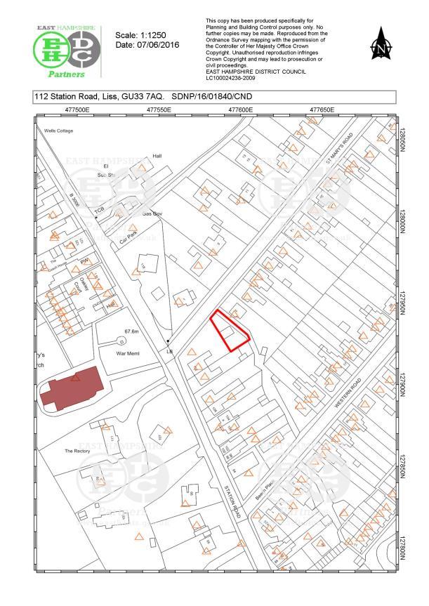
113
PART 1 EAST HAMPSHIRE DISTRICT COUNCIL SECTION 1 SCHEDULE OF APPLICATION RECOMMENDATIONS
 PART 1 EAST HAMPSHIRE DISTRICT COUNCIL PLANNING COMMITTEE REPORT OF THE HEAD OF PLANNING Applications to be determined by the Council as the Local Planning Authority SECTION 1 SCHEDULE OF APPLICATION RECOMMENDATIONS
26 September 2014 CONSULTATION EXPIRY : APPLICATION EXPIRY : 22 July 2014 SUMMARY RECOMMENDATION: PERMISSION
 Item No.: 5 The information, recommendations and advice contained in this report are correct as at the date of preparation, which is more than one week in advance of the Committee meeting. Because of the
Reference: 15/06961/RCU Received: 13th November 2015 Accepted: 17th November 2015 Ward: Coppetts Expiry 12th January 2016
 Location 91 Manor Drive London N20 0XD Reference: 15/06961/RCU Received: 13th November 2015 Accepted: 17th November 2015 Ward: Coppetts Expiry 12th January 2016 Applicant: Mr Christos Papadopoulos Proposal:
PLANNING COMMITTEE REPORT
 PLANNING COMMITTEE REPORT TO: BY: Planning Committee South Head of Development DATE: 19 December 2017 DEVELOPMENT: SITE: WARD: APPLICATION: APPLICANT: Conversion of existing water storage reservoir to
2014/0590 Reg Date 26/06/2014 Chobham
 2014/0590 Reg Date 26/06/2014 Chobham LOCATION: PROPOSAL: TYPE: APPLICANT: OFFICER: ASCOT PARK POLO CLUB, WESTCROFT PARK FARM, WINDLESHAM ROAD, CHOBHAM, WOKING, GU24 8SN Erection of a two storey detached
3 Abbey View Mill Hill London NW7 4PB
 Location 3 Abbey View Mill Hill London NW7 4PB Reference: 15/03203/HSE Received: 26th May 2015 Accepted: 16th June 2015 Ward: Mill Hill Expiry 11th August 2015 Applicant: Proposal: Mr Richard Benson Alterations
Ground Floor Flat 15 Redbourne Avenue London N3 2BP
 Location Ground Floor Flat 15 Redbourne Avenue London N3 2BP Reference: 17/4160/FUL Received: 28th June 2017 Accepted: 29th June 2017 Ward: West Finchley Expiry 24th August 2017 Applicant: Proposal: Mr
Mr & Mrs Connolly per Pump House Designs Pump House Yard The Green SEDLESCOMBE, East Sussex. TN33 0QA
 AGENDA ITEM NO: 5 (c) Report to: PLANNING COMMITTEE Date: 03 June 2015 Report from: Head of Housing and Planning Services Application Address: Proposal: Application No: Recommendation: Ward: File No: Applicant:
37 NAGS HEAD LANE BRENTWOOD ESSEX CM14 5NL
 SITE PLAN ATTACHED 37 NAGS HEAD LANE BRENTWOOD ESSEX CM14 5NL RAISE RIDGE, EXTEND HIPPED ROOF TO GABLE AND ADD SIDE DORMER WITH PART SINGLE PART TWO STOREY REAR EXTENSION INCORPORATING JULIETTE BALCONY
Case Officer: Sarah Kay File No: CHE/14/00515/REM Tel. No: (01246) Plot No: 2/6132 Ctte Date: 15 th September 2014 ITEM 1
 Plot No: 2/6132 Ctte Date: 15 th September 2014 ITEM 1") Case Officer: Sarah Kay File No: CHE/14/00515/REM Tel. No: (01246) 345786 Plot No: 2/6132 Ctte Date: 15 th September 2014 ITEM 1 APPROVAL OF RESERVED MATTERS FROM APPLICATION CHE/12/00234/OUT (1) LAYOUT,
Case Officer: Sarah Kay File No: CHE/14/00515/REM Tel. No: (01246) 345786 Plot No: 2/6132 Ctte Date: 15 th September 2014 ITEM 1 APPROVAL OF RESERVED MATTERS FROM APPLICATION CHE/12/00234/OUT (1) LAYOUT,
5 Gratton Terrace London NW2 6QE. Reference: 17/5094/HSE Received: 4th August 2017 Accepted: 7th August 2017 Ward: Childs Hill Expiry 2nd October 2017
 Location 5 Gratton Terrace London NW2 6QE Reference: 17/5094/HSE Received: 4th August 2017 Accepted: 7th August 2017 Ward: Childs Hill Expiry 2nd October 2017 Applicant: WSD (Gratton) Ltd Proposal: The
Reference: 16/1447/FUL Received: 7th March 2016 Accepted: 7th March 2016 Ward: East Finchley Expiry 2nd May 2016
 Location 374B Long Lane London N2 8JX Reference: 16/1447/FUL Received: 7th March 2016 Accepted: 7th March 2016 Ward: East Finchley Expiry 2nd May 2016 Applicant: Ms Katrin Hirsig Proposal: Single storey
PLANNING COMMITTEE. 14 October 2014
 AGENDA ITEM NO 8 PLANNING COMMITTEE 14 October 2014 APPLICATION NUMBER : CA//14/01744/FUL PROPOSAL : Extension and conversion of roof space of an existing detached bungalow together with enhanced parking
SOUTH CAMBRIDGESHIRE DISTRICT COUNCIL. Director of Development Services
 SOUTH CAMBRIDGESHIRE DISTRICT COUNCIL REPORT TO: Development and Conservation Control Committee 5 th April 2006 AUTHOR/S: Director of Development Services S/2290/05/F Haslingfield House (Revised Design)
49 Broughton Avenue London N3 3EN
 Location 49 Broughton Avenue London N3 3EN Reference: 17/3448/RCU Received: 30th May 2017 Accepted: 1st June 2017 Ward: Finchley Church End Expiry 27th July 2017 Applicant: Mr P Atwal Proposal: Erection
SOUTH CAMBRIDGESHIRE DISTRICT COUNCIL. Executive Director (Operational Services) Corporate Manager (Planning and New Communities)
 Corporate Manager (Planning and New Communities)") SOUTH CAMBRIDGESHIRE DISTRICT COUNCIL REPORT TO: Planning Committee 12 January 2011 AUTHOR/S: Executive Director (Operational Services) Corporate Manager (Planning and New Communities) Notes: S/1848/10
SOUTH CAMBRIDGESHIRE DISTRICT COUNCIL REPORT TO: Planning Committee 12 January 2011 AUTHOR/S: Executive Director (Operational Services) Corporate Manager (Planning and New Communities) Notes: S/1848/10
DEVELOPMENT MANAGEMENT REPORT
 ITEM A08-1 DEVELOPMENT MANAGEMENT REPORT TO: BY: DATE: DEVELOPMENT: SITE: WARD: APPLICATION: APPLICANT: Development Management Committee Development Manager Proposed live/work unit in connection with existing
3 Tretawn Gardens London NW7 4NP
 Location 3 Tretawn Gardens London NW7 4NP Reference: 16/7886/HSE Received: 12th December 2016 Accepted: 19th December 2016 Ward: Mill Hill Expiry 13th February 2017 Applicant: Proposal: Mr Murray Two storey
CA//17/02777/FUL. Scale 1:1,250. Planning Services Canterbury City Council Military Road Canterbury Kent CT1 1YW
 O CA//17/02777/FUL Scale 1:1,250 Map Dated: 15/03/2018 Planning Services Canterbury City Council Military Road Canterbury Kent CT1 1YW AGENDA ITEM NO 16 PLANNING COMMITTEE APPLICATION NUMBER: SITE LOCATION:
Report Author/Case Officer: Joanne Horner Contact Details:
 APP 04 Application Number: 16/00140/FUL Other Two storey side extension to existing dwelling and formation of hard standing to provide parking for number 54 (Resubmission of withdrawn application 15/02852/FUL)
PARISH / WARD: Peacehaven / Peacehaven East PROPOSAL:
 APPLICATION ITEM LW/16/0802 NUMBER: NUMBER: 7 APPLICANTS NAME(S): Mr J Robison & Ms S Teng PARISH / WARD: Peacehaven / Peacehaven East PROPOSAL: Planning Application for Conversion of existing garage to
PART 2 SOUTH DOWNS NATIONAL PARK AUTHORITY PLANNING COMMITTEE REPORT OF THE SERVICE MANAGER PLANNING DEVELOPMENT
 PART 2 SOUTH DOWNS NATIONAL PARK AUTHORITY PLANNING COMMITTEE REPORT OF THE SERVICE MANAGER PLANNING DEVELOPMENT Applications to be determined by the council on behalf of the South Downs National Park
2014/0943 Reg Date 06/11/2014 Lightwater
 2014/0943 Reg Date 06/11/2014 Lightwater LOCATION: PROPOSAL: TYPE: APPLICANT: OFFICER: LAND REAR OF 4, 6 & 8 MACDONALD ROAD, LIGHTWATER, GU18 5TN Erection of 2 linked-detached two storey dwellings with
PART 2 SOUTH DOWNS NATIONAL PARK AUTHORITY SECTION 1 SCHEDULE OF APPLICATION RECOMMENDATIONS
 42 PART 2 SOUTH DOWNS NATIONAL PARK AUTHORITY PLANNING COMMITTEE REPORT OF THE SERVICE MANAGER PLANNING DEVELOPMENT Applications to be determined by the council on behalf of the South Downs National Park
Garages To Rear Of The Willows 1025 High Road London N20 0QE
 Location Garages To Rear Of The Willows 1025 High Road London N20 0QE Reference: 15/03944/FUL Received: 25th June 2015 Accepted: 2nd July 2015 Ward: Totteridge Expiry 27th August 2015 Applicant: Mr Alex
DONCASTER METROPOLITAN BOROUGH COUNCIL. PLANNING COMMITTEE - 15th October Expiry Date:
 DONCASTER METROPOLITAN BOROUGH COUNCIL PLANNING COMMITTEE - 15th October 2013 Application 3 Application Number: 13/01158/FUL Application Expiry Date: 31st July 2013 Application Type: Full Application Proposal
REFERENCE: B/00601/12 Received: 11 February 2012 Accepted: 21 February 2012 WARD(S): High Barnet Expiry: 17 April 2012
: High Barnet Expiry: 17 April 2012") LOCATION: 37 Kings Road, Barnet, Herts, EN5 4EG REFERENCE: B/00601/12 Received: 11 February 2012 Accepted: 21 February 2012 WARD(S): High Barnet Expiry: 17 April 2012 Final Revisions: APPLICANT: PROPOSAL:
LOCATION: 37 Kings Road, Barnet, Herts, EN5 4EG REFERENCE: B/00601/12 Received: 11 February 2012 Accepted: 21 February 2012 WARD(S): High Barnet Expiry: 17 April 2012 Final Revisions: APPLICANT: PROPOSAL:
REFERENCE: B/03745/12 Received: 02 October 2012 Accepted: 05 October 2012 WARD(S): Totteridge Expiry: 30 November 2012.
: Totteridge Expiry: 30 November 2012.") LOCATION: 15A Pyecombe Corner, London, N12 7AJ REFERENCE: B/03745/12 Received: 02 October 2012 Accepted: 05 October 2012 WARD(S): Totteridge Expiry: 30 November 2012 Final Revisions: APPLICANT: PROPOSAL:
LOCATION: 15A Pyecombe Corner, London, N12 7AJ REFERENCE: B/03745/12 Received: 02 October 2012 Accepted: 05 October 2012 WARD(S): Totteridge Expiry: 30 November 2012 Final Revisions: APPLICANT: PROPOSAL:
CA//16/00504/FUL. Canterbury City Council Military Road Canterbury Kent CT1 1YW. Crown copyright and database rights 2016 Ordnance Survey
 O Scale 1:1,250 Map Dated: 09/05/2016 CA//16/00504/FUL Crown copyright and database rights 2016 Ordnance Survey 100019614 Canterbury City Council Military Road Canterbury Kent CT1 1YW AGENDA ITEM NO 13
Report Author/Case Officer: Paul Keen Senior Planning Officer (Dev Control) Contact Details:
 Contact Details:") APP 03 Application Number: 17/02060/FUL Description A full planning application for the demolition of an existing bungalow (C3 use class) and associated out buildings and the erection of two, two storey
APP 03 Application Number: 17/02060/FUL Description A full planning application for the demolition of an existing bungalow (C3 use class) and associated out buildings and the erection of two, two storey
Ward: West Wittering. Proposal Change of use from public highway pavement to residential garden use.
 Parish: West Wittering Ward: West Wittering WW/17/03295/FUL Proposal Change of use from public highway pavement to residential garden use. Site Izora 1 Watersedge Gardens West Wittering PO20 8RA Map Ref
18 Birkbeck Road London NW7 4AA. Reference: 15/02994/HSE Received: 14th May 2015 Accepted: 26th May 2015 Ward: Mill Hill Expiry 21st July 2015
 Location 18 Birkbeck Road London NW7 4AA Reference: 15/02994/HSE Received: 14th May 2015 Accepted: 26th May 2015 Ward: Mill Hill Expiry 21st July 2015 Applicant: Proposal: Mrs Tania Kallis Single storey
Application Recommended for Approval Hapton with Park Ward
 Application Recommended for Approval Hapton with Park Ward APP/2017/0036 Outline Planning Application Outline application for the construction of a new 3 bedroom dwelling (with all matters reserved for
Rev John Withy, Sion House, 120 Melmount Road, Sion Mills
 Derry City and Strabane District Council Planning Committee Report COMMITTEE DATE: 4 th October 2017 APPLICATION No: APPLICATION TYPE: PROPOSAL: LOCATION: APPLICANT: AGENT: LA11/2016/0701/F Full Retrospective
Perth and Kinross Council Development Management Committee 24 April 2013 Report of Handling by Development Quality Manager
 Perth and Kinross Council Development Management Committee 24 April 2013 Report of Handling by Development Quality Manager Alterations,Carpenter House, Carpenter Street, Perth, PH1 5GB Ref. No: 13/00303/FLL
1 The development hereby permitted shall be carried out in accordance with the following approved plans:
 Location 59 Greenway Close London N20 8ES Reference: 16/00011/HSE Received: 30th December 2015 Accepted: 7th January 2016 Ward: Totteridge Expiry 3rd March 2016 Applicant: Mr Ankit Shah Proposal: Part
3(iv)(b) TCP/11/16(29)
(b) TCP/11/16(29)") 3(iv)(b) TCP/11/16(29) TCP/11/16(29) Planning Application 09/02229/AML Erection of a dwellinghouse, garage with upper floor accommodation and stables (Approval of Matters Specified by Conditions) at land
3(iv)(b) TCP/11/16(29) TCP/11/16(29) Planning Application 09/02229/AML Erection of a dwellinghouse, garage with upper floor accommodation and stables (Approval of Matters Specified by Conditions) at land
Tennis Court Rear Of 3-5 Corringway London NW11 7ED
 Location Tennis Court Rear Of 3-5 Corringway London NW11 7ED Reference: 18/4122/FUL Received: 3rd July 2018 Accepted: 3rd July 2018 Ward: Garden Suburb Expiry 28th August 2018 Applicant: Ms Sarah Robinson
Derry City and Strabane District Council Planning Committee Report
 Derry City and Strabane District Council Planning Committee Report COMMITTEE DATE: 29 th November 2017 APPLICATION No: APPLICATION TYPE: PROPOSAL: LOCATION: APPLICANT: AGENT: LA11/2016/0854/O Outline Shared
Persimmon Homes Thames Valley Date received: 2 nd April week date(major): 2 nd July 2014 Ward: Nascot
: 2 nd July 2014 Ward: Nascot") PART A Report of: DEVELOPMENT MANAGEMENT SECTION HEAD Date of Committee: 26 th June 2014 Site address: Rounton, 28, Nascot Wood Road Reference Number: 14/00497/REM Description of Development: Reserved
PART A Report of: DEVELOPMENT MANAGEMENT SECTION HEAD Date of Committee: 26 th June 2014 Site address: Rounton, 28, Nascot Wood Road Reference Number: 14/00497/REM Description of Development: Reserved
+ Cllr Ken Pedder - Chairman + Cllr Cathie Whitcroft - Vice-Chairman
 1 + Cllr Ken Pedder - Chairman + Cllr Cathie Whitcroft - Vice-Chairman MINUTES OF A MEETING OF THE COMMITTEE held at Surrey Heath House, Camberley on 16 th October 2006 + Cllr Bill Chapman - Cllr Pat Pearce
Derry City and Strabane District Council Planning Committee Report
 Derry City and Strabane District Council Planning Committee Report COMMITTEE DATE: 23 rd March 2016 APPLICATION No: APPLICATION TYPE: PROPOSAL: LOCATION: APPLICANT: LA11/2015/0395/F Residential Development
DEMOLITION OF EXISTING BUNGALOW AND REPLACEMENT BUNGALOW. Ms Sukhi Dhadwar
 SITE PLAN ATTACHED 04. HIGH POINT BEGGAR HILL FRYERNING ESSEX CM4 0PN DEMOLITION OF EXISTING BUNGALOW AND REPLACEMENT BUNGALOW. APPLICATION NO: 15/00315/FUL WARD Ingatestone, Fryerning & Mountnessing 8/13
Reference: 16/1234/HSE Received: 25th February 2016 Accepted: 2nd March 2016 Ward: High Barnet Expiry 27th April 2016
 Location 7 Sunset View Barnet EN5 4LB Reference: 16/1234/HSE Received: 25th February 2016 Accepted: 2nd March 2016 Ward: High Barnet Expiry 27th April 2016 Applicant: Proposal: Mr & Mrs Peter & Anny Woodhams
Parish of Repton NEIGHBOURHOOD DEVELOPMENT PLAN
 Parish of Repton NEIGHBOURHOOD DEVELOPMENT PLAN BASIC CONDITIONS STATEMENT December 2018 CEF 4 Legal Requirements This statement has been produced by the NDP Working Group on behalf of Repton Parish Council
SOUTH CAMBRIDGESHIRE DISTRICT COUNCIL. Planning and New Communities Director
 SOUTH CAMBRIDGESHIRE DISTRICT COUNCIL REPORT TO: Planning Committee 5 June 2013 AUTHOR/S: Planning and New Communities Director S/0747/13/FL HISTON Construction of Car Park at Histon Baptist Church, Station
PLANNING COMMITTEE 15 September 2015
 AGENDA ITEM NO 12 PLANNING COMMITTEE 15 September 2015 APPLICATION NUMBER : CA//15/01402/FUL PROPOSAL : Single-storey conservatory to rear. LOCATION OF SITE : 5 Mill Lane, Herne, CT6 7ED APPLICATION TYPE
Test Valley Borough Council Southern Area Planning Committee 8 January 2019
 ITEM 11 APPLICATION NO. 18/02218/FULLS APPLICATION TYPE FULL APPLICATION - SOUTH REGISTERED 23.08.2018 APPLICANT Rugby Football Union SITE The Trojans Club, Stoneham Lane, Eastleigh, SO50 9HT, CHILWORTH
Plumpton Neighbourhood Development Plan Revised Pre Submission Document - Regulation 14 Consultation
 REPRESENTATIONS... Plumpton Parish Council Plumpton Neighbourhood Development Plan Revised Pre Submission Document - Regulation 14 Consultation Representations submitted on behalf of: Cala Homes (South
SOUTH CAMBRIDGESHIRE DISTRICT COUNCIL. Planning and New Communities Director. Linton. Yes
 SOUTH CAMBRIDGESHIRE DISTRICT COUNCIL REPORT TO: Planning Committee 2 July 2014 AUTHOR/S: Planning and New Communities Director Application Number: Parish(es): Proposal: Site address: Applicant(s): Recommendation:
1 The development hereby permitted shall be carried out in accordance with the following approved plans:
 Location The Avenue Tennis Club The Avenue London N3 2LE Reference: 16/6509/FUL Received: 10th October 2016 Accepted: 10th October 2016 Ward: Finchley Church End Expiry 5th December 2016 Applicant: Mrs
Planning and Regulatory Committee 20 May Applicant Local Councillor Purpose of Report
 Planning and Regulatory Committee 20 May 2014 7. APPLICATION FOR PLANNING PERMISSION FOR THE CARRYING-OUT OF DEVELOPMENT PURSUANT TO PLANNING PERMISSION REFERENCE NUMBER 603451 DATED 28 FEBRUARY 2007 WITHOUT
DEVELOPMENT MANAGEMENT REPORT
 ITEM A07-1 DEVELOPMENT MANAGEMENT REPORT TO: BY: Development Management Committee (South) Development Manager DATE: 21 June 2016 DEVELOPMENT: SITE: WARD: APPLICATION: APPLICANT: Outline application for
SOUTH CAMBRIDGESHIRE DISTRICT COUNCIL. Director of Development Services
 SOUTH CAMBRIDGESHIRE DISTRICT COUNCIL REPORT TO: Development and Conservation Control Committee 1 st June 2005 AUTHOR/S: Director of Development Services S/0743/05/F - Great Shelford Extension and Conversion
Brookside Walk Children's Play Area, London, NW4
 LOCATION: Brookside Walk Children's Play Area, London, NW4 REFERENCE: H/05584/13 Received: 26 November 2013 Accepted: 11 December 2013 WARD(S): Hendon Expiry: 05 February 2014 Final Revisions: APPLICANT:
Perth and Kinross Council Development Management Committee 20 February 2013 Report of Handling by Development Quality Manager
 Perth and Kinross Council Development Management Committee 20 February 2013 Report of Handling by Development Quality Manager 4(4)(iii) 13/81 Erection of sports hall, associated changing facilities, offices
6B Bertram Road London NW4 3PN
 Location 6B Bertram Road London NW4 3PN Reference: 16/6621/RCU Received: 14th October 2016 Accepted: 19th October 2016 Ward: West Hendon Expiry 14th December 2016 Applicant: Proposal: Ms Kavita Singh Erection
Change Paper / Date CAIRNGORMS NATIONAL PARK AUTHORITY
 Change Paper / Date CAIRNGORMS NATIONAL PARK AUTHORITY Title: Prepared by: REPORT ON CALLED-IN PLANNING APPLICATION FIONA MURPHY (PLANNING OFFICER DEVELOPMENT MANAGEMENT) DEVELOPMENT PROPOSED: REFERENCE:
LONGDEN VILLAGE DEVELOPMENT STATEMENT
 LONGDEN VILLAGE DEVELOPMENT STATEMENT 2017-2027 1 Longden Development Statement 2017-2027 15/01/18 1. Background 1.1 Longden Village Longden village is a very rural and traditional community first mentioned
PLANNING COMMITTEE REPORT
 PLANNING COMMITTEE REPORT TO: BY: Planning Committee South Head of Development DATE: 21 August 2018 DEVELOPMENT: SITE: WARD: APPLICATION: APPLICANT: Erection of a new chalet bungalow with associated parking
SOUTH CAMBRIDGESHIRE DISTRICT COUNCIL. Planning and New Communities Director
 SOUTH CAMBRIDGESHIRE DISTRICT COUNCIL REPORT TO: Planning Committee 9 January 2013 AUTHOR/S: Planning and New Communities Director S/2064/12/FL WATERBEACH Demolition of existing 35 no. shared amenity apartments
Schedule of Planning Applications Committee Date: 23 May Reference: 06/17/0726/F Parish: Hemsby Officer: Mr J Beck Expiry Date:
 Schedule of Planning Applications Committee Date: 23 May 2018 Reference: 06/17/0726/F Parish: Hemsby Officer: Mr J Beck Expiry Date: 22-05-2018 Applicant: Proposal: Site: Mr Gillett Change of use to the
SOUTH CAMBRIDGESHIRE DISTRICT COUNCIL. Executive Director (Operational Services)/ Corporate Manager (Planning and New Communities)
/ Corporate Manager (Planning and New Communities)") SOUTH CAMBRIDGESHIRE DISTRICT COUNCIL REPORT TO: Planning Committee 6 July 2011 AUTHOR/S: Executive Director (Operational Services)/ Corporate Manager (Planning and New Communities) S/0226/11 - TOFT Erection
SOUTH CAMBRIDGESHIRE DISTRICT COUNCIL REPORT TO: Planning Committee 6 July 2011 AUTHOR/S: Executive Director (Operational Services)/ Corporate Manager (Planning and New Communities) S/0226/11 - TOFT Erection
MINUTES OF THE PLANNING COMMITTEE MEETING HELD MONDAY 19 TH JANUARY PM BURBAGE MILLENNIUM HALL
 55 MINUTES OF THE PLANNING COMMITTEE MEETING HELD MONDAY 19 TH JANUARY 2015 7PM BURBAGE MILLENNIUM HALL Present: Cllr Mrs M Lynch (in the chair) Cllrs Mr S Deeming, Mr R Flemming, Mr P Hall, Mr K Lynch,
Derry City and Strabane District Council Planning Committee Report
 Derry City and Strabane District Council Planning Committee Report COMMITTEE DATE: 20.12.2017 APPLICATION No: APPLICATION TYPE: PROPOSAL: LOCATION: APPLICANT: AGENT: A/2014/0495/F Full Construction of
Ward: Southbourne. White Croft 14 Breach Avenue Southbourne West Sussex PO10 8NB
 Parish: Southbourne Ward: Southbourne Proposal Site SB/15/01827/FUL Erection of a detached chalet bungalow. White Croft 14 Breach Avenue Southbourne West Sussex PO10 8NB Map Ref (E) 477023 (N) 106593 Applicant
Planning Committee 04/02/2015 Schedule Item 6. Smith Farm Estate, Old Bridge Close, Northolt, UB5 6UA.
 Planning Committee 04/02/2015 Schedule Item 6 Ref: Address: Ward: Proposal: PP/2014/5145 Smith Farm Estate, Old Bridge Close, Northolt, UB5 6UA. Greenford Broadway Installation of sports pitch, reconstruction
PLANNING COMMITTEE REPORT
 PLANNING COMMITTEE REPORT TO: BY: Planning Committee South Development Manager DATE: 17 January 2017 DEVELOPMENT: SITE: WARD: APPLICATION: APPLICANT: Change of use of land to caravan site for stationing
PLANNING COMMITTEE REPORT
 PLANNING COMMITTEE REPORT TO: BY: Planning Committee South Head of Development DATE: 20 March 2018 DEVELOPMENT: SITE: WARD: APPLICATION: APPLICANT: Proposed erection of 2 no. 3-bedroom dwellings and conversion
Applicant s partner is an employee of the Council COMMITTEE TO DETERMINE
 Item No. 13 APPLICATION NUMBER CB/13/02360/FULL LOCATION Land adj to 2 Sandy Lane, Leighton Buzzard, LU7 3BE PROPOSAL Demolition of existing garages & construction of a new 2 bed bungalow, together with
Cookham Parish Council s Response to The Draft Local Borough Plan
 Cookham Parish Council s Response to The Draft Local Borough Plan As Agreed at the Planning Committee Meeting on 10 th January 2017. Designation of Poundfield as a Local Green Space The Parish Council
APP/G1630/W/15/
 Appeal Decision Site visit made on 20 October 2015 by William Fieldhouse BA (Hons) MA MRTPI an Inspector appointed by the Secretary of State for Communities and Local Government Decision date: 20 November
Land Adj. 63 Sunny Bank Road, Sutton Coldfield, Birmingham, B73 5RJ
 Committee Date: 11/07/2013 Application Number: 2013/03520/PA Accepted: 20/05/2013 Application Type: Full Planning Target Date: 15/07/2013 Ward: Sutton Vesey Land Adj. 63 Sunny Bank Road, Sutton Coldfield,
APPLICATION ITEM LW/17/0325 NUMBER: NUMBER: 8 APPLICANTS. PARISH / Peacehaven / P L Projects NAME(S):
:") APPLICATION ITEM LW/17/0325 NUMBER: NUMBER: 8 APPLICANTS PARISH / Peacehaven / P L Projects NAME(S): WARD: Peacehaven North Planning Application for Demolition of the existing bungalow and PROPOSAL: erection
APPLICATION ITEM LW/17/0325 NUMBER: NUMBER: 8 APPLICANTS PARISH / Peacehaven / P L Projects NAME(S): WARD: Peacehaven North Planning Application for Demolition of the existing bungalow and PROPOSAL: erection
Ullswater Court 92 Holders Hill Road London NW4 1LN
 Location Ullswater Court 92 Holders Hill Road London NW4 1LN Reference: 17/5396/CON Received: 18th August 2017 Accepted: 18th August 2017 Ward: Finchley Church End Expiry 13th October 2017 Applicant: IBSA
Harrow Lane, St Leonards-on-Sea, East Sussex, TN37 7JZ ERECTION OF 113 DWELLINGS TOGETHER WITH ESTATE ROADS (DETAILED SUBMISSION)
") AGENDA ITEM NO: Report to: PLANNING BOARD Date: 10 September, 2003 Report from: Borough Planning Officer Application Address: Proposal: Application No: Recommendation: Ward: File No: Applicant: Interest:
AGENDA ITEM NO: Report to: PLANNING BOARD Date: 10 September, 2003 Report from: Borough Planning Officer Application Address: Proposal: Application No: Recommendation: Ward: File No: Applicant: Interest:
PLANNING DECISION NOTICE
 PLANNING DECISION NOTICE TOWN AND COUNTRY PLANNING ACT, 1990 Applicant WILLITON VILLAGE HALL STEERING COMM. C/O ALISON CALLOWWAY 54 NORTHCROFT WILLITON TAUNTON TA4 4RT Date Registered 11/08/2006 Application
Development in the Green Belt
 Supplementary Planning Document: Development in the Green Belt Consultation Draft February 2013 Local Development Framework How to comment This document was published on 21st March 2013 and comments should
Site Location Plan. Land on the North West of Epsom Road Waddon Croydon. 1 : A4 September The. Waddon. Waddon.
 138 140 44.3m MP 11.5 El Sub Sta EPSOM ROAD 13 Bank 1 to 5 154 Trough 19to21 1 to 5 156 The Waddon (PH) 23 FB Waddon Station 45.0m Posts 29to31 1 to 9 Stafford Court 39 37 Meridian Court 10 43 to 45 1
DELEGATED DECISION on 1st September 2015
 Application N o : 14/04810/OUT LONDON BOROUGH OF BROMLEY TOWN PLANNING RENEWAL AND RECREATION DEPARTMENT DELEGATED DECISION on 1st September 2015 14/04810/OUT Claire Harris 4 Oaklands Road Bromley BR1
INTRODUCTION CURRENT APPLICATION
 05/01805/FUL & 05/01807/LBC ERECTION OF A SINGLE DWELLING HOUSE WITH ANCILLARY ACCOMMODATION AT Flamingo Zoological Gardens, Olney Road, Weston Underwood FOR Mr A J Crowther (as amended by letter dated
PLANNING COMMITTEE DATE: 07/09/2015 REPORT OF THE SENIOR MANAGER PLANNING AND ENVIRONMENT SERVICE CAERNARFON. Number: 4
 Number: 4 Application Number: C15/0034/37/LL Date Registered: 21/05/2015 Application Type: Full - Planning Community: Llanaelhaearn Ward: Llanaelhaearn Proposal: Location: Summary of the Recommendation:
an Inspector appointed by the Secretary of State for Communities and Local Government Decision date: 13 February 2018
 Appeal Decision Site visit made on 23 January 2018 by Stephen Hawkins MA MRTPI an Inspector appointed by the Secretary of State for Communities and Local Government Decision date: 13 February 2018 Appeal
2015/1020 Mr Edward Cockburn Caravan storage on hardcore base (Retrospective) Ranah Stones, Whams Road, Hazlehead, Sheffield, S36 4HT
 Ranah Stones, Whams Road, Hazlehead, Sheffield, S36 4HT") 2015/1020 Mr Edward Cockburn Caravan storage on hardcore base (Retrospective) Ranah Stones, Whams Road, Hazlehead, Sheffield, S36 4HT Dunford Parish Council have not commented Councillor Andrew Millner
2015/1020 Mr Edward Cockburn Caravan storage on hardcore base (Retrospective) Ranah Stones, Whams Road, Hazlehead, Sheffield, S36 4HT Dunford Parish Council have not commented Councillor Andrew Millner
MID SUFFOLK DISTRICT COUNCIL
 SA/17/01 MID SUFFOLK DISTRICT COUNCIL Minutes of the Meeting of the MID SUFFOLK DEVELOPMENT CONTROL COMMITTEE B held at the Council Chamber, Mid Suffolk District Council Offices, High Street, Needham Market
an Inspector appointed by the Secretary of State for Communities and Local Government
 Appeal Decision Site visit made on 11 October 2016 by Mike Hayden BSc DipTP MRTPI an Inspector appointed by the Secretary of State for Communities and Local Government Decision date: 21 November 2016 Appeal
LOCATION: 592 Finchley Road, London, NW11 7RX REFERENCE: F/03977/12 Received: 22 October 2012 Accepted: 29 November 2012 WARD(S): Childs Hill Expiry:
: Childs Hill Expiry:") LOCATION: 592 Finchley Road, London, NW11 7RX REFERENCE: F/03977/12 Received: 22 October 2012 Accepted: 29 November 2012 WARD(S): Childs Hill Expiry: 24 January 2013 Final Revisions: APPLICANT: Mr S Kapoor
LOCATION: 592 Finchley Road, London, NW11 7RX REFERENCE: F/03977/12 Received: 22 October 2012 Accepted: 29 November 2012 WARD(S): Childs Hill Expiry: 24 January 2013 Final Revisions: APPLICANT: Mr S Kapoor
STATEMENT OF OBJECTION TO THE PROPOSED DEVELOPMENT OF LAND AT CHURCH CLIFF DRIVE FILEY
 STATEMENT OF OBJECTION TO THE PROPOSED DEVELOPMENT OF LAND AT CHURCH CLIFF DRIVE FILEY You will be aware that Scarborough borough council have adopted a new local plan that includes land at Church Cliff
UPPER GORDON ROAD TO CHURCH HILL, CAMBERLEY CONSERVATION AREA
 Introduction This leaflet explains the purpose of conservation areas and the implication of their designation for residents, property owners and the Council. It provides you with a plan of the area and
1. The application was not subject to any pre-application discussion with a planning officer.
 MID SUFFOLK DISTRICT COUNCIL DEVELOPMENT CONTROL COMMITTEE - 17 August 2016 AGENDA ITEM NO APPLICATION NO PROPOSAL SITE LOCATION SITE AREA (Ha) APPLICANT RECEIVED EXPIRY DATE 2 1822/16 Change of use of
Outh SOUTH CAMBRIDGESHIRE DISTRICT COUNCIL. Joint Director for Planning and Economic Development S/0179/18/OL. Histon. Approval.
 Outh SOUTH CAMBRIDGESHIRE DISTRICT COUNCIL REPORT TO: Planning Committee 4 April 2018 AUTHOR/S: Joint Director for Planning and Economic Development Application Number: Parish(es): Proposal: Site address:
Called-in by Cllr Richard Stay for the following reasons: DETERMINE. Application recommended for refusal
 Item No. 13 APPLICATION NUMBER CB/15/00275/OUT LOCATION Prebendal Farm, Grove Road, Slip End, Luton, LU1 4BZ PROPOSAL Outline Development: Redevelopment of land previously used as a farm yard to residential
Site: Essex Police & La Plata House London Road Brentwood Essex CM14 4QJ
 Reference: 16/01805/OUT Ward: Brentwood West Site: Essex Police & La Plata House London Road Brentwood Essex CM14 4QJ Proposal: Outline application for demolition of existing police station buildings,
an Inspector appointed by the Secretary of State for Communities and Local Government
 Appeal Decision Site visit made on 6 November 2017 by Rachel Walmsley BSc MSc MA MRTPI an Inspector appointed by the Secretary of State for Communities and Local Government Decision date: 19 th January
PLANNING COMMITTEE REPORT
 PLANNING COMMITTEE REPORT TO: BY: Planning Committee South Head of Development DATE: 15 May 2018 DEVELOPMENT: SITE: WARD: APPLICATION: APPLICANT: Proposed erection of 2 no. 3-bedroom dwellings and conversion
LONDON BOROUGH OF WALTHAM FOREST
 LONDON BOROUGH OF WALTHAM FOREST Committee/Date: Planning 5th December 2006 Application reference: Applicant: Location: Proposed development: Wards affected: Appendices: 2006/1330/OUT Mr Z Ahmed Nita Villa
Ward: Southbourne. Outline application with all matters reserved. Erection of 5 no. dwellings and associated works.
 Parish: Southbourne Ward: Southbourne SB/16/00205/OUT Proposal Site Outline application with all matters reserved. Erection of 5 no. dwellings and associated works. Dunkirk South Lane Southbourne Emsworth
Description Details submitted pursuant to discharge of condition 5 (Design Code) attached to planning permission 13/01729/OUT.
 attached to planning permission 13/01729/OUT.") ITEM 9 Application Number: 18/00266/DISCON Description Details submitted pursuant to discharge of condition 5 (Design Code) attached to planning permission 13/01729/OUT. AT The Point, 602 Midsummer Boulevard,
ITEM 9 Application Number: 18/00266/DISCON Description Details submitted pursuant to discharge of condition 5 (Design Code) attached to planning permission 13/01729/OUT. AT The Point, 602 Midsummer Boulevard,
Final Revisions: Provision of single storey modular classroom and associated works.
 LOCATION: St Catherines Catholic Primary School, Vale Drive, Barnet, Herts, EN5 2ED REFERENCE: B/01924/12 Received: 17 May 2012 Accepted: 28 May 2012 WARD(S): Underhill Expiry: 23 July 2012 Final Revisions:
an Inspector appointed by the Secretary of State for Communities and Local Government
 Appeal Decision Site visit made on 23 January 2017 by Gareth Wildgoose BSc (Hons) MSc MRTPI an Inspector appointed by the Secretary of State for Communities and Local Government Decision date: 6 February