SHAFTESBURY GROVE, STOKES VALLEY PROPOSED PLAN CHANGE
|
|
|
- Estella Stevens
- 5 years ago
- Views:
Transcription
1

2 SHAFTESBURY GROVE, STOKES VALLEY PROPOSED PLAN CHANGE Hutt City Council wishes to change the zone of an area of land off Shaftesbury Grove, Stokes Valley. The site is located on a west-facing hillside in Hutt Valley, running between Eastern Hutt Road on the floor of the valley and Shaftesbury Grove on the ridgeline at the top edge of Stokes Valley. It is currently within the General Recreation Activity Area of the District Plan and Council proposes to change the zone to a Residential Activity Area to facilitate future development. Plans have been prepared which show two potential development options for the site. This assessment considers the potential effects of this existing recreational land being used for residential purposes by identifying the potential landscape and visual amenity effects associated with the plan change. 1. LANDSCAPE CONTEXT Residential development in the Hutt Valley is largely concentrated on the valley floor and the lower slopes of the hills to the west. Due to their slope and aspect, these western hills are well vegetated, with houses are set into a matrix of trees and shrubs. The eastern hills in contrast are steeper, more exposed to sun and the prevailing winds and have taken longer to progress through the revegetation process from pasture to gorse and finally to native bush cover. There is now established native vegetation in the sheltered gullies and on-going natural regeneration on the lower slopes. Once a feature of the eastern hills, gorse is visually prominent only on the more exposed front spurs and ridges. The result is a distinctive pattern of light and dark cover that highlights the underlying landform. At the time of the site visit, the gorse was in flower and the pattern of vegetation was more pronounced. Refer Figure W, 001 Landscape Assessment
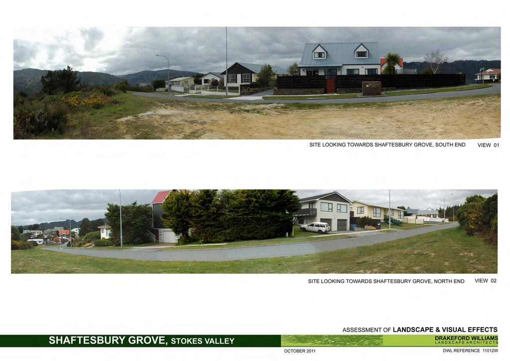
3 Development up out of the valley floor onto the eastern hill slopes is limited, with only industrial/commercial development in Page Grove off Eastern Hutt Road and Taita College playing fields and buildings on the lower slopes visible from across the valley. Residential development tends to be on the flat, on the floor of the Hutt Valley or tucked into smaller valleys and screened by the landform. There is no settlement on the higher slopes and ridges of Eastern Hills from Seaview through to Taita until Stokes Valley. At this point, somewhere north of Naenae where a large spur splits off the main hills and runs in a northerly direction down to the river, the ridgeline drops, the hills are less steep and the land more accessible. Houses in Shaftesbury Grove are the first built development on this ridgeline, followed by the Aldersgate Grove development down onto the hillside. From this point residential development becomes more visible, extending north on Holborn Drive along the ridgeline, clustered on the broad tops of the front spurs and finally spreading across the hillside on the streets of Manor Drive, Lord Street, Robson Street, Kingsley Street at the entrance to the Stokes Valley suburb. The ridgeline, from Stokes Valley Road through to Taita is characterised by clusters of mature pine trees which break up the line of the landform and the bulk and location of built development. Stokes Valley Stokes Valley is set into the eastern hills in a valley orientated to the north. The hills that separate Stokes Valley and Hutt Valley are relatively low and the eastern ridgeline is at a higher elevation. Built development is contained largely at the entrance and within the valley. To the east, housing is located on the lower slopes of the hills; to the west, houses have spread up to and over the ridgeline. Holborn Drive runs along this ridgeline to the intersection with Shaftesbury Grove. At this point Holborn Drive turns into Logie Street and descends down the hillside into Stokes Valley. Shaftesbury Grove continues up the ridgeline. There are houses on both sides of Holborn Drive with a number of cul-de-sacs and driveways extending built development down the west facing slopes with views out over the Hutt Valley to the Western Hills, Wellington Harbour and the more distant Kaikoura Ranges. After Aldersgate Grove, the landform to the west becomes steeper and falls abruptly away into a gully. Shaftesbury Grove has been developed on one side, on the easier slopes to the east, although further development to the west was anticipated. Prior to 1991 the District Plan showed subdivision extending up the ridgeline with a cul-de-sac named Muswell Grove on the major spur within the site and another two cul-de-sacs further to the south. This never proceeded though the Muswell Grove cul-de-sac is shown as formed on a number of road maps. A large area of land along the ridgeline south of Shaftesbury Grove is zoned Hill Residential. It is currently undeveloped although indicative layout plans have been drawn up for possible subdivision and an existing unsealed road provides access further up the ridgeline. Plan options indicate potential for a further three to seven residential lots on the western side of the ridgeline. Shaftesbury Grove Shaftesbury Grove was developed in the late 1970 s and early 1980 s and consists of eleven properties. All properties are located on the eastern side of the street. Houses are a mix of single, split level and two storey dwellings, mostly set close to street with outdoor living to the rear of the property. There are two houses on back lots. Refer Appendix 1, View 1 & W, 001 Landscape Assessment

4 2. THE SITE The site of the proposed plan change is an area of land approximately 16,700m ² and legally described as Pt Section 862. It is located on the western side of Shaftesbury Grove where the hill slopes are folded and corrugated into a series of spurs and gullies. Within the wider landform context, the land can be broadly described as a steep gully contained between two prominent spurs, one with Aldersgate Grove running down the crest, and one off-set from Fenchurch Grove. Refer Figure 2. Looking at the site in detail, the larger gully is partially divided by a low spur off the ridgeline and there is a small but equally steep gully to the south. In views from the floor of the Hutt Valley the underlying geomorphology is made legible by the vegetation cover, with established native bush in the gully, two to three metre high gorse/kanuka mix on the exposed west facing spurs and regenerating bush overtaking the gorse on the south and east facing slopes. The remnant clusters of pine trees just below the road have subsequently seeded and established themselves in the damper and less exposed gullies. Views from the Shaftesbury Grove street are also dictated by the landform: where the land drops away steeply, there are direct views down to bush in the gullies; where the ridgeline is broad and the land is flatter, roadside vegetation blocks views to the western hills. The clumps of mixed age pine trees create a dense but intermittent screen for views over the site. A preliminary geotechnical report notes that the bulk of the 16,700m² site is unsuitable for development. The site is typically too steep for development (30-40 degrees), however, two flat to moderately steep (0-20 degrees) spurs branch west 11012W, 001 Landscape Assessment
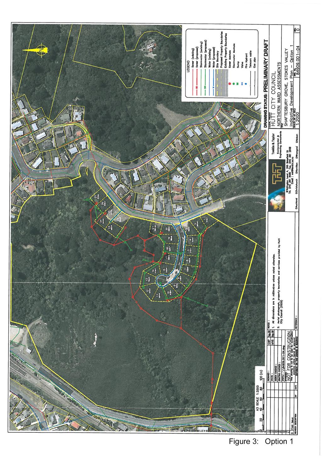
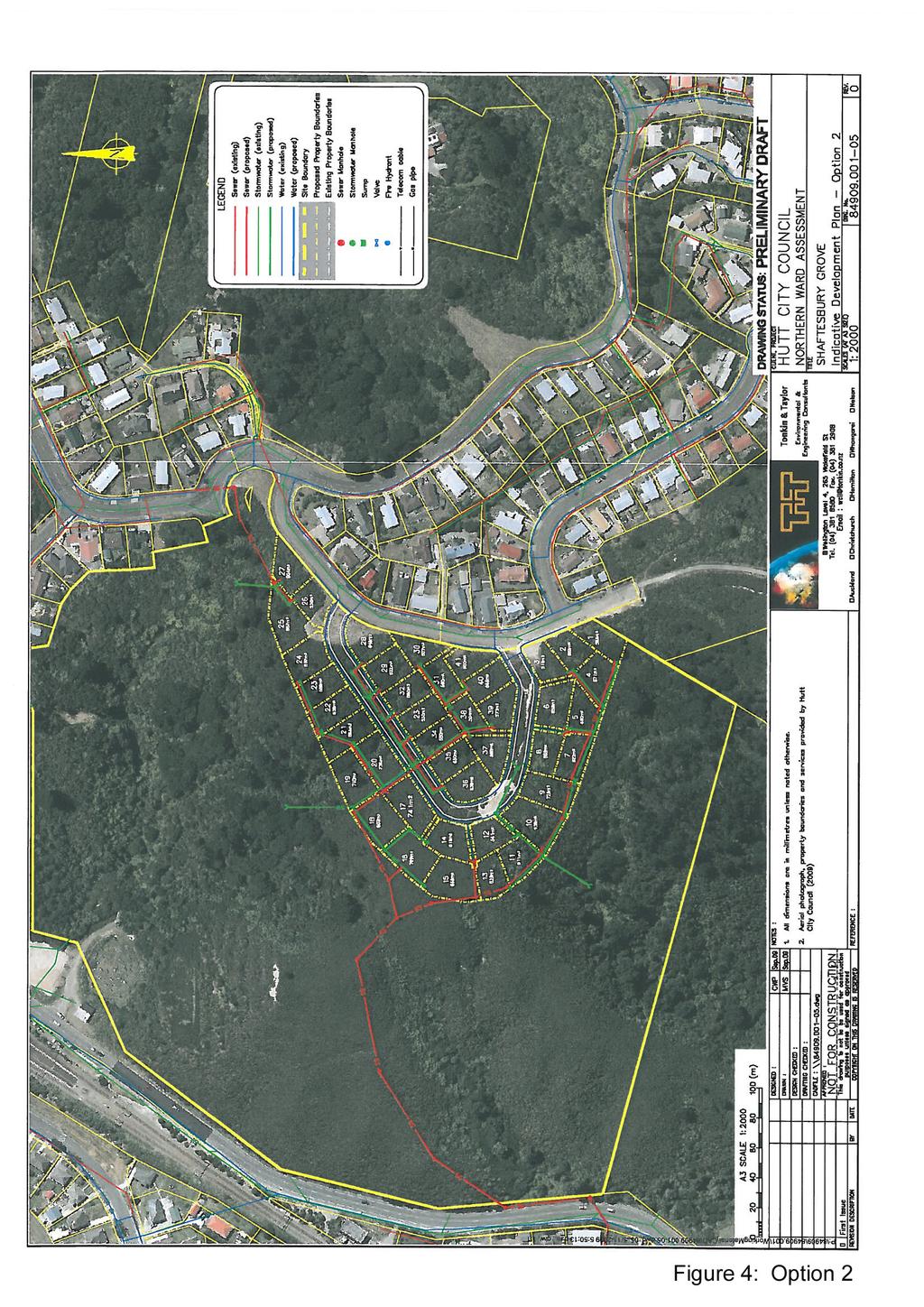
5 from the ridgeline. 1 These two spurs are visible from the street in the form of flat, open, grassed areas, one opposite 3 Shaftesbury Grove and the other opposite 10 Shaftesbury Grove. 3. THE PROPOSAL Two indicative development plans were proposed by Tonkin and Taylor in a preliminary land development assessment in November Refer Appendix 2, Figures 3 & 4 Option 1: a 27-lot residential subdivision based around the two flat to moderately steep spurs on the site. Access to each of the lots on the southern spur (lots 1-21) would be from a new cul-de-sac road. Access to the lots on the northern spur (lots 23-27) would be directly from Shaftesbury Grove. Lots in Option 1 are confined to the tops of the spurs which can be built on with only minor surface preparation. Residential development on areas towards the edge of the spurs would require excavation and retaining or battering of upslope cuts. The back boundaries of north facing lots at the end of the cul-de-sac extend down the hillside to about 120m elevation. Vegetation on these lots is mainly a 2-3m high mix of gorse and emergent bush. On southern side where the land is steeper, back boundaries extend further down to 110m elevation and cut into the bushline. Lots 23 and 24, which are back sections accessed from Shaftesbury Grove, extend into more mature bush in the gully. Option 2: the filling of the gully between the two spurs to allow a 41-lot subdivision. Access would be from a loop road off Shaftesbury Grove. Option 2 would require a substantial fill batter. No detail has been provided on the height of the batter however it allows the subdivision to extend further down the hillside than Option 1, by up to 10m (in elevation). The gully will be filled in, with the base of the fill batter at about 90m elevation. Lots at the end of the main spur are covered in a 2-3m high mix of gorse and emergent bush. Lots to the north extend down to 110m elevation with extensive cuts into existing bush. Lots on the steeper slopes to the south extend to 90m elevation and cut further into the bushline than those in a similar location in Option 1. The indicative plans propose allotments that are larger that the 400sqm and 13m wide minimum standard of the General Residential Activity Area in the District Plan. Allotments in both Options are a minimum 500 m², with the majority of them requiring only minor earthworks to form a 10x15m building platform. 2 1 Page 3, Preliminary Geotechnical Suitability Assessment, Shaftesbury Grove. Tonkin & Taylor Ltd. August Option 1 has 27 lots in total. 16 of them require minor earthworks to construct the building platform, and 11 require 1.5m retaining walls and battered slopes to stabilize uphill cuts W, 001 Landscape Assessment

6 4. LANDSCAPE EFFECTS Both Options require the clearance of vegetation from the site. Option 2 covers a larger area, has back lots that extend further into the bush in the side gullies and will require additional vegetation removal of mature bush in the area of the fill batter. Provision of services will also have an impact on the vegetation. The proposed stormwater system falls mainly within the lots, with outfalls to adjacent gullies. The sewer system will have an impact on the landscape for both options. In Option 1, the sewer runs across the site, cutting through the bush gullies and extending across the gorse/kanuka cover on the front of the main spur 20-60m below the lot rear boundaries. The main sewer line for Option 2 runs down the front face of the main spur to Eastern Hutt Road. The impact of vegetation removal could be considerable, even in the areas of gorse on ridges and spur faces, given the maturity of the gorse/kanuka mix and the exposed nature of the site. In both options this opens the existing canopy with the potential to retard on-going regeneration, allow weed infestation into the bush, create problems of erosion and alter existing patterns of water runoff. Landscape impacts for Option 2 have the potential to be significant with the construction of the large fill batter across the head of the main gully. However there is potential for the Option 1 to mitigate effects, controlling vegetation removal and limiting penetration into bush areas by locating the building platform at the front of the site. 5. VISUAL EFFECTS Views from the wider Hutt Valley to the west Before analysing the visual effects from a number of viewpoints, it is worth describing the existing development at Aldersgate Grove as it provides a baseline and model for comparison for the proposed Option 1 development on the site, particularly along the main spur. Refer Figure W, 001 Landscape Assessment
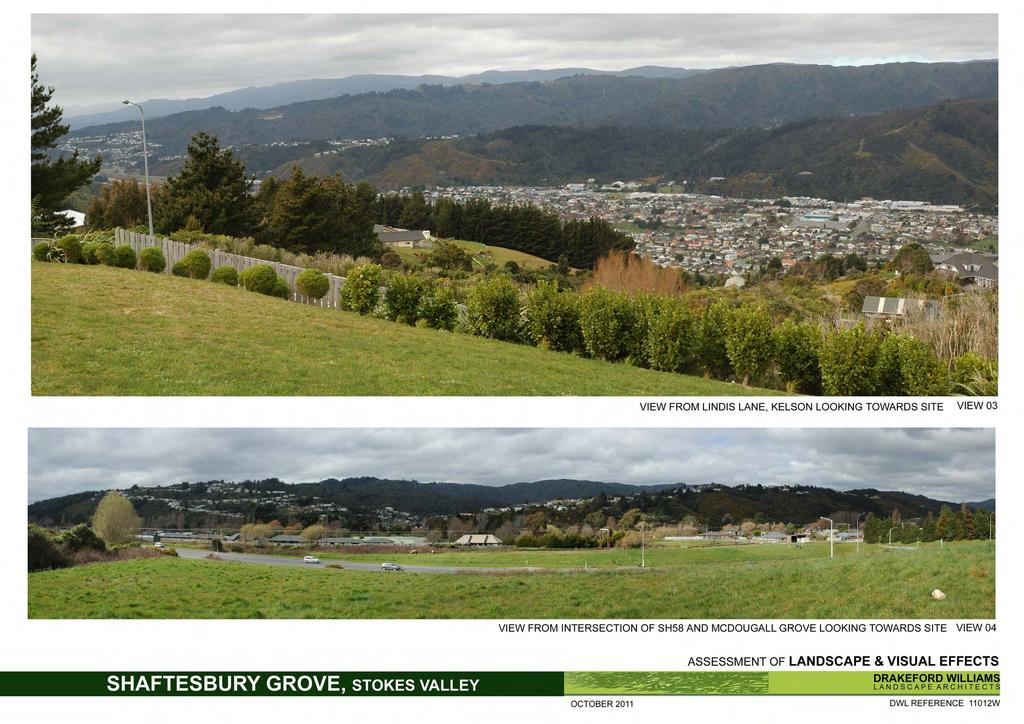
7 The visual prominence of the development is dictated by two factors: its location on the front face of a spur extending out from the ridgeline towards the valley floor, and the penetration of built development down the vegetated hillside. Aldersgate Grove houses are located close to the road but tend to extend down the slope in order to maximise floor area. This creates multi level dwellings that have considerable bulk when viewed from the valley floor or views to the west; building foundations can add an additional level of built structure to the dwelling. Residents may use additional retaining structures at the rear of the property to create functional outdoor living area. For example 7 Aldersgate Grove, the property at the end of the cul-de-sac, has a house that is three stories high at the rear. In detail, the back of the dwelling is located on the 100m contour. A retaining wall has been constructed across the rear boundary. In all, built development extends down to the 95m contour. In contrast, development in Option 1 is located slightly higher on the hillside, with the rear boundary of lots 11 and 12 at the bottom of the road located somewhere around the 120m contour. Kelson Viewing distance 2.3km Refer Appendix 1, View 3 Viewed from Lindis Lane at the top end of Kelson some 2.3km from the site and at a higher elevation, the site is backdropped by Blue Mountains in the distance and the main line of the eastern hills. The bush clad major gully is visible, highlighted to some extent by the enclosing gorse-clad spurs. Holborn Drive and Shaftesbury Grove are discernable as a ribbon of residential development along Stokes Valley ridgeline and it is evident where Shaftesbury Grove stops, and the undeveloped ridgeline continues. From this viewpoint, there is a clear demarcation between development on the valley floor and development on the hills. The houses on Aldersgate Grove extend residential development down the hillside and into the natural landscape. Visual effects The proposed Option 1 continues the existing pattern of development, effectively repeating the Aldersgate Grove subdivision, although with slightly increased visual prominence from this angle of view looking down to the main spur. It maintains the existing separation of ridgeline and valley floor development and does not extend development any further south than the existing houses in Shaftesbury Grove. Effects from this distance within the wider landscape context are considered low. Option 2 has greater visual impacts due to the size of the fill batter and the intensity of the lot layout. The proposal changes both the pattern of development on the eastern hills and the pattern of vegetation and the effects are more than minor. Intersection of SH58 and McDougall Grove Viewing distance 1.8km Refer Appendix 1, View 4 Drivers coming into the Hutt Valley from Porirua on SH58 Paremata Haywards Road look across to the entrance to Stokes Valley and residential development along the Holborn Drive ridgeline to the Aldersgate Grove subdivision. Although some 1.4km distant, houses in Aldersgate Grove are clearly visible, due in part to the viewing 11012W, 001 Landscape Assessment
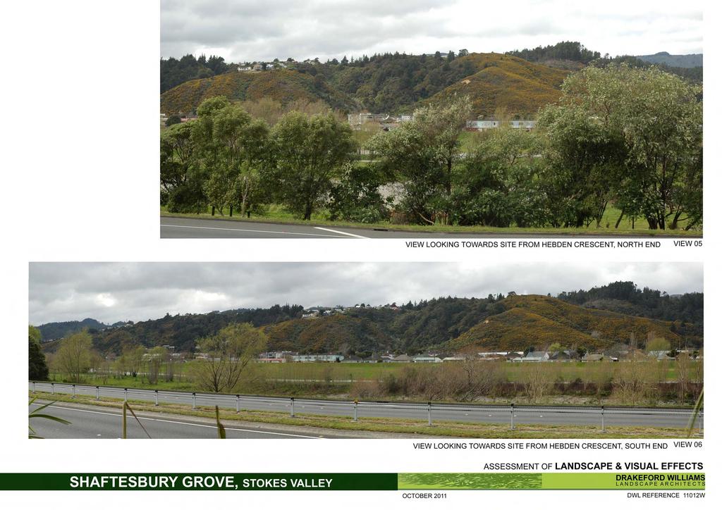
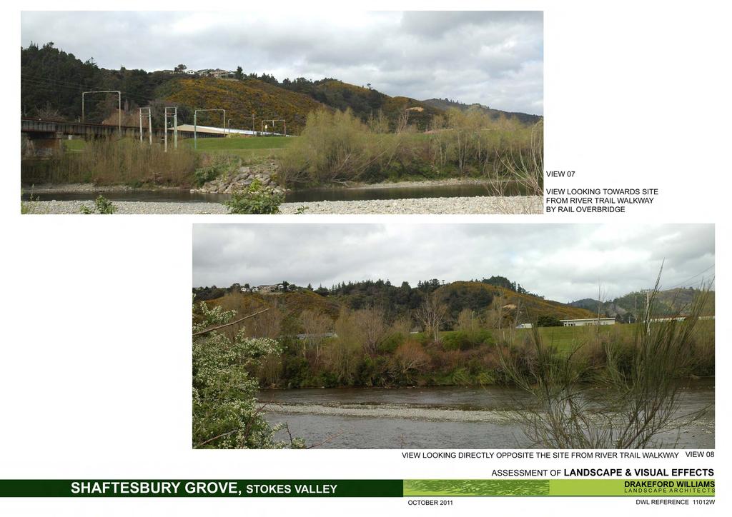
8 angle which gives built development at the end of the road increased visual prominence. The main spur within the site is visible in profile, backdropped by a cluster of pine trees and hills to the south. The large gully is concealed behind the Aldersgate Grove spur. Visual effects Viewed from this location, both options follow the current pattern of residential development although they extend housing further south along the hills into a previously natural landscape. Built development on the main spur will be visible, although much of it will be backdropped by the distant ridgeline. The fill batter for Option 2 will not be visible. From Hebden Crescent Viewing distance varies from km Refer Appendix 1, View 5 & 6 Hebden Crescent runs parallel with SH2 but is elevated above the main highway. Therefore views from Hebden Crescent are similar to views for drivers on SH2 but with less screening from the riverside vegetation and willow plantings. Seen from north Hebden Crescent, opposite the site, built development on Shaftesbury Grove is partially screened by pines on the site but is discernable on the skyline. Individual houses on Aldersgate Grove are visible, particularly at the end of the cul-de-sac and the cleared back sections stand out against the vegetated hill slopes. In more distant views from south Hebden Crescent (before Liverton Road), built development on the Shaftesbury Grove ridgeline cannot be seen through the trees on the skyline. The Aldersgate Grove subdivision is visible, but it is more difficult to see the detail of individual houses. Visual effects Both existing and proposed development along Shaftesbury Grove will be visible once the building platforms are cleared. Although at a higher elevation, Option 1 replicates the Aldersgate Grove development, leaving a buffer of vegetation between the valley floor and the proposed built development. The Option 2 fill batter and associated vegetation clearance has increased visual prominence, particularly in closer views. River Trail Walkway Viewing distance 0.9km, from the true right bank or western side of the river. Refer Appendix 1, View 7 & 8 Views north of the site from the river trail adjacent to the railway overbridge are filtered through vegetation including willow plantings both sides of the river. From this location Aldersgate Grove is in the foreground, and the main spur is profiled on the skyline. The gully is partially screened from view. Visual effects Development on the spur will be evident on skyline, similar to development on Aldersgate Grove. The upper end of the Option 2 fill batter may be visible, depending on its height and location W, 001 Landscape Assessment
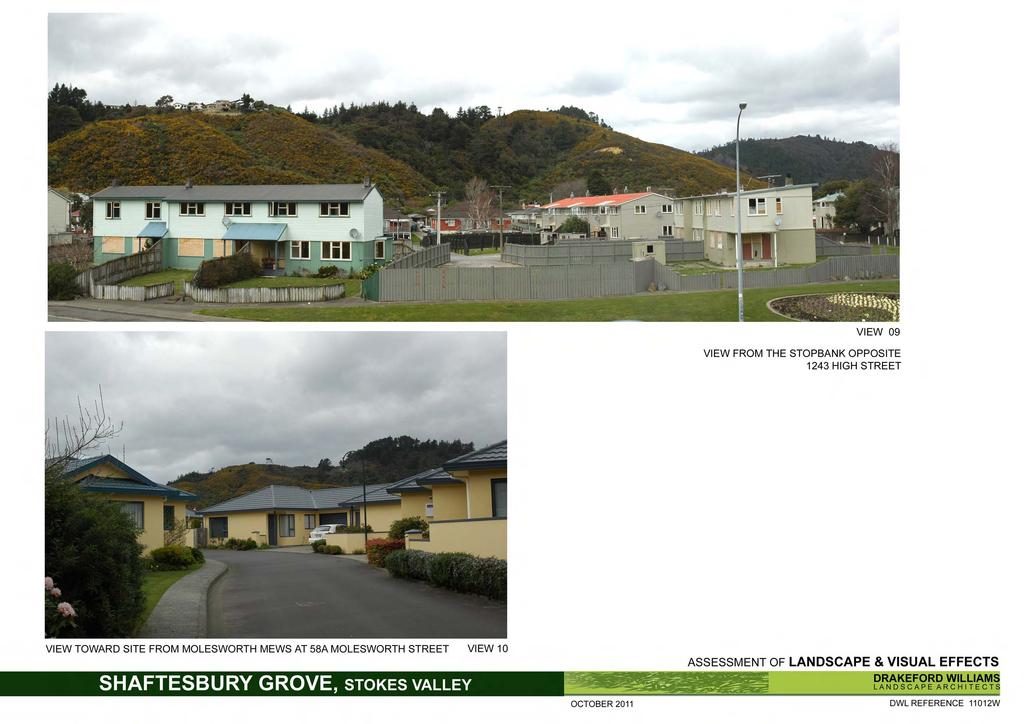
9 Views from the river trail opposite the site are largely screened by existing riverside vegetation; the trail is set down from the riverbank slightly and the focus on the walkway rather than views out, although the presence of the eastern hills is strong. From this location the gully is recessed between the two major spurs, with no built development visible on the skyline. Visual effects Views from this location are focussed up the site towards the ridgeline. Development will be visible in both options, particularly with the removal of existing vegetation on the skyline. Option 1 effects are mitigated by the allotment layout which retains a cluster of trees on the skyline between the major and minor spurs. Option 2 has greater impacts; the fill batter will dominate views and this is further emphasised by the requirements for vegetation clearance. Top of the stopbank, at 1243 High Street Viewing distance 0.8km Refer Appendix 1, View 9 Views from this location on the stopbank are similar to the previous views from the River Trail Walkway, albeit slightly closer and without the screening of intervening vegetation. Visual Effects Visual effects are similar to views from View 8 on the walkway on the other side of the river. Molesworth Mews, 58A Molesworth Street, Taita Viewing distance 1 km Refer Appendix 1, View 10 It is difficult to gain clear views to the site from the streets in Taita, given the flatness of the land, trees, overhead wires and density of building. This view, taken southwest of the site, sees the major spur in profile, with the smaller gully to the south seen in detail. No built development is visible on the hillside in this viewshaft. Visual effects Housing on the front and south face of the spur will be visible although the bulk of the proposed development for both options is screened by the landform. The proposed change in land use will introduce built development into an otherwise natural landscape but this is consistent with the viewing context, given that there is no opportunity for residents to see the full expanse of the eastern hills. Summary for views from the wider Hutt Valley The overall site is most visible in views from the west into the major gully. Views from the north and south are limited by the intervening landform in the form of the major spur within the site, and the Aldersgate Grove spur. The pattern of built development on the eastern hills north of the site is well defined, with houses running along the ridgeline down to the entry to the valley, and dropping down the tops of the spurs that divide and fold the hillsides. Currently the eastern hills south of Stokes Valley are undeveloped, although land adjacent to the site is zoned Hill Residential with the potential to extend residential development further south along the ridgeline. A broad band of vegetation separates the hillside development from the main floor of the Hutt Valley, with the patterns of revegetation highlighting the underlying landform by defining the spurs and gullies W, 001 Landscape Assessment
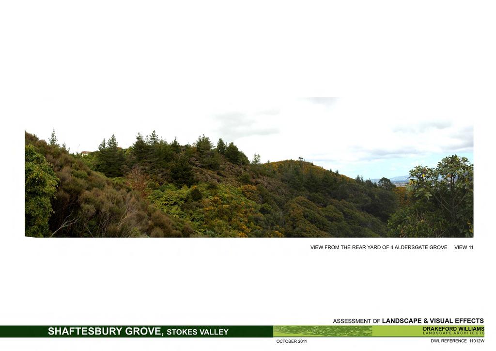
10 Two development options have been proposed. Option 1 extends existing development south in a form that matches existing development but maintains the broad band of vegetation on the eastern hills that separates the ridgeline from the valley floor. The proposed development of the main spur on the site replicates the pattern of cul-de-sacs along the Stokes Valley hillside, and is consistent in terms of layout with properties in Aldersgate Grove. Retention of some larger trees on and just below the ridgeline mitigates the impact of built development, both existing and proposed, on the skyline. Overall the visual effects are no more than minor. In contrast, Option 2 has visual effects that range from moderate to significant, depending on the angle of view and proximity to the site. Lots running off the major spur extend further down the slopes than in Option 1, with some rear boundaries at a lower elevation than Aldersgate Grove properties. The proposed fill batter in particular will alter the landform, remove mature vegetation in the gully, disrupt the wider pattern of vegetative cover on the hillside and create a dense cluster of housing visible from the Western Hutt hills. Given its orientation and elevation, revegetation of the batter would be unlikely to mitigate the visual impact of the earthworks. 6. CLOSE VIEWS Views from the north from Aldersgate Grove Viewing distance m Refer Appendix 1, View 11 Nearby properties at 184 and 186 Holborn Drive and 1 Aldersgate Grove, some 75m away, are oriented to the west and have oblique views to the site. Residents of houses at 2, 3, 5 and 6 Aldersgate Grove have views south to the site, with both the major spur and the minor spur silhouetted on the skyline. Built development is discernable on the ridgeline but constitutes a minor part of the overall view. Visual effects All of these properties will see some degree of change within the site: the closer properties have views to development on the minor spur; Aldersgate Grove properties will see development on the major spur. Residents at 5 and 6 Aldersgate Grove will have views back towards the face of the fill batter for Option 2. The outstanding views for all these residents are the distant views to the western hills and towards the harbour and Wellington city, rather than the more direct vista to the spur to the south. Neither of the options blocks these panoramic views. Buildings and vegetation removal will be visible from these properties and the visual effects are considered to be moderate. Mitigation in the form of restrictions on vegetation removal from the site, particularly from those areas on the steeper slopes to the rear of allotments, has the potential to reduce visual impacts by allowing existing trees and vegetation to filter views to the built development, and effects would be minor W, 001 Landscape Assessment
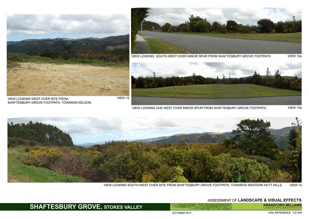
11 The visual impact of the increased number of houses and the fill batter for the Option 2 proposal is considered to be significant. Controls on vegetation removal would have no impact on the adverse effects arising from the site earthworks. Views from the east from Shaftesbury Grove Minimum viewing distance 15m Refer Appendix 1, View 12, 13a & 13b, and 14 Residents on Shaftesbury Grove have direct views to the site, with houses located as little as 15m away from the site boundary. Properties at the bottom of the street have views filtered through mature vegetation on the perimeter of the site but as the road rises and the topography changes, the views become more expansive: first views across to the spurs within the site, then to the Western Hutt hills and finally the harbour and the distant Kaikoura Ranges. Visual effects There is little difference between the two options in terms of the built streetscape. Both options have lots fronting onto Shaftesbury Grove: Option 1 has nine lots, and Option 2 has eight lots. However the Option 1 proposal has a reduced visual density, and the 40 metre distance between the housing clusters will leave visually significant vegetation on the road verge and allow views across the gully for residents at 4, 5 and 6 Shaftesbury Grove. Option 2 proposed a more solid wall of houses, with reduced opportunities to break up the built development with vegetation or open space. Built development on the site will change existing views to the site. The extent of the change is dependent on the final site levels, the size of each proposed house and its location on the site. Given that a number of the existing houses are storeys high and are elevated above the street, it is unlikely that the more panoramic distant views over the site to the distant hills will be blocked completely. Residents of single storey houses at 8 and 9 Shaftesbury Grove are located opposite allotments and are most affected. However it is noted that the views that are currently enjoyed by these residents will be limited over time through the natural progression of vegetative growth. In other words, with no development the existing pines, bush and gorse/kanuka cover will continue to mature and grow to screen views over the site to the west and south. The introduction of housing into an otherwise undeveloped site must by definition create visual impacts for local residents. In this proposal, the lot sizes and layout plans for Option 1 are consistent with the existing residential context of this neighbourhood and the pattern of development. The visual effects fall within the parameters of existing development and are therefore considered to be less than minor. Submissions Hutt City Council received nine submissions on the proposed plan change for Shaftesbury Grove. Seven residents (six from Shaftesbury Grove and one from Aldersgate Grove) submitted on issues concerned with the impact of the proposed development on the bush, on loss of views and on including the scars of vegetation removal and on the existing quality of life. The issues of views and vegetation removal have been discussed above and will be further set out in the Ecological Report. Issues of amenity are addressed below W, 001 Landscape Assessment
12 7. EFFECTS ON AMENITY Submissions note that some local residents have assumed that the site is a reserve and have an expectation of an on-going natural landscape. Submitter #25, Jennifer Jackson says Any development will affect our enjoyment of living here... While acknowledging that residents receive amenity from living next to the site, the land is not classified as a reserve under Reserves Act The site is in the General Recreation Activity Area but is located between two residential activity areas, namely General Residential and Hill Residential. It was zoned General Residential up to It is not contiguous with land on the Eastern Hills in the Passive Recreation Activity Area identified as having high amenity values, although it does impinge on Stokes Valley Bush, an area identified as SNC50 in Map Appendix 1A of the District Plan. In summary, the development is consistent with existing residential character. The proposed allotments are larger than the minimum standard of the General Residential Activity Area in the District Plan and the subdivision will not generate adverse effects in terms of noise, glare, loss of daylight and sunlight, or loss of privacy. The effects on residential amenity arising from the change in land use from general recreation to residential are less than minor. 8. RELEVANT STATUTORY PROVISIONS IN THE DISTRICT PLAN General Residential Activity Area Chapter 4A The General Residential Activity Area policies are designed to maintain and enhance the amenity values and residential character of the General Residential Activity Areas of the City. They ensure amenity for residents by managing the adverse effects of development on neighbouring properties through rules on net site area, minimum yard requirements, recession planes and site coverage. New development controls introduced in Plan Change 12 in June 2011 include an additional requirement to have 30% of the site covered in permeable surfaces. The Current Landscape Protection rule that references to vegetation removal in the General Residential Activity Area will be revoked from 1 January The Proposed District Plan Change 23 Amendments to Vegetation Removal Provisions and Remnant Nikau Palm Protection Provisions notes: The main issue with Residential Chapters 4A, 4B, 4D and 4E is that the vegetation removal provisions (for Restricted Discretionary Activities) are in conflict with the RMAA 2009 as the provisions are considered to be blanket protection, which the RMAA 2009 disallows in urban environments. 3 These provisions, which place specific restrictions on the removal of vegetation in excess of 500 m² or 35% of the site, whichever the lesser, can no longer be considered. However the objectives and policies within the General Residential Activity Area still apply, particularly 4A Residential Character and Amenity Values, Policy (e): That vegetation and trees which add to the particular amenity values of the area be retained where practicable. Council has a number of mechanisms to meet the intent of the policy, (and effectively to match the specific requirements of the vegetation removal rule) including resource 3 Plan change 23, page W, 001 Landscape Assessment
13 consent conditions relating to landscaping and vegetation planting in order to mitigate the adverse effects from vegetation removal. Subdivision Chapter11 The chapter on Subdivision contains standards and terms for allotment design to ensure that allotments have minimum designs standards that are suitable for the proposed use, and assessment criteria in terms of matching subdivision layout to the landform in order to minimize earthworks and give due regard to the natural and physical characteristics of the land. The Preliminary Land Development Assessment notes that the development will be regarded as a Restricted Discretionary Activity 4, and so council can consider and additional range of effects including: effects on existing natural features and topography; effects on amenity values arising from the visual prominence of earthworks; the impacts of dust and noise on neighbouring properties; and the effects of retaining structures when viewed from both adjoining properties and public areas. In summary, the Hutt City District Plan contains a range of regulatory tools that allow Council to consider the effects of the overall subdivision development on landscape character and the amenity of existing residents and the wider public. At a more detailed level, rules within the plan control the effects of development on the site and on the amenity of neighbouring residents. 9. MITIGATION Site design Roading and lot layouts for Option 1 development plans have been designed to minimise earthworks, with allowance for roading on the broad ridgeline and building platforms with earthworks on upslope cuts so that retaining structures and cut batters can be screened by the built development in close views from Aldersgate Grove or Shaftesbury Grove or in more distant views from the west. Concentrating built development on the broader spurs and leaving the adjoining gullies undeveloped creates vegetative buffers between allotment clusters that reduce visual impacts and provide amenity for neighbouring properties. Site widths exceed District Plan requirements and facilitate the location of building platforms close to the road and away from the steeper slopes which have more mature and visually prominent vegetation. The District Plan A number of policies and rules in the District Plan can be used together to mitigate the effects of subdivision and residential development. Rules that control building scale, intensity, location and site coverage in conjunction with the requirement for a minimum permeable surfaces area effectively to discourage removal of vegetation or at least minimise vegetation clearance. The combined restriction on 35% site coverage and requirement to have 30% of the site covered in permeable surfaces discourages the removal of vegetation, particularly on steeper slopes where grass (another permeable surface) is less functional. While the specific restrictions on the removal of vegetation as a percentage of the site can no longer be considered, 4 Tonkin & Taylor, November W, 001 Landscape Assessment
14 policies that support the maintenance and enhancement of amenity values and residential character remain, namely: 4A (e) That vegetation and trees which add to the particular amenity values of the area be retained where practicable. (f) That the clearance of vegetation be managed to avoid, remedy or mitigate any adverse effects on the intrinsic values of ecosystems. Assessment criteria for Restricted Discretionary Activities allows Council to take into consideration the visual prominence of vegetation on the site and any replacement planting to be undertaken. Within this regulatory context, mitigation could be achieved through conditions that: Limit vegetation removal to that required for the building platform. Control vegetation clearance on rear yards to minimise visual impacts and penetration into the vegetation canopy of existing bush; Require retention of large trees on the site to mitigate visual effects for both close and distant views; Manage the installation of sewer and stormwater services in order to limit vegetation removal; and Require street tree planting to break up the line of built development on Shaftesbury Grove and the proposed new cul-de-sac for close and distant views to the site W, 001 Landscape Assessment
15 10. CONCLUSION It is considered that the visual and landscape effects associated with the Option 2 development proposal are moderate to high. This Option cannot be supported. With regard to the Option 1 development proposal, it is considered that: The Hutt City District Plan contains a range of regulatory tools that allow Council to avoid, remedy or mitigate the effects of the proposed development on landscape character and the amenity of existing residents and the wider public. While the landscape effects have the potential to be more than minor, effects can be mitigated through the control of earthworks and vegetation removal, and by imposing conditions on the location of the building platform and the location and installation of site services. The proposal will create a pattern of built development that reflects existing residential subdivision along the ridgeline and on the upper slopes of the eastern hills of Stokes Valley. The layout and siting of the development maintains the broad pattern of vegetation on the eastern hills that separates the ridgeline from the valley floor. Distant views to the western hills and towards the south for residents of Aldersgate Grove and Shaftesbury Grove may be restricted but not fully blocked. However even with no development, the views that are currently enjoyed by residents will be limited over time through the natural progression of vegetative growth. The potential visual impact of vegetation removal from the site for close views from Aldersgate Grove can be mitigated, though this will require controls on the development in terms of vegetation clearance. These residents have an opportunity to plant within their property to filter views to the development without compromising their more panoramic distant views. The development is consistent with existing residential character and effects on residential amenity arising from the change in land use are less than minor. And The zoning of the site to General Residential to allow for the proposed Option 1 development is appropriate W, 001 Landscape Assessment
16 APPENDIX 1 Figure 3: Indicative Development Plan: Option 1 Figure 4: Indicative Development Plan: Option W, 001 Landscape Assessment
17
18
19 APPENDIX 2 VIEWS OF THE SITE View Number View 1 View 2 View 3 View 4 View 5 View 6 View 7 View 8 View 9 View 10 View 11 View 12 View 13a View 13b View 14 View location Site looking towards Shaftesbury Grove, south end Site looking towards Shaftesbury Grove, north end Lindis Lane, Kelson Intersection of SH58 and McDougall Grove Hebden Crescent, north end Hebden Crescent, south end River Trail Walkway by rail overbridge River Trail Walkway, opposite the site Stopbank opposite 1243 High Street Molesworth Mews, 58A Molesworth Street Rear property 4 Aldersgate Grove Shaftesbury Grove foothpath, looking west to Kelson Shaftesbury Grove foothpath looking south west over minor spur Shaftesbury Grove foothpath looking due west over minor spur Shaftesbury Grove foothpath, looking southwest to Western Hutt Hills 11012W, 001 Landscape Assessment
20
21
22
23
24
25
26
4 Residential and Urban Living Zones
 4 Residential and Urban Living Zones Refer to Chapters 11 to 20 for additional rules that may apply to these zones. 4.1 OBJECTIVES AND POLICIES Objective Res1 Policy 1 Policy 2 Policy 3 Policy 4 Policy
4 RESIDENTIAL ZONE. 4.1 Background
 4 RESIDENTIAL ZONE 4.1 Background The residential areas within the City are characterised by mainly lowrise dwellings sited on individual allotments. Past architectural styles, settlement patterns and
I611. Swanson North Precinct
 I611. Swanson North Precinct I611.1. Precinct Description Swanson North is located in the north eastern foothills of the Waitakere Ranges. It is outside the Waitakere Ranges Heritage Area Act and the Waitakere
Section Three, Appendix 16C Medium Density Housing, Design Assessment Criteria (Residential 8A zone)
") APPENDIX 16C MEDIUM DENSITY HOUSING, DESIGN ASSESSMENT CRITERIA (RESIDENTIAL 8A ZONE) PURPOSE OF APPENDIX 16C (RESIDENTIAL 8A ZONE) In the Residential 8A Zone the following are defined as restricted discretionary
APPENDIX 16C MEDIUM DENSITY HOUSING, DESIGN ASSESSMENT CRITERIA (RESIDENTIAL 8A ZONE) PURPOSE OF APPENDIX 16C (RESIDENTIAL 8A ZONE) In the Residential 8A Zone the following are defined as restricted discretionary
open space environment
 This section updated August 09 GUIDELINE TO THE RULES The Open Space Environment Rules apply to activities on sites within the Open Space Environment as shown on the Human Environments Maps. Most of the
Section 12C Subdivision in the Rural Residential Zone
 Section 12C 12C Subdivision in the Rural Residential Zone The Rural Residential Zone provides part of the range of residential opportunities within the City. Land zoned rural residential is considered
I602. Birdwood Precinct
 I602. Birdwood Precinct I602.1. Precinct description The Birdwood Precinct applies to an area west of Don Buck Road and south of Red Hills Road in west Auckland. It incorporates subdivision and development
I403 Beachlands 1 Precinct
 I403. Beachlands 1 I403.1. Precinct Description Beachlands is a rural and coastal village located on the eastern side of Auckland, adjoining the Tamaki Strait coastline. The original Beachlands village
Section Three, Appendix 17C Multiple Unit Housing Design Assessment Criteria
 APPENDIX 17C MULTIPLE UNIT HOUSING DESIGN ASSESSMENT CRITERIA Purpose of Appendix 17C In the Residential 9 Zone the construction and use of multiple household units located within the Multiple Household
LANDSCAPE GUIDELINES. Countryside & Coastal Countryside Environments. Landscape, Natural Character & Amenity Values Guide
 Landscape, Natural Character & Amenity Values Guide Copyright WDC 2009 Version A2 18May09 Environmental Services Group Publication Countryside & Coastal Countryside Environments START HERE Quality Land
QUEENSTOWN LAKES DISTRICT COUNCIL SUBDIVISION DESIGN GUIDELINES
 Attachment C: Draft QLDC Subdivision Design Guidelines QUEENSTOWN LAKES DISTRICT COUNCIL DESIGN GUIDELINES A DESIGN GUIDE FOR AND DEVELOPMENT IN THE URBAN ZONES QUEENSTOWN OFFICE 10 Gorge Road Queenstown
ENHANCED ACCESSIBILITY GUIDELINES
 City of Vancouver Land Use and Development Policies and Guidelines Planning and Development Services, 453 W. 12th Ave Vancouver, BC V5Y 1V4 F 604.873.7344 fax 604.873.7060 planning@vancouver.ca ENHANCED
GIBBSTON CHARACTER ZONE. QLDC PROPOSED DISTRICT PLAN [PART FOUR] AUGUST gibbston character zone
![GIBBSTON CHARACTER ZONE. QLDC PROPOSED DISTRICT PLAN [PART FOUR] AUGUST gibbston character zone](/thumbs/75/72573993.jpg "GIBBSTON CHARACTER ZONE. QLDC PROPOSED DISTRICT PLAN [PART FOUR] AUGUST gibbston character zone") 23 GIBBSTON CHARACTER ZONE QLDC PROPOSED DISTRICT PLAN [PART FOUR] AUGUST 2015 23 gibbston character zone QLDC PROPOSED DISTRICT PLAN [PART FOUR] AUGUST 2015 23 gibbston character zone 23.1 Zone Purpose
23 GIBBSTON CHARACTER ZONE QLDC PROPOSED DISTRICT PLAN [PART FOUR] AUGUST 2015 23 gibbston character zone QLDC PROPOSED DISTRICT PLAN [PART FOUR] AUGUST 2015 23 gibbston character zone 23.1 Zone Purpose
AOTEA SUPERMARKET ZONE. Zone Introduction
 C18 AOTEA SUPERMARKET ZONE Zone Introduction C18.1 Objective This zone identifies a specific area in Aotea for a stand alone supermarket. The zone is site specific and has a range of objectives, policies
I539. Smales 2 Precinct
 I539. Smales 2 Precinct I539.1. Precinct Description The Smales 2 Precinct applies to a 4.8 hectare block of land located on the southern side of Northcote Road and fronting Lake Pupuke, Takapuna. The
Types of Reserves. Recreational activities
 VALLEY FLOOR AND EASTERN HILLS Physical and ecological features Large, flat valley floor and river plain with intensive urban development Hutt River / Te Awa Kairangi and tributaries Waiwhetu Stream Eastern
I511. Hatfields Precinct
 I511. Hatfields Precinct I511.1. Precinct Description The Hatfields Precinct is a contiguous 183.8 hectare block of rural land held in 8 freehold titles, located immediately to the north of Hatfields Beach.
Guidance Notes Completing an AEE
 Guidance Notes Completing an AEE The purpose of this guidance note is to assist you with completing your Assessment of Environmental Effects (AEE) for your land-use consent application. If you do not provide
Section 3b: Objectives and Policies Rural Environment Updated 19 November 2010
 Page 1 of Section 3b 3b RURAL ENVIRONMENT 3b.1 Introduction The Rural Environment comprises all the land outside of the Residential, Town Centre and Industrial Environments. Most land within the District
SECTION 7A: WHAKARONGO RESIDENTIAL AREA
 SECTION 7A: WHAKARONGO RESIDENTIAL AREA CONTENTS 7A.1 Introduction 1 7A.2 Resource Management Issues 1 7A.3 Objectives and Policies 1 7A.4 Methods 4 7A.5 Residential Zone 4 7A.5.1 Rules: Controlled Activities
H7 Open Space zones. (a) provide for the needs of the wider community as well as the needs of the community in which they are located;
 provide for the needs of the wider community as well as the needs of the community in which they are located;") H7. Open Space zones H7.1. Background The majority of land zoned as open space is vested in the Council or is owned by the Crown. However some areas zoned open space are privately owned. While the open
H7. Open Space zones H7.1. Background The majority of land zoned as open space is vested in the Council or is owned by the Crown. However some areas zoned open space are privately owned. While the open
Wide asphalt driveway abutting school property. garage built with incompatible materials, too close to park. incompatible fencing materials
 Wide asphalt driveway abutting school property incompatible fencing materials garage built with incompatible materials, too close to park Lack of plantings as a buffer between private property and open
GENERAL PLAN CONSISTENCY ANALYSIS
 GENERAL PLAN CONSISTENCY ANALYSIS Prepared by Planning Staff 10/28/2013 APPLICABLE GOALS, POLICIES AND PROGRAMS FROM the LAND USE CHAPTER Goal LU-1 Policy LU-1.1 Policy LU-1.2 Goal LU-2 Protect the character
15 Rural Residential Zone
 15 Rural Residential Zone Section 15A 15A Purpose of the Rural Residential Zone... 1 15A.1 Objectives and Policies of the Rural Residential Zone... 1 15A.2 Activity Status Rules... 5 15A.3 Permitted Activity
OVERVIEW PROJECT SUMMARY
 OVERVIEW These five houses on Ridge View Crescent form an important part of the wider Anslemi Ridge development. They are the backdrop to the lake that is the community heart of the nieghbourhood, and
I615. Westgate Precinct
 I615. Westgate Precinct I615.1. Precinct Description The Westgate Precinct is located approximately 18km west of the Auckland city centre. There are seven Sub-precincts in the Westgate Precinct: Sub-precinct
I412. Flat Bush Precinct
 I412. Flat Bush Precinct I412.1. Precinct description The Flat Bush precinct covers approximately 1730ha of land adjacent to the Rural Urban Boundary. The Flat Bush Precinct incorporates the provisions
I609. Penihana North Precinct
 I609. Penihana North Precinct I609.1. Precinct description The Penihana North Precinct is located south of the Swanson Railway Station, adjacent to the Rural Urban Boundary (RUB) and Waitakere Ranges Heritage
Rural (Urban Expansion) Environment
 Environment") RUEE.1 Rural (Urban Expansion) Environment Subsequent to the receipt of appeals, a 'marked up' version of the Proposed District Plan was prepared. The provisions of the Proposed Version of the Plan subject
RUEE.1 Rural (Urban Expansion) Environment Subsequent to the receipt of appeals, a 'marked up' version of the Proposed District Plan was prepared. The provisions of the Proposed Version of the Plan subject
PART II APPENDIX 3: COASTAL TASMAN AREA SUBDIVISION AND DEVELOPMENT DESIGN GUIDE
 Operative Part II, Appendix 3 Coastal Tasman Area Subdivision and Development Design Guide 26 September 2009 PART II APPENDIX 3: COASTAL TASMAN AREA SUBDIVISION AND DEVELOPMENT DESIGN GUIDE CHAPTER 1 -
4.3 Dudley Area Plan. Introduction. History and Existing Character. Desired Future Character for Dudley
 4.3 Dudley Area Plan Introduction The suburb of Dudley has developed as a result of various circumstances including its topography, history and mineral resources. Dudley development has been identified
Draft Part 11 Heritage Area Plans West Wallsend / Holmesville
 TABLE OF CONTENTS: PART 1 WEST WALLSEND / HOLMESVILLE HERITAGE AREA PLAN... 3 1.1 INTRODUCTION... 3 1.2 BACKGROUND... 3 1.3 LAND TO WHICH THIS PLAN APPLIES... 3 PART 2 WEST WALLSEND / HOLMESVILLE HERITAGE
Retirement Village & Carehome Complex BUPA New Zealand 25 Ulyatt Road, Napier
 Retirement Village & Carehome Complex BUPA New Zealand 25 Ulyatt Road, Napier Resource Consent Application Wasley Knell Consultants Limited Table of Contents 1.0 PROPOSAL... 2 2.0 LOCATION... 3 3.0 RESOURCE
Part 11 Heritage Area Plans West Wallsend / Holmesville
 TABLE OF CONTENTS: PART 1 WEST WALLSEND / HOLMESVILLE HERITAGE AREA PLAN... 3 1.1 INTRODUCTION... 3 1.2 BACKGROUND... 3 1.3 LAND TO WHICH THIS PLAN APPLIES... 3 PART 2 WEST WALLSEND / HOLMESVILLE HERITAGE
WELLINGTON HOSPITAL DESIGN GUIDE TABLE OF CONTENTS
 WELLINGTON HOSPITAL DESIGN GUIDE TABLE OF CONTENTS 1.0 Introduction Page 2 The Place of Wellington Hospital 2 The Future of the Hospital 2 2.0 The Intention of the Design Guide 3 3.0 Analysis 4 General
3. Highway Landscaping Assessment
 Guidelines for Highway Landscaping 3-1 3. Highway Landscaping Assessment 3.1 Introduction This section outlines the steps necessary to assess the highway landscaping component of a state highway construction
RLE.1 Rural Living Environment
 Index.1 Description and Expectations.2 Objectives.3 Policies.4 Guidance RLE.2 Landuse RLE.2.1 Eligibility Rules RLE.2.2 Notification Rules RLE.2.3 Discretionary Activities RLE.3 Subdivision RLE.3.1 Eligibility
Subdivision Design Criteria. Penihana North GUIDELINES TO THE RULES
 Created September 2013 Penihana North Subdivision Design Criteria GUIDELINES TO THE RULES This part of the Plan sets out the design criteria for subdivision in Penihana North. The criteria will be considered
QLDC PROPOSED DISTRICT PLAN [PART FOUR] NOVEMBER WAKATIPU BASIN WAKATIPU BASIN
![QLDC PROPOSED DISTRICT PLAN [PART FOUR] NOVEMBER WAKATIPU BASIN WAKATIPU BASIN](/thumbs/82/85315845.jpg "QLDC PROPOSED DISTRICT PLAN [PART FOUR] NOVEMBER WAKATIPU BASIN WAKATIPU BASIN") QLDC PROPOSED DISTRICT PLAN [PART FOUR] NOVEMBER 2017 24 WAKATIPU BASIN 24 WAKATIPU BASIN QLDC PROPOSED DISTRICT PLAN [PART FOUR] NOVEMBER 2017 24 WAKATIPU BASIN 24.1 Zone Purpose This chapter applies
QLDC PROPOSED DISTRICT PLAN [PART FOUR] NOVEMBER 2017 24 WAKATIPU BASIN 24 WAKATIPU BASIN QLDC PROPOSED DISTRICT PLAN [PART FOUR] NOVEMBER 2017 24 WAKATIPU BASIN 24.1 Zone Purpose This chapter applies
South of Hillside Road West, Rothbury. Design and Access Statement with Design Code. Outline Planning Application May 2016
 Outline Planning Application May 2016 Design and Access Statement with Design Code Jane Darbyshire and David Kendall Ltd This Design and Access Statement has been produced by Jane Darbyshire and David
RURAL ZONE - POLICY. Rural Zone Policy. Issue: Rural Environment. Ruapehu District Plan Page 1 of 8
 Rural Zone Policy RU2 RURAL ZONE - POLICY RU2.1 Introduction The natural resources of the rural environment in the Ruapehu District provide the basis for the existing and potential character, intensity
I209 Quay Park Precinct
 I209. Quay Park I209.1. Precinct description The Quay Park Precinct is located on reclaimed land at the eastern end of the city centre and along the City Centre waterfront. It is dissected to the east
Visual Effects Assessment Hapimana Street, Ōrākei. Prepared for Ngāti Whātua Ōrākei
 Xanthe White Design Ltd Studio 29, Level 2, St Kevin s Arcade, 179 Karangahape Rd PO Box 68658, Wellesley Street, Auckland 1141 (09) 300 7135 www.xwd.co.nz Visual Effects Assessment Hapimana Street, Ōrākei
RESIDENTIAL ACTIVITY PERFORMANCE STANDARDS
 Preferred Options Consultation Q&A Sheet RESIDENTIAL ACTIVITY PERFORMANCE STANDARDS What are the key goals for managing the design of residential buildings in the Second Generation Plan (2GP)? The key
Chapter 13 Residential Areas: Appendices APPENDIX 1 Residential Areas
 Chapter 13 Residential Areas: Appendices Page 1 Chapter 13 Residential Areas: Appendices APPENDIX 1 Residential Areas Design Code for Intensive Housing INTRODUCTION DESIGN ELEMENTS A NEIGHBOURHOOD DESIGN
1. Assessment of Environmental Effects
 1. Assessment of Environmental Effects Table of Contents 1. Introduction and Overview 1 2. Statutory Assessment 3 3. Site Description 5 4. Proposal Description 7 5. Assessment of Effects on the Environment
TIDAPA Structure Plan
 TIDAPA Structure Plan Prepared by Tract Consultants 28 MARCH 2017 0217-0074 Table of Contents 01 STRATEGIC CONTEXT Executive Summary Regional Context Page 3 Page 4 02 LOCAL CONTEXT Aerial Photograph Local
Infill Residential Design Guidelines
 Infill Residential Design Guidelines Adopted March 23, 2004 Amended September 10, 2013 City of Orange Community Development Department Planning Division Phone: (714) 744-7220 Fax: (714) 744-7222 www.cityoforange.org
Housing and Coach House Guidelines - Ladner
 Housing and Coach House Guidelines - Ladner Policy D.8: Encourage Compatible Housing Design Encourage housing design that is sensitive to existing single family housing neighbourhoods by requiring a design
City of Vaughan Urban Design Guidelines for Infill Development in Established Low-Rise Residential Neighbourhoods
 City of Vaughan Urban Design Guidelines for Infill Development in Established Low-Rise Residential Neighbourhoods DRAFT - September 2016 Contents 1. Introduction 1 2. Policy Context 3 3. Characteristics
Tāhuhu whakaruruhau ā-taone The sheltering ridge pole
 B2. Tāhuhu whakaruruhau ā-taone - Urban growth and form B2.1. Issues Tāhuhu whakaruruhau ā-taone The sheltering ridge pole Auckland s growing population increases demand for housing, employment, business,
3.10 LAND USE SETTING PROJECT SITE EXISTING LAND USE DESIGNATIONS AND ZONING. General Plan Land Use Designations.
 This section of the Draft EIR addresses the existing land uses on and adjacent to the project site and discusses the potential impacts of the proposed project on existing land uses. Key issues addressed
Part 9 Specific Land Uses - Housing on Small and Narrow Lots
 19 HOUSING ON SMALL AND NARROW LOTS This section of the DCP applies where development for the purpose of a dwelling house, attached dwellings, or semi-detached dwellings is or are proposed in the R2 Low
64 Mineral Extraction Area Rules
 64 Mineral Extraction Area Rules 64.1 Introduction For the purposes of this Chapter: Active Area, in relation to a Mineral Extraction Area (MEA), is that part of the Mineral Extraction Area which is owned
Next Steps / Development Process. Structure Plan. June submitted to City of Fremantle. Structure Plan. July supported for advertising
 overview What is today about? In July 0, the City of Fremantle resolved that the be advertised for public comment. Today is about: Understanding the history and context of the site Having your say on the
Rural (Urban Expansion) Environment
 Environment") RUEE.1 Rural (Urban Expansion) Environment Index RUEE.1 RUEE.1.1 RUEE.1.2 RUEE.1.3 RUEE.1.4 RUEE.2 RUEE.2.1 RUEE.2.2 RUEE.2.3 RUEE.2.4 RUEE.3 Rural (Urban Expansion) Environment Description and Expectations
RUEE.1 Rural (Urban Expansion) Environment Index RUEE.1 RUEE.1.1 RUEE.1.2 RUEE.1.3 RUEE.1.4 RUEE.2 RUEE.2.1 RUEE.2.2 RUEE.2.3 RUEE.2.4 RUEE.3 Rural (Urban Expansion) Environment Description and Expectations
Draft Ada Street Cardiff Area Plan
 Draft Ada Street Cardiff Area Plan (Draft Amendment to Lake Macquarie Development Control Plan 2014) Exhibition: The draft Area Plan is on public exhibition from 29 February 2016 to 29 March 2016. Submissions:
Ensure that development within the Arrowtown Urban Growth Boundary provides:
 URBAN DEVELOPMENT 4 4.2.5.2 Ensure that development within the Arrowtown Urban Growth Boundary provides: an urban form that is sympathetic to the character of Arrowtown, including its scale, density, layout
King s College Proposed Private Plan Change 41 Golf Avenue, Otahuhu URBAN DESIGN ASSESSMENT
 King s College Proposed Private Plan Change 41 Golf Avenue, Otahuhu URBAN DESIGN ASSESSMENT CONTENTS 1.0 EXCECUTIVE SUMMARY... 1 2.0 INTRODUCTION... 2 2.1 Purpose of document... 2 2.2 Report structure...
WELLINGTON CITY DISTRICT PLAN
 Section 32 Report WELLINGTON CITY DISTRICT PLAN PROPOSED DISTRICT PLAN CHANGE 54 REZONING 178 AND 180 OWHIRO BAY PARADE 1 Introduction Before a Proposed District Plan change is publicly notified the Council
REMARKABLES PARK ZONE
 .10 Remarkables Park Zone.10.1 Resources, Activities and Values The Remarkables Park Area comprises approximately 150 hectares of perimeter urban land in the vicinity of Frankton and occupies a strategic
PUBLIC NOTICE UNDER CLAUSE 5 OF SCHEDULE 1 OF THE RESOURCE MANAGEMENT ACT 1991 PLAN CHANGE 12 TO THE OPERATIVE CITY OF NAPIER DISTRICT PLAN
 PUBLIC NOTICE UNDER CLAUSE 5 OF SCHEDULE 1 OF THE RESOURCE MANAGEMENT ACT 1991 PLAN CHANGE 12 TO THE OPERATIVE CITY OF NAPIER DISTRICT PLAN Public notice is given in accordance with Clause 5 of Schedule
A. General Plan: Land Use, Growth Management and the Built Environment Element. d. Use visually unobtrusive building materials.
 Chapter 16 Hillside Protection 16.010 Purpose This chapter establishes the regulations for development and alteration of properties in hillside and ridgeline areas in order to preserve the essential scenic
Nob Hill Pipeline Improvements Project EIR
 Section 3.1 Aesthetics This section addresses the visual aspects that may affect the views experienced by the public, including the potential to impact the existing character of each area that comprises
Town of Portola Valley General Plan. Nathhorst Triangle Area Plan
 Town of Portola Valley General Plan Amended December 10, 1997 Table of Contents Introduction... 1 Planning Area... 1 Objectives... 2 Principles... 2 Standards... 4 Description... 4 Community Commercial...
SENSITIVE LANDS OVERLAY
 SENSITIVE LANDS OVERLAY Chapter 22 Sensitive Lands Overlay 22.1 PURPOSE 22.2 APPLICATION AND ANALYSIS REQUIREMENTS 22.3 SENSITIVE LAND REGULATIONS 22.4 ADMINISTRATIVE PROVISIONS 22.5 DESIGN STANDARDS 22.6
H1. Residential Large Lot Zone
 H1. Residential Large Lot Zone H1.1. Zone description The Residential Large Lot Zone provides for large lot residential development on the periphery of urban areas. Large lot development is managed to
Design Guide: - Residential Centres
 Design Guide: - Residential Centres Introduction Hamilton City Council wishes to take a stronger and more visionary role in guiding the future development of Hamilton s built environment to ensure that
Proposed Kapiti Coast District Plan
 5 This Chapter primarily implements Objectives 2.1 Tāngata Whenua, 2.3 Development Management, 2.11 Character and Amenity Values, and 2.12 Housing Choice and Affordability as set out in Chapter 2. The
URBAN DESIGN BRIEF. 2136&2148 Trafalgar Road. Town of Oakville
 URBAN DESIGN BRIEF 2136&2148 Trafalgar Road Town of Oakville Prepared By: METROPOLITAN CONSULTING INC For 2500674 Ontario Inc November 2016 TABLE OF CONTENTS Page No. 1.0 Introduction/Description of Subject
Chapter 2: OUTLINE PLANNING APPLICATION PROPOSALS. A New Garden Neighbourhood Matford Barton 17
 Chapter 2: OUTLINE PLANNING APPLICATION PROPOSALS A New Garden Neighbourhood Matford Barton 17 2.1. SUMMARY AND STATUS OF THE PROPOSALS 2.1.1. The parameter plans and associated wording in this chapter
Assessment of Landscape, Visual and Natural Character Effects
 Assessment of Landscape, Visual and Natural Character Effects Consent Footprint Amendments Mangamaunu Half Moon Bay Okiwi Bay South Report prepared for: New Zealand Transport Agency and KiwiRail Holdings
6 Landsc apes and rur al char ac
 LANDSCAPES AND RURAL CHARACTER QLDC PROPOSED DISTRICT PLAN [PART TWO] DECISION VERSION ter 6 Landsc apes and rur al char ac 6.1 Purpose Appendix C QLDC DISTRICT PLAN [PART TWO] DECISION VERSION 6 Landsc
Plan Modification to Chapter B2 of the Auckland Unitary Plan(AUP) Operative in part (15 November 2016)
 Operative in part (15 November 2016)") UNITARY PLAN UPDATE REQUEST MEMORANDUM TO FROM Phill Reid Linley Wilkinson DATE 25 September 2018 SUBJECT Plan Modification to Chapter B2 of the Auckland Unitary Plan(AUP) Operative in part (15 November
UNITARY PLAN UPDATE REQUEST MEMORANDUM TO FROM Phill Reid Linley Wilkinson DATE 25 September 2018 SUBJECT Plan Modification to Chapter B2 of the Auckland Unitary Plan(AUP) Operative in part (15 November
2 Status of the Design Guidelines The Design Controls are to be applied to each of the residential titles by way of consent notices.
 6 October 2015 HARAKEKE 2015 LTD DESIGN CONTROLS 1 Introduction The Design s apply to all of the buildings to be erected in the Harakeke Subdivision on the sites 101-130, 201-232, 301-322, 401-426, and
RULES FOR URBAN TREE GROUPS AND REMOVAL OF INDIGENOUS VEGETATION REMOVAL
 27A RULES FOR URBAN TREE GROUPS AND REMOVAL OF INDIGENOUS VEGETATION REMOVAL Activities Table Policies 4.4.10, 12.4.7, 12.4.10, 12.4.11, 12.4.12, 12.4.13, 12.4.14, 12.4.15, and 12.4.16 27A.1 Activities
Chapter 7: Landscape and Visual Impact Assessment
 Chapter 7: Landscape and Visual Impact Assessment Landscape Character and Visual Impact Assessment 7. Landscape Character and Visual Impact Assessment... 2 7.1 Methodology... 2 7.2 Assessment Findings...
H13. Business Mixed Use Zone
 H13. Business Mixed Use Zone H13.1. Zone description The Business Mixed Use Zone is typically located around centres and along corridors served by public transport. It acts as a transition area, in terms
The Proposed Auckland Unitary Plan (notified 30 September 2013)
") 3 Business zones Introduction There are 10 business zones in the Unitary Plan: City Centre Metropolitan Centre Town Centre Local Centre Neighbourhood Centre Mixed Use General Business Business Park Light
3 Business zones Introduction There are 10 business zones in the Unitary Plan: City Centre Metropolitan Centre Town Centre Local Centre Neighbourhood Centre Mixed Use General Business Business Park Light
CA.1 Coastal Area. Index. CA.1.1 Description and Expectations
 Index.1.2.3.4 CA.2 CA.2.1 CA.2.2 CA.2.3 CA.3 CA.3.1 CA.3.2 CA.3.1 CA.4 CA.4.1 CA.4.2 CA.4.3 CA.4.4 CA.5 CA.5.1 CA.5.2 Description and Expectations Objectives Policies Guidance Note Landuse Eligibility
Toddington Central Bedfordshire Stage 3 Green Belt Study December 2017
 Toddington Central Bedfordshire Stage 3 Green Belt Study December 2017 Site: ALP086 - Middle Lakes, Toddington Site size (ha): 2.83 Site: ALP086 - Middle Lakes, Toddington Site size (ha): 2.83 Site description
I331. St John s Theological College Precinct
 I331. St John s Theological College Precinct I331.1. Precinct Description The precinct contains the existing St John s Theological College which is a residential college for the Anglican Church in New
URBAN DESIGN BRIEF 305, 309, & 315 SOUTHDALE ROAD WEST LONDON ONTARIO
 URBAN DESIGN BRIEF 305, 309, & 315 SOUTHDALE ROAD WEST LONDON ONTARIO CARVEST PROPERTIES LTD. December 2013 Section 1 - Land Use Planning Context 1.1 Subject Lands The subject lands are located immediately
H14. Business General Business Zone
 H14. Business General Business Zone H14.1. Zone description The Business General Business Zone provides for business activities from light industrial to limited office, large format retail and trade suppliers.
St Michaels C of E Junior & Infant School, Nantmel Grove, Bartley Green, Birmingham, B32 3JS
 Committee Date: 06/03/2014 Application Number: 2013/08595/PA Accepted: 19/11/2013 Application Type: Full Planning Target Date: 14/01/2014 Ward: Bartley Green St Michaels C of E Junior & Infant School,
INCREMENTAL CHANGE AREA REVIEW March 2015 Page 1
 INCREMENTAL CHANGE AREA REVIEW March 2015 Page 1 Table of Contents Introduction... 3 Background to Review... 3 Comparison of the Schedules to the General Residential Zone... 7 Methodology... 7 Policy Context...
Mollers Lane, Leopold, Victoria Significant Landscape Overlay Re-assessment
 XURBAN Mollers Lane, Leopold, Victoria Significant Landscape Overlay Re-assessment For: TGM Group November 2016 Final Mollers Lane, Leopold, Victoria Significant Landscape Overlay Re-assessment Client
APPENDIX 1 DISTRICT PLAN CHANGE REQUEST
 APPENDIX 1 DISTRICT PLAN CHANGE REQUEST Summerset Villages (Lower Hutt) Ltd District Plan Change Request Prepared by Urban Perspectives Ltd 17 September 2014 65 39 66 PROPOSED DISTRICT PLAN CHANGE PROVISIONS
Section 6A 6A Purpose of the Natural Features and Landscapes Provisions
 Section 6A 6A Purpose of the Natural Features and Landscapes Provisions This Chapter addresses the protection and management of natural features and landscapes within the City. The City has a number of
Chapter 3: Natural Environment. Proposed Waikato District Plan Stage 1. (Notified version)
") Chapter 3: Natural Environment Proposed Waikato District Plan Stage 1 Page 2 of 7 Contents Chapter 3: Natural Environment... 3 3.1 Indigenous Vegetation and Habitats... 3 3.1.1 Objective Biodiversity and
Chapter 3: Natural Environment Proposed Waikato District Plan Stage 1 Page 2 of 7 Contents Chapter 3: Natural Environment... 3 3.1 Indigenous Vegetation and Habitats... 3 3.1.1 Objective Biodiversity and
RESIDENTIAL. QLDC PROPOSED DISTRICT PLAN [PART THREE] DECISIONS VERSION 8 medium density residential
![RESIDENTIAL. QLDC PROPOSED DISTRICT PLAN [PART THREE] DECISIONS VERSION 8 medium density residential](/thumbs/84/89275880.jpg "RESIDENTIAL. QLDC PROPOSED DISTRICT PLAN [PART THREE] DECISIONS VERSION 8 medium density residential") 8 MEDIUM DENSITY RESIDENTIAL QLDC PROPOSED DISTRICT PLAN [PART THREE] DECISIONS VERSION 8 medium density residential QLDC PROPOSED DISTRICT PLAN [PART THREE] DECISIONS VERSION 8 medium density residential
8 MEDIUM DENSITY RESIDENTIAL QLDC PROPOSED DISTRICT PLAN [PART THREE] DECISIONS VERSION 8 medium density residential QLDC PROPOSED DISTRICT PLAN [PART THREE] DECISIONS VERSION 8 medium density residential
Urban Design Brief Proposed Residential Development 5219 Upper Middle Road City of Burlington
 Urban Design Brief Proposed Residential Development 5219 Upper Middle Road City of Burlington Prepared by Weston Consulting Prepared for BLOOMFIELD DEVELOPMENT INC. Date: March 2017 Table of Contents 1.
EXHIBIT B PROJECT NARRATIVE POULSBO MEADOWS
 EXHIBIT B PROJECT NARRATIVE POULSBO MEADOWS Name of Project: Poulsbo Meadows; A Planned Residential Development (PRD)/Plat Applicants Name: PBH Group LLC/Byron Harris PO Box 1010 Silverdale, WA 98038 Description
Landscape Assessment CEUGP/SR9B
 Landscape Assessment CEUGP/SR9B TABLE OF CONTENTS 1 STUDY PHILOSOPHY... 3 2 GENERAL DESCRIPTION OF SITE... 4 3 LANDSCAPE THEMES... 8 TABLE OF FIGURES Table 1: Landscape... 5 Table 2: Landscape Themes...
Rezoning. Rezone from A-1 to RH to create 9 suburban single family residential lots. Approval to Proceed
 City of Surrey PLANNING & DEVELOPMENT REPORT Rezoning Proposal: Rezone from A-1 to RH to create 9 suburban single family residential lots. Recommendation: Approval to Proceed Location: 18712 and Portion
Division 13 Local Business and Industry Buffer Zone: Assessment Criteria and Assessment Tables
 Division 13 Local Business and Industry Buffer Zone: Assessment Criteria and Assessment Tables 4.13.1 Local Business and Industry Buffer Zone The provisions in this division relate to the Local Business
SECTION ONE North East Industrial Zone Design Guide Palmerston North City Council June 2004
 SECTION ONE North East Industrial Zone Design Guide Palmerston North City Council June 2004 young heart easy living 1 Preface Industrial areas are a very important component of the economic well-being
APPENDIX K. Visual Impact Assessment
 APPENDIX K Visual Impact Assessment Integra Open Cut Project VISUAL IMPACT ASSESSMENT Prepared for URS Australia Pty Ltd 3 rd December 2008 GREEN BEAN DESIGN l a n d s c a p e a r c h I t e c t s GREEN
I207. Learning Precinct
 I207. Learning Precinct I207.1. Precinct description The Learning Precinct is centred on the Symonds Street ridge where the University of Auckland and Auckland University of Technology have the majority
Site Option 3: Te Matai
 Site Option 3: Te Matai Location Napier Drain looking south east Description The Te Matai growth option is located between the existing residential boundary (Ruamahanga Crescent) Napier Road (State Highway