Community Plan TABLE OF CONTENTS ACTIVITY LOG
|
|
|
- Oscar Reed
- 6 years ago
- Views:
Transcription
1 Community Plan TABLE OF CONTENTS ACTIVITY LOG COMMUNITY MAPS COMMUNITY PLAN I. Introduction II. Function of the Community Plan III. Land Use Policies and Programs IV. Coordination Opportunities for Public Agencies V. Urban Design (General Plans) A Part of the General Plan - City of Los Angeles
2 ACTIVITY LOG ADOPTION DATE PLAN CPC FILE NO. COUNCIL FILE NO. Dec. 16, 1998 Encino-Tarzana Community Plan Update CPU Jan. 4, 1991 Ventura-Cahuenga Boulevard Corridor Specific Plan S22 May 13, 1992 Mulholland Scenic Parkway Specific Plan SP ADOPTION AMENDMENT CPC FILE NO. COUNCIL FILE NO. Sept. 7, 2016 Mobility Plan 2035 Update CPC GPA-SPCA-MSC
3 Community Plan Chapter I INTRODUCTION COMMUNITY BACKGROUND PLAN AREA Encino-Tarzana Community Plan area is located approximately 13 miles west of downtown Los Angeles. It is bounded by the communities of Sherman Oaks-Studio City-Toluca Lake and Van Nuys-North Sherman Oaks on the east, Canoga Park-Winnetka-Woodland Hills-West Hills to the west, Brentwood-Pacific Palisades on the south, and Reseda-West Van Nuys on the north. The Plan is comprised of two community sub-areas, each with its own identity, described as follows: Encino with its roots traced to early Spanish settlers, was named for its abundance of large spreading oak trees, Los Encinos. Today with its diverse mix of commercial uses that focus along Ventura Boulevard, Encino has two identities. On the eastern end starting at the 405 Freeway and extending to Balboa Boulevard, one senses that they are entering a Regional Center. The predominant development pattern is that of high-rise buildings surrounded by specialty shops and restaurants which serve the everyday work force that is housed in the large monolith buildings that line Ventura Boulevard. Further west, the development pattern generally follows that commonly found throughout the rest of the Valley, strip-center type commercial development. Residential development is comprised of large estate size single family lots located south of Ventura Boulevard, and a mix of single family and multiple density dwellings located north, between the 101 Freeway and Ventura Boulevard. C Tarzana was part of the 116,858 acre Ranch Ex-Mission de San Fernando which extended over what is the current San Fernando Valley. In 1910 Tarzana was called Runnymede III, a subdivision developed by Los Angeles Suburban Homes. In 1928 the area s name was changed from Runnymede III to Tarzana, in honor of the largest landowner of the area, Edgar Rice Burrough, the creator of Tarzan the ape man. Commercial properties located along Ventura Boulevard are developed with a mix of pedestrian oriented storefronts and office structures. Residential development parallels that of Encino, large estate lots south of Ventura Boulevard and a mix of single-family and multiple density housing located between the Ventura Freeway and Ventura Boulevard. I-1
4 Contained within the diverse residential area north of Ventura Blvd., bounded by Tampa Ave. on the east, Corbin Ave. on the west, Topham Street on the north, and Martha Street on the south lies Melody Acres. With its own distinctive identity, characterized by large estate lots, quaint narrow streets, and uniqueness of housing style, this community provides its residents with a flavor of semi-rural living. Specific Plans the Ventura/Cahuenga Boulevard Corridor and Mulholland Scenic Parkway Specific Plans address the unique development problems associated with commercial and residential development within the Encino-Tarzana plan area. Ventura/Cahuenga Boulevard Corridor Specific Plan The goals of the Ventura/Cahuenga Boulevard Corridor Specific Plan are to assure an equilibrium between the transportation infrastructure and land use development. They also provide for an effective local circulation system; promote attractive and harmonious site design for commercial development; provide compatible and harmonious relationships between commercial and residential areas when adjacent to each other; promote and encourage the development of pedestrian activity, while reducing traffic congestion; and maintain the distinct character of each of the five Specific Plan communities located within its boundaries. Mulholland Scenic Parkway Specific Plan The goals of the Mulholland Scenic Parkway Specific plan are to assure maximum preservation and enhancement of the parkways outstanding and unique scenic features and resources; to assure that design and placement of buildings and other improvements preserve, complement and/or enhance views; minimize grading and assure that graded slopes have a natural appearance. Additionally, the plan seeks to preserve the natural appearance compatible with the characteristics of the Santa Monica Mountains; to protect prominent ridges, trees and environmentally sensitive areas; and protect all identified archaeological and paleontological resources. COMMUNITY PARTICIPATION The State of California requires citizen participation in the preparation or amendments of community plans. General Plan Government Code Section reads, During the preparation or amendment of the general plan the planning agency shall provide opportunities for the involvement of citizens, public agencies, public utility companies, civic, education, and other community groups through public hearings and any other means the city or county deems appropriate. Drafting of the first community plan involved members of the community who helped to identify and define the needs, desires, resources, and the unique nature of the community. Subsequent changes in the plan have served to broaden the community participation that took place with the formation of the original plan. Community participation helps to update the plan as to what changes have taken place since its adoption. I-2
5 COMMUNITY ISSUES AND OPPORTUNITIES The following summarizes the most significant planning and land use issues and opportunities which were identified in the Encino-Tarzana Community Plan Area: RESIDENTIAL Issues Need to preserve single family neighborhoods. Lack of open space in apartment projects. Cumulative effects if permitted development exceeds infrastructure capacity. Need to preserve and enhance historic buildings and residences. Need for more affordable senior housing. Rising cost of housing. Compatibility between residential and industrial uses. Opportunities Active homeowners groups promoting identification and preservation and rehabilitation of historic residences. Access and proximity to employment. Potential for residential and mixed use development along commercial corridors. Undeveloped or underdeveloped land may allow opportunities for clustered development. Potential for appropriately scaled new housing in proximity to new transit facilities. COMMERCIAL Issues Lack of continuity of complementary uses and cohesiveness along commercial frontages. Lack of overall parking and access within commercial strips due to such physical constraints as shallow commercial lot depths. Unsightliness of new construction due to the lack of landscaping, architectural character and scale. Inadequate transition between commercial and residential uses. I-3
6 Opportunities Support for efforts to preserve and rehabilitate commercial and residential historic structures when located on commercial sites. Complement any unique existing development/uses to reinforce desirable design characteristics and uses. Establish appropriate transitions between commercial (mixed use) and adjoining uses, especially residential. Create pedestrian/friendly shopping areas by incorporating street trees, benches, convenient parking/access, and maintaining retail frontage at ground level. INDUSTRIAL Issues To ensure that industrially zoned properties are located north of Ventura Boulevard. To provide adequate protection for residentially zoned properties adjacent to industrial uses. Opportunities Expand manufacturing uses that generate employment for the local work force. Attract desirable ( clean ) industrial uses, thus generating less harmful pollutants and lower noise levels. Providing appropriate administrative review for major expansions of existing industrial sites when located near residential uses. Excellent access to regional freeways and rail services. Availability of sites planned for job producing uses that improve the economic and physical condition of the area. TRANSPORTATION Issues Establishing a route for a possible east-west transit rail line or transportation corridor. Developing standards for development in possible transit station locations along the east-west route. Opportunities Potential for joint development between private and public sectors to integrate, optimize and coordinate new construction. I-4
7 Potential to determine the intensity, density and design of development in proximity to transit station stops. Potential to incorporate needed facilities conveniently near transit stations stops such as child care, senior housing, and art and craft districts. Potential to reflect and enhance community identity with themes for each transit station stop. RECREATION AND Issues PARKS AND OPEN SPACE Addition, expansion and/or improvement of needed local parks throughout the Community should be accelerated, where feasible. Continued development of Equestrian, Hiking and Bicycle Trails. C Providing public access to state owned parkland. Opportunities Continued efforts to establish State and local park sites within the hillside areas. MAJOR DEVELOPMENT OPPORTUNITY SITE One area has been identified as a major opportunity site: the rail line located along Oxnard Street and portion of Topham Street. This designation is applied to areas which will potentially generate significant community wide impacts. The MTA rail right-of-way The rail right-of-way runs east to west adjacent to Oxnard Street until it turns north at Cahill Avenue onto Topham Street. Properties along the right-of-way are developed with a variety of uses that include commercial, industrial and residential. Issues C C C Determine if the rail right-of-way should be retained for possible transit line use. Determine where a transit station should be located along the rail right-ofway. The increase in traffic volume in the vicinity. Opportunities C Integrating the development of the rail right-of-way with adjacent properties. I-5
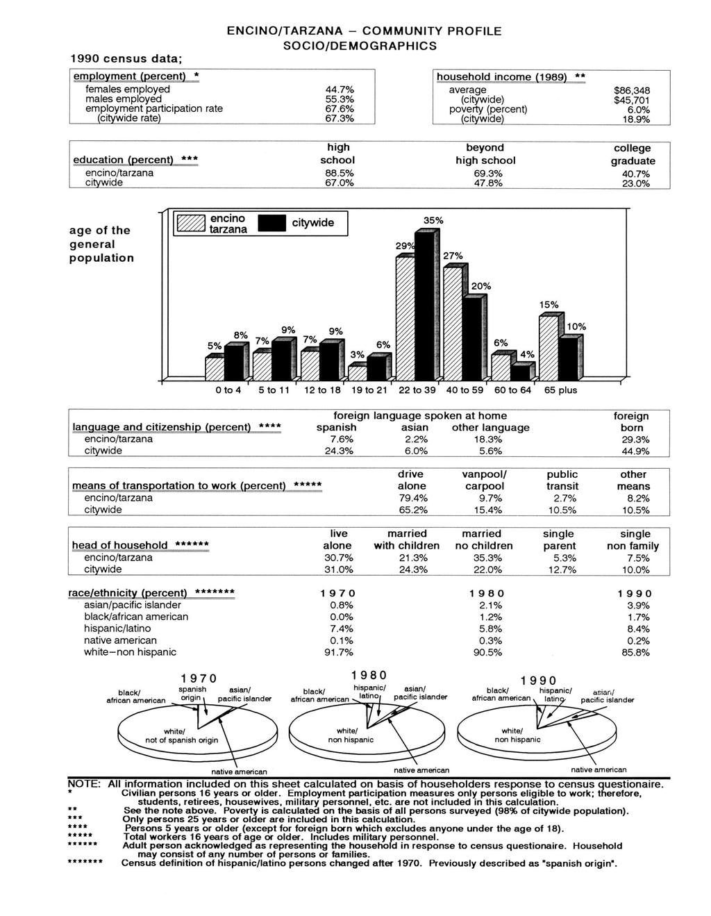
8 C C Establishing the proper types of uses if the rail line in not used for transit uses. Establish design features that complement adjacent uses for any future transit station stop. NEIGHBORHOOD CHARACTER Preserve and enhance the positive characteristics of existing uses which provide the foundation for community identity, such as scale, height, bulk, setbacks and appearance. Issues Scale, density and character of multiple dwelling housing adjacent to single-family homes. Impact on street parking from new high density apartments. The need to preserve and rehabilitate historic areas with a sensitivity to the character of the established neighborhood. New development that complements significant historic structures. Opportunities Development of areas adjacent to transit station stops provide opportunities to enhance community identity. Potential for appropriately scaled new housing in proximity to transit facilities. Inclusion of mixed use development in commercial areas adjacent to transit station stops. Development of specific design guidelines for areas located adjacent to commuter rail service and transit station stops. COMMUNITY PROFILE The Community Profile provides an overview of population, housing, and socio/demo-graphics for the Encino-Tarzana Community Plan Area and compares it to the rest of the city. The following tables contain the statistical data for previous census dates and rates of growth. I-6
9
10
11
12
13 Chapter II FUNCTION OF THE COMMUNITY PLAN Chapter II of the Plan Text contains the statutory requirements for the Community Plan outlining the mandatory elements that must be addressed. The chapter contains the explanations of the Role, Purpose, and Organization of the Community Plan. Chapter II shows the relationship to other General Plan elements and provides for Plan Monitoring and Consistency. STATUTORY REQUIREMENTS California State Law (Government Code 65300) requires that each city prepare and adopt a comprehensive, long-term general plan for its physical development. It must contain seven mandatory elements including land use, circulation, housing, conservation, open space, noise, and safety. In the City of Los Angeles, thirty five community plans comprise the city s Land Use Element. State of California law requires that the Land Use Element be prepared as part of the City s General Plan, and that the Land Use Element be coordinated with the Circulation Element. The Land Use Element has the broadest scope of the General Plan elements required by the State. Since it regulates how land is to be utilized, many of the issues and policies contained in all other plan elements are impacted and/or impact this element. Government Code Section (a) states that a land use element designates the proposed general distribution and general location and the extent of the uses of land for housing, business and industry, open space, including agriculture, natural resources, recreation, and enjoyment of scenic beauty, education, public buildings and grounds, solid and liquid waste disposal facilities, and other categories of public and private uses of land. The land use element shall include a statement of the standards of population density and building intensity recommended for the various districts and other territory covered by the plan. The Encino-Tarzana Community Plan is a part of the General Plan of the City of Los Angeles. It of the text and the accompanying map. The Community Plan text states the goals, objective, policies and programs. The Community Plan Map, footnotes and legend outline the arrangement and intensities of land uses, the street system, and the locations and characteristics of public service facilities. II-1
14 ROLE OF THE COMMUNITY PLAN The Community Plan is intended to promote an arrangement of land uses, streets, and services which will encourage and contribute to the economic, social and physical health, safety, welfare, and convenience of the people who live and work in the community. The plans are also intended to guide development in order to create a healthful and pleasant environment. Goals, objectives, policies, and programs are created to meet the existing and future needs and desires of the community through the year The general plan clarifies and articulates the city s intentions with respect to the rights and expectations of the general public, property owners, prospective investors and business interests. Through the Community Plan, the city can inform these groups of is goals, policies, and development standards, thereby communicating what is expected of the city government and private sector to meets its objectives. The Community Plan ensures that sufficient land is designated which provides for the housing, commercial, employment, educational, recreational, cultural, social, and aesthetic needs of the residents of the plan area. The Plan identifies and provides for the maintenance of any significant environmental resources within the Plan Area. The Plan also seeks to enhance community identity and recognizes unique neighborhoods within the Plan area. PURPOSE OF THE COMMUNITY PLAN The last comprehensive update of the Encino-Tarzana Community Plan was completed in 1987 through the General Plan Consistency Program required by AB283. In the past 20 years the community has shown a smaller growth rate than the overall rate for the city. From 1970 to 1980 the community population increased by 7,514 residents, an increase of 12.7%. Since 1980 the community s population has decreased by 16 residents representing a decline of -0.0%. During this time, considerable change has occurred, new issues have emerged, and new community objectives regarding the management of new development and community preservation have evolved. Consequently, it is necessary to update the Community Plan to not only reflect current conditions, but to accurately reflect the prevailing visions and objectives of the area s residents and property and business owners. This Community Plan was developed in the context of promoting a vision of the Encino-Tarzana area as a community that looks at its past with pride and approaches its future with eagerness, while maintaining its individual identity by: Preserving and enhancing the positive characteristics of existing residential neighborhoods while providing a variety of compatible new housing opportunities. Improving the function, design and economic vitality of the commercial corridors. II-2
15 Preserving and enhancing the positive characteristics of existing uses which provide the foundation for community identity, such as scale, height, bulk, setbacks and appearance. Maximizing the development opportunities of the future rail transit system while minimizing any adverse impacts. Planning the remaining commercial and industrial development opportunity sites for needed job producing uses that improves the economic and physical condition of the Encino-Tarzana Community Plan Area. ORGANIZATION AND CONTENT OF THE COMMUNITY PLAN This Plan sets forth goals, objectives, policies, and programs that pertain to Encino-Tarzana. Broader issues, goals, objectives, and policies are provided by the Citywide General Plan Framework. The Plan is organized and formatted to facilitate periodic updates. The State recommends that the entire plan be comprehensively reviewed every five years to reflect new conditions, local attitudes, and technological advances. The principal method for the implementation of the Land Use Map is the Zoning Ordinance. The City s Zoning Map must be updated to remain consistent with the adopted Land Use Map. Together, the Zoning Ordinance and the Zoning Map will identify specific types of land use, intensity of use and development standards applicable to specific areas and parcels of land within the community. RELATIONSHIP TO OTHER GENERAL PLAN ELEMENTS The City of Los Angeles has the responsibility to maintain and implement the City s General Plan. Since State Law requires that the General Plan have internal consistency, the Encino-Tarzana Community Plan must be consistent with other Elements and components of the General Plan. The General Plan Framework is a long range, citywide, comprehensive growth strategy. It is a special element of the General Plan which looks to the future as required by law and replaces Concept Los Angeles and the Citywide Plan (adopted in 1974). The Framework provides a citywide context within which local planning takes place. Both the benefits and challenges of growth are shared. The Citywide General Plan Framework Element neither overrides nor supersedes the Community Plan. It guides the city s long range growth and development policy, establishing citywide standards, goals, policies, and objectives for citywide elements and community plans. The Framework is flexible, suggesting a range for uses within its land use definitions. Precise determinations are make in the Community Plans. II-3
16 The General Plan Framework provides the following projections for population, housing and employment levels for the Encino-Tarzana Community Plan for the year 2010 are: Population (2010) Projection 79,352 Employment (2010) Projection 53,641 Housing (2010) Projection 32,628 The above population, employment and housing numbers are provided as reference during the Community Plan update. It needs to be recognized, however, that these figures are only best estimates and are derived from regional data which are disaggregated to the city and then the community level. Population, jobs and housing could grow more quickly, or slowly, than anticipated depending on economic trends. Regional forecast does not always reflect the adopted community plan land use capacity or buildout estimated from planned land use. Plan capacity or buildout is also an imprecise estimate and depends on specific assumptions about future density of development and household size, which may be more or less, than actually occurs. It should be also noted that the community plan capacity does not include housing in commercial districts nor the current residential vacancy rate. In addition to the seven State mandated elements, the City s General Plan includes a Service System Element, a Cultural Element, major Public Facilities areas Element, and an Air Quality Element. All the provisions and requirements of the General Plan elements apply to the Encino-Tarzana Community Plan. Neighborhood plans involve the preparation of special plans which blend both policy and implementation functions for unique neighborhoods within a community. In addition to these neighborhood plans, overlay zones also combine policy and implementation functions to address issues peculiar to a specific neighborhood. The Community Plan includes appropriate policies and implementation measures generated from the mitigation measures listed in the environmental clearance. In many instances these measures encompass the policies contained in the General Plan Framework. PLAN CONSISTENCY Each plan land use category indicates the corresponding zones permitted by the Plan unless further restricted by the Plan Text, footnotes, adopted Specific Plans or other specific limitations on discretionary approvals. The Plan recognizes that the residential densities, commercial intensities and industrial intensities depicted on the Plan Map are theoretical and will not occur due to plan and zone regulations, economic conditions, and design limitations. For each plan category, the Plan permits all identified corresponding zones, as well as those zones which are more restrictive, as referenced in Section II-4
17 12.23 of the Los Angeles Municipal Code (LAMC). Any subsequent action that modifies the Plan or any monitoring review that results in changes to the Plan must make new Plan consistency findings at the time of the decision. City actions on most discretionary projects require a finding that the action is consistent or in conformance with the General Plan. In addition to the required general finding, decision-makers acting on certain projects in the Encino-Tarzana Community Plan Area shall refer to each of the applicable additional findings that the Plan identifies as programs, policies or objectives in Chapter III of the Plan which are underlined for ease of reference. To further substantiate the consistency findings decision makers may site other programs, policies, or objectives which would be furthered by the proposed project. In addition, Chapter V of the Plan requires a decision maker to make a finding of conformance with applicable design standards for discretionary projects. PLAN MONITORING The Plan has a land use capacity greater than the projected development likely to occur during the Plan period. During the life of the Plan, growth will be monitored and reported in the City s Annual Report on Growth and Infrastructure which will be submitted to the City Planning Commission, Mayor, and City Council. In the fifth year following Plan adoption (and every five years thereafter), the Director shall report to the Commission on the relationship between population, employment, and housing growth and plan capacities. If growth has occurred faster than projected, a revised environmental analysis will be prepared and appropriate changes recommended to the Community Plan and zoning. These Plan and zoning changes and any related moratorium of interim control ordinance, shall be submitted to the Planning Commission, Mayor, and City Council as specified in the LAMC. II-5
18 Chapter III LAND USE POLICIES AND PROGRAMS Chapter III of the Plan Text contains Goals, Objectives, Policies, and Programs for all appropriate land use issues, such as residential, commercial, and industrial, as well as public and institutional service system categories. The Planning Department has responsibility for the goals, objectives, policies, initiation and direct implementation of the programs contained in Chapter III. The quality of life and stability of neighborhoods throughout Encino-Tarzana critically depends on providing infrastructure resources (i.e. police, fire, water, sewerage, parks, traffic circulation, etc.) Commensurate with the needs of its population. If population growth occurs faster than projected and without needed infrastructure improvements to keep pace with that growth, the consequences for livability within Encino-Tarzana could be problematic. Accordingly, the proposed Plan has three fundamental premises. First, is the limiting residential densities in various neighborhoods to the prevailing density of development in these neighborhoods. Second, is the monitoring of population growth and infrastructure improvements through the City s Annual Report on Growth and Infrastructure with a report to the City Planning Commission every five years on the Encino-Tarzana following Plan adoption. Third, if this monitoring finds that population in the Plan area is occurring faster than projected; and that infrastructure resource capacities are threatened, particularly critical resources such as water and sewerage: and that there is not clear commitment to at least begin the necessary improvements within twelve months; then building controls should be put into effect, for all or portions of the Encino-Tarzana Community, until land use designations for the Encino-Tarzana Community Plan and corresponding zoning are revised to limit development. RESIDENTIAL Existing residential land use patterns vary greatly according to local conditions in the neighborhoods and communities which comprise the Encino-Tarzana Community Plan. Topography, population characteristics, housing markets, age and degree of existing development have great influence on the type, location and density of development throughout the community. Much of the existing residential development in the area was established by physical controls such as topography, large amounts of then available land and infrastructure. In recent years, there has been increasing pressure for development in the hillside areas, much of which is out of scale with adjacent homes. Such new single-family development impacted the existing street system and infrastructure. Additionally, development pressure from projects along Ventura Boulevard have increased an overall concern for the future functional development of these areas. Historically, the majority of the area has been planned for residential purposes. The 1975 Plan designated approximately 63 percent of the total III-1
19 land area for residential use. Of this portion 60 percent was designated for single-family use only. Therefore, current plan policy provides for continued preservation of the existing residential neighborhoods throughout the area, retaining existing single family districts and multi-family clusters. Areas around transit stations and along transit corridors would realize any changes in densities as existing properties zoned for multi-family development continue to build out to their maximum potential. The Plan designates residential land use densities as indicated in the following table. The table depicts the reasonable expected population and dwelling unit count for the year 2010, using the mid-point of the range for the dwelling units per net acre category. The midpoint represents a reasonable factor to use, as new development within each land use category is not likely to occur at one or the other extremes of the range but rather throughout the entire range. PLAN POPULATION AND DWELLING UNIT CAPACITY Residential Land Use Category Dwelling Units Per Net Acre Midpoint (Range) Number of Dwelling Units Net Acres Persons Per Dwelling Unit (2010) Reasonable Exp. Population (2010) Minimum 0.5 (0-1 ) 572 1, ,630 Very Low I 2.0 (1+ to 3) 5,522 2, ,738 Very Low II 3.5 (3+ to 4) 5,996 1, ,649 Low 6.5 (4+ to 9) 8,710 1, ,733 Low Medium I 13.5 (9+ to 18) ,000 Low Medium II 23.5 (18+ to 29) 1, ,055 Medium 42.0 (29+ to 55) 13, ,411 TOTALS 36,100 7,376 86,216 * DU: Dwelling Unit GOAL 1 Objective 1-1 A SAFE, SECURE, AND HIGH QUALITY RESIDENTIAL ENVIRONMENT FOR ALL ECONOMIC, AGE, AND ETHNIC SEGMENTS OF THE COMMUNITY. To provide for the preservation of existing housing and for the development of new housing to meet the diverse economic and physical needs of the existing residents and projected population of the Plan area to the year III-2
20 Policies Designate specific lands to provide for adequate multi-family residential development. Program: The Plan Map identifies specific areas where multifamily residential development is permitted Protect existing single family residential neighborhoods from new, out-of-scale development. Program: Recent changes in the Zoning Code set height limits for new single family residential development Protect existing stable single-family and low density residential neigh-borhoods from encroachment by higher density residential and other incompatible uses. Program: The Plan Map identifies lands where only single-family residential development is permitted; it protects these areas from encroachment by designating appropriate, transitional residential densities which serve as buffers; and reflects plan amendments and corresponding zone changes which are directed at minimizing incompatible uses Protect the quality of the residential environment through attention to the appearance of communities, including attention to building and site design. Program: The Plan includes an Urban Design Chapter which is supplemented by Design Guidelines and Standards for residential development Maintain at least 63% residential land designated for single family uses. Program: The Plan designates residential lands to reflect this percentage The city should promote neighbor-hood preservation, particularly in existing single family neighborhoods, as well as in areas with existing multi-family residences. Program: With the implementation of the Community Plan, single family residential land use categories, all zone changes, subdivisions, parcel maps, variances, conditional uses, specific plans, community and neighborhood revitalization programs for residential projects shall provide for Plan consistency. Program: The Homeowner s Encouragement Loan Program (HELP), administered by the City s Housing Preservation and Production Department, provides rehabilitation loans to owners of small residential buildings (one to four units) to correct code violation. III-3
21 Program: The Residential Rehab-ilitation Loan Program, administered by the Community Redevelopment Agency (CRA), makes funds available for the rehabilitation of lower-income multifamily rental housing. The program is partially funded by the U.S. Department of Housing and Urban Development (HUD) and requires matching funds from a private lender with CRA as a last resort. Objective 1-2 To locate new housing in a manner which reduces vehicular trips and makes it accessible to services and facilities. Policies Locate higher residential densities near commercial centers or transit stations and major bus routes where public services facilities, utilities and topography will accommodate this development. Program: Maintain and continue the implementation of the City s Land Use/Transportation Policy Encourage multiple residential development in commercial zones. Program: The Plan provides the potential for a floor area ratio bonus by providing for mixed use corridors in specific commercial areas. Program: Maintain and continue the implementation of the City s Land Use/Transportation Policy. Objective 1-3 To preserve and enhance the varied and distinct residential character and integrity in existing single and multi- family neighborhoods. Policies Seek a high degree of compatibility and landscaping for new infill development to protect the character and scale of existing residential neighborhoods. Program: The Plan includes Design Guidelines which establish design standards for residential development to implement this policy Consider factors such as neighborhood character and identity, compatibility of land uses, impact on livability, impacts on services and public facilities, and impacts on traffic levels when changes in residential densities are proposed. Program: The decision-maker should adopt a finding which addresses these factors as part of any decision relating to changes in planned residential densities Preserve existing views in hillside areas. III-4
22 Program: Maintain and continue implementation of the adopted Citywide Hillside Ordinance and the Mulholland Scenic Parkway Specific Plan which contribute to preservation of views. Objective 1-4 To promote and ensure the provision of adequate housing for all persons regardless of income, age or ethnic background. Policies Promote greater individual choice in type, quality, price and location of housing. Program: The plan promotes greater individual choice through its establishment of residential design standards and its allocation of lands for a variety of residential densities Promote housing in mixed use projects in pedestrian oriented areas. Program: Maintain and continue the implementation of the Land Use/Transportation Policy. Program: The plan provides a bonus in floor area for mixed use projects in the areas identified in this policy Ensure that new housing opportunities minimize displacement of the residents. Program: The decision-maker shall adopt a finding which addresses any potential displacement of residents as part of any decision relating to new housing construction Provide for development of townhouses and other similar condominium type of housing units to increase home ownership options. Program: The Plan cannot require that condominium units be built instead of rental units; however, the Plan encourages such type of development by designating specific areas for Low Medium residential land use categories. Objective 1-5 To limit the intensity and density in hillside areas. Policies Limit development according to the adequacy of the existing and assured street circulation system within the Plan Area and surrounding areas. Program: Continue the implementation of the Citywide Hillside Ordinance and the Mulholland Scenic Parkway Specific Plan. III-5
23 Ensure that a footnote of the Plan Map Legend is considered by the decision-maker for subdivisions and parcel map applications within hillside areas Ensure the availability of adequate sewers, drainage facilities, fire protection services and facilities and other public utilities to support development within hillside areas. Program: The decision-maker shall adopt a finding which addresses the availability of these services and utilities as part of any decision relating to hillside residential development Consider the steepness of the topography and suitability of the geology in any proposal for development within the Plan Area. Program: The Plan retains hillside areas in restrictive plan designations and zones due to topography. Continue the implementation of the Subdivision Map Act on individual project applications. The decision maker shall follow the standards set forth in a footnote of the Plan Map Legend when considering hillside development Require that any proposed development be designed to enhance and be compatible with adjacent development. Program: Continue the implementation of the Citywide Hillside Ordinance and the Mulholland Scenic Parkway Specific Plan. COMMERCIAL Commercial land use in the Encino-Tarzana Community Plan area is a vital component of the community. It is as diverse as the various areas that make up the Community Plan Area. The varied mixed forms of commercial uses that are found along Ventura Boulevard dominate the commercial aspect of the community. Except for the high-rise development west of the 405 Freeway to Balboa Boulevard, the predominant land use pattern is mainly strip commercial developed on shallow lots with limited on-site parking. Along Ventura Boulevard which runs the length of the Plan Area, a specific plan has been in effect that has helped to address the parking problems. Plan policy provides for the development of single or aggregated parcels for mixed use commercial and residential development. These structures would normally incorporate retail, office, and/or parking on the lower floors and residential units on the upper floors. The intent is to provide housing in close proximity to jobs, to reduce vehicular trips, to reduce congestion and air pollution, to assure adequate sites for housing, and to stimulate pedestrian oriented areas to enhance the quality of life in the Plan area. While the Plan does not mandate mixed-use projects, it encourages them in certain commercially designated areas, such as in pedestrian oriented areas. GOAL 2 A STRONG AND COMPETITIVE COMMERCIAL SECTOR WHICH BEST SERVES THE NEEDS OF THE COMMUNITY THROUGH MAXIMUM EFFICIENCY AND ACCESSIBILITY WHILE PRESERVING THE HISTORIC COMMERCIAL AND CULTURAL CHARACTER OF THE DISTRICT. III-6
24 Objective 2-1 To conserve and strengthen viable commercial development Policies New commercial uses shall be located in existing established commercial areas or existing shopping centers. Program: The plan provides well defined boundaries for commercial areas, any extended growth outside those boundaries would require a plan amendment Protect commercially planned/zoned areas outside pedestrian orientated areas from encroachment by residential only development. Program: Provisions of the Zoning Code currently restrict floor area of buildings, including residential buildings, in commercial zones within Height District 1, to a 1.5 floor area ratio, rather than the 3 to 1 floor area ratio in a residential zone. This provision effectively discourages residential only developments in commercial zones outside of pedestrian orientated areas Require that projects be designed and developed to achieve a high level of quality, distinctive character, and compatibility with existing uses and development Program: Chapter V- Urban Design, proposes policies for commercial development which address this policy. Objective 2-2 Allow for the development of automobile-related uses in specifically designated commercial designations along most boulevards. Policies Prohibit the development of new automobile-related uses in pedestrian oriented areas (POA s). Program: Maintain and continue implementation of the adopted Ventura/Cahuenga Boulevard Corridor Specific Plan, which prohibits certain uses in the POA s Require screening of open storage and auto repair uses, and prohibit storage of automobile parts and other noxious commercial related products in front of commercial development, exposed to the street. Program: The Plan and Specific Plan include Design guidelines which address this policy. Objective 2-3 To enhance the identity of distinctive commercial districts and to identify pedestrian oriented areas (POA s). Policies III-7
25 2-3.1 Existing pedestrian oriented areas are to be preserved. Program: The Plan map identifies specific corridors as pedestrian oriented areas. Development within these areas is subject to the applicable design standards of the Design Guidelines. The Plan identifies appropriate land use designations and establishes height limits and appropriate zones which preserve and enhance the existing pedestrian oriented character. Maintain and continue implementation of the Ventura/Cahuenga Boulevard Corridor Specific Plan which designates specific areas as POA s New development needs to add to and enhance the existing pedestrian street activity. Program: Development within these areas are subject to the uses specified within the Specific Plan regulations. Further development within these areas is subject to the design standards established in the Design Guidelines for pedestrian oriented areas Ensure that commercial infill projects achieve harmony with the best of existing development. Program: Implementation of Design Guidelines and the Ventura/Cahuenga Boulevard Corridor Specific Plan Identify pedestrian oriented areas as preferred locations for mixeduse projects. Program: Through this policy and Plan Map designations, the Plan proposes pedestrian oriented areas as preferred locations for mixed use projects Require that mixed use projects and development in pedestrian oriented areas be designed and developed to achieve a high level of quality, distinctive character, and compatibility with existing uses. Program: The Plan includes a Design Guidelines provision which will implement this policy for commercial projects located within pedestrian oriented areas Require that the first floor street frontage of structures, including mixed use projects and parking structures located in pedestrian oriented areas, incorporate commercial uses. Program: Maintain and implement the Ventura/Cahuenga Boulevard Corridor Specific Plan Design Guidelines which address this policy for areas within the Specific Plan boundaries. Additionally, where appropriate establish Pedestrian Oriented Areas outside of the Specific Plan boundaries. III-8
26 Objective 2-4 To enhance the appearance of commercial districts Policies Require that any proposed development be designed to enhance and be compatible with adjacent development. Program: Continue the implementation of the Ventura/ Cahuenga Boulevard Corridor Specific Plan, and implement the applicable design standards identified in the Design Guidelines of the Community Plan Preserve community character, scale and architectural diversity. Program: The Plan establishes height limits, amends Plan designations and recommends corresponding zone changes to implement this policy. Design standards for commercial areas included in the Design Guidelines of the Community Plan implement this policy Improve safety and aesthetics of parking areas in commercial areas. Program: Implement design standards for parking areas established in the Ventura/Cahuenga Boulevard Corridor Specific Plan and within the Chapter Design Standards of this plan Landscaped corridors should be created and enhanced through the planting of street trees along segments with no building setbacks and through median plantings. Program: The Design Guidelines in this Plan and the Ventura/Cahuenga Boulevard Corridor Specific Plan include sections which establishes guidelines for community design and landscaping. These guidelines are intended to serve as reference to other city departments and public agencies and any private entities who participate in projects which involve improvements to public spaces and right-of-way, including streetscape and landscaping. INDUSTRIAL Industrial development within the plan area has been limited to the properties adjacent to the railroad tracks that run along Oxnard Street. The majority of the industrial uses are located within several blocks east and west of Reseda Boulevard. The pattern of industrial development within the plan area is similar to what has taken place throughout the valley in general, commercial uses located along arterials. The majority of industrial uses are located east and west of Reseda Boulevard, the commercial intrusion has taken place on the corners of Reseda Boulevard and Oxnard Street. Industrial uses provide needed employment opportunities and economic benefits to the community and should be encouraged when impacts to surrounding land uses can be mitigated. III-9
27 GOAL 3 Objective 3-1 Provide land of sufficient size for expansion of low intensity non-toxic producing industrial uses which create employment opportunities and have minimal adverse impacts on adjacent residential uses. To provide for existing and future industrial uses which contribute job opportunities for residents and which minimize environmental and visual impacts to the community. Policies Designate lands for the continuation of existing industrial uses, research and development uses which provide employment opportunities. Program: The Plan Map identifies lands, which have industrial designations to accommodate the variety of uses noted above. The addition of plan amendments and recommended corresponding zone changes will implement this policy Require that any proposed development be designed to enhance and be compatible with adjacent development. Program: Design Guidelines include provisions for industrial projects which are adjacent to or in the vicinity of residential uses. Objective 3-2 To assure mitigation of potential negative impacts generated by industrial uses when they are located in proximity to residential neighborhoods, the Plan proposes design guidelines for new industrial uses when so located. Policies Encourage new industrial uses adjacent to residential neighborhoods to mitigate their impact on the residential neighborhoods to the extent feasible. Program: New development of industrial uses located adjacent to residential neighborhoods shall comply with the Industrial/Residential design guidelines found in the Urban Design Chapter (Chapter V) of this Plan. Program: Restrict new industrial uses located adjacent to a residential neighborhood to uses first permitted in the CM zone. PUBLIC AND INSTITUTIONAL LAND USE Public facilities such as fire stations, libraries, schools, parks shown on the Encino-Tarzana Community Plan are to be developed in substantial conformance with the standards of need, site area, design and general location identified in the Service Systems Element and the Safety Element of the General Plan. Such development shall be sequenced and timed to III-10
28 provide an efficient and adequate balance between land use and public services. Development to the full residential, commercial, and industrial densities and intensities proposed by the Plan are predicated upon substantial compliance with the standards contained in the Public Facilities and Service Element of the General Plan. Such development should be sequenced and timed to provide a workable, efficient and adequate balance between land use and service facilities. There is a continuing need for the modernizing of public facilities to improve services and accommodate changes in the Encino-Tarzana Community Plan. However, the amenities and environmental quality of the community must be adequately protected. Cost and equitable distribution are major issues in the provisions of public facilities. It is essential that priorities be established and new and different sources of revenue be found. Furthermore, public and private development must be fully coordinated, in order to avoid expensive duplication and to assure a balance among needs, services and costs. This plan seeks to utilize the location, characteristics, and timing of public facility and utility development as a tool in achieving planned land use patterns. The intent is to achieve economy and efficiency in the provision of services and facilities consistent with standards for environmental quality. The Community Plan includes appropriate policies and implementation measures generated from the mitigation measures listed in the environmental clearance. In many instances these measures encompass the policies contained in the General Plan Framework. The full residential, commercial, and industrial densities and intensities proposed by the Plan are predicated upon substantial compliance with the standards contained in the Public Facilities and Service Element of the General Plan. Such development should be sequenced and timed to provide a workable, efficient and adequate balance between land use and service facilities. RECREATION AND PARK FACILITES In the Encino-Tarzana Community Plan area public parks and the majority of recreational areas are managed by the City of Los Angeles Recreation and Parks Department. There are three types of parks-regional, community and neighborhood parks. There are three Neighborhood and two Community Parks which serve the Encino-Tarzana Community Plan Area. Additionally, the Sepulveda Basin Recreation Area with its diverse multi-recreational uses is located within the plan area. Located south of Ventura Boulevard are two private golf courses. The plan area with its diverse topography limits the placement of neighborhood park sites south of Ventura Boulevard. However the Santa Monica Mountain Conservancy has acquired vast sections of the mountain areas located south of Ventura Boulevard. These open space park lands serve to fulfill the need when the topography does not allow for the construction of neighborhood park sites. The community parks serve a much wider interest range due to the lack of sites in the hillside areas of the plan III-11
29 area. While the existing parks satisfy the needs of the current residents, the community is still deficient in the number of neighborhood parks. GOAL 4 Objective 4-1 ADEQUATE RECREATION AND PARK FACILITIES TO MEET THE NEEDS OF THE RESIDENTS IN THE PLAN AREA. To conserve, maintain and better utilize existing recreation and park facilities which promote the recreational experience. Policies Preserve the existing recreational facilities and park space. Program: The plan assists in preserving such facilities and park space by changing the existing zone as applicable to the Open Space Zone, which provides such protection. Program: Encourage the Department of Recreation and Parks to continue identifying funding sources and other mechanisms such as, but not limited to developer fees, bond financing, and proposition funds for the continuing maintenance of recreation and park facilities. Objective 4-2 To encourage the Department of Recreation and Parks to develop new recreation and park facilities. Policies Promote the development of new recreation and park facilities through the acquisition of new recreation and park land. Program: Encourage the Department of Recreation and Parks to continue utilizing existing funding and to pursue additional sources of funding and other mechanisms such as, but not limited to supplemental developer fees, bond financing, proposition funds, transfer of development rights, and land dedications for the acquisition and development of suitable recreation and park land within the plan area. Program: Encourage the Department of Recreation and Parks to coordinate efforts with other agencies and non-profit organizations toward the acquisition and development of recreation and park land. OPEN SPACE In the Encino-Tarzana Community Plan Area, major open space areas exist separate from land under control of the City of Los Angeles Department of Recreation and Parks. Open space is important due to its role in both physical and environmental protection. Open Space is divided onto publicly owned and privately owned open space. Open Space is broadly defined as land which is essentially free of structures and buildings and/or is natural in character and which functions in one or more of the following ways: III-12
Policies and Code Intent Sections Related to Town Center
 Policies and Code Intent Sections Related to Town Center The Town Center Vision is scattered throughout the Comprehensive Plan, development code and the 1994 Town Center Plan. What follows are sections
Community Plan TABLE OF CONTENTS ACTIVITY LOG
 Community Plan TABLE OF CONTENTS ACTIVITY LOG COMMUNITY MAPS COMMUNITY PLAN I. Introduction II. Function of the Community Plan III. Land Use and Programs IV. Coordination Opportunities for Public Agencies
EXISTING COMPREHENSIVE PLAN
 EXISTING COMPREHENSIVE PLAN Town Center Land Use Element: V. LAND USE POLICIES Town Center Mercer Island's business district vision as described in "Your Mercer Island Citizen-Designed Downtown" was an
A. WHAT IS A GENERAL PLAN?
 I. Introduction A. WHAT IS A GENERAL PLAN? A general plan is the planning guideline for the future of a city. It contains goals and policies which regulate urban development, the protection of the natural
4. ENVIRONMENTAL IMPACT ANALYSIS 7. LAND USE AND PLANNING
 4. ENVIRONMENTAL IMPACT ANALYSIS 7. LAND USE AND PLANNING 4.7.1 INTRODUCTION The following analysis discusses the consistency of the Proposed Project with the corresponding land use and zoning designations
CHAPTER 1. Ms. Guajardo s Class - Central Elementary CH 1 1
 INTRODUCTION CHAPTER 1 Ms. Guajardo s Class - Central Elementary CH 1 1 1.1 SETTING South Centre City is a linear corridor south of Downtown Escondido paralleling Centre City Parkway and South Escondido
CONTENTS 8.0 LAND USE 8.1 GENERAL LAND USE 8.2 RESIDENTIAL 8.3 MIXED USE 8.4 COMMERCIAL 8.5 EMPLOYMENT LANDS
 8-2 Land Use 8.0 LAND USE CONTENTS 8.1 GENERAL LAND USE 8.1.1 Uses provided for in all Land Use Designations 8.1.2 Uses prohibited in Hazardous Lands, Hazardous Sites and Special Policy Areas 8.1.3 Uses
Planning & Zoning Commission Staff Report
 Planning & Zoning Commission Staff Report Meeting Date: May 26, 2015 Drafted by: Katherine Harrison-Rogers CASE # Z2886 PROJECT NAME: APPLICANT/ REPRESENTATIVE: Shawna Runyan PROPERTY OWNER: 1840 (previously
SAN RAFAEL GENERAL PLAN 2040 INTRODUCTION AND OVERVIEW
 SAN RAFAEL GENERAL PLAN 2040 INTRODUCTION AND OVERVIEW Steering Committee Presentation February 14, 2018 Purpose of General Plan Guide land use and development decisions Coordinate transportation, infrastructure,
NEW CASTLE COUNTY S ZONING DISTRICTS
 NEW CASTLE COUNTY S ZONING DISTRICTS This is general information about New Castle County s zoning districts. The information included is by no means exhaustive or complete. Before designing plans to develop
The transportation system in a community is an
 7 TRANSPORTATION The transportation system in a community is an important factor contributing to the quality of life of the residents. Without a sound transportation system to bring both goods and patrons
4.1.3 LAND USE CATEGORIES
 4.1.3 LAND USE CATEGORIES a. City Center District The City Center District incorporates the existing character and mix of uses in downtown Belmont to encourage redevelopment and new development in keeping
CITY OF PUYALLUP. Background. Development Services
 CITY OF PUYALLUP Development Services 333 South Meridian Puyallup WA 98371 To: City Council From: Katie Baker, AICP, Planning Division Re: South Hill Neighborhood Plan Adoption Date: (Meeting date: February
The Five Components of the McLoughlin Area Plan
 The Five Components of the McLoughlin Area Plan This documents contains the complete language of the five components of the McLoughlin Area Plan: The Vision Statement The Values The Guiding Principles
G. RECREATION AND OPEN SPACE ELEMENT. The following summarizes the Recreation and Open Space Element:
 G. RECREATION AND OPEN SPACE ELEMENT The purpose of the Element is to provide the framework and direction for a comprehensive system of public and private sites for recreation, including, but not limited
178 Carruthers Properties Inc.
 178 Carruthers Properties Inc. Planning Rationale for 178 Carruthers Avenue Site Plan Control Application June 2014 Table of Contents 1.0 Introduction 2.0 Overview of Subject Property 3.0 Current Zoning
POCKET COMMUNITY PLAN
 POCKET COMMUNITY PLAN Part Three : COMMUNITY PLAN AREAS AND SPECIAL STUDY AREAS CONTENTS Community Location... 3-P-3 Community Vision... 3-P-4 Community Profile... 3-P-4 Community Issues... 3-P-6 Land
GENERAL PLAN CONSISTENCY ANALYSIS
 GENERAL PLAN CONSISTENCY ANALYSIS Prepared by Planning Staff 10/28/2013 APPLICABLE GOALS, POLICIES AND PROGRAMS FROM the LAND USE CHAPTER Goal LU-1 Policy LU-1.1 Policy LU-1.2 Goal LU-2 Protect the character
Midtown Greenway Land Use and Development Plan Executive Summary
 Midtown Greenway Land Use and Development Plan Executive Summary Introduction The Midtown Greenway Land Use and Development Plan sets policy direction for land use and development in the Midtown Greenway
Baumgarten MPUD. Exhibit 3 Evaluation Criteria
 Pursuant to LDC subsections 10.02.13 B, 10.02.08 F and Chapter 3 G. of the Administrative Code, staff s analysis and recommendation to the Planning Commission, and the Planning Commission s recommendation
2040 LUP is a part of the Comprehensive Plan and carries the same legal authority. Economic Challenges
 1.1. Guiding Anchorage s Growth Where will new residents settle over the next two decades? Where will people work, shop, and play? Will there be enough room to grow? How will Anchorage look? Will growth
Joint Study Session of the Sutter County. March 2, 2009
 Joint Study Session of the Sutter County Board of Supervisors and Planning Commission March 2, 2009 CURRENT APPLICATION General Plan Amendment Specific Plan Specific Plan Appendices Utility Plans Transit/AQ
Planned Development Review Revisions (Project No. PLNPCM )
") Planned Development Review Revisions (Project No. PLNPCM2014-00139) Standard residential development Planned Development Example: Smaller lot sizes than what is allowed to create open space amenity. What
Planned Development Review Revisions (Project No. PLNPCM2014-00139) Standard residential development Planned Development Example: Smaller lot sizes than what is allowed to create open space amenity. What
SOUTH NATOMAS COMMUNITY PLAN
 SOUTH NATOMAS Community Plan Part Three : COMMUNITY PLAN AREAS AND SPECIAL STUDY AREAS SACRAMENTO 2030 GENERAL PLAN Contents Community Location... 3-SN-3 Community Vision... 3-SN-4 Community Profile...
SECTION II SECTION II STATEMENT OF GOALS, OBJECTIVES, PRINCIPLES, ASSUMPTIONS, POLICIES AND STANDARDS
 STATEMENT OF GOALS, OBJECTIVES, PRINCIPLES, ASSUMPTIONS, POLICIES AND STANDARDS 1 2 STATEMENT OF GOALS, OBJECTIVES, PRINCIPLES, ASSUMPTIONS, POLICIES AND STANDARDS INTRODUCTION The New Jersey Municipal
2.0 AREA PLANS. Lakeside Business District. Lakeside Business District Land Use Categories:
 Lakeside Business District Lakeside Business District Land Use Categories: Campus Commercial Campus Commercial means a mixture of uses which includes corporate offices, office parks, hotels, commercial,
Mark-up of the effect of the proposed Bronte Village Growth Area OPA No.18 on the text of section 24, Bronte Village, of the Livable Oakville Plan
 Mark-up of the effect of the proposed Bronte Village Growth Area OPA No.18 on the text of section 24, Bronte Village, of the Livable Oakville Plan Notes: This document is provided for information purposes
Infill Residential Design Guidelines
 Infill Residential Design Guidelines Adopted March 23, 2004 Amended September 10, 2013 City of Orange Community Development Department Planning Division Phone: (714) 744-7220 Fax: (714) 744-7222 www.cityoforange.org
Staff Report and Recommendation
 Community Planning and Development Planning Services 201 W. Colfax Ave., Dept. 205 Denver, CO 80202 p: 720.865.2915 f: 720.865.3052 www.denvergov.org/cpd TO: City Council Neighborhoods and Planning Committee
PORT WHITBY COMMUNITY
 PORT WHITBY COMMUNITY SECONDARY PLAN UPDATE COMMUNITY IMPROVEMENT PLAN URBAN DESIGN GUIDELINES September 2015 DRAFT PROPOSED AMENDMENT NUMBER # to the Whitby Official Plan PURPOSE: The intent of this Amendment
3.10 LAND USE SETTING PROJECT SITE EXISTING LAND USE DESIGNATIONS AND ZONING. General Plan Land Use Designations.
 This section of the Draft EIR addresses the existing land uses on and adjacent to the project site and discusses the potential impacts of the proposed project on existing land uses. Key issues addressed
Community Plan TABLE OF CONTENTS ACTIVITY LOG
 Community Plan TABLE OF CONTENTS ACTIVITY LOG COMMUNITY MAPS COMMUNITY PLAN I. Introduction II. Function of the Community Plan III. Land Use Policies and Programs IV. Coordination Opportunities for Public
ARTICLE 6: Special and Planned Development Districts
 ARTICLE 6: Special and Planned Development Districts 6-10 Traditional Neighborhood Development (TND) District 6-10.10 Purpose and Intent The Traditional Neighborhood Development (TND) District provides
Chapter Master Planned Communities (MPC) District
 District") Sections 14.53.010 Purpose and Intent 14.53.020 Applicability 14.53.030 Procedure 14.53.040 MPC Standards 14.53.050 Required Findings 14.53.010 Purpose and Intent Chapter 14.53 Master Planned Communities
Sections 14.53.010 Purpose and Intent 14.53.020 Applicability 14.53.030 Procedure 14.53.040 MPC Standards 14.53.050 Required Findings 14.53.010 Purpose and Intent Chapter 14.53 Master Planned Communities
RECOMMENDATION REPORT
 DEPARTMENT OF CITY PLANNING RECOMMENDATION REPORT City Planning Commission Case No.: CPC-2012-1165-GPA-ZC Date: August 9, 2012 Time: After 8:30 AM Place: City Hall, Room 350 Public Hearing: Required CEQA
13 THORNHILL YONGE STREET STUDY IMPLEMENTATION CITY OF VAUGHAN OPA 669 AND TOWN OF MARKHAM OPA 154
 13 THORNHILL YONGE STREET STUDY IMPLEMENTATION CITY OF VAUGHAN OPA 669 AND TOWN OF MARKHAM OPA 154 The Planning and Economic Development Committee recommends the adoption of the recommendations contained
Table L-1 Summary Action Strategy. Action Item Timing Status Responsible Agency
 CHAPTER 4: CIRCULATION ELEMENT ISSUE #1: MAJOR THOROUFARES AND TRANSPORTATION ROUTES A balanced transportation system for Fontana is provided that meets the mobility needs of current and future residents
EXHIBIT A. Tax Increment Reinvestment Zone No. 1 (Town Center) First Amended Project Plan 1
 First Amended Project Plan 1") EXHIBIT A Tax Increment Reinvestment Zone No. 1 (Town Center) First Amended Project Plan 1 1 As amended by Resolution No. 2008-02-001(TR1R) of the Tax Increment Reinvestment Zone No.1, and approved to
EXHIBIT A Tax Increment Reinvestment Zone No. 1 (Town Center) First Amended Project Plan 1 1 As amended by Resolution No. 2008-02-001(TR1R) of the Tax Increment Reinvestment Zone No.1, and approved to
CHAPTER 7: VISION AND ACTION STATEMENTS. Noble 2025 Vision Statement
 CHAPTER 7: VISION AND ACTION STATEMENTS This chapter presents the vision, policy and action statements that transform the comprehensive planning study, an analysis of Noble s past, future trends and community
REZONING GUIDE. Zone Map Amendment (Rezoning) - Application. Rezoning Application Page 1 of 3. Return completed form to
 - Application. Rezoning Application Page 1 of 3. Return completed form to") Zone Map Amendment (Rezoning) - Application COMMUNITY PLANNING & DEVELOPMENT REZONING GUIDE Rezoning Application Page 1 of 3 PROPERTY OWNER INFORMATION* CHECK IF POINT OF CONTACT FOR APPLICATION Property
Zone Map Amendment (Rezoning) - Application COMMUNITY PLANNING & DEVELOPMENT REZONING GUIDE Rezoning Application Page 1 of 3 PROPERTY OWNER INFORMATION* CHECK IF POINT OF CONTACT FOR APPLICATION Property
Chapter 4. Linking Land Use with Transportation. Chapter 4
 Chapter 4 Linking Land Use with Transportation Chapter 4 59 Chapter 4 Linking Land Use with Transportation Community Design and Transportation Program Introduction Since the 1950s, the predominant development
LAND USE OVERVIEW WHAT YOU WILL FIND IN THIS CHAPTER
 LAND USE WHAT YOU WILL FIND IN THIS CHAPTER Information about the City s expected population and employment growth. Description and capacity of existing and future land use designations. Policies that
WILSHIRE. Community Plan
 WILSHIRE Community Plan TABLE OF CONTENTS ACTIVITY LOG COMMUNITY PLAN I. Introduction II. Function of the Community Plan III. Land Use Policies and Programs IV. Coordination Opportunities for Public Agencies
SUMMERSIDE / MT. CARMEL REINVESTMENT CORRIDOR COMMUNITY DEVELOPMENT STRATEGY
 SUMMERSIDE / MT. CARMEL REINVESTMENT CORRIDOR COMMUNITY DEVELOPMENT STRATEGY FEBRUARY 2013 I. Location of the Summerside/Mt. Carmel Reinvestment Corridor The Summerside/Mt. Carmel Reinvestment Corridor
SECTION UNIFIED DEVELOPMENT ORDINANCE SECTION Part 1 Ordinance. ARTICLE 1 Zoning Districts
 SECTION 1-100 UNIFIED DEVELOPMENT ORDINANCE SECTION 1-300 Part 1 Ordinance SECTION 1-100. Introduction. ARTICLE 1 Zoning Districts Crystal Lake strives to maintain a balance of various land uses for a
RECREATION AND OPEN SPACE ELEMENT GOALS, OBJECTIVES, AND POLICIES
 RECREATION AND OPEN SPACE ELEMENT GOALS, OBJECTIVES, AND POLICIES Goal 7 To provide park facilities, recreation programs, and open space resources that are safe, adequate, and accessible to all City residents,
TREASURE COAST REGIONAL PLANNING COUNCIL M E M O R A N D U M. To: Council Members AGENDA ITEM 5H
 TREASURE COAST REGIONAL PLANNING COUNCIL M E M O R A N D U M To: Council Members AGENDA ITEM 5H From: Date: Subject: Staff October 17, 2008 Council Meeting Local Government Comprehensive Plan Review Draft
IMPLEMENTATION STRATEGIES. In This Chapter. Goals & Strategies 182 Project List 183 Future Land Use 186 CHAPTER 11 IMPLEMENTATION STRATEGIES
 In This Chapter Goals & Strategies 182 Project List 183 Future Land Use 186 11 IMPLEMENTATION STRATEGIES NORTH AUGUSTA, SC 2017 COMPREHENSIVE PLAN 179 Individual commitment to a group effort that is what
3. VISION AND GOALS. Vision Statement. Goals, Objectives and Policies
 Vision Statement Queen Creek s interconnected network of parks, trails, open spaces and recreation opportunities provide safe and diverse activities and programs that sustain its unique, small town, equestrian
Authority of the General Plan
 Authority of the General Plan This La Habra Heights General Plan will serve as the blueprint for future planning and development in the City. This General Plan describes the City s vision for the future
COMMUNITY DESIGN. GOAL: Create livable and attractive communities. Intent
 COMMUNITY DESIGN Intent An attractive, well-designed County will attract quality development, instill civic pride, improve the visual character of the community, and create a strong, positive image for
Living in Albemarle County s Urban Places
 Living in Albemarle County s Urban Places ALBEMARLE COUNTY, VIRGINIA A Closer Look at Albemarle s Approach to Managing Growth and Creating Quality Urban Environments www.albemarle.org Page 2 Living in
Gold Line Bus Rapid Transit Transit Oriented Development (BRTOD) Helmo Station Area Plan
 Helmo Station Area Plan") Appendix F Gold Line Bus Rapid Transit Transit Oriented Development (BRTOD) Helmo Station Area Plan Introduction and Purpose of the Plan The Gold Line Bus Rapid Transit facility is an eleven-mile dedicated
Appendix F Gold Line Bus Rapid Transit Transit Oriented Development (BRTOD) Helmo Station Area Plan Introduction and Purpose of the Plan The Gold Line Bus Rapid Transit facility is an eleven-mile dedicated
3. Project Description
 3.1 PROJECT LOCATION The Platinum Triangle (herein after also referred to as the Project Area ) is located at the confluence of the Interstate 5 (I-5 Freeway) and the State Route 57 (SR-57 Freeway), in
LAND USE ELEMENT. Purpose. General Goals & Policies
 LAND USE ELEMENT Purpose This Land Use Element contains the goals and policies necessary to support the City s responsibility for managing land resources and guiding development through implementing regulations,
QUEEN-RIVER SECONDARY PLAN
 34 QUEEN-RIVER SECONDARY PLAN 34. QUEEN RIVER SECONDARY PLAN 1. INTRODUCTION The Queen-River area is approximately 6.4 hectares and is located at the eastern edge of the Downtown as shown on Map 34-1.
Chapter 10 IMPLEMENTATION RECOMMENDATIONS
 Chapter 10 IMPLEMENTATION RECOMMENDATIONS The recommended land use plan presented in the previous chapter provides a design for the attainment of the urban and rural development and open space preservation
ORDINANCE WHEREAS, this Ordinance is consistent with the City of Winter Garden Comprehensive Plan; and
 ORDINANCE 17-06 AN ORDINANCE OF THE CITY COMMISSION OF THE CITY OF WINTER GARDEN, FLORIDA, CREATING ARTICLE XIV OF CHAPTER 118 OF THE CITY OF WINTER GARDEN CODE OF ORDINANCES PROVIDING FOR THE EAST PLANT
Concord Community Reuse Project Goals and Guiding Principles. Overarching Goals (OG)
") Concord Community Reuse Project Goals and Guiding Principles Overarching Goals (OG) No priority is implied by the order of presentation of the goals and guiding principles. Overarching goals for the Concord
Concord Community Reuse Project Goals and Guiding Principles Overarching Goals (OG) No priority is implied by the order of presentation of the goals and guiding principles. Overarching goals for the Concord
CHAPTER 12 IMPLEMENTATION
 CHAPTER 12 IMPLEMENTATION The 2010 Town of Denton Comprehensive Plan is intended to capture a vision of the future of Denton. As such, it provides a basis for a wide variety of public and private actions
LOS ANGELES CITY PLANNING DEPARTMENT STAFF REPORT
 LOS ANGELES CITY PLANNING DEPARTMENT STAFF REPORT LOS ANGELES CITY PLANNING COMMISSION CASE NO: CPC 2006-9374 CRA CEQA: Exempt DATE: December 21, 2006 Location: Valley Plaza and Laurel Plaza TIME: after
LAND USE AMENDMENT CORNERSTONE (WARD 3) 60 STREET NE AND COUNTRY HILLS BOULEVARD NE MAP 26NE BYLAW 22D2017
 60 STREET NE AND COUNTRY HILLS BOULEVARD NE MAP 26NE BYLAW 22D2017") Page 1 of 14 EXECUTIVE SUMMARY This Land Use Amendment application covers an area of 43.76 hectares ± (108.14 acres ±) located in northeast Calgary, bound by Country Hills Boulevard NE to the south and
Page 1 of 14 EXECUTIVE SUMMARY This Land Use Amendment application covers an area of 43.76 hectares ± (108.14 acres ±) located in northeast Calgary, bound by Country Hills Boulevard NE to the south and
Ten Mile Creek Planning Area
 PLANNING AREA POLICIES TEN MILE CREEK Ten Mile Creek Planning Area Location and Context The Ten Mile Creek Planning Area ( Ten Mile Creek area ) is located south of the current Boise AOCI, generally south
EXECUTIVE SUMMARY DRAFT CHAPTER 1 INTRODUCTION EXECUTIVE SUMMARY
 CHAPTER 1 EXECUTIVE SUMMARY INTRODUCTION Through the joint efforts of the City of Tulsa planning staff and the Land Services division of Indian Nations Council of Governments (INCOG), the Berryhill Land
Community Plan RESEDA - WEST VAN NUYS TABLE OF CONTENTS ACTIVITY LOG
 ommunity Plan TABLE OF ONTENTS ATIVITY LOG OMMUNITY MAPS OMMUNITY PLAN I. Introduction II. Function of the ommunity Plan III. Land Use Policies and Programs IV. oordination Opportunities for Public Agencies
and services The protection and conservation of environmentally significant and sensitive natural heritage features and functions.
 6. Land Use 6.0 Preamble A healthy and livable city is one in which people can enjoy a vibrant economy and a sustainable healthy environment in safe, caring and diverse neighbourhoods. In order to ensure
Land Use Amendment in Southwood (Ward 11) at and Elbow Drive SW, LOC
 at and Elbow Drive SW, LOC") 2018 November 15 Page 1 of 10 EXECUTIVE SUMMARY This land use amendment application was submitted by Rick Balbi Architect on 2017 August 31 on behalf of Sable Developments Ltd, and with authorization from
2018 November 15 Page 1 of 10 EXECUTIVE SUMMARY This land use amendment application was submitted by Rick Balbi Architect on 2017 August 31 on behalf of Sable Developments Ltd, and with authorization from
Review of Opportunity Area C Draft Comprehensive Plan and Draft BOS Follow-On Motions. Special Working Group Meeting March 4, 2015
 Review of Opportunity Area C Draft Comprehensive Plan and Draft BOS Follow-On Motions Special Working Group Meeting March 4, 2015 The slides that follow identify where the draft Comprehensive Plan has
C. Westerly Creek Village & The Montview Corridor
 C. Westerly Creek Village & The VISION Community Vision When the goals of the city are achieved Westerly Creek Village, a distinctive community defined by Montview Boulevard and Westerly Creek, is a strong
1.0 Circulation Element
 5/9/18 1.0 Circulation Element 1.1 Introduction As growth and development occur in Apache County, enhancements to its circulation system will be necessary. With time, more roads will be paved and air and
THAT the attached Terms of Reference for the Thornhill Centre Street Study be approved.
 COMMITTEE OF THE WHOLE AUGUST 18, 2003 THORNHILL CENTRE STREET STUDY PLANNING FILE: 15.92 Recommendation The Commissioner of Planning recommends: THAT the attached Terms of Reference for the Thornhill
CITY OF COLWICH COMPREHENSIVE PLAN LAND USE LAND USE 1
 LAND USE LAND USE 1 WHAT YOU WILL FIND IN THIS CHAPTER: Discussion of today s conditions and tomorrow s projections Discussion of challenges and opportunities Discussion of the environmental quality goals,
A. LAND USE 1. LAND USE PLANS/ZONES
 IV. ENVIRONMENTAL IMPACT ANALYSIS A. LAND USE 1. LAND USE PLANS/ZONES This Section describes the consistency of the Project with adopted planning and zoning regulations applicable to the Project Site and
AWH REPORT OF THE PLANNING AND DEVELOPMENT DEPARTMENT FOR APPLICATION FOR REZONING ORDINANCE TO PLANNED UNIT DEVELOPMENT
 AWH REPORT OF THE PLANNING AND DEVELOPMENT DEPARTMENT FOR APPLICATION FOR REZONING ORDINANCE TO PLANNED UNIT DEVELOPMENT MAY 8, 2014 The Planning and Development Department hereby forwards to the Planning
PSRC REVIEW REPORT & CERTIFICATION RECOMMENDATION
 PSRC REVIEW REPORT & CERTIFICATION RECOMMENDATION KITSAP COUNTY COUNTYWIDE PLANNING POLICIES July 2, 2012 BACKGROUND A major emphasis of the Washington State Growth Management Act (GMA) is the need to
APPENDIX D: BACKGROUND AND VISION
 APPENDIX D: BACKGROUND AND VISION BACKGROUND A. Specific Plan Location Jordan Downs is located at 9800 Grape Street in Los Angeles, California, 90002. The Jordan Downs Urban Village Specific Plan area
DEVELOPMENT FRAMEWORK POST 2030 LAND USE PLAN INTRODUCTION
 INTRODUCTION Oak Grove s Comprehensive Plan identifies a future Metropolitan Urban Service Area (MUSA). The Metropolitan Council does not anticipate extending utilities to this area prior to 2030. The
A Growing Community Rural Settlement Areas
 Town of Huntsville Official Plan Review - POLICY BACKGROUND PAPER A Growing Community Rural Settlement Areas BACKGROUND: In addition to the fully municipally-serviced Urban Settlement Area and the Hidden
LAND USE MEADOWS PLANNING AREA
 LAND USE MEADOWS PLANNING AREA I. Profile of Meadows Planning Area A. Location Meadows Planning Area is delineated by I-5 on the north, the Nisqually Bluffs representing the growth boundary on the east,
CITY CLERK. Parkland Acquisition Strategic Directions Report (All Wards)
") CITY CLERK Clause embodied in Report No. 10 of the, as adopted by the Council of the City of Toronto at its meeting held on November 6, 7 and 8, 2001. 10 Parkland Acquisition Strategic Directions Report
CITY CLERK Clause embodied in Report No. 10 of the, as adopted by the Council of the City of Toronto at its meeting held on November 6, 7 and 8, 2001. 10 Parkland Acquisition Strategic Directions Report
Appendix C: Interim Mixed-Use Evaluation Criteria
 Appendix C: Interim Mixed-Use Evaluation Criteria C-1 Appendix C: Interim Mixed-Use Evaluation Criteria PURPOSE: The implementation of numerous policies contained within the Master Plan hinges on the creation
CHAPTER 7: Transportation, Mobility and Circulation
 AGLE AREA COMMUNITY Plan CHAPTER 7 CHAPTER 7: Transportation, Mobility and Circulation Transportation, Mobility and Circulation The purpose of the Transportation, Mobility and Circulation Chapter is to
Urban Fringe Subarea Plan
 Urban Fringe Subarea Plan Updated February 27, 2018 Table of Contents Page I. Existing Goals and Policy Framework 2 A. Growth Management Act (GMA) B. County-wide Planning Policies C. Whatcom County Comprehensive
DRAFT. October Wheaton. Design Guidelines
 October 2011 DRAFT Wheaton Design Guidelines 2 Draft - Design Guidelines - Wheaton Sector Plan Contents 04 Section 1: Introduction 06 Section 2: Context 08 Section 3: Design Guidelines 09 Goal 1: Create
Appendix A. Planning Processes. Introduction
 1 Planning Processes Introduction This appendix outlines a number of planning processes which are used in the Auckland Region to support the effective management of development in the region s rural and
RESEDA - WEST VAN NUYS COMMUNITY PLAN UPDATE WORKSHOP
 Welcome Agenda 6:00 P.M. to 8:00 P.M. Welcome Community Plan Update Overview Presentation Table Discussions: Preserving Residential Neighborhoods Commercial Corridors Mobility Parks and the Public Realm
Sheridan Boulevard S TAT I O N A R E A P L A N S H E R I D A N B O U L E VA R D S TAT I O N A R E A P L A N
 Sheridan Boulevard S TAT I O N A R E A P L A N 1 City of Lakewood Adopted November, 2006 S H E R I D A N B O U L E VA R D S TAT I O N A R E A P L A N The Vision The City of Lakewood s overall vision is
ARLINGTON COUNTY, VIRGINIA
 ARLINGTON COUNTY, VIRGINIA County Board Agenda Item Meeting October 15, 2005 DATE: September 28, 2005 SUBJECT: Request to Advertise the adoption of the 2005 Clarendon Sector Plan C. M. RECOMMENDATION:
INTRODUCTION PLANNING HISTORY
 INTRODUCTION The Upper Rock Creek Master Plan Area lies in the east central part of Montgomery County. The Master Plan Area is adjacent to the City of Rockville to the south, the Olney Planning Area to
Official Plan Review
 Official Plan Review Summary Report - The Built Environment August 2014 Part 1: Introduction Planning for a healthy, prosperous and sustainable community is an important goal for our municipality. From
City of Hermosa Beach Administrative Policy #
 City of Hermosa Beach Administrative Policy # SUBJECT: Living Streets Policy Date: Approved by: City Council Authority: Public Works Department & Community Development Department Mayor, PURPOSE The City
INTRODUCTION. b. The extent to which such problems and objectives have been reduced or have increased subsequent to such date.
 INTRODUCTION INTRODUCTION The Municipal Land Use Law directs a Planning Board to prepare a Periodic Reexamination Report every six years that identifies and describes the following: a. The major problems
This page is intentionally left blank
 This page is intentionally left blank Granada Hills-Knollwood Community Plan Chapter 3 Land Use and Design Land Use & Design Mountain views are characteristic of the hillside communities in Granada Hills-Knollwood.
FUTURE LAND USE ELEMENT
 FUTURE LAND USE ELEMENT GOAL I: To create and sustain a great place to live, play, and prosper Objective 1: The City of Ocala shall incorporate the principles and strategies of the Ocala 2035 Vision into
6 PORT SYDNEY SETTLEMENT AREA
 Section 6 Port Sydney Page 61 6 PORT SYDNEY SETTLEMENT AREA 6.1 Basis and Principles Village of Port Sydney Waterfront Community Existing Services 6.1.1 Port Sydney is an historic settlement that has developed
DRAFT Land Use Chapter
 Stevens Creek Urban Village DRAFT 1 18 17 Land Use Chapter INTRODUCTION This Land Use Chapter describes how the Stevens Creek Urban Village will accommodate the growth that is planned for it in the Envision
Section 9 NEIGHBORHOOD DESIGN
 Section 9 NEIGHBORHOOD DESIGN City of Lancaster Comprehensive Plan D u n k i n, S e f k o & A s s o c i a t e s, I n c. NEIGHBORHOOD DESIGN INTRODUCTION There are many ways in which a neighborhood can
HOUSING ELEMENT GOALS, OBJECTIVES, AND POLICIES
 HOUSING ELEMENT GOALS, OBJECTIVES, AND POLICIES Goal 6 Maintain and enhance the supply of decent, safe, energy efficient and affordable housing and maximize viable options and opportunities for present
Chapter IV: Development Pattern
 Chapter IV: Development Pattern Introduction The 2002 Prince George s County Approved General Plan designates three growth policy tiers Developed, Developing, and Rural as well as three center designations
Implementation Guide Comprehensive Plan City of Allen
 Implementation Guide 2030 Comprehensive Plan City of Allen DRAFT 2015 Implementation Guide Allen 2030 Comprehensive Plan INTRODUCTION The Comprehensive Plan serves as a guide for the growth and development