PORT WHITBY COMMUNITY
|
|
|
- Hillary Adams
- 6 years ago
- Views:
Transcription

1 PORT WHITBY COMMUNITY SECONDARY PLAN UPDATE COMMUNITY IMPROVEMENT PLAN URBAN DESIGN GUIDELINES September 2015

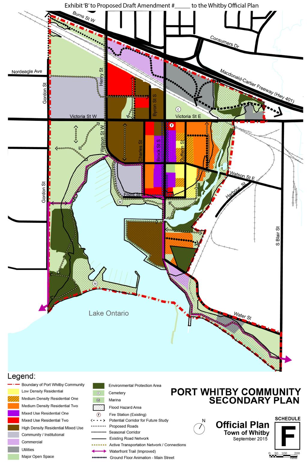
2 DRAFT PROPOSED AMENDMENT NUMBER # to the Whitby Official Plan PURPOSE: The intent of this Amendment is to incorporate policies in the Official Plan that establish the basis for development in the Port Whitby Community Secondary Plan Area. This document should be read in conjunction with the Port Whitby Urban Design Guidelines and the Port Whitby Community Improvement Plan. LOCATION: The Secondary Plan area is bounded by Highway 401 to the north, by an irregular boundary along Pringle Creek, and the adjacent industrial lands to the east, following Water Street and South Blair Street in the southeast, Lake Ontario to the south, and by Gordon Street to the west (Figure 1). The gross land area of the study area is approximately 183 hectares with an approximate existing population of 2,000 people and 500 jobs. Figure 1 illustrates the Secondary Plan area, shows the study area boundary and marks some of its key features. Figure 1 Port Whitby Community Secondary Plan Area BASIS: The Region of Durham adopted Regional Official Plan Amendment 128 to conform to the Provincial Growth Plan. ROPA 128 has identified, amongst other matters, Waterfront Places, major transit station areas, and Regional Corridors as areas where intensification is intended to occur. The Town of Whitby adopted Official Plan Amendment (OPA) 90 in 2010 to incorporate Port Whitby Community Secondary Plan Update 1
3 intensification policies into its Official Plan. The Port Whitby Community Secondary Plan area includes the Port Whitby/Whitby GO Station Area Intensification Area identified in OPA 90. OPA 90 sets a target of 10,500 more people and 3,290 more jobs in the Port Whitby/Whitby GO Station Area by As such, the Port Whitby Secondary Plan Area is to be planned to accommodate a total of 12,500 people and 3,790 jobs by The Town of Whitby also adopted the Port Whitby Sustainable Community Plan in 2011, which included recommendations for updates to the Port Whitby Community Secondary Plan to accommodate future growth and development in a sustainable manner. The purpose of the Secondary Plan Update, Urban Design Guidelines and Community Improvement Plan documents is to proactively plan for future development in Port Whitby by providing a framework for redevelopment and intensification to meet population and employment targets. The policies and provisions within these documents guide the physical, social, economic and environmental management of growth in Port Whitby. ACTUAL AMENDMENT: The Town of Whitby Official Plan is hereby amended as follows: 1. By Amending Schedule D Transportation, by adding a Collector Road, as shown on the attached Exhibit A. 2. By replacing Schedule F Port Whitby Community Secondary Plan with the attached Exhibit B. 2. By replacing Section 11.1 Port Whitby Community Secondary Plan, in its entirety, with the following: Section 11.1 Port Whitby Community Secondary Plan Goals To encourage the sensitive integration of new development into the fabric of the existing Port Whitby community To establish where new development and intensification will be located and to determine how existing stable neighbourhoods and environmental features will be protected, while facilitating positive change and growth. Port Whitby Community Secondary Plan Update 2
4 To create better transit, pedestrian, cycling and vehicular connections to the waterfront, GO Station, surrounding neighbourhoods, the downtown and within the Port Whitby community Objectives To maximize the potential for the utilization of the Whitby Harbour as a small-craft harbour and the utilization of the adjoining public open space lands for active and passive recreational purposes To provide for the growth and development of mixed use community through infilling and/or intensification in order to provide a mix and range of housing, appropriate in terms of scale, traffic generated, and demand on municipal services To create a compact neighbourhood with a range of services that includes the necessary amenities and transportation options for an economically and socially viable neighbourhood To promote Port Whitby as a vibrant and diverse, liveable place for appropriate opportunities for intensification, entertainment, leisure, and civic activities, and where a variety of experiences, unique and neighbourhood retail uses, and a range of residential uses are available To ensure that the character of existing and well-established residential streets is maintained and enhanced by ensuring that development and redevelopment is consistent with the policies of this plan, and compatible with neighbouring development, in terms of built form, character of adjacent buildings and the scale and density of existing development To foster a sense of civic identity through a high standard of community design in all future development that encompasses: a) the appropriate integration of public and private spaces; b) a high degree of visual diversity and aesthetic quality; c) a well-defined public realm, including an interconnected open space network; d) sustainable and energy efficient building and site design; Port Whitby Community Secondary Plan Update 3
5 e) the sensitive integration of new development with existing development; and, f) a pedestrian oriented development pattern To encourage reductions in the use of private automobiles by promoting public transit, active transportation, auto sharing, and the use of Transportation Demand Management measures To create a sustainable community that demonstrates excellence in all aspects of sustainability including land use and economic vitality, energy, water and wastewater, materials and solid waste, environment, habitat and biodiversity, and accessibility and transportation, and that advances the strategies and recommendations contained in the Port Whitby Sustainable Community Plan Sustainability The Town, through the review of development applications, will require proponents of new development to address sustainability matters outlined in the Port Whitby Sustainable Community Plan and Section and of this Plan, to be considered through the development approval process. On this basis, proponents of new development may be required to prepare a Sustainability Plan that considers the elements of sustainability identified in this Plan and the Port Whitby Sustainable Community Plan, to demonstrate how the proposed development would advance sustainability objectives New development within the Port Whitby area may be conditional on meeting sustainability objectives as appropriate. Considerations will be given through all review processes as to how these requirements could be phased through the development process Low Density Residential Lands designated Low Density Residential shall be developed in accordance with the policies of Section except as modified by the following additional policies Lands designated Low Density Residential permit single and semi-detached dwellings. Port Whitby Community Secondary Plan Update 4
6 The maximum residential density shall not exceed 30 dwelling units per net hectare and the maximum building height shall not exceed three storeys Where a single detached or semi-detached building is proposed to be demolished and replaced, the Municipality may require proponents to demonstrate how the new dwelling is compatible from a siting, design and architectural perspective with existing homes on adjacent lots Development that has the effect of increasing the frontage of any existing lot or by increasing the building façade by 25% or more is discouraged unless it can be demonstrated that the relationship between the built form and the street frontage along the street is generally maintained. The width of any new or enlarged lot, or new or enlarged building façade, should not generally exceed the average width of the existing lots or building façades on the same block or as a consequence of a land assembly Medium Density Residential One Lands designated Medium Density Residential One shall be developed in accordance with the policies of Section except as modified by the following additional policies Lands designated Medium Density Residential One permit townhouses, multiple dwellings, and low-rise apartment buildings The minimum residential density is 30 dwelling units per net hectare and the maximum residential density shall not exceed 50 dwelling units per net hectare. The minimum building height shall be two storeys and the maximum building height shall not exceed four storeys The planned built form characteristics of the Medium Density Residential One designation should encourage the development of a variety of building forms that are generally low rise in height and are subject to the following design and built form criteria: a) Buildings should be located at or close to the street line to reinforce a strong street edge, where appropriate, while respecting the existing condition; b) Parking areas shall generally not be located between buildings and the streetlines; and Port Whitby Community Secondary Plan Update 5
7 c) Landscape treatments should be provided to contribute to the development of a walkable and safe pedestrian environment The retention and updating of existing low-rise buildings in the Medium Density Residential One designation is encouraged where feasible. On this basis, additional development, redevelopment or alterations may be permitted on lots that are the site of low-rise buildings provided that as a condition of approval, the façades of the existing buildings are updated and modernized. In addition, the location and arrangement of parking areas shall be reviewed and altered where feasible to minimize the impact of the parking areas on the streetscape. The addition of landscaping and other features is also encouraged Where redevelopment is proposed, it should have direct access from the dwelling to the street to support and encourage the residential character of the area. Garages and/or parking for the new dwellings should be located to the rear of the building It is recognized that the provision of additional landscaping may not be feasible when lots are redeveloped and/or when existing uses are expanded, particularly if the landscaping potentially limits the amount of development that could occur and/or is not feasible given building and parking area location. In these cases, the focus shall be on the enhancement of the streetscape by the addition of landscaping between the building and the public road and the parking areas adjacent to the public road Medium Density Residential Two Lands designated Medium Density Residential Two shall be developed in accordance with the policies of Section except as modified by the following additional policies Lands designated Medium Density Residential Two permit mid-rise multiple dwelling units and mid-rise apartment buildings The minimum residential density is 50 dwelling units per net hectare and the maximum residential density shall not exceed 65 dwelling units per net hectare. The minimum Port Whitby Community Secondary Plan Update 6
8 building height shall be three storeys and the maximum building height shall not exceed six storeys The planned built form characteristics of the Medium Density Residential Two designation should encourage the development of a variety of building forms that are generally mid-rise in height and are subject to the following design and built form criteria: a) Buildings should be located at or close to the street line to reinforce a strong street edge, where appropriate, while respecting the existing condition; b) Parking areas shall generally not be located between buildings and the streetlines; and c) Landscape treatments should be provided to contribute to the development of a walkable and safe pedestrian environment Mixed Use Residential One Lands designated Mixed Use Residential One shall be developed in accordance with the policies of Section and Section 4.5.3, except as modified by the following additional policies Lands designated Mixed Use Residential One permit residential uses in a multiple unit setting and a wide range of small-scale retail, cultural and small-scale service commercial and office uses. Drive-through service facilities are not permitted The minimum residential density is 30 dwelling units per net hectare and the maximum residential density shall not exceed 60 dwelling units per hectare. The minimum building height shall be three storeys and a maximum building height shall not exceed six storeys Mixed-use commercial development shall be required to include integrated residential uses. For the purposes of this policy, floorspace shall be calculated based on requiring a minimum of one square metre of residential floorspace, for each one square metre of ground floor commercial floor space. Offices may be permitted within the upper floors of a mixed-use development, provided that residential uses are separated from non-residential uses. Port Whitby Community Secondary Plan Update 7
9 Development taking place where frontage is located on Brock Street South or Victoria Street must contain ground floor related commercial uses New construction should frame and enclose the public realm of Brock Street South with mid-rise infill buildings that are stepped back from a four storey street wall New infill development along Brock Street South should have adaptable and accessible ground floor spaces suitable for a range of uses such as galleries, professional offices, retail, community space and live/work units that can animate the public realm Improvements to the streetscape, such as soft landscaping, lighting fixtures, benches and public art, will be required as part of the overall project design of new developments The encroachment of restaurant patios and the outdoor display and sale of goods related to a business along Brock Street South is encouraged and may be permitted within the municipal right-of-way provided the scale and extent of the encroachment does not affect pedestrian/vehicular movement in the area Parking to serve uses along Brock Street South shall be comprised of a combination of private and, where feasible, public parking facilities. The provision of adequate and convenient off-street parking is recognized as a necessity in the promotion and enhancement of Lower Brock Street. On this basis, the Municipality will encourage the coordination of existing parking facilities including the linkage of driveways and lanes for parking purposes. To the extent possible, new parking facilities shall be coordinated and linked with existing parking facilities Notwithstanding, any provisions of this plan to the contrary, townhouse development may be permitted to a maximum density of 75 units per hectare, on the properties having frontage on Brock Street South, located in Part of Lot 26, Broken Front Concession, identified as Assessment Roll # and Assessment Roll # , subject to inclusion in the implementing Zoning By-law. Port Whitby Community Secondary Plan Update 8
10 Mixed Use Residential Two Lands designated Mixed Use Residential Two shall be developed in accordance with the policies of Section , Section 4.5.3, and Sections to inclusive, except as modified by the following additional policies Lands designated Mixed Use Residential Two permit residential uses in a multiple unit and apartment setting and a wide range of small-scale retail, cultural and small-scale service commercial and office uses. Drive-through service facilities are not permitted The minimum residential density is 60 dwelling units per net hectare and the maximum residential density shall not exceed 75 dwelling units per hectare. The minimum building height shall be four storeys and a maximum building height shall not exceed eight storeys Notwithstanding, any provisions of this Plan to the contrary, for the lands located at 101 Victoria Street West, and 1510, 1514 and 1518 Brock Street South, identified as Assessment Roll # s , , and the maximum permitted density shall be 300 units per net hectare, with a maximum building height of twelve storeys, with the accessory use of ground floor retail and commercial floorspace, to a maximum of 1,100 square metres, subject to inclusion of appropriate provisions in the zoning by-law High Density Residential Mixed Use Lands designated High Density Residential Mixed Use shall be developed in accordance with Section , except as modified by the following additional policies Lands designated High Density Residential Mixed Use permit multi-storey residential buildings and a wide range of small-scale retail, cultural, small-scale service commercial and office uses. Drive-through service facilities are not permitted The minimum residential density is 75 dwelling units per net hectare and the maximum residential density shall not exceed 300 dwelling units per net hectare. The minimum Port Whitby Community Secondary Plan Update 9
11 building height shall be six storeys and a maximum building height shall not exceed eighteen storeys Notwithstanding any provisions of this Plan to the contrary, for the property at 1600 Charles Street, identified as Assessment Roll # , the maximum permitted residential density shall be 202 dwelling units per hectare Notwithstanding any provisions of this Plan to the contrary for lands located within Part Lot 27, Broken Front Concession, identified as Assessment Roll # s , and , the minimum residential density shall be 115 dwelling units per net hectare density and the maximum residential density shall be 370 dwelling units per net hectare. A marina, ancillary retail, and personal service uses may also be permitted. Retail and personal uses will be harbour-related and serve the recreational and tourist function of the harbour as well as the residents of lands subject to this policy Notwithstanding any provisions of this Plan to the contrary, the maximum residential density permitted at 1606, 1610, and 1614 Charles Street, identified as Assessment Roll # s , and , shall be 300 dwelling units per net hectare with a maximum building height of up to eighteen storeys Commercial Lands designated Commercial shall be developed in accordance with the policies of Section c), except as modified by the following additional policies Lands designated Commercial north of the rail line between Henry Street and Brock Street permit business and professional offices, trade and convention centres, hotels and uses that are associated with the above uses and integrated within office buildings, such as take-out or full service restaurants, financial institutions, personal service shops, convenience stores and commercial fitness centres. The minimum building height shall be three storeys and the maximum building height shall be eighteen storeys Lands designated Commercial south of Water Street permit smaller floorplate retail and personal service uses limited to Port Whitby Community Secondary Plan Update 10
12 businesses and amenities servicing local residents and visitors. The maximum building height shall be two storeys New office buildings shall generally form a continuous wall along public streets, respecting a consistent setback from the public street, to be determined through a detailed site analysis Community / Institutional Lands designated Community/Institutional shall be developed on accordance with the policies of Section 4.7, except as modified by the following additional policies Lands designated Community/Institutional bounded by Watson Street, Charles Street, Front Street and the Lake Ontario shoreline permit the uses permitted in the Mixed Use Residential One designation as set out in Section of this Plan, subject to the preparation of an Urban Design Plan as set out in Section of this Plan Major Open Space Lands designated as Major Open Space shall be developed in accordance with the policies of Section 4.8 of this Plan, except as modified by the following additional policies Docking areas and related on-shore facilities are permitted on lands designated Marina on Schedule F. No expansion of existing facilities shall be permitted Active transportation networks and connections linking Major Open Space area with surrounding land uses shall be provided through the development approval process A park shall be included as part of the future redevelopment of the GO Station site north of Victoria Street. This park shall provide an amenity space for residents of the redeveloped GO Station site and a strong pedestrian linkage between this neighbourhood and the waterfront The continued existence of St. John s Church, cemetery and grounds shall be permitted and is recognized as one of the significant heritage sites in Port Whitby Community. Notwithstanding any other policies to the contrary, any further redevelopment of these lands for other unrelated uses shall require an amendment to this Plan. Port Whitby Community Secondary Plan Update 11
13 Utilities Lands designated as Utilities on Schedule F shall be in accordance with the provisions of the Durham Regional Official Plan The lands designated Utilities north of Victoria Street and east of Brock Street recognize the continued existence of the Regional Sewage Treatment facility. The lands designated Utilities south of Water Street east of Brock Street South recognize the continued existence of the Regional Water Treatment facility Applications for development and redevelopment within the Port Whitby Community Secondary Plan area, as contemplated by the policies of this Plan, may require supporting Functional Servicing Reports to address required extensions, improvements and upgrading of components of the water supply, sanitary sewer and storm sewer services The lands north of the rail corridor shall permit transportation related uses, including vehicular parking for GO Transit if required Environmental Protection Area Lands designated Environmental Protection Area shall be governed in accordance with the policies of Sections 4.9 and 5 of this Plan, except as modified and/or enhanced by the following additional policies Lands designated Environmental Protection Area include natural hazard lands / floodplain, valley lands, woodlands, wetlands, as well as Provincially Significantly Wetlands Where appropriate, Council shall consult with the Region of Durham and the Central Lake Ontario Conservation Authority to encourage the use of conservation easements to protect private lands within the Environmental Protection Area designation Full Environmental Impact Studies (EIS) will be required for applications for development within 30 metres of natural heritage features and for applications for development within 120 metres of a Provincially Significant Wetland. The details of the EIS shall be dependent on the features within and adjacent to the proposed development. Port Whitby Community Secondary Plan Update 12
14 An EIS must be prepared by a qualified professional(s) in the appropriate field(s) of expertise (e.g., ecology, hydrogeology and/or environmental planning) and must be submitted to the Town of Whitby as part of a complete development application. The Town of Whitby will consult with Central Lake Ontario Conservation Authority, Ministry of Natural Resources or other appropriate agencies in a review capacity or for additional guidance with respect to key issues An EIS will identify and assess the potential impact of a proposed development on the ecologic and hydrogeological features and functions within the proposed development area. The EIS will include a detailed water balance to demonstrate that pre- and post-development infiltration can be maintained and recommendations on buffers adjacent to sensitive areas and preservation, maintenance, and enhancement of woodlot, wetland and natural linkage corridors are provided Where an EIS recommends that minor modifications can be made to the boundary of the Environmental Protection Area designation and subject to the satisfaction of the Town of Whitby and Central Lake Ontario Conservation Authority, then the boundary can be refined without further amendment to this Plan. Where boundaries are adjusted, the abutting land use designation shall apply, provided the intent of the Plan is maintained Flood Hazard Area Lands identified as Flood Hazard Area shall be governed in accordance with the policies of Section 4.9 of this Plan, except as modified by the following additional policies Within the Flood Hazard Area, where opportunity exists to reduce the size of the floodplain as a consequence of the upgrading of infrastructure in the area, it shall be the responsibility of the landowners involved to complete the work required and secure the appropriate approvals. Once approvals are secured, and the works have been completed to the satisfaction of the Town of Whitby and the Central Lake Ontario Conservation Authority, development may occur on these lands in accordance with the applicable land use designation. Port Whitby Community Secondary Plan Update 13
15 Transportation The classification of all existing and proposed roads in the Port Whitby Community Secondary Plan study area is described on Schedule D. Existing and proposed trails and connections are identified on Schedule F While the Arterial Roads shown on Schedule D are intended primarily to allow for the ease of motor vehicle traffic throughout the Region and the Municipality, regard must be had in their design to the other public interest objectives established by this Plan, which require that higher density development be established along Arterial Roads in a pedestrian oriented and transit supportive environment Arterial roads must be designed in a manner that provides for other modes of non-motorized travel and the pedestrian. In addition, priority shall be given to ensuring that public transit facilities, such as stops, shelters and dedicated lanes, are all part of the overall design of the arterial road over the long term Within the Mixed Use Residential One and Mixed Use Residential Two designations focused on Brock Street South, it is the intent of this Plan that a pedestrian oriented public realm be established to promote a safe, walkable and vibrant urban environment. On this basis, Brock Street South shall be designed in a manner that accommodates planned right-of-way to be devoted for the automobile, the pedestrian and non-motorized modes of travel, and landscaping as generally depicted in the Urban Design Guidelines Figure All of the right-of-ways in the Port Whitby Community Secondary Plan area shall be planned to allow for a tree canopy that will provide shade and enhance and establish a vibrant urban environment. In this regard, a Tree Canopy Plan may be required as part of a complete development application, and the trees should be planted as soon as feasible to ensure that a canopy is established in the shorter term Given anticipated densities and built form, all right-of-ways in the Port Whitby Community Secondary Plan study area shall be planned to accommodate sidewalks on both sides where feasible Increased east-west connectivity through the Port Whitby Community Secondary Plan study area should be Port Whitby Community Secondary Plan Update 14
16 accomplished over the long-term and considered during the development approval process New development proposals may be required to be supported by a traffic study that identifies options that have the effect of improving connectivity, especially between Henry Street and Brock Street. In order to provide for the orderly development of lands north of Victoria Street, phasing options may need to be considered Any new roads or road improvements will be subject to an Environmental Assessment and must meet the engineering standards of the Town and the Region. If it is determined that proposed connections are not feasible, other alternative alignments that provide the same function will need to be considered Major applications for development shall be supported by a parking management plan that identifies how parking is to be provided on site. Such a parking management plan shall also take into account the potential to provide on-street and off-site off-street parking in the area to support proposed development. As a condition of approval, the Town may require that easements be provided to allow for the sharing of internal accesses between parking areas The provision of appropriate space for the storing and parking of bicycles and motor vehicles that are part of a car sharing program shall be required as a condition of approval for major development in Port Whitby. In addition, the establishment of surface parking on any lands north of Victoria Street shall be restricted to short-term parking requirements In considering the continual enhancement of the Region s public transit system, priority may be given to developments which support public transit and/or which facilitate the provision of transit stations and/or related infrastructure as a condition of development approval. In addition, parking requirements may be reduced in circumstances where it can be demonstrated that the number of vehicles expected to access the proposed use is, or can be, lessened through the use of public transit or other travel demand management As an incentive to encourage travel demand management, the Municipality may permit reduced parking standards for developments that demonstrate through their travel demand Port Whitby Community Secondary Plan Update 15
17 management plan and implementation strategy that a reduction in the parking standards is appropriate Connectivity across Victoria Street for pedestrians, particularly between the existing signalized intersections at Brock Street and Watson Street, should be accommodated Urban Design The provisions of Section 6.2 of this Plan shall apply to all lands within the Port Whitby Community Secondary Plan study area, except as modified and/or enhanced by the policies of this Section, the Port Whitby Urban Design Guidelines and the Port Whitby Community Improvement Plan An Urban Design Plan may be required as part of a complete application for development, to illustrate such matters as consolidation or joint development of lands, integration of uses, building placement, access and internal circulation, pedestrian connections, land use compatibility, accessibility, landscaping and opportunities for transit connections. Where an Urban Design Plan is required, such plan shall consider all matters listed in Sections 6.2 and of this Plan, as well as the Port Whitby Urban Design Guidelines and the Port Whitby Community Improvement Plan Landscaping and planting are an integral component of all new development on vacant lots, redevelopment of existing uses and/or proposed alterations. All landscaping and planting plans shall be developed in accordance with the Port Whitby Urban Design Guidelines Proponents may be required to restore or enhance building façade(s) on the same lot in order to maintain the architectural character and identity of the surrounding area in accordance with the Port Whitby Urban Design Guidelines The Town of Whitby shall encourage and require tree planting and preservation through subdivision agreements and development approvals so that all areas are provided with sufficient urban tree canopy to maintain a high standard of amenity and identity for the Port Whitby waterfront community Where feasible, electrical, cable, telephone and other utilities shall be encouraged to locate underground and the location Port Whitby Community Secondary Plan Update 16
18 of associated at-grade service boxes will have regard to the pedestrian environment and vehicular sight-lines The Town of Whitby will work with Whitby Hydro, Durham Region and landowners to secure re-location of the existing hydro facilities to a location within the Brock Street South right-of-way It is the intent of this Plan that lands be developed in an integrated fashion by encouraging the consolidation or joint development of lands Notwithstanding Section , where consolidation or joint development is not possible or desirable, development may be permitted on individual properties, provided that the Urban Design Plan outlined in Section indicates how the proposed development of the specific parcel will permit the orderly and harmonious, future development of adjacent lands Heritage Considerations Development and redevelopment on or adjacent to lands with heritage resources shall be considered in accordance with the policies of Section 6.1 of this Plan In order to support the economic viability of retaining heritage resources, properties with buildings designated under the Ontario Heritage Act may be zoned to permit such additional uses as limited office, retail or personal service uses, provided that compatibility with adjacent land uses and conformity with the general intent of this Plan are maintained Implementation The provisions of Section 11.1 apply to the Port Whitby Community Secondary Plan study area as shown on Schedule F and provide more precise illustrations of the land use designations shown on Schedules A and B and in the policies of Part I of this Plan The Port Whitby Community Secondary Plan policies outlined in Section 11.1 shall be read and applied in conjunction with the Port Whitby Urban Design Guidelines and the Port Whitby Community Improvement Plan. Port Whitby Community Secondary Plan Update 17
19 IMPLEMENTATION: The provisions set forth in the Town of Whitby Official Plan, as amended, regarding the implementation of the Plan shall apply in regard to this amendment. INTERPRETATION: The provisions set forth in the Town of Whitby, as amended, regarding the interpretation of the Plan shall apply in regard to this amendment. Port Whitby Community Secondary Plan Update 18
20 Exhibit 'A' to Draft Proposed Official Plan Amendment # to the Whitby Official Plan Add 'Collector Road'
21
FORMER CANADIAN FORCES BASE (CFB) ROCKCLIFFE SECONDARY PLAN. Official Plan Amendment XX to the Official Plan for the City of Ottawa
 ROCKCLIFFE SECONDARY PLAN. Official Plan Amendment XX to the Official Plan for the City of Ottawa") FORMER CANADIAN FORCES BASE (CFB) ROCKCLIFFE SECONDARY PLAN Official Plan Amendment XX to the Official Plan for the City of Ottawa 1 INDEX THE STATEMENT OF COMPONENTS PART A THE PREAMBLE PAGE Purpose...
FORMER CANADIAN FORCES BASE (CFB) ROCKCLIFFE SECONDARY PLAN Official Plan Amendment XX to the Official Plan for the City of Ottawa 1 INDEX THE STATEMENT OF COMPONENTS PART A THE PREAMBLE PAGE Purpose...
Mark-up of the effect of the proposed Bronte Village Growth Area OPA No.18 on the text of section 24, Bronte Village, of the Livable Oakville Plan
 Mark-up of the effect of the proposed Bronte Village Growth Area OPA No.18 on the text of section 24, Bronte Village, of the Livable Oakville Plan Notes: This document is provided for information purposes
CONTENTS 8.0 LAND USE 8.1 GENERAL LAND USE 8.2 RESIDENTIAL 8.3 MIXED USE 8.4 COMMERCIAL 8.5 EMPLOYMENT LANDS
 8-2 Land Use 8.0 LAND USE CONTENTS 8.1 GENERAL LAND USE 8.1.1 Uses provided for in all Land Use Designations 8.1.2 Uses prohibited in Hazardous Lands, Hazardous Sites and Special Policy Areas 8.1.3 Uses
The West Vaughan Employment Area Secondary Plan Policies
 Part 2: The West Vaughan Employment Area Secondary Plan Policies 2.1 General Policies It is the policy of Council: 2.1.1. That the West Vaughan Employment Area (the WVEA), identified on Schedule 1, will
SCHEDULE 'A' TO BY-LAW as Amended by AMENDMENT NO. 90 TO THE WHITBY OFFICIAL PLAN
 SCHEDULE 'A' TO BY-LAW 6413-10 as Amended by 6553-11 AMENDMENT NO. 90 TO THE WHITBY OFFICIAL PLAN SECTION A: GROWTH PLAN CONFORMITY PURPOSE: LOCATION: BASIS: The purpose of this Amendment is to: conform
DRAFT Northeast Quadrant of Kipling Avenue and Highway 7 DRAFT AUGUST 29, Goals Land Use. The goals of this Plan are to:
 AUGUST 29, 2017 12.15 Northeast Quadrant of Kipling Avenue and Highway 7 12.15.1 Goals 12.15.2 Land Use The goals of this Plan are to: 12.15.2.1 General Provisions: a) Ensure the development of a compact
and services The protection and conservation of environmentally significant and sensitive natural heritage features and functions.
 6. Land Use 6.0 Preamble A healthy and livable city is one in which people can enjoy a vibrant economy and a sustainable healthy environment in safe, caring and diverse neighbourhoods. In order to ensure
Clairtrell Area Context Plan
 Clairtrell Area Context Plan March 2005 Urban Development Services City Planning Contents 1. Introduction... 4 2. Development Structure... 6 2.1 Streets... 7 2.1.1 Sheppard Avenue and Bayview Avenue...
2136 & 2148 Trafalgar Road Town of Oakville Region of Halton
 PLANNING JUSTIFICATION REPORT 2136 & 2148 Trafalgar Road Town of Oakville Region of Halton Zoning By-Law Amendment Application 2500674 Ontario Inc. November 2016 Table of Contents Page 1.0 Location/Summary
URBAN DESIGN BRIEF. 2136&2148 Trafalgar Road. Town of Oakville
 URBAN DESIGN BRIEF 2136&2148 Trafalgar Road Town of Oakville Prepared By: METROPOLITAN CONSULTING INC For 2500674 Ontario Inc November 2016 TABLE OF CONTENTS Page No. 1.0 Introduction/Description of Subject
Complete Neighbourhood Guidelines Review Tool
 Complete Neighbourhood Guidelines Review Tool Prepared By: City of Regina Planning Department October 2014 Page 1 of 14 Community Development Review Checklist for Secondary Plans and Concept Plans The
URBAN DESIGN BRIEF URBAN DESIGN BRIEF 721 FRANKLIN BLVD, CAMBRIDGE August 2018
 URBAN DESIGN BRIEF URBAN DESIGN BRIEF 721 FRANKLIN BLVD, CAMBRIDGE August 2018 DESIGN BRIEF CONTENTS PART A 1.0 INTRODUCTION 2.0 DESCRIPTION & ANALYSIS OF SITE CONTEXT 3.0 DESIGN CONSTRAINTS AND OPPORTUNITIES
HURON COMMUNITY PLAN
 CITY OF KITCHENER DEPARTMENT OF DEVELOPMENT AND TECHNICAL SERVICES PD 94/7 HURON COMMUNITY PLAN Recommended by Planning and Economic Development Committee: October 31, 1994 Adopted by Kitchener City Council:
*** DRAFT 2 FOR PUBLIC REVIEW ***
 6.7 The area is generally bounded by the Red Hill Valley Parkway to the west, Lake Avenue to the east, the Queen Elizabeth Way (QEW) to the north, and by the properties just south of Queenston Road to
Trafalgar Road Corridor Planning Study Open House
 Trafalgar Road Corridor Planning Study Open House June 24, 2013 6:30-8:30 p.m. Oakville & Trafalgar Rooms Overview The Livable Oakville Plan identifies the lands along Trafalgar Road, between the QEW and
YONGE STEELES CORRIDOR SECONDARY PLAN. Young + Wright / IBI Group Architects Dillon Consulting Ltd. GHK International (Canada) Ltd.
 Ltd.") PART A: PREAMBLE 1.0 PURPOSE The purpose of this Secondary Plan is to provide a development framework for intensification of the Yonge/ Steeles corridor including the north side of Steeles Avenue West
PART A: PREAMBLE 1.0 PURPOSE The purpose of this Secondary Plan is to provide a development framework for intensification of the Yonge/ Steeles corridor including the north side of Steeles Avenue West
A Growing Community Rural Settlement Areas
 Town of Huntsville Official Plan Review - POLICY BACKGROUND PAPER A Growing Community Rural Settlement Areas BACKGROUND: In addition to the fully municipally-serviced Urban Settlement Area and the Hidden
QUEEN-RIVER SECONDARY PLAN
 34 QUEEN-RIVER SECONDARY PLAN 34. QUEEN RIVER SECONDARY PLAN 1. INTRODUCTION The Queen-River area is approximately 6.4 hectares and is located at the eastern edge of the Downtown as shown on Map 34-1.
11.4 Highway 400 North Employment Lands Secondary Plan
 11.4 Highway 400 North Employment Lands Secondary Plan APPROVED BY THE ONTARIO MUNICIPAL BOARD ON NOVEMBER 21, 2011 11.4.1 General 11.4.1.1. The following policies and Schedules A - I form Official Plan
The lands identified as Residential Areas on Schedule A1, Urban Structure, represent the areas that provide for stable residential communities.
 Livable Oakville Part D: Land Use Designations and Policies 11. RESIDENTIAL 11.1 General The lands identified as Residential Areas on Schedule A1, Urban Structure, represent the areas that provide for
11.4 Highway 400 North Employment Lands Secondary Plan APPROVED BY THE ONTARIO MUNICIPAL BOARD ON NOVEMBER 21, 2011
 11.4 Highway 400 North Employment Lands Secondary Plan APPROVED BY THE ONTARIO MUNICIPAL BOARD ON NOVEMBER 21, 2011 11.4.1 General 11.4.1.1. as approved by the Ontario Municipal Board on November 21, 2011,
[PLANNING RATIONALE] For Site Plan Control and Lifting of Holding Zone By-Law 101 Champagne Avenue. May 23, 2014
![[PLANNING RATIONALE] For Site Plan Control and Lifting of Holding Zone By-Law 101 Champagne Avenue. May 23, 2014](/thumbs/75/71599615.jpg "[PLANNING RATIONALE] For Site Plan Control and Lifting of Holding Zone By-Law 101 Champagne Avenue. May 23, 2014") [PLANNING RATIONALE] For Site Plan Control and Lifting of Holding Zone By-Law 101 Champagne Avenue May 23, 2014 Contents 1.0 Introduction... 2 2.0 Site Context... 2 2.1 Adjacent Uses... 2 Figure 1: Site
[PLANNING RATIONALE] For Site Plan Control and Lifting of Holding Zone By-Law 101 Champagne Avenue May 23, 2014 Contents 1.0 Introduction... 2 2.0 Site Context... 2 2.1 Adjacent Uses... 2 Figure 1: Site
THE CITY OF VAUGHAN BY-LAW BY-LAW NUMBER A By-law to adopt Amendment Number 1 to the Official Plan of the Vaughan Planning Area.
 THE CITY OF VAUGHAN BY-LAW BY-LAW NUMBER 015-2014 A By-law to adopt Amendment Number 1 to the Official Plan of the Vaughan Planning Area. NOW THEREFORE the Council of the Corporation of the City of Vaughan
AMENDMENT NO.XX TO THE CLARINGTON OFFICIAL PLAN
 AMENDMENT NO.XX TO THE CLARINGTON OFFICIAL PLAN PURPOSE: The purpose of this Amendment is to create a planning framework that will facilitate the development of a transit supportive, pedestrian friendly,
178 Carruthers Properties Inc.
 178 Carruthers Properties Inc. Planning Rationale for 178 Carruthers Avenue Site Plan Control Application June 2014 Table of Contents 1.0 Introduction 2.0 Overview of Subject Property 3.0 Current Zoning
CITY OF NIAGARA FALLS. By-law No
 CITY OF NIAGARA FALLS By-law No. 2018- A by-law to provide for the adoption of Amendment No. 128 to the City of Niagara Falls Official Plan (OPA #128). THE COUNCIL OF THE CORPORATION OF THE CITY OF NIAGARA
6 PORT SYDNEY SETTLEMENT AREA
 Section 6 Port Sydney Page 61 6 PORT SYDNEY SETTLEMENT AREA 6.1 Basis and Principles Village of Port Sydney Waterfront Community Existing Services 6.1.1 Port Sydney is an historic settlement that has developed
Commercial Development Proposal Tenth Line Road. Planning Rationale Report. Minto Developments Inc.
 Commercial Development Proposal 2168 Tenth Line Road Report September 2015 Prepared for Minto Developments Inc. Paquette Planning Associates Ltd. 56 Hutchison Avenue Ottawa, Ontario K1Y 4A3 PH: 613-722-7217
Richmond Secondary Plan
 1.0 Introduction Richmond was founded in 1818 and is the oldest community in the former Township of Goulbourn. Historically, growth in Richmond has been modest with a population that now approaches 4,500
SECTION E. Realizing the Plan
 SECTION E Realizing the Plan 60 DESIGN REGINA - OFFICIAL COMMUNITY PLAN SECTION E Realizing the Plan Design Regina has been an ambitious plan-making exercise, with a high level of community, stakeholder,
13 THORNHILL YONGE STREET STUDY IMPLEMENTATION CITY OF VAUGHAN OPA 669 AND TOWN OF MARKHAM OPA 154
 13 THORNHILL YONGE STREET STUDY IMPLEMENTATION CITY OF VAUGHAN OPA 669 AND TOWN OF MARKHAM OPA 154 The Planning and Economic Development Committee recommends the adoption of the recommendations contained
Table 8-4: Road Classification Local Roads, second table, of Chapter 8 Create a Multi-Modal City, be amended by adding the following:
 1 Port Street East Official Plan Amendment APPENDIX 3 Amendments to Mississauga Official Plan Table 8-4: Road Classification Local Roads, second table, of Chapter 8 Create a Multi-Modal City, be amended
6.0 Land Use Policies for Rural Settlements. 6.1 Rural Settlement Strategy
 6.0 Land Use Policies for Rural Settlements 6.1 Rural Settlement Strategy INTRODUCTION AMENDMENT NO. 131 PURPOSE Designated rural settlements comprise Rural Clusters, Villages and Serviced Villages as
Urban Design Brief. Watson Parkway North & Watson Road North Guelph, Ontario. Prepared by Coletara Development
 Urban Design Brief Watson Parkway North & Watson Road North Guelph, Ontario Prepared by Coletara Development December, 2013 Urban Design Brief, Coletara Development 1 Introduction This Urban Design Brief
MAYFIELD WEST SECONDARY PLAN PHASE 2
 MAYFIELD WEST SECONDARY PLAN PHASE 2 Public Open House #3 February 25, 2010 Draft Preferred Land Use Scenario TOWN OF CALEDON PLANNING & DEVELOPMENT DEPARTMENT Open House Agenda TOWN OF CALEDON 1. Welcome
DAVENPORT VILLAGE SECONDARY PLAN
 27 DAVENPORT VILLAGE SECONDARY PLAN 27. DAVENPORT VILLAGE SECONDARY PLAN 1. VISION FOR THE DAVENPORT VILLAGE SECONDARY PLAN Davenport Village, municipally known as 830, 940, 980 and 1100 Lansdowne Avenue,
ELMVALE ACRES SHOPPING CENTRE MASTER PLAN
 ELMVALE ACRES SHOPPING CENTRE MASTER PLAN Contents 1.0 INTRODUCTION... 2 2.0 LOCATION... 2 3.0 EXISTING CONTEXT... 2 4.0 VISION & GUIDING PRINCIPLES... 2 5.0 LAND USE AND BUILT FORM... 4 5.1 St. Laurent
5.1 Site Plan Guidelines
 5. Community Core Guidelines Development of the Community Core will take place by plan of subdivision and site plan approval. It will occur in a phased manner that will reflect the timing of residential
burlington mobility hubs study Downtown Burlington Mobility Hub
 burlington mobility hubs study Downtown Burlington Mobility Hub Draft Precinct Plan Workbook PIC #3, September 7, 2017 downtown mobility hub objectives City staff and their consultants are proposing an
Leonard s Beach Secondary Plan (Alcona North) Official Plan Amendment
 Official Plan Amendment") Leonard s Beach Secondary Plan (Alcona North) Official Plan Amendment Public Meeting Presentation August 14, 2013 Note: This document is for presentation purposes only. Please see Staff Report DSR-135-13
Leonard s Beach Secondary Plan (Alcona North) Official Plan Amendment Public Meeting Presentation August 14, 2013 Note: This document is for presentation purposes only. Please see Staff Report DSR-135-13
North Oakville East Parks Facilities Distribution Plan. November, 2009
 North Oakville East November, 2009 POLICY CONTEXT 1) Purpose a) The purpose of this document is to be a guide for the location, configuration, design and development of the parks system for the North Oakville
4.1.3 LAND USE CATEGORIES
 4.1.3 LAND USE CATEGORIES a. City Center District The City Center District incorporates the existing character and mix of uses in downtown Belmont to encourage redevelopment and new development in keeping
THRIVE STABLE COMMUNITY V PROSPER VISION DESIGN TRUST ACTIVE DISTINCT SAFE FUTURE LANDUSE ENERGY FORM INFRASTRUCTURE STREETSCAPE URBAN MULTI-MODAL
 LE ATION PEDESTRIANS FUTURE C THRIVE SAFE PLAN INNOV IVERSE INSPIR VISION ENERGY CONSULTATION INNOVATION VIBRANT BUILDING F PROSPER DISTINCT SAFE NATURAL STREETSCAPE FORM INFRASTRUCTURE DIVERSE VIBRANT
PUBLIC OPEN HOUSE HURONTARIO-MAIN CORRIDOR SECONDARY PLAN
 PUBLIC OPEN HOUSE HURONTARIO-MAIN CORRIDOR SECONDARY PLAN Tuesday, February 28, 2012 6pm 9pm 1 st Floor Atrium, City Hall 2 Wellington Street West, Brampton 1 POLICY FRAMEWORK The 2006 Provincial Growth
Foster Creek West Clarington, Ontario PLANNING JUSTIFICATION REPORT
 Foster Creek West Clarington, Ontario PLANNING JUSTIFICATION REPORT Official Plan Amendment Zoning By-law Amendment Neighbourhood Design Plan Amendment Draft Plan of Subdivision File No. 112092 February
Secondary Plan for the Samac Community
 Secondary Plan for the Samac Community (Section 6.2 of the Official Plan of the former Planning Area of the City of Oshawa) Office Consolidation Copy of the Secondary Plan for the Samac Community This
4.11 Town Centre Secondary Plan (Former City of Cumberland)
") 4.11 Town Centre Secondary Plan (Former City of Cumberland) 4.11.1 Town Centre Objectives 4.11.1.1 Introduction The reason for the preparation of this Secondary Plan for the Town Centre is as follows:
4.11 Town Centre Secondary Plan (Former City of Cumberland) 4.11.1 Town Centre Objectives 4.11.1.1 Introduction The reason for the preparation of this Secondary Plan for the Town Centre is as follows:
URBAN DESIGN BRIEF New Street Burlington, ON
 3225-3237 New Street Burlington, ON MARCH 2017 Prepared for: Royal Living Development Group Inc. Prepared by: adesso design inc. 218 Locke Street South, 2nd Floor Hamilton, ON L8P 4B4 t. 905.526.8876 3225-3237
5.0 VILLAGE AREAS. February 2008 Municipality of West Elgin ~ Official Plan 5-1
 5.0 VILLAGE AREAS This section of the Official Plan deals with the villages of Rodney and West Lorne being the two largest and only fully serviced settlement areas in West Elgin and the most logical and
4 HUNTSVILLE URBAN SETTLEMENT AREA
 Section 4 Huntsville Urban Settlement Area Page 31 4 HUNTSVILLE URBAN SETTLEMENT AREA 4.1 Basis and Principles Huntsville Urban Settlement Area Accommodate Anticipated Growth Boundaries Land Use Designations
This page has been intentionally left blank.
 This page has been intentionally left blank. Chapter 3 3-2 3. Employment 3.A Niagara Economic Gateway 3.A.1 General The Niagara Economic Gateway comprises: a) The Gateway Economic Zone which includes all
Policies and Code Intent Sections Related to Town Center
 Policies and Code Intent Sections Related to Town Center The Town Center Vision is scattered throughout the Comprehensive Plan, development code and the 1994 Town Center Plan. What follows are sections
599 Kennedy Road - Official Plan Amendment and Zoning Amendment Application - Preliminary Report
 STAFF REPORT ACTION REQUIRED 599 Kennedy Road - Official Plan Amendment and Zoning Amendment Application - Preliminary Report Date: March 7, 2017 To: From: Wards: Reference Number: Scarborough Community
URBAN DESIGN BRIEF Gordon Street City of Guelph. Prepared on behalf of Ontario Inc. March 25, Project No. 1507
 URBAN DESIGN BRIEF 1131 Gordon Street City of Guelph Prepared on behalf of 1876698 Ontario Inc. March 25, 2016 Project No. 1507 423 Woolwich Street, Suite 201, Guelph, Ontario, N1H 3X3 Phone (519) 836-7526
Draft Urban Hamilton Official Plan. Amendment No. XX
 1 of 75 The following text, together with: Draft Appendix A Appendix B Volume 1, Schedule E-1 Urban Land Use Designations Appendix C Volume 1, Appendix A Parks Classification Map Appendix D Volume 1, Appendix
6. REGIONAL AND COMMUNITY FACILITIES DESIGNATIONS 6.1. OBJECTIVES FOR REGIONAL AND COMMUNITY FACILITIES LAND USE DESIGNATIONS
 6. REGIONAL AND COMMUNITY FACILITIES DESIGNATIONS INTRODUCTION The Regional and land use designations provide the primary locations for uses which satisfy the health, education and other service needs
Urban Design Manual PLANNING AROUND RAPID TRANSIT STATIONS (PARTS) Introduction. Station Study Areas
 Introduction. Station Study Areas") 111111 PLANNING AROUND RAPID TRANSIT STATIONS (PARTS) Introduction The ION rapid transit system will link Waterloo, Kitchener and Cambridge through a central transit corridor (CTC). There are a number
111111 PLANNING AROUND RAPID TRANSIT STATIONS (PARTS) Introduction The ION rapid transit system will link Waterloo, Kitchener and Cambridge through a central transit corridor (CTC). There are a number
Planning Justification Report
 Planning Justification Report Application for Zoning By-law Amendment Prepared for: Sherrill Becker (OK Tire Auto Service) Prepared By: Black, Shoemaker, Robinson & Donaldson Limited June 2015 Sherrill
East Bayshore Road Neighbourhood
 East Bayshore Road Neighbourhood Northridge Property Management Urban Design Brief 3195 East Bayshore Road City of Owen Sound January 2016 East Bayshore Road Neighbourhood Northridge Property Management
OFFICE CONSOLIDATION SECONDARY PLAN AREA 22 THE BRAMALEA SOUTH INDUSTRIAL SECONDARY PLAN
 OFFICE CONSOLIDATION SECONDARY PLAN AREA 22 THE BRAMALEA SOUTH INDUSTRIAL SECONDARY PLAN November 2010 EXPLANATORY NOTES (Secondary Plan Area 22) General (pertaining to all secondary plan office consolidations)
Growing Community Urban Settlement Area and Hidden Valley Settlement Area
 Town of Huntsville Official Plan Review - POLICY BACKGROUND PAPER Growing Community Urban Settlement Area and Hidden Valley Settlement Area BACKGROUND: Through the Provincial Policy Statement (PPS), the
COMMUNITY, DISTRICT AND SPECIAL STUDY AREA PLANS
 1.8 RIVER OAKS COMMUNITY - FIGURE "O" a) Background The River Oaks Community is bounded by Dundas Street on the north; the Sixteen Mile Creek on the west; Upper Middle Road on the south; and Trafalgar
6 Growth Management Challenges and Opportunities
 6 Growth Management Challenges and Opportunities The Town has established a goal of attaining a 50% participation rate with respect to employment opportunities versus residential population. The Town s
OFFICE CONSOLIDATION CHAPTER 47 HIGHWAY 427 INDUSTRIAL SECONDARY PLAN
 OFFICE CONSOLIDATION CHAPTER 47 HIGHWAY 427 INDUSTRIAL SECONDARY PLAN NOTE: This Secondary Plan is partially in effect. Highlighted sections are under appeal. August 2017 1 EXPLANATORY NOTE Office Consolidation
URBAN DESIGN BRIEF 181 Burloak Drive, Oakville
 URBAN DESIGN BRIEF 181 Burloak Drive, Oakville February 2017 Our File: 1730B 230-7050 WESTON ROAD / WOODBRIDGE / ONTARIO / L4L 8G7 / T: 905 761 5588/ F: 905 761 5589/WWW.MHBCPLAN.COM TABLE OF CONTENTS
Official Plan Review
 Official Plan Review Summary Report - The Built Environment August 2014 Part 1: Introduction Planning for a healthy, prosperous and sustainable community is an important goal for our municipality. From
Official Plan Review: Draft Built Form Policies
 PG.30.1 REPORT FOR ACTION Official Plan Review: Draft Built Form Policies Date: May 15, 2018 To: Planning and Growth Management Committee From: Chief Planner and Executive Director, City Planning Division
URBAN DESIGN BRIEF. Saginaw Subdivision 124 SAGINAW PARKWAY, CAMBRIDGE OCTOBER 2015 OUR FILE 1422A
 URBAN DESIGN BRIEF Saginaw Subdivision 124 SAGINAW PARKWAY, CAMBRIDGE OCTOBER 2015 OUR FILE 1422A Contents 1.0 INTRODUCTION AND SITE DESCRIPTION... 1 2.0 MUNICIPAL DESIGN DIRECTION... 7 3.0 MASTER CONCEPT
THE STRUCTURE OF THE PLAN...
 TABLE OF CONTENTS THE STRUCTURE OF THE PLAN... 1 A1 THE COMMUNITY VISION... 3 A2 GOALS AND OBJECTIVES... 3 A2.1 THE NATURAL ENVIRONMENT... 3 A2.1.1 Goal... 3 A2.1.2 Objectives... 3 A2.2 GROWTH AND SETTLEMENT...
Urban Design Guidelines Townhouse and Apartment Built Form
 Urban Design Guidelines Townhouse and Apartment Built Form Town of Wasaga Beach Table of Contents 1. Introduction 1.1. Purpose 1.2. Urban Design Principles 1.3. Application of Guidelines 2. Site Design,
Further input invited as Colchester Growth Strategy nears final phase
 IUE 3 / NOVEMBER 2015 Further input invited as Colchester Growth trategy nears final phase trathcona County is seeking public feedback as it enters the final phase of work on a Growth Management trategy
5.0 Community Design Plan
 5.0 Community Design Plan The Community Design Plan for the Mer Bleue area is a composite of three plans: Land Use Plan Transportation Plan Municipal Servicing Plan Read together, these Plans and associated
McCowan Precinct Plan Study Background & Deliverables
 1 DRAFT & WITHOUT PREJUDICE McCowan Precinct Plan Study Background & Deliverables In September, 2011, City Planning (Scarborough District) began a study of an area within the Scarborough Centre, identified
Summary of Changes for the Comprehensive Draft Proposed Official Plan Amendment
 Summary of Changes for the Comprehensive Draft Proposed Official Plan Amendment Note: Due to the broad scope of the Official Plan Review, this list is not exhaustive of the extent of changes in the comprehensive
12 AMENDMENT NO. 149, TOWN OF MARKHAM HIGHWAY 404 NORTH SECONDARY PLAN
 12 AMENDMENT NO. 149, TOWN OF MARKHAM HIGHWAY 404 NORTH SECONDARY PLAN The Planning and Economic Development Committee recommends the adoption of the recommendation contained in the following report August
13. VANDORF-PRESTON LAKE SECONDARY PLAN 13.1 INTRODUCTION
 13. VANDORF-PRESTON LAKE SECONDARY PLAN 13.1.1 Purpose 13.1 INTRODUCTION The Vandorf-Preston Lake Secondary Plan establishes the principles, objectives and general policies, as well as specific strategies
Bank Street Secondary Plan
 1.1 Introduction The is a guide to the long term design and development of the portion of Bank Street between Riverside Drive and Ledbury Park, and provides direction on land use, built form, design, parking,
141 GEORGE STREET PLANNING RATIONALE
 141 GEORGE STREET PLANNING RATIONALE MINOR ZONING BY-LAW AMENDMENT NOVEMBER 2, 2016 PLANNING RATIONALE 223 McLeod Street Ottawa, ON K2P 0Z8 613.730.5709 fotenn.com INTRODUCTION FOTENN Consultants is acting
7437, 7439 and 7441 Kingston Road - Zoning By-law Amendment and Site Plan Control Applications - Preliminary Report
 STAFF REPORT ACTION REQUIRED 7437, 7439 and 7441 Kingston Road - Zoning By-law Amendment and Site Plan Control Applications - Preliminary Report Date: August 13, 2015 To: From: Wards: Reference Number:
EXISTING COMPREHENSIVE PLAN
 EXISTING COMPREHENSIVE PLAN Town Center Land Use Element: V. LAND USE POLICIES Town Center Mercer Island's business district vision as described in "Your Mercer Island Citizen-Designed Downtown" was an
New Street Proposed Redevelopment Architecture & Urban Design Brief
 2130 2136 New Street Proposed Redevelopment Architecture & Urban Design Brief Prepared By: Cynthia Zahoruk Architect Inc. 3077 New Street, Burlington, ON, L7N 1M6 TABLE OF CONTENTS Background and Objective
New-Cast Mixed-use Development Proposal King Street West, Newcastle, Ontario
 URBAN DESIGN BRIEF New-Cast Mixed-use Development Proposal King Street West, Newcastle, Ontario TABLE OF CONTENTS: 1.0 Executive Summary 2.0 Creating Vibrant and Sustainable Urban Places: Excerpts from
2. Shaping Waterloo Region s Urban Communities
 2. Much of the region s growth over the past several decades has occurred in suburban areas that separated where people live from where they work and shop. This pattern of growth has increased the need
Tremaine Dundas Secondary Plan (Draft May 2017)
") PB-52-17 Appendix A Tremaine Dundas Secondary Plan (Draft May 2017) Page 2 Tremaine Dundas Secondary Plan (Draft May 2017) This page has been left blank intentionally Page 3 Tremaine Dundas Secondary Plan
PB-52-17 Appendix A Tremaine Dundas Secondary Plan (Draft May 2017) Page 2 Tremaine Dundas Secondary Plan (Draft May 2017) This page has been left blank intentionally Page 3 Tremaine Dundas Secondary Plan
Master Environmental Servicing Plan & Secondary Plan
 1 East Side Lands Stage 2 Master Environmental Servicing Plan & Secondary Plan Public Consultation Centre #4 March 20, 2018 Welcome! Today s Agenda Please sign in at the registration table. 6:00 pm 6:30
BENSON / HUNT TERTIARY PLAN
 BENSON / HUNT TERTIARY PLAN TABLE OF CONTENTS 1.0 INTRODUCTION 1.1 Purpose 2 1.2 How to Read This Plan 3 1.3 Tertiary Plan Context 3 1.4 Vision and Principles 5 1.5 Public Consultation 5 2.0 PLANNING CONTEXT
PLANNING RATIONALE 3843 INNES ROAD, ORLEANS 78 UNITS CONDOMINIUM PROJECT MELKART DEVELOPMENTS Inc.
 78 UNITS CONDOMINIUM PROJECT MELKART DEVELOPMENTS Inc. 2 PLANNING RATIONALE 78 UNITS CONDOMINIUM PROJECT Proposed at 3843 Innes Road Orleans, Ontario Report Prepared for: Melkart Developments Inc. 3497
Eglinton Avenue East & 50 Thermos Road - Official Plan Amendment Application Preliminary Report
 STAFF REPORT ACTION REQUIRED 1966 2050 Eglinton Avenue East & 50 Thermos Road - Official Plan Amendment Application Preliminary Report Date: March 15, 2016 To: From: Wards: Reference Number: Scarborough
Regency Developments. Urban Design Brief. Holyrood DC2 Rezoning
 Regency Developments Urban Design Brief Holyrood DC2 Rezoning Stantec Consulting Ltd. 7-31-2017 1. Overview Regency Developments intends to rezone the lands located at 8510 and 8511 93 Avenue, within the
RECREATION AND OPEN SPACE ELEMENT GOALS, OBJECTIVES, AND POLICIES
 RECREATION AND OPEN SPACE ELEMENT GOALS, OBJECTIVES, AND POLICIES Goal 7 To provide park facilities, recreation programs, and open space resources that are safe, adequate, and accessible to all City residents,
PLANNING RATIONALE FOR 1127, 1128 MILL STREET AND 1125 CLAPP LANE CITY OF OTTAWA
 PLANNING RATIONALE FOR 1127, 1128 MILL STREET AND 1125 CLAPP LANE CITY OF OTTAWA Prepared by: Realty Initiatives and Development On behalf of the Manotick Mill Community Lands Development Corporation March
Uptown Rideau Street Secondary Plan [Amendment #166, January 12, 2016]
![Uptown Rideau Street Secondary Plan [Amendment #166, January 12, 2016]](/thumbs/76/73760497.jpg "Uptown Rideau Street Secondary Plan [Amendment #166, January 12, 2016]") [Amendment #166, January 12, 2016] The policies of this Secondary Plan are in effect, save and except for the property at 560 Rideau Street, for which there remains a site specific appeal to this Secondary
[Amendment #166, January 12, 2016] The policies of this Secondary Plan are in effect, save and except for the property at 560 Rideau Street, for which there remains a site specific appeal to this Secondary
AWH REPORT OF THE PLANNING AND DEVELOPMENT DEPARTMENT FOR APPLICATION FOR REZONING ORDINANCE TO PLANNED UNIT DEVELOPMENT
 AWH REPORT OF THE PLANNING AND DEVELOPMENT DEPARTMENT FOR APPLICATION FOR REZONING ORDINANCE TO PLANNED UNIT DEVELOPMENT MAY 8, 2014 The Planning and Development Department hereby forwards to the Planning
11. BALLANTRAE-MUSSELMAN LAKE AND ENVIRONS SECONDARY PLAN
 11. BALLANTRAE-MUSSELMAN LAKE AND ENVIRONS SECONDARY PLAN 11.1 PURPOSE The Ballantrae-Musselman Lake and Environs Secondary Plan Area includes two small existing settlement areas, Ballantrae and Musselman
KANATA CENTRUM 255 KANATA AVENUE OFFICIAL PLAN AMENDMENT ZONING BY-LAW AMENDMENT
 KANATA CENTRUM 255 KANATA AVENUE OFFICIAL PLAN AMENDMENT ZONING BY-LAW AMENDMENT JUNE 2015 PREPARED BY: FOTENN Consultants Inc. 223 Mcleod Street Ottawa, ON K2P OZ8 (613) 730-5709 PREPARED FOR: Kanata
THE CITY OF VAUGHAN BY-LAW BY-LAW NUMBER
 THE CITY OF VAUGHAN BY-LAW BY-LAW NUMBER 123-2013 A By-law to designate the whole of the City of Vaughan as a Site Plan Control Area, and to adopt site development guidelines and rules of procedure for
280 Manse Road - Official Plan Amendment, Zoning Amendment, Draft Plan of Subdivision Applications - Preliminary Report
 STAFF REPORT ACTION REQUIRED 280 Manse Road - Official Plan Amendment, Zoning Amendment, Draft Plan of Subdivision Applications - Preliminary Report Date: March 11, 2014 To: From: Wards: Reference Number:
MAYFIELD WEST SECONDARY PLAN PHASE 2
 MAYFIELD WEST SECONDARY PLAN PHASE 2 Council Information Workshop February 16, 2010 Draft Preferred Land Use Plan TOWN OF CALEDON PLANNING & DEVELOPMENT DEPARTMENT Workshop Agenda TOWN OF CALEDON 1. Welcome
4800 Yonge Street - Official Plan Amendment, Zoning Amendment and Site Plan Applications - Request for Direction Report
 STAFF REPORT ACTION REQUIRED 4800 Yonge Street - Official Plan Amendment, Zoning Amendment and Site Plan Applications - Request for Direction Report Date: April 16, 2018 To: From: Wards: Reference Number:
AGINCOURT SECONDARY PLAN
 1 AGINCOURT SECONDARY PLAN 1. AGINCOURT SECONDARY PLAN The following policies and principles apply to the area herein referred to as Agincourt, as outlined on Map 1-1. 1. GENERAL POLICIES 1.1 This Secondary