Draft Urban Hamilton Official Plan. Amendment No. XX
|
|
|
- Moses Terry
- 6 years ago
- Views:
Transcription
1 1 of 75 The following text, together with: Draft Appendix A Appendix B Volume 1, Schedule E-1 Urban Land Use Designations Appendix C Volume 1, Appendix A Parks Classification Map Appendix D Volume 1, Appendix B Major Transportation Facilities and Routes Appendix E Volume 2, Appendix A Secondary Plans Index Map Appendix F Volume 2, Land Use Plan Map B Appendix G Volume 2, Maximum Building Heights in the Node Map B Appendix H Volume 2, Centennial Neighbourhoods Secondary Plan Transportation and Connections Map B Appendix I Volume 2, Site Specific Policy Areas Map B Appendix J Volume 2, Centennial Neighbourhoods Secondary Plan Transition Areas Appendix A Appendix K Volume 2, Old Town Secondary Plan Land Use Plan Map B Appendix L Volume 3, Map 1 Area Specific Policies Key Map Appendix M Volume 3, Map H-4 Area Specific Policies Appendix N Volume 3, Map 2 Urban Site Specific Key Map attached hereto, constitutes Official Plan Amendment XX to the Urban Hamilton Official Plan. 1.0 Purpose and Effect: The purpose of this amendment is to: Incorporate the into the, identifying land uses, densities, development forms, development standards and site specific policies; Amend various policies, schedules and appendices of the Urban Hamilton Official Plan to reflect the principles, policies, land use designations and land use features in the ; and, 1 of 75
2 2 of 75 Make minor housekeeping updates to an Appendix in the Official Plan. The effect of this amendment to the is to establish a detailed policy framework to guide the development of lands within the. 2.0 Location: The lands affected by this Amendment are generally bounded by the Red Hill Valley Parkway to the west, Lake Avenue to the east, the Queen Elizabeth Way (QEW) to the north, and by the properties just south of Queenston Road to the south, as illustrated on Appendix F to this amendment. 3.0 Basis: The basis for this Amendment is as follows: The proposed amendment is consistent with the Provincial Policy Statement and conforms to the Growth Plan for the Greater Golden Horseshoe. The proposed Secondary Plan helps to achieve the overall vision, goals and objectives of the Provincial Policy Statement, the Growth Plan for the Greater Golden Horseshoe, and the. Changes to the allow for consistency between the policies of the and the policies proposed in the new ; 4.0 Actual Text and Schedule/Map/Appendix Changes: 4.1 Volume 1 Parent Plan Chapter E Urban Systems and Designations Section E.4.2 Commercial and Mixed Use Designations General Policies a) That Policy be amended by: i) Adding the phrase Volume 2 or before the words Volume 3 so the policy reads as follows: Notwithstanding Policies E and E.4.2.6, four major commercial areas currently exist in the City of Hamilton that 2 of 75
3 3 of 75 exceed 25,000 square metres of retail and commercial service space, but are not anticipated to evolve into mixed use areas during the life of this Plan. These four areas are not identified as Urban Nodes or Urban Corridors, are within the Neighbourhood element of the Urban Structure on Schedule E - Urban Structure, are designated District Commercial on Schedule E-1 - Urban Land Use Designations and have area or site specific requirements contained in Volume 2 or Volume 3. The amount or type of retail uses in these locations shall not be expanded without an amendment to the Urban Structure. The four major commercial areas are located: ii) Changing the address in part d) of Policy to 502 to 560 Centennial Parkway North so the policy reads as follows: 4.2.9d) at 502 to 560 Centennial Parkway North. Section E Pedestrian Focus Streets a) That Table in Policy be amended by: i) Adding two new table lines in the Hamilton portion of the table: Queenston Road Nash Road East side of Centennial Parkway Centennial Parkway South side of Queenston Road Railway line north of Bancroft Street so the table reads as follows: Hamilton Street From To Queenston Road Nash Road East side of Centennial Parkway Centennial Parkway South side of Queenston Road Railway line north of Bancroft Street Volume 1 Schedules and Appendices a) That Schedule E-1 be amended by: i) redesignating the lands located in the general area of Centennial 3 of 75
4 4 of 75 Parkway North, south of the railway line from Arterial Commercial to Industrial Land, as shown on Appendix B of this amendment. ii) iii) iv) redesignating the lands located in the general area of Centennial Parkway North, north of Barton Street East from Arterial Commercial to Mixed Use High Density, as shown on Appendix B of this amendment. redesignating the lands located in the general area southwest of Centennial Parkway North and Barton Street East from District Commercial to Mixed Use Medium Density, as shown on Appendix B of this amendment. redesignating the following lands from Mixed Use Medium Density to Mixed Use High Density, as shown on Appendix B of this amendment: 1) lands located in the general area of Queenston Road just east of Nash Road; 2) lands generally located on the north east corner of Queenston Road and Centennial Parkway; and 3) lands located in the general area of the east side of Centennial Parkway North, near Delawana Drive. v) redesignating the lands in the general area of Eastgate Court and lands on the south side of Barton Street East, between Kenora Avenue and Centennial Parkway North from District Commercial to Neighbourhoods, as shown on Appendix B of this amendment. vi) redesignating the following lands from Mixed Use Medium Density to Neighbourhoods, as shown on Appendix B of this amendment: 1) lands located in the general area on the north side of Queenston Road, between Woodman Drive North and Nash Road; 2) lands located at 23 Delawana Drive; 3) lands located at Delawana Drive; and, 4) lands located in the general area of Queenston Road and Riverdale Drive. 4 of 75
5 5 of 75 vii) making a minor boundary adjustment between the District Commercial designation and the Business Park designation on lands located in the general area of Centennial Parkway North just south of the Queen Elizabeth Way, as shown on Appendix B of this amendment, to recognize existing property boundaries. viii) redesignating the lands located in the general area just west of Henry and Beatrice Warden Park from Mixed Use Medium Density to Open Space, as shown on Appendix B of this amendment. ix) redesignating the lands located in the general area of the Red Hill Valley Parkway, north of the railway line from Industrial Land to Open Space, as shown on Appendix B of this amendment. x) redesignating the lands located in the general area southeast of Centennial Parkway North and Barton Street East from District Commercial to Mixed Use High Density, as shown on Appendix B of this amendment. b) That Appendix A be amended by adding the Centennial Neighbourhoods Secondary Plan, as shown on Appendix C attached to this amendment. c) That Appendix B be amended by: i) extending the Potential Rapid Transit Line on Centennial Parkway north to the Railway line, as shown on Appendix D of this amendment. ii) iii) iv) changing the HSR Terminal at Eastgate Square to a Future Multi- Modal Hub as shown on Appendix D of this amendment. changing the text Proposed New GO Centre (LIUNA Station) in the legend to Proposed GO Station, as shown in Appendix D of this amendment. Adding a new Proposed GO Station at the southwest corner of Centennial Parkway and the Railway north of Barton Street East, as shown on Appendix D of this amendment. 4.2 Volume 2 Secondary Plans Chapter B, Secondary Plans a) That Chapter B, Secondary Plans be amended by adding a new Section 5 of 75
6 6 of , as shown on Appendix A attached to this amendment. Section B.7.2 Old Town Secondary Plan b) That Chapter B, Secondary Plans be amended by: i) adding the word generally after The Old Town Secondary Plan area is, changing the word lines to boundaries and deleting the phrase south of King Street in the first sentence, so that it reads as follows: The Old Town Secondary Plan area is generally bounded by the rear lot lines of the properties fronting on the north side of Queenston Road, Gray Road to the East, the Niagara Escarpment to the South, to the west by the western property boundaries in line with Alpine Avenue just East of Centennial Parkway North, north of King Street East, as well as Centennial Parkway North. ; ii) iii) deleting Policy Mixed Use High Density Designation; renumbering Policy District Commercial Designation to Policy ; and, iv) deleting Policy Site Specific Policy Area C Secondary Plan Maps a) That Appendix A be amended by adding the Centennial Neighbourhoods Secondary Plan, as shown on Appendix E, attached to this amendment. b) That the Old Town Secondary Plan Land Use Plan Map B be amended by removing lands located in the general area of Queenston Road and Centennial Parkway, as shown on Appendix K, attached to this amendment. c) That Map B Land Use Plan be added, as shown on Appendix F, attached to this amendment. d) That Map B Maximum Building Heights in the Node be added, as shown on Appendix G, attached to this amendment. e) That Map B Transportation and Connections be added, as shown on Appendix H, 6 of 75
7 7 of 75 attached to this amendment. f) That Map B Site Specific Policy Areas be added, as shown on Appendix I, attached to this amendment. g) That Appendix A Transition Areas be added, as shown on Appendix J, attached to this amendment. 4.3 Volume 3 Special Policy Areas, Area Specific Polices and Site Specific Policies Chapter B Urban Area Specific Policies a) That Policy UH-1, 1.0 be amended by deleting Policy 1.0 f) in its entirety Chapter C Urban Site Specific Policies a) That Chapter C Urban Site Specific Policies, be amended by deleting the following site specific areas in their entirety: i) UHN-10 Lands located at 505 to 537 Queenston Road, former City of Hamilton; ii) iii) UHC-4 Lands located at 480 and 500 Centennial Parkway North and 20 Warrington Street, former City of Hamilton; and, UHE-7 Lands located at Lands located at 398, 400, 402 Nash Road North and 30, 50, 54 Bancroft Street. b) That Chapter C Urban Site Specific Policies be amended by deleting the words and 460 Kenora Avenue from the title of Urban Site Specific UCW- 1C, and replacing the comma with the word and so that it reads as follows: UCW-1C Lands located at 27 Olympic Drive and 37 Kilbride Road c) That Chapter C Urban Site Specific Policies be amended by deleting policy 3.0, in its entirety, of Urban Site Specific UCW-1C Volume 3 Maps a) That Map 1 Area Specific Policies Key Map be amended by deleting 7 of 75
8 8 of 75 UH-1f, as shown on Appendix L, attached to this amendment. b) That Map H-4 Area Specific Policies Map be deleted, as shown on Appendix M, to this amendment. c) That Map 2 Urban Site Specific Key Map be amended by deleting UHC- 4, UCW-1C, UHN-10 and UHE-7, as shown on Appendix N to this attachment. 5.0 Implementation: Implementing Zoning By-law Amendments and site plans will give effect to this Amendment. This is Schedule 1 to By-law No. XX-XXX passed on the XX day of XXX, The City of Hamilton Fred Eisenberger MAYOR Rose Caterini CITY CLERK 8 of 75
9 6.7 Appendix B to Report PED of 75 The area is generally bounded by the Red Hill Valley Parkway to the west, Lake Avenue to the east, the Queen Elizabeth Way (QEW) to the north, and by local streets and properties just south of Queenston Road to the south. The area contains a wide variety of land uses and residential densities. The focal point of the Secondary Plan is the Centennial Sub-Regional Service Node, or the Centennial Node, which is a major centre of retail activity for the City with a regional function. The Centennial Node is centred on the intersection of Queenston Road and Centennial Parkway and extends north of this intersection along Centennial Parkway North and west along Queenston Road. The major anchor for the Node is a shopping mall (Eastgate Square Mall) located on the northwest corner of Queenston Road and Centennial Parkway. The Centennial Node plays an important role in the future transit network of the City, as it is planned as a terminus point for Light Rail Transit services and is also serviced by interregional transit. The Centennial Node also has an important function as part of the City s urban structure by connecting different areas of the City. It connects to other existing and planned nodes in the City via a primary corridor on Queenston Road west of Centennial Parkway and secondary corridors on Centennial Parkway and on Queenston Road east of Centennial Parkway. The vision for Sub-Regional Service Nodes is that these areas are to be planned to achieve a mix of uses and significant densities which are supportive of higher order transit. Commercial uses are an important component of Sub-Regional Service Nodes. Sub- Regional Service Nodes will also accommodate a significant proportion of City-wide residential intensification. The planning framework for the Centennial Node supports provincial policy directions regarding the efficient use of land, intensifying within existing built-up areas, and creating transit-supportive densities around major transit station areas and along priority transit corridors. Surrounding the Centennial Node are residential neighbourhoods with a variety of residential densities and other community uses, such as parks, open spaces and institutional uses. The residential uses and other associated uses work together to form a complete community where people have opportunities to live, work, learn, and play. The neighbourhoods supply a variety of different housing types which support 9 of 75
10 6.7.1 Vision Appendix B to Report PED of 75 various household needs and incomes. These neighbourhoods may accommodate some residential intensification over time, primarily along arterial roads or on larger sites where changes are comprehensively reviewed; however they are generally regarded as stable. North of Barton Street East, a large employment area provides an important employment function, by contributing to the provision of jobs in close proximity to where people live, and by contributing to the City s overall supply of employment lands. The employment area benefits from valuable transportation connections, as the area is also a key entryway into the City, with access points from the Red Hill Valley Parkway and the QEW, and abuts the future Confederation GO station. The primary purpose of the is to guide redevelopment and intensification within the Centennial Node to achieve more transit-supportive densities and an appropriate mix of uses, while maintaining the regional commercial function of the Node. This is balanced with the need to ensure that the Node is appropriately integrated with surrounding neighbourhoods in the community and existing employment areas. As such, the Secondary Plan provides direction for both the Centennial Node and adjacent neighbourhoods and employment areas. Section B.6.7, Map B Centennial Neighbourhoods - Land Use Plan, Map B Centennial Neighbourhoods - Maximum Building Heights in the Node, Map B Centennial Neighbourhoods - Transportation and Connections Plan, Map B Centennial Neighbourhoods Site Specific Policy Areas, and Appendix A - Centennial Neighbourhoods - Transition Areas, constitute the. The area is home to some of the City s most vibrant shopping, recreation, living and mixed use spaces. The Centennial Node will feature a higher order transit corridor and two major transit hubs, which are supported by compact, mixed use development along the Queenston Road and Centennial Parkway corridors. The Secondary Plan area s existing residential neighbourhoods are safe, well connected and affordable. The area s attractive and accessible public spaces, green spaces and streetscapes, along with its strong network of 10 of 75
11 6.7.2 Principles Appendix B to Report PED of 75 transportation infrastructure provide a unique sense of place that makes the Centennial Neighbourhoods an interesting, dynamic and exciting place. Eleven planning principles represent the foundation of the Centennial Neighbourhoods Secondary Plan. The principles provide direction for accommodating development, promoting compatible intensification, preserving the area s green spaces and promoting opportunities for active transportation The is based on the following principles: a) Protect and enhance parks and natural areas; b) Create safe, connected, vibrant streetscapes; c) Provide more opportunities and spaces for people to meet, relax and socialize; d) Promote active transportation throughout the community; e) Provide opportunities for mixed use development and intensification in strategic locations; f) Promote transit-oriented development; g) Provide a variety of housing choices; h) Protect existing residential neighbourhoods from incompatible development; i) Provide sustainable infrastructure; j) Improve the appearance and function of the public realm; and, k) Provide opportunities for a greater variety of recreational choices Policy Goals 11 of 75
12 Land Use Appendix B to Report PED of 75 In addition to the policy goals in Volume 1, Chapters B, C, and E, the following policy goals shall provide direction for planning and development in the : a) Support and implement the planned function of the Sub - Regional Service Node identified on Map B Centennial Neighbourhoods Land Use Plan; b) Protect and enhance existing residential areas; c) Support the provision and maintenance of a mix of housing types and tenures that meet the housing needs of residents throughout their life cycle and provide opportunities for residents to remain within the community; d) Ensure compatibility between areas of different land uses, densities and heights; e) Promote development that fosters a healthy, safe, efficient, connected and visually pleasing urban environment; f) Encourage and foster a healthy balance of housing, employment, community services and recreation opportunities that are connected, accessible and people-oriented; g) Direct the majority of intensification to the Sub Regional Service Node; h) Encourage residential infill development within existing residential neighbourhoods; i) Promote and encourage appropriate development in proximity to major transit station areas in support of and to take advantage of investment in public transit; j) Support Eastgate Square Mall as a regional commercial shopping centre while providing direction and opportunity for mixed use redevelopment of the site over the planning horizon of this plan; k) Provide appropriate community facilities and amenities to serve current and future residents; and, 12 of 75
13 13 of 75 l) Support the transition of the Centennial Node from low density, auto-dependent lands uses and built form to a more compact, transit supportive environment Urban Design a) Provide high quality urban design and a consistent, identifiable neighbourhood image; b) Ensure design promotes pedestrian walkability, cycling, physical activity, social interaction and public gathering spaces; c) Encourage innovative building and site development and green infrastructure which contributes to the physical environment of the community, is forward looking in response to climate change, and enhances desirability as a place to live, learn, work and play; d) Promote design variety within streetscapes and identified Streetscape Improvement Areas; e) Promote interesting gateway and design features at Gateway Improvement Areas and Prominent Intersections identified on Map B Centennial Neighbourhoods - Transportation and Connections; f) Encourage public space enhancements at major transit station areas to support opportunities for gathering and social interaction; and, g) Ensure appropriate transitions between different building heights and uses Active Transportation, Transit and Transportation Linkages a) Enhance the neighbourhood s primary corridors as places for all modes of transportation and users of all ages, abilities, and incomes in an equitable manner, including pedestrians, cyclists, transit riders and drivers; 13 of 75
14 14 of 75 b) Support the public transit system, future rapid transit corridors and connections to the GO transit station to decrease reliance on the private automobile; c) Promote, enhance and support a safe, healthy, attractive, accessible and efficient active transportation network through the application of a complete streets approach that supports all modes of transportation; d) Encourage an integrated transportation network throughout the Secondary Plan area; and, e) Minimize and encourage consolidation of access driveways along primary corridors for improved safety Municipal Services and Utilities a) Provide adequate services, public facilities and infrastructure to support development Open Space and Parks a) Provide an integrated and interconnected system of parks and open spaces that are accessible to all residents, to serve a wide range of active and passive recreational needs; b) Maintain and enhance existing neighbourhood and community parkland, and strategically review opportunities to acquire additional parkland when and where appropriate; c) Provide appropriate programming and facilities within existing parks to serve the surrounding neighbourhoods; d) Preserve and protect significant natural heritage features; and, e) Maintain and enhance the urban tree canopy General Policies The shall guide development within the Secondary Plan area. The following policies apply to the Secondary Plan area: 14 of 75
15 15 of 75 a) The area shall include a range of housing forms and tenures and a mix of employment, commercial, institutional and open space uses. b) The contains 3 major transit station areas, which are shown on Map B Centennial Neighbourhoods Transportation and Connections around the following locations: i) the planned Light Rail Transit stop at the intersection of Queenston Road and Nash Road; ii) iii) the planned Light Rail Transit stop on Queenston Road south of Eastgate Square Mall; and, the planned GO bus and rail station at the southwest corner of Centennial Parkway North and Goderich Road. c) Major transit station areas include lands within the Sub-Regional Service Node as well as commercial areas, employment areas and a variety of high density and medium density residential uses in stable neighbourhoods outside the Node. Together, population and employment growth in these areas contribute to achieving transitsupportive densities around the major transit stations. d) The major transit station areas around the 2 proposed Light Rail Transit stops are planned to achieve a minimum density of 160 residents and jobs per hectare in the long term. e) There are lands designated High Density Residential and Mixed Use High Density which are not located within a major transit station area, but are important contributors to the function of a major transit station area. f) Reductions in parking requirements for development proposals may be considered where Transportation Demand Management measures are implemented and a Parking Justification Study has been submitted which demonstrates that parking can be adequately accommodated on site, to the satisfaction of the City. g) The City may require consultation with the Design Review Panel prior to any public or private development approvals, to ensure that the design objectives and policies of this Plan are reflected in all 15 of 75
16 16 of 75 projects. Applications for an Official Plan Amendment or Zoning By-law Amendment which may alter the planned function and vision of the Secondary Plan shall be referred to the Design Review Panel Centennial Sub-Regional Service Node (Centennial Node) The Centennial Sub-Regional Service Node is generally identified by the (UHOP) on Schedule E - Urban Structure of Volume 1. The detailed boundary of the Node is identified on Map B Centennial Neighbourhoods Land Use Plan. For the purposes of this Plan, the Sub-Regional Service Node is referred to as the Centennial Node. The Centennial Node has historically been characterized by predominantly single storey auto-oriented development. The Centennial Node is planned to transform over time to a multi-storey built form, through infilling, additions to existing buildings and redevelopment. This transformation will include the introduction of additional medium and high density residential uses in the Node. The transformation of the Centennial Node will facilitate a more pedestrian focused and transit-supportive environment, contributing to a unique sense of place within the Secondary Plan area. It is recognized that this transformation will take time, and may continue beyond the planning period of this Plan. Some auto oriented uses and built forms will continue to exist in the area in the interim. It is expected that change to built form and land uses will occur incrementally as other changes occur in the area, such as the introduction of GO transit services and light rail transit to the Centennial Node In addition to Section E Sub-Regional Service Nodes of Volume 1, within the area identified as the Sub-Regional Service Node shown on Map B Centennial Neighbourhoods - Land Use Plan, the following policies shall apply: a) The Centennial Node shall function as a mixed use area with retail uses, residential uses and other population serving employment uses such as but not limited to offices, personal services and local institutions. Retail shall be an important part of the Node, providing a regional function serving the needs of residents across the City and surrounding area as well as serving the weekly and daily 16 of 75
17 17 of 75 shopping needs of residents within the Centennial Node and in surrounding neighbourhoods. b) The regional retail function of the Centennial Node is an essential part of the Node s function, and is dependent on maintaining a significant amount of retail floor space in the Node. There are a number of large sites in the Centennial Node which contribute significantly to the existing overall retail floor space amount. Accordingly, where redevelopment is proposed on sites larger than 2 hectares which will reduce the amount of existing retail commercial uses, a retail impact study may be required which demonstrates to the satisfaction of the City that the planned retail function of the Centennial Node is not being negatively impacted. c) The Centennial Node shall be the focus for commercial, residential and mixed use growth, development and intensification within the. The majority of new development, particularly commercial and mixed use development, shall be directed to locate within the Node boundary. d) The Centennial Node shall be connected to the active transportation network, the City s public transportation network, future rapid transit and interregional public transportation services and shall have a strong pedestrian focus. e) Automobile access will continue to be important to the Centennial Node; however, it shall be balanced with the need to improve transit access and opportunities for active transportation. f) The Centennial Node is planned to achieve a minimum density target of 100 people and jobs per hectare by the year It is anticipated that the Node will achieve a density between 100 and 150 persons and jobs per hectare by The Centennial Node may continue to increase in density beyond 150 persons and jobs per hectare after 2031 provided adequate infrastructure is available and the transportation network is functioning adequately to accommodate additional density. g) The minimum building height for all lands with frontage on Queenston Road shall be 3 storeys. h) Large scale commercial sites, including Eastgate Square Mall, are important to the retail function of the Centennial Node. The 17 of 75
18 18 of 75 continued maintenance and function of large scale commercial sites is desirable. It is recognized that large commercial sites may need to transition gradually over the long term to the more mixed use form of development envisioned by the Secondary Plan. i) Notwithstanding Policy E a) and b) of Volume 1, Policy B g) and Policies B a) and b), to support the continued use and gradual transition of commercial sites, for properties designated Mixed Use Medium Density or Mixed Use High Density, the following requirements shall apply: i) For sites with an area greater than 2 hectares, small scale new buildings for commercial uses may be permitted which do not meet the minimum building heights. ii) For all sites, limited small scale additions or expansions to buildings existing on the date of approval of this Plan may be permitted which do not meet the minimum building heights and which are not built directly up to the street line. k) Lands designated High Density Residential 1 within the Centennial Node identified on Map B Centennial Neighbourhoods Land Use Plan shall be subject to Section E. 3.6 High Density Residential of Volume 1, Policy B and Policy B l) Where there is a Transition Area shown on all or a portion of a property shown on Appendix A Centennial Neighbourhoods Transition Areas, Policy B shall apply Residential Designations Outside of the Centennial Node, the Centennial Neighbourhoods Secondary Plan area has stable residential neighbourhoods with a mix of housing types, densities and housing forms. The residential policies define the location and scale of each type of residential use, and shall help ensure that a variety of residential housing types are provided to meet the housing needs of area residents The residential areas within the Centennial Neighbourhoods Secondary Plan are designated Low Density Residential 2, Low Density Residential 18 of 75
19 19 of 75 3, Medium Density Residential 2, Medium Density Residential 3 and High Density Residential 1 as identified on Map B Centennial Neighbourhoods - Land Use Plan. Generally the residential designations recognize existing residential land uses within the Secondary Plan area General Residential Policies In addition to Section E.3.0 Neighbourhoods Designation of Volume 1, the following policies shall also apply: a) Development shall provide a mix of housing opportunities in terms of built form, style and tenure that are suitable for residents of different age groups, income levels and household sizes. b) Reverse frontage lotting patterns shall not be permitted, and new multiple dwelling residential development shall be oriented to the street. c) The existing character of established residential neighbourhoods shall be respected. Residential intensification within these areas shall comply with Section B.2.4 Residential Intensification of Volume 1 and other applicable policies of this Plan. d) Existing rental housing is an important asset to the Centennial Neighbourhoods area and contributes significantly to the supply of affordable housing. The preservation and proper maintenance of the supply of rental housing is strongly encouraged. Conversions of rental housing to condominium ownership shall comply with Policy B of Volume Low Density Residential 2 Designation In addition to Section E.3.4 Low Density Residential of Volume 1, for lands designated Low Density Residential 2 on Map B Centennial Neighbourhoods - Land Use Plan, the following policies shall apply: a) Notwithstanding Policy E of Volume 1, for lands designated Low Density Residential 2, only single detached, semi-detached, and duplex dwellings shall be permitted. b) Notwithstanding Policy E of Volume 1, the maximum net residential density shall be 40 units per hectare. 19 of 75
20 20 of Low Density Residential 3 Designation In addition to Section E.3.4 Low Density Residential of Volume 1, for lands designated Low Density Residential 3 on Map B Centennial Neighbourhoods - Land Use Plan, the following policies shall apply: a) In addition to Policy E of Volume 1, the following additional residential uses shall be permitted: i) fourplex dwellings; and, ii) all forms of townhouses. b) The net residential density shall be 40 units or greater per hectare and not greater than 60 units per hectare Medium Density Residential 2 Designation Notwithstanding Policy E of Volume 1, for lands designated Medium Density Residential 2 on Map B Centennial Neighbourhoods - Land Use Plan the net residential density shall be 60 units or greater per hectare and not greater than 75 units per hectare Medium Density Residential 3 Designation Notwithstanding Policy E of Volume 1, for lands designated Medium Density Residential 3 on Map B Centennial Neighbourhoods Land Use Plan, the net residential density shall 75 units or greater per hectare and not greater than 100 units per hectare High Density Residential 1 Designation In addition to Section E.3.6 High Density Residential of Volume 1, for lands designated High Density Residential 1 on Map B Centennial Neighbourhoods - Land Use Plan, the following policies shall apply: a) Notwithstanding Policy E b) of Volume 1, additional density may be permitted up to 300 units per hectare without amendment to this Plan, subject to Policy B e). 20 of 75
21 21 of 75 b) Outside of the Centennial Node, the maximum building height shall be 8 storeys or the existing building height as recognized on the date of the adoption of this Plan, whichever is greater. c) For lands within the boundary of the Centennial Node, the maximum building height shall be in accordance with the heights shown on Map B Centennial Neighbourhoods Maximum Building Heights in the Node. d) Where development abuts an area designated Low Density Residential or Medium Density Residential, as identified on Appendix A Centennial Neighbourhoods Transition Areas, development shall provide an appropriate transition in accordance with Policy B e) A development application with a density that is greater than 200 units per hectare shall require a Zoning By-law Amendment to permit the increase in density, except where the density is already permitted by the Zoning By-law regulations existing as of the time of adoption of the Secondary Plan Commercial and Mixed Use Designations The mixed use designations of the Centennial Neighbourhoods Secondary Plan area are generally focused within the Centennial Node along the primary corridors of Centennial Parkway and Queenston Road. District Commercial, Arterial Commercial and Local Commercial uses are located outside of the Node. The commercial and mixed use areas provide an important regional retail function, as well as meeting the daily and weekly retail needs of the surrounding neighbourhoods. The mixed use areas within the Centennial Node are intended to transition over time to a more compact, pedestrian focused and transit-supportive environment that supports higher order transit and major transit station areas within the Secondary Plan The commercial areas within the Centennial Neighbourhoods Secondary Plan are designated Mixed Use Medium Density, Mixed Use High Density, Local Commercial, District Commercial and Arterial Commercial, as identified on Map B Centennial Neighbourhoods - Land Use Plan General Commercial Policies 21 of 75
22 22 of 75 a) Existing commercial areas shall evolve over time through infilling, additions to existing buildings and redevelopment into mixed use, pedestrian-oriented places. b) Development shall be consistent with the policies of Section Transportation and Connections. c) Adequate internal traffic circulation, parking, loading and manoeuvring facilities shall be accommodated on-site. d) The redevelopment of commercial areas is encouraged in a coordinated and comprehensive manner. e) New development shall balance the needs for improved pedestrian access, opportunities for active forms of transportation and accommodation of public transportation, including rapid transit, with existing automobile use and access. f) Development within the mixed use designations shall contribute to vibrant people places with increased day and night activity through the introduction of residential uses. g) As part of a mixed use building containing both residential and commercial uses, amenity space shall be provided exclusively for the residential component and shall be functionally separated from public areas associated with the commercial component. h) When major redevelopment occurs on a site larger than 2.5 hectares existing as of the date of approval of this Plan, the redevelopment shall include an appropriate mix of uses, in accordance with Policy E of Volume 1. The Zoning By-law shall define the proportion of commercial and non-commercial uses to be provided on a site. i) Notwithstanding Policy E of Volume 1 and Policy B h), a mix of commercial and other uses shall not be required for major redevelopment on lands greater than 2.5 hectares abutting industrial designations or uses, if it is determined that the uses: i) are not compatible with the industrial uses, having regard for provincial guidelines concerning compatibility between industrial facilities and sensitive land uses; or, 22 of 75
23 23 of 75 ii) due to other adverse impacts caused by the industrial uses. j) In addition to Policies E b), E , E b) and E of Volume 1, applications to amend this Plan or the Zoning By-law to permit a drive-through facility, gas bar, motor vehicle service station or car wash shall require demonstration that the proposed facility: i) cannot be located in other potential locations in the Local Commercial, Mixed Use Medium Density or Mixed Use - High Density designations which are not part of the Light Rail Transit corridor; ii) iii) iv) shall not change the planned streetscape character; enhances the pedestrian environment; shall not compromise the safe, efficient and comfortable movement of pedestrians; v) shall not preclude the planned function and design intent for the Light Rail Transit corridor including: 1) a comfortable, active and visually stimulating walking and shopping environment; 2) a streetscape with buildings and storefronts oriented to the street; and, 3) the operation of the Light Rail Transit and the associated traffic movements in the Light Rail Transit corridor. vi) vii) shall not have an adverse impact on surrounding residential neighbourhoods, including but not limited to potential noise and traffic impacts; and, addresses the General Policies and Principles of Section B.3.3.2, the Built Form policies of Section B.3.3.3, and the Access and Circulation policies of Section B of Volume 1. Existing Motor Vehicle Dealerships in the Centennial Node 23 of 75
24 24 of 75 k) Several existing motor vehicle dealerships are located within the boundary of the Centennial Node. These are transitional uses that pre-date the and are legal non-complying. It is the intent of the Plan that these uses will cease to exist within the Centennial Node over time. Many of the existing motor vehicle dealerships have existed in the area for a significant period of time and may have achieved an acceptable level of tolerance that can be continued in the interim. The following policies shall apply to these uses: i) Legal non-complying motor vehicle dealerships may be recognized as an existing use in the Zoning By-law in accordance with Policy F of Volume 1. ii) iii) iv) Notwithstanding Policy F of Volume 1, existing motor vehicle dealerships shall not expand beyond the boundary of legally zoned sites existing as of the date of approval of this Plan. All additions or alterations to buildings existing at the date of the approval of this Plan shall enhance the pedestrian environment by providing distinctive high quality landscape elements and a high level of streetscape design at grade along the street. New buildings or the demolition of existing buildings and replacement with new buildings shall only be permitted if the proposal complies with Policy E of Volume 1 and Policies B and B Mixed Use Medium Density Designation In addition to Section E Mixed Use Medium Density Designation of Volume 1, the following policies shall apply to the Mixed Use Medium Density Designation, as identified on Map B Centennial Neighbourhoods - Land Use Plan: a) Maximum building heights shall be in accordance with Schedule B Centennial Neighbourhoods - Maximum Building Heights in the Node. 24 of 75
25 25 of 75 b) Minimum building heights shall be in accordance with Policy B g) and Policy B a), as applicable. c) Any development with a proposed height of 7 or 8 storeys shall meet the requirements of Policy E of Volume 1. d) Where a Transition Area is located on any portion of a property, as identified on Appendix F Centennial Neighbourhoods Transition Areas, the development shall demonstrate an appropriate transition to adjacent uses and is subject to Policy B e) Notwithstanding Policy E a) of Volume 1 and in addition to Policy E of Volume 1, the following uses shall be prohibited, even as an accessory use, along Queenston Road, west of Nash Road: i) drive through facilities; and, ii) gas bars and car washes Mixed Use High Density Designation In addition to Section E Mixed Use High Density Designation of Volume 1, the following policies shall apply to the Mixed Use High Density Designation, as identified on Map B Centennial Neighbourhoods - Land Use Plan: a) Maximum building heights shall be in accordance with Schedule B Centennial Neighbourhoods - Maximum Building Heights in the Node. b) Minimum building heights shall be in accordance with Policy B g) and Policy B a), as applicable. c) Where residential development is proposed, the intent is that the form of development shall be high density building(s), where each building, if considered as a free-standing solely residential building, achieves a density of approximately 100 units per hectare or greater. For large sites, where only a portion of a site is being redeveloped, the intent is that this target density be achieved for that portion of the site affected by the redevelopment proposal, including building areas, parking and landscaping areas and internal driveway aisles and accesses, not the entire site. 25 of 75
26 26 of 75 d) Notwithstanding Policy B a) and in addition to Policy B c), additional height may be permitted above the heights noted on Map B Centennial Neighbourhoods Maximum Building Heights in the Node without amendment to the Secondary Plan, subject to the following requirements: i) The additional height shall be limited to a maximum of 5 additional storeys; ii) iii) iv) The increase in height is authorized through a Zoning By-law amendment; Development shall have frontage on a Major Arterial or Minor Arterial road; and, Development shall not preclude the ability of other properties in the Centennial Node to develop in accordance with the heights permitted on Map B Centennial Neighbourhoods - Maximum Building Heights, in terms of infrastructure and transportation network capacity. An infrastructure and servicing study and traffic impact study may be required to demonstrate conformity with this policy. e) Where a Transition Area is located on any portion of a property, as identified on Appendix F Centennial Neighbourhoods Transition Areas, development shall demonstrate an appropriate transition to adjacent uses and is subject to Policy B Pedestrian Focus Streets In addition to Section E.4.3 Pedestrian Focus Streets - of Volume 1 the following policies shall apply to all lands identified as pedestrian focus streets on Map B Centennial Neighbourhoods - Land Use Plan: a) All lands designated Mixed Use Medium Density and Mixed Use High Density identified as pedestrian focus streets shall have a minimum height of 2 storeys. b) Notwithstanding Policy B a), for properties adjacent to Queenston Road, the minimum height shall be 3 storeys, in accordance with Policy B g). 26 of 75
27 27 of 75 c) Pedestrian focus streets shall be a focus for retail activity and shall provide pedestrian oriented design at grade along the street. d) Street design that invites all forms of active transportation while accommodating automobiles and transit vehicles is commonly referred to as complete streets. Development shall provide a high level of streetscape design to assist in the creation of complete streets. e) New buildings shall be built close to the street to provide street presence and enclosure. f) Building entrances shall be emphasized as a focal point of a building s façade and be placed in highly visible locations where they provide opportunity to animate the street. g) Minor setbacks of portions of a building from the primary building face in order to enhance the public realm and accommodate public amenity space shall be permitted. h) Notwithstanding Policy E b) of Volume 1, where multiple buildings are located on a single site, buildings may be located in the interior of the site as long as the development provides an adequate block face along the pedestrian focus street, in accordance with Policy E a) of Volume 1 and the Zoning Bylaw Local Commercial Designation Section E Local Commercial of Volume 1 shall apply to lands designated Local Commercial on Map B Centennial Neighbourhoods - Land Use Plan Notwithstanding Policy E a) of Volume 1, the following uses shall be prohibited on lands designated Local Commercial along Queenston Road, even as accessory uses: i) drive through facilities; and, ii) motor vehicle service stations District Commercial Designation 27 of 75
28 28 of 75 Section E.4.7 District Commercial of Volume 1 shall apply to lands designated District Commercial on Map B Centennial Neighbourhoods Land Use Plan Arterial Commercial Designation Section E.4.8 Arterial Commercial Designation of Volume 1 shall apply to lands designated Arterial Commercial on Map B Centennial Neighbourhoods - Land Use Plan Employment Area Designations Employment areas in the Secondary Plan are located north of Barton Street East. East of Centennial Parkway North, employment uses are generally located along Barton Street East. West of Centennial Parkway North is a large area of industrial uses located adjacent to the planned GO transit rail and bus facility, a major transit station area. The continued functioning of employment areas is supported. Heavier industrial uses are directed to the northwest corner of the industrial area, to promote compatibility between industrial uses and planned mixed use intensification along Centennial Parkway North Employment Areas are designated General Industrial, Light Industrial and Business Park on Map B Centennial Neighbourhoods - Land Use Plan Section E.5.3 Employment Area Industrial Land Use Designation of Volume 1 shall apply to lands designated General Industrial and Light Industrial Section E.5.4 Employment Area Business Park Designation of Volume 1 shall apply to lands designated Business Park In addition to Policy E of Volume 1, for sites designated General Industrial or Light Industrial on Map B Centennial Neighbourhoods Land Use Plan which are visible from the Red Hill Valley Parkway, enhanced landscaping, tree planting and higher quality building design shall be provided in the areas visible from the Red Hill Valley Parkway to improve both the City s and the employment area s image Notwithstanding the permitted uses in Policy E of Volume 1, for lands designated Light Industrial on Map B Centennial Neighbourhoods Secondary Plan - Land Use Plan, new industrial uses 28 of 75
29 29 of 75 which result in significant potential for frequent noise, vibration, odours, dust, or other emissions shall be prohibited In addition to Policies E and E of Volume 1, development of lands designated General Industrial, Light Industrial or Business Park on Map B Centennial Neighbourhoods - Land Use Plan shall be subject to the industrial design requirements in Policy B Parks and Open Space Designations The parks and open space areas of the Centennial Neighbourhoods Secondary Plan contribute to the character of the neighbourhood and are an essential component in the day to day life of residents, by providing green space opportunities to meet both active and passive recreational needs Parks and Open Space Designations In addition to Section B Parkland Policies and Section C.3.3 Open Space Designations of Volume 1, the following policies shall apply to lands designated Neighbourhood Park, Community Park, General Open Space and Natural Open Space on Map B Centennial Neighbourhoods - Land Use Plan: a) All existing parks in the Secondary Plan area shall be retained for use as parks and shall not be developed for other uses. b) Significant natural features shall be preserved and maintained. c) Where future opportunities exist, the provision of additional Neighbourhood Parkland shall be encouraged. d) The provision of additional trails and multi-use pathways on lands designated as Parks or Open Space is encouraged Natural Open Space In addition to Policy B b) Parkland Policies and Section C.3.3 Open Space Designations of Volume 1, on lands designated Natural Open Space on Map B Centennial Neighbourhoods - Land Use Plan, natural features and ecological functions shall be protected and enhanced Institutional Designation 29 of 75
30 30 of 75 Institutional uses such as schools, places of worship, cultural facilities and long term care facilities are important to quality of life for residents. Existing institutional uses are recognized throughout the Secondary Plan area In addition to Policy E of Volume 1, on lands designated institutional on Map B Centennial Neighbourhoods - Land Use Plan which are no longer required for institutional uses, Medium Density Residential 2 development may be permitted without an amendment to this Plan, subject to Policies B and B Utility Designation In addition to Section C.3.4 Utility Designation, and Section B Urban Services and Utilities of Volume 1, the following policies shall apply to lands designated Utility on Map B Centennial Neighbourhoods - Land Use Plan: a) A major hydroelectric operation owned by Hydro One (2549 Barton Street East) is designated utilities on Map B Centennial Neighbourhoods Land Use Plan and connects to utility corridors outside of the Secondary Plan. Grading and drainage of land within or adjacent to the hydroelectric site shall have regard for comments from Hydro One or its successor. b) Where feasible, urban services, utilities and overhead wires should be buried underground as part of future planned road reconstruction, streetscape installation projects or development. c) Utilities shall be planned for and installed on a coordinated and integrated basis in order to be more efficient and cost effective and to minimize disruptions Urban Design As redevelopment and intensification occur within the Secondary Plan, urban design plays an important role in fostering an attractive, liveable and functional community. High quality building and site design creates a sense of place and can provide other significant community benefits, such as encouraging physical activity and social interaction, reducing crime and mitigating impacts on climate change. 30 of 75
31 31 of 75 The intent of the Urban Design policies is to promote human-scaled design, improve the pedestrian and cyclist experience, and ensure built form respects the neighbourhood s character and contributes to sustainable development General Urban Design Policies In addition to Section B.3.3 Urban Design Policies of Volume 1, the following policies shall also apply to lands within the Centennial Neighbourhoods Secondary Plan area: a) Policies B b) to n) shall apply to commercial and mixed use areas, institutional uses, townhouses and multiple dwelling developments. They shall not apply to employment areas and single detached, semi-detached and duplex dwellings. b) For any development application with a proposed height greater than 6 storeys, and for properties in the area of a gateway or prominent intersection, an Urban Design Report and a Sun/Shadow Study shall be required which demonstrate the following design elements: i) How the proposed building and site design relate to the existing and planned context of the area, including taking into account the relationship of the site to other existing or planned buildings in the area; ii) iii) iv) That potential adverse impacts on adjacent uses have been mitigated, including that proposed buildings or structures do not unduly overshadow, block light, or result in loss of privacy for adjacent buildings; That buildings are oriented and massed to minimize shadow impacts on the public realm and on private amenity areas both on adjacent lands and within the development; and, That buildings are progressively stepped back from adjacent areas designated for low and medium density residential uses, institutional uses, open space, or other sensitive land uses. c) Development shall be consistent with the City-Wide Corridor Planning Principles and Design Guidelines. 31 of 75
32 32 of 75 d) The City shall consider recommendations in the Streetscape and Public Realm Design Study described in Policy B a) when evaluating development proposals. e) Connections to existing active transportation features of the neighbourhood shall be provided through the provision of sidewalks and other amenities such as street furniture and short and longterm bicycle parking. f) Landscaping shall form an integral part of all developments. Distinctive, high-quality landscape elements shall be provided. g) Sites shall incorporate a mix of hard and soft-scaping treatments to ensure a comfortable transition between public and private realm. h) Development fronting on Queenston Road or Centennial Parkway shall have a high quality design, promote pedestrian activity, be transit-supportive, and create accessible public spaces. Public transportation access, cycling infrastructure and pedestrian amenities shall be integrated with existing and new development. i) Private and public parking areas shall be subject to the following: i) Parking areas shall be buffered from the street through the use of building placement or where this is not possible, with enhanced landscaping; and, ii) iii) iv) The location of parking areas shall not negatively affect the pedestrian and cycling environment or access to buildings. New development is encouraged to provide electric vehicle (EV) charging stations. The provision of additional surface parking areas in excess of Zoning By-law requirements is discouraged. v) The construction or reconstruction of large surface parking areas shall incorporate landscaping, including landscaped islands, into the design of parking areas Gateway Improvement Areas and Prominent Intersections 32 of 75
33 33 of 75 Section B Gateways of Volume 1 shall apply to Gateway Improvement Areas and Prominent Intersections shown on Map B Centennial Neighbourhoods - Transportation and Connections. In addition to Section B Gateways of Volume 1, the following policies shall also apply: a) Gateway Improvement Areas have been identified in the following general areas and are intended to promote a sense of arrival into the Centennial Neighbourhoods. These locations include: i) Centennial Parkway North, at Goderich Road; ii) iii) iv) Queenston Road, just east of the Red Hill Valley Parkway; Centennial Parkway and Queenston Road intersection; and, Barton Street East and Nash Road North intersection. b) A Prominent Intersection has been identified at the intersection of Barton Street East and Centennial Parkway North. A Prominent Intersection is not intended to portray a sense of arrival into the neighbourhood but is a visually prominent area which also requires special design considerations. c) Gateway and Prominent Intersection design shall be consistent with any design directions adopted by Council pursuant to Policy B a), and with the recommendations of the Centennial Neighbourhoods Transportation Management Plan Streetscape and Public Realm a) Proposed Major Transit Station Areas have been conceptually identified on Map B Centennial Neighbourhoods Transportation Connections. The design of development in these areas is encouraged to provide publicly accessible spaces connected to the public realm to create a vibrant streetscape and provide more opportunities for social interaction. b) The development of corner sites around existing and proposed major transit stations presents an opportunity for publicly accessible corner plazas to be created as part of development. Plaza type public spaces can animate the street, make development human scale and pedestrian friendly and provide places for people to relax 33 of 75
34 34 of 75 and socialize. These types of public spaces are encouraged as part of the design of new development at corner sites. c) Pedestrian and cycling connections between the public realm and the private realm shall be encouraged wherever possible to improve pedestrian and cycling access to properties. d) Streetscape design shall provide for ease and continuity of pedestrian movement and a comfortable, barrier-free pedestrian environment. Streetscape elements may include, but are not limited to, street furniture, pavement markings, wayfinding signage, planters or gardens, tree planting, and public art. e) The design, style and choice of pavement materials, street furniture and landscape treatments within the public realm should be consistent and coordinated Streetscape Improvement Areas a) Streetscape Improvement areas are identified on Map B Centennial Neighbourhoods Transportation and Connections. Along streets which are identified as streetscape improvement areas, the following policies shall apply: i) In the public realm, the City shall implement streetscape improvements in accordance with Policy B b). ii) Streetscape improvements within the private realm shall be provided as part of development, subject to Section B Urban Design, Section B Transportation, and shall be guided by any design direction established in accordance with Policy B a) Industrial Design In addition to Policy E and Policy E of Volume 1, the following policies shall apply within the Light Industrial and Business Park designations shown on Map B Centennial Neighbourhoods - Land Use Plan: a) Development shall be consistent with any streetscape design guidelines adopted by Council for the Centennial Neighbourhoods Secondary Plan area pursuant to Policy B a). 34 of 75
35 35 of 75 b) Building design is encouraged to incorporate sustainable design measures including but not limited to Leadership in Energy and Environmental Design (LEED). c) Buildings that incorporate sustainable design measures shall be encouraged to have orientation, massing, material selection and landscaping as a visible representation of their sustainable design. d) Buildings shall front onto the street to help shape the public realm. Where a plant or warehouse component is proposed, the principal entrance and office area should be located closer to the street, and pedestrian connections provided throughout the site to the street, for visibility and street presence, where feasible. e) Pedestrian connections shall be provided to buildings and public sidewalks. f) Buildings shall have architectural variation in form and materials. g) Appropriate screening of storage, service and loading areas shall be required Transition Areas Transition areas are areas within the Centennial Node where a Mixed Use or High Density Residential designation abuts areas outside the Node which are a different use and/or intensity. There are two types of transition areas within the, neighbourhood transition areas and industrial transition areas. Neighbourhood transition areas are areas that abut low or medium density residential uses or other sensitive land uses in adjacent stable neighbourhoods. Industrial transition areas are areas which abut industrial uses. The intent of the transition areas policies is to ensure that development within the Node transitions appropriately to the existing land uses and densities outside the Node. Transition areas are shown conceptually on Appendix A Centennial Neighbourhoods Transition Areas. Neighbourhood Transition Areas a) Where lands within the Centennial Node designated High Density Residential 1, Mixed Use-High Density or Mixed Use-Medium 35 of 75
36 36 of 75 Density abut low or medium density residential uses or other sensitive land uses, development shall respect the character and existing built form of these areas by providing an appropriate transition in scale and heights between the proposed development and the adjacent neighbourhood. b) Proposals for development shall demonstrate the transition to existing residential, open space or institutional uses. c) Development shall use various transition elements, including landscaped buffers, fencing, trees, setbacks, massing, scale or other built form considerations, or a combination thereof to minimize the impact of new high density or mixed use development on adjacent existing uses. d) All developments shall provide appropriate screening between existing sensitive land uses and commercial uses, mixed uses, and parking areas. Industrial Transition Areas e) Proponents of new sensitive land uses within 300 metres of lands designated General Industrial, Light Industrial or Business Park shall demonstrate compatibility with existing industrial uses and shall be responsible for addressing and implementing necessary mitigation measures to the satisfaction of the City and in accordance with all applicable provincial and municipal guidelines and standards. The City may require the submission of a land use compatibility study or other studies deemed appropriate with an application for development to identify potential adverse impacts including but not limited to noise, vibration, odours, dust or other emissions, and to determine appropriate mitigation measures. f) Any new sensitive land uses north of Barton Street shall be located a minimum of 70 metres from lands designated Light Industrial or Business Park. This separation distance shall not include parking areas ancillary to a sensitive land use. g) Notwithstanding Policy B f), the minimum setback requirement shall not apply to the lands directly to the east of the GO Transit Rail and Bus Station lands, designated Light Industrial and identified as Site Specific Policy Area A on Map B Centennial Neighbourhoods - Site Specific Policy Areas. 36 of 75
37 37 of 75 h) Proponents of new sensitive land uses within 400 metres of the railway that crosses Centennial Parkway North shall complete a Noise Study, and shall implement any control measures necessary to meet provincial sound level criteria and the criteria contained in Section B of Volume Cultural Heritage Policies In addition to Section B.3.4 of Volume 1, the following policies shall apply: Cultural heritage landscapes shall be conserved and protected with the intent of retaining major characteristics through the review of Planning Act applications. The Red Hill Valley, as shown on Appendix F Cultural Heritage Resources of Volume 1, is a cultural heritage landscape As part of the City-wide inventory of cultural heritage landscapes, the extent of the Red Hill Valley cultural heritage landscape identified in Policy B shall be confirmed Transportation and Connections The Centennial Neighbourhoods Transportation Management Plan (CNTMP) provides direction for the transportation network in the Centennial Neighbourhoods. The policies of this Plan are intended to support the recommendations of the CNTMP and other transportation master plans prepared for the overall City and adjacent neighbourhoods. The transportation system within the Secondary Plan area is intended to accommodate all users and modes of transportation, with a priority placed on developing complete streets through the promotion of active transportation, improving pedestrian and cycling connections, enhancing public transportation and balancing the needs of automobile and truck users with those of active transportation modes. Transportation is one of the leading sources of greenhouse gas emissions in Hamilton. In addition to providing public health benefits, increasing opportunities for active transportation and transit use is an important way to reduce our contribution to emissions to mitigate our impacts on climate change. 37 of 75
38 38 of General Transportation Policies In addition to Section C.4.0 Integrated Transportation Network of Volume 1, the following transportation policies shall also apply: a) The integrated transportation network for the Centennial Neighbourhoods Secondary Plan area shall consist of public roads, public laneways, pedestrian sidewalks, multi-use pathways, cycling routes, public transit routes, the planned accommodation of rapid transit along Queenston Road and Centennial Parkway, interregional transit, truck routes and railway lines. The transportation system is detailed on Map B Centennial Neighbourhoods - Transportation and Connections Plan. b) All transportation improvements shall be in accordance with the recommendations of relevant City approved plans, including but not limited to: i) Centennial Neighbourhoods Transportation Management Plan; ii) iii) iv) Hamilton Transportation Master Plan; Hamilton s Cycling Master Plan; City-wide Truck Route Master Plan; v) Pedestrian Mobility Master Plan; and, vi) Hamilton Recreational Trails Master Plan. c) Development of the transportation system in the Centennial Neighbourhoods Secondary Plan area shall proceed on the basis of the recommendations of the CNTMP, and in accordance with the documents listed in Policy B b). d) Transportation improvements shall support the direction of this plan to encourage active transportation and transit trips in daily living. e) All major intersections should be designed to support safe pedestrian crossing points and connections to public walkways. Where warranted, and in accordance with the CNTMP, pedestrian 38 of 75
39 39 of 75 crossings shall be enhanced in order to facilitate the movement of pedestrians throughout the Secondary Plan area. f) In the vicinity of intersections, boulevard tree plantings should be closely spaced in order to enhance the pedestrian environment. g) Consideration shall be given to incorporating Urban Braille along Major and Minor Arterial Roads within the Centennial Node Boundary in order to enhance the accessible sidewalk network. h) The City shall plan for and protect corridors and rights-of-way for all modes of transportation and infrastructure facilities to meet current and projected needs. i) Where feasible, access points along major arterial and minor arterial roads shall be consolidated to reduce driveways for improved safety Active Transportation Network a) The City shall promote active transportation through the application of the Pedestrian Mobility Plan, Cycling Master Plan, Recreational Trails Master Plan and the Complete Liveable Better streets framework in the Hamilton Transportation Master Plan to enhance walkability and bikeability throughout the Secondary Plan area. b) Trails, cycling facilities and pedestrian pathways shall be encouraged to connect people to prominent destinations, such as parks, open spaces, institutional uses and commercial areas. c) Where lands shown as locations for proposed trails and connections on Map B Centennial Neighbourhoods - Transportation Connections are privately owned, the trails and connections shall be achieved through land dedications, easements, or any other measures deemed appropriate. d) An active transportation connection shall be encouraged over the Red Hill Valley Parkway as shown on Schedule B Transportation and Connections Plan to provide an additional connection for walking and cycling. 39 of 75
40 40 of 75 e) When development occurs on properties fronting on Major or Minor Arterial Roads, on-site pedestrian and cycling amenities shall be required in order to encourage active transportation. f) Any missing sidewalks adjacent to developments, as identified in the Centennial Neighbourhoods Transportation Management Plan, shall be constructed as part of the development. g) The pedestrian and bicycle network shall be implemented in accordance with the Hamilton Cycling Master Plan, the Hamilton Recreational Trails Master Plan and the Centennial Neighbourhoods Transportation Management Plan. Proposed trails, sidewalks, connections, cycling infrastructure and greenways are shown on Map B Centennial Neighbourhoods Transportation and Connections in accordance with the recommendations of these plans. h) Additional pedestrian trails and bicycle lanes may be provided on public street rights-of-way and public open space lands without amendment to this Plan. i) Generally, Neighbourhood Greenways are residential streets where pedestrians and cyclists are given priority over other forms of transportation. Proposed Neighbourhood Greenways are identified on Map B Centennial Neighbourhoods - Transportation and Connections. j) Neighbourhood Greenways shall be established in accordance with the Centennial Neighbourhoods Transportation Management Plan to calm traffic and improve walking and cycling connections. Public realm improvements may include, but are not limited to: i) Street furniture and amenities (e.g. seating, planters or gardens, public art, bicycle racks, pedestrian-scale lighting, water fountains, tree or shade canopies); ii) iii) iv) Way-finding signage and pavement markings; Traffic speed and volume management (e.g. traffic calming, signs and pavement markings); Bike lanes to narrow road width; 40 of 75
41 41 of 75 v) Other measures that may give bicycles priority; and, vi) Sustainable stormwater infrastructure (e.g. LID) Public Transit Network and Rapid Transit a) Development along public transit routes shall incorporate access to public transit and public transit infrastructure, where feasible. b) Proposed major transit stations and major transit station areas are identified on Map B Centennial Neighbourhoods Transportation and Connections. Minor changes to the location of major transit stations associated with planned rapid transit on Queenston Road may be permitted without amendment to this plan. c) The major transit station on Queenston Road near Centennial Parkway may continue to be used as a hub for bus transit as well as rapid transit. d) Where feasible, public transit stops should be designed to maximize transit use and access. e) A rapid transit corridor is proposed along Queenston Road west of Centennial Parkway through the Centennial Neighbourhoods Secondary Plan area. f) Any lands required for rapid transit corridors and transit facilities shall be dedicated to the City, to the satisfaction of the City, in accordance with Section C of Volume 1. g) The extension of Goderich Road to Kenora Ave is shown on Map B Centennial Neighbourhoods Transportation and Connections. This extension will improve road network connectivity and provide pedestrian and cycling access to the GO Transit Rail and Bus station from Kenora Avenue. This extension may be established at the time of redevelopment of the lands directly to the west of the GO Station lands, or through other means. h) Cycling connections shall be provided between the Light Rail Transit stop adjacent to Eastgate Square Mall and the wider cycling infrastructure network in the area Infrastructure, Energy and Sustainability Policies 41 of 75
42 42 of 75 Municipal services, such as sewers, water, stormwater systems and public/private utilities shall be provided, maintained and upgraded, as may be required, to accommodate the needs of existing and future development in the area In addition to with Section C.5.0 Infrastructure of Volume 1, the following policies shall also apply: a) The City shall monitor the capacity and reassess the need to manage stormwater runoff, as may be required. b) To increase energy efficiency and reduce the environmental impact of buildings, all commercial, institutional, mixed use and multiple dwelling buildings will be encouraged to: i) Build to higher energy efficient standards as outlined in the Ontario Building Code; ii) iii) iv) Have green roofs and cool roofing materials; Provide solar capture equipment; Utilize grey water recycling; v) Plant trees and other vegetation to provide shade and additional tree canopy; or, vi) Any combination of the above. c) The approval of development applications shall be contingent on the availability of water and wastewater capacity. d) Low Impact Development (LID) is a design technique which contributes to aquatic habitat protection, can help regulate water runoff, improve water quality and reduce the flooding risks associated with extreme weather events. Redevelopment, including the redevelopment or creation of parking lots, shall utilize Low Impact Development (LID) measures in site design where feasible to reduce water runoff and improve water quality Implementation 42 of 75
43 43 of 75 a) The City shall undertake a Streetscape and Public Realm Design Study of the Streetscape Improvement areas identified conceptually on Map B Centennial Neighbourhoods Transportation and Connections. The study shall provide recommendations for the design of the public realm and the interface between private development and the public realm. b) The study may provide recommendations for, but is not limited to, any of the following elements: i) Streetscape improvements for the public realm that establish a unique sense of place for each street; ii) iii) iv) Public realm treatments for Gateway Improvement Areas and Prominent Intersections identified on Map B Centennial Neighbourhoods Transportation and Connections; Proposed signage in accordance with the City s Wayfinding Strategy; Design direction for the interface between the private realm and streetscapes and other public realm elements; v) Design direction for development around Gateway Improvement Areas and Prominent Intersections; vi) vii) Detailed guidance for the design, size and location of new privately owned public spaces within developments; and, Identification of cost estimates for capital improvements, to allow for incorporation into the capital budget planning process and growth related development charges. c) There will be a long-term need to upgrade and improve the area s three major public open spaces to ensure that they have the diversity of amenities and programming needed to accommodate additional residents moving into the areas as a result of intensification. These public spaces are Sam Manson Park, Henry and Beatrice Warden Park and the Domenic Agostino Community Centre lands. The City will periodically review the facilities, amenities and programs offered in these spaces and plan for 43 of 75
44 44 of 75 appropriate upgrades on an incremental basis as intensification occurs. d) A Municipal Servicing Study shall be undertaken by the City to confirm network capacity and determine if there are any specific water, sanitary and stormwater infrastructure gaps within the area, as well as verify downstream and upstream impacts through system modelling. The City shall ensure that the cost of any growth-related improvements needed are incorporated into the capital budget planning process. e) Development proposals shall consider the City s Transportation Demand Management Land Development Guidelines. A proposal for development may be required to submit a Transportation Demand Management Options Report, at the discretion of the City, to review measures that can be taken to encourage sustainable travel choices. f) During the next municipal review of the Urban Hamilton Official Plan the City shall consider amending Schedule E - Urban Structure of Volume 1 to extend the Secondary Corridor on Centennial Parkway north to the GO transit station. g) For the purposes of this Plan, the term development shall also include the term redevelopment. h) Notwithstanding Policy E of Volume 1, the Zoning By-law shall establish provisions to implement the policies of this Plan, including but not limited to minimum and maximum setbacks, requirements for heights, densities, permitted uses, and other specific directions on built form. i) Development proposals may include infrastructure for drainage control located on private lands. Where deemed necessary, the City may require the registration of Site Plan agreements on title of a property, to give the City legal authority to ensure that these controls continue to function appropriately in the future Site Specific Policies Site Specific Policy Areas have been identified on Map B Site Specific Policy Areas. 44 of 75
45 45 of Site Specific Policy Area A (395 and 397 Centennial Parkway North, 25 Arrowsmith Road and 185 Bancroft Street) For the lands located at 395 and 397 Centennial Parkway North, 25 Arrowsmith Road and 185 Bancroft Street, designated Light Industrial and shown as Area A on Map B Centennial Neighbourhoods Site Specific Policy Areas, the following policies shall apply: a) Notwithstanding the permitted uses in Policy E of Volume 1, these lands shall only be used for an interregional bus and rail transportation facility. b) The site shall be designed to accommodate a seamless integration of various modes of transportation including rail, bus, future rapid transit, vehicles, pedestrians, and cyclists. c) The site shall provide a safe, interesting, and engaging public realm. Over the long term, a public space shall be incorporated into the site design adjacent to Centennial Parkway North to provide opportunities for gathering and socialization. d) The transit station shall be well-designed for a high quality user experience that encourages appropriate connections via walking or cycling and makes the transit system more attractive to potential users. The design of the station shall be consistent with the urban design policies of Section B e) The site shall be designed to minimize its ecological footprint through measures such as low impact design, the use of sustainable energy, and innovative water, landscape and waste management practices, where feasible. f) Enhanced landscaping shall be provided along the edges of the property and throughout the site Site Specific Policy Area B (71, 83 and 85 Centennial Parkway South) For the lands located at 71, 83 and 85 Centennial Parkway South, designated Medium Density Residential 3 and shown as Area B on Map B Site Specific Policy Areas, the following policies shall apply: 45 of 75
46 46 of 75 a) In addition to Policy E of Volume 1, housing with supports shall also be permitted. b) A retirement home shall be considered a multiple dwelling. c) Notwithstanding Policy E of Volume 1, additional building height to a maximum of 8 storeys may be permitted. d) Notwithstanding Policy E of Volume 1 and Policy , the maximum net residential density shall be 135 units per hectare. e) For the purpose of density requirements, two retirement home dwelling units may be considered as one dwelling unit, where units do not contain full kitchens Site Specific Policy Area C (460 Kenora Avenue) For the lands located at 460 Kenora Avenue, designated Light Industrial and shown as Area C on Map B Centennial Neighbourhoods Secondary Plan - Site Specific Policy Areas, the following additional policies shall apply: a) Notwithstanding Policy E Hazardous Waste Management Facilities and in addition to Policy E Employment Area Industrial Land Designation of Volume 1, the existing waste management facility shall be permitted. b) To reduce the potential for negative impacts such as odors on the mixed use areas along Centennial Parkway north, consideration shall be given to re-locating this facility to a new location in the east Hamilton or Stoney Creek area if a suitable alternative site can be located. c) Any proposal to expand the existing waste management facility at this location shall be required to consider the adjacent lands designated mixed use and any impacts to the potential for future residential development. d) If the existing waste management facility use ceases at this location, only light industrial uses shall be permitted, in accordance with Policy B of 75
47 47 of 75 e) The future extension of Goderich Road to Kenora Avenue through these lands is shown on Map B Centennial Neighbourhoods Transportation and Connections. At such time as the existing use as a waste management facility ceases on these lands, the City will extend Goderich Road to Kenora Avenue to provide improved road, pedestrian and cycling connectivity to the GO station Site Specific Policy Area D (502 to 560 Centennial Parkway North) For the lands located at 502 to 560 Centennial Parkway North, designated District Commercial and Business Park and shown as Area D on Map B Land Use Plan, the following policies shall apply: a) The lands shall be developed with a mix of retail and non-retail uses and serve as a mixed use gateway into the City. b) On the lands designated District Commercial, the following policies shall apply: i) In addition to the uses permitted in Policy E District Commercial of Volume 1, the following uses shall also be permitted: 1. one department store; 2. hotel and convention centre; 3. entertainment uses; and 4. arts and cultural uses. ii) iii) Notwithstanding Policies E b) and E District Commercial of Volume 1, main floor offices and stand-alone office buildings shall be permitted in accordance with the Zoning By-law. Notwithstanding Policy E c) - District Commercial of Volume 1, no residential uses shall be permitted. iv) Notwithstanding Policies E c) and E of Volume 1, the maximum amount of gross floor area for one department store shall not exceed 18,581 square metres. 47 of 75
48 48 of 75 c) On the lands designated Business Park, the following policies shall apply: i) Notwithstanding the uses permitted in Policy E of Volume 1, the following uses shall not be permitted: 1. retail establishments as ancillary uses, except as provided in policy c) ii); 2. waste processing facilities and waste transfer facilities. ii) Notwithstanding Policies E and E of Volume 1, the following uses shall be permitted: 1. office buildings with a minimum gross floor area of 2,000 square metres and a maximum gross floor area of 9,999 square metres; and 2. limited ancillary uses and convenience retail, as defined in the Zoning By-law, on the ground floor of an office building with a minimum gross floor area of 2,000 square metres and a maximum gross floor area of 9,999 square metres. d) Notwithstanding Policies E c) and E District Commercial and Section E and E Employment Area Business Park Designation of Volume 1, the following provisions shall apply: i) The maximum gross floor area for all development shall not exceed 45,058 square metres. ii) Development of the site shall be completed in a phased manner consisting of an initial permitted development of 23,226 square metres of retail and service uses. An additional 1 square metre of retail and service uses shall be permitted for every 1 square metre of non-retail, employment and service uses, as identified in the Zoning By-law, for which construction has substantially commenced on the site. 48 of 75
49 49 of 75 e) Prior to development the proponent shall complete urban design guidelines for the development of the site, to the satisfaction of the City. f) Urban design guidelines shall be in accordance with the Design Principles and Policies in Policies B g) and h). In the event that conditions and/or restrictions arise as a result of the Record of Site Condition, specific design solutions shall be incorporated in consultation with the City through the Site Plan approvals process. g) The following Design Principles shall apply: i) The Centennial Parkway North site is a gateway location in the City of Hamilton, arriving from the Queen Elizabeth Way along Centennial Parkway North. The site shall evolve as a mixed use area with a physical form that is human-scaled, pedestrian-friendly, cycle friendly, and transit-supportive. ii) Notwithstanding Section B.3.3 Urban Design and Policies E to E District Commercial Design of Volume 1, the site shall: 1. Support a high quality form of urban design including streetscapes, views and vistas, gateways, walkways, and amenity spaces; 2. Be a gateway location into the City that promotes a sense of arrival; 3. Be a mixed use area with a range of commercial uses, employment uses, and amenity spaces; 4. Concentrate the arrangement of uses and buildings such that it encourages comfortable pedestrian and cycling activity on and surrounding the site, and which facilitates public transit ridership; 5. Have a connected circulation system internally that comfortably and efficiently links all buildings, transit facilities, parking areas, and amenity spaces to the bounding public streets; 49 of 75
50 50 of Have a prominent multi-storey building, or buildings, of high quality architectural design at the intersection of Centennial Parkway North and the South Service Road; 7. Have a strong edge and frame facing the bounding public streets, including the placement and design of buildings and high quality landscaping; 8. Incorporate framing views and vistas within the site by aligning buildings and building elements to create terminus views; and 9. Appropriately transition to surrounding properties in terms of buffering and screening. h) The lands shall be developed in accordance with the following urban design policies: i) Entrance Gateways 1. Entrance Gateways are access points to a site, and provide a sense of arrival to a development. Two types of Entrance Gateways shall be provided at the site: Primary Entrance Gateways, and Secondary Entrance Gateways. 2. Primary Entrance Gateways identify the principal vehicular and pedestrian entry point to the site, and may include information signage for traffic circulation through the site. There should be one Primary Entrance Gateway to the site, from Centennial Parkway North. 3. Secondary Entrance Gateways serve as secondary vehicular and pedestrian entry points to the site. There could be multiple Secondary Entrance Gateways to the site, from South Service Road and Warrington Street. 4. All Entrance Gateways should be given special built form and landscape treatment, including the consideration of appropriate positioning of buildings, adequate sight lines, and the inclusion of both vertical and horizontal elements, including signage and landscape features. Given their principal function, the Primary Entrance 50 of 75
51 51 of 75 Gateway should be more visually prominent than the Secondary Entrance Gateway(s) in terms of scale and design. ii) For all buildings on the site, the following built form policies apply: 1. Buildings shall be sited and designed to enhance the public nature of streets, amenity spaces, and pedestrian realm. 2. Buildings should generally be sited parallel to the public street. 3. The principal building façade shall contain the primary building entrance. The principal building façade shall be varied and articulated, through the use of elements such as bay projections, canopies and/or varied roof lines, colours and other elements in order to provide visual interest and to break up long walls to create the impression of smaller building units. 4. Principal building entrances shall be located at grade, and shall be easily accessed from the public sidewalk on the adjacent public streets and the internal pedestrian walkways. 5. Principal building entrances shall be emphasized on the building s façade through architectural treatments. 6. Other building façades shall be designed in a similar fashion to the principal building façade, with respect to colour, material, and articulation. 7. All building signage shall be designed in a manner integral to the building design in terms of size, form, material, and colour. 8. Roof-top mechanical equipment shall be enclosed or screened, particularly in a manner integral with the overall building design in terms of form, material, and colour. 51 of 75
52 52 of Canopies over doorways, arcades and other treatments are encouraged in the design of a building façade, particularly along pedestrian routes, to provide a comfortable pedestrian environment for walking. 10. Stacking lanes and order stations for drive-through facilities shall not be located between a building wall and the road allowance of a bounding public street. iii) For buildings that are located abutting Centennial Parkway North and South Service Road, the following additional policies apply: 1. Buildings along Centennial Parkway North shall be located close to the edge of the respective road allowance so as to frame the streetscape. 2. Buildings along the South Service Road may be located further from the street edge with landscape treatment to define the street edge, which may contain a tiered design of lawn, low hedges, trees, masonry, and decorative metal fences and gates culminating in taller plantings. 3. The streetscape shall create a positive community image, which may include the coordinated use of high quality paving materials, wide sidewalks, street furniture, pedestrian-scale lighting and signage, and enhanced landscaping. iv) For buildings abutting Warrington Street, the rail line, and the hydro corridor, the following additional policies apply: 1. Loading and service areas shall be adequately screened with the use of a landscaped buffer, which may contain landscape berms, evergreen and deciduous trees and shrubs, and fencing. 2. Façades that face a loading area or service area shall be finished with material and architectural features consistent with the principal façade of the building. 52 of 75
53 53 of 75 v) For the prominent buildings at the Centennial Parkway North and South Service Road intersection, the following policies shall apply: 1. Buildings shall be placed so the tallest buildings are at the corner of Centennial Parkway North and the South Service Road. 2. Buildings shall have a distinct architectural appearance, including a high level of architectural detailing, given their prominence on the site. Detailing may include varied rooflines, canopies, decorative elements, and projecting bays. Large blank walls and a continuous, repetitive façade shall not be permitted. 3. Buildings shall have articulated façades facing both the bounding public streets and the interior of the site. 4. A high quality of landscape design along the edges of the property and within the interior shall provide a setting that is pedestrian-friendly and visually attractive. 5. Design of the buildings shall complement the landscape design between the building wall and the road allowances at the corner, in order to promote a sense of entry into the site and into the City from the Queen Elizabeth Way. 6. Loading areas and service areas shall not be located between a building s wall and the road allowance of Centennial Parkway North or South Service Road. 7. Buildings and their landscape features are encouraged to have feature lighting to signify and highlight these buildings during night-time. vi) Pedestrian Realm 1. Pedestrian routes that connect to buildings, transit stops or facilities, and pedestrian routes in the surrounding community shall be provided. Internal walkways and linkages shall be designed as a condition of Site Plan Approval. 53 of 75
54 54 of Pedestrian walkways that connect parking areas to building entrances shall be provided. These walkways shall be designed to contribute to the safety and visual continuity of the entire pedestrian system, and may include such elements as special paving materials, trees, and lighting. 3. Barrier-free design of buildings, streets, and publicly accessible exterior spaces shall be implemented. 4. Crosswalks and differentiated paving materials and patterns shall be constructed at primary crossings of principal internal streets to provide connectivity between the site s different areas. 5. Parking areas, servicing lanes, utility and mechanical equipment, and drop off and loading zones shall be designed and located in a manner that has minimal physical impact on public sidewalks and accessible exterior spaces. Shared driveways and service lanes at the side and rear of buildings are to be provided for these functions. vii) Landscaped Areas 1. Landscaping shall be used to enhance the overall aesthetic qualities of the development. Landscape treatment may include a range of different hard and soft landscape elements and features to create provide outdoor amenity spaces, pedestrian comfort, soften the site s edges, highlight entrance gateways, prominent buildings, screen loading and service areas, and buffer the site from neighbouring uses, as necessary. 2. Landscaped areas shall be provided as a screen or buffer to address the interface with the publicly accessible or visual areas of the site. 3. Landscaped buffers and/or visual barriers shall be provided to screen loading and service areas from users using the bounding public streets or internal drive aisles. 54 of 75
55 55 of Landscaped islands shall be provided throughout parking lots to identify, reinforce and connect pedestrian routes, separate roads from parking areas, define edges, and to visually and physically divide large parking areas into smaller sections. viii) Parking Entrances, Loading Zones and Service Lanes 1. The location of entrances to parking areas, loading zones, and service lanes shall be coordinated with the location of pedestrian and cycling routes to limit vehicular and pedestrian/cycling movement conflicts on the site. 2. A landscaped strip shall be provided between any surface parking area that abuts a public street to define the street edge and screen the parking area. The minimum width of the landscaped strip shall be set out in the implementing Zoning By-law. 3. All loading zones and service lanes shall be screened and landscaped. Screens shall be designed to complement the materials and details of the associated building facades. 4. Wherever possible, on-site loading zones and service lanes shall be consolidated and shared at the rear or side of buildings. 5. On-street parking along internal drive aisles is encouraged to provide the look and feel of a public street. This shall not occur on the main drive aisle into the site. iv) Vehicular Access 1. The number and location of vehicular access points shall be limited so as to minimize disruption to traffic flow and to minimize the impact on local streets. 55 of 75
56 56 of Area/Site Specific Policy Area E (505 to 537 Queenston Road) For lands located at 505 to 537 Queenston Road, designated Medium Density Residential 2 and shown as Area Specific Policy Area E on Map B Centennial Neighbourhoods Site Specific Policy Areas, the following policies shall apply: a) In addition to Policy E of Volume 1, limited commercial uses shall also be permitted within existing buildings. b) Commercial uses shall be restricted to low impact uses such as offices, service uses and small scale retail uses. High traffic generating uses such as restaurants and commercial entertainment shall not be permitted. c) Appropriate buffering shall be provided between commercial uses and adjacent residential uses to mitigate potential adverse impacts, such as negative visual impacts, reduced privacy, increased noise, and light from parking areas. In this regard, measures such as setbacks, landscape strips and visual barriers may be used. d) Enlargements or additions to existing buildings may be permitted only if they are in keeping with the established built form and residential character of the area. e) Development shall be sympathetic to and shall ensure compatibility with the low profile residential character of the area, and shall provide streetscape features and enhancements consistent with the residential character of the area, including the provision of landscaping along Queenston Road and Woodman Drive Site Specific Policy Area F (75 Centennial Parkway North (Eastgate Square Mall)) For the lands located at 75 Centennial Parkway North (Eastgate Square Mall), designated Mixed Use High Density and shown as Site Specific Policy - Area F on Map B Centennial Neighbourhoods Site Specific Policy Areas, the following policies shall apply: a) Special Policy Area F (Eastgate Square Mall) is the largest commercial site in the, and is the focal point of the Centennial Node. It is essential to the function of the area as a Sub-Regional Node, providing a regional 56 of 75
57 57 of 75 retail function as well as meeting the weekly and daily shopping needs of surrounding areas. This commercial function shall be maintained and supported. b) The lands are encouraged to evolve over the long term to a more compact, pedestrian friendly form that accommodates a mix of uses in addition to retail, such as but not limited to service commercial, residential, office and entertainment uses. c) The lands are intended to be an important location for access to public transit, including higher order transit. A major transit station shall be located adjacent to the site which shall provide the site with access to higher order transit. The site may also continue to have a transit terminal function for bus transit. d) All development shall have a minimum height of 3 storeys in accordance with Policies B g) and B b), except as permitted by Policy B i). e) Notwithstanding Policy B d), and Policies B g) and B b), for the area with a maximum height of 3 storeys, shown on Map B Centennial Neighbourhoods Secondary Plan Maximum Building Heights in the Node, the minimum height shall be 2 storeys. f) Development along the westerly and northerly edges of the site, adjacent to a residential designation, shall be a maximum of 3 storeys in height, as shown on Map B Centennial Neighbourhoods Maximum Building Heights in the Node. g) Minor changes to the limits of the area with a maximum height of 3 storeys, identified on Map B Centennial Neighbourhoods Maximum Building Heights in the Node may be permitted without amendment to this plan. h) New development is intended to have a gradation of building heights across the site, with the lowest heights along the westerly and northerly edges of the site, transitioning to higher heights along Queenston Road and Centennial Parkway, and towards the intersection of Queenston Road and Centennial Parkway. The implementing Zoning By-law shall establish requirements for heights to ensure that this gradation is achieved, to provide an 57 of 75
58 58 of 75 appropriate transition between taller buildings and existing low density residential areas. i) The area generally near the intersection of Queenston Road and Centennial Parkway is intended to be a focal point for the site, where the greatest amount of activity is taking place. Accordingly, the following policies shall apply to this area: i) The tallest buildings on the site should be located within or near this area. ii) Redevelopment in this area shall be integrated with and supportive of any transit facilities on or adjacent to the site. iii) Public spaces which are located in prominent areas and are integrated with the streetscape environment contribute to a vibrant, active streetscape and provide opportunities for people to meet, relax and socialize, which is consistent with the goals of this plan. Major redevelopment shall include a publicly accessible open space or plaza area which provides opportunities for gathering and social interaction. This shall be located within the pedestrian focus area of the site, as identified on Map B Land Use Plan. iv) Redevelopment shall include gateway design elements in accordance with Policy B j) When redevelopment occurs, elements of the pedestrian focus streets are encouraged to be extended throughout the site through the provision of visible, attractive pedestrian linkages. k) Lower intensity uses are encouraged along Kenora Avenue and Delawana Drive. l) Bike parking shall be required for any redevelopment on the site. m) The site shall be considered for future bike share program facilities. n) Nothing in the policies of this Plan is intended to prevent the potential future subdivision of the site into smaller parcels of land. 58 of 75
59 59 of 75 o) The reconstruction of any portion of the existing shopping mall, which does not result in significant changes to the commercial built form, shall not be considered major redevelopment. p) If the current use, form or function of the lands as a shopping mall is proposed to be changed, by adding residential uses or by significant changes to the commercial built form, a public realm and built form plan shall be submitted with a development application, which shall demonstrate how the development achieves the following design elements: i) A high quality public realm design including streetscapes, views and vistas, gateways, walkways, and amenity spaces; ii) iii) iv) An arrangement of uses and buildings that encourages comfortable pedestrian activity on and surrounding the site, and which facilitates public transit ridership; A well-connected internal circulation system that comfortably and efficiently links all buildings, transit facilities, parking areas, and amenity spaces within the site to the bounding public streets; A strong edge of high quality landscaping; v) Framing of views and vistas within the site by aligning buildings and building elements to create terminus views; and, vi) Appropriate transitions to surrounding properties in terms of buffering and screening. q) If redevelopment is proposed for a portion of the site, and the current use, form or function of the lands as a shopping mall is proposed to be changed by adding residential uses or by significant changes to the commercial built form, a concept plan of the entire site shall be submitted with a development application identifying: i) How the area can be developed in accordance with the vision and direction described in this Plan and particularly in Policy B ; and, 59 of 75
60 60 of 75 ii) That the proposed development will achieve the vision and directions of this Plan. r) The concept plan shall not be considered an approved development plan. The concept plan may be amended from time to time in response to changes in the market or other considerations Site Specific Policy Area G (33 Cromwell Crescent) For the lands located at 33 Cromwell Crescent, designated Institutional and shown as Site Specific Policy - Area G on Map B Centennial Neighbourhoods Site Specific Policy Areas, the following policies shall apply: a) In addition to Policy E of Volume 1, multiple dwellings and all forms of townhouses shall also be permitted. b) At such time as the institutional use on the lands ceases, the lands are intended to be comprehensively redeveloped for residential purposes in accordance with the following policies: i) Any redevelopment shall not provide vehicular access to Cromwell Crescent, with the exception of single detached dwellings with individual driveway accesses. ii) iii) Development shall be compatible with adjacent existing residential dwellings. Notwithstanding that the site is designated Institutional, Transition Areas policies B a) to d) shall apply to development on site specific policy area G. The maximum building height shall be 6 storeys Area Specific Policy Area H (north side of Barton Street) For the lands located on the north side of Barton Street East, designated Light Industrial and Business Park, shown as Area H on Map B Site Specific Policy Areas, the City shall assess of the appropriateness of these lands as employment lands during the next municipal comprehensive review, and may consider a conversion to other uses. The assessment shall consider, but is not limited to the following factors: 60 of 75
61 a) the existing function of the lands; Appendix B to Report PED of 75 b) the proximity of the lands to major transportation routes; c) opportunities to introduce transitional land uses along the edge of the industrial area; and, d) consideration of the potential need for arterial commercial lands City-wide Area Specific Policy Area I (45 Goderich Road) For the lands located at 45 Goderich Road, designated Arterial Commercial and shown as Area I on Map B Centennial Neighbourhoods Secondary Plan Site Specific Policy Areas, the following policies shall apply: a) In addition to Policy E of Volume 1, office uses shall also be permitted, except a medical clinic. b) Offices shall not exceed 4,000 square metres of gross floor area for each free standing building Area Specific Policy Area J (860 Queenston Road) For the lands located at 860 Queenston Road, designated Mixed Use Medium Density and shown as Area J on Map B Centennial Neighbourhoods Secondary Plan Site Specific Policy Areas, an Ontario Municipal Board appeal is in progress Area Specific Policy Area K (398, 400, and 402 Nash Road North and 30, 50, and 54 Bancroft Street) For the lands located at 398, 400, 402 Nash Road North and 30, 50, 54 Bancroft Street, designated Light Industrial and shown as Area K on Map B Site Specific Policy Areas, Commercial Recreation shall also be permitted in addition to the uses permitted in Policy E Industrial Land Designation of Volume Area Specific Policy Area L (670, 674, 686 and 692 Queenston Road) 61 of 75
62 62 of 75 For the lands located at 670, 674, 686 and 692 Queenston Road, designated Mixed Use High Density and shown as Area L on Map B Site Specific Policy Areas, the following policies shall apply: a) New development is intended to have a gradation of building heights across the site, with the highest heights in the pedestrian focus street area, and lower heights on the southern portion of the site, outside of the pedestrian focus street area. b) Redevelopment in the pedestrian focus street area shall be integrated with and supportive of any transit facilities adjacent to the site. c) The reconstruction of any portion of existing buildings on the site, which does not result in significant changes to the commercial built form, shall not be considered major redevelopment. d) Notwithstanding Policy B c), residential uses proposed in the southern portion of the lands outside of the pedestrian focus street area may have densities in the range of 60 to 100 units per hectare. 62 of 75
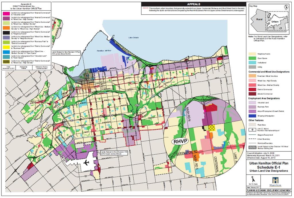
63 63 of of 75
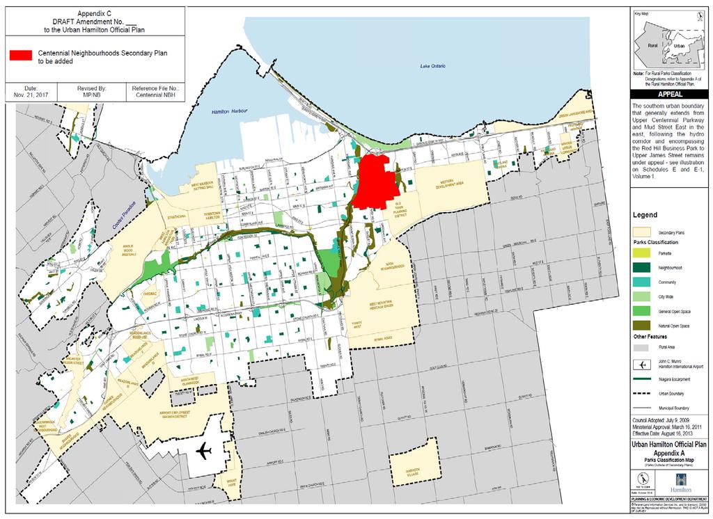
64 64 of of 75
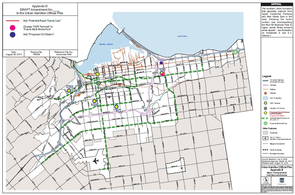
65 65 of of 75
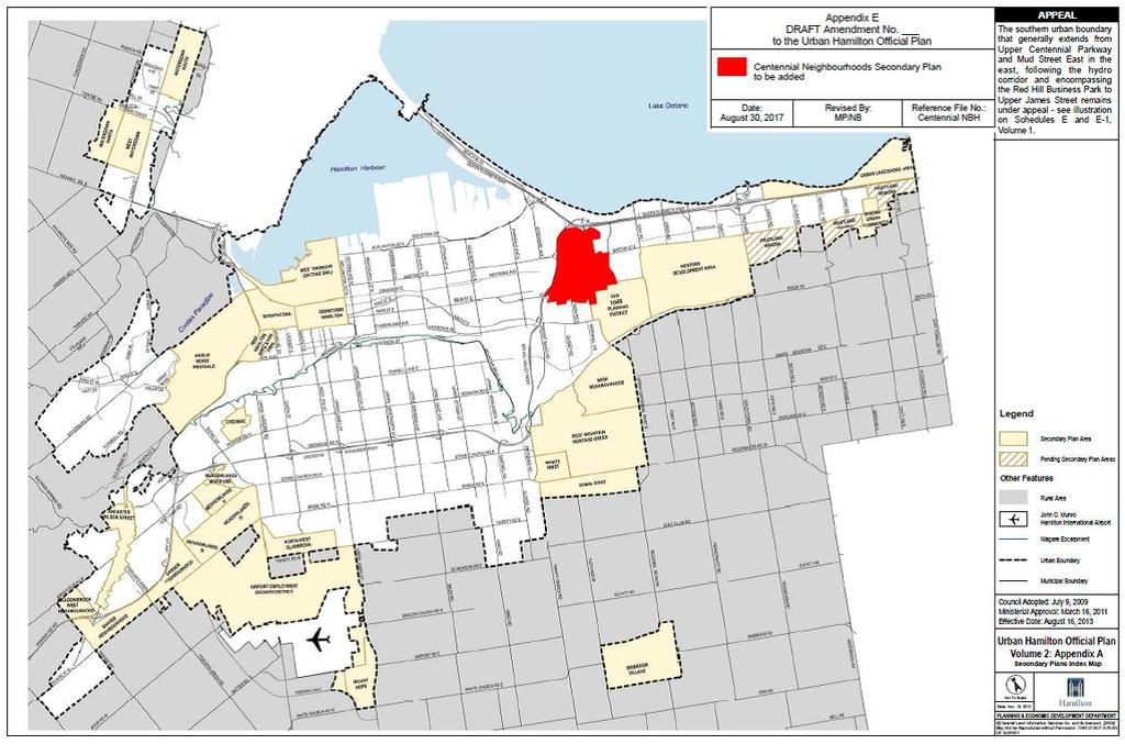
66 66 of of 75
67 67 of of 75
68 68 of of 75
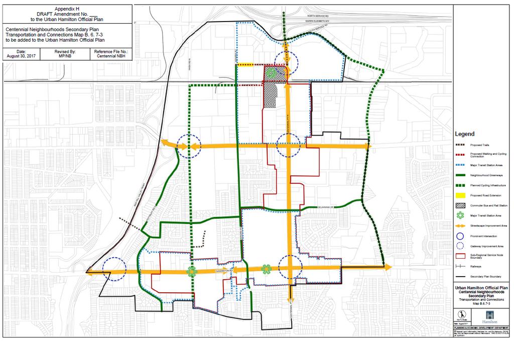
69 69 of of 75

70 70 of of 75
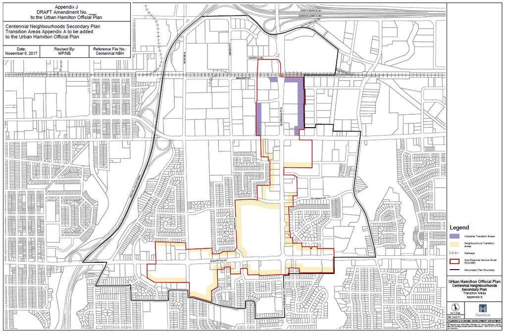
71 71 of of 75
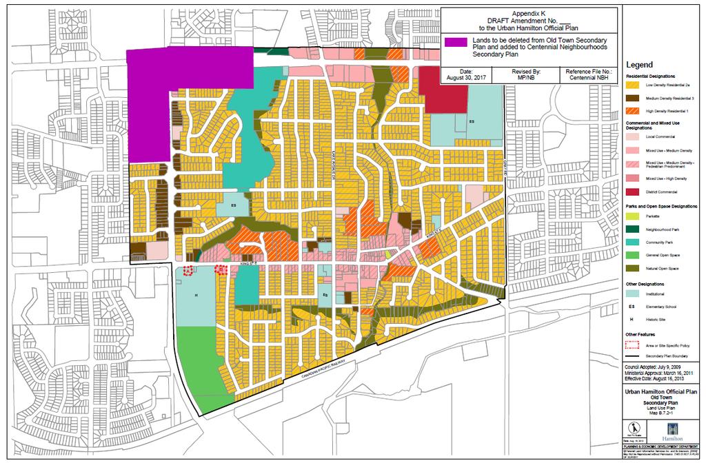
72 72 of of 75
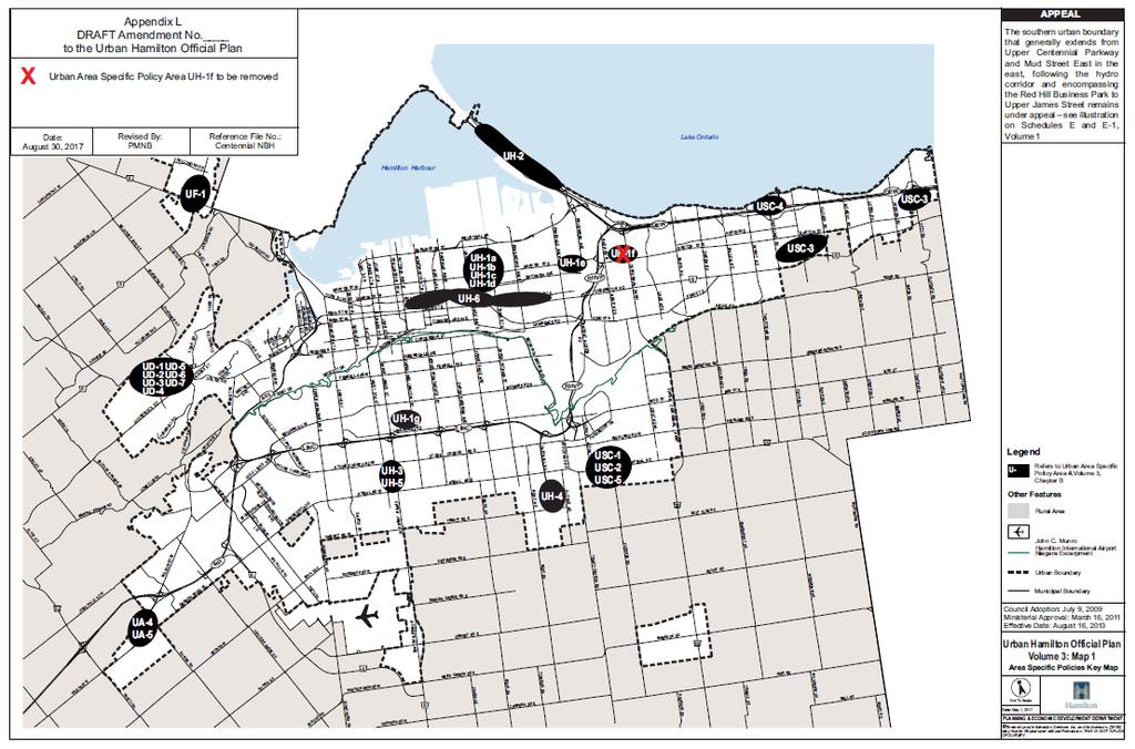
73 73 of of 75
74 74 of of 75
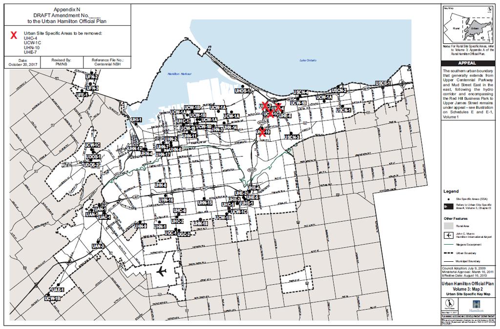
75 75 of of 75
Draft Urban Hamilton Official Plan. Amendment No. XX
 1 of 75 The following text, together with: Draft Appendix A Centennial Neighbourhoods Secondary Plan Appendix B Volume 1, Schedule E-1 Urban Land Use Designations Appendix C Volume 1, Appendix A Parks
*** DRAFT 2 FOR PUBLIC REVIEW ***
 6.7 The area is generally bounded by the Red Hill Valley Parkway to the west, Lake Avenue to the east, the Queen Elizabeth Way (QEW) to the north, and by the properties just south of Queenston Road to
Mark-up of the effect of the proposed Bronte Village Growth Area OPA No.18 on the text of section 24, Bronte Village, of the Livable Oakville Plan
 Mark-up of the effect of the proposed Bronte Village Growth Area OPA No.18 on the text of section 24, Bronte Village, of the Livable Oakville Plan Notes: This document is provided for information purposes
THE CITY OF VAUGHAN BY-LAW BY-LAW NUMBER A By-law to adopt Amendment Number 1 to the Official Plan of the Vaughan Planning Area.
 THE CITY OF VAUGHAN BY-LAW BY-LAW NUMBER 015-2014 A By-law to adopt Amendment Number 1 to the Official Plan of the Vaughan Planning Area. NOW THEREFORE the Council of the Corporation of the City of Vaughan
YONGE STEELES CORRIDOR SECONDARY PLAN. Young + Wright / IBI Group Architects Dillon Consulting Ltd. GHK International (Canada) Ltd.
 Ltd.") PART A: PREAMBLE 1.0 PURPOSE The purpose of this Secondary Plan is to provide a development framework for intensification of the Yonge/ Steeles corridor including the north side of Steeles Avenue West
PART A: PREAMBLE 1.0 PURPOSE The purpose of this Secondary Plan is to provide a development framework for intensification of the Yonge/ Steeles corridor including the north side of Steeles Avenue West
and services The protection and conservation of environmentally significant and sensitive natural heritage features and functions.
 6. Land Use 6.0 Preamble A healthy and livable city is one in which people can enjoy a vibrant economy and a sustainable healthy environment in safe, caring and diverse neighbourhoods. In order to ensure
Official Plan Review
 Official Plan Review Summary Report - The Built Environment August 2014 Part 1: Introduction Planning for a healthy, prosperous and sustainable community is an important goal for our municipality. From
Trafalgar Road Corridor Planning Study Open House
 Trafalgar Road Corridor Planning Study Open House June 24, 2013 6:30-8:30 p.m. Oakville & Trafalgar Rooms Overview The Livable Oakville Plan identifies the lands along Trafalgar Road, between the QEW and
FORMER CANADIAN FORCES BASE (CFB) ROCKCLIFFE SECONDARY PLAN. Official Plan Amendment XX to the Official Plan for the City of Ottawa
 ROCKCLIFFE SECONDARY PLAN. Official Plan Amendment XX to the Official Plan for the City of Ottawa") FORMER CANADIAN FORCES BASE (CFB) ROCKCLIFFE SECONDARY PLAN Official Plan Amendment XX to the Official Plan for the City of Ottawa 1 INDEX THE STATEMENT OF COMPONENTS PART A THE PREAMBLE PAGE Purpose...
FORMER CANADIAN FORCES BASE (CFB) ROCKCLIFFE SECONDARY PLAN Official Plan Amendment XX to the Official Plan for the City of Ottawa 1 INDEX THE STATEMENT OF COMPONENTS PART A THE PREAMBLE PAGE Purpose...
PORT WHITBY COMMUNITY
 PORT WHITBY COMMUNITY SECONDARY PLAN UPDATE COMMUNITY IMPROVEMENT PLAN URBAN DESIGN GUIDELINES September 2015 DRAFT PROPOSED AMENDMENT NUMBER # to the Whitby Official Plan PURPOSE: The intent of this Amendment
URBAN DESIGN BRIEF. 2136&2148 Trafalgar Road. Town of Oakville
 URBAN DESIGN BRIEF 2136&2148 Trafalgar Road Town of Oakville Prepared By: METROPOLITAN CONSULTING INC For 2500674 Ontario Inc November 2016 TABLE OF CONTENTS Page No. 1.0 Introduction/Description of Subject
CONTENTS 8.0 LAND USE 8.1 GENERAL LAND USE 8.2 RESIDENTIAL 8.3 MIXED USE 8.4 COMMERCIAL 8.5 EMPLOYMENT LANDS
 8-2 Land Use 8.0 LAND USE CONTENTS 8.1 GENERAL LAND USE 8.1.1 Uses provided for in all Land Use Designations 8.1.2 Uses prohibited in Hazardous Lands, Hazardous Sites and Special Policy Areas 8.1.3 Uses
ELMVALE ACRES SHOPPING CENTRE MASTER PLAN
 ELMVALE ACRES SHOPPING CENTRE MASTER PLAN Contents 1.0 INTRODUCTION... 2 2.0 LOCATION... 2 3.0 EXISTING CONTEXT... 2 4.0 VISION & GUIDING PRINCIPLES... 2 5.0 LAND USE AND BUILT FORM... 4 5.1 St. Laurent
The lands identified as Residential Areas on Schedule A1, Urban Structure, represent the areas that provide for stable residential communities.
 Livable Oakville Part D: Land Use Designations and Policies 11. RESIDENTIAL 11.1 General The lands identified as Residential Areas on Schedule A1, Urban Structure, represent the areas that provide for
11.4 Highway 400 North Employment Lands Secondary Plan APPROVED BY THE ONTARIO MUNICIPAL BOARD ON NOVEMBER 21, 2011
 11.4 Highway 400 North Employment Lands Secondary Plan APPROVED BY THE ONTARIO MUNICIPAL BOARD ON NOVEMBER 21, 2011 11.4.1 General 11.4.1.1. as approved by the Ontario Municipal Board on November 21, 2011,
AGINCOURT SECONDARY PLAN
 1 AGINCOURT SECONDARY PLAN 1. AGINCOURT SECONDARY PLAN The following policies and principles apply to the area herein referred to as Agincourt, as outlined on Map 1-1. 1. GENERAL POLICIES 1.1 This Secondary
11.4 Highway 400 North Employment Lands Secondary Plan
 11.4 Highway 400 North Employment Lands Secondary Plan APPROVED BY THE ONTARIO MUNICIPAL BOARD ON NOVEMBER 21, 2011 11.4.1 General 11.4.1.1. The following policies and Schedules A - I form Official Plan
Sustainable Growth. Sustainable Growth
 2 Sustainable Growth Sustainable Growth SUSTAINABLE GROWTH 2.1 COMMUNITY VISION... 2-5 2.2 THE CITY SYSTEM... 2-7 2.2.1 AREAS... 2-7 2.2.2 CITY-WIDE SYSTEMS... 2-8 2.2.3 PROVINCIAL PLAN BOUNDARIES AND
Midtown Oakville will be a vibrant, transit-supportive, mixed use urban community and employment area.
 Livable Oakville Part E: Growth Areas, Special Policy Areas and Exceptions 20. MIDTOWN OAKVILLE 20.1 Goal The interchange of Trafalgar Road and the QEW and the Oakville GO Station are major entry points
Figure 1- Site Plan Concept
 Figure 1- Site Plan Concept Parking will be provided underground on three levels at rate of 1.0 space/ unit; this rate includes all visitors parking. MMM Group has prepared a parking assessment (April,
A Growing Community Rural Settlement Areas
 Town of Huntsville Official Plan Review - POLICY BACKGROUND PAPER A Growing Community Rural Settlement Areas BACKGROUND: In addition to the fully municipally-serviced Urban Settlement Area and the Hidden
URBAN DESIGN BRIEF URBAN DESIGN BRIEF 721 FRANKLIN BLVD, CAMBRIDGE August 2018
 URBAN DESIGN BRIEF URBAN DESIGN BRIEF 721 FRANKLIN BLVD, CAMBRIDGE August 2018 DESIGN BRIEF CONTENTS PART A 1.0 INTRODUCTION 2.0 DESCRIPTION & ANALYSIS OF SITE CONTEXT 3.0 DESIGN CONSTRAINTS AND OPPORTUNITIES
[PLANNING RATIONALE] For Site Plan Control and Lifting of Holding Zone By-Law 101 Champagne Avenue. May 23, 2014
![[PLANNING RATIONALE] For Site Plan Control and Lifting of Holding Zone By-Law 101 Champagne Avenue. May 23, 2014](/thumbs/75/71599615.jpg "[PLANNING RATIONALE] For Site Plan Control and Lifting of Holding Zone By-Law 101 Champagne Avenue. May 23, 2014") [PLANNING RATIONALE] For Site Plan Control and Lifting of Holding Zone By-Law 101 Champagne Avenue May 23, 2014 Contents 1.0 Introduction... 2 2.0 Site Context... 2 2.1 Adjacent Uses... 2 Figure 1: Site
[PLANNING RATIONALE] For Site Plan Control and Lifting of Holding Zone By-Law 101 Champagne Avenue May 23, 2014 Contents 1.0 Introduction... 2 2.0 Site Context... 2 2.1 Adjacent Uses... 2 Figure 1: Site
QUEEN-RIVER SECONDARY PLAN
 34 QUEEN-RIVER SECONDARY PLAN 34. QUEEN RIVER SECONDARY PLAN 1. INTRODUCTION The Queen-River area is approximately 6.4 hectares and is located at the eastern edge of the Downtown as shown on Map 34-1.
178 Carruthers Properties Inc.
 178 Carruthers Properties Inc. Planning Rationale for 178 Carruthers Avenue Site Plan Control Application June 2014 Table of Contents 1.0 Introduction 2.0 Overview of Subject Property 3.0 Current Zoning
SCHEDULE 'A' TO BY-LAW as Amended by AMENDMENT NO. 90 TO THE WHITBY OFFICIAL PLAN
 SCHEDULE 'A' TO BY-LAW 6413-10 as Amended by 6553-11 AMENDMENT NO. 90 TO THE WHITBY OFFICIAL PLAN SECTION A: GROWTH PLAN CONFORMITY PURPOSE: LOCATION: BASIS: The purpose of this Amendment is to: conform
AMENDMENT NO. 42 TO THE OFFICIAL PLAN OF THE TOWN OF GRIMSBY
 AMENDMENT NO. 42 TO THE OFFICIAL PLAN OF THE TOWN OF GRIMSBY INITIATED BY TOWN OF GRIMSBY TABLE OF CONTENTS PART I: THE CERTIFICATION Certification Page Adopting By-law of the Town of Grimsby PART II:
2136 & 2148 Trafalgar Road Town of Oakville Region of Halton
 PLANNING JUSTIFICATION REPORT 2136 & 2148 Trafalgar Road Town of Oakville Region of Halton Zoning By-Law Amendment Application 2500674 Ontario Inc. November 2016 Table of Contents Page 1.0 Location/Summary
THE CORPORATION OF THE TOWN OF OAKVILLE BY-LAW NUMBER
 THE CORPORATION OF THE TOWN OF OAKVILLE BY-LAW NUMBER 2017-120 A by-law to adopt an amendment to the Livable Oakville Plan, Official Plan Amendment Number 20 (Downtown Oakville Growth Area) WHEREAS the
PLANNING AND URBAN DESIGN RATIONALE REPORT. Hunters Pointe Golf Course Redevelopment 289 Daimler Parkway Prepared For: Ontario Ltd.
 PLANNING AND URBAN DESIGN RATIONALE REPORT Hunters Pointe Golf Course Redevelopment 289 Daimler Parkway Prepared For: 2599587 Ontario Ltd. February 2018 Redevelopment of Hunters Pointe Golf Course, Welland
PILLAR FOUR INTEGRATE LAND USE & TRANSPORTATION
 PILLAR FOUR INTEGRATE LAND USE & TRANSPORTATION 8 Scarborough Centre on the Move Transportation Master Plan 123 8 Transportation Pillar Four Integrate Land Use & The fourth pillar focuses on the relationship
DRAFT Northeast Quadrant of Kipling Avenue and Highway 7 DRAFT AUGUST 29, Goals Land Use. The goals of this Plan are to:
 AUGUST 29, 2017 12.15 Northeast Quadrant of Kipling Avenue and Highway 7 12.15.1 Goals 12.15.2 Land Use The goals of this Plan are to: 12.15.2.1 General Provisions: a) Ensure the development of a compact
Urban Design Manual PLANNING AROUND RAPID TRANSIT STATIONS (PARTS) Introduction. Station Study Areas
 Introduction. Station Study Areas") 111111 PLANNING AROUND RAPID TRANSIT STATIONS (PARTS) Introduction The ION rapid transit system will link Waterloo, Kitchener and Cambridge through a central transit corridor (CTC). There are a number
111111 PLANNING AROUND RAPID TRANSIT STATIONS (PARTS) Introduction The ION rapid transit system will link Waterloo, Kitchener and Cambridge through a central transit corridor (CTC). There are a number
URBAN DESIGN BRIEF New Street Burlington, ON
 3225-3237 New Street Burlington, ON MARCH 2017 Prepared for: Royal Living Development Group Inc. Prepared by: adesso design inc. 218 Locke Street South, 2nd Floor Hamilton, ON L8P 4B4 t. 905.526.8876 3225-3237
K. SMART ASSOCIATES LIMITED
 Planning Justification Report Zoning By-Law Amendment 185 King Street North Waterloo, Ontario April 7th, 2017 Project Reference Number 16-245 K. SMART ASSOCIATES LIMITED CONSULTING ENGINEERS AND PLANNERS
AMENDMENT NO.XX TO THE CLARINGTON OFFICIAL PLAN
 AMENDMENT NO.XX TO THE CLARINGTON OFFICIAL PLAN PURPOSE: The purpose of this Amendment is to create a planning framework that will facilitate the development of a transit supportive, pedestrian friendly,
1 Introduction. Chapter. In this chapter:
 Chapter 1 Introduction In this chapter: 1.1 A Snapshot of the Region 1.2 Towards a Sustainable Region 1.3 The Provincial Context 1.4 Purpose and Organization The Regional Municipality of York Official
The West Vaughan Employment Area Secondary Plan Policies
 Part 2: The West Vaughan Employment Area Secondary Plan Policies 2.1 General Policies It is the policy of Council: 2.1.1. That the West Vaughan Employment Area (the WVEA), identified on Schedule 1, will
URBAN DESIGN BRIEF REPORT
 URBAN DESIGN BRIEF REPORT PREPARED FOR 2568401 ONTARIO INC NEW GASBAR, CONVENIENCE STORE & CARWASH DEVELOPMENT @ 1509 FANSHAWE PARK ROAD WEST LONDON, ONTARIO GAMA ENGINEERING INC. PROJECT NUMBER 1669 PREPARED
and Richmond Street West - Official Plan Amendment Application - Preliminary Report
 STAFF REPORT ACTION REQUIRED 822-838 and 860-862 Richmond Street West - Official Plan Amendment Application - Preliminary Report Date: August 14, 2017 To: From: Wards: Reference Number: Toronto and East
Clairtrell Area Context Plan
 Clairtrell Area Context Plan March 2005 Urban Development Services City Planning Contents 1. Introduction... 4 2. Development Structure... 6 2.1 Streets... 7 2.1.1 Sheppard Avenue and Bayview Avenue...
OFFICIAL PLAN FOR THE CITY OF NIAGARA FALLS
 OFFICIAL PLAN FOR THE CITY OF NIAGARA FALLS Planning & Development Office Consolidation Amended to April 2017, Approved October 6, 1993 by the Ministry of Municipal Affairs 1 OFFICIAL PLAN CITY OF NIAGARA
Welcome. Walk Around. Talk to Us. Write Down Your Comments
 Welcome This is an information meeting introducing the applications for proposed redevelopment of the Yorkdale Shopping Centre site at 3401 Dufferin Street and 1 Yorkdale Road over the next 20+ years,
This page has been intentionally left blank.
 This page has been intentionally left blank. Chapter 3 3-2 3. Employment 3.A Niagara Economic Gateway 3.A.1 General The Niagara Economic Gateway comprises: a) The Gateway Economic Zone which includes all
OFFICE CONSOLIDATION CHAPTER 47 HIGHWAY 427 INDUSTRIAL SECONDARY PLAN
 OFFICE CONSOLIDATION CHAPTER 47 HIGHWAY 427 INDUSTRIAL SECONDARY PLAN NOTE: This Secondary Plan is partially in effect. Highlighted sections are under appeal. August 2017 1 EXPLANATORY NOTE Office Consolidation
PUBLIC OPEN HOUSE HURONTARIO-MAIN CORRIDOR SECONDARY PLAN
 PUBLIC OPEN HOUSE HURONTARIO-MAIN CORRIDOR SECONDARY PLAN Tuesday, February 28, 2012 6pm 9pm 1 st Floor Atrium, City Hall 2 Wellington Street West, Brampton 1 POLICY FRAMEWORK The 2006 Provincial Growth
WELCOME and introduction
 1 WELCOME and introduction Mobility Hub Locations within Burlington STUDY OVERVIEW STUDY OBJECTIVES The City of Burlington is developing four Area Specific Plans, one for each of Burlington s Mobility
Bank Street Secondary Plan
 1.1 Introduction The is a guide to the long term design and development of the portion of Bank Street between Riverside Drive and Ledbury Park, and provides direction on land use, built form, design, parking,
Table 8-4: Road Classification Local Roads, second table, of Chapter 8 Create a Multi-Modal City, be amended by adding the following:
 1 Port Street East Official Plan Amendment APPENDIX 3 Amendments to Mississauga Official Plan Table 8-4: Road Classification Local Roads, second table, of Chapter 8 Create a Multi-Modal City, be amended
Complete Neighbourhood Guidelines Review Tool
 Complete Neighbourhood Guidelines Review Tool Prepared By: City of Regina Planning Department October 2014 Page 1 of 14 Community Development Review Checklist for Secondary Plans and Concept Plans The
6 PORT SYDNEY SETTLEMENT AREA
 Section 6 Port Sydney Page 61 6 PORT SYDNEY SETTLEMENT AREA 6.1 Basis and Principles Village of Port Sydney Waterfront Community Existing Services 6.1.1 Port Sydney is an historic settlement that has developed
PLANNING JUSTIFICATION REPORT
 PLANNING JUSTIFICATION REPORT 55 DELHI STREET CITY OF GUELPH PREPARED FOR: VESTERRA PROPERTY MANAGEMENT PREPARED BY: LABRECHE PATTERSON & ASSOCIATES INC. SCOTT PATTERSON, BA, CPT, MCIP, RPP PRINCIPAL,
CONTENTS 2.0 A FRAMEWORK FOR SUSTAINABLE GROWTH 2.1 MANAGING SUSTAINABLE GROWTH THE VISION TO GOALS AND OBJECTIVES 2.3 MARKHAM STRUCTURE
 2 A Framework for Sustainable Growth 2.0 A FRAMEWORK FOR SUSTAINABLE GROWTH CONTENTS 2.1 MANAGING SUSTAINABLE GROWTH THE VISION TO 2031 2.2 GOALS AND OBJECTIVES 2.2.1 Protecting the Natural Environment
2.0 A FRAMEWORK FOR SUSTAINABLE GROWTH CONTENTS
 2-2 A Framework for Sustainable Growth 2.0 A FRAMEWORK FOR SUSTAINABLE GROWTH CONTENTS 2.1 MANAGING SUSTAINABLE GROWTH THE VISION TO 2031 2.2 GOALS AND OBJECTIVES 2.2.1 Protecting the Natural Environment
DAVENPORT VILLAGE SECONDARY PLAN
 27 DAVENPORT VILLAGE SECONDARY PLAN 27. DAVENPORT VILLAGE SECONDARY PLAN 1. VISION FOR THE DAVENPORT VILLAGE SECONDARY PLAN Davenport Village, municipally known as 830, 940, 980 and 1100 Lansdowne Avenue,
Corridor Transformation Strategy
 Corridor Transformation Strategy County Road 22 Special Planning Area Design Guidelines January 2012 D14-06017 Corridor Transformation Strategy County Road 22 Special Planning Area Corridor Design Guidelines
Urban Design Brief December 23, 2015 Southside Construction Group Official Plan & Zoning By-Law Amendment
 Urban Design Brief Proposed Official Plan & Zoning By-Law Amendment 3244, 3263 and 3274 Wonderland Road South Southside Group December 23, 2015 TABLE OF CONTENTS Page No. INTRODUCTION... 1 SECTION 1 LAND
PART 2 THE AMENDMENT DRAFT
 PART 2 THE AMENDMENT 2.1 PREAMBLE All of this part of the document entitled PART 2 THE AMENDMENT, consisting of the explanatory text and the attached maps identified as Schedules B3 to Schedule B8 constitute
770 Don Mills Road and 805 Don Mills Road - Official Plan Amendment and Zoning By-law Amendment Application Preliminary Report
 REPORT FOR ACTION 770 Don Mills Road and 805 Don Mills Road - Official Plan Amendment and Zoning By-law Amendment Application Preliminary Report Date: To: From: Wards: June 22, 2018 North York Community
THE STRUCTURE OF THE PLAN...
 TABLE OF CONTENTS THE STRUCTURE OF THE PLAN... 1 A1 THE COMMUNITY VISION... 3 A2 GOALS AND OBJECTIVES... 3 A2.1 THE NATURAL ENVIRONMENT... 3 A2.1.1 Goal... 3 A2.1.2 Objectives... 3 A2.2 GROWTH AND SETTLEMENT...
Foster Creek West Clarington, Ontario PLANNING JUSTIFICATION REPORT
 Foster Creek West Clarington, Ontario PLANNING JUSTIFICATION REPORT Official Plan Amendment Zoning By-law Amendment Neighbourhood Design Plan Amendment Draft Plan of Subdivision File No. 112092 February
DRAFT Land Use Chapter
 Stevens Creek Urban Village DRAFT 1 18 17 Land Use Chapter INTRODUCTION This Land Use Chapter describes how the Stevens Creek Urban Village will accommodate the growth that is planned for it in the Envision
LAND USE AMENDMENT CORNERSTONE (WARD 3) 60 STREET NE AND COUNTRY HILLS BOULEVARD NE MAP 26NE BYLAW 22D2017
 60 STREET NE AND COUNTRY HILLS BOULEVARD NE MAP 26NE BYLAW 22D2017") Page 1 of 14 EXECUTIVE SUMMARY This Land Use Amendment application covers an area of 43.76 hectares ± (108.14 acres ±) located in northeast Calgary, bound by Country Hills Boulevard NE to the south and
Page 1 of 14 EXECUTIVE SUMMARY This Land Use Amendment application covers an area of 43.76 hectares ± (108.14 acres ±) located in northeast Calgary, bound by Country Hills Boulevard NE to the south and
1.0 PLANNING MARKHAM S FUTURE CONTENTS
 1-1 Planning Markham s Future 1.0 PLANNING MARKHAM S FUTURE CONTENTS 1.1 THE PURPOSE OF THE OFFICIAL PLAN 1.2 THE MARKHAM CONTEXT 1.3 THE REGULATORY CONTEXT 1.3.1 Province of Ontario 1.3.2 York Region
NEW REGIONAL OFFICIAL PLAN HIGH LEVEL PROCESS & FRAMEWORK
 NEW REGIONAL OFFICIAL PLAN HIGH LEVEL PROCESS & FRAMEWORK Why A New Official Plan Originally the role of Regionally Planning and content of Regional Official Plan (1970s) primarily focused on protecting
NOTE: PLEASE REFER TO CITY PLAN FOR ADDITIONAL CITY-WIDE POLICIES WHICH APPLY TO THIS DISTRICT.
 NOTE: THE POLICIES IN THIS DOCUMENT ARE SPECIFIC TO THE SHERIDAN RESIDENTIAL PLANNING DISTRICT OF, AND MUST BE READ IN CONJUNCTION WITH ALL THE POLICIES OF CITY PLAN PLEASE REFER TO FOR ADDITIONAL CITY-WIDE
Employment and Commercial Review Analysis of Policy Directions
 Employment and Commercial Review Analysis of Policy Directions Appendix A The following analysis is town staff s response to the policy directions provided by the consultants who prepared the Employment
New-Cast Mixed-use Development Proposal King Street West, Newcastle, Ontario
 URBAN DESIGN BRIEF New-Cast Mixed-use Development Proposal King Street West, Newcastle, Ontario TABLE OF CONTENTS: 1.0 Executive Summary 2.0 Creating Vibrant and Sustainable Urban Places: Excerpts from
Uptown Rideau Street Secondary Plan [Amendment #166, January 12, 2016]
![Uptown Rideau Street Secondary Plan [Amendment #166, January 12, 2016]](/thumbs/76/73760497.jpg "Uptown Rideau Street Secondary Plan [Amendment #166, January 12, 2016]") [Amendment #166, January 12, 2016] The policies of this Secondary Plan are in effect, save and except for the property at 560 Rideau Street, for which there remains a site specific appeal to this Secondary
[Amendment #166, January 12, 2016] The policies of this Secondary Plan are in effect, save and except for the property at 560 Rideau Street, for which there remains a site specific appeal to this Secondary
Urban Design Brief. Watson Parkway North & Watson Road North Guelph, Ontario. Prepared by Coletara Development
 Urban Design Brief Watson Parkway North & Watson Road North Guelph, Ontario Prepared by Coletara Development December, 2013 Urban Design Brief, Coletara Development 1 Introduction This Urban Design Brief
MAYFIELD WEST SECONDARY PLAN PHASE 2
 MAYFIELD WEST SECONDARY PLAN PHASE 2 Council Information Workshop February 16, 2010 Draft Preferred Land Use Plan TOWN OF CALEDON PLANNING & DEVELOPMENT DEPARTMENT Workshop Agenda TOWN OF CALEDON 1. Welcome
GO Station Mobility Hubs: Draft Precinct Plans. Committee of the Whole July 12, 2018
 GO Station Mobility Hubs: Draft Precinct Plans Committee of the Whole July 12, 2018 Purpose of this Workshop Present Draft Precinct Plans for the 3 GO Station Mobility Hubs Continue the conversations that
Beamsville GO Transit Station Background Study. October 2017
 Beamsville GO Transit Station Background Study October 207 Play structures in Hilary Bald Community Park, Lincoln. This document provides the background and draft policy framework to support the development
Land Use Policies Urban Area. Land Use Policies Urban Area
 8 Land Use Policies Urban Area Land Use Policies Urban Area This page has been left intentionally blank LAND USE POLICIES URBAN AREA 8.1 MIXED USE INTENSIFICATION AREAS... 8-5 8.1.1 URBAN CENTRES... 8-5
MAYFIELD WEST SECONDARY PLAN PHASE 2
 MAYFIELD WEST SECONDARY PLAN PHASE 2 Public Open House #3 February 25, 2010 Draft Preferred Land Use Scenario TOWN OF CALEDON PLANNING & DEVELOPMENT DEPARTMENT Open House Agenda TOWN OF CALEDON 1. Welcome
2.0 A FRAMEWORK FOR SUSTAINABLE GROWTH CONTENTS
 2-2 A Framework for Sustainable Growth 2.0 A FRAMEWORK FOR SUSTAINABLE GROWTH CONTENTS 2.1 MANAGING SUSTAINABLE GROWTH THE VISION TO 2031 2.2 GOALS AND OBJECTIVES 2.2.1 Protecting the Natural Environment
PART III LAND USE POLICIES URBAN PLANNING AREA
 To be read with other parts of the Plan 1.0 INTRODUCTION *D9 This part of the Plan presents the principles, objectives and policies for the land use designations identified on the Settlement Pattern and
C.10 Boyne Survey Secondary Plan
 C.10 Boyne Survey Secondary Plan SECONDARY PLAN July 2017 C.10 BOYNE SURVEY SECONDARY PLAN C.10.1 C.10.1.1 GENERAL PURPOSE The purpose of the Boyne Survey Secondary Plan is to establish a more detailed
ONTARIO MUNICIPAL BOARD
 PL 120483 ONTARIO MUNICIPAL BOARD Applicant/Appellant: 2124123 Ontario Limited Subject: OPA, Rezoning and Draft Plan of Subdivision Municipal Address: 3940 Highway 7 East Municipality: City of Markham
Regency Developments. Urban Design Brief. Holyrood DC2 Rezoning
 Regency Developments Urban Design Brief Holyrood DC2 Rezoning Stantec Consulting Ltd. 7-31-2017 1. Overview Regency Developments intends to rezone the lands located at 8510 and 8511 93 Avenue, within the
DRAFT: OPA 125, DOWNTOWN NIAGARA FALLS GO TRANSIT SECONDARY PLAN CITY OF NIAGARA FALLS OFFICIAL PLAN
 DRAFT: OPA 125, DOWNTOWN NIAGARA FALLS GO TRANSIT SECONDARY PLAN CITY OF NIAGARA FALLS OFFICIAL PLAN PART 2 - BODY OF THE AMENDMENT All of this part of the document entitle PART 2 Body of the Amendment,
Bressa Developments Limited. Planning Justification Report. Revised Draft Plan of Subdivision and Zoning By-Law Amendment
 Bressa Developments Limited Revised Draft Plan of Subdivision and Zoning By-Law Amendment Planning Justification Report Part of Lots 7 & 8 Concession 1, North of Dundas Street Town of Oakville September,
Municipal Development Plan Update Urban Service Area and Hamlets
 ENCLOSURE 1 Municipal Development Plan Update Urban Service Area and Hamlets Priorities Committee January 24, 2017 MUNICIPAL DEVELOPMENT PLAN UPDATE SHAPING OUR FUTURE MDP Update - Agenda MDP Update Public
2. Shaping Waterloo Region s Urban Communities
 2. Much of the region s growth over the past several decades has occurred in suburban areas that separated where people live from where they work and shop. This pattern of growth has increased the need
AMENDMENT NUMBER ## TO THE VAUGHAN OFFICIAL PLAN 2010 FOR THE VAUGHAN PLANNING AREA
 AMENDMENT NUMBER ## TO THE VAUGHAN OFFICIAL PLAN 2010 FOR THE VAUGHAN PLANNING AREA The following text and schedules "1", 2, 3, 4 and 5 constitute Amendment Number ## to the Official Plan of the Vaughan
Brampton. Secondary Plan. Review. Bram West. A New Direction in Planning & Public Consultation
 Brampton Bram West Secondary Plan Review A New Direction in Planning & Public Consultation Introduction The Bram West Secondary Plan Review offers an important opportunity for the community to define a
THE CITY OF VAUGHAN BY-LAW BY-LAW NUMBER
 THE CITY OF VAUGHAN BY-LAW BY-LAW NUMBER 177-2018 A By-law to adopt Amendment Number 33 to the Vaughan Official Plan 2010 for the Vaughan Planning Area. NOW THEREFORE the Council of the Corporation of
EXISTING COMPREHENSIVE PLAN
 EXISTING COMPREHENSIVE PLAN Town Center Land Use Element: V. LAND USE POLICIES Town Center Mercer Island's business district vision as described in "Your Mercer Island Citizen-Designed Downtown" was an
Eglinton Avenue East & 50 Thermos Road - Official Plan Amendment Application Preliminary Report
 STAFF REPORT ACTION REQUIRED 1966 2050 Eglinton Avenue East & 50 Thermos Road - Official Plan Amendment Application Preliminary Report Date: March 15, 2016 To: From: Wards: Reference Number: Scarborough
Table of Contents 1.0 Introduction
 Table of Contents 1.0 Introduction..1 2.0 Site Description and Surrounding Land Uses 1 3.0 Redevelopment Proposal..3 4.0 Provincial, Regional and Municipal Policy Context... 10 4.1 The Provincial Policy
KING-SPADINA SECONDARY PLAN
 16 KING-SPADINA SECONDARY PLAN 16. KING-SPADINA SECONDARY PLAN 1. INERPREAION 1.1 he lands affected by this Secondary Plan for the King-Spadina Area are shown on Map 16-1. 1.2 Where a building within a
THE GARDEN CITY PLAN. City of St. Catharines Official Plan. City of St. Catharines
 THE GARDEN CITY PLAN City of St. Catharines Official Plan City of St. Catharines August 2010 APPROVAL INFORMATION This Official Plan of the City of St. Catharines Planning Area, known as the Garden City
5.1 Site Plan Guidelines
 5. Community Core Guidelines Development of the Community Core will take place by plan of subdivision and site plan approval. It will occur in a phased manner that will reflect the timing of residential
CITY OF LANGLEY OFFICIAL COMMUNITY PLAN BYLAW, 2005, NO APPENDIX II - REGIONAL CONTEXT MAP
 CITY OF LANGLEY OFFICIAL COMMUNITY PLAN BYLAW, 2005, NO. 2600 APPENDIX II - REGIONAL CONTEXT MAP ± Legend Agricultural Mixed Employment Industrial Conservation & Recreation Regional City Centre Urban Containment
Niagara GO Hub and Transit Stations Study
 Niagara GO Hub and Transit Stations Study Public Open House #2 June 2017 Study Purpose The purpose of this study is to prepare four key deliverables for each station area: 1. Work with Metrolinx to provide
PART III LAND USE POLICIES URBAN PLANNING AREA
 To be read with other parts of the Plan 1.0 INTRODUCTION *D9 This part of the Plan presents the principles, objectives and policies for the land use designations identified on the Settlement Pattern and
The protection of the agricultural resources of the Province;
 PART II INTRODUCTION An Official Plan is a policy document, which is intended to serve as the basis for making land use decisions and managing change in any municipality in Ontario. According to the Planning
Port Credit Local Advisory Panel October 20 th Meeting
 Port Credit Local Advisory Panel October 20 th Meeting Focus Of This Evening s Meeting: 1. Hurontario Main Street Higher Order Transit Study 2. Port Credit Mobility Hub & GO Station Parking Structure Study
Land Use Policies Urban Area. Land Use Policies Urban Area
 8 Land Use Policies Urban Area Land Use Policies Urban Area LAND USE POLICIES URBAN AREA 8.1 MIXED USE INTENSIFICATION AREAS... 8-5 8.1.1 URBAN CENTRES... 8-5 8.1.1(3) DOWNTOWN URBAN CENTRE... 8-9 8.1.1(4)
HEMSON C o n s u l t i n g L t d.
 INVENTORY & ASSESSMENT OF INTENSIFICATION OPPORTUNITIES City of Brampton Discussion i Paper for Public Review C o n s u l t i n g L t d. November 2008 EXECUTIVE SUMMARY This report is one of the key background