Interpreting and Using the RI Site Specific Soil Mapping Standards and Procedures
|
|
|
- Anthony Allen
- 6 years ago
- Views:
Transcription
1 Interpreting and Using the RI Site Specific Soil Mapping Standards and Procedures Using the New Rhode Island Site Specific Soil Mapping Guide URI Coastal Institute, Kingston November 15, 2007 Lorraine Joubert, URI Cooperative Extension NEMO


2 Acknowledgments Author Dr. Mark Stolt, Associate Professor of Pedology and Soil-Environmental Science, URI NRS Department Reviewers Peter Fletcher, Consulting Soil Scientist David Kalen, NE Onsite Wastewater Training Center George Loomis, NE Onsite Wastewater Training Ctr. Jim Turenne, USDA NRCS Tom Peragallo, Consulting Soil Scientist Editing Lorraine Joubert and Lisa Philo, URI Cooperative Extension NEMO Funding Developed by URI Cooperative Extension under the EPA Block Island and Green Hill Pond Watershed Community Wastewater Demonstration Project with additional support to NEMO from RI HEALTH
3 Nonpoint Education for Municipal Officials RI NEMO provides training and technical support to local decision makers in evaluating and managing impacts of land use on local water resources. URI NEMO is part of the Cooperative Extension Water Quality Program. Funded by RI HEALTH Office of Drinking Water under the Municipal Capacity Training program and by RI DOT under the Phase II Stormwater Education and Outreach Program.
4 Topics Why use site soil specific (SSS) mapping? Where is SSS mapping most useful? How to interpret and display results?

5 RI Soil Survey Designed for planning. Line error plus or minus 40 ft. Minimum map unit ¼ acre. One soil unit may include several types complexes and inclusions. Created at 1:15,840 1 = 1,320 ft. 1 = ¼ mile Urban / filled soils not mapped.

6 Soil mapping is required for local land development applications. RI Soil survey maps commonly used with site plans at 1 = 40 ft or larger.
7 Why use Site Specific Soil Mapping Soil properties and characteristics can be accurately mapped. Provides evidence town officials, developers, land owners need to evaluate suitability for development. Improve communication among all parties. Protects project designers by documenting site planning decisions. Standard method ensures fairness and consistency.

8 Site Specific Soil Mapping applications Comprehensive assessment of a parcel for planning and initial site design. Siting onsite wastewater treatment systems and stormwater facilities. Selection of test sites for more costly and disruptive field investigations. Provides better data local board members need to document decisions and prepare findings of fact for difficult sites.
9 Topics Why use site soil specific (SSS) mapping? Where is SSS mapping most useful? How to interpret and display results?
10 Where is SSS mapping most useful? New Applications: Flexible design to select building sites and promote compact development. Stormwater management using low impact nonstructural methods. Local needs to avoid or minimize impact in critical areas/marginal sites.

11 Conservation Development is a creative land use technique that allows a community to guide growth to the most appropriate areas within a parcel of land to avoid impacts to the environment and to protect the characterdefining features of the property. RIDEM, The RI Conservation Development Manual
12 RIDEM Conservation Development Manual Undeveloped
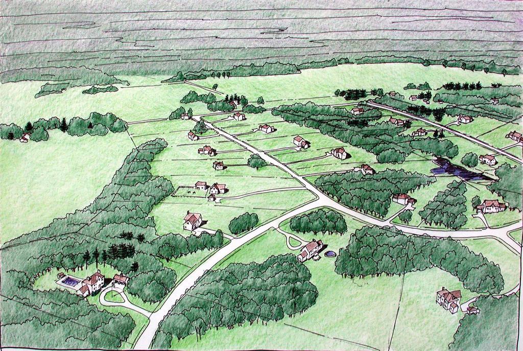
13 Conventional
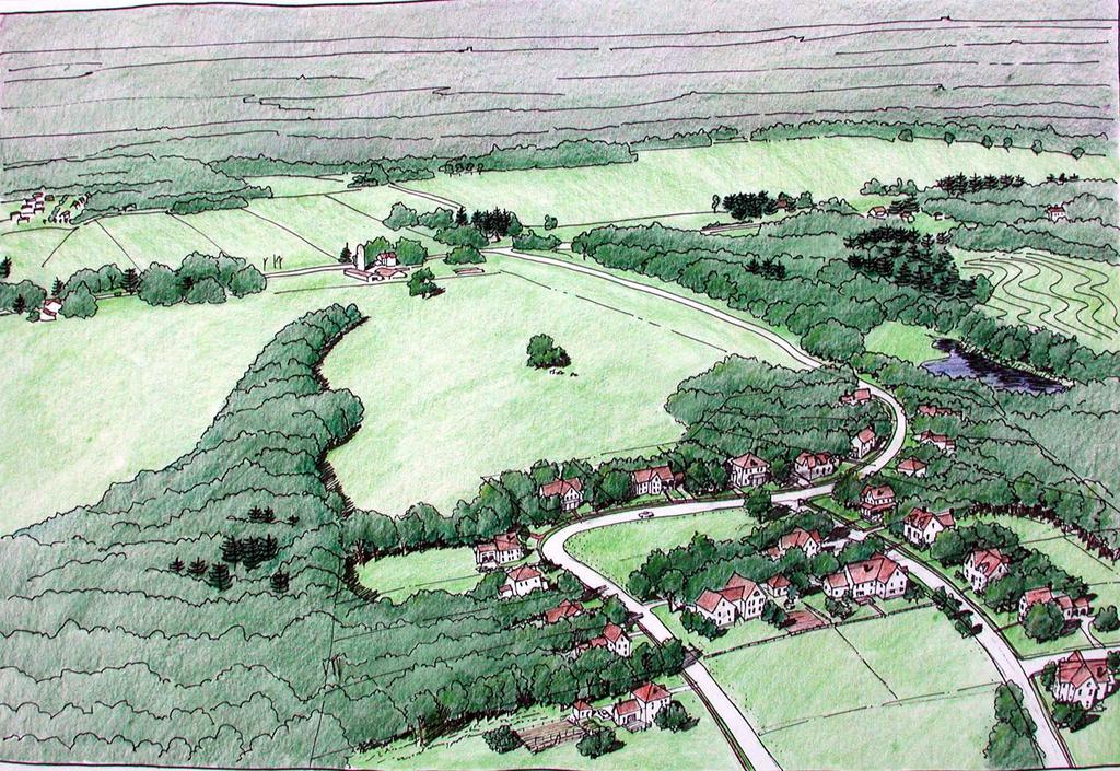
14 Conservation Design

15 The Design process: 1. Analyze the site 2. Designate conservation areas. 3. Locate areas for development. 4. Locate house sites, layout roads, draw lot lines. Undeveloped

16 The design process emphasizes early site assessment to ID conservation areas Non-buildable areas wetlands, regulated buffers, hydric soils, etc. Partially Constrained - high water tables < 3.5 ft, impermeable layers, slopes > 15%.


17 New village center Rural conservation development Design of compact development projects.

18 Site specific mapping for Stormwater Management using Low Impact Development methods

19 Jordan Cove subdivision, CT NEMO Low impact development (LID) a stormwater management and land development strategy applied at the parcel and subdivision scale that emphasizes conservation and use of on-site natural site features integrated with engineered, smallscale hydrologic controls to more closely mimic predevelopment hydrologic functions. LID Technical Guidance Manual for Puget Sound
20 Step 1 Site analysis Comprehensive inventory and assessment of on-site and adjacent off-site conditions are the initial steps for implementing low impact development. Soil Analysis LID requires detailed understanding of site soils for two primary reasons: 1) LID emphasizes evaporation, storage and infiltration of stormwater in smaller scale facilities distributed throughout the site; and 2) on sites with mixed soil types, the LID site plan should locate less permeable soils and preserve and utilize permeable soils for infiltration LID guidance manual for Puget Sound

21 Jordan Cove Traditional subdivision Conventional lot layout, standard frontage and setbacks. Jordan Cove traditional subdivision Dr. Michael Dietz, CT NEMO Closed drainage system discharg es to Large detention basin.

22 Low impact stormwater design Cluster layout with small lots, preserved open space Bioretention cul-de-sac Rain gardens Shared driveways Grassed swales Pervious roadway Jordan Cove LID Subdivision. Dr. Michael Dietz, CT NEMO


23 Jordan Cove BMP Cluster Subdivision Bioretention area in turnaround Shared, Pervious driveways Concrete grid lined grass swale Rain gardens
24
25 Hydrologic group definition: soils having similar runoff potential under similar storm and cover conditions. Soil properties that influence runoff potential are depth to a seasonally high water table, and saturated hydraulic conductivity after prolonged wetting, and depth to a layer with a very slow water transmission rate. Classified as A, B, C, or D. U.S. Department of Agriculture, Natural Resources Conservation Service National Engineering Handbook.

26 Need for Soil Hydrologic group data Hydrogroups required for determining runoff volumes, peak discharge rates and storage requirements using TR State of RI Storm Water Design and Installation Standards Manual. RIDEM 2006 Draft updated manual specifies: Use of soil surveys to determine site soil types Delineate hydrologic soil types on concept site plans to guide site layout and the placement of buildings and impervious surfaces Infiltration trenches, North Kingstown, RI
27 Where is SSS mapping most useful? New Applications: Flexible design to select building sites and promote compact development. Stormwater management using low impact nonstructural methods. Local needs to avoid or minimize impact in critical areas/marginal sites.

28 Municipal requirements for site assessment and impact avoidance may exceed state minimum standards, particularly on marginal sites and in environmentally critical areas
29 A B B C C C/D Hydrodrologic Soil Group Jamestown Source Water Assessment URI Cooperative Extension
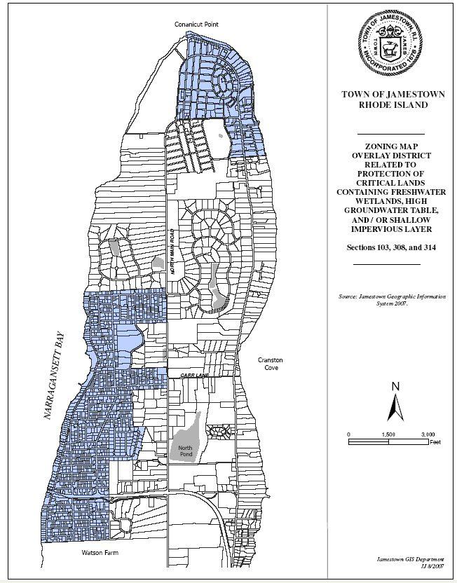
30
31 The Town of Jamestown High Groundwater Ordinance Adopted In 2003 to provide local jurisdiction over development on lots with water table < 3 ft. Amended in 2004, 2005 and Main Focus: Protect groundwater by denitrification, pathogen or microbiological treatment Reduce Impervious surface coverage Provide adequate stormwater controls Protect wetlands and their buffers Not to impede groundwater flow Additional soil test pits may be required on individual lots. The Town of Jamestown High Groundwater Ordinance Development of lots within subdistrict A (water table less than 18 ) requires a special use permit application to include Site specific soils map of the property. Town of Jamestown website

32 The Town of South Kingstown Zoning Section 504 Prohibits location of OWTS within 150 of wetland, except where special use permit is approved. Application requires use of advanced wastewater treatment system and submittal of a Site Specific Soils survey.

33 The Towns of North Kingstown and Narragansett Establish zoning overlay districts based on soils type and associated limitations. The Town of North Smithfield has drafted a proposed Zoning Section 6.12 OWTS Setback from wetlands and waterbodies. This requires a special use permit for activities within wetland buffers, to include a development plan with a: Site specific soils map of the property prepared by a professional soil scientist recognized by the Soil Science Society, Southern New England Chapter, or ARCPAC certified.

34 Elsewhere in New England Site-Specific Soil Mapping Standards have been used in New Hampshire and Vermont since In Maine Soil survey report must be prepared by a certified soil scientist. Soil surveys must comply with the Maine Association of Professional Soil Scientists Standards for Soil Surveys. Section 11.
35 Topics Why use site soil specific (SSS) mapping? Where is SSS mapping most useful? How to interpret and display results?
36 Goal: Interpret soil mapping units and display visually in useful format for local land use decisions. Use combination of soil hydrogroups and water table depth as key features for stormwater and wastewater management. A B B C C C/D Hydrodrologic Soil Group

37 A B B C C C/D Hydrodrologic Soil Group Jamestown Source Water Assessment URI Cooperative Extension
 Current")

38 Soil Hydro Group and Water Table Depth (URI) Current soil mapping available at DEM interactive map server A B B C C C/D


39 Slope Categories may be mapped using site specific contours. Example slope map developed from USGS topography, Source: Paul Jordan RI DEM, interactive map server
40 Table 7. Classification matrix for soil parent material, wetness, and restrictive layer classes. Depth to Restrictive Layer 0 12 (0) >12 24 (1) Depth to the SHWT >24 36 (2) Outwash (1) >36 48 (3) >48 (4) <24 (1) (2) >48 (3) Ice Contact Stratified Deposits (2) <24 (1) (2) >48 (3) Dense Till (3) <24 (1) (2) >48 (3) Next step evaluate soil map units and organize into logical rankings.
41 Next Steps 1. URI will accept comments on SSS mapping standards and procedures. 2. Prepare interpretation guide for local officials, planners, other land use decision makers. 3. Conduct additional training and outreach on manual. 4. Revise as necessary based on comments received. makers.
42 Questions to address in your workshop survey and open discussion Do you see applications for SSS mapping? In what type of projects or site conditions would SSS mapping would be most useful? What are pros / cons of SSS mapping in your work? How should we proceed with this?
43 Thank you for your attention! Contacts: Lorraine Joubert Mark Stolt University of Rhode Island, Cooperative Extension Natural Resources Science, Coastal Institute in Kingston 1 Greenhouse Road, Kingston, RI 02881
Draft Rhode Island Stormwater Design and Installation Standards Manual
 Draft Rhode Island Stormwater Design and Installation Standards Manual Summary The May 2009 Public Review Draft version of the RI Stormwater Design and Installation Standards Manual consists of approximately
APPENDIX A. Proposed Guidance and LID checklists for UConn and Town of Mansfield
 APPENDIX A. Proposed Guidance and LID checklists for UConn and Town of Mansfield 22 Guidance Document for Low Impact Development Best Management Practices for UConn June, 2011 In 2007, the Connecticut
Chapter 3 Site Planning and Low Impact Development
 CHAPTER 3 Site Planning and Low Impact Development Chapter 3 Site Planning and Low Impact Development 3.0 Introduction The City of Charleston requires that major residential, large commercial (>1 acre),
APPENDIX G: TOWN ORDINANCE REVIEW
 APPENDIX G: TOWN ORDINANCE REVIEW TYLin (225740) Woodard & Curran SWMP January 2013 Stormwater LID strategies, ranked for Zoning Bylaw and Site Plan Review Standards Dimensional Requirements Permit the
Appendices: Glossary. General Terms. Specific Terms. Low Impact Development Approaches Handbook
 67 67 General Terms Specific Terms 66 Low Impact Development Approaches Handbook The vocabulary of low impact development is evolving, and many terms are used interchangeably and to describe the same or
Using the Updated RI Soil Erosion and Sediment Control Handbook. The Introductory Workshop for RIDEM/CRMC Staff January 23, 2015
 Using the Updated RI Soil Erosion and Sediment Control Handbook The Introductory Workshop for RIDEM/CRMC Staff January 23, 2015 URI Cooperative Extension NEMO URI Cooperative Extension NEMO White Oak,
CHAPTER 11 SITE DESIGN AND LOW IMPACT DEVELOPMENT
 CHAPTER 11 SITE DESIGN AND LOW IMPACT DEVELOPMENT Source: City of Bend Chapter Organization 11.1 Purpose... 11-1 11.2 Applicability... 11-1 11.3 Low Impact Development Overview... 11-2 11.3.1 Key Strategies...
Introduction to Low Impact Development. Dr Kathy Chaston Coral & Coastal Management Specialist NOAA Office of Ocean & Coastal Resource Management
 Introduction to Low Impact Development Dr Kathy Chaston Coral & Coastal Management Specialist NOAA Office of Ocean & Coastal Resource Management http://hawaii.gov/dbedt/czm/resource/publication.php A Comprehensive
STORMWATER MANAGEMENT CODES ANALYSIS RICHLAND COUNTY, SC SITE PLANNING ROUNDTABLE
 STORMWATER MANAGEMENT CODES ANALYSIS RICHLAND COUNTY, SC SITE PLANNING ROUNDTABLE Codes analyses for each subcommittee were completed to assist participants of the Richland County Site Planning Roundtable.
Metropolitan Area Planning Council 60 Temple Place, Boston, Massachusetts fax
 Metropolitan Area Planning Council 60 Temple Place, Boston, Massachusetts 02111 617-451-2770 fax 614-482-7185 www.mapc.org Serving the 101 Cities and Towns in the Metropolitan Boston Region MEMORANDUM
understanding Green Infrastructure In Zoning
 understanding Green Infrastructure In Zoning Purpose Measurable standards can be adopted within municipal zoning codes, and subdivision and stormwater regulations, to promote a comprehensive approach to
New Development Stormwater Guidelines
 New Development Stormwater Guidelines CITY OF MOUNTLAKE TERRACE Table of Contents Introduction... 2 Ecology s Minimum Requirements for stormwater management... 2 Description of the 9 Minimum Requirements...
Appendix I. Checklists
 Appendix I Checklists Town of Greenwich Drainage Manual Department of Public Works - Engineering Division Town Hall - 101 Field Point Road, Greenwich, CT 06836-2540 Phone 203-622-7767 - Fax 203-622-7747
Pennsylvania Stormwater Best Management Practices Manual. Chapter 4. Integrating Site Design and Stormwater Management
 Pennsylvania Stormwater Best Management Practices Manual Chapter 4 Integrating Site Design and Stormwater Management 363-0300-002 / December 30, 2006 Chapter 4 Integrating Site Design and Stormwater Management
LID CASE STUDY DESIGN WORKSHOP HSG B/D SOIL EXAMPLE SINGLE FAMILY SUBDIVISION WITH OUTPARCEL
 LID CASE STUDY DESIGN WORKSHOP HSG B/D SOIL EXAMPLE SINGLE FAMILY SUBDIVISION WITH OUTPARCEL B Y : M A R T Y W A N I E L I S T A A N D E R I C L I V I N G S T O N August, 2016 ACKNOWLEDGEMENTS The Low
Pennsylvania Stormwater Best Management Practices Manual
 Pennsylvania Stormwater Best Management Practices Manual DRAFT - JANUARY 2005 Section 4 Comprehensive Stormwater Management: Integrating Site Design, Non-Structural, and Structural BMP's This page intentionally
STORMWATER GREEN INFRASTRUCTURE AND PLANNING/ZONING BOARDS
 STORMWATER GREEN INFRASTRUCTURE AND PLANNING/ZONING BOARDS Source: Center for Watershed Protection, 2007 Southern Tier Central Regional Planning & Development Board Chemung County Stormwater Team OUTLINE
Charles County, MD Low Impact Development (LID)/ Environmental Site Design (ESD) Ordinance & Design Manual
/ Environmental Site Design (ESD) Ordinance & Design Manual") Charles County, MD Low Impact Development (LID)/ Environmental Site Design (ESD) Ordinance & Design Manual Presentation Highlights Background What is LID / ESD? Why adopt LID/ESD MD SWM Act 2007 Planning
Charles County, MD Low Impact Development (LID)/ Environmental Site Design (ESD) Ordinance & Design Manual Presentation Highlights Background What is LID / ESD? Why adopt LID/ESD MD SWM Act 2007 Planning
Rhode Island Stormwater Design and Installation Standards Manual
 Rhode Island Stormwater Design and Installation Standards Manual RIDOT Workshop LID Site Planning and Design Strategies: How to Meet Minimum Standard No. 1 August 25, 2011 Low Impact Development (LID)
Low Impact Development in Coastal South Carolina: A Planning and Design Guide
 Low Impact Development in Coastal South Carolina: A Planning and Design Guide ACE Basin & North Inlet-Winyah Bay National Estuarine Research Reserves Network of 28 Reserves NOAA Program Research, Stewardship,
Map Reading 201: Where Does the Water Go?? Map Reading Map Reading 201. Interconnected Systems
 Map Reading 201: Where Does the Water Go?? Today s Presenters: John Rozum, NEMO Program Paula Stahl, Green Valley Institute A Key Skill for Land Use Commissioners As the map is rolled out at the P&Z meeting...
Conservation Development
 Acknowledgements RIDEM: Scott Millar Anthony Lachowicz-Planning and Zoning Consultant Director of Planning 1 : a creative land use technique that allows a community to guide growth to the most appropriate
Appendix D - Technical Design Criteria for BMPs
 Appendix D - Technical Design Criteria for BMPs City of Wayzata Page 3 On-site infiltration features Definitions and Scope: Infiltration facilities are constructed basins or depressions located in permeable
NEPONSET WATERSHED TOWN BYLAWS AND REGULATIONS THAT ARE CONSISTENT WITH PROPER STORMWATER MANAGEMENT
 NEPONSET WATERSHED TOWN BYLAWS AND REGULATIONS THAT ARE CONSISTENT WITH PROPER STORMWATER MANAGEMENT = Current Bylaw and/or regulation is consistent with MAPC Recommendations = Current Bylaw and/or regulation
Low Impact Development Ideas and Effects in the Built Environment
 Low Impact Development Ideas and Effects in the Built Environment Joe Sewards UF/IFAS Extension, Volusia county Urban Horticulture agent and Master gardener coordinator Presentation Outline Predevelopment
Standards Manual. RIDOT Workshop. Design Strategies: How to Meet Minimum Standard No. 1 July 13, 2011
 Rhode Island Stormwater Design and Installation Standards Manual RIDOT Workshop LID Site Planning and Design Strategies: How to Meet Minimum Standard No. 1 July 13, 2011 Low Impact Development (LID) Community
ST. MARY S SOIL CONSERVATION DISTRICT (SMSCD) AND DPW&T CONCEPT EROSION AND SEDIMENT CONTROL AND STORMWATER MANAGEMENT GUIDELINES AND CHECKLIST
 AND DPW&T CONCEPT EROSION AND SEDIMENT CONTROL AND STORMWATER MANAGEMENT GUIDELINES AND CHECKLIST") St. Mary s Soil Conservation District 26737 Radio Station Way, Suite B Leonardtown, MD 20650 Phone: 301-475-8402 ext. 3 Fax: 301-475-8391 www.stmarysscd.com St. Mary s County Government Department of Public
St. Mary s Soil Conservation District 26737 Radio Station Way, Suite B Leonardtown, MD 20650 Phone: 301-475-8402 ext. 3 Fax: 301-475-8391 www.stmarysscd.com St. Mary s County Government Department of Public
Chapter 4 - Preparation of Stormwater Site Plans
 Chapter 4 - Preparation of Stormwater Site Plans The Stormwater Site Plan is the comprehensive report containing all of the technical information and analysis necessary for the City to evaluate a proposed
State of Rhode Island Stormwater Management Guidance for Individual Single-Family Residential Lot Development
 State of Rhode Island Stormwater Management Guidance for Individual Single-Family Residential Lot Development Section 300.6 of the RI Coastal Resources Management Program (RICRMP) and Rule 7.12 of the
Introduction to Low Impact Development. Fred Milch. East Central Florida Regional Planning Council
 Introduction to Low Impact Development Fred Milch East Central Florida Regional Planning Council Low Impact Development (LID) Low impact development (LID) is a term used to describe a land planning and
Guidelines and Princi les FINANCIAL ACTION SUMMARY
 '1 ;i II CITY OF WOODINVILLE, WA REPORT TO THE CITY COUNCIL 17301 133rd Avenue NE, Woodinville, WA 98072 WWW.CI.WOODINVILLE.WA.US To: By: Honorable City Council Thomas E. Hansen, P.E., Public Works Director
Low Impact Development Practices
 Low Impact Development Practices Michael Dietz, Ph.D. CT Nonpoint Education for Municipal Officials (NEMO) Center for Land Use Education and Research May 8, 2013 Town of Bolton Planning and Zoning Commission
5. LOW IMPACT DEVELOPMENT DESIGN STANDARDS
 5. LOW IMPACT DEVELOPMENT DESIGN STANDARDS Low Impact Development (LID) requires a shift in stormwater management away from conveying runoff to a small number of downstream points through hydraulically
APPENDIX A SIMPLIFIED APPROACH TO STORMWATER MANAGEMENT FOR SMALL PROJECTS. In West Sadsbury Township, Chester County, Pennsylvania
 APPENDIX A SIMPLIFIED APPROACH TO STORMWATER MANAGEMENT FOR SMALL PROJECTS In West Sadsbury Township, Chester County, Pennsylvania TABLE OF CONTENTS I. Introduction 3 II. Importance of Stormwater Management
Appendix 6-A. Site Plan Preparation and Submission as Part of the Land Development Process
 Appendix 6-A Site Plan Preparation and Submission as Part of the Land Development Process Table of Contents Appendix Section Headings 6-A.1.0 INTRODUCTION 6-A-2 6-A.2.0 THE STORMWATER MANAGEMENT PLAN 6-A-6
Prepared for: Central Coast Low Impact Development Initiative centralcoastlidi.org
 Page 1 of 37 USER GUIDE & TEMPLATE: Municipal Landscape Gap Analysis Tool for Planning & Development Review Standards and Procedures Prepared for: Central Coast Low Impact Development Initiative centralcoastlidi.org
Low-Impact Development Code Update. Thurston County Community Stakeholder Group June 25, 2015
 Low-Impact Development Code Update Thurston County Community Stakeholder Group June 25, 2015 Overview The County is required to review its local development codes under the latest NPDES municipal stormwater
Low Impact Development Guidance Manual
 May 2009 TABLE OF CONTENTS Section 1 Introduction 1 Overview 2 Definitions 4 2 Conservation Design Practices 5 Cluster Development 6 Minimize Pavement Widths 8 Minimize Setbacks & Frontages 10 Open Space
J. Paul Guyer, P.E., R.A.
 J. Paul Guyer, P.E., R.A. Paul Guyer is a registered civil engineer, mechanical engineer, fire protection engineer, and architect with over 35 years experience in the design of buildings and related infrastructure.
12/7/2007. Christopher B. Burke Engineering West, Ltd Aux Sable Creek Watershed Plan Update 1
 The ABC s of BMP s Aux Sable Watershed Plan St. Charles, IL Why are BMP s Important Best Management Practices (BMPs) developed as a set of practices which help to achieve goals of the Clean Water Act and
DRAFT DESIGN CRITERIA STORMWATER TREATMENT STANDARDS CITY OF OVERLAND PARK
 DRAFT DESIGN CRITERIA STORMWATER TREATMENT STANDARDS CITY OF OVERLAND PARK A. Authority As set forth in the Overland Park Municipal Code (OPMC), Chapter 16.210, the Director of Planning and Development
Minnesota Department of Natural Resource - Natural Resource Guidance Checklist Conserving Natural Resources through Density Bonuses
 Minnesota Department of Natural Resource - Natural Resource Guidance Checklist Conserving Natural Resources through Density Bonuses NRDB Why Use Density Bonuses & This Checklist Local units of government
 PSLS Surveyors' Conference Workshop Information Form Workshop Number: (leave blank if unknown) Hours: Workshop Title: Workshop Description: Suggested Speaker(s), affiliation/contact information 1. 2. 3.
Technical guidance to meet stormwater management design requirements; and,
 Chapter 1. INTRODUCTION 1.1 Purpose of the Manual The purpose of this Stormwater Management Design Manual is to provide engineers, developers, plan reviewers, inspectors, contractors, property owners,
LOW IMPACT DEVELOPMENT TOOLS FOR VERMONT TOWNS
 LOW IMPACT DEVELOPMENT TOOLS FOR VERMONT TOWNS Low Impact Development (LID) is an approach to managing stormwater runoff based on strategies that mimic natural hydrologic processes. LID provides an alternative
Rain Gardens Water Quality the Way Mother Nature Intended
 Rain Gardens Water Quality the Way Mother Nature Intended Maintenance Discussion Design Discussion Susan Morgan, Ph.D, PE Southern Illinois University Edwardsville smorgan@siue.edu (618) 650 5014 Michael
Schematic Design Stormwater Site Plan University Ridge Bellingham, Washington
 Schematic Design Stormwater Site Plan University Ridge Bellingham, Washington Tax Parcel Number: 380332 172175 Prepared By: Freeland & Associates, Inc. 220 West Champion St., Suite 290 Bellingham, WA 98225
Article 20 Stormwater Management
 Article 20 Section 20.01 Intent Article 20 The purpose of this Article is to protect the health, safety, and general welfare of the citizens by requiring compliance with accepted standards and practices
2.1.4 Roof Downspout Rain Gardens
 2008 SWMM, 2010 Revision City of Tacoma 2.1.4 Roof Downspout Rain Gardens Purpose and Definition Bioretention areas are shallow stormwater retention facilities designed to mimic forested systems by controlling
BMP Siting Tool. Step-by-Step Guide
 BMP Siting Tool Step-by-Step Guide ArcGIS 10.1 Service Pack 1 (Build 3143) Prepared by: Tetra Tech, Inc. 10306 Eaton Place, Suite 340 Fairfax, VA 22030 January 2013 Contents 1 Getting Started... 1 1.1
Low Impact Development
 Low Impact Development Code Update and Integration Toolkit Worksheets and resources to help Phase II jurisdictions integrate Low Impact Development into local codes, rules, standards, and other enforceable
Example Stormwater Control Plan For a Residential Subdivision Project. Whispering Pines Lane Anytown, USA. February 21, 2018
 Example Stormwater Control Plan For a Residential Subdivision Project Whispering Pines Lane Anytown, USA February 21, 2018 XYZ Corporation Jane Jones, 925-555-1212 This example prepared by Dan Cloak Environmental
2012 Saginaw Bay Watershed Conference
 2012 Saginaw Bay Watershed Conference March 16, 2012 Russ Beaubien, P.E., CFM Low Impact Development Fundamentals Summary LID overview Education on LID Fundamentals of LID Examples of LID practices Other
Presented By: Matt Roberts and Cass Chapman The University of Minnesota Law School Environmental Sustainability Clinic
 Presented By: Matt Roberts and Cass Chapman The University of Minnesota Law School Environmental Sustainability Clinic Overview Who We Are and MIDS Project The Problem Recommendations Benefits to Communities
Stormwater Low Impact Development - A Natural Solution
 Stormwater Low Impact Development - A Natural Solution Sarah U Ren Program Director The Watershed Center of Grand Traverse Bay 231-935-1514, suren@gtbay.org Our Mission: The Watershed Center advocates
A LOW IMPACT DEVELOPMENT MANUAL FOR COASTAL SOUTH CAROLINA TABLE OF CONTENTS
 A LOW IMPACT DEVELOPMENT MANUAL FOR COASTAL SOUTH CAROLINA TABLE OF CONTENTS Chapter 1: 1.1 to LID 1.2 Manual Purpose and Application 1.3 Environmental Benefits of LID 1.4 Economic Benefits of LID Case
Nonpoint Education for Municipal Officials. Linking Land Use to Water Quality. Partnership for Environmental Technology Education
 MAINE NEMO Nonpoint Education for Municipal Officials Linking Land Use to Water Quality Partnership for Environmental Technology Education When it rains, pollution happens 1 Maine s Water Budget Impacts
Land Development Characteristics (Module 6)
") Land Development Characteristics (Module 6) Robert Pitt and Celina Bochis Department of Civil, Construction and Environmental Engineering The University of Alabama Tuscaloosa, AL 35487 Example of 1 m monochromatic
Land Development Characteristics (Module 6) Robert Pitt and Celina Bochis Department of Civil, Construction and Environmental Engineering The University of Alabama Tuscaloosa, AL 35487 Example of 1 m monochromatic
Michael Clark, P.E. & Michael Moonan, RLA Weston and Sampson Engineers & David Lachance Woodbury Ridge Developer
 Michael Clark, P.E. & Michael Moonan, RLA Weston and Sampson Engineers & David Lachance Woodbury Ridge Developer Woodbury Ridge An LID Conservation Subdivision Presentation to: Low Impact Development
Using Runoff Reduction Practices to Shrink the Water Quality Volume (WQv) September 18, 2018 Jay Dorsey
 September 18, 2018 Jay Dorsey") Using Runoff Reduction Practices to Shrink the Water Quality Volume (WQv) September 18, 2018 Jay Dorsey This Presentation Ohio EPA Post-Construction Criteria/Guidance Runoff Reduction Accounting Green
Using Runoff Reduction Practices to Shrink the Water Quality Volume (WQv) September 18, 2018 Jay Dorsey This Presentation Ohio EPA Post-Construction Criteria/Guidance Runoff Reduction Accounting Green
STORMWATER SITE PLAN INSTRUCTIONS AND SUBMITTAL TEMPLATE Medium and Large Projects
 DEPARTMENT OF COMMUNITY DEVELOPMENT 621 Sheridan Street, Port Townsend, WA 98368 Tel: 360.379.4450 Fax: 360.379.4451 Web: www.co.jefferson.wa.us/communitydevelopment E-mail: dcd@co.jefferson.wa.us STORMWATER
Karen Wiggen, RLA PGM/Planning Bob Harrington, P.E. PGM/CPIS Michael Clar, P.E. - ECOSITE
 Karen Wiggen, RLA PGM/Planning Bob Harrington, P.E. PGM/CPIS Michael Clar, P.E. - ECOSITE Presentation Highlights Background of Grant Award What are the County s grant requirements? Maryland Stormwater
Cost Effective Low Impact Development
 Cost Effective Low Impact Development An Introductory Guide to Conserve Land, Restore Resources, Protect Water, and Save Money in Massachusetts Stefanie Covino Shaping the Future of Your Community Program
Structural Stormwater Best Management Practices
 Structural Stormwater Best Management Practices for Small Commercial and Residential Applications Timothy Bruno Watershed Manager PA Department of Environmental Protection What are STRUCTURAL BMPs? Physical
Title 11 Streets and Sidewalks
 Chapter 11.01 - Definitions Title 11 Streets and Sidewalks Low Impact Development (LID) - A stormwater and land use management strategy that strives to mimic predisturbance hydrologic processes of infiltration,
Metropolitan Area Planning Council 60 Temple Place, Boston, Massachusetts fax
 Metropolitan Area Planning Council 60 Temple Place, Boston, Massachusetts 02111 617-451-2770 fax 614-482-7185 www.mapc.org Serving the 101 Cities Towns in the Metropolitan Boston Region MEMORANDUM TO:
THREE-STEP DESIGN PROCESS FOR OPEN SPACE SUBDIVISIONS
 00216106.DOC NMA/RRK 1/30/14 THREE-STEP DESIGN PROCESS FOR OPEN SPACE SUBDIVISIONS Open space subdivisions, sometimes called cluster developments, maintain a significant portion of a development site in
Chapter 2: Strategies for Local Governments Chapter 3: Site Assessment and Design for Low Impact Development. Break Out Group 10:30 am to 12 pm
 Chapter 2: Strategies for Local Governments Chapter 3: Site Assessment and Design for Low Impact Development Break Out Group 10:30 am to 12 pm A Low Impact Development Manual for Coastal South Carolina
Selecting Appropriate Stormwater Control Measures for Your Development Project
 Phase II Post-Construction Stormwater Requirements Workshop - February 10, 2014 Selecting Appropriate Stormwater Control Measures for Your Development Project Jill Bicknell, P.E., EOA, Inc. Outline of
IMPLEMENTING STORMWATER MANAGEMENT REQUIREMENTS FOR DEVELOPMENT
 IMPLEMENTING STORMWATER MANAGEMENT REQUIREMENTS FOR DEVELOPMENT 4.1 Overview Description: Requirements and standards for controlling runoff from development are critical to addressing water quantity and
When planning stormwater management facilities, the following principles shall be applied where possible.
 2.0 Principles When planning stormwater management facilities, the following principles shall be applied where possible. 2.0.1 Drainage is a regional phenomenon that does not respect the boundaries between
Adopting the Manual of Best Management Practices for Stormwater Quality. Facts for Communities
 Adopting the Manual of Best Management Practices for Stormwater Quality Facts for Communities Adopting the Manual of Best Management Practices for Stormwater Quality September 2006 prepared for the Mid-America
Importance of Master Planning Marcy Colclough
 Importance of Master Planning Marcy Colclough Senior Planner Southwest Michigan Planning Commission WHERE and HOW we develop Land affects Water Quality! 43.2 Acres total 20 Homes 35.8 Acres of open space
Stormwater Prevention and Control
 Stormwater Prevention and Control Principles of Stormwater Management Stormwater Fact Sheet No. 4 This fact sheet is No. 4 of a eight-part series focused on stormwater runoff problems and control strategies.
County of Fairfax, Virginia
 County of Fairfax, Virginia To protect and enrich the quality of life for the people, neighborhoods, and diverse communities of Fairfax County DATE: July 16, 2007 TO: SUBJECT: All Architects, Attorneys,
4.6. Low Impact and Retentive Grading
 4.6. Low Impact and Retentive Grading Low Impact Grading techniques focus on utilizing existing topography during Site layout to minimize cost. Proposing structures, roads, and other impervious surfaces
Low Impact Development. Charlene LeBleu Auburn University Landscape Architecture (334)
") Low Impact Development Charlene LeBleu Auburn University Landscape Architecture leblecm@auburn.edu (334) 844-0192 What is Low Impact Development? Infiltrate Filter Store Evaporate Detain An innovative
Low Impact Development Charlene LeBleu Auburn University Landscape Architecture leblecm@auburn.edu (334) 844-0192 What is Low Impact Development? Infiltrate Filter Store Evaporate Detain An innovative
Climate Smart Communities Green Infrastructure Case Studies
 New York State Water Resources Institute Climate Smart Communities Green Infrastructure Case Studies Emily Vail Hudson River Estuary Program NYS Department of Environmental Conservation Cornell University
Managing Stormwater in Urban Areas
 Managing Stormwater in Urban Areas Using Restorative Redevelopment to Enhance the Community and the Environment Managing Stormwater in Urban Areas, aka "Urban NEMO", is a new educational presentation that
Tackling Stormwater Education and Outreach: Developing A Master Strategy for Woonsocket
 Tackling Stormwater Education and Outreach: Developing A Master Strategy for Woonsocket Education Goal #1: Don t dump down storm drains Primary Audience: Areas where dumping has been noticed (South Main
Stormwater Retrofitting: The Art of Opportunity. Presented by the Center for Watershed Protection
 Stormwater Retrofitting: The Art of Opportunity Presented by the Center for Watershed Protection What Are Stormwater Retrofits? Retrofits are stormwater management measures inserted in an urban or ultra-urban
INTRODUCTION TO GREEN INFRASTRUCTURE HOW WE CAN PROTECT OUR COMMUNITIES AND OUR WATERS Maywood Public Library Bergen County, New Jersey
 INTRODUCTION TO GREEN INFRASTRUCTURE HOW WE CAN PROTECT OUR COMMUNITIES AND OUR WATERS Maywood Public Library Bergen County, New Jersey Jeremiah D. Bergstrom, LLA, ASLA Rutgers Cooperative Extension Water
TOWN OF SPRINGFIELD, NEW HAMPSHIRE
 TOWN OF SPRINGFIELD, NEW HAMPSHIRE NATURAL RESOURCES INVENTORY EXECUTIVE SUMMARY March 2008 Prepared by: Watershed to Wildlife, Inc. Natural Resource Consultants 42 Mill Street, Suite 3 Littleton, NH 03561
Example Stormwater Control Plan For a Residential Subdivision Project. Whispering Pines Lane Anytown, USA
 Example Stormwater Control Plan For a Residential Subdivision Project Whispering Pines Lane Anytown, USA December 2, 2015 XYZ Corporation Jane Jones, 707-555-1212 This example prepared by Dan Cloak Environmental
Preparing Permit Application Submittals
 Chapter 3 Preparing Permit Application Submittals This Chapter outlines the development review process and gives step-by-step instructions for preparing C.3 stormwater submittals for planning and building
SANTA CRUZ COUNTY REGULATORY IMPEDIMENT GAP ANALYSIS TOOL
 SANTA CRUZ COUNTY REGULATORY IMPEDIMENT GAP ANALYSIS TOOL BENCHMARK/OBJECTIVE Street Width Is the minimum pavement width allowed for streets in low density residential developments that have less than
GENERAL ASSEMBLY OF NORTH CAROLINA SESSION 2007 SESSION LAW SENATE BILL 1967
 GENERAL ASSEMBLY OF NORTH CAROLINA SESSION 2007 SESSION LAW 2008-211 SENATE BILL 1967 AN ACT TO PROVIDE FOR IMPROVEMENTS IN THE MANAGEMENT OF STORMWATER IN THE COASTAL COUNTIES IN ORDER TO PROTECT WATER
Stormwater Technical Guide
 Stormwater Technical Guide Compliance with Stormwater Post-Construction Requirements in Santa Barbara County Dan Cloak, Principal Dan Cloak Environmental Consulting January 9, 2014 Introduce yourself Name
Key elements : Filter Strips must be designed within parameters required by the Fort Wayne s Development Standards/Criteria Manual.
 4.4. Filter Strips Filter Strips are densely vegetated lands that treat sheet flow storm water from adjacent pervious and impervious areas. They function by slowing runoff, trapping sediment and pollutants,
Tools for Managing Local Drainage Issues: Land Use Regulations / Driveway Standards.
 Tools for Managing Local Drainage Issues: Land Use Regulations / Driveway Standards. The purpose of our program is to help Planning Board members, ZBA members and CEO s understand that: Local land use
Brian Friedlich, PE. Jeremiah Bergstrom, LLA
 Engineering Concepts for Bioretention Facilities: From Rain Gardens to Basins NJASLA 2011 Annual Meeting & Expo February 1, 2011 Brian Friedlich, PE Senior Engineer Jeremiah Bergstrom, LLA Senior Project
Low Impact Development Stormwater Management Planning and Design Guide
 3.0 LOW IMPACT DEVELOPMENT PRACTICES 3.1 Principles of Low Impact Development As noted previously, in Ontario a treatment train approach to stormwater management, that utilizes a combination of lot level,
Moon Brook FRP BMP Summary Sheet. Ownership of Land where BMP is Located
 Outlet Retrofit Hitzel Terrace The town owned parcel along Hitzel Terrace is a natural wetland area which currently provides some level of stormwater detention and peak-flow attenuation. The proposed project
Tennessee Stormwater Management Program. Stormwater Management Site Assessment and Inventory Checklist. Quick Check o Vicinity Map within Watershed
 Tennessee Stormwater Management Program Project Name: Location: File Number: Reviewer: Date of Submittal: Review Date: Project Meeting Chronology: Type of Meeting: Date: Stormwater Management Site Assessment
Richton Park Western Development Corridor Green Infrastructure Development Plan August 18, 2017
 Richton Park Western Development Corridor Green Infrastructure Development Plan August 18, 2017 Conservation Design Forum Geosyntec Consultants 403 W. St. Charles Road 1420 Kensington Road, Suite 103 Lombard,
Improve Neighborhood Design and Reduce Non Point Source Water Pollution
 HOW TO Planning Guide Improve Neighborhood Design and Reduce Non Point Source Water Pollution This document was funded by a grant from the New Hampshire Coastal Program with funding from the National Oceanic
Managing Stormwater within the Road Right-of-Way: An Urban NAI Approach
 Turgay Dabak, Joni Calmbacher, Sara DeGroot, Andrea Ryon Managing Stormwater within the Road Right-of-Way: An Urban NAI Approach Presentation Outline Project Background Project Overview BMPs Evaluated
City of Fort Worth. December 1, 2004
 City of Fort Worth December 1, 2004 Storm Water Issues in our Region Disappearing water features and habitat Erosion and degradation of natural streams Flooding in new and old developed areas Pollutants
Volume 6 - Low Impact Development. Table of Contents
 City of Tacoma Volume 6 - Low Impact Development Table of Contents Purpose of this Volume............................................................6-1 Content and Organization of this Volume..............................................6-1
PRESENTATION NOTES. 4. So, why should we care about stormwater and its impacts?
 PRESENTATION NOTES 1. Welcome to Managing Stormwater to Protect Rhode Island s Waters, part of the online module series Providing Resilience Education for Planning in Rhode Island (or PREP RI). Image Source: