Northumberland Key Land Use Impact Study PART B. Proposed Extension of the Green Belt Around Morpeth
|
|
|
- Paulina Wade
- 6 years ago
- Views:
Transcription
1 Northumberland Key Land Use Impact Study PART B Proposed Extension of the Green Belt Around Morpeth
2
3 1. INTRODUCTION 1.1. The study brief requires that an assessment is carried out of the landscape qualities of the area proposed for the expansion of the Green Belt in the area around Morpeth, and recommendations are made to inform the definition of the inner boundary of the Green Belt around a number of settlements. Discussion with Northumberland County Council further refined the requirements of the study brief by identifying which settlements should be surrounded by Green Belt, and which should be washed over. The requirements of the project brief are to be carried out through two stages: Stage 1: Assessment of landscape qualities of the proposed Green Belt expansion area, and their contribution to Green belt objectives; and Stage 2: Evaluation and recommendation of inner Green Belt boundaries surrounding eight identified settlements Two of the settlements, Morpeth and Pegswood, within the Green Belt study are also identified as settlements to be evaluated for their capacity for absorbing additional development, and north Morpeth is also identified as a Growth Point (see Part A of this report). POLICY AND GUIDANCE 1.3. Planning Policy Guidance 2: Green Belts 1 outlines that the fundamental aim of Green Belt policy is to prevent urban sprawl by keeping land permanently open. The guidance sets out five purposes of including land in Green Belts: to check the unrestricted sprawl of large built-up areas; to prevent neighbouring towns from merging into one another; to assist in safeguarding the countryside from encroachment; to preserve the setting and special character of historic towns; and to assist in urban regeneration, by encouraging the recycling of derelict and other urban land. (Paragraph 1.5) 1.4. Once Green Belts have been defined, the policy notes that the land should play a positive role in providing recreational opportunities, providing attractive landscapes, improving damaged land, providing nature conservation interest and remaining in productive agricultural, forestry and related uses. However, the extent to which the use of land fulfils these objectives is not itself a material factor in the inclusion of land within a Green Belt, or in its continued protection. (paragraphs ) 1 Office of the Deputy Prime Minister (1995, amended March 2001) Planning Policy Guidance 2: Green Belts. B-1
4 1.5. Where new Green Belt boundaries have to be defined, the policy stresses that these boundaries need to be robust and enduring, but should not include land which it is unnecessary to keep permanently open (paragraph 2.8). They should also take account of the need to promote sustainable patterns of development (paragraph 2.10) PPG2 also states that wherever practicable a Green Belt should be several miles wide, so as to ensure an appreciable open zone all around the built-up area concerned. Boundaries should be clearly defined, using readily recognisable features, such as roads, streams, belts of trees or woodland edges (paragraph 2.9). GREEN BELT IN NORTHUMBERLAND 1.7. Northumberland County and National Park Joint Structure Plan First Alteration 2 saved Policy S5 states "An extension to the Green Belt will extend from the existing boundary northwards to lie: To the west of Netherwitton, Hartburn and Belsay; North of Longhorsley and west of Widdrington Station excluding the Stobswood Opencast Site; East of Pegswood; West of Ashington, Guide Post, Bedlington and the A1068; and East of Bothal, Hepscott, Nedderton and Hartford Bridge Due to local government reorganisation in April 2009, work to define the outer boundary of this area was not completed, and a comprehensive digital boundary of the proposed Green Belt extension is therefore not available Wansbeck Local Plan 3 and Blyth Valley Core Strategy 4 have already defined their parts of the Green Belt extension (see Consolidated Planning Policy Framework). Castle Morpeth Council had reached a draft submission stage in terms of its Core Strategy before the amalgamation of the Councils, after which it was not possible to progress it through to adoption An indicative proposed boundary of the extended Green Belt is illustrated on Figure B1.1. This illustrates the defined areas in Wansbeck and Blyth Valley, and an approximated line which follows the description provided in Policy S5, quoted above The evaluation of the landscape qualities of this area has been carried out in relation to the following landscape character areas, defined in the Northumberland Landscape 2 & Northumberland National Park Authority (2005) Northumberland County and National Park Joint Structure Plan 3 Wansbeck District Council (2007) Wansbeck District Local Plan. 4 Blyth Valley Borough Council (2007) Blyth Valley Borough Local Development Framework Core Strategy Development Plan Document B-2

5 09a 8f 8e 38a 35a Northumberland Key Land Use Impact Study Green Belt Study Indicative map of existing and extended Green Belt 8f 37a Longhorsley 38b Widdrington Station 39a 40a Key Study Area Existing Green Belt Netherwitton 35b Indicative area of Green Belt extension Landscape character areas Green Belt settlement for boundary definition 37b Hartburn Morpeth Pegswood 41a 42a Belsay Stannington 38c 39c 40b 36a 39b 38d Km Map scale 1:160,000 Figure B1.1 Reproduced from Ordnance Survey digital map data Crown copyright All rights reserved. Licence number LUCGL r0
6 Character Assessment (NLCA), which lie within the proposed Green Belt expansion area: 35b Font and Wansbeck Valleys; 37a Wingates Ridge; 37b Longwitton Ridge; 38b Longhorsley; 38c Whalton and Belsay; 39a Coastal Coalfields; and 39c Stannington. Insetting and washing over The study brief identifies that settlements within the area of the proposed Green Belt extension could either be inset within, or washed over by, the Green Belt designation PPG2 states that washing over is appropriate for settlements where no new building or infilling only is proposed. Settlements identified for infilling only can also be inset within Green Belt, while settlements identified for limited development or limited expansion should always be inset within the Green Belt (paragraph 2.11) Sustainable settlements within the proposed Green Belt extension have been identified by. These are the most likely settlements to be inset within the Green Belt or at its edge, and investigation of potential Green Belt boundaries is required. These settlements are: Morpeth; Pegswood; Stannington; Netherwitton; Hartburn; Belsay; Longhorsley; and Widdrington Station All other settlements within the proposed Green Belt would almost certainly be washed over. B-3
7 2. METHODOLOGY LANDSCAPE AND VISUAL OBJECTIVES OF GREEN BELT DESIGNATION 2.1. Taking the five purposes of Green Belt designation, as set out in PPG2, these have been explored with regard to their role in relation to landscape and visual objectives in Table B2.1 below, and expanded into the assessment criteria in the following section. Table B2.1 Landscape and visual objectives relating to PPG2 Green Belt objectives PPG 2 Green Belt objective to check the unrestricted sprawl of large built-up areas to prevent neighbouring towns from merging into one another to assist in safeguarding the countryside from encroachment to preserve the setting and special character of historic towns to assist in urban regeneration, by encouraging the recycling of derelict and other urban land Landscape and visual objective Maintaining settlement identity Strong, defensible, Green Belt boundaries Maintaining settlement identity (including actual and perceived separation between settlements) Strong, defensible, Green Belt boundaries Protecting areas of landscape which contribute to setting and character of historic towns and features within settlements This is a planning objective and does not relate to the landscape ASSESSMENT OF LANDSCAPE QUALITIES OF THE PROPOSED GREEN BELT (STAGE 1) 2.2. The assessment of the landscape qualities of the proposed Green Belt draws on the descriptions included in the NLCA, with some input from field survey. It examines two of the objectives identified in Table B2.1: setting; and identity. Characteristics of surroundings (setting) 2.3. The following aspects of landscape character are used to evaluate sensitivity to built development: Landform; Land use and landcover (including recreation); B-4
8 Field patterns and boundaries; Main human influences; Settlement pattern; Landmarks and key views (including transport and access routes); Scale and enclosure; Diversity and pattern; Condition and quality; and Forces for change These characteristics and their role in settlement setting are explored through the following criteria: Does the landscape play a role in contributing to the physical or functional relationship between the settlement and the surrounding landscape? How important is the landscape in relation to key views from static locations, such as landmarks, hills and recreational areas? How important is the landscape in views from key transport corridors? Does the landscape play an important role in the setting of other areas of landscape importance? Role of landscape in contributing to settlement identity 2.5. Besides the general consideration of the landscape, an evaluation of the relationships between settlements and the landscape has been undertaken. This considers settlement form, size, building character, features, transport routes, designations and policy considerations This is explored through the following criteria: Does the landscape contribute to appreciation of the (historic) settlement form? Are elements of the wider landscape important to the settlement identity? (e.g. rivers, hills etc which are important to settlement identity) Does the landscape include distinctive features which contribute to a sense of place? Does the landscape contribute to settlement identity through providing physical, visual or perceptual distinction between settlements? B-5
9 EVALUATION AND RECOMMENDATION OF INNER GREEN BELT BOUNDARIES (STAGE 2) 2.7. The settlement evaluation for the purposes of boundary definition focuses on three main issues: Settlement identity; Settlement setting and character; Green Belt boundaries These are explored through the desk based review and field survey. The issue of settlement identity has been explored in greater detail for the settlements for which boundaries are to be defined, drawing out information on the historical development of the settlement, and key landscape and built features within the settlement The boundary review examines the following issues for each settlement: Current boundaries: What features comprise the current settlement edge? Are these strong or weak based on the guidance set out in PPG2? Opportunities for boundary enhancement: Where weaker areas of boundary are identified, what opportunities exist for enhancement? Potential new boundary features and potential areas for settlement expansion: Where a weaker boundary edge is identified, is there an alternative stronger boundary feature which would allow future settlement growth? B-6
10 3. LANDSCAPE QUALITIES OF THE PROPOSED EXTENSION TO THE GREEN BELT 3.1. This section presents the findings of Stage 1of the Green Belt study. It explores the landscape qualities of the Green Belt, providing a description of the key characteristics of each landscape character area, and a summary evaluation against the identified Green Belt criteria. The key characteristics and character area descriptions are drawn from the NLCA. LCT 35 BROAD LOWLAND VALLEY 3.2. Key characteristics: Broad, gently v-shaped valleys set into rolling farmland. No sharp landform distinction between valleys and surrounding farmland. Medium to small scale mixed farming landscape with enclosure provided principally by hedgerows. Riparian woodlands are frequent alongside meandering river channels. Significant local estate influences. 35b Font and Wansbeck Valleys Character area description 3.3. This character area consists of the valleys of the Font and the Wansbeck downstream of Fontburn reservoir and the Wallington estate respectively. Riparian woodlands often take on the meandering form of the hidden river channel. The landscape becomes more incised and dramatic along the course of the Hart Burn, a tributary of the Wansbeck which flows through a wooded ravine. As is frequently the case along rivers, there is much evidence of early settlement including a deserted medieval village, roman camps and an early Norman castle at Mitford. Urban fringe elements at the western edge of Morpeth are largely cloaked by woodland at Mitford. Proposed Green Belt within 35b Font and Wansbeck Valleys 3.4. The area of Green Belt extension extends from Mitford at the edge of Morpeth, towards the settlements of Netherwitton and Hartburn, and numerous small hamlets scattered throughout the estate-influenced landscape. B-7
11 Evaluation Setting How important is the landscape in relation to key views from static locations, such as landmarks, hills and recreational areas? How important is it in views from key transport corridors? Does the landscape play an important role in the setting of other areas of landscape importance? Identity Does the landscape contribute to appreciation of the (historic) settlement form? Are elements of the wider landscape important to the settlement identity? (e.g. rivers, hills etc which are important to settlement identity) Does the landscape include distinctive features which contribute to a sense of place? Does the landscape contribute to settlement identity through providing physical, visual or perceptual distinction between settlements? There are no identified landmarks, hills or recreational areas within the landscape character area. The B6343 is the main road through the area, and there is a network of local roads. The frequent estate woodland and subtle landform play some role in limiting views from the roads. The perception of the valley landform is most apparent when travelling over the edge of the valley, or along the main valley floor, or from elevated locations outwith the character area. The landscape does not play an important role in the setting of other areas of landscape importance. The meandering river courses, frequent estate woodlands and scattered settlement provides wider landscape context for the historic settlement pattern across the landscape. The small settlements of Netherwitton and Hartburn have a strong association with the surrounding estate influenced landscape and the river courses on which they are situated. The meandering rivers with riparian woodland are a distinctive landscape feature within the farmland landscape. The association of the settlements with the river courses contributes to the sense of place. The landscape to the west of Morpeth has a distinct rural character, and there is limited visual association between this area of landscape and Morpeth. Within the landscape character area, woodlands and river courses disrupt visibility between the small settlements. B-8
12 Summary 3.5. The settlements within this landscape character area have a strong association with their valley setting. In the case of Morpeth, there is a clear transition between the rural valley and the western settlement edge. Settlement boundaries are explored further in Section 4 of this report. The Font and Wansbeck Valleys character area plays an important role in contributing to the setting and identity of Morpeth, Netherwitton and Hartburn within their valley situations. LCT 37 LOWLAND FARMED RIDGES 3.6. Key characteristics: Elevated rolling upland fringe farmland. Relatively open, medium to large scale. Coniferous shelterbelts and plantations. Areas of moorland rough grazing, particularly to the west, among mixed farmland. 37a Wingates ridge Character area description 3.7. The Wingates ridge is relatively pronounced, particularly to the south where it slopes steeply to the River Font. Numerous small-scale coniferous plantations and linear shelterbelts cross the ridge. Grassland is semi-improved, with frequent scrub and bracken encroachment in places. The land is grazed by sheep, cattle and increasingly by horses in fields surrounding large rural properties and smallholdings. The landscape is crossed by a network of narrow lanes, many of which are tree lined and very enclosed. There is a caravan park at Todburn Moor. Proposed Green Belt within 37a Wingates Ridge 3.8. There are no settlements within the area of this landscape character area which lies within the Green Belt extension. The landscape provides an area of more elevated ground which lies between Longhorsley and Netherwitton, providing physical and visual separation between the two. Evaluation Setting How important is the landscape in relation to key views from static locations, such as landmarks, hills and recreational areas? How important is it in views from key transport corridors? The low ridge provides a backdrop in views from Longhorsley, although it is not significant in views from other static locations. Main transport route of the A697 passes close to this landscape area B-9
13 Does the landscape play an important role in the setting of other areas of landscape importance? Identity Does the landscape contribute to appreciation of the (historic) settlement form? Are elements of the wider landscape important to the settlement identity? (e.g. rivers, hills etc which are important to settlement identity) Does the landscape include distinctive features which contribute to a sense of place? Does the landscape contribute to settlement identity through providing physical, visual or perceptual distinction between settlements? The landscape does not play a significant role in providing setting to other areas of landscape importance. The landscape does not contribute directly to the appreciation of historic settlement form. The low ridge plays some role in providing a backdrop to Longhorsley and Netherwitton The landscape is a long low ridge within a wider area of low lying undulating farmland. The ridge plays some role in providing physical, visual and perceptual separation between Longhorsley and Netherwitton. Summary 3.9. This is a strongly rural, semi upland landscape which contains only scattered farmsteads and properties. The landscape is set within an area of surrounding elevated landscape, linking to Longhorsley Moor to the south-east, and the uplands of the national park to the north-west. Reflecting the rural character, lack of settlement or proximity to larger urban areas, the landscape does not contribute strongly to Green Belt objectives. 37b Longwitton Ridge Character area description This character area lies between the Font and Wansbeck rivers. Generally open and windswept, much of the area consists of expansive areas of treeless pasture bounded by dry stone walls. In places this is relieved by scrub and hedgerow remnants, and broken up by plantations. Land is predominantly managed as pasture, though with some significant arable acreages, particularly towards the east. Woodland cover includes a large conifer plantation at Broomfield Fell and numerous predominantly coniferous on-farm woodlands. There are some notable areas of ancient woodland close to Longwitton and along Hart Burn, and a number of distinctive mature pine and beech shelterbelts. Proposed Green Belt within 37b Longwitton Ridge The landscape area does not include any significant settlements, but there are a number of farmsteads and clusters of properties. B-10
14 Evaluation Setting How important is the landscape in relation to key views from static locations, such as landmarks, hills and recreational areas? How important is it in views from key transport corridors? Does the landscape play an important role in the setting of other areas of landscape importance? Identity Does the landscape contribute to appreciation of the (historic) settlement form? Are elements of the wider landscape important to the settlement identity? (e.g. rivers, hills etc which are important to settlement identity) Does the landscape include distinctive features which contribute to a sense of place? Does the landscape contribute to settlement identity through providing physical, visual or perceptual distinction between settlements? The Northumberland National Park lies to the west of the landscape, although the extensive coniferous Harwood Forest provides a physical and visual barrier between the two landscapes. The B6343 passes through the character area linking Morpeth to Hartburn and local roads extend along the ridge, which provide some views into the landscape. The landscape includes a number of small scale policy landscapes, and provides the rural context for these areas. The landscape provides setting for the dispersed settlement pattern, within this rural landscape. Longwitton is located on the ridge, and the estate woodlands contribute to the rural character of the area. The estate influenced woodland contributes to the distinctive character of the area. The low ridge provides visual and physical separation between Netherwitton and Hartburn. Summary This is a rural, agricultural landscape, which does not contribute strongly to Green Belt objectives due to the lack of settlement or association with urban areas. LCT 38 MID NORTHUMBERLAND FARMLAND Key characteristics: Undulating agricultural landscape with rich soils under predominantly arable cultivation. Generally little tree cover, with occasional small-scale woodlands and plantations. Medium scale parliamentary enclosure landscape. B-11
15 Enclosure by hedgerows, with frequent hedgerow trees, has been eroded in many places. Trunk roads and prominent road alignments exert strong influence. Locally important estate influences, with woodland, and estate villages. 38b Longhorsley Character area description This area has a strong enclosure pattern and an intricate network of small settlements, farmsteads, hedgerow trees and woodlands. Around Longhorsley, field sizes are smaller and patterns are less regular, indicating that they are older, possibly medieval. The fertile farmland of the character area is cut by two major roads, the A1 and A697, which exert a significant influence on the landscape through severance and visual and aural intrusion. Proposed Green Belt within 38b Longhorsley The area of proposed Green Belt extends north from Morpeth to encompass the settlement of Longhorsley, and the smaller settlements of Tritlington and Hebron. The area also includes a number of farmsteads and estate buildings. Evaluation Setting How important is the landscape in relation to key views from static locations, such as landmarks, hills and recreational areas? How important is it in views from key transport corridors? Does the landscape play an important role in the setting of other areas of landscape importance? Identity Does the landscape contribute to appreciation of the (historic) settlement form? This is a gently undulating agricultural landscape and the rising land of Longhorsley Moor provides an elevated location for views over the area. The landscape is crossed by the major roads of the A697 and the A1. The landscape has a farmland character with a strong pattern of enclosure, but does not contribute directly to the setting of other areas of landscape importance. There are distant views to the uplands to the north-west. The settlement pattern is one of small settlements and scattered farmsteads. The strong enclosure pattern contributes to the appreciation of this dispersed settlement pattern and the understanding of the historic settlement form of Longhorsley, which is located on a low ridge above the valley of the River B-12
16 Are elements of the wider landscape important to the settlement identity? (e.g. rivers, hills etc which are important to settlement identity) Does the landscape include distinctive features which contribute to a sense of place? Does the landscape contribute to settlement identity through providing physical, visual or perceptual distinction between settlements? Coquet to the north. The rising slopes of Longhorsley Moor provide a backdrop to Longhorsley. Hebron lies on the lower slopes of Hebron Hill and woodland separates the settlement from the large area of disused workings to the east. Longhirst is a linear settlement covered by a Conservation Area and the estate woodland and parkland provide setting and identity for the settlement. The landscape includes extensive areas of policy influenced woodland, which are distinctive to the area Hebron is separated from Morpeth by open farmland, with an intact rural character. Areas of woodland at the edge of both settlements further maintain the perception of the distinct identity of the settlements. Hebron and Longhirst are separated by the area of reclaimed mineral workings which comprise farmland and new woodland. North of Hebron the cluster of farm buildings at Cockle Park is owned by the University of Newcastle. Although a short distance from Hebron, Cockle Park lies on the north-eastern slopes of Beacon Hill and the mixed woodland of Blubbery Wood provides visual and perceptual separation. North of Cockle Park is the hamlet of Tritlington, comprised of scattered farm buildings and cottages. Woodland associated with Tritlington provides some distinction to the settlement edge. Longhorsley has a rural setting and lies some distance from the other main settlements. Summary The landscape has a strong rural character which contributes to the setting of the small settlements and hamlets, including Longhorsley. Although there is some influence from the main road routes which cross the area, this is not dominant. This B-13
17 landscape plays a role in maintaining separation between the developed northern edge of Morpeth and small settlements to the north. Settlement boundaries are explored further in Section 4 of this report. 38c Whalton and Belsay Character area description This is a medium to large scale landscape of mixed arable and pastoral fields, with villages set within it. The country estates at Belsay and Bolam, and to a lesser extent Milbourne, stand out as well-wooded fragments of historic landscape, with 18th century parkland, estate buildings and other characteristic details. There is a scattering of medieval shrunken village sites across the area. Areas of less regular, smaller scale field patterns, notably around Whalton and Ogle, hint at continuity from an earlier date, possibly medieval. To the east of the character area, the disused Tranwell airfield, A1 trunk road, and institutional land uses including Kirkley Hall College and the former St Mary s Hospital site, combine with other urban fringe influences. Proposed Green Belt within 38c Whalton and Belsay The area within the proposed Green Belt extension includes the settlements of Whalton, Belsay, Ogle and Bolam. Morpeth is at the north-eastern edge of the character area. Evaluation Setting How important is the landscape in relation to key views from static locations, such as landmarks, hills and recreational areas? How important is it in views from key transport corridors? Does the landscape play an important role in the setting of other areas of landscape importance? The landscape does not play a significant role in key views from static locations. The gently undulating landform allows open views. Bolam Lake Country Park is located to the west of Bolam, and surrounds the woodland and lake. The woodland is likely to limit views to the surrounding area. The landscape is crossed by the A698 and is important in views from this route. It is also crossed by a network of local roads providing access to the settlements within the area The landscape includes Belsay registered historic park and garden. The landscape provides wider setting and context for this area. B-14
18 Identity Does the landscape contribute to appreciation of the (historic) settlement form? Are elements of the wider landscape important to the settlement identity? (e.g. rivers, hills etc which are important to settlement identity) Does the landscape include distinctive features which contribute to a sense of place? Does the landscape contribute to settlement identity through providing physical, visual or perceptual distinction between settlements? The settlements of Ogle, Whalton and Belsay are small scale and retain their traditional linear settlement form. These settlements are typically located on low rises within the undulating landform. The designed landscape at Belsay links to the estate influences in the wider landscape, and contributes to the setting of Belsay. The strong estate influences which are distinctive across the landscape play an important role in contributing to the sense of place. The settlements within this landscape character area are small scale and dispersed, and this contributes to maintaining distinct settlement identity. Additionally the fairly open character of this landscape allows views between settlements such as Whalton and Belsay and the character of the landscape is important in maintaining separation between settlements. Summary The landscape plays an important role in providing setting and maintaining the separate identity of the settlements within the landscape, and provides rural setting for the designed landscape at Belsay Hall, an important part of the context of Belsay. The landscape is crossed by the main route of the A696, increasing the visibility of the landscape. This landscape plays a role in maintaining separation between the south-west edge of Morpeth and rural settlements in the wider area. Settlement boundaries are explored further in Section 4 of this report. LCT 39 COALFIELD FARMLAND Key characteristics: Low-lying coastal farmland, medium to large scale, and generally open and expansive. Heavily modified rural area, with extensive industrial and urban fringe influences. Well settled, with mining towns and villages. Large-scale opencast mine sites; B-15
19 Distinctive, simple landscapes on restored former opencast sites. Pylons, chimneys, and transport and industrial infrastructure are prominent. Occasional wooded estate landscapes. 39a Coastal Coalfields Character area description This relatively flat coastal plain has been heavily modified by mining and industrial activity. Restoration has generally resulted in oversimplified geometric landscapes of pasture and conifer blocks, which lack distinctive features. Opencast mining operations are ongoing at a small number of large sites. Despite general heavy modification of this landscape, there are pockets of unaltered rural character, including fragments of ancient woodland, and many of the older village centres, such as Ulgham, feature attractive honey coloured sandstone buildings. There are nature reserves at Druridge Bay and Hauxley. A golf course is situated within the estate of Longhirst Hall near Pegswood. Proposed Green Belt within 39a Coastal Coalfields The area of proposed Green Belt within this character area includes the settlements of Widdrington Station, Ulgham, Longhirst, Pegswood and Bothal. Adjacent settlements include Morpeth to the immediate south-west, the small settlement of Widdrington to the north, Linton, Ellington and Lynemouth towards the coast, and the larger settlements of Ashington and Guide Post to the south-east. Evaluation Setting How important is the landscape in relation to key views from static locations, such as landmarks, hills and recreational areas? How important is it in views from key transport corridors? Does the landscape play an important role in the setting of other areas of landscape importance? Identity Does the landscape contribute to appreciation of the (historic) settlement The landscape is not identified as having significance in views from key locations, reflecting in part the relatively flat nature of the landscape and lack of distinctive features. The area of Green Belt is crossed by the east coast mainline (ECML) railway, and a feature in views from this route. The A197 between Ashington and Pegswood also passes through this landscape. The landscape provides wider context for part of the incised river valley of the River Wansbeck. The historic core of Longhirst is clearly defined through its linear form, and Bothal has a distinctive relationship with B-16
20 form? Are elements of the wider landscape important to the settlement identity? (e.g. rivers, hills etc which are important to settlement identity) Does the landscape include distinctive features which contribute to a sense of place? Does the landscape contribute to settlement identity through providing physical, visual or perceptual distinction between settlements? the river valley. The scattered farmsteads and other properties within the landscape reflect the historic farmland character of the area, despite areas of restored land evident from former opencast coal extraction. The more recent growth of settlements such as Widdrington Station and Pegswood has partly masked their relationship with the landscape. The River Lyne forms a strong edge to the settlement of Ulgham, and the incised wooded valley of the River Wansbeck makes an important contribution to the setting of Bothal. Within an otherwise flat landscape, the incised wooded valleys are locally distinctive features. The landscape includes a number of settlements, and clusters of farm buildings and other properties. The area of proposed Green Belt provides physical separation between Widdrington Station, Ulgham, Longhirst, Pegswood and Morpeth. Ulgham lies a couple of kilometers north of Longhirst, and there is limited settlement within the intervening landscape, contributing an agricultural character. The northern edge of Ulgham is clearly defined by the incised wooded valley of the River Lyne. The woodland to the east of Northwood Farm and at Stobswood reduce visual association between Ulgham and Widdrington Station. Open farmland separates Pegswood from Longhirst and contributes to the physical and perceptual distinction between the two settlements. To the east, open farmland and woodland provide separation between Pegswood and Ashington. Pegswood is separated from Morpeth by open farmland and the incised wooded valley of the River Wansbeck and the B-17
21 How Burn provides a distinct edge to Morpeth. Summary The landscape is experienced from a number of main transport routes and provides rural context for the settlements. The historic settlements within this landscape are small and typically well located within the gently undulating landscape. The larger settlements which have experienced more recent growth are less closely related to the landscape, and typically more visually prominent. The landscape has a clear role in maintaining the separate identity of Morpeth, Pegswood and Widdrington Station. Settlement boundaries are explored further in Section 4 of this report. 39c Stannington Character area description The character of this landscape is significantly modified and influenced by adjoining urban areas and their associated infrastructure. Several transport corridors run north-south through this landscape, including the A1, East Coast Main Line, A192, and another rail line. Scattered development east of the A1 gives a more urban fringe impression associated with the west edge of the industrial settlements of Bedlington and Cramlington. To the west of the A1, the landscape is more rural, and includes the wooded Blagdon Estate designed landscape. From many vantage points, electricity transmission lines, housing and industry are prominent if not dominant elements. The wooded, incised valleys of the Blyth and Wansbeck rivers are significant features cutting through the farmland, and both have public access, with Plessey Woods Country Park on the Blyth. Proposed Green Belt within 39c Stannington The area of proposed new Green Belt lies to the east of the ECML railway to the boundary with the former Wansbeck District. Green Belt areas within Wansbeck District have been defined. The main settlements within the area of proposed new Green Belt are Hepscott, and Stannington Station, and residential areas on the southeast fringe of Morpeth. There are also a number of clusters of farm buildings and estate properties. Adjacent settlements include Guide Post and Bedlington to the east, and Cramlington to the south-east. Evaluation Setting How important is the landscape in relation to key views from static locations, such as landmarks, hills and recreational areas? How important is it in views from key transport corridors? The area includes the recreational resource of Plessey Woods Country Park. This is a relatively flat area of landscape, and as such views are largely limited. This area of landscape is crossed by the ECML railway and the A192. These routes provide local views into the B-18
22 Does the landscape play an important role in the setting of other areas of landscape importance? landscape. This area of landscape does not play an important role in the setting of other areas of landscape importance. Identity Does the landscape contribute to appreciation of the (historic) settlement form? Are elements of the wider landscape important to the settlement identity? (e.g. rivers, hills etc which are important to settlement identity) Does the landscape include distinctive features which contribute to a sense of place? Does the landscape contribute to settlement identity through providing physical, visual or perceptual distinction between settlements? The landscape does not make a direct contribution to the appreciation of historic settlement form as the landscape is mostly flat and the settlements are not prominent within this. The incised river valley of the River Blyth is significant to the settlement identity of Hartford Bridge (located within defined area of Green Belt within the former Wansbeck District Council). The incised wooded valley at Stannington is also an important feature in relation to the settlement. The incised river valleys of the River Wansbeck and the River Blyth are distinctive local landscape features. The local wooded burns and woodland blocks provide locally distinctive landscape features. The undeveloped character of the landscape contributes to the perceptual distinction of Morpeth from the Newcastle conurbation when experienced from the ECML railway. At a local level Hepscott lies close to the south-eastern edge of Morpeth. There is limited physical separation between the two settlements along the A192 and perceptual separation is further reduced by the farm buildings and cottages located between the two. Woodland at the edge of both settlements provides distinction at the settlement edge and visual separation. The smaller dispersed settlements of Stannington Station and Stannington lie within the farmland to the south of B-19
23 Morpeth. In combination, the dispersed settlements contribute to an urban influenced landscape, although visual links to the larger settlements to the east are limited by the low lying landform. To the east of Stannington Station the area of Green Belt expansion has already been defined around Nedderton. Stannington and Stannington Station lie within the area of previously defined Green Belt. Summary The landscape plays an important role in maintaining the separate identities of Stannington and Stannington Station, which are physically and perceptually close. This is particularly important because of the further influence of the development at Netherton Park and the dispersed nature of the settlement of Stannington Station The landscape to the west of Stannington is a largely intact agricultural landscape with large scale, predominantly arable fields bounded by hedgerows. The landscape is open, with some woodland blocks, and extensive views are possible To the south of Morpeth the undeveloped character of the landscape maintains the separate identity of the settlement, which here is spreading beyond its historical valley setting. Settlement boundaries are explored further in Section 4 of this report. This character area provides separation between Morpeth, Guide Post and Bedlington. B-20
24 4. EVALUATION AND RECOMMENDATION OF INNER GREEN BELT BOUNDARIES 4.1. This section presents the findings of Stage 2 of the Green Belt study. It explores the potential inner Green Belt boundaries of Morpeth, Pegswood, Stannington, Netherwitton, Hartburn, Belsay, Longhorsley, and Widdrington Station. MORPETH Settlement identity, historic features and character 4.2. Morpeth is a medium sized market town on the banks of the meandering River Wansbeck. The historic core of the town formed around the castle and the central marketplace, and is characterised by its traditional sandstone buildings. The main roads radiate from the historic core and rise away from the Wansbeck Valley to connect Morpeth with its wider surroundings Views from the historic part of the settlement are largely contained within the Wansbeck valley. From southern parts of Morpeth views can be obtained across rising ground to the south. Cottingwood Common allows views across the surrounding landscape and south across parts of Morpeth Upon approach from the north and north-east, the descent into the sheltered valley allows limited views of the town. Approaching from the south and south-east, modern housing estates expand across areas of gently sloping ground which becomes increasingly steep on approaching the town centre Modern developments have extended from the historic core, following a radiating pattern of development, gradually covering valley sides and sloping ground away from the river. Settlement boundaries are generally defined by linear features such as hedgerows, shelterbelts, wooded watercourses and roads Bridge crossings and the clock tower form distinct landmarks. The remains of the original 13 th century bridge are visible to the south of the modern bridge. The remains of the castle and abbey commanded prominent positions on the southern banks of the river. The valleys of the Wansbeck and its tributaries are distinctly wooded which adds to their sense of enclosure and habitat value (e.g. Borough and Scotch Gill Woods Nature Reserves) A race course was built in 1730 to the north of the town, west of the How Burn, and remained in use until the mid-19 th century. It fell out of use when the asylum was built The central core of Morpeth is designated a Conservation Area; this extends along Newgate Street and Bridge Street and the bridge area. B-21
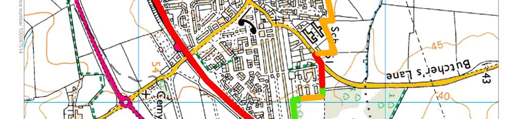
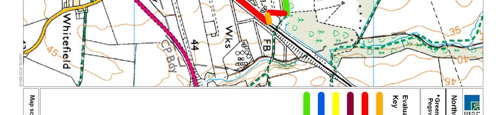
25 Settlement evolution 4.9. Much of the plan of the modern town centre probably dates back to the medieval period, the historic core of Morpeth extended along Newgate Street and Bridge Street to the north of the river, with limited development to the south of the bridge and at High Church. The town continued to grow, with larger areas of housing appearing to the north of the settlement core and south of the river in the early 1900s. Development in the Stobshillgate area appeared in the 1950s and 1960s. Extensive growth took place to the west of Stobshillgate in the 1970s, and north of the river near Grange House. Relationship with other settlements To the north of Morpeth is the small linear settlement of Fairmoor. Although physically close to Morpeth, a strong boundary feature is formed by the A1. However, to the north of Morpeth, part of the settlement extends beyond Peacock Gap and towards the hospital. This potentially blurs the separation between Morpeth and Fairmoor when travelling on the A km to the north of Morpeth is the small settlement of Hebron. There is no direct visual relationship between the two settlements, and the intervening farmland is strongly agricultural with limited development The small linear settlement of Longhirst lies about 3km to the north-east of Morpeth, beyond Pegswood. Longhirst has a strong settlement boundary provided by woodland and parkland and has a distinct identity from Morpeth Pegswood lies 2km to the north-east of Morpeth. The settlement edge of Morpeth at this point is strongly defined by the railway and incised wooded valley of the River Wansbeck. The main road access between the two settlements has an undeveloped character, although the new road construction and area of former opencast detract from the rural character To the south-east of Morpeth is the settlement of Hepscott. The A196 forms a strong boundary to Stobshillgate, but development extends to the south of the A192 reducing the distance between Hepscott and Morpeth. Hepscott has a distinct identity from Morpeth and is separated by intact farmland Mitford lies to the west of Morpeth, separated by the course of the A1. The settlement lies at the confluence of the River Font and the River Wansbeck. Some residential development extends from the edge of Morpeth along the B6343 towards Mitford, although this is contained within the valley woodland and landform. Landscape contribution to settlement setting and identity The surrounding landscape is characterised by agricultural fields, bound by hedgerows and occasional hedgerow trees. Opencast workings have influenced the landscape to the north-east of Morpeth and the area continues to change as a result of subsequent landscape restoration. B-22
26 4.17. Large parts of the settlement are contained by the immediate rising topography of the Wansbeck valley. Rising ground at Cottingwood Common to the north, and Grindle Hill and Diamond Hill to the south further contain views. Identity Morpeth is situated within the sheltered valley of the River Wansbeck. Its historic core is set along the meandering river and spreads along the river banks which, in places, rise steeply away from the flood plain. Morpeth is well related to the landform, through its association with the valley of the River Wansbeck. The surrounding landscape has a distinct rural character and provides a clear transition between urban and rural areas at the settlement edge The valleys of the Wansbeck and its tributaries are distinctly wooded which adds to their sense of enclosure and habitat value (e.g. Borough and Scotch Gill Woods Nature Reserves). The river is a main feature within the town and is important to the settlement identity The surrounding landscape is characterised by agricultural fields, bounded by hedgerows and occasional hedgerow trees. Opencast workings have influenced the landscape to the north-east of Morpeth and the area continues to change as a result of subsequent landscape restoration Large parts of the settlement are contained by the immediate rising topography of the Wansbeck valley. Rising ground at Cottingwood Common to the north, and Grindle Hill and Diamond Hill to the south further contain views. The intact rural character of the landscape contributes to the identity of Morpeth as a market town within a rural landscape. Setting The relationship between Morpeth and the surrounding landscape is largely a product of landform, and association of the settlement with the River Wansbeck. As a result Morpeth relates well to the surrounding landscape, but does not have a high level of intervisibility or role in views from the surrounding area The surrounding landscape is characterised by agricultural fields, bound by hedgerows and occasional hedgerow trees. Opencast workings have influenced the landscape to the north-east of Morpeth and the area continues to change as a result of subsequent landscape restoration Morpeth is well related to the landscape and in the approach from the A1 and A197 an overview of part of the settlement is possible although the settlement is broken up with trees and the whole town is not visible Recreation is focused on the river valley within Morpeth, and Morpeth Common to the south of the town The main approach roads to Morpeth provide the experience of travelling through a rural landscape and views to the town are limited by the landform until entering the town. The character of the landscape surrounding the settlement is therefore very important in maintaining this experience. B-23
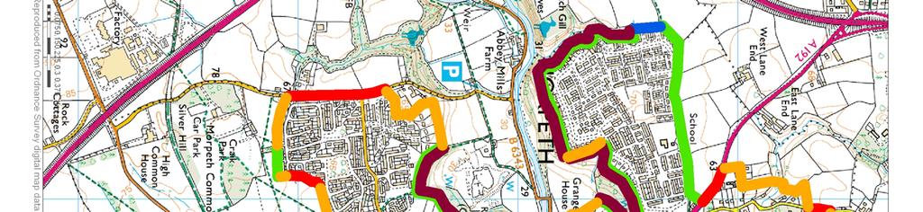
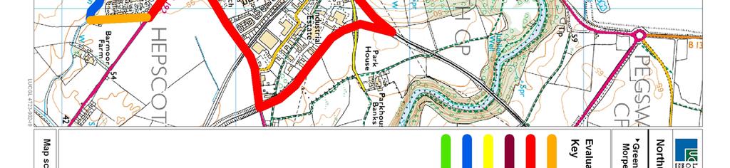
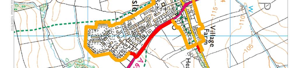
27 Boundaries The settlement boundaries of Morpeth are typically strongly defined with topography, woodland and roads playing a major role around the settlement edge. Weaker edges are those formed by garden boundaries or field boundaries although these are typically more limited in extent In the north, high ground at Cottingwood Common forms a visual settlement edge, although on the ground the disused institutional buildings result in a less well-defined boundary. To the east, strong boundaries are provided by the How Burn gorge, the wooded Wansbeck valley, and the railway embankment to the south-east. The southern boundary is also relatively strong, following the A196, the Coal Burn valley, the golf course at Grindle Hill, and the wooded Craik Park. Further wooded valleys at Borough Wood and Scotch Gill define the western settlement edge. To the north-west, rear garden boundaries form a weaker edge either side of the A The evaluation of settlement boundaries has identified that the main area for potential boundary enhancement is at Cottingwood, although the large areas of open space surrounding the hospital buildings provide a gradual transition between the built up area and adjacent landscape. Boundaries are illustrated on Figure B The construction of the proposed North Morpeth Bypass, linking the A1 with the A197 west of Pegswood, may affect the perceptions of settlement edge, and potential Green Belt boundaries, in the area north of the settlement An assessment of the relative sensitivity to development of the landscapes surrounding Morpeth has been made. This identifies areas that may have potential to accommodate development beyond the existing settlement boundaries. The findings of this assessment are presented in Part A of this Key Land Use Impact Study, and may be of relevance in selecting final Green Belt boundaries. Conclusions Morpeth lies at the junction of five landscape character areas (35b, 38b, 38c, 39a, 39c), which all have a strong rural character and play an important role in contributing to settlement setting and identity. The urban edges of Morpeth are also strongly defined with clear transitions between the urban area and the surrounding rural landscape. These characteristics indicate that the inner Green Belt boundary around Morpeth should be drawn quite tightly. Opportunities for boundary enhancement or the creation of a new boundary feature beyond the existing settlement edge may exist in the Cottingwood area. Generally however, there is a lack of strong alternative boundary features beyond the existing settlement edge. B-24
28
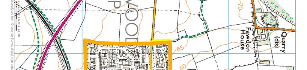
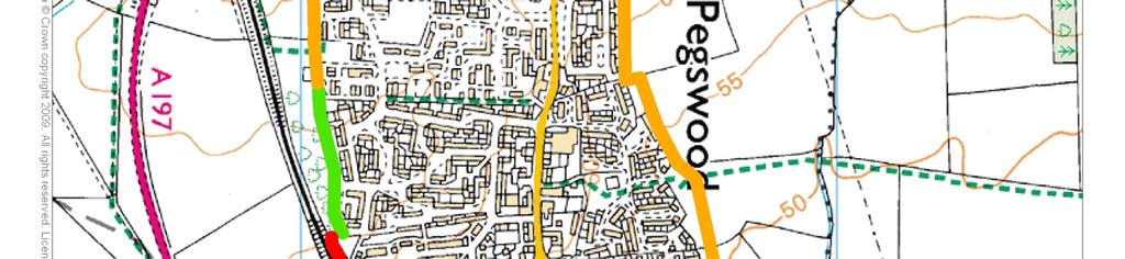
29 PEGSWOOD Settlement identity, historic features and character Pegswood is situated on rising ground above the wooded valleys of the Bothal Burn and the River Wansbeck. Pegswood developed as a mining settlement and subsequently expanded along the old A197 to Morpeth The historic core of Pegswood is characterised by a number of historic buildings along Longhirst Road, and the distinctive rows of yellow brick miner s terraces. The settlement gradually expanded along the road to Morpeth, with more recent infill development to the north and east. To the west of the settlement lies Pegswood Community Park, an area recently restored and enhanced with woodland planting for the benefit of local residents Originally developing as a linear settlement along the A917, by the early 20 th century the core of the settlement had expanded between the railway A917 and Longhirst Road. Further expansion took place to the south of the A917, with more recent infill development to the north of North Farm and East Farm. The historic core between the railway, A917 and Longhirst Road also underwent dramatic change with the closure of the mine and subsequent redevelopment of the site in the 1980s and 1990s. Relationship with other settlements Pegswood is the largest settlement in close proximity to Morpeth. Pegswood lies to the north-east of Morpeth beyond the incised valley of the River Wansbeck. The river valley provide strong containment to the settlement edge of Morpeth, although the edge of Pegswood is less strongly defined. The hamlet of Longhirst lies a short distance to the north of Pegswood, and is also separated from Morpeth by the incised valley of the How Burn and River Wansbeck To the east are the larger settlements of Ashington, Guide Post and Bedlington, and these are separated by the wooded course of the Bothal Burn, River Wansbeck and the ECML railway which contains the edge of Pegswood. Landscape contribution to settlement setting and identity Identity Pegswood is situated on rising ground between the valleys of the River Wansbeck and Bothal Burn. The settlement is fairly prominent within the immediate surrounding landscape and is poorly related to the landform. The recent construction of the bypass and restoration of the areas of opencast to the west of Pegswood serve to provide greater definition to the settlement edge Opencast workings at Pegswood Moor and the woodland on restored ground to east of Pegswood reflect the association of the settlement with a history of mining and quarrying. B-25
30 4.40. There is a relatively short distance between Pegswood and Morpeth. However, the incised valley of the River Wansbeck and How Burn provides a distinctive landscape feature which contributes to both physical and visual distinction between settlements. There is limited visual relationship between the two settlements as a result of landform and the characteristics of each settlement. Setting The elevated location of the settlement allows views across surrounding farmland and is locally contained by shelterbelts, rising ground to the west and at Climbing Tree Farm to the south. The settlement does not relate well to the landscape, although the maturation of the community woodland to the west will provide a stronger settlement edge, and the links between this area and the restored opencast should further support the relationship between the settlement and landscape Pegswood overlooks the surrounding landscape which is used for local recreation and access between Pegswood and Morpeth. The network of new paths and access to the west of the town provide recreational use of the landscape. Views across Pegswood and the surrounding landscape may be obtained from the viewpoint on the hill along Butchers Lane There are clear views to Pegswood from the A197, and the settlement does not relate well to the landscape. The settlement edge is poorly defined, although the new planting alongside the A197 will mature and further reduce views from this transport route. Some views to the settlement are possible from the B1337 on the approach to Morpeth; the maturation of the planting of the community woodland will reduce this visibility over time The settlements of Longhirst and Bothal are conservation areas, and both of these settlements are very distinct from Pegswood, lacking visual association, despite the close proximity. This separation is contributed by both landform and the woodland associated with each settlement. Boundaries The settlement boundaries of Pegswood are strong to the south and east, where development is contained by the railway line and by the wooded Bothal Burn respectively. Some development has taken place beyond this edge, including a new fire station. To the north and west, the settlement edge is less well-defined. Both these edges relate poorly to the landform, and principally comprise rear garden boundaries Overall, Pegswood does not relate positively to its landscape setting. Opportunities for reinforcing these weaker settlement boundaries are limited by the lack of strong alternative boundary features. Boundaries are illustrated on Figure B An assessment of the relative sensitivity to development of the landscapes surrounding Pegswood has been made. This identifies areas that may have potential to accommodate development beyond the existing settlement boundaries. The findings of this assessment are presented in Part A of this Key Land Use Impact Study, and may be of relevance in selecting final Green Belt boundaries. B-26
31
32 Conclusions Pegswood lies within landscape character area 39a Coastal Coalfields, and although the landscape plays an important role in maintaining the distinct identity of the settlement, it has a lesser role in contributing to setting. Although the settlement boundaries are not strongly defined on all aspects, particularly to the north, there is a lack of strong alternative boundary features. The creation of a new boundary would be required should the Green Belt boundary be drawn beyond the existing settlement edge. B-27
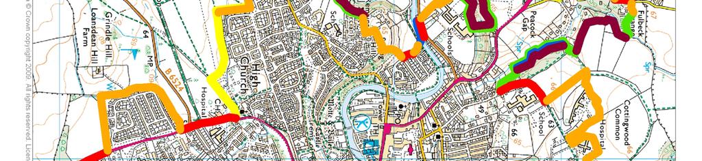
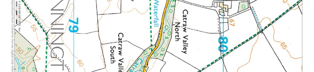
33 STANNINGTON Settlement identity, historic features and character Stannington lies to the immediate west of the A1 and above the valley of the Catraw Burn. The parish church lies to the west of the village and is a prominent landmark in approaches to the village from the west. Stannington originally developed as a small clustered settlement along Church Road and has an attractive historic core. The village did not undergo significant change until the 1970s when the properties of The Glebe were built, with more recent development at Green Close. Relationship with other settlements Stannington lies approximately 5km south of Morpeth and forms one of the settlements which lie along the route of the A1. 2km to the north is the linear settlement of Stannington Station. The north-south line of the A1 provides separation and the intervening landscape has a rural character, although there are some properties within the landscape Hartford Bridge lies approximately 3km to the east of Stannington, on the River Blyth. Barriers between the two settlements include the A1 and the ECML railway. There is no direct access between the two settlements Beyond Hartford Bridge are the larger settlements of Bedlington and Cramlington. The intervening landscape has an intact rural character, and these settlements do not have a direct relationship with Stannington. Further south, and also detached from Stannington are Seaton Burn, Dinnington, and Ponteland to the south-east. Landscape contribution to settlement identity Identity The landscape surrounding Stannington is relatively flat and the settlement is not prominent within the landscape. The association of the village with the Catraw Burn provides a landscape feature on the western edge of the village, and a strong settlement boundary. On a wider landscape scale, the surrounding landscape which has an intact rural character contributes to the settlement identity through providing rural context for a settlement lying close to larger urban areas. Setting The historic setting of the village is based on the association with the wooded valley of the Catraw Burn and the church. This association links the settlement to the landscape. Views to Stannington from the surrounding area are limited as a result of the subtle topography. Glimpse views are possible from the A1, although mostly screened by woodland. The intact agricultural landscape which surrounds Stannington contrasts with the degraded landscapes to the west of Cramlington. B-28
34
35 Boundaries The settlement boundaries are robust to the west and south, but weaker to the north. The distinction between Stannington and settlements to the north is reliant on the rural character of the intervening landscape, and therefore it is recommended that the northern settlement boundary is further enhanced with woodland planting to provide a robust edge. There are no clear alternative boundary features to the north of the settlement which would provide an alternative settlement edge. Boundaries are illustrated on Figure B4.3. Conclusion Stannington lies within landscape character area 39c Stannington. The landscape plays a lesser role in contributing to settlement setting, but has a stronger role in maintaining the separate identities of Stannington and Stannington Station. Although the northern settlement boundary of Stannington is less strongly defined, the creation of a new settlement boundary allowing development to the north of Stannington would erode the important role played by the landscape character area in maintaining settlement identity. B-29
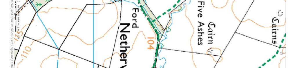
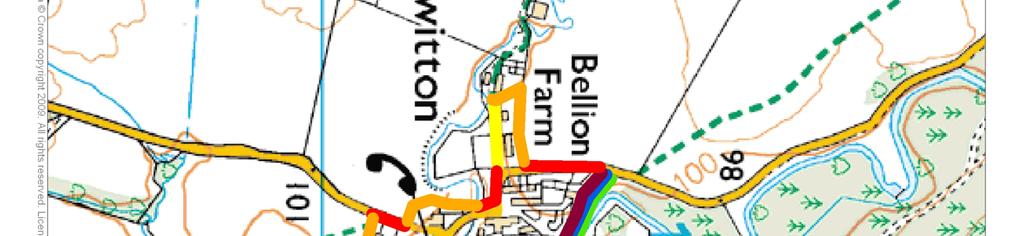
36 NETHERWITTON Settlement identity, historic features and character Netherwitton comprises the imposing Netherwitton Hall and surrounding properties. The Hall is separated from the main village by the wooded course of the River Font The settlement at Netherwitton is largely unchanged from the mid 1800s. The main changes to the present day include the properties at Bellion Farm and additional properties south of the road at Netherwitton Farm which were constructed in the 1960s and 1970s. The whole of Netherwitton, excluding the properties at Bellion Farm and south of Netherwitton Farm is a Conservation Area. Relationship with other settlements Netherwitton lies approximately 9km to the north-west of Morpeth, and is situated within a landscape of strong estate influences and scattered farmsteads. To the north and south are the small settlements of Longhorsley and Hartburn, separated from Netherwitton by fingers of higher land. Landscape contribution to settlement identity Identity The immediate landscape features of the river valley and wooded course of the burn are important to the appreciation of the historic settlement form, although the relationship with the wider landscape is more limited. There is some visual association between the flat river floodplain valley to the west of the settlement and the outlying properties, however, the wooded valley of the burn are more significant in contributing to the sense of place. Netherwitton is located within a sparsely populated rural landscape and has a distinct identity contributed by its close association with its immediate landscape setting and distance from other settlements. Setting The settlement nestles within the landscape and is not widely visible from the surrounding area. The settlement has an intimate relationship with the landscape. Views to the settlement as a whole are limited. Netherwitton Hall is more prominent within the landscape and in views from the east. The landscape contributes particularly to the wider setting of the hall and estate woodlands. Boundaries The settlement edges of Netherwitton are strongly defined in places through the relationship between the settlement, the river, adjoining burns and through the landscape role of the foreground to Netherwitton Hall. Although the settlement edges are less robust in places, these reflect the small scale character of settlement, and no alternative boundary features beyond these are identified. Some small scale development associated with Netherwitton Hall could be accommodated within the defined curtilage of the walled garden. Boundaries are illustrated on Figure B4.4. B-30
37
38 Conclusions Netherwitton lies within landscape character area 35b Font and Wansbeck Valleys. The small settlement has a strong association with the landscape. The settlement boundaries are generally robust, and should the Green Belt extend to this settlement, the boundaries should be drawn close to the existing settlement edge. B-31
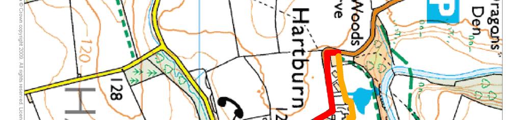
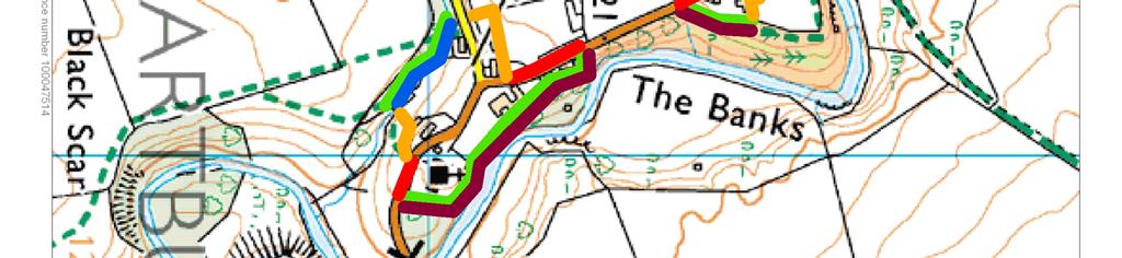
39 HARTBURN Settlement identity, historic features and character Hartburn is located along the B6343 and above the incised wooded course of the stream. The historic core of Hartburn comprises the properties along the three roads which converge in the settlement centre. The houses at Hartburn House are a later edition from the 1950s. Key buildings within the settlement include the Vicarage, built around a 13 th century house and the village church which is an attractive feature, along with the central war memorial. A grotto was built in the 18 th century by the burn. Relationship with other settlements Hartburn lies approximately 9km to the west of Morpeth, within a strongly estate influenced rural landscape. To the north, separated by the low finger of Longwitton ridge is Netherwitton and to the south-west within the Wansbeck valley is the small settlement of Middleton. Landscape contribution to settlement identity Identity Hartburn is nestled within the landscape, and closely associated with the wooded form of the valley which has shaped the linear settlement form. The steep wooded sides of the valley of the Hart Burn are important within the wider landscape, although the settlement itself is not widely visible. The close association between the settlement and the valley is important to the identity of the settlement and sense of place. The settlement has a distinct identity, and the deep valley is an important feature of this. This is an immediate and local association, and no other settlements are in close proximity. Setting From the west, the landscape has a semi upland character with medium sized fields lacking strong field boundaries, pockets of stronger estate influence, tree groups and a strong rural character. The immediate landscape surrounding Hartburn screens and shields the settlement from the wider landscape. The relationship between the settlement landform and woodland mean that views of the settlement are screened until you are in the settlement itself. Boundaries The settlement boundaries of Hartburn are typically robust due to the incised valley of the Hart Burn and woodland. The northern boundary of the northern cluster of properties could be extended to the edge of the woodland and steep slopes to provides a stronger edge. No other alternative boundary features are identified for the remainder of the settlement. Boundaries are illustrated on Figure B4.5. B-32


40
41 Conclusions Hartburn lies within landscape character area 35b Font and Wansbeck Valleys. Within this landscape character area the settlements have a strong association with the landscape. The settlement boundaries are robust, and should the Green Belt extend to this settlement, the boundaries should be drawn close to the existing settlement edge. B-33
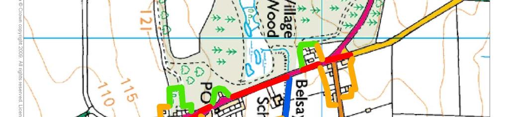
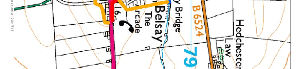
42 BELSAY Settlement identity, historic features and character Belsay has a dispersed settlement character with a small number of properties which are focused on the A696 main road through the village. The historic settlement has remained largely unchanged from the mid 1800s, with only very minor changes to the settlement through alterations and infill. A number of the properties within the settlement are listed including the substantial school building and Arcade. New development has taken place on the northern edge of the village, which strongly reflects the built character of the settlement, but does not provide a strong settlement edge The whole of Belsay is within a Conservation Area, and Belsay Hall Registered Park and Garden extends to the west of the settlement. Views to Belsay Hall and Belsay Castle are screened from the village. Relationship with other settlements Belsay lies within a largely rural agricultural landscape, the nearest settlement being the small linear village of Whalton approximately 3km to the north-east, and the hamlet of Ogle to the east. Belsay is distant from Morpeth and Ponteland. Landscape contribution to settlement identity Identity The settlement has a linear form which extends along the main road through the village. As such the settlement is more closely associated with this built feature than the landform. The wider landscape has a rural character and policy influences, and the settlement has a visual relationship with the policy woodlands of Belsay Hall. The settlement has a distinct identity, although there are visual links to Whalton to the north-east of Belsay. The strong rural character of the surrounding landscape limits the influence of the proximity of another settlement. Setting Belsay is located within a slightly elevated area of landscape, and the landscape provides foreground for the settlement and estate context. Although Belsay Hall is a local landscape feature and tourist attraction views between the two areas are screened by the woodland. The whole of Belsay is highly visible from the A696, and the linear nature of the settlement contributes to a perception that it is a larger settlement than in reality. The wider estate influenced landscape provides important landscape context for the designed landscape at Belsay Park. Boundaries Belsay is a dispersed settlement with variation in the strength of the current boundaries. To the east, the boundaries are less strongly defined. As with other settlements, there are no clear alternative boundary features. Existing boundaries should be strengthened. Boundaries are illustrated on Figure B4.6. B-34
43
44 Conclusions Belsay lies within landscape character area 38c Whalton and Belsay, and the landscape plays an important role in providing setting and maintaining the separate identity of settlements. Should the Green Belt be required to extend to Belsay, the eastern boundary of the settlement is not strong. However, creation of an alternative boundary should seek to respect the settlement form and identity. B-35
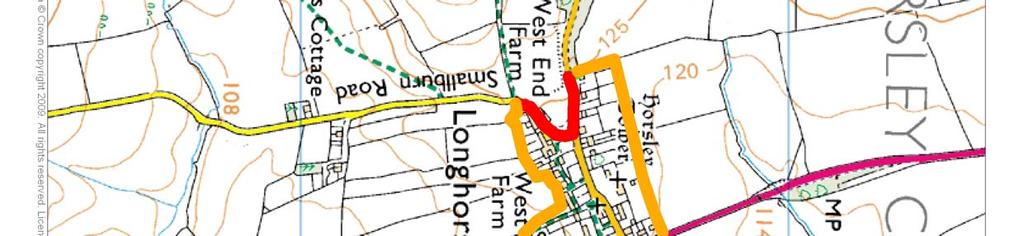
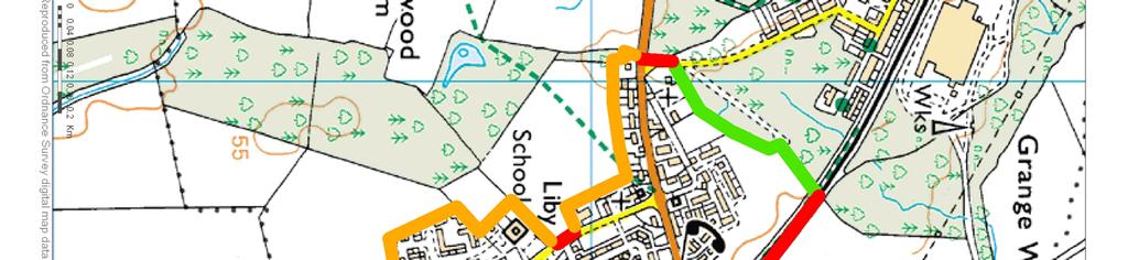
45 LONGHORSLEY Settlement identity, historic features and character The village formally lay in three separate townships, which were known as Bigge's Quarter, Freeholders Quarter and Riddells Quarter. Linden Hall is a notable feature now run as a hotel and country club. Longhorsley Pele Tower is a notable landmark within the village. The central core of Longhorsley aligned along East Road is designated a Conservation Area Longhorsley s original settlement form was linear, aligned along East Road. The surrounding farmland was divided into a number of quarters comprising fields, some defined as linear strips. The growth of Longhorsley to the south along the A697 began in the 1970s, with more recent expansion to the south of this earlier development. Relationship with other settlements Morpeth lies approximately 8km to the south-east of Longhorsley, and is directly connected along the A697. Longhorsley has a rural context with the closest settlement being Netherwitton approximately 6km to the south-west. Landscape contribution to settlement identity Identity Longhorsley lies within an area of undulating upland ridges above the River Coquet. The settlement is situated along the roads which pass through the settlement and has a slightly dispersed settlement character. The core of the settlement is aligned along the ridge, but more recent development blurs this historic layout. In approaches form the south the Paxtondean Burn lies in a shallow valley from the south, before the land rises towards the low ridge. The approach to Longhorsley from the south involves crossing the higher land to the south of Longhorsley Moor which contributes to the perception of the rural character and separate identity of the settlement. Setting Longhorsley is located on a low ridge and forms part of the wider rolling landscape. The settlement is a key feature in views from the A697 which passes through the centre of the village. The wider landscape contributes to the rural character of this small settlement Boundaries The majority of the settlement boundaries of Longhorsley are not strongly defined, being formed by garden boundaries. To the north the settlement form reflects the historic settlement pattern, and the southern part of the settlement represents more recent growth. Again, due to the relationship of the settlement with the landform, unless the settlement boundary was extended to Smallburn Road in the west there are no clear alternative boundary features. Boundaries are illustrated on Figure B4.7. B-36
46
47 Conclusions Longhorsley lies within landscape character area 38b Longhorsley, which has a strong rural character which contributes to the setting of the settlement. The settlement boundaries are not strongly defined. Should the Green Belt extend to this settlement, the definition of a boundary should reflect the historic settlement form and role of the landscape in contributing to the settlement identity. B-37
48 WIDDRINGTON STATION Settlement identity, historic features and character The settlement originates from the arrival of the railway in the 19th century and the building of a station south-west of Widdrington village. The first phases of development took place to the east of the railway in the early 1900s, with development to the west of the railway occurring in the 1950s. Further infilling of open ground within the settlement took place in the 1980s and 1990s, continuing to present day. Relationship with other settlements The small settlement of Stobswood lies to the immediate north-west of Widdrington Station. It is separated by woodland and has no visual relationship with Widdrington Station. Approximately 3km to the south-east is Ellington, which is separated by an area of intact farmland. Widdrington Station lies approximately 6km to the north of the larger settlements of Ashington, Pegswood and Morpeth The settlement of Ulgham lies approximately 1km from Widdrington Station, although road alignment increases this distance, and the River Lyne provides a strong physical edge to Ulgham, supporting their perception as individual settlements. Landscape contribution to settlement identity Identity Widdrington Station is located on a low ridge within a subtly undulating landform, and as such relates well to the landscape, with the associated trees and woodland on the settlement edge increasing the integration with the landscape. The landscape has views to the sea, and also the areas of industry within the coastal settlements to the south. The areas of opencast are also a significant influence on the landscape. The landscape is well defined both through its lack of visual association with adjacent settlements, relationship with the landscape and containment by the road network. Setting The settlement is not well related to the landform being located on a low ridge. The settlement is visible from the A1068 but not strongly prominent in views. The open character of the landscape to the east reinforces the perception of being close to the coast, and there are distant views to the sea. Boundaries The existing settlement boundary has some robust edges to the north formed by the railway and woodland. To the north-east the settlement boundary is mostly formed by garden boundaries. The overhead power line just beyond the edge provides a physical constraint. To the west, the settlement edge is also formed by garden boundaries, and extension to the woodland would provide a more robust edge. On the southern edge of the settlement there are no clear alternative boundary features B-38
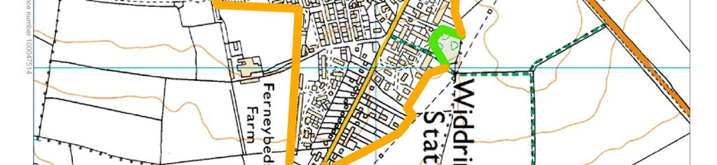
49
Toddington Central Bedfordshire Stage 3 Green Belt Study December 2017
 Toddington Central Bedfordshire Stage 3 Green Belt Study December 2017 Site: ALP086 - Middle Lakes, Toddington Site size (ha): 2.83 Site: ALP086 - Middle Lakes, Toddington Site size (ha): 2.83 Site description
The analysis of key visual characteristics and attributes that contribute to variations in the
 15.0 CHIGWELL/CHIGWELL ROW 15.1 Overview 15.1.1 Chigwell and Chigwell Row settlements are situated in the south of Epping Forest District, to the south of Abridge and southwest of Stapleford Abbotts. Both
Landscape Guidelines. Landscape type: Valley Pasture Character areas: Frome Valley Pasture Stour Valley Pasture. Landscape change
 Landscape type: Valley Pasture Character areas: Frome Valley Pasture Stour Valley Pasture The valley pasture landscape type is found along the lower reaches of the Stour and Frome, formed from alluvial
Rolling Wooded Pasture Lulworth Wooded Pasture Rempstone Wooded Pasture
 Landscape type: Character areas: Rolling Wooded Pasture Lulworth Wooded Pasture Rempstone Wooded Pasture The rolling wooded pasture landscape type is found around the margins of the Dorset Heaths. Although
National Character Area 70 Melbourne Parklands
 Summary The are a landscape of rolling farmland, parkland and woodland on the northern flanks of the ridge between Burton upon Trent and Swadlincote. The land slopes down to the River Trent, which borders
Oxford Green Belt Study. Summary of Final Report Prepared by LUC October 2015
 Oxford Green Belt Study Summary of Final Report Prepared by LUC October 2015 Project Title: Oxford Green Belt Study Client: Oxfordshire County Council Version Date Version Details Prepared by Checked by
- - - Key Characteristics
 S23 Dyffryn Dysynni Reproduced from the Ordnance Survey map with the permission of Ordnance Survey on behalf of the Controller of Her Majesty s Stationery Office, Crown copyright Licence No. 100023387
LANDSCAPE CHARACTER ASSESSMENT
 THE COUNTY DURHAM LANDSCAPE CHARACTER ASSESSMENT FOREWORD The landscape of County Durham is one of great contrast and diversity. From the North Pennines in the west to the Durham Coast in the east it contains
PONTELAND NEIGHBOURHOOD PLAN LANDSCAPE QUALITY ASSESSMENT
 PONTELAND NEIGHBOURHOOD PLAN LANDSCAPE QUALITY ASSESSMENT UPDATED CONSULTATION ISSUE NOVEMBER 2016 CONTENTS 2 Introduction 2 Methodology 4 Landscape Quality Areas Plan 5 Landscape Quality Area 1 SMALLBURN
Landscape Character Assessment
 Landscape Character Assessment What Is It? Survey of the county landscapes For what purpose? To analyse and define character Says Who? Planning and Development Act 2000 Applications To provide a basis
Lower Sensitivity. VS Classification Level 2: Hills, Lower Plateau & Scarp Slopes (74%)/ Lowland Valleys (17%) / Exposed Upland/Plateau (7%)
/ Lowland Valleys (17%) / Exposed Upland/Plateau (7%)") S06 Coedwig Gwydyr Reproduced from the Ordnance Survey map with the permission of Ordnance Survey on behalf of the Controller of Her Majesty s Stationery Office, Crown copyright Licence No. 100023387 Location
S06 Coedwig Gwydyr Reproduced from the Ordnance Survey map with the permission of Ordnance Survey on behalf of the Controller of Her Majesty s Stationery Office, Crown copyright Licence No. 100023387 Location
Warwickshire County Council. Upper and Lower Brailes. Landscape Study
 Warwickshire County Council Upper and Lower Brailes Landscape Study Produced by WCC Landscape Architects March 2016 Landscape Assessment of Potential Development Sites within the parish of Brailes 1.0
Central Bedfordshire and Luton Green Belt Study Appendix 1
 Central Bedfordshire Council www.centralbedfordshire.gov.uk Central Bedfordshire and Luton Green Belt Study Appendix 1 July 2017-1 - Appendix 1 Stage 1 assessments Central Bedfordshire and Luton Green
S08 Dyffryn Y Ddwyryd
 S08 Dyffryn Y Ddwyryd Reproduced from the Ordnance Survey map with the permission of Ordnance Survey on behalf of the Controller of Her Majesty s Stationery Office, Crown copyright Licence No. 100023387
Totternhoe Central Bedfordshire Stage 3 Green Belt Study December 2017
 Totternhoe Central Bedfordshire Stage 3 Green Belt Study December 2017 Site description The site is comprised of a single arable field on the southern side of the washed over settlement of Totternhoe.
Lower Sensitivity. VS Classification Level 2: Exposed Upland/Plateau
 S04 Moel Hebog Reproduced from the Ordnance Survey map with the permission of Ordnance Survey on behalf of the Controller of Her Majesty s Stationery Office, Crown copyright Licence No. 100023387 Location
B - Coalfield River Corridor Landscape Character Type
 B - Coalfield River Corridor Landscape Character Type Landscape Character Type - Coalfield River Corridor The Coalfield River Corridors Landscape Character Type is located in the two converging valleys
Genex Kidston Connection Project: Draf t Environmental Assessment Report Powerlink Queensland
 : Draf t Environmental Assessment Report Powerlink Queensland Chapter 14 \\autsv1fp001\projects\605x\60577456\6. Draft Docs\6.1 Reports\4. Compiled draft 17 September\Covers\Chapters\Ch 14.docx Rev ision
Landscape Guidelines. Landscape type: Wooded Hills Character areas: Landscape change. Planning guidelines
 Landscape type: Wooded Hills Character areas: Axe Valley Hills Wootton Hills Chideock Hills Powerstock Hills Powerstock Woods Landscape change Policy driven farming changes over the last sixty years, resulting
Viewpoint 1. Location: View from Murch Road on the north eastern boundary of Application Site. Viewing south / southwest.
 Application Site (eastern field) Former site of St. Cyres Lower School Murch Road 1 Location: View from Murch Road on the north eastern boundary of Application Site. Viewing south / southwest. Baseline
Environmental and Landscape Mapping
 Environmental and Landscape Mapping In support of the Calveley Neighbourhood Plan November 2016 Project Name and Number: Calveley Neighbourhood Plan 16-025 Document Name and Revision: Environmental and
ENVIRONMENTAL AND LANDSCAPE MAPPING
 APPENDIX IV : Environmental and Landscape Mapping ENVIRONMENTAL AND LANDSCAPE MAPPING Calveley Neighbourhood Plan November 2016 ENVIRONMENTAL AND LANDSCAPE MAPPING Calveley Neighbourhood Plan Calveley
GUILDFORD BOROUGH GREEN BELT AND COUNTRYSIDE STUDY
 GUILDFORD BOROUGH GREEN BELT AND COUNTRYSIDE STUDY Volume II - Addendum On behalf of Guildford Borough Council PPG Ref : BNL.0287 April 2014 COPYRIGHT The conents of this document must not be copied or
Settlement Boundaries Methodology North Northumberland Coast Neighbourhood Plan (August 2016)
") Introduction This background paper sets out a methodology for the definition of settlement boundaries in the North Northumberland Coast Neighbourhood Plan. The neighbourhood plan is planning positively
Introduction This background paper sets out a methodology for the definition of settlement boundaries in the North Northumberland Coast Neighbourhood Plan. The neighbourhood plan is planning positively
Proposed Sheffield City Region Combined Green Belt Review A Common Approach August 2014
 Proposed Sheffield City Region Combined Green Belt Review A Common Approach August 2014 1.1 Purpose To achieve the principles of Duty to Cooperate, it is beneficial for all Local Authorities within the
Lower Sensitivity. VS Classification Level 2: Exposed Upland/Plateau
 S05 Y Moelwynion Reproduced from the Ordnance Survey map with the permission of Ordnance Survey on behalf of the Controller of Her Majesty s Stationery Office, Crown copyright Licence No. 100023387 Location
tributary farmland tributary farmland
 NORFOLK O R F O L K COAST C O A SAONB T A O NIntegrated B I n t elandscape g r a t e d L Guidance a n d s c a p e G u i d a n c e 1 Integrated landscape character MAP 23a - Landscape Character Type - Tributary
CHAPTER 18 - Strategy Area: Dundry and River Valleys
 This south-eastern part of the Community Forest is a complex area with a wide variety of different landscapes close together, including the Chew Valley, the southern part of the Avon Valley and the eastern
CORNWALL AND ISLES OF SCILLY LANDSCAPE CHARACTER STUDY
 LCA - East Cornwall and Tamar Moorland Fringe LCA No CA26 JCA Constituent LDUs Total 10: 211, 217U, 233U, 310, 312, 311, 313, 413, 420U, 421U Crown copyright. All rights reserved. Cornwall County Council
LEEDS SITE ALLOCATIONS PLAN MATTER 3 GREEN BELT KCS DEVELOPMENT AUGUST 2017
 LEEDS SITE ALLOCATIONS PLAN MATTER 3 GREEN BELT KCS DEVELOPMENT AUGUST 2017 Smith Limited Suite 9C Joseph s Well Hanover Walk Leeds LS3 1AB T: 0113 2431919 F: 0113 2422198 E: planning@peacockandsmith.co.uk
INTRODUCTION. Land south of Bishopswood Lane, Tadley
 0 INTRODUCTION THE SITE Introduction Gladman Developments Ltd. has successfully invested in communities throughout the UK over the past 0 years, developing high quality and sustainable residential, commercial
East Harptree Landscape & Character Assessment
 East Harptree Landscape & Character Assessment Produced by East Harptree Parish Council in consultation with local residents September 2014 Contents The Parish of East Harptree: Objective Introduction
HIGH LITTLETON AND HALLATROW COMMUNITY PLACEMAKING PLAN
 HIGH LITTLETON AND HALLATROW COMMUNITY PLACEMAKING PLAN DOCUMENT 3 of 4 SNAPSHOT CHARACTER SUMMARY HALLATROW Context B&NES Landscape type: Area 6 Farrington Gurney Farmland/ Area 12 Cam and Wellow Brook
coastal plain coastal plain
 NORFOLK O R F O L K COAST C O A SAONB T A O NIntegrated B I n t elandscape g r a t e d L Guidance a n d s c a p e G u i d a n c e 1 Integrated landscape character MAP 23a - Coastal Plain Key Plan This
APPENDIX 4. 5 ST AGNES LOCAL LANDSCAPE CHARACTER ASSESSMENT TABLE ST AGNES BEACON
 APPENDIX 4. 5 ST AGNES LOCAL LANDSCAPE CHARACTER ASSESSMENT TABLE ST AGNES BEACON CHARACTER AREA: ST AGNES BEACON DATE OF ASSESSMENT May 2016 Character Attribute Landscape reference guide ST AGNES BEACON
Historic England Advice Report 26 August 2016
 Case Name: Kingsland Castle Case Number: 1435892 Background Historic England has been asked to review the scheduling for Kingsland Castle. The land on which the monument lies is understood to be for sale.
6 THE LECHT AND STRATHDON
 6 THE LECHT AND STRATHDON This section of the LCA includes the Lecht and Strathdon. This character assessment is presented, working from west to east, as follows: 40. The Lecht 41. Strathdon: Corgarff
Summary Note on Landscape and Visual Impact and Mitigation
 East Anglia TWO Offshore Windfarm Appendix 4.4 Summary Note on Landscape and Visual Impact and Mitigation Preliminary Environmental Information Volume 3 Document Reference EA2-DEVWF-ENV-REP-IBR- 000799_004
Dene pastures. Subtypes. Disturbed land. Subtypes LANDSCAPE CHARACTER THE WEAR LOWLANDS LOCAL LANDSCAPE TYPES
 Dene pastures Incised denes and steeply sloping bluffs of improved or semi-improved pasture or rough grazing. Steeply sloping pastures are often difficult to manage or improve agriculturally and tend to
Lower Sensitivity. VS Classification Level 2: Exposed Upland/Plateau (86%)/ Upland Valleys (10%)
/ Upland Valleys (10%)") S09 Y Mignient Reproduced from the Ordnance Survey map with the permission of Ordnance Survey on behalf of the Controller of Her Majesty s Stationery Office, Crown copyright Licence No. 100023387 Location
S09 Y Mignient Reproduced from the Ordnance Survey map with the permission of Ordnance Survey on behalf of the Controller of Her Majesty s Stationery Office, Crown copyright Licence No. 100023387 Location
8.0 Design and Form of Development 43/
 42/ 8.0 Design and Form of Development 43/ Rothwells Farm, Golborne/ Development Statement Figure 7. Site Constraints Key 44/ Site Boundary 360 Bus Route/Stops Existing Trees Underground Water Pipe Sensitive
Droitwich Spa 6. Reasoned Justification
 87 Droitwich Spa 6 Reasoned Justification 6.1 Droitwich Spa is identified in the settlement hierarchy (Policy SWDP1) as a main town being the largest settlement in Wychavon District with an estimated population
Neighbourhood Planning Local Green Spaces
 Neighbourhood Planning Local Green Spaces Introduction... 2 1. Why green space is important... 4 2. Neighbourhood plans and green space... 6 3. Evidence... 8 Statutory designations... 9 Green space audit...
S18 Mynyddoedd Yr Aran
 S18 Mynyddoedd Yr Aran Reproduced from the Ordnance Survey map with the permission of Ordnance Survey on behalf of the Controller of Her Majesty s Stationery Office, Crown copyright Licence No. 100023387
an Inspector appointed by the Secretary of State for Communities and Local Government
 Appeal Decision Site visit made on 6 November 2017 by Rachel Walmsley BSc MSc MA MRTPI an Inspector appointed by the Secretary of State for Communities and Local Government Decision date: 19 th January
North Hertfordshire Green Belt Review
 North Hertfordshire Green Belt Review July 2016 North Hertfordshire Local Plan 2011-2031 Evidence Base Report 2 Contents 1. Background and Approach to the Review. PART ONE: ASSESSMENT OF THE CURRENT GREEN
ENVIRONMENTAL INVENTORY
 Hungarton Neighbourhood Plan ENVIRONMENTAL INVENTORY Sites scoring 25/36 or more (70%) are judged to be the most important environmental and community sites and are proposed as Local Green Space. Other
LANDSCAPE UNIT 10 Te Kawau, Turipeka & Otautu Point
 Location Map LANDSCAPE VALUES Landscape Unit No. 10 Description: Te Kawau, Turipeka, & Otautu Point KEY LANDSCAPE FACTORS / VARIABLES LANDSCAPE UNIT 10 Te Kawau, Turipeka & Otautu Point LEGEND Outstanding
SPG 1. * the northern and western sections which are open fields used for pasture and grazing;
 SPG 1 1.0 INTRODUCTION This development brief is based on the allocation of the Priors Hall site for employment and countryside recreational purposes in the Corby Borough Local Plan. The brief is intended
Public Consultation. Land at Monks Farm, North Grove. Welcome
 Welcome Welcome to our public exhibition for development on Land at Monks Farm, orth Grove. Gallagher Estates and Gleeson Strategic Land are preparing an outline planning application for new homes, open
WELCOME GYPSY LANE. Wider Site Location plan. Proposals for the development of LAND OFF FOXLYDIATE LANE WEBHEATH. Proposals for the development of
 WELCOME The developers are preparing an outline planning application for a residential led development and need the community s views in order to develop the proposals further WHAT IS PROPOSED? A high
To secure a Green Belt around Cambridge whose boundaries are clearly defined and which will endure for the plan period and beyond.
 4. GREEN BELT OBJECTIVES GB/a GB/b GB/c GB/d To secure a Green Belt around Cambridge whose boundaries are clearly defined and which will endure for the plan period and beyond. To maintain the purposes
viii Figure ES1: Recommended changes to Green Belt boundaries in Waverley
 viii Figure ES1: Recommended changes to Green Belt boundaries in Waverley 50 3.4 Elstead (segments W5, W11, W18, W19) 3.4.1 Area of search 51 3.4.2 Assessment against Green Belt criteria Segment W5: land
Cotswolds AONB Landscape Strategy and Guidelines. June 2016
 Cotswolds AONB Landscape Strategy and Guidelines June 2016 Cotswolds AONB Landscape Strategy and Guidelines Introduction The evolution of the landscape of the Cotswolds AONB is a result of the interaction
18 South of St Pegas Rd including west of Foxcovert Rd, south of Werrington parkway and east to the Car Dyke
 18 South of St Pegas Rd including west of Foxcovert Rd, south of Werrington parkway and east to the Car Dyke Information reviewed Historical background: SAJ ver2 June 2016 Classification Comments NCA 75
Former Panshanger Aerodrome, Welwyn Garden City Masterplan Scenarios. Mariposa Investments
 Former Panshanger Aerodrome, Welwyn Garden City Masterplan Scenarios Mariposa Investments Contents 1.0 Introduction 1 2.0 The Site and Surroundings 2 3.0 Local Area Context 6 4.0 Site Features 10 5.0 Development
Examination of South Cambridgeshire Local Plan
 Matter SC6A - Policy SS/5 Waterbeach New Town Historic England( formerly English Heritage) 874 Rep Nos 59748, 60250, 60253 Examination of South Cambridgeshire Local Plan Historic England, Hearing Statement
NON-TECHNICAL SUMMARY
 Proposed Sand and Gravel Extraction and Associated Processing Operations with Restoration to a Mixture of Agriculture and Nature Conservation including Areas of Shallow Water at Hedgeley, Northumberland
There are two assessment methods used. The first is according to the criteria set out in the Neighbourhood Plan which are set out below.
 Background Paper 4 Site Assessments Context This background paper has been compiled to support the Gotham Neighbourhood Plan and is intended to document the viability of sites around Gotham with respect
DESIGN AND MANAGEMENT PART 3 HA 57/92 NEW ROADS INTEGRATION WITH RURAL LANDSCAPES SUMMARY
 DESIGN MANUAL FOR ROADS AND BRIDGES VOLUME 10 SECTION 1 ENVIRONMENTAL DESIGN AND MANAGEMENT NEW ROADS PART 3 HA 57/92 NEW ROADS INTEGRATION WITH RURAL LANDSCAPES SUMMARY This Advice Note gives guidance
Strip Enclosure. Summary of Dominant Character
 Strip Enclosure Summary of Dominant Character This zone is characterised by long thin curving fields, sometimes all running in the same direction and sometimes forming a patchwork pattern across the landscape.
Upper Dean Landscape Character Area: A1 Landscape Character Type: River Valley
 Upper Dean Landscape Character Area: A1 Landscape Character Type: River Valley Key characteristics A well wooded river valley landscape Strong human influence with urban development and sections of engineered
Wind energy development in the South Pennines landscape
 Wind energy development in the South Pennines landscape Programme for today Background Policy context South Pennines landscape Impacts of wind energy development The South Pennines Wind Energy Landscape
Lower Sensitivity. VS Classification Level 2: Exposed Upland/Plateau
 S02 Y Carneddau Reproduced from the Ordnance Survey map with the permission of Ordnance Survey on behalf of the Controller of Her Majesty s Stationery Office, Crown copyright Licence No. 100023387 Location
Physical Structure. This historic image from 1882 emphasizes the dramatic topography that distinguishes Cornell s setting at the top of East Hill.
 Physical Structure The natural, agrarian and urban setting for Cornell s campus is a precious resource to protect and enhance. It has also shaped the physical structure of the campus. Buildings, roads
Case Studies; Meitheal Clusters Applied to Villages and Rural Settlements
 Case Studies; Meitheal Clusters Applied to Villages and Rural Settlements 23.3.9 (ii) Case Studies, Meitheal Clusters applied to villages and rural settlments Fig 22.3.12 Cluster site plan; church opposite
Land East of Cromwell Lane
 Land East of Cromwell Lane VISION DOCUMENT AUGUST 2016 The proposals for Land East of Cromwell Lane will be defined by existing landscape features, ensuring that the development offers a quality place
LANDSCAPE AND VISUAL ASSESSMENT
 Hertfordshire County Council LAND AT BALDOCK SITE 2 LANDSCAPE AND VISUAL ASSESSMENT JULY 2008 Jon Etchells Consulting Barn A, Dixies High Street Ashwell Herts SG7 5NT 01462 744662 HERTFORDSHIRE COUNTY
SOUTH TIPPERARY LANDSCAPE CHARACTER ASSESSMENT PHASE ONE UPLANDS
 CUNNANE STRATTON REYNOLDS SOUTH TIPPERARY LANDSCAPE CHARACTER ASSESSMENT PHASE ONE UPLANDS CUNNANE STRATTON REYNOLDS 3 Molesworth Place, Dublin 2 South Tipperary County Council September 2006 South Tipperary
Assessment of Landscape, Visual and Natural Character Effects
 Assessment of Landscape, Visual and Natural Character Effects Consent Footprint Amendments Mangamaunu Half Moon Bay Okiwi Bay South Report prepared for: New Zealand Transport Agency and KiwiRail Holdings
MATURE SUBURBS RESIDENTIAL DEVELOPMENT GUIDELINES
 MATURE SUBURBS RESIDENTIAL DEVELOPMENT GUIDELINES DRAFT FEBRUARY 2005 BIRMINGHAM CITY COUNCIL 1 Introduction Mature Suburbs Residential Development Guidelines - Interim Supplementary Planning Advice -
Landscape and Heritage A Park landscape that embraces the physical, cultural and social heritage of the area
 80 Park Development Framework Our Aim for Landscape and Heritage A Park landscape that embraces the physical, cultural and social heritage of the area Why do we think it is important? The landscapes of
20. Ballysadare Mini-Plan
 20. Ballysadare Mini-Plan 20. Ballysadare Mini-Plan Community facilities Ballysadare has a wide range of community facilities: a primary school, St Mary s College (secondary school), a health centre, playing
SETTLEMENT ASSESSMENT PROFORMA
 SETTLEMENT ASSESSMENT PROFORMA Surveyors(s):Clare Sheridan Character Area: Park Estate = Midland Rd, Severn Rd, Festival Rd, Park Rd, Willow Rd, Rylands Rd. Date: Feb Weather: cloudy Look through all the
Arden. National Character Area 97. Summary
 Summary comprises farmland and former wood-pasture lying to the south and east of Birmingham, including part of the West Midlands conurbation. Traditionally regarded as the land lying between the River
GREEN BELT ASSESSMENT OF HOLLANDS FARM, BOURNE END AND SURROUNDING AREA
 27 November 2017 SHF/AC P17-1325 KBEG OF HOLLANDS FARM, BOURNE END AND SURROUNDING AREA PREPARED ON BEHALF OF KEEP BOURNE END GREEN (KBEG) Prepared by: SARAH HAMILTON FOYN BSc (Hons) Dip TP MRTPI ANDREW
Landscape Guidelines. Landscape type: Chalk Ridge/Escarpment Character areas:
 Landscape type: Chalk Ridge/Escarpment Character areas: Purbeck Ridge North Dorset Escarpment South Dorset Escarpment West Dorset Escarpment Landscape change Policy driven farming changes over the last
And now... The KEY Arguments in. Greater Detail
 And now... The KEY Arguments in Greater Detail 'Exceptional Circumstances' Are Needed to Change the Green Belt EBC justification to build on Green Belt is based on: SHMA guestimate of housing needs for
A428 Cambourne to Cambridge Segregated Bus Route
 A428 Cambourne to Cambridge Segregated Bus Route Consideration of Green Belt Issues August 2017 A 17 Minster Precincts Peterborough PE1 1XX United Kingdom T +44 (0) 1733 310 471 F +44 (0) 1733 553 661
LANDSCAPE AND VISUAL ASSESSMENT
 Hertfordshire County Council LAND AT BALDOCK SITE 3 LANDSCAPE AND VISUAL ASSESSMENT JULY 2008 Jon Etchells Consulting Barn A, Dixies High Street Ashwell Herts SG7 5NT 01462 744662 HERTFORDSHIRE COUNTY
LandscapeCollective. Dorothy House, Winsley. Landscape and Visual Appraisal. On behalf of Dorothy House Hospice Care.
 Project Ref: LC/00043 Project Number: 00043A Authored by: Stuart Hocking Reviewed by: Stephen Wadsworth Date: August 2016 Document version P:\Landscape Collective\Admin\Templates\LC Report Template Jan
The targets do not adhere to the government projections or methodology, being aspirational rather than achievable.
 Question 1: Preferred Growth Option (see pages 7-9 of the consultation document) Do you agree with the preferred growth option for the Joint Local Plan? The targets do not adhere to the government projections
9 Pershore. Introduction. Pershore Abbey
 118 Introduction 9.1 The historic town of Pershore lies on the River Avon and has a population of 7,000 (2009 Mid-Term Population Estimates). The main areas of the town are centred on the Abbey, the bustling
Guidance for Wind Turbine Development in the Dorset Area of Outstanding Natural Beauty
 DRAFT January 2012 Guidance for Wind Turbine Development in the Dorset Area of Outstanding Natural Beauty Photo 1: Rew Manor Farm, West Dorset, chalk downland landscape (Planning application ref: 1/D/09/001280
3. STATEMENTS OF DESIRED CHARACTER FOR PLANNING AREAS AND PRECINCTS
 3.30 Planning Area No. 30 Mary River Valley 3.30.1 Location and Role This Planning Area encompasses rural lands in the western part of the Shire. These lands are located within the catchment area of the
Chapter 2: OUTLINE PLANNING APPLICATION PROPOSALS. A New Garden Neighbourhood Matford Barton 17
 Chapter 2: OUTLINE PLANNING APPLICATION PROPOSALS A New Garden Neighbourhood Matford Barton 17 2.1. SUMMARY AND STATUS OF THE PROPOSALS 2.1.1. The parameter plans and associated wording in this chapter
Landscape and Heritage
 86 Park Development Framework Our Aim for A Park landscape that embraces the physical, cultural and social heritage of the area Why do we think it is important? The landscape provides a setting for every
Lancaster Conservation Area Appraisal. Character Area 8. Cathedral
 Lancaster Conservation Area Appraisal Character Area 8. Cathedral March 2013 118 3.8 Character Area 8. Cathedral 3.8.1. Definition of Special Interest "This character area is distinctive for the fine group
Guidance for Wind Turbine Development in the Dorset AONB
 Photo 1: Rew Manor Farm, West Dorset, chalk downland landscape (Planning application ref: 1/D/09/001280 1 ) Scale & siting: 12m to hub / 16m to blade tip. A well sited small scale turbine, grouped with
Application and Proposals. Part 211
 Application and Proposals Part 211 Site Location and Context The application site comprises two distinct land parcels totalling some 135 hectares. The site is bisected eastwest by Churchlands Development.
SITE ASSESSMENT FORM
 Appendix 2 SITE ASSESSMENT FORM 1. Site information Settlement: Colwall Main Village Site name: SITE 1 Part of vacated Colwall school site and adjacent area Site address: Walwyn Road Site area (hectares):
Watford Local Plan Part 2 Publication Stage Environmental Report. Appendix 3: Consultation Comments
 Watford Local Plan Part 2 Publication Stage Environmental Report Appendix 3: Consultation Comments August 2016 Appendix 3 - Responses to Consultation of the Local Plan Part 2 As required by the SEA Directive,
Landscape considerations in Forests & Woodlands. Jill Bullen, Senior Landscape Specialist
 Landscape considerations in Forests & Woodlands Jill Bullen, Senior Landscape Specialist UK Forestry Standard (UKFS) Sustainable forest management Landscape sub-section (S6.4, page 96) Standards and requirements
Evesham 7. Reasoned Justification
 95 Reasoned Justification 7.1 Evesham is situated within the Vale of Evesham and has an estimated population of 22,800 (2009 Mid-Term Population Estimates). As a main town it provides a wide range of services
Rudy Parish Neighbourhood Plan Steering Group Meeting 6/8/2018. Proposed Green Spaces (Continued from SG meeting of 2/7/18)
") Rudy Parish Neighbourhood Plan Steering Group Meeting 6/8/2018 Proposed Green Spaces (Continued from SG meeting of 2/7/18) NPPF: Green Space Designation The Local Green Space designation will not be appropriate
Rudy Parish Neighbourhood Plan Steering Group Meeting 6/8/2018 Proposed Green Spaces (Continued from SG meeting of 2/7/18) NPPF: Green Space Designation The Local Green Space designation will not be appropriate
Neighbourhood Planning Guidance Local Green Spaces
 Neighbourhood Planning Guidance Local Green Spaces Introduction This guidance note has been produced for communities preparing neighbourhood plans in North Dorset to help them to identify, assess and designate
Visual Impact Rating Form - Instructions
 Visual Impact Rating Form Instructions Project Name: Baron Winds Project EDR Project No: 13039 Date: 05.16.17 Reference: Visual Impact Rating Form - Instructions These instructions are intended to guide
Great Hammerton Growth Area: Our Vision August Hammerton Growth Area Harrogate: Our Vision
 Great Hammerton Growth Area: Our Vision August 2015 Hammerton Growth Area Harrogate: Our Vision i Contents 1.0 Introduction 1 2.0 Our Vision 3 3.0 Principle of Development 5 4.0 Site Context 7 5.0 Townscape
A737/A738 Trunk Road (Dalry Bypass)
") IN ASSOCIATION WITH DRAWING STATUS A737/A738 Trunk Road (Dalry Bypass) Environmental Statement July 2013 Introduction The A737 trunk road forms a strategic link from the M8 motorway, at Paisley, to Ayrshire.
IN ASSOCIATION WITH DRAWING STATUS A737/A738 Trunk Road (Dalry Bypass) Environmental Statement July 2013 Introduction The A737 trunk road forms a strategic link from the M8 motorway, at Paisley, to Ayrshire.
What do you like about South Marston?
 What do you like about South Marston? What you have said so far: Strong and separate identity, distinct from Swindon Village character (Church, School, Green and Hall) Surrounding working countryside and