Arden. National Character Area 97. Summary
|
|
|
- Junior Skinner
- 5 years ago
- Views:
Transcription
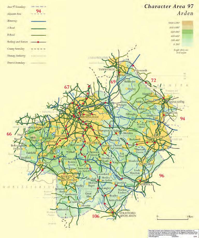
1 Summary comprises farmland and former wood-pasture lying to the south and east of Birmingham, including part of the West Midlands conurbation. Traditionally regarded as the land lying between the River Tame and the River Avon in Warwickshire, the landscape also extends into north Worcestershire to abut the Severn and Avon Vales. To the north and north-east it presents a steep escarpment to the open landscape of the Mease/Sence Lowlands. The eastern part abuts and surrounds Coventry, with the fringes of Warwick and Stratford-upon-Avon to the south. 32% of the area is urban and almost 5% is woodland. Predominant pattern of high-very high levels of dispersed settlement with village-based settlement in valleys and to south-east, set in varied patterns of fields that reflect medieval woodland clearance, post medieval enclosure of common and later variations in historic farm size. There are four sub-areas: 1 An inner ring to the conurbation, with a mix of nucleated and dispersed settlement and of some historic farmsteads set within a greenbelt subject to extensive 20th century suburban development. 2 A central band the historic core of the - with the greatest concentrations of irregular enclosure, dispersed settlement and loose courtyard farmsteads including L-plan layouts with a third building to the yard. There are high numbers of 18th century and earlier houses dispersed across this landscape. 3 The southern and eastern fringe extending to Coventry. This is an area with higher historic concentrations of villages and where many isolated farmsteads relate to the post-15th century enclosure of former open fields. Large-scale regular courtyard layouts are predominant, set within landscapes of larger fields and estates with planned woodland, and with some early groups mostly on the edge of villages and in shrunken settlements. 4 The Warwickshire coalfield, from Tamworth to Nuneaton, where smallholdings developed alongside mining villages and the continuing growth of larger farms continuing in the Leicestershire Vales. Landscape and Settlement High to very high levels of dispersed settlement, with 12.4% of farmsteads in hamlets and 8.6% in villages. Medium-high density of farmsteads in the landscape, lessening in the areas from the Avon Valley to Coventry to the south. Large-scale farmsteads (38.2%) predominant with low numbers of very small-scale (11.7%) and small to medium (25.6%) and very large-scale (19.8%) farmsteads reflecting a strong degree of local variation in farm and field size. Farmstead and Building Types Small to medium scale farmsteads, concentrated in areas of irregular enclosure, most commonly comprising loose courtyard and L-shaped layouts with working buildings up to 3 sides of the yard. Large regular courtyard groups including multi-yard and E-plans concentrated in areas of reorganised largerscale fields where larger-scale mixed farms developed. Some linear farmsteads in areas of smallholdings and adjacent to former extensive areas of rough commons.


2 Rarity and Significance Medium rate of survival high rates of loss (21%) around expanding towns, but over 56% of farmsteads recorded from late 19th century maps retain more than half of their historic footprint. There are relatively high numbers of 18th century and earlier farmhouses and working buildings, with the strongest survival being within landscapes of irregular (often medieval) enclosure. Across these landscapes are also large numbers of 18th century and earlier houses which were associated with working farms. Some farmsteads have a diversity of timber-framed buildings including rare surviving examples of cattle housing and stables as well as threshing barns of varied scales. Unconverted examples are very rare. Field barns and outfarms are now very rare. Drivers for Change A low proportion of farmsteads in agricultural use (26%) with two-thirds of farmsteads in residential use. There is a relatively high participation of farmsteads in residential use in in small businesses (7% of farmsteads are company registered offices) and a high participation in substantial firms at director level (over 40 directorships per hundred households) and a relatively high proportion of farmsteads in non-residential use outside of agriculture (7%). Above 20% of listed working buildings have obvious signs of structural disrepair, and 40-50% with visible adaptive reuse. A hamlet of three farmsteads located to the east of Birmingham near the Birmingham and Fazeley Canal. Two of the farmsteads are detached from agriculture, one having little surviving farmstead character whilst the other consists of a medieval house and barn. The third farmstead remains in agricultural use but its historic buildings have been totally replaced by large sheds. The small irregular fields, some reflecting open field strips, have been swept away creating large arable fields a process which accelerated with the development of large farms well-placed to export produce by canal and then rail in the late 18th and 19th centuries. A roadside farmstead in the core of the. Much of the is characterised by its network of lanes linking the dispersed farmsteads of the area. Hedgerows along these lands and many field boundaries are rich in species diversity. 2
3 3
4 1 HISTORIC DEVELOPMENT was historically a wood-pasture region of woodland on the loam and clay-based soils, and heaths on light soils, where dairying and stock farming has been more important than grain production. From the late 17th century the expanding urban population of the coalfields and Birmingham stimulated an increase in barley production, and strengthening of the dairy industry, including the export of cheese to London and Birmingham via the canal network. Significant areas of orchard were planted to provide produce to the Birmingham Conurbation. Pastoral farming combined with dispersed settlement fostered the development of a prosperous and independent class of freeholders since the medieval period, reflected in high numbers of high-status moated sites of the 12th-14th centuries, pre-18th century farmstead architecture and gentry houses. Heathlands provided a foci for common-edge smallholding and also in part the framework for the development of manorial deer parks in the medieval period e.g. Paddington, Stoneleigh. This inherited pattern of rural development has in turn provided the framework for exurban development including the conversion of farmsteads into the rural beyond the suburbs of Halesowen and south-west Birmingham, Redditch and Bromsgrove. Industrialisation of the Arrow Valley and Redditch in the 18th and 19th centuries was focused on the needle industry, making use of.earlier waterpowered corn mills. Development of the coalfield in the north-east was linked to the coking and smelting industries. farmsteads moved out of the villages in association with the piecemeal enclosure of former open fields and common land from the 15th century. Many historic houses within the villages originated as farmhouses, changing their function as new steadings were built in the newly-enclosed fields. Elsewhere many existing settlement nuclei originated as markets in the medieval period (eg Tanworth in ) and expanded into their present form as service and residential centres over the 19th and 20th centuries. Across the landscape the present scale of fields and historic farmsteads reflects varied patterns of historic farm size and development: Some areas with high densities of dispersed settlement dominated by small-medium scale irregular fields derived from medieval woodland clearance. The largest fields and farms in the broad river valleys and in the southern band dominated by estates from Warwick to east of Birmingham. Areas where the medieval pattern of dispersed settlement sits within enlarged fieldscapes dating from the reorganisation and growth of farms especially in the 19th and 20th centuries, sometimes earlier. Large fields and fields with straight boundaries often sit a broader framework of irregular boundaries and meandering lanes. Small to medium-scale rectilinear fields created by late 18th/19th century enclosure of heathland commons. 2 LANDSCAPE AND SETTLEMENT The wood pasture economy of much of the is still reflected in abundant tree and woodland cover, including mature hedgerow oaks. Predominant pattern of high to very high levels of dispersed settlement had developed by the 14th century set within irregular-shaped fields cleared from woodland, particularly within sub-area 2 which had been a relatively sparsely populated area in the 11th century. In contrast, sub-area 3 contains extensive evidence of Roman and earlier settlement and developed a more nucleated settlement pattern, concentrated in the river valleys, in the Saxon period. Some 4


5 meters Farmstead Outfarm miles Fillongley The core of the is an area characterised by dispersed settlement; hamlets and isolated farmsteads sit within a landscape of small, irregular fields and linked by a network of lanes and paths. The fields within this area are largely the result of the clearance of woodland from the 14th century although the larger fields on the western edge of the map were probably created when a medieval deer park associated with Castle Hills Castle was given over to farming. Many of the farmsteads in this area are of medieval origin, often retaining timber-framed farmhouses and barns of 16th-17th century date, typically forming small loose courtyard groups with working buildings to one or two sides of the yard. Map based on OS 2nd Edition 25 map and database right Crown Copyright and Landmark Information Group Ltd (All rights reserved 2005) Licence numbers and TP0024 5

6 meters Farmstead Outfarm miles Yaringale Common Within the landscapes of ancient, irregular enclosures, the also contained areas of unenclosed common into the late 19th century. Some small areas, such as Lye Green, were the focus for settlement from the medieval period. Larger areas, such as Yaringale Common, were subject to gradual encroachment and partial enclosure; the east and south-east of the common has a series of semiregular fields suggestive of enclosure by agreement whereas the small islands of intakes and the narrow plots on the north and west edges are characteristic of squatter encroachments. The larger farms associated with the enclosure of the common tend to be small medium scale regular plan types as opposed to the loose courtyard plans found amongst the ancient enclosures. Additionally, field barns are found in the some of the later enclosures whereas they are largely absent from the earlier irregular fields, possibly reflecting fields that were associated with the older farms which had previously had common rights. To the south-east of the area is a large house in a parkland setting. Such large houses appeared in the in greater numbers from the late 17th century in tandem with the growth of Birmingham, the countryside attracting some of the wealthier industrialists who could take the opportunity to become landowners. The growing population profiting landowners around the expanding urban areas who could supply the market, a process made easier with the development of the canals. Map based on OS 2nd Edition 25 map and database right Crown Copyright and Landmark Information Group Ltd (All rights reserved 2005) Licence numbers and TP0024 6


7 3 FARMSTEAD AND BUILDING TYPES Farmstead Types Small-medium scale farmsteads, concentrated in areas of irregular enclosure, most commonly comprising loose courtyard and L-shaped layouts with working buildings up to 3 sides of the yard. Large regular courtyard groups, mostly regular E, U-shaped and multi-yard plans, concentrated in areas of reorganised larger-scale fields where larger-scale mixed farms developed particularly to southern and eastern fringe. Some linear farmsteads in areas of smallholdings and adjacent to former extensive areas of rough commons. Some row plans in the north-west of the area. Dispersed plans relatively rare but a small group of dispersed multi-yards to the south-west of Birmingham. Building Types 5-bay and some 3-bay barns, with some farmsteads having larger barns or groups of two or more barns. Many barns, including earlier examples form part of combination ranges with cattle housing with haylofts over or linked to form form row plans. Stables including some timber-framed examples of early date and some with granaries above. Open-fronted shelter sheds for cattle often attached to an earlier barn. Outfarms mostly comprising a threshing barn and shelter shed - developed in areas of larger villagebased farms and large-scale arable farm especially in the south-east. Historically their distribution was almost exclusively restricted to areas of wholesale landscape reorganisation, driven by large estates such as the Ragley Estate (south of Alcester) in the late 18th and 19th centuries. The, like the Severn and Avon Vales to its west and other parts of the West Midlands, retains some very complete groupings of early timber-framed farm buildings. Roadside threshing bans to two farmsteads in residential use, with farmhouses of 17th century and earlier date. It was common for farmhouses to be attached to the working buildings. This early 19th century house has a stable and larger threshing barn in timber frame to the right, and cattle housing (in brick) attached to another threshing barn in timber frame on the left. This group close to the deserted settlement at Kinwarton in the south of the area includes a single-storey animal house extending forwards from the barn. This arrangement is seen elsewhere in the Avon valley area, extending across the Severn Valley into the Teme Valley. Early animal housing is very rare. 7


8 4 MATERIALS AND DETAIL Timber-framing was the dominant building form until the 17th century Brick increasingly used from 17th century and now dominant. Some use of sandstone for walling and plinths, particularly in the north of the area. Plain clay tile widely used for roofing. The rear of a large timber-framed barn. Threshing barns typically had large threshing doors for winnowing the corn crop. As in other wood pasture regions of England, it is probable that many barns combined animal housing. Investigation of buildings such as this will indicate whether they were subdivided into animal housing and lofts for their fodder. Timber-framed threshing barns are commonly associated with timber framed houses of the 17th century and earlier which testify to the prosperity of farmers in this area. Barns were commonly extended and refronted in brick, as here in this example converted to residential use in the suburbs of Birmingham. The window openings are not purely domestic: it was common for barns to be converted into housing for dairy cattle in the late 19th century. An example of an early to mid 19th century threshing barn, altered in order to ensure continued agricultural use in the later 20th century. Large multi-functional combination barns were commonly built in brick in the early-mid 19th century, and brought many functions together into a single building. This example includes a threshing barn flanked by a stable (right) and cattle housing at the lower end to the left. 8


9 A small cow house or stable and cart shed range set in a L-plan. It represents the extension and remodelling of a 17th century timber-framed building, its square panels being typical of the distinct timber-frame tradition which developed in western England. The combination of brick and earlier timber frame is a typcial feature of the. The 19th and 20th century recladding of the buildings in this group obscures an intact loose courtyard group with a small house, a combined barn and stable range and a cowhouse all in timber frame. ( Eloise Marwick/Coventry City Council). An outfarm group of a threshing barn and derelict shelter shed with a fold yard. These were commonly built to serve large farms in areas of the landscape that were reorganised or subject to new enclosure in the late 18th and 19th centuries. 9
10 This is one of the Farmsteads Character Statements for the National Character Areas. Further illustrated guidance on historic character and significance, under the same headings, is provided in the West Midlands Farmsteads Character Statement. They result from The West Midlands Farmsteads and Landscapes Project, which has mapped the historic character and use of farmsteads across the region, and developed planning tools to inform future change. A Summary Report summarises the results of the whole project for the whole region and sets out policy and land use implications, and recommendations and next steps for further work. The Rarity and Significance and Drivers for Change headings, and other elements of the main text, are based upon the mapping and interpretation of historic character. These records are stored in the relevant local authority Historic Environment Record and there is a Historic Farmstead Characterisation Report for each county and the Central Conurbation. These have been used as a baseline to determine the patterns of current use, as summarised for each area in the Drivers for Change section. There is a Farmstead Use Report for the region. Also under the Drivers for Change heading are percentages of listed working farm buildings with visible structural failure and evidence of adaptive reuse. These are based on comparison of 1980s with photographs, from the Photo Image Survey (University of Gloucestershire for English Heritage, 2009). In the West Midlands 27% of listed working farm buildings have evidence for residential reuse (national level 30%), 3% other (national 4%) and 70% (national 66%) have no other evidence for other use. 18.9% have evidence for structural failure (national 8.9%). The West Midlands Farmsteads and Landscapes Project is a collaborative project led by English Heritage with the county and metropolitan authorities This document has been written by Jeremy Lake of English Heritage s Characterisation Team with assistance from Bob Edwards of Forum Heritage Services. All photographs are by English Heritage and Forum Heritage Services unless otherwise acknowledged. PMS 356 Green If you would like this document in a different format, please contact the English Heritage Customer Services Department: Telephone Text phone customers@english-heritage.org.uk 10
National Character Area 70 Melbourne Parklands
 Summary The are a landscape of rolling farmland, parkland and woodland on the northern flanks of the ridge between Burton upon Trent and Swadlincote. The land slopes down to the River Trent, which borders
Strip Enclosure. Summary of Dominant Character
 Strip Enclosure Summary of Dominant Character This zone is characterised by long thin curving fields, sometimes all running in the same direction and sometimes forming a patchwork pattern across the landscape.
KENT FARMSTEADS GUIDANCE
 KENT FARMSTEADS GUIDANCE PART 3 KENT FARMSTEADS CHARACTER STATEMENTS High Weald North Kent Downs Thames Estuary Janina Holubecki/High Weald AONB Unit; Kent Downs AONB; NMR 26888 011 CONTENTS OF PART 3
Rolling Wooded Pasture Lulworth Wooded Pasture Rempstone Wooded Pasture
 Landscape type: Character areas: Rolling Wooded Pasture Lulworth Wooded Pasture Rempstone Wooded Pasture The rolling wooded pasture landscape type is found around the margins of the Dorset Heaths. Although
Environmental and Landscape Mapping
 Environmental and Landscape Mapping In support of the Calveley Neighbourhood Plan November 2016 Project Name and Number: Calveley Neighbourhood Plan 16-025 Document Name and Revision: Environmental and
ENVIRONMENTAL AND LANDSCAPE MAPPING
 APPENDIX IV : Environmental and Landscape Mapping ENVIRONMENTAL AND LANDSCAPE MAPPING Calveley Neighbourhood Plan November 2016 ENVIRONMENTAL AND LANDSCAPE MAPPING Calveley Neighbourhood Plan Calveley
East Harptree Landscape & Character Assessment
 East Harptree Landscape & Character Assessment Produced by East Harptree Parish Council in consultation with local residents September 2014 Contents The Parish of East Harptree: Objective Introduction
tributary farmland tributary farmland
 NORFOLK O R F O L K COAST C O A SAONB T A O NIntegrated B I n t elandscape g r a t e d L Guidance a n d s c a p e G u i d a n c e 1 Integrated landscape character MAP 23a - Landscape Character Type - Tributary
Landscape Guidelines. Landscape type: Valley Pasture Character areas: Frome Valley Pasture Stour Valley Pasture. Landscape change
 Landscape type: Valley Pasture Character areas: Frome Valley Pasture Stour Valley Pasture The valley pasture landscape type is found along the lower reaches of the Stour and Frome, formed from alluvial
SETTLEMENT ASSESSMENT PROFORMA
 SETTLEMENT ASSESSMENT PROFORMA Surveyors(s):Clare Sheridan Character Area: Park Estate = Midland Rd, Severn Rd, Festival Rd, Park Rd, Willow Rd, Rylands Rd. Date: Feb Weather: cloudy Look through all the
HIGH LITTLETON AND HALLATROW COMMUNITY PLACEMAKING PLAN
 HIGH LITTLETON AND HALLATROW COMMUNITY PLACEMAKING PLAN DOCUMENT 3 of 4 SNAPSHOT CHARACTER SUMMARY HALLATROW Context B&NES Landscape type: Area 6 Farrington Gurney Farmland/ Area 12 Cam and Wellow Brook
Droitwich Spa 6. Reasoned Justification
 87 Droitwich Spa 6 Reasoned Justification 6.1 Droitwich Spa is identified in the settlement hierarchy (Policy SWDP1) as a main town being the largest settlement in Wychavon District with an estimated population
LANDSCAPE CHARACTER ASSESSMENT
 THE COUNTY DURHAM LANDSCAPE CHARACTER ASSESSMENT FOREWORD The landscape of County Durham is one of great contrast and diversity. From the North Pennines in the west to the Durham Coast in the east it contains
Landscape Guidelines. Landscape type: Wooded Hills Character areas: Landscape change. Planning guidelines
 Landscape type: Wooded Hills Character areas: Axe Valley Hills Wootton Hills Chideock Hills Powerstock Hills Powerstock Woods Landscape change Policy driven farming changes over the last sixty years, resulting
Volume 1 EXTRACT Third Edition March 2016 Wyvern Heritage and Landscape Consultancy
 Historic Landscape Character Areas and their special qualities and features of significance Volume 1 EXTRACT Third Edition March 2016 Wyvern Heritage and Landscape Consultancy Emma Rouse, Wyvern Heritage
Conservation Area Designation, amendments and Review
 Conservation Area Designation, amendments and Review Location: No.s 37-49 (odd) Twickenham Road Date Assessed: January 2018 Adjacent Conservation Area Significance: Teddington Lock CA. The Teddington Lock
The analysis of key visual characteristics and attributes that contribute to variations in the
 15.0 CHIGWELL/CHIGWELL ROW 15.1 Overview 15.1.1 Chigwell and Chigwell Row settlements are situated in the south of Epping Forest District, to the south of Abridge and southwest of Stapleford Abbotts. Both
Warwickshire County Council. Upper and Lower Brailes. Landscape Study
 Warwickshire County Council Upper and Lower Brailes Landscape Study Produced by WCC Landscape Architects March 2016 Landscape Assessment of Potential Development Sites within the parish of Brailes 1.0
Hunts Court Forthay, North Nibley, Dursley, Gloucestershire, GL11 6DZ
 Hunts Court Forthay, North Nibley, Dursley, Gloucestershire, GL11 6DZ Hunts Court Forthay, North Nibley, Dursley, Gloucestershire, GL11 6DZ A desirable residence with land, comprising an attractive unlisted
The Prehistoric Landscape Coaxial Field Systems
 The Prehistoric Landscape We know that much of Cornwall was densely populated in prehistory but that most of the fields laid out during this time were reorganised and overlain by medieval and later field
Lancaster Conservation Area Appraisal. Character Area 8. Cathedral
 Lancaster Conservation Area Appraisal Character Area 8. Cathedral March 2013 118 3.8 Character Area 8. Cathedral 3.8.1. Definition of Special Interest "This character area is distinctive for the fine group
Parish Derry Slopes ITM Coordinates ; NG Coordinates C House B1 and farm buildings B2; Registered Garden L061
 Asset Ref No. HB/01/27/018A-C, Ballyarnett & Farm; Registered Historic Garden L061 Heritage Type Location Protection Status Condition Ownership (if known) Built Post-Medieval house & farm OS 6-inch map
Paynes Farm Uplowman, Tiverton, Devon
 Paynes Farm Uplowman, Tiverton, Devon Paynes Farm Uplowman, Tiverton, Devon, EX16 7LY Tiverton about 5 miles Wellington about 15 miles Taunton about 19 miles Exeter about 22 miles (Distances are approximate)
APPENDIX 4. 5 ST AGNES LOCAL LANDSCAPE CHARACTER ASSESSMENT TABLE ST AGNES BEACON
 APPENDIX 4. 5 ST AGNES LOCAL LANDSCAPE CHARACTER ASSESSMENT TABLE ST AGNES BEACON CHARACTER AREA: ST AGNES BEACON DATE OF ASSESSMENT May 2016 Character Attribute Landscape reference guide ST AGNES BEACON
Case Studies; Meitheal Clusters Applied to Villages and Rural Settlements
 Case Studies; Meitheal Clusters Applied to Villages and Rural Settlements 23.3.9 (ii) Case Studies, Meitheal Clusters applied to villages and rural settlments Fig 22.3.12 Cluster site plan; church opposite
Historic farm buildings: Extending the evidence base
 Historic farm buildings: Extending the evidence base CONTENTS INTRODUCTION 1 page MAPPING FARMSTEAD CHARACTER 3 Evidence from the Farmsteads and Landscape Project 5 DISREPAIR: EVIDENCE FROM THE HISTORIC
Upper Rushmire Farm. Gloucestershire
 Upper Rushmire Farm Gloucestershire A traditional period farmhouse with a separate barn conversion and excellent views over the surrounding countryside Upper Rushmire Farm, Bowcott, Wotton under Edge,
Freedom Farm Stud Great Bradley, Newmarket
 Freedom Farm Stud Great Bradley, Newmarket Freedom Farm Stud East Green Farm Great Bradley, Newmarket CB8 9LU Newmarket 9 miles, A11(Six Mile Bottom) 7 miles, Stansted Airport 32 miles, London 65 miles
Cattle and sheep handling building A steel framed building, with a cattle run and cattle crush installed.
 Lees House, Whitewell Road, Cow Ark, Clitheroe, Lancashire Lees House, Whitewell Road, Cow Ark, Clitheroe, Lancashire A 202 acre farm with detached house, stables and farm buildings all set in the idyllic
WILMCOTE NEIGHBOURHOOD PLAN
 WILMCOTE NEIGHBOURHOOD PLAN 1. Introduction. 1.1 David Holmes Planning Ltd has been instructed to advise Wilmcote Parish Council, who wish to prepare a Neighbourhood Plan. In particular we are asked to
MEDLANDS FARM Combe Lane, Shere, Guildford, Surrey
 MEDLANDS FARM Combe Lane, Shere, Guildford, Surrey MEDLANDS FARM Combe Lane, Shere Guildford, Surrey GU5 9TD SHERE VILLAGE - 0.75 mile Guildford (Waterloo 38 mins) - 5 miles Set in 37 acres of pastureland
SANDPIT FARM BRUISYARD 8 SUFFOLK
 SANDPIT FARM BRUISYARD 8 SUFFOLK SANDPIT FARM Bruisyard, Suffolk GRADE II LISTED COUNTRY HOUSE OFF A QUIET COUNTRY LANE SURROUNDED BY UNDULATING COUNTRYSIDE WITH ATTRACTIVE GARDENS, STUDIO ANNEXE, TRADITIONAL
Penfedw Brongest Newcastle Emlyn Ceredigion. SA38 9ES 795,000
 Penfedw Brongest Newcastle Emlyn Ceredigion. SA38 9ES 795,000 An approx. 75 acre farm Featuring a lovely 4 bed farmhouse Range of beautiful stone outbuildings More modern agricultural buildings Soil Association
Landscape Character Assessment
 Landscape Character Assessment What Is It? Survey of the county landscapes For what purpose? To analyse and define character Says Who? Planning and Development Act 2000 Applications To provide a basis
CHAPTER 18 - Strategy Area: Dundry and River Valleys
 This south-eastern part of the Community Forest is a complex area with a wide variety of different landscapes close together, including the Chew Valley, the southern part of the Avon Valley and the eastern
- - - Key Characteristics
 S23 Dyffryn Dysynni Reproduced from the Ordnance Survey map with the permission of Ordnance Survey on behalf of the Controller of Her Majesty s Stationery Office, Crown copyright Licence No. 100023387
U p p e r L a n g d a l e s F a r m h o u s e C R E E T I N G S T M A R Y 8 S U F F O L K
 U p p e r L a n g d a l e s F a r m h o u s e C R E E T I N G S T M A R Y 8 S U F F O L K Upper Langdales Farmhouse Creeting St Mary, Suffolk, IP6 8QF R E S T O R E D P E R I O D F A R M H O U S E I N
CORNWALL AND ISLES OF SCILLY LANDSCAPE CHARACTER STUDY
 LCA - East Cornwall and Tamar Moorland Fringe LCA No CA26 JCA Constituent LDUs Total 10: 211, 217U, 233U, 310, 312, 311, 313, 413, 420U, 421U Crown copyright. All rights reserved. Cornwall County Council
DESIGN AND MANAGEMENT PART 3 HA 57/92 NEW ROADS INTEGRATION WITH RURAL LANDSCAPES SUMMARY
 DESIGN MANUAL FOR ROADS AND BRIDGES VOLUME 10 SECTION 1 ENVIRONMENTAL DESIGN AND MANAGEMENT NEW ROADS PART 3 HA 57/92 NEW ROADS INTEGRATION WITH RURAL LANDSCAPES SUMMARY This Advice Note gives guidance
Clifton Mill. Clifton Oxfordshire
 Clifton Mill Clifton Oxfordshire Clifton Mill Clifton Oxfordshire Approximate distances: Banbury 8 miles (London Marylebone by rail from 55 minutes) Bicester 11 miles (London Marylebone from 40 minutes)
Toddington Central Bedfordshire Stage 3 Green Belt Study December 2017
 Toddington Central Bedfordshire Stage 3 Green Belt Study December 2017 Site: ALP086 - Middle Lakes, Toddington Site size (ha): 2.83 Site: ALP086 - Middle Lakes, Toddington Site size (ha): 2.83 Site description
Nailsea and District Local History Society
 YOUNGWOOD LANE, NAILSEA AN HISTORIC LANDSCAPE BY MARGARET THOMAS Coombe Grange Previously published June1996 by Nailsea & District Local History Society This ebook version, Margaret Thomas and Nailsea
Sunday's Well Proposed Architectural Conservation Area
 1 Sunday's Well Proposed Architectural Conservation Area D A E C B F Old City Gaol Saint Vincent s RC Church Saint Albert s Former Good Shepherd Convent Boundary of Area Sunday's Well is an area located
STAGE 1 ARCHAEOLOGICAL ASSESSMENT OF RATHBURN ROAD, FROM DUKE OF YORK BOULEVARD TO SHIPP DRIVE, CITY OF MISSISSAUGA. Submitted to:
 STAGE 1 ARCHAEOLOGICAL ASSESSMENT OF RATHBURN ROAD, FROM DUKE OF YORK BOULEVARD TO SHIPP DRIVE, CITY OF MISSISSAUGA Submitted to: McCormick Rankin Corporation 2655 North Sheridan Way, Suite 280 Mississauga,
HERITAGE STATEMENT AND IMPACT ASSESSMENT HILLBARK FARMHOUSE FRANKBY
 HILLBARK FARMHOUSE HERITAGE STATEMENT AND IMPACT ASSESSMENT HILLBARK FARMHOUSE FRONT ENTRANCE CONTENTS Executive summary 1.0 INTRODUCTION 1.1. Background to the report 1.2. Purpose of the Report 2.0 SIGNIFICANCE
Charlton Farm Staunton in the Vale, Nottinghamshire
 Charlton Farm Staunton in the Vale, Nottinghamshire A glorious late 18th Century farmhouse with indoor pool, separate well appointed RESIDENTIAL barn conversion, glorious grounds and gardens approx 3.44
A 56 acre farm with two semi-detached cottages and a range of agricultural buildings located at the foot of the Malvern Hills.
 FOR SALE Park Farm, Blackmore Park Road, Malvern, WR14 3LF. A 56 acre farm with two semi-detached cottages and a range of agricultural buildings located at the foot of the Malvern Hills. Possibly with
Oldberrow Court HENLEY-IN-ARDEN, WARWICKSHIRE
 Oldberrow Court HENLEY-IN-ARDEN, WARWICKSHIRE Oldberrow Court HENLEY-IN-ARDEN, WARWICKSHIRE A beautiful moated country house with stunning grounds and extensive outbuildings sitting at the head of a long
B - Coalfield River Corridor Landscape Character Type
 B - Coalfield River Corridor Landscape Character Type Landscape Character Type - Coalfield River Corridor The Coalfield River Corridors Landscape Character Type is located in the two converging valleys
Nucleated Rural Settlements Zone
 Nucleated Rural Settlements Zone Each character area within this zone, equating to an individual settlement core, has been described and mapped separately in the Nucleated Settlement Gazetteer. As a result,
Newnham Court Farm NEWNHAM BRIDGE TENBURY WELLS WORCESTERSHIRE
 Newnham Court Farm NEWNHAM BRIDGE TENBURY WELLS WORCESTERSHIRE Newnham Court Farm NEWNHAM BRIDGE TENBURY WELLS WORCESTERSHIRE Tenbury Wells 5 miles Worcester 19 miles M5 (J5) 25 miles (All distances approximate)
Appendix B Figures L1 and L2 - Townscape Analysis
 The Derriford Transport Scheme WEBTag Townscape and Visual Impact Appraisal (WTVA) Appendix B Figures L1 and L2 - Townscape Analysis J:\29210 Plymouth City Modelling\Technical\Landscape\Reports\29210_De
Landscape and Heritage A Park landscape that embraces the physical, cultural and social heritage of the area
 80 Park Development Framework Our Aim for Landscape and Heritage A Park landscape that embraces the physical, cultural and social heritage of the area Why do we think it is important? The landscapes of
Examination of South Cambridgeshire Local Plan
 Matter SC6A - Policy SS/5 Waterbeach New Town Historic England( formerly English Heritage) 874 Rep Nos 59748, 60250, 60253 Examination of South Cambridgeshire Local Plan Historic England, Hearing Statement
STRENSALL RAILWAY BUILDINGS CONSERVATION AREA APPRAISAL. In association with Strensall with Towthorpe Parish Council
 STRENSALL RAILWAY BUILDINGS CONSERVATION AREA APPRAISAL In association with Strensall with Towthorpe Parish Council CONTENTS Page 1 Introduction 2 2 Location and Context 3 3 Topography and Setting 4 4
The Cedars THE CAUSEWAY 8 GREAT HORKESLEY 8 COLCHESTER
 The Cedars THE CAUSEWAY 8 GREAT HORKESLEY 8 COLCHESTER The Cedars The Causeway, Great Horkesley, Colchester CLASSIC PERIOD COUNTRY HOUSE WITH SELF CONTAINED ANNEXE, SUPERB GARDENS & PADDOCKS ON THE EDGE
CGT visit to Godolphin 11 th May 2016
 CGT visit to Godolphin 11 th May 2016 The garden at Godolphin Is one of Cornwall s most important medieval gardens and is on the national Register of Parks and Gardens as II*. The Register summary states
Landscape Appraisal at Cattishall, Bury St Edmunds
 Great Barton Parish Council Landscape Appraisal at Cattishall, Bury St Edmunds Strategic landscape proposals to protect settlement identity March 2012 LSDP Chartered Landscape Architects OCTAGON HOUSE
INTRODUCTION. Land off Main Road, Great Leighs. Introduction
 01 INTRODUCTION Introduction Gladman Developments Ltd have successfully invested in communities throughout the UK over the past 20 years, developing high quality and sustainable residential scheme. We
Commonwood Villa, Woodgate Green, Knighton-on-Teme, Tenbury Wells, Worcestershire, WR15 8LX Offers in the region of 550,000 No Onward Chain
 Commonwood Villa, Woodgate Green, Knighton-on-Teme, Tenbury Wells, Worcestershire, WR15 8LX Offers in the region of 550,000 No Onward Chain A detached double fronted farmhouse requiring some modernising
5. Bankside and The Borough 5.1. Bankside and The Borough Area Vision
 5. 5.1. Area Vision 5.1.1. are: A globally significant central London business district which is home to international business headquarters; At the heart of the commercial and cultural life of the capital
PONTELAND NEIGHBOURHOOD PLAN LANDSCAPE QUALITY ASSESSMENT
 PONTELAND NEIGHBOURHOOD PLAN LANDSCAPE QUALITY ASSESSMENT UPDATED CONSULTATION ISSUE NOVEMBER 2016 CONTENTS 2 Introduction 2 Methodology 4 Landscape Quality Areas Plan 5 Landscape Quality Area 1 SMALLBURN
WELCOME GYPSY LANE. Wider Site Location plan. Proposals for the development of LAND OFF FOXLYDIATE LANE WEBHEATH. Proposals for the development of
 WELCOME The developers are preparing an outline planning application for a residential led development and need the community s views in order to develop the proposals further WHAT IS PROPOSED? A high
Northumberland Key Land Use Impact Study PART B. Proposed Extension of the Green Belt Around Morpeth
 Northumberland Key Land Use Impact Study PART B Proposed Extension of the Green Belt Around Morpeth 1. INTRODUCTION 1.1. The study brief requires that an assessment is carried out of the landscape qualities
Historic Farmsteads. Preliminary Character Statement:Yorkshire and the Humber Region
 Historic Farmsteads Preliminary Character Statement:Yorkshire and the Humber Region Acknowledgements The text of this document was prepared by Jeremy Lake and Bob Edwards with contributions to the national
coastal plain coastal plain
 NORFOLK O R F O L K COAST C O A SAONB T A O NIntegrated B I n t elandscape g r a t e d L Guidance a n d s c a p e G u i d a n c e 1 Integrated landscape character MAP 23a - Coastal Plain Key Plan This
7.1 Area 1: Haslemere Conservation Area
 7.1 Area 1: Haslemere Conservation Area Detailed map of Haslemere Town Conservation Area as of 2006 Crown copyright and database right 2011 Ordnance Survey LA100025451 27 The Conservation Area is characterised
Barns at Brookfields Farm ABBOTS LENCH WORCESTERSHIRE
 Barns at Brookfields Farm ABBOTS LENCH WORCESTERSHIRE Agent s Note Please note that the site is in the process of being partly cleared and some buildings shown in the image below have been demolished.
Manor House Main Street Sedgeberrow Worcestershire WR117UE
 Manor House Main Street Sedgeberrow Worcestershire WR117UE MANOR HOUSE Delightful period home full of charm and character, with sweeping drive, large gardens, detached double garage and workshop, five
Ketelfield HIGHAM SUFFOLK
 Ketelfield HIGHAM SUFFOLK Ketelfield HIGHAM SUFFOLK A remarkable Grade II Listed contemporary house in a stunning setting A12 1½ miles Stoke-by-Nayland 3½ miles Colchester 9 miles (Liverpool Street from
Conservation Area Designation, amendments and Review
 Conservation Area Designation, amendments and Review Location: Any area largely confined to Park Road and St. James Avenue which includes the following properties: St. James Church, St. James Road; No.
Settlement Boundaries Methodology North Northumberland Coast Neighbourhood Plan (August 2016)
") Introduction This background paper sets out a methodology for the definition of settlement boundaries in the North Northumberland Coast Neighbourhood Plan. The neighbourhood plan is planning positively
Introduction This background paper sets out a methodology for the definition of settlement boundaries in the North Northumberland Coast Neighbourhood Plan. The neighbourhood plan is planning positively
Public Consultation. Land at Monks Farm, North Grove. Welcome
 Welcome Welcome to our public exhibition for development on Land at Monks Farm, orth Grove. Gallagher Estates and Gleeson Strategic Land are preparing an outline planning application for new homes, open
Highfield House. Wilton, Wiltshire
 Highfield House Wilton, Wiltshire Highfield House Wilton, Wiltshire A magnificent renovated Country House in about 5.4 acres of private grounds. Marlborough 8 miles, Great Bedwyn 2.6 miles with mainline
Pebworth Parish Neighbourhood Plan Evidence Base
 Pebworth Parish Neighbourhood Plan Evidence Base ASSESSMENT OF IMPORTANT VIEWS IN PEBWORTH PARISH Working document July 2018 Produced by BPA and Pebworth Neighbourhood Development Plan Steering Group 1.
INTRODUCTION. Land south of Bishopswood Lane, Tadley
 0 INTRODUCTION THE SITE Introduction Gladman Developments Ltd. has successfully invested in communities throughout the UK over the past 0 years, developing high quality and sustainable residential, commercial
CHESHIRE HISTORIC TOWNS SURVEY
 CHESHIRE HISTORIC TOWNS SURVEY Frodsham Archaeological Strategy 2003 CHESHIRE HISTORIC TOWNS SURVEY Frodsham Archaeological Strategy 2003 Environmental Planning Cheshire County Council Backford Hall Backford
Dene pastures. Subtypes. Disturbed land. Subtypes LANDSCAPE CHARACTER THE WEAR LOWLANDS LOCAL LANDSCAPE TYPES
 Dene pastures Incised denes and steeply sloping bluffs of improved or semi-improved pasture or rough grazing. Steeply sloping pastures are often difficult to manage or improve agriculturally and tend to
CROOKED BILLET FARM, FULLERS HILL, LITTLE GRANSDEN
 CROOKED BILLET FARM, FULLERS HILL, LITTLE GRANSDEN A modern family home built in a farmhouse style with excellent equestrian facilities situated within gardens and grounds of approximately 4.5 acres in
Longhorsley Neighbourhood Plan
 Site Assessment 1. The availability of the site 1.1 Is the land owner willing for their site to be made available for development? 1.2 If yes, do you have any written evidence to back this up? Planning
Table of Allocated Housing Sites
 Draft as of 0 November 016 Table of Allocated Housing s Name Green 1 (30, 33, 10, 169, 36/ 100) Barratt s Farm Balsall Common Yes 57 800 Includes existing park. Listed buildings to edge of site. of search
Late 20 th Century Municipal Suburbs
 Late 20 th Century Municipal Suburbs Summary of Dominant Character This zone represents suburban areas built by municipal authorities since 1960. There is often significant divergence between the plan
Suffolk Coastal Local Plan Review Issues and Options, August 2017, Public Consultation
 Suffolk Coastal Local Plan Review Issues and Options, August 2017, Public Consultation Having reviewed the issues and options documents, the Society has made the following response: Part 1 - Strategic
LCT 1A Open Inland Planned Plateaux
 LCT 1A Open Inland Planned Plateaux Consitiutent LDUs in East Devon AONB + buffer 143, 145, 158, 159, 104, 154, 166 Location - Located on high ground through the northern half of the area with a general
WELCOME. Land west of Great Canfield Road, Takeley. Welcome. Have your say. Pegasus Urban Design
 01 WELCOME Welcome Gladman Developments Ltd have successfully invested in communities throughout the UK over the past 20 years, developing high quality and sustainable residential, commercial and industrial
Cotswolds AONB Landscape Strategy and Guidelines. June 2016
 Cotswolds AONB Landscape Strategy and Guidelines June 2016 Cotswolds AONB Landscape Strategy and Guidelines Introduction The evolution of the landscape of the Cotswolds AONB is a result of the interaction
Hoton Hills Farmhouse. Loughborough Road Hoton Leicestershire LE12 5SF
 Hoton Hills Farmhouse Loughborough Road Hoton Leicestershire LE12 5SF Property at a glance Substantial Period Three Storey Farmhouse EPC House - F EPC Annex - D 1.7 Acres of Gardens & Paddock Completely
Your Place Matters: Community Planning Toolkit for the Future of Rural Buildings and their Setting
 Your Place Matters: Community Planning Toolkit for the Future of Rural Buildings and their Setting Authorship and Copyright This toolkit has been written by Emily Hathaway of Worcestershire County Council
Church Cottage Saintbury, Gloucestershire KnightFrank.co.uk
 Church Cottage Saintbury, Gloucestershire KnightFrank.co.uk Church Cottage Saintbury, Gloucestershire A stunning, updated, Cotswold stone property with exceptional views, in a sought after hamlet, close
THE OLD House FRENSHAM SURREY
 THE OLD House FRENSHAM SURREY THE OLD HOUSE FRENSHAM SURREY A beautifully presented Grade II listed country house with stunning gardens, situated on the edge of a highly sought after village and with
Land East of Cromwell Lane
 Land East of Cromwell Lane VISION DOCUMENT AUGUST 2016 The proposals for Land East of Cromwell Lane will be defined by existing landscape features, ensuring that the development offers a quality place
Purpose of the Variation: The purpose of an ACA is to protect and enhance the special character of the ACA by:
 To the Lord Mayor and Report No. 202/2017 Members of Dublin City Council Report of the Assistant Chief Executive Proposed Draft Variation (No. 2) of Dublin City Development Plan 2016 2022 Designating Hollybrook
PDP DESIGN & ACCESS STATEMENT
 PDP The Planning & Design Partnership Planning.. Architecture.. Interiors.. Landscape The Chicory Barn Studio, The Old Brickyards, Moor Lane, Stamford Bridge York, The East Riding Of Yorkshire, YO41 1HU.
Archaeological evaluation at Stables, Hatch Farm, Fen Lane, Bulphan, Essex, RM14 3RL
 Archaeological evaluation at Stables, Hatch Farm, Fen Lane, Bulphan, Essex, RM14 3RL November-December 2016 by Laura Pooley figures by Ben Holloway and Emma Holloway fieldwork by Ben Holloway and Alec
INCREMENTAL CHANGE AREA REVIEW March 2015 Page 1
 INCREMENTAL CHANGE AREA REVIEW March 2015 Page 1 Table of Contents Introduction... 3 Background to Review... 3 Comparison of the Schedules to the General Residential Zone... 7 Methodology... 7 Policy Context...
RISEHOLME - 25 SPRINGHILL ROAD
 RISEHOLME - 25 SPRINGHILL ROAD GORING ON THAMES SOUTH OXFORDSHIRE RISEHOLME - 25 SPRINGHILL ROAD GORING ON THAMES SOUTH OXFORDSHIRE Goring & Streatley Station (London Paddington within the hour) 10 mins
Maesgwynne Hall Estate. Howey Nr Llandrindod Wells Powys
 Maesgwynne Hall Estate Howey Nr Llandrindod Wells Powys Maesgwynne Hall Estate Howey Nr Llandrindod Wells Powys ld1 5rn Exciting Sporting Estate in Mid Wales Exciting opportunity to acquire an historic
How we find the sites
 How we find the sites Many of the archaeological sites mapped by aerial archaeologists have been levelled by ploughing and are identified from the photos as cropmarks or soilmarks. Archaeological sites
Forstal Farm Brook. Distinctive country property
 Forstal Farm Brook Country Houses www.hobbsparker.co.uk Forstal Farm Brook Nr Wye, Kent TN25 5PD A wonderful period farmhouse and separate freehold cottage surrounded by its own land including gardens,
ENVIRONMENTAL INVENTORY
 Hungarton Neighbourhood Plan ENVIRONMENTAL INVENTORY Sites scoring 25/36 or more (70%) are judged to be the most important environmental and community sites and are proposed as Local Green Space. Other