Much Wenlock Neighbourhood Plan
|
|
|
- Jasper Ross
- 6 years ago
- Views:
Transcription

1 Much Wenlock Neighbourhood Plan Referendum Version 09 April 2014
2 This page is intentionally left blank 1
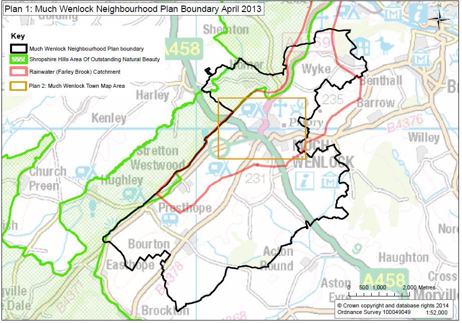
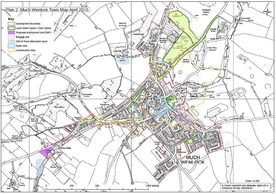
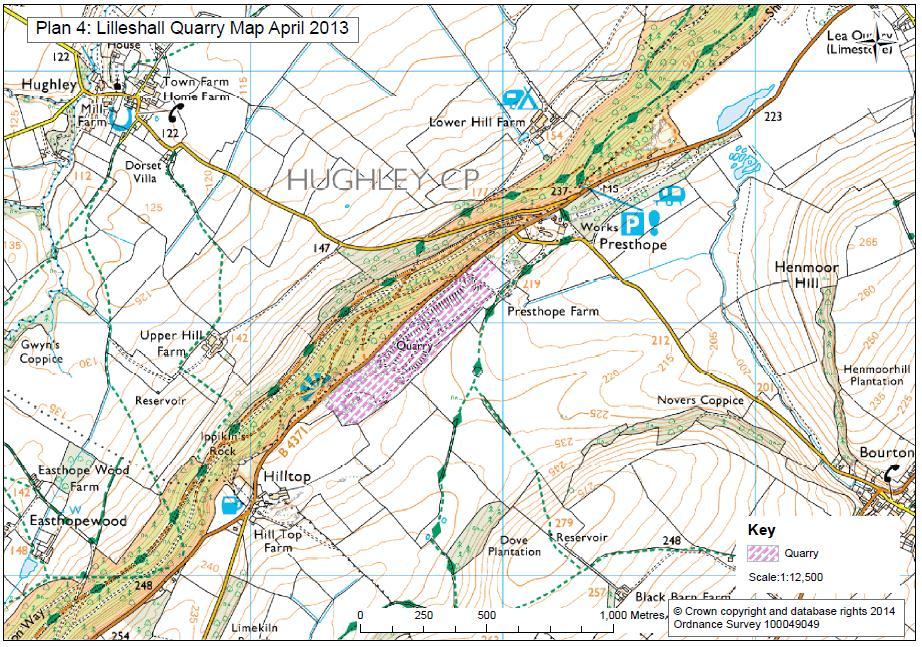
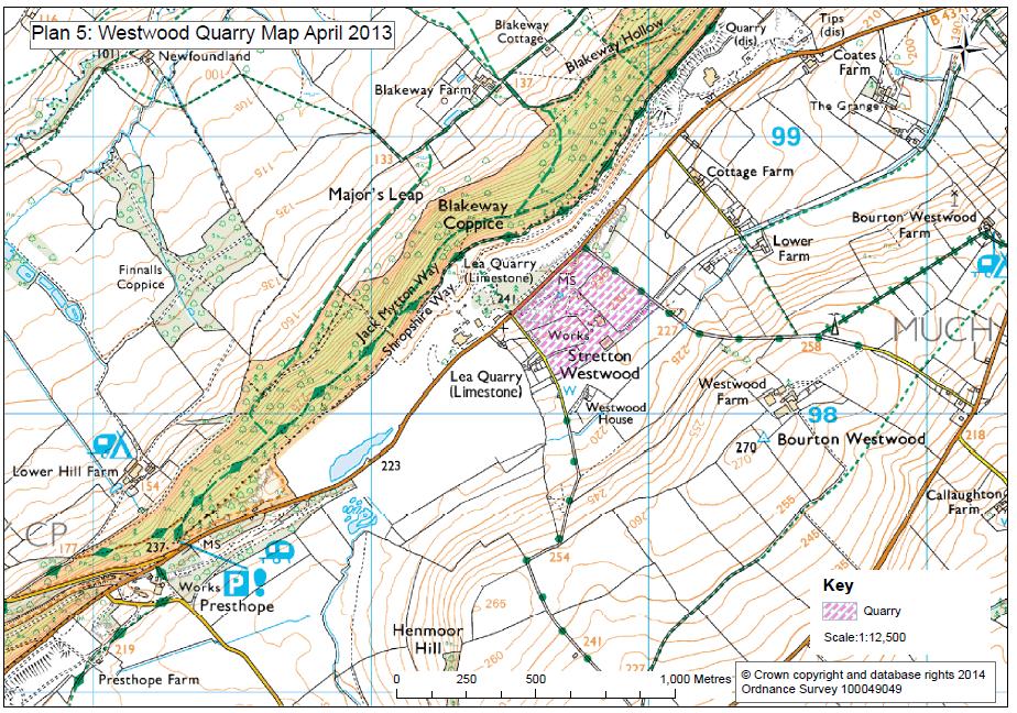
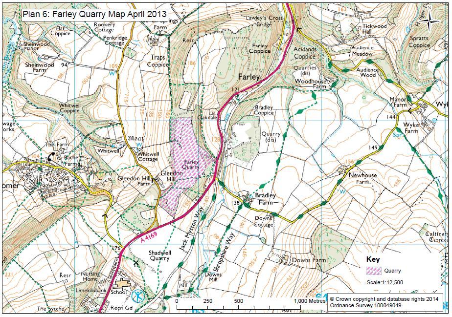
3 Much Wenlock Neighbourhood Plan Referendum Version Contents Introduction pg 3 Objective 1: Housing pg 6 Objective 2: The economy and jobs pg 11 Objective 3: Reducing flood risk pg 16 Objective 4: Traffic management and accessibility pg 19 Objective 5: Community well-being pg 21 Objective 6: Good quality design pg 23 Objective 7: Green and open spaces pg 26 Objective 8: The local landscape and wildlife pg 28 Objective 9: Sustainability and climate change pg 30 Appendix 1: Demonstrating Viability pg 32 Appendix 2: Deliverability and Viability of Employment Land pg 35 Appendix 3: Definition of minor development pg 37 Plan 1: Much Wenlock Civil Parish Boundary Map pg 38 Plan 2: Much Wenlock Town Map pg 39 Plan 3: Bourton Map pg 40 Plan 4: Lilleshall Quarry Map pg 41 Plan 5: Westwood Quarry Map pg 42 Plan 6: Farley Quarry Map pg 43 2
4 Introduction This Neighbourhood Plan defines a community vision for how the parish of Much Wenlock will develop in the coming years. If adopted at referendum, this Plan will stand alongside the Shropshire Council Local Development Framework (LDF) Adopted Core Strategy to guide development within the parish. The Plan covers the period from April 2013 to March The Community s Vision Our starting point for preparing this Plan was to ensure that the residents of Much Wenlock parish were given the opportunity to decide what development should happen and where it should take place. The vision, encapsulated by the line, Our Plan, Our Future has been defined by the desires and aspirations of local residents and other stakeholders of Much Wenlock parish. The objectives and policies that are set out in the Plan come directly from the views and opinions expressed in the Residents Survey and at many other consultation events hosted by community volunteers. The community has said it wants the Plan to shape future development so that it: meets local needs in ways that are in keeping with the scale and size of the town and other settlements in the Parish; complements and enhances our natural and historic environment; creates job opportunities for local young people; protects the high quality nationally-recognised rural landscapes and the town s landscape setting; and addresses our long standing issues of flooding, traffic and affordable housing. Much Wenlock is a small historic Shropshire market town with a wider rural parish area which runs from the lip of the Severn Gorge down to the south west along Wenlock Edge. Much Wenlock is also one of the most desirable places to live in Shropshire because of the town s qualities and especially its location near the growth points of Telford and Shrewsbury and being within ready commuting distance of the West Midlands conurbation. The resulting development pressures and high house prices set us a challenge to provide housing to meet local needs in a way that respects the quality of the town and its rural setting. To help deliver the local community s ambitions and needs for the plan period from 2013 to 2026 the Plan proposes: one site for local employment; a collaborative approach to deliver affordable housing; green space designations; the creation of new and protection of existing flood attenuation areas; and policies to encourage investment in the re-use of land and improvements to community facilities. 3
5 These are all aimed at helping Much Wenlock retain its identity as a market town within a beautiful rural parish. The Town Council will treat the Neighbourhood Plan as an Action Plan and have resolved to review the Plan within three years of the making of the Plan and monitor it annually. The initial review will focus on housing delivery and will be able to assess progress on the granting of planning permissions and/or the delivery of housing in the Plan area. If necessary the review of the Plan will be the trigger either for the modification of some of its policies and/or the allocation of a suitable urban extension site that itself meets the basic conditions. The Plan represents a starting point for localism and we expect that there will be considerable progress in protecting and enhancing the built and natural environment and supporting the economic vitality of the town centre and wider parish over the plan period. More specifically we expect that by 2018 there will be: A successful and positive operational relationship with Housing Associations to bring forward affordable housing; Progress on the marketing and development of the EMP1 employment site; Implementation of the Much Wenlock Integrated Urban Drainage Management Plan (IUDMP) and active measures to address flooding issues in Much Wenlock. The Town Council will develop formal indicators to monitor the Plan in the years ahead. Legal requirements Although the Government s intention is to give local people the opportunity to decide what goes on in their neighbourhood, the Localism Act sets out some important legal requirements. One of these is that all Neighbourhood Plans must conform to the framework given by higher-level planning policy. This means that the Much Wenlock Neighbourhood Plan must be in line with the National Planning Policy Framework (referred to throughout as the NPPF) and local policy, in particular Shropshire Council s Core Strategy (2011). The Core Strategy says that, the town is subject to inward development pressure and to avoid becoming a commuting settlement, the priority is for local employment opportunities balanced with housing and infrastructure to meet local needs. The Core Strategy sets an indicative scale of up to 500 new dwellings for Much Wenlock between 2006 and 2026 (which can be a mixture of windfalls, exceptions and allocated sites) and identifies Much Wenlock as a Key Centre to serve as a town and employment centre for its outlying rural settlements. The Objectives and Policies which follow have taken into account the requirements of the NPPF and especially the Core Strategy which has undergone a formal strategic environmental assessment (SEA). Furthermore, the policies have been assigned a green-leaf motif in order to demonstrate that we have assessed the environmental and other implications of the policies against Shropshire Council s 4
6 Local Development Framework Draft Sustainability Appraisal Scoping Report (July 2008). A Consultation Statement on the Much Wenlock Neighbourhood Plan website provides an overview of our extensive consultations, demonstrating that the Plan fully accords with the requirements of the Localism Act. This consultation included meeting the requirements of Regulation 14 of the Neighbourhood Planning (General) Regulations The Plan has been amended where appropriate in response to consultation comments. A key objective is to ensure that the ambitions of the Neighbourhood Plan are delivered and that mechanisms are in place to ensure this happens. Shropshire s Core Strategy is accompanied by an LDF Implementation Plan coupled with appendices for each market town and key centre. These outline the key infrastructure requirements needed to support the development of sustainable places and the agreed scale of growth. For this parish, the Much Wenlock and Surrounding Area Place Plan is relevant and sets out a series of priorities for investment and, as such, it is expected that Community Infrastructure Levy (CIL) funds will be used to deliver some of the Neighbourhood Plan s stated ambitions. The Town Council will work closely with Shropshire Council and other delivery bodies, such as Housing Associations, to monitor housing and employment development on an annual basis. Our policies have been separated into different themes but it should be noted that any new development is expected to meet the requirements of all relevant policies, for example, new housing will be expected to meet not only the housing policies but those on design, reducing flood risk, green and open spaces and traffic management and accessibility. The Neighbourhood Plan draws upon evidence gathered from a range of sources and it builds upon other community endeavours such as the Town & Parish Plan (2005), the Design Statement for Much Wenlock (2000) and the work of the Town Council s Flood Management Working Group. These have helped inform and provide the rationale for the policies set out in the Plan. While we intend that the Plan will last through to 2026, we recognise that challenges and pressures will change. The Town Council, as the Neighbourhood Plan authority, will become responsible for maintaining the Plan as a living document that will be reviewed periodically. 5
7 Objective 1: Housing (H) The Plan will provide for a limited amount of housing to meet local needs. It will do this through: developing collaborative partnerships with one or more Housing Associations to bring forward affordable housing on exception and other sites. permitting small-scale infill sites and conversions within the parish. supporting the redevelopment of some brownfield (previously used) sites to mixed uses. making sure that developments include a suitable mix of housing suited to local needs, including dwellings suited to older residents. Housing: Our policies Policy H1 Policy H2 Policy H3 Policy H4 Policy H5 Affordable housing shall be provided at a rate of 20% of total yield on site. Housing developments within the development boundary of Much Wenlock will be permitted where they include a range of house type, including two and three bedroom dwellings. Housing developments will also be expected to include an element of single level dwellings and to meet the needs of the elderly and people with disabilities. The redevelopment of brownfield sites in the Much Wenlock development boundary for mixed uses, including housing, will be supported where it can be shown that an otherwise lawful use of the site is no longer viable. Housing infill development and the conversion of existing buildings to residential use will be supported where they contribute positively to local character and where they help to meet local housing needs. Within the conservation areas of Much Wenlock and Bourton infill development should conserve or enhance the special architectural and historic character of these settlements. Proposals for small scale affordable housing developments outside the Much Wenlock development boundary will be supported subject to the following criteria: they comprise up to 10 dwellings; and the proposals contribute to meeting the affordable and socialrented needs of people with a local connection; and the development is subject to an agreement which will ensure that it remains as affordable housing for people with a local connection in perpetuity; and 6
8 the proposals would not have a significant impact on the surrounding rural landscape and the landscape setting of any settlement in the plan area; and the development is appropriate in terms of its scale, character and location with the settlement to which it is associated. Open market housing will only be permitted outside the Much Wenlock development boundary where this type of development can be demonstrated to be essential to ensure the delivery of affordable housing as part of the same development proposal. Policy H6 Proposals for housing development will be required to provide a minimum of two parking spaces per dwelling. Proposals accompanied by a parking provision of less than two parking spaces per dwelling will only be permitted if: alternative and reasonably accessible car parking arrangements can be demonstrated and which in themselves do not add to onstreet parking; or otherwise acceptable and well-designed new build or conversion schemes in the town centre conservation area would be incapable of meeting this parking provision. Sustainability These policies aim to contribute to sustainable development by: Providing a sufficient quantity of good quality housing, which meets the needs of all sections of society. Protect and maximise the benefits of Shropshire s cultural and landscape heritage. Ensuring the efficient use of land and material resources. Reasons for our policies The Plan proposes a range of policies to deliver a housing target of 130 dwellings for the Much Wenlock town area in the Plan period ( ). This level of growth reflects both the Plan period and a balanced assessment of the future development of the town. In order to ensure that this level of growth is delivered the implementation of the Plan will be monitored on an annual basis. A review of the Plan will be carried out within three years of the making of the Plan. Our policies align with the aims of the NPPF and Core Strategy and seek to secure a housing supply which meets local needs while ensuring that sufficient land comes forward to meet those needs over the Plan period. A number of Core Strategy policies are relevant, but in particular Objective 5 which states that the Core Strategy 7
9 will, Provide for a mix of good quality, sustainable housing development of the right size, type, tenure and affordability to meet the housing needs and aspirations of all sections of the community, including provision for specialist needs and the elderly. The evidence from the Residents Survey and analysis of housing needs complements this overarching strategy and provides a clear steer to the Plan s policies on housing. Key findings from the survey showed the community has aspirations towards home ownership at an affordable level which suits the needs of an ageing population, firsttime buyers and young families. The consultation also showed a need to increase the provision of affordable homes, particularly social rented housing stock to provide homes for lower income families. Affordable housing is about more than just numbers and the local evidence base indicates that careful consideration has to be given to the type of provision and tenure of affordable dwellings. Historically, local Housing Associations have not bought sites or built homes in the parish, but have expanded their stock through acquisitions within market development sites. In order to meet identified needs the Plan seeks a new way of working to bring forward small-scale social rented and affordable housing on exception sites through collaborative partnerships with local Housing Associations and Shropshire Council. This positive approach will provide greater certainty and local control over delivery to meet specific local needs. The 2011 Census shows that within the Parish there are 1,346 dwellings. Shropshire Council s figures for completed developments in Much Wenlock since 2002 show that there have been 136 completed dwellings in the town but this has only brought forward 12 affordable housing units in 10 years. This represents slightly over one unit per year, clearly showing that the market does not, of its own volition, meet the affordable housing needs of the community. On this basis, the Plan increases the proportion of affordable housing to be built on open market sites to make up for an historic undersupply. We note that this is higher than Shropshire Council s current rate of 13% affordable housing on development sites but understand that work in progress may well revise this figure upwards and consider that the evidence justifies this requirement. Core Strategy policies also encourage the development of self-build properties for local need on suitable plots both within and adjacent to the development boundary and the Neighbourhood Plan supports this approach. To ensure that houses on exception sites meet local needs for people with a strong local connection, occupants will be expected to meet the requirements of Shropshire Council s SPD The Type and Affordability of Housing (March 2011) Paragraph Shropshire Council s Interim Planning Guidance on affordable housing sets a maximum size of 20 dwellings, for urban exception sites (defined as settlements over 3,000 population). The Census 2011 shows that Much Wenlock is smaller than this and therefore exception sites should "reflect the character and scale of the settlement". We support this policy and have included the figure of ten dwellings in Policy H5 as a guide rather than a target, taking into account local housing need. 8
10 In recent years, infill sites have provided a steady supply of housing at a rate of around 10 dwellings per year. This trend is likely to continue but the Plan allows for the numbers to be kept under review to ensure that sufficient development is coming forward to meet local needs. Additionally a review may be triggered by national changes in policy, updated information on housing needs or issues raised by the public, private or third sector regarding the operation of the Neighbourhood Plan. Much Wenlock Town Council has resolved to review the Plan within 3 years. Policy H1 states that affordable housing should be provided at a rate of 20% of total yield on site. If a higher figure is published by Shropshire Council during the Plan period, the target shall at least match that established by Shropshire Council. The delivery of local housing needs through infill and exception sites will be monitored during the Plan period, should this clearly demonstrate that local needs are not being met, the Plan will be reviewed. Policy H3 allows for the re-use of brownfield sites which are no longer viable. Guidance on the process for assessing viability is included at Appendix 1. Large-scale development is not acceptable to the community and where new housing is needed the consensus was that it should be delivered through smaller sites. There is an overwhelming desire to maintain the scale, style and setting of Much Wenlock and to protect the rural settlements and surrounding countryside from development. The 2011 Census shows that the median age of the local population is 51 compared with 39 nationally. 27% of residents are aged 65 and the single largest cohort, accounting for a fifth of the local population is in the age group. It further indicates that average household size in Much Wenlock is smaller than the county and national averages, but the average number of bedrooms is higher than that in either Shropshire or England. There was also a strong response from older residents who attended the community consultation events that sheltered or housing suitable for older residents was a high priority. Outside the development boundary new development will be strictly controlled in line with national policies and Core Strategy CS5. Relevant Strategic Policies National Planning Policy Framework (NPPF) NPPF 6: Delivering a wide choice of high quality homes Shropshire Core Strategy CS1: Strategic approach CS3: The Market Towns and Other Key Centres CS5: Countryside and Green Belt CS6: Sustainable design and development principles CS9: Infrastructure contributions CS10: Managed release of housing land CS11: Type and affordability of housing 9
11 Supplementary Planning Documents (SPDs) Sustainable Design SPD, Part 1. July 2011 Local Housing Market Assessment. July 2010 Developer Contributions SPD. July 2011 LDF Implementation Plan and Local Investment Plan Much Wenlock and Surrounding Area Place Plan Type and Affordability of Housing SPD. March 2011 Build Your Own Affordable Home Information Pack. Sept
12 Objective 2: The economy and jobs (EJ) The Plan will help business create jobs by: allocating land for business use. making sure that existing employment sites are kept for employment use wherever possible and appropriate. supporting new business premises in suitable locations. protecting the vitality of Much Wenlock town centre. supporting new mixed use developments, so that where appropriate, people can combine work and home life. encouraging appropriate and sustainable green tourism activities. The economy and jobs: Our policies Policy EJ1 Policy EJ2 Policy EJ3 Proposals for the development of employment uses on 0.72 hectares of land at Stretton Road (and shown as EMP1 on the Town Inset Map) will be supported subject to the following criteria: the proposal would not have significant harmful impacts on the surrounding landscape and the wider setting of the town; the proposal would not have any significant harmful impacts on the ecological setting of the site; and the proposals and their HGV traffic generation would not have an unacceptable traffic impact on the wider town and the capacity and operation of its highway network. Proposals for the use of land or buildings on existing employment sites for uses other than employment purposes will not be permitted unless: it can be demonstrated that the on-going use of the premises or land for employment purposes is no longer viable on the basis of the criteria in Appendix 1 of the Plan; or the alternative proposal would provide demonstrable employment benefits to the local community and contribute to its long-term sustainability. New business development on land already in commercial use will be supported subject to the following criteria: the scale and nature of the proposals would not have significant harmful impacts on the amenities of adjoining activities; and the scale and nature of the proposals would not have unacceptable conflicts with agriculture and other land-use activities; and the proposal would not have unacceptable impacts on the local road network. 11
13 Policy EJ4 Policy EJ5 Policy EJ6 Policy EJ7 The provision of any new or additional retail floor-space in the retail core of Much Wenlock (High Street/Barrow Street) will be supported provided that it complements local provision and enhances the town s unique shopping offer and its role as a Key Centre. Additional provision outside the retail core will be supported if it complements the town centre retail offer, is compatible with the size and scale of the existing town centre, and does not have unacceptable impacts on the road network. The change of use of business premises from A1, A2, A3, A4, and A5 uses will not be permitted unless it can be demonstrated that the ongoing use of the premises for these purposes is no longer viable. Excepting those identified in Policy LL1, the use of former quarries for small-scale industrial use and/or recreational activity and public access alongside restoration will be supported, provided that the biodiversity of the site is protected and the scale of the proposal is appropriate to its setting and the tranquillity of the Area of Outstanding Natural Beauty. Proposals for recreational and tourism activities and facilities will be supported providing that the siting, design and scale of the development conserves the quality of the parish s built and natural environments, including its townscape and surrounding countryside. Sustainability These policies aim to contribute to sustainable development by: Promoting a strong and sustainable economy throughout Shropshire. Encouraging a high quality inward investment, and supporting existing businesses to expand and diversify. Reducing the need of people and businesses to travel. Protecting and enhancing the range and populations of species and the quality and extent of wildlife habitats. The economy and jobs: Reasons for our policies Much Wenlock has a relatively buoyant local economy with a long-established business base. Residents and businesses alike are keen to promote economic prosperity and encourage growth in local employment, particularly for young people. The Plan is designed to achieve this by helping existing employers to stay and grow, enabling the town to act as an employment centre for the outlying settlements and encouraging new businesses to invest and create a wide range of new jobs for local people. 12
14 Through its Core Strategy (CS14) Shropshire Council is required to identify 290 hectares of land for employment development across the whole of Shropshire from 2006 to In the East Spatial Zone, within which Much Wenlock falls, an employment target in a range of hectares has been identified. Market Towns and Key Centres (Much Wenlock is identified as a Key Centre) are expected to take the majority of this new land. The principal strategic objective for planning the local economy of Much Wenlock is to balance local employment opportunities with housing development to meet local need. The aim is to manage the significant inward development pressure on the town, to diversify and strengthen the local economy and to ensure Much Wenlock does not simply become a commuting settlement. Accordingly, site EMP1 has been allocated for employment uses and Shropshire Council have provided assurances that it will be brought forward for development within the next five years. A deliverability and viability assessment for the site is attached at Appendix 2. The site lies immediately adjacent to an arm of the Environmental Network and care will be needed to ensure that there are no adverse effects on the Network (including through lighting) and that landscaping should enhance the network where possible in line with CS17. Any development on greenfield parts of this site would be subject to an Ecological Assessment. Development proposals on the EMP1 site will also need to be able to demonstrate that they do not have an unacceptable impact on HGV movements in the town. A transport assessment would be the most appropriate way of so doing It should be noted, however, that the site was previously included in a land allocation for employment use in the Bridgnorth Local Plan in 2005, since when there has been little interest in its development. It appears, therefore, that some up-front public or private investment will be required to facilitate its use and Shropshire Council s statement of intent offers assurances that this will take place. Unless this investment is made, there will be a significantly increased risk of the Core Strategy policy failing to provide for local employment to balance housing allocations and avoid creating a commuting town. Where an applicant is seeking to demonstrate that an existing employment site is not suitable for continued employment use, it is expected that a planning application will be accompanied by a detailed supporting statement that seeks to demonstrate that this is the case. (See Appendix 1 for guidance). In determining the application, the Town Council will come to a view as to whether the site is suitable for continued employment use taking into account the evidence supplied in the supporting statement. Where consideration is being given to alternative uses of employment land or premises, any such proposals must ensure that the proposed use does not conflict with the character of the surrounding area and other policies and proposals within the Plan, or any other material considerations. In looking to encourage growth and reduce outward commuting the community is concerned to protect the parish from unsuitable development which will have an adverse impact on local residents, the road network and the environment. To this 13
15 end, our policies in the traffic management and accessibility section are relevant to securing growth which does not add unduly to the existing problems of heavy traffic. The town has an unusually high level of self-employment and home-working which the Plan aims to encourage in line with Shropshire Council s Core Strategy CS13. Self-employment adds to the character and viability of the local economy and supports the community s aim to avoid the settlements in the parish becoming overdependent on outward commuting. Residents and business owners are strongly in favour of the re-use of brownfield sites and former quarries for employment use, but at the same time were concerned about the impact of HGV traffic on the road network and the loss of wildlife habitats. Our policies aim to strike a balance between these views by supporting small scale employment uses where appropriate and opposing redevelopment in quarries where the biodiversity is greatest. During the development of the Neighbourhood Plan planning permission has been granted for employment use at Lea Quarry for development which is expected to create between 13 and 23 jobs and there is further small-scale opportunity for employment uses at former quarries (See Policy EJ6). Much Wenlock s town centre, with its wide range of independent shops, local market stallholders, bank, Post Office and petrol filling station is of great importance to the community, serving the needs of local residents, visitors and a wide rural hinterland. The Plan is designed to protect Much Wenlock s retail core and promote and support its viability. Any development which compromises the town centre and its range of provision will not be supported. In line with NPPF 3 the Plan seeks to support sustainable rural tourism and leisure developments that benefit businesses in rural areas, communities and visitors, and which respect the character of the countryside. The parish has many resources to support sustainable tourism including the historic character of the town; its shops, attractions and facilities; and the opportunities for quiet recreation on Wenlock Edge. The Plan aims to encourage and support appropriate leisure and tourism activities and facilities, particularly green tourism. Noisy activities and sports which will impact on the peace and tranquillity of the parish are considered inappropriate for its rural setting. Relevant Strategic Policies National Planning Policy Framework (NPPF) NPPF 1: Building a strong, competitive economy NPPF 2: Ensuring the vitality of town centres NPPF 3: Supporting a prosperous rural economy NPPF 4: Promoting sustainable transport 14
16 Shropshire Core Strategy CS5: Countryside and Green Belt CS13: Economic development, enterprise and employment CS14: Managed Release of Employment Land CS15: Town and rural centres CS16: Tourism, culture and leisure CS20: Strategic planning for minerals Supplementary Planning Documents (SPDs) LDF Implementation Plan and Local Investment Plan Much Wenlock and Surrounding Area Place Plan
17 Objective 3: Reducing flood risk (RF) The Plan will encourage new ways of reducing flood risk and water pollution throughout the parish by: supporting the implementation of the Much Wenlock Integrated Urban Drainage Management Plan (IUDMP). keeping sites which can be used to slow down the flow of surface water (Flood Attenuation Areas See Town Map) free from inappropriate development. making sure that developments minimise the impact on water quality and subsequent health risks during flooding conditions. protecting and improving local water quality. Reducing flood risk: Our policies Policy RF1 Development proposals within the surface water catchment area of Much Wenlock as defined on Plan 1 will be permitted where they can demonstrate that: the development proposed is a minor housing or commercial extension (as set out in Appendix 3 of the Plan); or the development proposed will have no detrimental impact on surface water run-off in the town s surface water catchment area; or the development proposed is entirely self-sufficient in its ability to manage surface water run-off. Proposals for the construction of new dwellings will also be expected to comply with Policy RF3. Policy RF2 Policy RF3 Policy RF4 Policy RF5 All developments in flood-sensitive areas will be designed and constructed to reduce the overall level of flood risk both to the use of the site and elsewhere when compared to current use. All new dwellings will be designed to have a predicted water discharge of no more than 80 litres of water per person per day. Proposals that would create new culverts (unless essential to the provision of an access) and that would result in the loss of an open watercourse will not be permitted. Development will not be permitted in flood attenuation areas (as shown as flood attenuation ponds on the Town Map) where that development would reduce the ability of these areas to alleviate flooding. 16
18 Policy RF6 Parking spaces and driveways associated with new development will be required to have permeable surfaces. Sustainability These policies aim to contribute to sustainable development by: Reducing the parish s contribution to climate change. Reducing the risk of flooding to people, property and wildlife. Protecting and improving Shropshire s water and air quality and actively addressing known flooding issues. Adapting to the impacts of climate change Reducing flood risk: Reasons for our policies The NPPF provides clear guidance that local planning authorities should adopt proactive strategies to mitigate and adapt to climate change, taking full account of flood risk and water supply and demand considerations. Similarly the Core Strategy seeks to avoid flood risk and to minimise the impact where it does occur. These higher-level strategies provide a clear context for the Neighbourhood Plan s policies in relation to reducing flood risk. The particular circumstances which apply in Much Wenlock suggest that a more local interpretation of these policies is appropriate. (See Shropshire Council s Integrated Urban Drainage Management Plan). Much Wenlock was badly affected by damaging floods in 2007 and in a referendum in the same year the community expressed its strong views that development should be restricted until solutions to reduce the risk of flooding are put in place. The Much Wenlock Integrated Urban Drainage Management Plan (IUDMP) sets out actions which are designed to reduce the risk of flooding from a 1 in 8 year rainfall event to approximately a 1 in 30 year rainfall event. Policy RF1 describes constraints on development proposals in Much Wenlock town s surface water catchment area. By minor development the Plan adopts the guidance given by the Environment Agency (See Appendix 3). Should the implementation of the IUDMP be delayed beyond 2014 then Policy RF1 will be reviewed. The community is strongly in favour of taking the opportunity in the Plan to support the IUDMP by protecting and designating Flood Attenuation Areas to reduce the risk of flooding still further and complement the IUDMP attenuation ponds. Policy RF2 is somewhat more specific that Core Strategy Policy CS8 in that it actually seeks to reduce flood risk through new development. Limiting discharge levels from new build will further reduce risks and Policy RF3 to promote a high level of water efficiency in line with best practice reflects the community s drive to reduce the causes and impacts of flooding while embedding high levels of sustainability in new developments. This policy will help to minimise loading to the existing combined sewerage system and will also contribute to wider climate change 17
19 reduction/sustainability. It is supported by Shropshire Council s Shropshire Outline Water Cycle Study Final Report June 2010 and Shropshire Council s Surface Water Management Interim Guidance for Developers - 15 June Policy RF4 has the strong support of the Environment Agency in order to maximise the separation of foul and surface water and address specific local issues relating to the sewerage system. These policies to reduce flooding risk have been strongly community-led with 78% of residents who responded to the Residents Survey supporting improved flood prevention measures. Relevant Strategic Policies National Planning Policy Framework (NPPF) NPPF 10: Meeting the challenge of climate change, flooding and coastal change Shropshire Core Strategy CS6: Sustainable design and development proposals CS8: Facilities, services and infrastructure provision CS 18: Sustainable water management Supplementary Planning Documents (SPDs) Developer Contributions SPD Sustainable Design SPD Part 1. July 2011 LDF Implementation Plan and Local Investment Plan Much Wenlock and Surrounding Area Place Plan
20 Objective 4: Traffic management and accessibility (TM) The Plan will support new ways of managing the traffic in and around the town of Much Wenlock by: making sure that new developments have enough car parking to meet current and future needs. supporting local and strategic traffic management which reduces HGV/LGV vehicles through the parish in order to minimise their adverse impact, whilst managing new developments so that they do not have an unacceptable traffic impact on local residents. Traffic management and accessibility: Our policy Policy TM1 Development proposals that would result in the loss of off-street car parking will not be permitted unless: in relation to existing public car parks an equivalent or better capacity is provided elsewhere in the town; or in relation to private car parks or similar off-street parking areas an equivalent or better capacity is provided elsewhere or the need for the private parking capacity can be shown to be reduced as a result of the implementation of the development proposal. Sustainability The policies in the Plan aim to contribute to sustainable development by: Encouraging a modal shift to more sustainable forms of transport. Promoting safer communities. Creating active and healthier communities for all. Reducing the risk of flooding to people, property and wildlife. Traffic management and accessibility: Reasons for our policy Residents expressed strong concern about traffic and transport issues in the Residents Survey, highlighting problems of congestion; the dangers caused by onstreet parking; the impact of HGV traffic through the historic narrow streets; and risks to pedestrian and cyclist safety. Our Plan policies, therefore, are to be used as a set of policies designed to manage the traffic arising from new local development and to improve access to alternative forms of transport. The community s expectation is that other measures to address these issues will be included as a priority in the Much Wenlock Place Plan and Shropshire Council s Local Transport Plan for
21 The community wishes to encourage cycling and walking as safe options. Accordingly, the Plan aims to take opportunities to improve highway safety and minimise conflicts between road traffic, cyclists and pedestrians. Car parking standards have been carefully considered and are included because car ownership levels in the parish are high and well above local and national averages; reflecting both our rural location and limited availability of public transport. The 2011 Census shows that in Much Wenlock parish, 45% of households have two or more cars or vans and only 13% have no vehicle at all. In contrast, nationally, only 32% of all households have two or more cars and vans and more than twice as many as locally (26%) have no vehicle at all. Fewer than 2% of the Parish s workforce travel to work via public transport. The Plan s parking standards reflect these local factors and seek to make sure that new development does not add to the current levels of congestion caused by on-street parking. Heavy vehicles pass through the town on a daily basis in connection with quarrying operations and the use of former quarries for haulage and industry. In addition, bridge and road weight limits bring considerable volumes of heavy traffic through Much Wenlock on the A458 and A4169. Given its location at the heart of a network of important roads the Plan seeks to manage development arising in the parish to ensure that new development does not exacerbate existing problems. Due to the overlap between traffic management and the other themes of this plan, traffic management-related policies can be found elsewhere in the plan, i.e. H6 and RF6. It is recognised that this Plan cannot prescribe all the measures and improvements that the community desires. However, these matters are likely to feature in reviews of this Plan. In addition, other mechanisms will be used, e.g. the development and implementation of the Much Wenlock and Surrounding Area Place Plan. Relevant Strategic Policies National Planning Policy Framework (NPPF) NPPF 4: Supporting a prosperous rural economy Shropshire Core Strategy CS6: Sustainable design and development principles CS7: Communications and transport 20
22 Objective 5: Community well-being (CW) The Plan will protect existing community facilities and services considered important for a vibrant community and support the development of new ones which benefit local people and visitors by encouraging: new facilities for families, the elderly and young people. developments or uses associated with a positive visitor experience. the protection of existing community buildings and services. new public toilet provision to cater for local and visitor needs. Community well-being: Our policies Policy CW1 Proposals that would result in the loss of community facilities will not be supported unless: it can be demonstrated that the facilities are no longer needed or viable; or it can be demonstrated that suitable alternate provision exists in the immediate area to serve the community; or suitable alternative provision is included in the development proposal itself. Policy CW2 Proposals for new and/or improved community facilities will be supported subject to the following criteria: the proposal would not have significant harmful impacts on the amenities of surrounding residents and other activities; and the proposal would not have significant harmful impacts on the surrounding local environment; and the proposal would not have unacceptable impacts on the local road network; and the proposal would adequately address surface water run-off issues. Sustainability These policies aim to contribute to sustainable development by: Promoting community participation in a diverse range of sporting, recreational and cultural activities. 21
23 Community well-being: Reasons for our policies The NPPF provides a clear framework for the promotion, retention and development of local services and community facilities in villages, such as local shops, meeting places, sports venues, cultural buildings, public houses and places of worship. The Core Strategy also includes policies to protect and enhance existing facilities and resist any inappropriate loss. In the Neighbourhood Plan area, there is a thriving community with education, health, social and leisure facilities which contribute greatly to the local quality of life. Notwithstanding Core Strategy policies, recent years have seen the loss of a number of services and facilities, including the British Legion Hall, the Roman Catholic church and two banks. The community is rightly concerned that there should be no further loss of facilities, in particular, health services, the bank, the Post Office and library, and there is strong support for the Neighbourhood Plan to seek the improvement and retention of these vital community assets in the interests of community wellbeing and sustainability. Before granting planning permission for a change of use or redevelopment which would result in the loss of any of these facilities, therefore, Policy CW1 requires compelling evidence that the facility is both no longer needed by the local community and is no longer commercially viable in line with the guidance attached at Appendix 1. Much Wenlock itself also serves as a centre for a much wider rural catchment area and its facilities are of value to residents living well outside the parish boundaries Through the safeguarding of local community facilities and services and the provision of new services the Plan aims to strengthen Much Wenlock s role as a Key Settlement in line with the Core Strategy. Public toilet provision within Much Wenlock is considered inadequate and limited to facilities in St Mary s Road Car Park and at Queen Street. Provision at the Gaskell Recreation Ground was closed some years ago. New provision is needed not just to improve existing facilities, for instance, by reinstating facilities at the Gaskell Recreation Ground, but also by increasing provision at the car parks to meet needs associated with the growing number of visitors and tourists to Much Wenlock. The Much Wenlock and Surrounding Area Place Plan provides a mechanism for supporting this objective. Relevant Strategic Policies National Planning Policy Framework (NPPF) NPPF 3: Promoting sustainable transport NPPF 8: Promoting healthy communities Shropshire Core Strategy CS5: Countryside and Green Belt CS6: Sustainable design and development principles CS8: Facilities, services and infrastructure provision 22
24 Objective 6: Good quality design (GQD) All future development will be well designed and will aim to: respect the scale, style and setting of the historic townscapes of Much Wenlock (in particular the unique characteristics of the bowl setting) and Bourton. make sure that in Much Wenlock and Bourton, the use of building materials is in keeping with those used in their respective Conservation Areas. Elsewhere, new developments should use materials which respect their setting and rural environment. be of the highest quality design. new developments will include gardens of an appropriate scale to the property. Good quality design: Our policies Policy GQD1 Policy GQD2 The high quality natural landscape outside the development boundary of Much Wenlock will be protected from any development which adversely affects the town s character, setting and open views. All development will be designed to a high quality and to reinforce local distinctiveness. Design which fails to have regard to local context and does not preserve or enhance the character and quality of an area will not be acceptable. Development proposals, extensions and alterations to existing buildings and structures will be expected to: have regard to the principles set out in the Much Wenlock Design Statement; and make efficient use of land while respecting the density, character, landscape and biodiversity of the surrounding area; and be suitably designed for the context within which they are set; and retain existing important landscape and natural features; and ensure that the scale and massing of buildings relate sympathetically to the surrounding area; and create safe environments addressing crime prevention and community safety; and use traditional and vernacular building materials where such treatment is necessary to respect the context of the development concerned. 23
25 Policy GQD3 Policy GQD4 The erection of new dwellings at the rear of existing properties will not be permitted within the areas indicated as Burgage Plots on the Town Map. New development of more than three dwellings will be required in the submitted design and access statement to demonstrate how the proposal s scale, proportions, materials and layout and amenity space respects the local context and that garden space is commensurate with the size and type of development. Sustainability These policies aim to contribute to sustainable development by: Protecting and maximising the benefits of Shropshire s cultural and landscape heritage. Good quality design: Reasons for our policies The parish is set in unspoilt countryside of rolling hills, with Much Wenlock itself set in a hollow or bowl on Wenlock Edge. The urban skyline is dominated by the Holy Trinity church, Wenlock Priory and the old windmill, with a backcloth of pasture land and woodland on the higher ground surrounding the town. This unique setting allows for views of open countryside from almost every part of the historic town centre, which gives the town a strong identity and sense of place. The limestone which defines the landscape has been used as a local building material since medieval times and this creates an attractive unity in the built environment and contributes to the townscape of Much Wenlock. (Bridgnorth District Council Landscape Sensitivity Study 2008 page 216 and the Much Wenlock Design Statement 2000). The NPPF and Core Strategy attach great importance to good quality design. Similarly, the community, through the Residents Survey was wholeheartedly unanimous that the town should be protected from inappropriate development; that its setting should be safeguarded; and that new development should be of an appropriate scale and form. Where possible, open views towards the countryside, or across open spaces, should be maintained from key existing routes within the town. The three main streets of the medieval town: High Street, Barrow Street and Wilmore Street/Sheinton Street contain a wealth of stone, brick and timber frame buildings and, in particular, areas on either side of Barrow Street and on the eastern side of Sheinton Street contain some of the best preserved examples of the long burgage plots of the historic core. Already, many other burgage plots have been lost to development in different parts of the town and Policy GQD3 reflects the importance attached to preventing any further loss of Much Wenlock s historic character and medieval layout. 24
26 The parish s extensive history has given it a legacy of buildings of architectural and historic significance and both Much Wenlock and Bourton are protected by Conservation Area status. While Conservation Area status can do much to protect the historic built environment, the Much Wenlock Design Statement 2000 provides a well-founded basis for assessing new developments which will deliver positive improvements in the quality of local design by respecting the old, but not stifling high quality modern design. The Design Statement provides guidance not only for housing developments but also commercial development and public spaces. It was reviewed and adopted by Much Wenlock Town Council Planning Committee in February Developers must demonstrate in their design and access statements how their proposals for any development in the town follow the guidance set out in the Much Wenlock Design Statement. Elsewhere, the parish is characterised by small settlements, such as Bourton and Homer, as well as hamlets and scattered farmsteads and it is important that new development respects its rural setting and does not detract from the high quality landscape of the parish in line with CS6. Policy GQD4 proposes that new development of more than three dwellings will be required in the submitted design and access statement to demonstrate how the proposal s scale, proportions, materials and layout and amenity space respects the local context and that garden space is commensurate with the size and type of development. Relevant Strategic Policies National Planning Policy Framework (NPPF) NPPF 7: Requiring good design NPPF 11: Conserving and enhancing the natural environment Shropshire Core Strategy CS3: The Market Towns and Other Key Centres CS5: Countryside and Green Belt CS6: Sustainable design CS16: Tourism, Culture and Leisure CS17: Environmental networks Supplementary Planning Documents (SPDs) and other documents Much Wenlock Design Statement 2000 Shropshire Playing Fields Association, Safe Places Young People Play Outdoors, March
27 Objective 7: Green and open spaces (GOS) The Plan will make sure that: existing areas of green space within the parish are protected and their quality is improved. extra areas of green space are created within new developments and opportunities taken to create linkages between sites and address gaps in existing networks by the creation of new rights of way. new accessible green space should at least meet or exceed Shropshire Council s standards for green and play spaces and allotments. Green and open spaces: Our policies Policy GOS1 Policy GOS2 Policy GOS3 Built development will not be permitted on the green and open spaces as shown on the Much Wenlock Town Map. New development will include or contribute to the provision of recreational open space in line with standards set out by Shropshire Council. New housing and employment developments will be expected to establish publicly accessible links from development sites to the wider footpath network and green spaces wherever possible. Sustainability These policies aim to contribute to sustainable development by: Promoting safer communities. Creating active and healthier communities for all. Promoting community participation in a diverse range of sporting, recreational and cultural activities. Protecting and enhancing the range and populations of species and the quality and extent of wildlife habitats. Green and open spaces: Our reasons for these policies Open space, including gardens, allotments, recreational space, open fields, woodlands and pathways are important to us all. Natural and semi natural open space is highly valued by local residents not just for its recreational value but also for its landscape character, quiet enjoyment and biodiversity. Our policies aim to support and add weight to the policies contained in the Core Strategy by designating sites as Local Green Space to safeguard them and protect them from inappropriate development. Currently, the only sites afforded protection are Hunter s Gate and the Railway Walks which are designated as Open Space under the Open Spaces Act. The Railway 26
28 Walk has the additional new designation of a QE2 field which means that it must remain a public open space in perpetuity. Additionally it is considered that the Gaskell Fields, Windmill Hill, the Holy Trinity Church Green and land at Southfield Road and Havelock Crescent meet the relevant criteria under NPPF guidance for special protection under the designation of Local Green Space (See Bridgnorth District Council Landscape Sensitivity Study page 216). Despite the rural setting of the settlements of Much Wenlock, Homer and Bourton, the parish is not well served by play provision. A quantitative shortfall of play provision has been identified in Much Wenlock (See Shropshire Council PPG17 Study) and Policy GOS2 seeks to address this. Where developers are not able to make provision for play provision on site, financial contributions to off-site play space may be used to meet local needs, with priority given to additional provision to the south of the town. The Neighbourhood Plan endorses Shropshire Council s Open Space Interim Planning Guidance and is keen to make sure that our children have access to high quality outdoor play. Many miles of footpaths and bridleways criss-cross the parish and are enjoyed by local residents and visitors alike. Much Wenlock now has Walkers are Welcome status and the Plan aims to take opportunities to integrate any new developments with the existing rights of way network and enhance existing provision by creating new links wherever possible, particularly where there is potential to improve links to the recreational route network on Wenlock Edge and to make better use of the former railway line as a green route. Policy GOS3 supports the Core Strategy Policy CS6 which seeks to ensure that, All new developments will be required to make provision for footpaths and cycle-paths which should be, where possible linked to the existing network of cycle-paths and footpaths. In line with the Much Wenlock Place Plan, developer contributions may be used to deliver parts of the green infrastructure network, bearing in mind the benefits that will accrue to new residents, existing residents and wildlife. Relevant Strategic Policies National Planning Policy Framework (NPPF) NPPF 4: Promoting sustainable transport NPPF 7: Requiring good design NPPF 8: Promoting healthy communities Shropshire Core Strategy CS6: Sustainable design CS7: Communications and transport CS16: Tourism, Culture and Leisure CS17: Environmental networks Supplementary Planning Documents (SPDs) and other documents Sustainable Design SPD, Part 1. July 2011 Developer Contributions SPD. July 2011 LDF Implementation Plan and Local Investment Plan Much Wenlock and Surrounding Area Place Plan Shropshire Council PPG17 Study, Open Space Interim Planning Guidance Jan
29 Objective 8: The local landscape and wildlife (LL) The Plan will encourage sympathetic management of the countryside and natural outdoor environment in and around the parish to enhance the quality of the landscape, improve local biodiversity and provide other benefits to the community s quality of life. The local landscape and wildlife: Our policies Policy LL1 Policy LL2 Policy LL3 Policy LL4 Proposals for the restoration and the implementation of aftercare proposal for former quarries will be permitted where they deliver restoration for wildlife, biodiversity and public access and are consistent with other Plan policies. In particular proposals for biodiversity restoration combined with commercial/leisure use and public access will be permitted at the Lea North/Hayes/Coales quarry complex and at the Shadwell quarry. New industrial and commercial uses will not be supported at Lilleshall, Westwood and Farley quarries as shown Plan Maps 4-6 respectively. The Plan will expect developments to retain features of high nature conservation or landscape value, including mature trees, species-rich hedgerows, ponds and existing areas of woodland. Improvement of the connectivity between wildlife areas and green spaces will be encouraged to enhance the green infrastructure of the Parish. Flood attenuation ponds and new areas of recreational green space required as part of new developments will be expected to be designed to encourage nature conservation and biodiversity. Sustainability These policies aim to contribute to sustainable development by: Protecting and enhancing the range and populations of species and the quality and extent of wildlife habitats. Ensuring the efficient use of land and material resources. Maintaining important hedgerows, trees and woodland so that natural features are protected for their landscape and wildlife benefits. 28
30 The local landscape and wildlife: Reasons for our policies Much Wenlock, Homer and Bourton lie in a beautiful landscape, rich in wildlife. The Plan area is partially within the Shropshire Hills AONB, of which Wenlock Edge is a key feature. The landscape character and its distinctive flora and fauna are founded on limestone, the importance of which is recognised by the designation of a Local Geological Site and several SSSIs. The Plan s policies aim to protect and enhance our unique environment and to improve its biodiversity. The Plan offers special protection from re-use to older disused small quarry workings where no commercial activity has taken place for more than 15 years and Lilleshall, Westwood and Farley quarries (see Plans 4 to 6) because of the richness of their habitats. (See Evidence for proposals relating to former quarries on Much Wenlock Neighbourhood Plan website). The aim is to improve and enhance local biodiversity, and encourage improved access to allow more local people and visitors to enjoy the unique landscape and natural environment of Wenlock Edge. This biodiversity reflects the length of time since these quarries were last worked and the natural regeneration already underway. Elsewhere, there may well be opportunities for reuse for employment uses alongside restoration (See Policy EJ6) and the Plan endorses the Core Strategy approach. It is recognised that measures to reduce flood risks can also benefit wildlife and we aim to make creative use of opportunities to support wildlife conservation wherever possible. Relevant Strategic Policies National Planning Policy Framework (NPPF) NPPF 11: Conserving and enhancing the natural environment Shropshire Core Strategy CS6: Sustainable design CS17: Environmental networks CS20: Strategic Planning for Minerals Other relevant documents Shropshire Hills AONB Management Plan 29
31 Objective 9: Sustainability and climate change (SCC) The Plan will encourage moves towards a low-carbon economy which includes local food production, high standards of energy conservation and the use of renewable energy through: the application of higher energy standards in new houses. supporting small scale proposals for hydro-electricity, solar energy, anaerobic digestion, biomass and wood fuel products where appropriate and encouraging their use in the local community. encouraging the use of land within the parish to support food production that meets the needs of local people and markets. Sustainability and climate change: Our policies Policy SCC1 With the exception of the conversion of listed buildings, development proposals will be expected to have a minimum energy efficiency standard equivalent to Level 4 of the Code for Sustainable Homes. Policy SCC2 Proposals for individual and community scale energy from hydroelectricity, solar photovoltaic panels, local biomass facilities, anaerobic digestions and wood fuel products will be supported subject to the following criteria: the siting and scale of the proposed development is appropriate to its setting and position in the wider landscape; and the proposed development does not create an unacceptable impact on the amenities of local residents; and the proposed development does not have an unacceptable impact on a feature of natural or biodiversity importance. Sustainability These policies aim to contribute to sustainable development by: Reducing Shropshire s contribution to climate change Adapting to the impacts of climate change Protecting and improving Shropshire s water and air quality 30
32 Sustainability and climate change: Reasons for our policies The community expressed strong support for action to address climate change and were positive about finding ways to achieve sustainable development locally. For these reasons, sustainability considerations thread through the Plan and underpin all its policies. The Plan strongly aligns with and supports Shropshire s Core Strategy Vision to be a recognised leader in responding to climate change. To play its part in moving towards a low carbon future in a changing climate, the community strongly backs improvements to energy efficiency. While supportive of alternative energy generation, residents are opposed to wind power in this location and consider that other alternative energy sources are more appropriate in this location. The Neighbourhood Plan endorses the approach to wind turbines taken in the Shropshire Hills AONB Management Plan (Policy 35.) Relevant Strategic Policies National Planning Policy Framework (NPPF) NPPF 10: Meeting the challenge of climate change, flooding and coastal change Shropshire Core Strategy CS6: Sustainable design CS8: Facilities, service and infrastructure provision CS13: Economic Development, Enterprise and Employment Other relevant documents Shropshire Hills AONB Management Plan 31
33 Appendix 1: Demonstrating Viability Viability: Community facilities The release of any community facilities to other uses must be fully justified in terms of their contribution and viability. Shropshire Council will require any application involving the loss of a facility to be supported by written evidence that the facility is no longer needed and/or no longer viable. The level of evidence required to be submitted will vary according to the level of access to alternative facilities in the area and the extent to which the facility contributes towards sustainable communities, but would be expected to include such evidence as: The current and projected patterns of community use; The nature and condition of the building and the cost of repairs, renovations or improvements needed to allow the facility to continue in operation; The extent of the local catchment including the location of the premises in relation to the local settlement pattern and accessibility; The nature and location of comparable facilities; The potential to relocate the use into other premises in the community; Evidence of the marketing of a site should include sales literature, details of approaches and details of offers and show that it has been offered as a whole and that parts have not been identified for separate sale; Evidence that the local community has been notified of the intention to close the facility and has not, within a period of one year come forward with a realistic proposal to assume operation of the facility, including proposals to finance and operate the facility. The importance of particular facilities will vary, and it is essential that the community is involved in considering the merits of any facility and the suitability of any proposals for alternative forms of community use should their continued viability of operation be in doubt. Applicants proposing to redevelop or convert facilities valued by the community will be expected to consult local communities about the relative importance of the facilities which could be lost. Not all facilities satisfactorily meet the needs of local communities, and it may be that combining or rationalising facilities might be more appropriate. Support will be given to the provision of new facilities where these will enhance the sustainability of community life and will meet the needs of an existing or growing and changing population. 32
34 Viability of employment sites and retail premises: Evidencing non-viability It is important that the potential for all employment uses are considered on the site before planning applications are made for non-employment uses. Where a business is coming to the end of its economic life or has ceased trading altogether, applicants will be expected to submit a Viability Statement as part of the planning application. The Viability Statement should provide proof of marketing and demonstrate that there is no realistic prospect of retaining or re-using the site in its current use. The viability case will be considered along with other policy considerations. Proof of marketing should include all of the following criteria: i. The land/premises has/have been widely marketed through an agent or surveyor at a price that reflects its current market or rental value for employment purposes, and no reasonable offer has been refused. The period of marketing should be 18 months for commercial / industrial, 6 months for retail. ii. iii. iv. The land/premises has been regularly advertised in the local press and regional press, property press, specialist trade papers and any free papers covering relevant areas. This should initially be weekly advertising for the first month, followed by monthly advertising for the remainder of the marketing period. Advertisements should be targeted at the appropriate target audience. The land/premises has been continuously included on the agent s website, the agent s own papers and lists of commercial/business premises for the marketing period. There has been an agent s advertisement board on each site frontage to the highway throughout the marketing period. v. Evidence that local property agents, specialist commercial agents and local businesses have been contacted and sent mail shots or hard copies of particulars to explore whether they can make use of the premises. The Viability Statement should also detail the following information: i. Details of current occupation of the buildings and where this function would be relocated; ii. iii. iv. Details as to why the site location makes it unsuitable for existing uses. Any physical constraints making the site difficult to accommodate existing uses; Environmental considerations/amenity issues; and v. Consideration, firstly, for a mixed-use scheme involving the existing use and other compatible uses, secondly, for other employment generating uses such as those relating to tourism, leisure, retail and residential institutions and, thirdly, of the viability of providing affordable housing on the site, which could meet a specific local need, before consideration of market housing. 33
35 In certain cases, for example, where a significant departure from policy is proposed, the Council may seek to independently verify the Viability Statement, and the applicant will be required to bear the cost of independent verification. 34
36 Appendix 2: Deliverability and Viability of Employment Land in relation to Core Strategy Policy CS14: Managed Release of Employment Land Through its Core Strategy (CS14) Shropshire Council is required to identify 290 hectares of land for employment development across the whole of Shropshire from 2006 to In the East Spatial Zone, within which Much Wenlock falls, an employment target in a range of hectares has been identified. This is expected to deliver sufficient employment development to proportionately support the proposed housing target ( ,850 dwellings) for the Zone. Market Towns and Key Centres are expected to take the majority of this new land. Much Wenlock is defined in the Core Strategy as a Key Centre which has a local economy firmly based on service industries due to its rural location and the tourism appeal of its heritage assets. The principal strategic objective for planning the local economy of Much Wenlock is to balance local employment opportunities with housing development to meet local need. The purpose of this strategy is to manage the significant inward development pressure on the town, to diversify and strengthen the local economy and to ensure Much Wenlock does not simply become a commuting settlement. Much Wenlock has had a relatively low level of Class B employment development (0.25 hectares) from 1998 to 2008 reflecting the predominance of service industries in the town. Of this employment development, there has been one key development of 0.13 hectares off Stretton Road and currently there are no existing permissions for Class B employment development in the town. There is a perceived need for new employment land to meet the needs of local companies wishing to expand or for new companies wishing to move into the area. There is currently no serviced employment land available for this purpose. The former Bridgnorth Local Plan allocated land for employment development off Stretton Road to support the local economy. This support was needed as employment in quarrying declined and to reduce the dependence in the town on out commuting for employment. This employment allocation has remained undeveloped throughout the last 4 years but is subject to drainage constraints and requires a flood risk assessment. Much Wenlock would appear to require some diversification of its service based economy and some assistance to facilitate development in suitable location(s) in the town. In terms of viability, most of the employment sites in Shropshire have been provided by the public sector with subsidy as development costs are greater than serviced land values. Whilst sites may be advertised developers/promoters cannot make them stack up. To date there has been no interest in the site at Stretton Rd which was advertised as employment land for sale by Wenlock Estates. Subsequently, the Business and Enterprise Service of Shropshire Council purchased the site with funds from the Economic Development Capital programme for use a temporary overspill car park (for 2 years) to serve visitors generated from Wenlock s Olympic connections. This 35
37 was on the basis that the site had been allocated as an employment site and would be required in future. Shropshire Council will market the site as it has had some interest as a development plot but failing interest will look to provide infrastructure however this is dependent upon for securing funds from the capital programme which is likely to be severely constrained. The Council would expect, however, to carry this out within the next 5 years. Accordingly a 0.72ha site for employment (EMP 1) at Stretton Road has been allocated and is deemed deliverable and viable. Prediction of future Employment Development The prediction of future employment needs is firstly based on a simple formula for balancing the level of housing development across the whole Spatial Zone. However, the primary factors for distributing land for employment development are the capacity of settlements to accommodate employment uses, the availability of suitable land and the current or potential market demand for land for employment development. In Much Wenlock, these factors would suggest that the current allocation of 0.72 hectares off Stretton Road may satisfy the needs of Much Wenlock, at least for the first 5 years of the Core Strategy, if the current constraints on the site are resolved. The key functions, layout and character of Much Wenlock town would also suggest that Stretton Road is a suitable location for Class B development to achieve the primary purpose of diversifying and strengthening the local economy. 36
38 Appendix 3: Definition of minor development Minor non residential extensions: Industrial/Commercial/Leisure etc. extensions with a footprint less than 250 m2. Alterations: development that does not increase the size of buildings e.g. alterations to external appearance. Householder development: e.g. sheds, garages, games rooms etc. within the curtilage of the existing dwelling in addition to physical extensions to the existing dwelling itself. This definition excludes any proposed development that would create a separate dwelling within the curtilage of the existing dwelling e.g. subdivision of houses into flats. 37
39 38
40 39
41 40
42 41
43 42
44 43
Much Wenlock Neighbourhood Development Plan
 Much Wenlock Neighbourhood Development Plan Public Consultation Draft 15 February 2013 www.wenlockplan.org mail@wenlockplan.org In accordance with Neighbourhood Planning (General) Regulations 2012, Part
Parish of Repton NEIGHBOURHOOD DEVELOPMENT PLAN
 Parish of Repton NEIGHBOURHOOD DEVELOPMENT PLAN BASIC CONDITIONS STATEMENT December 2018 CEF 4 Legal Requirements This statement has been produced by the NDP Working Group on behalf of Repton Parish Council
Great Easton Neighbourhood Plan Statement of Basic Conditions
 Great Easton Neighbourhood Plan 2017-2031 Statement of Basic Conditions OCTOBER 2016 GREAT EASTON PARISH COUNCIL Contents 1.0 Introduction....Page 2 2.0 Summary of Submission Documents and Supporting Evidence..
Schedule of Planning Applications Committee Date: 23 May Reference: 06/17/0726/F Parish: Hemsby Officer: Mr J Beck Expiry Date:
 Schedule of Planning Applications Committee Date: 23 May 2018 Reference: 06/17/0726/F Parish: Hemsby Officer: Mr J Beck Expiry Date: 22-05-2018 Applicant: Proposal: Site: Mr Gillett Change of use to the
The Gwennap Parish Vision Statement
 QUICK GUIDE What is a Neighbourhood Development Plan? Ultimately it is a document used by developers or anyone wishing to submit a planning application that describes the vision, strategy, plans, regeneration,
Briefing Document of CNP. June 2017
 Cholsey Parish Council Cholsey Neighbourhood Plan Briefing Document of CNP June 2017 Cholsey Neighbourhood Plan Page! 1 of! 8 Cholsey Plan Briefing v1.4 Page Left Intentionally Blank Cholsey Neighbourhood
OKEFORD FITZPAINE NEIGHBOURHOOD PLAN
 OKEFORD FITZPAINE NEIGHBOURHOOD PLAN Dear Parishioner, The Neighbourhood Plan Project Team have prepared this leaflet to summarise the full Neighbourhood Plan document. It provides a summary of the Vision,
EXTRACT FROM THE CUDDINGTON NEIGHBOURHOOD PLAN The Policies
 EXTRACT FROM THE CUDDINGTON NEIGHBOURHOOD PLAN The Policies Environment and Landscape Policy 1 - Landscape Setting Development should respect and wherever possible enhance the landscape setting of Cuddington
Planning and Sustainability Statement
 Land adjacent to Manor Farm, Catterick Village Pallett Hill Sand and Gravel Co Ltd Proposed 10 new dwellings, (6 No market dwellings and 4 No affordable dwellings) with access, associated car parking and
DUNSFOLD NEIGHBOURHOOD PLAN Site Selection Policies
 DUNSFOLD NEIGHBOURHOOD PLAN Site Selection Policies The criteria for assessing sites for future housing and business development in Dunsfold are set out below. (Development criteria, covering what it is
Site Assessment Technical Document Appendix A: Glossary
 Central Bedfordshire Council www.centralbedfordshire.gov.uk Site Assessment Technical Document Appendix A: Glossary July 2017 1.1.11-1 - ii Appendix A: Glossary Term Agricultural Land Classification AONB
LONGDEN VILLAGE DEVELOPMENT STATEMENT
 LONGDEN VILLAGE DEVELOPMENT STATEMENT 2017-2027 1 Longden Development Statement 2017-2027 15/01/18 1. Background 1.1 Longden Village Longden village is a very rural and traditional community first mentioned
Stantonbury Neighbourhood Plan
 Stantonbury Neighbourhood Plan 2018-2031 Basic Conditions Statement October 2018 Intentionally blank 1.0 Basic Conditions Statement Introduction 1.1 This statement has been prepared by Stantonbury Parish
Copyright Nigel Deeley and licensed for reuse under this Creative Commons Licence
 1 Copyright Nigel Deeley and licensed for reuse under this Creative Commons Licence Prepared by the Neighbourhood Plan Steering Group on behalf of Garway Parish Council with assistance from 2 Table of
INTRODUCTION NORTH HEYBRIDGE GARDEN SUBURB
 INTRODUCTION This event is being hosted by the promoters of the proposed North Heybridge Garden Suburb who are working with Maldon District Council and other key stakeholders on the preparation of a comprehensive
ROCHFORD LOCAL DEVELOPMENT FRAMEWORK: Sustainability Appraisal/ Strategic Environmental Assessment. Rochford Core Strategy Preferred Options Document
 ROCHFORD LOCAL DEVELOPMENT FRAMEWORK: Sustainability Appraisal/ Strategic Environmental Assessment Non Technical Summary Rochford Core Strategy Preferred Options Document October 2008 SUSTAINABILITY APPRAISAL
Sustainability Statement. Whitby Business Park Area Action Plan
 Sustainability Statement Whitby Business Park Area Action Plan November 2014 Contents Page 1. Introduction 1 2. Scoping 3 3. Sustainability Appraisal of Options 6 4. Assessment of Draft Area Action Plan
Suffolk Coastal Local Plan Review Issues and Options, August 2017, Public Consultation
 Suffolk Coastal Local Plan Review Issues and Options, August 2017, Public Consultation Having reviewed the issues and options documents, the Society has made the following response: Part 1 - Strategic
STATEMENT OF OBJECTION TO THE PROPOSED DEVELOPMENT OF LAND AT CHURCH CLIFF DRIVE FILEY
 STATEMENT OF OBJECTION TO THE PROPOSED DEVELOPMENT OF LAND AT CHURCH CLIFF DRIVE FILEY You will be aware that Scarborough borough council have adopted a new local plan that includes land at Church Cliff
Rochford District Council Allocations Development Plan Document: Discussion and Consultation Document Sustainability Appraisal
 Option SWH1 Balanced Communities Option SWH1 1 To ensure the delivery of high quality sustainable communities where people want to live and work Will it ensure the phasing of infrastructure, including
Local Development Scheme
 Local Development Scheme 2012 2016 The Local Development Scheme (LDS) is a project plan that outlines how and when the Authority will update its planning policies and other associated documents. It ensures
Ipswich Issues and Options for the Ipswich Local Plan Review, August 2017, Public Consultation
 Ipswich Issues and Options for the Ipswich Local Plan Review, August 2017, Public Consultation Having reviewed the issues and options documents, the Society has made the following response: Part 1 Strategic
About 10% of the Borough's population lives in the seven rural parishes. Population figures from the 1991 census are given below:-
 8. THE DISTRICT VILLAGES 8.1 Population About 10% of the Borough's population lives in the seven rural parishes. Population figures from the 1991 census are given below:- Village No. of Persons Cottingham
DRAFT STRATEGIC ENVIRONMENTAL ASSESSMENT REPORT
 DRAFT STRATEGIC ENVIRONMENTAL ASSESSMENT REPORT Published by Limpsfield Parish Council in accordance with EU Directive 2001/42 on Strategic Environmental Assessment and with the Environmental Assessment
Cotswolds AONB Landscape Strategy and Guidelines. June 2016
 Cotswolds AONB Landscape Strategy and Guidelines June 2016 Cotswolds AONB Landscape Strategy and Guidelines Introduction The evolution of the landscape of the Cotswolds AONB is a result of the interaction
1.3 The following table presents a Statement of Compliance demonstrating how the Standish Neighbourhood Plan meets those requirements.
 1. Introduction 1.1 This Basic Condition Statement was prepared to accompany the draft Standish Neighbourhood Plan (2018). 1.2 Paragraph 8 of Schedule 4B of the Town and Country Planning Act 1990 requires
Our City Centre is a vibrant, creative and welcoming destination, with a modern business, cultural, shopping, leisure and residential offer
 3. Sheffield in 2034 Our City sits at the heart of a strong, distinctive and internationally successful City Region economy which supports innovation and enterprise Our City Centre is a vibrant, creative
Tāhuhu whakaruruhau ā-taone The sheltering ridge pole
 B2. Tāhuhu whakaruruhau ā-taone - Urban growth and form B2.1. Issues Tāhuhu whakaruruhau ā-taone The sheltering ridge pole Auckland s growing population increases demand for housing, employment, business,
3. Neighbourhood Plans and Strategic Environmental Assessment
 1. Introduction This report sets out a draft Screening Determination for the Preston Parish Council s Neighbourhood Plan and has been prepared by rth Hertfordshire District Council. The purpose of the
WINCHESTER TOWN 3.1 LOCATION, CHARACTERISTICS & SETTING
 WINCHESTER TOWN 3.1 LOCATION, CHARACTERISTICS & SETTING 3.1.1 The area referred to by the City Council, as Winchester Town, consists of the Winchester Wards plus the adjoining built up areas of Badger
Vigo Neighbourhood Plan Basic Conditions Statement
 Vigo Neighbourhood Plan Basic Conditions Statement Plan Period: 2016 to 2028 Status: Submission Version Qualifying Body: Vigo Parish Council Glossary of Some Terms & Abbreviations Used in this Document
Basic Conditions Statement Exmouth Neighbourhood Plan
 Exmouth Neighbourhood Plan 2018-2031. On behalf Exmouth Neighbourhood Plan Steering Group July 2018 Table of Contents 1. Introduction... 4 2. Legal Requirements... 5 3. Why there is a need for a Neighbourhood
Plumpton Neighbourhood Development Plan Revised Pre Submission Document - Regulation 14 Consultation
 REPRESENTATIONS... Plumpton Parish Council Plumpton Neighbourhood Development Plan Revised Pre Submission Document - Regulation 14 Consultation Representations submitted on behalf of: Cala Homes (South
DEVELOPMENT MANAGEMENT REPORT
 ITEM A07-1 DEVELOPMENT MANAGEMENT REPORT TO: BY: Development Management Committee (South) Development Manager DATE: 21 June 2016 DEVELOPMENT: SITE: WARD: APPLICATION: APPLICANT: Outline application for
Welford-on-Avon Neighbourhood Plan Consultation Event Sunday, 6 April Your name Your address
 Welford-on-Avon Neighbourhood Plan Consultation Event Sunday, 6 April 2014 Your name Your email address Please either: - complete this feedback form and put it in the box before leaving the Memorial Hall
DEVELOPMENT MANAGEMENT REPORT
 ITEM A08-1 DEVELOPMENT MANAGEMENT REPORT TO: BY: DATE: DEVELOPMENT: SITE: WARD: APPLICATION: APPLICANT: Development Management Committee Development Manager Proposed live/work unit in connection with existing
PLANNING STATEMENT. Market House Market Place Kingston upon Thames KT1 1JS
 PLANNING STATEMENT To support planning and listed building consent applications for change of use from Class A1 shop and Class A3 cafe to Class A3 restaurant at: Market House Market Place Kingston upon
Settlement Boundaries Methodology North Northumberland Coast Neighbourhood Plan (August 2016)
") Introduction This background paper sets out a methodology for the definition of settlement boundaries in the North Northumberland Coast Neighbourhood Plan. The neighbourhood plan is planning positively
Introduction This background paper sets out a methodology for the definition of settlement boundaries in the North Northumberland Coast Neighbourhood Plan. The neighbourhood plan is planning positively
Droitwich Spa 6. Reasoned Justification
 87 Droitwich Spa 6 Reasoned Justification 6.1 Droitwich Spa is identified in the settlement hierarchy (Policy SWDP1) as a main town being the largest settlement in Wychavon District with an estimated population
Cookham Parish Council s Response to The Draft Local Borough Plan
 Cookham Parish Council s Response to The Draft Local Borough Plan As Agreed at the Planning Committee Meeting on 10 th January 2017. Designation of Poundfield as a Local Green Space The Parish Council
Basic Conditions Statement
 POTTON NEIGHBOURHOOD DEVELOPMENT PLAN Basic Conditions Statement Date: 19/10/2018 Version: 1 Status: draft Table of Contents 1 INTRODUCTION... 3 1.1 POTTON NEIGHBOURHOOD PLAN DESIGNATED AREA... 3 1.2 PREPARATION
Land at Fiddington Hill Nursery, Market Lavington
 Land at Fiddington Hill Nursery, Market Lavington Briefing Report for Market Lavington Parish Council Persimmon Homes (Wessex) April 2016 Background This brief report has been prepared following the Market
Plan Modification to Chapter B2 of the Auckland Unitary Plan(AUP) Operative in part (15 November 2016)
 Operative in part (15 November 2016)") UNITARY PLAN UPDATE REQUEST MEMORANDUM TO FROM Phill Reid Linley Wilkinson DATE 25 September 2018 SUBJECT Plan Modification to Chapter B2 of the Auckland Unitary Plan(AUP) Operative in part (15 November
UNITARY PLAN UPDATE REQUEST MEMORANDUM TO FROM Phill Reid Linley Wilkinson DATE 25 September 2018 SUBJECT Plan Modification to Chapter B2 of the Auckland Unitary Plan(AUP) Operative in part (15 November
elbridge Core Strategy
 C elbridge Core Strategy Celbridge is designated as a Moderate Growth Town in the RPGs. The County Development Plan reinforces this designation in its settlement strategy. Moderate Growth Towns within
South Worcestershire Development Plan. South Worcestershire Design Guide Supplementary Planning Document
 South Worcestershire Development Plan South Worcestershire Design Guide Supplementary Planning Document Statement of Consultation: Early Engagement Scoping Paper February 2017 1. Introduction 1.1 This
PLANNING COMMITTEE DATE: 07/09/2015 REPORT OF THE SENIOR MANAGER PLANNING AND ENVIRONMENT SERVICE CAERNARFON. Number: 4
 Number: 4 Application Number: C15/0034/37/LL Date Registered: 21/05/2015 Application Type: Full - Planning Community: Llanaelhaearn Ward: Llanaelhaearn Proposal: Location: Summary of the Recommendation:
SOUTH EAST LINCOLNSHIRE LOCAL PLAN: HOUSING PAPER DONINGTON (JUNE 2016)
") SOUTH EAST LINCOLNSHIRE LOCAL PLAN: HOUSING PAPER DONINGTON (JUNE 2016) 1 DONINGTON S PLACE IN THE SPATIAL STRATEGY 1.1 Policy 2 of the South East Lincolnshire Local Plan 2011-2036 Draft for Public Consultation
SOUTH EAST LINCOLNSHIRE LOCAL PLAN: HOUSING PAPER DONINGTON (JUNE 2016) 1 DONINGTON S PLACE IN THE SPATIAL STRATEGY 1.1 Policy 2 of the South East Lincolnshire Local Plan 2011-2036 Draft for Public Consultation
Wallingford Neighbourhood Plan
 Wallingford Neighbourhood Plan Introduction What is neighbourhood planning? Neighbourhood planning was introduced by the Localism Act 2011 to give local people more influence over how development comes
Newcourt Masterplan. November Exeter Local Development Framework
 Newcourt Masterplan November 2010 Exeter Local Development Framework Background The Exeter Core Strategy Proposed Submission sets out the vision, objectives and strategy for the development of Exeter up
EAST LANGTON PARISH NEIGHBOURHOOD PLAN. Submission version
 EAST LANGTON PARISH NEIGHBOURHOOD PLAN Submission version 2011 2031 Contents Chapter heading Page Introduction from Chair 3 1. Why Neighbourhood Plans are important 5 2. Why we need a Neighbourhood Plan
Revised draft District Plan for Council
 Revised draft District Plan for Council June 2012 1 Chapter 1: Background to the revised draft District Plan 1.1 This revised draft District Plan has been written in the context of the Localism Act and
A Growing Community Rural Settlement Areas
 Town of Huntsville Official Plan Review - POLICY BACKGROUND PAPER A Growing Community Rural Settlement Areas BACKGROUND: In addition to the fully municipally-serviced Urban Settlement Area and the Hidden
Everton s Neighbourhood Plan. Site Allocation - Assessment Criteria
 Everton s Neighbourhood Plan Site llocation - ssessment Criteria Introduction 1.1 This report assesses all the sites identified through the emerging Neighbourhood Plan for Everton and their potential for
Case Officer: Sarah Kay File No: CHE/14/00515/REM Tel. No: (01246) Plot No: 2/6132 Ctte Date: 15 th September 2014 ITEM 1
 Plot No: 2/6132 Ctte Date: 15 th September 2014 ITEM 1") Case Officer: Sarah Kay File No: CHE/14/00515/REM Tel. No: (01246) 345786 Plot No: 2/6132 Ctte Date: 15 th September 2014 ITEM 1 APPROVAL OF RESERVED MATTERS FROM APPLICATION CHE/12/00234/OUT (1) LAYOUT,
Case Officer: Sarah Kay File No: CHE/14/00515/REM Tel. No: (01246) 345786 Plot No: 2/6132 Ctte Date: 15 th September 2014 ITEM 1 APPROVAL OF RESERVED MATTERS FROM APPLICATION CHE/12/00234/OUT (1) LAYOUT,
Rochford District Council. Adopted 16 December Local Development Framework. Development Management Plan LDF.
 Rochford District Council Adopted 16 December 2014 Local Development Framework Development Management LDF www.rochford.gov.uk Contents Page 1 Introduction... 3 The Role of the Development Management...
Kibworth Harcourt. Introduction. Introduction
 Introduction Introduction Welcome to this public exhibition on the proposals for the delivery of new homes on land at The Kibworths. The purpose of today s exhibition is to give you the opportunity to
Planning and Regulatory Committee 20 May Applicant Local Councillor Purpose of Report
 Planning and Regulatory Committee 20 May 2014 7. APPLICATION FOR PLANNING PERMISSION FOR THE CARRYING-OUT OF DEVELOPMENT PURSUANT TO PLANNING PERMISSION REFERENCE NUMBER 603451 DATED 28 FEBRUARY 2007 WITHOUT
Welcome to our public exhibition
 About our scheme Welcome to our public exhibition Taylor Wimpey East Anglia intends to submit a detailed planning application for a new residential development of 39 high-quality homes at the B&M Concrete
Statement of Community Involvement LAND OFF SOUTHDOWN ROAD HORNDEAN, HAMPSHIRE
 LAND OFF SOUTHDOWN ROAD HORNDEAN, HAMPSHIRE CONTENTS Page 1. Introduction 3 2. Pre-application Discussions 4 3. The Consultation Process 5 4. Consultation Feedback 7 5. Responses to Consultation Feedback
Basic Conditions Statement
 POTTON NEIGHBOURHOOD DEVELOPMENT PLAN Basic Conditions Statement Date: 19/10/2018 Version: 1 Status: draft Table of Contents 1 INTRODUCTION... 3 1.1 POTTON NEIGHBOURHOOD PLAN DESIGNATED AREA... 3 1.2 PREPARATION
Derry City and Strabane District Council Planning Committee Report
 Derry City and Strabane District Council Planning Committee Report COMMITTEE DATE: 23 rd March 2016 APPLICATION No: APPLICATION TYPE: PROPOSAL: LOCATION: APPLICANT: LA11/2015/0395/F Residential Development
Welcome to our exhibition
 Welcome to our exhibition The Homes & Communities Agency (HCA) welcomes you to this public exhibition explaining our proposals for the redevelopment of the former Lea Castle Hospital site. About the Homes
Copyright Nigel Deeley and licensed for reuse under this Creative Commons Licence
 1 Copyright Nigel Deeley and licensed for reuse under this Creative Commons Licence Prepared by the Neighbourhood Plan Steering Group on behalf of Garway Parish Council with assistance from 2 Table of
2. Spatial Portrait, Vision and Objectives
 VISION & OBJECTIVES 2. Spatial Portrait, Vision and Objectives Introduction 2.1 This section sets out the spatial portrait of Uttlesford, the vision we have for the future of the area and the objectives
Neighbourhood Planning Guidance Local Green Spaces
 Neighbourhood Planning Guidance Local Green Spaces Introduction This guidance note has been produced for communities preparing neighbourhood plans in North Dorset to help them to identify, assess and designate
Full Name /title*. Address 1. Address 2 Post Code* *.. Phone* *Required fields for draw
 You can return this later to post boxes at: the Parish Council Office, Rowney Green Village Hall, The Petrol Station at Hopwood, or the Library. Closing date 14 th March: Draw on 14 th April 2014 at Alvechurch
WELCOME GYPSY LANE. Wider Site Location plan. Proposals for the development of LAND OFF FOXLYDIATE LANE WEBHEATH. Proposals for the development of
 WELCOME The developers are preparing an outline planning application for a residential led development and need the community s views in order to develop the proposals further WHAT IS PROPOSED? A high
Neighbourhood Planning Local Green Spaces
 Neighbourhood Planning Local Green Spaces Introduction... 2 1. Why green space is important... 4 2. Neighbourhood plans and green space... 6 3. Evidence... 8 Statutory designations... 9 Green space audit...
Special Landscape Area (Great Orme and Creuddyn Peninsular). Agricultural land (grade 3a). TPO A14 (1982) - group of trees (G4) on east boundary.
. Agricultural land (grade 3a). TPO A14 (1982) - group of trees (G4) on east boundary.") TAN 24 and TAN 5: Technical Advice Note (TAN) 24: The Historic Environment (2017) Guidance on how the planning system considers the historic environment during development plan preparation and decision
TAN 24 and TAN 5: Technical Advice Note (TAN) 24: The Historic Environment (2017) Guidance on how the planning system considers the historic environment during development plan preparation and decision
SECOND DRAFT ARMTHORPE NEIGHBOURHOOD DEVELOPMENT PLAN AUGUST 2014
 SECOND DRAFT ARMTHORPE NEIGHBOURHOOD DEVELOPMENT PLAN AUGUST 2014 ARMTHORPE NEIGHBOURHOOD DEVELOPMENT PLAN August 2014 Contents Copyright Armthorpe Parish Council 2014 Introduction... 4 Vision and Aims...
SOUTH CAMBRIDGESHIRE DISTRICT COUNCIL. Planning and New Communities Director
 SOUTH CAMBRIDGESHIRE DISTRICT COUNCIL REPORT TO: Planning Committee 5 June 2013 AUTHOR/S: Planning and New Communities Director S/0747/13/FL HISTON Construction of Car Park at Histon Baptist Church, Station
National Planning Policy Framework
 National Planning Policy Framework February 2019 Ministry of Housing, Communities and Local Government ( ( (!"#$%&"'()'"&&$&*()%'$+,( -."/01%.2( ( ( @$"0"/1"9(12(@&$
Change of use and development of land to form The Stour Valley Visitor Centre at Horkesley Park.
 Sue Jackson Principal Planning Officer Colchester Borough Council PO Box 889 Rowan House 33 Sheepen Road Colchester CO3 3WG By email only 2 Aug 2012 Dear Ms Jackson, 120965 Change of use and development
LEEDS SITE ALLOCATIONS PLAN MATTER 3 GREEN BELT KCS DEVELOPMENT AUGUST 2017
 LEEDS SITE ALLOCATIONS PLAN MATTER 3 GREEN BELT KCS DEVELOPMENT AUGUST 2017 Smith Limited Suite 9C Joseph s Well Hanover Walk Leeds LS3 1AB T: 0113 2431919 F: 0113 2422198 E: planning@peacockandsmith.co.uk
Stratford Neighbourhood Plan Questionnaire
 Stratford Neighbourhood Plan Questionnaire Please tick the appropriate box or answer in the space provided. If you require further copies of the questionnaire, as more than one person in the household
SOUTH CAMBRIDGESHIRE DISTRICT COUNCIL. Executive Director (Operational Services) Corporate Manager (Planning and New Communities)
 Corporate Manager (Planning and New Communities)") SOUTH CAMBRIDGESHIRE DISTRICT COUNCIL REPORT TO: Planning Committee 12 January 2011 AUTHOR/S: Executive Director (Operational Services) Corporate Manager (Planning and New Communities) Notes: S/1848/10
SOUTH CAMBRIDGESHIRE DISTRICT COUNCIL REPORT TO: Planning Committee 12 January 2011 AUTHOR/S: Executive Director (Operational Services) Corporate Manager (Planning and New Communities) Notes: S/1848/10
What do you like about South Marston?
 What do you like about South Marston? What you have said so far: Strong and separate identity, distinct from Swindon Village character (Church, School, Green and Hall) Surrounding working countryside and
Bridge Neighbourhood Plan
 Bridge Neighbourhood Plan Consultation Draft October 2014 Bridge Neighbourhood Plan Draft 1.4 October 2014 Introduction This Plan sets out our vision for the future of Bridge from now until 2030 and lays
Babergh and Mid Suffolk Joint Draft Local Plan Consultation, August 2017, Public Consultation
 Babergh and Mid Suffolk Joint Draft Local Plan Consultation, August 2017, Public Consultation Having reviewed the documents, the Society has made the following response: Housing Delivery Q 7. Do you agree
Longbridge Town Centre Phase 2 Planning Application
 Longbridge Town Centre Phase 2 Planning Application Non-Technical Summary of the Environmental Statement December 2013 Introduction A full application for Planning Permission has been submitted to Birmingham
PLANNING DECISION NOTICE
 PLANNING DECISION NOTICE TOWN AND COUNTRY PLANNING ACT, 1990 Applicant WILLITON VILLAGE HALL STEERING COMM. C/O ALISON CALLOWWAY 54 NORTHCROFT WILLITON TAUNTON TA4 4RT Date Registered 11/08/2006 Application
Reporter: Section 3 Place, Drymen, pp reference: Body or person(s) submitting a representation raising the issue (including reference number):
 submitting a representation raising the issue (including reference number):") Issue 10 Drymen Development plan Reporter: Section 3 Place, Drymen, pp.66-69 reference: Body or person(s) submitting a representation raising the issue (including reference number): Nadja Ray (85) Stuart
Issue 10 Drymen Development plan Reporter: Section 3 Place, Drymen, pp.66-69 reference: Body or person(s) submitting a representation raising the issue (including reference number): Nadja Ray (85) Stuart
Appendix 1 Structure plan guidelines
 Appendix 1 Structure plan guidelines This appendix forms part of the regional policy statement [rps]. 1.1. Introduction Structure plans are an important method for establishing the pattern of land use
2.0 Strategic Context 4
 2.0 Strategic Context 4 2.1 The Area Action Plan is a non-statutory plan, which forms a corporate policy document, expressing particular issues and areas of concern while also providing a vision for the
8.0 Design and Form of Development 43/
 42/ 8.0 Design and Form of Development 43/ Rothwells Farm, Golborne/ Development Statement Figure 7. Site Constraints Key 44/ Site Boundary 360 Bus Route/Stops Existing Trees Underground Water Pipe Sensitive
Introduction. Grounds of Objection
 Planning application ref. number 18/04496/APP Planning application to Aylesbury Vale District Council for the erection of 17 dwellings and associated works to the South of Hogshaw Road Granborough. Granborough
Perth and Kinross Council Development Management Committee 20 February 2013 Report of Handling by Development Quality Manager
 Perth and Kinross Council Development Management Committee 20 February 2013 Report of Handling by Development Quality Manager 4(4)(iii) 13/81 Erection of sports hall, associated changing facilities, offices
Sutton cum Lound Neighbourhood Plan
 Sutton cum Lound Parish Neighbourhood Plan 2016-2031 Pre-Submission Consultation Version Sutton cum Lound Neighbourhood Plan 2016-2031 Sutton cum Lound Neighbourhood Plan Steering Group on behalf of Sutton
Ebbsfleet Development Corporation
 Title of Paper Planning and Housing Delivery Report September 2018 Presented by Sub-Committee Mark Pullin, Chief Planning Officer Planning Committee Purpose of Paper and Executive Summary This paper provides
Planning Application S.08/0408/FUL Proposed Development at Bath Road, Leonard Stanley. Response from Leonard Stanley Parish Council.
 Planning Application S.08/0408/FUL Proposed Development at Bath Road, Leonard Stanley Response from Leonard Stanley Parish Council Objection The Parish Council and the community of Leonard Stanley accept
9 Pershore. Introduction. Pershore Abbey
 118 Introduction 9.1 The historic town of Pershore lies on the River Avon and has a population of 7,000 (2009 Mid-Term Population Estimates). The main areas of the town are centred on the Abbey, the bustling
WELCOME. Land North of STEVENAGE. We would like to thank you for attending our public exhibition today.
 WELCOME We would like to thank you for attending our public exhibition today. The purpose of this event is to share our proposals and hear your thoughts on our ideas. Members of the project team are on
WHITELEY TOWN COUNCIL NORTH WHITELEY DEVELOPMENT SEPTEMBER 2014
 WHITELEY TOWN COUNCIL NORTH WHITELEY DEVELOPMENT SEPTEMBER 2014 Dear Resident This Special Edition of the Whiteley Voice which has been prepared in conjunction with the North Whiteley Consortium is to
WILMCOTE NEIGHBOURHOOD PLAN
 WILMCOTE NEIGHBOURHOOD PLAN 1. Introduction. 1.1 David Holmes Planning Ltd has been instructed to advise Wilmcote Parish Council, who wish to prepare a Neighbourhood Plan. In particular we are asked to
Public Consultation. Land at Monks Farm, North Grove. Welcome
 Welcome Welcome to our public exhibition for development on Land at Monks Farm, orth Grove. Gallagher Estates and Gleeson Strategic Land are preparing an outline planning application for new homes, open
SOUTH CAMBRIDGESHIRE DISTRICT COUNCIL. REPORT TO: Planning Committee 1 April 2015 Planning and New Communities Director
 SOUTH CAMBRIDGESHIRE DISTRICT COUNCIL REPORT TO: Planning Committee 1 April 2015 AUTHOR/S: Planning and New Communities Director Application Number: Parish(es): Proposal: Site address: Applicant(s): Recommendation:
Development in the Green Belt
 Supplementary Planning Document: Development in the Green Belt Consultation Draft February 2013 Local Development Framework How to comment This document was published on 21st March 2013 and comments should
National Planning Policy Framework
 National Planning Policy Framework Draft text for consultation March 2018 Ministry of Housing, Communities and Local Government Crown copyright, 2018 Copyright in the typographical arrangement rests with
MATURE SUBURBS RESIDENTIAL DEVELOPMENT GUIDELINES
 MATURE SUBURBS RESIDENTIAL DEVELOPMENT GUIDELINES DRAFT FEBRUARY 2005 BIRMINGHAM CITY COUNCIL 1 Introduction Mature Suburbs Residential Development Guidelines - Interim Supplementary Planning Advice -
BLEWBURY NEIGHBOURHOOD DEVELOPMENT PLAN STATEMENT OF BASIC CONDITIONS
 BLEWBURY NEIGHBOURHOOD DEVELOPMENT PLAN STATEMENT OF BASIC CONDITIONS Introduction 1.1 This statement has been prepared to accompany the submission of the Blewbury Neighbourhood Development Plan ( the