Section Form-Based Zoning Districts
|
|
|
- Pierce Nash
- 6 years ago
- Views:
Transcription


1 Created for By:
2 Section Form-Based Zoning Districts Table of Contents Purpose and Intent Relationship to the Town s Strategic Plan for Commercial Corridors and the Comprehensive Plan Update Applicability FB Zoning District Structure Administration Schedule of Uses Development Standards A. Introduction B. General to all sites C. Specific to the Regional Center North and Regional Center South FB Zoning Districts D. Specific to the Village Center FB Zoning District E. Specific to the Corridor FB Zoning District Definitions Appendices to the Form Based Zoning Districts: A. Zoning Framework Plan Regional Center South FB Zoning District B. Zoning Framework Plan Regional Center North FB Zoning District C. Zoning Framework Plan Village Center FB Zoning District D. Zoning Framework Plan Corridor FB Zoning District E. FB Zoning District Structure and Review Process Flow Chart F. Street Design Standards and Typical Cross Sections 2 P a g e
3 Purpose and Intent Section Form-Based Zoning Districts The purpose and intent of the Town of Argyle Form-Based (FB) Zoning Districts is to implement the Town s 2015 Comprehensive Plan Update and the 2010 Strategic Plan for Commercial Corridors. The goal is to proactively implement a balanced and sustainable growth policy for key undeveloped areas of the Town. Specifically, the FB Zoning Districts are intended to: A. Implement the Town s vision for a vibrant and sustainable approach to the development of key Land Use Districts. Within these Districts, four major catalytic areas were identified Regional Center North and South along I-35W, the Village Center located at FM 407 and US 377, and along the Town s major corridor US 377. These four catalytic areas have been chosen for their immediate potential to take advantage of the local and regional location and market opportunities while providing a long-term diversification of the Town s tax base; B. Implement development of an appropriate style reflecting Argyle s character per the Comprehensive Plan along its major approach corridors -- FM 407 and US 377. C. Establish a high level of development standards to create development of exemplary and enduring quality that fits into the Town s vision; D. Encourage the development of vertical and horizontal mixed-use areas that are safe, comfortable and attractive to pedestrians while protecting significant environmentally sensitive areas; E. Provide flexibility on the site and with design of new development to anticipate changes in the marketplace while establishing human-scaled buildings; F. Leverage the frontage and access to the I-35W and regional corridors while preserving environmentally significant areas as features and not constraints; G. Create of a variety of connected community gathering places and passive open spaces with trails to make walking and biking easy from one place to another and connect to off-site trails; H. Include a range of residential options that reflect changing lifestyles considering both market demand and Town preferences; I. Provide appropriate transitions to protect adjacent neighborhoods and to promote sustained value; J. Encourage efficient uses of land; and K. Utilize existing transportation and parking assets efficiently in order to optimize both auto traffic on surrounding streets and on-site parking demand through design strategies and policy incentives that support use of multiple modes of transportation Relationship to the Town s Strategic Plan for Commercial Corridors and Comprehensive Plan Update The Argyle FB Zoning Districts implement the goals of the following documents: A Comprehensive Plan Update B Strategic Plan for Commercial Corridors 3 P a g e
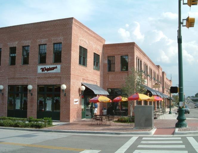
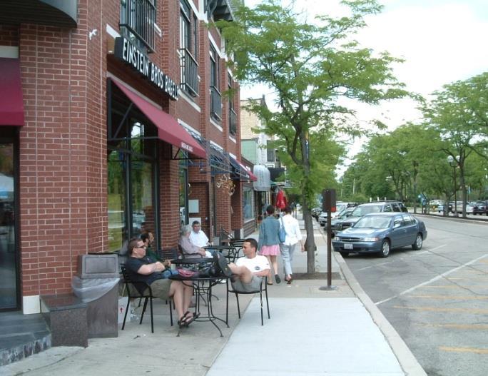
4 Applicability A. The Argyle FB Zoning Districts are intended to implement Regional Center, Village Center and Corridor land use categories of the Town s Comprehensive Plan. To that end, applicants in any of these areas shall request to rezone property to the appropriate FB Zoning District. The illustrative Zoning Framework Plans (Appendix A D) shall be used to guide the zoning change and MDP applications. B. The provisions of the Argyle FB Zoning District (this Section), when in conflict, shall take precedence over those in the Town Development Standards (TDS), as amended, except as noted herein. Development standards not addressed in this Section shall be governed by the TDS to the extent they are not in conflict with the intent or text of the Argyle FB Zoning District standards in this Section FB Zoning District Structure The following plans establish the structure within which the details of the FB Zoning Districts are calibrated to a specific MDP at the time of rezoning and development. The Zoning Framework Plans for each catalytic area establishes the recommended major street network and character zone allocations within each FB Zoning District. A. Zoning Framework Plans (ZFP) are the conceptual level plans that shall guide the establishment of the different character zones and street network at the time of rezoning of any of the four catalytic areas into a FB Zoning District. Using the recommended Zoning Framework Plans (ZFP) (Appendix A - D) and this Section, an applicant shall specify certain details of the development and may refine recommended ZFP elements per the criteria established in this Section during the rezoning and Master Development Plan (MDP) process. Four Form-Based Zoning Districts are established, each of which implements specific aspects of the Town s Comprehensive Plan. The Four FB Zoning Districts established are: Regional Center North, Regional Center South, Village Center, and Corridor Districts. Each FB Zoning District is further comprised of Character Zones that are tailored to the context of the different FB Zoning Districts. The residential densities and open space requirements in the different FB Zoning Districts shall meet the recommended guidelines in the corresponding Comprehensive Plan land use classifications in the most recently adopted Comprehensive Plan. 1. Regional Center North and Regional Center South: The Regional Center North and Regional Center South FB Zoning Districts are primarily for compact commercial and mixed use development that takes advantage of the I-35W access and frontage along the two key interchanges at FM 407 and Crawford Road/Robson Ranch Road. The Regional Center District is intended for a continuum of development from the highest intensity mixed use development immediately adjacent to the highway to the lowest intensity uses adjacent to existing neighborhoods. The Character Zones as per the ZFP recommended for the Regional Center North and Regional Center South (see Appendix A and B) FB Zoning Districts are: i. Highway Mixed Use: The Highway Mixed Use zone is intended to be the primary location of large scale retail uses and offices for business, professional and technical uses that can take advantage of the frontage and access along I-35W. Such large scale development shall transition internally to provide for pedestrian-oriented, mixed use development and connections to the Regional Center Transition and Neighborhood zones. 4 P a g e
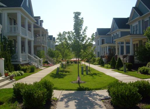
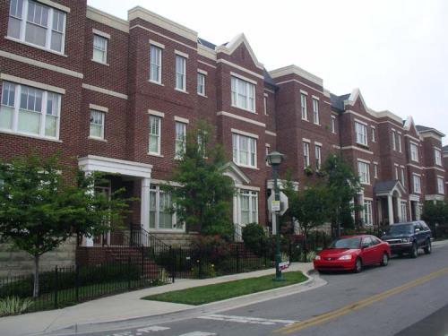
5 ii. Regional Center Transition: This zone shall provide for the use and scale transitions within a walkable neighborhood context from the highest intensity Highway Mixed Use zone to the adjoining Regional Center Neighborhood Zone. Such transitions may be in the form of smaller garden office developments, lodging uses, and urban residential uses such as stacked flats, courtyard apartments, townhomes, or live work units. iii. Regional Center Neighborhood: This zone shall provide for a range of single-family residential uses within a walkable, traditional neighborhood development context with appropriately designed open spaces and streets. 2. Village Center: The Village Center FB Zoning District is intended for a mix of neighborhoodoriented commercial, residential, and public/civic land uses. It is intended to be lower in intensity than the Regional Center area and takes advantage of the intersection of regional corridors such as US 377 and FM 407. The Character Zones as per the ZFP recommended for the Village Center (see Appendix C) are: i. Village Center Mixed Use: This zone is intended to provide for a range of neighborhood serving retail, office, and service uses in a walkable neighborhood context. Primary automobile access shall be from US 377 or FM 407, but will also have pedestrian and automobile access within the zone and to adjacent zones. It shall be generally located closer to the US 377 or FM 407 frontage in order to take advantage of visibility from these regional roadways. ii. Village Center Transition: This zone shall provide for the use and scale transitions within a walkable neighborhood context from any Village Center Mixed Use zone to the adjoining Neighborhood zone. Such transitions may be in the form of smaller garden office, live-work, and single-family residential uses. iii. Village Center Neighborhood: This zone shall provide for a range of single-family residential uses within a walkable, traditional neighborhood development context with appropriately designed open spaces and streets. 3. Corridor: The Corridor FB Zoning District is intended to provide primarily for commercial uses with complementary residential and public/civic uses along its major roadway corridor -- US 377. This area is intended to be lower in intensity than the Regional Center area. In addition, some key locations may be appropriate for destination entertainment and lifestyle uses. The Character Zones per the ZFP recommended for the Corridor FB Zoning District (see Appendix D) are: i. Corridor Mixed Use: This zone is intended to provide for a range of neighborhood serving retail, office, and service uses in a walkable neighborhood context. Primary automobile access shall be from US 377, but will also have pedestrian and automobile access within the zone and to adjacent zones. It shall be located closer to the US 377 frontage in order to take advantage of visibility from this regional roadway. ii. Destination Mixed Use: This zone is intended to provide for unique destination retail, restaurant, office, lodging, residential, and recreational uses that take advantage of a site s environmental features such as heavily wooded areas, creeks, or hills. B. Master Development Plan (MDP) In conjunction with a zoning change application, a Master Development Plan (MDP) shall establish the exact location of Character Zones, land uses and open spaces, blocks, lots, building and street layout, treatment of transition areas to adjacent uses and any other appropriate information required by this Section. The MDP shall illustrate the design direction of the site with dimensional standards that provide substantial certainty about the development outcomes, intensity, and phasing of the proposed development. It shall be created and submitted by the applicant/developer in conjunction with a zoning change request prior to any new development on the site (plat or building permit) in lieu of a Concept 5 P a g e
6 Plan requirement per Section of the Town Development Standards. For sites 20 acres or less, a Type 2 Site Plan may be filed in lieu of an MDP application per (C) at the time of rezoning application. An MDP shall meet the performance and development standards as established in this Section and shall be developed for a minimum acreage as established for each FB Zoning District even if development is phased. 1. Minimum Acreage Required: The minimum acreage required for any initial MDP (and zoning change request) shall be no smaller than one of the following: (1) all the contiguous property under one single ownership; or (2) all property under one Character Zone within any FB Zoning District per the recommended Zoning Framework Plan; or (3) all property circumscribed by any proposed new or existing streets per the Zoning Framework Plan. Smaller properties may be brought forward for a rezoning and MDP based on any of the following criteria: i. Need to accommodate existing buildings and uses on or adjacent to the subject property; or ii. Provision of cross access easements or preservation of ROW per the recommended ZFP; or iii. Need to accommodate adjoining property that has been developed under an approved MDP; or iv. The extent to which any proposed development on the subject property does not negatively impact adjoining property due to refinements to any ZFP elements. 2. Amendments to Approved Master Development Plans: After the initial MDP approval, subsequent amendments to approved MDPs shall include the entire area of the initial MDP approval regardless of the standards in (B).1. above. C. Site Plans Site plans shall be the most detailed building and lot level plans and shall be required for individual lots and/or buildings prior to Building Permit approval. The approval process for site plans shall be based on the process established for Type 1 or 2 applications in Section (B). For sites 20 acres or less, a Type 2 Site Plan (see (B.).3.ii)may be filed in lieu of an MDP application. Such an application shall combine the requirements of an MDP with a Site Plan application. D. Developer s Agreements In conjunction with any MDP application, an applicant shall also submit an application for Developer s Agreement per TDS requirements Administration A. General: No new building or structure may be erected unless in conformity with this Section. Existing non-conforming buildings may be maintained or modified per Section of the TDS. B. Authority for Approval (See Appendix E for a flow chart illustrating the Application Process): 1. Zoning Change and Zoning Framework Plans: may only be approved by Town Council after recommendation by the Planning and Zoning Commission. The process for Zoning Change applications in the TDS Section shall be followed. Modifications to 6 P a g e
7 recommended ZFPs may also be processed in conjunction with an MDP or Type 2 Site Plan applications per (B).2. and (B).3. below. 2. Master Development Plans: may only be approved by Town Council after recommendation by the Planning and Zoning Commission. The process for Concept Plan review in the TDS Section shall be followed for MDP approvals. Through the zoning change and MDP process, the Planning and Zoning Commission and Town Council may modify any ZFP element and development standard established in Section using any of the following criteria: i. The extent to which the proposed modifications to street layout and/or character zones impact adjoining properties with respect to continuity and adjacency predictability; ii. The overall purpose and intent of the FB Zoning District; iii. The extent to which the proposal fits the adjoining design context by providing appropriate building scale and use transitions; iv. The extent to which the proposal provides public benefits such as usable civic and open spaces, livable streets, a range of housing options, structured and/or shared parking, and multi-modal linkages; and v. The extent to which the proposal does not hinder future opportunities for higher intensity development. 3. Site Plans: Site Plans may be classified into Type 1 and Type 2 applications. i. Type 1 Applications: a. Shall include any new or revised Site Plans consistent with the requirements of this Section, a previously approved MDP, and applicable sections of the TDS. b. May be approved administratively by the Director of Community Development. ii. Type 2 Applications: a. Shall include any new or revised Site Plans that are NOT consistent with the requirements of this Section, an approved MDP, or applicable sections of the TDS or propose alternative standards to the standards in this Section or an approved MDP. b. May only be approved by Town Council after recommendation by the Planning and Zoning Commission. c. The process for Type 2 Applications shall follow TDS Section for Site Plans. In considering Type 2 Applications, the Planning and Zoning Commission and the Town Council may use any of the following criteria: 1) The extent to which the proposed application impacts adjoining properties with respect to continuity and adjacency predictability; 2) The extent to which the application meets the overall purpose and intent of the FB Zoning Districts; 3) The extent to which the proposal fits the adjoining design context by providing appropriate building scale and use transitions; 4) The extent to which the application provides public benefits such as usable civic and open spaces, livable streets, a range of housing options, structured and/or shared parking, and multi-modal linkages; and 5) The extent to which the application does not hinder future opportunities for higher intensity development. 7 P a g e
8 4. Developer s Agreements: may only be approved by Town Council after recommendation by the Planning and Zoning Commission in conjunction with an MDP application. The process established in the TDS shall be followed for Developer s Agreements. C. Master Development Plan Required: Prior to any new Site Plan application, an approved MDP shall be required unless the site is 20 acres or less; then see (C). The MDP shall include the minimum area as established in the Section (B) Each MDP application shall: i. demonstrate compliance with purpose, intent, and development standards of the FB Zoning District; ii. include exhibits meeting all the informational requirements for a Concept Plan under Section of the TDS, and meeting the standards of this Section and recommended ZFP including: a. Delineation of the Character Zones per the ZFP (including any modifications to recommended ZFP elements); b. The layout of proposed blocks, major and minor streets, bikeways, sidewalks, and trails; c. the location and acreage of open space areas and whether each will be privately owned, a common area for residents only or dedicated to public use; d. Type A and B Development Frontage designations based on the standards in this Section. e. A conceptual level plan for the accommodation of stormwater drainage and detention and other major water and sewer infrastructure elements for the overall area included in the MDP; f. The location and area of retail, office, industrial, residential, civic, and open space uses; g. The approximate shape, size, and placement of buildings; h. A Lighting Plan and Design Standards Detail for all infrastructure including a photometric plan; and i. The general parking location relative to streets and buildings and approximate parking count, with indication of parking lot landscape areas. iii. Include a Street Classification Master Plan with associated with cross-sections and street classifications for the proposed MDP area (or for each phase, if it is to be developed in phases) specifying right-of-way width, minimum pavement width, on-street parking, approximate location of street trees, bikeways and sidewalks (Appendix F, ITE s Designing Walkable Urban Thoroughfares manual or NACTO s Urban Street Design Guide shall guide the development of the proposed cross sections in lieu of the street standards in the TDS. See Definitions for complete citation). iv. Include a report in the form of text, statistical information, tables, guidelines, and graphics that includes: a. a statement of the purpose and intent of the proposed development consistent with the vision and ZFP for the FB Zoning District and its Character Zones; b. a description of the mix of land uses and the factors which ensure compatibility both within the development site, with adjacent land uses, and compliance with the recommendations of all the adopted elements of the Comprehensive Plan; 8 P a g e
9 c. any special standards for signage in the form of a Master Sign Plan application that provides a design palette addressing the location, size, type, lighting, colors, and materials for all signage in the proposed development unless meeting the Sign Regulations in Article IV of the TDS; d. statistical information including: 1) gross acreage of the site, and net acreage of the site excluding jurisdictional wetlands, regulatory floodplains, and slopes over 20%; 2) the amount of land devoted to open space, both in acres and as a percentage of the gross acreage of the site; 3) the amount of land devoted to retail, office, industrial, residential, and civic uses; 4) a plan for pedestrian, bicycle, and vehicular circulation describing the general design capacity of the system as well as access points to any regional trail system; 5) a daily and peak hour trip generation and directional distribution report by use unless the Town Engineer finds that the traffic to be generated by the proposed development does not warrant the preparation and submission of a study; 6) the maximum allowable building coverage and height; and 7) the minimum and maximum building setbacks. 8) Development standards for the proposed development that meet Section and specifying standards for all the flexible elements by each Character Zone within the specific MDP area in the form of a table (see Development Standard Tables in Section for criteria and format) (including any modifications to these standards and justification for such modifications); 9) Building design and general architectural design standards that meet Sections for the proposed development specifying general materials and configurations permitted for facades, roofs, and openings; 10) a landscape concept plan that includes the design direction and general approach to buffers, screening, streetscapes and public/open spaces types; and 11) a preliminary schedule for the entire development (or for each phase, if it is to be developed by phases), which shall show generally how the applicant will complete the project containing the following information: (i) The proposed order of construction by section delineated on the Master Development Plan; (ii) The proposed schedule for construction of improvements to open space areas; and (iii) The proposed schedule for the installation of required public streets, utilities improvements and the dedication of public rights-of-way and/or easements. D. Site Plans and Minor Amendments to Approved MDPs: 1. Site Plan Requirements: A Site Plan shall be required for all commercial and non-singlefamily residential (3 or more units per lot) development. Site Plans within the FB Zoning 9 P a g e
10 District shall meet the submittal requirements for Site Plans established under the Section of the TDS. Additional information that adequately illustrates the site plan s compliance with this Section and the applicable MDP may also be required. The process for approval of Site Plans is established in Section (B) The Director of Community Development may approve minor changes and modifications to an approved MDP or site plan with the applicant s written justification for such changes. Any significant changes to and deviations from approved plans shall be regarded as an amendment to that particular plan and may be reviewed by the Director of Community Development and processed per the standards established in this Section. The Director of Community Development shall make the determination as to whether a proposed change is minor or significant, based upon consideration of the following facts: i. whether the proposed change substantially alters the arrangement of character zones, buildings or changes the use of building space designated on the original plan; ii. whether there is an increase in the number of residential dwelling units beyond the threshold established in the approved MDP; iii. whether the proposed change substantially alters vehicular circulation or the placement/ arrangement of parking areas; or iv. whether the proposed change will reduce or lessen the effectiveness of open space, landscape buffers, and edges. E. Application and Fees: The applicant must submit all the required information for an MDP and Site Plan per the requirements of this Section including: 1. All information deemed necessary as is shown on the completed application checklist form provided by the Town and as filled out at the applicant s pre-application meeting with staff to discuss the details of the proposed project. A written narrative description of the proposed application may be required by staff at the time of initial meeting to ensure that all parties are aware of the proposed project s nature, extent and impact. 2. Complete applications shall be submitted and the specific number and size of copies shall be determined by the Director of Community Development. 3. Applicant shall submit the required fees as shown on the Town adopted fee schedule. 10 P a g e
11 Schedule of Uses A. No Building Permit may be issued for a use that is not allowed by this Section. B. Use Categories: In order to regulate use, categories of uses have been established. Use categories provide a systematic basis for assigning land uses to appropriate categories with other, similar uses. Use categories classify land uses and activities based on common functional, product, or physical characteristics. C. Principal Uses: Allowed principal uses by FB Zoning District and character zones are listed in Table 6-1 Permitted Use Table. Principal uses are grouped into categories of uses. The example uses listed are not an exhaustive list. The Director of Community Development has the responsibility for categorizing all uses (see Sec (G). Use Determination). D. Accessory Uses: The following standards shall apply to Accessory Uses: 1. Unless otherwise expressly stated, accessory uses are permitted in conjunction with allowed principal uses. Accessory uses shall be accessory and customarily incidental and subordinate to a permitted principal use. 2. No accessory use may be established on a site prior to the establishment of a permitted principal use. 3. The Director of Community Development is authorized to determine when a structure or use meets the definition of an accessory use. In order to classify a structure or use as accessory, the Director of Community Development must determine that the use: a. Is subordinate to the principal use in terms of area, extent and purpose; b. Contributes to the comfort, convenience or necessity of occupants of the principal use served; c. Is located on the same lot as the principal structure or use, or on a contiguous lot in the same ownership; d. Does not involve operations not in keeping with the character of the principal use served; and e. Is not of a nature likely to attract visitors in larger numbers than would normally be expected for the principal structure or use. E. Home Occupations: Shall meet the standards in Section of the TDS. F. Live-Work Uses and Structures: Live-work uses and structures are permitted per Table 6-1. A live-work structure is a mixed use building type with a dwelling unit that is also used for work purposes, provided that the work character is (1) restricted to the uses of professional office, personal service, cottage industrial, artist s workshop, studio, or other similar uses, (2) is located on the street level and ground floors constructed to Commercial Ready standards, and (3) is constructed as separate units under a condominium regime or as a single unit. The live character may be located on the street level (behind the work character) or any other level of the building. Live-work dwelling is distinguished from a home occupation otherwise defined by this Section in that the work character is not required to be incidental and secondary to the live character. Additionally, the work character may employ individuals who are not residents of the live character. G. Use Determination: The Director of Community Development is responsible for categorizing all uses. If a proposed use is not listed in a use category, but is similar to a listed use, the Director 11 P a g e
12 of Community Development shall place the proposed use under that use category. A use not specifically listed shall be prohibited unless otherwise determined using the process established in TDS Section H. Accessory Structures: All accessory structures shall be clearly subordinate to the principal structure on the lot. All accessory structures shall meet Section of the TDS unless alternative standards are proposed by the applicant and adopted as part of the MDP approval. I. Schedule of Uses: See Table P a g e
13 Land Use Table 6.1 Schedule of Uses Permitted Use = P Not Permitted = blank cell Special Use Permit (SUP) = P/SUP FB Zoning Districts Regional Center Village Center Corridor Character Zones H-MU RC-T RC-N VC-MU VC-T VC-N C-MU D-MU Commercial Uses (Office, Retail, Sales and Service Uses) Retail Sales or Service (personal service uses) with no drive through facility (no P P P P (in buildings P alcohol sales). <10,000 Excluded from this category are retail sq.ft.) sales and service establishments geared towards the automobile Auto-related Sales or Service P P P establishments Finance, Insurance, and Real Estate establishments including banks, credit unions, real estate, and property management services, with no drive through facility Offices for business, professional, administrative, and technical services such as accountants, architects, lawyers, doctors, etc. Research laboratory headquarters, laboratories and associated facilities Food Service Uses such as full-service restaurants, cafeterias, bakeries and snack bars with no drive through facilities Included in this category is café seating within a public or private sidewalk area with no obstruction of pedestrian circulation. Also included in this category is the sale of alcoholic beverages (with food service). P P P P (in buildings <10,000 sq.ft.) P P P P P P P P P P P P P P P P Alcohol Sales (retail, restaurant, etc.) SUP SUP SUP SUP SUP Pet and animal sales or service (incl. vet P P P P P clinic) Any permitted use with a drive through P SUP SUP P SUP SUP P SUP facility Arts, Entertainment, and Recreation Uses Amusement or theme park establishment (indoor) including bowling alleys, bingo parlor, games arcades, skating, etc. P SUP P Amusement or theme park establishment (outdoor) including miniature golf, go-cart tracks, etc. P Art galleries P P P P P P Art, antique, furniture or electronics studio (retail, repair or fabrication; excludes auto electronics sales or service) P P P P P P Theater, cinema, dance, or music establishment Museums and other special purpose recreational institutions Fitness, recreational sports, gym, or athletic club Parks, greens, plazas, squares, and playgrounds Educational, Public Administration, Health Care and Other Institutional Uses Business associations and professional membership organizations P P SUP SUP P P P P P P P P P P P P P P P P P P P P Child day care and preschools P P P P P P P P P P P 13 P a g e
14 Land Use Table 6.1 Schedule of Uses Permitted Use = P Not Permitted = blank cell Special Use Permit (SUP) = P/SUP FB Zoning Districts Regional Center Village Center Corridor Character Zones H-MU RC-T RC-N VC-MU VC-T VC-N C-MU D-MU Schools, libraries, and community halls P P P P P P Universities and Colleges P SUP P Technical, trade, and specialty schools P SUP P Hospitals and nursing establishments P SUP SUP P Civic uses P P P P P P Social and fraternal organizations P P P P P P Social services and philanthropic P P P P organizations Public administration uses (including local, P P P P P P state, and federal government uses, public safety, health and human services) Religious Institutions P P P P P P P P Funeral homes P Residential Uses Home Occupations P P P P P P P P Multi-family residential (residential units SUP SUP SUP* allowed on all floors) Residential Lofts (Upper floor residential P P P units only) Single-family residential attached dwelling P P P P P unit (Townhomes) (includes dwelling units detached by no more than 3 ) Single-family residential detached P P P P dwelling unit Accessory residential unit P P P Live-work unit P P P Manufacturing, transportation, communication, and utility Uses Cottage Manufacturing uses Food and textile product manufacturing Wood, paper, and printing products manufacturing Machinery, electronics, and transportation equipment manufacturing Miscellaneous manufacturing and assembly P P (included in this category are jewelry, silverware, equipment, electronics, personal metal goods, flatware, dolls, toys, games, musical instruments, office supplies, and signs.) Wholesale trade establishment Warehouse and storage services Transportation services (air, rail, road, truck and freight) Publishing (newspaper, books, periodicals, P software) Motion picture and sound recording P Telecommunications and broadcasting (radio, TV, cable, wireless communications, including stealth telecommunications towers, SUP * No more than 4 units/lot. Building must appear to be one large house with no more than one front door, although additional side and rear doors are allowed. Parking shall be from a rear driveway or alley and garages shall not face a public street. Permitted south of FM 407 only in the Village Center Mixed Use Zone Permitted on courts, mews, eyebrows, or other similar open space improvements only. Permitted south of FM 407 only in the Village Center Mixed Use Zone 14 P a g e
15 Land Use Table 6.1 Schedule of Uses Permitted Use = P Not Permitted = blank cell Special Use Permit (SUP) = P/SUP FB Zoning Districts Regional Center Village Center Corridor Character Zones H-MU RC-T RC-N VC-MU VC-T VC-N C-MU D-MU telephone, etc) Telecommunications Tower (standards in SUP SUP SUP SUP SUP SUP SUP SUP TDS shall apply) Information services and data processing P P Other Uses Hotels, full and limited service P P SUP SUP SUP Parking, surface (primary use of property) P Parking, surface (accessory use of P P P P P P P P property) Parking, structured P P P P P Private attached garage (residential) P P P P Private detached garage (residential) P P Veterinary clinic P P P P Community garden P P P P P Antennas including cell, accessory, and mounted on top of buildings. SUP SUP SUP SUP SUP SUP 15 P a g e
16 Development Standards A. Introduction: This section shall establish the overarching development standards for walkable, mixed-use development within each FB Zoning District and their Character Zones. Performance and design standards and criteria to be applied during the development of a Master Development Plan. Some standards apply to all FB Zoning Districts and other standards are specific to each FB Zoning District and/or Character Zone. B. General to all FB Zoning Districts: 1. Four (4) FB Zoning Districts are established, each of which implements specific aspects of the Town s Comprehensive Plan. They are: Regional Center North, Regional Center South, Village Center, and Corridor FB Zoning Districts. Prior to any new development within these areas and in conjunction with a zoning change application, an MDP shall be developed by the applicant/property owner or developer. Each FB Zoning District is further comprised of Character Zones per the respective recommended Zoning Framework Plan (ZFP) (Appendix A D). 2. Standards in the Argyle FB Districts are intended to facilitate the development of market responsive and unique pedestrian-friendly environments. To this end, design and development standards are intended to be tailored to create such an environment based on market-driven projects over a long-term development horizon. In order to provide flexibility in use and design with prescription of performance standards for specific building form outcomes, all applicable development standards for each FB Zoning District and Character Zone shall be established via the MDP for each proposed development. These standards shall be based on Section and the criteria in the Site Development Standards Table and shall be developed at the time of MDP by the applicant. Any modifications to standards in this Section shall be included with the MDP application. 3. General Layout Standards: In addition to meeting the recommended ZFP, any MDP within an FB Zoning District shall meet the following general standards and principles: i. Buildings and landscaping should contribute to the physical definition of Thoroughfares as Civic places. ii. Development should adequately accommodate automobiles while providing supportive design and programs/incentives to increase the use of other modes of transportation and respecting the spatial form of public areas. iii. Architecture and landscape design should grow from local climate, topography, history, and building practice. iv. Buildings should provide their inhabitants with a clear sense of geography and climate through energy efficient methods. v. Civic Buildings and public gathering places should be provided as locations that reinforce community identity and support self-government. vi. The plan should anticipate a harmonious and orderly evolution of the district based on market changes. 4. Street Design Standards: The ZFP shall guide the layout of streets and blocks in all FB Zoning Districts. The street network depicted in these ZFPs shall be illustrative only and may be refined by an applicant through the zoning change and MDP process. Appendix F, ITE s Designing Walkable Urban Thoroughfares manual or NACTO s Urban Street Design Guide shall be used to develop the Street Design Standards for all development in the Argyle FB Districts and shall meet the following performance standards: i. Streets in the Argyle FB Districts shall create a localized grid of pedestrian and vehicular travel ways. 16 P a g e
17 ii. Streets shall be designed to create a pleasant walking environment with on-street parking and streetscape treatments. iii. Cul-de-sacs are prohibited unless natural features such as topography, floodplains or stream corridors prevent a street connection. iv. Blocks may be square, elongated or irregular. Block shape and size should respond to topography, existing vegetation, hydrology, and design intentions. v. Average blocks widths shall be between 400 feet and 600 feet. Blocks should vary in size based on the FB Zoning District and character zone. vi. Blocks that are longer than 1,000 feet should be bisected by a walking path vii. The MDP shall establish the cross section standards for the different street types in the Argyle FB Zoning District. viii. The MDP shall also establish the Type A and Type B development frontage designations per the character zone standards within each Specific Focus Area. ix. Porte-cocheres, if used along Type A frontages, shall maintain the pedestrian streetscape along the edge of the street within minimal encroachments of driveways and with the utilization of street walls along the street frontage to help define the public realm. 5. Open Space Standards: The provision of adequate and appropriate open space areas shall be integral to all development in Argyle FB Zoning districts. The minimum requirement for open space in all FB Zoning districts shall be based on the recommendations in the Comprehensive Plan for the specific land use category and shall be reviewed as a part of the zoning change and MDP application.. The design of open spaces within the development shall be integrated with the design of stormwater improvements. However, no more than 25% of any required open space shall be used for stormwater improvements. The Planning and Zoning Commission and Town Council may amend open space requirements specific to each development as it pertains to the amount of open space in flood plain, stormwater improvements, and other non-usable areas that do not meet the intent of the open space requirement. In addition to the following standards for the design, location, and orientation of open space, site specific standards shall also apply based on the FB Zoning District context: i. The open space provided shall be appropriately distributed, designed and scaled in each of the FB Districts and character zones. ii. The following criteria shall be used to evaluate the merits of proposed open spaces in the Argyle FB District Master Development Plan: a. The extent to which environmental elements preserved are considered as features or focal points and integrated into and prominently featured as front yards in the development; adding value to the development; b. The extent to which emphasis has been placed on preservation of existing wooded areas, view sheds, water bodies, topography, and stream corridors in a natural and contiguous state; c. The extent to which pedestrian connectivity in the form of sidewalks, natural walking paths along stream and creek corridors has been accommodated; and d. The extent to which a range of open spaces have been provided to be contiguous with existing open spaces and to invite passive recreational uses from plazas and squares to playgrounds, parks and environmental preserves, appropriately organized within the respective character zone. 17 P a g e
18 iii. Open spaces may be in the form of plazas, pocket parks, children s play areas, squares, linear greens, parks, and environmental preserves. Active sports fields and structured recreational activities shall be limited to less than 10% of any required open space located in any Argyle FB Zoning District unless specifically approved as a part of an MDP. iv. Plazas and squares shall be permitted only in the Highway Mixed Use, Corridor Mixed Use, and Destination Mixed Use character zones. A plaza which is intended to serve as open space may be located at a street intersection or a focal point and shall generally be small in scale (under ¼ acre in size). A square which is intended to serve as open space may also be located at a street intersection or as a focal point of a development. 6. Special Designations: The following Special Designations are optional, but if used, shall be designated on the MDP: i. Mandatory and/or Recommended Commercial Ready/Active Edge Requirement: Shall be designated frontages requiring active ground floor uses for a minimum depth of 25 (no residential uses, lodging rooms, parking, or service uses permitted) and with the ground floor façade being no less than 60% glazed with windows and doors (VT higher than 0.6). Permitted character zones- Highway Mixed Use, Corridor Mixed Use, and Destination Mixed Use. ii. Designations for Mandatory and/or Recommended Gallery or Colonnade Frontage: requiring or advising that a building provide a permanent cover over the sidewalk, either cantilevered or supported by columns. The Gallery or Colonnade Frontage designation may be combined with a Commercial Ready or Active Edge Frontage designation. 7. Building Design Standards: Building design standards shall be established at the time of the MDP and shall be based on the following standards and criteria. i. Building Orientation: a. Primary Façade Orientation: Primary building facades for all non-residential and mixed use buildings shall be oriented towards a Type A frontage designation. Development standard tables in Section shall establish the minimum amount of Type A block frontage required within all the character zones. A focal point such as a landscaped street, plaza, mews, court street, similar formal open space or an environmental feature shall also be considered as a Type A frontage for the purposes of the FB Zoning Districts. b. Building Frontage: Lots and blocks along Type A frontages shall establish a minimum standard for building frontage per the Development Standards Table for each FB Zoning District and character zone. Lots and blocks along Type B frontages need not have a minimum building frontage requirement. (see illustration in the Definitions section on how building frontage is to be calculated). c. Building Setbacks and Build-to Zones: Buildings shall be built at or close to the sidewalk along Type A frontages to better define the pedestrian realm. Any surface parking frontage along Type A frontages shall be minimized, be located in the middle of the block, and screened by a minimum 3 high vegetative screen along such frontages. The specific minimum and maximum building setbacks shall 18 P a g e
19 be established by the applicant at the time of MDP application per the criteria Development Standards Table for each of the FB Zoning District character zones. ii. Building Façade Standards: a. Primary facades along Type A frontages shall contain the main entrance of any principal building located along that street. b. All principal buildings located on a Type A frontage shall also have doors, windows, and other architectural features facing that street. Non-residential or mixed use corner buildings shall have at least one customer entrance facing each street or a corner entrance instead of two entrances. c. The minimum ground floor height as measured from the finished sidewalk to the bottom of the second floor structural member for all Mandatory and/or Recommended Commercial Ready/Active Edge frontages shall be 12 feet. d. The ground floor elevation of all residential buildings (attached, detached, and stacked) located less than 10 from the front property line shall be raised a minimum of 18 above the finished level of the public sidewalk/trail in front of the residential structures. e. All development shall provide ground floor windows on the building façade facing and adjacent to a street (with the exception of alleys) or facing onto a park, plaza, or other civic space. The required area of windows and doors on each street façade along a Type A frontage, park, square, green, plaza, or other civic space as a percentage of that façade shall be established by the applicant at the time of MDP based on the specific FB Zoning District and character zone criteria. The required minimum area of windows and doors on all other street facades (Type B frontages with the exception of alleys) may be reduced by 20% of the corresponding requirement along a Type A frontage façade. Darkly tinted windows and mirrored windows that block two-way visibility shall not be permitted along ground floor facades of Type A frontages. 8. Architectural Design Standards: To ensure compatibility of building types and to relate new buildings to the building traditions of the region, architectural design shall be regulated, governed, and enforced through architectural design standards proposed by the applicant at the time of MDP. The applicant shall submit the proposed standards as a part of the MDP application for all development in the proposed MDP. The Director of Community Development shall review the proposed standards for compliance with this section and shall make a recommendation for approval or denial of the design standards for the MDP to the Planning and Zoning Commission and Town Council. Architectural design standards for a proposed development in the Argyle FB district shall: i. specify the materials and configurations permitted for walls, roofs, openings, street furniture, and other elements; ii. be based on traditional/historical building precedents from the region; iii. include the following: a. architectural compatibility among structures within the different character zones of each FB Zoning District; b. human scale design; c. pedestrian use of the entire FB Zoning District; d. relationship to the street, to surrounding buildings, and to adjoining land uses; and e. any special architectural treatment of gateways/civic buildings. 19 P a g e
20 iv. All building frontages along public and private streets (with the exception of alleys) shall break any flat, monolithic facades by including architectural elements such as bay windows, recessed entrances, or other articulations so as to provide pedestrian interest along the street level façade including discernible and architecturally appropriate features such as, but not limited to, porches, cornices, bases, fenestration, fluted masonry, bays, recesses, arcades, display windows, unique entry areas, plazas, courts, or other treatments to create visual interest, community character, and promote a sense of pedestrian scale. v. All buildings in any Argyle FB zoning district shall be constructed with exterior building materials and finishes of a quality to convey an impression of permanence and durability. Materials such as masonry (stone, brick, 3-step stucco) and similar durable architectural materials are allowed as primary building materials and shall be approved with the MDP for the district. vi. Non-residential buildings and sites shall be organized to group the utilitarian functions away from the public view of any street (with the exception of alleys). Delivery and loading operations, HVAC equipment, trash compacting and collection, and other utility and service functions shall be incorporated into the overall design of the buildings and landscaping. The visual and acoustic impacts of all mechanical, electrical, and communications equipment (ground and roof-mounted) shall not be visible from adjacent properties and public streets, and screening materials and landscape screens shall be architecturally compatible with and similar to the building materials of the principal structures on the lot. 9. Location and Design of Parking and Service Areas: During the MDP process, the applicant shall provide standards for the quantity of off-street parking proposed (both automobile and bicycle parking) in the Argyle FB zoning districts including within each character zone based on an analysis of the parking demand and a transportation management study for the mix of uses proposed and availability of on-street parking. The MDP shall establish the parking standards based on documented parking demand and transportation management study provided by the applicant. Parking standards in TDS Section shall apply if the applicant does not establish alternative parking standards during the MDP application. In addition, the location of surface parking on individual lots shall be regulated as follows: i. All surface parking lots for non-residential uses shall be located at the side or rear of a building. Specifically, the frontage of surface parking lots shall be minimized along Type A frontage designations. If located adjacent to a Type B frontage or a residential use, screening shall be provided in the form of a landscaped/vegetative or combination fence which is at least 3 feet in height. ii. A surface parking lot may not be adjacent to a street intersection with a Type A frontage or civic space such as a plaza or square, or occupy a lot that terminates a street vista. iii. Shared parking facilities are encouraged for non-residential uses in all Argyle FB Districts. iv. Bicycle parking shall be provided for non-residential uses, multi-family uses, especially for schools, parks, trails, and other recreational facilities. Bicycle parking shall be provided at a rate of 5% of all off-street automobile parking spaces provided for all non single-family residential uses (attached and detached). Bicycle parking may be 20 P a g e

21 shared between uses and should be centrally located, easily accessible, covered/protected from the elements, lit at night, and visible from streets or parking lots. They may be located between the roadway and the building facades as long as their location does not impede pedestrian walkways. v. Any off-street parking provided for residential uses shall be located in such a manner as to minimize the impact of garages and driveways along the residential street. All residential lots that are 40 feet or less in width shall have off-street parking and/or garages accessed from alleys. All lots wider than 50 feet may have front loaded garages, but in no case shall the width of the garage exceed 50% of the front façade width of the entire building or 24 (whichever is smaller). In addition, the garage shall be set back at least ten (10) feet from the front façade of the home. 10. Design of Automobile Related Site Elements (Drive Throughs, service bays, etc.): i. Drive-through lanes, drive up windows, service bays, and other auto-related site elements shall not be located along or be visible from any Type A Frontages. ii. Along Type B Frontages, no more than 60% of the lot s frontage along a Type B Frontage shall be dedicated to auto-related site elements. iii. Drive-through lanes shall be hidden behind a screening device (min. 3 in height) along the Type B frontage. There shall be no limit to the number or frontage of drivethrough lanes located along alleys. iv. All off-street loading, unloading, and trash pick-up areas shall be located along alleys only. Such uses may be located along Type B Frontages only if the lot has no access to an alley. Any off-street loading, unloading, or trash pick-up areas shall be screened in accordance with Section (A).9. v. Driveways shall be located along Type B Frontages unless the site has no access to a Type B Frontage or alley. Driveway widths shall be a maximum of 24 unless providing service access in which case they shall be no wider than 30. Driveways shall maintain a continuous and level sidewalk across the curb cut. Driveway spacing shall be per the Town Development Standards or as approved by the Town Engineer. Driveways along US 377, FM 407 and I-35W access road are under the purview of Texas Department of Transportation (TxDOT) and shall meet TxDOT standards. 11. Design of Parking Structures Image showing appropriate design of auto-related site elements 21 P a g e
 shall be designed with both vertical (façade rhythm of 20 30 ) and horizontal (aligning with horizontal elements in the block)")


22 i. All frontages of parking structures located on Type A frontages shall be lined by active edges or commercial ready frontages on the ground floor to a minimum depth of 25. ii. Parking structure facades on all public streets (except alleys) shall be designed with both vertical (façade rhythm of ) and horizontal (aligning with horizontal elements in the block) articulation. iii. Where above ground structured parking is located at the perimeter of a building, it shall be screened in such a way that cars on all parking levels are not visible from adjacent buildings or the street. Parking garage ramps shall not be visible from any public street. Ramps shall not be located along the perimeter of the parking structure with frontage along a Type A designation. Architectural screens shall be used to articulate the façade, hide parked vehicles, and shield car bumpers and headlights. 12. Landscaping Standards Images showing appropriate design of parking structures i. The purpose of landscaping in the Argyle FB Zoning District is to enhance pedestrian and open space areas, to help delineate active areas from passive areas, to provide a screening buffer between pedestrians and vehicular circulation, utility functions, and incompatible adjacent developments. ii. The applicant shall submit a landscape concept plan in conjunction with an MDP application. The landscape concept plan establishes the design direction and general schematics for all proposed landscaping including all major aspects of the public realm, streetscape treatments, open space types, and any special treatments. iii. Proposed landscaping concept plan shall meet the following standards: a. Be pedestrian oriented. b. Designed in such a way to not create a security or physical hazard to pedestrians, bicyclists or motorists. c. Enhance or complement the architectural design of the mixed-use development. d. Provide visual interest year-round. Utilize water conservation methods and drought tolerant planting where possible. e. Shall be provided between parking lots and all adjacent sidewalks. 22 P a g e
23 f. Meet the standards for Installation and Maintenance in the Town Development Standards Section iv. Landscaping along I-35W, US 377, and FM 407: The frontages of these major roadways shall be treated differently from internal streets within the FB Zoning Districts. The following minimum standards shall apply (unless alternative standards are proposed by the applicant and approved as part of the MDP): a. A landscaped yard of a minimum width of 20 shall be required on all lots with frontage along I-35W, US 377, and FM 407. b. Landscaping required: The following plantings shall be required within the required yard per every 100 of linear frontage along the specific roadway: 1) 3 shade trees 2) 6 ornamental trees, 3) 8 shrubs 4) Ground cover, ornamental grasses, or turf grasses for the remaining unpaved areas c. A minimum six (6) foot wide sidewalk shall be required along these frontages. Such a facility may be placed within the required 20 yard. In lieu of a sidewalk along the I-35W frontage roads, alternative pedestrian connectivity alignments may be proposed by an applicant and approved through the MDP process. 23 P a g e
24 C. Specific to the Regional Center North and Regional Center South FB Zoning Districts 1. An MDP and associated standards shall be developed by the applicant/developer to meet the standards and performance criteria in this Section and the recommended ZFPs (Appendix A and B). 2. Development Standards: i. Standards in the Regional Center North and South FB Zoning Districts are intended to facilitate the development of unique and pedestrian-friendly environments. To this end, design and development standards are intended to be tailored to create such an environment. In order to provide flexibility in use with prescription of the building form, all applicable development standards for each development shall be established via the MDP consistent with the requirements in this Section and the recommended ZFP. If there are any conflicts between standards in Regional Center Development Standards Table below and any other standards in the Town Development Standards, then standards in Development Standards Table below shall prevail. ii. The following standards shall apply to all development in the Regional Center North and South FB Zoning Districts. Most standards have a numerical range and few have a specific numerical value. Due to the inapplicability of one development standard across all developments in the Regional Center and its character zones, and to encourage a diversity of development proposals, the developer shall propose the standards indicated as Flexible or Permitted/Flexible on the following table for the proposed development at the time of MDP application submittal including any proposed modifications to standards. 24 P a g e
25 Regional Center North and South FB Zoning Districts DEVELOPMENT STANDARDS TABLE Development Standard Highway Mixed Use Regional Center - Transition Regional Center - Neighborhood 1.0 Building and Site Standards a. Principal Building Height* 10 stories or 130 (maximum) 4 stories or 50 (maximum) 3 stories or 40 (maximum) * Building height shall be measured in number of stories. Habitable attics and mezzanines shall be excluded from the height calculation as long as they do not exceed 50% of the floor area of a typical floor in the same building. b. Setbacks and build-to zones** Front Type A Frontages Min. setback = Required/Flexible; Max. setback = 25 Min. setback = Required/Flexible; Max. setback = 30 Min. setback = Required/Flexible; Max. setback = 40 Front I-35W Frontage Min. setback = 20 ; N/A N/A Road Max. setback = Flexible Type B Frontages Min. setback = 5 ; Max. setback = Flexible Min. setback = 5 ; Max. setback = Flexible Min. setback = 10 ; Max. setback = Flexible Side Flexible Flexible Flexible Rear Flexible Flexible Flexible **Minimum and/or maximum setback standards shall be proposed by the applicant for each character zone based on the above criteria and Development Standards established in Section (B).7 of this Section. c. Minimum Building Frontage Type A Frontages 70% 50% None required All other frontages None required None required None required Corner building facades at street intersections shall be built to the build-to-zone for a minimum of 30 from the corner along both streets or the width of the corner lot, whichever is less. This standard shall apply to any street intersection with a Type A Frontage (even if the cross street has a Type B Frontage designation). d. Accessory buildings Permitted/Flexible Permitted/Flexible Permitted/Flexible Standards for accessory uses and structures shall be provided by the applicant. The standards shall result in accessory buildings being subordinate in size and scale to the principal building. Standards in TDS Section shall apply if the applicant does not specifically provide regulations for accessory uses and structures. e. Principal building orientation Buildings shall be oriented to a Type A frontage or toward another focal point such as a park, plaza, square, other open space or environmental feature. See subsection (B).7 for additional requirements. f. Building façade & architectural design standards The applicant shall propose appropriate building façade and architectural design standards for all the character zones in the development with the application for Master Development Plan. They shall be based on the criteria established in subsections (B).8 of this Section. 2.0 Block and Lot Standards a. Block Type Regular (square or rectangular) Irregular blocks may be permitted only if natural topography and/or vegetation prevents a rectilinear grid Regular or irregular (square, rectangular, or curvilinear based on topography and vegetation) b. Block Perimeter Max. block perimeter = 2,400 Max. block perimeter = 1,600 Max. block perimeter = 2,000 (unless limited by unique site conditions such as topography and vegetation) c. Type A Frontage Designation (Frontages along civic/open spaces shall be considered Type A frontage) Minimum of 15% of all new block frontages to be designated as Type A Frontage Minimum of 25% of all new block frontages to be designated as Type A Frontage d. Lot Area Flexible Flexible Flexible e. Lot Width and Depth Flexible Flexible Flexible f. Maximum Lot Coverage Flexible Flexible Flexible g. Maximum Impervious Cover Flexible for each character zone. Average overall site impervious cover shall not exceed 80%. The development shall meet stormwater drainage requirements in the Town Development Standards unless the applicant proposed Light Impact Stromwater Design (LID) techniques subject to approval by the Town Engineer. 3.0 Street Design Standards (This standard applies to all new streets, public and private, located in the Regional Center North and South FB Zoning District) Street design standards in the FB Districts shall be based upon creating a safe and inviting walking environment through an interconnected network of roads with sidewalks, street trees, street furniture, and amenities. Cul-de-sacs are prohibited unless natural features such as topography or stream corridors prevent a street connection. The right-of-way widths for streets in any Argyle FB Zoning District shall depend on the street typology and streetscape standards proposed by the applicant and approved in conjunction with the MDP application by the Town Engineer. See Appendix F, Section (B).4 of this Section and criteria below for Street Design Standards within the Regional Center North and South FB Zoning Districts, subject to the approval of the Town Engineer. NA 25 P a g e
26 Regional Center North and South FB Zoning Districts DEVELOPMENT STANDARDS TABLE Development Standard Highway Mixed Use Regional Center - Transition Regional Center - Neighborhood a. Design speed See Appendix F for design speed ranges per street type. b. Street types allowed i. Boulevards: 4-lane divided) i. Boulevards: 4-lane divided) ii. Avenues: 3-lane divided ii. Avenues: 3-lane divided iii. Main streets iv. Residential streets: 2-lane undivided iii. Residential streets: 2-lane undivided iv. Commercial and Residential v. Commercial Alleys Alleys i. Boulevards: 4-lane divided) ii. Avenues: 3-lane divided iii. Residential streets: 2-lane undivided iv. Residential Alleys c. Travel lane widths Appendix F, ITE s Designing Walkable Urban Thoroughfares manual or NACTO s Urban Street Design Guide shall guide the development of street design standards and shall be established as part of the MDP with the approval of d. Turning radii the Town Engineer. e. On-street Parking (along all internal streets except alleys) Parallel Permitted Permitted Permitted Angled (head-in or reverse angled). Permitted Permitted Not permitted Head in perpendicular Not permitted Not permitted Not permitted f. Parking lane width Parallel Angled 8 feet 9 feet X feet 8 feet 9 feet X feet 7-8 feet N/A g. Alleys ** Permitted/Flexible Permitted/Flexible Permitted/Flexible 4.0 Streetscape Standards (Shall not include I-35W Frontage Road) a. Sidewalks/Trails/ Walkways 10 feet (min. along Type A frontages) 5 feet (minimum along all other streets except alleys) 5 feet (minimum) 5 feet (minimum) b. Planter/Planting Strip Type Required - Tree wells or Planters Required - Tree wells or Planters Required - Planters c. Planter/Planting Strip 6feet (min.) wide tree well or 6 feet (min.) wide tree well or 6 feet (min.) wide planting strip width planting strip planting strip d. Street trees Required/Flexible Required/Flexible Required/Flexible The applicant shall submit a Landscape Concept Plan, which shall be reviewed as part of the MDP and must be approved by at time of Master Development Plan. The requirements for the landscape concept plan are outlined in section (B).12 of this Section. 5.0 Open/Civic Space Standards a. Open/Civic Space Required/Flexible Squares and plazas are appropriate Required/Flexible, Squares and greens are appropriate Required/Flexible, Squares and greens are appropriate *Overall open/civic space allocations in the FB Zoning district shall be a minimum of 20% of the gross area of the entire site included in the MDP and shall be distributed appropriately between the character zones. The location and design of appropriate open spaces shall be based on Section (B).5. of this Section. 6.0 Parking & Screening Standards a. Off-street parking The applicant shall propose off-street parking standards appropriate to serve the proposed uses in the FB Zoning District. Standards in Town Development Standards Section shall apply if alternative standards are not established through the Master Development Plan. Sections B.9 and B.11 shall regulate the location and design of all proposed off-street parking including any structured parking proposed. Parking standards in the FB Zoning District are intended to be flexible due to the mixed use nature, shared parking opportunities, and availability of on-street parking. b. Off-street loading Section of the Town Development Standards applies unless alternative standards are provided N/A c. Screening 1. Trash/recycling receptacles Required/Flexible 2. Other utility equipment See Sec (B).8 and (B).9 Required for non-residential uses Flexible for residential uses (along alleys if alleys are provided) Flexible for residential uses (along alleys if alleys are provided) 3. Loading spaces Screening required for non-residential uses. Section of the Town Development Standards applies only to non-residential uses unless alternative standards are provided ** Alleys shall be required for all residential development with lots 40 feet or less in width. 26 P a g e
27 Regional Center North and South FB Zoning Districts DEVELOPMENT STANDARDS TABLE Development Standard Highway Mixed Use Regional Center - Transition Regional Center - Neighborhood 4. Surface parking areas Required/Flexible (Standards in B.9 shall apply to any surface parking located along any public street with the exception of alleys unless the applicant proposes alternative screening standards at the time of Master Development Plan. ) 7.0 Landscape and Streetscape a. Landscaping # 1. Landscape buffer between surface parking and sidewalks/trails and streets (except alleys) 2. Parking lot minimum interior landscaping Required/Flexible Required only for non-residential uses N/A Flexible Flexible N/A # The applicant shall submit a Landscape Concept Plan, which shall be reviewed as part of the MDP and must be approved at time of Master Development Plan. The requirements for the landscape concept plan are outlined in section (B).12 of this Section. Information provided at the MDP phase may be schematic meeting the design intent of the proposed development. Detailed landscaping plans shall be required at the site plan stage for all non-residential development. b. Lighting 1. Street Lighting 2. Building entrances 3. Parking areas, trails, and streets 8.0 Signs Required/Flexible (As a part of the MDP or Site Plan application, the applicant shall propose lighting standards that includes street light standards and other amenities as a part of the streetscape treatment plan. The landscape concept plan may be combined with a concept plan for lighting. ) Flexible (Flexible signage in the Regional Center FB Zoning District may be proposed by the applicant and approved by the Planning and Zoning Commission as part of the MDP application or as a separate Master Sign Plan. Signage in the Regional Center FB Zoning District shall integrate the streetscape and architectural design of the district through a palette of signs that enhance the pedestrian environment and create a unique identity. If no standards are proposed by the applicant, standards in Article IV, Section of the Town Development Standards shall apply.) 27 P a g e
28 D. Specific to the Village Center FB Zoning District 1. An MDP and associated standards shall be developed by the applicant/developer to meet the recommended ZFP (Appendix C) and standards and performance criteria in this Section. 2. Development Standards: i. Standards in the Village Center FB Zoning District are intended to facilitate the development of unique and pedestrian-friendly environments. To this end, design and development standards are intended to be tailored to create such an environment. In order to provide flexibility in use with prescription of the building form, all applicable development standards for each development shall be established via the MDP consistent with the recommended ZFP and requirements in this Section. If there are any conflicts between standards in Village Center Development Standards Table below and any other standards in the Town Development Standards, then standards in Development Standards Table below shall prevail. ii. The following standards shall apply to all development in the Village Center FB Zoning District. Most standards have a numerical range and few have a specific numerical value. Due to the inapplicability of one development standard across all developments in the Village Center and its character zones, and to encourage a diversity of development proposals, the developer shall propose the standards indicated as Flexible or Permitted/Flexible on the following table for the proposed development at the time of MDP application submittal including any proposed modifications to standards. 28 P a g e
29 Village Center FB Zoning District DEVELOPMENT STANDARDS TABLE Development Standard Village Center - Mixed Use Village Center - Transition Village Center - Neighborhood 1.0 Building and Site Standards a. Principal Building Height* 3 stories or 40 by right 3 stories or 40 by right 3 stories or 40 (maximum) * Building height shall be measured in number of stories. Habitable attics and mezzanines shall be excluded from the height calculation as long as they do not exceed 50% of the floor area of a typical floor in the same building. b. Setbacks and build-to zones** Front Type A Frontages Min. setback = Required/Flexible; Max. setback = 25 Front US 377 or FM 407 Min. setback = 20 ; Max. setback = Flexible Type B Frontages Min. setback = 5 ; Max. setback = Flexible Min. setback = Required/Flexible; Max. setback = 30 Min. setback = 5 ; Max. setback = Flexible Side Flexible Flexible Flexible Min. setback = Required/Flexible; Max. setback = 40 Min. setback = 10 ; Max. setback = Flexible Rear Flexible Flexible Flexible **Minimum and/or maximum setback standards shall be proposed by the applicant for each character zone based on the above criteria and Development Standards established in Section (B).7 of this Section. c. Minimum Building Frontage Type A Frontages 70% 60% 60% All other frontages None required None required None required Corner building facades at street intersections shall be built to the build-to-zone for a minimum of 30 from the corner along both streets or the width of the corner lot, whichever is less. This standard shall apply to any street intersection with a Type A Frontage (even if the cross street has a Type B Frontage designation). d. Accessory buildings Permitted/Flexible Permitted/Flexible Permitted/Flexible Standards for accessory uses and structures shall be provided by the applicant. The standards shall result in accessory buildings being subordinate in size and scale to the principal building. Standards in TDS Section shall apply if the applicant does not specifically provide regulations for accessory uses and structures. e. Principal building orientation Buildings shall be oriented to a Type A frontage or toward another focal point such as a park, plaza, square, other open space or environmental feature. See subsection (B).7 for additional requirements. f. Building façade & architectural design standards The applicant shall propose appropriate building façade and architectural design standards for all the character zones in the development with the application for Master Development Plan. They shall be based on the criteria established in subsections (B).8 of this Section. 2.0 Block and Lot Standards a. Block Type Regular (square or rectangular) Irregular blocks may be permitted only if natural topography and/or vegetation prevents a rectilinear grid Regular or irregular (square, rectangular, or curvilinear based on topography and vegetation) b. Block Perimeter Max. block perimeter = 2,000 Max. block perimeter = 1,600 Max. block perimeter = 2,000 (unless limited by unique site conditions such as topography and vegetation) c. Type A Frontage Designation (Frontages along civic/open spaces shall be considered Type A frontage) Minimum of 15% of all new block frontages to be designated as Type A Frontage Minimum of 25% of all new block frontages to be designated as Type A Frontage Minimum of 50% of all new block frontages to be designated as Type A Frontage d. Lot Area Flexible Flexible Flexible e. Lot Width and Depth Flexible Flexible Flexible f. Maximum Lot Coverage Flexible Flexible Flexible g. Maximum Impervious Cover Flexible for each character zone. Average overall site impervious cover shall not exceed 70%. The development shall meet stormwater drainage requirements in the Town Development Standards unless the applicant proposed Light Impact Stromwater Design (LID) techniques subject to approval by the Town Engineer. 3.0 Street Design Standards (This standard applies to all new streets, public and private, located in the Village Center FB Zoning District) Street design standards in the FB District shall be based upon creating a safe and inviting walking environment through an interconnected network of roads with sidewalks, street trees, street furniture, and amenities. Cul-de-sacs are prohibited unless natural features such as topography or stream corridors prevent a street connection. The right-of-way widths for streets in the Argyle FB shall depend on the street typology and streetscape standards proposed by the applicant and approved in conjunction with the MDP application by the Town Engineer. See Appendix F, (B).4 of this Section and criteria below for Street Design Standards within the Village Center FB Zoning District, subject to the approval of the Town Engineer. 29 P a g e
30 Village Center FB Zoning District DEVELOPMENT STANDARDS TABLE Development Standard Village Center - Mixed Use Village Center - Transition Village Center - Neighborhood a. Design speed See Appendix F for design speed ranges per street type. b. Street types allowed i. Boulevards: 4-lane divided) i. Boulevards: 4-lane divided) ii. Avenues: 3-lane divided ii. Avenues: 3-lane divided iii. Main streets iv. Residential streets: 2-lane undivided iii. Residential streets: 2-lane undivided iv. Commercial and Residential v. Commercial Alleys Alleys i. Boulevards: 4-lane divided) ii. Avenues: 3-lane divided iii. Residential streets: 2-lane undivided iv. Residential Alleys c. Travel lane widths Appendix F, ITE s Designing Walkable Urban Thoroughfares manual or NACTO s Urban Street Design Guide shall guide the development of street design standards and shall be established as part of the MDP with the approval of d. Turning radii the Town Engineer. e. On-street Parking (along all internal streets except alleys) Parallel Permitted Permitted Permitted Angled (head-in or reverse angled). Permitted Permitted Not permitted Head in perpendicular Not permitted Not permitted Not permitted f. Parking lane width Parallel Angled 8 feet 9 feet X feet 8 feet 9 feet X feet 7-8 feet N/A g. Alleys Permitted/Flexible Permitted/Flexible Permitted/Flexible 4.0 Streetscape Standards (Shall not include US 377 and FM 407 Frontages) a. Sidewalks/Trails/ Walkways 10 feet (min. along Type A 5 feet (minimum) 5 feet (minimum) frontages) 5 feet (minimum along all other streets except alleys) b. Planter/Planting Strip Type Required - Tree wells or Planters Required - Tree wells or Planters Required - Planters c. Planter/Planting Strip width 6 feet (min.) wide tree well or planting strip 6 feet (min.) wide tree well or planting strip 6 feet (min.) wide planting strip d. Street trees Required/Flexible Required/Flexible Required/Flexible The applicant shall submit a Landscape Concept Plan, which shall be reviewed as part of the MDP and must be approved by at time of Master Development Plan. The requirements for the landscape concept plan are outlined in Section (B).12 of this Section. 5.0 Open/Civic Space Standards a. Open/Civic Space Required/Flexible Squares and plazas are appropriate Required/Flexible, Squares and greens are appropriate Required/Flexible, Squares and greens are appropriate *Overall open/civic space allocations in the FB Zoning district shall be a minimum of 15% of the gross area of the entire site included in the MDP and shall be distributed appropriately between the character zones. The location and design of appropriate open spaces shall be based on Section (B).5. of this Section. 6.0 Parking & Screening Standards a. Off-street parking The applicant shall propose off-street parking standards appropriate to serve the proposed uses in the FB Zoning District. Standards in Town Development Standards Section shall apply if alternative standards are not established through the Master Development Plan. Sections (B).9 and (B).11 shall regulate the location and design of all proposed off-street parking including any structured parking proposed. Parking standards in the FB Zoning District are intended to be flexible due to the mixed use nature, shared parking opportunities, and availability of on-street parking. b. Off-street loading Section of the Town Development Standards applies unless alternative standards are provided N/A c. Screening 1. Trash/recycling receptacles Required/Flexible 2. Other utility equipment See Sec (B).8 and (B).9 Required for non-residential uses Flexible for residential uses (along alleys if alleys are provided) Flexible for residential uses (along alleys if alleys are provided) 3. Loading spaces Screening required for non-residential uses. Section of the Town Development Standards applies only to non-residential uses unless alternative standards are provided Alleys shall be required for all residential development with lots 40 feet or less in width. 30 P a g e
31 Village Center FB Zoning District DEVELOPMENT STANDARDS TABLE Development Standard Village Center - Mixed Use Village Center - Transition Village Center - Neighborhood 4. Surface parking areas Required/Flexible (Standards in (B).9 shall apply to any surface parking located along any public street with the exception of alleys unless the applicant proposes alternative screening standards at the time of Master Development Plan. ) 7.0 Landscape and Streetscape a. Landscaping # 1. Landscape buffer between surface parking and sidewalks/trails and streets (except alleys) 2. Parking lot minimum interior landscaping Required/Flexible Required only for non-residential uses N/A Flexible Flexible N/A # The applicant shall submit a Landscape Concept Plan, which shall be reviewed as part of the MDP and must be approved by at time of Master Development Plan. The requirements for the landscape concept plan are outlined in section (B).12 of this Section. Information provided at the MDP phase may be schematic meeting the design intent of the proposed development. Detailed landscaping plans shall be required at the site plan stage for all non-residential development. b. Lighting 1. Street Lighting 2. Building entrances 3. Parking areas, trails, and streets Required/Flexible (As a part of the MDP or Site Plan application, the applicant shall propose lighting standards that includes street light standards and other amenities as a part of the streetscape treatment plan. The landscape concept plan may be combined with a concept plan for lighting.) 8.0 Signs Flexible (Flexible signage in the Village Center FB Zoning District may be proposed by the applicant and approved by the Planning and Zoning Commission as part of the MDP application or as a separate Master Sign Plan. Signage in the Village Center FB Zoning District shall integrate the streetscape and architectural design of the district through a palette of signs that enhance the pedestrian environment and create a unique identity. If no standards are proposed by the applicant, standards in Article IV, Section of the Town Development Standards shall apply.) 31 P a g e
32 E. Specific to the Corridor FB Zoning District 1. An MDP and associated standards shall be developed by the applicant/developer to meet the recommended ZFP (Appendix D) and standards and performance criteria in this Section. 2. Development Standards: i. Standards in the Corridor FB Zoning District are intended to facilitate the development of unique and pedestrian-friendly environments. To this end, design and development standards are intended to be tailored to create such an environment. In order to provide flexibility in use with prescription of the building form, all applicable development standards for each development shall be established via the MDP consistent with the recommended ZFP and requirements in this Section. If there are any conflicts between standards in Corridor Development Standards Table below and any other standards in the Town Development Standards, then standards in Development Standards Table below shall prevail. ii. The following standards shall apply to all development in the Corridor FB Zoning District. Most standards have a numerical range and few have a specific numerical value. Due to the inapplicability of one development standard across all developments in the Corridor FB character zones, and to encourage a diversity of development proposals, the developer shall propose the standards indicated as Flexible or Permitted/Flexible on the following table for the proposed development at the time of MDP application submittal including any proposed modifications to standards. 32 P a g e
33 Corridor FB Zoning District DEVELOPMENT STANDARDS TABLE Development Standard Corridor Mixed Use Destination Mixed Use 1.0 Building and Site Standards a. Principal Building Height* 3 stories or 40 by right 3 stories or 40 by right * Building height shall be measured in number of stories. Habitable attics and mezzanines shall be excluded from the height calculation as long as they do not exceed 50% of the floor area of a typical floor in the same building. b. Setbacks and build-to zones** Front Type A Frontages Min. setback = Required/Flexible; Max. setback = 25 Min. setback =Required/Flexible Max. setback = 40 Front US 377 or FM 407 Min. setback = 20 ; Max. setback = Flexible Min. setback = 20 ; Max. setback = Flexible Type B Frontages Min. setback = 5 ; Max. setback = Flexible Min. setback = 5 ; Max. setback = Flexible Side Flexible Flexible Rear Flexible Flexible **Minimum and/or maximum setback standards shall be proposed by the applicant for each character zone based on the above criteria and Development Standards established in Section (B).7 of this Section. c. Minimum Building Frontage Type A Frontages 70% 70% All other frontages None required None required Corner building facades at street intersections shall be built to the build-to-zone for a minimum of 30 from the corner along both streets or the width of the corner lot, whichever is less. This standard shall apply to any street intersection with a Type A frontage (even if the cross street has a Type B frontage designation). d. Accessory buildings Permitted/Flexible Permitted/Flexible Standards for accessory uses and structures shall be provided by the applicant. The standards shall result in accessory buildings being subordinate in size and scale to the principal building. Standards in TDS Section shall apply if the applicant does not specifically provide regulations for accessory uses and structures. e. Principal building orientation Buildings shall be oriented to a Type A frontage or toward another focal point such as a park, plaza, square, other open space or environmental feature. See subsection (B).7 for additional requirements. f. Building façade & architectural design standards The applicant shall propose appropriate building façade and architectural design standards for all the character zones in the development with the application for Master Development Plan. They shall be based on the criteria established in subsection (B).8 of this Section. 2.0 Block and Lot Standards a. Block Type Regular (square or rectangular) Irregular blocks may be permitted only if natural topography and/or vegetation prevents a rectilinear grid b. Block Perimeter Max. block perimeter = 2,000 Max. block perimeter = 1,600 c. Type A Frontage (Frontages along civic/open spaces shall be considered Type A frontage) Minimum of 15% of all new block frontages to be designated as Type A Frontage Minimum of 15% of all new block frontages to be designated as Type A Frontage d. Lot Area Flexible Flexible e. Lot Width and Depth Flexible Flexible f. Maximum Lot Coverage Flexible Flexible g. Maximum Impervious Cover Flexible for each character zone. Average overall site impervious cover shall not exceed 70%. The development shall meet stormwater drainage requirements in the Town Development Standards unless the applicant proposed Light Impact Stormwater Design (LID) techniques subject to approval by the Town Engineer. 3.0 Street Design Standards (This standard applies to all new streets, public and private, located in the Corridor FB Zoning District) Street design standards in the FB District shall be based upon creating a safe and inviting walking environment through an interconnected network of roads with sidewalks, street trees, street furniture, and amenities. Cul-de-sacs are prohibited unless natural features such as topography or stream corridors prevent a street connection. The right-of-way widths for streets in the Argyle FB Districts shall depend on the street typology and streetscape standards proposed by the applicant and approved in conjunction with the MDP application by the Town Engineer. See Appendix F, Section (B).4 of this Section and criteria below for Street Design Standards within the Corridor FB Zoning District, subject to the approval of the Town Engineer. 33 P a g e
34 Corridor FB Zoning District DEVELOPMENT STANDARDS TABLE Development Standard Corridor Mixed Use Destination Mixed Use a. Design speed See Appendix F for design speed ranges per street type. b. Street types allowed i. Boulevards: 4-lane divided) i. Boulevards: 4-lane divided) ii. Avenues: 3-lane divided ii. Avenues: 3-lane divided iii. Main streets iv. Residential streets: 2-lane undivided iii. Residential streets: 2-lane undivided iv. Commercial and Residential Alleys v. Commercial Alleys c. Travel lane widths Appendix F, ITE s Designing Walkable Urban Thoroughfares manual or NACTO s Urban Street Design d. Turning radii Guide shall guide the development of street design standards and shall be established as part of the MDP with the approval of the Town Engineer. e. On-street Parking (along all internal streets except alleys) Parallel Permitted Permitted Angled (head-in or reverse angled). Permitted Permitted Head in perpendicular Not permitted Not permitted f. Parking lane width Parallel Angled 8 feet 9 feet X feet 8 feet 9 feet X feet g. Alleys Permitted/Flexible Permitted/Flexible 4.0 Streetscape Standards (Shall not include US 377 and FM 407 Frontages) a. Sidewalks/Trails/ Walkways 10 feet (min. along Type A frontages) 5 feet (minimum) 5 feet (minimum along all other streets except alleys) b. Planter/Planting Strip Type Required - Tree wells or Planters Required - Tree wells or Planters c. Planter/Planting Strip width 6 feet (min.) wide tree well or planting strip 6 feet (min.) wide tree well or planting strip d. Street trees Required/Flexible Required/Flexible The applicant shall submit a Landscape Concept Plan, which shall be reviewed as part of the MDP and must be approved by at time of Master Development Plan. The requirements for the landscape concept plan are outlined in section (B).12 of this Section. 5.0 Open/Civic Space Standards a. Open/Civic Space Required/Flexible Squares and plazas are appropriate Required/Flexible, Squares and greens are appropriate *Overall open/civic space allocations in the FB Zoning district shall be a minimum of 15% of the gross area of the entire site included in the MDP and shall be distributed appropriately between the character zones. The location and design of appropriate open spaces shall be based on Section (B).6. of this Section. 6.0 Parking & Screening Standards a. Off-street parking The applicant shall propose off-street parking standards appropriate to serve the proposed uses in the FB Zoning District. Standards in Town Development Standards Section shall apply if alternative standards are not established through the Master Development Plan. Sections (B).9 and (B).11 shall regulate the location and design of all proposed off-street parking including any structured parking proposed. Parking standards in the FB Zoning District are intended to be flexible due to the mixed use nature, shared parking opportunities, and availability of on-street parking. b. Off-street loading Section of the Town Development Standards applies unless alternative standards are provided c. Screening 1. Trash/recycling receptacles Required/Flexible Required for non-residential uses Flexible for residential uses (along alleys if alleys are provided) 2. Other utility equipment See Sec (B).8 and (B).9 3. Loading spaces Screening required for non-residential uses. Section of the Town Development Standards applies only to non-residential uses unless alternative standards are provided 4. Surface parking areas Required/Flexible (Standards in (B).9 shall apply to any surface parking located along any public street with the exception of alleys unless the applicant proposes alternative screening standards at the time of Master Development Plan. ) Alleys shall be required for all residential development with lots 40 feet or less in width. 34 P a g e
35 Corridor FB Zoning District DEVELOPMENT STANDARDS TABLE Development Standard Corridor Mixed Use Destination Mixed Use 7.0 Landscape and Streetscape a. Landscaping # 1. Landscape buffer between surface parking and sidewalks/trails and streets (except alleys) 2. Parking lot minimum interior landscaping Required/Flexible Flexible Required only for non-residential uses Flexible # The applicant shall submit a Landscape Concept Plan, which shall be reviewed as part of the MDP and must be approved by at time of Master Development Plan. The requirements for the landscape concept plan are outlined in section (B).12 of this Section. Information provided at the MDP phase may be schematic meeting the design intent of the proposed development. Detailed landscaping plans shall be required at the site plan stage for all non-residential development. b. Lighting 1. Street Lighting 2. Building entrances 3. Parking areas, trails, and streets 8.0 Signs Required/Flexible (As a part of the MDP or Site Plan application, the applicant shall propose lighting standards that includes street light standards and other amenities as a part of the streetscape treatment plan. The landscape concept plan may be combined with a concept plan for lighting.) Flexible (Flexible signage in the Corridor FB Zoning District may be proposed by the applicant and approved by the Planning and Zoning Commission as part of the MDP application or as a separate Master Sign Plan. Signage in the Corridor FB Zoning District shall integrate the streetscape and architectural design of the district through a palette of signs that enhance the pedestrian environment and create a unique identity. If no standards are proposed by the applicant, standards in Article IV, Section of the Town Development Standards shall apply.) 35 P a g e

 Is the area between the minimum and maximum front setbacks from the property line.")

36 Definitions Many terms used in this Section are defined in Town Development Standards. Definitions are only included here if not defined in Section of the Town Development Standards), or if the definition for this Section differs from the Section In case of a conflict between the definitions under this Section and the TDS, the definitions in this section shall supersede. Build-to Zone (BTZ) Is the area between the minimum and maximum front setbacks from the property line. The principal building façade line shall be located within this area. Illustration indicating the location of the build-to zone relative to the minimum and maximum setbacks and the building façade line Building Façade Line Is the location of the vertical plane of a building along a street frontage. Section View Gallery Building Section View Arcade Building 36 P a g e
 as a proportion of the lot s width along the fronting public street.")

37 Building Façade Line Illustrations Plan View Building Frontage Is the percentage of a building s façade line that is required to be located within the Build-to Zone (BTZ) as a proportion of the lot s width along the fronting public street. Required driveways, stairs to access entrances, parks, plazas, squares, improved forecourts, and pedestrian breezeway frontages shall count towards the required building frontage. Image showing Building Frontage calculation Building Step-back Building step-back is the setting back of the building façade line away from the street at a specific floor or height. 37 P a g e


38 Colonnade Illustration of a Building Step-back Is a portion of the main façade of the building that is at or near the property line and a colonnade supports the upper floors of the building. Colonnades are intended for buildings with ground floor commercial or retail uses. The ground floor area within the colonnade may be conditioned or non-conditioned space. Character Zone Images of colonnade buildings Means an area within any Argyle FB Zoning District that is intended to preserve and/or create an urban form that is distinct from other areas. General layout of the Character Zones are identified in Zoning Framework Plan and may be refined as part of the MDP per this Section. 38 P a g e

.")
39 Commercial Use or Mixed Use Building Means a building in which at least the ground floor of the building is built to Commercial Ready standards and any of the floors are occupied by non-residential or residential uses. Commercial Ready or Active Edge Means a ground floor space constructed with appropriate building orientation, entrance and window treatment and floor-to-floor height in order to accommodate ground floor retail/commercial uses (including but not limited to commercial, retail, restaurant, entertainment, and lobbies for civic, hotel, or multi-family uses). Standards for Commercial Ready or Active Edge frontages are to be established as part of the MDP. Prior to the issuance of a certificate of occupancy for a retail/commercial use in a Commercial Ready space, the space must comply with all building and construction Sections for commercial uses. The intent of Commercial Ready or Active Edge space is to provide the flexibility of occupying a space in accordance with market demand and allowing the use in such space to change to retail/commercial uses accordingly. Comprehensive Plan: Is the Town of Argyle s most recently adopted comprehensive framework for informed decision making and establishes the blueprint for the long-term growth and development of the Town. Director of Community Development Shall be the Town of Argyle Director of Community Development or his/her designee. Encroachment Means any structural or non-structural element such as a sign, awning, canopy, terrace, or balcony that breaks the plane of a vertical or horizontal regulatory limit, extending into a setback, into the public right-of-way, or above a height limit. Façade Area Gallery Means the surface area of a building s elevation (including all floors) not counting minor indentations fronting a particular street. Ground floor façade area is the surface area of a building s ground floor elevation not counting minor indentations fronting a particular street. Upper floor façade area is the surface area of a building s upper floor elevations not counting minor indentations fronting a particular street. Is a roofed promenade or canopy, especially one extending along the wall of a building and supported by arches or columns on the outer side. The gallery space is unenclosed (nonconditioned) space and may be 2 or more stories tall. Images of Galleries 39 P a g e
40 ITE s Designing Walkable Urban Thoroughfares Manual Daisa, James M., Designing walkable urban thoroughfares: a context sensitive approach. Washington, DC: Institute of Transportation Engineers. (most recent edition) Live-Work Unit Means a dwelling unit that is also used for work purposes, provided that the work character is restricted to the uses of professional office, artist s workshop, studio, or other similar uses and is located on the street level and constructed as separate units under a condominium regime or as a single unit. The live character may be located on the street level (behind the work character) or any other level of the building. Live-work unit is distinguished from a home occupation otherwise defined by the TDS in that the work use is not required to be incidental to the dwelling unit, nonresident employees may be present on the premises and customers may be served on site. Major Amendments Means any requested amendment to any approved plan that does not meet the standards for a minor amendment per Section 5 G of this Section. Master Development Plan (MDP): A Master Development Plan (MDP) is a detailed plan for development that is based on the ZFP and establishes the standards and specifications for all the critical elements of the built environment based on a specific development vision per all the requirements of this Section. Minor Amendments Means a requested amendment to an approved plan (site plan or MDP) per Section (D). The Director of Community Development shall have the authority to approve or approve with conditions or deny a minor amendment to an approved plan. NACTO s Urban Street Design Guide Urban Street Design Guide. New York City: National Association of City Transportation Officials. (most recent edition) Open Space Is publicly accessible open space in the form of parks, courtyards, forecourts, plazas, greens, playgrounds, squares, etc. provided to meet the standards in of this Section. Open space may be privately or publicly owned and/or maintained. Primary Entrance Means the public entrance located along the front of a building facing a street or sidewalk and provides access from the public sidewalk to the building. It is different from a secondary entrance which may be located at the side or rear of a building providing private controlled access into the building from a sidewalk, parking or service area. Residential Use Building Means a building that is built to accommodate only residential uses on all floors of the building such as a detached single family home, attached single family home (i.e. townhome), two family home (i.e. duplex), multiple family (3 or more), apartment building (under single ownership or under multiple owners within a condominium regime). Service-related site functions Means all uses that support the principal use on the site including parking access, garbage/trash collection, utility meters and equipment, loading/unloading areas, and similar uses. 40 P a g e

41 Street Frontage Designation As identified on the approved Master Development Plan, future streets in the Argyle FB Zoning Districts are designated as Type A or Type B. Each frontage designation establishes a certain development context in order to improve walkability and pedestrian orientation within the district. Street Screen Is a freestanding wall or living fence or combination fence built along the frontage line or in line with the building façade along the street. It may mask a parking lot or a loading/service area from view or provide privacy to a side yard and/or strengthen the spatial definition of the public realm. Street Wall Image of a combination masonry and living street screen Indicates the creation of a wall or a sense of enclosure along the street with buildings placed immediately adjacent to the street/sidewalk. A street wall has a void if there is a surface parking lot or service area adjacent to the sidewalk/street. Type 1 Application Shall be a site plan application that meets the requirements of this Section, the recommended ZFP and MDP. Appendix E summarizes the different application types and their respective processes. Type 2 Application Shall be a site plan application that does not meet the requirements of this Section, the recommended ZFP or an approved MDP or proposes alternative standards to the same. Appendix E summarizes the different application types and their respective processes. Type A Frontage Means the block frontages identified as such on the adopted MDP. Type A frontages are the primary pedestrian frontages and buildings along Type A frontages shall be held to the highest standard of pedestrian-oriented design. Type B Frontage Means the block frontages identified as such on the adopted MDP. Type B frontages are intended to primarily accommodate access to parking, service, utility, and other auto-related functions 41 P a g e
42 Zoning Framework Plan (ZFP) Shall be the recommended guides for Argyle s FB Zoning Districts that conceptually establish the boundaries of the FB zoning districts and their character zones, major street and open space networks. They shall guide the development of the MDP and rezoning application by property owners/developers at the time of new development or redevelopment. 42 P a g e

43 Appendix A Zoning Framework Plan Regional Center South FB Zoning District 43 P a g e

44 Appendix B Zoning Framework Plan Regional Center North FB Zoning District 44 P a g e

45 Appendix C Zoning Framework Plan Village Center FB Zoning District 45 P a g e

46 Appendix D Zoning Framework Plan Corridor FB Zoning District 46 P a g e

47 Appendix E Development Process Flow Chart 47 P a g e
48 June 17, 2015 Appendix F Street Design Standards and Typical Cross Sections Street Types Parkway Blvd Ave Street Alley Commercial Residential Commercial Residential ROW Design Speed 45 MPH MPH MPH 25 MPH 25 MPH <20 MPH <20 MPH Traveled Way Zone # of Lanes Yield Lane Widths Yield* (12-15 ) Median Required Y (14-16 ) Y (12-14 ) N N N N N (Y/N; Min. Width) On-Street Parking (Y/N) N Y Y Y Y N Flexible Parallel - Y Y Y Y - - Angled - Y Y Y N - - Head-in - N N Y(<6,000 N - - cars/day B frontage) On-Street Bike Lane** - Optional Optional Optional Street Scape Zone Landscape/ Furnishing Zone 6-8 Parkway Sidewalk/ Clear zone (Main St. Type A) 4-6 (Type B) FB Zoning District Regional Center *Fire Lane Exception ** Other Criteria Apply; for any other bike facility discuss with Town Applicable FB Zoning District All All All All All All 48 P a g e

49 June 17, 2015 Appendix F Typical Cross Sections Parkway Boulevard 49 P a g e

50 June 17, 2015 Avenue Commercial Street 50 P a g e


51 June 17, 2015 Residential Street Commercial Alley Residential Alley 51 P a g e
ARTICLE 6: Special and Planned Development Districts
 ARTICLE 6: Special and Planned Development Districts 6-10 Traditional Neighborhood Development (TND) District 6-10.10 Purpose and Intent The Traditional Neighborhood Development (TND) District provides
MIDTOWN MIXED-USE VILLAGE. TECHNICAL DATA SHEET COMPONENT C-1 FOR PUBLIC HEARING - PETITION NUMBER Project No RZ1.1. Issued.
 N MIDTOWN MIXED-USE VILLAGE TECHNICAL DATA SHEET COMPONENT C- FOR PUBLIC HEARING - PETITION NUMBER 04-00 Project No. 496 Issued Revised SCALE: " = 0' N 0 0 0 40 RZ. c GENERAL PROVISIONS: a. SITE LOCATION.
2.18 MU Mixed Use District.
 2.18. Intent - The is established to promote the development of an urban residential environment. The regulations are intended to encourage single family urban residential use and development while allowing
REZONING APPLICATION MPD SUPPLEMENT
 REZONING APPLICATION MPD SUPPLEMENT For Staff Use Only: DATE/TIMESTAMP: ZA# RECEIVED BY: The intent of the Master Planned District (MPD) designation is to allow flexibility in the design and construction
CHAPTER 21 NC-PUD NEIGHBORHOOD COMMERCIAL PUD DISTRICT
 CHAPTER 21 NC-PUD NEIGHBORHOOD COMMERCIAL PUD DISTRICT Section 21.1. Title and Purpose. The Neighborhood Commercial Planned Unit Development District, designated the, is intended for commercial uses of
and services The protection and conservation of environmentally significant and sensitive natural heritage features and functions.
 6. Land Use 6.0 Preamble A healthy and livable city is one in which people can enjoy a vibrant economy and a sustainable healthy environment in safe, caring and diverse neighbourhoods. In order to ensure
(DC1) Direct Development Control Provision DC1 Area 4
 Direct Development Control Provision DC1 Area 4") . General Purpose (DC) Direct Development Control Provision DC Area 4 The purpose of this Provision is to provide for an area of commercial office employment and residential development in support of the
. General Purpose (DC) Direct Development Control Provision DC Area 4 The purpose of this Provision is to provide for an area of commercial office employment and residential development in support of the
Gold Line Bus Rapid Transit Transit Oriented Development (BRTOD) Helmo Station Area Plan
 Helmo Station Area Plan") Appendix F Gold Line Bus Rapid Transit Transit Oriented Development (BRTOD) Helmo Station Area Plan Introduction and Purpose of the Plan The Gold Line Bus Rapid Transit facility is an eleven-mile dedicated
Appendix F Gold Line Bus Rapid Transit Transit Oriented Development (BRTOD) Helmo Station Area Plan Introduction and Purpose of the Plan The Gold Line Bus Rapid Transit facility is an eleven-mile dedicated
CHAPTER 10 GC GENERAL COMMERCIAL DISTRICT
 CHAPTER 10 GC GENERAL COMMERCIAL DISTRICT SECTION 10.01 DESCRIPTION AND PURPOSE A. This District is intended for commercial development of a general nature near areas where greater concentrations of residential
DRAFT Northeast Quadrant of Kipling Avenue and Highway 7 DRAFT AUGUST 29, Goals Land Use. The goals of this Plan are to:
 AUGUST 29, 2017 12.15 Northeast Quadrant of Kipling Avenue and Highway 7 12.15.1 Goals 12.15.2 Land Use The goals of this Plan are to: 12.15.2.1 General Provisions: a) Ensure the development of a compact
B. Blocks, Buildings and Street Networks
 B. Blocks, Buildings and Street Networks Figure IV.4 A rational block pattern with connected streets Introduction The single most important element in the physical and functional integration of mixed use
4.1.3 LAND USE CATEGORIES
 4.1.3 LAND USE CATEGORIES a. City Center District The City Center District incorporates the existing character and mix of uses in downtown Belmont to encourage redevelopment and new development in keeping
Complete Neighbourhood Guidelines Review Tool
 Complete Neighbourhood Guidelines Review Tool Prepared By: City of Regina Planning Department October 2014 Page 1 of 14 Community Development Review Checklist for Secondary Plans and Concept Plans The
North Oakville East Parks Facilities Distribution Plan. November, 2009
 North Oakville East November, 2009 POLICY CONTEXT 1) Purpose a) The purpose of this document is to be a guide for the location, configuration, design and development of the parks system for the North Oakville
Vision Statement for the Town of Flower Mound Master Plan The Town of Flower Mound Master Plan furthers the established community based vision to:
 Vision Statement for the The furthers the established community based vision to: Preserve the country atmosphere and natural environment that makes Flower Mound a unique and desirable community; Mitigate
Policies and Code Intent Sections Related to Town Center
 Policies and Code Intent Sections Related to Town Center The Town Center Vision is scattered throughout the Comprehensive Plan, development code and the 1994 Town Center Plan. What follows are sections
Chapter PEDESTRIAN COMMERCIAL (PC) ZONING DISTRICT
 ZONING DISTRICT") Chapter 11-17 PEDESTRIAN COMMERCIAL (PC) ZONING DISTRICT Sections: 11-17-01 GENERAL PURPOSE 11-17-02 PERMITTED BUILDING TYPES 11-17-03 USES PERMITTED WITH DESIGN REVIEW 11-17-04 USES PERMITTED BY CONDITIONAL
Chapter 11-17 PEDESTRIAN COMMERCIAL (PC) ZONING DISTRICT Sections: 11-17-01 GENERAL PURPOSE 11-17-02 PERMITTED BUILDING TYPES 11-17-03 USES PERMITTED WITH DESIGN REVIEW 11-17-04 USES PERMITTED BY CONDITIONAL
3.5 C-I: Commercial - Industrial District
 3.5 Intent: The s are established to promote and maintain: gateway developments into the major industrial parks within the Town of Plainfield; and, the development of support facilities necessary for the
BOULEVARD AND PARKWAY STANDARDS
 88-323 BOULEVARD AND PARKWAY STANDARDS 88-323-01 PURPOSE Considerable public and private investment exists and is expected to occur adjacent to boulevards and parkways within the city. The following standards
The Village. Chapter 3. Mixed Use Development Plan SPECIFIC PLAN
 The Village SPECIFIC PLAN Chapter 3 3.1 INTRODUCTION 3.1.1 Purpose This Chapter describes the development regulations applicable to the Mixed-Use and Transit Center Planning Areas. These form-based regulations
CITY OF KEIZER MASTER PLAN APPLICATION & INFORMATION SHEET
 CITY OF KEIZER MASTER PLAN APPLICATION & INFORMATION SHEET PRE-APPLICATION CONFERENCE Prior to the actual filing of a Master Plan application, it is strongly recommended that the applicant contact Planning
D1 September 11, 2013 Public Hearing APPLICANT:
 D1 September 11, 2013 Public Hearing APPLICANT: BEACH MUNICIPAL FEDERAL CREDIT UNION PROPERTY OWNER: SISTERS II, LLC STAFF PLANNER: Karen Prochilo REQUEST: Conditional Change of Zoning (AG-2 Agriculture
APPROVED MARCH 10, 2015 ORDINANCE #O-15-28
 (MSN-SP): An Amendment to the Northeast Old Conway Area Specific Plan APPROVED MARCH 10, 2015 ORDINANCE #O-15-28 Table of Contents 1.0 Introduction 2.0 Markham Street Neighborhood Structure 3.0 Components
2.0 AREA PLANS. Lakeside Business District. Lakeside Business District Land Use Categories:
 Lakeside Business District Lakeside Business District Land Use Categories: Campus Commercial Campus Commercial means a mixture of uses which includes corporate offices, office parks, hotels, commercial,
VILLAGE OF SKOKIE Design Guidelines for Mixed-Use Districts NX Neighborhood Mixed-Use TX Transit Mixed-Use CX Core Mixed-Use
 VILLAGE OF SKOKIE Design Guidelines for Mixed-Use Districts NX Neighborhood Mixed-Use TX Transit Mixed-Use CX Core Mixed-Use TABLE OF CONTENTS CHAPTER 1 SITE DESIGN Purpose 1 CHAPTER 2 SITE DESIGN Streetscape
3.1 community vision. 3.3 required plan elements
 Chapter 3 Community Form 3.1 community vision 3.2 Parks & landscaping concepts 3.3 required plan elements D R A F T 20 Community Form Chapter 3 3.0 Community form 3.1 community vision The Specific Plan
PLANNED UNIT DEVELOPMENT & SUBDIVISION STAFF REPORT Date: May 18, 2017
 & PUD-0000102-2017 PLANNED UNIT DEVELOPMENT & SUBDIVISION STAFF REPORT Date: May 18, 2017 NAME SUBDIVISION NAME Dauphin Creek Estates Subdivision Dauphin Creek Estates Subdivision LOCATION CITY COUNCIL
SPECIFIC PLAN Requirements
 CITY OF LANCASTER PLANNING DEPARTMENT 44933 Fern Avenue, Lancaster, California 93534 (661) 723-6100 SPECIFIC PLAN Requirements Purpose The purpose of a specific plan is to provide for the logical development
EXISTING COMPREHENSIVE PLAN
 EXISTING COMPREHENSIVE PLAN Town Center Land Use Element: V. LAND USE POLICIES Town Center Mercer Island's business district vision as described in "Your Mercer Island Citizen-Designed Downtown" was an
Community Mixed Use Zone Districts (CMU)
") 18.28.500 Community Mixed Use Zone Districts (CMU) The Community Mixed Use Zone Districts (CMU) are intended to help implement the land use goals and strategies found in the Golden Vision 2030 values,
18.28.500 Community Mixed Use Zone Districts (CMU) The Community Mixed Use Zone Districts (CMU) are intended to help implement the land use goals and strategies found in the Golden Vision 2030 values,
Eastcreek Farm. Planned Development Standards September, 2014
 Eastcreek Farm Planned Development Standards September, 2014 ekfarm Contents 01. General Standards 02. Residential Development Standards 03. Architectural Design Standards 04. Landscape Design Standards
I615. Westgate Precinct
 I615. Westgate Precinct I615.1. Precinct Description The Westgate Precinct is located approximately 18km west of the Auckland city centre. There are seven Sub-precincts in the Westgate Precinct: Sub-precinct
4 Residential and Urban Living Zones
 4 Residential and Urban Living Zones Refer to Chapters 11 to 20 for additional rules that may apply to these zones. 4.1 OBJECTIVES AND POLICIES Objective Res1 Policy 1 Policy 2 Policy 3 Policy 4 Policy
EXHIBIT. PUD Written Description
 EXHIBIT D PUD Written Description Krispy Kreme at Merrill Road PUD Revised 09-30-2013 City Development Number: I. PROJECT DESCRIPTION The subject property identified as Real Estate No.120466 0030 on Panel
Mark-up of the effect of the proposed Bronte Village Growth Area OPA No.18 on the text of section 24, Bronte Village, of the Livable Oakville Plan
 Mark-up of the effect of the proposed Bronte Village Growth Area OPA No.18 on the text of section 24, Bronte Village, of the Livable Oakville Plan Notes: This document is provided for information purposes
CHAPTER 11 HC HIGHWAY COMMERCIAL DISTRICT
 CHAPTER 11 HC HIGHWAY COMMERCIAL DISTRICT SECTION 11.01 DESCRIPTION AND PURPOSE This District is intended primarily for uses emphasizing highway related service, such as service stations, restaurants,
The broad range of permitted and special uses allowed in the district remain, but some descriptions have been clarified.
 Memorandum To: Emily Fultz, AICP City Planner, City of Edwardsville From: Michael Blue, FAICP Principal, Teska Associates Date: January 24, 2019 RE: B-1 Zoning District Update A draft, updated B-1 Central
Planned Residential Neighborhoods Land Use Goals
 Planned Residential Neighborhoods Land Use Goals Issue: Guidelines that provide for diverse high quality residential areas that include a variety of housing styles and layouts are needed. Goal 1: Create
Highland Village Green Design Guidelines
 Highland Village Green Design Guidelines Publishing Information Title Highland Village Green Design Guidelins Author The City of Calgary Status DRAFT - Proposed document subject to changes Additional Copies
FLORIN ROAD CORRIDOR Site Plan and Design Review Guidelines Checklist
 FLORIN ROAD CORRIDOR Site Plan and Design Review Guidelines Checklist Applicant s Name: Project Address: Phone: Email: Applicant shall fill out the design guidelines checklist for all guidelines applicable
1. General Purpose. 3. Uses
 1. General Purpose The purpose of this DC1 Provision is to facilitate the development of a pedestrian friendly Community Commercial Centre that may accommodate a range of commercial, residential, office,
DRAFT DESIGN GUIDELINES
 IHZ Booklet #7 May 6, 2010 DRAFT DESIGN GUIDELINES CANTERBURY 7 Overview During the recent planning process for the Plan of Conservation and Development community character was identified as an important
OFFICE CONSOLIDATION SECONDARY PLAN AREA 22 THE BRAMALEA SOUTH INDUSTRIAL SECONDARY PLAN
 OFFICE CONSOLIDATION SECONDARY PLAN AREA 22 THE BRAMALEA SOUTH INDUSTRIAL SECONDARY PLAN November 2010 EXPLANATORY NOTES (Secondary Plan Area 22) General (pertaining to all secondary plan office consolidations)
2.11 GC - General Commercial
 2.11 GC - General Commercial Intent - GC: s are established to provide a location for higher volume and higher intensity commercial uses than the NR District. Activities in this District are often large
RESIDENTIAL DISTRICTS
 RESIDENTIAL DISTRICTS The residential district standards have been revised to reflect on-the-ground conditions, while continuing to respect the use patterns established within the neighborhoods. This will
CONTENTS 8.0 LAND USE 8.1 GENERAL LAND USE 8.2 RESIDENTIAL 8.3 MIXED USE 8.4 COMMERCIAL 8.5 EMPLOYMENT LANDS
 8-2 Land Use 8.0 LAND USE CONTENTS 8.1 GENERAL LAND USE 8.1.1 Uses provided for in all Land Use Designations 8.1.2 Uses prohibited in Hazardous Lands, Hazardous Sites and Special Policy Areas 8.1.3 Uses
Section 9 NEIGHBORHOOD DESIGN
 Section 9 NEIGHBORHOOD DESIGN City of Lancaster Comprehensive Plan D u n k i n, S e f k o & A s s o c i a t e s, I n c. NEIGHBORHOOD DESIGN INTRODUCTION There are many ways in which a neighborhood can
PORT WHITBY COMMUNITY
 PORT WHITBY COMMUNITY SECONDARY PLAN UPDATE COMMUNITY IMPROVEMENT PLAN URBAN DESIGN GUIDELINES September 2015 DRAFT PROPOSED AMENDMENT NUMBER # to the Whitby Official Plan PURPOSE: The intent of this Amendment
PLANNED UNIT DEVELOPMENT Date: April 5, 2018
 PLANNED UNIT DEVELOPMENT Date: April 5, 2018 DEVELOPMENT NAME SUBDIVISION NAME LOCATION Robert Myers Robert Myers 2955 and 2989 Dauphin Street (Southeast corner of Dauphin Street and Sage Avenue) CITY
Westwind Developments Ltd. PIONEER LANDS AREA STRUCTURE PLAN - PROPOSED AMENDMENT
 FEBRUARY 2013 TABLE OF CONTENTS 1.0 BACKGROUND... 1 1.1 Amendment... 1 2.0 LOCATION & CONTEXT... 2 2.1 Land Ownership... 2 3.0 POLICY CONTEXT... 3 3.1 Municipal Development Plan... 3 3.2 Capital Region
VILLAGE OF CLEMMONS PLANNING BOARD DRAFT STAFF REPORT
 VILLAGE OF CLEMMONS PLANNING BOARD DRAFT STAFF REPORT PETITION INFORMATION Docket # C-226 Staff Megan Ledbetter Petitioner(s) JBJH Properties, LLC Owner(s) JBJH Properties, LLC Subject Property 5892-49-1766
Urban Design Brief December 23, 2015 Southside Construction Group Official Plan & Zoning By-Law Amendment
 Urban Design Brief Proposed Official Plan & Zoning By-Law Amendment 3244, 3263 and 3274 Wonderland Road South Southside Group December 23, 2015 TABLE OF CONTENTS Page No. INTRODUCTION... 1 SECTION 1 LAND
6. REGIONAL AND COMMUNITY FACILITIES DESIGNATIONS 6.1. OBJECTIVES FOR REGIONAL AND COMMUNITY FACILITIES LAND USE DESIGNATIONS
 6. REGIONAL AND COMMUNITY FACILITIES DESIGNATIONS INTRODUCTION The Regional and land use designations provide the primary locations for uses which satisfy the health, education and other service needs
Created for By:
 Created for By: DRAFT March 12, 2015 Table of Contents City of Garland SH 190/Campbell Mixed Use Center Planned Development District I. Purpose and Intent II. Applicability III. SH 190/Campbell MUC-PD
Resolution : Exhibit A. Downtown District Design Guidelines March 2003
 Resolution 03-011: Exhibit A Downtown District Design Guidelines March 2003 DOWNTOWN DISTRICT DESIGN GUIDELINES CITY OF SOUTHLAKE, TEXAS Adopted March 2003 1 DOWNTOWN DISTRICT DESIGN GUIDELINES Adopted
Request Conditional Rezoning (R-15 Residential to Conditional A-24 Apartment) Staff Recommendation Approval. Staff Planner Jimmy McNamara
 Staff Recommendation Approval. Staff Planner Jimmy McNamara") Applicant Franklin Johnston Group Management & Development, LLC Property Owner Virginia Wesleyan College Public Hearing July 12, 2017 City Council Election District Bayside Agenda Item 3 Request Conditional
Applicant Franklin Johnston Group Management & Development, LLC Property Owner Virginia Wesleyan College Public Hearing July 12, 2017 City Council Election District Bayside Agenda Item 3 Request Conditional
Additional information about land use types is given in Chapter 5. Design guidelines for Centers and Neighborhoods are given in Chapter 7.
 4. Place Types Introduction In Albemarle County s Development Areas, the Neighborhood is the fundamental unit of community planning. The County s Neighborhood Model, an adopted part of the Comprehensive
Metro. Activity Center Design Guidelines. Recommendations For Developing Focused, Mixed-Use Commercial/Residential Centers
 Metro Activity Center Design Guidelines Recommendations For Developing Focused, Mixed-Use Commercial/Residential Centers Metro Activity Centers What is a MAC? Legacy, the adopted guide for the future growth
Urban Design Manual PLANNING AROUND RAPID TRANSIT STATIONS (PARTS) Introduction. Station Study Areas
 Introduction. Station Study Areas") 111111 PLANNING AROUND RAPID TRANSIT STATIONS (PARTS) Introduction The ION rapid transit system will link Waterloo, Kitchener and Cambridge through a central transit corridor (CTC). There are a number
111111 PLANNING AROUND RAPID TRANSIT STATIONS (PARTS) Introduction The ION rapid transit system will link Waterloo, Kitchener and Cambridge through a central transit corridor (CTC). There are a number
4. Shape Transitions. 4. Shape Transitions
 4. Shape Transitions 49 Zoning District Policies Overall Intent: Maintain neighborhood character by creating compatible transitions that minimize land use conflicts. Strategy: Define the character of zoning
Mill Conversion Overlay District Zoning Bylaw Amendment
 Mill Conversion Overlay District Zoning Bylaw Amendment To see if the Town will vote to amend the Zoning By-Law by adding a new Section 13, Mill Conversion Overlay District, and by amending Sections 2.1,
Dwelling Units Max 12 dwelling units per acre/min 8 dwelling units per acre. Development Mix 80% non residential/20% residential
 13. OSTEEN LOCAL PLAN Background: The Osteen Local Plan area is located in southwest Volusia County along the SR 415 corridor between Lemon Bluff Road and Acorn Lake Road and includes 3,990 acres. The
5.1 Site Plan Guidelines
 5. Community Core Guidelines Development of the Community Core will take place by plan of subdivision and site plan approval. It will occur in a phased manner that will reflect the timing of residential
MIXED-USE VILLAGE OVERLAY FLOATING DISTRICT
 MIXED-USE VILLAGE OVERLAY FLOATING DISTRICT Zoning regulations developed by committee to the Planning Board for the Town of DeWitt, NY Issue date: 13 July 2017 revised 3/12/2018, revised 4/26/2018, 5/9/2018
7437, 7439 and 7441 Kingston Road - Zoning By-law Amendment and Site Plan Control Applications - Preliminary Report
 STAFF REPORT ACTION REQUIRED 7437, 7439 and 7441 Kingston Road - Zoning By-law Amendment and Site Plan Control Applications - Preliminary Report Date: August 13, 2015 To: From: Wards: Reference Number:
The Highway Overlay District applies to an area within the City of Papillion's zoning jurisdiction described as:
 ARTICLE XXVIII. HOD Highway Overlay District 205-164. Intent. The Highway Overlay District recognizes the strategic importance of the Highway 370 corridor as an entrance to Papillion from Interstate 80
PINE CURVE REZONING. BACKGROUND Purchased as two parcels in 2001 and 2002
 BACKGROUND Purchased as two parcels in 2001 and 2002 WHAT THE PROJECT IS AND IS NOT A Rezoning establishes the land use standards for Annexed and Zoned Greater Downtown District Historic Center September
The transportation system in a community is an
 7 TRANSPORTATION The transportation system in a community is an important factor contributing to the quality of life of the residents. Without a sound transportation system to bring both goods and patrons
Supplemental Design Guidelines
 Supplemental Design Guidelines 65 SUPPLEMENTAL DESIGN GUIDELINES As a supplemental reference to the project, the following diagrams are included to illustrate the site planning approaches that were followed
DRAFT. 10% Common Open Space
 % OF CHARLOTTE IS CATEGORIZED AS A. LAND USES : Placeholder map displaying location of Place Type GOALS: Accommodate XX% of future growth. Provide a concentration of primarily commercial and civic activity
ELMVALE ACRES SHOPPING CENTRE MASTER PLAN
 ELMVALE ACRES SHOPPING CENTRE MASTER PLAN Contents 1.0 INTRODUCTION... 2 2.0 LOCATION... 2 3.0 EXISTING CONTEXT... 2 4.0 VISION & GUIDING PRINCIPLES... 2 5.0 LAND USE AND BUILT FORM... 4 5.1 St. Laurent
CHAPTER 4 - LAND USE CLASSIFICATIONS
 CHAPTER 4 - LAND USE CLASSIFICATIONS Four new land use classification categories are established in the Gualala Town Plan: Gualala Village Mixed Use; Gualala Highway Mixed Use; Gualala Planned Development
KEIZER STATION PLAN INTRODUCTION
 KEIZER STATION PLAN INTRODUCTION Planning for this area began in 1987 when the Keizer Comprehensive Plan established the Chemawa Activity Center and McNary Activity Center. The first Chemawa Activity Center
INSTITUTIONAL USE DESIGN COMPATIBILITY TECHNIQUES
 INSTITUTIONAL USE DESIGN COMPATIBILITY TECHNIQUES INTRODUCTION Community institutions are an important part of the character and vitality of neighborhoods in Forsyth County. Institutional uses include
CENTERS AND CORRIDORS
 INITIAL DESIGN STANDARDS AND GUIDELINES for CENTERS AND CORRIDORS City of Spokane Planning Services Third Floor, City Hall 808 W. Spokane Falls Blvd. Spokane, WA 99201-3329 (509) 625-6300 www.spokaneplanning.org
Incentive Zoning Regulations Florida Municipal City of Orlando
 Topic: Resource Type: State: Jurisdiction Type: Municipality: Year (adopted, written, etc.): 2002 Community Type applicable to: Title: Incentive Zoning Regulations Florida Municipal City of Orlando Document
ATTACHMENT A. SILVERDALE DESIGN STANDARDS Amendments to the Waaga Way Town Center Chapter
 ATTACHMENT A SILVERDALE DESIGN STANDARDS Amendments to the Waaga Way Town Center Chapter Chapter 10. Waaga Way Town Center 10.1 Physical Identity Elements & Opportunities The Waaga Way Town Center includes
Joint Study Session of the Sutter County. March 2, 2009
 Joint Study Session of the Sutter County Board of Supervisors and Planning Commission March 2, 2009 CURRENT APPLICATION General Plan Amendment Specific Plan Specific Plan Appendices Utility Plans Transit/AQ
ORDINANCE WHEREAS, this Ordinance is consistent with the City of Winter Garden Comprehensive Plan; and
 ORDINANCE 17-06 AN ORDINANCE OF THE CITY COMMISSION OF THE CITY OF WINTER GARDEN, FLORIDA, CREATING ARTICLE XIV OF CHAPTER 118 OF THE CITY OF WINTER GARDEN CODE OF ORDINANCES PROVIDING FOR THE EAST PLANT
TOWN OF FAIRVIEW. CPDD Commercial Planned Development District
 TOWN OF FAIRVIEW CPDD Commercial Planned Development District Adopted: September 11, 2014 TOWN OF FAIRVIEW Commercial Planned Development District BACKGROUND This Planned Development District ( PDD ) governs
1. Parks & Recreation Neighborhood Parks Community Parks Special Use Sites 2. Open Space 3. Trails
 Appendix A: Park Classifications The intent of parks and recreation classifications is to aid in making acquisition and design decisions for park sites, facilities and the organization of recreation space
WINDSOR GLEN DESIGN GUIDELINES
 WINDSOR GLEN DESIGN GUIDELINES Adopted by Council, 2006 WINDSOR GLEN REDEVELOPMENT DESIGN GUIDELINES August 2006 1.0 Master Plan Organization For this area of the Coquitlam Town Centre, a mix of high,
Developer s Program. The Station at East 54
 Developer s Program The Station at East 54 Existing Conditions The Station at East 54 is proposed for a 1.12 acre site at the northeast corner of Hamilton Road and Prestwick Road, tucked between the East
3.0 URBAN DESIGN. December 6, OVERVIEW
 Urban Design 3.0 URBAN DESIGN December 6, 2007 3.1 OVERVIEW The highly urban character of Easton Place is defined by the overall design of the community. The following sections provide an overview of the
Design Review Application *Please call prior to submittal meeting to determine applicable fees*
 CITY OF EAGLE 660 E. Civic Lane, Eagle, ID 83616 Phone#: (208) 939-0227 Fax: (208) 938-3854 Design Review Application *Please call prior to submittal meeting to determine applicable fees* FILE NO.: CROSS
II. SINGLE FAMILY RESIDENTIAL
 II. SINGLE FAMILY RESIDENTIAL Castle Rock is made up of numerous individually built houses and subdivision tracts that have been developed during the past century. Some of the tracts are diverse in architectural
Mitchell Ranch South MPUD Application for Master Planned Unit Development Approval Project Narrative. Introduction
 Mitchell Ranch South MPUD Application for Master Planned Unit Development Approval Project Narrative Introduction Mitchell Ranch South is a proposed single family (detached) residential development on
STAFF SUMMARY FOR S17-02 SPECIAL USE PERMIT APPLICATION
 APPLICATION SUMMARY Case Number: S17-02 Request: STAFF SUMMARY FOR S17-02 SPECIAL USE PERMIT APPLICATION SUP application in order to develop a convenience food store. Applicant: Property Owner(s): Cindee
PSec MCN Mahan Corridor Node District
 PSec. 10-269 MCN Mahan Corridor Node District 1. Purpose and Intent 2. Allowable District Location The Mahan Corridor Node (MCN) zoning district is intended to implement the Mahan Gateway Node Map (FLUM)
Town Center (part of the Comprehensive Plan)
") Town Center (part of the Comprehensive Plan) Mercer Island Town Center Looking North (2014) In 1994, a year-long process culminated in a set of design guidelines and code requirements for the Town Center
Town Center (part of the Comprehensive Plan) Mercer Island Town Center Looking North (2014) In 1994, a year-long process culminated in a set of design guidelines and code requirements for the Town Center
13. New Construction. Context & Character
 13. New Construction Context & Character While historic districts convey a sense of time and place which is retained through the preservation of historic buildings and relationships, these areas continue
Planning Board Briefing
 Planning Board Briefing Why Now? The Sector Plan Implementation Chapter States: Before Stage 1 begins, the following must occur: Approval of the Sectional Map Amendment. Approval of the Greater Lyttonsville
Be it enacted by the Town Board of the Town of Guilderland that the following new A (Transit Oriented Development (TOD) District) is adopted:
 District) is adopted:") Local Law No. 4 of 2018 (Adoption of 280-18A (Transit Oriented Development District) Be it enacted by the Town Board of the Town of Guilderland that the following new 280-18A (Transit Oriented Development
Local Law No. 4 of 2018 (Adoption of 280-18A (Transit Oriented Development District) Be it enacted by the Town Board of the Town of Guilderland that the following new 280-18A (Transit Oriented Development
PUBLIC RIGHT-OF-WAY IN THIS CHAPTER PUBLIC REALM
 PUBLIC RIGHT-OF-WAY This section provides design guidelines for improvements in the public right-of-way. The public right-of-way refers to streets, sidewalks, non-vehicular thoroughfares, parks and greenways
Glenborough at Easton Land Use Master Plan
 Implementation 114 9.0 IMPLEMENTATION 9.1 OVERVIEW This chapter summarizes the administrative procedures necessary to implement the proposed land use plan, infrastructure improvements, development standards,
Design Guidelines for Residential Subdivisions
 Design Guidelines for Residential Subdivisions Development Services 972-466-3225 cityofcarrollton.com This page intentionally left blank. Table of Contents Purpose... 1 Design Objectives... 1 Design Guidelines
Lehigh Acres Land Development Regulations Community Planning Project
 Lehigh Acres Land Development Regulations Planning Effort Summary In July, 2010 Commissioner Frank Mann invited the Lehigh Acres community to start discussing how to achieve their recently adopted community
Derry Green Corporate Business Park
 Town of Milton Derry Green Corporate Business Park Urban Design Guidelines BMI/Pace - June 2010 Draft 3 Prepared by: Brook McIlroy Planning + Urban Design / Pace Architects Suite 300-51 Camden Street Toronto,
McDonald s Restaurant - Purcellville Town of Purcellville Special Use Permit Statement of Justification July 24, 2014
 Introduction / Written Statement McDonald s Restaurant - Purcellville McDonald s Corporation is proposing to redevelop the existing McDonald s eating establishment with a drive-through located at 121 N
URBAN DESIGN BRIEF. 2136&2148 Trafalgar Road. Town of Oakville
 URBAN DESIGN BRIEF 2136&2148 Trafalgar Road Town of Oakville Prepared By: METROPOLITAN CONSULTING INC For 2500674 Ontario Inc November 2016 TABLE OF CONTENTS Page No. 1.0 Introduction/Description of Subject