A Historical Context of the Turpentine (Naval Stores) Industry in the Atlantic and Gulf Coastal Plains of Georgia, South Carolina, and Florida
|
|
|
- Godwin Byron Butler
- 6 years ago
- Views:
Transcription


1 A Historical Context of the Turpentine (Naval Stores) Industry in the Atlantic and Gulf Coastal Plains of Georgia, South Carolina, and Florida APPENDIX A NAVAL STORES INDUSTRY RELATED ARCHAEOLOGICAL SITES THE LEGACY RESOURCE MANAGEMENT PROGRAM DEPARTMENT OF DEFENSE LEGACY PROJECT # REPORT SUBMITTED TO: DIRECTORATE OF PUBLIC WORKS, ENVIRONMENTAL DIVISION, CULTURAL RESOURCES MANAGEMENT PROGRAM 1550 VETERANS PARKWAY BLDG 1137 FORT STEWART, GA AND U.S. ARMY CORPS OF ENGINEERS, SAVANNAH DISTRICT 100 W. OGLETHORPE STREET SAVANNAH, GA REPORT PREPARED BY: MARTIN HEALEY AND S. DWIGHT KIRKLAND WITH CONTRIBUTIONS BY BRIAN K. GREER FINAL REPORT JULY 2015 MIPR Reference Number: MIPR2HDBPPP360 United States Army Corps of Engineers, IDIQ CONTRACT W912HN-11-D-0001 Delivery Order 0004 LG 2 Environmental Solutions, Inc. Project # Southeastern Horizons, Inc. Project Number: 1046
2
3 APPENDIX A-1: GEORGIA ARCHAEOLOGICAL SITE FORMS
4
5
6
7
8
9
10
11
12
13
14
15
16
17
18
19
20
21
22
23
24
25
26
27
28
29
30
31
32
33
34

35
36
37
38
39
40
41
42
43
44
45
46

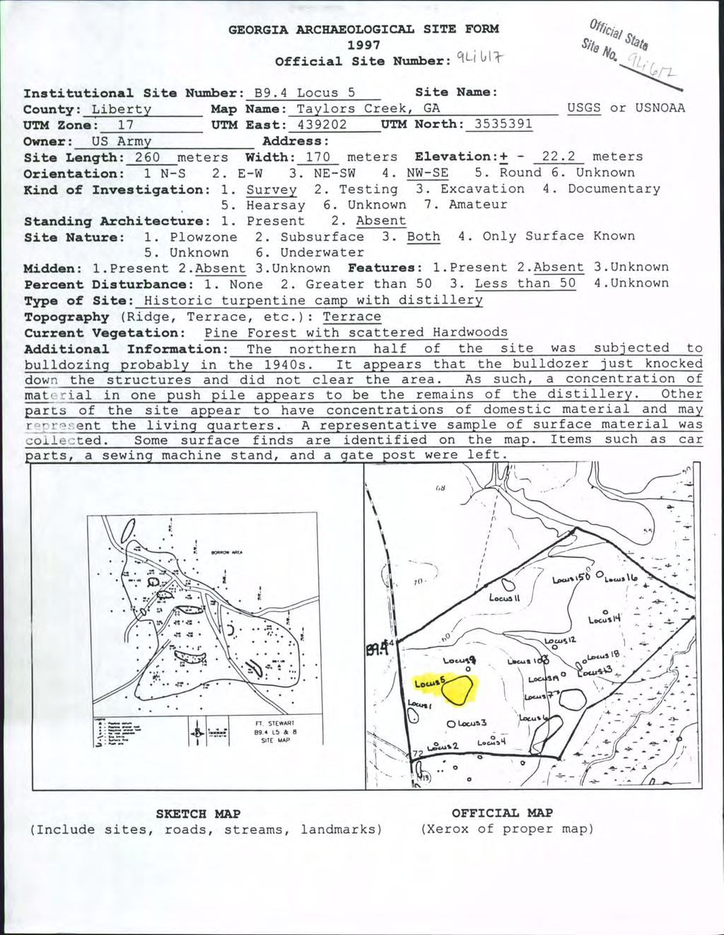
47 GEORGIA ARCHAEOLOGICAL SITE FORM 1999 Official Site Number: 9CE657 (Revisit) Offit,ial State Site No. 9( (g ~J Revisit Institutional Site Number: Site Name: County: Chattahoochee Map Name: Cusseta USGS ,, UTM Zone: 16S UTM East: UTM North: Owner: U.S. Army Address: Fort Benning, Georgia Site Length: 125 meters Width: 70 meters Elevation: meters Orientation: 1.N-S 2.E-W 3.NE-SW 4.NW-SE 5.Round 6.Unknown Kind of Investigation: 1.Survey 2.Testing 3.Excavation 4.Documentary 5.Hearsay 6.Unknown 7.Amateur Standing Architecture: 1.Present 2.Absent Site Nature: 1.Plowzone 2.Subsurface 3.Both 4.0nly Surface Known Midden: Percent Type of -----:-----_----=:.-' '~ Unknown 6.Underwater 1.Present 2.Absent 3.Unknown Features: 1.Present 2.Absent 3.Unknown Disturbance: 1.None 2. Greater than 50 3.Less than 50 4.Unknown Site (Mill, Mound, Quarry, Lithic Scatter, etc.): Twentieth century artifact scatter Topography (Ridge, Terrace, etc.): Upland ridge Current Vegetation (Woods, Pasture, etc.): Planted pines Additional Information: Site 9CE657 represents a very light density twentieth century non-indian artifact scatter. Site 9CE657 appears to have been selectively harvested and most of the mature pines noted in the original report are now gone. Visual and subsurface examinations showed the site to have been impacted by past logging events, road-related construction and maintenance, and military activities. As a result of severe erosion, there is little to no soil remaining on most parts of 9CE657. This site is effectively destroyed with little to no research potential remaining. Based on the quantity and the nature of the evidence recovered as well as the extent of damage and disturbance to the entire area, PCI recommends 9CE657 be considered ineligible for listing on the NRHP. As such, no additional archaeological research is warranted for this location. c "..- e.e-... _ SKETCH MAP (Include sites, roads, FORT BENNING 27 PHASE II, ece657 SITE low' streams, landmarks) o Mot o JOG lloo lioo 1200 Flit -~ OFFICIAL MAP (Xerox of proper map)
48 State Site Number: 9CE657 Institutional Site Name: Public Status: 1.National Historic Landmark 2.National Natural Landmark 3.Georgia Register 4.Georgia Historic Trust 5.HABS 6.HAER National Register Standing: 1.Determined Eligible 3.Recommended Eligible 4.Nominated 5.Listed 2.Recommended Ineligible 6.Unknown 7.Removed National Register Level of Significance: 1.Local 2.State 3.National Preservation State (Select up to Two): 1.Undisturbed 2.Cultivated 3.Eroded 4.Submerged 5.Lake Flooded 6.Vandalized 7.Destroyed 8.Redeposited 9.Graded 10.Razed Preservation Prospects: 1.Safe 3.Unknown 2.Endangered by: military activities Georgia Archaeological Site File RECORD OF INVESTIGATIONS Report No. LIb Q S Supervisor: Warren Carruth Affiliation: Panamerican Consultants, Inc. Date: April 22, 2008 Report Title: Phase II Investigation of 27 Sites (9CE44, 9CE243, 9CE657, 9CE884, 9CE1220, 9CE1227, 9CE1369, 9CE1500, 9CE1556, 9CE1592, 9CE1788, 9CE1801, 9CE1889, 9CE2038, 9CE2071, 9CE2565, 9CE2601, 9ME23, 9ME233, 9ME486, 9ME566, 9ME667, 9ME668, 9ME669, 9MEI056, 9ME1226, and 9ME1358) for Fort Benning Military Reservation, Chattahoochee and Muscogee Counties, Georgia Artifacts Collected: brick fragments, wire nails, whiteware (hand painted and undecorated), alkaline glazed stoneware, aqua container glass, brass shotgun shell head Location of Collections: Location of Field Notes: Private Collections: Fort Benning, Fort Benning, GA GA ~ Name: Cultural Periods: Twentieth century Address: CULTURAL AFFINITY Phases: Date 11/11/08 FORM PREPARATION AND Name Amy Carruth REVISION Institutional Affiliation Panamerican Consultants, Inc.

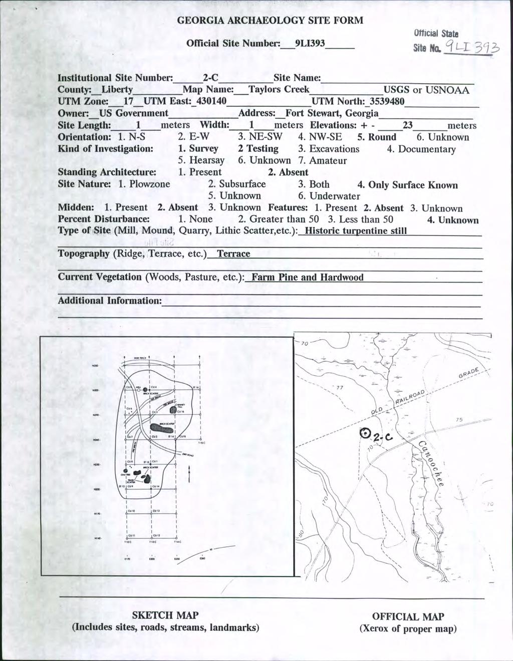
49 GEORGIA ARCHAEOLOGICAL SITE FORM 1994 ~~ Off icia1 site Number:_-'-''--'...-:.._''''''''_...:''--_ Officia' State ~;t. ~I:' Cj C/3. ~51 Institutional site Number: HC-S-7 site Name: county: Chattahoochee Map Name: Cusseta, 7.5' USGS or USNOAA UTM Zone:16 UTM East: UTM North: owner: US Army Address: -=F...::t~.!...--;!B::.;e::::.n~n~i±n~gl :" site Length: 140 meters width: 90 meters Elevation: meters orientation: 1. N-S 2. E-W 3. NE-SW 4, NW-SE 5. Round 6. Unknown Rind of Investigation: 1. Survey 2. Testing 3. Excavation 4. Documentary 5. Hearsay 6. Unknown 7. Amateur standing Architecture: 1. Present 2. Absent Site Nature: 1. Plowzone 2. Subsurface 3. Both 4. Only Surface Known /J 5. Unknown 6. Underwater Midden: 1.Present 2.Absent 3.Unknown Features: 1.Present 2.Absent 3.Unknown Percent Disturbance: 1. None 2. Greater than Less than 50 4.Unknown Type of site (Mill, Mound, Quarry, Lithic Scatter, etc.): possible turpentine processing site or historic homesite Topography (Ridge, Terrace, etc.): _...:::u'.l::p'-"lo.::a~n...,d"'--'r"'_l=_ d=g=e'---=t=o~p= Current Vegetation (Woods, Pasture, etc.) : ~w~o~o~d~s~~(~p~i~n~e~s~)~ Additional Information: This site has an abundance of turpentine rendering ceramic vessel sherds. Scars on some pine tree trunks may indicate turpentine gathering, but this is not certain. Other artifacts such as whiteware, stoneware, glass and brick may indicate a house site. The site is on a SE-NW oriented ridge top overlooking the Mill Creek drainage. r;:::====:::;---;~;;:;::;;:::=;,---) _ -. SITE LIMITS FORT BENNING VICTORY FOCUS HARMONY CHURCH PLAN VIEW SITE VFHC-S7 1l o ~ (-f----: _ ~ 6. DATUM POSITI\I[ SH<M:L TEST o NEGATI\I[ SHOVEL TEST l) PUSH PK..E t -J{-, ( ~..-, CONCRm~PAO.. :... ~ 0 a , 0 i, 1., \ \ 0 \ i.. ' POSSIBLE BORROW PIT SKETCH MAP (Include sites, roads, streams, landmarks)
50 state site Number: Institutional site Number: HC-S-7 Public status: 1. National Historic Landmark 2. National Natural Landmark 3. Georgia Register 4. Georgia Historic Trust 5. HABS 6. HAER National Register standing: 1. Determined Eligible 2. Recommended Ineligible 3. Recommended Eligible 4. Nominated 5. Listed 6. Unknown 7. Removed National Register Level of Significance: 1. Local 2. State 3. National Preservation state (Select up to Two): 1. Undisturbed 2. Cultivated 3. Eroded 4. Submerged 5. Lake Flooded 6. Vandalized 7. Destroyed 8. Redeposited 9. Graded 10. Razed Preservation Prospects: 1. Safe 2. Endangered by:military use and logging 3. Unknown Georgia Archaeological Site File Report No 4 ~OS RECORD OF INVESTIGATIONS Supervisor: Erwin Roemer Affiliation:Panamerican Consultants Date: 7/1/94 Report Title: Archaeological SurveY of Selected Areas Within Ft. Benninq. Chattahoochee and Muscogee counties. Georqia: Victory Focus. Areas and 3; South Harmony Church; and Two Parcels Within Lawson Army Airfield Other Reports : Artifacts Collected: see report - whiteware (plain. stamped. annular/handpainted, yellow glazed). turpentine jar fragments. stoneware, glass (clear and green). brick _ Location of Collections:~F~t~.~B~e=n=n=l= n=g~.~g=a~. Location of Field Notes:~F~tu.~B~e~nwn~l~ n~g~.~g~a~. Private Collections: _ Name: _ Address : _ CULTURAL AFFINITY Cultural Periods: historic African/Euro-American; probably early twentieth century Phases : _ Date 5/25/94 Name Geoffrey Herbert FORM PREPARATION AND REVISION Institutional Affiliation Panamerican Consultants. Inc.
51
52
53
54
55
56
57
58
59
60
61
62
63
64
65
66
67
68
69
70
71
72
73
74
75
76
77
78
79
80
81
82
83
84
85
86
87
88
89
90
91
92
93
94
AN ARCHAEOLOGICAL SURVEY FOR THE NAVIDAD RESOURCES, LLC FERGUSON STATE PRISON FARM UNIT PROJECT IN MADISON COUNTY, TEXAS
 AN ARCHAEOLOGICAL SURVEY FOR THE NAVIDAD RESOURCES, LLC FERGUSON STATE PRISON FARM UNIT PROJECT IN MADISON COUNTY, TEXAS Antiquities Permit 5714 By William E. Moore Brazos Valley Research Associates Contract
ARTICLE IV: DEVELOPMENT STANDARDS 404 MASTER PLANNING
 IV 13 404 MASTER PLANNING Master Planning through the Site Analysis (Master Planning Site Analysis) or Planned Development (Master Planning Planned Development) is provided to encourage development which
Summary of Other State Archeological Guidelines
 Summary of Other State Archeological Guidelines This is a summary all guidelines for archeology from 17 other states. This information was gathered in order to see what type of guidelines other states
National Historic Preservation Act Section 106 Compliance
 National Historic Preservation Act Section 106 Compliance Regulatory Program Workshop Erin E. Hess Cultural Resource Specialist National Historic Preservation Act Compliance Regulatory Division, Sacramento
Archaeological evaluation at Stables, Hatch Farm, Fen Lane, Bulphan, Essex, RM14 3RL
 Archaeological evaluation at Stables, Hatch Farm, Fen Lane, Bulphan, Essex, RM14 3RL November-December 2016 by Laura Pooley figures by Ben Holloway and Emma Holloway fieldwork by Ben Holloway and Alec
HISTORIC SITE FORM - HISTORIC SITES INVENTORY PARK CITY MUNICIPAL CORPORATION (10-08) 1 IDENTIFICATION
 1 IDENTIFICATION") HISTORIC SITE FORM - HISTORIC SITES INVENTORY PARK CITY MUNICIPAL CORPORATION (10-08) 1 IDENTIFICATION Name of Property: Address: 164 Sandridge Road AKA: City, County: Park City, Summit County, Utah Tax
HISTORIC SITE FORM - HISTORIC SITES INVENTORY PARK CITY MUNICIPAL CORPORATION (10-08) 1 IDENTIFICATION Name of Property: Address: 164 Sandridge Road AKA: City, County: Park City, Summit County, Utah Tax
Architectural Inventory Form
 COLORADO CULTURAL RESOURCE SURVEY Page 1 of 8 Official Eligibility Determination (OAHP use only) Rev. 9/98 OAHP1403 Date Initials Determined Eligible National Register Determined Not Eligible National
AN ARCHAEOLOGICAL SURVEY FOR THE RICHARDS, TEXAS FARM-TO-MARKET ROAD 149 FIBER OPTIC CABLE PROJECT IN MONTGOMERY COUNTY, TEXAS
 AN ARCHAEOLOGICAL SURVEY FOR THE RICHARDS, TEXAS FARM-TO-MARKET ROAD 149 FIBER OPTIC CABLE PROJECT IN MONTGOMERY COUNTY, TEXAS Antiquities Permit 6097 By William E. Moore Brazos Valley Research Associates
ELIGIBILITY CRITERIA CHECKLIST OPEN SPACE CLASSIFICATION
 THURSTON COUNTY DEVELOPMENT SERVICES OPEN SPACE TAX PROGRAM ELIGIBILITY CRITERIA CHECKLIST OPEN SPACE CLASSIFICATION Use this checklist to help you determine whether your property is eligible for open
ImEE~E m I UNCLASSIFIED B WITHROW 87 SEP 93 F/G 5/6 NI
 AD-A173 489 CULTURAL RESOURCES SURVEY OF PROPOSED FLOOD CONTROL' / PROJECT AREA GAYS MILLS CRAWFORD COUNTY WISCONSIN(U) CORPS OF ENGINEERS ST PAUL MN ST PAUL DISTRICT I UNCLASSIFIED B WITHROW 87 SEP 93
Florida Department of TRANSPORTATION. Technical Memorandum Cultural Resource Assessment Survey of the Proposed VE Pond
 Florida Department of TRANSPORTATION Technical Memorandum Cultural Resource Assessment Survey of the Proposed VE Pond Malabar Road (SR 514) PD&E Study From East of Babcock Street (SR 507) to US 1 Brevard
Architectural Inventory Form
 COLORADO CULTURAL RESOURCE SURVEY Page 1 of 8 Official Eligibility Determination (OAHP use only) Rev. 9/98 OAHP1403 Date Initials Determined Eligible National Register Determined Not Eligible National
HISTORIC SITE FORM - HISTORIC SITES INVENTORY PARK CITY MUNICIPAL CORPORATION (10-08) 1 IDENTIFICATION
 1 IDENTIFICATION") HISTORIC SITE FORM - HISTORIC SITES INVENTORY PARK CITY MUNICIPAL CORPORATION (10-08) 1 IDENTIFICATION Name of Property: Kimball's Garage Address: 638 Park Ave AKA: City, County: Park City, Summit County,
HISTORIC SITE FORM - HISTORIC SITES INVENTORY PARK CITY MUNICIPAL CORPORATION (10-08) 1 IDENTIFICATION Name of Property: Kimball's Garage Address: 638 Park Ave AKA: City, County: Park City, Summit County,
STAGE 1 ARCHAEOLOGICAL ASSESSMENT OF RATHBURN ROAD, FROM DUKE OF YORK BOULEVARD TO SHIPP DRIVE, CITY OF MISSISSAUGA. Submitted to:
 STAGE 1 ARCHAEOLOGICAL ASSESSMENT OF RATHBURN ROAD, FROM DUKE OF YORK BOULEVARD TO SHIPP DRIVE, CITY OF MISSISSAUGA Submitted to: McCormick Rankin Corporation 2655 North Sheridan Way, Suite 280 Mississauga,
Architectural Inventory Form
 COLORADO CULTURAL RESOURCE SURVEY Page 1 Official eligibility determination (OAHP use only) Date Initials Determined Eligible- NR Determined Not Eligible- NR Determined Eligible- SR Determined Not Eligible-
HISTORIC SITE FORM - HISTORIC SITES INVENTORY PARK CITY MUNICIPAL CORPORATION (10-08) 1 IDENTIFICATION
 1 IDENTIFICATION") HISTORIC SITE FORM - HISTORIC SITES INVENTORY PARK CITY MUNICIPAL CORPORATION (10-08) 1 IDENTIFICATION Name of Property: James M. Louder House Address: 170 MAIN ST City, County: Park City, Summit County,
HISTORIC SITE FORM - HISTORIC SITES INVENTORY PARK CITY MUNICIPAL CORPORATION (10-08) 1 IDENTIFICATION Name of Property: James M. Louder House Address: 170 MAIN ST City, County: Park City, Summit County,
Centre for Archaeological Fieldwork Evaluation/Monitoring Report No Monitoring Report No. 201
 Monitoring Report No. 201 Land adjacent to 58 Drumreagh Road Drumreagh Ballygowan Co. Down LICENCE NO.: AE/10/91E BRIAN SLOAN 1 Site Specific Information Site Name: Land adjacent to 58 Drumreagh Road,
APPENDIX A 6 CONCEPTUAL PRELIMINARY PLAN GUIDE AND CHECKLIST FOR MAJOR SUBDIVISIONS CARRBORO DEVELOPMENT GUIDE APPENDIX A
 6 CONCEPTUAL PRELIMINARY PLAN GUIDE AND CHECKLIST FOR MAJOR SUBDIVISIONS Conceptual Preliminary Guide/Checklist for Major Subdivisions Page 1 FORM: REVIEW DATE: CONCEPTUAL PLAN REVIEW 2000 REVIEWED BY:
Ivol Buildings, Woodcote Road, South Stoke, Oxfordshire
 Ivol Buildings, Woodcote Road, South Stoke, Oxfordshire An Archaeological Watching Brief For Christ Church, Oxford by Pamela Jenkins Thames Valley Archaeological Services Ltd Site Code IBSS 04/03 March
Architectural Inventory Form
 COLORADO CULTURAL RESOURCE SURVEY Page 1 of 3 Official Eligibility Determination (OAHP use only) Rev. 9/98 OAHP1403 Date Initials Determined Eligible National Register Determined Not Eligible National
Architectural Inventory Form
 COLORADO CULTURAL RESOURCE SURVEY Page 1 of 8 Official Eligibility Determination (OAHP use only) Rev. 9/98 OAHP1403 Date Initials Determined Eligible National Register Determined Not Eligible National
Zoning Ordinance Chapter 10
 CHAPTER 10 - WASHES SECTION 10.0 GENERAL: A. The purpose of this Ordinance is to establish standards for development in or near Major and Minor Washes as defined in Appendix A Glossary of Terms and Definitions
MONITORING REPORT: No. 283
 MONITORING REPORT: No. 283 Dunluce Castle Visitor Centre Option Site D Magheracross Co. Antrim AE/14/109E Dermot Redmond List of Contents Site Specific Information 1 Account of the Monitoring 2 Discussion
Windsor Berkshire. Archaeological Watching Brief. King Edward VII Car Park Extension. Archaeological Watching Brief Report
 King Edward VII Car Park Extension Windsor Berkshire Archaeological Watching Brief Report March 202 Client: Royal Borough of Windsor and Maidenhead Issue No: OA Job No: 5242 NGR: SU 972 779 Archaeological
An Archeological Reconnaissance of the Eagle Creek and Chandler Bridge Creek Channelization Project, Dorchester County, South Carolina
 University of South Carolina Scholar Commons Research Manuscript Series Archaeology and Anthropology, South Carolina Institute of 10-1-1980 An Archeological Reconnaissance of the Eagle Creek and Chandler
APPENDIX G. Historical Resources Overview Documentation
 APPENDIX G Historical Resources Overview Documentation Statement of Justification for Historical Resources Act Requirements for projects other than small-scale oil and gas This document contains sensitive
An Archaeological Evaluation at Granta Cottages, Newmarket Road, Great Chesterford, Essex. August 2015
 An Archaeological Evaluation at Granta Cottages, Newmarket Road, Great Chesterford, Essex August 2015 by Pip Parmenter and Ben Holloway on behalf of Mr G Elmer and Mrs L King CAT project ref.: 15/06a NGR:
January 18, JOINT PUBLIC NOTICE Savannah District/State of Georgia
 DEPARTMENT OF THE ARMY SAVANNAH DISTRICT, CORPS OF ENGINEERS 100 WEST OGLETHORPE AVENUE SAVANNAH, GEORGIA 31401-3640 January 18, 2019 Regulatory Branch SAS-2009-00770 JOINT PUBLIC NOTICE Savannah District/State
Architectural Inventory Form (page 1 of 5)
") OAHP1403 Rev. 9/98 COLORADO CULTURAL RESOURCE SURVEY (page 1 of 5) I. IDENTIFICATION 1. Resource number 5RT-2050 2. Temporary resource number: 145008005 3. County: Routt County 4. City: Steamboat Springs
OAHP1403 Rev. 9/98 COLORADO CULTURAL RESOURCE SURVEY (page 1 of 5) I. IDENTIFICATION 1. Resource number 5RT-2050 2. Temporary resource number: 145008005 3. County: Routt County 4. City: Steamboat Springs
Archaeological Evaluation and Assessment of Land at Kent Cottage, 19 Chapel Street, Hythe, Kent
 Archaeological Evaluation and Assessment of Land at Kent Cottage, 19 Chapel Street, Hythe, Kent Planning Application Y13/0463/SH Date of Report: 29/04/2015 Report for Marc Carney SWAT. ARCHAEOLOGY Swale
IMPORTANT NOTICE. Architectural Inventory Form COLORADO CULTURAL RESOURCE SURVEY I. IDENTIFICATION th Street 5WL.5601
 IMPORTANT NOTICE OAHP1403 Rev. 9/98 COLORADO CULTURAL RESOURCE SURVEY Architectural Inventory Form Page 1 This survey form represents an UNOFFICIAL COPY and is provided for informational purposes only.
Bureau for Historic Preservation s Guidance for Historic Preservation Planning
 Bureau for Historic Preservation s Guidance for Historic Preservation Planning The Municipalities Planning Code was revised in 2000 and included a provision for historic preservation planning. The Bureau
HISTORIC SITE FORM - HISTORIC SITES INVENTORY PARK CITY MUNICIPAL CORPORATION (10-08) 1 IDENTIFICATION
 1 IDENTIFICATION") HISTORIC SITE FORM - HISTORIC SITES INVENTORY PARK CITY MUNICIPAL CORPORATION (10-08) 1 IDENTIFICATION Name of Property: Egyptian Theater Address: 328 MAIN ST City, County: Park City, Summit County, Utah
HISTORIC SITE FORM - HISTORIC SITES INVENTORY PARK CITY MUNICIPAL CORPORATION (10-08) 1 IDENTIFICATION Name of Property: Egyptian Theater Address: 328 MAIN ST City, County: Park City, Summit County, Utah
PennDOT. single spann lanes and 3- mayy need to be to accommodate. any bridge. addition to III. Date: CRP 07/27/2015 CRP.
 (10/27/14) PennDOT Section 106 Field Assessments and Finding Combined Early tification/finding? Yes Concurrence required or requested: Yes MPMS: 51507 ER# (if consultation with PHMC required) ): County:
Archaeological evaluation at Willowdene, Chelmsford Road, Felsted, Essex
 Archaeological evaluation at Willowdene, Chelmsford Road, Felsted, Essex August 2013 report prepared by Ben Holloway on behalf of Mr Anthony McGurren Planning reference: UTT/13/0235 CAT project ref.: 13/07g
ARTICLE VI: SITE PLAN REVIEW
 Section 6.01 - Site Plan Review (All Districts) ARTICLE VI: SITE PLAN REVIEW Site plans give the Planning commission an opportunity to review development proposals in a concise and consistent manner. The
Architectural Inventory Form
 IMPORTANT NOTICE OAHP1403 Rev. 9/98 COLORADO CULTURAL RESOURCE SURVEY Page 1 This survey form represents a only. All information, particularly determinations of eligibility for the National Register, the
Original License Report. Submitted to: New Horizon Development Inc. 69 John Street South, Suite 304 Hamilton, Ontario L8N 2B9 Phone (905)
") STAGE 1 ARCHAEOLOGICAL ASSESSMENT OF 2480-2496 OLD BRONTE ROAD, PART OF LOT 31, CONCESSION 1 SOUTH OF DUNDAS STREET, GEOGRAPHIC TOWNSHIP OF TRAFALGAR, TOWN OF OAKVILLE, REGIONAL MUNICPALITY OF HALTON Original
STAGE 1 ARCHAEOLOGICAL ASSESSMENT OF 2480-2496 OLD BRONTE ROAD, PART OF LOT 31, CONCESSION 1 SOUTH OF DUNDAS STREET, GEOGRAPHIC TOWNSHIP OF TRAFALGAR, TOWN OF OAKVILLE, REGIONAL MUNICPALITY OF HALTON Original
HISTORIC SITE FORM - HISTORIC SITES INVENTORY PARK CITY MUNICIPAL CORPORATION (10-08) 1 IDENTIFICATION
 1 IDENTIFICATION") HISTORIC SITE FORM - HISTORIC SITES INVENTORY PARK CITY MUNICIPAL CORPORATION (10-08) 1 IDENTIFICATION Name of Property: The New Park Hotel Address: 573 MAIN ST AKA: City, County: Park City, Summit County,
HISTORIC SITE FORM - HISTORIC SITES INVENTORY PARK CITY MUNICIPAL CORPORATION (10-08) 1 IDENTIFICATION Name of Property: The New Park Hotel Address: 573 MAIN ST AKA: City, County: Park City, Summit County,
APPENDIX 9: Archaeological Assessment by Ken Phillips
 APPENDIX 9: Archaeological Assessment by Ken Phillips ARCHAEOLOGICAL ASSESSMENT PROPOSED SERVICE STATION DEVELOPMENT BRUCE ROAD, PAPAMOA TAURANGA Prepared by KEN PHILLIPS (MA HONS) MARCH 2016 ARCHAEOLOGY
Architectural Inventory Form
 IMPORTANT NOTICE OAHP1403 Rev. 9/98 COLORADO CULTURAL RESOURCE SURVEY Page 1 This survey form represents a only. All information, particularly determinations of eligibility for the National Register, the
Archaeological evaluation on land at Mersea Fleet Way, Chelmer Road, Braintree, Essex, CM7 3PZ
 Archaeological evaluation on land at Mersea Fleet Way, Chelmer Road, Braintree, Essex, CM7 3PZ by Laura Pooley figures by Ben Holloway and Emma Holloway fieldwork by Ben Holloway, Robin Mathieson, Nigel
Glue Pot Farm, Edwards Lane, Bramfield, Suffolk. BMF 024
 Glue Pot Farm, Edwards Lane, Bramfield, Suffolk. BMF 024 Archaeological Evaluation Report SCCAS Report No. 2013/107 Client: Keith Frost Architectural Design Services Author: Linzi Everett August 2013 SCCAS
Final Initial Study. Chalice Unitarian Universalist Congregation Conditional Use Permit
 5 Final Initial Study Chalice Unitarian Universalist Congregation Conditional Use Permit Appendix B Chalice Unitarian Universalist Congregation Cultural Resources Memorandum TRC 9685 Research Drive Irvine,
NYC Envirothon 2017 Soil Science Review. Richard K Shaw USDA-NRCS
 NYC Envirothon 2017 Soil Science Review Richard K Shaw USDA-NRCS Introduction Who Are We? U.S. Department of Agriculture (1862) Natural Resources Conservation Service (1935) What Do We Do? Provide leadership
AN ARCHAEOLOGICAL SURVEY FOR THE DIALVILLE-OAKLAND WATER SUPPLY CORPORATION IN CENTRAL CHEROKEE COUNTY, TEXAS. BVRA Project Number 03-25
 AN ARCHAEOLOGICAL SURVEY FOR THE DIALVILLE-OAKLAND WATER SUPPLY CORPORATION IN CENTRAL CHEROKEE COUNTY, TEXAS BVRA Project Number 03-25 Author and Principal Investigator William E. Moore Prepared by Brazos
Plat Requirements CHECKLIST FOR SITE PLAN REVIEW
 This checklist is to be used as a guide for complying with the Town of Hollis Site Plan Regulations. It is to be used for each individual site plan review application submitted. Applicants are encouraged
GIS to Estimate Archaeological Site Loss and Develop Conservation Strategies
 GIS to Estimate Archaeological Site Loss and Develop Conservation Strategies Terry Jackson Office of Decision Support Systems Planning and Environmental Management Division Georgia Department of Community
HISTORIC SITE FORM - HISTORIC SITES INVENTORY PARK CITY MUNICIPAL CORPORATION (10-08)
") 1 IDENTIFICATION HISTORIC SITE FORM - HISTORIC SITES INVENTORY PARK CITY MUNICIPAL CORPORATION (10-08) Name of Property: Address: 1114 PARK AVE AKA: City, County: Park City, Summit County, Utah Tax Number:
1 IDENTIFICATION HISTORIC SITE FORM - HISTORIC SITES INVENTORY PARK CITY MUNICIPAL CORPORATION (10-08) Name of Property: Address: 1114 PARK AVE AKA: City, County: Park City, Summit County, Utah Tax Number:
HISTORIC SITE FORM - HISTORIC SITES INVENTORY PARK CITY MUNICIPAL CORPORATION (10-08) 1 IDENTIFICATION
 1 IDENTIFICATION") HISTORIC SITE FORM - HISTORIC SITES INVENTORY PARK CITY MUNICIPAL CORPORATION (10-08) 1 IDENTIFICATION Name of Property: Address: 158 Main Street City, County: Park City, Summit County, Utah AKA: Tax Number:
HISTORIC SITE FORM - HISTORIC SITES INVENTORY PARK CITY MUNICIPAL CORPORATION (10-08) 1 IDENTIFICATION Name of Property: Address: 158 Main Street City, County: Park City, Summit County, Utah AKA: Tax Number:
HISTORIC SITE FORM - HISTORIC SITES INVENTORY PARK CITY MUNICIPAL CORPORATION (10-08)
") 1 IDENTIFICATION HISTORIC SITE FORM - HISTORIC SITES INVENTORY PARK CITY MUNICIPAL CORPORATION (10-08) Name of Property: Address: 929 PARK AVE AKA: City, County: Park City, Summit County, Utah Tax Number:
1 IDENTIFICATION HISTORIC SITE FORM - HISTORIC SITES INVENTORY PARK CITY MUNICIPAL CORPORATION (10-08) Name of Property: Address: 929 PARK AVE AKA: City, County: Park City, Summit County, Utah Tax Number:
Archaeological trial-trenching evaluation: New Hall School, The Avenue, Boreham, Essex. July 2015
 Archaeological trial-trenching evaluation: New Hall School, The Avenue, Boreham, Essex report prepared by Ben Holloway on behalf of New Hall School Planning reference: 14/01846/FUL CAT project ref.: 15/04i
HISTORIC SITE FORM - HISTORIC SITES INVENTORY PARK CITY MUNICIPAL CORPORATION (10-08) 1 IDENTIFICATION
 1 IDENTIFICATION") HISTORIC SITE FORM - HISTORIC SITES INVENTORY PARK CITY MUNICIPAL CORPORATION (10-08) 1 IDENTIFICATION Name of Property: Wilson-Shields House Address: 139 Park Avenue City, County: Park City, Summit County,
HISTORIC SITE FORM - HISTORIC SITES INVENTORY PARK CITY MUNICIPAL CORPORATION (10-08) 1 IDENTIFICATION Name of Property: Wilson-Shields House Address: 139 Park Avenue City, County: Park City, Summit County,
Phase One Archaeological Investigation Results, James Madison Park Master Development Plan Project, City of Madison, Dane County, Wisconsin
 Phase One Archaeological Investigation Results, James Madison Park Master Development Plan Project, City of Madison, Dane County, Wisconsin Prepared for the City of Madison Parks Department 28 January
Archaeological evaluation at Redbank, Bury Water Lane, Newport, Essex, CB11 3TZ
 Archaeological evaluation at Redbank, Bury Water Lane, Newport, Essex, CB11 3TZ March 2017 by Laura Pooley figures by Ben Holloway and Emma Holloway fieldwork by Ben Holloway with Harvey Furniss and Elliott
Architectural Inventory Form
 OAHP1403 Rev. 9/98 COLORADO CULTURAL RESOURCE SURVEY Architectural Inventory Form Official eligibility determination (OAHP use only) Date Initials Determined Eligible- NR Determined Not Eligible- NR Determined
Chapter 4. Summary and Recommendations
 Chapter 4 Summary and Recommendations Phase I archaeological literature review was completed by professional archaeologist Lauren W. Ritterbush with the assistance of anthropology student Victoria Rau
Specifications for Investigation and Perpetuation of U.S. Public Land Survey Corners
 Specifications for Investigation and Perpetuation of U.S. Public Land Survey Corners John M. Thornton State Land Surveyor January 12, 2016 SPECIFICATIONS FOR INVESTIGATION AND PERPETUATION OF U. S. PUBLIC
Architectural Inventory Form
 COLORADO CULTURAL RESOURCE SURVEY Page 1 of 7 Official Eligibility Determination (OAHP use only) Rev. 9/98 OAHP1403 Date Initials Determined Eligible National Register Determined Not Eligible National
Architectural Inventory Form (page 1 of 5)
") OAHP1403 Rev. 9/98 COLORADO CULTURAL RESOURCE SURVEY (page 1 of 5) Official eligibility determination (OAHP use only) Date Initials Determined Eligible- NR Determined Not Eligible- NR Determined Eligible-
OAHP1403 Rev. 9/98 COLORADO CULTURAL RESOURCE SURVEY (page 1 of 5) Official eligibility determination (OAHP use only) Date Initials Determined Eligible- NR Determined Not Eligible- NR Determined Eligible-
Archaeological monitoring at Clintons, Bury Green, Little Hadham, Hertfordshire April 2008
 Archaeological monitoring at Clintons, Bury Green, Little Hadham, Hertfordshire April 2008 report prepared by Ben Holloway on behalf of Charles Britton Equestrian Construction CAT project ref.: 08/3b NGR:
CONSERVATION ELEMENT GOALS, OBJECTIVES, AND POLICIES
 CONSERVATION ELEMENT GOALS, OBJECTIVES, AND POLICIES Goal 4 To conserve, manage, appropriately use and protect the natural resources of the City ensuring continued resource availability and environmental
Chapter 19: Cultural Resources
 Chapter 19: Cultural Resources Introduction and Setting Traditionally the term "cultural resources" has been used rather narrowly to refer to archaeological remains and to historical structures. Archaeologists,
AN ARCHAEOLOGICAL SURVEY OF THE TIGER CREEK COMPARTMENT 3 JASPER COUNTY TEXAS
 AN ARCHAEOLOGICAL SURVEY OF THE TIGER CREEK COMPARTMENT 3 JASPER COUNTY TEXAS By William E. Moore Brazos Valley Research Associates Contract Report Number 89 2001 AN ARCHAEOLOGICAL SURVEY OF THE TIGER
HISTORIC SITE FORM - HISTORIC SITES INVENTORY PARK CITY MUNICIPAL CORPORATION (10-08) 1 IDENTIFICATION
 1 IDENTIFICATION") HISTORIC SITE FORM - HISTORIC SITES INVENTORY PARK CITY MUNICIPAL CORPORATION (10-08) 1 IDENTIFICATION Name of Property: McPolin Farmstead Address: 3000 Highway 224 City, County: Park City, Summit County,
HISTORIC SITE FORM - HISTORIC SITES INVENTORY PARK CITY MUNICIPAL CORPORATION (10-08) 1 IDENTIFICATION Name of Property: McPolin Farmstead Address: 3000 Highway 224 City, County: Park City, Summit County,
17.18 SENSITIVE AREAS
 17.18 SENSITIVE AREAS 17.18.010 Purpose...1 17.18.020 Definitions...1 17.18.030 Review Process...1 17.18.040 Sensitive Areas Analysis...2 17.18.050 Standards and Development Plan...3 17.18.060 Geotechnical
COMBINED PHASE I ARCHAEOLOGICAL SURVEY BUILDING/LANDSCAPE AND ARCHAEOLOGICAL ASSESSMENT PLAN
 COMBINED PHASE I ARCHAEOLOGICAL SURVEY BUILDING/LANDSCAPE AND ARCHAEOLOGICAL ASSESSMENT PLAN ST. ELIZABETHS HOSPITAL - WEST CAMPUS 2700 MARTIN LUTHER KING, JR. AVENUE, SE DISTRICT OF COLUMBIA [SITE NUMBER
I 5 South Multimodal Corridor Study. Appendix F. I 5 South Multimodal Corridor Study Cultural Resources Constraints Analysis (February 8, 2010)
") I 5 South Multimodal Corridor Study Appendix F I 5 South Multimodal Corridor Study Cultural Resources Constraints Analysis (February 8, 2010) 847 Jamacha Road, El Cajon, California 92019-3206 tel: (619)
I 5 South Multimodal Corridor Study Appendix F I 5 South Multimodal Corridor Study Cultural Resources Constraints Analysis (February 8, 2010) 847 Jamacha Road, El Cajon, California 92019-3206 tel: (619)
African-American Archaeological Sites & the National Register of Historic Places: Creating a Public Memory
 African Diaspora Archaeology Newsletter Volume 7 Issue 1 January 2000 Article 1 1-1-2000 African-American Archaeological Sites & the National Register of Historic Places: Creating a Public Memory Erika
TAKANINI STRUCTURE PLAN AREAS 6A & 6B: ARCHAEOLOGICAL ASSESSMENT
 TAKANINI STRUCTURE PLAN AREAS 6A & 6B: ARCHAEOLOGICAL ASSESSMENT Report prepared for Hosken & Associates Ltd By Barry Baquie (MA) Rod Clough (PhD) April 2006 Clough & Associates Ltd heritage@clough.co.nz
Appendix G. Archaeological and Paleontological Resources Records Searches
 Appendix G Archaeological and Paleontological Resources Records Searches South Central Coastal Information Center California State University, Fullerton Department of Anthropology MH-426 800 North State
4.16 Historic and Archaeological Resources
 4.16 Historic and Archaeological Resources 4.16.1 Introduction to Resources and Regulatory Requirements The National Historic Preservation Act of 1966 (NHPA) Section 106 states that any federal or federally
National Museum of African American History & Culture ENVIRONMENTAL IMPACT STATEMENT & SECTION 106 CONSULTATION
 Smithsonian Institution National Museum of African American History & Culture ENVIRONMENTAL IMPACT STATEMENT & SECTION 106 CONSULTATION Phase II Archeology May 30, 2007 Review of Phase I Findings Archival
JOINT PUBLIC NOTICE. 26 June United States Army Corps of Engineers State of Louisiana
 JOINT PUBLIC NOTICE 26 June 2017 United States Army Corps of Engineers State of Louisiana New Orleans District Department of Environmental Quality Regulatory Branch Office of Environmental Services 7400
Prepared for Stantec Consulting Services, Inc. 23 June 2017
 Phase I Archaeological and Cultural Resource Investigation Results: Proposed Lower Eastern Beaver River Course Realignment Project, Silver Bay Golf Course, Beaver Bay Township, Lake County, Minnesota.
STAFF REPORT FOR STANDARD COASTAL DEVELOPMENT PERMIT #CDP FEBRUARY 26, 2015 CPA - 1 PO BOX 238 APTOS, CA 94001
 STAFF REPORT FOR STANDARD COASTAL DEVELOPMENT PERMIT #CDP 2014-0030 FEBRUARY 26, 2015 CPA - 1 OWNER/APPLICANT: AGENT: REQUEST: HANS HEIM PO BOX 238 APTOS, CA 94001 JAMES HAY PO BOX 762 MENDOCINO, CA 95460
Newcombe House & Kensington Church Street
 Newcombe House & Kensington Church Street Archaeological Evaluation September 2017 Summary Site name: Newcombe House, Kensington Church Street, Notting Hill, London Grid reference: TQ 25318 80372 Site
ARCHEOWORKS INC. Project Number: Licence/CIF#: P June 2006
 ARCHEOWORKS INC. ADDENDUM to CIF# P029-088: Stage 2 Archaeological Assessment of Two parcels within Proposed Green Ginger Developments Subdivision: A) Fallow Field/Wooded Parcel (16.3-acres) & B) Holdout
New Media Building, Goldsmiths College, New Cross, London Borough of Lewisham
 New Media Building, Goldsmiths College, New Cross, London Borough of Lewisham An Archaeological Evaluation for Willmott Dixon Construction by Andy Taylor Thames Valley Archaeological Services Ltd Site
1300 Peace Haven Road Chapin, South Carolina
 For Sale ±3.6 AC Site 1300 Peace Haven Road Chapin, South Carolina Gerald Steele +1 803 744 9851 gsteele@naiavant.com Property Features ±3.6 Acres for sale in Chapin Sales Price: $90,000 Price per acre:
Historic and Cultural Resources
 Chapter 4: Historic and Cultural Resources 4.1 INTRODUCTION This chapter assesses the potential effects to historic structures and archaeological resources as a result of the construction and operation
Archaeological Survey Report
 Archaeological Survey Report for UNION STREET RAILROAD BRIDGE (Trail Connection Project) Key No. 11085 ODOT, Region 2 Local Agency On-Call ATA 23456 WOC 1 City of Salem, Urban Development HDR Project No.
January 29, 2015 Page 1 of Annual Status Report St. Elizabeths Programmatic Agreement. PA Ref. Line Begin End. Description Timeframe Category
 2014 Annual Report Page 1 of 7 60 64 Finalize deed conveyance per Exchange Not Specified Recitals Completed. Agreement to Transfer Five Buildings and Related Land From DC to GSA 71 74 Finalize Occupancy
Archaeological Investigation in advance of Development at 2 Palace Cottages, Charing Palace, Charing, Kent
 Archaeological Investigation in advance of Development at 2 Palace Cottages, Charing Palace, Charing, Kent Site Code CHAR-EV-14 NGR 95412 49439 Date of Report 18/12/2014 Swale and Thames Archaeological
PRIMARY RECORD Trinomial # NRHP Status Code 3S, 3CS, 5S3 Other Listings Review Code Reviewer Date
 PRIMARY RECORD # NRHP Status Code 3S, 3CS, 5S3 Other Listings Review Code Reviewer Date Page 1 of 6 1252 *Resource Name or # (Assigned by recorder) Old Topanga Canyon Road P1. Other Identifier: *P2. Location:
You re the boss of the machine. Julia Child, Chef. BIM, bam, BOOM
 A computer lets you make more mistakes faster than any other invention with the possible exceptions of handguns and tequila. Mitch Ratcliffe, Tech Writer You re the boss of the machine. Julia Child, Chef
Historic England Advice Report 26 August 2016
 Case Name: Kingsland Castle Case Number: 1435892 Background Historic England has been asked to review the scheduling for Kingsland Castle. The land on which the monument lies is understood to be for sale.
PARK CITY MUNICIPAL CODE TABLE OF CONTENTS TITLE 15 LAND MANAGEMENT CODE - CHAPTER 2.21
 PARK CITY MUNICIPAL CODE TABLE OF CONTENTS TITLE 15 LAND MANAGEMENT CODE - CHAPTER 2.21 TITLE 15 - LAND MANAGEMENT CODE CHAPTER 2.21 - SENSITIVE LAND OVERLAY ZONE (SLO) REGULATIONS 15-2.21-1. PURPOSE...1
CEQA and Historic Preservation: A 360 Degree Review
 CEQA and Historic Preservation: A 360 Degree Review California Preservation Foundation Workshop February 11, 2015 Presented by Chris McMorris Partner / Architectural Historian CEQA and Historic Preservation
Archaeological Evaluation and Assessment of Land at Minnis Beeches, Canterbury Road, Swingfield, Dover, Kent
 Archaeological Evaluation and Assessment of Land at Minnis Beeches, Canterbury Road, Swingfield, Dover, Kent NGR: TQ 6307 1545 Site Code: MB-EV-10 (Planning Consent Y10/0311/SH) Report for Thorndene Ltd.
A Research Framework for the Archaeology of Wales Version 01, Final Paper Neolithic and Earlier Bronze Age
 NEOLITHIC AND EARLIER BRONZE AGE Introduction The introduction of farming around 4000 BC had a dramatic impact on the landscape of Wales and fundamentally changed they ways in which people lived and interacted.
ADDRESSING EROSIVE CONDITIONS AT TWO ARCHAEOLOGICAL SITE AREAS
 ADDRESSING EROSIVE CONDITIONS AT TWO ARCHAEOLOGICAL SITE AREAS AT MARINE CORPS BASE CAMP PENDLETON NINA M. HARRIS MARINE CORPS BASE CAMP PENDLETON Marine Corps Base Camp Pendleton addressed potential impacts
Meales Farm, Sulhamstead, West Berkshire
 Meales Farm, Sulhamstead, West Berkshire An Archaeological Watching Brief For Mr. Robert Astor by Steve Ford Thames Valley Archaeological Services Ltd Site Code CHH02/29 May 2002 Summary Site name: Meales
HISTORIC SITE FORM - HISTORIC SITES INVENTORY PARK CITY MUNICIPAL CORPORATION (10-08) 1 IDENTIFICATION
 1 IDENTIFICATION") HISTORIC SITE FORM - HISTORIC SITES INVENTORY PARK CITY MUNICIPAL CORPORATION (10-08) 1 IDENTIFICATION Name of Property: John W. Buck House Address: 1110 Woodside Avenue AKA: City, County: Park City, Summit
HISTORIC SITE FORM - HISTORIC SITES INVENTORY PARK CITY MUNICIPAL CORPORATION (10-08) 1 IDENTIFICATION Name of Property: John W. Buck House Address: 1110 Woodside Avenue AKA: City, County: Park City, Summit
2013 Annual Status Report St. Elizabeths Programmatic Agreement. January 29, 2014 Page 1 of 8. PA Ref. Line Begin End. Description Timeframe Category
 Page 1 of 8 60 64 Finalize deed conveyance per Exchange Recitals Completed. Agreement to Transfer Five Buildings and Related Land From DC to GSA 71 74 Finalize Occupancy Agreements Recitals Completed.
2.0 AREA PLANS. Lakeside Business District. Lakeside Business District Land Use Categories:
 Lakeside Business District Lakeside Business District Land Use Categories: Campus Commercial Campus Commercial means a mixture of uses which includes corporate offices, office parks, hotels, commercial,
CRESCENT RESOURCES INC.
 CRESCENT RESOURCES INC. Due Diligence Checklist Project Name: Client: Project No. Date: 1 Survey Review survey for compliance with Crescent Resources, Inc. s Instructions to Surveyors (see below): All
HISTORIC SITE FORM - HISTORIC SITES INVENTORY PARK CITY MUNICIPAL CORPORATION (10-08) 1 IDENTIFICATION
 1 IDENTIFICATION") HISTORIC SITE FORM - HISTORIC SITES INVENTORY PARK CITY MUNICIPAL CORPORATION (10-08) 1 IDENTIFICATION Name of Property: Lapage H. Raddon House Address: 817 Woodside Avenue AKA: City, County: Park City,
HISTORIC SITE FORM - HISTORIC SITES INVENTORY PARK CITY MUNICIPAL CORPORATION (10-08) 1 IDENTIFICATION Name of Property: Lapage H. Raddon House Address: 817 Woodside Avenue AKA: City, County: Park City,
Proposed Retirement Village Cole Green Way, Hertford. Archaeology Statement
 RETIREMENT LIVING MADE BETTER Proposed Retirement Village Cole Green Way, Hertford Archaeology Statement Woodlands Retirement Village RETIREMENT LIVING MADE BETTER Retirement Living Made Better Archaeology
Dome Industrial Park Project II Redevelopment Area
 CITY OF ST. PETERSBURG Dome Industrial Park Project II Redevelopment Area Historic Structures Study Submitted To: Prepared By: March 2008 Dome Industrial Park Project II - Redevelopment Area City of St.