Planning Appeal. Statement of Case
|
|
|
- Evan Powers
- 6 years ago
- Views:
Transcription
 Smith Jenkins Ltd 30A High Street, Stony Stratford, Milton Keynes, MK11 1AF Tel: 01908")
1 Planning Appeal Statement of Case LAND NORTH OF THE GLEBE, LAVENDON On behalf of the Appellant: Mr & Mrs Gray June 2017 (LPA ref: 16/01630/OUT) Smith Jenkins Ltd 30A High Street, Stony Stratford, Milton Keynes, MK11 1AF Tel:
2 Contents 1 Introduction 1 2 Site, Surroundings & Planning History 2 3 Appeal Scheme 4 4 Planning Policy 5 5 The Case on behalf of the Appellant 8 Appendix 1 Decision Notice Appendix 2 Committee Report Appendix 3 Committee minutes Appendix 4 Site Location Plan Appendix 5 Policy extracts
3 Mr & Mrs Gray Land North of The Glebe, Lavendon 1 Introduction 1.1 This appeal is made against the refusal of outline planning permission for the erection of 14 new dwellings (all matters reserved other than means of access). The application was received by Milton Keynes Council on 11 July 2016 and given the application reference number 16/01630/OUT. 1.2 The application was refused at the Development Control Committee on 11 th May This decision was against case officers recommendation for approval. The single reason for refusal given was as follows: Saved Policy S10 of the Milton Keynes Local Plan (Adopted 2005) states that planning permission will only be granted for development in the open countryside where it is essential for agriculture, forestry, countryside recreation and other development which is wholly appropriate to a rural area and cannot be located within a settlement. In addition, Policies CS1 and CS9 of the Milton Keynes Core Strategy (Adopted 2013) seek to focus development in the rural area within the development boundaries of the main and most sustainable towns or key settlements. The application site lies outside the settlement boundary of Lavendon and falls within land designated as 'Open Countryside'. The proposal is therefore contrary to Saved Policy S10 of the Milton Keynes Local Plan (Adopted 2005) and Policies CS1 and CS9 of the Milton Keynes Core Strategy (Adopted 2013). 1.3 The Decision Notice is contained within Appendix 1 and the Committee report (recommending approval) within Appendix 2. The minutes of the Committee are contained within Appendix The application was originally submitted for 21 dwellings. It was subsequently amended in February 2017 to 14 dwellings to reflect the advice of drainage officers. The amended application form held by the Local Authority still refers to 21 dwellings although the description of the application assigned by the Local Authority clearly refers to 14 dwellings and it is on that basis that the appeal is made. All plans are superseded other than the submitted site plan (ref: SK02 rev. N). A full list of application documents has been submitted together with this statement. 1.5 This Statement of Case sets out the planning case and positive merits of the scheme on behalf of the Appellants, Mr & Mrs Gray. Smith Jenkins Ltd 1
4 Mr & Mrs Gray Land North of The Glebe, Lavendon 2 Site, Surroundings & Planning History Site 2.1 The appeal site is located to the immediate north of Lavendon, a large village with a population of around 1,300 people in the north of the Borough of Milton Keynes. It measures 0.95ha and is roughly triangular in shape. The site hugs the northern edge of Lavendon and nestles between existing development on The Glebe (to the south) and Castle Road (to the west). It is relatively flat but does slope gently from south to north. 2.2 The site is currently used for equestrian purposes and comprises paddock land used for the grazing of horses, stables and manège occupying approximately a third of the northern part of the site. 2.3 The site is bounded by residential development along its longest edge to the west. Its southern edge is also bordered by existing development on The Glebe, which lies beyond mature hedging and a small drainage ditch. The remaining boundary to the east comprises further mature hedges and trees, beyond which lies open countryside. 2.4 The stables and manège benefit from a narrow gated access from Castle Road that runs along the short northern edge of the site. Access from The Glebe is presently by private pedestrian means only with a small padlocked gate. 2.5 The site can be clearly identified from the Site Location Plan, drawing number SU02 contained within our Appendix 4. Surroundings 2.6 The village of Lavendon itself forms the immediate surroundings of the site. The village has developed in a relatively linear fashion along the five different roads that lead into and out of the settlement. The site is situated off Castle Road, which forms a northern road out of the village, serving a number of dwellings and farms before terminating several kilometres north of the site. Dwellings along Castle Road are generally detached or semi-detached, set within spacious plots and date from the post-war period. 2.7 The Glebe to the south comprises more modern dwellings that are generally semi-detached or terraced. The Glebe was built out in two distinct phases in 1970 and 1992 linking Castle Road and Harrold Road to the east. The area of The Glebe in closest proximity to the appeal site was the more recent phase of development and in some respects the appeal proposals represent a logical third phase of development from The Glebe. The gate between the appeal site and The Glebe suggests that this may well have been the intention at some point in time and there is anecdotal evidence from Stanley Hughs Leach (developers of The Glebe) that they were advised to construct access roads to a width sufficient to accommodate additional future development; consideration of the existing layout and road standard supports this. 2.8 Lavendon is well-served by a number of community facilities including a shop and post office, playing field, pubs and a village school, which all lie at the centre of the village less than 400m from the appeal site. The village bus stops lie a similar distance away. The village is served by a number of different bus services including the 21, which provides seven services a day to Central Milton Keynes and the 41, which offers fourteen services a day to Bedford and Northampton. Smith Jenkins Ltd 2
5 Mr & Mrs Gray Land North of The Glebe, Lavendon 2.9 The remainder of the site s surroundings consist of open fields, which lie directly to the east beyond the existing building line of The Glebe. These are separated from the site by a mature hedgerow and trees As a settlement Lavendon has experienced modest growth in recent years. The village is an other village for the purposes of the Local Plan settlement hierarchy (a matter discussed further in Section 4 of this Statement). There are various sites on the periphery of the village that have been promoted for development although none that relate as well to existing development as land north of The Glebe. The village itself is around 3 miles north-east of the nearest market town (Olney) and approximately equidistant between the three larger service centres of Milton Keynes, Bedford and Northampton all of which are very accessible by public transport. Planning History 2.11 Relevant planning history for the site is restricted to two applications in 2008 for the creation of the manège (the second of which proposed an amended location), which was permitted and implemented accordingly. The stable block was granted permission in There are also historic applications from the late 1950s and early 1960s for residential development. Smith Jenkins Ltd 3
6 Mr & Mrs Gray Land North of The Glebe, Lavendon 3 Appeal Scheme 3.1 The proposed development comprises the erection of 14 residential dwellings alongside the creation of an access from The Glebe. The accompanying site plan (repeated in part below) includes an indicative layout that demonstrates that the site can accommodate a satisfactory layout (a matter that is reserved) with appropriate flood risk management. This is proposed to be dealt with by way of a flood meadow between the development and The Glebe. 3.2 The existing stables and manège will be demolished as part of the proposals and redeveloped as brownfield land. The density of the scheme was reduced during the course of the application from 21 dwellings per hectare to 15 dwellings per hectare. This is beneath the expected 30 dwellings per hectare that would normally be expected in a rural location although is principally due to the creation of the flood meadow. The Officer s report in Appendix 2 confirms that the density was considered appropriate given the site s edge of countryside location and the need to blend development appropriately on this fringe. 3.3 Scale will also be a reserved matter although the indicative layout has been prepared assuming a housing mix of nine 3-bed dwellings, three 4-bed dwellings, and two 2-bed dwellings. The scheme is almost equally divided by house type with six detached dwellings and eight semi-detached dwellings. All dwellings benefit from generous private amenity space and Milton Keynes parking standards are fully met by the development including eight visitor parking spaces. Indicative elevations of proposed house-types were submitted as part of the application although will be confirmed via a reserved matters application. It is anticipated that materials would be of a high-quality and reflect local vernacular where possible. 3.4 The access to the site will be delivered to adoptable standards with permeable paving to the southern edge to address flood risk. The existing stream will be culverted and the scrubby vegetation in this particular area cut back. The culvert would be of an open pipe design, which would be able to accommodate higher rates of flow. The submitted plans show that an ample service strip will be provided. Cycle and pedestrian access will also be created along the existing narrow track onto Castle Road. For vehicular purposes the development will be a no-through road. 3.5 The proposals will incorporate appropriate boundary treatment with post and rail fencing to the east and west boundaries and significant trees including Ash, Thorn and Oak retained. The flood meadow towards the site s southern edge was designed to attenuate significantly storm flows and as such will constitute amenity or formal play space for the vast majority of the year. 3.6 During the course of determination the Appellant agreed planning obligations to the order of 236, with the Council. This included just under 60,000 towards education, around 100,000 for leisure, recreation and sports and around 70,000 towards social infrastructure. A carbon neutrality contribution (estimated to be 6,390) would also be payable subject to reserved matters. The Appellants confirm their willingness to make these contributions. 3.7 The application and appeal are supported by a Flood Risk Assessment, Great Crested Newt Survey, Landscape & Visual Impact Assessment, Preliminary Ecological Appraisal, Topographical Survey, Transport Assessment and Travel Plan. Smith Jenkins Ltd 4
7 Mr & Mrs Gray Land North of The Glebe, Lavendon 4 Planning Policy National Planning Policy Framework (NPPF) 4.1 The NPPF was published in March 2012 and sets out the Government s planning policies for England and how they are expected to be applied. At the heart of the NPPF is a presumption in favour of sustainable development (paragraph 14) which should be seen as a golden thread running through both plan making and decision taking. For decision taking this means unless material considerations indicate otherwise: Approving development proposals that accord with the development plan without delay; and Where the development plan is absent, silent or relevant policies are out of date, granting permission unless: o any adverse impacts of doing so would significantly and demonstrably outweigh the benefits, when assessed against the policies in this Framework taken as a whole; or o specific policies in this Framework indicate development should be restricted (e.g. those policies relating to sites protected under the birds and habitats directive and/or designated as SSSIs, land designated as Green Belt, Local Green Space, AONB, Heritage Coast or within a National Park, designated heritage assets, and locations at risk of flooding or coastal erosion). 4.2 Applications for residential development should be considered in the context of the presumption in favour of sustainable development according to paragraph 49. Paragraph 47 explains that Local Authorities should boost significantly the supply of housing by identifying a supply of specific deliverable sites sufficient to provide five years worth of housing against their requirements (with an appropriate buffer). 4.3 Paragraph 55 of the NPPF promotes sustainable development in rural areas and explains that housing should be located where it will enhance or maintain the vitality of rural communities, particularly where this results in local services being supported. 4.4 The core planning principles of the NPPF are outlined in paragraph 17 and include encouraging the reuse of previously developed land that is not of high environmental value and recognising the intrinsic character and beauty of the countryside and supporting thriving rural communities within it Local Plan 4.5 Saved policies from Milton Keynes Council s 2005 Local Plan still form part of the Development Plan for the application site. This includes a proposals map, the extract of which below demonstrates that the site is technically open countryside although is clearly tied to Lavendon with the settlement boundary wrapping around most of its perimeter: Smith Jenkins Ltd 5

8 Mr & Mrs Gray Land North of The Glebe, Lavendon Figure 1: 2005 Local Plan Proposals Map extract showing site in red; black line represents settlement boundary, green dots open countryside, green lines areas of attractive landscape. 4.6 Policy S10 of the Local Plan explains that within open countryside only agriculture, forestry, countryside recreation and other development which is wholly appropriate to a rural area will be permitted. 4.7 Policy H7 refers to housing on unidentified sites although is generally only applied when considering areas within settlement boundaries. Nevertheless its provisions are helpful to consider in respect of the appeal as to a large extent the site constitutes land that is within Lavendon. H7 explains that in such instances proposals will be assessed against whether the site has been previously developed, whether there are empty or underused buildings on the site suitable for conversion, the location and accessibility of the site, the compatibility of housing development with the surrounding area, whether there is sufficient capacity in services, and whether there are any physical or environmental constraints affecting the land. 4.8 Policy H8 addresses housing density and explains that density in new residential developments should be well-related to the character and appearance of development in the surrounding area. For rural areas such as Lavendon an average net density of 30 dwellings per hectare is sought, although as per the rest of the policy, this may be lower or higher depending on the exact character and appearance of the surrounding area. Policy H9 explains that proposals that are larger than 5 dwellings should incorporate a range of house types and sizes. Smith Jenkins Ltd 6
9 Mr & Mrs Gray Land North of The Glebe, Lavendon 4.9 The Local Plan also incorporates various policies relating to transport, which are aimed at securing multiple modes and access for different users. Of particular relevance are parking standards, revised versions of which were adopted in These specify that for residential development in areas like Lavendon, parking standards range from 1 space (plus 0.33 unallocated) for one-bedroom dwellings, through to 3 spaces (plus 0.33 allocated) for 4+ bedroom dwellings Policy D1 addresses design and specifically the impact of development proposals on the locality. It states that permission will be refused for development that is harmful for reasons of traffic, drainage, visual intrusion, pollution, physical damage or inadequate access. Policy D2 and D2A cover urban design and explain that developments should relate well to the surrounding area and includes various principles for creating high-quality places Policy NE4 refers to conserving and enhancing landscape character with particular emphasis on areas of attractive landscape. There are such areas located around Lavendon (see Figure 1) although these are some way distant from the application site Core Strategy 4.12 Policy CS1 of the Core Strategy outlines the settlement hierarchy for Milton Keynes and identifies 5 tiers of settlement. Lavendon is designated as an other village within which small scale redevelopment and infill will be permitted Policy CS2 outlines the Council s strategy in respect of meeting housing land supply requirements. At the time of the Core Strategy is was envisaged that an identified deficit in rural housing would be addressed by a Site Allocations Plan, the basis for which would be provided by the settlement hierarchy outlined in Policy CS1. However, it is understand that this role has since been overtaken by the preparation of Neighbourhood Plans in the rural areas. Lavendon Neighbourhood Plan 4.14 It is understood that Lavendon Parish Council are in the process of preparing a Neighbourhood Plan for the area. However, no neighbourhood area has yet been designated nor are there any draft policies to consider. Therefore the emerging neighbourhood plan is not material to the determination of this appeal. Smith Jenkins Ltd 7
10 Mr & Mrs Gray Land North of The Glebe, Lavendon 5 The Case on behalf of the Appellant 5.1 This appeal is lodged against Milton Keynes Council s decision to refuse planning permission for the Appellants development of 14 new dwellings on land east of Castle Road, and north of The Glebe, Lavendon. Permission was refused subject to a single reason, as follows: Saved Policy S10 of the Milton Keynes Local Plan (adopted 2005) states that planning permission will only be granted for development in the open countryside where it is essential for agriculture, forestry, countryside recreation and other development which is wholly appropriate to a rural area and cannot be located within a settlement. In addition, Policies CS1 and CS9 of the Milton Keynes Core Strategy (Adopted 2013) seek to focus the development in the rural area within the development boundaries of the main and most sustainable towns or key settlements. The application site lies outside the settlement boundary of Lavendon and falls within land designated as Open Countryside. The proposal is therefore contrary to Saved Policies S10 of the Milton Keynes Local Plan (Adopted 2005) and Policies CS1 and CS9 of the Milton Keynes Core Strategy (Adopted 2013). 5.2 Permission was refused contrary to the recommendation of the Council s Planning Officers. Officers concluded that development was acceptable following a thorough assessment of the development, and applying appropriate weight to matters in the decision making process. In coming to their recommendation, they concluded: the principle of the development on this site which is in the open countryside is contrary to the development plan. However, it is considered that the harm to the countryside is limited in this instance given the specific site circumstances. Furthermore, the site includes previously developed land and it is considered that the emphasis in the NPPF to reuse such land and significantly boost the supply of housing outweighs this harm. Furthermore, the proposed access details are considered acceptable and all other detailed matters would be addressed as part of a reserved matter application. As such, no objections are raised to the proposed development subject to the conditions as detailed [below] and a section 106 agreement to secure a financial contribution as detailed in [paragraph 5.54 above]. (Paragraph 5.57, Officers Report to Committee, see Appendix 2) 5.3 The Appellants agreed to enter into the Section 106 agreement and this is not a matter of dispute between the Appellants and Council. 5.4 In reaching this decision, the Appellants consider that Officers approach was correct and is presented as a series of logical steps within the report to Committee. To summarise: 5.5 Officers identified the relevant planning policy as identified in the documents that form the development plan for Milton Keynes. The Proposals Map identifies the site as being outside of the settlement boundary of Lavendon and Policy S10 (Open Countryside) applies. 5.6 Officers look beyond the wording of the Policy to look at it s objectives, and identify that these are: To protect the countryside and to concentrate new development within and adjoining existing settlements. (our emphasis) 5.7 Paragraph 5.5 of the report to committee is important in understanding the way in which Officers came to their recommendation: Smith Jenkins Ltd 8
11 Mr & Mrs Gray Land North of The Glebe, Lavendon However, it is noteworthy that the objection of Policy S10 is to protect the countryside and to concentrate new development within and adjoining existing settlements. Paragraph 17 of the NPPF similarly seeks to protect the countryside and sets out that planning should take account of the different roles and characters of areas and recognise the intrinsic character and beauty of the countryside. Therefore, it is considered necessary to consider the impact of the proposal on the countryside and any other material considerations before concluding on the principle of the proposed development. 5.8 The Appellants consider that this is the correct approach and accords with Section 38(6) of the Planning and Compulsory Purchase Act Paragraph 2 of the NPPF confirms this approach and sets out that the NPPF is a material consideration. 5.9 Officers consider the following matters to be material to the determination of the application: The site is not in an area of attractive landscape or any other designated area; The site adjoins the settlement boundary and is not open agricultural land but in equestrian use; While the introduction of housing would have an urbanising impact the inclusion of open space would retain the open area and character of the southern part of the site; The site is well screened by existing vegetation which could be supplemented; The site would be viewed from limited vantage points, and seen in the context of existing development; and Development would be limited to the existing historic field boundaries Officers concluded: Overall in terms of countryside impact, due to the site containing existing development, the infill nature of the proposal, the existing screening afforded to the site, and the potential for the retention of an open area to the southern part of the site, it is considered that there would only be limited harm to the countryside arising from the proposal. (Paragraph 5.9 Officers Report to Committee, Appendix 3) 5.11 Once Officers had determined that limited harm to the countryside would occur, they considered that the development would re-use an element of brownfield land, and that the site was not of high environmental value. They also noted the NPPF objective of significantly boosting the supply of housing. Any limited harm that occurred would be outweighed by other material considerations It is the view of the Appellants that Officers proceeded with the tilted balance approach which resulted in harm caused by the development being outweighed by the positive benefits of the scheme. These were sufficient to outweigh the provisions of the development plan There were no technical objections to the scheme, and the key issue for consideration both by Officers, and now as part of this appeal, is the principle of development Section 38(6) of the Planning and Compulsory Purchase Act 2004 states: If regard is to be had to the development plan for the purpose of any determination to be made under the planning Acts the determination must be made in accordance with the plan unless material considerations indicate otherwise The National Planning Policy Framework (March 2012) recognises the primacy of the development plan. The NPPF is a material consideration for the purpose of Section 38(6) and it is up to the Smith Jenkins Ltd 9
12 Mr & Mrs Gray Land North of The Glebe, Lavendon decision maker to determine the amount of weight to be given to each material consideration in deciding the acceptability of a planning application or appeal The Officers recommendation, as set out in Paragraph 5.57 of the Report to Committee, gave sufficient weight to the material considerations that these overcame the development plan presumption against development in the open countryside The Appellants recognise that Officers were not the decision makers, but that the decision was made by the Development Control Committee. Minutes of the meeting are contained in Appendix 3. The debate at Committee centred around Policy S10 and the site s location in the open countryside. Members considered the need to significantly boost the supply of housing but noted this scheme would only increase the number of dwellings in Lavendon by 2.5% which they did not think was significant. Members also did not consider that the site was sufficiently brownfield for this to be considered material Planning permission was refused for a single reason contrary to Officer advice. It should be noted that the NPPF is not referred to in the decision notice. It is also relevant to note that no formal site visit was undertaken before Members reached their decision It is the opinion of the Appellants that the decision taker did not fully consider all of the material considerations in coming to their decision. The decision taker did not correctly undertake the correct tilted balance and apply weight to the elements identified by Officers in their report. It is the Appellants view that the decision taker ignored the advice of Officers concerning the correct interpretation of previously developed land as set out in the NPPF. As such, the Appellants believe the decision taker came to the wrong conclusion, and that planning permission should have been granted It is these matters that the Appellants asks the Inspector to consider in this appeal and form the basis of their case The Appellants case is as follows: 5.22 Section 38(6) of the Planning and Compulsory Purchase Act 2004 allows development to be approved not in accordance with the development plan. This is the advantage of the discretionary planning system Policy S10 states: The open countryside is defined as all land outside the development boundaries defined on the Proposals Map. In the open countryside, planning permission will only be given for development that is essential for agriculture, forestry, countryside recreation or other development which is wholly appropriate to a rural area and cannot be located with a settlement There are a number of important points to make in respect of the policy. First, the policy is prescriptive in its requirement to only support development that are essential in the countryside. However, the objective of the policy, as set out on page 25 of the Local Plan (2005) states: To protect the countryside and to concentrate new development within and adjoining existing settlements. Lavendon is an identified settlement with a defined settlement boundary for the purpose of the development plan. The appeal site abuts the settlement boundary on two sides, and therefore adjoins the settlement in accordance with the objective of the policy. While the wording is not Smith Jenkins Ltd 10
13 Mr & Mrs Gray Land North of The Glebe, Lavendon included within the policy, it sets out the purpose of the policy within the local plan and should be read together Secondly, the policy was adopted in 2005, some 12 years ago. It met the requirements of Government planning policy at that time, which was contained within PPG7. PPG7 was replaced by PPS7 and subsequently the NPPF. The NPPF sets out the approach to protection of the countryside in Paragraph 17 and also Paragraph 55. Paragraph 17 sets out that policy and decision making should recognise the intrinsic character and beauty of the countryside and support thriving rural communities within it. It also encourages the effective use of land by reusing land that has been previously developed, provided that it is not of high environmental value Paragraph 55 states: To promote sustainable development in rural areas, housing should be located where it will enhance or maintain the viability of rural communities Neither Paragraph advances the protection of the countryside for its own sake but instead considers that an assessment of both the land and the community within which it sits is essential to the decision making process (ie that the decision taken is objective). Neither paragraph precludes development in the open countryside but instead asks the decision maker to assess the character and beauty of the countryside, to not develop land of high environmental quality, to prioritise the development of previously developed land and to support rural communities. Furthermore, as advised in Paragraph 6 of the NPPF, the NPPF must be read as a whole, with the golden thread that runs through all decision making being the presumption in favour of sustainable development. The assessment of whether a development is sustainable is considered in three parts: environmental, economic and social The appeal site is not in an area designated for a specific characteristic nor is it particularly beautiful in its own right. It has been used for the keeping of horses for recreational purposes with the northern part of the site occupied by a hay store, stables and manege. The remaining part of the site is used for the grazing of horses. The site is well contained and is limited to within the historic field pattern in the area ie it does not extend into the open countryside beyond. The appeal is supported by LVIA which concludes that there is a high degree of visual screening of the site from existing vegetation. Any glimpsed views of the site would be seen in the general context of existing development in Lavendon. The proposed open space within the site retains an openness to the southern part of the site, and a link back to the countryside beyond The Appellants do not consider that the site is of high environmental quality, partly due to the existence of buildings on the site but also due to the heavy grazing by horses across the field. The existence of buildings, and their curtilage (as set out in the PDL definition in the NPPF) mean that at least a third of the site is previously developed and more land is within the curtilage of it. With a further portion given over to open space in the appeal scheme, this reduces the area of incursion of built development to a small area in the middle of the site Both Paragraphs 17 and 55 discuss the importance of maintaining rural communities. The provision of small residential schemes plays an important part in providing a population to support village services and amenities. This is discussed further below in respect of the sustainable merits of the site Policy S10 has been assessed as being up to date and compatible with the NPPF however, the discretion allowed by S38(6) of the Planning Act means that the weight afforded to it can be limited Smith Jenkins Ltd 11
14 Mr & Mrs Gray Land North of The Glebe, Lavendon especially where the NPPF as a material consideration is more relevant. It is the Appellants view that the NPPF is the more relevant document for the purpose of determining this appeal In terms of the sustainability of the site, it is considered that the site does represent a sustainable form of development on the edge of a defined settlement. It is not an isolated site in the open countryside but adjoins the settlement on two sides, and can provide both road and separate footpath links to the village. Lavendon is served by two pubs, nursery school, a primary school, village shop and post office, and two churches. The village is well served by buses to many local towns. The proposed development would support the viability of these services and it is likely that due to the close proximity of the site to the centre of the village, the use of the private car would not be the sole means of transport for future residents. There would be the provision of jobs during construction. The provision of a large area of open space within the appeal site would benefit local wildlife as well as providing for flood attenuation as required. As such, the scheme would be socially, economically and environmentally sustainable The Appellants case does not centre on the 5 year housing land supply situation in Milton Keynes but on the tilted balance in the decision making process. However, when the planning application was originally submitted, the Council could not demonstrate a 5 year supply. Due to delays in the determination of the application, by the time the application was determined, there was evidence of a 5 year supply. This is currently 5.16 years which is marginally more than the requirement as set out in Paragraph 47 of the NPPF. Having a 5 year supply does not prevent the approval of schemes that are not in accordance with adopted policy contained within the development plan. Section 38(6) allows for departures from the development plan regardless of the considerations of 5 year supply However, it is a material consideration that Councils are required to significantly boost the supply of housing. This means that they must ensure a delivery of housing for the following 5 years, but also for the future. Some of these sites will be identified through the local plan process, and Councils allow for some sites, such as this, to come through the process of windfall. The appeal site would assist in boosting the supply of housing because it is available and deliverable. Subject to planning permission, the size of the site means that dwellings would be available for occupation within 3 years. It would also provide choice in the housing market. The indicative layout plan shows a range of house types that would supplement the housing stock in Lavendon The Appellants have agreed to enter into a S106 Agreement with Milton Keynes Council. This was agreed before the scheme was presented to the Development Control Committee. This agreement remains, and solicitors on both sides are working to complete the agreement for submission before determination of the appeal It is the limited harm caused by the scheme considered against the benefits that outweigh the development plan policies in respect of protection of the open countryside. Policy S10 is the starting point for the consideration of the scheme but should be read together with its objectives which allow for development adjoining settlement boundaries. More weight should be attributed to the NPPF in part due to the age of Policy S10 but also the general shift in Government policy since it was adopted. It is the shift in favour of the NPPF that is material to the determination of this appeal. Conclusion 5.37 The Appellants acknowledge that it is for the decision maker to give weight to matters in the determination of planning decisions. However, the matters that form the material considerations in Smith Jenkins Ltd 12
15 Mr & Mrs Gray Land North of The Glebe, Lavendon each case must be properly and carefully evaluated and appropriate weight must be given. Section 38(6) is the starting point for the determination of planning applications but it does not set out to automatically refuse permission where development does not accord with the development. It is important to consider those matters that are material considerations in the determination of the application and balance these against the policies in the development plan It is the view of the Appellants that Officers of Milton Keynes Council in their report to the Development Control Committee correctly undertook the tilted balance and determined that while the development subject of this appeal was contrary to the policies of the development plan, they were not contrary to the objectives of those policies or to the NPPF, which is a material consideration. While the development was found to cause limited harm, this harm was overcome so as to make the scheme acceptable The Appellants consider that this is the approach that the Development Control Committee should also have taken, however their decision focused only on the consideration of the definition of open countryside contained mainly within Policy S10. The Committee did not give any weight to the material considerations in making their decision, and the NPPF is not considered in the decision notice. The Committee did not visit the site, and were limited in their appreciation of the key points raised by Officers in relation to site screening, the relationship of the site to the village and the low environmental quality of the land The site is sustainably located, and would support the viability of Lavendon as a village. The NPPF does not preclude development in the countryside but seeks that any such development is sustainably located, and makes the best use of land. The appeal site does this by re-using a partpreviously developed site, and land that does not positively contribute to the openness of the countryside. Any development in this location would be seen in the context of adjacent development at The Glebe and on Castle Road and would not cause any specific visual impact At the time of production of this Statement of Case, Milton Keynes Council could provide a 5 year supply of housing, however the NPPF requires Councils to significantly boost the supply of housing. If the 5 year supply is marginally more than the requirement, this is not significant. While the appeal proposal is for 14 units, it is the cumulative impact of such sites that are important, not just the site in isolation. Windfall sites are important to the overall supply, and maintaining that supply over the longer term, and this is a positive benefit of this scheme We therefore respectfully request that the appeal is allowed and planning permission is granted. Smith Jenkins Ltd 13
16 Appendix 1
17 TOWN AND COUNTRY PLANNING ACT 1990 (AS AMENDED) TOWN AND COUNTRY PLANNING (DEVELOPMENT MANAGEMENT PROCEDURE) (ENGLAND) ORDER 2015 (AS AMENDED) PLANNING PERMISSION REFUSED To: Kemp And Kemp LLP Mr Jon Waite 1-3 Ock Street Abingdon OXON OX14 5AL Application no: 16/01630/OUT Applicant: Mr & Mrs Gray C/o Agent Milton Keynes Council, under their powers provided by the above legislation, Refuse Permission for Outline planning permission including means of access (all other matters reserved) for erection of 14 new dwellings At: Land East of Castle Road And North of The Glebe Lavendon in accordance with your application, valid on 11th July 2016 and the following drawings: SK02N electronically registered on 15th February 2017 The reason(s) for refusing your application are: (1) Saved Policy S10 of the Milton Keynes Local Plan (Adopted 2005) states that planning permission will only be granted for development in the open countryside where it is essential for agriculture, forestry, countryside recreation and other development which is wholly appropriate to a rural area and cannot be located within a settlement. In addition, Policies CS1 and CS9 of the Milton Keynes Core Strategy (Adopted 2013) seek to focus development in the rural area within the development boundaries of the main and most sustainable towns or key settlements. The application site lies outside the settlement boundary of Lavendon and falls within land designated as 'Open Countryside'. The proposal is therefore contrary to Saved Policy S10 of the Milton Keynes Local Plan (Adopted 2005) and Policies CS1 and CS9 of the Milton Keynes Core Strategy (Adopted 2013). Working with the Applicant In accordance with paragraphs 186 and 187 of the National Planning Policy Framework, Milton Keynes Council takes a positive and proactive approach to development proposals focused on solutions. Milton Keynes Council works with applicants/agents in a positive and proactive manner by: offering a pre-application advice service; as appropriate updating applicants/agents of any issues that may arise in the processing of their application; where possible suggesting solutions to secure a successful outcome; Development Management, Planning and Transport Civic Offices, 1 Saxon Gate East, Central Milton Keynes MK9 3EJ Planning Enquiries Direct Line (01908) Fax: (01908) MK Council Tel: (01908)
18 TOWN AND COUNTRY PLANNING ACT 1990 (AS AMENDED) TOWN AND COUNTRY PLANNING (DEVELOPMENT MANAGEMENT PROCEDURE) (ENGLAND) ORDER 2015 (AS AMENDED) informing applicants/agents of any likely recommendation of refusal prior to a decision; and by adhering to the requirements of the Milton Keynes Council Corporate Plan and the Planning and Transport Service Plan. Your attention is drawn to the attached notes. Date: 12th May 2017 Senior Planning Officer For and on behalf of the Council Development Management, Planning and Transport Civic Offices, 1 Saxon Gate East, Central Milton Keynes MK9 3EJ Planning Enquiries Direct Line (01908) Fax: (01908) MK Council Tel: (01908)
19 TOWN AND COUNTRY PLANNING ACT 1990 (AS AMENDED) TOWN AND COUNTRY PLANNING (DEVELOPMENT MANAGEMENT PROCEDURE) (ENGLAND) ORDER 2015 (AS AMENDED) NOTES Appeals to the Secretary of State If you are aggrieved by the decision of your local planning authority to refuse permission for the proposed development or to grant it subject to conditions, them you can appeal to the Secretary of State for the Environment under Section 78 of the Town and Country Planning Act 1990 (as amended). If you want to appeal, then you must do so within six months of the date of this notice. The Secretary of State can allow a longer period for giving notice of an appeal, but he will not normally be prepared to use this power unless there are special circumstances which excuse the delay in giving notice of appeal. You can appeal using a form that you can get from The Planning Inspectorate, Temple Quay House, 2 The Square, Temple Quay, Bristol, BS1 6PN. Customer Support Unit, Tel: Appeal forms and guidance can also be downloaded from the Planning Inspectorate s website Alternatively, the Planning Inspectorate have introduced an online appeals service which you can use to make your appeal online. You can find the service through the Appeals area of the Planning Portal The Inspectorate will publish details of your appeal on the internet (on the Appeals area of the Planning Portal). This may include a copy of the original planning application form and relevant supporting documents supplied to the local planning authority by you or your agent, together with the completed appeal form and information you submit to the Planning Inspectorate. Please ensure that you only provide information, including personal information, that you are happy will be made available to others in this way. If you supply personal information belonging to a third party please ensure have their permission to do so. More detailed information about data protection and privacy matters is available on the Planning Portal. The Secretary of State need not consider an appeal if it seems to him that the local planning authority could not have granted planning permission for the proposed development or could not have granted it without the conditions they imposed, having regard to the statutory requirements, to the provisions of any development order and to any directions given under a development order. In practice, the Secretary of State does not refuse to consider appeals solely because the local planning authority based their decision on a direction given by him. Purchase Notices If either the local planning authority or the Secretary of State for the Environment refuses permission to develop land or grants it subject to conditions, the owner may claim that they can neither put the land to a reasonably beneficial use in its existing state nor render the land capable of a reasonably beneficial use by carrying out of any development which has been or would be permitted. In these circumstances, the owner may serve a purchase notice on the Council (District Council, London Borough Council, or Common Council of the City of London) in whose area the land is situated. This notice will require the Council to purchase their interest in the land in accordance with the provision of Part VI of the Town and Country Planning Act Compensation In certain circumstances compensation may be claimed from the local planning authority if permission is refused or granted subject to conditions by the Secretary of State appeal or reference of the application to him. These circumstances are set out in section 114 and related provisions of the Town and Country Planning Act 1990 (as amended). Development Management, Planning and Transport Civic Offices, 1 Saxon Gate East, Central Milton Keynes MK9 3EJ Planning Enquiries Direct Line (01908) Fax: (01908) MK Council Tel: (01908)
20 Application Number: 16/01630/OUT Major Outline planning permission including means of access (all other matters reserved) for the erection of 14 new dwellings AT Land East of Castle Road And North of, The Glebe, Lavendon FOR Mr & Mrs Gray Target: 10th October 2016 (Extension of Time: ) Ward: Olney Parish: Lavendon Parish Council Report Author/Case Officer: Adam Smith Senior Planning Officer Contact Details: Team Leader: Katy Lycett Interim DM Manager West Team Contact Details: INTRODUCTION (A brief explanation of what the application is about) 1.1 The main section of the report set out below draws together the core issues in relation to the application including policy and other key material considerations. This is supplemented by an appendix which brings together planning history, additional matters and summaries of consultees responses and public representations. Full details of the application including plans, supplementary documents, consultee responses and public representations are available on the Council s Public Access System All matters have been taken into account in writing this report and recommendation. 1.2 This application is referred to the Development Control Panel for determination as the recommendation is a departure from the Development Plan and there are objections from the Parish Council and a large number of third parties. 1.3 The Site The application site is located on the northern edge of Lavendon and is specifically to the east of Castle Road and to the north of The Glebe. It measures some 0.95 hectares in area and tapers in width and rises in land levels from south to north. 1.4 The site is used for equestrian purposes, with the northern part of the site benefitting from a stables and a manege and the southern part of the site used as pasture land. The equestrian facilities are served by a vehicular access off Castle Road. 1.5 The site benefits from mature hedgerows which include trees to the north east
21 Appendix 2
22 and south east boundaries with close boarded fencing predominantly to the southern western boundary and a mix of hedgerows and post and rail fencing to the north western boundary. A drainage ditch also runs along the south eastern boundary of the site. 1.6 The site is bounded by residential properties on Castle Road and The Glebe to the south western and south eastern sides with fields to the north east and north west. 1.7 Background The application originally proposed 21 new dwellings and its determination was delayed to allow the resolution of issues relating to flooding associated with the drainage ditch running along the south eastern boundary of the site. Discussions relating to the flooding issue resulting in the application being amended in February this year to propose 14 dwellings (a reduction of 7 units from that originally proposed) and the inclusion of amenity open space / flood meadows on the illustrative plans. 1.8 The revised scheme for 14 dwellings went out to consultation in February 2017, but its determination was delayed due to Great Crested Newts being identified to the east of Castle Road in March and a resulting need for further ecology surveys to be undertaken. This survey work has now been undertaken and found acceptable by the Countryside Officer. 1.9 The Proposal The proposal seeks outline planning permission for the erection of 14 dwellings with all matters reserved for determination at a later date except for access The application is accompanied by indicative plans including a layout plan and elevations to identify the proposed access and to demonstrate how the site could be satisfactorily developed with 14 dwellings. Whilst the indicative plans are illustrative only, it is noteworthy that the layout plan shows a strip of open land that is free from built form adjacent to the southern boundary of the site to serve as a flood meadow and amenity open space. In addition, the submitted details show an intention to provide housing that would be two storeys in height and a mix of detached and semi-detached dwellings Access to the proposed development would be taken from the Glebe with the existing access off Castle Road changed to a pedestrian link The submission is also supplemented with a Planning Statement, Design and Access Statement, Landscape and Visual Impact Assessment, Preliminary Ecology Appraisal, Great Crested Newt Surveys, Flood Risk Assessments, Transport Assessments, and an Anglian Water Pre-application Assessment. 2.0 RELEVANT POLICIES (The most important policy considerations relating to this application)
23 2.1 National Policy National Planning Policy Framework 2012 (hereafter referred to as the NPPF) Paragraphs 11-16: Presumption in favour of sustainable development Paragraph 17: Core Planning Principles Section 1: Building a Strong Competitive Economy Section 3: Supporting a Prosperous Rural Economy Section 4: Promoting Sustainable Transport Section 6: Housing Section 7: Design Section 8: Promoting Healthy Communities Section 10: Meeting the Challenge of Climate Change & Flooding Section 11: Conserving and Enhancing the Natural Environment Paragraph 173: Ensuring Viability and Deliverability Paragraphs 187 &187: Positive Approach to Decision Taking Paragraphs 196 & 197: Determining Applications Paragraphs : Conditions and Obligations 2.2 Local Policy Milton Keynes Core Strategy 2013 Policy CSA: Presumption in favour of sustainable development Policy CS1: Milton Keynes Development Strategy Policy CS9: Strategy for the Rural Area Policy CS10: Housing Policy CS11: A Well Connected Milton Keynes Policy CS12: Developing Successful Neighbourhoods Policy CS13: Ensuring High Quality, Well Designed Places Policy CS18: Healthier and Safer Communities Policy CS19: The Historic and Natural Environment Policy CS21: Delivering Infrastructure Adopted Milton Keynes Local Plan Saved Policy S10: Open Countryside Saved Policy D1: Impact of Development Proposals on Locality Saved Policy D2A: Urban Design Saved Policy D2: Design of Buildings Saved Policy D4: Sustainable Construction Saved Policy HE1: Protection of Archaeological Sites Saved Policy T1: Transport User Hierarchy Saved Policy T2: Access for those with Impaired Mobility Saved Policy T3: Pedestrians and Cyclists Saved Policy T5: Public Transport Saved Policy T9: The Road Hierarchy Saved Policy T10: Traffic Saved Policy T15: Parking Provision Saved Policy NE2: Protected Species Saved Policy NE3: Biodiversity and Geological Enhancement Saved Policy NE4: Conserving and Enhancing Landscape Character
24 Saved Policy H7: Housing on Unidentified Sites Saved Policy H8: Housing Density Saved Policy H9: Housing Mix Saved Policy PO4: Planning Obligations Supplementary Planning Guidance/Documents (SPG/SPD) Parking Standards for Milton Keynes SPD (2016) Sustainable Construction SPD (2007) Social Infrastructure Obligations SPD (2005) Education SPG (2004) Leisure, Recreation & Sports SPG (2005) New Residential Developments Design Guide (2012) 3.0 MAIN ISSUES (The issues which have the greatest bearing on the decision) 3.1 The main issues for the consideration of this application comprise as follows: Principle of development Locational Credentials Housing Mix Design, Density and Layout Open Space, Landscaping and Trees Residential amenity Land contamination Parking, Access & other Highway matters Drainage and Flood Risk Ecology Sustainable construction Archaeology and historic environment Planning Obligations Human Rights 4.0 RECOMMENDATION (The decision that officers recommend to the Committee) 4.1 It is recommended that planning permission be granted subject to the conditions set out in Section 6 of this report and a Section 106 Agreement to secure the financial contributions detailed in Paragraph 5.54 of this report 5.0 CONSIDERATIONS (An explanation of the main issues that have led to the officer Recommendation) 5.1 Principle of development Planning law requires applications for planning permission to be determined in accordance with the development plan, unless material considerations indicate otherwise. The National Planning Policy Framework (NPPF) is a
25 material consideration in planning decisions. 5.2 The Council can demonstrate a 5 year housing land supply figure of 5.03 years. Therefore, in terms of Paragraph 49 of the NPPF, the Council can demonstrate a five year supply of deliverable housing sites and relevant policies for the supply of housing are not considered to be out-of-date. 5.3 Saved Policy S10 of the Milton Keynes Local Plan states that planning permission will only be granted for development in the open countryside where it is essential for agriculture, forestry, countryside recreation and other development which is wholly appropriate to a rural area and cannot be located within a settlement. In addition, Core Strategy Policies CS1 and CS9 seek to focus development in the rural area within the development boundaries of the main and most sustainable towns or key settlements. 5.4 The site lies outside the development limits of Lavendon, as shown on the saved Milton Keynes Local Plan Proposals Map, and falls within land designated as Open Countryside. As such, the proposal does not accord with Saved Local Plan Policy S10 and Core Strategy Policies CS1 and CS However, it is noteworthy that the objective of Policy S10 is to protect the countryside and to concentrate new development within and adjoining existing settlements. Paragraph 17 of the NPPF similarly seeks to protect the countryside and sets out that planning should take account of the different roles and characters of areas and recognise the intrinsic character and beauty of the countryside. Therefore, it is considered necessary to consider the impact of the proposal on the countryside and any other material consideration before concluding on the principle of the proposed development. 5.6 In terms of the impact of the proposal on the countryside, whilst the application site is designated as Open Countryside under the Development Plan, the site does not fall within a designated Area of Attractive Landscape on the Proposals Map or comprise an area with the highest status of protection in relation to landscape and scenic beauty as defined in the NPPF. 5.7 The site also directly adjoins the settlement boundary of Lavendon and is not open agricultural land. Indeed, it is in equestrian use and includes equestrian facilities to the northern part of the site in the form of a stable building and associated hard surfacing and a 40m x 20m menage. As such, the site contains existing development and is considered to include previously developed (brownfield) land as defined in the NPPF. 5.8 The proposal would change the application site from a low level equestrian use, which is appropriate in the countryside, to a small housing development and would, therefore, clearly have an urbanising impact on the site. However, the illustrative plans accompanying the amended application indicate the potential for the retention of part of the existing open area and character to the southern part of the site. Furthermore, the application is supported by a
26 Landscape and Visual Impact Assessment (LVIA) which considers the local landscape character and the impact of the development on views from public vantage points. Whilst acknowledging that the photographic survey accompanying the LVIA is relatively weak, officers concur with the general findings of this assessment that there is a high degree of screening provided by the village structure and existing vegetation. Indeed, the most significant visual impacts would be from the public footpath some 200m to the south east of the site, and in glimpsed views between properties, through field accesses along Castle Road, and through the new access off the Glebe. However, the development would replace existing built form and would infill the northern corner of Lavendon such that it would be seen in the context of existing development from these vantage points. In addition, the development would be limited to the existing historic field boundary hedgerows and these could be strengthened by additional planting to further break up views of the site and achieve hedgerow improvement objectives sought under the Council s Landscape Character Assessment as part of a reserved matters scheme. 5.9 Overall in terms of countryside impact, due to the site containing existing development, the infill nature of the proposal, the existing screening afforded to the site and the potential for the retention of an open area to the southern part of the site, it is considered that there would only be limited harm to the countryside arising from the proposal. In addition, this harm could be further reduced by the detail of the scheme under a reserved matters application Paragraphs 17 and 111 of the NPPF are also a material consideration and encourage the effective use of land by reusing land that has been previously developed (brownfield land), provided that it is not of high environmental value. As detailed above, the site falls within the NPPF definition of previously developed land and it is considered that it is difficult to argue that the site is of high environmental value. Therefore it is considered that the effective reuse of the site is encouraged under the NPPF In addition, it is also noteworthy that the NPPF seeks to significantly boost the supply of housing (Paragraph 47) To conclude on the principle of development, the proposal would be contrary to Development Plan Policies S10, CS1 and CS9 by virtue of the Open Countryside location of the site. However, it is considered that the impact of the proposal on the countryside would only be limited and that this harm would be outweighed by guidance in the NPPF which seeks to encourage the reuse of previously developed land and significantly boost the supply of housing. As such it is considered that objections could not be sustained to the principle of residential development in this instance Locational Credentials The National Planning Policy Framework (NPPF) requires the need to travel to be minimised and the use of sustainable transport modes to be maximised (paragraph 34).
27 5.14 There are a reasonable range of services within Lavendon including a primary school, nursery school, a village shop and post office, and two pubs/restaurants. In addition, the village is served by two bus services which connect Lavendon to Bedford and Northampton and also Milton Keynes. Although, there are only limited employment opportunities in Lavendon The site would be located on the edge of the settlement and, whilst it would connect in with the existing footpath network serving the Glebe and have a pedestrian link to Castle Road, it is acknowledged that most services and the bus stops are some distance from the site. As such, whilst many people may choose to use their cars to access services and employment opportunities, it is considered that there are opportunities to access services and employment opportunities using transport methods other than the private motor car In light of the above, it is considered that objections could not be sustained on the basis of the location of the site being unsustainable Housing mix Saved Policy H9 of the Milton Keynes Local Plan seeks to ensure that developments incorporate a range of house types and sizes. Whilst this application is for outline planning permission only, the submitted details indicate that the applicant intends to provide a mix of 2, 3 and 4 bedroom dwellings comprising a mix of detached and semi-detached properties. As such, it is considered that a mix of dwelling sizes and types could be achieved under a reserved matters application should planning permission be forthcoming Design, Density and Layout Saved Policies D2, D2A and H8 of the Milton Keynes Local Plan and Core Strategy Policies CS12, CS13 and CS18 seek to ensure that all new developments are high quality, well designed and relate well to the surrounding area and that proposals design out the opportunities for crime. Further, the Core Planning Principles in Paragraph 17 of the National Planning Policy Framework state that planning should always seek to secure high quality design The design and layout of the scheme would be the subject of an application for the approval of reserved matters should planning permission be forthcoming. However, an indicative layout and elevation plans have been provided. The indicative layout shows the site served off a main spine road extending off the Glebe with a short cul-de-sac to the eastern side of the site, an open amenity area / flood meadow to the south eastern boundary of the site and a turning heading at the northern end of the spine road. Buildings on this indicative layout are shown to be fairly evenly spaced along the road network with the elevations indicating that the applicant intends for the properties to be two storey in scale The scale and appearance of the dwellings shown on the indicative plans
28 would integrate acceptably with the surrounding area. The indicative layout has been amended during the course of the application to seek to address the concerns raised by the Senior Urban Designer. There are, however, still a number of shortcomings with the illustrative scheme as detailed in the Senior Urban Designer consultation response However, the submitted indicative plans are just a potential layout for the development and matters of layout, scale and appearance would be fully considered at reserved matters stage should planning permission be forthcoming The application proposes 14 dwellings on a 0.95 hectare site which equates to some 15 dwellings per hectare (dph), although the density of the scheme shown on the indicative layout is greater (21dph) due to the inclusion of the amenity open space / flood meadow area. These densities would fall below the 30 dwellings per hectare average net densities sought under Saved Local Plan Policy H8 for the rural parts of the Borough. However, the density requirements of Saved Local Plan Policy H8 are to ensure that new housing development is in keeping with the character and appearance of the area. As such, given the location of the site on the edge of Lavendon, and the size and shape of this site, it is considered that the reduction in the density sought under Saved Local Plan Policy H8 is not objectionable Overall in design terms, it would appear that 14 units could be accommodated on the site and could positively contribute to an appropriate mixed and balanced community in accordance with the requirements of the development plan. These detailed matters are therefore for consideration at reserved matters stage should planning permission be forthcoming Open Space, Landscaping and Trees Saved Policy D2 of the Milton Keynes Local Plan details that proposals should include landscaping that integrates with the surrounding area The site is limited to the existing historic field boundary hedgerows and there are a number of mature trees to the north west, north east and south west boundaries of the site, with the indicative plans show the retention of the majority of these trees including a large oak tree adjacent to the proposed access to the site The Senior Landscape Architect welcomes the retention of the hedgerows on the indicative plans, seeking its further enhancement, but also raises some concerns regarding the indicative details and the potential for the proposal to impact on the retention of trees near the turning head and the oak tree shading gardens of residential properties. The Arboricultural Officer similarly seeks measures to secure the retention of the boundary trees and also suggests that the proposal should include replacement tree planting to offset trees recently felled on site. However, none of the trees within the site are protected under Tree Preservation Orders and it would not be reasonable to seek the replacement of trees that have already been felled on site. Further, the application is only for outline permission and the concerns raised are
29 detailed matters for consideration at reserved matters stage Turning to open space, whilst the Senior Landscape Architect is seeking a play area on site, there is no policy requirement for the provision of open space within the site and this cannot therefore be reasonably the subject of a condition should planning permission be forthcoming. Notwithstanding this, the indicative plans show an intention to provide a significant area of open space driven by the requirement to address surface water runoff, such that it is likely that open space would be included as part of a reserved matters scheme Residential Amenity Saved Policy D1 of the Milton Keynes Local Plan details that planning permission will be refused for development where it would adversely affect residential amenity. In addition, the New Residential Development Design Guide SPD (2012) provides guidance on achieving acceptable levels of amenities for future occupiers. Further, the core planning principles in the National Planning Policy Framework (Paragraph 19) details that planning decisions should seek to secure a good standard of amenity for all existing and future occupants of land and buildings A full assessment against the Milton Keynes New Residential Development Design Guide SPD would take place at the reserved matters stage when design, layout and scale would be under consideration Notwithstanding this, in respect of the amenity of neighbouring properties, the Environmental Health Officer does not object to the application and it is considered that the proposal would not generate noise or disturbance or vehicle movements of a magnitude to adversely impact the amenities of neighbouring properties. Further, the indicative plans indicate that the 22m back to back distances sought in the New Residential Development Design Guide SPD (2012) on privacy grounds could be achieved as part of a reserved matters scheme. Therefore, it is considered that there is scope within the site for 14 dwellings to be accommodated without an unacceptable impact on the amenity of neighbouring properties It is also noted that a number of local residents have raised concerns regarding amenity issues arising from construction works and it is considered that these concerns can be addressed by a Construction Management Plan should planning permission be forthcoming Turning to the amenity of future occupiers, a number of the properties on the indicative plan would have garden depths that would fall slightly short of the 10 metre sought in the New Residential Development Design Guide SPD (2012). However, this is compensated for by the widths of the gardens. In addition, the position of the boundary between Plots 2 and 3 on the indicative site plan would give rise to overlooking issues, although this issue could be designed out as part of a reserved matters scheme. As such it is considered that a good standard of amenity for future occupiers could be provided as part
30 of a reserved matters scheme should planning permission be granted Overall, it is considered that there is scope within the site to provide 14 dwellings without prejudicing the amenities of neighbouring properties and whilst still also providing a good standard of amenity for future occupiers Land Contamination The Environmental Protection Team has recommended that a condition requiring the assessment of ground conditions to determine the likelihood of contamination be applied to any grant of planning permission for this site, given that the proposed use is particularly vulnerable to the presence of contamination. Therefore, subject to the aforementioned condition, no objections are raised with regards to land contamination Parking, Access & other Highway matters Saved Policy T10 of the Milton Keynes Local Plan relates to highway safety and details that proposals will be refused for development if it would be likely to generate motor traffic that would exceed the highway capacity of the local road network or cause significant risk of accident. In addition, Saved Policy T15 of the Milton Keynes Local Plan and the new Milton Keynes Parking Standards Supplementary Planning Document (2016) set out the parking requirements for proposed developments The National Planning Policy Framework (2012) also details in Paragraph 32 that development should be prevented or refused on transport grounds where the residual cumulative impacts of development are severe and indicates in Paragraph 39 that local parking standards should take into account issues include accessibility and the type, mix and use of development Access is not a reserved matter. It must therefore be given full consideration under this application The vehicular access to the site would be located off The Glebe and the concerns of residents of the Glebe regarding highway safety are noted. However, the Highway Engineer has visited the site and advises that in terms of width, alignment and visibility, the access off the Glebe would be acceptable in highway terms to serve 21 units as originally proposed. Furthermore, the Highway Engineer advises that 21 units would not exceed the highway capacity of the wider road network including the junctions with Harold Road and Northampton Road. The proposal has subsequently been revised to reduce the number of units from 21 and 14 whilst keeping the same access arrangements. As such an objection could not be sustained to the proposed access arrangements and traffic generation on the grounds of highway safety Turning to the indicative layout, the amended indicative plans show sufficient allocated and visitor parking to meet the Parking Standards with, for example all dwellings to benefit from at least two on plot parking spaces. However, the
31 amended indicative site plan still includes some layout issues (for example visitor spaces that appear to be on plot and insufficient details of visibility splays), although these matters can be addressed at the reserved matters stage. As such it is considered that the amended indicative layout sufficiently demonstrates that 14 dwellings could be accommodated on the site in parking and highway terms In light of the above comments, the proposed development is considered acceptable with regard to its access and all other highway and parking matters would be controlled through reserved matters should planning permission be forthcoming Drainage and flood risk The National Planning Policy Framework (NPPF) in paragraph 100 details that inappropriate development in areas at risk of flooding should be avoided by directing development away from areas at highest risk, but where development is necessary, making it safe without increasing flood risk elsewhere. This guidance is echoed under Saved Policy D1 of the Local Plan which advises that planning permission will be refused where inadequate drainage is identified. The NPPF also provides a sequential test to steer new development to areas with the least probability of flooding (paragraph 101) and states that development should not increase flood risk elsewhere (paragraph 103) The village of Lavendon has been impacted by historic flooding events, including a notable event on the 14th July Furthermore, according to the Environment Agency Risk of Flooding from Surface Water Map, there is a high risk of surface water flooding on the south eastern site boundary of the site associated with the ordinary watercourse that originates from agricultural land to the northeast of the site. In addition, whilst the majority of the site is located within Flood Zone 1, further modelling has recently been undertaken for the adjacent ordinary watercourse, and this indicates that part of the site is located within Flood Zone 3 (associated with the 1 in 100 year floodplain of this ordinary watercourse) The application originally proposed 21 units and was supported by a Flood Risk Assessment (FRA). However, the Local Lead Flood Authority (LLFA) recommended refusal of the 21 unit scheme on the basis that the proposed dwellings to the south of the site, as shown on the indicative plans, would be at risk of flooding and, additionally, that the development would obstruct flow routes and thus exacerbate the risk of flooding to surrounding properties The LLFA entered into discussion with the applicant and the proposal was subsequently amended to reduce the number of dwellings from 21 to 14, with a revised FRA and indicative plans showing the potential to keep a flood meadow area adjacent to the southern boundary of the site to address the flood risk concerns. The revised details have been assessed the LLFA and the LLFA has raised no objection to the 14 unit scheme subject to a condition to secure the detailed design of a surface water drainage scheme. On this
32 basis, the proposed development is considered to accord with Development Plan Policy D1 and the principles outlined in the NPPF with regard to drainage and flood risk Ecology Saved Policies NE2 and NE3 of the Milton Keynes Local Plan and Core Strategy Policy CS19 seek to protect wildlife and protected species and encourage biodiversity enhancements. This is supported by the NPPF which aims to conserve and enhance biodiversity (Paragraph 118) The application is accompanied by a Preliminary Ecological Appraisal (PEA) which found that the majority of the site was composed of poor semi improved grassland, with a stable block, horse arena and access drive. Further, the site boundaries comprise predominantly native species poor hedges and garden boundaries with Leylandii with a few trees to its western end and trees located within the boundary hedge, these including Ash and Oak In terms of protected species, the PEA found that the site has suitable bird breeding habitat and the eastern boundary hedge offers a suitable commuting corridor for bats and that there is potential for roosting bats, in some of the site s trees. The PEA was also accompanied by a Great Crested Newt survey which found that Great Crested Newts are highly unlikely to utilise the site and hence do not pose a constraint to the development of the site. An additional Great Crested Newt survey was also submitted following the presence of Great Crested Newts being identified to the east of Castle Road in March of this year 5.47 The Countryside Officer agrees with the findings of the PEA and Great Crested Newt surveys and raises no objections to the scheme subject to appropriate biodiversity mitigation and enhancement. Biodiversity mitigation and enhancement can be controlled at reserved matters stage and no objections are therefore raised with respect to protected species and biodiversity under the NPPF and development plan policies NE1, NE3 and CS Sustainable Construction Saved Policy D4 of the Milton Keynes Local Plan and the Sustainable Construction Supplementary Planning Document (2007) requires all new development exceeding 5 dwellings to incorporate sustainable construction including renewable energy and carbon offset provision The requirement for 10 per cent renewable energy could be secured by a condition. There is also a policy requirement for a financial contribution for carbon offsetting and the applicant has indicated an agreement in principle for the completion of a section 106 legal agreement to secure the requisite contribution. As such no objections are raised with regards to Saved Local Plan Policy D4 and the Sustainable Construction SPD.
33 5.50 Archaeology and historic environment Policy HE1 provides justification for archaeological investigations to be undertaken when dealing with scheduled sites and unscheduled sites of known interest, only. However, paragraph 128 of the NPPF states that where a site on which development is proposed includes or has the potential to include heritage assets with archaeological interest, local planning authorities should require developers to submit an appropriate desk-based assessment and, where necessary, a field evaluation The Senior Archaeological Officer has advised that there is potential for archaeological remains on the site and as such it will be necessary to carry out field evaluation of the site prior to development. In this instance, it is considered reasonable for the evaluation and any subsequent necessary archaeological mitigation to be carried out under an appropriately worded condition if permission is granted The centre of Lavendon includes a conservation area and a number of listed buildings. However, given the distance and presence of intervening properties between the site and the heritage assets, and having regard to the duties under sections 66 and 72 of the 66 and 72 of The Planning (Listed Buildings and Conservation Areas) Act (1990), it is considered that the proposal would not have a detrimental impact on these heritage assets Planning Obligations Planning Obligations are required in accordance with Milton Keynes Core Strategy Policy CS21, Saved Policies D4 and PO4 of the Milton Keynes Local Plan and the following relevant Supplementary Planning Documents(SPDs)/Guidance (SPGs): Affordable Housing SPD (2013) Education Facilities SPG (2004) Leisure Recreation and Sports Facilities SPG (2005) Social Infrastructure SPD (2005) Sustainable Construction SPD (2007) 5.54 In accordance with the aforementioned SPD/Gs, and based on the size of the development and consultations with service providers, Section 106 contributions totalling 236, ( 16, per unit including an indicative figure for Carbon Offsetting) are required to mitigate the impact of this development. These contributions are set out in more detail below and the Council s Senior Planning Obligations Officer advises that they meet the tests as outlined at paragraph 204 of the NPPF and are in accordance with CIL Regulations 122 and 123: Education: Contribution Total Early Years 9,918.37
34 Primary pupils 49, Secondary pupils 0.00 Post 16 pupils 0.00 Leisure Recreation & Sports: Playing Fields 14, Local Play 20, Neighbourhood Play 25, Community Hall 33, Local Parks 3, Allotments 1, Social Infrastructure: Library & Adult Continuing Education 0.00 Crematorium/Burial Grounds 1, Museums and Archives 2, Health Facilities 25, Waste Management 4, Waste Receptacles 1, Emergency Services Voluntary Sector 3, Inward Investment & Skills (University & College) 19, Public Art - 1% (Estimated) 12, Other Requirements: Carbon Neutrality (Estimated) 6, Public Transport Bus Pass 5.55 The applicant has agreed in principle to secure the provision of these requisite financial contributions by way of s106 agreement. Subject to the s106 being progressed and completed should planning permission be forthcoming, the development would comply with Policies CS21, H4 and D4 and associated SPDs and SPGs 5.56 Human Rights Comments have been received suggesting that the proposed development would breach human rights. Article 8 Para1-2 of the Human Rights Act relates to the right to respect for private and family life. Whilst not Planning Legislation, human rights are incorporated within planning legislation and are taken into account when determining an application. The proposal is not regarded to affect this right as it does not adversely affect the amenity of families or private individuals.
35 5.57 Conclusion To conclude, the principle of the development on this site which is in the open countryside is contrary to the development plan. However, it is considered that the harm to the countryside is limited in this instance given the specific site circumstances. Furthermore, the site includes previously developed land and it is considered that the emphasis in the NPPF to reuse such land and significantly boost the supply of housing outweighs this harm. Furthermore, the proposed access details are considered acceptable and all other detailed matters would be addressed as part of a reserved matter application. As such, no objections are raised to the proposed development subject to the conditions as detailed below and a section 106 agreement to secure a financial contribution as detailed in paragraph 5.54 above. 6.0 CONDITIONS (The conditions that need to be imposed on any planning permission for this development to ensure that the development is satisfactory. To meet legal requirements all conditions must be Necessary, Relevant, Enforceable, Precise and Reasonable ) 1) Approval of the details of the scale, layout and appearance of the buildings, and landscaping of the site (hereinafter called ''the reserved matters'') shall be obtained in writing from the Local Planning Authority before any development is commenced. Reason: Outline Planning Permission only is granted in accordance with the application submitted. 2) Application for approval of all the reserved matters shall be made to the Local Planning Authority before the expiration of three years from the date of this permission. Reason: To comply with Section 51 of the Planning and Compulsory Purchase Act ) The development hereby permitted shall be begun on or before the expiration of two years from the date of the approval of the last of the reserved matters to be approved. Reason: To comply with Section 51 of the Planning and Compulsory Purchase Act ) The details to be submitted for approval in accordance with condition 1 above shall include a scheme for cycle storage and, car parking and manoeuvring, and the provision of visitor car parking spaces in accordance with the Council s Car Parking Standards within the 2016 Parking Standards Supplementary Planning Documents or to the standards in force at the time of any reserved matters applications. The approved scheme shall be implemented and made available for use before the development hereby
36 permitted is occupied and the approved cycle storage, parking and manoeuvring areas shall not thereafter be used for any other purpose. Reason: To ensure that adequate parking facilities are provided to serve the development in accordance with saved Policies T3 and T15 of the Milton Keynes Local Plan (2005) and 2016 Parking Standards. 5) The landscaping details required by Condition 1 above shall include an Arboricultural report completed in accordance with BS 5837:2012 and a scheme for the provision of the planting of trees and shrubs including native species and those beneficial to wildlife. The scheme shall show all existing trees and hedgerows which are to be retained and the numbers, types and sizes of trees and shrubs to be planted and their location. All existing trees and hedgerows which are to be retained as part of the development shall be protected in accordance with British Standards 5837:2012 for the duration of the construction works. All planting shall be carried out in accordance with the scheme and shall be carried out within twelve months of commencement of the development. Any trees or shrubs removed, dying, severely damaged or diseased within two years of planting shall be replaced in the next planting season with trees or shrubs of such size and species as may be agreed by the Local Planning Authority. Reason: To protect significant trees and hedgerows, safeguarding the character of the area and preserving habitat and to minimise the effect of development on the area in accordance with Policies D1 and D2A of the Milton-Keynes Local Plan 2005 and Policy CS13 of the Milton-Keynes Core Strategy ) The details to be submitted for approval in accordance with condition 1 above shall include a detailed design and associated management and maintenance plan, for a surface water drainage scheme, based on sustainable drainage principles for the site shall be submitted to and be approved in writing by the local planning authority. The management and maintenance plan shall include a detailed time table for the implementation of the surface water drainage scheme. The approved drainage scheme shall subsequently be implemented in accordance with the approved detailed design and in accordance with the approved time table for implementation and be retained thereafter. Reason: To ensure satisfactory and sustainable surface water drainage to prevent the increased risk of flooding on or off site. 7) A full sustainability statement shall be submitted with the Reserved Matters application detailing the sustainable construction techniques to be used in accordance with Saved Policy D4 of the Milton Keynes Local Plan ( ) and the Sustainable Construction Supplementary Planning Document (adopted April 2007). The statement shall be agreed in writing by the Local Planning Authority and the approved scheme shall be implemented in full prior to the first use of the building /occupation of each dwelling.
37 Reason: To ensure that the development complies with the Council's objective for Sustainable Development in accordance with Policy D4 of the Adopted Local Plan: ) Prior to the commencement of the development hereby approved, a Construction Management Plan shall be submitted to and approved in writing by the local planning authority. The approved Plan shall be adhered to throughout the construction period and include provision for: i. The parking of vehicles of site operatives and visitors ii. Loading and unloading of plant and materials iii. Storage of plant and materials used in constructing the development iv. The erection and maintenance of security fencing/hoardings and lighting v. Welfare and other site facilities vi. Construction traffic routing and signage vii. Working hours and delivery times viii. Measures to control the emission of dust, dirt, noise and vibrations during construction Reason: For the safety and convenience of users of the highway and to protect the amenity of neighbours during the construction process in accordance with the provisions of Saved Policy D1 of the Milton Keynes Local Plan ) Prior to the commencement of the development hereby permitted, an assessment of ground conditions to determine the likelihood of any ground, groundwater or gas contamination of that part of the site shall be undertaken and the results of this survey together with a strategy for any remedial action deemed necessary to bring the site to a condition suitable for its intended use shall be submitted to and approved in writing by the LPA. Any remedial works shall be carried out in accordance with the approved strategy and validated by submission of an appropriate verification report to the local planning authority prior to first occupation of any part of the development. Should any unforeseen contamination be encountered in that phase or part of the development the local planning authority shall be informed immediately. Any additional site investigation and remedial work that is required as a result of unforeseen contamination shall be carried out to the written satisfaction of the local planning authority. Reason: To ensure that the site is fit for its proposed purposed and any potential risks to human health, property, and the natural and historical environment, are appropriately investigated and minimised. 10) Prior to the commencement of the development hereby permitted, a programme of archaeological field evaluation comprising trial trenching shall be completed in accordance with a Written Scheme of Investigation that has been submitted to and approved in writing by the local planning authority. On completion of the agreed archaeological field evaluation, a further Written Scheme of Investigation for a programme of archaeological mitigation in respect of any identified areas of significant buried archaeological remains
38 shall be submitted to and approved by the local planning authority in writing. No development shall take place other than in accordance with the Written Scheme of Investigation so approved. The development hereby permitted shall not be occupied until the site investigation and post investigation assessment has been completed in accordance with the programme set out in the approved Written Scheme of Investigation and the provision made for analysis, publication and dissemination of results and archive deposition has been secured. Reason: To ensure that a proper record is produced of any archaeological remains affected by the development pursuant to paragraph 141 of the National Planning Policy Framework. 11) Prior to the commencement of the development hereby permitted, a wastewater strategy shall be submitted to and approved in writing by the Local Planning Authority. No dwellings shall be occupied until the works have been carried out in accordance with the wastewater strategy so approved unless otherwise approved in writing by the Local Planning Authority. Reason: To prevent environmental and amenity problems. 12) Prior to the commencement of the development hereby permitted, details of the proposed finished floor levels of all buildings and the finished ground levels in relation to existing ground levels shall be submitted to and approved in writing by the Local Planning Authority. The development shall be carried out in accordance with the approved levels. Reason: To ensure that development is carried out at suitable levels in accordance with Saved Policies D1, D2A, and D3 of the Milton Keynes Local Plan and to ensure satisfactory and sustainable surface water drainage to prevent the increased risk of flooding on or off site in accordance with the Written Ministerial Statement issued on 18 December 2014 in relation to sustainable drainage systems. 13) Prior to the commencement of the construction of any dwellings hereby permitted above ground floor slab level, a schedule and samples of all external materials shall be submitted to and approved in writing by the Local Planning Authority. The development shall be carried out in accordance with the approved details. Reason: To ensure a satisfactory appearance of the development and in accordance with Saved Policies D1, and D2A of the Milton Keynes Local Plan ) Prior to the construction of any of the dwellings hereby permitted above ground floor slab level, a Biodiversity Enhancement Scheme informed by the DEFRA Impact Assessment Biodiversity Calculator methodology and including bird bricks and bat tubes in buildings, hedgehog fence passes and the use of native plant species shall be submitted to approved by the Local Planning Authority. The approved scheme shall be implemented prior to the
39 first occupation of the development and retained thereafter. Reason: To ensure development includes biodiversity enhancement measures in accordance with saved Policy NE3 of the Milton Keynes Local Plan ) Prior to construction of any of the dwellings hereby approved above ground floor slab level, details of external lighting including security lighting shall be submitted to and approved in writing by the local planning authority. The plans shall show lighting proposed in accordance with BS5489 standards and detail how the presence of bats in the area has been taken into account. The development shall thereafter be carried out in accordance with the approved details. Reason: To ensure that the development does not detract from residential amenity and the appearance of the locality and in the interests of ecology and crime prevention in accordance with Policies D1, D2A, D3, and NE3 of the Milton Keynes Local Plan and CS19 of the Core Strategy. 16) Prior to the construction of all adoptable and non-adoptable roads, footways, and private driveways, details of the proposed surface treatments and construction details for any areas of hard landscaping within root protection areas of trees to be retained shall be submitted to and approved in writing by the Local Planning Authority. The development shall be completed in accordance with the approved details prior to the occupation of any dwelling served by that road, footway, or private driveway. Reason: In the interests of the visual amenities of the locality and highway safety in accordance with saved Policies D2 and T10 of the Milton Keynes Local Plan. 17) Prior the occupation of the development hereby permitted, details of the proposed boundary treatments to all dwellings shall be submitted to and approved in writing by the Local Planning Authority. The details shall include the type and height of fences, hedges, walls, gates and other means of enclosure and shall be provided for each dwelling prior to the occupation of that dwelling in accordance with the approved details. Reason: To protect the appearance of the locality, safeguard residential amenity and in the interest of crime prevention in accordance with Policies Policy D1 and D2 of the Milton Keynes Local Plan and Policy CS19 of the Core Strategy 18) Prior to the occupation of the development hereby permitted, signage and bollards to serve the pedestrian and cycle link to Castle Road shall be provided in accordance with details that have been submitted to and approved in writing by the local planning authority. The signage and bollards shall thereafter be retained in accordance with the approved details. Reason: In the interest of the needs and safety of pedestrian and cyclists.
40 19) Prior to the occupation of the development hereby approved, a refuse strategy shall be submitted to and approved in writing by the Local Planning Authority. The development shall be carried out in accordance with the approved refuse strategy. Reason: To ensure that adequate refuse storage facilities are provided to serve the development. 20) All dwellings shall achieve Secured by Design accreditation. Prior to the occupation of each dwelling, a copy of the certificate confirming the achievement of Secured by Design accreditation for that dwelling shall be submitted to and approved in writing by the Local Planning Authority. Reason: In the interests of reducing crime and disorder and in accordance with Core Strategy Policy CS19.
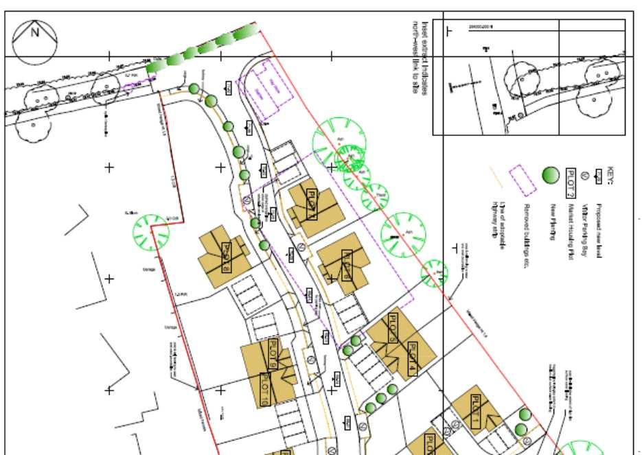
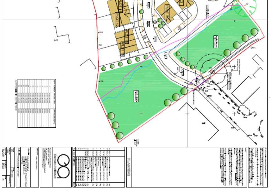
41
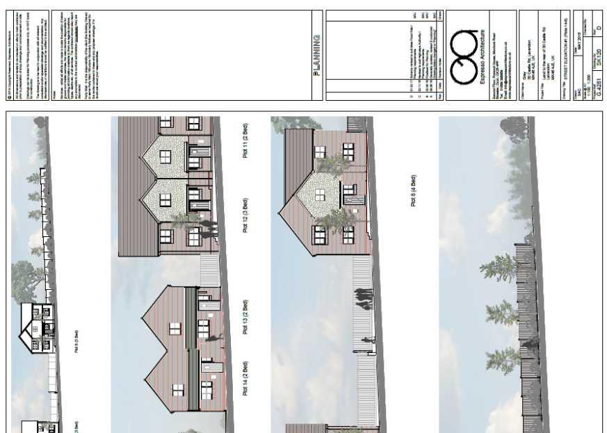
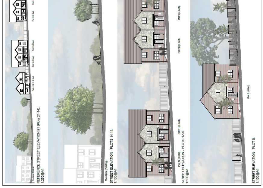
42
43
44 Appendix to 16/01630/OUT A1.0 RELEVANT PLANNING HISTORY (A brief outline of previous planning decisions affecting the site this may not include every planning application relating to this site, only those that have a bearing on this particular case) A1.1 08/01132/FUL Creation of a menage (resubmission for amended siting) Permitted /00716/FUL Creation of a menage adjacent to stables Permitted A2.0 ADDITIONAL MATTERS A2.1 None (Matters which were also considered in producing the Recommendation)
45 A3.0 CONSULTATIONS AND REPRESENTATIONS (Who has been consulted on the application and the responses received. The following are a brief description of the comments made. The full comments can be read via the Council s web site) Comments A3.1 Parish - Lavendon Lavendon Parish Council has reviewed the application for the amendment to 14 houses on the site and cannot see how this resolves the flooding issues that were pointed out in our previous objection and indeed, highlighted by your professional during the investigation of the application to 21 houses; whilst the site appears to have lost a pond and gained a couple of fields, if the pond was considered important before, why is it not now? It has been proven that the area is prone to flooding and any development would cause problems for the properties immediately surrounding the site as well as the rest of the village. Whilst we trust that your professionals will calculate independently of the applicant s paid consultants and we are by no means experts in this field, we are understandably cautious of adding to an already precarious and inadequate drainage system. Additionally, all our previous objections still stand, in that the access to the site is too narrow, the intensification of traffic through The Glebe and into Harrold Road at peak times is already excessive, the safety of the area would be further compromised with young and old crossing in the area, the doctors surgeries are at capacity, there is no bus service to Officer Response See See See See
46 one of these options and the village school is also at capacity. Therefore, please accept this as confirmation that Lavendon Parish Council OBJECTS to this amended application. A3.2 Ward - Olney - Cllr P Geary No comments received. A3.3 Ward - Olney - Cllr Hosking No comments received. A3.4 Ward - Olney - Cllr McLean No comments received. A3.5 Development Plans The Council is in a position (March 2017) whereby it can demonstrate a 5 year land supply figure of 5.03 years. Noted Therefore in terms of Paragraph 49 of the NPPF, the Council can now demonstrate a sufficient 5-year land supply and relevant policies for the supply of housing are no longer considered out-of-date. A3.6 MKC Urban Design In terms of design, I do not object to the principle of development on this site. Whilst the proposed layout is indicative at this stage I would like to raise the following comments: See The angle of Plots 4, 5, 11 and 12 should align with the street. The proposed buildings should follow the
47 line of the road better in order that the buildings and the road define the street. Plot 1 is too close to the side of plot 4, resulting in some visual intrusion. The New Residential Development guide seeks a side to back relationship of minimum distance of 13.7m. The proposed turning head at the end of the cul-dusac appears a little isolated. With the existing access to the livery being converted into a cycle / footpath link, I would recommend that development overlooks this area in the interests of security. Plot 14 should be orientated toward the Play Area with appropriate separation to the proposed active area of play. There should also be a landscaped strip and small path between the proposed parking area and the property wall. A3.7 Crime Prevention Design Advisor No comments received. A3.8 Environmental Health Manager No objections A3.9 Environmental Protection Team As the proposed use is particularly vulnerable to the presence of contamination, it is recommend that a condition requiring the assessment of ground conditions to determine the likelihood of contamination be applied to any grant of planning permission for this site. A3.10 Landscape Architect The site is in designated open countryside, in close Noted See 5.33 See and
48 proximity (2 fields away) to the Ouse Valley Area of Attractive Landscape (AAL). The Landscape Character Type is 5a Ouse North Undulating Clay Farmland. The Milton Keynes Landscape Character Assessment, 2015 sets out development considerations for the landscape character area including: - Restrict built development in the area retaining the primary role for agriculture and recreation - Where built development or restoration is considered appropriate indigenous building materials or equally visually acceptable alternatives should be used - Proposed development within or adjacent to the Ouse Valley should be accompanied by a landscape and visual assessment The Milton Keynes Landscape Character Assessment, 2015 sets out landscape management opportunities including: - The retention, restoration and planting of hedges and the addition of hedgerow trees within the open landscape to provide additional structure. The pattern of new hedgerow planting to follow historic field boundaries where possible - The removal of inappropriate coniferous species in hedges and replacement with native broadleaves. A pre-application submission raised an objection on landscape grounds. The current submission for outline permission would not be supported without a tree-hedgerow survey informing the layout and additional amendments to the site layout and submission: - The development site layout is limited to the existing historic field boundary hedgerows recorded on
49 historic mapping dating back to c1880, which is positive and must be protected and enhanced - The turning heads must be relocated at least 2m outside of the canopy-spread and root protection area of the hedgerows and trees - The tree identified as an Oak on the layout along the southern site boundary will extend its canopy/root spread is it matures and cast greater shade which has the potential to raise future concern for the owners of plots 1 and 2. - The application must be supported by a tree survey, tree constraints plan and root protection area drawing - The tree survey and root protection area is required to be overlaid on an amended development layout - A landscape principles plan is required - Landscape management plan is required - A 'LVI assessment' has been submitted however the photographic survey report is not particularly detailed. It does not clearly indicate on plan the extent of possible visibility; ideally this and the viewpoints should have been agreed with MKC. Also the approximate extent of the development site and visible landmarks and / or existing buildings/dwellings are not annotated on to the photos to aid review - The layout plan shows a play area close to the access road. There is only one LEAP and one NEAP covering the whole of Lavendon. The site falls outside of the catchment area of the existing LEAP but falls within the catchment of the NEAP. At the very least amenity open space should be provided on site and a contribution should be sought through a s106 towards the refurbishment of the NEAP.
50 A3.11 Landscape Services Manager - Trees The trees around the margins of the site must be retained and protected in accordance with BS 5837: See It seems that two large oak trees were recently felled at this site. The proposals should therefore include in addition to the proposed planting, for planting of seven replacement Oak trees. The foundations of the proposed dwellings should be of sufficient depth and robustness to prevent any future problems arising in relation to subsoil shrinkage from water abstraction by adjacent trees when at their mature size. Submission of soft landscaping details are a bit premature at outline stage though these are of fairly broad brush, so detail proposals must be submitted at a later stage. I would comment generally that among the general tree planting proposals should be included three or four less commonly planted exotic species. The cycle / footway link on the north margin of the site must be of raised construction using a cellular confinement system in order to protect the root systems of the trees there, raised construction may also be required to the buildings and hard surfacing of plots 4 and 14 that are in the vicinity of trees. A3.12 Countryside Officer Habitats The Preliminary Ecological Appraisal (PEA) found that the See
51 majority of the site was composed of poor semi improved grassland, with a stable block, horse arena and access drive. The site boundaries being predominantly native species poor hedges and garden boundaries with Leylandii. The site had a few trees to its western end and trees located within the boundary hedge, these including Ash and two mature Oaks. The last sentence of Section 5 states Should horse grazing cease or be reduced it is likely that the potential ecological value of the site would increase. Protected Animals Great Crested Newts The Great Crested Newt survey states that... Great Crested Newts are highly unlikely to utilise the site and hence do not pose a constraint to the development of the site.... And that... the risk of encountering newts as negligible. No mitigation is required; Bats I would agree with the PEA observation that the eastern boundary hedge offers a suitable commuting corridor for bats and that there is potential for roosting bats, in some of the site s trees. Birds The site has suitable bird breeding habitat, any habitats that are proposed to be cleared will need to comply with bird protection legislation. Biodiversity The information supplied regarding biodiversity
52 enhancements is minimal, with no information in advance of some recommendations in the PES and The Great Crested Newt survey being provided. Information regarding the biodiversity mitigation and enhancement actions to include bird bricks and bat tubes, in (not on) buildings, hedgehog fence passes and the use of native province trees, shrubs, wild flower and grass seeds, also bulb planting, along with the locations of proposed habitats, will need to be provided to the Planning Authority for approval. To assess the effect on biodiversity, the development proposals should be subject to DEFRA Impact Assessment Biodiversity Calculator methodology to inform avoidance, mitigation and compensation actions that will ensure compliance with the NPPF and Local Plan Policy NE3. Additional Comments April 2017 I have now reviewed the updated April 2017 Great Crested Newt report, which is acceptable. I would agree with the report in its conclusions section that states; Great crested newts are highly unlikely to utilise the site and hence do not pose a constraint to the development of the site A3.13 Highways Development Control (Comments provided for 21 unit scheme only; amended scheme for 14 units has same access arrangements) See Traffic
53 The Transport Statement (adjusted to 21 units) is 9 vehicles in the am peak, 11 in the pm peak and 95 over a 12 hour day. This will not significantly impact the highway network. As per the Transport Statement, there have been no recordable accidents in the vicinity of the site within the 5 year period to Sept The site is therefore not contrary to policy T10 of the Local Plan. Access The access into the site has now been amended to my satisfaction including adequate space for refuse vehicle turning. The approach to the site is via the Glebe. The Glebe is a standard residential road layout which in terms of width and alignment is acceptable to serve the proposed development. My site visit, where I observed the existing parking and traffic conditions, led me to conclude that it is suitable to accommodate the additional units. Access to/from Harold Road and the A428 is also acceptable in terms of layout and visibility. It is proposed that the access onto Castle Road should be for pedestrian and cyclists. Although parts of Castle Road do not have footways, I do not have an objection to the proposed access for pedestrians/cyclists onto Castle Road, subject to the access being constructed in a bound material, signed for shared use and at each end for it to have bollards to prevent vehicle access. Pedestrian access is also provided via footways on the Glebe and via Joiners Way (which links with the Castle Road footway). The site is therefore not contrary to policy D1 of the Local Plan.
54 Parking Parking to be provided at the reserved matters stage in accordance with the council s adopted parking standards (2016). Zone 4 location. I have no objections subject to conditions. A3.14 Travel Plan Coordinator The number of dwellings planned in this development falls below travel plan thresholds, a transport statement is required and has been submitted. A3.15 Archaeology Officer The application lacks any assessment of the potential impacts on heritage assets. Noted See Despite the presence of 3 scheduled monuments in the immediate environs, the surrounding countryside is relatively unexplored archaeologically yet evidence for occupation from at least the Iron Age onwards is known. As such, and with this being a green field site of significant size adjacent to a historic settlement I would advise that the site is subject to an archaeological field evaluation and (if significant remains are revealed) appropriate archaeological mitigation prior to development. This could be secured via a condition: A3.16 Natural England No comments.
55 A3.17 Environment Agency No objection. A3.18 Anglian Water No objections subject to a condition requiring a waste water drainage strategy. Noted See Conditions A3.19 Internal Drainage Board No comments A3.20 Local Lead Flood Authority We do not object to the above application, subject to a condition requiring the submission of a detailed design for a surface water drainage scheme. A3.21 Sustainable Construction I have no objection subject to the applicants signing a s106 on carbon offset contribution and a condition requiring a sustainability statement addressing policy D4 requirements to be submitted at the reserved matters stage. A3.22 Planning Obligations From consultation with service providers, it is expected that Section 106 contributions totalling 236, as set out in this document are required to mitigate the impact of this development. See See In accordance with CIL Regulation 122, the planning obligations sought are compliant with the three statutory tests.
56 A3.23 Local Residents The occupiers of the following properties were notified of the application: - 47, 49, 51, 53, 55 and 77 The Glebe Lavendon - 22, 26, 30, 36, 38, 42, 44, 46, 48, 50, 52, 54, 63, 65, 67 Castle Road Lavendon In addition, site notices was also posted and an advert placed in the newspaper to publicise the application. A3.24 Third Party comments on 21 unit scheme 141 objection letters were received in response to the scheme as originally submitted for 21 units. These letters included the following points: - The development should be resisted because it is designated as open countryside. There are other better suited areas of the Borough for housing; alternative and more appropriate land for housing will come forward as part of the development plan. - Lavendon is not in need of more housing. - The proposal is not in accordance the Olney Neighbourhood Plan or the emerging MKC plan - If development is allowed to continue unchecked, villages will merge with Milton Keynes. - The site is an agricultural greenfield and brownfield land should be considered instead. - The proposal would ruin the rural character of Lavendon and its village status. - The LVIA does not accurately reflect the visual impact on the proposal which would be significant, especially on views of the countryside from Castle See See previous comments. The site is outside the Olney Neighbourhood Plan Area The development will not result in the merging of settlements see The site is previously developed land see See See
57 Road. - The proposal would change the character of the landscape dwellings is an overdevelopment of the site and 2-3 properties would be more appropriate. - The planning application is not sustainable - The additional 21 dwellings would result in highway issues arising from a significant increase (some 25%) in traffic volumes on the Glebe. The Glebe is a culde-sac with narrow sections and existing on street parking problems which impede the flow of traffic and causes issues for HGV and emergency vehicle access. Children also play on the Glebe - The Glebe is not suitable for construction traffic. - There is already congestion on the junction onto the Harold Road and A428 Northampton-Bedford road and this would be exacerbated. - Lavendon is a commuter village and therefore the peak traffic flows will be greater than stated by the applicant. - Pedestrian and cycle access should not be provided to Castle Road which has no pavements. - The proposal would have insufficient parking. - This site had an application refused for a stables a few years ago on the grounds of unsafe access and drainage not being suitable. - Flooding is already a major issue in Lavendon. - The proposal would increase flood risk in the area; surface water currently flows through the site from the Three Shire Woods and neighbouring fields and the existing site currently helps to control existing surface water runoff. See See See 5.57 The Highway Engineer does not object to the proposal see See previous comments See previous comments See previous comments See previous comments See previous comments and There have been two previous approvals for stables on the site. Noted. See
58 - The existing drainage ditch running through the site is already inadequate with neighbouring gardens on The Glebe being repeatedly flooded. - The proposal is building on a flood plain - Sewerage capacity is a challenge. Further, waste water would have to be pumped up hill and is liable to flood due to power cuts. - The attenuation pond poses a safety risk for children. - The additional 21 dwellings would result in residential amenity issues to existing properties neighbouring the site on the Glebe and Castle Road, including visual impact, loss of privacy, loss of daylight, overshadowing, noise and disturbance - Lighting was previously not allowed for the stables on the site due to impact on residential amenities; lighting from the proposed development would therefore affect the amenities of neighbouring properties. - Neighbouring properties would lose their views of the countryside. - The proposal would impact on the right to light of neighbouring properties. - Construction traffic would cause amenity issues as well as health issues. - The proposal would breach the human rights of neighbours. - Concerned trees have been felled on site to the detriment of protected species. - The proposal would harm wildlife - Concerned that then scheme would adversely affect bats and newts - The development does not come across as truly Noted. See Anglian Water do not object to the application subject to a condition. This is not a planning consideration. See The impact of floodlighting for a menage is considered to have a materially different impact to lighting associated with residential development. This is not a planning consideration. This is not a planning consideration. A construction management condition is proposed See 5.56 This is not a consideration to the assessment of this application. The Countryside Officer raises no objections see See previous comments. The application is for outline permission only see
59 committed to habitat creation and biodiversity enhancements - There are the remains of a castle in the locality and an archaeological survey should therefore be undertaken. - The necessary infrastructure and facilities to serve the development does not exist with the school, doctor and dental surgeries and waste collection already over stretched. - The village has a very poor bus network and residents have to rely on the car. There is no bus service from Lavendon to Harrold which has the only medical centre residents will be able to register at. - Proposal is likely to miss the opportunity to provide affordable homes needed by local people - The development would increase the school size resulting in it feeling less safe. - The proposal would result in global warming - There may be land ownership issues with access to The Glebe and also regarding the watercourse.. - The proposal would affect property values. A3.25 Two letters of support were received in response to the scheme as originally submitted for 21 units. These letters included the following points: - The development is sensitive, relatively small scale development which is much needed in the village. - The provision of family housing is welcomed. - There are relatively few homes being provided given the size of the plot. - The pedestrian link would allow children on Castle Road to more safely access the village playing field. See The applicant has agreed to infrastructure contributions to offset the impact of the development See See The proposal falls below the affordable housing threshold This is not a material planning consideration. The proposal would comply with Policy D4 see Land ownership is not a material planning consideration. This is not a material planning consideration. Noted
60 - Welcome more homes in the village, particularly low cost / affordable A3.26 Third Party comments on 14 unit scheme Following the scheme being amended from 21 to 14 units, a further 25 letters of objection have been received. These objections essentially detail that the reduction in the number of units does not overcome the objections previously raised to the scheme as originally submitted and detailed above. Although one of the objection letters does provide evidence to show that Great Crested Newts are present at No. 63 Castle Road. Noted. See
61 Appendix 3
 Councillors: Bint, Eastman, Exon, Legg, McLean, Miles (Substituting for Councillor C Wilson and not present for Application), Morla, Petchey,")
62 ITEM 3(a) Minutes of the special meeting of the DEVELOPMENT CONTROL COMMITTEE held on THURSDAY 11 MAY 2017 at 7.00 pm. Present: Officers: Apologies: Councillor A Geary (Chair) Councillors: Bint, Eastman, Exon, Legg, McLean, Miles (Substituting for Councillor C Wilson and not present for Application), Morla, Petchey, C Williams (Substituting for Councillor Alexander) and P Williams B Leahy (Head of Development Management), A Smith (Senior Planning Officer), J Bioorj (Senior Planning Officer), A Sacbuker (Senior Planning Officer), P Caves (Highways Engineer), J Price- Jones (Solicitor Planning) and D Imbimbo (Committee Manager). Councillors Alexander, and C Wilson Also Present: Councillors Hosking and P Geary Number of Public Present: Approx. 100 DCC96 DCC97 CHAIRMANS WELCOME The Chair welcomed Members of The Committee, Officers and Public to the meeting. The made the following announcements. Congratulations extended to Mr B Leahy who had been appointed as Head of Planning, Congratulations extended to Miss S Taylor who had been appointed a Senior Planning Officer, and, Thanks to Mr A Smith for his service to the Council on his leaving the Authority. MINUTES OF PREVIOUS MEETINGS RESOLVED That the minutes of the meetings of the Development Control Committee held on 9 March 2017, 30 March 2017 and 6 April 2017 and those of the meetings of the Development Control Panel on 16 March 2017 and 20 April 2017 be agreed as accurate records and signed as such. DEVELOPMENT CONTROL 11 MAY 2017 PAGE 1 COMMITTEE CHAIR S INITIALS.
63 DCC98 DCC99 DECLARATION OF INTERESTS Councillor Eastman asked that it be noted that in respect of application 16/03023/FUL, he being the Ward Member was aware of the level of opposition to this matter, however, had not expressed a view and would consider the application on its merit. Councillor A Geary stated that he had received numerous s and other communications in respect of the application and that he believed other member of the Committee will have also received them. Councillor C Williams asked that it be noted that he was Chair of the Councils Housing and Community Committee. Councillor Bint asked that it be noted that in respect of application 17/00533/FUL, he was the Ward Councillor for the area and a resident and used the surgery in a personal capacity but had no greater involvement than any other resident could be expected to have. Councillor McLean asked that it be noted that in respect of application 16/01630/OUT, he was Ward member and had attended various meeting where the application had been discussed but he had not expressed a view in respect the application and would judge it on its merits. QUESTIONS FROM MEMBERS OF THE PUBLIC The Chair told the Committee that this being a Special meeting of the Committee, Ordinarily Questions from the Public would not be taken, however due to a notice of an intention to determine the Salden Chase Application for South West Milton Keynes having been given earlier in the week, he would allow a question to be put in respect of that matter. Mr M Galloway (Clerk to Newton Longville Parish Council), asked the following Question; As you are, I believe, aware AVDC are intending to consider the application described as South West Milton Keynes at a meeting in Aylesbury next Wednesday morning at 9:30am. This is the application which your committee, when commenting on the application as submitted to AVDC, decided to object following an excellent officer with additional points from the committee after hearing from residents of West Bletchley and Newton Longville. The objection was sent by way of a letter in your name to AVDC. In the AVDC officer report to their meeting there are a number of instances in which various aspects of the proposal are said to be agreed to by Milton Keynes Council. Can you please confirm that all that MKC have decided at this point is to comment on the application to AVDC with an objection, that any DEVELOPMENT CONTROL 11 MAY 2017 PAGE 2 COMMITTEE CHAIR S INITIALS.
64 DCC100 DCC101 determination by Milton Keynes Council has yet to be made, and that it is for the DCC to decide such matters following advice from planning and highways officers. The Chair confirmed that the situation was as Mr Galloway had stated, furthermore the Chair confirmed that it was his intention to attend the meeting of the AVGC Development Control Committee where he hoped to address the Committee, though he had experienced some difficulty in registering to speak. REPRESENTATIONS ON APPLICATIONS Mrs L Wardlaw, Mr S Hussey, Mrs Scholefield (all representing Blakelands Residents Assovciation and Councillor D Stabler (Great Linford PC) spoke in objection to application 16/03023/FUL, Demolition of existing B8 storage and distribution warehouse, and erection of a new B8 storage and distribution warehouse with ancillary B1 floorspace and associated works at Blakelands 1, Yeomans Drive, Blakelands. The applicant s agent, Mr D Staniland exercised the right of reply. Mr S Axtell, Mr C Redsull, Councillor D Tomkins (Lavendon Parish Council), Councillor Hosking (Ward Councillor) and Councillor P Geary (Ward Councillor), spoke in objection to application 16/01630/OUT, Outline planning permission including means of access (all other matters reserved) for the erection of 14 new dwellings at Land East of Castle Road And North of, The Glebe, Lavendon. The applicant s agents, Mr J Waite exercised the right of reply. Mr P Addyman, Mr C Redsull and Councillor Pittman (Wavendon Parish Council) spoke in objection to application 16/03595/OUT, Outline application for residential development to provide approximately 16 units with access from Walton Road together with landscaping, infrastructure and ancillary works at Land Off, Walton Road, Wavendon. The applicant s agent Mr A Collins declined the right of reply. PLANNING APPLICATIONS 16/03023/FUL DEMOLITION OF EXISTING B8 STORAGE AND DISTRIBUTION WAREHOUSE, AND ERECTION OF A NEW B8 STORAGE AND DISTRIBUTION WAREHOUSE WITH ANCILLARY B1 FLOORSPACE AND ASSOCIATED WORKS AT BLAKELANDS 1, YEOMANS DRIVE, BLAKELANDS FOR MR A MCGUIGAN The Senior Planning Officer introduced the application with a presentation. It was noted that a Site Inspection had been undertaken attended by DEVELOPMENT CONTROL 11 MAY 2017 PAGE 3 COMMITTEE CHAIR S INITIALS.
65 Councillors A Geary, Eastman, Petchey and McLean. The Planning Officer told the Committee that following representations from the conservation Officer an additional condition in respect of recording the existing building, as detailed in the published additional report was recommended. It was further commented that a large number of late representations had been received and these had been addressed in the published additional report. Concerns raised in respect of overshadowing were recognized but the proposed building would not breach the Industry Standard BRE Assessment 25 degree rule and as such this was not a matter that could be considered as unacceptable in the circumstances. The Committee heard that the Officer recommendation remained to grant the application subject to the conditions set out in Section 6 of the DCC Report together with the additional condition in respect of recording the existing structure in terms of conservation and a Section 106 Legal Agreement The Committee heard representations from members of the residents association and the Parish Council in objection to the application, raising the following concerns; The proposed development is out of scale with the surrounding area. The proposal to develop a facility that would operate 24/7 with heavy vehicle movement at all times of the day in close vicinity to residential properties is unacceptable. Visual Intrusion. Loss of light. A shadow over residential properties for 5 months of the year. Increased Pollution. Disruption to the lives and amenity of a large volume of elderly and infirm persons living in close proximity to the site. DEVELOPMENT CONTROL 11 MAY 2017 PAGE 4 COMMITTEE CHAIR S INITIALS.
66 There are numerous alternative sites, developing this site further, contravenes Policy CS1 of the Core Strategy. Independent research has demonstrated that properties in Bessemer Court will suffer overshadowing and no direct sunlight for 10 weeks between November and February due to the height and scale of the proposed development. The proposal is in breach of Policies D1(3) and D3 (1) and (2) of the saved Local Plan The proposal breaches the Great Linford Neighbourhood Plan Policy N13 Clauses A, C and D. The proposed development is contrary to two of the original key design principles for Milton Keynes; creating a city where traffic flows and traffic James are avoided and creating an environment where industry and homes are situated side by side in harmony. The proposal will add to the existing congestion experienced in the area. Proposals to put parking restrictions in Yeomans Drive will serve to displace the increased parking problems that will result from the development. Air pollution will be significantly increased in an area where there is a high proportion of elderly persons suffering respiratory problems. If the Committee is minded to grant the application it should consider imposing a condition restricting hours of operation to reflect those presently operated. The proposals do not provide any benefit for the local economy or employment. The development represents a 62% increase in height and would present an unacceptable visual intrusion. The Applicant s agent told the Committee that the proposal was completely compliant with all Milton Keynes Council Policies and the NPPF. DEVELOPMENT CONTROL 11 MAY 2017 PAGE 5 COMMITTEE CHAIR S INITIALS.
67 It was concluded from a soft marketing exercise that the existing building did not meet modern storage and distribution requirements and the proposal sought to address this. Significant investment is intended to be made into external cladding and materials to negate any potential harm. The Planning Officer confirmed that the Environmental Health Officer had not expressed any concern in respect of the 24/7 operations proposed by the developer. Councillor A Geary proposed that the Officer recommendation be agreed, this was seconded by Councillor Exon. In response to questions the Committee heard the following; Despite comments that the development could be sited elsewhere the Committee was required to consider the application as presented. The Neighborhood Plan was made and therefore carried full weight. The benefits to employment do form a material planning consideration. No similar developments close to residential areas existed in Milton Keynes to act as a comparator. The existing operating hours were voluntarily applied by the existing occupiers of the premises but did not represent a requirement on the existing premises. Planting of trees could be conditioned to be by way of mature trees to avoid a long period of growth before the screening was effective. Right to Light was a matter covered by Building Regulations not a planning permission consideration. It was access to daylight and sunlight that was relevant and the BRE Vertical Sky Component 25 degree line rule was not breached by the proposed development. DEVELOPMENT CONTROL 11 MAY 2017 PAGE 6 COMMITTEE CHAIR S INITIALS.
68 There was a risk that should the matter go to appeal there could be amendments or deletions to the condition being proposed. Members of the Committee recognised that the environment was unique within Milton Keynes in so far as industrial and residential developments being in close proximity. The concerns of the residents were recognised as were the comments of the planning officer which demonstrated that the proposal was policy compliant. It was proposed by Councillor Petchey that a condition in respect of the hours of operation of heavy vehicles into, out of and within the site be added to restrict operation to 07:00 to 21:00 Monday to Friday and 10:00 to 16:00 at weekends, this was seconded by Councillor P Williams Councillor A Geary as proposer of the substantive motion accepted the amendment. On being put to the vote the proposal to grant the application under the conditions detailed above was carried with 6 Members voting in favour and 4 against the proposal. RESOLVED That the application be granted subject to the conditions set out in Section 6 of the Committee report together with the additional condition as detailed in the published update report and the additional condition in respect of hours of operation and a S106 agreement. 16/01630/OUT OUTLINE PLANNING PERMISSION INCLUDING MEANS OF ACCESS (ALL OTHER MATTERS RESERVED) FOR THE ERECTION OF 14 NEW DWELLINGS AT LAND EAST OF CASTLE ROAD AND NORTH OF, THE GLEBE, LAVENDON FOR MR & MRS GRAY The Senior Planning Officer introduced the application with a presentation. The Committee heard that the recommendation remained to grant the application subject to the conditions as detailed in the Committee report together with a S106 agreement. DEVELOPMENT CONTROL 11 MAY 2017 PAGE 7 COMMITTEE CHAIR S INITIALS.
69 The Committee heard from Objectors who raised the following objections; The site access would be through the Glebe and would result in congestion and safety concerns. The site is subject to regular flooding, as is the Glebe on occasions, the development would likely lead to additional flooding in the Glebe. The reduction to 14 dwellings from 21 would not reduce the risk of flooding, and would cause water to flow into Castle Road. The Site is not identified on the Development Plans for residential use. The site despite being referred to as a Brown Field site is open countryside and only a small area was developed and only by way of a stable and ménage, the proposal is therefore in contravention of Policy S10 of the saved local plan and Policies CS9 and CS10 The Applicant s Agent told the Committee that the site was defines as a Brown Field site and the argument that the proposed development was in breach of Policy S10 was not valid. The applicant s agent confirmed that specialist flooding prevention advice had been taken and the development reduced from 21 to 14 units to take account of the advice. The Senior Planning Officer confirmed that the site did fall into the definition of Brown Field as defined in the NPPF. All matters raised were addressed in the Committee report. Councillor A Geary proposed that the Officer recommendation be agreed, this was seconded by Councillor Legg. It was noted that the NPPF required that a proposal represented a significant boost to the provision of housing, the Committee heard that the proposal represented an increase of 2.5% of houses in the village which was not seen to be a significant boost. It was also noted that the by reducing the number of dwellings to 14 the threshold of 15 to DEVELOPMENT CONTROL 11 MAY 2017 PAGE 8 COMMITTEE CHAIR S INITIALS.
70 16/03595/OUT provide affordable housing was not reached. Members commented that if it were accepted that the site was Brown Field, only about 1/3 of the site had any form of development on it. It was noted that the definition did include the curtilage. Members of the Committee took a view that the site was clearly in open countryside and the majority of the site was undeveloped and could not be considered Brown Field. On being put to the vote the proposal to grant the application was lost. Councillor A Geary proposed that the application be refused as the site was in Open Countryside and did not meet the criteria and was therefore in contravention of saved policy S10 of the Local Plan and Policies CS1 and CS9. This was seconded by Councillor McLean. On being put to the vote the motion to refuse the application for the reasons stated above was carried unanimously, and it was; RESOLVED That the application be refused as the proposed development, by virtue of its location was in open countryside and the application was therefore in contravention of saved policy S10 of the Milton Keynes Local Plan and policies CS1 and CS9 of the Core Strategy. OUTLINE APPLICATION FOR RESIDENTIAL DEVELOPMENT TO PROVIDE APPROXIMATELY 16 UNITS WITH ACCESS FROM WALTON ROAD TOGETHER WITH LANDSCAPING, INFRASTRUCTURE AND ANCILLARY WORKS AT LAND OFF, WALTON ROAD, WAVENDON FOR HEWLETT PACKARD ENTERPRISE SERVICES UK LIMITED The Senior Planning Officer introduced the application with a presentation. The Committee heard representations in Objection to the Application raising concerns that the site access arrangements were potentially dangerous and presented Highway Safety Concerns, the proposed siting of the access was directly opposite the windows of The Barn a residential building. DEVELOPMENT CONTROL 11 MAY 2017 PAGE 9 COMMITTEE CHAIR S INITIALS.
71 The applicant s agent told the Committee that mitigation was proposed to lessen the impact on the Barn, however these had been rejected by the occupant of the Barn. It was further commented that alternative access arrangement through Ortensia Drive could not be used due to the land not being in the control of the applicant. Councillor A Geary proposed that the Officer recommendation to grant the application subject to the conditions as detailed in the Committee report be agreed, this was seconded by Councillor Exon. The Committee debated the application at length and in particular the concerns raised in respect of the access arrangements and potential impacts of the proposed arrangements. Members of the Committee indicated that they supported the principle of the development but could not support the access arrangements and following a short adjournment Councillor A Geary proposed that determination of the application be deferred to allow further discussion with the developer and relevant parties to redesign the access arrangements, this was seconded by Councillor Legg. On being put to the vote the proposal to defer the determination of the application was carried unanimously. RESOLVED That determination of the application be deferred to allow discussion with the applicant to redesign or move the access road. 17/00533/FUL ERECTION OF THREE SINGLE STOREY EXTENSIONS TO FORM ADDITIONAL EIGHT CONSULTING ROOMS, AND TREATMENT SPACE TO EXISTING DOCTOR'S PRACTICE AT MILTON KEYNES VILLAGE PRACTICE, GRIFFITH GATE, MIDDLETON FOR MILTON KEYNES VILLAGE PRACTICE The Officer reported that there was no update on the Committee report and that the recommendation remained to grant the application subject to the conditions as detailed in the Committee report. DEVELOPMENT CONTROL 11 MAY 2017 PAGE 10 COMMITTEE CHAIR S INITIALS.
72 DCC102 Councillor A Geary proposed that the application be granted subject to the Conditions as detailed in the Officer report, this was seconded by Councillor Legg. On being put to the vote the proposal to grant the application was carried unanimously, and it was; RESOLVED That Planning Permission be granted subject to the conditions as detailed in the Committee report. DEVELOPMENT CONTROL SCHEME OF OFFICER DELEGATION and DEVELOPMENT CONTROL MEETINGS PUBLIC PARTICIPATION SPEAKING ARRANGEMENTS The Committee considered reports in respect of the proposed Development Control Scheme of Delegation and Development Control Speaking Arrangements; Access to Information Annex A of the Council Constitution. The Committee heard from the Head of Development Management that following the matter being considered at length by the Committee in April, all the agreed amendments had been made and incorporated into the scheme. Since the publication of the agenda a further representation from the representative of the Parishes had been received asking for an amendment to the wording of Paragraph 4 of annex A of the scheme. It was recommended that the paragraph be amended to read; No Delegated decision on a planning application shall be made until the formal consultation period has expired. The Committee heard from Councillor L Inoke speaking on behalf of Milton Keynes Town Council that paragraph 5b. of the Officer Scheme of Delegation was slightly ambiguous in so far as it implied that where a Parish Council had failed to attend the meeting on two occasions any applications within that Parish would be determined by delegated powers irrespective of what objections might be made by other parties and asked that the Committee consider amending the paragraph to include after the word Powers the words where the Parish or Town Council is the sole objector. Councillor C Williams proposed that the wording be amended to read; Any applications within that parish being determined in accordance with the Officer recommendation under delegated powers. This would also be for a concurrent 3 month period and would only take effect in cases where no other parties have lodged objections and requested the case be heard before a panel or committee as at point 1. The amendment was agreed by acclamation. DEVELOPMENT CONTROL 11 MAY 2017 PAGE 11 COMMITTEE CHAIR S INITIALS.
73 Councillor Miles proposed that Paragraph 7 be amended to include the word Partner at the final bullet point. This was agreed by acclamation. In respect of the Speaking Arrangements, the Committee heard that the Parish Councils sought a right to speak in a neutral position, the Committee took a view that in such cases the Town or Parish should submit a written representation rather than speak on a matter in these circumstances. The Committee asked that paragraph f. be amended to include the words or their agents after Applicant. It was further commented that due to the fact that the matters are related Councillor Miles proposed that the Committee recommended to Council that it Adopts the Officer Scheme of Delegation and the Amendments to Annex A of the Access to Information rules relating to speaking at Development Control meetings. as one item, this was seconded by Councillor A Geary and agreed by acclamation. RESOLVED 1. That the Development Control Scheme of Delegation be agreed as amended above, and, 2. That the Development Control Speaking Arrangements; Access to Information Annex A of the Council Constitution be agreed as amended above. 3. That the Development Control Scheme of Delegation and the Development Control Speaking Arrangements; Access to Information Annex A of the Council Constitution be recommended to Council for Adoption. THE CHAIR CLOSED THE MEETING AT 10:47 PM DEVELOPMENT CONTROL 11 MAY 2017 PAGE 12 COMMITTEE CHAIR S INITIALS.
74 Appendix 4
75
76 Appendix 5
77 5. Development Strategy and Areas of Change 5.7 There will also be opportunities for infill and redevelopment in other villages which have development boundaries defined on the Local Plan Proposals Map. These boundaries remain unchanged Policy CS1 Milton Keynes Development Strategy by the Core Strategy, although there may be minor changes introduced through the Site Allocations Plan and Plan:MK at a future date (see Policy CS2 'Housing Land Supply'). The provision of new homes and jobs will take account of the Settlement Hierarchy set out in Table 5.1 'Settlement Hierarchy' below. The majority will be focused on, and adjacent to, the existing urban area of Milton Keynes. Here, the continued development of Central Milton Keynes, completion of existing city estates (20), existing Local Plan Expansion Areas (21), and redevelopment and infill development (particularly in the older parts of the city) will all contribute to a more sustainable city (see Policy CS7 'Central Milton Keynes' and Policy CS8 'Other Areas of Change'). A Strategic Land Allocation to the south east of the city will provide a sustainable urban extension adjoining the existing urban boundary (22). In addition to the Strategic Land Allocation other non-strategic development sites will be brought forward through the Site Allocations Plan to provide short term flexibility and contingency ahead of a full review of this Core Strategy in Plan:MK (See Policy CSAD1). This Council's approach to major development proposals adjoining the city, but within the area of a neighbouring local authority, is set out in Policy CS6 'Place-shaping Principles for Sustainable Urban Extensions in Adjacent Local Authorities'. Milton Keynes Council Milton Keynes Core Strategy: Adopted July The main incomplete city estates are Tattenhoe Park, Oakgrove, Oxley Park and Kingsmead South. There are some smaller sites within other estates including Grange Farm and Monkston Park. Place shaping details can be seen in Table 5.8 'Overarching Development Strategy'. 21 Existing expansion areas are to the north, east and west of Milton Keynes, Stantonbury Park Farm and Newton Leys - see Table 5.8 'Overarching Development Strategy' for place shaping details. 22 The change to the urban development boundary can be seen on the Policies Map amendment (see Appendix E 'Policies Map Amendment'). 21
78 5. Development Strategy and Areas of Change Milton Keynes Council Milton Keynes Core Strategy: Adopted July 2013 In the remainder of the Borough: i. Development will be concentrated on the Key Settlements of Newport Pagnell, Olney and Woburn Sands, as the towns with the largest range of facilities and best public transport links (see Policy CS9 'Strategy for the Rural Area') ii. A limited amount of new housing (23) will be allowed in Sherington (as a Selected Village). Small scale redevelopment and infill development will be permitted in the 'Other Villages' with a development boundary (24) Central Milton Keynes Uncompleted city estates Table 5.1 Settlement Hierarchy 1. Milton Keynes City Main areas for development will be: District centres: A) Bletchley Wolverton B) Kingston Westcroft 2. Key Settlements City Expansion Areas: Existing expansion areas, Strategic Land Allocation Selective infill, regeneration and redevelopment opportunities Newport Pagnell Olney Woburn Sands 3. Selected Villages (25) Sherington Hanslope Bow Brickhill 4. Other villages Villages with development boundaries (26) 5. Other settlements Villages in the open countryside The limited amount of development to be allocated in Sherington will be determined through work on the Site Allocations Plan. In line with the level of development in existing Selected Villages, new allocations are expected to provide around a total of new dwellings. 24 Small scale redevelopment and infill developments are defined as proposals for development on any non-allocated site within the development boundaries of the city and other towns and villages. 25 Hanslope and Bow Brickhill are identified as Selected Villages in the Local Plan. No new allocations will be sought in theses settlements but existing allocations will remain in place. 26 Other villages with a development boundary are Astwood, Castlethorpe, Clifton Reynes, Emberton, Lavendon, Little Brickhill, Long Street, New Haversham, Newton Blossomville, North Crawley, Ravenstone, Sherington, Stoke Goldington, Wavendon and Weston Underwood
79 5. Development Strategy and Areas of Change Delivery 5.8 Policies CS2 - CS4 provide additional detail of the quantity of housing, employment land and leisure/retail provision to be made across the Borough. 5.9 Policies CS5 - CS9 set out in more detail how this development will be delivered across Milton Keynes Topic based Policies CS10 - CS21 provide additional measures to ensure development occurs in a timely and sustainable manner Table 5.8 'Overarching Development Strategy' provides additional place shaping detail of those areas which have already been planned through the Local Plan (2005) The Plan:MK will provide criteria against which small-scale redevelopment and infill proposals can be assessed. Until Plan:MK is completed, Local Plan (2005) policies will continue to be implemented The strategy was initially drawn up in a period of economic growth but the recession has severely affected the phasing of the growth of Milton Keynes. The economic downturn has resulted in a slowdown in house building and a rise in unemployment. This has resulted in the estimated number of housing completions over the next few years to be reduced compared to recent years. Housing starts have contracted and many developments that were due to start have been postponed. This situation is reflected in Chapter 18 'Development Timeline and Housing Trajectory'which shows that housing completions will not approach 2007/08 levels for some time, based on up-to-date data and surveys Development Plan Documents (in the form of Action Area Plans), Neighbourhood Plans or Supplementary Planning Documents will be considered as a delivery mechanism for localised regeneration projects. These projects will be identified through community-led appraisals, Heathchecks, Parish Plans or their equivalents which identify community needs The Timeline and Housing Trajectory are realistic given the economic position during 2008 to However, this trajectory has been prepared during an economic downturn which has severely hit housebuilding, so accurate long term predictions are difficult to forecast. Many sites are already under construction, have permission, or at least have a development brief. This should mean that there will be few delays to the delivery of housing caused by planning delays when the market recovers. In addition, Milton Keynes has an excellent track record in delivering infrastructure before and alongside housing, through the tariff system, reducing potential delays. The Joint Delivery Teams will also assist in unblocking and co-ordinating development. As set out in Table 17.1 'Core Strategy Objectives, Critical Success Factors and Monitoring Indicators', the housing trajectory's accuracy will be assessed by staying within a 20% range of the annual forecast rate of housing delivery. A full review of this Core Strategy will consider the longer term implications of the economic situation on housing and employment needs and demands in the Plan:MK, as set out in Policy CSAD1 'Review of the Core Strategy'. Milton Keynes Council Milton Keynes Core Strategy: Adopted July

80 9. Development in the Rural Area Milton Keynes Council Milton Keynes Core Strategy: Adopted July Development in the Rural Area 9.1 Growth in the rural area of Milton Keynes has always been treated separately to the growth requirements of the city, with the majority of development focused on the urban area. Past rates of housing completions in the rural area have averaged 120 per year on allocated sites and through windfall development (63). Only a limited amount of development should therefore take place in the other towns and villages in the Borough, and any shortfall in housing completions in the city will not be offset by more development in rural settlements. New housing in Wavendon will be counted as rural growth. 9.2 The hierarchy in Policy CS1 'Milton Keynes Development Strategy' continues to focus development in the rural area on the main, most sustainable towns or Key Settlements. These towns have the best public transport service, the most facilities and serve surrounding villages as well as their own residents. Policy CS2 'Housing Land Supply' sets the framework for identifying any new housing sites. Olney Town Centre 9.4 Sherington Parish Council supports Selected Village status for their village on the basis that a limited amount of sensitive housing development would support improvements to local facilities and the local drainage system. This may lead to a change to the development boundary for Sherington to allow development on a new site(s). 9.5 The settlement hierarchy identifies Other Villages with a Development Boundary. These villages could see some small scale development within their existing boundaries through sensitive infill or redevelopment. We have not made any changes to the development boundaries for these villages; they remain as shown on the Local Plan Proposals Map. 9.6 Other Villages without a Development Boundary are classed as being part of the open countryside. These are the smallest and least sustainable rural settlements and as such, we do not envisage any new housing development in these villages unless it is to meet identified local housing needs, for example the exception site at Cranfield Road, Moulsoe. 9.7 We will carry out more detailed work for the Site Allocations Plan and Plan:MK to identify any constraints to development. At the same time, we will consider the need for additional facilities in the Key Settlements The Local Plan identified the villages of Hanslope and Bow Brickhill as Selected Villages following support from each Parish Council for a limited amount of new housing. These sites are regarded as commitments. There may be scope for small, infill developments in these villages, but we will not be looking to identify more new housing sites outside the current development boundaries of these villages. Policy CS9 Strategy for the Rural Area The Council will prepare a Site Allocations Plan to identify land that can assist the delivery of an average of 110 homes per year in the rural area. The Settlement Hierarchy in Policy CS1 'Milton Keynes Development Strategy' will provide the sequence for prioritising site selection. Development will be focused on the Key Settlements of Newport Pagnell, Olney and Woburn Sands as the most sustainable rural settlements, taking into account the population, constraints, transport links and the capacity of services in these towns. Any changes to the 63 See for details of past housing completions.
81 9. Development in the Rural Area boundaries of these settlements will be considered through the Site Allocations Plan and Plan:MK. Sites identified for housing development in the Local Plan in the Selected Villages of Hanslope and Bow Brickhill, will remain as allocations in the Core Strategy. Sherington is also identified as a Selected Village. A site(s) will be identified for a limited amount of housing development (64) through the Site Allocations Plan. Appropriate infill development and conversions will be allowed in villages with development boundaries. An update of all village boundaries will take place through the Site Allocations Plan and Plan:MK. Conversions will not be at the expense of key rural facilities (65), which will be protected from redevelopment for other uses. New development that provides rural employment, farm diversification and the reuse of rural buildings for employment will be encouraged (66). Delivery 9.8 The Site Allocations Plan will allocate new sites for housing and other required facilities in the Key Settlements and the Selected Village, Sherington. 9.9 Until the Plan:MK is adopted, saved Local Plan Policies E5 and E6 support the reuse of rural buildings for employment use and farm diversification schemes. The Plan:MK will set out criteria for permitting the conversion in the open countryside for economic and residential purposes, and for farm diversification proposals The Plan:MK will include policies to protect the integrity of rural settlements and ensure they continue to function in a sustainable manner. This will include policies on individual town/village centres and conservation areas where required. The Site Allocations Plan and Plan:MK will also consider the need to review the existing development boundaries of rural towns and villages Parish and Town Councils will be key participants in new Local Plans. Where they exist, village plans will be a useful starting point for this work and villages are encouraged to produce such plans. Public engagement will follow the Statement of Community Involvement. This work may lead to other villages identifying a need for additional land for housing. Where this is the case, the inclusion of settlements as Selected Villages will be considered at the next periodic review of the Core Strategy We will monitor the rate of housing development in the Annual Monitoring Report and regular updates of the Strategic Housing Land Availability Assessment. If this shows a shortfall in the five year land supply (67), we will consider the need for a full or partial review of the Core Strategy and/or the need to allocate new sites in the preparation of the Site Allocations Plan and Plan:MK Over the plan period, housing developments within the boundary of Wavendon continue to be classed as rural completions. Milton Keynes Council Milton Keynes Core Strategy: Adopted July See Policy CS1 'Milton Keynes Development Strategy' for definition of 'limited' 65 Key rural facilities are defined in the Rural Spatial Options Technical Paper for the Core Strategy Preferred Options as a food store, school, post office and pub. 66 Rural employment should be of a scale appropriate for the rural area and help to meet wider sustainability objectives, including movement. Economic uses will be preferred for existing buildings in the rural area where they are appropriately located and suitably constructed. Farm diversification should help to support the agricultural role of farms, rather than replace the use. 67 The five year land supply is made up of suitable sites which are confirmed as being available and deliverable within the next five years 67

82 STRATEGIC POLICIES OPEN COUNTRYSIDE Objective of policy To protect the countryside and to concentrate new development within and adjoining existing settlements 3.54 The term open countryside is a policy designation that applies to all land outside the development boundaries of settlements. It is not simply a descriptive term relating only to land that is open in character The overall strategic approach to development in the open countryside is deliberately restrictive and consistent with that in the previous Local Plan. However, other policies in the Local Plan cover specific types of development that may be acceptable as exceptions to this general approach, e.g. wind turbines (Policy D5). The Minerals Local Plan and Waste Local Plan are also relevant to parts of the open countryside. The Minerals Local Plan is currently under review New areas of woodland will be also be encouraged in the open countryside, particularly to the south and east of the City, linking up with the Brickhill woods and the Marston Vale Community Forest Proposals for agricultural or forestry worker s dwellings will be assessed against the tests in PPG7. OPEN COUNTRYSIDE POLICY S10 The open countryside is defined as all land outside the development boundaries defined on the Proposals Map. In the open countryside, planning permission will only be given for development that is essential for agriculture, forestry, countryside recreation or other development which is wholly appropriate to a rural area and cannot be located within a settlement. AREAS OF ATTRACTIVE LANDSCAPE Other policies relating to the open countryside: E5: reuse of rural buildings for employment use E6: new buildings in the open countryside L6: horse related development L10: conversion of farm buildings to form visitor accommodation L11: camping and touring caravan sites H11: low impact dwellings in the countryside HE8: conserving and enhancing landscape character R6: retail uses in the open countryside PPG7: The Countryside Environmental Quality and Economic and Social Development Annex I Objective of policy To protect and enhance those areas of countryside identified as having countywide landscape value 3.58 The Areas of Attractive Landscape (AAL) are a county designation shown in the Structure Plan. The Council recognised that the advice in PPG7 coupled with the Council s new unitary status, made it imperative to both examine the criteria for designation (which were inherited from the County Council) and the boundaries of the AALs, to identify if modifications were needed to the way they have been defined in the Local Plan 3.59 The Landscape Study recommended some changes to the boundaries of the 2 AALs and confirmed that there were no other areas of the Borough that justified AAL status. Three additions have been agreed to the Ouse Valley AAL east of Olney; south of Lavendon; and the Linford Lakes area west of Newport Pagnell. Milton Landscape Character (2000) Keynes Study Milton Keynes Local Plan Adopted December
Outline planning permission including means of access (all other matters reserved) for the erection of 14 new dwellings
 for the erection of 14 new dwellings") APP 02 Application Number: 16/01630/OUT Major Outline planning permission including means of access (all other matters reserved) for the erection of 14 new dwellings AT Land East of Castle Road And North
APP 02 Application Number: 16/01630/OUT Major Outline planning permission including means of access (all other matters reserved) for the erection of 14 new dwellings AT Land East of Castle Road And North
Plumpton Neighbourhood Development Plan Revised Pre Submission Document - Regulation 14 Consultation
 REPRESENTATIONS... Plumpton Parish Council Plumpton Neighbourhood Development Plan Revised Pre Submission Document - Regulation 14 Consultation Representations submitted on behalf of: Cala Homes (South
DEVELOPMENT MANAGEMENT REPORT
 ITEM A08-1 DEVELOPMENT MANAGEMENT REPORT TO: BY: DATE: DEVELOPMENT: SITE: WARD: APPLICATION: APPLICANT: Development Management Committee Development Manager Proposed live/work unit in connection with existing
2014/0590 Reg Date 26/06/2014 Chobham
 2014/0590 Reg Date 26/06/2014 Chobham LOCATION: PROPOSAL: TYPE: APPLICANT: OFFICER: ASCOT PARK POLO CLUB, WESTCROFT PARK FARM, WINDLESHAM ROAD, CHOBHAM, WOKING, GU24 8SN Erection of a two storey detached
LONGDEN VILLAGE DEVELOPMENT STATEMENT
 LONGDEN VILLAGE DEVELOPMENT STATEMENT 2017-2027 1 Longden Development Statement 2017-2027 15/01/18 1. Background 1.1 Longden Village Longden village is a very rural and traditional community first mentioned
an Inspector appointed by the Secretary of State for Communities and Local Government
 Appeal Decision Site visit made on 23 January 2017 by Gareth Wildgoose BSc (Hons) MSc MRTPI an Inspector appointed by the Secretary of State for Communities and Local Government Decision date: 6 February
1 The development hereby permitted shall be carried out in accordance with the following approved plans:
 Location The Avenue Tennis Club The Avenue London N3 2LE Reference: 16/6509/FUL Received: 10th October 2016 Accepted: 10th October 2016 Ward: Finchley Church End Expiry 5th December 2016 Applicant: Mrs
Derry City and Strabane District Council Planning Committee Report
 Derry City and Strabane District Council Planning Committee Report COMMITTEE DATE: 23 rd March 2016 APPLICATION No: APPLICATION TYPE: PROPOSAL: LOCATION: APPLICANT: LA11/2015/0395/F Residential Development
Case Officer: Sarah Kay File No: CHE/14/00515/REM Tel. No: (01246) Plot No: 2/6132 Ctte Date: 15 th September 2014 ITEM 1
 Plot No: 2/6132 Ctte Date: 15 th September 2014 ITEM 1") Case Officer: Sarah Kay File No: CHE/14/00515/REM Tel. No: (01246) 345786 Plot No: 2/6132 Ctte Date: 15 th September 2014 ITEM 1 APPROVAL OF RESERVED MATTERS FROM APPLICATION CHE/12/00234/OUT (1) LAYOUT,
Case Officer: Sarah Kay File No: CHE/14/00515/REM Tel. No: (01246) 345786 Plot No: 2/6132 Ctte Date: 15 th September 2014 ITEM 1 APPROVAL OF RESERVED MATTERS FROM APPLICATION CHE/12/00234/OUT (1) LAYOUT,
Schedule of Planning Applications Committee Date: 23 May Reference: 06/17/0726/F Parish: Hemsby Officer: Mr J Beck Expiry Date:
 Schedule of Planning Applications Committee Date: 23 May 2018 Reference: 06/17/0726/F Parish: Hemsby Officer: Mr J Beck Expiry Date: 22-05-2018 Applicant: Proposal: Site: Mr Gillett Change of use to the
APP/G1630/W/15/
 Appeal Decision Site visit made on 20 October 2015 by William Fieldhouse BA (Hons) MA MRTPI an Inspector appointed by the Secretary of State for Communities and Local Government Decision date: 20 November
Settlement Boundaries Methodology North Northumberland Coast Neighbourhood Plan (August 2016)
") Introduction This background paper sets out a methodology for the definition of settlement boundaries in the North Northumberland Coast Neighbourhood Plan. The neighbourhood plan is planning positively
Introduction This background paper sets out a methodology for the definition of settlement boundaries in the North Northumberland Coast Neighbourhood Plan. The neighbourhood plan is planning positively
DEVELOPMENT MANAGEMENT REPORT
 ITEM A07-1 DEVELOPMENT MANAGEMENT REPORT TO: BY: Development Management Committee (South) Development Manager DATE: 21 June 2016 DEVELOPMENT: SITE: WARD: APPLICATION: APPLICANT: Outline application for
DONCASTER METROPOLITAN BOROUGH COUNCIL. PLANNING COMMITTEE - 15th October Expiry Date:
 DONCASTER METROPOLITAN BOROUGH COUNCIL PLANNING COMMITTEE - 15th October 2013 Application 3 Application Number: 13/01158/FUL Application Expiry Date: 31st July 2013 Application Type: Full Application Proposal
Site Assessment Technical Document Appendix A: Glossary
 Central Bedfordshire Council www.centralbedfordshire.gov.uk Site Assessment Technical Document Appendix A: Glossary July 2017 1.1.11-1 - ii Appendix A: Glossary Term Agricultural Land Classification AONB
Town And Country Planning Act 1990 (As Amended) Town And Country Planning (General Development Procedure) Order 1995
 Town And Country Planning (General Development Procedure) Order 1995") Cornwall Council Council Offices St Clare Penzance TR18 3QW Tel: 01736 331166 Email: planning.west1@cornwall.gov.uk Web: www.cornwall.gov.uk Agent: Mr Paul Connelly LDA Design Kings Wharf The Quay Exeter
Cornwall Council Council Offices St Clare Penzance TR18 3QW Tel: 01736 331166 Email: planning.west1@cornwall.gov.uk Web: www.cornwall.gov.uk Agent: Mr Paul Connelly LDA Design Kings Wharf The Quay Exeter
SOUTH CAMBRIDGESHIRE DISTRICT COUNCIL. Executive Director (Operational Services) Corporate Manager (Planning and New Communities)
 Corporate Manager (Planning and New Communities)") SOUTH CAMBRIDGESHIRE DISTRICT COUNCIL REPORT TO: Planning Committee 12 January 2011 AUTHOR/S: Executive Director (Operational Services) Corporate Manager (Planning and New Communities) Notes: S/1848/10
SOUTH CAMBRIDGESHIRE DISTRICT COUNCIL REPORT TO: Planning Committee 12 January 2011 AUTHOR/S: Executive Director (Operational Services) Corporate Manager (Planning and New Communities) Notes: S/1848/10
an Inspector appointed by the Secretary of State for Communities and Local Government
 Appeal Decision Site visit made on 14 July 2015 by I Radcliffe BSc(Hons) MCIEH DMS an Inspector appointed by the Secretary of State for Communities and Local Government Decision date: 18 August 2015 Appeal
Introduction. Grounds of Objection
 Planning application ref. number 18/04496/APP Planning application to Aylesbury Vale District Council for the erection of 17 dwellings and associated works to the South of Hogshaw Road Granborough. Granborough
WELCOME. Olney Road, Lavendon INTRODUCTION. The Site. The Application. The Need for Housing. A Sustainable Location LAVENDON TURVEY OLNEY ROAD
 0 WELCOME INTRODUCTION Gladman Developments Ltd have successfully invested in communities throughout the UK over the past 0 years, developing high quality and sustainable residential, commercial and industrial
an Inspector appointed by the Secretary of State for Communities and Local Government
 Appeal Decision Site visit made on 6 November 2017 by Rachel Walmsley BSc MSc MA MRTPI an Inspector appointed by the Secretary of State for Communities and Local Government Decision date: 19 th January
DUNSFOLD NEIGHBOURHOOD PLAN Site Selection Policies
 DUNSFOLD NEIGHBOURHOOD PLAN Site Selection Policies The criteria for assessing sites for future housing and business development in Dunsfold are set out below. (Development criteria, covering what it is
Statement of Community Involvement LAND OFF SOUTHDOWN ROAD HORNDEAN, HAMPSHIRE
 LAND OFF SOUTHDOWN ROAD HORNDEAN, HAMPSHIRE CONTENTS Page 1. Introduction 3 2. Pre-application Discussions 4 3. The Consultation Process 5 4. Consultation Feedback 7 5. Responses to Consultation Feedback
Demolition of The Suffolk Punch Public House and clearing of the site including the car park and associated works. Parish: Bradwell Parish Council
 APP 01 Application Number: 15/01914/FUL Demolition of The Suffolk Punch Public House and clearing of the site including the car park and associated works. AT The Suffolk Punch, 1 Langcliffe Drive, Heelands
Ward: Southbourne. Outline application with all matters reserved. Erection of 5 no. dwellings and associated works.
 Parish: Southbourne Ward: Southbourne SB/16/00205/OUT Proposal Site Outline application with all matters reserved. Erection of 5 no. dwellings and associated works. Dunkirk South Lane Southbourne Emsworth
Great Easton Neighbourhood Plan Statement of Basic Conditions
 Great Easton Neighbourhood Plan 2017-2031 Statement of Basic Conditions OCTOBER 2016 GREAT EASTON PARISH COUNCIL Contents 1.0 Introduction....Page 2 2.0 Summary of Submission Documents and Supporting Evidence..
Garages To Rear Of The Willows 1025 High Road London N20 0QE
 Location Garages To Rear Of The Willows 1025 High Road London N20 0QE Reference: 15/03944/FUL Received: 25th June 2015 Accepted: 2nd July 2015 Ward: Totteridge Expiry 27th August 2015 Applicant: Mr Alex
Ward: West Wittering. Proposal Change of use from public highway pavement to residential garden use.
 Parish: West Wittering Ward: West Wittering WW/17/03295/FUL Proposal Change of use from public highway pavement to residential garden use. Site Izora 1 Watersedge Gardens West Wittering PO20 8RA Map Ref
Reference: 16/1447/FUL Received: 7th March 2016 Accepted: 7th March 2016 Ward: East Finchley Expiry 2nd May 2016
 Location 374B Long Lane London N2 8JX Reference: 16/1447/FUL Received: 7th March 2016 Accepted: 7th March 2016 Ward: East Finchley Expiry 2nd May 2016 Applicant: Ms Katrin Hirsig Proposal: Single storey
SOUTH EAST LINCOLNSHIRE LOCAL PLAN: HOUSING PAPER DONINGTON (JUNE 2016)
") SOUTH EAST LINCOLNSHIRE LOCAL PLAN: HOUSING PAPER DONINGTON (JUNE 2016) 1 DONINGTON S PLACE IN THE SPATIAL STRATEGY 1.1 Policy 2 of the South East Lincolnshire Local Plan 2011-2036 Draft for Public Consultation
SOUTH EAST LINCOLNSHIRE LOCAL PLAN: HOUSING PAPER DONINGTON (JUNE 2016) 1 DONINGTON S PLACE IN THE SPATIAL STRATEGY 1.1 Policy 2 of the South East Lincolnshire Local Plan 2011-2036 Draft for Public Consultation
Parish of Repton NEIGHBOURHOOD DEVELOPMENT PLAN
 Parish of Repton NEIGHBOURHOOD DEVELOPMENT PLAN BASIC CONDITIONS STATEMENT December 2018 CEF 4 Legal Requirements This statement has been produced by the NDP Working Group on behalf of Repton Parish Council
LETTER OF OBJECTION LAND TO THE SOUTH WEST OF FORGE GARAGE, HIGH STREET, PENSHURST, KENT, TN11 8BU
 Senior Planning Officer Andrew Byrne Sevenoaks District Council Community & Planning Services PO Box 183 Argyle Road Sevenoaks Kent TN13 1GN 04 November 2011 Your Ref: 11/02258/FUL For the attention of
BLACKHEATH SQUASH CLUB Blackheath Sports Club, Rectory Field, Charlton Road, London, SE7 7EY. Planning, Design and Access Statement
 Planning, Design and Access Statement Revised: 28 th Jan 2016 Peter Pendleton & Associates Ltd Introduction Planning permission will be sought for a refurbishment of existing courts and extension to provide
About 10% of the Borough's population lives in the seven rural parishes. Population figures from the 1991 census are given below:-
 8. THE DISTRICT VILLAGES 8.1 Population About 10% of the Borough's population lives in the seven rural parishes. Population figures from the 1991 census are given below:- Village No. of Persons Cottingham
Development of land adjacent to Braggs Farm Lane and Rumbush Lane, Dickens Heath. Welcome. Today s exhibition. The proposal site
 Welcome Welcome to this event to discuss the development of land adjacent to Braggs Farm Lane. is currently in the preliminary stages of designing proposals to sensitively develop this site with high-quality
Report Author/Case Officer: Joanne Horner Contact Details:
 APP 04 Application Number: 16/00140/FUL Other Two storey side extension to existing dwelling and formation of hard standing to provide parking for number 54 (Resubmission of withdrawn application 15/02852/FUL)
3. Neighbourhood Plans and Strategic Environmental Assessment
 1. Introduction This report sets out a draft Screening Determination for the Preston Parish Council s Neighbourhood Plan and has been prepared by rth Hertfordshire District Council. The purpose of the
Persimmon Homes Thames Valley Date received: 2 nd April week date(major): 2 nd July 2014 Ward: Nascot
: 2 nd July 2014 Ward: Nascot") PART A Report of: DEVELOPMENT MANAGEMENT SECTION HEAD Date of Committee: 26 th June 2014 Site address: Rounton, 28, Nascot Wood Road Reference Number: 14/00497/REM Description of Development: Reserved
PART A Report of: DEVELOPMENT MANAGEMENT SECTION HEAD Date of Committee: 26 th June 2014 Site address: Rounton, 28, Nascot Wood Road Reference Number: 14/00497/REM Description of Development: Reserved
an Inspector appointed by the Secretary of State for Communities and Local Government
 Appeal Decision Hearing held on 27 May 2015 Site visit made on 27 May 2015 by L Gibbons BA (Hons) MRTPI an Inspector appointed by the Secretary of State for Communities and Local Government Decision date:
Derry City and Strabane District Council Planning Committee Report. Amended layout from approval A/2004/0462/F with reduction from 166 units
 Derry City and Strabane District Council Planning Committee Report COMMITTEE DATE: 1 st February 2017 APPLICATION No: APPLICATION TYPE: PROPOSAL: LOCATION: APPLICANT: AGENT: Full Planning application Amended
49 Broughton Avenue London N3 3EN
 Location 49 Broughton Avenue London N3 3EN Reference: 17/3448/RCU Received: 30th May 2017 Accepted: 1st June 2017 Ward: Finchley Church End Expiry 27th July 2017 Applicant: Mr P Atwal Proposal: Erection
Ground Floor Flat 15 Redbourne Avenue London N3 2BP
 Location Ground Floor Flat 15 Redbourne Avenue London N3 2BP Reference: 17/4160/FUL Received: 28th June 2017 Accepted: 29th June 2017 Ward: West Finchley Expiry 24th August 2017 Applicant: Proposal: Mr
REFERENCE: B/03745/12 Received: 02 October 2012 Accepted: 05 October 2012 WARD(S): Totteridge Expiry: 30 November 2012.
: Totteridge Expiry: 30 November 2012.") LOCATION: 15A Pyecombe Corner, London, N12 7AJ REFERENCE: B/03745/12 Received: 02 October 2012 Accepted: 05 October 2012 WARD(S): Totteridge Expiry: 30 November 2012 Final Revisions: APPLICANT: PROPOSAL:
LOCATION: 15A Pyecombe Corner, London, N12 7AJ REFERENCE: B/03745/12 Received: 02 October 2012 Accepted: 05 October 2012 WARD(S): Totteridge Expiry: 30 November 2012 Final Revisions: APPLICANT: PROPOSAL:
SOUTH CAMBRIDGESHIRE DISTRICT COUNCIL. Planning and New Communities Director
 SOUTH CAMBRIDGESHIRE DISTRICT COUNCIL REPORT TO: Planning Committee 5 June 2013 AUTHOR/S: Planning and New Communities Director S/0747/13/FL HISTON Construction of Car Park at Histon Baptist Church, Station
6B Bertram Road London NW4 3PN
 Location 6B Bertram Road London NW4 3PN Reference: 16/6621/RCU Received: 14th October 2016 Accepted: 19th October 2016 Ward: West Hendon Expiry 14th December 2016 Applicant: Proposal: Ms Kavita Singh Erection
Reserved Matters application for a site that straddles the boundary between CBC and BBC
 BBC APPLICATION 15/02682/MAR NUMBER CBC APPLICATION CB/15/04294/RM NUMBER LOCATION Wixams Land at former storage depot, Bedford Road, Wilstead Bedfordshire PROPOSAL Reserved Matters Application for Strategic
Description Details submitted pursuant to discharge of condition 5 (Design Code) attached to planning permission 13/01729/OUT.
 attached to planning permission 13/01729/OUT.") ITEM 9 Application Number: 18/00266/DISCON Description Details submitted pursuant to discharge of condition 5 (Design Code) attached to planning permission 13/01729/OUT. AT The Point, 602 Midsummer Boulevard,
ITEM 9 Application Number: 18/00266/DISCON Description Details submitted pursuant to discharge of condition 5 (Design Code) attached to planning permission 13/01729/OUT. AT The Point, 602 Midsummer Boulevard,
Development in the setting of the Cotswolds AONB
 COTSWOLDS CONSERVATION BOARD POSITION STATEMENT Development in the setting of the Cotswolds AONB.1. Introduction Areas of Outstanding Natural Beauty (AONBs) are designated by the Government for the purpose
CA//17/02777/FUL. Scale 1:1,250. Planning Services Canterbury City Council Military Road Canterbury Kent CT1 1YW
 O CA//17/02777/FUL Scale 1:1,250 Map Dated: 15/03/2018 Planning Services Canterbury City Council Military Road Canterbury Kent CT1 1YW AGENDA ITEM NO 16 PLANNING COMMITTEE APPLICATION NUMBER: SITE LOCATION:
3(iv)(b) TCP/11/16(29)
(b) TCP/11/16(29)") 3(iv)(b) TCP/11/16(29) TCP/11/16(29) Planning Application 09/02229/AML Erection of a dwellinghouse, garage with upper floor accommodation and stables (Approval of Matters Specified by Conditions) at land
3(iv)(b) TCP/11/16(29) TCP/11/16(29) Planning Application 09/02229/AML Erection of a dwellinghouse, garage with upper floor accommodation and stables (Approval of Matters Specified by Conditions) at land
PLANNING STATEMENT. Market House Market Place Kingston upon Thames KT1 1JS
 PLANNING STATEMENT To support planning and listed building consent applications for change of use from Class A1 shop and Class A3 cafe to Class A3 restaurant at: Market House Market Place Kingston upon
an Inspector appointed by the Secretary of State for Communities and Local Government
 Appeal Decision Hearing held on 26 May 2016 Site visits made on 26 and 27 May 2016 by Tim Wood BA(Hons) BTP MRTPI an Inspector appointed by the Secretary of State for Communities and Local Government Decision
18 Birkbeck Road London NW7 4AA. Reference: 15/02994/HSE Received: 14th May 2015 Accepted: 26th May 2015 Ward: Mill Hill Expiry 21st July 2015
 Location 18 Birkbeck Road London NW7 4AA Reference: 15/02994/HSE Received: 14th May 2015 Accepted: 26th May 2015 Ward: Mill Hill Expiry 21st July 2015 Applicant: Proposal: Mrs Tania Kallis Single storey
SPG 1. * the northern and western sections which are open fields used for pasture and grazing;
 SPG 1 1.0 INTRODUCTION This development brief is based on the allocation of the Priors Hall site for employment and countryside recreational purposes in the Corby Borough Local Plan. The brief is intended
1 The development hereby permitted shall be carried out in accordance with the following approved plans:
 Location 59 Greenway Close London N20 8ES Reference: 16/00011/HSE Received: 30th December 2015 Accepted: 7th January 2016 Ward: Totteridge Expiry 3rd March 2016 Applicant: Mr Ankit Shah Proposal: Part
Neighbourhood Plan Representation
 Date: 10 th November 2017 Neighbourhood Plan Representation Land to the east of Callow Hill Road, Alvechurch Introduction This representation has been prepared by RPS Planning and Development on behalf
UTT/17/2075/FUL - (BERDEN) (Referred to Committee by Councillor Janice Loughlin. Reason: In the Public Interest)
 (Referred to Committee by Councillor Janice Loughlin. Reason: In the Public Interest)") UTT/17/2075/FUL - (BERDEN) (Referred to Committee by Councillor Janice Loughlin. Reason: In the Public Interest) PROPOSAL: LOCATION: APPLICANT: Amendments to the design of a scheme for a 49.99MW battery
UTT/17/2075/FUL - (BERDEN) (Referred to Committee by Councillor Janice Loughlin. Reason: In the Public Interest) PROPOSAL: LOCATION: APPLICANT: Amendments to the design of a scheme for a 49.99MW battery
Reference: 15/06961/RCU Received: 13th November 2015 Accepted: 17th November 2015 Ward: Coppetts Expiry 12th January 2016
 Location 91 Manor Drive London N20 0XD Reference: 15/06961/RCU Received: 13th November 2015 Accepted: 17th November 2015 Ward: Coppetts Expiry 12th January 2016 Applicant: Mr Christos Papadopoulos Proposal:
3 Abbey View Mill Hill London NW7 4PB
 Location 3 Abbey View Mill Hill London NW7 4PB Reference: 15/03203/HSE Received: 26th May 2015 Accepted: 16th June 2015 Ward: Mill Hill Expiry 11th August 2015 Applicant: Proposal: Mr Richard Benson Alterations
University Park, Worcester Non Technical Summary December 2011
 University Park, Worcester Non Technical Summary December 2011 Introduction UW Wrenbridge LLP, a Joint Venture Company of the University of Worcester and Wrenbridge Land Ltd (the Applicants ) intend to
4 RESIDENTIAL ZONE. 4.1 Background
 4 RESIDENTIAL ZONE 4.1 Background The residential areas within the City are characterised by mainly lowrise dwellings sited on individual allotments. Past architectural styles, settlement patterns and
INTRODUCTION CURRENT APPLICATION
 05/01805/FUL & 05/01807/LBC ERECTION OF A SINGLE DWELLING HOUSE WITH ANCILLARY ACCOMMODATION AT Flamingo Zoological Gardens, Olney Road, Weston Underwood FOR Mr A J Crowther (as amended by letter dated
2015/0141 Reg Date 17/02/2015 Bagshot
 2015/0141 Reg Date 17/02/2015 Bagshot LOCATION: WESTON PADDOCKS (LAND ADJACENT TO 1) WHITMOOR ROAD, BAGSHOT, GU19 5QE PROPOSAL: Outline application for the erection of 10 dwelling houses following the
Parish: Bradwell Parish Council
 APP 02 Application Number: 16/01475/FUL Demolition of existing public house and erection of 27 dwellings, two storey D1 use building for a nursery and associated car parking to east of St Augustines Church
Stantonbury Neighbourhood Plan
 Stantonbury Neighbourhood Plan 2018-2031 Basic Conditions Statement October 2018 Intentionally blank 1.0 Basic Conditions Statement Introduction 1.1 This statement has been prepared by Stantonbury Parish
Committee Report. Committee Date: 23 February Item No: 3 Reference: 4242/16 Case Officer: DYJO
 Committee Report Committee Date: 23 February 2017 Item No: 3 Reference: 4242/16 Case Officer: DYJO Description of Development: Application for Outline Planning Permission (include access only) for the
Site north of Hattersley Road West (east of Fields Farm Road), Hattersley
, Hattersley") Application Number 17/00982/REM Proposal Site Applicant Recommendation Reason for report Application for the approval of reserved matters (means of access, landscaping, layout, scale and appearance) relating
Application Number 17/00982/REM Proposal Site Applicant Recommendation Reason for report Application for the approval of reserved matters (means of access, landscaping, layout, scale and appearance) relating
MATURE SUBURBS RESIDENTIAL DEVELOPMENT GUIDELINES
 MATURE SUBURBS RESIDENTIAL DEVELOPMENT GUIDELINES DRAFT FEBRUARY 2005 BIRMINGHAM CITY COUNCIL 1 Introduction Mature Suburbs Residential Development Guidelines - Interim Supplementary Planning Advice -
DEMOLITION OF EXISTING BUNGALOW AND REPLACEMENT BUNGALOW. Ms Sukhi Dhadwar
 SITE PLAN ATTACHED 04. HIGH POINT BEGGAR HILL FRYERNING ESSEX CM4 0PN DEMOLITION OF EXISTING BUNGALOW AND REPLACEMENT BUNGALOW. APPLICATION NO: 15/00315/FUL WARD Ingatestone, Fryerning & Mountnessing 8/13
Land North of Hall Road, Rochford. Rochford District Council. Planning Application Index. Prepared on behalf of Bellway Homes Ltd
 Land North of Hall Road, Rochford Rochford District Council Planning Application Index Prepared on behalf of Bellway Homes Ltd April 2010 Land North of Hall Road, Rochford Rochford District Council Scope
Designations protecting the historic designed landscape
 Historic Landscape Project Designations protecting the historic designed landscape A. Key national designations affecting the historic environment: 1. Listed buildings 2. Scheduled Monuments (generally
SOUTH CAMBRIDGESHIRE DISTRICT COUNCIL. REPORT TO: Planning Committee 1 April 2015 Planning and New Communities Director
 SOUTH CAMBRIDGESHIRE DISTRICT COUNCIL REPORT TO: Planning Committee 1 April 2015 AUTHOR/S: Planning and New Communities Director Application Number: Parish(es): Proposal: Site address: Applicant(s): Recommendation:
To secure a Green Belt around Cambridge whose boundaries are clearly defined and which will endure for the plan period and beyond.
 4. GREEN BELT OBJECTIVES GB/a GB/b GB/c GB/d To secure a Green Belt around Cambridge whose boundaries are clearly defined and which will endure for the plan period and beyond. To maintain the purposes
Perth and Kinross Council Development Management Committee 8 June Pre-Application Report by Development Quality Manager
 Perth and Kinross Council Development Management Committee 8 June 2016 5(3)(i) 16/259 Pre-Application Report by Development Quality Manager Residential development at St Martins Road, Land 120 metres West
Planning and Regulatory Committee 20 May Applicant Local Councillor Purpose of Report
 Planning and Regulatory Committee 20 May 2014 7. APPLICATION FOR PLANNING PERMISSION FOR THE CARRYING-OUT OF DEVELOPMENT PURSUANT TO PLANNING PERMISSION REFERENCE NUMBER 603451 DATED 28 FEBRUARY 2007 WITHOUT
Report Author/Case Officer: Paul Keen Senior Planning Officer (Dev Control) Contact Details:
 Contact Details:") APP 03 Application Number: 17/02060/FUL Description A full planning application for the demolition of an existing bungalow (C3 use class) and associated out buildings and the erection of two, two storey
APP 03 Application Number: 17/02060/FUL Description A full planning application for the demolition of an existing bungalow (C3 use class) and associated out buildings and the erection of two, two storey
CHRISTOPHER WICKHAM ASSOCIATES Town Planning Consultancy
 ROCHFORD CORE STRATEGY EXAMINATION STATEMENT BY CHRISTOPHER WICKHAM ASSOCIATES (4961) ON BEHALF OF INNER LONDON GROUP (9917) POLICY H1 THE EFFICIENT USE OF LAND FOR HOUSING REPRESENTATION ID: 16190 CHRISTOPHER
5 Gratton Terrace London NW2 6QE. Reference: 17/5094/HSE Received: 4th August 2017 Accepted: 7th August 2017 Ward: Childs Hill Expiry 2nd October 2017
 Location 5 Gratton Terrace London NW2 6QE Reference: 17/5094/HSE Received: 4th August 2017 Accepted: 7th August 2017 Ward: Childs Hill Expiry 2nd October 2017 Applicant: WSD (Gratton) Ltd Proposal: The
ROCHFORD LOCAL DEVELOPMENT FRAMEWORK: Sustainability Appraisal/ Strategic Environmental Assessment. Rochford Core Strategy Preferred Options Document
 ROCHFORD LOCAL DEVELOPMENT FRAMEWORK: Sustainability Appraisal/ Strategic Environmental Assessment Non Technical Summary Rochford Core Strategy Preferred Options Document October 2008 SUSTAINABILITY APPRAISAL
LEEDS SITE ALLOCATIONS PLAN MATTER 3 GREEN BELT KCS DEVELOPMENT AUGUST 2017
 LEEDS SITE ALLOCATIONS PLAN MATTER 3 GREEN BELT KCS DEVELOPMENT AUGUST 2017 Smith Limited Suite 9C Joseph s Well Hanover Walk Leeds LS3 1AB T: 0113 2431919 F: 0113 2422198 E: planning@peacockandsmith.co.uk
Test Valley Borough Council Southern Area Planning Committee 8 January 2019
 ITEM 11 APPLICATION NO. 18/02218/FULLS APPLICATION TYPE FULL APPLICATION - SOUTH REGISTERED 23.08.2018 APPLICANT Rugby Football Union SITE The Trojans Club, Stoneham Lane, Eastleigh, SO50 9HT, CHILWORTH
A payment of 1080 is due in this instance, for a meeting and follow up written response, and will be made by card over the phone.
 JPPC ref: AG/6002 18 th September 2014 Planning Services Vale of White Horse District Council Benson Lane Crowmarsh Gifford Wallingford OX10 8ED Dear Sir/Madam REQUEST FOR PRE-APPLICATION ADVICE RE: RESIDENTIAL
St Michaels C of E Junior & Infant School, Nantmel Grove, Bartley Green, Birmingham, B32 3JS
 Committee Date: 06/03/2014 Application Number: 2013/08595/PA Accepted: 19/11/2013 Application Type: Full Planning Target Date: 14/01/2014 Ward: Bartley Green St Michaels C of E Junior & Infant School,
Departure from the Development Plan. Town Council objection to a major application. DETERMINE
 Item No. 9 APPLICATION NUMBER CB/17/01642/OUT LOCATION Land rear of 43 to 91 Silver Birch Avenue South of Alder Green and Aspen Gardens, Aspen Gardens, Stotfold PROPOSAL Outline application for up to 95
The eight-week period for this application expires on 5 October 2006.
 06/01213/FUL CHANGE OF USE FROM AGRICULTURAL LAND TO PRIVATE CAR PARK AND NEW FENCING. AT Land To The South of Perceval Almhouses, Lower Weald, Calverton FOR Calverton Parochial Church Council INTRODUCTION
CHANGE OF USE FROM PADDOCK TO RESIDENTIAL GARDEN LAND AT Yew Tree Cottage, Timpson Lane, Clifton Reynes FOR Iain Morrison
 08/01064/FUL CHANGE OF USE FROM PADDOCK TO RESIDENTIAL GARDEN LAND AT Yew Tree Cottage, Timpson Lane, Clifton Reynes FOR Iain Morrison INTRODUCTION Yew Tree Cottage is a detached dwelling at the northern
Perth and Kinross Council Development Management Committee 20 February 2013 Report of Handling by Development Quality Manager
 Perth and Kinross Council Development Management Committee 20 February 2013 Report of Handling by Development Quality Manager 4(4)(iii) 13/81 Erection of sports hall, associated changing facilities, offices
WELCOME. Land North of STEVENAGE. We would like to thank you for attending our public exhibition today.
 WELCOME We would like to thank you for attending our public exhibition today. The purpose of this event is to share our proposals and hear your thoughts on our ideas. Members of the project team are on
AT Land North And West of Wavendon Business Park, Ortensia Drive, Wavendon Gate
 APP 02 Application Number: 15/02337/OUT Major Outline application for up to 134 residential units, 75-100 sqm of A1 (retail use) for the provision of a local convenience store with access from Ortensia
Neighbourhood Planning Local Green Spaces
 Neighbourhood Planning Local Green Spaces Introduction... 2 1. Why green space is important... 4 2. Neighbourhood plans and green space... 6 3. Evidence... 8 Statutory designations... 9 Green space audit...
PLANNING APPLICATION FOR ERECTION OF 258 DWELLINGS AND ASSOCIATED WORKS LAND TO THE REAR OF MILTON CRESCENT, LUPSET
 SEPTEMBER 2017 EH YOR.2801 PLANNING APPLICATION FOR ERECTION OF 258 DWELLINGS AND ASSOCIATED WORKS PLANNING STATEMENT LAND TO THE REAR OF MILTON CRESCENT, LUPSET ON BEHALF OF KEEPMOAT HOMES TOWN & COUNTRY
2014/0943 Reg Date 06/11/2014 Lightwater
 2014/0943 Reg Date 06/11/2014 Lightwater LOCATION: PROPOSAL: TYPE: APPLICANT: OFFICER: LAND REAR OF 4, 6 & 8 MACDONALD ROAD, LIGHTWATER, GU18 5TN Erection of 2 linked-detached two storey dwellings with
Newcourt Masterplan. November Exeter Local Development Framework
 Newcourt Masterplan November 2010 Exeter Local Development Framework Background The Exeter Core Strategy Proposed Submission sets out the vision, objectives and strategy for the development of Exeter up
PARISH / WARD: Peacehaven / Peacehaven East PROPOSAL:
 APPLICATION ITEM LW/16/0802 NUMBER: NUMBER: 7 APPLICANTS NAME(S): Mr J Robison & Ms S Teng PARISH / WARD: Peacehaven / Peacehaven East PROPOSAL: Planning Application for Conversion of existing garage to
Ipswich Issues and Options for the Ipswich Local Plan Review, August 2017, Public Consultation
 Ipswich Issues and Options for the Ipswich Local Plan Review, August 2017, Public Consultation Having reviewed the issues and options documents, the Society has made the following response: Part 1 Strategic
26 September 2014 CONSULTATION EXPIRY : APPLICATION EXPIRY : 22 July 2014 SUMMARY RECOMMENDATION: PERMISSION
 Item No.: 5 The information, recommendations and advice contained in this report are correct as at the date of preparation, which is more than one week in advance of the Committee meeting. Because of the
PLANNING COMMITTEE REPORT
 PLANNING COMMITTEE REPORT TO: BY: Planning Committee South Head of Development DATE: 19 December 2017 DEVELOPMENT: SITE: WARD: APPLICATION: APPLICANT: Conversion of existing water storage reservoir to
Agenda Update Sheet. Planning Committee A
 Agenda Update Sheet Planning Committee A Date: 22 nd June 2017 Agenda Section 5: Applications Part I Recommended for Approval ITEM: 1 DM/16/5502 Summary of Consultees Surrey County Council No objection
PLANNING COMMITTEE. 14 October 2014
 AGENDA ITEM NO 8 PLANNING COMMITTEE 14 October 2014 APPLICATION NUMBER : CA//14/01744/FUL PROPOSAL : Extension and conversion of roof space of an existing detached bungalow together with enhanced parking
CALA HO ME S WELCOME
 WELCOME Welcome to this public consultation event for our proposed residential development of 56 high quality homes on land to the north east of Station Road in Earls Colne. Thank you for taking the time