Outline planning permission including means of access (all other matters reserved) for the erection of 14 new dwellings
|
|
|
- Elfreda Walker
- 5 years ago
- Views:
Transcription
1 APP 02 Application Number: 16/01630/OUT Major Outline planning permission including means of access (all other matters reserved) for the erection of 14 new dwellings AT Land East of Castle Road And North of, The Glebe, Lavendon FOR Mr & Mrs Gray Target: 10th October 2016 (Extension of Time: ) Ward: Olney Parish: Lavendon Parish Council Report Author/Case Officer: Adam Smith Senior Planning Officer Contact Details: Team Leader: Katy Lycett Interim DM Manager West Team Contact Details: INTRODUCTION (A brief explanation of what the application is about) 1.1 The main section of the report set out below draws together the core issues in relation to the application including policy and other key material considerations. This is supplemented by an appendix which brings together planning history, additional matters and summaries of consultees responses and public representations. Full details of the application including plans, supplementary documents, consultee responses and public representations are available on the Council s Public Access System All matters have been taken into account in writing this report and recommendation. 1.2 This application is referred to the Development Control Panel for determination as the recommendation is a departure from the Development Plan and there are objections from the Parish Council and a large number of third parties. 1.3 The Site The application site is located on the northern edge of Lavendon and is specifically to the east of Castle Road and to the north of The Glebe. It measures some 0.95 hectares in area and tapers in width and rises in land levels from south to north. 1.4 The site is used for equestrian purposes, with the northern part of the site benefitting from a stables and a manege and the southern part of the site used as pasture land. The equestrian facilities are served by a vehicular
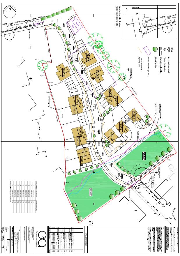
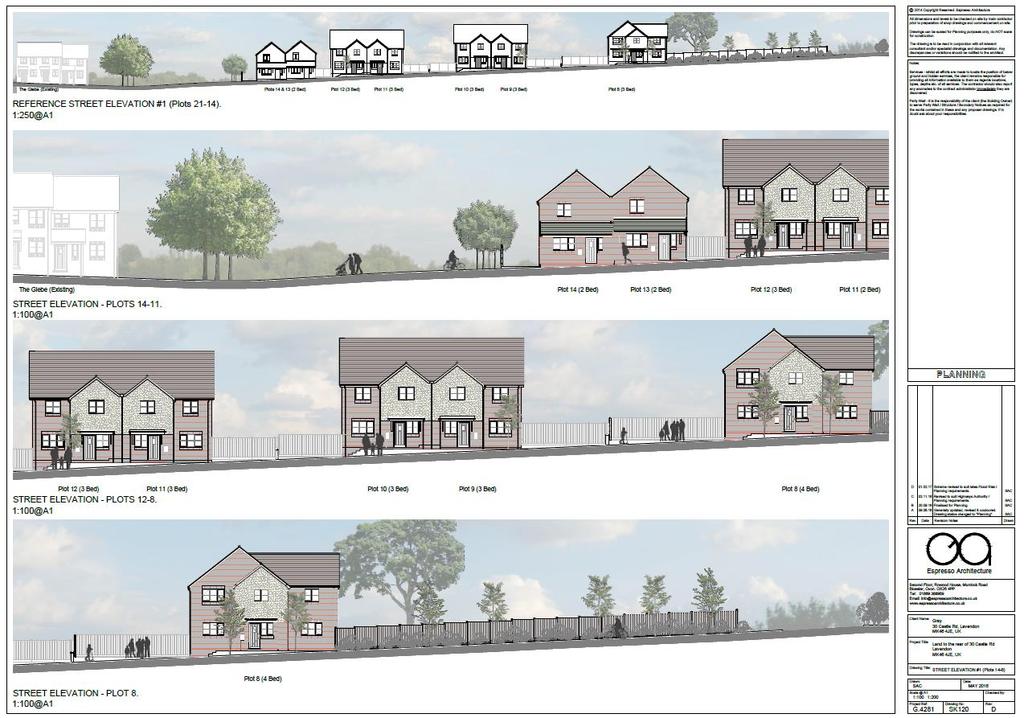
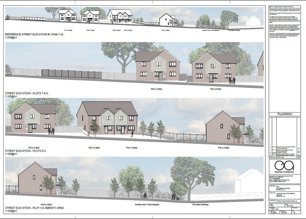
2 access off Castle Road. 1.5 The site benefits from mature hedgerows which include trees to the north east and south east boundaries with close boarded fencing predominantly to the southern western boundary and a mix of hedgerows and post and rail fencing to the north western boundary. A drainage ditch also runs along the south eastern boundary of the site. 1.6 The site is bounded by residential properties on Castle Road and The Glebe to the south western and south eastern sides with fields to the north east and north west. 1.7 Background The application originally proposed 21 new dwellings and its determination was delayed to allow the resolution of issues relating to flooding associated with the drainage ditch running along the south eastern boundary of the site. Discussions relating to the flooding issue resulting in the application being amended in February this year to propose 14 dwellings (a reduction of 7 units from that originally proposed) and the inclusion of amenity open space / flood meadows on the illustrative plans. 1.8 The revised scheme for 14 dwellings went out to consultation in February 2017, but its determination was delayed due to Great Crested Newts being identified to the east of Castle Road in March and a resulting need for further ecology surveys to be undertaken. This survey work has now been undertaken and found acceptable by the Countryside Officer. 1.9 The Proposal The proposal seeks outline planning permission for the erection of 14 dwellings with all matters reserved for determination at a later date except for access The application is accompanied by indicative plans including a layout plan and elevations to identify the proposed access and to demonstrate how the site could be satisfactorily developed with 14 dwellings. Whilst the indicative plans are illustrative only, it is noteworthy that the layout plan shows a strip of open land that is free from built form adjacent to the southern boundary of the site to serve as a flood meadow and amenity open space. In addition, the submitted details show an intention to provide housing that would be two storeys in height and a mix of detached and semi-detached dwellings Access to the proposed development would be taken from the Glebe with the existing access off Castle Road changed to a pedestrian link The submission is also supplemented with a Planning Statement, Design and Access Statement, Landscape and Visual Impact Assessment, Preliminary Ecology Appraisal, Great Crested Newt Surveys, Flood Risk Assessments, Transport Assessments, and an Anglian Water Pre-application Assessment.
3 2.0 RELEVANT POLICIES (The most important policy considerations relating to this application) 2.1 National Policy National Planning Policy Framework 2012 (hereafter referred to as the NPPF) Paragraphs 11-16: Presumption in favour of sustainable development Paragraph 17: Core Planning Principles Section 1: Building a Strong Competitive Economy Section 3: Supporting a Prosperous Rural Economy Section 4: Promoting Sustainable Transport Section 6: Housing Section 7: Design Section 8: Promoting Healthy Communities Section 10: Meeting the Challenge of Climate Change & Flooding Section 11: Conserving and Enhancing the Natural Environment Paragraph 173: Ensuring Viability and Deliverability Paragraphs 187 &187: Positive Approach to Decision Taking Paragraphs 196 & 197: Determining Applications Paragraphs : Conditions and Obligations 2.2 Local Policy Milton Keynes Core Strategy 2013 Policy CSA: Presumption in favour of sustainable development Policy CS1: Milton Keynes Development Strategy Policy CS9: Strategy for the Rural Area Policy CS10: Housing Policy CS11: A Well Connected Milton Keynes Policy CS12: Developing Successful Neighbourhoods Policy CS13: Ensuring High Quality, Well Designed Places Policy CS18: Healthier and Safer Communities Policy CS19: The Historic and Natural Environment Policy CS21: Delivering Infrastructure Adopted Milton Keynes Local Plan Saved Policy S10: Open Countryside Saved Policy D1: Impact of Development Proposals on Locality Saved Policy D2A: Urban Design Saved Policy D2: Design of Buildings Saved Policy D4: Sustainable Construction Saved Policy HE1: Protection of Archaeological Sites Saved Policy T1: Transport User Hierarchy Saved Policy T2: Access for those with Impaired Mobility Saved Policy T3: Pedestrians and Cyclists Saved Policy T5: Public Transport Saved Policy T9: The Road Hierarchy Saved Policy T10: Traffic Saved Policy T15: Parking Provision
4 Saved Policy NE2: Protected Species Saved Policy NE3: Biodiversity and Geological Enhancement Saved Policy NE4: Conserving and Enhancing Landscape Character Saved Policy H7: Housing on Unidentified Sites Saved Policy H8: Housing Density Saved Policy H9: Housing Mix Saved Policy PO4: Planning Obligations Supplementary Planning Guidance/Documents (SPG/SPD) Parking Standards for Milton Keynes SPD (2016) Sustainable Construction SPD (2007) Social Infrastructure Obligations SPD (2005) Education SPG (2004) Leisure, Recreation & Sports SPG (2005) New Residential Developments Design Guide (2012) 3.0 MAIN ISSUES (The issues which have the greatest bearing on the decision) 3.1 The main issues for the consideration of this application comprise as follows: Principle of development Locational Credentials Housing Mix Design, Density and Layout Open Space, Landscaping and Trees Residential amenity Land contamination Parking, Access & other Highway matters Drainage and Flood Risk Ecology Sustainable construction Archaeology and historic environment Planning Obligations Human Rights 4.0 RECOMMENDATION (The decision that officers recommend to the Committee) 4.1 It is recommended that planning permission be granted subject to the conditions set out in Section 6 of this report and a Section 106 Agreement to secure the financial contributions detailed in Paragraph 5.54 of this report 5.0 CONSIDERATIONS (An explanation of the main issues that have led to the officer Recommendation) 5.1 Principle of development Planning law requires applications for planning permission to be determined in accordance with the development plan, unless material considerations indicate otherwise. The National Planning Policy Framework (NPPF) is a material consideration in planning decisions.
5 5.2 The Council can demonstrate a 5 year housing land supply figure of 5.03 years. Therefore, in terms of Paragraph 49 of the NPPF, the Council can demonstrate a five year supply of deliverable housing sites and relevant policies for the supply of housing are not considered to be out-of-date. 5.3 Saved Policy S10 of the Milton Keynes Local Plan states that planning permission will only be granted for development in the open countryside where it is essential for agriculture, forestry, countryside recreation and other development which is wholly appropriate to a rural area and cannot be located within a settlement. In addition, Core Strategy Policies CS1 and CS9 seek to focus development in the rural area within the development boundaries of the main and most sustainable towns or key settlements. 5.4 The site lies outside the development limits of Lavendon, as shown on the saved Milton Keynes Local Plan Proposals Map, and falls within land designated as Open Countryside. As such, the proposal does not accord with Saved Local Plan Policy S10 and Core Strategy Policies CS1 and CS However, it is noteworthy that the objective of Policy S10 is to protect the countryside and to concentrate new development within and adjoining existing settlements. Paragraph 17 of the NPPF similarly seeks to protect the countryside and sets out that planning should take account of the different roles and characters of areas and recognise the intrinsic character and beauty of the countryside. Therefore, it is considered necessary to consider the impact of the proposal on the countryside and any other material consideration before concluding on the principle of the proposed development. 5.6 In terms of the impact of the proposal on the countryside, whilst the application site is designated as Open Countryside under the Development Plan, the site does not fall within a designated Area of Attractive Landscape on the Proposals Map or comprise an area with the highest status of protection in relation to landscape and scenic beauty as defined in the NPPF. 5.7 The site also directly adjoins the settlement boundary of Lavendon and is not open agricultural land. Indeed, it is in equestrian use and includes equestrian facilities to the northern part of the site in the form of a stable building and associated hard surfacing and a 40m x 20m menage. As such, the site contains existing development and is considered to include previously developed (brownfield) land as defined in the NPPF. 5.8 The proposal would change the application site from a low level equestrian use, which is appropriate in the countryside, to a small housing development and would, therefore, clearly have an urbanising impact on the site. However, the illustrative plans accompanying the amended application indicate the potential for the retention of part of the existing open area and character to the southern part of the site. Furthermore, the application is supported by a Landscape and Visual Impact Assessment (LVIA) which considers the local
6 landscape character and the impact of the development on views from public vantage points. Whilst acknowledging that the photographic survey accompanying the LVIA is relatively weak, officers concur with the general findings of this assessment that there is a high degree of screening provided by the village structure and existing vegetation. Indeed, the most significant visual impacts would be from the public footpath some 200m to the south east of the site, and in glimpsed views between properties, through field accesses along Castle Road, and through the new access off the Glebe. However, the development would replace existing built form and would infill the northern corner of Lavendon such that it would be seen in the context of existing development from these vantage points. In addition, the development would be limited to the existing historic field boundary hedgerows and these could be strengthened by additional planting to further break up views of the site and achieve hedgerow improvement objectives sought under the Council s Landscape Character Assessment as part of a reserved matters scheme. 5.9 Overall in terms of countryside impact, due to the site containing existing development, the infill nature of the proposal, the existing screening afforded to the site and the potential for the retention of an open area to the southern part of the site, it is considered that there would only be limited harm to the countryside arising from the proposal. In addition, this harm could be further reduced by the detail of the scheme under a reserved matters application Paragraphs 17 and 111 of the NPPF are also a material consideration and encourage the effective use of land by reusing land that has been previously developed (brownfield land), provided that it is not of high environmental value. As detailed above, the site falls within the NPPF definition of previously developed land and it is considered that it is difficult to argue that the site is of high environmental value. Therefore it is considered that the effective reuse of the site is encouraged under the NPPF In addition, it is also noteworthy that the NPPF seeks to significantly boost the supply of housing (Paragraph 47) To conclude on the principle of development, the proposal would be contrary to Development Plan Policies S10, CS1 and CS9 by virtue of the Open Countryside location of the site. However, it is considered that the impact of the proposal on the countryside would only be limited and that this harm would be outweighed by guidance in the NPPF which seeks to encourage the reuse of previously developed land and significantly boost the supply of housing. As such it is considered that objections could not be sustained to the principle of residential development in this instance Locational Credentials The National Planning Policy Framework (NPPF) requires the need to travel to be minimised and the use of sustainable transport modes to be maximised (paragraph 34) There are a reasonable range of services within Lavendon including a primary
7 school, nursery school, a village shop and post office, and two pubs/restaurants. In addition, the village is served by two bus services which connect Lavendon to Bedford and Northampton and also Milton Keynes. Although, there are only limited employment opportunities in Lavendon The site would be located on the edge of the settlement and, whilst it would connect in with the existing footpath network serving the Glebe and have a pedestrian link to Castle Road, it is acknowledged that most services and the bus stops are some distance from the site. As such, whilst many people may choose to use their cars to access services and employment opportunities, it is considered that there are opportunities to access services and employment opportunities using transport methods other than the private motor car In light of the above, it is considered that objections could not be sustained on the basis of the location of the site being unsustainable Housing mix Saved Policy H9 of the Milton Keynes Local Plan seeks to ensure that developments incorporate a range of house types and sizes. Whilst this application is for outline planning permission only, the submitted details indicate that the applicant intends to provide a mix of 2, 3 and 4 bedroom dwellings comprising a mix of detached and semi-detached properties. As such, it is considered that a mix of dwelling sizes and types could be achieved under a reserved matters application should planning permission be forthcoming Design, Density and Layout Saved Policies D2, D2A and H8 of the Milton Keynes Local Plan and Core Strategy Policies CS12, CS13 and CS18 seek to ensure that all new developments are high quality, well designed and relate well to the surrounding area and that proposals design out the opportunities for crime. Further, the Core Planning Principles in Paragraph 17 of the National Planning Policy Framework state that planning should always seek to secure high quality design The design and layout of the scheme would be the subject of an application for the approval of reserved matters should planning permission be forthcoming. However, an indicative layout and elevation plans have been provided. The indicative layout shows the site served off a main spine road extending off the Glebe with a short cul-de-sac to the eastern side of the site, an open amenity area / flood meadow to the south eastern boundary of the site and a turning heading at the northern end of the spine road. Buildings on this indicative layout are shown to be fairly evenly spaced along the road network with the elevations indicating that the applicant intends for the properties to be two storey in scale The scale and appearance of the dwellings shown on the indicative plans would integrate acceptably with the surrounding area. The indicative layout
8 has been amended during the course of the application to seek to address the concerns raised by the Senior Urban Designer. There are, however, still a number of shortcomings with the illustrative scheme as detailed in the Senior Urban Designer consultation response However, the submitted indicative plans are just a potential layout for the development and matters of layout, scale and appearance would be fully considered at reserved matters stage should planning permission be forthcoming The application proposes 14 dwellings on a 0.95 hectare site which equates to some 15 dwellings per hectare (dph), although the density of the scheme shown on the indicative layout is greater (21dph) due to the inclusion of the amenity open space / flood meadow area. These densities would fall below the 30 dwellings per hectare average net densities sought under Saved Local Plan Policy H8 for the rural parts of the Borough. However, the density requirements of Saved Local Plan Policy H8 are to ensure that new housing development is in keeping with the character and appearance of the area. As such, given the location of the site on the edge of Lavendon, and the size and shape of this site, it is considered that the reduction in the density sought under Saved Local Plan Policy H8 is not objectionable Overall in design terms, it would appear that 14 units could be accommodated on the site and could positively contribute to an appropriate mixed and balanced community in accordance with the requirements of the development plan. These detailed matters are therefore for consideration at reserved matters stage should planning permission be forthcoming Open Space, Landscaping and Trees Saved Policy D2 of the Milton Keynes Local Plan details that proposals should include landscaping that integrates with the surrounding area The site is limited to the existing historic field boundary hedgerows and there are a number of mature trees to the north west, north east and south west boundaries of the site, with the indicative plans show the retention of the majority of these trees including a large oak tree adjacent to the proposed access to the site The Senior Landscape Architect welcomes the retention of the hedgerows on the indicative plans, seeking its further enhancement, but also raises some concerns regarding the indicative details and the potential for the proposal to impact on the retention of trees near the turning head and the oak tree shading gardens of residential properties. The Arboricultural Officer similarly seeks measures to secure the retention of the boundary trees and also suggests that the proposal should include replacement tree planting to offset trees recently felled on site. However, none of the trees within the site are protected under Tree Preservation Orders and it would not be reasonable to seek the replacement of trees that have already been felled on site. Further, the application is only for outline permission and the concerns raised are detailed matters for consideration at reserved matters stage.
9 5.26 Turning to open space, whilst the Senior Landscape Architect is seeking a play area on site, there is no policy requirement for the provision of open space within the site and this cannot therefore be reasonably the subject of a condition should planning permission be forthcoming. Notwithstanding this, the indicative plans show an intention to provide a significant area of open space driven by the requirement to address surface water runoff, such that it is likely that open space would be included as part of a reserved matters scheme Residential Amenity Saved Policy D1 of the Milton Keynes Local Plan details that planning permission will be refused for development where it would adversely affect residential amenity. In addition, the New Residential Development Design Guide SPD (2012) provides guidance on achieving acceptable levels of amenities for future occupiers. Further, the core planning principles in the National Planning Policy Framework (Paragraph 19) details that planning decisions should seek to secure a good standard of amenity for all existing and future occupants of land and buildings A full assessment against the Milton Keynes New Residential Development Design Guide SPD would take place at the reserved matters stage when design, layout and scale would be under consideration Notwithstanding this, in respect of the amenity of neighbouring properties, the Environmental Health Officer does not object to the application and it is considered that the proposal would not generate noise or disturbance or vehicle movements of a magnitude to adversely impact the amenities of neighbouring properties. Further, the indicative plans indicate that the 22m back to back distances sought in the New Residential Development Design Guide SPD (2012) on privacy grounds could be achieved as part of a reserved matters scheme. Therefore, it is considered that there is scope within the site for 14 dwellings to be accommodated without an unacceptable impact on the amenity of neighbouring properties It is also noted that a number of local residents have raised concerns regarding amenity issues arising from construction works and it is considered that these concerns can be addressed by a Construction Management Plan should planning permission be forthcoming Turning to the amenity of future occupiers, a number of the properties on the indicative plan would have garden depths that would fall slightly short of the 10 metre sought in the New Residential Development Design Guide SPD (2012). However, this is compensated for by the widths of the gardens. In addition, the position of the boundary between Plots 2 and 3 on the indicative site plan would give rise to overlooking issues, although this issue could be designed out as part of a reserved matters scheme. As such it is considered that a good standard of amenity for future occupiers could be provided as part of a reserved matters scheme should planning permission be granted.
10 5.32 Overall, it is considered that there is scope within the site to provide 14 dwellings without prejudicing the amenities of neighbouring properties and whilst still also providing a good standard of amenity for future occupiers Land Contamination The Environmental Protection Team has recommended that a condition requiring the assessment of ground conditions to determine the likelihood of contamination be applied to any grant of planning permission for this site, given that the proposed use is particularly vulnerable to the presence of contamination. Therefore, subject to the aforementioned condition, no objections are raised with regards to land contamination Parking, Access & other Highway matters Saved Policy T10 of the Milton Keynes Local Plan relates to highway safety and details that proposals will be refused for development if it would be likely to generate motor traffic that would exceed the highway capacity of the local road network or cause significant risk of accident. In addition, Saved Policy T15 of the Milton Keynes Local Plan and the new Milton Keynes Parking Standards Supplementary Planning Document (2016) set out the parking requirements for proposed developments The National Planning Policy Framework (2012) also details in Paragraph 32 that development should be prevented or refused on transport grounds where the residual cumulative impacts of development are severe and indicates in Paragraph 39 that local parking standards should take into account issues include accessibility and the type, mix and use of development Access is not a reserved matter. It must therefore be given full consideration under this application The vehicular access to the site would be located off The Glebe and the concerns of residents of the Glebe regarding highway safety are noted. However, the Highway Engineer has visited the site and advises that in terms of width, alignment and visibility, the access off the Glebe would be acceptable in highway terms to serve 21 units as originally proposed. Furthermore, the Highway Engineer advises that 21 units would not exceed the highway capacity of the wider road network including the junctions with Harold Road and Northampton Road. The proposal has subsequently been revised to reduce the number of units from 21 and 14 whilst keeping the same access arrangements. As such an objection could not be sustained to the proposed access arrangements and traffic generation on the grounds of highway safety Turning to the indicative layout, the amended indicative plans show sufficient allocated and visitor parking to meet the Parking Standards with, for example all dwellings to benefit from at least two on plot parking spaces. However, the amended indicative site plan still includes some layout issues (for example
11 visitor spaces that appear to be on plot and insufficient details of visibility splays), although these matters can be addressed at the reserved matters stage. As such it is considered that the amended indicative layout sufficiently demonstrates that 14 dwellings could be accommodated on the site in parking and highway terms In light of the above comments, the proposed development is considered acceptable with regard to its access and all other highway and parking matters would be controlled through reserved matters should planning permission be forthcoming Drainage and flood risk The National Planning Policy Framework (NPPF) in paragraph 100 details that inappropriate development in areas at risk of flooding should be avoided by directing development away from areas at highest risk, but where development is necessary, making it safe without increasing flood risk elsewhere. This guidance is echoed under Saved Policy D1 of the Local Plan which advises that planning permission will be refused where inadequate drainage is identified. The NPPF also provides a sequential test to steer new development to areas with the least probability of flooding (paragraph 101) and states that development should not increase flood risk elsewhere (paragraph 103) The village of Lavendon has been impacted by historic flooding events, including a notable event on the 14th July Furthermore, according to the Environment Agency Risk of Flooding from Surface Water Map, there is a high risk of surface water flooding on the south eastern site boundary of the site associated with the ordinary watercourse that originates from agricultural land to the northeast of the site. In addition, whilst the majority of the site is located within Flood Zone 1, further modelling has recently been undertaken for the adjacent ordinary watercourse, and this indicates that part of the site is located within Flood Zone 3 (associated with the 1 in 100 year floodplain of this ordinary watercourse) The application originally proposed 21 units and was supported by a Flood Risk Assessment (FRA). However, the Local Lead Flood Authority (LLFA) recommended refusal of the 21 unit scheme on the basis that the proposed dwellings to the south of the site, as shown on the indicative plans, would be at risk of flooding and, additionally, that the development would obstruct flow routes and thus exacerbate the risk of flooding to surrounding properties The LLFA entered into discussion with the applicant and the proposal was subsequently amended to reduce the number of dwellings from 21 to 14, with a revised FRA and indicative plans showing the potential to keep a flood meadow area adjacent to the southern boundary of the site to address the flood risk concerns. The revised details have been assessed the LLFA and the LLFA has raised no objection to the 14 unit scheme subject to a condition to secure the detailed design of a surface water drainage scheme. On this basis, the proposed development is considered to accord with Development
12 Plan Policy D1 and the principles outlined in the NPPF with regard to drainage and flood risk Ecology Saved Policies NE2 and NE3 of the Milton Keynes Local Plan and Core Strategy Policy CS19 seek to protect wildlife and protected species and encourage biodiversity enhancements. This is supported by the NPPF which aims to conserve and enhance biodiversity (Paragraph 118) The application is accompanied by a Preliminary Ecological Appraisal (PEA) which found that the majority of the site was composed of poor semi improved grassland, with a stable block, horse arena and access drive. Further, the site boundaries comprise predominantly native species poor hedges and garden boundaries with Leylandii with a few trees to its western end and trees located within the boundary hedge, these including Ash and Oak In terms of protected species, the PEA found that the site has suitable bird breeding habitat and the eastern boundary hedge offers a suitable commuting corridor for bats and that there is potential for roosting bats, in some of the site s trees. The PEA was also accompanied by a Great Crested Newt survey which found that Great Crested Newts are highly unlikely to utilise the site and hence do not pose a constraint to the development of the site. An additional Great Crested Newt survey was also submitted following the presence of Great Crested Newts being identified to the east of Castle Road in March of this year 5.47 The Countryside Officer agrees with the findings of the PEA and Great Crested Newt surveys and raises no objections to the scheme subject to appropriate biodiversity mitigation and enhancement. Biodiversity mitigation and enhancement can be controlled at reserved matters stage and no objections are therefore raised with respect to protected species and biodiversity under the NPPF and development plan policies NE1, NE3 and CS Sustainable Construction Saved Policy D4 of the Milton Keynes Local Plan and the Sustainable Construction Supplementary Planning Document (2007) requires all new development exceeding 5 dwellings to incorporate sustainable construction including renewable energy and carbon offset provision The requirement for 10 per cent renewable energy could be secured by a condition. There is also a policy requirement for a financial contribution for carbon offsetting and the applicant has indicated an agreement in principle for the completion of a section 106 legal agreement to secure the requisite contribution. As such no objections are raised with regards to Saved Local Plan Policy D4 and the Sustainable Construction SPD.
13 5.50 Archaeology and historic environment Policy HE1 provides justification for archaeological investigations to be undertaken when dealing with scheduled sites and unscheduled sites of known interest, only. However, paragraph 128 of the NPPF states that where a site on which development is proposed includes or has the potential to include heritage assets with archaeological interest, local planning authorities should require developers to submit an appropriate desk-based assessment and, where necessary, a field evaluation The Senior Archaeological Officer has advised that there is potential for archaeological remains on the site and as such it will be necessary to carry out field evaluation of the site prior to development. In this instance, it is considered reasonable for the evaluation and any subsequent necessary archaeological mitigation to be carried out under an appropriately worded condition if permission is granted The centre of Lavendon includes a conservation area and a number of listed buildings. However, given the distance and presence of intervening properties between the site and the heritage assets, and having regard to the duties under sections 66 and 72 of the 66 and 72 of The Planning (Listed Buildings and Conservation Areas) Act (1990), it is considered that the proposal would not have a detrimental impact on these heritage assets Planning Obligations Planning Obligations are required in accordance with Milton Keynes Core Strategy Policy CS21, Saved Policies D4 and PO4 of the Milton Keynes Local Plan and the following relevant Supplementary Planning Documents(SPDs)/Guidance (SPGs): Affordable Housing SPD (2013) Education Facilities SPG (2004) Leisure Recreation and Sports Facilities SPG (2005) Social Infrastructure SPD (2005) Sustainable Construction SPD (2007) 5.54 In accordance with the aforementioned SPD/Gs, and based on the size of the development and consultations with service providers, Section 106 contributions totalling 236, ( 16, per unit including an indicative figure for Carbon Offsetting) are required to mitigate the impact of this development. These contributions are set out in more detail below and the Council s Senior Planning Obligations Officer advises that they meet the tests as outlined at paragraph 204 of the NPPF and are in accordance with CIL Regulations 122 and 123:
14 Education: Contribution Total Early Years 9, Primary pupils 49, Secondary pupils 0.00 Post 16 pupils 0.00 Leisure Recreation & Sports: Playing Fields 14, Local Play 20, Neighbourhood Play 25, Community Hall 33, Local Parks 3, Allotments 1, Social Infrastructure: Library & Adult Continuing Education 0.00 Crematorium/Burial Grounds 1, Museums and Archives 2, Health Facilities 25, Waste Management 4, Waste Receptacles 1, Emergency Services Voluntary Sector 3, Inward Investment & Skills (University & College) 19, Public Art - 1% (Estimated) 12, Other Requirements: Carbon Neutrality (Estimated) 6, Public Transport Bus Pass 5.55 The applicant has agreed in principle to secure the provision of these requisite financial contributions by way of s106 agreement. Subject to the s106 being progressed and completed should planning permission be forthcoming, the development would comply with Policies CS21, H4 and D4 and associated SPDs and SPGs 5.56 Human Rights Comments have been received suggesting that the proposed development would breach human rights. Article 8 Para1-2 of the Human Rights Act relates to the right to respect for private and family life. Whilst not Planning Legislation, human rights are incorporated within planning legislation and are
15 taken into account when determining an application. The proposal is not regarded to affect this right as it does not adversely affect the amenity of families or private individuals Conclusion To conclude, the principle of the development on this site which is in the open countryside is contrary to the development plan. However, it is considered that the harm to the countryside is limited in this instance given the specific site circumstances. Furthermore, the site includes previously developed land and it is considered that the emphasis in the NPPF to reuse such land and significantly boost the supply of housing outweighs this harm. Furthermore, the proposed access details are considered acceptable and all other detailed matters would be addressed as part of a reserved matter application. As such, no objections are raised to the proposed development subject to the conditions as detailed below and a section 106 agreement to secure a financial contribution as detailed in paragraph 5.54 above. 6.0 CONDITIONS (The conditions that need to be imposed on any planning permission for this development to ensure that the development is satisfactory. To meet legal requirements all conditions must be Necessary, Relevant, Enforceable, Precise and Reasonable ) 1) Approval of the details of the scale, layout and appearance of the buildings, and landscaping of the site (hereinafter called ''the reserved matters'') shall be obtained in writing from the Local Planning Authority before any development is commenced. Reason: Outline Planning Permission only is granted in accordance with the application submitted. 2) Application for approval of all the reserved matters shall be made to the Local Planning Authority before the expiration of three years from the date of this permission. Reason: To comply with Section 51 of the Planning and Compulsory Purchase Act ) The development hereby permitted shall be begun on or before the expiration of two years from the date of the approval of the last of the reserved matters to be approved. Reason: To comply with Section 51 of the Planning and Compulsory Purchase Act ) The details to be submitted for approval in accordance with condition 1 above shall include a scheme for cycle storage and, car parking and manoeuvring, and the provision of visitor car parking spaces in accordance with the Council s Car Parking Standards within the 2016 Parking Standards Supplementary Planning Documents or to the standards in force at the time of any reserved matters applications. The approved scheme shall be
16 implemented and made available for use before the development hereby permitted is occupied and the approved cycle storage, parking and manoeuvring areas shall not thereafter be used for any other purpose. Reason: To ensure that adequate parking facilities are provided to serve the development in accordance with saved Policies T3 and T15 of the Milton Keynes Local Plan (2005) and 2016 Parking Standards. 5) The landscaping details required by Condition 1 above shall include an Arboricultural report completed in accordance with BS 5837:2012 and a scheme for the provision of the planting of trees and shrubs including native species and those beneficial to wildlife. The scheme shall show all existing trees and hedgerows which are to be retained and the numbers, types and sizes of trees and shrubs to be planted and their location. All existing trees and hedgerows which are to be retained as part of the development shall be protected in accordance with British Standards 5837:2012 for the duration of the construction works. All planting shall be carried out in accordance with the scheme and shall be carried out within twelve months of commencement of the development. Any trees or shrubs removed, dying, severely damaged or diseased within two years of planting shall be replaced in the next planting season with trees or shrubs of such size and species as may be agreed by the Local Planning Authority. Reason: To protect significant trees and hedgerows, safeguarding the character of the area and preserving habitat and to minimise the effect of development on the area in accordance with Policies D1 and D2A of the Milton-Keynes Local Plan 2005 and Policy CS13 of the Milton-Keynes Core Strategy ) The details to be submitted for approval in accordance with condition 1 above shall include a detailed design and associated management and maintenance plan, for a surface water drainage scheme, based on sustainable drainage principles for the site shall be submitted to and be approved in writing by the local planning authority. The management and maintenance plan shall include a detailed time table for the implementation of the surface water drainage scheme. The approved drainage scheme shall subsequently be implemented in accordance with the approved detailed design and in accordance with the approved time table for implementation and be retained thereafter. Reason: To ensure satisfactory and sustainable surface water drainage to prevent the increased risk of flooding on or off site. 7) A full sustainability statement shall be submitted with the Reserved Matters application detailing the sustainable construction techniques to be used in accordance with Saved Policy D4 of the Milton Keynes Local Plan ( ) and the Sustainable Construction Supplementary Planning Document (adopted April 2007). The statement shall be agreed in writing by the Local Planning Authority and the approved scheme shall be implemented in full prior to the first use of the building /occupation of each dwelling.
17 Reason: To ensure that the development complies with the Council's objective for Sustainable Development in accordance with Policy D4 of the Adopted Local Plan: ) Prior to the commencement of the development hereby approved, a Construction Management Plan shall be submitted to and approved in writing by the local planning authority. The approved Plan shall be adhered to throughout the construction period and include provision for: i. The parking of vehicles of site operatives and visitors ii. Loading and unloading of plant and materials iii. Storage of plant and materials used in constructing the development iv. The erection and maintenance of security fencing/hoardings and lighting v. Welfare and other site facilities vi. Construction traffic routing and signage vii. Working hours and delivery times viii. Measures to control the emission of dust, dirt, noise and vibrations during construction Reason: For the safety and convenience of users of the highway and to protect the amenity of neighbours during the construction process in accordance with the provisions of Saved Policy D1 of the Milton Keynes Local Plan ) Prior to the commencement of the development hereby permitted, an assessment of ground conditions to determine the likelihood of any ground, groundwater or gas contamination of that part of the site shall be undertaken and the results of this survey together with a strategy for any remedial action deemed necessary to bring the site to a condition suitable for its intended use shall be submitted to and approved in writing by the LPA. Any remedial works shall be carried out in accordance with the approved strategy and validated by submission of an appropriate verification report to the local planning authority prior to first occupation of any part of the development. Should any unforeseen contamination be encountered in that phase or part of the development the local planning authority shall be informed immediately. Any additional site investigation and remedial work that is required as a result of unforeseen contamination shall be carried out to the written satisfaction of the local planning authority. Reason: To ensure that the site is fit for its proposed purposed and any potential risks to human health, property, and the natural and historical environment, are appropriately investigated and minimised. 10) Prior to the commencement of the development hereby permitted, a programme of archaeological field evaluation comprising trial trenching shall be completed in accordance with a Written Scheme of Investigation that has been submitted to and approved in writing by the local planning authority. On completion of the agreed archaeological field evaluation, a further Written Scheme of Investigation for a programme of archaeological mitigation in
18 respect of any identified areas of significant buried archaeological remains shall be submitted to and approved by the local planning authority in writing. No development shall take place other than in accordance with the Written Scheme of Investigation so approved. The development hereby permitted shall not be occupied until the site investigation and post investigation assessment has been completed in accordance with the programme set out in the approved Written Scheme of Investigation and the provision made for analysis, publication and dissemination of results and archive deposition has been secured. Reason: To ensure that a proper record is produced of any archaeological remains affected by the development pursuant to paragraph 141 of the National Planning Policy Framework. 11) Prior to the commencement of the development hereby permitted, a wastewater strategy shall be submitted to and approved in writing by the Local Planning Authority. No dwellings shall be occupied until the works have been carried out in accordance with the wastewater strategy so approved unless otherwise approved in writing by the Local Planning Authority. Reason: To prevent environmental and amenity problems. 12) Prior to the commencement of the development hereby permitted, details of the proposed finished floor levels of all buildings and the finished ground levels in relation to existing ground levels shall be submitted to and approved in writing by the Local Planning Authority. The development shall be carried out in accordance with the approved levels. Reason: To ensure that development is carried out at suitable levels in accordance with Saved Policies D1, D2A, and D3 of the Milton Keynes Local Plan and to ensure satisfactory and sustainable surface water drainage to prevent the increased risk of flooding on or off site in accordance with the Written Ministerial Statement issued on 18 December 2014 in relation to sustainable drainage systems. 13) Prior to the commencement of the construction of any dwellings hereby permitted above ground floor slab level, a schedule and samples of all external materials shall be submitted to and approved in writing by the Local Planning Authority. The development shall be carried out in accordance with the approved details. Reason: To ensure a satisfactory appearance of the development and in accordance with Saved Policies D1, and D2A of the Milton Keynes Local Plan ) Prior to the construction of any of the dwellings hereby permitted above ground floor slab level, a Biodiversity Enhancement Scheme informed by the DEFRA Impact Assessment Biodiversity Calculator methodology and including bird bricks and bat tubes in buildings, hedgehog fence passes and the use of native plant species shall be submitted to approved by the Local
19 Planning Authority. The approved scheme shall be implemented prior to the first occupation of the development and retained thereafter. Reason: To ensure development includes biodiversity enhancement measures in accordance with saved Policy NE3 of the Milton Keynes Local Plan ) Prior to construction of any of the dwellings hereby approved above ground floor slab level, details of external lighting including security lighting shall be submitted to and approved in writing by the local planning authority. The plans shall show lighting proposed in accordance with BS5489 standards and detail how the presence of bats in the area has been taken into account. The development shall thereafter be carried out in accordance with the approved details. Reason: To ensure that the development does not detract from residential amenity and the appearance of the locality and in the interests of ecology and crime prevention in accordance with Policies D1, D2A, D3, and NE3 of the Milton Keynes Local Plan and CS19 of the Core Strategy. 16) Prior to the construction of all adoptable and non-adoptable roads, footways, and private driveways, details of the proposed surface treatments and construction details for any areas of hard landscaping within root protection areas of trees to be retained shall be submitted to and approved in writing by the Local Planning Authority. The development shall be completed in accordance with the approved details prior to the occupation of any dwelling served by that road, footway, or private driveway. Reason: In the interests of the visual amenities of the locality and highway safety in accordance with saved Policies D2 and T10 of the Milton Keynes Local Plan. 17) Prior the occupation of the development hereby permitted, details of the proposed boundary treatments to all dwellings shall be submitted to and approved in writing by the Local Planning Authority. The details shall include the type and height of fences, hedges, walls, gates and other means of enclosure and shall be provided for each dwelling prior to the occupation of that dwelling in accordance with the approved details. Reason: To protect the appearance of the locality, safeguard residential amenity and in the interest of crime prevention in accordance with Policies Policy D1 and D2 of the Milton Keynes Local Plan and Policy CS19 of the Core Strategy 18) Prior to the occupation of the development hereby permitted, signage and bollards to serve the pedestrian and cycle link to Castle Road shall be provided in accordance with details that have been submitted to and approved in writing by the local planning authority. The signage and bollards shall thereafter be retained in accordance with the approved details.
20 Reason: In the interest of the needs and safety of pedestrian and cyclists. 19) Prior to the occupation of the development hereby approved, a refuse strategy shall be submitted to and approved in writing by the Local Planning Authority. The development shall be carried out in accordance with the approved refuse strategy. Reason: To ensure that adequate refuse storage facilities are provided to serve the development. 20) All dwellings shall achieve Secured by Design accreditation. Prior to the occupation of each dwelling, a copy of the certificate confirming the achievement of Secured by Design accreditation for that dwelling shall be submitted to and approved in writing by the Local Planning Authority. Reason: In the interests of reducing crime and disorder and in accordance with Core Strategy Policy CS19.
21
22
23
Parish: Bradwell Parish Council
 APP 02 Application Number: 16/01475/FUL Demolition of existing public house and erection of 27 dwellings, two storey D1 use building for a nursery and associated car parking to east of St Augustines Church
Report Author/Case Officer: Joanne Horner Contact Details:
 APP 04 Application Number: 16/00140/FUL Other Two storey side extension to existing dwelling and formation of hard standing to provide parking for number 54 (Resubmission of withdrawn application 15/02852/FUL)
Report Author/Case Officer: Paul Keen Senior Planning Officer (Dev Control) Contact Details:
 Contact Details:") APP 03 Application Number: 17/02060/FUL Description A full planning application for the demolition of an existing bungalow (C3 use class) and associated out buildings and the erection of two, two storey
APP 03 Application Number: 17/02060/FUL Description A full planning application for the demolition of an existing bungalow (C3 use class) and associated out buildings and the erection of two, two storey
SOUTH CAMBRIDGESHIRE DISTRICT COUNCIL. REPORT TO: Planning Committee 1 April 2015 Planning and New Communities Director
 SOUTH CAMBRIDGESHIRE DISTRICT COUNCIL REPORT TO: Planning Committee 1 April 2015 AUTHOR/S: Planning and New Communities Director Application Number: Parish(es): Proposal: Site address: Applicant(s): Recommendation:
DEVELOPMENT MANAGEMENT REPORT
 ITEM A08-1 DEVELOPMENT MANAGEMENT REPORT TO: BY: DATE: DEVELOPMENT: SITE: WARD: APPLICATION: APPLICANT: Development Management Committee Development Manager Proposed live/work unit in connection with existing
Mid Suffolk District Council Planning Control Department 131 High Street Needham Market IP6 8DL
 Mid Suffolk District Council Planning Control Department 131 High Street Needham Market IP6 8DL OUTLINE PLANNING PERMISSION Town and Country Planning Act 1990 THE TOWN AND COUNTRY PLANNING (DEVELOPMENT
Planning Appeal. Statement of Case
 Planning Appeal Statement of Case LAND NORTH OF THE GLEBE, LAVENDON On behalf of the Appellant: Mr & Mrs Gray June 2017 (LPA ref: 16/01630/OUT) Smith Jenkins Ltd 30A High Street, Stony Stratford, Milton
Departure from the Development Plan. Town Council objection to a major application. DETERMINE
 Item No. 9 APPLICATION NUMBER CB/17/01642/OUT LOCATION Land rear of 43 to 91 Silver Birch Avenue South of Alder Green and Aspen Gardens, Aspen Gardens, Stotfold PROPOSAL Outline application for up to 95
Derry City and Strabane District Council Planning Committee Report
 Derry City and Strabane District Council Planning Committee Report COMMITTEE DATE: 23 rd March 2016 APPLICATION No: APPLICATION TYPE: PROPOSAL: LOCATION: APPLICANT: LA11/2015/0395/F Residential Development
SOUTH CAMBRIDGESHIRE DISTRICT COUNCIL. Executive Director (Operational Services) Corporate Manager (Planning and New Communities)
 Corporate Manager (Planning and New Communities)") SOUTH CAMBRIDGESHIRE DISTRICT COUNCIL REPORT TO: Planning Committee 12 January 2011 AUTHOR/S: Executive Director (Operational Services) Corporate Manager (Planning and New Communities) Notes: S/1848/10
SOUTH CAMBRIDGESHIRE DISTRICT COUNCIL REPORT TO: Planning Committee 12 January 2011 AUTHOR/S: Executive Director (Operational Services) Corporate Manager (Planning and New Communities) Notes: S/1848/10
Schedule of Planning Applications Committee Date: 23 May Reference: 06/17/0726/F Parish: Hemsby Officer: Mr J Beck Expiry Date:
 Schedule of Planning Applications Committee Date: 23 May 2018 Reference: 06/17/0726/F Parish: Hemsby Officer: Mr J Beck Expiry Date: 22-05-2018 Applicant: Proposal: Site: Mr Gillett Change of use to the
Demolition of The Suffolk Punch Public House and clearing of the site including the car park and associated works. Parish: Bradwell Parish Council
 APP 01 Application Number: 15/01914/FUL Demolition of The Suffolk Punch Public House and clearing of the site including the car park and associated works. AT The Suffolk Punch, 1 Langcliffe Drive, Heelands
CA//16/00504/FUL. Canterbury City Council Military Road Canterbury Kent CT1 1YW. Crown copyright and database rights 2016 Ordnance Survey
 O Scale 1:1,250 Map Dated: 09/05/2016 CA//16/00504/FUL Crown copyright and database rights 2016 Ordnance Survey 100019614 Canterbury City Council Military Road Canterbury Kent CT1 1YW AGENDA ITEM NO 13
SOUTH CAMBRIDGESHIRE DISTRICT COUNCIL. Planning and New Communities Director
 SOUTH CAMBRIDGESHIRE DISTRICT COUNCIL REPORT TO: Planning Committee 5 June 2013 AUTHOR/S: Planning and New Communities Director S/0747/13/FL HISTON Construction of Car Park at Histon Baptist Church, Station
Outh SOUTH CAMBRIDGESHIRE DISTRICT COUNCIL. Joint Director for Planning and Economic Development S/0179/18/OL. Histon. Approval.
 Outh SOUTH CAMBRIDGESHIRE DISTRICT COUNCIL REPORT TO: Planning Committee 4 April 2018 AUTHOR/S: Joint Director for Planning and Economic Development Application Number: Parish(es): Proposal: Site address:
Target: 27th October 2016 (Extension of Time Agreed Until )
") APP 01 Application Number: 16/02106/OUT Outline application (all matters reserved except access) for residential development of up to 150 dwellings, estate road, open space and associated works. AT Land
APP 01 Application Number: 16/02106/OUT Outline application (all matters reserved except access) for residential development of up to 150 dwellings, estate road, open space and associated works. AT Land
Description Details submitted pursuant to discharge of condition 5 (Design Code) attached to planning permission 13/01729/OUT.
 attached to planning permission 13/01729/OUT.") ITEM 9 Application Number: 18/00266/DISCON Description Details submitted pursuant to discharge of condition 5 (Design Code) attached to planning permission 13/01729/OUT. AT The Point, 602 Midsummer Boulevard,
ITEM 9 Application Number: 18/00266/DISCON Description Details submitted pursuant to discharge of condition 5 (Design Code) attached to planning permission 13/01729/OUT. AT The Point, 602 Midsummer Boulevard,
DONCASTER METROPOLITAN BOROUGH COUNCIL. PLANNING COMMITTEE - 15th October Expiry Date:
 DONCASTER METROPOLITAN BOROUGH COUNCIL PLANNING COMMITTEE - 15th October 2013 Application 3 Application Number: 13/01158/FUL Application Expiry Date: 31st July 2013 Application Type: Full Application Proposal
Case Officer: Sarah Kay File No: CHE/14/00515/REM Tel. No: (01246) Plot No: 2/6132 Ctte Date: 15 th September 2014 ITEM 1
 Plot No: 2/6132 Ctte Date: 15 th September 2014 ITEM 1") Case Officer: Sarah Kay File No: CHE/14/00515/REM Tel. No: (01246) 345786 Plot No: 2/6132 Ctte Date: 15 th September 2014 ITEM 1 APPROVAL OF RESERVED MATTERS FROM APPLICATION CHE/12/00234/OUT (1) LAYOUT,
Case Officer: Sarah Kay File No: CHE/14/00515/REM Tel. No: (01246) 345786 Plot No: 2/6132 Ctte Date: 15 th September 2014 ITEM 1 APPROVAL OF RESERVED MATTERS FROM APPLICATION CHE/12/00234/OUT (1) LAYOUT,
SOUTH CAMBRIDGESHIRE DISTRICT COUNCIL. Planning and New Communities Director
 SOUTH CAMBRIDGESHIRE DISTRICT COUNCIL REPORT TO: Planning Committee 9 January 2013 AUTHOR/S: Planning and New Communities Director S/2270/12/FL FEN DRAYTON 850m long flood defence embankment ranging in
AT Land North And West of Wavendon Business Park, Ortensia Drive, Wavendon Gate
 APP 02 Application Number: 15/02337/OUT Major Outline application for up to 134 residential units, 75-100 sqm of A1 (retail use) for the provision of a local convenience store with access from Ortensia
Site north of Hattersley Road West (east of Fields Farm Road), Hattersley
, Hattersley") Application Number 17/00982/REM Proposal Site Applicant Recommendation Reason for report Application for the approval of reserved matters (means of access, landscaping, layout, scale and appearance) relating
Application Number 17/00982/REM Proposal Site Applicant Recommendation Reason for report Application for the approval of reserved matters (means of access, landscaping, layout, scale and appearance) relating
DUNSFOLD NEIGHBOURHOOD PLAN Site Selection Policies
 DUNSFOLD NEIGHBOURHOOD PLAN Site Selection Policies The criteria for assessing sites for future housing and business development in Dunsfold are set out below. (Development criteria, covering what it is
Plumpton Neighbourhood Development Plan Revised Pre Submission Document - Regulation 14 Consultation
 REPRESENTATIONS... Plumpton Parish Council Plumpton Neighbourhood Development Plan Revised Pre Submission Document - Regulation 14 Consultation Representations submitted on behalf of: Cala Homes (South
2014/0590 Reg Date 26/06/2014 Chobham
 2014/0590 Reg Date 26/06/2014 Chobham LOCATION: PROPOSAL: TYPE: APPLICANT: OFFICER: ASCOT PARK POLO CLUB, WESTCROFT PARK FARM, WINDLESHAM ROAD, CHOBHAM, WOKING, GU24 8SN Erection of a two storey detached
Introduction. Grounds of Objection
 Planning application ref. number 18/04496/APP Planning application to Aylesbury Vale District Council for the erection of 17 dwellings and associated works to the South of Hogshaw Road Granborough. Granborough
Application Recommended for Approval Hapton with Park Ward
 Application Recommended for Approval Hapton with Park Ward APP/2017/0036 Outline Planning Application Outline application for the construction of a new 3 bedroom dwelling (with all matters reserved for
Mr & Mrs Connolly per Pump House Designs Pump House Yard The Green SEDLESCOMBE, East Sussex. TN33 0QA
 AGENDA ITEM NO: 5 (c) Report to: PLANNING COMMITTEE Date: 03 June 2015 Report from: Head of Housing and Planning Services Application Address: Proposal: Application No: Recommendation: Ward: File No: Applicant:
1 The development hereby permitted shall be carried out in accordance with the following approved plans:
 Location The Avenue Tennis Club The Avenue London N3 2LE Reference: 16/6509/FUL Received: 10th October 2016 Accepted: 10th October 2016 Ward: Finchley Church End Expiry 5th December 2016 Applicant: Mrs
Derry City and Strabane District Council Planning Committee Report. Amended layout from approval A/2004/0462/F with reduction from 166 units
 Derry City and Strabane District Council Planning Committee Report COMMITTEE DATE: 1 st February 2017 APPLICATION No: APPLICATION TYPE: PROPOSAL: LOCATION: APPLICANT: AGENT: Full Planning application Amended
Ward: West Wittering. Proposal Change of use from public highway pavement to residential garden use.
 Parish: West Wittering Ward: West Wittering WW/17/03295/FUL Proposal Change of use from public highway pavement to residential garden use. Site Izora 1 Watersedge Gardens West Wittering PO20 8RA Map Ref
DEVELOPMENT MANAGEMENT REPORT
 ITEM A07-1 DEVELOPMENT MANAGEMENT REPORT TO: BY: Development Management Committee (South) Development Manager DATE: 21 June 2016 DEVELOPMENT: SITE: WARD: APPLICATION: APPLICANT: Outline application for
Reserved Matters application for a site that straddles the boundary between CBC and BBC
 BBC APPLICATION 15/02682/MAR NUMBER CBC APPLICATION CB/15/04294/RM NUMBER LOCATION Wixams Land at former storage depot, Bedford Road, Wilstead Bedfordshire PROPOSAL Reserved Matters Application for Strategic
Reference: 16/1447/FUL Received: 7th March 2016 Accepted: 7th March 2016 Ward: East Finchley Expiry 2nd May 2016
 Location 374B Long Lane London N2 8JX Reference: 16/1447/FUL Received: 7th March 2016 Accepted: 7th March 2016 Ward: East Finchley Expiry 2nd May 2016 Applicant: Ms Katrin Hirsig Proposal: Single storey
University Park, Worcester Non Technical Summary December 2011
 University Park, Worcester Non Technical Summary December 2011 Introduction UW Wrenbridge LLP, a Joint Venture Company of the University of Worcester and Wrenbridge Land Ltd (the Applicants ) intend to
PLANNING DECISION NOTICE
 PLANNING DECISION NOTICE TOWN AND COUNTRY PLANNING ACT, 1990 Applicant WILLITON VILLAGE HALL STEERING COMM. C/O ALISON CALLOWWAY 54 NORTHCROFT WILLITON TAUNTON TA4 4RT Date Registered 11/08/2006 Application
DELEGATED DECISION on 1st September 2015
 Application N o : 14/04810/OUT LONDON BOROUGH OF BROMLEY TOWN PLANNING RENEWAL AND RECREATION DEPARTMENT DELEGATED DECISION on 1st September 2015 14/04810/OUT Claire Harris 4 Oaklands Road Bromley BR1
Persimmon Homes Thames Valley Date received: 2 nd April week date(major): 2 nd July 2014 Ward: Nascot
: 2 nd July 2014 Ward: Nascot") PART A Report of: DEVELOPMENT MANAGEMENT SECTION HEAD Date of Committee: 26 th June 2014 Site address: Rounton, 28, Nascot Wood Road Reference Number: 14/00497/REM Description of Development: Reserved
PART A Report of: DEVELOPMENT MANAGEMENT SECTION HEAD Date of Committee: 26 th June 2014 Site address: Rounton, 28, Nascot Wood Road Reference Number: 14/00497/REM Description of Development: Reserved
an Inspector appointed by the Secretary of State for Communities and Local Government
 Appeal Decision Site visit made on 14 July 2015 by I Radcliffe BSc(Hons) MCIEH DMS an Inspector appointed by the Secretary of State for Communities and Local Government Decision date: 18 August 2015 Appeal
Site Address: Site Accessed off Bondfield Close, Bondfield Crescent, Wombwell, Barnsley, S73 8TX
 2017/0155 Applicant: Craig Hawley, Gleeson Regeneration Ltd Description: Residential development of 49 no dwelling houses. Site Address: Site Accessed off Bondfield Close, Bondfield Crescent, Wombwell,
Test Valley Borough Council Southern Area Planning Committee 8 January 2019
 ITEM 11 APPLICATION NO. 18/02218/FULLS APPLICATION TYPE FULL APPLICATION - SOUTH REGISTERED 23.08.2018 APPLICANT Rugby Football Union SITE The Trojans Club, Stoneham Lane, Eastleigh, SO50 9HT, CHILWORTH
Garages To Rear Of The Willows 1025 High Road London N20 0QE
 Location Garages To Rear Of The Willows 1025 High Road London N20 0QE Reference: 15/03944/FUL Received: 25th June 2015 Accepted: 2nd July 2015 Ward: Totteridge Expiry 27th August 2015 Applicant: Mr Alex
Ward: Southbourne. Outline application with all matters reserved. Erection of 5 no. dwellings and associated works.
 Parish: Southbourne Ward: Southbourne SB/16/00205/OUT Proposal Site Outline application with all matters reserved. Erection of 5 no. dwellings and associated works. Dunkirk South Lane Southbourne Emsworth
Planning and Regulatory Committee 20 May Applicant Local Councillor Purpose of Report
 Planning and Regulatory Committee 20 May 2014 7. APPLICATION FOR PLANNING PERMISSION FOR THE CARRYING-OUT OF DEVELOPMENT PURSUANT TO PLANNING PERMISSION REFERENCE NUMBER 603451 DATED 28 FEBRUARY 2007 WITHOUT
Newcourt Masterplan. November Exeter Local Development Framework
 Newcourt Masterplan November 2010 Exeter Local Development Framework Background The Exeter Core Strategy Proposed Submission sets out the vision, objectives and strategy for the development of Exeter up
26 September 2014 CONSULTATION EXPIRY : APPLICATION EXPIRY : 22 July 2014 SUMMARY RECOMMENDATION: PERMISSION
 Item No.: 5 The information, recommendations and advice contained in this report are correct as at the date of preparation, which is more than one week in advance of the Committee meeting. Because of the
SOUTH CAMBRIDGESHIRE DISTRICT COUNCIL. Planning and New Communities Director. Linton. Yes
 SOUTH CAMBRIDGESHIRE DISTRICT COUNCIL REPORT TO: Planning Committee 2 July 2014 AUTHOR/S: Planning and New Communities Director Application Number: Parish(es): Proposal: Site address: Applicant(s): Recommendation:
PLANNING COMMITTEE REPORT
 PLANNING COMMITTEE REPORT TO: BY: Planning Committee South Head of Development DATE: 19 December 2017 DEVELOPMENT: SITE: WARD: APPLICATION: APPLICANT: Conversion of existing water storage reservoir to
REFERENCE: B/03745/12 Received: 02 October 2012 Accepted: 05 October 2012 WARD(S): Totteridge Expiry: 30 November 2012.
: Totteridge Expiry: 30 November 2012.") LOCATION: 15A Pyecombe Corner, London, N12 7AJ REFERENCE: B/03745/12 Received: 02 October 2012 Accepted: 05 October 2012 WARD(S): Totteridge Expiry: 30 November 2012 Final Revisions: APPLICANT: PROPOSAL:
LOCATION: 15A Pyecombe Corner, London, N12 7AJ REFERENCE: B/03745/12 Received: 02 October 2012 Accepted: 05 October 2012 WARD(S): Totteridge Expiry: 30 November 2012 Final Revisions: APPLICANT: PROPOSAL:
CA//17/02777/FUL. Scale 1:1,250. Planning Services Canterbury City Council Military Road Canterbury Kent CT1 1YW
 O CA//17/02777/FUL Scale 1:1,250 Map Dated: 15/03/2018 Planning Services Canterbury City Council Military Road Canterbury Kent CT1 1YW AGENDA ITEM NO 16 PLANNING COMMITTEE APPLICATION NUMBER: SITE LOCATION:
49 Broughton Avenue London N3 3EN
 Location 49 Broughton Avenue London N3 3EN Reference: 17/3448/RCU Received: 30th May 2017 Accepted: 1st June 2017 Ward: Finchley Church End Expiry 27th July 2017 Applicant: Mr P Atwal Proposal: Erection
2015/0141 Reg Date 17/02/2015 Bagshot
 2015/0141 Reg Date 17/02/2015 Bagshot LOCATION: WESTON PADDOCKS (LAND ADJACENT TO 1) WHITMOOR ROAD, BAGSHOT, GU19 5QE PROPOSAL: Outline application for the erection of 10 dwelling houses following the
REFERENCE: 15/01661/FUL Registered: 16 March 2015 Expiry date: 25 October 2016
 LOCATION: Land North Of Charcot Road, Colindale REFERENCE: 15/01661/FUL Registered: 16 March 2015 Expiry date: 25 October 2016 WARD: Colindale APPLICANT: PROPOSAL: Fairview New Homes (Colindale) Ltd Erection
It is recommended that the Committee resolve to APPROVE the application and grant planning permission subject to the following conditions:
 LOCATION: Phase 2A Millbrook Park (Site of Former Inglis Barracks), Mill Hill East, London, NW7 1PZ REFERENCE: H/04606/12 Received: 04 December 2012 Accepted: 17 December 2012 WARD: Mill Hill Expiry: 18
Great Easton Neighbourhood Plan Statement of Basic Conditions
 Great Easton Neighbourhood Plan 2017-2031 Statement of Basic Conditions OCTOBER 2016 GREAT EASTON PARISH COUNCIL Contents 1.0 Introduction....Page 2 2.0 Summary of Submission Documents and Supporting Evidence..
LONGDEN VILLAGE DEVELOPMENT STATEMENT
 LONGDEN VILLAGE DEVELOPMENT STATEMENT 2017-2027 1 Longden Development Statement 2017-2027 15/01/18 1. Background 1.1 Longden Village Longden village is a very rural and traditional community first mentioned
PARISH / WARD: Peacehaven / Peacehaven East PROPOSAL:
 APPLICATION ITEM LW/16/0802 NUMBER: NUMBER: 7 APPLICANTS NAME(S): Mr J Robison & Ms S Teng PARISH / WARD: Peacehaven / Peacehaven East PROPOSAL: Planning Application for Conversion of existing garage to
Parish of Repton NEIGHBOURHOOD DEVELOPMENT PLAN
 Parish of Repton NEIGHBOURHOOD DEVELOPMENT PLAN BASIC CONDITIONS STATEMENT December 2018 CEF 4 Legal Requirements This statement has been produced by the NDP Working Group on behalf of Repton Parish Council
Planning Area Committee 25 June 2018 Addendum to Officers Report RESTRICTION OF PERMITTED DEVELOPMENT RIGHTS - EXTENSIONS
 Planning Area Committee 25 June 2018 Addendum to Officers Report 17/8150/RMA West Hendon Regeneration Area (Phase 6) Pages 11 54 The conditions section shall be changed as follows: RESTRICTION OF PERMITTED
APP/G1630/W/15/
 Appeal Decision Site visit made on 20 October 2015 by William Fieldhouse BA (Hons) MA MRTPI an Inspector appointed by the Secretary of State for Communities and Local Government Decision date: 20 November
Site Assessment Technical Document Appendix A: Glossary
 Central Bedfordshire Council www.centralbedfordshire.gov.uk Site Assessment Technical Document Appendix A: Glossary July 2017 1.1.11-1 - ii Appendix A: Glossary Term Agricultural Land Classification AONB
Construction of 9 dwellings and associated infrastructure.
 Application Number 16/00653/FUL Proposal Site Applicant Recommendation Construction of 9 dwellings and associated infrastructure. Land at Grange Road South, Hyde McDermott Developments Ltd Approve REPORT
18 Birkbeck Road London NW7 4AA. Reference: 15/02994/HSE Received: 14th May 2015 Accepted: 26th May 2015 Ward: Mill Hill Expiry 21st July 2015
 Location 18 Birkbeck Road London NW7 4AA Reference: 15/02994/HSE Received: 14th May 2015 Accepted: 26th May 2015 Ward: Mill Hill Expiry 21st July 2015 Applicant: Proposal: Mrs Tania Kallis Single storey
Land Adj. 63 Sunny Bank Road, Sutton Coldfield, Birmingham, B73 5RJ
 Committee Date: 11/07/2013 Application Number: 2013/03520/PA Accepted: 20/05/2013 Application Type: Full Planning Target Date: 15/07/2013 Ward: Sutton Vesey Land Adj. 63 Sunny Bank Road, Sutton Coldfield,
SOUTH CAMBRIDGESHIRE DISTRICT COUNCIL. Planning and New Communities Director
 SOUTH CAMBRIDGESHIRE DISTRICT COUNCIL REPORT TO: Planning Committee 9 January 2013 AUTHOR/S: Planning and New Communities Director S/2064/12/FL WATERBEACH Demolition of existing 35 no. shared amenity apartments
UTT/17/2075/FUL - (BERDEN) (Referred to Committee by Councillor Janice Loughlin. Reason: In the Public Interest)
 (Referred to Committee by Councillor Janice Loughlin. Reason: In the Public Interest)") UTT/17/2075/FUL - (BERDEN) (Referred to Committee by Councillor Janice Loughlin. Reason: In the Public Interest) PROPOSAL: LOCATION: APPLICANT: Amendments to the design of a scheme for a 49.99MW battery
UTT/17/2075/FUL - (BERDEN) (Referred to Committee by Councillor Janice Loughlin. Reason: In the Public Interest) PROPOSAL: LOCATION: APPLICANT: Amendments to the design of a scheme for a 49.99MW battery
2014/0943 Reg Date 06/11/2014 Lightwater
 2014/0943 Reg Date 06/11/2014 Lightwater LOCATION: PROPOSAL: TYPE: APPLICANT: OFFICER: LAND REAR OF 4, 6 & 8 MACDONALD ROAD, LIGHTWATER, GU18 5TN Erection of 2 linked-detached two storey dwellings with
3. Neighbourhood Plans and Strategic Environmental Assessment
 1. Introduction This report sets out a draft Screening Determination for the Preston Parish Council s Neighbourhood Plan and has been prepared by rth Hertfordshire District Council. The purpose of the
Welcome to our exhibition
 Welcome to our exhibition The Homes & Communities Agency (HCA) welcomes you to this public exhibition explaining our proposals for the redevelopment of the former Lea Castle Hospital site. About the Homes
Derry City and Strabane District Council Planning Committee Report. Environmental Improvement Scheme. Derry City & Strabane District Council
 Derry City and Strabane District Council Planning Committee Report COMMITTEE DATE: 7 th September 2016 APPLICATION No: APPLICATION TYPE: PROPOSAL: LA11/2015/0776/F Environmental Improvement Scheme Provision
Stantonbury Neighbourhood Plan
 Stantonbury Neighbourhood Plan 2018-2031 Basic Conditions Statement October 2018 Intentionally blank 1.0 Basic Conditions Statement Introduction 1.1 This statement has been prepared by Stantonbury Parish
SOUTH EAST LINCOLNSHIRE LOCAL PLAN: HOUSING PAPER DONINGTON (JUNE 2016)
") SOUTH EAST LINCOLNSHIRE LOCAL PLAN: HOUSING PAPER DONINGTON (JUNE 2016) 1 DONINGTON S PLACE IN THE SPATIAL STRATEGY 1.1 Policy 2 of the South East Lincolnshire Local Plan 2011-2036 Draft for Public Consultation
SOUTH EAST LINCOLNSHIRE LOCAL PLAN: HOUSING PAPER DONINGTON (JUNE 2016) 1 DONINGTON S PLACE IN THE SPATIAL STRATEGY 1.1 Policy 2 of the South East Lincolnshire Local Plan 2011-2036 Draft for Public Consultation
Ground Floor Flat 15 Redbourne Avenue London N3 2BP
 Location Ground Floor Flat 15 Redbourne Avenue London N3 2BP Reference: 17/4160/FUL Received: 28th June 2017 Accepted: 29th June 2017 Ward: West Finchley Expiry 24th August 2017 Applicant: Proposal: Mr
Report Author/Case Officer: Debbie Kirk Contact Details:
 APP 01 Application Number: 14/00350/OUTEIS MAJOR A residential development for up to 400 dwellings, together with formal and informal open space, amenity space, retained vegetation, structural landscaping,
1 The development hereby permitted shall be carried out in accordance with the following approved plans:
 Location 59 Greenway Close London N20 8ES Reference: 16/00011/HSE Received: 30th December 2015 Accepted: 7th January 2016 Ward: Totteridge Expiry 3rd March 2016 Applicant: Mr Ankit Shah Proposal: Part
Statement of Community Involvement LAND OFF SOUTHDOWN ROAD HORNDEAN, HAMPSHIRE
 LAND OFF SOUTHDOWN ROAD HORNDEAN, HAMPSHIRE CONTENTS Page 1. Introduction 3 2. Pre-application Discussions 4 3. The Consultation Process 5 4. Consultation Feedback 7 5. Responses to Consultation Feedback
3 Abbey View Mill Hill London NW7 4PB
 Location 3 Abbey View Mill Hill London NW7 4PB Reference: 15/03203/HSE Received: 26th May 2015 Accepted: 16th June 2015 Ward: Mill Hill Expiry 11th August 2015 Applicant: Proposal: Mr Richard Benson Alterations
The term 'development' in the conditions below means the development permitted by this consent.
 APPENDIX 1 Conditions The term 'development' in the conditions below means the development permitted by this consent. 1 Approved plans The development hereby permitted shall be carried out in accordance
PHASE III: Reserved Matters Submission
 Statement of Compliance with the outline approval for the proposed residential development of land at: BURGES LANE, WIVELISCOMBE PHASE III: Reserved Matters Submission Foreword Contents: This Statement
Reference: 15/06961/RCU Received: 13th November 2015 Accepted: 17th November 2015 Ward: Coppetts Expiry 12th January 2016
 Location 91 Manor Drive London N20 0XD Reference: 15/06961/RCU Received: 13th November 2015 Accepted: 17th November 2015 Ward: Coppetts Expiry 12th January 2016 Applicant: Mr Christos Papadopoulos Proposal:
an Inspector appointed by the Secretary of State for Communities and Local Government
 Appeal Decision Site visit made on 11 October 2016 by Mike Hayden BSc DipTP MRTPI an Inspector appointed by the Secretary of State for Communities and Local Government Decision date: 21 November 2016 Appeal
Town Council. Report Author/Case Officer: Alex Harrison Contact Details:
 Application Number: 09/00330/FUL ERECTION OF TWO STOREY SIDE EXTENSION AT The Pink Punters, 2 Watling Street, Fenny Stratford FOR Mr F McMahon Target: 27th April 2009 Ward: Bletchley And Fenny Stratford
6B Bertram Road London NW4 3PN
 Location 6B Bertram Road London NW4 3PN Reference: 16/6621/RCU Received: 14th October 2016 Accepted: 19th October 2016 Ward: West Hendon Expiry 14th December 2016 Applicant: Proposal: Ms Kavita Singh Erection
Planning and Regeneration PO Box 28, Birmingham B1 1TU DECISION DOCUMENT APPLICATION NUMBER: 2017/05933/PA TOWN AND COUNTRY PLANNING ACT 1990
 Planning and Regeneration PO Box 28, Birmingham B1 1TU DECISION DOCUMENT APPLICATION NUMBER: 2017/05933/PA TOWN AND COUNTRY PLANNING ACT 1990 APPLICANT EDSI 1 Lancaster Circus Queensway Birmingham B4 7DJ
STATEMENT OF OBJECTION TO THE PROPOSED DEVELOPMENT OF LAND AT CHURCH CLIFF DRIVE FILEY
 STATEMENT OF OBJECTION TO THE PROPOSED DEVELOPMENT OF LAND AT CHURCH CLIFF DRIVE FILEY You will be aware that Scarborough borough council have adopted a new local plan that includes land at Church Cliff
Committee Report. Case Officer: Gemma Walker. Ward: Bacton & Old Newton. Ward Member/s: Cllr Jill Wilshaw.
 Committee Report Item No: 1 Ward: Bacton & Old Newton. Ward Member/s: Cllr Jill Wilshaw. Reference: DC/17/05423 Case Officer: Gemma Walker Description of Development Outline planning application (all matters
1 The development hereby permitted shall be carried out in accordance with the following approved plans:
 Location Victoria Park Ballards Lane London N3 Reference: 17/1030/FUL Received: 20th February 2017 Accepted: 20th February 2017 Ward: West Finchley Expiry 17th April 2017 Applicant: Mrs Mia Freedman Proposal:
Site off Hattersley Road West (bound by Hattersley Road West to the north west and Sandy Bank Avenue to the south and west), Hattersley
, Hattersley") Application Number 17/00984/REM Proposal Site Applicant Recommendation Reason for report Application for the approval of reserved matters (means of access, landscaping, layout, scale and appearance) relating
Application Number 17/00984/REM Proposal Site Applicant Recommendation Reason for report Application for the approval of reserved matters (means of access, landscaping, layout, scale and appearance) relating
Welcome to our public exhibition
 About our development Welcome to our public exhibition This exhibition gives you the chance to view and comment on our proposals for a new residential development of 165 high-quality homes, along with
About 10% of the Borough's population lives in the seven rural parishes. Population figures from the 1991 census are given below:-
 8. THE DISTRICT VILLAGES 8.1 Population About 10% of the Borough's population lives in the seven rural parishes. Population figures from the 1991 census are given below:- Village No. of Persons Cottingham
WELCOME. Olney Road, Lavendon INTRODUCTION. The Site. The Application. The Need for Housing. A Sustainable Location LAVENDON TURVEY OLNEY ROAD
 0 WELCOME INTRODUCTION Gladman Developments Ltd have successfully invested in communities throughout the UK over the past 0 years, developing high quality and sustainable residential, commercial and industrial
SUBJECT TO ATTACHED SCHEDULE OF THIRTY SIX CONDITIONS
 Stratton House 58/60 High West Street Dorchester Dorset DT1 1UZ Duchy of Cornwall Poundbury Farmhouse Poundbury Farm Way Poundbury Dorchester DT1 3RT Tel: (01305) 251010 Fax: (01305) 251481 Minicom: (01305)
PLANNING STATEMENT. Market House Market Place Kingston upon Thames KT1 1JS
 PLANNING STATEMENT To support planning and listed building consent applications for change of use from Class A1 shop and Class A3 cafe to Class A3 restaurant at: Market House Market Place Kingston upon
Replacement Golf Course Facilities and Residential Development, Churston. Environmental Statement Non-Technical Summary
 Replacement Golf Course Facilities and Residential Development, Churston Environmental Statement Non-Technical Summary July 2011 Reproduced from the Ordnance Survey s map with the permission of the Controller
LETTER OF OBJECTION LAND TO THE SOUTH WEST OF FORGE GARAGE, HIGH STREET, PENSHURST, KENT, TN11 8BU
 Senior Planning Officer Andrew Byrne Sevenoaks District Council Community & Planning Services PO Box 183 Argyle Road Sevenoaks Kent TN13 1GN 04 November 2011 Your Ref: 11/02258/FUL For the attention of
Report Author/Case Officer: Samantha Taylor Planning Officer Contact Details:
 APP 01 Application Number: 16/03023/FUL Major Demolition of existing B8 storage and distribution warehouse, and erection of a new B8 storage and distribution warehouse with ancillary B1 floorspace and
REFERENCE: B/00601/12 Received: 11 February 2012 Accepted: 21 February 2012 WARD(S): High Barnet Expiry: 17 April 2012
: High Barnet Expiry: 17 April 2012") LOCATION: 37 Kings Road, Barnet, Herts, EN5 4EG REFERENCE: B/00601/12 Received: 11 February 2012 Accepted: 21 February 2012 WARD(S): High Barnet Expiry: 17 April 2012 Final Revisions: APPLICANT: PROPOSAL:
LOCATION: 37 Kings Road, Barnet, Herts, EN5 4EG REFERENCE: B/00601/12 Received: 11 February 2012 Accepted: 21 February 2012 WARD(S): High Barnet Expiry: 17 April 2012 Final Revisions: APPLICANT: PROPOSAL:
OKEFORD FITZPAINE NEIGHBOURHOOD PLAN
 OKEFORD FITZPAINE NEIGHBOURHOOD PLAN Dear Parishioner, The Neighbourhood Plan Project Team have prepared this leaflet to summarise the full Neighbourhood Plan document. It provides a summary of the Vision,
3 Tretawn Gardens London NW7 4NP
 Location 3 Tretawn Gardens London NW7 4NP Reference: 16/7886/HSE Received: 12th December 2016 Accepted: 19th December 2016 Ward: Mill Hill Expiry 13th February 2017 Applicant: Proposal: Mr Murray Two storey
INTRODUCTION CURRENT APPLICATION
 05/01805/FUL & 05/01807/LBC ERECTION OF A SINGLE DWELLING HOUSE WITH ANCILLARY ACCOMMODATION AT Flamingo Zoological Gardens, Olney Road, Weston Underwood FOR Mr A J Crowther (as amended by letter dated