Report Author/Case Officer: Samantha Taylor Planning Officer Contact Details:
|
|
|
- Agatha Jordan
- 5 years ago
- Views:
Transcription
1 APP 01 Application Number: 16/03023/FUL Major Demolition of existing B8 storage and distribution warehouse, and erection of a new B8 storage and distribution warehouse with ancillary B1 floorspace and associated works AT Blakelands 1, Yeomans Drive, Blakelands FOR Mr A McGuigan Target: 23rd January 2017 Ward: Newport Pagnell South Parish: Great Linford Parish Council Report Author/Case Officer: Samantha Taylor Planning Officer Contact Details: samantha.taylor2@miltonkeynes.gov.uk Team Leader: Justin Booij, Senior Planning Officer Contact Details: justin.booij@milton-keynes.gov.uk INTRODUCTION (A brief explanation of what the application is about) 1.1 The main body of the report set out below draws together the core issues in relation to the application including policy and other key material considerations. This is supplemented by an appendix which brings together planning history, additional matters and summaries of consultees responses and public representations. Full details of the application, including plans, supplementary documents, consultee responses and public representations are available on the Council s Public access system All matters have been taken into account in writing this report and recommendation. 1.2 This application is referred to the Development Control Committee following an objection from Great Linford Parish Council, a public petition with 140 signatures and a number of public representations objecting to the proposed development. 1.3 The Site The application site is situated on the northern boundary of one of the employment areas of Blakelands. It is currently occupied by a large warehouse with ancillary offices, loading/unloading areas and parking areas for HGVs and cars. The surrounding area is largely characterised by light industrial, warehouse and office uses occupying buildings of varying sizes. However, abutting the northern boundary of the site are residential properties and in particular a row of bungalows in Bessemer Court. Details of the location of the site and its relationship to surrounding properties can be seen in the plans
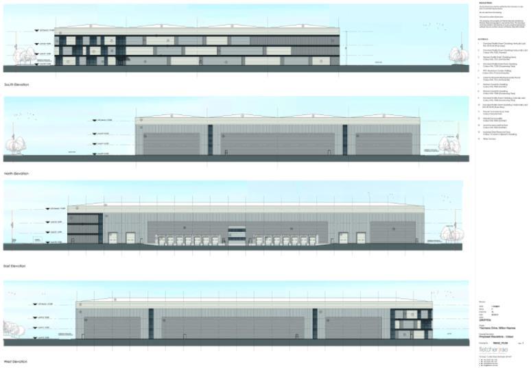
2 attached to this report. 1.4 The Proposal The proposal involves the redevelopment of the existing warehouse to provide a new warehouse within a redesigned site layout. The existing warehouse building has a floorspace of 17,414 square metres whilst the proposal would increase this to 20,522 square metres. In addition the existing building is 10.5 metres high along the elevation facing towards Bessemer Court whilst the proposed building would be 17.0 metres high along the same elevation and 18.4 metres high in total. 1.5 The existing building is 48 metres from the rear elevation of the closest dwelling (70 Bessmer Court) and 40 metres from the rear of the garden. The proposed building would be 37.0 meters from the same property. Details of the proposal as described above can be seen in the plans appended to this report. 1.6 The proposed development would have on-site 24 hour storage and distribution operations. The proposal includes 14 dock levellers and 4 loading doors for HGVs along the eastern elevation of the building along with parking spaces for 35 trailers and a main car park for 173 cars in front of the southern elevation of the building together with a remodelled access to serve the loading bays/hgv parking. The proposal has been amended to include a 51 space Overflow car park to the north of the building and provision is also made for cycle and motorcycle parking. 2.0 RELEVANT POLICIES (The most important policy considerations relating to this application) 2.1 National Policy National Planning Policy Framework Section 1 Delivering a Sustainable Economy Paragraph 14 Presumption in favour of sustainable development Paragraphs 32 & 34 Promoting sustainable transport Paragraphs 60 & 61 Requiring good design 2.2 Local Policy Core Strategy CSA Presumption in favour of sustainable development CS1 Milton Keynes Development Strategy CS13 Ensuring high quality, well designed places CS15 Delivering Economic Prosperity CS19 The Historic and Natural Environment CS21 Delivering Infrastructure Adopted Milton Keynes Local Plan D1 Impact on locality D2A Urban design D2 Design of buildings D4 Sustainable construction
3 T1 Transport User Hierarchy T2 Access for those with Impaired Mobility T3 Pedestrians and cyclists T10 Traffic T11 Transport Assessments and Travel Plans T15 Parking provision E1 Protection of existing employment land E9 Controlling the Risk of Pollution NE2 Protected Species NE3 Biodiversity and Geological Enhancement Supplementary Planning Guidance Parking standards SPD 2.3 Neighbourhood Plan Great Linford North Neighbourhood Plan Following the successful referendum on 11 th February and the making of the Great Linford North Neighbourhood Plan by Full Council on 23 rd March 2016, the Neighbourhood Plan forms part of the Development Plan and should be used when considering planning application. The following Neighbourhood Plan policies are relevant to the consideration of this application: N9 Trees, hedgerows and planting N11 New development accessibility, getting around and biodiversity N13 Proposals for larger scale employment and enterprise N14B Major developments in strategic locations 3.0 MAIN ISSUES (The issues which have the greatest bearing on the decision) 3.1 Principle of the Proposed development Design Visual Impact Impact on Residential Amenity (Privacy, Access to light, sunlight and daylight, Overbearance) Highways and Parking Noise Pollution (Noise, Air Quality, Light Pollution, Site Contamination) Landscaping Flood Risk Ecology S106 Contributions 4.0 RECOMMENDATION (The decision that officers recommend to the Committee) 4.1 It is recommended that planning permission be granted subject to the completion of a S.106 agreement and the conditions outlined at Section 6.0 of this report.
4 5.0 CONSIDERATIONS (An explanation of the main issues that have led to the officer Recommendation) Background Currently the site, known as Blakelands 1, is operated by John Lewis as a B8 Warehouse and Distribution facility with some associated B1 Office space. Following the approval of a scheme for an alternate facility, John Lewis are currently in the process of relocating their operations from the Blakelands 1 Site. The application site will then become vacant, having already a skeleton staff arrangement operating under its full capacity. Since awareness of the relocation of John Lewis, the site has received limited interest and no offers to use the site as existing. The Planning Statement explains the existing facility is no longer fit for purpose as a result of its relatively low height (in industrial terms) and lack of modern storage facilities. As such, the application has been submitted for a replacement warehouse in order to modernise the facility in line with the current industry requirements, in order to be able to continue the existing use and its associated economic benefits.. Principle The Milton Keynes Local Plan allocates the application site for employment purposes and the site is currently used in accordance with its designation. Under saved policy E1 of the Milton Keynes Local Plan existing employment sites are protected and should be retained for such purposes. In addition, Section 1 of the National Planning Policy Framework requires Local Planning Authorities to build a strong and competitive economy with paragraph 19 applying significant weight on the need to support economic growth. The proposed development seeks full planning permission for the replacement of the existing warehouse with additional floorspace with alterations to the access and car parking layout. As the development would not result in the loss of existing employment land and would improve the existing provision, the principle of development is acceptable, subject to the scheme fulfilling other policy requirements such as design, layout, neighbour amenity, parking and landscaping. Furthermore, the proposed replacement warehouse would contribute to the Borough s economy through both the short term, (during construction) and long term (on-going site operations and improvement to employment stock). The proposed development, to replace the existing warehouse, with a larger warehouse and distribution facility with ancillary B1 floorspace would be an appropriate function in this location and would offer local employment opportunities in conjunction with saved policy E1 of the Milton Keynes Local Plan The proposed development also would support and improve the Borough s economy. As such the development would comply with Section 1 of the National Planning Policy Framework. Design Saved policies D2 and D2A of the Milton Keynes Local Plan and
5 CS13 of the Core Strategy seek to ensure that all developments have a high quality design and relate well to the surrounding area. Policy NP13 of the Great Linford North Neighbourhood Plan requires large scale employment sites to be integrated with and complement clusters of activity in terms of their design, mass and scale The application site is set within the context of the Blakelands and Tongwell industrial area. Largescale industrial/warehouse facilities are located to the north and south of the A422 (Monks Way) and extend from Brickhill Street to the M1. The proposed building would have a simple appearance and functional form with a floor area of 20,522m 2. The floor area would provide 19,754 m 2 of B8 warehouse space and 768m 2 of B1 office space, which is divided over 3 floors. This would increase the floorspace above the existing provision by 3,109m 2. The scale of the proposed development would be inkeeping with the industrial character of Blakelands and Tongewell. This height of 17 metres-18.4 metres, would meet modern requirement and is currently used by a number of contemporary warehouses, such as the new facilities at Magna Park. The existing building is 10.5 metres in height, and the development would be between 6.5 and 7.9 taller than the existing. By virtue of their nature, storage and distribution facilities typically have a fit for purpose design. The proposed warehouse has a functional and industrial character as expected, however, incorporates vertical and horizontal cladding on the exterior with partial areas of glazing. The external treatments would have variations of grey that will help to break up the appearance of the façade and create visual interest. This will help reduce the perceived bulk and scale of the replacement warehouse and give a contemporary appearance. The overall design is deemed to be suitable for this site in terms of scale, form and appearance. The external appearance incorporates features which help to reduce the perceived bulk and create visual interest. The proposed development would therefore be in compliance with saved policies D2 and D2A of the Milton Keynes Local Plan Visual Impact Saved policies D2 and D2A of the Milton Keynes Local Plan and CS13 of the Core Strategy seek to ensure that development proposals positively contribute to the character of the area and that they relate well to the surrounding area. Policy NP13 of the Great Linford North Neighbourhood Plan requires larger scale employment sites to ensure that the development is integrated with existing clusters of activity in terms of their design, mass and scale. It is noted that the Council s Landscape Architect has recommended that the application is amended on the following grounds: It is important that the landscape architect consultant appointed to prepare the LVI Appraisal visits the site / surrounding area with me to agree viewpoints and discuss appropriate mitigation. A key view from the Redway by the lake public car park will need to be included as views and character from here have the potential to be significantly affected by
6 change. LVIA should be amended to clearly identify where vegetation is proposed for removal. The LVIA s mitigation list should be updated and demonstrated with a landscape principles plan. The key views and wireframe visual montages must demonstrate the worst case i.e. views resulting in the greatest harm. This must then inform the mitigation i.e. layout changes and landscape screening. Visual montages of the proposed landscape mitigation at year 1 and year 15 should be shown. A sunlight / shadow assessment plan of both the existing and proposed buildings is required to demonstrate that the building has been sufficiently set-back from the properties at Bessemer Court to minimise impact. Boundary treatment / fencing will need to be amended and would need to be conditioned. Landscape scheme planting plan will need to be amended and would need to be conditioned. Root protection areas and trees to be removed must be clearly highlighted on the amended proposed site layout and landscape scheme in a contrasting colour. The existing hedge along Yeomans Drive between the site and Bessemer Court provides a good level of screening and must be retained or replaced by proposed wildlife hedging to create a greater level of screening than the existing hedge. To achieve this, a minimum 5m width native landscape buffer hedgerow with trees along the north-east boundary of the site is needed to mitigate the visual intrusion in terms of height and mass of the building from the nearby public open space and district park of Tongwell Lake In Officers opinion submitted LVIA addresses the substantial requirements from the Landscape Architect and it presents a sufficiently complete clear assessment of the proposed development to adequately assess the impact on the surrounding area. Given the site context, where there is an industrial character existing large-scale warehouse and the nature of the proposed development, of a replacement warehouse, it is not necessary to consider further viewpoint assessments. Notwithstanding this, the majority of the Landscape Officer s comments have been considered within the submitted LVIA and the recommendation of a condition requiring the submission of an amended landscape scheme is outlined at section 6.0 of this report. This condition would address the Landscape Architect s concerns be requiring the submission of a suitable final scheme. The LVIA has identified three character areas, which are the industrial estate, the settlement of Blakelands and Tongwell Lake and assesses landscape susceptibility, landscape value, landscape sensitivity and the change and landscape effects. The assessment also identifies landscape character mitigation strategies. It is expected these measures would be incorporated into the submission of a suitable landscaping scheme. The application site is considered to fall within the industrial estate and is
7 clearly separated from the residential development to the north of the site through the dense planting screen that would be retained and enhanced by the proposed development. In line with the Landscape Architect s comments, a landscape buffer between the residential development along Bessemer Court and the warehouse building of between 17-24metres in depth has been achieved (measured to the closest point of the car park). Along the north eastern edge a landscape buffer of 6.2 metres to the link road and turning circle, at the narrowest point as been provided, above the required 5 metre width. From the north eastern corner there is also an existing area of tree planting to the north of the application site boundary, outside of the control of the applicant, which provides an additional screening belt of 11 metres from the rear gardens of the residential properties Industrial Estate The character of the Industrial Estate consists of large scale industrial units to the east of Brickhill Street and to the west of the M1. The area extends north towards Newport Pagnell and to the south, towards Willen. The area is a highly active industrial area with dense road network and infrastructure, service yards and associated car parking facilities. The area is characterised by varying scales of warehouse and associated developments. There are no landscape designations within the industrial area. The predominant activity within the industrial estate is employment with transient landscape for associate vehicle travel. Settlement of Blakelands The settlement is located to the west of Brickhill Street, with the residential are located between the industrial estates to the north and south. Properties within the residential are varied, from bungalows to three storey properties. The LVIA identifies, the landscape susceptibility to change is low and the landscape value is low. Tongwell Lake Tongwell Lake is located to the east, towards the M1. The LVIA notes that this area contains attractive features, such as the lake, established vegetation and circulatory footpath network. However, there are also some detracting urban elements which are apparent above the existing tree cover, with the M1 a prominent element of the local landscape. Overall, for each of the above identified character areas, the LVIA identifies that within both year 1 and year 15, the proposed replacement warehouse would have a negligible to low impact on the landscape setting of the area. In terms of the visual impact, for which residential, pedestrian and vehicle receptors have been assessed it has been identified there are a number of highly sensitive residential receptors along Bessemer Court and Telford Way. The visual effect of the proposed development in year 1 (pre-mitigation) would have a slight to moderate impact, with one view point having a moderate-substantial effect. In terms of the year 15 (with mitigation) impacts, the level of these effects reduce to low-negligible to moderate, with no
8 substantial effects recorded. It is considered, that given the sight context and the mitigation proposed, and required by the recommended conditions, there would not be unacceptable harm to the visual effects of the proposed development The proposed development is not considered to have a detrimental impact on the existing landscape character which is an industrial area, where limited landscaping is usually expected. The proposed development ensures sufficient screening is retained an enhanced along the sites northern and north eastern boundary to screen the development from the adjacent residential properties. The proposed development would therefore accord with saved policies D1 and D2 of the Milton Keynes Local Plan Impact on Residential Amenity Privacy Saved policy D1(iii) of the Milton Keynes Local Plan seeks to ensure that proposed developments do not cause an unacceptable overlooking of neighbouring residential properties. The impact on the privacy of the properties along Bessemer Court which share their rear boundary with the application site, was a key concern raised by the neighbour objections received. The proposed development includes two narrow vertical strips of glazing on the proposed north elevation, which face onto the rear garden spaces and elevations of the residential properties along Bessemer Court. However, as shown on the submitted site layout plan and floor plans, this would be an area of warehouse activity with limited potential for overlooking as operations would take place at ground level such that there would be harm to residential amenity through a loss of privacy. Notwithstanding this, the site layout plan shows an area of dense landscaping to be retained and enhanced. This would provide dense screening between the residential properties of Bessemer Court and the proposed replacement warehouse. This would mitigate any potential for overlooking into residential properties. The proposed development would therefore comply with saved policy D1(iii) of the Milton Keynes Local Plan as it would not cause an unacceptable loss of privacy. Access to light, sunlight and daylight Saved policy D1(iii) of the Milton Keynes Local Plan outlines that planning permission will be refused for development where it would adversely affect residential amenity of neighbouring properties in terms of harm to sunlight, daylight or privacy. The Core Planning Principles outlined within Paragraph 17 of the National Planning Policy Framework requires decision making to seek to secure a good standard of amenity for all existing and future occupants of land and buildings. It is noted by Officers, that a key concern of the neighbour representations received is the impact of the proposed development on the surrounding residential properties in relation to the potential loss of light, sunlight and
9 daylight as a result of the increase in height, scale and proximity of the proposed new building As the proposed development is for a replacement warehouse, consideration must particularly be given to the additional impacts arising from the development compared to the existing situation. The proposed development would result in an additional 3,109 square metres of floorspace and would be sited approximately 11.2 metres closer to the nearest residential property, no. 70 Bessemer Court. The height of the proposed warehouse would increase by 6.5 metres to a total of 17 metres, in relation to the elevation closest to Bessemer Court. The application has been supported by proposed section drawings showing a 25 degree line of sight from adjacent properties and a Daylight, Sunlight and Shadow Study in accordance with BRE Guidance (BRE209 Site Layout Planning for Daylight and Sunlight 2011). The BRE Guide provides a standard which is used when considering the impact of development proposals on residential amenity which is the 25 degree test. The 25 degree test is used where development is opposite a window and uses a line of sight to determine if proposals may result in an unacceptable loss of daylight, sunlight or by being visually obtrusive. The centre of the lowest habitable room is usually used as a reference point with a 25 degree line of sight measured vertically. If the proposed development falls beneath a the 25 degree line of site, the proposed development is considered not to cause unacceptable harm to daylight, sunlight or by creating a visual intrusion to neighbouring properties. The submitted sectional drawings show a 25 degree line of sight taken from the ground level of the private garden space closest to the dwelling. These sectional drawings show a worst case scenario impact on the residential properties and demonstrates that the proposed warehouse building does not breach the 25 degree line of sight for any of the nearby residential properties. Should the 25 degree line of sight be taken in line with the industry standard, from the lowest habitable room, the impact would improve as the 25 degree line of sight starting point would be at a higher level than the ground. In addition to the submitted proposed sections, the Daylight, Sunlight and Shadow Study which uses BRE Guidelines confirms the proposed development is fully compliant with these guidelines in terms of the neighbouring daylight, sunlight and overshadowing. This assessment provides further evidence to demonstrate that the proposed development would not cause unacceptable harm to the amenity of the neighbouring properties along Bessemer Court through a loss of sunlight, daylight or through overshadowing. In light of the assessments submitted by the applicant, the proposed development would not cause any substantial loss of light, sunlight or overshadowing or create a visual intrusion to the neighbouring residential properties. As such, the proposed development would comply with saved
10 policy D1(iii) of the Milton Keynes Local Plan Dominance and Visual Intrusion Saved policy D1(iii) of the Milton Keynes Local Plan seeks to ensure that development proposals do not cause an unacceptable visual intrusion. Private views are not protected and are not a material planning consideration; however, an assessment of whether the proposed development would create a visual intrusion can be considered. The proposed development must be considered against the additional visual impact only. In this section of the report, the visual impact in relation to the adjacent residential properties is considered only, not the impact on the streetscene. It is acknowledged that a key concern of the neighbour representations received is the visual impact of the scale, bulk and mass of the proposed development on the neighbouring residential properties as this is considered to be overbearing. As shown on the submitted sectional site drawings, the proposed replacement warehouse does not impinge on the 25 degree line of sight. It is therefore considered, the additional height would not be visually oppressive causing harm through overdominance or the creation of a visual intrusion. In addition, the site layout plan shows the retention of the existing landscape buffer along the northern boundary (to the rear of the properties along Bessemer Court) in conjunction with proposed enhanced landscaping. The proposed enhanced landscaping is illustrative at the current time and a suitable condition requiring the submission of a landscaping scheme is recommended at section 6.0 of this report. Only the portion of warehouse above the tree canopy would visible from neighbouring properties. Care has been taken to reduce the perceived bulk of the warehouse through the use of different elevational cladding and colouration. The siting of the proposed replacement warehouse is broadly located on the footprint of the existing warehouse. The design incorporates low, facing gables to the north (towards Bessemer Court) where there is existing dense landscaping and to the south (within the Blakelands industrial area). This design feature helps to lower the height of the proposed warehouse and reduce its bulk, when perceived from the residential properties. It is accepted by Officers, that proposed replacement warehouse is substantially taller than the existing warehouse. However, it is considered the proposed replacement warehouse would not cause an unacceptable visual intrusion as demonstrated by the applicant within the supporting documentation. As such, the proposed development would comply with saved policy D1(iii) of the Milton Keynes Local Plan Highways and Parking Saved policy T15 of the Milton Keynes Local Plan and the new Parking Standards Supplementary Planning Document sets out the parking requirements for the proposed development. In addition saved policy T3 of
11 the Milton Keynes Local Plan requires proposals must be designed to meet the needs of pedestrians and cyclists. Saved policy T10 of the Milton Keynes Local Plan details that proposals will be refused for development if they would exceed the highway capacity of the local road network or cause significant risk of accident The Highways Engineer initially raised several issues with the proposed scheme and objected to the application on the grounds of inadequate parking and access. However, subsequent to these initial comments a Transport Technical Note was submitted and there has been correspondence between the Highways Engineer and the applicant s agent. The Highways Engineer has since changed their advice to no objection, subject to conditions. As outlined in the submitted Transport Statement, an analysis of the accident data for the latest five year period has been undertaken. This analysis has confirmed there are no existing highway safety issues in the local highway network that the proposed development may exacerbate. HGV Access Improvements to the proposed access to the site, at the south of the site have been made from the original permission. A plan has been submitted showing the HGV access to Yeomans Drive at a much squarer angle. This allows for HGV movements from the direction of Brickhill Street to the west and from Dansteed Way (via Delaware Drive) to the east. This realigned access also improves the pedestrian crossing by narrowing the width, which the Highways Engineer considered to be a significant improvement from access as first proposed. Car Park Access The initial concern with regard to larger vehicle tracking when entering the site has been overcome through the information submitted within the technical note. The note acknowledges that all vehicles will be directed around the car park and will overcome the tracking issue. Pedestrian Access The application as initially submitted, did not included a section of pedestrian pathway from the length of Yeomans Drive, running east-west, potentially forcing pedestrians to walk on the carriageway. The applicant has now confirmed that this footway will be constructed as part of the development proposals. These works would form part of a s.278 agreement with the Highways Authority. Parking The Highways Engineer initially objected to the proposed development due to inadequate provision of car parking to serve the development. An amended site plan has been submitted to show an area of parking to the north of the development, using an existing access point. This parking areas would provide 51 car parking spaces. The spaces have good access to the internal pedestrian routes, as such, no additional footways would be required.
12 As a result of the new car parking area shown on the site layout plan, the proposed parking would satisfy the requirements of the Parking Standards SPD. Parking for HGV s has remained as per the original submission, which the Highways Engineer notes does not meet the requirements outlined in the Parking Standards SPD. However, the Highways Engineer accepts that the applicant/ end user would have control over the arrival and departure of HGV s such that HGV parking to be provided would be acceptable for the scale of development proposed. The HGV parking is acceptable and would be subject to a condition requiring the submission of a Traffic Management Plan, as recommended at section 6.0 of this report. Cycle Parking The provision of cycle parking has doubled in relation to the initial offer and the provision of 24 cycle spaces is considered to be acceptable. For the reasons outlined above, the proposed development is considered to be appropriate in highways term. The proposed development would accord with saved policies T10 and T15 of the Milton Keynes Local Plan Pollution Noise Saved policy D1(iv) of the Milton Keynes Local Plan seeks to ensure that development proposals do not cause unacceptable pollution by noise, to the detriment of the locality. It is noted by Officers that a key concern of the representations received is the potential increase in harmful noise generation to the detriment of residential amenity. A noise assessment has been prepared by an external consultant on behalf of the applicant and submitted as part of the supporting application documentation. The Noise Assessment considers the operation of the propose development unit in line with the requirements of BS 4142:2014. The Assessment identifies that the control of noise associated with any fixed external plant can be achieved through the selection and siting of plant and/or through standard noise mitigation techniques and that 24 hour warehousing is acceptable in this location, given the surrounding context with residential properties. In response, the proposed development incorporates a 4m high acoustic barrier along the north eastern corner of the application site. The benefits of this acoustic barrier have been assessed within the noise assessment which concludes the barrier in conjunction with complementary management controls, would ensure that the 24 hour loading activities are feasible and would not result in an unacceptable loss of amenity to the nearest identified noise sensitive receptors (i.e. the residential properties along Bessemer Court). The Council s Environmental Health Officer has been consulted on the proposed development and in their response, no objection has been raised in
13 terms of the noise generation and proximity to neighbouring properties. The Environmental Health officer has recommended a series of conditions to ensure the development would be acceptable in terms of the proximity to neighbouring dwellings. These conditions are recommended at section 6.0 of the report and these cover the following: Submission of a Noise Management Plan Any plant/air handling units on the roof to directed away from the residential units and/or suitably screened The retention of the noise barrier Requirement for vehicles operating on the site to be fitted with fully functioning broadband (white noise) reversing alarms As such, in regard to potential noise pollution, the proposed development would accord with saved policy D1(iv) of the Milton Keynes Local Plan with suitable conditions recommended at Section 6.0 of this report. Air Quality Saved policy D1(iv) also protects the impact of the proposed development on the locality from unacceptable pollution by smell, light or other emission to air, water or land. Saved policy E9 of the Milton Keynes Local Plan is permissive of industrial uses within employment areas, provided that the following criteria is met: i) Ground water, surface water and soil are protected; ii) Adequate controls are proposed to deal with air pollution and noise; iii) Adequate controls are proposed to deal with vibration, smell, fumes, smoke, soot, ash, dust, grit, gases, heat light and visual intrusion; iv) The site and surrounding land are protected from contamination v) The proposed use is compatible with existing or potential surrounding uses Concern has been raised within the submitted representations regarding the impact of increased diesel fumes and the impact this would have on health nd air quality. Comments received from the Environmental Health Officer confirm there are no objections to the proposed development in terms of the impact on air quality within the site context, adjacent to residential properties. In the Environmental Health Officers comments, consideration has been given to the estimate peak hourly trip generations, which noted to be a maximum of 67 vehicles of which 28 would be HGVs. This would be an increase of around 4 vehicles movements per hour above the existing levels noted in the Transport Statement. The main access into the site would be from the south side of the warehouse, away from residential properties, with the loading bay located to the east of the site. The northern roadway would be used for emergency use only and the access would also serve the overspill car park to the north. The Environmental Health Officer confirms, there is no risk that air quality objectives would be exceeded at the nearest residential properties and as such, there is no requirement for an air quality assessment, as the application is considered acceptable.
14 The proposed development would comply with saved policy D1(iv) in respect of the impact on air quality and due consideration has been given to the proximity and content of residential properties. Light Pollution Saved policy D1(iv) of the Milton Keynes Local Plan also seeks to ensure that development proposals do not cause harm to the amenity of residential properties through the generation of unacceptable light pollution. The proposed development has been carefully designed to ensure the volume of glazed openings on the north elevation is reduced in order to limit any potential light spill. In addition, the windows are proposed to have a dark coloured glazing, to integrate with the external appearance but also, reduce any light spill from the windows. As such it is considered the proposed warehouse building would not generate significant light spill to the detriment of the adjoining neighbouring properties, even with 24 hour operation. A key concern of the representations received is the impact of external lighting serving the proposed overspill car park to the north of the application site and potential generation from the loading bay located to the east of the replacement warehouse. No lighting details have yet been proposed on the submitted drawings and weight cannot be given to the consideration of this matter as part of the determination of this application. However, it is expected that some external lighting would be required, a suitable condition has been recommended that requires the submission of any external lighting details, prior to its installation so the light spillage can be adequately controlled. The proposed warehouse is considered not to generate harmful light pollution to the detriment of neighbouring properties with 24 hour operations as appropriate details would be controlled by the conditions recommended at section 6.0 of this report and would comply with saved policy D1(iv) of the Milton Keynes Local Plan in respect of light pollution. Site Contamination Saved policy D1(iv) of the Milton Keynes Local Plan requires proposals not to cause unacceptable pollution to water or land. The application was supported by An Environmental Review. The Environment Practitioner has commented on the application raising no objection and notes the conclusion of the Environmental review that there is potential for residual contamination following the earlier diesel spill in The Practitioner supports the report s recommendation for on site assessment and advises that standard conditions for an assessment of ground conditions and remedial works should be imposed if planning permission is granted. These are included within Section 6.0 of this report. The proposed development, is not considered to cause harm to land or water through any on site contamination, however, given the site s history further assessment to confirm this is required and this is covered within the
15 conditions section of the report. The proposed development, subject to further assessment, would comply with saved policy D1(iv) of the Milton Keynes Local Plan Landscaping Saved policy D2(iv) requires development proposals to include landscaping and boundary treatments that integrate with those of the surrounding area. Whilst the application was supported by a landscape plan, this has been superseded as a result of the changes to the site layout plan to include the retention of the overspill car park to the north of the proposed replacement warehouse. However, as shown on the submitted layout plan, the perimeter of the site would include the provision or retention of landscaping. It is recommended at section 6.0 of this report, that a condition requires the submission and agreement of a landscape plan. A Tree Survey and Arboricultural Impact Assessment has been submitted as part of the supporting documentation. The survey identified a total of eightynine individual trees and three groups of trees. The majority of the trees/groups of trees identified fell within Category C, those of low quality and value. Usually, Category C trees would not be retained where they would impose a significant constraint to development. The proposed development would result in the loss of two individual Category B Trees (moderate quality and value) and 72 Category C trees. Whilst the loss of these trees is regrettable, the benefits of the proposed development must be weighed against any harm caused to the loss of soft landscaping and its impacts on the character of the area. Much of the landscaping to be removed is located along the western, southern and eastern edges of the application site. These edges are located adjacent to existing industrial buildings and form part of the industrial character of Delaware Drive/Yeomans Drive. The loss of these trees is not considered to cause significant harm to the character of the area. During the application process, an amended site plan has been submitted to include a car park along the northern elevation of the proposed warehouse. This would result in the loss of some of the proposed landscaping shown on the submitted planting plan. The applicant has been contacted and will provide an amended planting plan. However, should this not be available by the Committee meeting, an additional condition would be recommended should permission be granted. The Arboricultural Officer has been consulted on the proposed development and has not raised any objection. The Officer does not that the proposal would result in the loss of considerable number of trees, however recommends that the proposal is supported by a robust tree replacement plan along with measures to protect the tree being retained. The replacement tree planting would be excepted as part of a landscape plan, required by the conditions recommended at section 6.0 of this report.
16 It is considered that the development is set within an industrial context with a shared boundary to the north with residential properties and not within an area of important or attractive landscaping. It is considered that agreement could be reached through the recommended condition, requiring the submission of a landscape scheme, to mitigate any harm caused through the loss of trees in accordance with saved policy D2 of the Milton Keynes Local Plan Flood Risk Saved policy D1(ii) of the Milton Keynes Local Plan requires developments to provide adequate drainage including surface water disposal. Anglian Water have been consulted on the proposed development and initially raised concern to the proposed development. An additional note on Surface Water Drainage was submitted and Anglian Water have confirmed that the existing foul drainage and sewerage system have capacity for the flows that would result from the proposed development. Whilst Anglian Water have not objected to the proposed development, a request has been made for a condition requiring the submission of a drainage strategy, which has been imposed at section 6.0 of this report. This is because Anglian Water advise that the submitted surface water strategy is not acceptable and further detail is required. The proposed development, subject to suitable details through the recommended condition, would comply with saved policy D1(ii) of the Milton Keynes Local Plan Ecology Saved polices NE2 and NE3 of the Milton Keynes Local Plan seek to ensure that development proposals do not cause harm to protected species and provide suitable biodiversity enhancements. Although the site is located in relatively close proximity to Willen Lake which is known to provide habitat to protect species, the context of the site amongst commercial and residential development and the M1 motorway restricts the likeliness of protected species using the site as habitat. The site comprises of a limited range of species poor habitats. Within the site, one tree is noted within the submitted preliminary ecological assessment has have low suitability for roosting bats, although the risk of roosting in this location is considered to be low. The is very limited potential for any protected species to be present on site and overall, this is not considered to be a constraint to the proposed development. The submitted ecological assessment outlines that notwithstanding the limited potential, there is a requirement for development proposals to positively contribute to biodiversity. This assessment outlines that it would be reasonable to impose a condition requiring the submission of a Biodiversity Enhancement and Management Plan to provide a net gain to biodiversity on the site.
17 The Council s Countryside Officer has provided no objections to the proposed development and confirmation of the internal discussion with the Officer notes that any harm which may be caused, is off-set by the mitigation methods outlined in the submitted Preliminary Ecological Assessment. To ensure the delivery of the mitigation methods, the Countryside Officer has recommended that a biodiversity enhancement plan is submitted to and approved, which aligns with the suggested mitigation. The officer also recommends that consideration is given to the inclusion of native species of vegetation within the landscape scheme in order to improve habitat provision. Whilst it is noted the development does not include any details of external lighting, it is recommended that details of any external lighting are secured by condition in order to ensure that suitable lighting is proposed given the potential for impact on bats. These elements are recommended to secured via the conditions outlined in section 6.0 of this report. Subject to the submission of a suitable biodiversity plan and the development being carried out in accordance with the above recommendations, the development would comply with saved policies NE2 and NE3 of the Milton Keynes Local Plan S106 Contributions Planning obligations are required in accordance with the Milton Keynes Core Strategy CS21 and saved policies PO4 of the Milton Keynes Local Plan The Planning Obligations Team have confirmed the requirements for the development would be for Carbon Neutrality and Public Art. The requirements for this scheme would be Carbon Neutrality in accordance with Policy D4 and the Sustainable Construction SPD and Public Art in accordance with PO4 and the Social Infrastructure SPD. Public Art is calculated at 1% of the gross development cost excluding land and should either be incorporated into the design of the development or as a separate project post completion within or within the immediate vicinity of the development, engaging a public artist in accordance with the MKC Art and Public Art Strategy In terms of the Carbon Neutrality Contribution, it would be reasonable to only charge for the additional floor space rather than the entire proposed floor space. These contributions would be sought through a s.106 agreement and would accord with the requirements of saved policy PO4 of the Milton Keynes Local Plan and NP14B of the Great Linford North Neighbourhood Plan. No contributions to Highways Improvements have been requested. Conclusion One of the principles of the NPPF is that planning should proactively drive and support sustainable economic development to deliver homes, business
18 and industrial units, infrastructure and thriving local places that the country needs. The Government is committed to securing economic growth in order to create jobs and prosperity and to meeting the twin challenges of global competition and of a low carbon future The proposal is considered to be of a high quality, sustainable design that achieves the overall design intent for Yeomans Drive and in line with the objectives of the NPPF to secure economic benefits through the improvements to employment stock. In addition, the proposed development would allow the Council to assert greater control of the operation of the site than currently accounted for. This is because, there are no known conditions imposed on the original grant of consent relating to the operational hours, control of noise, light or vehicular movements. Whilst the existing operator does not exercise these rights, the Council would not have any control should the existing site be brought into such operations. As such, it is considered the exercise of controls the Council would have on matters relating to the impact on amenity of residential properties would be of benefit to the neighbouring dwellings. The applicant has demonstrated that the proposed development would comply with policy in respect of the material planning merits of the application. As such, Officers consider that the proposed replacement warehouse would be in accordance with the Great Linford North Neighbourhood Plan Local Plan Policies, the Core Strategy, the Development Framework and the National Planning Policy Framework. 6.0 CONDITIONS (The conditions that need to be imposed on any planning permission for this development to ensure that the development is satisfactory. To meet legal requirements all conditions must be Necessary, Relevant, Enforceable, Precise and Reasonable ) 1. The development hereby permitted shall be begun before the expiration of three years from the date of this permission. Reason: To prevent the accumulation of planning permissions; to enable the Local Planning Authority to review the suitability of the development in the light of altered circumstances; and to comply with section 51 of the Planning and Compulsory Purchase Act (D11) 2. Prior to the commencement of the development details of the Industrial Access Road(s) including vision splays shall be approved in writing by the Local Planning Authority and no part of the development shall be occupied until the access road(s) have been laid out and constructed in accordance with the approved details. The access road(s) so laid out shall be retained thereafter. Reason: In order to minimise danger, obstruction and inconvenience to users of the highway and of the development. 3. Within one calendar month of the new access being brought into use
19 all other existing access points not incorporated in the development hereby permitted shall be stopped up in accordance with the details shown in the approved drawings. Reason: To limit the number of access points along the site boundary for the safety and convenience of the highway user. 4. Prior to the initial occupation of the development the turning area shown in the approved drawings shall be provided and that area shall not be used for any other purpose thereafter. Reason: To enable vehicles to draw off and turn clear of the highway thereby avoiding the need to reverse onto the public highway. 5. Prior to the first occupation of the development hereby permitted details of the proposed bicycle parking shall be submitted to and approved in writing by the Local Planning Authority and the scheme approved shall be provided and be retained thereafter. Reason: To ensure that adequate parking facilities are provided to serve the development. 6. Prior to the occupation of the development hereby permitted the car parking area shown on the approved drawings shall be constructed, surfaced and permanently marked out. The car parking area so provided shall be maintained as a permanent ancillary to the development and shall be used for no other purpose thereafter. Reason: To ensure adequate parking provision at all times so that the development does not prejudice the free flow of traffic or the safety on the neighbouring highway. 7. No drainage works shall commence until a surface water management strategy has been submitted to and approved in writing by the Local Planning Authority. No hard-standing areas to be constructed until the works have been carried out in accordance with the surface water strategy so approved unless otherwise agreed in writing by the Local Planning Authority Reason: To prevent environmental and amenity issues arising from flooding. 8. Prior to construction of any part of the development above ground floor slab level, details of external lighting including security lighting shall be submitted to and approved in writing by the local planning authority. The plans shall show lighting proposed in accordance with BS5489 standards and detail how the presence of bats in the area has been taken into account. The development shall thereafter be carried out in accordance with the approved details. Reason: To ensure that the development does not detract from residential amenity and the appearance of the locality and in the interests of ecology and
20 crime prevention in accordance with Policies D1, and D2A, and NE3 of the Milton Keynes Local Plan and CS19 of the Core Strategy. 9. A landscaping scheme, which shall include provision for the planting of trees and shrubs, shall be submitted to and approved by the Local Planning Authority before first use of the development. The scheme shall show the numbers, types and sizes of trees and shrubs to be planted and their location in relation to proposed roads, footpaths and drains. All planting in accordance with the scheme shall be carried out in accordance with the approved details within the first planting season following completion of development. Any trees or shrubs removed, dying, severely damaged or diseased within two years of planting shall be replaced in the next planting season with trees or shrubs of such size and species as approved. Reason: To protect the appearance and character of the area and to minimise the effect of development on the area. 10. Prior to the commencement of any development above slab level a Biodiversity Enhancement Scheme detailing specifications and locations of biodiversity enhancements and ongoing management prescriptions shall be submitted to the Local Planning Authority for approval. Once approved the scheme shall be implemented prior to the occupation of the building hereby permitted. Reason: To ensure long term biodiversity enhancement of the site. 11. Prior to any development taking place, the developer shall carry out an assessment of ground conditions to determine the likelihood of any ground, groundwater or gas contamination of the site. The results of this survey detailing the nature and extent of any contamination, together with a strategy for any remedial action deemed necessary to bring the site to a condition suitable for its intended use, shall be submitted to and approved by the Local Planning Authority before construction works commence. Reason: To ensure that the site is fit for its proposed purposed and any potential risks to human health, property, and the natural and historical environment, are appropriately investigated and minimised. 12. Any land contamination remedial works shall be carried out in accordance with the approved strategy and validated by submission of an appropriate verification report prior to first occupation of the development. Reason: To ensure that the site is fit for its proposed purposed and any potential risks to human health, property, and the natural and historical environment, are appropriately investigated and minimised. 13. Should any unforeseen contamination be encountered the Local Planning Authority shall be informed immediately. Any additional site
21 investigation and remedial work that is required as a result of unforeseen contamination will also be carried out to the written satisfaction of the Local Planning Authority. Reason: To ensure that the site is fit for its proposed purposed and any potential risks to human health, property, and the natural and historical environment, are appropriately investigated and minimised. 14. All existing trees, woodlands and hedges to be retained are to be protected according to the provisions of BS 5837: 2012 'Trees in relation to design, demolition and construction - Recommendations' All protective measures especially the fencing and ground protection must be put in place first, prior to any other work commencing on site (this includes vegetation clearance, ground-works, vehicle movements, machinery / materials delivery etc.) The fencing shall be of the same specification as that depicted in figure 2, page 20 and ground protection as specified in pages 21/22 in BS 5837: Signs informing of the purpose of the fencing and warning of the penalties against destruction or damage to the trees and their root zones shall be installed at minimum intervals of 10 metres and a minimum of two signs per separate stretch of fencing. Once erected the local authority tree officer shall be notified so the fencing can be inspected and approved. The Root Protection Area (RPA) within the protective fencing must be kept free of all construction, construction plant, machinery, personnel, digging and scraping, service runs, water-logging, changes in level, building materials and all other operations, personnel, structures, tools, storage and materials, for the duration of the construction phase. The developer shall submit details of the proposed layout and general arrangements of the site in relation to the trees to be retained. In particular details of storage areas including what substances will stored and where, locations of car parking, welfare facilities, cement plant, fuel storage and where discharge, filling and mixing of substances will take place. The details should include site levels to enable risks posed to trees to be quantified. The RPA will be amended as the arboriculture officer feels appropriate after taking account of the details submitted. No fire shall be lit such that it is closer than 20 metres to any tree or that flames would come within 5 metres of any part of any tree. Earthworks, level changes, service runs, foundations and all other works involving excavation should not be located within the root protection areas. Reason: To ensure that the development maintains and enhances existing and proposed landscaping features. 15. A tree protection plan in accordance with BS 5837:2012 shall be submitted. It should include a scale plan accurately marking the position of all
22 the retained trees and hedges, the extent of the root protection areas, the BS 5837: 2012 tree protection fencing along the root protection area margin, any areas to be covered in BS 5837: 2012 ground protection, construction details for the BS 5837: 2012 fencing and ground protection and sufficient detail of hard & soft landscaping works, service and drainage runs and proposed & existing spot levels in sufficient numbers and at appropriate spacing s to enable the impact of the development on the tree root zones to be assessed. Reason: To ensure that the development maintains and enhances existing and proposed landscaping features. 16. Construction details for raised construction, nil-excavation surfaces and foundations shall be submitted for approval, demonstrating that they are both specifically tailored to and are feasible in this site context. Details of the protocol for altering the protective fencing and ensuring the root protection areas remain undamaged during the raised path construction shall also be submitted for approval. Reason: To ensure that the development maintains and enhances existing and proposed landscaping features. 17. Prior to any development above slab level, a Noise Management Plan shall be submitted to and approved in writing by the Local Planning Authority, The Plan shall then be updated, in order to reflect operations on the site Reason: To ensure the development does not cause unacceptable noise pollution to the detriment of residential amenity. 18. Any vehicles operating on the site shall be fitted with broadband (White noise reversing alarms. Reason: To ensure the development does not cause unacceptable noise pollution to the detriment of residential amenity. 19. Any plant and/or air handling units which are roof mounted shall be directed away from residential properties or suitably screened, to limit operation noise to 5dB below background levels at the nearest noise sensitive receiver. Reason: To ensure the development does not cause unacceptable noise pollution to the detriment of residential amenity. 20. The proposed noise barrier, as shown on the submitted drawings shall be installed prior to the occupation of the warehouse and shall thereafter be retained. Reason: To ensure the development does not cause unacceptable noise pollution to the detriment of residential amenity. 21. Prior to any development above slab level, a Traffic Management Plan shall be submitted to and approved in writing by the Local Plan Authority. The
23 site shall therefore be managed in accordance with the approved details. Reason: To ensure the development provides adequate movement within the site and at the access points.
24 Appendix to 16/03023/FUL A1.0 RELEVANT PLANNING HISTORY (A brief outline of previous planning decisions affecting the site this may not include every planning application relating to this site, only those that have a bearing on this particular case) A1.1 09/01431/FUL INSTALLATION OF CABIN FOR USE AS A TEMPORARY OFFICE PER /01737/CLUP Certificate of lawfulness (proposed) for changes to dock shelter CLUPL A2.0 ADDITIONAL MATTERS A2.1 None. (Matters which were also considered in producing the Recommendation)
25
26 Existing Site Plan

27 Proposed Site Plan

28 Existing Elevations and Sections
29 Proposed Elevations
Report Author/Case Officer: Joanne Horner Contact Details:
 APP 04 Application Number: 16/00140/FUL Other Two storey side extension to existing dwelling and formation of hard standing to provide parking for number 54 (Resubmission of withdrawn application 15/02852/FUL)
Report Author/Case Officer: Paul Keen Senior Planning Officer (Dev Control) Contact Details:
 Contact Details:") APP 03 Application Number: 17/02060/FUL Description A full planning application for the demolition of an existing bungalow (C3 use class) and associated out buildings and the erection of two, two storey
APP 03 Application Number: 17/02060/FUL Description A full planning application for the demolition of an existing bungalow (C3 use class) and associated out buildings and the erection of two, two storey
Description Details submitted pursuant to discharge of condition 5 (Design Code) attached to planning permission 13/01729/OUT.
 attached to planning permission 13/01729/OUT.") ITEM 9 Application Number: 18/00266/DISCON Description Details submitted pursuant to discharge of condition 5 (Design Code) attached to planning permission 13/01729/OUT. AT The Point, 602 Midsummer Boulevard,
ITEM 9 Application Number: 18/00266/DISCON Description Details submitted pursuant to discharge of condition 5 (Design Code) attached to planning permission 13/01729/OUT. AT The Point, 602 Midsummer Boulevard,
SOUTH CAMBRIDGESHIRE DISTRICT COUNCIL. REPORT TO: Planning Committee 1 April 2015 Planning and New Communities Director
 SOUTH CAMBRIDGESHIRE DISTRICT COUNCIL REPORT TO: Planning Committee 1 April 2015 AUTHOR/S: Planning and New Communities Director Application Number: Parish(es): Proposal: Site address: Applicant(s): Recommendation:
Case Officer: Sarah Kay File No: CHE/14/00515/REM Tel. No: (01246) Plot No: 2/6132 Ctte Date: 15 th September 2014 ITEM 1
 Plot No: 2/6132 Ctte Date: 15 th September 2014 ITEM 1") Case Officer: Sarah Kay File No: CHE/14/00515/REM Tel. No: (01246) 345786 Plot No: 2/6132 Ctte Date: 15 th September 2014 ITEM 1 APPROVAL OF RESERVED MATTERS FROM APPLICATION CHE/12/00234/OUT (1) LAYOUT,
Case Officer: Sarah Kay File No: CHE/14/00515/REM Tel. No: (01246) 345786 Plot No: 2/6132 Ctte Date: 15 th September 2014 ITEM 1 APPROVAL OF RESERVED MATTERS FROM APPLICATION CHE/12/00234/OUT (1) LAYOUT,
1 The development hereby permitted shall be carried out in accordance with the following approved plans:
 Location The Avenue Tennis Club The Avenue London N3 2LE Reference: 16/6509/FUL Received: 10th October 2016 Accepted: 10th October 2016 Ward: Finchley Church End Expiry 5th December 2016 Applicant: Mrs
Reference: 16/1447/FUL Received: 7th March 2016 Accepted: 7th March 2016 Ward: East Finchley Expiry 2nd May 2016
 Location 374B Long Lane London N2 8JX Reference: 16/1447/FUL Received: 7th March 2016 Accepted: 7th March 2016 Ward: East Finchley Expiry 2nd May 2016 Applicant: Ms Katrin Hirsig Proposal: Single storey
Ground Floor Flat 15 Redbourne Avenue London N3 2BP
 Location Ground Floor Flat 15 Redbourne Avenue London N3 2BP Reference: 17/4160/FUL Received: 28th June 2017 Accepted: 29th June 2017 Ward: West Finchley Expiry 24th August 2017 Applicant: Proposal: Mr
CA//16/00504/FUL. Canterbury City Council Military Road Canterbury Kent CT1 1YW. Crown copyright and database rights 2016 Ordnance Survey
 O Scale 1:1,250 Map Dated: 09/05/2016 CA//16/00504/FUL Crown copyright and database rights 2016 Ordnance Survey 100019614 Canterbury City Council Military Road Canterbury Kent CT1 1YW AGENDA ITEM NO 13
Schedule of Planning Applications Committee Date: 23 May Reference: 06/17/0726/F Parish: Hemsby Officer: Mr J Beck Expiry Date:
 Schedule of Planning Applications Committee Date: 23 May 2018 Reference: 06/17/0726/F Parish: Hemsby Officer: Mr J Beck Expiry Date: 22-05-2018 Applicant: Proposal: Site: Mr Gillett Change of use to the
Reference: 16/1234/HSE Received: 25th February 2016 Accepted: 2nd March 2016 Ward: High Barnet Expiry 27th April 2016
 Location 7 Sunset View Barnet EN5 4LB Reference: 16/1234/HSE Received: 25th February 2016 Accepted: 2nd March 2016 Ward: High Barnet Expiry 27th April 2016 Applicant: Proposal: Mr & Mrs Peter & Anny Woodhams
26 September 2014 CONSULTATION EXPIRY : APPLICATION EXPIRY : 22 July 2014 SUMMARY RECOMMENDATION: PERMISSION
 Item No.: 5 The information, recommendations and advice contained in this report are correct as at the date of preparation, which is more than one week in advance of the Committee meeting. Because of the
SOUTH CAMBRIDGESHIRE DISTRICT COUNCIL. Executive Director (Operational Services) Corporate Manager (Planning and New Communities)
 Corporate Manager (Planning and New Communities)") SOUTH CAMBRIDGESHIRE DISTRICT COUNCIL REPORT TO: Planning Committee 12 January 2011 AUTHOR/S: Executive Director (Operational Services) Corporate Manager (Planning and New Communities) Notes: S/1848/10
SOUTH CAMBRIDGESHIRE DISTRICT COUNCIL REPORT TO: Planning Committee 12 January 2011 AUTHOR/S: Executive Director (Operational Services) Corporate Manager (Planning and New Communities) Notes: S/1848/10
3 Tretawn Gardens London NW7 4NP
 Location 3 Tretawn Gardens London NW7 4NP Reference: 16/7886/HSE Received: 12th December 2016 Accepted: 19th December 2016 Ward: Mill Hill Expiry 13th February 2017 Applicant: Proposal: Mr Murray Two storey
Garages To Rear Of The Willows 1025 High Road London N20 0QE
 Location Garages To Rear Of The Willows 1025 High Road London N20 0QE Reference: 15/03944/FUL Received: 25th June 2015 Accepted: 2nd July 2015 Ward: Totteridge Expiry 27th August 2015 Applicant: Mr Alex
Application Recommended for Approval Hapton with Park Ward
 Application Recommended for Approval Hapton with Park Ward APP/2017/0036 Outline Planning Application Outline application for the construction of a new 3 bedroom dwelling (with all matters reserved for
Outline planning permission including means of access (all other matters reserved) for the erection of 14 new dwellings
 for the erection of 14 new dwellings") APP 02 Application Number: 16/01630/OUT Major Outline planning permission including means of access (all other matters reserved) for the erection of 14 new dwellings AT Land East of Castle Road And North
APP 02 Application Number: 16/01630/OUT Major Outline planning permission including means of access (all other matters reserved) for the erection of 14 new dwellings AT Land East of Castle Road And North
Parish: Bradwell Parish Council
 APP 02 Application Number: 16/01475/FUL Demolition of existing public house and erection of 27 dwellings, two storey D1 use building for a nursery and associated car parking to east of St Augustines Church
REFERENCE: B/03745/12 Received: 02 October 2012 Accepted: 05 October 2012 WARD(S): Totteridge Expiry: 30 November 2012.
: Totteridge Expiry: 30 November 2012.") LOCATION: 15A Pyecombe Corner, London, N12 7AJ REFERENCE: B/03745/12 Received: 02 October 2012 Accepted: 05 October 2012 WARD(S): Totteridge Expiry: 30 November 2012 Final Revisions: APPLICANT: PROPOSAL:
LOCATION: 15A Pyecombe Corner, London, N12 7AJ REFERENCE: B/03745/12 Received: 02 October 2012 Accepted: 05 October 2012 WARD(S): Totteridge Expiry: 30 November 2012 Final Revisions: APPLICANT: PROPOSAL:
3 Abbey View Mill Hill London NW7 4PB
 Location 3 Abbey View Mill Hill London NW7 4PB Reference: 15/03203/HSE Received: 26th May 2015 Accepted: 16th June 2015 Ward: Mill Hill Expiry 11th August 2015 Applicant: Proposal: Mr Richard Benson Alterations
5 Gratton Terrace London NW2 6QE. Reference: 17/5094/HSE Received: 4th August 2017 Accepted: 7th August 2017 Ward: Childs Hill Expiry 2nd October 2017
 Location 5 Gratton Terrace London NW2 6QE Reference: 17/5094/HSE Received: 4th August 2017 Accepted: 7th August 2017 Ward: Childs Hill Expiry 2nd October 2017 Applicant: WSD (Gratton) Ltd Proposal: The
1 The development hereby permitted shall be carried out in accordance with the following approved plans:
 Location 59 Greenway Close London N20 8ES Reference: 16/00011/HSE Received: 30th December 2015 Accepted: 7th January 2016 Ward: Totteridge Expiry 3rd March 2016 Applicant: Mr Ankit Shah Proposal: Part
49 Broughton Avenue London N3 3EN
 Location 49 Broughton Avenue London N3 3EN Reference: 17/3448/RCU Received: 30th May 2017 Accepted: 1st June 2017 Ward: Finchley Church End Expiry 27th July 2017 Applicant: Mr P Atwal Proposal: Erection
Mid Suffolk District Council Planning Control Department 131 High Street Needham Market IP6 8DL
 Mid Suffolk District Council Planning Control Department 131 High Street Needham Market IP6 8DL OUTLINE PLANNING PERMISSION Town and Country Planning Act 1990 THE TOWN AND COUNTRY PLANNING (DEVELOPMENT
Departure from the Development Plan. Town Council objection to a major application. DETERMINE
 Item No. 9 APPLICATION NUMBER CB/17/01642/OUT LOCATION Land rear of 43 to 91 Silver Birch Avenue South of Alder Green and Aspen Gardens, Aspen Gardens, Stotfold PROPOSAL Outline application for up to 95
Ward: West Wittering. Proposal Change of use from public highway pavement to residential garden use.
 Parish: West Wittering Ward: West Wittering WW/17/03295/FUL Proposal Change of use from public highway pavement to residential garden use. Site Izora 1 Watersedge Gardens West Wittering PO20 8RA Map Ref
6B Bertram Road London NW4 3PN
 Location 6B Bertram Road London NW4 3PN Reference: 16/6621/RCU Received: 14th October 2016 Accepted: 19th October 2016 Ward: West Hendon Expiry 14th December 2016 Applicant: Proposal: Ms Kavita Singh Erection
Mr & Mrs Connolly per Pump House Designs Pump House Yard The Green SEDLESCOMBE, East Sussex. TN33 0QA
 AGENDA ITEM NO: 5 (c) Report to: PLANNING COMMITTEE Date: 03 June 2015 Report from: Head of Housing and Planning Services Application Address: Proposal: Application No: Recommendation: Ward: File No: Applicant:
Outh SOUTH CAMBRIDGESHIRE DISTRICT COUNCIL. Joint Director for Planning and Economic Development S/0179/18/OL. Histon. Approval.
 Outh SOUTH CAMBRIDGESHIRE DISTRICT COUNCIL REPORT TO: Planning Committee 4 April 2018 AUTHOR/S: Joint Director for Planning and Economic Development Application Number: Parish(es): Proposal: Site address:
Town Council. Report Author/Case Officer: Alex Harrison Contact Details:
 Application Number: 09/00330/FUL ERECTION OF TWO STOREY SIDE EXTENSION AT The Pink Punters, 2 Watling Street, Fenny Stratford FOR Mr F McMahon Target: 27th April 2009 Ward: Bletchley And Fenny Stratford
Parish of Repton NEIGHBOURHOOD DEVELOPMENT PLAN
 Parish of Repton NEIGHBOURHOOD DEVELOPMENT PLAN BASIC CONDITIONS STATEMENT December 2018 CEF 4 Legal Requirements This statement has been produced by the NDP Working Group on behalf of Repton Parish Council
Persimmon Homes Thames Valley Date received: 2 nd April week date(major): 2 nd July 2014 Ward: Nascot
: 2 nd July 2014 Ward: Nascot") PART A Report of: DEVELOPMENT MANAGEMENT SECTION HEAD Date of Committee: 26 th June 2014 Site address: Rounton, 28, Nascot Wood Road Reference Number: 14/00497/REM Description of Development: Reserved
PART A Report of: DEVELOPMENT MANAGEMENT SECTION HEAD Date of Committee: 26 th June 2014 Site address: Rounton, 28, Nascot Wood Road Reference Number: 14/00497/REM Description of Development: Reserved
Reference: 15/06961/RCU Received: 13th November 2015 Accepted: 17th November 2015 Ward: Coppetts Expiry 12th January 2016
 Location 91 Manor Drive London N20 0XD Reference: 15/06961/RCU Received: 13th November 2015 Accepted: 17th November 2015 Ward: Coppetts Expiry 12th January 2016 Applicant: Mr Christos Papadopoulos Proposal:
18 Birkbeck Road London NW7 4AA. Reference: 15/02994/HSE Received: 14th May 2015 Accepted: 26th May 2015 Ward: Mill Hill Expiry 21st July 2015
 Location 18 Birkbeck Road London NW7 4AA Reference: 15/02994/HSE Received: 14th May 2015 Accepted: 26th May 2015 Ward: Mill Hill Expiry 21st July 2015 Applicant: Proposal: Mrs Tania Kallis Single storey
REFERENCE: B/00601/12 Received: 11 February 2012 Accepted: 21 February 2012 WARD(S): High Barnet Expiry: 17 April 2012
: High Barnet Expiry: 17 April 2012") LOCATION: 37 Kings Road, Barnet, Herts, EN5 4EG REFERENCE: B/00601/12 Received: 11 February 2012 Accepted: 21 February 2012 WARD(S): High Barnet Expiry: 17 April 2012 Final Revisions: APPLICANT: PROPOSAL:
LOCATION: 37 Kings Road, Barnet, Herts, EN5 4EG REFERENCE: B/00601/12 Received: 11 February 2012 Accepted: 21 February 2012 WARD(S): High Barnet Expiry: 17 April 2012 Final Revisions: APPLICANT: PROPOSAL:
Derry City and Strabane District Council Planning Committee Report. Environmental Improvement Scheme. Derry City & Strabane District Council
 Derry City and Strabane District Council Planning Committee Report COMMITTEE DATE: 7 th September 2016 APPLICATION No: APPLICATION TYPE: PROPOSAL: LA11/2015/0776/F Environmental Improvement Scheme Provision
DEVELOPMENT MANAGEMENT REPORT
 ITEM A08-1 DEVELOPMENT MANAGEMENT REPORT TO: BY: DATE: DEVELOPMENT: SITE: WARD: APPLICATION: APPLICANT: Development Management Committee Development Manager Proposed live/work unit in connection with existing
DONCASTER METROPOLITAN BOROUGH COUNCIL. PLANNING COMMITTEE - 15th October Expiry Date:
 DONCASTER METROPOLITAN BOROUGH COUNCIL PLANNING COMMITTEE - 15th October 2013 Application 3 Application Number: 13/01158/FUL Application Expiry Date: 31st July 2013 Application Type: Full Application Proposal
Site north of Hattersley Road West (east of Fields Farm Road), Hattersley
, Hattersley") Application Number 17/00982/REM Proposal Site Applicant Recommendation Reason for report Application for the approval of reserved matters (means of access, landscaping, layout, scale and appearance) relating
Application Number 17/00982/REM Proposal Site Applicant Recommendation Reason for report Application for the approval of reserved matters (means of access, landscaping, layout, scale and appearance) relating
CA//17/02777/FUL. Scale 1:1,250. Planning Services Canterbury City Council Military Road Canterbury Kent CT1 1YW
 O CA//17/02777/FUL Scale 1:1,250 Map Dated: 15/03/2018 Planning Services Canterbury City Council Military Road Canterbury Kent CT1 1YW AGENDA ITEM NO 16 PLANNING COMMITTEE APPLICATION NUMBER: SITE LOCATION:
2014/0590 Reg Date 26/06/2014 Chobham
 2014/0590 Reg Date 26/06/2014 Chobham LOCATION: PROPOSAL: TYPE: APPLICANT: OFFICER: ASCOT PARK POLO CLUB, WESTCROFT PARK FARM, WINDLESHAM ROAD, CHOBHAM, WOKING, GU24 8SN Erection of a two storey detached
PLANNING COMMITTEE DATE: 07/09/2015 REPORT OF THE SENIOR MANAGER PLANNING AND ENVIRONMENT SERVICE CAERNARFON. Number: 4
 Number: 4 Application Number: C15/0034/37/LL Date Registered: 21/05/2015 Application Type: Full - Planning Community: Llanaelhaearn Ward: Llanaelhaearn Proposal: Location: Summary of the Recommendation:
St Michaels C of E Junior & Infant School, Nantmel Grove, Bartley Green, Birmingham, B32 3JS
 Committee Date: 06/03/2014 Application Number: 2013/08595/PA Accepted: 19/11/2013 Application Type: Full Planning Target Date: 14/01/2014 Ward: Bartley Green St Michaels C of E Junior & Infant School,
an Inspector appointed by the Secretary of State for Communities and Local Government
 Appeal Decision Site visit made on 11 October 2016 by Mike Hayden BSc DipTP MRTPI an Inspector appointed by the Secretary of State for Communities and Local Government Decision date: 21 November 2016 Appeal
Land Adj. 63 Sunny Bank Road, Sutton Coldfield, Birmingham, B73 5RJ
 Committee Date: 11/07/2013 Application Number: 2013/03520/PA Accepted: 20/05/2013 Application Type: Full Planning Target Date: 15/07/2013 Ward: Sutton Vesey Land Adj. 63 Sunny Bank Road, Sutton Coldfield,
PARISH / WARD: Peacehaven / Peacehaven East PROPOSAL:
 APPLICATION ITEM LW/16/0802 NUMBER: NUMBER: 7 APPLICANTS NAME(S): Mr J Robison & Ms S Teng PARISH / WARD: Peacehaven / Peacehaven East PROPOSAL: Planning Application for Conversion of existing garage to
Derry City and Strabane District Council Planning Committee Report
 Derry City and Strabane District Council Planning Committee Report COMMITTEE DATE: 20.12.2017 APPLICATION No: APPLICATION TYPE: PROPOSAL: LOCATION: APPLICANT: AGENT: A/2014/0495/F Full Construction of
Demolition of The Suffolk Punch Public House and clearing of the site including the car park and associated works. Parish: Bradwell Parish Council
 APP 01 Application Number: 15/01914/FUL Demolition of The Suffolk Punch Public House and clearing of the site including the car park and associated works. AT The Suffolk Punch, 1 Langcliffe Drive, Heelands
Derry City and Strabane District Council Planning Committee Report
 Derry City and Strabane District Council Planning Committee Report COMMITTEE DATE: 23 rd March 2016 APPLICATION No: APPLICATION TYPE: PROPOSAL: LOCATION: APPLICANT: LA11/2015/0395/F Residential Development
Introduction. Grounds of Objection
 Planning application ref. number 18/04496/APP Planning application to Aylesbury Vale District Council for the erection of 17 dwellings and associated works to the South of Hogshaw Road Granborough. Granborough
LETTER OF OBJECTION LAND TO THE SOUTH WEST OF FORGE GARAGE, HIGH STREET, PENSHURST, KENT, TN11 8BU
 Senior Planning Officer Andrew Byrne Sevenoaks District Council Community & Planning Services PO Box 183 Argyle Road Sevenoaks Kent TN13 1GN 04 November 2011 Your Ref: 11/02258/FUL For the attention of
SOUTH CAMBRIDGESHIRE DISTRICT COUNCIL. Planning and New Communities Director. Linton. Yes
 SOUTH CAMBRIDGESHIRE DISTRICT COUNCIL REPORT TO: Planning Committee 2 July 2014 AUTHOR/S: Planning and New Communities Director Application Number: Parish(es): Proposal: Site address: Applicant(s): Recommendation:
Derry City and Strabane District Council Planning Committee Report. Amended layout from approval A/2004/0462/F with reduction from 166 units
 Derry City and Strabane District Council Planning Committee Report COMMITTEE DATE: 1 st February 2017 APPLICATION No: APPLICATION TYPE: PROPOSAL: LOCATION: APPLICANT: AGENT: Full Planning application Amended
Test Valley Borough Council Southern Area Planning Committee 8 January 2019
 ITEM 11 APPLICATION NO. 18/02218/FULLS APPLICATION TYPE FULL APPLICATION - SOUTH REGISTERED 23.08.2018 APPLICANT Rugby Football Union SITE The Trojans Club, Stoneham Lane, Eastleigh, SO50 9HT, CHILWORTH
PLANNING COMMITTEE REPORT
 PLANNING COMMITTEE REPORT TO: BY: Planning Committee South Head of Development DATE: 19 December 2017 DEVELOPMENT: SITE: WARD: APPLICATION: APPLICANT: Conversion of existing water storage reservoir to
SOUTH CAMBRIDGESHIRE DISTRICT COUNCIL. Director of Development Services
 SOUTH CAMBRIDGESHIRE DISTRICT COUNCIL REPORT TO: Development and Conservation Control Committee 5 th April 2006 AUTHOR/S: Director of Development Services S/2290/05/F Haslingfield House (Revised Design)
Cookham Parish Council s Response to The Draft Local Borough Plan
 Cookham Parish Council s Response to The Draft Local Borough Plan As Agreed at the Planning Committee Meeting on 10 th January 2017. Designation of Poundfield as a Local Green Space The Parish Council
St Marys Church Of England High School Downage London NW4 1AB
 Location St Marys Church Of England High School Downage London NW4 1AB Reference: 16/2877/FUL Received: 29th April 2016 Accepted: 10th May 2016 Ward: Hendon Expiry 5th July 2016 Applicant: Proposal: Governors
Tennis Court Rear Of 3-5 Corringway London NW11 7ED
 Location Tennis Court Rear Of 3-5 Corringway London NW11 7ED Reference: 18/4122/FUL Received: 3rd July 2018 Accepted: 3rd July 2018 Ward: Garden Suburb Expiry 28th August 2018 Applicant: Ms Sarah Robinson
1 The development hereby permitted shall be carried out in accordance with the following approved plans:
 Location Victoria Park Ballards Lane London N3 Reference: 17/1030/FUL Received: 20th February 2017 Accepted: 20th February 2017 Ward: West Finchley Expiry 17th April 2017 Applicant: Mrs Mia Freedman Proposal:
It is recommended that the Committee resolve to APPROVE the application and grant planning permission subject to the following conditions:
 LOCATION: Phase 2A Millbrook Park (Site of Former Inglis Barracks), Mill Hill East, London, NW7 1PZ REFERENCE: H/04606/12 Received: 04 December 2012 Accepted: 17 December 2012 WARD: Mill Hill Expiry: 18
PLANNING COMMITTEE. 14 October 2014
 AGENDA ITEM NO 8 PLANNING COMMITTEE 14 October 2014 APPLICATION NUMBER : CA//14/01744/FUL PROPOSAL : Extension and conversion of roof space of an existing detached bungalow together with enhanced parking
Plumpton Neighbourhood Development Plan Revised Pre Submission Document - Regulation 14 Consultation
 REPRESENTATIONS... Plumpton Parish Council Plumpton Neighbourhood Development Plan Revised Pre Submission Document - Regulation 14 Consultation Representations submitted on behalf of: Cala Homes (South
4 Residential and Urban Living Zones
 4 Residential and Urban Living Zones Refer to Chapters 11 to 20 for additional rules that may apply to these zones. 4.1 OBJECTIVES AND POLICIES Objective Res1 Policy 1 Policy 2 Policy 3 Policy 4 Policy
BLACKHEATH SQUASH CLUB Blackheath Sports Club, Rectory Field, Charlton Road, London, SE7 7EY. Planning, Design and Access Statement
 Planning, Design and Access Statement Revised: 28 th Jan 2016 Peter Pendleton & Associates Ltd Introduction Planning permission will be sought for a refurbishment of existing courts and extension to provide
Approval for the layout, scale, appearance and landscaping details for a residential development comprising 44 dwellings.
 Application Number 17/00534/REM Proposal Site Applicant Recommendation Reason for report Approval for the layout, scale, appearance and landscaping details for a residential development comprising 44 dwellings.
DELEGATED DECISION on 1st September 2015
 Application N o : 14/04810/OUT LONDON BOROUGH OF BROMLEY TOWN PLANNING RENEWAL AND RECREATION DEPARTMENT DELEGATED DECISION on 1st September 2015 14/04810/OUT Claire Harris 4 Oaklands Road Bromley BR1
Planning Area Committee 25 June 2018 Addendum to Officers Report RESTRICTION OF PERMITTED DEVELOPMENT RIGHTS - EXTENSIONS
 Planning Area Committee 25 June 2018 Addendum to Officers Report 17/8150/RMA West Hendon Regeneration Area (Phase 6) Pages 11 54 The conditions section shall be changed as follows: RESTRICTION OF PERMITTED
SOUTH CAMBRIDGESHIRE DISTRICT COUNCIL. Planning and New Communities Director
 SOUTH CAMBRIDGESHIRE DISTRICT COUNCIL REPORT TO: Planning Committee 5 June 2013 AUTHOR/S: Planning and New Communities Director S/0747/13/FL HISTON Construction of Car Park at Histon Baptist Church, Station
SUBJECT TO ATTACHED SCHEDULE OF THIRTY SIX CONDITIONS
 Stratton House 58/60 High West Street Dorchester Dorset DT1 1UZ Duchy of Cornwall Poundbury Farmhouse Poundbury Farm Way Poundbury Dorchester DT1 3RT Tel: (01305) 251010 Fax: (01305) 251481 Minicom: (01305)
Derry City and Strabane District Council Planning Committee Report
 Derry City and Strabane District Council Planning Committee Report COMMITTEE DATE: 29 th November 2017 APPLICATION No: APPLICATION TYPE: PROPOSAL: LOCATION: APPLICANT: AGENT: LA11/2016/0854/O Outline Shared
Planning Committee 04/02/2015 Schedule Item 6. Smith Farm Estate, Old Bridge Close, Northolt, UB5 6UA.
 Planning Committee 04/02/2015 Schedule Item 6 Ref: Address: Ward: Proposal: PP/2014/5145 Smith Farm Estate, Old Bridge Close, Northolt, UB5 6UA. Greenford Broadway Installation of sports pitch, reconstruction
80 residential units with associated garages, roads and sewers. Land off South Meadow Road, Northampton,
 PLANNING COMMITTEE: 30 September 2010 DIRECTORATE: Planning and Regeneration HEAD OF PLANNING: Susan Bridge N/2010/0301: WARD: APPLICANT: AGENT: REFERRED BY: REASON: DEPARTURE: 80 residential units with
Harrow Lane, St Leonards-on-Sea, East Sussex, TN37 7JZ ERECTION OF 113 DWELLINGS TOGETHER WITH ESTATE ROADS (DETAILED SUBMISSION)
") AGENDA ITEM NO: Report to: PLANNING BOARD Date: 10 September, 2003 Report from: Borough Planning Officer Application Address: Proposal: Application No: Recommendation: Ward: File No: Applicant: Interest:
AGENDA ITEM NO: Report to: PLANNING BOARD Date: 10 September, 2003 Report from: Borough Planning Officer Application Address: Proposal: Application No: Recommendation: Ward: File No: Applicant: Interest:
Brookside Walk Children's Play Area, London, NW4
 LOCATION: Brookside Walk Children's Play Area, London, NW4 REFERENCE: H/05584/13 Received: 26 November 2013 Accepted: 11 December 2013 WARD(S): Hendon Expiry: 05 February 2014 Final Revisions: APPLICANT:
PLANNING COMMITTEE REPORT
 PLANNING COMMITTEE REPORT TO: BY: Planning Committee South Head of Development DATE: 21 August 2018 DEVELOPMENT: SITE: WARD: APPLICATION: APPLICANT: Erection of a new chalet bungalow with associated parking
List of Policies. SESPlan. None applicable. Consolidated Scottish Borders Local Plan 2011: POLICY G1 - QUALITY STANDARDS FOR NEW DEVELOPMENT
 List of Policies Local Review Reference: 15/00021/RREF Planning Application Reference: 15/00616/FUL Development Proposal: Installation of 16no solar photovoltaic (PV) panels to roof Location: Raebank,
DONCASTER METROPOLITAN BOROUGH COUNCIL. PLANNING COMMITTEE 3 rd May Expiry Date:
 DONCASTER METROPOLITAN BOROUGH COUNCIL PLANNING COMMITTEE 3 rd May 2016 Application 7 Application Number: 16/00741/FUL Application Expiry Date: 3 rd May 2016 Application Type: Full application Proposal
DEMOLITION OF EXISTING BUNGALOW AND REPLACEMENT BUNGALOW. Ms Sukhi Dhadwar
 SITE PLAN ATTACHED 04. HIGH POINT BEGGAR HILL FRYERNING ESSEX CM4 0PN DEMOLITION OF EXISTING BUNGALOW AND REPLACEMENT BUNGALOW. APPLICATION NO: 15/00315/FUL WARD Ingatestone, Fryerning & Mountnessing 8/13
University Park, Worcester Non Technical Summary December 2011
 University Park, Worcester Non Technical Summary December 2011 Introduction UW Wrenbridge LLP, a Joint Venture Company of the University of Worcester and Wrenbridge Land Ltd (the Applicants ) intend to
STATEMENT OF OBJECTION TO THE PROPOSED DEVELOPMENT OF LAND AT CHURCH CLIFF DRIVE FILEY
 STATEMENT OF OBJECTION TO THE PROPOSED DEVELOPMENT OF LAND AT CHURCH CLIFF DRIVE FILEY You will be aware that Scarborough borough council have adopted a new local plan that includes land at Church Cliff
UTT/17/2075/FUL - (BERDEN) (Referred to Committee by Councillor Janice Loughlin. Reason: In the Public Interest)
 (Referred to Committee by Councillor Janice Loughlin. Reason: In the Public Interest)") UTT/17/2075/FUL - (BERDEN) (Referred to Committee by Councillor Janice Loughlin. Reason: In the Public Interest) PROPOSAL: LOCATION: APPLICANT: Amendments to the design of a scheme for a 49.99MW battery
UTT/17/2075/FUL - (BERDEN) (Referred to Committee by Councillor Janice Loughlin. Reason: In the Public Interest) PROPOSAL: LOCATION: APPLICANT: Amendments to the design of a scheme for a 49.99MW battery
25 Clarry Drive, Sutton Coldfield, Birmingham, B74 2QT
 Committee Date: 04/09/2014 Application Number: 2014/02480/PA Accepted: 09/04/2014 Application Type: Full Planning Target Date: 04/06/2014 Ward: Sutton Four Oaks 25 Clarry Drive, Sutton Coldfield, Birmingham,
Planning and Regeneration PO Box 28, Birmingham B1 1TU DECISION DOCUMENT APPLICATION NUMBER: 2017/05933/PA TOWN AND COUNTRY PLANNING ACT 1990
 Planning and Regeneration PO Box 28, Birmingham B1 1TU DECISION DOCUMENT APPLICATION NUMBER: 2017/05933/PA TOWN AND COUNTRY PLANNING ACT 1990 APPLICANT EDSI 1 Lancaster Circus Queensway Birmingham B4 7DJ
Reserved Matters application for a site that straddles the boundary between CBC and BBC
 BBC APPLICATION 15/02682/MAR NUMBER CBC APPLICATION CB/15/04294/RM NUMBER LOCATION Wixams Land at former storage depot, Bedford Road, Wilstead Bedfordshire PROPOSAL Reserved Matters Application for Strategic
LOCATION: 592 Finchley Road, London, NW11 7RX REFERENCE: F/03977/12 Received: 22 October 2012 Accepted: 29 November 2012 WARD(S): Childs Hill Expiry:
: Childs Hill Expiry:") LOCATION: 592 Finchley Road, London, NW11 7RX REFERENCE: F/03977/12 Received: 22 October 2012 Accepted: 29 November 2012 WARD(S): Childs Hill Expiry: 24 January 2013 Final Revisions: APPLICANT: Mr S Kapoor
LOCATION: 592 Finchley Road, London, NW11 7RX REFERENCE: F/03977/12 Received: 22 October 2012 Accepted: 29 November 2012 WARD(S): Childs Hill Expiry: 24 January 2013 Final Revisions: APPLICANT: Mr S Kapoor
SOUTH CAMBRIDGESHIRE DISTRICT COUNCIL. Planning and New Communities Director
 SOUTH CAMBRIDGESHIRE DISTRICT COUNCIL REPORT TO: Planning Committee 3 October 2012 AUTHOR/S: Planning and New Communities Director S/1723/12/OL CAXTON AND ELSWORTH OUTLINE APPLICATION FOR ERECTION OF RESTAURANT/TAKEAWAY
Construction of 9 dwellings and associated infrastructure.
 Application Number 16/00653/FUL Proposal Site Applicant Recommendation Construction of 9 dwellings and associated infrastructure. Land at Grange Road South, Hyde McDermott Developments Ltd Approve REPORT
APPLICATION ITEM LW/17/0325 NUMBER: NUMBER: 8 APPLICANTS. PARISH / Peacehaven / P L Projects NAME(S):
:") APPLICATION ITEM LW/17/0325 NUMBER: NUMBER: 8 APPLICANTS PARISH / Peacehaven / P L Projects NAME(S): WARD: Peacehaven North Planning Application for Demolition of the existing bungalow and PROPOSAL: erection
APPLICATION ITEM LW/17/0325 NUMBER: NUMBER: 8 APPLICANTS PARISH / Peacehaven / P L Projects NAME(S): WARD: Peacehaven North Planning Application for Demolition of the existing bungalow and PROPOSAL: erection
UTT/17/2050/FUL - (STANSTED MOUNTFITCHET)
") UTT/17/2050/FUL - (STANSTED MOUNTFITCHET) (Referred to the Planning Committee by Cllr Sell. Reason: The loss of trees and introduction of back-land development) PROPOSAL: LOCATION: APPLICANT: AGENT: Erection
UTT/17/2050/FUL - (STANSTED MOUNTFITCHET) (Referred to the Planning Committee by Cllr Sell. Reason: The loss of trees and introduction of back-land development) PROPOSAL: LOCATION: APPLICANT: AGENT: Erection
open space environment
 This section updated August 09 GUIDELINE TO THE RULES The Open Space Environment Rules apply to activities on sites within the Open Space Environment as shown on the Human Environments Maps. Most of the
Great Easton Neighbourhood Plan Statement of Basic Conditions
 Great Easton Neighbourhood Plan 2017-2031 Statement of Basic Conditions OCTOBER 2016 GREAT EASTON PARISH COUNCIL Contents 1.0 Introduction....Page 2 2.0 Summary of Submission Documents and Supporting Evidence..
AT Land North And West of Wavendon Business Park, Ortensia Drive, Wavendon Gate
 APP 02 Application Number: 15/02337/OUT Major Outline application for up to 134 residential units, 75-100 sqm of A1 (retail use) for the provision of a local convenience store with access from Ortensia
37 NAGS HEAD LANE BRENTWOOD ESSEX CM14 5NL
 SITE PLAN ATTACHED 37 NAGS HEAD LANE BRENTWOOD ESSEX CM14 5NL RAISE RIDGE, EXTEND HIPPED ROOF TO GABLE AND ADD SIDE DORMER WITH PART SINGLE PART TWO STOREY REAR EXTENSION INCORPORATING JULIETTE BALCONY
an Inspector appointed by the Secretary of State for Communities and Local Government
 Appeal Decision Site visit made on 14 July 2015 by I Radcliffe BSc(Hons) MCIEH DMS an Inspector appointed by the Secretary of State for Communities and Local Government Decision date: 18 August 2015 Appeal
Site off Hattersley Road West (bound by Hattersley Road West to the north west and Sandy Bank Avenue to the south and west), Hattersley
, Hattersley") Application Number 17/00984/REM Proposal Site Applicant Recommendation Reason for report Application for the approval of reserved matters (means of access, landscaping, layout, scale and appearance) relating
Application Number 17/00984/REM Proposal Site Applicant Recommendation Reason for report Application for the approval of reserved matters (means of access, landscaping, layout, scale and appearance) relating
Site Address: Site Accessed off Bondfield Close, Bondfield Crescent, Wombwell, Barnsley, S73 8TX
 2017/0155 Applicant: Craig Hawley, Gleeson Regeneration Ltd Description: Residential development of 49 no dwelling houses. Site Address: Site Accessed off Bondfield Close, Bondfield Crescent, Wombwell,
PLANNING COMMITTEE REPORT
 PLANNING COMMITTEE REPORT TO: BY: Planning Committee South Head of Development DATE: 16 th January 2018 DEVELOPMENT: SITE: WARD: APPLICATION: APPLICANT: Realignment of southern kerb line, resurfacing of
Perth and Kinross Council Development Management Committee 8 June Pre-Application Report by Development Quality Manager
 Perth and Kinross Council Development Management Committee 8 June 2016 5(3)(i) 16/259 Pre-Application Report by Development Quality Manager Residential development at St Martins Road, Land 120 metres West
Applicant s partner is an employee of the Council COMMITTEE TO DETERMINE
 Item No. 13 APPLICATION NUMBER CB/13/02360/FULL LOCATION Land adj to 2 Sandy Lane, Leighton Buzzard, LU7 3BE PROPOSAL Demolition of existing garages & construction of a new 2 bed bungalow, together with