The horseshoe-shaped Wellington Town Belt as seen from Te Ahumairangi Hill Lookout
|
|
|
- Kelly Blankenship
- 6 years ago
- Views:
Transcription

1 1 Introduction The horseshoe-shaped Wellington Town Belt as seen from Te Ahumairangi Hill Lookout Wellington has a very beautiful natural setting by world standards. The inner city faces north and east to the natural sweep of Lambton Harbour, and steep hills enclose it from behind. The inner suburbs cling to these hills of which large areas, including significant ridgetops, are Town Belt. 1.1 The Town Belt concept Wellington is fortunate to retain a large portion of the space set aside as Town Belt in 1839 under the instruction of the Secretary of the New Zealand Company, John Ward, who stated: It is indeed desirable that the whole outside of the Town, inland, should be separated from the country by a broad belt of land which you will declare that the Company intends to be public property on condition that no buildings be ever erected upon it." Originally held by Central Government (the Crown) after it was gazetted in 1841, this horseshoeshaped green space on the hills cradling the central city and inner suburbs has been administered and controlled by Wellington City Council since A Town Belt is an area of land set aside during the design of towns and cities to provide a green and open space for the pleasure and health of the citizens. This design approach had been advocated by utopian and radical social reformers in Britain since the early 19th century as a means of providing relief for ordinary citizens from the overcrowding of the cities. Today it is widely accepted that open space in the city is essential to not only the character and function of the city but the physical, emotional and spiritual health and wellbeing of its people. Cities around the world with environmental and social problems are working to improve the urban environment, and the provision of open space is high on the agenda. Once the built landscape is there, trying to retrofit the cityscape to include open space is incredibly difficult and often impossible. Established open space within the urban landscape, (especially a large, diverse, connected, accessible and visible open-space network like the Town Belt), is extremely valuable to the city and the people who live there. Contemporary ideas on the value of natural environments fit with the Town Belt concept. The Town Belt in Wellington protects a large, predominantly natural, open-space environment with a Wellington Town Belt Management Plan - June
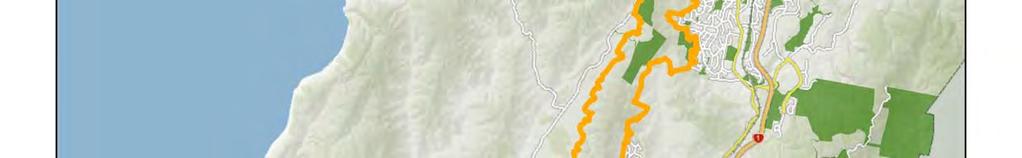
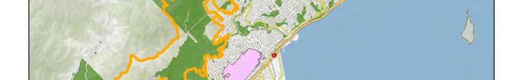
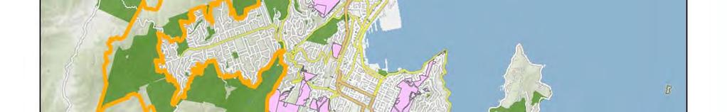
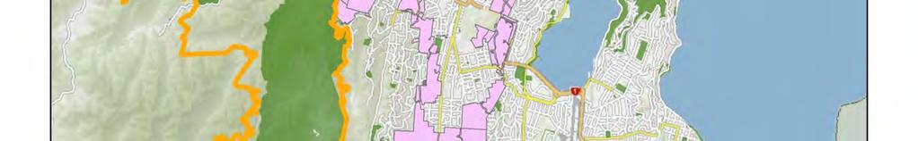
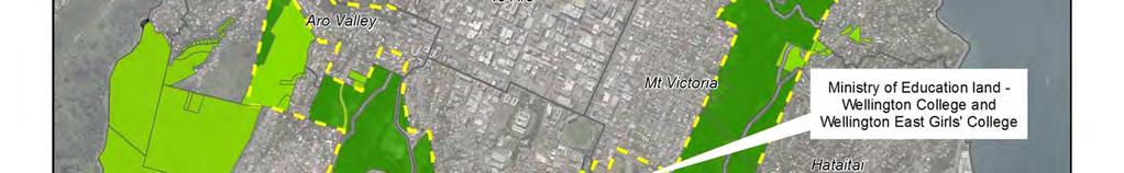
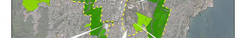
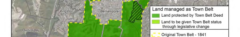
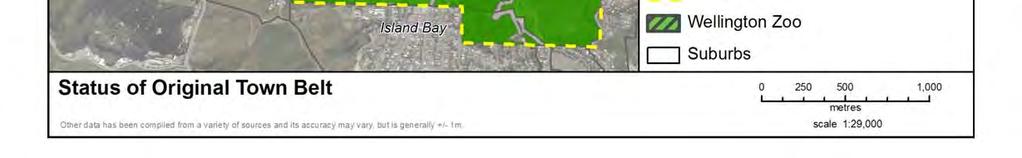
2 huge range of direct and indirect environmental, social, recreational and economic benefits to the city and its residents. The concept of a Town Belt has endured through the development of the city. The values associated with the Town Belt have however changed and continue to evolve as the value and potential values of open space in the urban environment is more widely debated and understood. 1.2 What is the Wellington Town Belt? 1 Before the arrival of European colonists, the Town Belt land was under the kaitiakitanga (guardianship) of the resident iwi/hapu. The earliest documented description and pictures of the Town Belt have the land covered in forest with the slopes of Mt Victoria/Tangi te keo covered in kanuka shrubland. The Māori history and traditions related to the places that now make up the Town Belt go back to the earliest arrival of Māori in Wellington. Two important components of the Town Belt are the key ridgelines in the east and west of central Wellington, known as Te Ranga a Hiwi or the ridge of Hiwi and the ridgeline of Ahumairangi. Hiwi was the son of the daughter of Tara, the eponymous ancestor of Ngāi Tara. Ngāi Tara were probably the first Māori to settle the area, constructing pā and developing gardens and using the forests to gather food. Before Ngāi Tara were others, more of the hunter-gatherer groups known by some as the kahui tipua, who moved around taking advantage of the natural resources of the region. The term original Town Belt refers to all of the land proclaimed as Town Belt in 1841 being 1544 acres (625 ha) that was set aside from land included in the Port Nicholson Deed of Purchase. Despite questions about the legality of purchase in 1841, Governor Hobson proclaimed the Town Belt a Crown reserve, labelled as land... reserved for the enjoyment of the public and not to be built upon (see map on page 5). The Crown (latterly through the Superintendent of the Province of Wellington) held the land from 1841 to The Wellington City Reserves Act 1871 instructed the Superintendent to convey the land upon such trusts and for such purposes of public utility to the City of Wellington and its inhabitants. The Superintendent executed a deed of trust now usually referred to as the Town Belt Deed. See Appendix 1. Other land forming the Basin Reserve was ultimately put into trust under a separate deed. The Canal Reserve, comprising the traffic islands between the Basin Reserve and Courtenay Place was included in (and is still part of) the Town Belt Deed. A total of 1061 acres (429 hectares) was finally conveyed to the Mayor, Councillors, and citizens of the City of Wellington on 20 March 1873 to be forever used as public recreation ground for the inhabitants of the City of Wellington. The Town Belt Deed set out how the Council was to manage the land and it remains the most important document for the Town Belt today. The Council holds the land in trust for the citizens of Wellington and is a similar concept to the public commons in England. A public commons means a place that has a public good that is free for people to view and enjoy and owned by everyone who wants to be a part of it. Since 1841, the growth of Wellington City has meant that over a third of the land originally designated for Town Belt has been taken for community purposes (see map on page 5). Significant portions of the Town Belt were lost for predominantly Crown uses. These included land for Wellington College, the Governor General's residence, Victoria University, Wellington Hospital, and various roads linking the inner city with the suburbs. 1 The name Wellington Town Belt has not been officially gazetted but is the accepted name for the land held under the Town Belt Deed (1873). Īn this plan the convention will be to use the full title for major headings but elsewhere it will be shortened to Town Belt. 2 Wellington Town Belt Management Plan June 2013
3 1.2.1 What makes the Wellington Town Belt distinct? The Town Belt s distinguishable features include its: perceived continuity and horseshoe shape of open space, comprising the first line of hills and undeveloped skylines encircling the central city geographic location and close visual relationship with the central city and inner suburbs patchwork and diversity of vegetation cover availability to be used for a wide range of sporting and recreation activities accessibility and provision of linkages to key community destinations rich historical and cultural links with Wellington citizens and mana whenua Role in open-space network The Wellington Town Belt forms an integral part of Wellington s open-space network comprising 4221 hectares. It is complemented by the Wellington Outer Green Belt established in the 1990s and 2000s and managed under the Outer Green Belt Management Plan (2004). The plan outlines the following vision: A continuous belt following the ridges to the west of the city from the South Coast to Colonial Knob, in which indigenous vegetation is restored and an informal recreation network is widely accessible. The map on the next page shows the Outer Green Belt and the Town Belt. 1.3 The Wellington Town Belt Management Plan The purpose of the Wellington Town Belt Management Plan is to provide Wellington City Council with a clear framework for making decisions and managing the Town Belt for at least the next 10 years. The plan provides a framework for addressing issues common to the Town Belt and managing them in a comprehensive and consistent way. Objectives and policies give guidance for the development, management, protection, operation and public use of the Town Belt. Specifically it will: ensure the Town Belt is managed and maintained in a consistent manner by providing common objectives and policies ensure protection and appropriate management for important natural, recreation, historical and cultural values on the Town Belt provide prioritised strategic management initiatives build on the policies and initiatives in the 1995 management plan (Appendix 6) Vision of the plan The Wellington Town Belt is a unique and historic horseshoe of open space around the inner city that brings nature into the city and provides current and future residents and visitors with a place to visit, recreate and enjoy. Wellington Town Belt Management Plan June


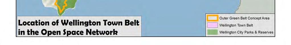
4 4 Wellington Town Belt Management Plan June 2013
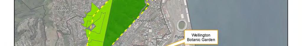
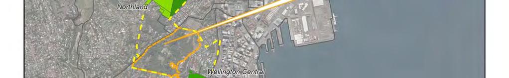
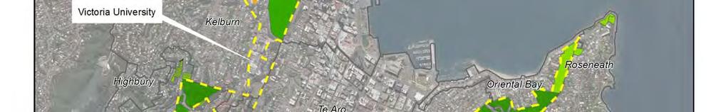

5 Wellington Town Belt Management Plan June

6 1.3.2 Structure of the plan Town Belt between the suburbs of Thorndon and Wilton. In 2011 the Council approved a set of guiding principles to guide and support the review of the 1995 management plan. This management plan identifies: the legal framework for the Town Belt the guiding principles the long-term vision for the Town Belt the natural and cultural features of the Town Belt and how these will be protected recreational role and activities on the Town Belt general management objectives and policies actions required to implement this plan. The guiding principles provide the wider community s values and aspirations for the Town Belt and provide a framework for decision making. They are fully described in section 2.2. The objectives and policies in this plan explain the intended methods for the protection, management, development, operation and public use of the Town Belt. Structure of the plan: In order to provide a framework to achieve connectivity and sustainability on the Town Belt, this plan is principally structured around key themes: Chapter 2 Town Belt legislative and policy framework Chapter 3 Partnership and community participation Chapter 4 Landscape Chapter 5 Ecology Chapter 6 Recreation Chapter 7 Culture and history Chapter 8 Management sectors Chapter 9 Rules for use and development While the plan is structured around themes, the Town Belt is divided into sectors for the purposes of implementation and ease of understanding for local communities (see Section 8). 6 Wellington Town Belt Management Plan June 2013
7 Each sector recognises the differences in topography, vegetation, uses and communities of interest inherent in the Town Belt. These sectors are: 1. Te Ahumairangi Hill 2. Kelburn Park 3. Aro Valley/Polhill Gully 4. Brooklyn Hills 5. Macalister Park 6. Golf Course/Mt Albert 7. Newtown/Crawford Road 8. Hataitai Park 9. Mt Victoria/Matairangi The general policies need to be read alongside the specific policies for each sector Coverage of the plan Objectives and policies in the plan will cover: hectares held in trust under the Town Belt Deed, and hectares of reserve land managed as Town Belt. 2 See map on page 5, and Appendix 2. Policies are not included for the Wellington Botanic Garden, the Wellington Zoo, the Canal Reserve or Wellington showgrounds (except the artificial turf behind Te Whaea). Wellington Botanic Garden: In 1844 land for a botanic garden (12 acres, 1 rood and 9 perches) was appropriated from the land set aside for Public Reserves (part of the Town Belt reserve vested in the Crown). In 1869 the Botanic Garden Act was passed and management of the garden was entrusted to a board under the auspices of the New Zealand Institute, the forerunner of the Royal Society of New Zealand. In 1891 the Wellington Botanic Garden Vesting Act dissolved the Botanic Garden Board and vested control in Wellington City Council. Wellington Botanic Garden is not covered by the provisions of the Town Belt Deed. The Botanic Garden is classified as Local Purpose Reserve (Botanic Garden) under the Reserves Act 1977 and managed under the Combined Management Plan (Wellington Botanic Garden, Anderson Park, Bolton Street Memorial Park (2002). Wellington Zoo: The Zoological Garden, established in 1906, sits on land managed in trust by the Council under the Town Belt Deed. It is an accepted historic use within the Town Belt. The zoo operation is now managed under the Wellington Zoo Trust Deed (2003). Canal Reserve: The Canal Reserve is still part of the Town Belt Deed but is not covered by this plan. Its future role is outlined in the Central City Framework developed as part of Wellington 2040 which outlines the development of a new linear park utilising this area and linking the Basin Reserve and Waitangi Park. Wellington showgrounds: In ha of land in Hutchinson Road was suspended from the Town Belt Deed by the Wellington City Exhibition Act. If this Act is repealed or the lease terminates, the showground land will automatically return to Town Belt management. 2 It is proposed that this land will be added to the Town Belt as part of legislative change. See policy Wellington Town Belt Management Plan June
8 Since 2010, the Council-managed area known as Te Whaea artificial sportsfield has been removed from the Premises Management Lease for the showgrounds. This area will be managed as part of the Town Belt. Road reserve that adjoins Town Belt land managed under this management plan will be managed in a consistent manner with the objectives and policies of this plan. Chest Hospital: The former Chest Hospital land (Chest Hospital) and buildings were transferred at no cost to the Council in December 2002 by the Capital & Coast District Health Board. The acquisition was consistent with the Town Belt Reinstatement Policy Key guiding policies and plans Council plans that give guidance in managing the Town Belt and/or in developing the policies in this plan are listed below. The chart below shows where this management plan fits with other Council plans and policies. Wellington City District Plan This is the Council s principal regulatory document setting out objectives and policies, methods and rules for managing the city environment, land uses and associated activities. The Wellington City District Plan is prepared in accordance with the Resource Management Act The Wellington Town Belt is identified as a separate open space area Open Space C (called Inner Town Belt) in the Wellington District Plan. The Inner Town Belt is valued for its historical, social and cultural importance. The District Plan s policies, objectives and rules will relate to the management plan. In particular the District Plan proposes to: Recognise the special status of the Inner Town Belt as public recreation land held in trust by the Council under the Town Belt Deed 1873 and identify that land on the District Plan maps Manage the impacts of activities in the Inner Town Belt in order to protect and preserve its special qualities for the benefit of future generations. In addition to policy guidance the District Plan has rules for Town Belt land. The rules allow the Council to exercise control on the type of building and activity that occurs, and this control is exercised by way of the resource consent process. The rules reflect the status of the Town Belt, but have not been reviewed since the District Plan became operative in A review of all Open Space rules (including the Town Belt/Open Space C rules) is currently programmed as a high priority review in the District Plan work programme. This will provide an opportunity to amend the policies and rules if it is determined they are no longer considered fit for purpose. 8 Wellington Town Belt Management Plan June 2013
9 Wellington Town Belt Management Plan June
10 . Wellington towards 2040: Smart Capital (2011) Wellington City Council s vision for Wellington is focused on the future development of the city over the next 30 years. It builds on Wellington s current strengths, acknowledges the challenges the city faces now and over the medium to long term, understands the changing role of cities, and is informed by Wellington s communities. The vision is supported by four community outcomes based on the city s competitive advantage. These are: eco-city; connected city; people-centred city and dynamic central city. These goals are central to the Council's Long Term Plan Central City Framework (2011) This is a spatial structure plan that provides overall context, direction for future planning, coordination, prioritisation and assessment of key city projects. The resulting central city open space strategy has 10 key elements, and there are two that specifically relate to the Town Belt: Big space links: There are large open areas that can play an improved role in the provision of open space in the city. Primarily these are the Town Belt and waterfront. Improving the links to these from the city area and providing additional amenities within these large open areas will enable increased use. Cross-valley links: The greening of city streets with urban forest across the valley will enhance urban ecology and reduce the hardness of the city-scape. This will also provide corridors across the valley to join the town belts and enhance accessibility. Our Capital Spaces Open Space and Recreation Framework 2013 (in draft) Our Capital Spaces is a plan for managing and protecting our parks, reserves, sport and recreation activities over the next 10 years. This plan replaces and updates both the Wellington City Council s Capital Spaces Strategy (1998) and Recreation Strategy (2003). There will be a range of initiatives that fall under the following outcomes: Getting everyone active and healthy Protecting our birds, nature, streams and landscapes Contributing to Wellington s outstanding quality of life Doing it together. Biodiversity Action Plan (2007) The Biodiversity Action Plan coordinates the Council s biodiversity activities and identifies local priorities and actions for biodiversity. Biodiversity activities include pest control, revegetation planting, and partnerships with other organisations and groups. The outcomes of the plan include: identifying the current state of Wellington s biodiversity and the areas/species that require the most protection protecting Wellington s indigenous biodiversity on public and private land motivating the community to become more involved in biodiversity conservation working closely with other organisations to ensure the conservation of Wellington s biodiversity restoring our indigenous biodiversity where possible and ensuring it is easily accessible for all Wellingtonians generating quality information through monitoring and research to enable us to conserve and manage our biodiversity into the future. 10 Wellington Town Belt Management Plan June 2013
11 Open Space Access Plan (2008) This plan sets out the Council s strategic vision for tracks in the city s parks, reserves and open spaces. The plan s vision is to strengthen and improve the open-space access network by: providing outstanding opportunities for recreation and tourism within the open spaces of Wellington ensuring tracks provide for a range of user interests, skills, abilities and fitness levels within each area achieving a quality primary network accessing major destination points in Wellington and adjoining districts, and linking with an equitable distribution of secondary and local track networks and recreational facilities. Outer Green Belt Management Plan (2004) The Outer Green Belt Management Plan ensures the protection of a coherent and essentially natural western ridgeline, and provides for public recreation. The long-term strategy is to provide public access from the south coast to Porirua City and Colonial Knob, and eventually north on the national Te Araroa Walkway. It has the following principles: Landscape and landform: To recognise and protect natural landscape and landform characteristics of the ridge system on the western side of the city. Indigenous ecosystems and important ecological features: To recognise and protect indigenous ecosystems and important ecological features, and in particular the streams and significant areas of indigenous vegetation from which a more continuous band of vegetation will grow. Recreational places and linkages: To identify and protect important existing or potential recreational sites and linkages (entrance points, tracks, routes and destinations). Cultural and historic places: To recognise and protect important cultural and historic places and features identified within the Outer Green Belt. Urban environment edge: To provide a western edge to the urban environment and a buffer of mainly open lands between the city s urban areas and the rural areas of Makara and Ohariu valleys. Continuity and integrity: To achieve continuity and integrity in the definition and management of the Outer Green Belt. Leases Policy for Community and Recreation Groups (2012) The Council provides leases of land and/or buildings at a subsidised rental to a wide range of community and recreation groups (groups). As Council-owned land and buildings are a limited resource, the Council needs to allocate this resource in a way that maximises the use of its assets and responds to changing demands. The Leases Policy for Community and Recreation Groups (policy) sets out the Council s role in leasing land and/or buildings to groups and provides guidance on: granting leases of land and/or buildings to community and recreation groups managing leases relating to the groups the standard to which land and/or buildings will be maintained to ensure appropriate asset management. The objectives of the policy are to: ensure maximum community benefit is derived from Council-owned land and buildings strengthen participation and engagement in community and recreational activities Wellington Town Belt Management Plan June
12 ensure leases are managed fairly, processes are transparent and Council staff have the flexibility to respond to community needs. The policy notes that the Wellington Town Belt Management Plan will be used by staff to ascertain what activity or structure can be permitted on Town Belt land. In the Council s capacity as administrator and trustee of Town Belt, it has the responsibility to ensure the land is managed in accordance with the Town Belt Deed and the Reserves Act The policy applies to all community and recreation groups that lease Council-owned land and/or buildings. Playground Policy (2002) This policy defines how the Council will provide playgrounds to the community in an equitable manner, recognising the needs of communities and suburbs and taking into account constraints of topography and funding. The objective of the Playgrounds Policy is therefore: The provision of a range of safe, enjoyable and stimulating playgrounds across the city in a way that best meets the needs of children, care-givers, communities and the city for access, safety, amenity and maintenance. Working towards this objective will establish an adequate provision of playgrounds in Wellington, as well as ensuring that excessive provision does not occur. Climate Change Action Plan (2010) This plan identifies cost-effective initiatives for Council operations and the community that will help the Council achieve its carbon neutral vision, and promote sustainable behaviour. The plan is divided into seven action areas: Actions of relevance to the Town Belt: Adaptation A1 A vulnerability assessment for the city to the impacts of climate change ($130k OPEX over two years). A2 Improve preparation for more frequent extreme weather events. A3 Enhance guidance for asset management on climate-change risks. A7 Investigate opportunities to green the roofs of Council and city facilities and promote tree planting. Forestry F2 F3 Investigate the impact of an enhanced pest-management programme in Council forests to increase carbon sequestration. Investigate opportunities to develop forest sinks with other councils to meet respective ETS obligations. Council operations C4 Develop a policy to manage carbon credits and obligations. C5 Investigate development tools that encourage energy efficiency, quality urban design and built environment. Many of the actions within the 2010 plan have being completed, or are continuing to be actioned. The plan is being reviewed during 2013 to reflect some of the changes to the ETS and government policy, and decisions taken within the Council, such as the Smart Energy Capital initiative. In addition the Council will be developing improved greenhouse gas inventories and projections to track our emissions over time and to ensure that we consider appropriate measures toward achieving our citywide and Council reduction targets. 12 Wellington Town Belt Management Plan June 2013
The management plan meets the requirements of the Reserves Act 1977.
 SUBURBAN RESERVES MANAGEMENT PLAN 2015 I 4 INTRODUCTION 1.1 PURPOSE OF THE PLAN Within any community, open space holds important landscape, recreational, social, ecological, amenity, and cultural or heritage
8.3 Sector 4 Brooklyn Hills
 8.3 Sector 4 Brooklyn Hills Wellington Town Belt on the Brooklyn Hills between Mt Cook and Brooklyn 8.4.1 Character and use This sector extends around the city-facing slopes below Brooklyn, from Mortimer
8.2 Sector 2 Kelburn Park
 8.2 Sector 2 Kelburn Park Kelburn Park, near Victoria University 8.2.1 Character and use Kelburn Park is a sector of the Town Belt, of a scale and character more like a suburban park. However, the woodland
8.8 Sector 8 Hataitai Park
 8.8 Sector 8 Hataitai Park The recreation hub at Hataitai Park Note Badminton Hall at the top of picture and Velodrome at bottom centre. 8.8.1 Character and use The sector occupies the east face of the
10.0 Open Space and Public Realm
 10.0 Open Space and Public Realm 10.0 Open Space and Public Realm The Public Open Space System is comprised of: outdoor spaces available for public use that are either publicly owned (e.g., parks and
Understanding Wellington City s DISTRICT PLAN
 Understanding Wellington City s DISTRICT PLAN Wellington City Council 1 UNDERTANDING WELLINGTON CITY S DISTRICT PLAN CONTENTS 1. Introduction...3 1.1. Overview of this Guide...3 1.2. What is the District
Khandallah, Broadmeadows, Ngaio, Crofton Downs and Kaiwharawhara
 3 Management sector plans 3.1 Sector 1 Khandallah, Broadmeadows, Ngaio, Crofton Downs and Kaiwharawhara A unique feature of this sector is the harbour escarpment and the steep gullies off Onslow Road and
North District What we heard
 What we heard Vision to 2056 and Priorities Governance and implementation Infrastructure and funding The vision for a metropolis of three cities, and the 30 minute city. Feedback emphasised: That for the
H7 Open Space zones. (a) provide for the needs of the wider community as well as the needs of the community in which they are located;
 provide for the needs of the wider community as well as the needs of the community in which they are located;") H7. Open Space zones H7.1. Background The majority of land zoned as open space is vested in the Council or is owned by the Crown. However some areas zoned open space are privately owned. While the open
H7. Open Space zones H7.1. Background The majority of land zoned as open space is vested in the Council or is owned by the Crown. However some areas zoned open space are privately owned. While the open
Wellington our sense of place BUILDING A FUTURE ON WHAT WE TREASURE
 Wellington our sense of place BUILDING A FUTURE ON WHAT WE TREASURE The Council s goal for Wellington is quality of life, growth and prosperity. In striving for this goal, we must ensure that we preserve
3 MANAGEMENT SECTOR PLANS
 SUBURBAN RESERVES MANAGEMENT PLAN 2015 I 37 3 MANAGEMENT SECTOR PLANS 3.1 SECTOR 1 Khandallah, Broadmeadows, Ngaio, Crofton Downs, Kaiwharawhara, Ngauranga Gorge A unique feature of this sector is the
Hobart A Strategic Framework
 Hobart 2025 A Strategic Framework Adopted by the Hobart City Council 15 October 2007 Table of Contents Introduction...2 Vision and Future Directions...3 FD1 Offers opportunities for all ages and a city
Appendix 1 Structure plan guidelines
 Appendix 1 Structure plan guidelines This appendix forms part of the regional policy statement [rps]. 1.1. Introduction Structure plans are an important method for establishing the pattern of land use
Central City District What we heard
 What we heard Vision to 2056 and Priorities Governance and implementation Infrastructure and funding The vision for a metropolis of three cities, and the 30 minute city. Feedback requested: Clearer communication
CITY CLERK. Parkland Acquisition Strategic Directions Report (All Wards)
") CITY CLERK Clause embodied in Report No. 10 of the, as adopted by the Council of the City of Toronto at its meeting held on November 6, 7 and 8, 2001. 10 Parkland Acquisition Strategic Directions Report
CITY CLERK Clause embodied in Report No. 10 of the, as adopted by the Council of the City of Toronto at its meeting held on November 6, 7 and 8, 2001. 10 Parkland Acquisition Strategic Directions Report
Parks Master Plan Implementation: Phase I Waterfront Use and Design REPORT #: September 7, 2016 File #
 0 'O DI Lan-171-14 1 - THE CORPORATION OF THE TOWN OF COBOURG..,. STAFF REPORT TO: FROM: Mayor and Members of Council Dean A. Hustwick, Director of Recreation and Culture DATE OF MEETING: Committee of
SUSTAINABLE MANAGEMENT
 . Sustainable Management.1 The Concept of Sustainable Management The concept of sustainable management recognises there are limits to the use of natural and physical resources and there is a need to balance
Western City District What we heard
 What we heard Vision to 2056 and Priorities Governance and implementation Infrastructure and funding The protection of the natural landscape including biodiversity and the Metropolitan Rural Area for food
Auckland City Council
 Auckland City Council Future planning framework version 3.0 9 September 2010 Find out more: Telephone (09) 379 2020 or visit www.aucklandcity.govt.nz www.itsmybackyard.co.nz Foreword Future planning framework
Group Executive Liveability and Natural Assets
 Strategic policy Community Gardens Policy Corporate Plan reference: Endorsed by Council on: Policy Owner: A healthy environment Maintaining and enhancing the region s natural assets, liveability and environmental
Arlington, Virginia is a worldclass
 EXECUTIVE S U M M A RY Arlington maintains a rich variety of stable neighborhoods, quality schools and enlightened land use policies, and received the Environmental Protection Agency s highest award for
WELLINGTON HOSPITAL DESIGN GUIDE TABLE OF CONTENTS
 WELLINGTON HOSPITAL DESIGN GUIDE TABLE OF CONTENTS 1.0 Introduction Page 2 The Place of Wellington Hospital 2 The Future of the Hospital 2 2.0 The Intention of the Design Guide 3 3.0 Analysis 4 General
Appendix A. Planning Processes. Introduction
 1 Planning Processes Introduction This appendix outlines a number of planning processes which are used in the Auckland Region to support the effective management of development in the region s rural and
Chapter 3: Natural Environment. Proposed Waikato District Plan Stage 1. (Notified version)
") Chapter 3: Natural Environment Proposed Waikato District Plan Stage 1 Page 2 of 7 Contents Chapter 3: Natural Environment... 3 3.1 Indigenous Vegetation and Habitats... 3 3.1.1 Objective Biodiversity and
Chapter 3: Natural Environment Proposed Waikato District Plan Stage 1 Page 2 of 7 Contents Chapter 3: Natural Environment... 3 3.1 Indigenous Vegetation and Habitats... 3 3.1.1 Objective Biodiversity and
Types of Reserves. Recreational activities
 VALLEY FLOOR AND EASTERN HILLS Physical and ecological features Large, flat valley floor and river plain with intensive urban development Hutt River / Te Awa Kairangi and tributaries Waiwhetu Stream Eastern
SHORELINE, FLOOD AND COASTAL DEFENCE MANAGEMENT PLANS
 These plans may provide opportunities as well as concern for recreational boating. They are currently being revised and consulted on. This document explains how we can engage in the process. Shoreline,
Published in March 2005 by the. Ministry for the Environment. PO Box , Wellington, New Zealand ISBN: X.
 Action Pack Published in March 2005 by the Ministry for the Environment Manatū Mō Te Taiao PO Box 10-362, Wellington, New Zealand ISBN: 0-478-18994-X ME number: 580 This document is available on the Ministry
DRAFT GREATER SYDNEY REGION PLAN OBJECTIVES, STRATEGIES AND ACTIONS
 Greater Sydney Commission DRAFT GREATER SYDNEY REGION PLAN OBJECTIVES, STRATEGIES AND ACTIONS Issued: 26 OCTOBER 2017 Version: 1 Subject: Greater Sydney Region and District Plans This information note
VCA Guidance Note. Contents
 Contents 1. Introduction... 2 2. Who can register a VCA?... 2 3. VCAs and sustainable development... 3 4. Verifying conservation performance... 4 4.1 Transparent, voluntary commitments... 4 4.2 Independent
QUEENSTOWN LAKES DISTRICT COUNCIL SUBDIVISION DESIGN GUIDELINES
 Attachment C: Draft QLDC Subdivision Design Guidelines QUEENSTOWN LAKES DISTRICT COUNCIL DESIGN GUIDELINES A DESIGN GUIDE FOR AND DEVELOPMENT IN THE URBAN ZONES QUEENSTOWN OFFICE 10 Gorge Road Queenstown
A REGIONAL HERITAGE STRATEGIC PLAN for OKANAGAN - SIMILKAMEEN
 A REGIONAL HERITAGE STRATEGIC PLAN for OKANAGAN - SIMILKAMEEN The Regional District of Okanagan-Similkameen is preparing a Regional Heritage Strategic Plan. The Strategic Plan will identify important themes
REVISED DRAFT NORTH DISTRICT PLAN PLANNING PRIORITIES AND ACTIONS
 Greater Sydney Commission REVISED DRAFT NORTH DISTRICT PLAN PLANNING PRIORITIES AND ACTIONS Issued: 26 OCTOBER 2017 Version: 1 Subject: Greater Sydney Region and District Plans This information note is
Tāhuhu whakaruruhau ā-taone The sheltering ridge pole
 B2. Tāhuhu whakaruruhau ā-taone - Urban growth and form B2.1. Issues Tāhuhu whakaruruhau ā-taone The sheltering ridge pole Auckland s growing population increases demand for housing, employment, business,
Cotswolds AONB Landscape Strategy and Guidelines. June 2016
 Cotswolds AONB Landscape Strategy and Guidelines June 2016 Cotswolds AONB Landscape Strategy and Guidelines Introduction The evolution of the landscape of the Cotswolds AONB is a result of the interaction
DRAFT WESTERN CITY DISTRICT PLAN PLANNING PRIORITIES AND ACTIONS
 Greater Sydney Commission DRAFT WESTERN CITY DISTRICT PLAN PLANNING PRIORITIES AND ACTIONS Issued: 26 OCTOBER 2017 Version: 1 Subject: Greater Sydney Region and District Plans This information note is
Port Lavaca Future Land Use
 Port Lavaca Future Land Use Introduction The City of Port Lavaca is beginning to see sustained growth, after many years of relative stable population. New single family homes, apartments, and businesses
Section 6A 6A Purpose of the Natural Features and Landscapes Provisions
 Section 6A 6A Purpose of the Natural Features and Landscapes Provisions This Chapter addresses the protection and management of natural features and landscapes within the City. The City has a number of
Taking forward the All London Green Grid
 Taking forward the All London Green Grid Foreword Earlier this year, the Mayor published the All London Green Grid Supplementary Planning Guidance to the London Plan which set the vision, and framework,
CITY VIEW OBJECTIVES
 SECTION 2: CITY VIEW OBJECTIVES CONTENTS 2.1 Introduction 1 2.2 Strategic Direction 1 2.3 The City View Resource Management Issues for the City 1 2.4 The Goal 3 2.5 The City View Objectives 3 Palmerston
PUBLIC REALM STRATEGY
 CONSULTATION DRAFT PUBLIC REALM STRATEGY Trenchard Street & Frogmore Street City Design Group Place Directorate Public Realm Strategy Trenchard Street & Frogmore Street Contents 1. Introduction 2. Understanding
Scottish Natural Heritage. Better places for people and nature
 Scottish Natural Heritage Better places for people and nature Contents Summary... 3 SNH approach... 5 Place-making in policy and practice... 6 Developing the contribution of the natural heritage to place-making...
WINCHESTER TOWN 3.1 LOCATION, CHARACTERISTICS & SETTING
 WINCHESTER TOWN 3.1 LOCATION, CHARACTERISTICS & SETTING 3.1.1 The area referred to by the City Council, as Winchester Town, consists of the Winchester Wards plus the adjoining built up areas of Badger
Tasks and content (under the former Planning Act)
") DENMARK: fact sheet for planning levels REGIONAL, B Danish Town Planning Institute, draft of 19.03.2007 Planning level Type of plan Illustration of the planning level Overview of the plan Facts Facts Legal
DENMARK: fact sheet for planning levels REGIONAL, B Danish Town Planning Institute, draft of 19.03.2007 Planning level Type of plan Illustration of the planning level Overview of the plan Facts Facts Legal
Section 3b: Objectives and Policies Rural Environment Updated 19 November 2010
 Page 1 of Section 3b 3b RURAL ENVIRONMENT 3b.1 Introduction The Rural Environment comprises all the land outside of the Residential, Town Centre and Industrial Environments. Most land within the District
Welcome. /The Design Companion 4. /Planning London 7. /Getting Homes Built 8. /Transport & Streets 10. /Tech & The City 12
 Welcome With the draft publication of the London Plan and the Mayor s Transport Strategy (MTS) this year s events programme will examine both documents in detail with a wide range of seminars, debates
Wetland Design Manual. A1: Vision, core outcomes and aspirational outcomes
 Wetland Design Manual A1: Vision, core outcomes and aspirational outcomes Table of contents Introduction 5 Vision 6 Core outcomes 7 Effective pollutant removal and flow management... 7 Community safety...
Appendix H: Easement cross sections
 Appendix H: Easement cross sections SHARED PATH 1.5m FOOTPATH NATURE STRIP 7.3m CARRIAGEWAY 2.7m NATURE STRIP EXISTING PIPELINE 150mm DIA 5.0m (approx.) LOCAL ACCESS ROAD EXISTING PIPELINE 500mm DIA 2.7m
Green Infrastructure, Natural England and the NW. Martin Moss, Green Infrastructure Delivery Leader, NW Regional Advocacy and Partnerships Team.
 Green Infrastructure, Natural England and the NW. Martin Moss, Green Infrastructure Delivery Leader, NW Regional Advocacy and Partnerships Team. Structure. GI and Natural England. Technical development
1.0 PLANNING MARKHAM S FUTURE CONTENTS
 1-1 Planning Markham s Future 1.0 PLANNING MARKHAM S FUTURE CONTENTS 1.1 THE PURPOSE OF THE OFFICIAL PLAN 1.2 THE MARKHAM CONTEXT 1.3 THE REGULATORY CONTEXT 1.3.1 Province of Ontario 1.3.2 York Region
TOPIC PAPER 2: Links to other sustainability tools
 TOPIC PAPER 2: INTRODUCTION 1.1 Landscape Character Assessment can inform a range of other sustainability tools and methodologies. Equally these other tools may assist in reaching decisions concerning
Neighbourhood Planning Local Green Spaces
 Neighbourhood Planning Local Green Spaces Introduction... 2 1. Why green space is important... 4 2. Neighbourhood plans and green space... 6 3. Evidence... 8 Statutory designations... 9 Green space audit...
GREEN NETWORK APPLICATIONS IN ESTONIA
 GREEN NETWORK APPLICATIONS IN ESTONIA Kalev Sepp, Tuuli Veersalu, Martk Külvik Estonian University of Life Sciences 1 WHY? BACKGROUND - POLITICAL By adopting the Pan-European Biological and Landscape Diversity
EXECUTIVE SUMMARY DRAFT CHAPTER 1 INTRODUCTION EXECUTIVE SUMMARY
 CHAPTER 1 EXECUTIVE SUMMARY INTRODUCTION Through the joint efforts of the City of Tulsa planning staff and the Land Services division of Indian Nations Council of Governments (INCOG), the Berryhill Land
Plan Modification to Chapter B2 of the Auckland Unitary Plan(AUP) Operative in part (15 November 2016)
 Operative in part (15 November 2016)") UNITARY PLAN UPDATE REQUEST MEMORANDUM TO FROM Phill Reid Linley Wilkinson DATE 25 September 2018 SUBJECT Plan Modification to Chapter B2 of the Auckland Unitary Plan(AUP) Operative in part (15 November
UNITARY PLAN UPDATE REQUEST MEMORANDUM TO FROM Phill Reid Linley Wilkinson DATE 25 September 2018 SUBJECT Plan Modification to Chapter B2 of the Auckland Unitary Plan(AUP) Operative in part (15 November
STRATEGIC DIRECTION. QLDC PROPOSED DISTRICT PLAN [PART TWO] DECISIONS VERSION 3 strategic direction
![STRATEGIC DIRECTION. QLDC PROPOSED DISTRICT PLAN [PART TWO] DECISIONS VERSION 3 strategic direction](/thumbs/79/79711764.jpg "STRATEGIC DIRECTION. QLDC PROPOSED DISTRICT PLAN [PART TWO] DECISIONS VERSION 3 strategic direction") 3 STRATEGIC DIRECTION QLDC PROPOSED DISTRICT PLAN [PART TWO] DECISIONS VERSION 3 strategic direction QLDC DISTRICT PLAN [PART TWO] AUGUST 2015 3 strategic direction 3.1 Purpose This chapter sets out the
3 STRATEGIC DIRECTION QLDC PROPOSED DISTRICT PLAN [PART TWO] DECISIONS VERSION 3 strategic direction QLDC DISTRICT PLAN [PART TWO] AUGUST 2015 3 strategic direction 3.1 Purpose This chapter sets out the
1 Introduction. Chapter. In this chapter:
 Chapter 1 Introduction In this chapter: 1.1 A Snapshot of the Region 1.2 Towards a Sustainable Region 1.3 The Provincial Context 1.4 Purpose and Organization The Regional Municipality of York Official
SECTION ONE: INTRODUCTION. introduction
 introduction 1 INTRODUCTION Since it was first established in 1843 as a trading post for the Hudson s Bay Company, Victoria has evolved into a Provincial capital city that is recognized across Canada and
Design Guidance. Introduction, Approach and Design Principles. Mauritius. November Ministry of Housing and Lands. .. a
 sig evelo r D Mauritius s. Utilities.. Individu a s. er itects.to ls chpers.po e Public. T. h rban D Sc U e me Promot e h ners. A Design Guidance o.h Planne rs n w iticians r l useholde National Development
1. MAKING CHOICES. What kind of city will Toronto be in the 21st century?
 1. MAKING CHOICES Toronto is a great city! It has evolved into a special place that people care about deeply. It is a wonderful city in which to live, offering a diversity and richness of urban life that
2.0 Strategic Context 4
 2.0 Strategic Context 4 2.1 The Area Action Plan is a non-statutory plan, which forms a corporate policy document, expressing particular issues and areas of concern while also providing a vision for the
Managing our Landscapes Conversations for Change
 Managing our Landscapes Conversations for Change Frequently Asked Questions The new State Government is committed to a significant reform program that will change the way natural resources are managed.
PRESENTATION ON JOHANNESBURG S BIODIVERSITY PROGRAMME
 PRESENTATION ON JOHANNESBURG S BIODIVERSITY PROGRAMME Member of Mayoral Committee: Cllr Prema Naidoo Environmental Management & Johannesburg City Parks PRESENTATION OVERVIEW Jo burg Overview & Context
LANDSCAPE GUIDELINES. Countryside & Coastal Countryside Environments. Landscape, Natural Character & Amenity Values Guide
 Landscape, Natural Character & Amenity Values Guide Copyright WDC 2009 Version A2 18May09 Environmental Services Group Publication Countryside & Coastal Countryside Environments START HERE Quality Land
Public Space. Design Policy
 Public Space Design Policy December 00 Contents Purpose of this policy Introduction... Purpose of this policy... Objectives and policies... Objective... To enhance Wellington s sense of place This Public
B4. Te tiaki taonga tuku iho - Natural heritage
 B4. Te tiaki taonga tuku iho - Natural heritage Tuia I runga, tuia i raro, tuia ki te waonui a Tiriwa Bind the life forces of heaven and earth to the great realm of Tiriwa B4.1. Issues Auckland s distinctive
Response to the London Bridge Area Vision and Site Allocations within the New Southwark Plan
 1 Melior Place London SE1 3SZ 020 7407 4701 teamlondonbridge.co.uk info@teamlondonbridge.co.uk 28 April 2017 Response to the London Bridge Area Vision and Site Allocations within the New Southwark Plan
AT A GLANCE... Our People, Culture & Place. A plan to sustain Ballarat s heritage (final draft)
") AT A GLANCE... Our People, Culture & Place A plan to sustain Ballarat s heritage 2017-2030 (final draft) Image: Lydiard Street, Ballarat, c1875-1938, John Henry Harvey collection, La Trobe Picture Collection,
AT A GLANCE... Our People, Culture & Place A plan to sustain Ballarat s heritage 2017-2030 (final draft) Image: Lydiard Street, Ballarat, c1875-1938, John Henry Harvey collection, La Trobe Picture Collection,
Eastern City District Plan
 OUR GREATER SYDNEY 2056 Revised Draft Eastern City District Plan OVERVIEW Bayside Burwood Canada Bay City of Sydney Inner West Randwick Strathfield Waverley Woollahra Snapshot of the Eastern City District
LANDSCAPE CHARACTER ASSESSMENT
 THE COUNTY DURHAM LANDSCAPE CHARACTER ASSESSMENT FOREWORD The landscape of County Durham is one of great contrast and diversity. From the North Pennines in the west to the Durham Coast in the east it contains
LANDSCAPES FOR EVERYONE: CREATING A BETTER FUTURE. A shared vision of why we must treasure our landscapes and how Government can help
 LANDSCAPES FOR EVERYONE: CREATING A BETTER FUTURE A shared vision of why we must treasure our landscapes and how Government can help BRITAIN S DIVERSE LANDSCAPES NEED CHAMPIONS A consortium of national
ROCHFORD LOCAL DEVELOPMENT FRAMEWORK: Sustainability Appraisal/ Strategic Environmental Assessment. Rochford Core Strategy Preferred Options Document
 ROCHFORD LOCAL DEVELOPMENT FRAMEWORK: Sustainability Appraisal/ Strategic Environmental Assessment Non Technical Summary Rochford Core Strategy Preferred Options Document October 2008 SUSTAINABILITY APPRAISAL
Northern Territory Compact Urban Growth Policy
 Northern Territory Compact Urban Growth Policy A Reference Policy Document to clause 2.7 (Reference to Policy) of the NT Planning Scheme May 2015 Table of Contents 1 Policy Setting... 3 1.1 Context for
FOREST SERVICE MANUAL NATIONAL HEADQUARTERS (WO) WASHINGTON, DC
 WASHINGTON, DC") Page 1 of 11 FOREST SERVICE MANUAL NATIONAL HEADQUARTERS (WO) WASHINGTON, DC FSM 2300 RECREATION, WILDERNESS, AND RELATED RESOURCE MANAGEMENT Amendment No.: 2300-2011-2 Effective Date: October 19, 2011
Page 1 of 11 FOREST SERVICE MANUAL NATIONAL HEADQUARTERS (WO) WASHINGTON, DC FSM 2300 RECREATION, WILDERNESS, AND RELATED RESOURCE MANAGEMENT Amendment No.: 2300-2011-2 Effective Date: October 19, 2011
Objectives and Strategies for the Integration of Recreation, Parks and Open Space in Regional Plans
 BULLETIN 2 Objectives and Strategies for the Integration of Recreation, Parks and Open Space in Regional Plans TABLE OF CONTENTS Introduction 3 Land-use Framework Outcomes 1 4-8 Land-use Framework Outcomes
PUBLIC NOTICE UNDER CLAUSE 5 OF SCHEDULE 1 OF THE RESOURCE MANAGEMENT ACT 1991 PLAN CHANGE 12 TO THE OPERATIVE CITY OF NAPIER DISTRICT PLAN
 PUBLIC NOTICE UNDER CLAUSE 5 OF SCHEDULE 1 OF THE RESOURCE MANAGEMENT ACT 1991 PLAN CHANGE 12 TO THE OPERATIVE CITY OF NAPIER DISTRICT PLAN Public notice is given in accordance with Clause 5 of Schedule
This page intentionally blank.
 This page intentionally blank. Parks, Recreation, and Open Space Chapter Relationship to Vision Vision Parks, Recreation and Open Space Chapter Concepts County Government. County government that is accountable
PARKS AND RECREATION
 PARKS AND RECREATION WHAT YOU WILL FIND IN THIS CHAPTER: Background information on the development of the Park, Recreation, and System Plan (PRSP). General overview of Ellensburg s parks and recreation
DLR Open Space Strategy. Final Draft Report April 2010
 I DLR Open Space Strategy Final Draft Report April 2010 Urban parks and green spaces are an essential part of the urban heritage and infrastructure, being a strong element in the architectural and landscape
THE AOTEAROA-NEW ZEALAND LANDSCAPE CHARTER
 THE AOTEAROA-NEW ZEALAND LANDSCAPE CHARTER NEW ZEALAND INSTITUTE OF LANDSCAPE ARCHITECTS Draft for review and discussion by NZILA members: March 2009 Updated version for NZILA Exec: November 2009 Updated
partnership document GREAT PLACES SCHEME
 partnership document GREAT PLACES SCHEME 2016 Route 66 Connecting Cumbria along the east/west axis While we know of stunning scenery, Cumbria is also a place that reflects some of the most pressing contemporary
Outline of Presentation
 LUSAKA CITY COUNCIL 2 nd Annual IGC Cities Conference Making Cities work for growth London School of Economics (LSE) United Kingdom. 28 th 29 th January 2016 Presenter: Alex Mwansa Town Clerk Lusaka City
Comprehensive Plan ADOPTED APRIL 2014
 Comprehensive Plan ADOPTED APRIL 2014 8 8. Outstanding Recreational & Cultural Opportunities We are proud of our community s parks and recreation system. Our community will ensure that the legacy of our
Executive Summary and Introduction
 Section I Executive Summary and Introduction Introduction Purpose and Implementation Vision Themes and Strategies Description of Plan Methodology and Approach History of Comprehensive Planning Page 1 of
Better Urban Planning Wananga for Maori Practitioners working in the Built Environment: Te Noho Kotahitanga Marae Tamaki Makaurau, 17 June 2016
 Better Urban Planning Wananga for Maori Practitioners working in the Built Environment: Te Noho Kotahitanga Marae Tamaki Makaurau, 17 June 2016 Comments from Hirini Matunga via Papa Pounamu, NZPI 16 June
Yorkshire Sculpture Park Historic Landscape Management Plan. Volume I. July 2010
 Yorkshire Sculpture Park Historic Landscape Management Plan Volume I July 2010 T: 01904 691630 www.landscapeagency.co.uk enquiries@landscapeagency.co.uk Contents 3 Volume I Historic Landscape Management
building with nature - a new benchmark for green infrastructure
 building with nature - a new benchmark for green infrastructure Danielle Sinnett, Gemma Jerome, Sarah Burgess, Nick Smith and Roger Mortlock outline the aims, development and proposed operation of Building
OUR GREATER SYDNEY A metropolis of three cities. OVERVIEW. connecting people. DRAFT Greater Sydney Region Plan
 OUR GREATER SYDNEY 2056. A metropolis of three cities. OVERVIEW. connecting people. DRAFT Greater Sydney Region Plan October 2017 This document is an overview of the draft Greater Sydney Region Plan. To
OPEN SPACE AND RECREATION
 OPEN SPACE AND RECREATION The Town celebrates and maintains the spectacular visual character of our Sonoran Desert setting and we value our open space, mountain views, washes, vegetation, and wildlife.
Policy and Resources Committee 10 th October Green Infrastructure Supplementary Planning Document (SPD) Summary. Title
 Summary. Title") Policy and Resources Committee 10 th October 2017 Title Report of Wards Status Urgent Key Enclosures Officer Contact Details Green Infrastructure Supplementary Planning Document (SPD) Deputy Chief Executive
Policy and Resources Committee 10 th October 2017 Title Report of Wards Status Urgent Key Enclosures Officer Contact Details Green Infrastructure Supplementary Planning Document (SPD) Deputy Chief Executive
Call for Proposals. Heritage, natural capital and ecosystem services: case studies. Project No: Date of Issue: Tuesday 14 th November 2017
 Call for Proposals Heritage, natural capital and ecosystem services: case studies Project No: 7705 Date of Issue: Tuesday 14 th November 2017 Summary Historic England is seeking expressions of interest
Open Space Strategy 2011
 our place our future Sunshine Coast Open Space Strategy 2011 Sunshine Coast Open Space Strategy 2011 1 Sunshine Coast Regional Council 2011. www.sunshinecoast.qld.gov.au mail@sunshinecoast.qld.gov.au T
The European Landscape Convention And National Landscape Strategy. Tony Williams Irish Landscape Institute
 The European Landscape Convention And National Landscape Strategy As a reflection of European identity and diversity, the landscape is our living natural and cultural heritage, be it ordinary or outstanding,
OPEN SPACE CHAPTER 7: OVERVIEW. Preserve open space to protect natural resources, enhance character and provide passive recreation opportunities
 CHAPTER 7: OPEN SPACE OVERVIEW Ridgefield has made tremendous progress permanently preserving areas of town as open space. Open space preservation can serve many important purposes, including: protect
A Unified Auckland The challenge of developing transport based Design Standards for the Auckland Region
 A Unified Auckland The challenge of developing transport based Design Standards for the Auckland Region Chris Beasley Principle Technical Specialist, PMO Section 1 Recap on formation of Auckland Transport
building activity into new devevelopment
 active design case study essex design guide: building activity into new devevelopment active design principles in action: 1. ACTIVITY FOR ALL 2. WALKABLE COMMUNITIES 3. CONNECTED WALKING & CYCLING ROUTES
6 Landsc apes and rur al char ac
 LANDSCAPES AND RURAL CHARACTER QLDC PROPOSED DISTRICT PLAN [PART TWO] DECISION VERSION ter 6 Landsc apes and rur al char ac 6.1 Purpose Appendix C QLDC DISTRICT PLAN [PART TWO] DECISION VERSION 6 Landsc
Wireless Hill Vision 2020
 Wireless Hill Vision 2020 Key Themes and Objectives for the Future of Wireless Hill Revision: Draft Issue Date: 23/04/2009 Document No: Wireless Hill Vision 2020 Page 1 4/30/2009 Table of Contents 1 Overview...
elbridge Core Strategy
 C elbridge Core Strategy Celbridge is designated as a Moderate Growth Town in the RPGs. The County Development Plan reinforces this designation in its settlement strategy. Moderate Growth Towns within
Issue 1 Protection of the special environmental qualities of the Hanmer Basin.
 Environments of special concern Issue 19 Hanmer Basin The Hanmer Basin is a special area, being a popular retirement and holiday destination as well as having considerable environmental and conservation
Draft South West District Plan - Campbelltown City Council Submission Attachment 1
 Draft South West District Plan - Campbelltown City Council Submission Attachment 1 Campbelltown City Council Report and Resolution - Draft South West District Plan - Draft Submission Ordinary Meeting 28/03/17