City of Surrey PLANNING & DEVELOPMENT REPORT File:
|
|
|
- Bennett Davidson
- 5 years ago
- Views:
Transcription
 General Development Permit to permit the development of a new Sustainable Energy and")

1 City of Surrey PLANNING & DEVELOPMENT REPORT File: Planning Report Date: July 11, 2016 PROPOSAL: Rezoning from RF and a portion from C-8 to CD (based upon C-35) General Development Permit to permit the development of a new Sustainable Energy and Environmental Engineering building for Simon Fraser University. LOCATION: OWNERS: 13408, and Avenue, portion of A Avenue, University Drive and portion of lane Simon Fraser University and City of Surrey ZONING: RF and C-8 OCP DESIGNATION: Central Business District
2 Staff Report to Council File: Planning & Development Report Page 2 RECOMMENDATION SUMMARY By-law Introduction and set date for Public Hearing for Rezoning. Approval to draft General Development Permit. DEVIATION FROM PLANS, POLICIES OR REGULATIONS None. RATIONALE OF RECOMMENDATION Complies with the Central Business District OCP designation. The proposed density and building form are appropriate for this part of City Centre. The proposed development of a 5-storey academic building for Simon Fraser University (SFU) will strengthen the Academic Precinct in Surrey City Centre. The proposed building intended for Sustainable Energy and Environmental Engineering supports key initiatives in the City s Smart City Strategy, which encourage Clean Technology and Sustainable Energy. The proposed expansion for SFU supports the City in furthering its consideration as one of the world s Intelligent Communities. A General Development Permit is proceeding concurrently with the proposed rezoning. Once funding is confirmed, SFU intends to submit a Detailed Development Permit application.
3 Staff Report to Council File: Planning & Development Report Page 3 RECOMMENDATION The Planning & Development Department recommends that: 1. a By-law be introduced to rezone the subject site from "Single Family Residential Zone (RF) and Community Commercial Zone (C-8) to "Comprehensive Development Zone (CD)" and a date be set for Public Hearing. 2. Council authorize staff to draft general Development Permit No generally in accordance with the attached drawings (Appendix II). 3. Council instruct staff to resolve the following issues prior to final adoption: (a) (b) (c) (d) (e) (f) (g) (h) (i) ensure that all engineering requirements and issues including restrictive covenants, dedications, and rights-of-way where necessary, are addressed to the satisfaction of the General Manager, Engineering; submission of a subdivision layout to the satisfaction of the Approving Officer; resolution of all urban design issues to the satisfaction of the Planning and Development Department; demolition of existing structures to the satisfaction of the Planning and Development Department; completion of the partial lane closure south of the four northernmost subject lots; registration of a Section 219 Restrictive Covenant to adequately address the City s needs with respect to public art, to the satisfaction of the General Manager Parks, Recreation and Culture; the applicant satisfy the deficiency in tree replacement on the site, to the satisfaction of the Planning and Development Department; the applicant to work with the owner to the immediate north (at Avenue and University Drive) to secure a reciprocal access and parking easement; and the applicant address the shortfall of parking spaces to the satisfaction of the General Manager, Engineering. REFERRALS Engineering: The Engineering Department has no objection to the project subject to the completion of Engineering servicing requirements, as outlined in Appendix III.
4 Staff Report to Council File: Planning & Development Report Page 4 Parks, Recreation & Culture: No concerns. Surrey Fire Department: The Fire Department has no concerns regarding the proposed development. SITE CHARACTERISTICS Existing Land Use: The subject site is currently being used for public parking managed by the City. Adjacent Area: Direction Existing Use OCP Designation Existing Zone North: East (Across University Drive): The Prime mixed-use highrise development currently under construction, approved under Application No North Surrey Recreation Centre, rinks and Central Surrey bus exchange. Existing public Central Business District Central Business District South (Across 102A Avenue): Central Business parking lot. District West: Duplexes. Central Business District CD By-law No CD By-law No , amended by By-law No C-8 RM-D DEVELOPMENT CONSIDERATIONS Four of the five subject properties are owned by the City, addressed as 13408, and Avenue and University Drive, with the fifth property owned by Simon Fraser University (SFU), addressed as A Avenue. The four City-owned properties and the portion of lane are to be sold by the City to SFU. The four City-owned properties are zoned Single Family Residential Zone (RF) and the SFU-owned property is zoned Community Commercial Zone (C-8). The majority of the subject site is designated Mixed Use 5.5, with a small portion south of the new 102A Avenue alignment, designated Mid to High Rise 3.5 FAR in the City Centre Plan. The entire subject site is designated Central Business District in the Official Community Plan (OCP).
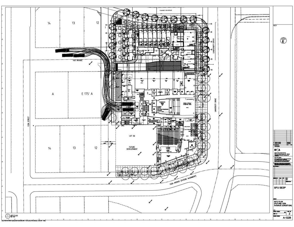
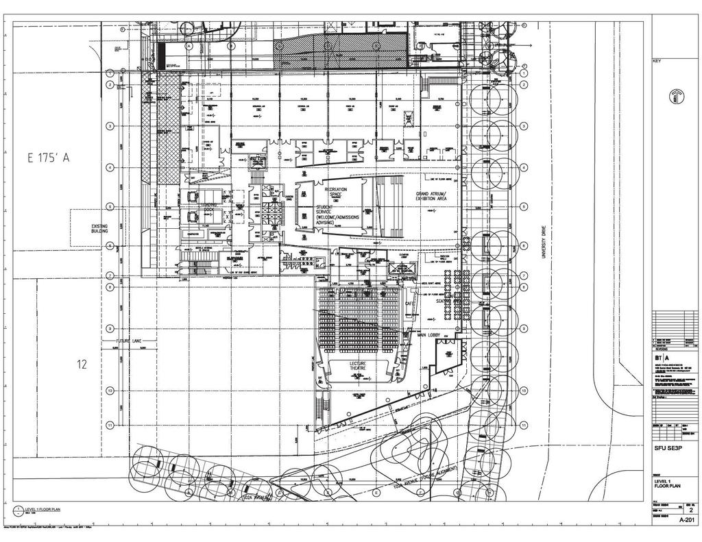
5 Staff Report to Council File: Planning & Development Report Page 5 SFU has submitted a development application which includes a rezoning from RF and C-8 to Comprehensive Development (CD), a General Development Permit and consolidation to allow for the development of a new 5-storey building for Sustainable Energy and Environmental Engineering. The building will house a 400-seat lecture hall, labs, office space, student recreation space and a café, totaling approximately 16,066 square metres (172,933 sq. ft.) of building floor area. The proposed density based upon the net site area is 3.6 floor area ratio (FAR) and 2.8 FAR based upon the gross site area. SFU has applied for the federal government s new Post-secondary Institutions Strategic Investment Fund (SIF), which will provide $2 billion over three years to support excellence in research, innovation and environmental sustainability at campuses across Canada. The SIF will cover up to 50 percent of the project s eligible costs, with the remaining funding to be matched by the provincial government. To comply with eligibility requirements, the building must be substantially completed by the end of April, To be eligible for SIF, the project should comply with one of the three categories below: o o o Improve the scale or quality of facilities for research and innovation, including commercialization spaces used by industry; Improve the scale or quality of facilities for specialized training at colleges focused on industry needs; and/or Improve the environmental sustainability of research and innovation related infrastructure at post-secondary institutions and college training infrastructure. The subject proposal complies with the 3 rd category. To this end, SFU is moving forward with a Rezoning and General Development Permit at this stage. The detailed design of the building will be submitted as part of a detailed Development Permit application after the Rezoning By-law has received Third Reading or possibly Final Adoption. The detailed design of the building will then be subject to review by the Advisory Design Panel (ADP). Road Network The subject site fronts 102A Avenue, which is to be realigned through the subject application. The realigned 102A Avenue aligns with the existing bus exchange on the east side of University Drive and will ultimately connect to King George Boulevard through redevelopment along City Parkway and King George Boulevard. The new 102A Avenue will support the future on-street transit operation, to replace the existing bus exchange. A new north-south green lane will continue along the west edge of the subject site, a continuation of the dedication provided through the Prime development at the north. This new lane will facilitate improved vehicular and pedestrian connections through this area. A portion of the existing east-west lane will remain open for the time being, until the lots further west are assembled and redeveloped. The existing duplex lot at 13407/ A Avenue will continue to have access to this lane at the northwest corner of the property.
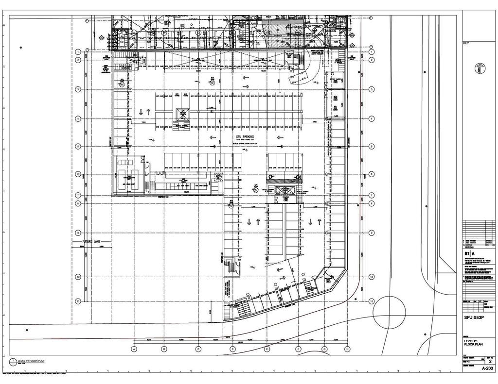
6 Staff Report to Council File: Planning & Development Report Page 6 Vehicular Access Vehicular access to the proposed development will be through a shared parking ramp situated on the mixed-use multiple residential and commercial development to the north, called Prime, approved under Application No At the time the Prime development application was reviewed, there was already discussion about allowing for a knock out wall in Prime s parkade level 1, which would connect to the redeveloped City-owned properties to the south. However, even though the design may accommodate the punch out wall, there was no formal legal document secured to ensure this was to happen, as at the time, the City did not have any immediate plans for redevelopment. The owner of the Prime has provided preliminary support of sharing the parkade ramp, subject to an agreement on costs and maintenance responsibilities. Two loading bays are proposed at the rear of the development, which will be accessible to the new north-south lane along the west edge of the development. SFU s proposed development is also showing a proposed knock out wall to the neighbouring duplex property to the west (addressed as 13407/ A Avenue), which SFU has not currently acquired. This site would also then be deriving its vehicular access from the Prime development. The owner of Prime has confirmed that he understands the neighbouring duplex lot will also be taking access from the one ramp. However, this will be subject to an acceptable reciprocal access easement agreement, which will include the City as a party. Proposed Parking Reduction and Bicycle Parking SFU is seeking a reduction in parking, as they expect many of the faculty and students will be utilizing public transit, given the proximity to the Central City SkyTrain Station, the future LRT on City Parkway and 102A Avenue and various bus routes. The proposed development is required to provide a total of 351 parking spaces based upon current Zoning By-law requirements broken down as follows: o 3 parking spaces for every 100 square metres (1,075 sq.ft.) of gross floor area for universities and colleges (482 spaces); o 1 parking space for every 4 seats for a 400-seat theatre (100 spaces); and o 3 parking spaces for the proposed café, less than 150 square metres (1,615 sq.ft.) in floor area (3 spaces). Coupled with the 20% parking reduction permitted in the City Centre and the 25% further discount for shared use, this results in a total of 351 parking spaces required.
7 Staff Report to Council File: Planning & Development Report Page 7 SFU has submitted a parking study, prepared by Bunt and Associates, which reviewed parking ratios of other university and college institutions within the Lower Mainland to demonstrate the appropriate parking ratio for the proposed development. This parking study observed parking demand of other institutions with similar proximity to rapid transit and correlated the overall parking demand to the number of Full Time Equivalent (FTE) students attending SFU. Based upon their findings, Bunt has proposed a parking ratio of 0.22 stall per FTE, which Engineering staff have reviewed and accepted as the appropriate ratio for the proposed development. The proposed SFU building is expected to have 320 undergraduate and 195 graduate students for a total of 515 FTE students. This would require 113 parking spaces to accommodate the proposed university expansion. Along with the parking requirement for the 400-seat theatre (less the 20% parking reduction permitted in the City Centre), a total of 145 parking spaces are required for the subject application. This total takes into account the 25% discount permitted in the Zoning By-law for shared parking. 3 parking spaces will be required for the proposed café use, which will be restricted to a maximum of 150 square metres (1,615 sq.ft.) in size. The total required parking will be 148 parking spaces for the development. The development is proposing 115 parking spaces overall within a one-level underground parkade. Of the 115 parking spaces, 2 spaces are to be disabled parking spaces and 3 will be small car parking spaces. The proposed 115 parking spaces equate to a shortfall of 33 parking spaces. The applicant has proposed to mitigate the shortfall by providing transportation demand management on-site, which includes carpooling parking spaces, enhanced bicycle parking and cycling facilities. The applicant will be required to provide cash-in-lieu in exchange for the shortfall as a condition of Final Adoption of the Rezoning By-law. Given the subject site s proximity to rapid transit and the transit exchange, this shortfall and proposed mitigation is supported by staff. The Zoning By-law requires that the proposed development provide 103 bicycle parking spaces for the students. The proposed development will provide 103 bicycle parking spaces, which complies with the Zoning By-law requirement for Colleges and Universities. PROPOSED CD BY-LAW (Appendix IV) The applicant is proposing to rezone the subject site to a CD Zone that is based, generally on the Community Commercial Zone (C-35). The following table compares the C-35 Zone and the proposed CD By-law:
8 Staff Report to Council File: Planning & Development Report Page 8 Table 1: Comparison of C-35 Zone and proposed CD Zone C-35 Zone Proposed CD By-law Land Uses Retail stores excluding adult entertainment stores and secondhand stores and pawnshops; Personal service uses excluding body rub parlours; General service uses excluding drive-through banks; Eating establishments excluding drive-through restaurants; Neighbourhood pubs; Office uses excluding social escort services and methadone clinics; Tourist accommodation; Indoor recreation facilities; Parking facilities, provided that the parking is contained within a structure; Entertainment uses excluding arcades and adult entertainment stores; Cultural uses; Assembly halls; Community services; Density (Floor Area Ratio) Child care centres; and Multiple unit residential building subject to the use forming an integral part of the commercial uses on the lot. 3.5 FAR, provided that not more than 67% of the floor area may be used as a multiple unit residential building. Lot Coverage 85% 90% Building Setbacks Front: 2.0 metres (7 ft.) Rear: 7.5 metres (25 ft.) Side Yard: 3.0 metres (10 ft.) (may be reduced to 0 metre/0 feet if located adjacent a residential lot) Side Yard on Flanking Street: 2.0 metres (7 ft.) Universities; Colleges and Institutes; Eating establishments, excluding drive-throughs and limited to a maximum size of 150 square metres; and Office uses excluding social escort services. 3.8 FAR (net) and no residential proposed. 5 metres (16 ft.) along the north, east and south sides, 2 metres (6.6 ft.) for the west, with interior lot lines reduced to 0 metre (0 ft.). Building Height N/A 35 metres (5 storeys)
9 Staff Report to Council File: Planning & Development Report Page 9 Off-Street Parking C-35 Zone Proposed CD By-law 3 parking spaces for every 100 square metres (1,075 sq.ft.) of gross floor area; 11 parking spaces for every 100 square metres (1,075 sq.ft.) of gross floor area for associated assembly hall/gymnasium; and 3 parking spaces for eating establishments limited to a maximum 150 square metres (1,615 sq.ft.) in size. Minimum of 115 parking spaces. Larger and more intensive commercial activities such as child care centres, neighbourhood pubs, assembly halls, indoor recreation facilities and large scale restaurants are not permitted in the proposed development, given the parking reduction requested by the applicant. There is also no residential component to the development. Eating establishments will be restricted in size, up to a maximum of 150 square metres (1,615 sq.ft.) to minimize peak time parking demands and in keeping with the intent to cater primarily to students and local residents and businesses. The proposed CD By-law will allow a maximum density of 3.8 floor area ratio (FAR), which is slightly higher than the 3.5 FAR permitted under the C-35 Zone. The maximum lot coverage is proposed at 90%, whereas it is 85% in the C-35 Zone. The proposed building setbacks along University Drive and the new 102A Avenue will be 5.0 metres (16 ft.) to create a more urban streetscape. Additional encroachments such as patios, seating and canopies will be permitted to encroach into the setbacks. The setback to the new north-south lane will be 2.0 metres (6.6 ft.). The interior lot lines will be permitted to be 0 metre (0 ft.) to allow for a seamless transition with the future redevelopment of the neighbouring duplex lot to the west (13407/ A Avenue). The proposed CD By-law will also allow for a reduction in parking, which has been justified through the provision of a Parking Study prepared by Bunt and Associates (see Proposed Parking Reduction and Bicycle Parking section), allowing for a minimum of 115 parking spaces. PRE-NOTIFICATION Pre-notification letters were mailed out on June 1, Staff have not received any comments with respect to the proposed development.
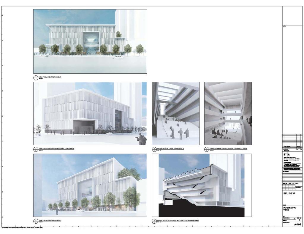
10 Staff Report to Council File: Planning & Development Report Page 10 DESIGN PROPOSAL AND REVIEW The proposed development will be 5 storeys in height, with one level of underground parking. The main entrance of the development is proposed from 102A Avenue. A small entry plaza is proposed at this location. The vehicular access to the development will be from the Prime development to the north, with service access from the new north-south lane at the west. The building massing of the proposed SFU building responds to the podium of the Prime development by stepping down to a roof terrace on the north side. The proposed building materials of the building façades will consist of a combination of insulated panel, clear glass and fritted glass and metal panel. An at-grade programmed space is proposed along University Drive to allow for activity to extend to the commercial street edge. A grand atrium extends over three levels to SFU Surrey s main lecture hall, a café, an exhibition space and the Capstone lab. The Capstone lab is a showcase lab for the university. In this lab, visitors can watch students actively working on individual engineering projects that typically involve physical activities like building prototypes and various mock-ups. The main atrium has been dropped to street level so that it is possible for pedestrians to view into the complex. The atrium will act as a secondary access, which will directly connect to the lecture hall from University Drive. The building will be targeting the LEED Gold standard. TREES AND LANDSCAPE (Appendix V) Norman Hol, ISA Certified Arborist of Arbortech Consulting, prepared an Arborist Assessment for the subject site. The table that follows, provides a summary of the tree retention and removal by tree species: Table 2: Summary of Tree Preservation by Tree Species: Tree Species Existing Remove Retain Deciduous Trees Cherry Coniferous Trees Douglas Fir Western Red Cedar Total Total Replacement Trees Proposed (excluding Boulevard Street Trees) TBD
11 Staff Report to Council File: Planning & Development Report Page 11 Total Retained and Replacement Trees Contribution to the Green City Fund 0 to be retained + TBD TBD The Arborist Assessment states that there are a total of 3 protected trees on the site. Of the 3 existing trees, none of the trees are Alder and Cottonwood trees. It was determined that none of the trees can be retained as part of this development proposal. The proposed tree retention was assessed taking into consideration the location of services, building footprints, road dedication, proposed lot grading, and underground parking. For those trees that cannot be retained, the applicant will be required to plant trees on a 2 to 1 replacement ratio. This will require a total of 6 replacement trees on the site. At this time, as the proposed landscape plans are conceptual, the final number of replacement trees has not yet been confirmed. If there is a deficit in tree replacement, then the application will be required to pay cash-in-lieu, representing $300 per tree, to the Green City Fund, in accordance with the City s Tree Protection By-law. In addition to replacement trees, boulevard street trees will be planted on University Drive and 102A Avenue. This will be determined by the Engineering Department during the servicing design review process. The landscape plan proposed is very schematic in nature at this time, to assist in facilitating the General Development Permit. A green roof is being proposed to the building along with a seating area. Sawcut, light sandblasted finish concrete pavers are proposed throughout, at grade, with a double row of trees along University Boulevard. A single row of trees is proposed along the future 102A Avenue road alignment, with the tree row in the boulevard to be accommodated with the realignment of 102A Avenue. As 102A Avenue is not proposed to be realigned immediately, a triangular area will be left as a remainder. The applicant s landscape architect has proposed to provide some grass cover, small trees and a timber seating bench as an interim design solution. More detailed landscape plans will be required at time of detailed Development Permit submission. DISTRICT ENERGY The subject site is located within Service Area A, as defined in the "City Centre District Energy System By-law" (see Appendix VI for location). The District Energy System consists of three primary components: o Community energy centres, City-operated facilities that generate thermal energy for distribution through a piped hot water network;
12 Staff Report to Council File: Planning & Development Report Page 12 o o Distribution piping that links the community energy centres with buildings connected to the system; and City-owned energy transfer stations (ETS) located within the building connected to the system. The ETS transfers heat energy from the distribution system to the building s mechanical system, and is used to meter the amount of energy used. All new developments within Service Area A with a build-out density equal to or greater than a floor area ratio (FAR) of 1.0 will be required to provide hydronic thermal energy systems in support of the City s District Energy (DE) system including domestic hot water, make-up air units and in-suite hydronic space heating. The City is committed to having the DE system operational within the timeframe of this project. Therefore, the subject application will be required to connect to the City s DE system prior to occupancy. In order to avoid conflicts between the District Energy System and other utilities, the location of the ETS and related service connections are confirmed by Engineering and the applicant at the servicing agreement stage. The Engineering Department also requires the applicant to register a statutory right-of-way and Section 219 Restrictive Covenant over the subject site for the following purposes: o o City access to, and maintenance and operation of, the ETS within the building and any infrastructure between the building and the property line; and To prevent conflicts with other utilities. Prior to the issuance of a building permit, the Engineering Department will confirm that the applicant has met the requirements of the "City Centre District Energy System By-law". SUSTAINABLE DEVELOPMENT CHECKLIST The applicant prepared and submitted a sustainable development checklist for the subject site on June 17, The table below summarizes the applicable development features of the proposal based on the seven (7) criteria listed in the Surrey Sustainable Development Checklist. Table 3: Sustainability Checklist Sustainability Criteria 1. Site Context & Location (A1-A2) Sustainable Development Features Summary The subject site is located within the City Centre Plan area. The proposed development is consistent with the Mixed-Use 5.5 FAR designation of the City Centre Plan and the Central Business District OCP designation. 2. Density & Diversity (B1-B7) 3. Ecology & Stewardship (C1-C4) The proposed gross density of the development is 2.8 FAR, with the proposed net density at 3.6 FAR. The proposed development is mainly an institutional use, with a small commercial component. The proposed development is to include Low Impact Development Standards (LIDS), such as a green roof, permeable pavement, rain water detention areas and storm detention in the underground
13 Staff Report to Council File: Sustainability Criteria 4. Sustainable Transport & Mobility (D1-D2) 5. Accessibility & Safety (E1-E3) 6. Green Certification (F1) 7. Education & Awareness (G1-G4) Planning & Development Report Sustainable Development Features Summary Page 13 parkade. The proposed development will allow for compost and recycling pickup. The project includes share parking, parking allocation/size amendments, electric vehicle charging stations and a visible, secure all-weather bicycle parking, as well as Transit Demand Management measures, such as showers and lockers for cyclists, electric vehicle charging stations, car pooling and the identification of this location as being a possible future public bike share station. The design of the project will incorporate Crime Prevention Through Environmental Design CPTED principles, such as lighting, visibility of public spaces (public spaces facing streets), elevator vestibules will be open to the ramp and there will be natural daylighting of the main atrium. The project will be targeting a LEED Gold standard. N/A INFORMATION ATTACHED TO THIS REPORT The following information is attached to this Report: Appendix I. Appendix II. Appendix III. Appendix IV. Appendix V. Appendix VI. Lot Owners, Action Summary, Project Data Sheets and Survey Plans Proposed Site Plan, Building Elevations and Conceptual Landscape Plans Engineering Summary Proposed CD By-law Summary of Tree Survey and Tree Preservation Map Showing District Energy Service Areas INFORMATION AVAILABLE ON FILE Geotechnical Study Prepared by Thurber Engineering Ltd. Dated March 14, Parking Study Prepared by Bunt & Associates. original signed by Judith Robertson PL/dk Jean Lamontagne General Manager Planning and Development
14 APPENDIX I Information for City Clerk Legal Description and Owners of all lots that form part of the application: 1. (a) Agent: Name: Ian Abercrombie Simon Fraser University Address: A Street Surrey, BC V3W 7J1 Tel: Properties involved in the Application (a) Civic Addresses: Avenue Avenue Avenue Portion of A Avenue University Drive Portion of Lane (b) Civic Address: Avenue Owner: City of Surrey PID: Lot 5 Block C Section 27 Block 5 North Range 2 West New Westminster District Plan 1726 (c) Civic Address: Avenue Owner: City of Surrey PID: Lot 6 Block C Section 27 Block 5 North Range 2 West New Westminster District Plan 1726 (d) Civic Address: Avenue Owner: City of Surrey PID: East 66 Feet of the East 175 Feet Lot A Section 27 Block 5 North Range 2 West New Westminster District Plan 7802 (e) Civic Address: Portion of A Avenue Owner: Simon Fraser University PID: Portion of Lot 1 Section 27 Block 5 North Range 2 West New Westminster District Plan LMP46320 (f) Civic Address: University Drive Owner: City of Surrey PID: Lot B Section 27 Block 5 North Range 2 West New Westminster District Plan BCP52191
15 (g) Portion of lane Owner: City of Surrey Portion of Road Dedicated on Plan 1726 Section 27 Block 5 North Range 2 West Westminster District 3. Summary of Actions for City Clerk's Office (a) Introduce a By-law to rezone the site.
16 DEVELOPMENT DATA SHEET Proposed Zoning: CD (based upon C-35) Required Development Data Minimum Required / Maximum Allowed LOT AREA* (in square metres) Gross Total Road Widening area Undevelopable area Net Total Proposed 5,734 sq.m. 1,218 sq.m. 4,516 sq.m. LOT COVERAGE (in % of net lot area) Buildings & Structures 85% Paved & Hard Surfaced Areas Total Site Coverage SETBACKS ( in metres) Front (102A Avenue) Rear (north) Side #1 (at lane) Side (west next to RM-D lot) Side #2 (University Drive) 5 m 0 m 2 m 0 m 5 m BUILDING HEIGHT (in metres/storeys) Principal Accessory NUMBER OF RESIDENTIAL UNITS Bachelor One Bed Two Bedroom Three Bedroom + Total FLOOR AREA: Residential FLOOR AREA: Commercial Retail Office Total FLOOR AREA: Industrial FLOOR AREA: Institutional TOTAL BUILDING FLOOR AREA 35 metres/5- storeys n/a N/A N/A 125 sq.m. N/A 15,941 sq.m. 16,066 sq.m.
17 Development Data Sheet cont'd Required Development Data Minimum Required / Maximum Allowed Proposed DENSITY # of units/ha /# units/acre (gross) # of units/ha /# units/acre (net) FAR (gross) 2.8 FAR (net) 3.6 AMENITY SPACE (area in square metres) Indoor Outdoor N/A PARKING (number of stalls) Based on Bunt Report Commercial 3 3 Industrial N/A Residential Bachelor + 1 Bedroom 2-Bed 3-Bed Residential Visitors N/A Institutional Total Number of Parking Spaces Number of disabled stalls 2 2 Number of small cars 52 (max 35%) 3 Tandem Parking Spaces: Number / % of N/A Total Number of Units Size of Tandem Parking Spaces width/length N/A Heritage Site NO Tree Survey/Assessment Provided YES
18
19
20
21
22
23
24
25
26
27
28
29
30
31
32
33
34
35
36
37
38
39
40 APPENDIX III
41 APPENDIX IV CITY OF SURREY BYLAW NO. A by-law to amend Surrey Zoning By-law, 1993, No , as amended THE CITY COUNCIL of the City of Surrey ENACTS AS FOLLOWS: 1. Surrey Zoning By-law, 1993, No , as amended, is hereby further amended, pursuant to the provisions of Section 479 of the Local Government Act, R.S.B.C. 2015, c. 1, as amended by changing the classification of the following parcels of land, presently shown upon the maps designated as the Zoning Maps and marked as Schedule "A" of Surrey Zoning By-law, 1993, No , as amended as follows: (a) FROM: SINGLE FAMILY RESIDENTIAL ZONE (RF) TO: COMPREHENSIVE DEVELOPMENT ZONE (CD) Parcel Identifier: Lot 5 Block C Section 27 Block 5 North Range 2 West New Westminster District Plan Avenue Parcel Identifier: Lot 6 Block C Section 27 Block 5 North Range 2 West New Westminster District Plan Avenue Parcel Identifier: East 66 Feet of the East 175 Feet Lot A Section 27 Block 5 North Range 2 West New Westminster District Plan Avenue Parcel Identifier: Lot B Section 27 Block 5 North Range 2 West New Westminster District Plan BCP University Drive - 1 -
42 That portion of lane shown on the Survey Plan attached hereto and forming part of this Bylaw, as Schedule A, certified correct by Scott Netherton, B.C.L.S. on the 10 th day of June, 2016, containing square metres, called Block A. (b) FROM: COMMUNITY COMMERCIAL ZONE (C-8) TO: COMPREHENSIVE DEVELOPMENT ZONE (CD) Portion of Parcel Identifier: Lot 1 Section 27 Block 5 North Range 2 West New Westminster District Plan LMP46320, as shown as Block B, on the Survey Plan attached hereto and forming part of this Bylaw, as Schedule B, certified correct by Adam Fulkerson, B.C.L.S. on the 6 th day of July, 2016, containing 1,284.7 square metres. Portion of A Avenue (hereinafter 1.(a) and (b) shall be referred to as the "Lands") 2. The following regulations shall apply to the Lands: A. Intent This Comprehensive Development Zone is intended to accommodate and regulate the development of comprehensive institutional uses such as universities and colleges in the City Centre. B. Permitted Uses The Lands and structures shall be used for the following uses only, or for a combination of such uses: 1. Universities named under the University Act, R.S.B.C. 1996, c.468, as amended. 2. Colleges and Institutes designated as such under the College and Institute Act, R.S.B.C. 1996, c.52, as amended. 3. Eating establishments, limited to a maximum 150 square metres (1,615 sq.ft.) in size, excluding drive-through restaurants. 4. Office uses excluding social escort services. C. Lot Area Not applicable to this Zone
43 D. Density The floor area ratio shall not exceed 3.8. E. Lot Coverage The lot coverage shall not exceed 90%. F. Yards and Setbacks 1. Buildings and structures shall be sited in accordance with the following minimum setbacks: Use Setback Front Rear Side Side Yard Yard Yard Yard on Flanking (102A (North) (West) Street Avenue) (University Drive) Principal Buildings and Accessory Buildings 5.0 m 5.0 m 2.0 m 5.0 m and Structures [16 ft.] [16 ft.] [6.6 ft.] [16 ft.] Measurements to be determined as per Part 1 Definitions of Surrey Zoning By-law, 1993, No , as amended. 2. Notwithstanding Section F.1, the setback for principal buildings and accessory buildings and structures may be reduced to zero for interior lot lines. 3. Notwithstanding Section F.1, canopies may be permitted within any setback. G. Height of Buildings Measurements to be determined as per Part 1 Definitions of Surrey Zoning By-law, 1993, No , as amended. 1. Principal buildings: The building height shall not exceed 35 metres [115 ft.]. 2. Accessory buildings and structures: The building height shall not exceed 4.5 metres [15 ft.]
44 H. Off-Street Parking 1. Parking spaces shall be provided in accordance with Part 5 Off-Street Parking and Loading/Unloading of Surrey Zoning By-law, 1993, No , as amended. 2. All required parking spaces shall be provided as underground parking or as parking within building envelope. 3. Notwithstanding Section H.1, a minimum of 115 parking spaces shall be provided. 4. Tandem parking is not permitted. 5. Notwithstanding Sub-section A.3(d) of Part 5 Off-Street Parking and Loading/Unloading of Surrey Zoning By-law, 1993, No , as amended the underground parking facility may extend up to 0.5 metre (1.6 ft.) of the front lot line and the lot line along a flanking street. I. Landscaping 1. All developed portions of the lot not covered by buildings, structures or paved areas shall be landscaped including the retention of mature trees. This landscaping shall be maintained. 2. The boulevard areas of highways abutting a lot shall be seeded or sodded with grass on the side of the highway abutting the lot, except at driveways. 3. Garbage containers and passive recycling containers shall be located within a building or within the underground parking. J. Subdivision Lots created through subdivision in this Zone shall conform to the following minimum standard: Lot Size Lot Width Lot Depth 4,500 sq. m. [1.1 acre] 30 metres [100 ft.] 30 metres [100 ft.] Dimensions shall be measured in accordance with Section E.21 of Part 4 General Provisions of Surrey Zoning By-law, 1993, No , as amended. K. Other Regulations In addition to all statutes, bylaws, orders, regulations or agreements, the following are applicable, however, in the event that there is a conflict with the provisions in this Comprehensive Development Zone and other provisions in Surrey Zoning By-law, 1993, No , as amended, the provisions in this Comprehensive Development Zone shall take precedence: - 4 -
45 1. Definitions are as set out in Part 1 Definitions of Surrey Zoning By-law, 1993, No , as amended. 2. Prior to any use, the Lands must be serviced as set out in Part 2 Uses Limited, of Surrey Zoning By-law, 1993, No , as amended and in accordance with the servicing requirements for the Community Commercial Zone (C-35), as set forth in the Surrey Subdivision and Development By-law, 1986, No. 8830, as amended. 3. General provisions are as set out in Part 4 General Provisions of Surrey Zoning By-law, 1993, No , as amended. 4. Additional off-street parking requirements are as set out in Part 5 Off-Street Parking and Loading/Unloading of Surrey Zoning By-law, 1993, No , as amended. 5. Sign regulations are as set out in Surrey Sign By-law, 1999, No , as amended. 6. Special building setbacks are as set out in Part 7 Special Building Setbacks, of Surrey Zoning By-law, 1993, No , as amended. 7. Building permits shall be subject to the Surrey Building Bylaw, 2012, No , as amended. 8. Building permits shall be subject to Surrey Development Cost Charge Bylaw, 2016, No , as may be amended or replaced from time to time. The Development Cost Charges shall be based as follows: (a) (b) Development Cost Charges for the portion of building developed for Universities named under the University Act, R.S.B.C. 1996, c.468, as amended, Colleges and Institutes designated as such under the Colleges and Institutes Act, R.S.B.C. 1996, c.52, as amended, shall be based on the rate for Public and Private Schools (Post Secondary); and Notwithstanding Section 8 (a), Development Cost Charges for commercial uses shall be based on the rate for Commercial. 9. Tree regulations are set out in Surrey Tree Protection Bylaw, 2006, No , as amended. 10. Development permits may be required in accordance with the Surrey Official Community Plan By-law, 2013, No , as amended
46 3. This By-law shall be cited for all purposes as "Surrey Zoning By-law, 1993, No , Amendment By-law,, No.." PASSED FIRST READING on the th day of, 20. PASSED SECOND READING on the th day of, 20. PUBLIC HEARING HELD thereon on the th day of, 20. PASSED THIRD READING on the th day of, 20. RECONSIDERED AND FINALLY ADOPTED, signed by the Mayor and Clerk, and sealed with the Corporate Seal on the th day of, 20. MAYOR CLERK - 6 -
47 SCHEDULE A
48 SCHEDULE B
49 APPENDIX V

50 APPENDIX VI
City of Surrey PLANNING & DEVELOPMENT REPORT File:
 City of Surrey PLANNING & DEVELOPMENT REPORT File: 7915-0222-00 Planning Report Date: April 24, 2017 PROPOSAL: Rezoning from RF to C-5 Development Permit Development Variance Permit to permit the development
City of Surrey PLANNING & DEVELOPMENT REPORT File:
 City of Surrey PLANNING & DEVELOPMENT REPORT File: 7916-0362-00 Planning Report Date: July 10, 2017 PROPOSAL: Development Permit Development Variance Permit to allow a truck/trailer staging area and to
City of Surrey ADDITIONAL PLANNING COMMENTS File:
 City of Surrey ADDITIONAL PLANNING COMMENTS PROPOSAL: Development Permit Planning Report Date: May 4, 2009 in order to permit the expansion of the vehicle storage area for White Rock Honda. LOCATION: OWNER:
City of Surrey PLANNING & DEVELOPMENT REPORT. OCP Amendment of a portion from Suburban to Urban
 City of Surrey PLANNING & DEVELOPMENT REPORT File: 7911-0119-00 Planning Report Date: November 7, 2011 PROPOSAL: OCP Amendment of a portion from Suburban to Urban Rezoning from RA to RH and RF in order
City of Surrey PLANNING & DEVELOPMENT REPORT File:
 City of Surrey PLANNING & DEVELOPMENT REPORT PROPOSAL: Development Permit Planning Report Date: March 10, 2008 Development Variance Permit in order to permit the development of a commercial building and
City of Surrey PLANNING & DEVELOPMENT REPORT File:
 City of Surrey PLANNING & DEVELOPMENT REPORT File: 7910-0272-00 PROPOSAL: Planning Report Date: February 28, 2011 OCP Amendment from Industrial to Commercial Rezoning from CHI to CD Development Permit
Rezoning Development Permit
 City of Surrey PLANNING & DEVELOPMENT REPORT File: Rezoning Development Permit Proposal: Rezone from RA, C-8 and CD to CD. Development Permit to permit commercial retail units, eating establishment and
Rezoning. Rezone from C-4 and RA to RF-9C and RF-12C to allow subdivision into approximately 47 small single family lots in East Clayton.
 City of Surrey PLANNING & DEVELOPMENT REPORT File: 7903-0275-00 Rezoning Proposal: Rezone from C-4 and RA to RF-9C and RF-12C to allow subdivision into approximately 47 small single family lots in East
Rezoning. Rezone from A-1 to RH to create 9 suburban single family residential lots. Approval to Proceed
 City of Surrey PLANNING & DEVELOPMENT REPORT Rezoning Proposal: Rezone from A-1 to RH to create 9 suburban single family residential lots. Recommendation: Approval to Proceed Location: 18712 and Portion
City of Surrey PLANNING & DEVELOPMENT REPORT File: Rezoning from RA to RF to allow subdivision into six (6) single family lots.
 single family lots.") City of Surrey PLANNING & DEVELOPMENT REPORT File: 7917-0206-00 Planning Report Date: September 11, 2017 PROPOSAL: Rezoning from RA to RF to allow subdivision into six (6) single family lots. LOCATION:
City of Surrey PLANNING & DEVELOPMENT REPORT File: 7917-0206-00 Planning Report Date: September 11, 2017 PROPOSAL: Rezoning from RA to RF to allow subdivision into six (6) single family lots. LOCATION:
30 and 44 Zorra Street - Zoning By-law Amendment Application - Preliminary Report
 STAFF REPORT ACTION REQUIRED 30 and 44 Zorra Street - Zoning By-law Amendment Application - Preliminary Report Date: March 14, 2016 To: From: Wards: Reference Number: Etobicoke York Community Council Director,
Rezoning. Approval to Proceed. City of Surrey PLANNING & DEVELOPMENT REPORT File:
 City of Surrey PLANNING & DEVELOPMENT REPORT Rezoning Proposal: Rezone from RA to RF in order to permit subdivision into 24 single family residential lots and a park lot. Recommendation: Approval to Proceed
5959 Yonge Street Rezoning Application - Preliminary Report
 STAFF REPORT ACTION REQUIRED 5959 Yonge Street Rezoning Application - Preliminary Report Date: February 23, 2011 To: From: Wards: Reference Number: North York Community Council Director, Community Planning,
City of Surrey PLANNING & DEVELOPMENT REPORT File:
 ` City of Surrey PLANNING & DEVELOPMENT REPORT File: 7913-0258-00 Planning Report Date: May 12, 2014 PROPOSAL: Development Variance Permit in order to allow the storage of landscaping material between
REPORT TO: Council FOR: Regular Meeting. PRESENTED: April 1, 2008 FILE: , Byl 1932 & 1936
 DISTRICT OF SQUAMISH REPORT TO: Council FOR: Regular Meeting PRESENTED: April 1, 2008 FILE: 2006-08, Byl 1932 & 1936 DEPARTMENT: Planning Department SUBJECT: First and Second Readings for Bylaws 1932 (rezoning)
1296 Kennedy Road - Zoning Amendment Application - Preliminary Report
 STAFF REPORT ACTION REQUIRED 1296 Kennedy Road - Zoning Amendment Application - Preliminary Report Date: January 15, 2016 To: From: Wards: Reference Number: Scarborough Community Council Acting Director,
City of Surrey PLANNING & DEVELOPMENT REPORT File: Development Permit in order to redevelop portions of this industrial site.
 City of Surrey PLANNING & DEVELOPMENT REPORT File: 7910-0181-00 Planning Report Date: December 13, 2010 PROPOSAL: Development Permit in order to redevelop portions of this industrial site. LOCATION: OWNER:
City of Surrey PLANNING & DEVELOPMENT REPORT File:
 City of Surrey PLANNING & DEVELOPMENT REPORT File: 7917-0292-00 Planning Report Date: November 20, 2017 PROPOSAL: Development Permit to permit the development of a 18,287 square metre (196,840 sq. ft.)
599 Kennedy Road - Official Plan Amendment and Zoning Amendment Application - Preliminary Report
 STAFF REPORT ACTION REQUIRED 599 Kennedy Road - Official Plan Amendment and Zoning Amendment Application - Preliminary Report Date: March 7, 2017 To: From: Wards: Reference Number: Scarborough Community
City of Surrey PLANNING & DEVELOPMENT REPORT File:
 City of Surrey PLANNNG & DEVELOPMENT REPORT File: 7915-0208-00 Planning Report Date: July 13, 2015 PROPOSAL: Development Variance Permit to vary building setbacks, landscaping and fencing requirements,
Bloor St. W. Rezoning - Preliminary Report
 STAFF REPORT ACTION REQUIRED 1638-1644 Bloor St. W. Rezoning - Preliminary Report Date: April 1, 2008 To: From: Wards: Reference Number: Toronto and East York Community Council Acting Director, Community
7437, 7439 and 7441 Kingston Road - Zoning By-law Amendment and Site Plan Control Applications - Preliminary Report
 STAFF REPORT ACTION REQUIRED 7437, 7439 and 7441 Kingston Road - Zoning By-law Amendment and Site Plan Control Applications - Preliminary Report Date: August 13, 2015 To: From: Wards: Reference Number:
646 Kingston Road - Official Plan Amendment and Zoning Amendment Applications - Preliminary Report
 STAFF REPORT ACTION REQUIRED 646 Kingston Road - Official Plan Amendment and Zoning Amendment Applications - Preliminary Report Date: December 8, 2014 To: From: Wards: Reference Number: Toronto and East
Bylaw A Bylaw to amend Bylaw 12800, as amended, The Edmonton Zoning Bylaw Amendment No. 2239
 Bylaw 17672 A Bylaw to amend Bylaw 12800, as amended, The Edmonton Zoning Bylaw Amendment No. 2239 WHEREAS City Council at its meeting of February 22, 2001, gave third reading to Bylaw 12800, as amended;
(DC1) Direct Development Control Provision DC1 Area 4
 Direct Development Control Provision DC1 Area 4") . General Purpose (DC) Direct Development Control Provision DC Area 4 The purpose of this Provision is to provide for an area of commercial office employment and residential development in support of the
. General Purpose (DC) Direct Development Control Provision DC Area 4 The purpose of this Provision is to provide for an area of commercial office employment and residential development in support of the
City of Surrey PLANNING & DEVELOPMENT REPORT File:
 City of Surrey PLANNING & DEVELOPMENT REPORT PROPOSAL: Planning Report Date: September 14, 2009 OCP Amendment Temporary Industrial Use Permit in order to allow the outdoor storage of construction waste
STAFF REPORT TO COUNCIL PLANNING AND DEVELOPMENT
 DATE: April 29, 2013 STAFF REPORT TO COUNCIL PLANNING AND DEVELOPMENT 1100 Patricia Boulevard, Prince George, B.C., V2L 3V9 TO: FROM: SUBJECT: MAYOR AND COUNCIL JESSE DILL, PLANNER Development Variance
FORMER CANADIAN FORCES BASE (CFB) ROCKCLIFFE SECONDARY PLAN. Official Plan Amendment XX to the Official Plan for the City of Ottawa
 ROCKCLIFFE SECONDARY PLAN. Official Plan Amendment XX to the Official Plan for the City of Ottawa") FORMER CANADIAN FORCES BASE (CFB) ROCKCLIFFE SECONDARY PLAN Official Plan Amendment XX to the Official Plan for the City of Ottawa 1 INDEX THE STATEMENT OF COMPONENTS PART A THE PREAMBLE PAGE Purpose...
FORMER CANADIAN FORCES BASE (CFB) ROCKCLIFFE SECONDARY PLAN Official Plan Amendment XX to the Official Plan for the City of Ottawa 1 INDEX THE STATEMENT OF COMPONENTS PART A THE PREAMBLE PAGE Purpose...
1-17 Anndale Drive, Bales Avenue and Glendora Avenue Zoning Amendment Application Preliminary Report
 STAFF REPORT ACTION REQUIRED 1-17 Anndale Drive, 31-35 Bales Avenue and 22-70 Glendora Avenue Zoning Amendment Application Preliminary Report Date: August 20, 2007 To: From: Wards: Reference Number: North
City of Surrey ADDITIONAL PLANNING COMMENTS File:
 City of Surrey ADDITIONAL PLANNING COMMENTS File: 7915-0235-00 Planning Report Date: December 19, 2016 PROPOSAL: Rezoning portions from RF and RM-D to RF and RF-10 to allow subdivision into 2 single family
THE CITY OF VAUGHAN BY-LAW BY-LAW NUMBER
 THE CITY OF VAUGHAN BY-LAW BY-LAW NUMBER 123-2013 A By-law to designate the whole of the City of Vaughan as a Site Plan Control Area, and to adopt site development guidelines and rules of procedure for
From: Director, Community Planning, Scarborough District. Ward 40 Scarborough-Agincourt
 STAFF REPORT ACTION REQUIRED 2967 Sheppard Ave E - Zoning Amendment Application - Preliminary Report Date: July 18, 2014 To: Scarborough Community Council From: Director, Community Planning, Scarborough
4780 Eglinton Avenue West - Zoning By-law Amendment and Draft Plan of Subdivision Applications - Preliminary Report
 STAFF REPORT ACTION REQUIRED 4780 Eglinton Avenue West - Zoning By-law Amendment and Draft Plan of Subdivision Applications - Preliminary Report Date: May 29, 2014 To: From: Wards: Reference Number: Etobicoke
Uptown Rideau Street Secondary Plan [Amendment #166, January 12, 2016]
![Uptown Rideau Street Secondary Plan [Amendment #166, January 12, 2016]](/thumbs/76/73760497.jpg "Uptown Rideau Street Secondary Plan [Amendment #166, January 12, 2016]") [Amendment #166, January 12, 2016] The policies of this Secondary Plan are in effect, save and except for the property at 560 Rideau Street, for which there remains a site specific appeal to this Secondary
[Amendment #166, January 12, 2016] The policies of this Secondary Plan are in effect, save and except for the property at 560 Rideau Street, for which there remains a site specific appeal to this Secondary
1071 King Street West Zoning Amendment Application - Preliminary Report
 STAFF REPORT ACTION REQUIRED 1071 King Street West Zoning Amendment Application - Preliminary Report Date: August 9, 2012 To: From: Wards: Reference Number: Toronto and East York Community Council Director,
523, 525 and 525A Adelaide Street West - Zoning Amendment Application - Preliminary Report
 STAFF REPORT ACTION REQUIRED 523, 525 and 525A Adelaide Street West - Zoning Amendment Application - Preliminary Report Date: May 12, 2012 To: From: Wards: Reference Number: Toronto and East York Community
REPORT TO THE CHIEF ADMINISTRATIVE OFFICER FROM THE DEVELOPMENT AND ENGINEERING SERVICES DEPARTMENT
 REPORT TO THE CHIEF ADMINISTRATIVE OFFICER FROM THE DEVELOPMENT AND ENGINEERING SERVICES DEPARTMENT ON DEVELOPMENT PERMIT APPLICATION NO. DPM00592 1393 9TH AVENUE/915 MCMURDO DRIVE OWNER/APPLICANT: 1393
MEMORANDUM. This memo deals with proposed amendments to previously issued Development Permit No for Park Royal North.
 MEMORANDUM Date: August 28, 2015 Our File: 1010-20-15-062 To: Design Review Committee From: Lisa Berg, Senior Community Planner Re: Amendment to Development Permit for Park Royal North This memo deals
Welcome. Walk Around. Talk to Us. Write Down Your Comments
 Welcome This is an information meeting introducing the applications for proposed redevelopment of the Yorkdale Shopping Centre site at 3401 Dufferin Street and 1 Yorkdale Road over the next 20+ years,
THE CITY OF VAUGHAN BY-LAW BY-LAW NUMBER A By-law to adopt Amendment Number 1 to the Official Plan of the Vaughan Planning Area.
 THE CITY OF VAUGHAN BY-LAW BY-LAW NUMBER 015-2014 A By-law to adopt Amendment Number 1 to the Official Plan of the Vaughan Planning Area. NOW THEREFORE the Council of the Corporation of the City of Vaughan
Smart Growth Development Checklist
 2004 Smart Growth Development Checklist Smart Growth Development Checklist Corporation of the City of New Westminster Guide and manage growth in a manner which is consistent with the principles of sustainable
Queen Street West - Zoning Amendment Application - Preliminary Report
 STAFF REPORT ACTION REQUIRED 944-952 Queen Street West - Zoning Amendment Application - Preliminary Report Date: February 6, 2013 To: From: Wards: Reference Number: Toronto and East York Community Council
OCP Amendment Rezoning Development Permit Development Variance Permit
 City of Surrey PLANNING & DEVELOPMENT REPORT OCP Amendment Rezoning Development Permit Development Variance Permit Proposal: OCP Amendment from Urban to Commercial. Rezone from RA to C-8 and Development
BYLAW C A Bylaw of Rocky View County to amend Land Use Bylaw C
 BYLAW C-7720-2017 A Bylaw of Rocky View County to amend Land Use Bylaw C-4841-97. The Council of Rocky View County enacts as follows: PART 1 TITLE This Bylaw shall be known as Bylaw C-7720-2017. PART 2
ROAD CLOSURE AND LAND USE AMENDMENT SILVER SPRINGS (WARD 1) NORTHEAST OF NOSEHILL DRIVE NW AND SILVER SPRINGS ROAD NW BYLAWS 2C2018 AND 29D2018
 NORTHEAST OF NOSEHILL DRIVE NW AND SILVER SPRINGS ROAD NW BYLAWS 2C2018 AND 29D2018") Page 1 of 19 EXECUTIVE SUMMARY This application proposes redesignating two parcels in the community of Silver Springs from Special Purpose Future Urban Development (S-FUD) District and undesignated road
Page 1 of 19 EXECUTIVE SUMMARY This application proposes redesignating two parcels in the community of Silver Springs from Special Purpose Future Urban Development (S-FUD) District and undesignated road
PUBLIC HEARING May 18, 2010 SUMMARY AND RECOMMENDATION
 PUBLIC HEARING May 18, 2010 SUMMARY AND RECOMMENDATION 7. REZONING: 5912-5970 Oak Street Summary: To rezone from RS-1 (single-family) to Comprehensive Development (CD-1) District to permit a 27-unit townhouse
[PLANNING RATIONALE] For Site Plan Control and Lifting of Holding Zone By-Law 101 Champagne Avenue. May 23, 2014
![[PLANNING RATIONALE] For Site Plan Control and Lifting of Holding Zone By-Law 101 Champagne Avenue. May 23, 2014](/thumbs/75/71599615.jpg "[PLANNING RATIONALE] For Site Plan Control and Lifting of Holding Zone By-Law 101 Champagne Avenue. May 23, 2014") [PLANNING RATIONALE] For Site Plan Control and Lifting of Holding Zone By-Law 101 Champagne Avenue May 23, 2014 Contents 1.0 Introduction... 2 2.0 Site Context... 2 2.1 Adjacent Uses... 2 Figure 1: Site
[PLANNING RATIONALE] For Site Plan Control and Lifting of Holding Zone By-Law 101 Champagne Avenue May 23, 2014 Contents 1.0 Introduction... 2 2.0 Site Context... 2 2.1 Adjacent Uses... 2 Figure 1: Site
REPORT TO THE CHIEF ADMINISTRATIVE OFFICER FROM THE DEVELOPMENT AND ENGINEERING SERVICES DEPARTMENT
 REPORT TO THE CHIEF ADMINISTRATIVE OFFICER FROM THE DEVELOPMENT AND ENGINEERING SERVICES DEPARTMENT ON REZONING APPLICATION NO. REZ00587 DEVELOPMENT PERMIT APPLICATION NO. DPM00559 1430 SUMMIT DRIVE OWNER/APPLICANT:
6. REGIONAL AND COMMUNITY FACILITIES DESIGNATIONS 6.1. OBJECTIVES FOR REGIONAL AND COMMUNITY FACILITIES LAND USE DESIGNATIONS
 6. REGIONAL AND COMMUNITY FACILITIES DESIGNATIONS INTRODUCTION The Regional and land use designations provide the primary locations for uses which satisfy the health, education and other service needs
DRAFT Northeast Quadrant of Kipling Avenue and Highway 7 DRAFT AUGUST 29, Goals Land Use. The goals of this Plan are to:
 AUGUST 29, 2017 12.15 Northeast Quadrant of Kipling Avenue and Highway 7 12.15.1 Goals 12.15.2 Land Use The goals of this Plan are to: 12.15.2.1 General Provisions: a) Ensure the development of a compact
City of Surrey PLANNING & DEVELOPMENT REPORT File:
 PROPOSAL: City of Surrey PLANNING & DEVELOPMENT REPORT File: 7915-0312-00 Planning Report Date: March 6, 2017 Rezoning from RA to CD (based on RA-G) Development Permit to allow subdivision into 4 suburban
Official Community Plan Bylaw No. 4360, 2004, Amendment Bylaw No. 4897, 2016 (Sewell s Landing)
") District of West Vancouver Official Community Plan Bylaw No. 4360, 2004, Amendment Bylaw No. 4897, 2016 (Sewell s Landing) Effective Date: 1089612v1 District of West Vancouver Official Community Plan Bylaw
District of West Vancouver Official Community Plan Bylaw No. 4360, 2004, Amendment Bylaw No. 4897, 2016 (Sewell s Landing) Effective Date: 1089612v1 District of West Vancouver Official Community Plan Bylaw
Welcome to the Oakridge Centre Open House
 Welcome to the Oakridge Centre Open House Why is the City hosting this event? This open house is to inform you of a rezoning application submitted to the City of Vancouver to amend the existing CD-1 (Comprehensive
AWH REPORT OF THE PLANNING AND DEVELOPMENT DEPARTMENT FOR APPLICATION FOR REZONING ORDINANCE TO PLANNED UNIT DEVELOPMENT
 AWH REPORT OF THE PLANNING AND DEVELOPMENT DEPARTMENT FOR APPLICATION FOR REZONING ORDINANCE TO PLANNED UNIT DEVELOPMENT MAY 8, 2014 The Planning and Development Department hereby forwards to the Planning
Regular Council - Land Use Minutes
 Regular Council - Land Use Minutes Council Chambers City Hall 13450-104 Avenue Surrey, B.C. MONDAY, FEBRUARY 5, 2018 Time: 5:38 p.m. Present: Mayor Hepner Councillor Gill Councillor Hayne Councillor LeFranc
City of Langford Green Development Checklist
 City of Langford Green Development Checklist The following Green Development Checklist creates a sustainability standard for all comprehensive development within the City of Langford. The commitments made
Simon Fraser University Official Community Plan
 Simon Fraser University Official Community Plan 1.0 Introduction Adopted 1996 September 9, Amended April 15, 2002 1.1 The Role of the S.F.U. Official Community Plan 1.1.1 The Simon Fraser University Official
8 & 10 Donalda Crescent Official Plan & Rezoning Application Final Report
 STAFF REPORT ACTION REQUIRED 8 & 10 Donalda Crescent Official Plan & Rezoning Application Final Report Date: July 26, 2010 To: From: Wards: Reference Number: Scarborough Community Council Director, Community
City of Surrey PLANNING & DEVELOPMENT REPORT File:
 City of Surrey PLANNING & DEVELOPMENT REPORT Planning Report Date: December 18, 2017 PROPOSAL: Development Permit Development Variance Permit to allow a free-standing, two-sided electronic message board
Advisory Design Panel Minutes
 Advisory Design Panel Minutes 2E - Community Room B City Hall 13450-104 Avenue Surrey, B.C. THURSDAY, FEBRUARY 28, 2019 Time: 4:09 p.m. Present: Panel Members: L. Mickelson, Chair A. Callison G. Borowski
Planning and Growth Management Committee. Chief Planner and Executive Director, City Planning Division. Pg12013 (File No NNY 34 OZ)
") 865 York Mills Road Official Plan Amendment Application Preliminary Report STAFF REPORT ACTION REQUIRED Date: February 28, 2012 To: From: Wards: Reference Number: Planning and Growth Management Committee
865 York Mills Road Official Plan Amendment Application Preliminary Report STAFF REPORT ACTION REQUIRED Date: February 28, 2012 To: From: Wards: Reference Number: Planning and Growth Management Committee
City of Surrey PLANNING & DEVELOPMENT REPORT File:
 City of Surrey PLANNING & DEVELOPMENT REPORT PROPOSAL: Development Permit Planning Report Date: July 28, 2008 Development Variance Permit to permit the construction of a concrete noise attenuation fence
I615. Westgate Precinct
 I615. Westgate Precinct I615.1. Precinct Description The Westgate Precinct is located approximately 18km west of the Auckland city centre. There are seven Sub-precincts in the Westgate Precinct: Sub-precinct
PLANNING JUSTIFICATION REPORT
 PLANNING JUSTIFICATION REPORT 55 DELHI STREET CITY OF GUELPH PREPARED FOR: VESTERRA PROPERTY MANAGEMENT PREPARED BY: LABRECHE PATTERSON & ASSOCIATES INC. SCOTT PATTERSON, BA, CPT, MCIP, RPP PRINCIPAL,
4121 Lawrence Avenue East Rezoning Application Preliminary Report
 STAFF REPORT ACTION REQUIRED 4121 Lawrence Avenue East Rezoning Application Preliminary Report Date: October 11, 2011 To: From: Wards: Reference Number: Scarborough Community Council Director, Community
280 Manse Road - Official Plan Amendment, Zoning Amendment, Draft Plan of Subdivision Applications - Preliminary Report
 STAFF REPORT ACTION REQUIRED 280 Manse Road - Official Plan Amendment, Zoning Amendment, Draft Plan of Subdivision Applications - Preliminary Report Date: March 11, 2014 To: From: Wards: Reference Number:
Yonge Street Zoning Amendment Application - Preliminary Report
 STAFF REPORT ACTION REQUIRED 341-355 Yonge Street Zoning Amendment Application - Preliminary Report Date: March 24, 2011 To: From: Wards: Reference Number: Toronto and East York Community Council Director,
240 and 242 Finch Avenue West Zoning By-law Amendment Application Preliminary Report
 REPORT FOR ACTION 240 and 242 Finch Avenue West Zoning By-law Amendment Application Preliminary Report Date: March 1, 2019 To: North York Community Council From: Director, Community Planning, North York
City of Surrey PLANNING & DEVELOPMENT REPORT File:
 City of Surrey PLANNING & DEVELOPMENT REPORT File: 7916-0706-00 Planning Report Date: May 8, 2017 PROPOSAL: NCP Amendment from Low Density Residential 6-10 upa to Medium Density Residential 10-15 upa and
4155 Yonge Street Official Plan Amendment and Rezoning Application Preliminary Report
 STAFF REPORT ACTION REQUIRED 4155 Yonge Street Official Plan Amendment and Rezoning Application Preliminary Report Date: May 5, 2011 To: From: Wards: Reference Number: North York Community Council Director,
PORT WHITBY COMMUNITY
 PORT WHITBY COMMUNITY SECONDARY PLAN UPDATE COMMUNITY IMPROVEMENT PLAN URBAN DESIGN GUIDELINES September 2015 DRAFT PROPOSED AMENDMENT NUMBER # to the Whitby Official Plan PURPOSE: The intent of this Amendment
393, 395, 397, 399, 401 and 403 Spring Garden Avenue Official Plan and Zoning By-law Amendment Application Preliminary Report
 STAFF REPORT ACTION REQUIRED 393, 395, 397, 399, 401 and 403 Spring Garden Avenue Official Plan and Zoning By-law Amendment Application Preliminary Report Date: March 29, 2010 To: From: Wards: Reference
From: Director, Community Planning, Etobicoke York District
 STAFF REPORT ACTION REQUIRED 4208, 4210 and 4214 Dundas Street West - Official Plan Amendment and Zoning By-law Amendment Application - Preliminary Report Date: July 22, 2014 To: Etobicoke York Community
City of Surrey PLANNING & DEVELOPMENT REPORT File:
 City of Surrey PLANNING & DEVELOPMENT REPORT File: 7917-0458-00 Planning Report Date: April 23, 2018 PROPOSAL: NCP Amendment from Urban Single Family Residential to Single Family Small Lots and for changes
Planning Commission Staff Report June 5, 2008
 Owner/Applicant Taylor Village Sacramento Investments Partners, LP c/o Kim Whitney 1792 Tribute Road #270 Sacramento, CA 95815 Staff Recommendation Planning Commission Staff Report Project: File: Request:
City of Surrey ADDITIONAL PLANNING COMMENTS File:
 City of Surrey ADDITIONAL PLANNING COMMENTS Planning Report Date: September 28, 2015 PROPOSAL: Development Variance Permit to permit setback variances on a proposed subdivision into six (6) single family
ARTICLE 6: Special and Planned Development Districts
 ARTICLE 6: Special and Planned Development Districts 6-10 Traditional Neighborhood Development (TND) District 6-10.10 Purpose and Intent The Traditional Neighborhood Development (TND) District provides
Gold Line Bus Rapid Transit Transit Oriented Development (BRTOD) Helmo Station Area Plan
 Helmo Station Area Plan") Appendix F Gold Line Bus Rapid Transit Transit Oriented Development (BRTOD) Helmo Station Area Plan Introduction and Purpose of the Plan The Gold Line Bus Rapid Transit facility is an eleven-mile dedicated
Appendix F Gold Line Bus Rapid Transit Transit Oriented Development (BRTOD) Helmo Station Area Plan Introduction and Purpose of the Plan The Gold Line Bus Rapid Transit facility is an eleven-mile dedicated
LAND USE AMENDMENT DOWNTOWN COMMERCIAL CORE (WARD 7) MACLEOD TRAIL SE AND 5 AVENUE SE BYLAW 254D2017
 MACLEOD TRAIL SE AND 5 AVENUE SE BYLAW 254D2017") Page 1 of 10 EXECUTIVE SUMMARY This Land Use Amendment application seeks to redesignate a full downtown block (currently the YWCA site) from a Direct Control based on the CM-2 District (Land Use Bylaw
Page 1 of 10 EXECUTIVE SUMMARY This Land Use Amendment application seeks to redesignate a full downtown block (currently the YWCA site) from a Direct Control based on the CM-2 District (Land Use Bylaw
ELMVALE ACRES SHOPPING CENTRE MASTER PLAN
 ELMVALE ACRES SHOPPING CENTRE MASTER PLAN Contents 1.0 INTRODUCTION... 2 2.0 LOCATION... 2 3.0 EXISTING CONTEXT... 2 4.0 VISION & GUIDING PRINCIPLES... 2 5.0 LAND USE AND BUILT FORM... 4 5.1 St. Laurent
East Panorama Ridge Concept Plan Amendment
 Page 1 of 7 L003 : East Panorama Ridge Concept Plan Amendment Corporate NO: L003 Report COUNCIL DATE: March 4, 2002 REGULAR COUNCIL LAND USE TO: Mayor & Council DATE: February 27, 2002 FROM: General Manager,
URBAN DESIGN BRIEF. 2136&2148 Trafalgar Road. Town of Oakville
 URBAN DESIGN BRIEF 2136&2148 Trafalgar Road Town of Oakville Prepared By: METROPOLITAN CONSULTING INC For 2500674 Ontario Inc November 2016 TABLE OF CONTENTS Page No. 1.0 Introduction/Description of Subject
The West Vaughan Employment Area Secondary Plan Policies
 Part 2: The West Vaughan Employment Area Secondary Plan Policies 2.1 General Policies It is the policy of Council: 2.1.1. That the West Vaughan Employment Area (the WVEA), identified on Schedule 1, will
POLICY AMENDMENT AND LAND USE AMENDMENT KILLARNEY/GLENGARRY (WARD 8) NW CORNER OF RICHMOND ROAD AND 33 STREET SW BYLAWS 1P2015 AND 7D2015
 NW CORNER OF RICHMOND ROAD AND 33 STREET SW BYLAWS 1P2015 AND 7D2015") Page 1 of 13 EXECUTIVE SUMMARY This application seeks to redesignate an RC-2 (Residential Contextual One/Two Dwelling) parcel to MC-Gd72 (Multi-Residential Contextual Grade-Oriented) to allow for multi-residential
Page 1 of 13 EXECUTIVE SUMMARY This application seeks to redesignate an RC-2 (Residential Contextual One/Two Dwelling) parcel to MC-Gd72 (Multi-Residential Contextual Grade-Oriented) to allow for multi-residential
Clairtrell Area Context Plan
 Clairtrell Area Context Plan March 2005 Urban Development Services City Planning Contents 1. Introduction... 4 2. Development Structure... 6 2.1 Streets... 7 2.1.1 Sheppard Avenue and Bayview Avenue...
George Hotel application STAFF REVIEW COMMITTEE OF THE WHOLE JANUARY 14, 2014
 George Hotel application STAFF REVIEW COMMITTEE OF THE WHOLE JANUARY 14, 2014 1 Presentation outline Purpose: to seek Council direction for next steps in the review process Application process to date
ARLINGTON COUNTY, VIRGINIA
 ARLINGTON COUNTY, VIRGINIA County Board Agenda Item Meeting of April 23, 2019 DATE: April 12, 2019 SUBJECT: SP #413 SITE PLAN AMENDMENT to permit a fixed bar in a private outdoor café space with associated
Dufferin Street and Centre Street Area Specific Policies
 12.XX 12.XX.1 12.XX.1.1. 12.XX.2. 12.XX.2.1. 12.XX.2.2 Dufferin Street and Centre Street Area Specific Policies Goals The goal of this Plan is to provide the necessary land use and development policies
and Richmond Street West - Official Plan Amendment Application - Preliminary Report
 STAFF REPORT ACTION REQUIRED 822-838 and 860-862 Richmond Street West - Official Plan Amendment Application - Preliminary Report Date: August 14, 2017 To: From: Wards: Reference Number: Toronto and East
LAND USE AMENDMENT CORNERSTONE (WARD 3) 60 STREET NE AND COUNTRY HILLS BOULEVARD NE MAP 26NE BYLAW 22D2017
 60 STREET NE AND COUNTRY HILLS BOULEVARD NE MAP 26NE BYLAW 22D2017") Page 1 of 14 EXECUTIVE SUMMARY This Land Use Amendment application covers an area of 43.76 hectares ± (108.14 acres ±) located in northeast Calgary, bound by Country Hills Boulevard NE to the south and
Page 1 of 14 EXECUTIVE SUMMARY This Land Use Amendment application covers an area of 43.76 hectares ± (108.14 acres ±) located in northeast Calgary, bound by Country Hills Boulevard NE to the south and
AGINCOURT SECONDARY PLAN
 1 AGINCOURT SECONDARY PLAN 1. AGINCOURT SECONDARY PLAN The following policies and principles apply to the area herein referred to as Agincourt, as outlined on Map 1-1. 1. GENERAL POLICIES 1.1 This Secondary
DRAFT. 1. General Purpose. 2. Area of Application. 3. Uses CLIFTON PLACE AREA A DC2 (DRAFT)
") CLIFTON PLACE AREA A DC2 () May 1, 2017 1. General Purpose To accommodate a high rise, high density residential Tower and podium that will accommodate a potential mix of commercial and residential uses,
CLIFTON PLACE AREA A DC2 () May 1, 2017 1. General Purpose To accommodate a high rise, high density residential Tower and podium that will accommodate a potential mix of commercial and residential uses,
City of Surrey PLANNING & DEVELOPMENT REPORT File:
 City of Surrey PLANNING & DEVELOPMENT REPORT File: 7915-0133-00 Planning Report Date: April 18, 2016 PROPOSAL: Partial NCP Amendment from Cluster Residential 10-15 upa to Civic Utility and to relocate
Report Regarding Site Plan Control for 55 Wellspring Way (File No. SP-06-16)
") Report Regarding Site Plan Control for 55 Wellspring Way (File No. SP-06-16) Executive Summary: The purpose of this report is to provide Council with information regarding site plan control under Section
Report Regarding Site Plan Control for 55 Wellspring Way (File No. SP-06-16) Executive Summary: The purpose of this report is to provide Council with information regarding site plan control under Section
CITY OF KITCHENER CONDITIONS REQUIRED FOR ISSUANCE OF SITE PLAN APPROVAL
 CITY OF KITCHENER CONDITIONS REQUIRED FOR ISSUANCE OF SITE PLAN APPROVAL The following is a list of conditions requiring completion to the City s Satisfaction prior to Site Plan Approval being granted
Development Permit Application Form. Property Owner Information as Registered on Legal Title Property Owner Name: Phone:
 Development Application Requirements 1 1926 Tsawwassen Drive Tel: 604-943-2112 Tsawwassen, BC V4M 4G2 www.tsawwassenfirstnation.com Canada Development Permit Application Form Name of Applicant: Address:
CONTENTS 8.0 LAND USE 8.1 GENERAL LAND USE 8.2 RESIDENTIAL 8.3 MIXED USE 8.4 COMMERCIAL 8.5 EMPLOYMENT LANDS
 8-2 Land Use 8.0 LAND USE CONTENTS 8.1 GENERAL LAND USE 8.1.1 Uses provided for in all Land Use Designations 8.1.2 Uses prohibited in Hazardous Lands, Hazardous Sites and Special Policy Areas 8.1.3 Uses
and services The protection and conservation of environmentally significant and sensitive natural heritage features and functions.
 6. Land Use 6.0 Preamble A healthy and livable city is one in which people can enjoy a vibrant economy and a sustainable healthy environment in safe, caring and diverse neighbourhoods. In order to ensure
City of Surrey PLANNING & DEVELOPMENT REPORT File:
 City of Surrey PLANNING & DEVELOPMENT REPORT Planning Report Date: February 24, 2014 PROPOSAL: Temporary Use Permit in order to permit existing outdoor container storage, vehicle parking, RV storage, and
112 College Street Zoning Amendment Application Preliminary Report
 ~TORONTO REPORT FOR ACTION 112 College Street Zoning Amendment Application Preliminary Report Date: January 25, 2019 To: Toronto and East York Community Council From: Director, Community Planning, Toronto