City of Surrey PLANNING & DEVELOPMENT REPORT File:
|
|
|
- Annice Moody
- 6 years ago
- Views:
Transcription

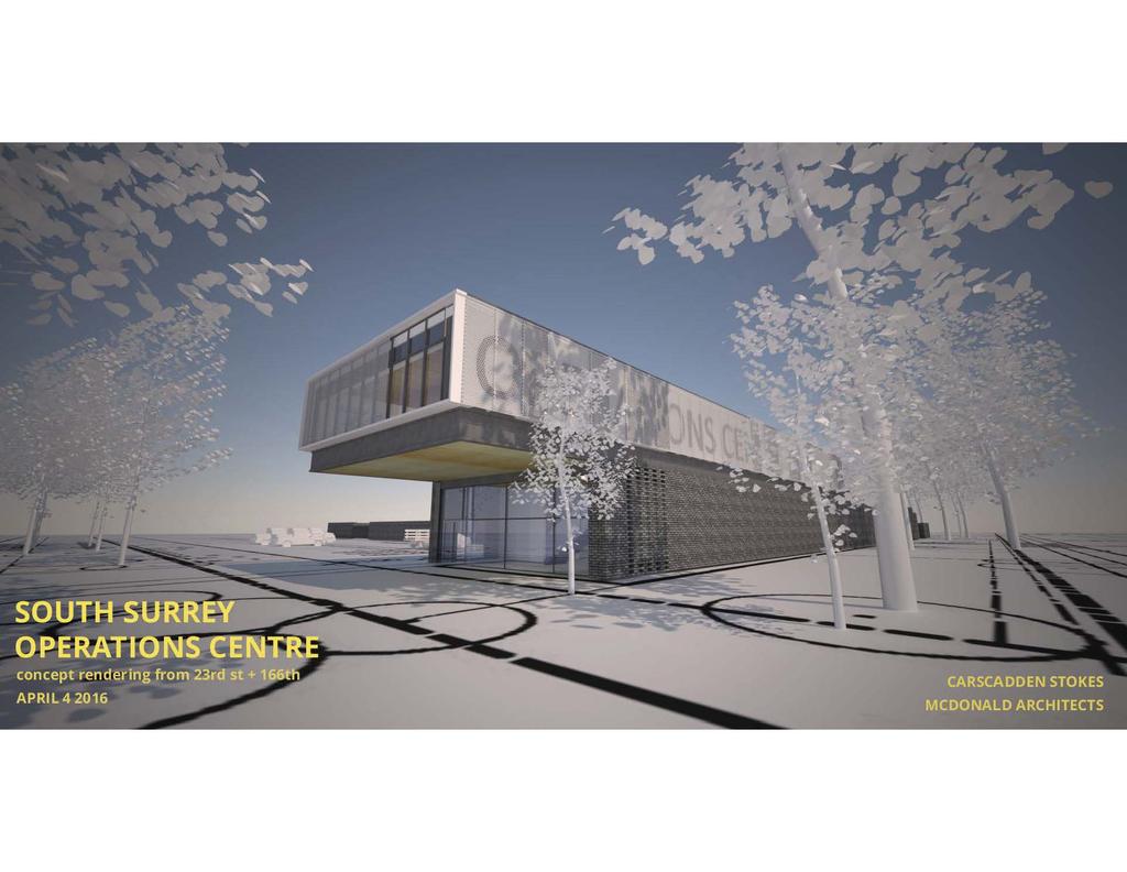
1 City of Surrey PLANNING & DEVELOPMENT REPORT File: Planning Report Date: April 18, 2016 PROPOSAL: Partial NCP Amendment from Cluster Residential upa to Civic Utility and to relocate a buffer Development Permit Development Variance Permit to permit the development of the South Surrey Operations Centre. LOCATION: 16596/16604/ Avenue and Avenue OWNER: City of Surrey ZONING: OCP DESIGNATION: NCP DESIGNATION: RA Urban Cluster Residential upa and Civic Utility
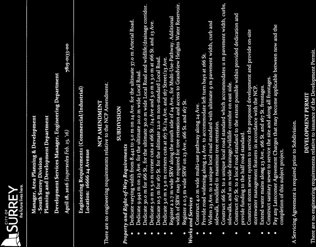
2 Staff Report to Council File: Planning & Development Report Page 2 RECOMMENDATION SUMMARY Approval to draft Development Permit. Approval for Development Variance Permit to proceed to Public Notification. DEVIATION FROM PLANS, POLICIES OR REGULATIONS The applicant is proposing an NCP amendment from Cluster Residential upa to Civic Utility for the two westernmost parcels at Avenue and Avenue. The applicant is also proposing to relocate the buffer on the westerly side of Avenue to Avenue. The applicant is proposing a Development Variance Permit to vary the westerly setback for the second storey of the proposed Operations building. RATIONALE OF RECOMMENDATION The proposed development of the South Surrey Operations Centre was announced as part of the City's 2016 capital budget in order to enhance the services provided to Surrey residents. The proposal complies with the OCP Designation for the site. The proposal partially complies with the NCP Designation for the site. The majority of the site is designated Civic Utility. Due to anticipated Metro Vancouver water reservoir requirements on the site, the amount of land available for a City Operations Centre was less than anticipated on Avenue, which has necessitated the purchase of additional parcels to the west. The proposed NCP amendment from Cluster Residential upa to Civic Utility is for the two parcels at Avenue and Avenue. In addition, an NCP amendment is also needed for relocation of a buffer, as the incorporation of the two parcels at Avenue and Avenue into the Operations Centre site necessitates the relocation of the buffer from the westerly side of Avenue to Avenue. The buffer consists of a landscaped 11.5-metre (38 ft.) wide corridor along the western boundary of the facility and also functions as a drainage corridor and a BCS corridor. In addition to the landscape buffer along the west boundary of the site, the applicant is proposing extensive tree retention along the south and east boundaries of the site, and at the northwest corner of the site, which will largely buffer the internal operations of the proposed Operations facility from the surrounding residential neighbourhood. The proposed setback variance for the cantilievered second floor of the Operations building from 9.8 metres (32 ft.) to 6.0 metres (20 ft.) is an architectural feature that provides visual interest to the Operations building. This portion of the building is adjacent to the proposed 11.5-metre (38 ft.) wide landscape buffer, and therefore has minimal impact on neighbouring lands.
3 Staff Report to Council File: Planning & Development Report Page 3 RECOMMENDATION The Planning & Development Department recommends that: 1. Council authorize staff to draft Development Permit No generally in accordance with the attached drawings (Appendix II). 2. Council approve Development Variance Permit No (Appendix VI) varying the following, to proceed to Public Notification: (a) reduce the minimum side yard (west) setback of the RA Zone from 9.8 metres (32 ft.) to 6.0 metres (20 feet) for the second floor of the proposed Operations building. 3. Council instruct staff to resolve the following issue prior to final approval: (a) (b) (c) (d) (e) (f) ensure that all engineering requirements and issues including restrictive covenants, dedications, and rights-of-way where necessary, are addressed to the satisfaction of the General Manager, Engineering; submission of a subdivision layout to the satisfaction of the Approving Officer; submission of a finalized tree survey and a statement regarding tree preservation to the satisfaction of the City Landscape Architect; submission of a landscaping plan and landscaping cost estimate to the specifications and satisfaction of the Planning and Development Department; demolition of existing buildings and structures to the satisfaction of the Planning and Development Department; and the applicant satisfy the deficiency in tree replacement on the site, to the satisfaction of the Planning and Development Department. 4. Council pass a resolution to amend the Sunnyside Heights NCP to redesignate the parcels at Avenue and Avenue from Cluster Residential upa to Civic Utility and to relocate the buffer on the westerly side of Avenue to Avenue when the project is considered for final approval. REFERRALS Engineering: The Engineering Department has no objection to the project subject to the completion of Engineering servicing requirements as outlined in Appendix III. Parks, Recreation & Culture: No concerns.
4 Staff Report to Council File: Planning & Development Report Page 4 Surrey Fire Department: No concerns. SITE CHARACTERISTICS Existing Land Use: The site contains a Metro Vancouver water reservoir which will be retained, and three single family dwellings and associated outbuildings which will be demolished. Adjacent Area: Direction Existing Use OCP/NCP Designation North (Across 24 Avenue): Single family residential, partially under application for an apartment building and townhouses (File No ). Multiple Residential / Multi-Family (30-45 upa) and Habitat Corridor (20m SROW) East: Single family residential. Commercial/ Special Residential upa South (Across 23 Single family residential and a Urban/ School and Avenue): City park (Sunnyside Saddle Park/Open Space Club). West: Single family residential. Urban/ Cluster Residential upa Existing Zone RA RA RA and A-1 RA JUSTIFICATION FOR PLAN AMENDMENT The majority of the site (large parcel at Avenue) is designated Civic Utility. Due to Metro Vancouver water reservoir requirements on the site, the amount of land that is available for a City Operations Centre was less than anticipated on the original main parcel, which necessitated the City purchase of 3 parcels to the west (16596/ Avenue and Avenue). These parcels have been included in the subject application and an Neighbourhood Concept Plan (NCP) amendment from Cluster Residential upa to Civic Utility is required for the two parcels at Avenue and Avenue. The third parcel, Avenue, will be primarily used for the extension of 166 Street, with a small remnant portion on the westerly side that will retain its Cluster Residential upa designation. It is anticipated that, when a future development application is made on the lands to the west of the subject site at Avenue, the small remnant portion of Avenue will be consolidated with these lands at that time. In addition, an NCP amendment is also needed for relocation of a buffer, as the incorporation of the two parcels at Avenue and Avenue into the Operations Centre site necessitates the relocation of the buffer from the westerly side of Avenue to Avenue. The buffer consists of a landscaped 11.5-metre (38 ft.) wide corridor along the western boundary of the facility, and also fulfills a function as a Biodiversity Conservation Strategy (BCS) corridor.
5 Staff Report to Council File: Planning & Development Report Page 5 The development proposal achieves the NCP objective for the extension of 166 and 167 Street and the associated drainage corridor along 166 Street. In addition, the application will provide the BCS corridor that is identified along 166 Street, as discussed later in this report. DEVELOPMENT CONSIDERATIONS Proposal The application proposes a partial NCP amendment from Cluster Residential upa to Civic Utility and a Development Permit to permit the development of the South Surrey Operations Centre. The application also proposes a Development Variance Permit to reduce the west building setback and a subdivision for lot consolidation and dedications. Surrey City Council previously approved the design and construction of a new South Surrey Operations Centre that will serve as the centre of operations for Engineering and Parks Operations staff in South Surrey. The project is fully funded and completion is expected in Fall The subject site consist of 4 parcels at 16596/16604/ Avenue and Avenue. The property at Avenue contains a Metro Vancouver water reservoir, which is on land that is leased to Metro Vancouver by the City of Surrey. The proposed consolidation will result in a hooked lot over 166 Street, with a small remainder piece on the west side of 166 Street. It is anticipated that this remnant will be consolidated with the lands to the west as part of a future residential development when these parcels redevelop. The proposal also includes the implementation of the proposed drainage corridor along 166 Street and a multi-use pathway along 24 Avenue. The applicant is proposing a two-storey building with a gross floor area of 2,000 square metres (21,525 sq.ft.), which represents a net floor area ratio (FAR) of The building is proposed to contain shops and maintenance areas on the ground floor and administration offices on the second floor. The site will also include space for fleet parking, recycling and disposal ramps and bins, vehicle and equipment wash bays, and a natural gas fueling station. Zoning By-law Compliance The Zoning By-law permits municipal buildings to be located in any zone, provided that all the minimum setbacks are equal to, or greater than, either the height of the principal building, or the setbacks prescribed in the underlying zone. Based on the proposed 9.8-metre (32 ft.) height of the building, the proposed Operations Centre building is required to be sited a minimum of 9.8-metre (32 ft.) from all lot lines. A variance is required for the western setback, as discussed later in this report.
6 Staff Report to Council File: Planning & Development Report Page 6 DESIGN PROPOSAL AND REVIEW Building Design The proposed Operations building is sited at the corner of 23 Avenue and 166 Street. The attractively designed building provides a significant presence on the street, and screens parking and storage areas from the public realm. The building design has a very modern form with clean lines and strong geometric features. The second floor is proposed to be cantilevered over the first floor on the west side of the building. Exterior cladding will consist of a brick rainscreen on the ground floor on portions of the north, south and east elevations and a rainscreen panel system on the second floor on the north and south elevations. Significant glazing is proposed where the internal functioning permits, particularly on the west and east elevations. The building is proposed to have shops and maintenance activities on the ground floor, with administrative offices on the second floor. The second floor extends for only a portion of the building. A landscaped green roof is proposed on the remainder of the second floor. The green roof will minimize the heat island effect and provide outdoor amenity to the administration and operation staff (see Landscape Section below for further detail on the green roof). Vehicular Access and Parking Two vehicular accesses from 166 Street are proposed to the site. It is anticipated that the majority of traffic to the site will come via 24 Avenue onto 166 Street, and will not enter the site through the residential neighbourhood to the south. There is an emergency access proposed on 23 Avenue but this will be used for emergencies only. A total of 139 parking spaces are proposed, which exceeds the requirements of the Zoning By-law of 27 parking spaces on the site. The parking area is split into a publicly accessible parking area along 166 Street, where 83 visitor and staff parking spaces are provided (including two electric vehicle charging spaces), and a fleet parking area that will be secured behind security gates where 56 spaces are provided. This area will include another two electric vehicle charging spaces. In addition, a total of 7 bicycle parking spaces will be provided Landscaping The applicant is proposing a number of landscaped areas throughout the site which is in addition to the retention of the existing treed areas along the southern and eastern portions of the site and in the northwest corner. A large landscaped area is proposed at the northwest corner of the site along 24 Avenue, which will contain a rain garden with sedges and river rock, and a pathway. This area includes the retention of a number of existing trees. The applicant is also proposing a green roof over a portion of the Operations building, as discussed above. The green roof will contain a patio area, a path and low ground cover planting, primarily succulents such as sedum herbs and grasses.
7 Staff Report to Council File: Planning & Development Report Page 7 The 11.5-metre (38 ft.) wide landscape buffer along 166 Street also functions as a drainage corridor and a BCS corridor. The landscape buffer will be in the form of an attractively designed rain garden and will enhance the streetscape. A depression will be created for the rain garden with a 0.40-metre (1 ft.) high corten steel wall proposed on the west side of the depression. A river stone channel is proposed at the base of the corten steel wall, mimicking a creek bed. Planting in the drainage corridor includes grasses, river birch and aspens. The forest understory will remain undisturbed along the eastern and most of the south portion of the site where significant numbers of trees are propose to be retained. This will result in a buffer area with a natural forest feel in these areas. The applicant is also proposing a concrete wall with brick detailing at the southwest corner of the site and along the public parking areas. The wall will screen the internal operations of the site in areas that are more visible from the public view. In areas along the Operations yard that are less visible from public view, a lock block concrete wall is proposed. Public Art The City of Surrey has supported the implementation of artworks within its civic facilities and public open space such as parks and greenways since 1998 when it adopted a Public Art Policy. Staff will work with the Public Art group to identify opportunities to incorporate public art on the proposed South Operations Centre site. TREES Thomas Walz, ISA Certified Arborist of BC Plant Health Care Inc, prepared an Arborist Assessment for the subject property. The table below provides a summary of the tree retention and removal by tree species: Table 1: Summary of Tree Preservation by Tree Species: Tree Species Existing Remove Retain Alder and Cottonwood Trees Alder Cottonwood Deciduous Trees (excluding Alder and Cottonwood Trees) Big Leaf Maple Mountain Ash Paper Birch Cherry Pacific Dogwood Cascara Willow Coniferous Trees Western Red Cedar Douglas Fir
8 Staff Report to Council File: Planning & Development Report Page 8 Tree Species Existing Remove Retain Scots Pine Spruce Grand Fir Western Hemlock Total (excluding Alder and Cottonwood Trees) Total Replacement Trees Proposed (excluding Boulevard Street Trees) Total Retained and Replacement Trees The Arborist Assessment states that there are a total of 307 protected trees on the site, excluding Alder and Cottonwood trees. Fifty-one (51) existing trees, approximately 14% of the total trees on the site, are Alder and Cottonwood trees. It was determined that 62 trees can be retained as part of this development proposal. The proposed tree retention was assessed taking into consideration the location of services, building and parking area footprints and road dedication. For those trees that cannot be retained, the applicant will be required to plant trees on a 1 to 1 replacement ratio for Alder and Cottonwood trees, and a 2 to 1 replacement ratio for all other trees. This will require a total of 542 replacement trees on the site. The applicant is proposing 32 replacement trees. The new trees on the site will consist of a variety of trees including fir, cedar, hemlock, aspens, and Japanese stewartia. In summary, a total of 94 trees are proposed to be retained or replaced on the site. BIODIVERSITY CONSERVATION STRATEGY The City of Surrey Biodiversity Conservation Strategy (BCS) Green Infrastructure Network (GIN) map, identifies that a Local BCS Corridor (#26) is located within the subject site. The corridor is located within the Redwood BCS management area and has a Low ecological value. The BCS further identifies the GIN area of the subject site as having a Low habitat suitability rating, derived from species at risk presence, species accounts and known ecosystem habitat inventories. The BCS recommends a target Corridor width of 20 metres (66 feet) and target area of 3,680 square metres (39,610 sq.ft.), or approximately 9.0% of the subject property. Protecting green infrastructure Hubs (large habitat areas) and Sites (smaller habitat areas) are critical to preserving natural habitat refuges and a diversity of habitat features while maintaining/enhancing Corridors ensures connectivity between fragmented hubs for genetic variation throughout the City. The closest Biodiversity Hub connection in the GIN to the subject site is Hub F, which is located in an area roughly bounded by 16 Avenue, 168 Street, 8 Avenue and Highway 99, centered on the Fergus Watershed Biodiversity Preserve. The BCS Management Area Objectives that the proposed corridor dedication (Corridor #26) will help
9 Staff Report to Council File: Planning & Development Report Page 9 to achieve include increased landscape permeability (amount of natural and semi-natural habitat) on public land and increased tree canopy cover. The development proposal conserves/enhances 2,070 square metres (22,280 sq.ft.) of the subject site through the dedication of a 11.5-metre (38 ft.) wide BCS corridor which is 56% of the target GIN area and 58% of the target corridor width. This method of GIN retention/enhancement will assist in the long term protection of the natural features and allows the City to better achieve biodiversity at this location that is consistent with the guidelines contained in the BCS. In order for the proposal to fully comply with the BCS target recommendations, an additional 1610 square metres (17,330 sq.ft.) of the GIN area would be required on the subject site. SUSTAINABLE DEVELOPMENT CHECKLIST The applicant prepared and submitted a sustainable development checklist for the subject site on April 5, The table below summarizes the applicable development features of the proposal based on the seven (7) criteria listed in the Surrey Sustainable Development Checklist. Sustainability Criteria 1. Site Context & Location (A1-A2) 2. Density & Diversity (B1-B7) 3. Ecology & Stewardship (C1-C4) 4. Sustainable Transport & Mobility (D1-D2) 5. Accessibility & Safety (E1-E3) 6. Green Certification (F1) 7. Education & Awareness (G1-G4) Sustainable Development Features Summary The majority of the site is designated as Civic Utility in the Sunnyside Heights NCP. n/a New absorbent soils, dry swales, natural landscaping, xeriscaping green roofs, permeable pavement and rain water wetlands are proposed. The applicant is providing a BCS corridor along 166 Street. The proposal includes preferred parking spaces for carpools and electric vehicle parking spaces and bicycle parking spaces. The design follows CPTED design principles to maximize surveillance. The project will follow best practices for green and environmental strategies and energy efficient systems. Feasibility of LEED certification will be assessed during design development and cost budgeting. Development signs were installed, pre-notification letters were sent, and a public open house was held.
10 Staff Report to Council File: Planning & Development Report Page 10 PRE-NOTIFICATION Pre-notification letters were sent on April 4, 2016, and development proposal signs were installed on the site to inform area residents about the proposal. In response, staff have received 1 phone call and 8 s. The caller wanted to discuss the possibility of the City purchasing his parcel as it was adjacent to the original development site. The City recently purchased the caller s parcel, and it has been added to the subject application. Two (2) of the respondents had no concerns and were looking for information on the proposal. Six (6) of the respondents expressed concerns about the amount of proposed tree removal and the potential impact of a City Operations Centre on nearby properties. (The applicant has retained a significant number of trees (62), and has designed the site such that the impact on nearby properties should be minimal. The site is buffered on the east and south through the extensive retention of trees and on the west by the landscape buffer, and also opaque screening as discussed above, which means the internal operations of the facility will not be visible from the public realm.) A public open house was held on Wednesday, May 27, 2015 at the Pacific Heights Elementary School. Thirty-one (31) people signed the sign-in sheet and 4 comment sheets were filled out. The comments indicated concerns about the potential impact of a City Operations Centre on nearby properties and asked for wider buffers to be provided around the proposed Operations Centre. (In response, the applicant has increased the width of the buffers around the proposed facility, and with the recent purchase of Avenue and Avenue has ensured that traffic to the site will be primarily from 24 Avenue through the soon-to-be constructed 166 Street, and not through the neighbourhood to the south of the site.) ADVISORY DESIGN PANEL The application was not referred to the ADP for review. The design and landscaping plans were reviewed by staff and found to be generally acceptable. BY-LAW VARIANCE AND JUSTIFICATION (a) Requested Variance: Reduce the minimum side yard (west) setback of the RA Zone from 9.8 metres (32 ft.) to 6.0 metres (20 ft.) for the second floor of the proposed Operations building. Staff Comments: The proposed setback variance is for the cantilievered second floor of the proposed Operations building only and is an architectural feature that provides visual interest to the Operations building.w3
11 Staff Report to Council File: Planning & Development Report Page 11 This portion of the building is adjacent to the proposed 11.5-metre (38 ft.) wide BCS corridor/landscape buffer, and therefore has minimal impact on the neighbouring lands. INFORMATION ATTACHED TO THIS REPORT The following information is attached to this Report: Appendix I. Lot Owners, Action Summary and Project Data Sheets Appendix II. Proposed Site Plan, Building Elevations, Landscape Plans and Perspective Appendix III. Engineering Summary Appendix IV. Summary of Tree Survey and Tree Preservation Appendix V. NCP Redesignation Map Appendix VI. Development Variance Permit No original signed by Ron Hintsche Jean Lamontagne General Manager Planning and Development KB/dk \\file-server1\net-data\csdc\generate\areaprod\save\ doc KD 4/14/16 1:17 PM
12 APPENDIX I Information for City Clerk Legal Description and Owners of all lots that form part of the application: 1. (a) Agent: Name: Matt Brown City of Surrey Address: Street Surrey, BC Tel: Properties involved in the Application (a) Civic Address: Avenue Avenue Avenue Avenue (b) Civic Address: Avenue Owner: City Of Surrey PID: West Feet Of The West Half Lot 4 Section 13 Township 1 New Westminster District Plan 7992 (c) Civic Address: Avenue Owner: City of Surrey PID: West Half Lot 4 Except: Westerly Feet, Section 13 Township 1 New Westminster District Plan 7992 (d) Civic Address: Avenue Owner: City Of Surrey PID: Lot A Section 13 Township 1 New Westminster District Plan 9408 (e) Civic Address: Avenue Owner: City of Surrey PID: Lot 1 Section 13 Township 1 New Westminster District Plan LMP Summary of Actions for City Clerk's Office (a) Proceed with Public Notification for Development Variance Permit No and bring the Development Variance Permit forward for an indication of support by Council. If supported, the Development Variance Permit will be brought forward for issuance and execution by the Mayor and City Clerk when the Development Permit is brought forward for issuance and execution. \\file-server1\net-data\csdc\generate\areaprod\save\ doc KD 4/14/16 1:17 PM
13 DEVELOPMENT DATA SHEET Existing Zoning: RA Required Development Data Minimum Required / Maximum Allowed LOT AREA* (in square metres) Gross Total Road Widening area Undevelopable area Net Total Proposed 41,034 sq.m. 9,314 sq.m. 31,720 sq.m. LOT COVERAGE (in % of net lot area) Buildings & Structures (Ops Centre bldg) 4% Paved & Hard Surfaced Areas Total Site Coverage SETBACKS ( in metres) South (23 Avenue) 9.8 m 12 m North (24 Avenue) 9.8 m 181 m East (167 Street) 9.8 m 115 m West (166 Street) 9.8 m 6 m (DVP required) BUILDING HEIGHT (in metres/storeys) Principal Accessory 9.8 m NUMBER OF RESIDENTIAL UNITS Bachelor One Bed Two Bedroom Three Bedroom + Total FLOOR AREA: Residential FLOOR AREA: Commercial Retail Office Total 2,000 sq.m. FLOOR AREA: Industrial FLOOR AREA: Institutional TOTAL BUILDING FLOOR AREA 2,000 sq.m. * If the development site consists of more than one lot, lot dimensions pertain to the entire site. \\file-server1\net-data\csdc\generate\areaprod\save\ doc KD 4/14/16 1:17 PM
14 Development Data Sheet cont'd Required Development Data Minimum Required / Maximum Allowed Proposed DENSITY # of units/ha /# units/acre (gross) # of units/ha /# units/acre (net) FAR (gross) FAR (net) (Ops Centre bldg) 0.06 AMENITY SPACE (area in square metres) Indoor Outdoor PARKING (number of stalls) Commercial Industrial and Office Residential Bachelor + 1 Bedroom 2-Bed 3-Bed Residential Visitors Institutional Total Number of Parking Spaces Number of disabled stalls 1 2 Number of small cars Tandem Parking Spaces: Number / % of Total Number of Units Size of Tandem Parking Spaces width/length Heritage Site NO Tree Survey/Assessment Provided YES \\file-server1\net-data\csdc\generate\areaprod\save\ doc KD 4/14/16 1:17 PM
15 24TH ST Carscadden Stokes McDonald Architects Inc 715 East Hastings Street Vancouver, BC V6A 1R3 GENERAL NOTES: carscadden.ca PARKING NOTES: EXISTING RESERIR 166TH ST 167TH ST (FUTURE) 1 FEATURE WALL SCALE 1:50 1 A1.1 JOB TITLE SOUTH SURREY OPERATIONS CENTRE REVISIONS 23RD ST SITE PLAN SHEET TITLE DRAWN JOB NO. SCALE CHECKED DATE Appendix II SHEET A1.2 Copyright reserved. These drawings are, and at all times, remain the exclusive property of the Architects, and cannot be used without the consent of the architects.
16 24TH ST Carscadden Stokes McDonald Architects Inc 715 East Hastings Street Vancouver, BC V6A 1R3 GENERAL NOTES: carscadden.ca EXISTING RESERIR LEED INFORMATION: 166TH ST 167TH ST (FUTURE) JOB TITLE SOUTH SURREY OPERATIONS CENTRE REVISIONS LAYOUT AND LEED BOUNDARY SITE PLAN SHEET TITLE DRAWN CHECKED JOB NO. DATE 23RD ST SCALE SHEET A1.1 Copyright reserved. These drawings are, and at all times, remain the exclusive property of the Architects, and cannot be used without the consent of the architects.
17 24TH ST Carscadden Stokes McDonald Architects Inc 715 East Hastings Street Vancouver, BC V6A 1R carscadden.ca Preferred Option Draft Mar 3, 2016 This is not a Legal Survey 1 LOCATION PLAN N/A EXISTING RESERIR GENERAL NOTES: FIRE SHEET - SITE NOTES 166TH ST 167TH ST (FUTURE) JOB TITLE SOUTH SURREY OPERATIONS CENTRE REVISIONS 2 STOREY NON-COMBUSTIBLE BUILDING SITE FIRE SHEET SHEET TITLE DRAWN CHECKED JOB NO. DATE 23RD ST SCALE SHEET A1.3 Copyright reserved. These drawings are, and at all times, remain the exclusive property of the Architects, and cannot be used without the consent of the architects.
18
19 RAINSCREEN PANEL SYSTEM GLAZING HATCHED AREAS ARE PERFORATED ALUMINUM PANELS ROOF ND FLOOR Carscadden Stokes McDonald Architects Inc 715 East Hastings Street Vancouver, BC V6A 1R carscadden.ca BRICK RAINSCREEN DARK RAINSCREEN PANEL REVEAL BAND VENTILATION THROUGH BRICK SCREEN GROUND FLOOR 1 EXTERIOR ELEVATION - SOUTH Scale 1:200 RAINSCREEN PANEL SYSTEM GLAZING HATCHED AREAS ARE PERFORATED ALUMINUM PANELS ROOF SOUTH SURREY OPERATIONS CENTRE 2ND FLOOR FOLDING OH DOORS SOLID GLASS DOORS AND TRANSOMS (FROSTED BELOW 8') GROUND FLOOR JOB TITLE SOUTH SURREY OPERATIONS CENTRE 2 EXTERIOR ELEVATION - NORTH Scale 1:200 REVISIONS SLIDING DOOR PANELS GLAZING 2ND FLOOR SHOWN DASHED GLAZING ELEVATIONS BRICK RAINSCREEN DARK RAINSCREEN PANEL REVEAL BAND ROOF SHEET TITLE DRAWN CHECKED 2ND FLOOR JOB NO. DATE SCALE DARK RAINSCREEN PANEL REVEAL BAND GROUND FLOOR SHEET A4.1 3 EXTERIOR ELEVATION - WEST Scale 1:200 4 EXTERIOR ELEVATION - EAST Scale 1:200 5 EXTERIOR ELEVATION - EAST Scale 1:200 Copyright reserved. These drawings are, and at all times, remain the exclusive property of the Architects, and cannot be used without the consent of the architects.

20 A CORTEN STEEL LANDSCAPE EDGE To create the topographic relief required to construct the rain garden parallel to 166th Street the landscape plan proposes a low corten steel wall. The steel adds an industrial flavour to the landscape design and creates an interesting backdrop to the naturalistic rain garden plantings. This material selection also lends itself well to other coordinated site elements such as signage, sculptural features and the building's architectural details. C A NOT IN PROJECT LIMITS B TREE GROVE PLANTING The Landscape design proposes areas with high density groupings of trees. These plantings support the tree compensation requirements as well help to preserve the site's woodland aesthetic. The plantings are not intended to screen the building but rather create a soft filter through with the building is viewed. The contrasting colours of the tree bark and building walls add to the visual interest. C ARCHITECTURAL RAIN GARDEN FEATURE A C A GATE GATE GARBAGE RAMP PROPOSED METRO VANCOUVER LEASE AREA BOUNDARY City of Surrey Biodiversity Strategy The west perimeter of the SSOC site has been identified as a "Local Corridor" in City of Surrey's Green Infrastructure Network. The landscape design for the SSOC proposes to support this initiative by developing a linear rain garden along its frontage with 166th street. By incorporating this space into the site's overall stormwater management strategy the corridor will serve as both green infrastructure and habitat for wildlife. As one of the early examples of a "Local Corridor" the landscape design for the SSOC will be important as a demonstration project. Furthermore, as this site will be home to City Operations staff, it will be convenient to monitor the functionality of the landscape on an on-going basis. As a semi-public site this project also provides an excellent opportunity for promoting and educating the public about the merits of the Biodiversity Strategy. To this end the landscape design proposes to employ architectural elements such as corten steel features and constructed rain water rills and weirs to draw attention to its functionality. B LANDSCAPE ARCHITECTS SPORTS FACILITY DESIGNERS P L LANDSCAPE PRELIMINARY SITE PLAN PLOTTED: :11:17 PM FILE: P:\2015\ \00 - CAD FILES\DWG\FINAL\ L1.DWG USER: MHARBUT ROAD SECTION BIODIVERSITY CORRIDOR SIDEWALK VISITOR PARKING


21 H Stewartia pseudocamellia RU RU RU R RU RU red osier dogwood winter heath Kalmia latifolia 'Elf' mountain laurel oregon grape sweetgale Rudbeckia fulgida 'goldstrum' black eyed susan Mahonia aquifolium Myrica gale Cornus stolonifera Erica carnea Nandina domestica firepower heavenly bamboo Symphoricarpos albus NOT IN PROJECT LIMITS sword fern snowberry Vaccinium corymbosum northern highbush blueberry Vaccinium ovatum evergreen huckleberry GATE PROPOSED METRO VANCOUVER LEASE AREA BOUNDARY GARBAGE RAMP O GATE LANDSCAPE ARCHITECTS SPORTS FACILITY DESIGNERS PLOTTED: :47:27 AM FILE: P:\2015\ \00 - CAD FILES\DWG\FINAL\ L2.DWG USER: MHARBUT LANDSCAPE CONCEPTUAL PLANTING PLAN


22
23 Tree Preservation Summary - Overall Surrey Project No: Address: Registered Arborist: 16666/16614/16615/ 16604/ Avenue, Surrey Thomas Walz - BC Plant Health Care Inc. On-Site Trees Protected Trees Identified (on-site and shared trees, including trees within boulevards and proposed streets and lanes, but excluding trees in proposed open space or riparian areas) Protected Trees to be Removed (or already removed) Protected Trees to be Retained (excluding trees within proposed open space or riparian areas) Total Replacement Trees Required: - Alder & Cottonwood Trees Requiring 1 to 1 Replacement Ratio 50 X one (1) = 50 Number of Trees All other Trees Requiring 2 to 1 Replacement Ratio 246 X two (2) = 492 Replacement Trees Proposed Replacement Trees in Deficit Protected Trees to be Retained in Proposed [Open Space / Riparian Areas] TBD TBD Off-Site Trees Protected Off-Site Trees to be Removed Total Replacement Trees Required: - Alder & Cottonwood Trees Requiring 1 to 1 Replacement Ratio X one (1) = 0 Number of Trees 0 - All other Trees Requiring 2 to 1 Replacement Ratio X two (2) = 0 Replacement Trees Proposed Replacement Trees in Deficit 0 Summary, report and plan prepared and submitted by: (Signature of Arborist) April 4, 2016 Date S:\1Tom Walz\City Surrey, Arar, Aiman, South Surrey Operations, Ave, Sry, TW, Apr 4, 2016\Apr 4 Tree Preservation Summary - Overall

24 : Proposed NCP Amendment Proposed amendment to move the Buffer from Ave to Ave Proposed amendment from Cluster Residential upa to Civic Utility
25 CITY OF SURREY (the "City") DEVELOPMENT VARIANCE PERMIT NO.: Issued To: City of Surrey ("the Owner") Address of Owner: Avenue Surrey, BC V3T 1V8 1. This development variance permit is issued subject to compliance by the Owner with all statutes, by-laws, orders, regulations or agreements, except as specifically varied by this development variance permit. 2. This development variance permit applies to that real property including land with or without improvements located within the City of Surrey, with the legal description and civic address as follows: Parcel Identifier: West Feet Of The West Half Lot 4 Section 13 Township 1 New Westminster District Plan Avenue Parcel Identifier: West Half Lot 4 Except: Westerly Feet, Section 13 Township 1 New Westminster District Plan Avenue Parcel Identifier: Lot A Section 13 Township 1 New Westminster District Plan Avenue Parcel Identifier: Lot 1 Section 13 Township 1 New Westminster District Plan LMP Avenue (the "Land") 3. (a) As the legal description of the Land is to change, the City Clerk is directed to insert the new legal description for the Land once title(s) has/have been issued, as follows:
26 - 2 - Parcel Identifier: (b) If the civic address(es) change(s), the City Clerk is directed to insert the new civic address(es) for the Land, as follows: 4. Surrey Zoning By-law, 1993, No , as amended is varied as follows: a) Reduce the minimum side yard (west) setback of the RA Zone from 9.8 metres (32 ft.) to 6.0 metres (20 ft.) for the second floor of the proposed Operations building. 5. This development variance permit applies to only that portion of the buildings and structures on the Land shown on Schedule A which is attached hereto and forms part of this development variance permit. This development variance permit does not apply to additions to, or replacement of, any of the existing buildings shown on attached Schedule A, which is attached hereto and forms part of this development variance permit. 6. The Land shall be developed strictly in accordance with the terms and conditions and provisions of this development variance permit. 7. This development variance permit shall lapse if the Owner does not substantially start any construction with respect to which this development variance permit is issued, within two (2) years after the date this development variance permit is issued. 8. The terms of this development variance permit or any amendment to it, are binding on all persons who acquire an interest in the Land. 9. This development variance permit is not a building permit. AUTHORIZING RESOLUTION PASSED BY THE COUNCIL, THE DAY OF, 20. ISSUED THIS DAY OF, 20. Mayor Linda Hepner City Clerk Jane Sullivan
27 24TH ST Carscadden Stokes McDonald Architects Inc 715 East Hastings Street Vancouver, BC V6A 1R3 GENERAL NOTES: carscadden.ca PARKING NOTES: EXISTING RESERIR 166TH ST 1 A TH ST (FUTURE) 1 FEATURE WALL SCALE 1:50 JOB TITLE SOUTH SURREY OPERATIONS CENTRE Schedule A REVISIONS SITE PLAN SHEET TITLE DRAWN CHECKED DVP to reduce the 23RD westerly ST setback from 9.8m to 6.0m for the second storey JOB NO. SCALE SHEET A1.2 DATE Copyright reserved. These drawings are, and at all times, remain the exclusive property of the Architects, and cannot be used without the consent of the architects.
City of Surrey PLANNING & DEVELOPMENT REPORT File:
 City of Surrey PLANNING & DEVELOPMENT REPORT File: 7916-0362-00 Planning Report Date: July 10, 2017 PROPOSAL: Development Permit Development Variance Permit to allow a truck/trailer staging area and to
City of Surrey PLANNING & DEVELOPMENT REPORT File:
 City of Surrey PLANNING & DEVELOPMENT REPORT PROPOSAL: Development Permit Planning Report Date: March 10, 2008 Development Variance Permit in order to permit the development of a commercial building and
City of Surrey PLANNING & DEVELOPMENT REPORT File:
 City of Surrey PLANNING & DEVELOPMENT REPORT File: 7915-0222-00 Planning Report Date: April 24, 2017 PROPOSAL: Rezoning from RF to C-5 Development Permit Development Variance Permit to permit the development
City of Surrey ADDITIONAL PLANNING COMMENTS File:
 City of Surrey ADDITIONAL PLANNING COMMENTS PROPOSAL: Development Permit Planning Report Date: May 4, 2009 in order to permit the expansion of the vehicle storage area for White Rock Honda. LOCATION: OWNER:
City of Surrey PLANNING & DEVELOPMENT REPORT. OCP Amendment of a portion from Suburban to Urban
 City of Surrey PLANNING & DEVELOPMENT REPORT File: 7911-0119-00 Planning Report Date: November 7, 2011 PROPOSAL: OCP Amendment of a portion from Suburban to Urban Rezoning from RA to RH and RF in order
Rezoning. Rezone from C-4 and RA to RF-9C and RF-12C to allow subdivision into approximately 47 small single family lots in East Clayton.
 City of Surrey PLANNING & DEVELOPMENT REPORT File: 7903-0275-00 Rezoning Proposal: Rezone from C-4 and RA to RF-9C and RF-12C to allow subdivision into approximately 47 small single family lots in East
City of Surrey PLANNING & DEVELOPMENT REPORT File:
 City of Surrey PLANNING & DEVELOPMENT REPORT File: 7917-0292-00 Planning Report Date: November 20, 2017 PROPOSAL: Development Permit to permit the development of a 18,287 square metre (196,840 sq. ft.)
City of Surrey PLANNING & DEVELOPMENT REPORT File: Rezoning from RA to RF to allow subdivision into six (6) single family lots.
 single family lots.") City of Surrey PLANNING & DEVELOPMENT REPORT File: 7917-0206-00 Planning Report Date: September 11, 2017 PROPOSAL: Rezoning from RA to RF to allow subdivision into six (6) single family lots. LOCATION:
City of Surrey PLANNING & DEVELOPMENT REPORT File: 7917-0206-00 Planning Report Date: September 11, 2017 PROPOSAL: Rezoning from RA to RF to allow subdivision into six (6) single family lots. LOCATION:
City of Surrey PLANNING & DEVELOPMENT REPORT File:
 City of Surrey PLANNING & DEVELOPMENT REPORT File: 7910-0272-00 PROPOSAL: Planning Report Date: February 28, 2011 OCP Amendment from Industrial to Commercial Rezoning from CHI to CD Development Permit
City of Surrey PLANNING & DEVELOPMENT REPORT File:
 ` City of Surrey PLANNING & DEVELOPMENT REPORT File: 7913-0258-00 Planning Report Date: May 12, 2014 PROPOSAL: Development Variance Permit in order to allow the storage of landscaping material between
Rezoning Development Permit
 City of Surrey PLANNING & DEVELOPMENT REPORT File: Rezoning Development Permit Proposal: Rezone from RA, C-8 and CD to CD. Development Permit to permit commercial retail units, eating establishment and
Rezoning. Rezone from A-1 to RH to create 9 suburban single family residential lots. Approval to Proceed
 City of Surrey PLANNING & DEVELOPMENT REPORT Rezoning Proposal: Rezone from A-1 to RH to create 9 suburban single family residential lots. Recommendation: Approval to Proceed Location: 18712 and Portion
City of Surrey PLANNING & DEVELOPMENT REPORT File:
 City of Surrey PLANNING & DEVELOPMENT REPORT PROPOSAL: Development Permit Planning Report Date: July 28, 2008 Development Variance Permit to permit the construction of a concrete noise attenuation fence
City of Surrey PLANNING & DEVELOPMENT REPORT File:
 City of Surrey PLANNNG & DEVELOPMENT REPORT File: 7915-0208-00 Planning Report Date: July 13, 2015 PROPOSAL: Development Variance Permit to vary building setbacks, landscaping and fencing requirements,
City of Surrey PLANNING & DEVELOPMENT REPORT File:
 City of Surrey PLANNING & DEVELOPMENT REPORT File: 7916-0706-00 Planning Report Date: May 8, 2017 PROPOSAL: NCP Amendment from Low Density Residential 6-10 upa to Medium Density Residential 10-15 upa and
City of Surrey PLANNING & DEVELOPMENT REPORT File:
 City of Surrey PLANNING & DEVELOPMENT REPORT File: 7916-0240-00 Planning Report Date: July 11, 2016 PROPOSAL: Rezoning from RF and a portion from C-8 to CD (based upon C-35) General Development Permit
City of Surrey PLANNING & DEVELOPMENT REPORT File: Development Permit in order to redevelop portions of this industrial site.
 City of Surrey PLANNING & DEVELOPMENT REPORT File: 7910-0181-00 Planning Report Date: December 13, 2010 PROPOSAL: Development Permit in order to redevelop portions of this industrial site. LOCATION: OWNER:
Rezoning. Approval to Proceed. City of Surrey PLANNING & DEVELOPMENT REPORT File:
 City of Surrey PLANNING & DEVELOPMENT REPORT Rezoning Proposal: Rezone from RA to RF in order to permit subdivision into 24 single family residential lots and a park lot. Recommendation: Approval to Proceed
City of Surrey PLANNING & DEVELOPMENT REPORT File:
 City of Surrey PLANNING & DEVELOPMENT REPORT Planning Report Date: December 18, 2017 PROPOSAL: Development Permit Development Variance Permit to allow a free-standing, two-sided electronic message board
City of Surrey PLANNING & DEVELOPMENT REPORT File:
 City of Surrey PLANNING & DEVELOPMENT REPORT PROPOSAL: Planning Report Date: September 14, 2009 OCP Amendment Temporary Industrial Use Permit in order to allow the outdoor storage of construction waste
City of Surrey ADDITIONAL PLANNING COMMENTS File:
 City of Surrey ADDITIONAL PLANNING COMMENTS Planning Report Date: September 28, 2015 PROPOSAL: Development Variance Permit to permit setback variances on a proposed subdivision into six (6) single family
OCP Amendment Rezoning Development Permit Development Variance Permit
 City of Surrey PLANNING & DEVELOPMENT REPORT OCP Amendment Rezoning Development Permit Development Variance Permit Proposal: OCP Amendment from Urban to Commercial. Rezone from RA to C-8 and Development
646 Kingston Road - Official Plan Amendment and Zoning Amendment Applications - Preliminary Report
 STAFF REPORT ACTION REQUIRED 646 Kingston Road - Official Plan Amendment and Zoning Amendment Applications - Preliminary Report Date: December 8, 2014 To: From: Wards: Reference Number: Toronto and East
599 Kennedy Road - Official Plan Amendment and Zoning Amendment Application - Preliminary Report
 STAFF REPORT ACTION REQUIRED 599 Kennedy Road - Official Plan Amendment and Zoning Amendment Application - Preliminary Report Date: March 7, 2017 To: From: Wards: Reference Number: Scarborough Community
240 and 242 Finch Avenue West Zoning By-law Amendment Application Preliminary Report
 REPORT FOR ACTION 240 and 242 Finch Avenue West Zoning By-law Amendment Application Preliminary Report Date: March 1, 2019 To: North York Community Council From: Director, Community Planning, North York
LOW DENSITY RESIDENTIAL
 LOW DENSITY RESIDENTIAL Corner lots with coach houses to increase diversity, provide unity to the streetscape and increase eyes on the street. Garages and ancillary units accessed via rear lanes. Parking
STAFF REPORT TO COUNCIL PLANNING AND DEVELOPMENT
 DATE: April 29, 2013 STAFF REPORT TO COUNCIL PLANNING AND DEVELOPMENT 1100 Patricia Boulevard, Prince George, B.C., V2L 3V9 TO: FROM: SUBJECT: MAYOR AND COUNCIL JESSE DILL, PLANNER Development Variance
City of Surrey PLANNING & DEVELOPMENT REPORT File:
 City of Surrey PLANNING & DEVELOPMENT REPORT File: 7917-0458-00 Planning Report Date: April 23, 2018 PROPOSAL: NCP Amendment from Urban Single Family Residential to Single Family Small Lots and for changes
URBAN DESIGN BRIEF Gordon Street City of Guelph. Prepared on behalf of Ontario Inc. March 25, Project No. 1507
 URBAN DESIGN BRIEF 1131 Gordon Street City of Guelph Prepared on behalf of 1876698 Ontario Inc. March 25, 2016 Project No. 1507 423 Woolwich Street, Suite 201, Guelph, Ontario, N1H 3X3 Phone (519) 836-7526
280 Manse Road - Official Plan Amendment, Zoning Amendment, Draft Plan of Subdivision Applications - Preliminary Report
 STAFF REPORT ACTION REQUIRED 280 Manse Road - Official Plan Amendment, Zoning Amendment, Draft Plan of Subdivision Applications - Preliminary Report Date: March 11, 2014 To: From: Wards: Reference Number:
REPORT TO THE CHIEF ADMINISTRATIVE OFFICER FROM THE DEVELOPMENT AND ENGINEERING SERVICES DEPARTMENT
 REPORT TO THE CHIEF ADMINISTRATIVE OFFICER FROM THE DEVELOPMENT AND ENGINEERING SERVICES DEPARTMENT ON DEVELOPMENT PERMIT APPLICATION NO. DPM00592 1393 9TH AVENUE/915 MCMURDO DRIVE OWNER/APPLICANT: 1393
Development Permit Application Form. Property Owner Information as Registered on Legal Title Property Owner Name: Phone:
 Development Application Requirements 1 1926 Tsawwassen Drive Tel: 604-943-2112 Tsawwassen, BC V4M 4G2 www.tsawwassenfirstnation.com Canada Development Permit Application Form Name of Applicant: Address:
City of Surrey PLANNING & DEVELOPMENT REPORT File:
 PROPOSAL: City of Surrey PLANNING & DEVELOPMENT REPORT File: 7915-0312-00 Planning Report Date: March 6, 2017 Rezoning from RA to CD (based on RA-G) Development Permit to allow subdivision into 4 suburban
523, 525 and 525A Adelaide Street West - Zoning Amendment Application - Preliminary Report
 STAFF REPORT ACTION REQUIRED 523, 525 and 525A Adelaide Street West - Zoning Amendment Application - Preliminary Report Date: May 12, 2012 To: From: Wards: Reference Number: Toronto and East York Community
The West Vaughan Employment Area Secondary Plan Policies
 Part 2: The West Vaughan Employment Area Secondary Plan Policies 2.1 General Policies It is the policy of Council: 2.1.1. That the West Vaughan Employment Area (the WVEA), identified on Schedule 1, will
393, 395, 397, 399, 401 and 403 Spring Garden Avenue Official Plan and Zoning By-law Amendment Application Preliminary Report
 STAFF REPORT ACTION REQUIRED 393, 395, 397, 399, 401 and 403 Spring Garden Avenue Official Plan and Zoning By-law Amendment Application Preliminary Report Date: March 29, 2010 To: From: Wards: Reference
Surrey Ecosystem Management Study
 Surrey Ecosystem Management Study Green Infrastructure Network Opportunities Public Open House & Information Session June 24 th, 2010 EMS Process Ecological Inventory Ecological Assessment Management Policy
FROM: General Manager, Planning and Development FILE: (North Grandview Heights)
") Corporate NO: C009 Report COUNCIL DATE: May 18/05 COUNCIL-IN-COMMITTEE TO: Mayor & Council DATE: May 12, 2005 FROM: General Manager, Planning and Development FILE: 6520-20 (North Grandview Heights) SUBJECT:
Corporate NO: C009 Report COUNCIL DATE: May 18/05 COUNCIL-IN-COMMITTEE TO: Mayor & Council DATE: May 12, 2005 FROM: General Manager, Planning and Development FILE: 6520-20 (North Grandview Heights) SUBJECT:
1071 King Street West Zoning Amendment Application - Preliminary Report
 STAFF REPORT ACTION REQUIRED 1071 King Street West Zoning Amendment Application - Preliminary Report Date: August 9, 2012 To: From: Wards: Reference Number: Toronto and East York Community Council Director,
Bloor St. W. Rezoning - Preliminary Report
 STAFF REPORT ACTION REQUIRED 1638-1644 Bloor St. W. Rezoning - Preliminary Report Date: April 1, 2008 To: From: Wards: Reference Number: Toronto and East York Community Council Acting Director, Community
7437, 7439 and 7441 Kingston Road - Zoning By-law Amendment and Site Plan Control Applications - Preliminary Report
 STAFF REPORT ACTION REQUIRED 7437, 7439 and 7441 Kingston Road - Zoning By-law Amendment and Site Plan Control Applications - Preliminary Report Date: August 13, 2015 To: From: Wards: Reference Number:
City of Surrey PLANNING & DEVELOPMENT REPORT
 City of Surrey PLANNING & DEVELOPMENT REPORT File: 7910-0321-00 Planning Report Date: July 23, 2012 PROPOSAL: Development Permit Development Variance Permit in order to permit the development of a gas
1296 Kennedy Road - Zoning Amendment Application - Preliminary Report
 STAFF REPORT ACTION REQUIRED 1296 Kennedy Road - Zoning Amendment Application - Preliminary Report Date: January 15, 2016 To: From: Wards: Reference Number: Scarborough Community Council Acting Director,
City of Langford Green Development Checklist
 City of Langford Green Development Checklist The following Green Development Checklist creates a sustainability standard for all comprehensive development within the City of Langford. The commitments made
City of Surrey ADDITIONAL PLANNING COMMENTS File:
 City of Surrey ADDITIONAL PLANNING COMMENTS File: 7906-0213-00 Planning Report Date: September 14, 2015 PROPOSAL: OCP amendment on a portion of the property from Urban to Conservation and Recreation NCP
8 & 10 Donalda Crescent Official Plan & Rezoning Application Final Report
 STAFF REPORT ACTION REQUIRED 8 & 10 Donalda Crescent Official Plan & Rezoning Application Final Report Date: July 26, 2010 To: From: Wards: Reference Number: Scarborough Community Council Director, Community
Regular Council - Land Use Minutes
 Regular Council - Land Use Minutes Council Chambers City Hall 13450-104 Avenue Surrey, B.C. MONDAY, FEBRUARY 5, 2018 Time: 5:38 p.m. Present: Mayor Hepner Councillor Gill Councillor Hayne Councillor LeFranc
North York Community Council. Director, Community Planning, North York District. Ward No. 26, Don Valley West
 STAFF REPORT ACTION REQUIRED 85 Laird Drive Zoning Application - Final Report Date: December 18, 2007 To: From: Wards: Reference Number: North York Community Council Director, Community Planning, North
PLANNING JUSTIFICATION REPORT
 PLANNING JUSTIFICATION REPORT 55 DELHI STREET CITY OF GUELPH PREPARED FOR: VESTERRA PROPERTY MANAGEMENT PREPARED BY: LABRECHE PATTERSON & ASSOCIATES INC. SCOTT PATTERSON, BA, CPT, MCIP, RPP PRINCIPAL,
Planning & Development. Background. Subject Lands
 Planning & Development APPLICATION BRIEFING Prepared For: Planning Advisory Committee Submitted by: Jason Fox, Director of Planning & Development Date: Subject: Development Agreement Application by Brentwood
From: Director, Community Planning, Scarborough District. Ward 40 Scarborough-Agincourt
 STAFF REPORT ACTION REQUIRED 2967 Sheppard Ave E - Zoning Amendment Application - Preliminary Report Date: July 18, 2014 To: Scarborough Community Council From: Director, Community Planning, Scarborough
1-17 Anndale Drive, Bales Avenue and Glendora Avenue Zoning Amendment Application Preliminary Report
 STAFF REPORT ACTION REQUIRED 1-17 Anndale Drive, 31-35 Bales Avenue and 22-70 Glendora Avenue Zoning Amendment Application Preliminary Report Date: August 20, 2007 To: From: Wards: Reference Number: North
LAND USE AMENDMENT CORNERSTONE (WARD 3) 60 STREET NE AND COUNTRY HILLS BOULEVARD NE MAP 26NE BYLAW 22D2017
 60 STREET NE AND COUNTRY HILLS BOULEVARD NE MAP 26NE BYLAW 22D2017") Page 1 of 14 EXECUTIVE SUMMARY This Land Use Amendment application covers an area of 43.76 hectares ± (108.14 acres ±) located in northeast Calgary, bound by Country Hills Boulevard NE to the south and
Page 1 of 14 EXECUTIVE SUMMARY This Land Use Amendment application covers an area of 43.76 hectares ± (108.14 acres ±) located in northeast Calgary, bound by Country Hills Boulevard NE to the south and
Southwest Fleetwood Enclave
 Southwest Fleetwood Enclave Development Concept Plan Southwest Fleetwood Enclave 1 st Land Owners Meeting April 30 th, 2012 Presentation Overview Why the Plan? ; Overview & Purpose of Study; Constraints
Bylaw A Bylaw to amend Bylaw 12800, as amended, The Edmonton Zoning Bylaw Amendment No. 2239
 Bylaw 17672 A Bylaw to amend Bylaw 12800, as amended, The Edmonton Zoning Bylaw Amendment No. 2239 WHEREAS City Council at its meeting of February 22, 2001, gave third reading to Bylaw 12800, as amended;
5959 Yonge Street Rezoning Application - Preliminary Report
 STAFF REPORT ACTION REQUIRED 5959 Yonge Street Rezoning Application - Preliminary Report Date: February 23, 2011 To: From: Wards: Reference Number: North York Community Council Director, Community Planning,
Welcome. Walk Around. Talk to Us. Write Down Your Comments
 Welcome This is an information meeting introducing the applications for proposed redevelopment of the Yorkdale Shopping Centre site at 3401 Dufferin Street and 1 Yorkdale Road over the next 20+ years,
City of Surrey PLANNING & DEVELOPMENT REPORT File: Development Permit to permit the development of an industrial warehouse building.
 City of Surrey PLANNING & DEVELOPMENT REPORT File: 7914-0060-00 Planning Report Date: February 1, 2016 PROPOSAL: Development Permit to permit the development of an industrial warehouse building. LOCATION:
Queen Street West - Zoning Amendment Application - Preliminary Report
 STAFF REPORT ACTION REQUIRED 944-952 Queen Street West - Zoning Amendment Application - Preliminary Report Date: February 6, 2013 To: From: Wards: Reference Number: Toronto and East York Community Council
CITY PLANNING COMMISSION AGENDA. ITEM NO(s): C.1 C.3 STAFF: STEVE TUCK
: C.1 C.3 STAFF: STEVE TUCK") Page 34 CITY PLANNING COMMISSION AGENDA ITEM NO(s): C.1 C.3 STAFF: STEVE TUCK FILE NOS: CPC ZC 12-00035 QUASI-JUDICIAL CPC NV 12-00036 QUASI-JUDICIAL AR DP 12-00039 QUASI-JUDICIAL PROJECT: APPLICANT: OWNER:
Page 34 CITY PLANNING COMMISSION AGENDA ITEM NO(s): C.1 C.3 STAFF: STEVE TUCK FILE NOS: CPC ZC 12-00035 QUASI-JUDICIAL CPC NV 12-00036 QUASI-JUDICIAL AR DP 12-00039 QUASI-JUDICIAL PROJECT: APPLICANT: OWNER:
A Guide to Open Space Design Development in Halifax Regional Municipality
 A uide to Open Space Design Development in Halifax Regional Municipality May 2007 1 Introduction Pursuant to Section 3.5 of the Regional Municipal Planning Strategy (RMPS), subdivision of land may proceed
ADMINISTRATION RECOMMENDATION(S) 2018 January 25. That Calgary Planning Commission recommend APPROVAL of the proposed Land Use Amendment.
 2018 January 25. That Calgary Planning Commission recommend APPROVAL of the proposed Land Use Amendment.") Page 1 of 9 EXECUTIVE SUMMARY This land use amendment proposes to redesignate a parcel from DC Direct Control District to Multi-Residential Contextual Grade-Oriented (M-CG) District to allow for multi-residential
Page 1 of 9 EXECUTIVE SUMMARY This land use amendment proposes to redesignate a parcel from DC Direct Control District to Multi-Residential Contextual Grade-Oriented (M-CG) District to allow for multi-residential
(DC1) Direct Development Control Provision DC1 Area 4
 Direct Development Control Provision DC1 Area 4") . General Purpose (DC) Direct Development Control Provision DC Area 4 The purpose of this Provision is to provide for an area of commercial office employment and residential development in support of the
. General Purpose (DC) Direct Development Control Provision DC Area 4 The purpose of this Provision is to provide for an area of commercial office employment and residential development in support of the
URBAN DESIGN BRIEF. 2136&2148 Trafalgar Road. Town of Oakville
 URBAN DESIGN BRIEF 2136&2148 Trafalgar Road Town of Oakville Prepared By: METROPOLITAN CONSULTING INC For 2500674 Ontario Inc November 2016 TABLE OF CONTENTS Page No. 1.0 Introduction/Description of Subject
Director, Community Planning, North York District
 STAFF REPORT ACTION REQUIRED 36 and 37 Jane Osler Boulevard and 42 and 44 Cartwright Avenue Zoning By-law Amendment and Draft Plan of Subdivision Approval Applications - Preliminary Report Date: May 22,
Bel-Air Lexus Automobile Service Station
 Bel-Air Lexus Automobile Service Station Design Brief 443-447 McArthur Avenue Ottawa April 30, 2015 14-1299-MCA Site Details Application: Site Plan Control Legal Description and Municipal Addresses: 443
THE CITY OF VAUGHAN BY-LAW BY-LAW NUMBER
 THE CITY OF VAUGHAN BY-LAW BY-LAW NUMBER 123-2013 A By-law to designate the whole of the City of Vaughan as a Site Plan Control Area, and to adopt site development guidelines and rules of procedure for
PORT WHITBY COMMUNITY
 PORT WHITBY COMMUNITY SECONDARY PLAN UPDATE COMMUNITY IMPROVEMENT PLAN URBAN DESIGN GUIDELINES September 2015 DRAFT PROPOSED AMENDMENT NUMBER # to the Whitby Official Plan PURPOSE: The intent of this Amendment
ROAD CLOSURE AND LAND USE AMENDMENT SILVER SPRINGS (WARD 1) NORTHEAST OF NOSEHILL DRIVE NW AND SILVER SPRINGS ROAD NW BYLAWS 2C2018 AND 29D2018
 NORTHEAST OF NOSEHILL DRIVE NW AND SILVER SPRINGS ROAD NW BYLAWS 2C2018 AND 29D2018") Page 1 of 19 EXECUTIVE SUMMARY This application proposes redesignating two parcels in the community of Silver Springs from Special Purpose Future Urban Development (S-FUD) District and undesignated road
Page 1 of 19 EXECUTIVE SUMMARY This application proposes redesignating two parcels in the community of Silver Springs from Special Purpose Future Urban Development (S-FUD) District and undesignated road
PRESENTED: April 15, 2008 FILE: DP No. 273/ Development Permit No Government Road Townhomes
 DISTRICT OF SQUAMISH REPORT TO: Council FOR: Regular PRESENTED: April 15, 2008 FILE: DP No. 273/2007-26 FROM: SUBJECT: Planning Department Development Permit No. 273 40126 Government Road Townhomes Recommendation
I615. Westgate Precinct
 I615. Westgate Precinct I615.1. Precinct Description The Westgate Precinct is located approximately 18km west of the Auckland city centre. There are seven Sub-precincts in the Westgate Precinct: Sub-precinct
4780 Eglinton Avenue West - Zoning By-law Amendment and Draft Plan of Subdivision Applications - Preliminary Report
 STAFF REPORT ACTION REQUIRED 4780 Eglinton Avenue West - Zoning By-law Amendment and Draft Plan of Subdivision Applications - Preliminary Report Date: May 29, 2014 To: From: Wards: Reference Number: Etobicoke
City of Surrey PLANNING & DEVELOPMENT REPORT File:
 City of Surrey PLANNING & DEVELOPMENT REPORT Planning Report Date: February 24, 2014 PROPOSAL: Temporary Use Permit in order to permit existing outdoor container storage, vehicle parking, RV storage, and
Advisory Design Panel Minutes
 Present: Chair - L Mickelson D. Newby M. Ehman M. Vance T. Coady K. Johnston S. Forrest M. Younger Advisory Design Panel Minutes Guests: C. Kay, Townline S. Jedreicich, Townline C. Mackintosh, GBL Architects
APPLICATION BRIEFING Prepared For: Submitted by: Date: Subject:
 Planning & Development APPLICATION BRIEFING Prepared For: Submitted by: Date: Subject: Planning Advisory Committee Jason Fox, Director of Planning & Development Development Agreement application by Godfrey
Gold Line Bus Rapid Transit Transit Oriented Development (BRTOD) Helmo Station Area Plan
 Helmo Station Area Plan") Appendix F Gold Line Bus Rapid Transit Transit Oriented Development (BRTOD) Helmo Station Area Plan Introduction and Purpose of the Plan The Gold Line Bus Rapid Transit facility is an eleven-mile dedicated
Appendix F Gold Line Bus Rapid Transit Transit Oriented Development (BRTOD) Helmo Station Area Plan Introduction and Purpose of the Plan The Gold Line Bus Rapid Transit facility is an eleven-mile dedicated
Smart Growth Development Checklist
 2004 Smart Growth Development Checklist Smart Growth Development Checklist Corporation of the City of New Westminster Guide and manage growth in a manner which is consistent with the principles of sustainable
Advisory Design Panel Minutes
 Advisory Design Panel Minutes 2E - Community Room B City Hall 13450-104 Avenue Surrey, B.C. THURSDAY, JUNE 7, 2018 Time: 4:00 p.m. Present: Chair - L. Mickelson Panel Members: J. Leger K. Johnston M. Enns
FORMER CANADIAN FORCES BASE (CFB) ROCKCLIFFE SECONDARY PLAN. Official Plan Amendment XX to the Official Plan for the City of Ottawa
 ROCKCLIFFE SECONDARY PLAN. Official Plan Amendment XX to the Official Plan for the City of Ottawa") FORMER CANADIAN FORCES BASE (CFB) ROCKCLIFFE SECONDARY PLAN Official Plan Amendment XX to the Official Plan for the City of Ottawa 1 INDEX THE STATEMENT OF COMPONENTS PART A THE PREAMBLE PAGE Purpose...
FORMER CANADIAN FORCES BASE (CFB) ROCKCLIFFE SECONDARY PLAN Official Plan Amendment XX to the Official Plan for the City of Ottawa 1 INDEX THE STATEMENT OF COMPONENTS PART A THE PREAMBLE PAGE Purpose...
City of Surrey PLANNING & DEVELOPMENT REPORT File:
 City of Surrey PLANNING & DEVELOPMENT REPORT File: 95-0339-00 Planning Report Date: May 8, 20 PROPOSAL: Development Permit Development Variance Permit to permit the development of an adult education centre
Clairtrell Area Context Plan
 Clairtrell Area Context Plan March 2005 Urban Development Services City Planning Contents 1. Introduction... 4 2. Development Structure... 6 2.1 Streets... 7 2.1.1 Sheppard Avenue and Bayview Avenue...
Advisory Design Panel Minutes
 Advisory Design Panel Minutes 2E - Community Room B City Hall 13450-104 Avenue Surrey, B.C. THURSDAY, FEBRUARY 28, 2019 Time: 4:09 p.m. Present: Panel Members: L. Mickelson, Chair A. Callison G. Borowski
150 Eighth Street Zoning By-law Amendment Application Preliminary Report
 REPORT FOR ACTION 150 Eighth Street Zoning By-law Amendment Application Preliminary Report Date: March 27, 2019 To: Etobicoke York Community Council From: Director, Community Planning, Etobicoke York District
City of Surrey ADDITIONAL PLANNING COMMENTS File:
 City of Surrey ADDITIONAL PLANNING COMMENTS File: 7915-0235-00 Planning Report Date: December 19, 2016 PROPOSAL: Rezoning portions from RF and RM-D to RF and RF-10 to allow subdivision into 2 single family
Urban Design Brief Woodland Cemetery Funeral Home 493 Springbank Drive
 Urban Design Brief Woodland Cemetery Funeral Home The Incorporated Synod of the Diocese of Huron April 15, 2016 Urban Design Brief April 15, 2016 TABLE OF CONTENTS Page No. INTRODUCTION... 1 SECTION 1
Report Regarding Site Plan Control for 55 Wellspring Way (File No. SP-06-16)
") Report Regarding Site Plan Control for 55 Wellspring Way (File No. SP-06-16) Executive Summary: The purpose of this report is to provide Council with information regarding site plan control under Section
Report Regarding Site Plan Control for 55 Wellspring Way (File No. SP-06-16) Executive Summary: The purpose of this report is to provide Council with information regarding site plan control under Section
University Endowment Lands Minutes from the ADVISORY DESIGN PANEL MEETING Tuesday, July 8, 2014
 Minutes from the ADVISORY DESIGN PANEL MEETING Tuesday, July 8, 2014 A meeting of the University Endowment Lands (UEL) Advisory Design Panel (ADP) was held on Tuesday, July 8, 2014 at 4:00 p.m. in the
City of Surrey PLANNING & DEVELOPMENT REPORT File:
 City of Surrey PLANNING & DEVELOPMENT REPORT File: 7915-0229-00 Planning Report Date: April 18, 2016 PROPOSAL: OCP Amendment from Suburban to Urban and remove site from Suburban Density Exception Area
City of Surrey PLANNING & DEVELOPMENT REPORT File:
 City of Surrey PLANNING & DEVELOPMENT REPORT File: 7914-0254-00 Planning Report Date: December 15, 2014 PROPOSAL: Development Permit in order to allow a two-storey addition to an existing automobile dealership.
Urban Design Brief. 583, 585 and 589 OXFORD STREET EAST. Salt Clinic Canada Inc.
 Urban Design Brief 583, 585 and 589 OXFORD STREET EAST Salt Clinic Canada Inc. February 3, 2013 TABLE OF CONTENTS Page No. INTRODUCTION... 1 SECTION 1 LAND USE PLANNING CONCEPT... 1 1.1 The Subject Property...
and Richmond Street West - Official Plan Amendment Application - Preliminary Report
 STAFF REPORT ACTION REQUIRED 822-838 and 860-862 Richmond Street West - Official Plan Amendment Application - Preliminary Report Date: August 14, 2017 To: From: Wards: Reference Number: Toronto and East
Request for Decision. Recommendation. Presented: Monday, Jul 07, Report Date Friday, Jun 20, Type: Public Hearings
 Presented To: Planning Committee Request for Decision Application for rezoning in order to permit a place of worship on a vacant lot zoned for C1, Local Commercial uses, Cam Street, Sudbury Sitiri Investments
DRAFT Northeast Quadrant of Kipling Avenue and Highway 7 DRAFT AUGUST 29, Goals Land Use. The goals of this Plan are to:
 AUGUST 29, 2017 12.15 Northeast Quadrant of Kipling Avenue and Highway 7 12.15.1 Goals 12.15.2 Land Use The goals of this Plan are to: 12.15.2.1 General Provisions: a) Ensure the development of a compact
URBAN DESIGN BRIEF URBAN DESIGN BRIEF 721 FRANKLIN BLVD, CAMBRIDGE August 2018
 URBAN DESIGN BRIEF URBAN DESIGN BRIEF 721 FRANKLIN BLVD, CAMBRIDGE August 2018 DESIGN BRIEF CONTENTS PART A 1.0 INTRODUCTION 2.0 DESCRIPTION & ANALYSIS OF SITE CONTEXT 3.0 DESIGN CONSTRAINTS AND OPPORTUNITIES
Development Services Staff Report for Design Review Committee
 Development Services Staff Report for Design Review Committee To: Design Review Committee From: DS Staff: Erika Akin Subject: Proposed Addition to J s Car Wash File: DSRFY2016-1 Date: January 19, 2016
30 and 44 Zorra Street - Zoning By-law Amendment Application - Preliminary Report
 STAFF REPORT ACTION REQUIRED 30 and 44 Zorra Street - Zoning By-law Amendment Application - Preliminary Report Date: March 14, 2016 To: From: Wards: Reference Number: Etobicoke York Community Council Director,
Complete Neighbourhood Guidelines Review Tool
 Complete Neighbourhood Guidelines Review Tool Prepared By: City of Regina Planning Department October 2014 Page 1 of 14 Community Development Review Checklist for Secondary Plans and Concept Plans The
12 January 12, 2011 Public Hearing APPLICANT: TAILWIND DEVELOPMENT GROUP,LLC PROPERTY OWNER: CITY OF VIRGINIA BEACH
 12 January 12, 2011 Public Hearing APPLICANT: TAILWIND DEVELOPMENT GROUP,LLC PROPERTY OWNER: CITY OF VIRGINIA BEACH STAFF PLANNER: Faith Christie REQUEST: Conditional Change of Zoning (from PD-H1 Planned
East Panorama Ridge Concept Plan Amendment
 Page 1 of 7 L003 : East Panorama Ridge Concept Plan Amendment Corporate NO: L003 Report COUNCIL DATE: March 4, 2002 REGULAR COUNCIL LAND USE TO: Mayor & Council DATE: February 27, 2002 FROM: General Manager,
8 Oak Street - Official Plan and Zoning By-law Amendment Application - Preliminary Report
 STAFF REPORT ACTION REQUIRED 8 Oak Street - Official Plan and Zoning By-law Amendment Application - Preliminary Report Date: March 17, 2014 To: From: Wards: Reference Number: Planning and Growth Management