UK National Parks have the highest level of planning protection in the UK and the framework for our decision-making is outlined below.
|
|
|
- Ezra George
- 5 years ago
- Views:
Transcription


1


2
3 Heritage Team 4th Floor 100 Parliament Street London SW1A 2BQ T: November 2016 Dear Ms Bourdin, Thank you for your letter of 17 October requesting further information regarding the nomination of the English Lake District for World Heritage inscription. You have asked for further details concerning proposals for development in the English Lake District and we feel that it would be helpful to preface our response with some explanation of the planning functions and powers of the Lake District National Park Authority, which is the planning authority for the whole of the candidate English Lake District World Heritage site. The English Lake District is an outstanding cultural landscape that has evolved over a long period of time and needs to continue evolving to sustain its future. We have a vibrant community of some 42,000 residents and an economy that is sustained by the key activities of upland hill farming and tourism. These activities inevitably need to develop in order to sustain the local economy and along with other requirements of the Lake District community, they generate planning applications which are determined by the Lake District National Park Authority. UK National Parks have the highest level of planning protection in the UK and the framework for our decision-making is outlined below. BACKGROUND TO THE PLANNING FUNCTION OF UK NATIONAL PARKS UK National Parks were established under the National Parks and Access to the Countryside Act 1949, and amended by the Environment Act 1995, to: conserve and enhance the natural beauty, wildlife and cultural heritage (of the National Parks); and promote opportunities for the understanding and enjoyment of the special qualities (of the National Parks) by the public. In pursuing the statutory purposes, National Park Authorities have a duty to:
4 Department for Culture, Media & Sport seek to foster the economic and social well-being of local communities. UK National Parks Authorities are the sole planning authorities for their respective Parks and have planning powers, including those for Minerals and Waste, under the Environment Act They must use their planning functions to further the National Park purposes and duty. As the Lake District National Park (candidate English Lake District World Heritage site) is an active, evolving cultural landscape, there are many different, and sometimes conflicting, interests to manage. The National Parks and Access to the Countryside Act 1949 (Section 11A) makes clear that if National Park purposes are in acute conflict, greater weight should be attached to the purpose of conserving and enhancing the natural beauty, wildlife and cultural heritage of the Lake District National Park. The Act also requires all relevant authorities and public bodies, such as District Councils and the Utilities Companies, to take National Park purposes into account when they make decisions or carry out activities which might affect the National Park: In exercising or performing any functions in relation to, or so as to affect, land in a National Park, any relevant authority shall have regard to the (National Park) purposes and, if it appears that there is a conflict between those purposes, shall attach greater weight to the purpose of conserving and enhancing the natural beauty, wildlife and cultural heritage of the area comprised in the National Park. Authorities and public bodies must show they have fulfilled this duty. Where their activities outside National Parks might have an impact inside them, the Government says that they should cooperate across National Park boundaries and this is what happens in practice. The wider national planning context for UK National Park and World Heritage sites is provided by the National Planning Policy Framework (2012) and National Planning Policy Practice Guidance (2014) (See Appendix A). PLANNING APPLICATIONS IN THE LAKE DISTRICT NATIONAL PARK On average the Lake District National Park Authority receives just over 1000 planning applications each year, the majority of which are for works that are small in scale, which do not impact on the OUV of the proposed WHS and which are unlikely to contribute to a cumulative impact. As a consequence, over 90% of these are approved, often following extensive consultation and negotiation designed to bring applications in line with National Park purposes and planning policy and to protect the defined Special Qualities of the National Park (and in the future the attributes of Outstanding Universal Value). Where applications are incompatible with the Special Qualities of the National Park and, indeed, the OUV of the proposed WHS, they are refused. Planning applications are classified as major, minor or other following definitions in
5 Department for Culture, Media & Sport The Town and Country Planning (Development Management Procedure) (England) Order 2015 and the Planning Application And Decision Statistics Data Forms: District Matters: Data Forms (PS1 and PS2): Guidance Notes 1 April to 30 June 2016 (see Appendix B). In the Authority received 1051 planning applications of which only 26 (2.4%) were major and the remainder were minor or other (i.e. minor commercial applications or householder applications for works to domestic buildings). All planning applications received by the Lake District National Park Authority are assessed against the National Park statutory purposes and duty and the policies in the Authority s Local Plan. The Local Plan deals specifically with planning policy as opposed to the Lake District Partnership Plan, which is the management plan for the Lake District National Park and the candidate English Lake District World Heritage site. The Local Plan is currently being reviewed and will incorporate the contextual information and planning requirements for the English Lake District candidate World Heritage site. It is anticipated that the revision process and adoption of the Plan will be completed by December The Authority s development management procedures are also being reviewed in anticipation of possible World Heritage inscription, to include a test of whether proposed development would impact on the attributes of Outstanding Universal Value and to determine if a Heritage Impact Assessment is required. The new procedures will be ready for implementation in July CURRENT DEVELOPMENT Infrastructure The largest currently proposed infrastructure project in the Lake District is a new high voltage power line on the western side of the national park known as North West Coastal Connections, which is described below. You will recall that we notified you of this proposed development in our letter of 3rd June The only other large scale infrastructure project in the Lake District which has just been given planning consent (9 November) is a new water pipeline known as the West Cumbria Supply. This is to supply water from the Thirlmere reservoir to the west coast of Cumbria and is required for both conservation (of rare freshwater mussels) and operational reasons. The planning approach taken with pipelines is similar to other large linear infrastructure projects: to establish that there is a genuine need for the project; then to ensure that, wherever possible, heritage and natural assets are avoided; and where this is not possible then appropriate mitigation measures are agreed and secured by planning conditions. The successful application of this approach will ensure that any detrimental effects on the landscape will be temporary and that in the long term the effects will be negligible.
6 Department for Culture, Media & Sport In the case of the West Cumbria Supply project, negotiations between the National Park Authority and the applicant, United Utilities Ltd, were conducted over several months prior to the grant of planning consent. The mitigation which has been agreed will include the restoration of all affected stone walls and hedges; the excavation and recording of archaeological features; and replacement planting to offset the loss of woodland. The planning application can be viewed on the Authority s website: data/assets/pdf_file/0003/812982/2016_11_09- Allerdale-Schedule-of-Planning-Applications.pdf Mid or large scale building complexes Developments of this scale are relatively infrequent in the Lake District National Park and generally comprise housing developments or one-off developments for specific requirements. The allocation of land in the Lake District for possible housing and other mid to large scale developments forms part of the process of developing the Local Plan. Thus many sites which are subsequently the subject of applications for such schemes have already been assessed for their landscape, historic and natural environment values. In the future this will be extended to consideration of the potential impact on attributes of Outstanding Universal Value. An example of a recent housing development that is deemed large scale relative to other proposed developments is Sheep Dog Field in Keswick which was approved in March 2015 (Ref. 7/2014/2300). This site had been identified in the Local Plan land allocation as suitable for a housing scheme. The joint applicants comprised a housing association and a community land trust and the majority of the 55 houses are classed as affordable for the local community. The planning consent was subject to a range of conditions, some of which were designed to protect the visual amenity of the area and included a stipulation for the use of traditional materials (slate and stone) and specific approval of the design of boundaries, surfacing, lighting and the style of stone walling and facing: nid=7/2014/2300&backurl=%3ca%20href=wphappcriteria.display?pasearchkey= %3ESearch%20Criteria%3C/a%3E%20%3E%20%3Ca%20href=%27wphappsearchre s.displayresultsurl?resultid= %26startindex=1%26sortorder=apnkey%20de sc%26dispresultsas=wphappsearchres%26backurl=%3ca%20href=wphappcrit eria.display?pasearchkey=560760%3esearch%20criteria%3c/a%3e%27%3esearch% 20Results%3C/a%3E An example of a one-off non-residential development that is considered large scale for the Lake District National Park is the Windermere Jetty Museum of Boats, Steam and Stories which is now under construction: An integral part of the brief for this development is to create a world class museum to a design which fulfils the requirements of conserving a highly significant historic boat collections while
7 Department for Culture, Media & Sport remaining sensitive to its special location on the shores of Windermere. Renewable energy schemes In recent years, and in response to climate change and the need to secure clean and renewable sources of energy, the Lake District and the landscape which provides its setting have been subject to numerous applications for wind turbines and hydroelectricity proposals. All proposals for large scale wind turbine projects which have affected the Lake District have been on land outside the National Park but within its setting. These have generally been opposed on the grounds of their impact on the landscape beauty of the Lake District. The National Park Authority s approach to such proposals is included in a Special Planning Document (Cumbria Wind Energy) which has been developed in partnership with other local planning authorities in Cumbria: A notable case was a proposal in 2005 was for a large windfarm of 27 turbines, each 115 metres high, on land at Whinash, just adjacent to the boundary of the Lake District National Park. This proposal was vigorously opposed by the Lake District National Park Authority and a range of other objectors including the Yorkshire Dales National Park Authority, the Countryside Agency (now part of Natural England), Friends of the Lake District, Cumbria Tourism and local residents. The scheme was refused following a sixweek public enquiry and the area of Whinash has now been included within the Lake District National Park as one of the recent small extensions which were added by the government in August The number of planning applications for new, small-scale hydro-electric schemes in the Lake District has increased in recent years and a number have now been successfully implemented. One of the key conservation concerns is to ensure that hydro-electric schemes are constructed in a manner which has minimal impact on the landscape. To this end, care is taken to ensure that the ground surface on the routes of pipe trenches is restored and that turbine houses are small in scale and are constructed from local materials in an appropriate style. During the recent evaluation mission the ICOMOS experts were taken to see a typical scheme, implemented by the National Trust, at Stickle Ghyll. The planning application for this scheme can be viewed on the National Park Website ( 2013/5515&backURL=%3Ca%20href=wphappcriteria.display?paSearchKey=560824%3 ESearch%20Criteria%3C/a%3E%20%3E%20%3Ca%20href=%27wphappsearchres.displ ayresultsurl?resultid= %26startindex=1%26sortorder=apnkey%20desc%26 DispResultsAs=WPHAPPSEARCHRES%26BackURL=%3Ca%20href=wphappcriteria.dis play?pasearchkey=560824%3esearch%20criteria%3c/a%3e%27%3esearch%20resu lts%3c/a%3e) and further information is available on the National Trust website:
8 Department for Culture, Media & Sport Quarries Quarries are an important element of the cultural landscape of the English Lake District and are important for providing local materials for the renovation and repair of historic buildings and for the appropriate construction of appropriate new buildings. Current quarrying activity is of a modest scale, but in view of their sensitivity, applications for quarrying operations are classed as major applications. They are extremely infrequent and always relate to the extension or re-working of existing, often historic, quarries. There are currently nine active slate quarries in the Lake District, the majority of which are worked only periodically. There are also three active crushed rock quarries (limestone and granite). Measures to protect historically significant elements of previous workings are put in place where necessary Policy CS29 in the Lake District Local Plan is quite clear on the strict requirements that are now placed on applications for mineral extraction: Policy CS29: Mineral extraction We will permit mineral extraction in the National Park where: it is for the extension of an existing site or the reopening of an old site; and it meets a local need for building stone and slate; and it makes careful use of mineral resources including the effective use of secondary aggregates; and includes details which ensure sensitive environmental restoration and aftercare of the site, including enhancement for biodiversity, geodiversity and landscape character and quality; and it supports the local economy and employment opportunities. In exceptional circumstances we will allow development proposals which cause an adverse impact on the special qualities of the National Park if the harm is outweighed by: the need to maintain a supply of local building material which cannot be sourced from elsewhere and the loss of supply would result in the devaluing of the built fabric of the National Park; or the need to conserve nationally significant buildings, or demonstrating a national need for high purity limestone. ( data/assets/pdf_file/0008/172763/core_strategy_oct_ pdf) The last working mineral mine in the Lake District closed in 1990 and there have been no applications for mining operations since then. As mentioned above, the Lake District National Park Local Plan is currently being reviewed and will incorporate the contextual information and planning requirements for the English Lake District candidate World Heritage site.
9 Department for Culture, Media & Sport North West Coastal Connections The North West Coastal Connections (NWCC) project is a large scale development proposal to connect a planned new nuclear power station (at Moorside, outside the English Lake District) with the UK s national electricity grid. The developer is National Grid PLC, the electricity transmission utility provider for the UK. Moorside is located very close to the site of the previous nuclear power station at Sellafield which was initially constructed in 1956 and was decommissioned in The scale of both the NWCC project and the new nuclear power station means each is being considered for planning consent through the Nationally Significant Infrastructure Projects (NSIP) planning process. NSIP projects are subject to an extensive and thorough consultation and assessment process, which is overseen by the national Planning Inspectorate (PINS). The final decision on consent is made by the relevant Secretary of State, rather than by the local planning authorities. You may recall that this is the process that led to the refusal of permission last year for the Navitus Bay off shore wind farm development because of its potential impact on the Dorset and East Devon Coast WHS. Impacts on the cultural landscape of the English Lake District and its landscape setting, including the attributes of Outstanding Universal Value (OUV) as defined in the nomination dossier for the current World Heritage inscription bid, plus visitors experience of these are major concerns for the Lake District National Park Partnership ( the Partnership ) which is supporting the WHS bid. The current outline timetable for the NWCC planning consent process is: Pre-application public consultation 28 October to 23 December 2016 Submission of Development Consent Order application 28 April 2017 Assessment of application by PINS, including public consultation and hearings summer 2017 autumn 2017 Decision by Secretary of State by spring 2018 The method of line construction which had initially been favoured by National Grid included a line of 50 metre high pylons (which would replace an existing line of 25 metre pylons) on a route some 24 km within the Lake District National Park and for 14km within its landscape setting. The Lake District National Park Partnership very strongly advocated the use of underground cables in order to protect the landscape value and OUV of the candidate World Heritage site. In October 2016 National Grid informed the Lake District National Park Authority that it had changed its position and that the proposals which will now go to public consultation comprise: Undergrounding of all of the new transmission cables within the Lake District National Park and proposed WHS boundary for 22km via trenching of cables plus horizontal directional drilling under three rivers
10 Department for Culture, Media & Sport Removal of the existing 132kV, 26 metre high pylons and cabling, which have been in place since the mid-1950s this supply network will become redundant. This will constitute a major enhancement to the landscape The cost to National Grid of this mitigation which has been secured will be in the order of 300 million The Lake District National Park Partnership has welcomed the use of undergrounding technology for the entire stretch of the project within the Lake District which will significantly reduce the landscape and visual impacts of the proposals, and on people s enjoyment of the cultural landscape. The terrain for much of the coastal strip along the western seaboard of the Lake District is flat with improved agricultural land. The landscape and visual impacts of the undergrounding works are anticipated to be medium term, and recovery postconstruction should be fully achieved. The removal of the existing 26 metre high 132kV pylons and cables is an additional major benefit. These have been a detractor in these landscapes for more than 60 years and removing them will enhance people s experience. The removal of them is likely to have minimal short term impacts. The modifications made to the scheme have gone a very long way towards reducing the potential impacts on the OUV of the candidate WHS. There is nevertheless a need to ensure that a full Heritage Impact Assessment of the proposals is undertaken to determine the extent of the remaining impacts and what mitigation may be necessary. We note your suggestion that an independent HIA should be undertaken and that other options for the transportation of electricity should be undertaken, before any decision is made, in consultation with the affected communities. National Grid undertook comprehensive options appraisals in conjunction with all key stakeholders over a 6 year period before developing the current proposed means of distribution for the further consultation that is now underway. The Lake District National Park Authority and Historic England have advised National Grid of the requirement to undertake HIA in line with the ICOMOS 2011 Guidelines. The scope of the HIA will be agreed with the Lake District National Park Authority and Historic England, who will also evaluate critically compliance of the completed HIA with the ICOMOS Guidelines and work with National Grid to ensure it meets the requisite standard of good practice and thereby ensures the protection of OUV. I hope that this information is sufficient but please do not hesitate to contact me if you require any further details at this stage. Kind regards, Hannah Jones World Heritage Site and Underwater Policy Advisor
11 Department for Culture, Media & Sport APPENDIX A NATIONAL PLANNING GUIDANCE ON UK NATIONAL PARKS AND WORLD HERITAGE SITES The National Planning Policy Framework (2012) ( pdf) contains the following: Paragraph 115 Great weight should be given to conserving landscape and scenic beauty in National Parks, the Broads and Areas of Outstanding Natural Beauty, which have the highest status of protection in relation to landscape and scenic beauty. The conservation of wildlife and cultural heritage are important considerations in all these areas, and should be given great weight in National Parks and the Broads. (Paragraph 115) Paragraph132 When considering the impact of a proposed development on the significance of a designated heritage asset, great weight should be given to the asset s conservation. The more important the asset, the greater the weight should be. Significance can be harmed or lost through alteration or destruction of the heritage asset or development within its setting. As heritage assets are irreplaceable, any harm or loss should require clear and convincing justification. Substantial harm to or loss of a grade II listed building, park or garden should be exceptional. Substantial harm to or loss of designated heritage assets of the highest significance, notably scheduled monuments, protected wreck sites, battlefields, grade I and II* listed buildings, grade I and II* registered parks and gardens, and World Heritage Sites, should be wholly exceptional. Paragraph 137 Local planning authorities should look for opportunities for new development within Conservation Areas and World Heritage Sites and within the setting of heritage assets to enhance or better reveal their significance. Proposals that preserve those elements of the setting that make a positive contribution to or better reveal the significance of the asset should be treated favourably. In addition, the National Planning Policy Practice Guidance (2014) ( includes the following: Paragraph 032 What principles should inform the development of a positive strategy for the conservation and enjoyment of World Heritage Sites? In line with the National Planning Policy Framework, policy frameworks at all levels should conserve the Outstanding Universal Value, integrity and authenticity (where relevant for cultural or mixed sites) of each World Heritage Site and its setting, including
12 Department for Culture, Media & Sport any buffer zone or equivalent. World Heritage Sites are designated heritage assets of the highest significance. Appropriate policies for the protection and sustainable use of World Heritage Sites, including enhancement where appropriate, should be included in relevant plans. These policies should take account of international and national requirements as well as specific local circumstances. When developing Local Plan policies to protect and enhance World Heritage Sites and their Outstanding Universal Value, local planning authorities, should aim to satisfy the following principles: o o o o o protecting the World Heritage Site and its setting, including any buffer zone, from inappropriate development striking a balance between the needs of conservation, biodiversity, access, the interests of the local community, the public benefits of a development and the sustainable economic use of the World Heritage Site in its setting, including any buffer zone protecting a World Heritage Site from the effect of changes which are relatively minor but which, on a cumulative basis, could have a significant effect enhancing the World Heritage Site and its setting where appropriate and possible through positive management protecting the World Heritage Site from climate change but ensuring that mitigation and adaptation is not at the expense of integrity or authenticity Planning authorities need to take these principles and the resultant policies into account when making decisions Paragraph 033 How is the setting of a World Heritage Site protected? The UNESCO Operational Guidelines seek protection of the immediate setting of each World Heritage Site, of important views and other areas or attributes that are functionally important as a support to the Property and suggest designation of a buffer zone wherever this may be necessary. A buffer zone is defined as an area surrounding the World Heritage Site which has complementary legal restrictions placed on its use and development to give an added layer of protection to the World Heritage Site. The buffer zone forms part of the setting of the World Heritage Site. It may be appropriate to protect the setting of World Heritage Sites in other ways, for example by the protection of specific views and viewpoints. Other landscape designations may also prove effective in protecting the setting of a World Heritage Site. However it is intended to protect the setting, it will be essential to explain how this is to be done in the Local Plan. Decisions on buffer zones are made on a case by case basis at the time of nomination and reviewed subsequently through the World Heritage Site Management Plan review process. Proposals to add or amend buffer zones following inscription are submitted by
13 Department for Culture, Media & Sport government for approval by the World Heritage Committee who will consider and adopt the proposals as appropriate. Paragraph 035 What approach should be taken to assessing the impact of development on World Heritage Sites? Applicants proposing change that might affect the Outstanding Universal Value, integrity and, where applicable, authenticity of a World Heritage Site through development within the Site or affecting its setting or buffer zone (or equivalent) need to submit sufficient information with their applications to enable assessment of impact on Outstanding Universal Value. This may include visual impact assessments, archaeological data or historical information. In many cases this will form part of an Environment Statement. Applicants may find it helpful to use the approach set out in the International Council on Monuments and Sites s Heritage Impact Assessment guidelines and Historic England s guidance on setting and views. World Heritage Sites are sensitive areas for the purposes of determining if an Environmental Impact Assessment is required for a particular development proposal. Lower development size thresholds apply to the requirement for Design and Access Statements within World Heritage Sites as compared with the norm.
14 Department for Culture, Media & Sport APPENDIX B DEFINITIONS OF DEVELOPMENT IN THE TOWN AND COUNTRY PLANNING (DEVELOPMENT MANAGEMENT PROCEDURE) (ENGLAND) ORDER 2015 The following definitions of development have been defined by the Department for Communities and Local Government (PLANNING APPLICATION AND DECISION STATISTICS DATA FORMS:DISTRICT MATTERS: DATA FORMS (PS1 and PS2): GUIDANCE NOTES1 April to 30 June 2016) Major developments - definition For district matter applications, major development means development involving any one or more of the following; The provision of dwellinghouses where o The number of dwellinghouses to be provided is 10 or more: or o The development is to be carried out on a site having an area of 0.5 hectares or more and it is not known whether the number of dwellinghouses to be provided is 10 or more. The provision of a building or buildings where the floor space to be created by the development is 1000 square metres or more: or Development carried out on a site having an area of one hectare or more; Where a site above one hectare is subject to a change of use application, it should be coded under major development and not as a change of use. Minor developments - definition For dwellinghouses, minor development is one where the number of dwellinghouses to be provided is between one and nine inclusive on a site having an area of less than one hectare. Where the number of dwelling houses to be provided is not known, a site area of less than 0.5 hectares should be used as the definition of a minor development. For all other 14 uses, a minor development is one where the floor space to be created is less than 1,000 square metres or where the site area is less than one hectare. Other development is any development that does not fall into the major or minor categories.
15 Heritage Team 4th Floor 100 Parliament Street London SW1A 2BQ T: February 2017 Dear Ms Bourdin, Thank you for your letter of 16 January, with its supporting comments and information on the evaluation of the English Lake District s bid for World Heritage Site inscription. We are also grateful for the opportunity for colleagues from the site to discuss these issues directly with the ICOMOS World Heritage Panel last November. Please find attached responses to the further information requested on a number of points related to the evaluation. Please do not hesitate to contact me if you require any further information. Kind regards, Hannah Jones Senior Policy Advisor: World Heritage and Underwater Cultural Heritage
16 1. Justification for inscription We are very pleased that the ICOMOS World Heritage Panel has agreed that the Lake District deserves to be represented on the World Heritage List and has found that the selected criteria are appropriate. We deal below with the Panel s specific comments on the use of criteria ii and vi. Criterion (ii) The ICOMOS panel has suggested that our justification for the use of Criterion (ii) should be elaborated and reference has been made to 19 th century developments in North America in landscape architecture and art. The well-documented influence of the writings of Wordsworth, Ruskin, and others about the significance of landscape on contemporaries in the United States and the influence of their works on the pioneers of the national parks in North America, including John Muir, is already noted in discussion of the use of criterion v (Nomination, Vol. 1, p.473). Our justification for Criterion (ii) refers to the interchange of values evidenced by the clear influence of 16 th century European landscape painting on the Picturesque aesthetic appreciation of the English Lake District and the subsequent design of villas, gardens and parkland landscape. This was developed and transformed by Romantic engagement with the English Lake District based on a new and vital relationship between humans and landscape. In turn this inspired globally important ideas about the sustainable use of landscape and the desirability of conserving its scenic and cultural values. These ideas comprised a further interchange of values both within the Lake District, in the form of the early conservation initiatives and battles, and elsewhere in the world as the models for landscape conservation inspired by the English Lake District began to be adopted more widely. One of the clearest expressions of this is the global influence of the National Trust movement. However, we should also acknowledge even wider significance of the ideas that were rooted in Romanticism and inspired by the English Lake District against a background of increasing industrial development and the expansion of urban centres both in the UK and elsewhere in the second half of the 19 th century. In this period the English Lake District became the focus for recreational activity not just by the aristocracy and wealthier classes but also by the working classes, many of whom were urban-based and could access the area using the expanding railway system. The attraction of the English Lake District was as a highly valued rural landscape of mountains and lakes which could provide opportunities for climbing, walking, sailing and quiet contemplation as an escape from oppressive industry and urban living. This tradition has been enshrined both in the UK national park movement and in other national parks around the world and is linked to similar developments in North America which influenced the ideas and landscape designs of Frederick Law Olmstead Sr. Olmstead visited the UK and Europe in 1850 and was strongly influenced by what he saw and read:
17 The American landscape itself was the source of Olmsted's earliest lessons in aesthetics but that influence was soon supplemented by the writings of late eighteenth-century-century English landscape gardeners, travelers, and theorists of landscape art. In his youth he read and was influenced thereafter by An Essay on the Picturesque, by Uvedale Price, published in 1794, and Remarks on Forest Scenery, and Other Woodland Views (Related Chiefly to Picturesque Beauty), Illustrated in the Scenes of the New Forest, by William Gilpin, published in Late in his career, Olmsted described these as "Books of the last century, but which I esteem so much more than any published since, as stimulating the exercise of judgment in matters of my art, that I put them into the hands of my pupils as soon as they come into our office, saying, 'You are to read these seriously, as a student of Law would read Blackstone.'" 2 The professional gardener who most influenced Olmsted was Humphry Repton, whose Sketches and Hints on Landscape Gardening and The Theory and Practice of Landscape Gardening were published in 1795 and 1803, respectively. (Charles E Beveridge 2000 Olmsted his essential theory Nineteenth Century, vol 20, no.2, His design of Central Park is said to have been influenced by his visit to Birkenhead Park. More could perhaps be made in the text of such links though it seems that he did not visit the Lake District and that he took his ideas of English landscape more from places such as the Isle of Wight. The Romantic idea, developed by William Wordsworth and key to his engagement with the English Lake District, of the capacity of scenic landscape to inspire and restore the human spirit, certainly underpinned the impetus for recreational experience in rural landscapes such as the English Lake District and urban parks both in the UK and elsewhere. The interchange of ideas which has ensued from this has included the concepts of protected areas, the value of outdoor recreation and the promotion by Olmstead and others of more democratic access to recreational experience than was envisioned by Wordsworth 1. In the light of this discussion, we wish to suggest small amendments both to the text of the actual citation for criterion (ii) (Nomination vol.1 pp. 30-1, 471, 518-9) and to the justification for use of the criterion in Section 3.1 of the Nomination Dossier (Nomination vol.1, p.472). For the actual citation we propose the following changes (highlighted in the text below): CRITERION (ii) Exhibit an important interchange of human values, over a span of time or within a cultural area of the world, on developments in architecture or technology, monumental arts, town-planning or landscape design. The harmonious beauty of the English Lake District is rooted in the vital interaction between an agro-pastoral land use system and the spectacular natural landscape of mountains, valleys and lakes. In the 18th century the quality of the landscape was recognised and celebrated by the Picturesque Movement, based on ideas related to 1 See Curry, N.R. (1994) Countryside Recreation, Access and Land Use Planning, Chapman & Hall, section 1.2
18 both Italian and Northern European styles of landscape painting. These ideas were applied to the English Lake District in the form of villas and designed features intended further to augment its beauty. The Picturesque values of landscape appreciation were subsequently transformed by Romantic engagement with the English Lake District into a deeper and more balanced appreciation of the significance of landscape, local society and place. This inspired the development of a number of powerful ideas and values including a new relationship between humans and landscape based on emotional engagement; the value of the landscape for inspiring and restoring the human spirit; and the universal value of scenic and cultural landscape which transcends traditional property rights. In the English Lake District these values led directly to practical conservation initiatives to protect its scenic and cultural qualities and to the development of recreational activities to experience the landscape, all of which continue today. These values and initiatives, including the concept of protected areas, have been widely adopted and have had global impact as an important stimulus for landscape conservation and enjoyment. These small changes will make clearer the role of the Lake District as an inspiration for all humanity. In Section 3.1, we propose adding a new short paragraph at the end of the justification for use of Criterion (ii) to bring out more strongly the links between landscape design and use in England and North America in the 19 th century (Nomination Document Vol 1, 472): The influence of the writings of Wordsworth, Ruskin and others on the founders of the American National Park movement are discussed in the justification of the use of Criterion (v). Landscape architects in North America were similarly influenced directly or indirectly by British practice, including Frederick Law Olmsted, one of the most influential American landscape architects of the 19 th century). 2 Criterion (vi) In the nomination we say: A number of ideas of universal significance are directly and tangibly associated with the Lake District.. Three conservation models of international significance for the establishment of the international conservation movement have developed in the Lake District: the origin of the National Trust movement; the origin of the concept of legallyprotected cultural landscapes including national parks; and influence on the creation of the World Heritage cultural landscape category. (Volume 1, Executive Summary, page 12). Expanding on the last point, we also say that: it was the nominations of the Lake District as a World Heritage Site in 1986 and 1989, both of which were deferred, which led directly to a debate within the World Heritage Committee about how to recognise cultural landscapes with Outstanding Universal 2 Charles E Beveridge 2000 Olmsted his essential theory Nineteenth Century, vol 20, no.2, 32 37
19 Value. From this review eventually emerged the adoption by the World Heritage Committee in 1992 of the World Heritage Cultural Landscape category of cultural sites. The World Heritage Convention is now the only international legal instrument which recognises and protects cultural landscapes across the whole world. Again there is a direct link back to the Lake District (Volume 1, Section 3, page 13). The ICOMOS panel has commented that it had not found the above wholly appropriate. We understand that the debate on cultural landscapes was fed by various contributions. While the idea that legally protected cultural landscapes originated in a response to the Lake District may hold true for English speaking countries, it is not necessarily so in the case of other countries with different languages, cultural and right traditions. We therefore understand the suggestion of a reformulation of this part of the justification. Considerations We consider that it is important to distinguish between three roles played by the English Lake District in the debates in the WH Committee between 1986 and 1989: as a pioneer; as a test case; and as a model. Pioneer: the nomination of the English Lake District in 1986 was the first nomination considered by the World Heritage Committee that focused specifically on the landscape. Although it failed to be inscribed at that stage, it was a pioneer, and as such triggered the ensuing debate on cultural landscapes which led to their inclusion under the World Heritage Convention. Test case: The nomination of the English Lake District in 1986 came when the World Heritage Committee was already wrestling with the problem of how to recognise the values embodied in what were then called rural landscapes 3. The Committee welcomed the proposal from the UK to present a draft nomination of a rural landscape, the Lake District National Park, as a way to test the applicability of changes which it was developing. For the next three years, the Committee tried to figure out how to deal with rural landscapes, using the Lake District as a test case. The World Heritage Bureau concluded that the test case had shown the need to reconsider the question of nominations which contained a synergetic combination of natural and cultural elements 4. In the ensuing discussions, the Committee sought greater clarity of the emerging idea of cultural landscapes. However, it concluded that it did not have sufficient criteria to inscribe the Lake District. Instead it set up an expert group that met in 1992 in La Petite Pierre (France) to recommend guidance on cultural landscapes. Model: On the advice of the working group, the 1992 World Heritage Committee amended the inscription criteria and gave guidance on the definitions and categories of 3 See Cameron and Rossler, (2013) Many Voices, One Vision Ashgate, pages Ibid, page 64
20 cultural landscapes. Three types of these were agreed: designed, organically evolved (on-going and fossilised) and associative. We do not suggest (nor does the nomination claim) that the Lake District was the model for cultural landscapes in general, though it is interesting that the nominated property seems to contain elements of all three types (as noted elsewhere in the nomination). Nonetheless, for certain kinds of harmonious humanised landscapes, especially in other parts of the English-speaking world and elsewhere in Europe, the Lake District remains an international reference point. In view of the above, we suggest the following highlighted changes in the text of Section 3: it was the nominations of the Lake District as a World Heritage Site in 1986 and 1989, both of which were deferred, which led directly to a debate within the World Heritage Committee about how to recognise cultural landscapes with Outstanding Universal Value. As the first proposal to inscribe a landscape as such, these nominations were in effect pioneers. Moreover, the proposal to add the Lake District to the World Heritage List was considered by the WH Committee at the time as a test case for how to deal with rural landscapes as a whole. From this review eventually emerged the adoption by the World Heritage Committee in 1992 of the World Heritage Cultural Landscape category of cultural sites. The World Heritage Convention is now the only international legal instrument which recognises and protects cultural landscapes across the whole world. While the still evolving concept of cultural landscapes is found within many other cultural traditions, and within legal and rights systems which differ from those prevailing by the Lake District, the inclusion of cultural landscapes in the Convention can be traced back to the nomination of the Lake District (revised text of Section 3,Nomination vol 1, 478-9). We consider that the sentence in the Executive Summary that refers to the influence (of the English Lake District) on the creation of the World Heritage cultural landscape category is accurate (we are not claiming that this influence was exclusive to the English Lake District) and does not require amendment. 2. Management The Environment Act 1995 reaffirmed the requirement for National Park Authorities to prepare and publish a National Park Management Plan which formulates its policy for the management and carrying out its functions in relation to the Park. In 2006 the Lake District National Park Partnership was established in order to strengthen working relationships and improve management of the Lake District National Park. This resulted in the publication of a Partnership s Plan for the period as the management plan for the Lake District National Park, and this was agreed as a joint management plan between all Partner organisations. The Partnership now has experience of operating collectively for over 10 years to deliver the statutory management responsibilities for the Lake District National Park, and through the World Heritage Site nomination process it has agreed responsibility for management of the candidate World Heritage Site. As the Lake District National Park Partnership s Plan is a joint management plan for the National Park and candidate World Heritage Site it is a statutory document.
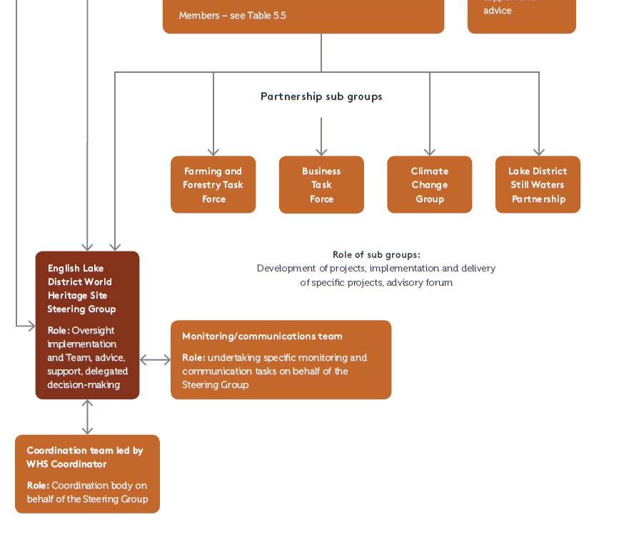
21 Following adoption of The Partnership s Plan The Management Plan for the English Lake District in December 2015, the Lake District National Park Partnership has taken over management responsibilities for the property and is progressing delivery of actions, monitoring progress against indicators, and using the plan to inform decisions to protect and manage the English Lake District. The Lake District National Park Partnership operates under a Memorandum of Understanding that has been agreed by all members of the Partnership (Appendix 1). The Partnership s Plan integrates the dual management plan requirements for the National Park and candidate World Heritage Site into the single Management Plan. This ensures all Partnership members look at the English Lake District holistically and that the overall strategic approach is consistent and appropriate for both World Heritage inscription and National Park designation. This multi-agency and organisation approach is used to provide an effective means of implementing protective measures through the statutory and discretionary responsibilities of these bodies. The key partners with statutory responsibilities are the Lake District National Park Authority, Natural England, Environment Agency, Forestry Commission, Historic England, United Utilities, Cumbria County Council, and four District Councils covering the nominated Site. In addition, the National Trust s powers to declare land inalienable and to hold it in perpetuity are based in statute law. This provides assurances to the future and on-going management of the Site. The Partnership s Plan includes a proposed structure for the inclusion of World Heritage site management at Vol. 1 Fig. 5.8 (see below).

22
23 3. Potential impact of development projects Moorside new nuclear power station There is a long history of nuclear power generation on the west coast of Cumbria which predates the establishment of the Lake District National Park. Construction of the first nuclear facility at Sellafield (originally named Windscale) started in 1947 and this was operational by October The National Park was created in The first of the four Magnox reactors subsequently built on the site was connected to the National Grid in 1956 and the later Windscale Advanced Gas cooled prototype reactor, built in 1962, was de-commissioned in In more recent years Sellafield was used for reprocessing and storage of nuclear materials and currently employs 10,000 people. Sellafield is the largest and most complex nuclear site in Europe and has co-existed alongside the protected landscape of the Lake District National Park over the last 70 years. The site of the proposed new nuclear power station at Moorside is immediately adjacent to the existing facility at Sellafield. The process through which Moorside was chosen as a potential site for a new nuclear power station goes back to 2006, when a review of energy policy reversed the UK government's opposition to building new nuclear capacity. To facilitate new nuclear build, from 2006 the UK government implemented several measures including streamlining the planning process and carrying out strategic siting assessment and strategic environmental assessment processes to identify and assess suitable sites for new nuclear plants. In January 2009 the UK government invited nominations for sites to be assessed for their suitability for the deployment of new nuclear power stations by As a result of this process, in October 2010, eight sites, including Moorside, were confirmed as suitable for development of nuclear power stations. The strategic selection of Moorside therefore predates both the availability and adoption of ICOMOS Heritage Impact Assessment methodology and occurred before the current nomination bid for World Heritage inscription for the English Lake District had been developed. The Moorside proposal is still in the early stages of planning and the details of design and other issues have not yet been agreed. In addition to a wider Environmental Impact Assessment, it is the intention of the applicant, NuGen, to carry out a Heritage Impact Assessment to investigate the potential impact on the attributes of OUV of the English Lake District candidate World Heritage site. While we understand concerns about the proximity of Moorside to the candidate World Heritage site, it is the professional judgement of both Historic England and the Lake District National Park Authority that the potential impacts of the development, as currently drafted, on OUV are limited and can be mitigated effectively. The outcomes of the Heritage Impact Assessment (HIA) will help to inform the detailed proposals that will be set out in the Development Consent Order application that will be submitted in due course by NuGen. The DCO process is specifically designed for National Strategic Infrastructure Projects, which are subject to rigorous scrutiny by the Planning Inspectorate which then advises the Secretary of State on the planning decision. The proposed Heritage Impact Assessment will inform a full range of mitigation measures if the new facility goes ahead.
24 North West Coastal Connections (NWCC) In our previous correspondence we confirmed that in October 2016 National Grid announced that its proposals for the new high voltage line on the western edge of the English Lake District will include undergrounding of all of the new transmission cables within the Lake District National Park and proposed World Heritage site. This will include the benefit of removing the existing 132kV, 26 metre high pylons and cabling, which have been in place since the mid-1950s, over a length of 23.6km. The estimated cost to National Grid of this mitigation will be in the order of 300 million. In addition, National Grid proposes to construct an under-sea tunnel across Morecambe Bay to take the cables south, thus avoiding the cables having to cross the southern part of the Lake District National Park. The estimated cost of the tunnel is 1.3 billion. National Grid has confirmed this mitigation through its inclusion in the proposals for the project which are subject to public consultation and will be included in the Development Consent Order application. Details can be found on National Grid s website: and in a newsletter. A public consultation was conducted by National Grid from 28 October 2016 to 6 January This was supported by an extensive Preliminary Environmental Information report which included an initial Heritage Impact Assessment for the candidate English Heritage World Heritage site. In their responses to the consultation, the statutory planning authorities, including the Lake District National Park Authority (LDNPA) along with Historic England, stated that the HIA was deficient as it was not preceded by a scoping exercise and it examined the impacts of the NWCC project on only a part of the first theme of OUV (i.e. the historic environment elements of the cultural landscape). In response, National Grid agreed to undertake a full HIA to cover all aspects of OUV. To begin this process, National Grid has developed a scoping report for this full HIA which has been agreed by Historic England and the LDNPA (see attached document Scoping Report for Heritage Impact Assessment for the North West Coastal Connections Project) and the work is currently programmed to conclude by the end of April The outcomes of the HIA and the extensive public consultation exercise will inform the detailed proposals that will be set out in the Development Consent Order (DCO) application that will be submitted in due course by National Grid. The DCO process is specifically designed for National Strategic Infrastructure Projects, which are subject to rigorous scrutiny by the Planning Inspectorate which then advises the Secretary of State on the planning decision. Submission of the DCO is currently planned for early summer however delays to this timetable are now anticipated. 4. Mining As we commented in our response letter of 11 November 2016, mining and quarrying over the last 1000 years of the diverse range of minerals from the English Lake District has been a traditional local economic activity and now forms an integral part of the
25 cultural landscape and is recognised as a component of OUV. In the English Lake District mining and quarrying date from at least as early as the medieval period and reached a peak in the 19 th century. A small number of individual metal ore mines survived into the late 20 th century but have all now closed. Quarrying, particularly for slate, also reached a peak in the 19 th and early 20 th centuries and the vast majority are now closed (see Appendix 2, Map 1). Fifteen quarries currently have planning consent but not all of these are active (see below and Appendix 2). They are important for providing local materials for the renovation and repair of historic buildings and for the appropriate construction of walls and roofs for new buildings (Appendix 2, Map 2). Loss of all active quarries could place at risk other attributes of OUV within the English Lake District since new materials from some of the quarries are required for their repair and maintenance (e.g. local farm buildings) in order to maintain their authenticity. Of the fifteen sites in the English Lake District where planning consent for quarrying has been given), twelve of these are slate quarries, 2 granite and one limestone (Appendix 2, Map 2). Although consent exists, not all of these quarries are active on a regular basis. The slate quarries in particular produce a range of different products and extraction occurs only when there is need. Five of the slate quarries operate on a regular basis (Brandy Crag, Broughton Moor, Bursting Stone, Elterwater, and Honister). Other slate quarries (High Fell, Brathay and Parrock) have been re-opened by local entrepreneurs on a very small scale or to reuse spoil from earlier quarrying activity. The sites at Moss Rigg, Peat Field, Petts and Spout Crag have planning consent but are currently inactive. The granite quarries at Shap Pink and Shap Blue and the limestone quarry at Shap Beck, all located on the eastern boundary of the National Park, are all currently active. Details of the locations and extents of these sites are provided in Appendix 2, Map 2. In our previous correspondence we outlined our Local Plan policies regarding the extraction of minerals which include Policy CS29: Mineral Extraction: We will permit mineral extraction in the National Park where: it is for the extension of an existing site or the reopening of an old site; and it meets a local need for building stone and slate: and it makes careful use of mineral resources including the effective use of secondary aggregates; and includes details which ensure sensitive environment restoration and aftercare of the site, including enhancement for biodiversity, geodiversity and landscape character and quality; and it supports the local economy and employment opportunities. In exceptional circumstances we will allow development proposals which cause an adverse impact on the special qualities of the National Park if the harm is outweighed by:
26 the need to maintain a supply of local building material which cannot be sourced from elsewhere and the loss of supply would result in the devaluing of the built fabric of the National Park; or the need to conserve nationally significant buildings, or demonstrating a national need for high purity limestone. In addition, national planning policy regarding mineral extraction in National Parks and other protected areas is outlined in the National Planning Policy Framework: 144. When determining planning applications, local planning authorities should: give great weight to the benefits of the mineral extraction, including to the economy as far as is practical, provide for the maintenance of landbanks of non-energy minerals from outside National Parks, the Broads, Areas of Outstanding Natural Beauty and World Heritage sites, Scheduled Monuments and Conservation Areas ensure, in granting planning permission for mineral development, that there are no unacceptable adverse impacts on the natural and historic environment, human health or aviation safety, and take into account the cumulative effect of multiple impacts from individual sites and/or from a number of sites in a locality ensure that any unavoidable noise, dust and particle emissions and any blasting vibrations are controlled, mitigated or removed at source 1, and establish appropriate noise limits for extraction in proximity to noise sensitive properties not grant planning permission for peat extraction from new or extended sites provide for restoration and aftercare at the earliest opportunity to be carried out to high environmental standards, through the application of appropriate conditions, where necessary. Bonds or other financial guarantees to underpin planning conditions should only be sought in exceptional circumstances not normally permit other development proposals in mineral safeguarding areas where they might constrain potential future use for these purposes consider how to meet any demand for small-scale extraction of building stone at, or close to, relic quarries needed for the repair of heritage assets, taking account of the need to protect designated sites recognise the small-scale nature and impact of building and roofing stone quarries, and the need for a flexible approach to the potentially long duration of planning permissions reflecting the intermittent or low rate of working at many sites The National Planning Practice Guidance contains the following: How should National Parks, the Broads, Areas of Outstanding Natural Beauty and World Heritage Sites plan for unconventional hydrocarbons? In considering applications for unconventional hydrocarbon development in National Parks, the Broads and Areas of Outstanding Natural Beauty, mineral planning authorities should give great weight to conserving their landscape and scenic beauty. These areas have the highest status of protection in relation to landscape and scenic
27 beauty, and the conservation of wildlife and cultural heritage in these areas should be given great weight. Where applications represent major development, planning permission should be refused in National Parks, the Broads and Areas of Outstanding Natural Beauty except in exceptional circumstances and where it can be demonstrated they are in the public interest. The assessment that needs to be carried out, including any detrimental effect on the environment, such as the noise and traffic which may be associated with hydraulic fracturing, is set out in paragraph 116 of the National Planning Policy Framework. World Heritage Sites are heritage assets of the highest significance. Where a proposed development for unconventional hydrocarbons would lead to substantial harm to or loss of a World Heritage Site, mineral planning authorities should refuse consent unless wholly exceptional circumstances apply. The test to be considered by mineral planning authorities is set out in paragraph 133 of the National Planning Policy Framework. Where appropriate, planning conditions can be imposed to ensure that development is made acceptable in planning terms before it can proceed. (National Planning Practice Guidance Paragraph: 223 Reference ID: ) 5. Buffer Zone Guidance on Buffer Zones is set out in paragraphs 103 to 107 of the 2015 World Heritage Operational Guidelines. Para 106 states that where no buffer zone is proposed, the nomination should include a statement as to why a buffer zone is not required. In the UK planning system, buffer zones only work if the relevant spatial plans include appropriate policies to protect the World Heritage property. In the case of the English Lake District, the nominated property is England s largest National Park, designated more than 60 years ago. It is protected by legislation and by robust spatial planning policies both in the National Park and in the surrounding authorities. The local authorities surrounding the Lake District National Park (see Appendix 3, Map 1) have a statutory obligation to have regard to the purposes of National Park designation when exercising or performing any functions in relation to, or so as to affect, land in the National Park. This has a direct bearing on their decisions as Local Planning Authority on applications for planning permission in their area which may affect the National Park (Environment Act 1995). Local authorities also have a duty as set out in the National Planning Policy Framework to cooperate on planning issues that cross administrative boundaries, including conservation and enhancement of the natural and historic environment, including landscape: 156. Local planning authorities should set out the strategic priorities for the area in the Local Plan. This should include strategic policies to deliver:
28 the homes and jobs needed in the area; the provision of retail, leisure and other commercial development; the provision of infrastructure for transport, telecommunications, waste management, water supply, wastewater, flood risk and coastal change management, and the provision of minerals and energy (including heat); the provision of health, security, community and cultural infrastructure and other local facilities; and climate change mitigation and adaptation, conservation and enhancement of the natural and historic environment, including landscape Public bodies have a duty to cooperate on planning issues that cross administrative boundaries, particularly those which relate to the strategic priorities set out in paragraph 156. The Government expects joint working on areas of common interest to be diligently undertaken for the mutual benefit of neighbouring authorities. (National Planning Policy Framework, 2012) There is also a duty on local planning authorities and public bodies to engage constructively, actively and on an ongoing basis to maximise the effectiveness of Local Plan preparation in the context of strategic cross boundary matters (Localism Act 2011). This is known as the duty to cooperate in plan making. The relevant sections of the Local Plans of the surrounding Districts affecting the Lake District National Park are included in Appendix 3. The LDNPA has longstanding consultation arrangements with its neighbouring local planning authorities who consult on applications for planning permission in proximity to the National Park boundary (other than minor proposals). The LDNPA responds on the basis of National Park considerations alone and its views are taken into account in the Districts decisions. The Districts decisions on individual proposals are supportive of our position and in the six decades since the creation of the Lake District National Park, these arrangements have worked effectively to protect it. The LDNPA also has the opportunity to review these consultation arrangements and if necessary revise them in the light of World Heritage Site designation. The World Heritage Site designation and the Attributes of Outstanding Universal Value are capable of being material considerations in the determination of applications by neighbouring local planning authorities, falling under the term heritage assets in the National Planning Policy Framework. There are thus two principal reasons why it is considered that there is no need for a buffer zone. These are outlined in section 5.b of the nomination dossier and further clarification is provided below.
29 Reason 1 Like many other IUCN Category V Protected Areas, the nominated Property is in itself of sufficient size (2,362 km 2 ) to act as its own buffer. Because the nominated Property follows the boundaries of the National Park, it will itself be big enough to prevent development that will have an adverse impact on the attributes of its proposed Outstanding Universal Value which are expressed across the whole of the site. UK planning policy (National Planning Policy Framework and Planning Practice Guidance) is quite clear about the importance of protecting the settings of World Heritage Sites. It notes that substantial harm or loss of heritage assets of the highest significance (including World Heritage Sites) resulting from development should be wholly exceptional : The National Planning Policy Framework states: When considering the impact of a proposed development on the significance of a designated heritage asset, great weight should be given to the asset s conservation. The more important the asset, the greater the weight should be. Significance can be harmed or lost through alteration or destruction of the heritage asset or development within its setting. As heritage assets are irreplaceable, any harm or loss should require clear and convincing justification. Substantial harm to or loss of a grade II listed building, park or garden should be exceptional. Substantial harm to or loss of designated heritage assets of the highest significance, notably scheduled monuments, protected wreck sites, battlefields, grade I and II* listed buildings, grade I and II* registered parks and gardens, and World Heritage Sites, should be wholly exceptional. (National Planning Policy Framework paragraph 132) Where a proposed development will lead to substantial harm to or total loss of significance of a designated heritage asset, local planning authorities should refuse consent, unless it can be demonstrated that the substantial harm or loss is necessary to achieve substantial public benefits that outweigh that harm or loss, or all of the following apply: the nature of the heritage asset prevents all reasonable uses of the site no viable use of the heritage asset itself can be found in the medium term through appropriate marketing that will enable its conservation conservation by grant-funding or some form of charitable or public ownership is demonstrably not possible the harm or loss is outweighed by the benefit of bringing the site back into use (National Planning Policy Framework paragraph 133) Where a development proposal will lead to less than substantial harm to the significance of a designated heritage asset, this harm should be weighed against the public benefits of the proposal, including securing its optimum viable use. (National Planning Policy Framework paragraph 134)
30 The Planning Practice Guidance describes how the setting of a World Heritage Site is protected. Each Local Planning Authority, which includes the Lake District National Park Authority and neighbouring District and County Councils are required to produce a Local Plan which sets out local planning policies and identifies how land is used, determining what will be built where. Development should be consistent with the National Planning Policy Framework. As such each Local Plan that lies within a World Heritage Site or may affect the setting of a World Heritage Site should apply the principles outlined in national policy and the Planning Practice Guidance. If Local Plans do not do this they are unlikely to be approved by the Planning Inspectorate which ensures that plans are compliant with national policy (see Appendix 3). Furthermore, it is considered that because the proposed English Lake District nominated boundary corresponds to the Lake District National Park boundary that this provides effective protection of the site and its setting. The Planning Practice Guidance states: When developing Local Plan policies to protect and enhance World Heritage Sites and their Outstanding Universal Value, local planning authorities, should aim to satisfy the following principles: protecting the World Heritage Site and its setting, including any buffer zone, from inappropriate development striking a balance between the needs of conservation, biodiversity, access, the interests of the local community, the public benefits of a development and the sustainable economic use of the World Heritage Site in its setting, including any buffer zone protecting a World Heritage Site from the effect of changes which are relatively minor but which, on a cumulative basis, could have a significant effect enhancing the World Heritage Site and its setting where appropriate and possible through positive management protecting the World Heritage Site from climate change but ensuring that mitigation and adaptation is not at the expense of integrity or authenticity Planning authorities need to take these principles and the resultant policies into account when making decisions. (Planning Practice Guidance paragraph 032) How is the setting of a World Heritage Site protected? The UNESCO Operational Guidelines seek protection of the immediate setting of each World Heritage Site, of important views and other areas or attributes that are functionally important as a support to the Property and suggest designation of a buffer zone wherever this may be necessary. A buffer zone is defined as an area surrounding the World Heritage Site which has complementary legal restrictions placed on its use and development to give an added layer of protection to the World Heritage Site. The buffer zone forms part of the setting of the World Heritage Site. It may be appropriate to protect the setting of World Heritage Sites in other ways, for example by the protection of specific views and viewpoints. Other landscape designations may also prove effective in protecting the setting of a World
31 Heritage Site. However it is intended to protect the setting, it will be essential to explain how this is to be done in the Local Plan. Decisions on buffer zones are made on a case by case basis at the time of nomination and reviewed subsequently through the World Heritage Site Management Plan review process. Proposals to add or amend buffer zones following inscription are submitted by government for approval by the World Heritage Committee who will consider and adopt the proposals as appropriate. (Planning Practice Guidance para 033) We believe that our current policy framework is sufficiently robust to manage and protect the attributes of OUV and future updates will reflect our learning about the English Lake District through the detail of the nomination document and the practicalities of managing a World Heritage site. Reason 2 National Parks are the highest level of landscape protection within the UK planning system and this is recognised in national spatial planning policy (see section 5.c of Volume 1 of the Nomination Dossier). Legislation (the 1995 Environment Act) requires all relevant authorities (including adjoining local planning authorities) to have regard to the purposes of National Park designation when exercising or performing any functions in relation to, or so as to affect, land in the National Park. This means that the neighbouring planning authorities must take into account, the need to conserve and enhance the natural beauty, wildlife and cultural heritage of the National Park when considering development proposals outside the Park boundaries. This is a statutory requirement enshrined in legislation. A map (Appendix 3 Map 1) of the neighbouring planning authorities identifies the areas where this statutory requirement may be applied if a proposal is deemed to affect the setting of the National Park. Many of these neighbouring planning authorities contain other designated landscapes including other National Parks and Areas of Outstanding Natural Beauty (Appendix 3 Map 1) both of which confer the highest level of landscape protection. As such the neighbouring planning authorities are experienced in dealing with development proposals that may affect these designated areas or their setting. These designations are also be considered to form another added boundary layer of protection to the setting of the proposed World Heritage site given national and local planning policy protection to such areas outlined in the National Planning Policy Framework and the Local Plans relating to relevant local planning authority areas. If development proposals are likely to have a significant adverse impact on the natural beauty, wildlife and cultural heritage of the National Park (together encompassing the attributes of proposed Outstanding Universal Value) then they should be refused. In the sixty years since the creation of the Lake District National Park, these arrangements have worked effectively to protect it, and we do not consider that is necessary to alter this arrangement by introducing a buffer zone for the proposed World Heritage site. Furthermore, all the neighbouring planning authorities are members of the Lake District National Park Partnership and are collectively committed to the project for inscription
32 and appropriate management, including the protection of OUV, of the proposed English Lake District World Heritage site. We considered whether it would be appropriate to identify a buffer zone in light of the existing protection drawn from the planning system and planning policy, and National Park designation. We concluded it would be impractical to draw a red line to define the setting of the candidate World Heritage Site given the large size of the proposed site and its landscape setting. Such a line would be entirely arbitrary unless it was drawn on the basis of a full view shed analysis - and this is likely to result in the definition of a huge area extending across an enormous part of northern England, the Solway and Irish Sea, and into South West Scotland. We firmly believe that more effective protection is delivered through the policy framework and partnership arrangements described above. 6. Tourism Management The Lake District receives just over 17 million tourists each year; 13 million day visits and, approximately 4 million staying overnight. As the National Park is relatively large (2,362 km 2 ), it has not been considered necessary to carry out capacity studies in relation to the impact of tourism on the entire site. However, monitoring of the impact on individual sites and infrastructure has been carried out and remedial action has been taken (e.g. footpaths see example below). The seasonal pattern of tourism has been studied and shows that the highest tourist numbers are concentrated in school holiday periods in the summer months (see Appendix 4). The need to manage visitor numbers in the busier parts of the English Lake District has been recognised for a long time, with high levels of car use and parking at localised pinch points being the main problem. Actions have been taken by members of the Lake District National Park Partnership to provide services and infrastructure to enable and encourage visitors to travel by other means, thus reducing the pressures. In addition, events and festivals which will attract visitors have been developed in Cumbria outside the National Park with the intention of spreading the economic benefit of tourism more widely. These include Taste Cumbria food festival in Cockermouth, the Kendal Mountain Festival and the Lakes Alive arts festival, also based in Kendal. The strategies for visitor management in the English Lake District can be found in the Lake District National Park Partnership s Plan (Volume 4 of the Nomination Document, 3.3.6, Visitor Movement) and within the Lake District National Park Local Plan, where a number of policies relate to encouraging sustainable travel and reducing the travel impacts of new developments. The Local Plan is currently under review and visitor movement is one area that has been highlighted for further work in order to protect the site and improve visitors experience. We have recently completed the first draft of the Access and Travel Main Issues Paper which will inform the review of policies.
33 The three projects summarised below provide examples of the work which we have implemented to manage visitor movement and provide more sustainable means of travel. GoLakes Travel and See More projects The GoLakes Travel ( ) and See More (2016-)) programmes are recent initiatives which were developed and implemented by a partnership between the Lake District National Park Authority (LDNPA), Cumbria County Council and Cumbria Tourism and funded by a grant from the UK Government (Department for Transport). Other partners such as the National Trust, local businesses and communities worked with us to deliver the projects to create a step change in the way visitors travel. The projects focused on the busier South and Central areas of the Lake District, and, in the final See More year, on the showcase corridors of South and Central Lakes, Ullswater and Dewentwater. Over 4 years between 2011 and 2015 GoLakes travel achieved the following: Created 50 miles of cycleway; Organised 81 guided cycle rides with British Cycling; Improved or created five bus services which carried 20,000 passengers in 2014 Introduced the innovative bike bus and bike boat; Built two new jetties on Windermere to encourage access by boat services rather than car; Provided low carbon or electric vehicles at nine locations. Between 2011 and 2014 these actions have contributed to a reduction in vehicle mileage in the Golakes Travel area of 14.5%, which equates to 4.8 million miles, and a 7.8% reduction in Carbon emissions from visitor travel, a saving of 41,000 tonnes CO 2 (well above the target set at the start of the programme of 11,000 tonnes Ref. Sustainable travel choices user survey, Red Research for the DfT, 2015) These figures are supported by the Cumbria Visitor Survey, which shows a decrease in the percentage of visitors who use the car as their main mode of transport within the Lake District from 73% in 2012 to 58% in 2015 (Ref. QA research for Cumbria Tourism, 2015) The See More legacy video can be seen here The Optimising Connectivity project A related initiative is the Optimising Connectivity project, which focuses on two congested parts of the Lake District - the Glebe at Bowness on Windermere and Town End, Grasmere. Town End has very high cultural significance as the location of The Wordsworth Trust and Wordsworth s former home of Dove Cottage. Optimising Connectivity aims to manage traffic and pedestrian flows to slow traffic speeds, facilitate more pedestrian movement and improve connectivity with the surroundings whilst improving the public realm. The works are of a high quality to match the significance of the landscape and culture of the surroundings. For example the Town End scheme incorporates Wordsworth quotations. The County Council led this project with input from the LDNPA, South Lakeland District Council, the Wordsworth Trust and local
34 communities. Funding was provided by the Cumbria Local Enterprise Partnership. More details can be found here. The Cross Lakes Experience This integrated bus and boat service was established in 2003 to enable visitors to reach the west shore of Windermere, Beatrix Potter s home at Hilltop and Hawkshead without using a motor vehicle. It was developed by a partnership between LDNPA, National Trust and the bus and boat operators (Mountain Goat and Windermere Lake Cruises). Beatrix Potter s former home of Hill Top is a well know cultural site, receiving 111,000 visitors in 2016, and one of the strategic aims of this service was to reduce traffic and parking issues around the site, which were creating problems for the community and damaging the visitor experience. The service has been developed to a point where it is now running seven months a year. Improvements to footpaths and cycle routes in this area have at the same time been delivered and form an integrated sustainable transport package that offers visitors an experience to tempt them out of their cars. More details can be found here In addition to the above, the National Trust has improved facilities around Wray Castle and the newly restored Claife Station in order to encourage visitors to leave their cars and use water transport and cycles. The culture of tourist water transport has a long history and is being sustained on Windermere and other lakes through the construction of new jetties at key locations and new initiatives such as the Cross Lakes Experience described above. Footpath maintenance and development The upland footpaths and bridleways of the English Lake District come under a lot of pressure from high numbers of walkers and in Britain the LDNPA and National Trust are acknowledged leaders in the field of footpath maintenance. Our Fix the Fells project, funded initially by the Heritage Lottery Fund and continued by volunteers, is a proven programme of path maintenance and restoration which has been running for over a decade. An important objective of the programme is raising public awareness of the issues of erosion and tourism. Management of individual sites with high visitor footfall The National Trust owns and manages a number of the most popular sites in the English Lake District which attract a high number of visitors and thus has a significant role in managing visitor flow and impact in the area. The National Trust s strategic approach to visitor management in the Lake District is based on a tiered planning structure which deals with factors affecting visitor impact and flow. At the top of this structure is the Visitor Experience Masterplan, completed in The objective of the Masterplan is to alleviate visitor pressure and enhance visitor experience while conserving both heritage assets and the natural environment.
35 The Masterplan currently identifies five key National Trust sites with the potential for growth in order to reduce load on other sites already at capacity. The five sites include Fell Foot and Sizergh Castle and opportunities are being sought to spread growth both seasonally and geographically. Busier sites include Beatrix Potter s residence at Hill Top, Sawrey and the Statesman s farm at Town End, Troutbeck, both of which have already been identified as at or over capacity. Here, opportunities are sought to spread visitor load to other sites and to modify the operation of these sites so that the impact of high visitor numbers is reduced. Sites within the scope of the Visitor Experience Masterplan are assessed in more detail using a proven National Trust planning methodology called Master planning. This involves making an holistic and multi-disciplinary assessment of the site in order to identify options for sustainable growth, constraints, and conservation risks and opportunities. Master planning also includes business modelling, visitor flow, car parking, catering as well as an assessment of the number of discreet components which form a visit to the site. The National Trust's market and survey analysis is a principal tool in this respect, allowing the direction of resources to encourage those more likely to visit out of main season, or in poor weather. The outcomes of master planning can, and often do include, enhanced seasonal programming and marketing, changes to visitor routes, appropriate enhancements to car parking and ticketing models. The master planning process at Hill Top will assess opportunities to spread the load of visitors but not increase overall numbers. Visitor facilities, timed ticketing and visitor route will be analysed in this process and it is likely that a more linear route through the property, avoiding double backs could significantly reduce foot fall in higher impact areas. Conversely Fell Foot, a former Country Park has been identified as a place with potential for sustainable growth, in this case within a Heritage Lottery funded restoration project to restore and enhance the landscape of the former historic villa landscape. Here master planning has involved assessing and much improving car connectivity with water transport on the lake and improved covered catering in order to widen seasonal use. The LDNPA, water tour providers and the Lakeland Arts Trust are key partners. Raising awareness of the problems of visitor pressure and encouraging behavioural change Both the LDNPA and National Trust, along with other partners, have core purposes to educate visitors about the significance of the English Lake District and the importance of conserving it. This is undertaken through various mechanisms including arts programming and events. An example is the National Trust s event programme for 2018, called The Great Gift, which is based on the gift of Scafell Pike and other peaks to the National Trust as a war memorial after the First World War. In addition to celebrating the England's highest mountain as a place of reflection and peaceful enjoyment, the
36 programme will also seek positively to engage with visitors over appropriate behaviour in the fragile upland environment of the English Lake District. This adds a cultural and educational element to the infrastructure plans designed to alleviate tourist pressure. The possibilities of raising funds from tourism to support conservation of the English Lake District are being developed. The Lake District Tourism and Conservation Partnership was established in 1994 by a partnership of tourism businesses to collect donations from visitors for conservation work. Rebranded in 2008 as Nurture Lakeland in order to recognise the challenge of climate change and to promote responsible tourism, the organisation has collected substantial funding for conservation initiatives ( 112,000 in ). Nurture Lakeland has just begun consultations on a further development, inspired by the possibility of World Heritage inscription, to develop as the Lake District Foundation, a re-formulated organisation designed to approach the visiting pubic directly, including international visitors, through new initiatives such as crowdfunding. Local communities involvement Farming Agri-environment schemes, co-funded by the European Union and the UK Government, since 1993, have recognised and contributed to the cost of the heritage services in the care of the cultural landscape provided by farmers. This has included, for example, funding for the physical maintenance of the cultural landscape, such as repair and maintenance of drystone walls and traditional farm buildings. The first major agri-environment grant scheme (the Environmentally Sensitive Area Scheme ESA) which ran from 1993 until 2004, provided substantial grants for repairs to over 1,000 traditional farm buildings. In the period the value of this work was 6.2 million see The succeeding agri-environment grant scheme Environmental Stewardship which ran from 2005 to 2014, provided total grant of 152 million to farmers in the English Lake District in return for a range of environmental and conservation services. The UK Government have guaranteed the continued funding of these schemes until 2020, following the anticipated UK exit from the European Union in After 2020, the UK Government will establish a new domestic agricultural policy, including decisions on levels, targets and mechanisms for financial support. Amongst stakeholders nationally there has been initial discussion around future funding following the principle of public payments for public benefits. The Lake District National Park Partnership is supportive of this approach and believes that the Lake District has a strong case to make on public payments for public benefits, based on the Lake District s Special Qualities and the World Heritage Attributes of Outstanding Universal Value, in
37 particular the cultural heritage value and the cultural landscape benefits of Lake District hill farming systems, including commons management. The Lake District National Park Authority and Historic England have been in initial discussions about their interest in proposing the Lake District as a national pilot for how post-2020 farming policy and funding could work to support cultural landscape benefits. Other policies and programmes that recognise and support farmers caring for the cultural landscape include some Heritage Lottery funded projects, for example, the Fell Futures Apprenticeship Scheme, training young people in cultural landscape management skills. We currently do not expect agricultural activity to intensify across the Lake District. Individual businesses may intensify production, but these are likely to be the exception to the rule. The Lake District National Park Partnership s strategy is to enable farm businesses to thrive without needing to intensify through a combination of: helping farmers to optimise the value of their marketable livestock products and increase business efficiency; enabling appropriate on farm diversification into tourism, food processing and other small-scale enterprises; encouraging participation in agri-environment schemes; developing the potential of non-publicly funded payments for ecosystem service mechanisms, for example through private sector investment into carbon sequestration through peatland and woodland management; developing a diverse and thriving local economy to enable off-farm earning to support farming household incomes. Local initiative to support farming businesses Breakthrough Action 5a in the Lake District National Park Partnership s Plan is to Develop, agree and implement coordinated initiatives to achieve a more profitable and sustainable future for the Lake District, its farmers, foresters, land managers and its cultural landscape. Various partner organisations are working on this action, led by the LDNPA, with an objective to complete by March 2020 and include development of new and alternative funding streams to those provided through the European Common Agricultural Policy. The LDNPA has been leading nationally on the development of a Payment for Ecosystem Services project, where private investment is secured from private businesses to help pay for the other ecosystem services delivered by land management other than food. The initial focus for this has been the sale of carbon because this is currently the most well-developed market and system. However, research has been undertaken into the sale of other ecosystem services using the same principles. Proof of concept has been achieved through the establishment of a 15ha woodland in Eskdale, which was part-funded by a private investment from London-based company ICAP, who
38 purchased the carbon that woodland will store over the next 60 years. The LDNP Partnership s intervention was fundamental in making this happen, acting as a broker between landowner/agent and the investor/sponsor. It is intended that this programme of initiatives will continue to be delivered beyond The Herdwick Sheep Breeder s Association recently established Lakeland Herdwick as a food with European Protected Designation of Origin (PDO) status. This was an opportunity to add a premium through developing a niche market around Herdwick meat, as well as raising its profile and promoting its qualities. As a result of the designation some Herdwick farmers have established new markets, particularly in London, where the meat is sold at a premium price, linked to the production of its location and associated diet. The LDNPA is currently working with the Herdwick Sheep Breeder s Association to look at opportunities to support the continuation of the PDO status and increase the promotion of the Herdwick meat through this designation. The LDNP Partnership has an annual carbon budget, and recognises that food, drink and accommodation contributes 11% of the CO 2 emissions generated from within the Lake District National Park area. As a result we have designed a large project (Lake District on a Plate), which would help address issues in the supply chain and provide marketing support and specialist advice to tourism businesses selling food/drink as well as to local producers of food and drink. Some funding was achieved (March 2015) for research for the project and to produce additional evidence and recommendations and further funding is now being sought for implementation. In conclusion, we consider the possibility of World Heritage inscription to be immensely important for ensuring that future farm support policies, grant schemes and initiatives including the Herdwick PDO recognise and support farming as key to the maintenance of the Lake District cultural landscape. Local communities involvement Involvement in the nomination process The Lake District National Park Partnership includes elected members of the various local government bodies that cover the English Lake District County Council, District Councils and Parish Councils - (see Annex 2 of the Lake District National Park Partnership Memorandum of Understanding in Appendix 1). The Partnership has officially endorsed the English Lake District World Heritage Nomination bid and thus there is direct representation of the local community in the bid process. In addition, the Lake District National Park Partnership s Plan, the joint management plan for the National Park and candidate World Heritage site, which is a statutory document, was subject to formal public consultation in 2014/15. We segment our community into four categories; residents, farmers, businesses and visitors. We have had extensive programmes of engagement about the bid with all four categories over many years. For example, with residents, we have regularly attended parish council discussions and have held evening events in areas across the park, which have given residents the chance to speak to us about the bid. For businesses, the


39 Partnership s Business Task Force has been actively engaged in the process and is currently working to identify potential economic opportunities associated with World Heritage Inscription. We have also spoken to business groups, such as the major hoteliers group and Local Enterprise Partnership. In relation to farmers, we have worked with our Farming and Forestry Task Force to inform and engage its members with the bid and we have been active at a number of agricultural shows (see below). There have been various initiatives over the long period of developing the World Heritage bid for the English Lake District to inform and involve the local community. For example for two months in 2008 a mobile exhibition on the World Heritage bid was installed in an articulated truck and taken around the towns and villages of the Lake District. 34 locations were visited both within the Lake District and in surrounding settlements. This was accompanied by workshops and competitions designed to involve children and young adults. Fig. 1 Lake District World Heritage Project mobile exhibition at Grasmere, May 2008 The current World Heritage communications programme, which has been running since 2014, has also included initiatives to involve local people and gauge their opinion about the bid. The World Heritage communications team have attended key local shows and events over the last two years (including Grasmere and Ambleside Sports, the Keswick and Kendal Mountain Festivals and the Westmorland Show) and have distributed
40 questionnaires on the World Heritage bid which included questions on awareness of the bid and support for it. The number of completed feedback forms from those identifying as local residents was 308 in 2015 and 574 in 2016 and the percentage of local respondents supporting the World Heritage bid for the English Lake District was 89% in 2015 and 88% in In addition to this, we have developed and distributed a World Heritage pack for local schools, worked with Lakeland Radio on a series of monthly slots - 80 seconds in the Lakes referencing the WH bid and we have also undertaken an extensive programme of talks on the bid to local societies and amenity groups. Our Lake District World Heritage website has had over 23,000 users since March 2015 and we have reached over 7 million people using social media.
 is entered into by the parties contained in Annex 1 (as may be reviewed from time to time) who will collectively act")
41 APPENDIX 1: MEMORANDUM OF UNDERSTANDING FOR THE LAKE DISTRICT NATIONAL PARK PARTNERSHIP (included as Appendix 7 in the Nomination Document Vol. 4, Partnership s Plan) 1. The Partners MEMORANDUM OF UNDERSTANDING This Memorandum of Understanding ( MOU ) is entered into by the parties contained in Annex 1 (as may be reviewed from time to time) who will collectively act as the Lake District National Park Partnership ( the Partnership ). 2 Purpose & Vision 2.1 This MOU outlines the purpose and structure of the Partnership and establishes a commitment towards good practice in the way the Partners work with each other. It is an opportunity for the Lake District and Cumbria to celebrate its approach to joint working in the region and beyond. 2.2 The vision for the Lake District National Park ( the Lake District ) as developed by the Partners is: The Lake District will be an inspirational example of sustainable development in action, a place where a prosperous economy, world class visitor experiences and vibrant communities all come together to sustain the spectacular landscape, its wildlife and cultural heritage. Local people, visitors and the many organisations working in the National Park or have a contribution to make to it, must be united in achieving this. ( the Vision ) 2.3 This MOU is not a contract. It is a ways of working document which provides the overarching framework for the activities of the Partnership. It sets out the functions of the Partnership and the relationship between it and the Partners to ensure the efficient and effective implementation of the Vision. 2.4 This MOU does not affect the statutory role and function of the Partners and builds on the existing working relationships between the Partners.
42 2.5 This MOU recognises section 62 of the Environment Act This requires the Lake District National Park Authority and any Partner who is a public body, statutory undertaker or a person holding a public office to have regard to the statutory purposes of conserving and enhancing the natural beauty, wildlife and cultural heritage of the National Park and promoting opportunities for the understanding and enjoyment of the special qualities of those areas by the public while fostering the economic and social well-being of local communities when exercising or performing any functions affecting the Lake District National Park. The Partners must attach greater weight to the purpose of conserving and enhancing the natural beauty, wildlife and cultural heritage of the area where there is a conflict between purposes. 2.6 This MOU is not legally binding on any Partner and the detailed working arrangements of the Partnership may be changed by agreement of the majority of Partners. 2.7 The Partners will work together to review and agree the overall vision for the National Park, the special qualities and key delivery aims every five (5) years. They will also agree an annual action plan that achieves both the Vision and the delivery aims of the Partnership. The Partnership is entitled to agree strategic position statements, particularly in relation to priority action areas. It is intended that the Partners will pursue these aims as far as practical, bearing in mind their own legal requirements, organisation s objectives and strategic framework of operation. 2.8 The Partnership aims to capture a genuine enthusiasm amongst the Partners to resolve conflict, reduce duplication and work together towards achieving the Vision. 3 Duration 3.1 This MOU will run from 17 June 2013 until either it is amended or it is terminated by the Partners. 3.2 Every five years this MOU and the Partnership s values will be reviewed by the Partners and amended if appropriate. 4 Role and Function of the Partnership 4.1 The Partnership will: Develop, agree, and continuously review, the Vision by engaging others; Develop, agree and monitor a rolling five year management plan for the Lake District National Park ( the Partnership s Plan ), with clear priority actions, outcomes and success measures, ensuring agreement and participation by all
43 Partners; and Provide strategic advice and recommendations to the Partners in creating, monitoring and reviewing policies for developing and managing the National Park and issues related to its future. This will include regularly reviewing the Partnership Plan, the Local Plan for the National Park and the State of the Park Report. 4.2 This will be achieved through the values of the Partnership: Trust, openness and integrity Working together to achieve excellence Adding value, and inspiring change Being creative and ensuring connectivity Demonstrating a willingness to learn Advocating success Ensuring a commitment to deliver 4.3 The Partners will encourage and facilitate effective working relationships between each other in those topics relevant to the delivery of the Vision. 4.4 The Partners agree to: collaborate and co-operate. Establish and adhere to the governance structure set out in this MOU to ensure that activities are delivered and actions taken as required; be accountable. Take on, manage and account to each other for performance of the respective roles and responsibilities set out in this MOU; be open. Communicate openly about major concerns, issues or opportunities relating to the Partnership; learn, develop and seek to achieve full potential. Share information, experience, materials and skills to learn from each other and develop effective working practices, work collaboratively to identify solutions, eliminate duplication of effort, mitigate risk and reduce cost; adopt a positive outlook. Behave in a positive, proactive manner; adhere to statutory requirements and best practice. Comply with applicable laws and standards including EU procurement rules, data protection and freedom of information legislation; act in a timely manner; manage stakeholders effectively; deploy appropriate resources. Ensure sufficient and appropriately qualified resources are available and authorised to fulfil the responsibilities set out in this MOU and the Partnership s Plan; and
44 act in good faith to support achievement of the Partnership 5 Legal Status & Enforceability 5.1 The Partnership is an un-constituted body. Its operation and work programme will be agreed by a committee comprising representatives from the Partnership ( Partnership Committee ) as referred to within Clause 6 below. 5.2 Nothing in this MOU shall constitute a legal agreement or the formation of a partnership as recognised under the Partnership Act 1890 between the parties and no Partner shall be entitled to enforce any rights or liabilities against any other Partner in relation to any issues arising under this MOU. 6 Partnership Committee 6.1 The Partnership Committee shall be represented by the members contained in Annex 2 (as may be reviewed from time to time): 6.2 The Chair of the Committee will be an independent person appointed by an appointment panel made up of three Partners including the Lake District National Park Authority ( LDNPA ). The position will be advertised and no representatives or members of the Partners may apply. The Chair will be appointed for a period of three years or until they resign or are removed by a vote of no confidence by the Partners, whichever is sooner. The number of times an independent person may be appointed as Chair is limited to two terms, unless under exceptional circumstances by Partnership agreement. 6.3 The Vice-Chair of the Committee will be the Chairman of the Lake District National Park Authority. 6.4 The Committee will meet together for the dispatch of business. They will adjourn and regulate their meetings as they see fit. They will usually meet quarterly, but in any event will meet at least once a year. 6.5 Each Partner will have one vote even though they may have more than one representative on the Committee. 6.6 The Partnership may invite any organisation to be a member of the Partnership. The application must be supported by two existing members. Any new member will be invited to have a representative sit on the Committee. The Committee may appoint any other person it feels appropriate to sit on the Committee. Any representative appointed under this clause will have the same role, responsibility and voting rights on the Partnership Committee as the existing Partners. 6.7 Decisions reached by the Committee will be reached by a majority of votes. In the case of an equal number of votes being cast, the Chair of the Committee
45 shall be entitled to a casting vote. 6.8 The quorum for a meeting of the Committee will be 30% of the Committee membership and there will be no quorum unless the LDNPA member or a nominated representative of the LDNPA is present in person. 6.9 Whenever a private sector Committee member has a financial interest or a public sector Committee member has a disclosable pecuniary interest (as defined in The Relevant Authorities (Disclosable Pecuniary Interests) Regulations 2012) in a matter to be discussed at a Partnership Committee meeting (or a sub-committee or task and finish group) the Committee member will: (i) (ii) Declare such an interest before any discussion begins on the matter; and Unless the Partnership Committee resolves otherwise Withdraw from the meeting for that item Not be counted in the quorum for that part of the meeting Not be entitled to vote on the matter 6.10 The Committee may conduct its business through sub-committees or task and finish groups provided that: (i) The sub-committee or task and finish group has been agreed by a meeting of the Partnership Committee; (ii) Each sub-committee or task and finish group is chaired by a member of the Partnership Committee. 7 The Relationship between the Partnership & the LDNPA 7.1 Whilst the LDNPA established the Partnership, it is an equal partner. The Partners recognise that the LDNPA has specific responsibilities to develop and monitor the Partnership Plan and the Local Plan for the National Park and to produce a State of the Park Report. These are critical documents in achieving the Vision and the Partners will provide collective advice on these documents. 7.2 The LDNPA facilitates the Partnership. This is coordinated by a dedicated Partnership support team ( Partnership Support Team ) made up of people employed by the LDNPA. The Partnership Support Team will work closely with all Partners and the Chair of the Partnership Committee to ensure effective partnership working. The Partnership Support Team shall provide a management and administrative resource that will: Coordinate Partnership meetings, prepare agendas and minutes Deal with any communication by , website links, letter and e-news relating to the Partnership Facilitate the preparation of the Partnership s Plan, its annual review together with its associated monitoring
46 Produce monitoring reports, annual reports and the State of the Park Report Facilitate other specialist sub groups Deal with Partnership responses to local, regional and national consultations, topics or issues 8 Communications Protocol 8.1 All Partners are responsible for communication of the Partnership s work both internally (within partner organisations) and externally (to their networks and audiences outside). 8.2 Communication between Partners includes consulting with their organisation and networks on the work of the Partnership and communicating decisions and achievements on issues relating to people living, working and visiting the National Park. 8.3 The Partnership Support Team will produce a general communication plan to guide the Partnership on issues relating to general communication. This will be reviewed and updated annually. The Partnership Support Team will also produce a communication guide, intended as a checklist to aid communication of all Partners. 9 The Partnership s Plan & Managing Performance 9.1 To make progress towards delivering the Vision, the Partnership is committed to updating and monitoring the progress and delivery of the Partnership s Plan by considering performance indicators and delivery of actions within the Partnership s Plan. Every Partner involved in the delivery of the Partnership s Plan is responsible for ensuring effective updating of the actions and performance indicators. Each Partner will understand and manage risks to delivering the Partnership s Plan. 9.2 The Partnership will agree a monitoring cycle for the Partnership s Plan, revolving around the meetings of the Partnership and the requirement for review of the Partnership s Plan. 9.3 The Partnership Plan sub group leads the monitoring and review process. This group is made up of nominated Partners for each of the Vision themes, as well as other interested Partner organisations. The sub group is open for any Partner to join. 9.4 All Partners agree to share relevant data with each other. This data will be used to monitor delivery of the Partnership s Plan, the setting of priorities and recording progress towards the Vision. 9.5 Poor performance (including lack of updates from Partners) will be highlighted as part of the monitoring process. Challenge by the Partnership of individual
47 Partners, based on an adoption of the values, is encouraged. 9.6 Success will be highlighted as part of the monitoring process and all Partners will promote success via their own networks. 9.7 he Partnership will produce the following reports to record and help manage performance: An annual monitoring report will capture progress on delivery of actions from the Partnership s Plan An annual report, will summarise the overall performance of the Partnership (including delivery of the Partnership s Plan) An annual State of the Park Report will include data which captures the condition and health of the National Park against key indicators. These key indicators will inform the Partnership whether the achievement of the Vision is being realised on the ground. 10 Scrutiny and Improvement 10.1 The Partnership is committed to reviewing the way it functions as an entity. Scrutiny and improvement will help the Partnership remain relevant and effective, having the greatest impact to achieve the Vision The Partnership will review and develop an Improvement Plan for the Partnership at least every 3 years Independent scrutiny of the Partnership will take place every five years through the existing National Park Authorities Performance Assessment (NPAPA) peer review process or any other process that replaces it. 11 Partnership & Financial Accountability 11.1 Partners are accountable to each other, to other relevant organisations and to those people who live, work, and visit the National Park. Accountability depends upon effective communication and the openness of the Partnership s processes and meetings. Minutes of the meetings, agendas, reports, delivery plans and newsletters are available either on the website ( or from the LDNPA Partnership Committee members are accountable for the commitments they make to the Partnership on behalf of their Partner organisation. They provide feedback on those commitments, on the business of the Partnership and on their organisation s achievements relating to the Vision to their Partner organisation. A Partnership communication guide is available for all Partners If the Partnership is in a position to manage financial resources, the Partnership will appoint an accountable body for those resources.
48 12 Assurance 12.1 The Partners will promptly do all things which may be reasonably required for the purpose of giving full effect to the Partnership Plan. 13 Variation and Waiver 13.1 No variation of this MOU will be valid unless it is in writing and signed by or on behalf of each of the Partners The Partners cannot assign or in any other way dispose of the MOU or any part of it to any person, firm or company. 14 Intellectual Property Rights 14.1 All intellectual property rights in any information or material that is produced by one Partner to the other Partners or to the Partnership will remain the property of the Partner that owns such intellectual property rights prior to such an introduction Each Partner grants an irrevocable licence to the other Partners to use their intellectual property for the purposes of the Partnership. 15 Information 15.1 The Partners acknowledge that the LDNPA and other public sector partners are subject to the requirements of the Freedom of Information Act 2000 (FOIA) and the Environmental Regulations 2004 (EIR). The Partners shall assist and cooperate with the LDNPA and public sector partners where necessary to comply with these requirements The Partners shall provide all necessary assistance to enable any public sector partner to respond to a request for information within the time for compliance and if requested to will permit the public sector partner to inspect such records as they may require to comply with the request. 16 Limitations of Liability 16.1 The Partners total liability arising under, or in connection with the MOU, whether in tort (including negligence or breach of statutory duty), contract, misrepresentation, restitution or otherwise, shall be limited to 1 (One Pound) A Partner will not be liable to other Partners for any direct, special or consequential loss or damage; or any loss of profits, turnover, business opportunities or damage to goodwill (whether direct or indirect). 17 Termination
49 17.1 The Partnership may require (a) Partner(s) to leave the Partnership by notice in writing with immediate effect with no liability to the Partner(s) where: (i) (ii) (iii) (iv) A Partner undergoes a change of control, within the meaning of Section 416 of the Income and Corporation Taxes Act 1988 which impacts adversely and materially on the Memorandum or the Project; or A Partner becomes insolvent, bankrupt, enters into liquidation, enters into a voluntary arrangement, appoints a receiver or such similar event in any jurisdiction save for the purposes of a solvent reconstruction or amalgamation; or A Partner is guilty of any fraud or dishonesty or acts in any manner which in the opinion of the Partners is likely to bring the Partners into disrepute or is materially adverse to the interests of the Partners; or A Partner suffers or allows any execution, whether legal or equitable, to be levied on its property or obtained against it, or is unable to pay its debts within the meaning of Section 123 of the Insolvency Act 1986 or the Partner ceases to trade 17.2 Without prejudice to any other rights or remedies which Partners may have, a Partner may leave the Partnership by giving one months written notice to the other Partners Upon leaving the Partnership in accordance with Clause 18, the leaving Partner shall return any information or materials it holds to the Partner that provided the information. 18 CONTRACTS (RIGHTS OF THIRD PARTNERS) ACT The Partners do not intend that any term of the MOU shall be enforceable by virtue of the Contracts (Right of Third Partners) Act 1999 by any person that is not a party to it. 19 GOVERNING LAW 19.1 This MOU and all disputes or claims arising out of or in connection with the activities of the Partners shall be governed by and construed in accordance with the law of England. SIGNED on behalf of ACTION WITH COMMUNITIES IN CUMBRIA SIGNED on behalf of ALLERDALE BOROUGH COUNCIL
50 SIGNED on behalf of COPELAND BOROUGH COUNCIL SIGNED on behalf of COUNTRY LAND AND BUSINESS ASSOCIATION SIGNED on behalf of CUMBRIA ASSOCIATION OF LOCAL COUNCILS SIGNED on behalf of CUMBRIA COUNTY COUNCIL SIGNED on behalf of CUMBRIA TOURISM SIGNED on behalf of CUMBRIA WILDLIFE TRUST SIGNED on behalf of EDEN DISTRICT COUNCIL SIGNED on behalf of ENGLISH HERITAGE SIGNED on behalf of ENVIRONMENT AGENCY SIGNED on behalf of FORESTRY COMMISSION SIGNED on behalf of FRIENDS OF THE LAKE DISTRICT SIGNED on behalf of LAKE DISTRICT LOCAL ACCESS FORUM SIGNED on behalf of LAKE DISTRICT NATIONAL PARK AUTHORITY SIGNED on behalf of LAKE DISTRICT NATIONAL PARK PARTNERSHIP S BUSINESS TASK FORCE SIGNED on behalf of LOCAL ENTERPRISE PARTNERSHIP, CUMBRIA SIGNED on behalf of NATIONAL FARMERS UNION SIGNED on behalf of NATIONAL TRUST SIGNED on behalf of NATURAL ENGLAND SIGNED on behalf of NURTURE LAKELAND SIGNED on behalf of ROYAL SOCIETY FOR THE PROTECTION OF BIRDS SIGNED on behalf of SOUTH LAKELAND DISTRICT COUNCIL SIGNED on behalf of UNITED UTILITIES SIGNED on behalf of UNIVERSITY OF CUMBRIA ANNEX 1 THE PARTNERS
51 1. Action with Communities in Cumbria 1. Allerdale Borough Council 1. Copeland Borough Council 1. Country Land and Business Association 1. Cumbria Association of Local Councils 1. Cumbria County Council 1. Cumbria Tourism 1. Cumbria Wildlife Trust 1. Eden District Council 1. English Heritage 1. Environment Agency 1. Forestry Commission 1. Friends of the Lake District 1. Lake District Local Access Forum 1. Lake District National Park Authority 1. Lake District National Park Partnership s Business Task Force 1. Local Enterprise Partnership, Cumbria 1. National Farmers Union 1. National Trust 1. Natural England 1. Nurture Lakeland 1. Royal Society for the Protection of Birds 1. South Lakeland District Council 1. United Utilities 1. University of Cumbria ANNEX 2 PARTNERSHIP COMMITTEE MEMBERS Organisation South Lakeland District Council Membership 1x member, 1x officer
52 Eden District Council Copeland Borough Council Allerdale Borough Council 1x member, 1x officer 1x member, 1x officer 1x member, 1x officer Cumbria County Council Lake District National Park 1x member, 1x officer 1x member, 1x officer Cumbria Association of Local Councils 1x Parish Councillor, 1x officer Cumbria LEP 1x representative Business Task Force Cumbria Tourism 1x representative 1x representative, 1x member University of Cumbria Cumbria Wildlife Trust Natural England English Heritage Forestry Commission Environment Agency Royal Society for Protection of Birds United Utilities Nurture Lakeland National Trust Country Land and Business Association 1x representative 1x representative 1x representative 1x representative 2x representatives 1x representative 1x representative 1x representative 1x representative 1x representative, 1x member 1x representative
53 National Farmers Union Friends of the Lake District Action with Communities in Cumbria Lake District Local Access Forum 1x representative 1x representative 1x representative 1x representative


54 APPENDIX 2: QUARRIES IN THE ENGLISH LAKE DISTRICT Map 1. Historical mines and quarries as a component of the cultural landscape of the English Lake District
55 Map 2. Quarries with planning consent in the English Lake District.


56
57 1. Brandy Crag Quarry Application Location Proposal Applicant Decision Date Expiry date Extent (ha) 7/2011/5485 Low Brandy Crag Quarry, Coniston Extension to slate quarry Burlington Slate Ltd Approved with Conditions 12 December November 2026 Lateral extension of 0.25ha. 2.2 ha overall Low Brandy Crag Quarry was reopened in 1982 following grant of planning permission 7/1982/5321. The quarry was further extended following grant of a subsequent permission (7/1984/5518) which expired in A further permission was granted in 1989 (7/1988/5158) for a 10 year period expiring in February An application was received prior to the expiry date to extend the life of the permission (7/1999/5087), which appears to remain undetermined. In 2001 temporary consent (7/2001/5351) was again granted for further extraction and restoration works. This presented a consolidated scheme of working and restoration for the quarry. 2. Brathay Quarry Application Location Proposal Applicant Decision Date Expiry date Extent (ha) 7/1997/5182 Near Pullwoods, Outgate Application for determination of conditions Kirkstone Quarries Ltd Temporary Consent granted 20 March February 2042 Intermittent, small scale use. Brathay Quarries are a series of small quarries and rock outcrops which are situated 2.5 km south east of Skelwith Bridge, halfway between Ambleside and Hawkshead. The site displays the Brathay Flags, which represent almost the whole of the Wenlock in the Lake District (and the Howgill Fells), the only other lithostratigraphic units of this age in this area being the Lower and Middle Coldwell Beds Site of Special Scientific Interest (SSSI) notified under Section 28 of the Wildlife and Countryside Act, Site purchased in 2012 by Burlington Slate Ltd to add to their portfolio. 5.3 ha 3. Broughton Moor Quarry Application Location Proposal Applicant Decision Date Expiry date Extent (ha) 7/1998/5229 Broughton Moor Quarry Application for determination of new conditions Burlington Slate Ltd Temporary consent granted 15 Apr February ha
58 Original planning consent dates from Bursting Stone Quarry Application Location Proposal Applicant Decision Date Expiry date Extent (ha) 7/1998/5567 Bursting Stone Quarry, Coniston Old Man Quarrying of slate Burlington Slate Ltd 1.3 ha Permission was granted in 1952 to Mandell s Slate Company Ltd to extract 2,000 tons of roofing slate per annum (NL 1/4/98), followed by further permissions in 1959 and 1960 (NL/ ) and in 1964 (NL 1/4/4268). Permission was granted for further working to the north east of the main quarry in 1980 (7/78/5793) and to the north west in 1986 (7/85/6135) In 1997 a single consolidating application was made to cover all matters relating to the working of the quarry (including the determination of new conditions under the 1995 Environment Act) 5. Elterwater Quarry Application Location Proposal Applicant Decision Date Expiry date Extent (ha) 7/2014/5739 Elterwater Quarry, Great Langdale, Ambleside, Cumbria, LA22 9HY Proposed extension of working areas, time extension for aggregates production and amended scheme of working Burlington Slate Ltd Approve with conditions 10 February February ha overall. Extension of 0.62ha (less than the previous approved area of 0.81ha) Elterwater Quarry is a long established minerals site for the winning and working of slate located to the south west side of Elterwater and the Great Langdale Beck. Planning permission 7/1997/5336 permits the quarrying and mining of slate as well as all incidental operations until 21 February This application was a notice of determination of conditions which reviewed all the previous relevant planning permissions on the site. Within that application an overall site boundary was shown as well as approved areas for slate extraction and production. Detailed restoration proposals for the tips under conditions 17, 20 and 21 were approved by letter from the LDNP on 7 February The production of aggregate from the unsuitable rock on the western part of the site, the main tip, was originally granted planning permission under 7/2002/5486. An extended time limit for aggregate production was subsequently granted under 7/2007/5637. This planning permission expires on 31 December /2014/5739 provides for an extension of the working area of the quarry and an amended scheme of working, a time extension for
59 the aggregates production and amended restoration proposals. The area that cannot now be worked amounts to some 0.81 hectares, so this proposal represents a lesser area to be quarried, but in a different place. 6. High Fell Application Location Proposal Applicant Decision Date Expiry date Extent (ha) 7/1998/5572 High Fellside Quarries, Tilberthwaite Application for determination of updated planning conditions High Fell Greenslate Co Ltd Temporary Consent Granted 24 November March ha Small scale quarry. 7. Honister Slate Mine Application Location Proposal Applicant Decision Date Expiry date Extent (ha) 7/2015/2024 Honister Slate Mine, Honister Pass, Borrowdale, Keswick, Cumbria, CA12 5XN Update of operating conditions on mining and quarrying roofing slates and appropriate byproducts (building stone, decorative slate products etc) with mine tours for visitors, planning permission reference Honister Slate Mine Approve with conditions 15 June February ha
60 Active but much reduced in scale compared to past activity. The side of the fell which overlooks Honister Pass is actually known as Honister Crag and this has been commercially quarried for its high quality green slate since the 1750s. In 1870 very substantial underground workings existed under Honister Crag with lesser workings on the opposite side of the valley at Yew Crags. There were also smaller scale underground workings on Dubbs Moor, together with a small opencast quarry opencast quarrying had been carried on at Honister since the late 17 th century. Dubbs Quarry ceased production around 1932, largely due to the difficulties and slowness of transporting finished product. The slate waste heaps at Dubbs Quarry are handpicked for walling and facing stone. In 1926 the new Kimberley Mine was started from the Road End level, with a substantial 600 ft (183m) long 14 x 14 ft (4.3 x 4.3m) internal electrically powered incline. During the mid 1890s it had been proposed to drive a level through to the Dubbs Quarries, and indeed a start was made and some 100 metres of level driven, but the project was shelved in favour of further developing the more significant workings under Honister Crag. Yew Crag mine was closed in 1966 due to difficult roof conditions. Aggregate is now a main tier product from the underground mining activity (roofing slate), the spoil heaps at Hopper Quarry are also used for crushing when time allows. 8. Moss Rigg Quarry Application Location Proposal Applicant Decision Date Expiry date Extent (ha) 7/1997/5335 Moss Rigg Quarry,, Tilberthwaite, Near Coniston Application for determination of conditions Burlington Slate Ltd Deferred for negotiations and amended plan Currently inactive. Environment Act 1996 Review of Minerals Sites determined as active 16 January Quarry Application Location Proposal Applicant Decision Date Expiry date Extent (ha) 7/2014/5796 Parrock Quarry, Hodge Close, Smithy Brow, Coniston, LA21 8DL A 5 year temporary permission for the removal of 2700 cubic metres of building stone from part of the Mr D Woolcock Approve with conditions 17 March March m3 Limited to one finger dump 4.5 ha
61 existing spoil heap Small scale re-use of waste material from past quarrying. Parrock Quarry is identified as being a post medieval quarry of archaeological interest. The quarry, believed to date from the late 1780s is identified within the Sites and Monument Record. Parrock Quarry consists of a 12 fingers of Lakeland slate spoil heaps, each of varying height, scale and definition, all radiating from an underground tunnel in the north east part of the site which functioned as part of the now disused quarries at Hodge Close. 10. Peat Field Quarry Application Location Proposal Applicant Decision Date Expiry date Extent (ha) 7/2003/5277 Peat Field Quarry, Hodge Close, Coniston Amended scheme of working and extension to quarry Burlington Slate Ltd Temporary Consent Granted 13 Oct October ha 11. Petts Quarry Application Location Proposal Applicant Decision Date Expiry date Extent (ha) 7/2015/5588 Petts Quarry, Kirkstone Road, Ambleside Application for the Extension of Working Time permitted by planning permission 7/1999/5147 Burlington Slate Ltd Approved with Conditions 4 December December ha Currently inactive. Quarry works at Kirkstone are first shown on the Ordnance survey 1st Edition map (1863) which depicts three unnamed quarries cut into the lower eastern slope of Snarker Pike. The quarry workings are annotated Pets Quarry on the Ordnance Survey 2nd Edition map (1899). Petts Quarry is currently has consent under planning permission 7/99/5147 which was granted on 10th January This permission allowed a northerly extension to the existing quarry and continuation of working until 31 December The initial planning approval for the extraction of slate was granted in 1950 following the reopening of the quarry in A number of consents have been granted
62 allowing a series of extensions over the years. There are also a number of planning consents for the buildings and plant on site. (Stephenson Halliday Planning Statement and Non-technical summary October 2015) 12. Shap (Beck) Application Location Proposal Applicant Decision Date Expiry date Extent (ha) 7/2014/3169 Shap Beck Quarry, Shap, Penrith, CA10 2NX Proposed drilling of eleven exploratory boreholes for limestone exploration and for the temporary retention of four of the boreholes for a period of up to five years for the purpose of groundwater monitoring using installed piezometers and data loggers Hanson Quarry Products Europe Ltd, Approve with conditions 11 February February ha Shap Beck Quarry is a limestone quarry comprising approximately 96ha in a rural setting some 3km north of Shap village. The quarry has been operational since 1945 and the remaining reserve is mainly situated within the Lake District National Park. 13. Shap (Blue) Application Location Proposal Applicant Decision Date Expiry date Extent (ha) 7/1997/3129 Land At Shap Blue Quarry, Shap, Nr Penrith Application for the determination of Rmc Roadstone Ltd Northern Approved with conditions 13 January February ha total area to be excavated in the National Park
63 new conditions for a mineral site 5.4ha for mineral waste Records show that quarrying activities were commenced in c1875 by the original Shap Granite Company. The Company s Shap Blue Quarry and Works comprises of two quarry workings, separated by the A6, together with a number of value added processes (involved principally in the manufacture of concrete products) and ancillary quarry facilities including a rail dispatch facility. To the west of the A6 lies the quarry workings with some processing plant and to the east lies the main processing plant (outside of the National Park) linked via a tunnel under the A6 used to transport quarried stone. The workings to the west of the A6 is covered by a single planning permission granted on 16 February 1950 by the former Westmorland County Council in respect of the continuation of quarrying, and has the reference WCC262. The extraction area under the 1950 permission extends to approximately 25.5 hectares, affecting land in both Cumbria and the Lake District National Park. Of this area 19.8 hectares lies within the National Park and 5.7 hectares within Cumbria. A further 5.8 ha is permitted for the disposal of quarry waste and 1.5 ha forms a 31m wide buffer to the A Shap (Pink) Application Location Proposal Applicant Decision Date Expiry date Extent (ha) 7/98/3123 Land At Shap Pink Quarry, Nr Shap Initial review of a phase 1 active site Rmc Roadstone Ltd North West Approved with Conditions 12 June February ha A granite quarry together with peripheral land extending to approximately hectares. The Quarry features an estimated total permitted reserve of 5.06 million tonnes of granite (Borrowdale Series) yielding two types of stone, namely Dark Shap and Light Shap. Dark Shap has been previously extracted and sold as a dimension stone product (for decorative and architectural uses) whilst Light Shap has been primarily worked as a source of aggregate. 15. Spout Crag Quarry Application Location Proposal Applicant Decision Date Expiry date Extent (ha) 7/1997/5334 Spout Crag Application for determination of conditions Burlington Slate Ltd Temporary Consent Granted 04/12/ /02/2042 Consent to re open in 1957 and 1970 consent granted to extend the quarry and tipping area. The slate has been quarried on two lifts with a combined thickness of over 150ft. there are a few buildings on site but no process plant and the block stone is normally taken to the company s process plant at
64 Kirkby Moor for processing and adaption for sale. Although there has been no production on site since 1986, the quarry is not abandoned and is expected to continue in use as and when the Company requires the particular colour or grade available from this working.

65 APPENDIX 3: PROTECTION OF THE LAKE DISTRICT NATIONAL PARK BY SURROUNDING LOCAL AUTHORITIES AND PROTECTED AREAS Map 1. Districts and protected areas surrounding the Lake District National Park.
66 THE LOCAL PLAN POLICIES OF THE DISTRICTS SURROUNDING THE LAKE DISTRICT NATIONAL PARK Planning Authorities are expected to avoid repetition of national policy within their Local Plans. The National planning Policy Framework provides the necessary safeguards to protect heritage assets such as World Heritage Site Designations including the setting of these assets. Two Local Planning Authorities (Allerdale Borough Council and Copeland Borough Council) adjoining the Lake District National Park Authority already contain a World Heritage Site Designation - Frontiers of the Roman Empire (Hadrian s Wall) World Heritage Site so these Local Planning Authorities are experienced in determining applications and protecting these heritage assets from inappropriate development. Heritage Assets, which the National Planning Policy Framework define as including World Heritage Sites, are well protected by planning policies of the Local Planning Authorities: Allerdale Borough Council Local Plan 2014 Strategic objective - SO5b Conserve and enhance both non-designated and designated heritage assets and their settings, including the Frontiers of the Roman Empire (Hadrian s Wall) World Heritage Site (Hadrian s Wall World Heritage Site), where possible seek the opportunity to enhance and better reveal significance. Policy S27 Heritage Assets The historic environment including all heritage assets and their settings will be conserved and enhanced in a manner appropriate to their intrinsic historic value and significance, their importance to local character, distinctiveness and sense of place, and to other social, cultural economic or environmental benefits/values. The Council will work with partners to seek the conservation and enhancement of all designated or non-designated heritage assets within the Plan Area. In determining applications that could affect the significance (including character, appearance, historic value, value to people and setting) of a heritage asset and/or archaeological asset, the following factors will be taken into account: The level of significance of the heritage asset(s). The impact of the proposal on the significance (including setting) of the heritage asset(s). How the significance and/or setting of the asset could be better revealed. Opportunities for mitigating climate change without damaging significance. Only proposals which do not harm any positive qualities of the heritage asset(s) will be approved, unless there is a clear and convincing public benefit to the proposal that will outweigh the harm caused to the asset(s). If the public benefits of a proposal outweighs and justifies the loss of a heritage asset, it must be fully recorded in accordance with agreed criteria which will be proportionate to the value and significance of the heritage asset. Where there is evidence of deliberate or conscious damage to, or neglect of, a heritage asset, the Council will take action that may involve prosecution, serving an Urgent Works or Repairs Notice to prevent further decay or adding the building to the National Buildings at Risk Register. Schemes which help ensure a sustainable future for Allerdale s heritage assets, especially those identified at being at risk of loss or decay will be supported.
67 Supporting statement para The strongest presumption against any damage will be accorded to those with the highest designations. For example, Hadrian s Wall World Heritage Site, where proposals that cause damage to its Outstanding Universal Value would have to be wholly exceptional. Policy S28 Hadrian s Wall World Heritage Site There is a presumption in favour of preserving the fabric, integrity and authenticity of archaeological sites that form part of Hadrian s Wall World Heritage Site. Development that would have a detrimental effect on archaeological remains and their setting will be refused. Proposed development in the Buffer Zone should be assessed for its impact on the Outstanding Universal Value of the World Heritage Site, and particularly on key views both into and out of it. Development that would have an adverse impact on Outstanding Universal Value will be refused. Proposed developments outside the boundaries of the Buffer Zone will be assessed for their effect on the Outstanding Universal Value. Any proposals that would have an adverse effect on this will be refused. New development within Hadrian s Wall World Heritage Site and its Buffer Zone, which enhances or better reveals its significance, will be supported. Significant development proposals affecting Hadrian s Wall World Heritage Site and its Buffer Zone will require a formal environmental impact assessment to ensure their impacts and implications for the longer term are evaluated in full. Copeland Borough Council Local Plan Policy ENV4 Heritage Assets The Council s policy is to maximise the value of the Borough s heritage assets by: A B C Protecting listed buildings, conservation areas and other townscape and rural features considered to be of historic, archaeological or cultural value Supporting proposals for heritage led regeneration, ensuring that any listed buildings or other heritage assets are put to an appropriate, viable and sustainable use Strengthening the distinctive character of the Borough s settlements, through the application of high quality urban design and architecture that respects this character and enhances the settings of listed buildings Policy DM27 supports this policy, setting out the Council s approach to development which affects built heritage and archaeology. Policy ENV5 Protecting and Enhancing the Borough s Landscapes The Borough s landscapes will be protected and enhanced by: A B Protecting all landscapes from inappropriate change by ensuring that development does not threaten or detract from the distinctive characteristics of that particular area Where the benefits of the development outweigh the potential harm, ensuring that the impact of the development on the landscape is minimised through adequate mitigation, preferably on-site
68 C Supporting proposals which enhance the value of the Borough s landscapes South Lakeland District Council Core Strategy 2010 CS8.2 Protection and enhancement of landscape and settlement character Development proposals should demonstrate that their location, scale, design and materials will protect, conserve and, where possible, enhance: The special qualities of the environment associated with the nationally designated areas of the National Parks and Arnside and Silverdale AONB including their settings CS8.6 Historic environment The Core Strategy supports: The safeguarding and, where possible, enhancing of historic environment assets, including their characteristic settings and any attributes that contribute to a sense of local distinctiveness. Such assets include listed buildings and features (both statutory and locally listed), conservation areas, scheduled ancient monuments and registered parks and gardens. Seeking the adaptive reuse of redundant or functionally obsolete listed buildings or important buildings within conservation areas, without harming their essential character. The preparation of a list of buildings and features of local architectural or historic importance in order to assist in the planning of a prioritised programme of conservation management for such buildings and features. The production of conservation area management plans to identify and explain how the Council will seek to preserve and enhance the special interest of such areas. Actions that will ensure the proper conservation of all heritage assets, giving particular priority to those identified as being at risk. Working with owners of heritage assets to ensure their maintenance and repair accessibility and, where opportunities exist, there use as an educational resource. Consideration of the introduction of tighter controls within conservation areas and other sites or areas of heritage importance by implementing Article 4 (2) Directions to control certain types of permitted development, which, if unchecked, would cause harm to the special character and appearance of such areas. The safeguarding and, where possible enhancement of, locally important archaeological sites and features within the historic environment. Eden District Council Local Plan Submission draft 2014 Policy ENV10 - The Historic Environment Development proposals will be expected to avoid harm to the historic environment wherever possible, and should aim to positively enhance Eden s historic environment. In determining planning applications for development proposals that may affect the historic environment key considerations will be the significance of the heritage asset, the degree of
69 harm that will be caused, and the degree of public benefit that will result from the development. Great weight will be attached to the conservation of heritage assets. Development proposals that would result in substantial harm to or total loss of significance of a designated heritage asset or its setting will only be permitted where it can be clearly demonstrated that substantial public benefits would outweigh the harm, and that the harm is necessary to achieve those benefits. Any proposals that cause substantial harm to or loss of a grade I or II* Listed Building, a Scheduled Monument, or a grade I or II* Registered Park and Garden, will only be permitted in wholly exceptional circumstances. Proposals that cause substantial harm to a grade II Listed Building, a grade II Registered Park and Garden and a Conservation Area will only be permitted in exceptional circumstances. Where a development proposal will lead to less than substantial harm to a designated heritage asset, the harm will be weighed against the public benefit of the proposal in determining the application. Development proposals in Conservation Areas will be expected to preserve and enhance their special architectural and historic interest. Any proposals that affect a non-designated heritage asset will be judged on the significance of the heritage asset and the scale of the harm.
")
70 APPENDIX 4: SEASONAL PATTERNS OF TOURISM IN THE LAKE DISTRICT NATIONAL PARK (source STEAM 2016)

71 APPENDIX 5: WORLD HERITAGE BID QUESTIONNAIRE
Cotswolds AONB Landscape Strategy and Guidelines. June 2016
 Cotswolds AONB Landscape Strategy and Guidelines June 2016 Cotswolds AONB Landscape Strategy and Guidelines Introduction The evolution of the landscape of the Cotswolds AONB is a result of the interaction
Parish of Repton NEIGHBOURHOOD DEVELOPMENT PLAN
 Parish of Repton NEIGHBOURHOOD DEVELOPMENT PLAN BASIC CONDITIONS STATEMENT December 2018 CEF 4 Legal Requirements This statement has been produced by the NDP Working Group on behalf of Repton Parish Council
12 TH ANNUAL CHILTERNS AONB PLANNING CONFERENCE ENGLISH HERITAGE: HISTORIC ENVIRONMENT GOOD PRACTICE ADVICE
 12 TH ANNUAL CHILTERNS AONB PLANNING CONFERENCE ENGLISH HERITAGE: HISTORIC ENVIRONMENT GOOD PRACTICE ADVICE MARTIN SMALL HISTORIC ENVIRONMENT PLANNING ADVISER ENGLISH HERITAGE Policy ENGLISH HERITAGE GOOD
11/04/2016. NPPF Paragraph 128. NPPF Paragraph 128. NPPF Paragraph 128. NPPF Paragraph 128. NPPF Paragraph 128
 Good practice in the preparation and understanding of NPPF-compliant heritage assessments/statements Stephen Bond, Heritage Places 1 NPPF Paragraphs 133-135 133: Where a proposed development will lead
Fixing the Foundations Statement
 Fixing the Foundations Statement 13 th August 2015 The Heritage Alliance is the largest coalition of non-government heritage interests in England, bringing together 98 national organisations which are
Plaistow and Ifold Neighbourhood Plan Pre-Submission Consultation Draft
 Mrs Beverley Weddell Clerk to Plaistow And Ifold Parish Council Lock House Lodge Knightons Lane Dunsfold, GU8 4NU. Dear Mrs Weddell, Our ref: Your ref: Telephone Fax HD/P5402/ 01483 252040 18 th October
Development in the setting of the Cotswolds AONB
 COTSWOLDS CONSERVATION BOARD POSITION STATEMENT Development in the setting of the Cotswolds AONB.1. Introduction Areas of Outstanding Natural Beauty (AONBs) are designated by the Government for the purpose
GREATER SHEPPARTON CULTURAL HERITAGE AWARDS GUIDELINES
 GREATER SHEPPARTON CULTURAL HERITAGE AWARDS GUIDELINES Adopted by Resolution of Council on 21 August 2018 Greater Shepparton City Council is proud to present the Cultural Heritage Awards program. The Awards
Lake District World Heritage Bid lakesworldheritage.co.uk #lakedistrictbid
 Lake District World Heritage Bid 2017 lakesworldheritage.co.uk #lakedistrictbid It s one of the best parts of the world. We shouldn t take it for granted. Nigel Wilkinson, Local businessman and resident
Neighbourhood Planning Local Green Spaces
 Neighbourhood Planning Local Green Spaces Introduction... 2 1. Why green space is important... 4 2. Neighbourhood plans and green space... 6 3. Evidence... 8 Statutory designations... 9 Green space audit...
Planning and Regulatory Committee 20 May Applicant Local Councillor Purpose of Report
 Planning and Regulatory Committee 20 May 2014 7. APPLICATION FOR PLANNING PERMISSION FOR THE CARRYING-OUT OF DEVELOPMENT PURSUANT TO PLANNING PERMISSION REFERENCE NUMBER 603451 DATED 28 FEBRUARY 2007 WITHOUT
Useful Studio 1st Floor, The Clove Building 4 Maguire Street, Butler s Wharf London SE1 2NQ
 Ms M Barlow Useful Studio 1st Floor, The Clove Building 4 Maguire Street, Butler s Wharf London SE1 2NQ Our ref: PL00049085 By email: michelle.b@usefulstudio.co.uk 12 th December 2016 Dear Ms Barlow, Re:
ROCHFORD LOCAL DEVELOPMENT FRAMEWORK: Sustainability Appraisal/ Strategic Environmental Assessment. Rochford Core Strategy Preferred Options Document
 ROCHFORD LOCAL DEVELOPMENT FRAMEWORK: Sustainability Appraisal/ Strategic Environmental Assessment Non Technical Summary Rochford Core Strategy Preferred Options Document October 2008 SUSTAINABILITY APPRAISAL
Designations protecting the historic designed landscape
 Historic Landscape Project Designations protecting the historic designed landscape A. Key national designations affecting the historic environment: 1. Listed buildings 2. Scheduled Monuments (generally
A Growing Community Rural Settlement Areas
 Town of Huntsville Official Plan Review - POLICY BACKGROUND PAPER A Growing Community Rural Settlement Areas BACKGROUND: In addition to the fully municipally-serviced Urban Settlement Area and the Hidden
Local Development Scheme
 Local Development Scheme 2012 2016 The Local Development Scheme (LDS) is a project plan that outlines how and when the Authority will update its planning policies and other associated documents. It ensures
Archaeology and Planning in Greater London. A Charter for the Greater London Archaeology Advisory Service
 Archaeology and Planning in Greater London A Charter for the Greater London Archaeology Advisory Service THE PURPOSE OF THE CHARTER This Charter sets out how English Heritage will provide archaeological
INTRODUCTION NORTH HEYBRIDGE GARDEN SUBURB
 INTRODUCTION This event is being hosted by the promoters of the proposed North Heybridge Garden Suburb who are working with Maldon District Council and other key stakeholders on the preparation of a comprehensive
Living with World Heritage in Africa
 INTERNATIONAL CONFERENCE Living with World Heritage in Africa [26 26-29 September 2012] South Africa BACKGROUND DOCUMENT The Government of the Republic of South Africa, in collaboration with the African
an Inspector appointed by the Secretary of State for Communities and Local Government
 Appeal Decision Site visit made on 6 November 2017 by Rachel Walmsley BSc MSc MA MRTPI an Inspector appointed by the Secretary of State for Communities and Local Government Decision date: 19 th January
High Speed Rail (London- West Midlands)
") High Speed Rail (London- West Midlands) Draft Environmental Minimum Requirements Annex 3: Draft Heritage Memorandum November 2013 ESA 4.4 High Speed Rail (London- West Midlands) Draft Environmental Minimum
High Speed Rail (London- West Midlands) Draft Environmental Minimum Requirements Annex 3: Draft Heritage Memorandum November 2013 ESA 4.4 High Speed Rail (London- West Midlands) Draft Environmental Minimum
PLANNING FOR THE SUPPLY OF BUILDING AND ROOFING STONE The Planning Officers Society 2008
 PLANNING FOR THE SUPPLY OF BUILDING AND ROOFING STONE The Planning Officers Society 2008 Extraction of minerals, including building and roofing stone, from the land requires planning permission under the
Ebbsfleet Development Corporation
 Title of Paper Planning and Housing Delivery Report September 2018 Presented by Sub-Committee Mark Pullin, Chief Planning Officer Planning Committee Purpose of Paper and Executive Summary This paper provides
Settlement Boundaries Methodology North Northumberland Coast Neighbourhood Plan (August 2016)
") Introduction This background paper sets out a methodology for the definition of settlement boundaries in the North Northumberland Coast Neighbourhood Plan. The neighbourhood plan is planning positively
Introduction This background paper sets out a methodology for the definition of settlement boundaries in the North Northumberland Coast Neighbourhood Plan. The neighbourhood plan is planning positively
Town and Country Planning Act 1990 Section 79 and Town and Country Planning (Inquiries Procedure) (England) Rules 2000
 (England) Rules 2000") Town and Country Planning Act 1990 Section 79 and Town and Country Planning (Inquiries Procedure) (England) Rules 2000 Statement of Case of Royal Botanic Gardens, Kew Application by Starbones Ltd. Land
Town and Country Planning Act 1990 Section 79 and Town and Country Planning (Inquiries Procedure) (England) Rules 2000 Statement of Case of Royal Botanic Gardens, Kew Application by Starbones Ltd. Land
RULE 6 (6) STATEMENT OF CASE
 STATEMENT OF CASE") RULE 6 (6) STATEMENT OF CASE Former Allerthorpe Park Golf Club, Allerthorpe, YO42 4RL Submitted on Behalf of Allerthorpe Parish Council Appeal by Turnwalk Ltd. and Park Leisure 2000 Ltd. Appeal Reference:
RULE 6 (6) STATEMENT OF CASE Former Allerthorpe Park Golf Club, Allerthorpe, YO42 4RL Submitted on Behalf of Allerthorpe Parish Council Appeal by Turnwalk Ltd. and Park Leisure 2000 Ltd. Appeal Reference:
Plumpton Neighbourhood Development Plan Revised Pre Submission Document - Regulation 14 Consultation
 REPRESENTATIONS... Plumpton Parish Council Plumpton Neighbourhood Development Plan Revised Pre Submission Document - Regulation 14 Consultation Representations submitted on behalf of: Cala Homes (South
Longmore House Salisbury Place Edinburgh EH9 1SH. 18 January 2008
 We safeguard the nation s historic environment and promote its understanding and enjoyment Martin Dean Access and Countryside Projects Officer Development and Environmental Services Clackmannanshire Council
PDA SUBMISSION: Queen s Wharf, Brisbane (DEV2017/846)
") PDA SUBMISSION: Queen s Wharf, Brisbane (DEV2017/846) Date:: 17 October 2017 Contact Officer: Jonathon Fisher Chief Executive Officer Email: heritage@nationaltrustqld.org Phone: 07 3223 6666 NATIONAL TRUST
PDA SUBMISSION: Queen s Wharf, Brisbane (DEV2017/846) Date:: 17 October 2017 Contact Officer: Jonathon Fisher Chief Executive Officer Email: heritage@nationaltrustqld.org Phone: 07 3223 6666 NATIONAL TRUST
BEDFORD BOROUGH COUNCIL PLAN IMPLEMENTATION MONITORING REPORT
 BEDFORD BOROUGH COUNCIL PLAN IMPLEMENTATION MONITORING REPORT 2017-18 Summary 1 Progress on local development documents 1 Local development documents adopted in the monitoring period 1st April 2017 31st
Land at Rampton Road. Cottenham
 Land at Rampton Road Cottenham Introduction TEP is preparing an outline planning application for 54 dwellings on 6.9 hectares of land adjacent to Rampton Road, Cottenham on behalf of the owners Cambridgeshire
Great Easton Neighbourhood Plan Statement of Basic Conditions
 Great Easton Neighbourhood Plan 2017-2031 Statement of Basic Conditions OCTOBER 2016 GREAT EASTON PARISH COUNCIL Contents 1.0 Introduction....Page 2 2.0 Summary of Submission Documents and Supporting Evidence..
Perth and Kinross Council Development Management Committee 8 June Pre-Application Report by Development Quality Manager
 Perth and Kinross Council Development Management Committee 8 June 2016 5(3)(i) 16/259 Pre-Application Report by Development Quality Manager Residential development at St Martins Road, Land 120 metres West
Legal protection of monuments in their settings: a means of maintaining the spirit of the place
 : a means of maintaining the spirit of the place Prof. dr. Ph.D. in Law University of Hasselt and Catholic University of Leuven Winkselsesteenweg 80 B 3020 Herent Belgium annemarie.draye@uhasselt.be Abstract.
WELCOME. Land North of STEVENAGE. We would like to thank you for attending our public exhibition today.
 WELCOME We would like to thank you for attending our public exhibition today. The purpose of this event is to share our proposals and hear your thoughts on our ideas. Members of the project team are on
MANAGING CHANGE IN THE HISTORIC ENVIRONMENT. Historic Battlefields August 2016
 MANAGING CHANGE IN THE HISTORIC ENVIRONMENT Historic Battlefields August 2016 Above: Most of Culloden battlefield lay under forestry until clearance by the National Trust for Scotland in the 1980s. While
Land Use Amendment in Southwood (Ward 11) at and Elbow Drive SW, LOC
 at and Elbow Drive SW, LOC") 2018 November 15 Page 1 of 10 EXECUTIVE SUMMARY This land use amendment application was submitted by Rick Balbi Architect on 2017 August 31 on behalf of Sable Developments Ltd, and with authorization from
2018 November 15 Page 1 of 10 EXECUTIVE SUMMARY This land use amendment application was submitted by Rick Balbi Architect on 2017 August 31 on behalf of Sable Developments Ltd, and with authorization from
The Old Royal High School, Edinburgh Public Discussion organised by the Architectural Heritage Society of Scotland 23 rd February 2015
 The Old Royal High School, Edinburgh Public Discussion organised by the Architectural Heritage Society of Scotland 23 rd February 2015 Presentation by Susan Denyer, Secretary ICOMOS-UK and World Heritage
3. Neighbourhood Plans and Strategic Environmental Assessment
 1. Introduction This report sets out a draft Screening Determination for the Preston Parish Council s Neighbourhood Plan and has been prepared by rth Hertfordshire District Council. The purpose of the
Sustainability Statement. Whitby Business Park Area Action Plan
 Sustainability Statement Whitby Business Park Area Action Plan November 2014 Contents Page 1. Introduction 1 2. Scoping 3 3. Sustainability Appraisal of Options 6 4. Assessment of Draft Area Action Plan
South Worcestershire Development Plan. South Worcestershire Design Guide Supplementary Planning Document
 South Worcestershire Development Plan South Worcestershire Design Guide Supplementary Planning Document Statement of Consultation: Early Engagement Scoping Paper February 2017 1. Introduction 1.1 This
13 THORNHILL YONGE STREET STUDY IMPLEMENTATION CITY OF VAUGHAN OPA 669 AND TOWN OF MARKHAM OPA 154
 13 THORNHILL YONGE STREET STUDY IMPLEMENTATION CITY OF VAUGHAN OPA 669 AND TOWN OF MARKHAM OPA 154 The Planning and Economic Development Committee recommends the adoption of the recommendations contained
PE1564/G. Petitioner Letter of 4 September th September Dear Mr Sharratt,
 PE1564/G Petitioner Letter of 4 September 2015 Scottish Parliament Petitions Committee, Room T3.40, Scottish Parliament Friends of the Great Glen, A Highland Conservation Group 4 th September 2015 Dear
Examination of South Cambridgeshire Local Plan
 Matter SC6A - Policy SS/5 Waterbeach New Town Historic England( formerly English Heritage) 874 Rep Nos 59748, 60250, 60253 Examination of South Cambridgeshire Local Plan Historic England, Hearing Statement
Change Paper / Date CAIRNGORMS NATIONAL PARK AUTHORITY
 Change Paper / Date CAIRNGORMS NATIONAL PARK AUTHORITY Title: Prepared by: REPORT ON CALLED-IN PLANNING APPLICATION FIONA MURPHY (PLANNING OFFICER DEVELOPMENT MANAGEMENT) DEVELOPMENT PROPOSED: REFERENCE:
PLANNING COMMITTEE DATE: 07/09/2015 REPORT OF THE SENIOR MANAGER PLANNING AND ENVIRONMENT SERVICE CAERNARFON. Number: 4
 Number: 4 Application Number: C15/0034/37/LL Date Registered: 21/05/2015 Application Type: Full - Planning Community: Llanaelhaearn Ward: Llanaelhaearn Proposal: Location: Summary of the Recommendation:
EAST OF ENGLAND OFFICE
 Mr Philip Isbell Direct Dial: 01223 582751 Mid Suffolk District Council 131 high Street Our ref: P00524468 Needham Market Ipswich Suffolk IP6 8DL 18 January 2017 Dear Mr Isbell T&CP (Development Management
19 th October FAO Paul Lewis Planning Policy Branch Planning Division Welsh Assembly Government Cathays Park Cardiff CF10 3 NQ
 19 th October 2009 FAO Paul Lewis Planning Policy Branch Planning Division Welsh Assembly Government Cathays Park Cardiff CF10 3 NQ Dear Sir / Madam Technical Advice Note 6 Planning for Sustainable Rural
Solar Electric (Photovoltaic) Panels and Slates on Listed Places of Worship
 Panels and Slates on Listed Places of Worship") Solar Electric (Photovoltaic) Panels and Slates on Listed Places of Worship On 1st April 2015 the Historic Buildings and Monuments Commission for England changed its common name from English Heritage to
Solar Electric (Photovoltaic) Panels and Slates on Listed Places of Worship On 1st April 2015 the Historic Buildings and Monuments Commission for England changed its common name from English Heritage to
Draft Hailey Neighbourhood Plan
 Persimmon Homes (Wessex) Draft Hailey Neighbourhood Plan Representations to West Oxfordshire District Council s Regulation 16 Consultation December 2018 2 Copyright 2018 Persimmon Homes Ltd. All rights
North York Moors National Park Authority Planning Committee
 Item 8 North York Moors National Park Authority Planning Committee 12 December 2013 Consultation from Redcar and Cleveland Borough Council on proposed Wind Farm at Bank Field Guisborough 1. Purpose of
Site Assessment Technical Document Appendix A: Glossary
 Central Bedfordshire Council www.centralbedfordshire.gov.uk Site Assessment Technical Document Appendix A: Glossary July 2017 1.1.11-1 - ii Appendix A: Glossary Term Agricultural Land Classification AONB
Babergh and Mid Suffolk Joint Draft Local Plan Consultation, August 2017, Public Consultation
 Babergh and Mid Suffolk Joint Draft Local Plan Consultation, August 2017, Public Consultation Having reviewed the documents, the Society has made the following response: Housing Delivery Q 7. Do you agree
SPG 1. * the northern and western sections which are open fields used for pasture and grazing;
 SPG 1 1.0 INTRODUCTION This development brief is based on the allocation of the Priors Hall site for employment and countryside recreational purposes in the Corby Borough Local Plan. The brief is intended
LANDSCAPE CHARACTER ASSESSMENT
 THE COUNTY DURHAM LANDSCAPE CHARACTER ASSESSMENT FOREWORD The landscape of County Durham is one of great contrast and diversity. From the North Pennines in the west to the Durham Coast in the east it contains
National Planning Policy Framework
 National Planning Policy Framework February 2019 Ministry of Housing, Communities and Local Government ( ( (!"#$%&"'()'"&&$&*()%'$+,( -."/01%.2( ( ( @$"0"/1"9(12(@&$
Town of Cobourg Heritage Master Plan. Statutory Public Meeting
 Town of Cobourg Heritage Master Plan Statutory Public Meeting April 25 th 2016 Presentation Overview 1. Introduction 2. Project background and schedule overview 3. Review of strategic direction content
Tennis Court Rear Of 3-5 Corringway London NW11 7ED
 Location Tennis Court Rear Of 3-5 Corringway London NW11 7ED Reference: 18/4122/FUL Received: 3rd July 2018 Accepted: 3rd July 2018 Ward: Garden Suburb Expiry 28th August 2018 Applicant: Ms Sarah Robinson
LETTER OF OBJECTION LAND TO THE SOUTH WEST OF FORGE GARAGE, HIGH STREET, PENSHURST, KENT, TN11 8BU
 Senior Planning Officer Andrew Byrne Sevenoaks District Council Community & Planning Services PO Box 183 Argyle Road Sevenoaks Kent TN13 1GN 04 November 2011 Your Ref: 11/02258/FUL For the attention of
Suffolk Coast & Heaths AONB Boundary Variation Project
 Suffolk Coast & Heaths AONB Boundary Variation Project 24 September 2014, David Vose, Jonathan Dix Background The project to formally consider a variation to the boundary of the SC&H AONB boundary www.naturalengland.org.uk
IUCN World Heritage Advice Note Environmental Assessment & World Heritage
 FINAL DRAFT, 07 June 2013 1 IUCN World Heritage Advice Note Environmental Assessment & World Heritage This Advice Note is intended to provide States Parties and other stakeholders with guidance on integrating
Planning Proposal Charlestown Swim and Leisure Centre LEP Amendment
 Planning Proposal Charlestown Swim and Leisure Centre LEP Amendment Amendment No. 4 to Lake Macquarie Local Environmental Plan 2014 (PP_2014_LAKEM_005_00) Local Government Area: Name of Draft LEP: Lake
Schedule of Planning Applications Committee Date: 23 May Reference: 06/17/0726/F Parish: Hemsby Officer: Mr J Beck Expiry Date:
 Schedule of Planning Applications Committee Date: 23 May 2018 Reference: 06/17/0726/F Parish: Hemsby Officer: Mr J Beck Expiry Date: 22-05-2018 Applicant: Proposal: Site: Mr Gillett Change of use to the
Oxford Green Belt Study. Summary of Final Report Prepared by LUC October 2015
 Oxford Green Belt Study Summary of Final Report Prepared by LUC October 2015 Project Title: Oxford Green Belt Study Client: Oxfordshire County Council Version Date Version Details Prepared by Checked by
Everton s Neighbourhood Plan. Site Allocation - Assessment Criteria
 Everton s Neighbourhood Plan Site llocation - ssessment Criteria Introduction 1.1 This report assesses all the sites identified through the emerging Neighbourhood Plan for Everton and their potential for
TOWN AND COUNTRY PLANNING ACT 1990 (AS AMENDED).
.") FAO: D. Williams Isle of Anglesey County Council Council Offices Llangefni Anglesey LL77 7TW 16 November 2017 DCRM Ref. No: WN0904-QUD-OS-LET-00002_English Dear Mr Williams TOWN AND COUNTRY PLANNING ACT
FAO: D. Williams Isle of Anglesey County Council Council Offices Llangefni Anglesey LL77 7TW 16 November 2017 DCRM Ref. No: WN0904-QUD-OS-LET-00002_English Dear Mr Williams TOWN AND COUNTRY PLANNING ACT
Statement of Community Involvement LAND OFF SOUTHDOWN ROAD HORNDEAN, HAMPSHIRE
 LAND OFF SOUTHDOWN ROAD HORNDEAN, HAMPSHIRE CONTENTS Page 1. Introduction 3 2. Pre-application Discussions 4 3. The Consultation Process 5 4. Consultation Feedback 7 5. Responses to Consultation Feedback
Barvills Solar Farm Environmental Statement Non-Technical Summary
 Barvills Solar Farm Environmental Statement Non-Technical Summary 13 March 2015 Produced for Prepared by St John s House Queen Street, Manchester M2 5JB Contents Contents... 2 1 Introduction... 3 1.1 Development
The Land of Oak & Iron - Sculpture Commission
 The Land of Oak & Iron - Sculpture Commission Background Set within the countryside of north east England, the Land of Oak & Iron stretches from the fringes of the North Pennines following the course of
Tall Buildings Strategy
 Chapter 8 Tall Building Strategy Mayor of London 115 existing & consented tall buildings effect on views of palace of westminster Chapter 8 Tall Buildings Strategy tall building cluster upto 150m with
Strategic Environmental Assessment Screening Report. Dublin Port Masterplan Review 2017
 Strategic Environmental Assessment Screening Report Dublin Port Masterplan Review 2017 Table of Contents 1 Introduction... 1 2 Purpose of the Masterplan... 2 3 Task 1.1 Pre-Screening Check... 5 4 Task
HeritageCollectiveLLP
 Appendix C, Review of Archaeology and Cultural Heritage Assessment Introduction 1. This information (SEI) addresses the likely significant impacts of a six-turbine development in which T6 is removed from
SOUTH CAMBRIDGESHIRE DISTRICT COUNCIL. Director of Development Services
 SOUTH CAMBRIDGESHIRE DISTRICT COUNCIL REPORT TO: Development and Conservation Control Committee 1 st June 2005 AUTHOR/S: Director of Development Services S/0743/05/F - Great Shelford Extension and Conversion
Rebuttal to Proof of Evidence from Dr Chris Miele (VSH Nominee) By Chris Surfleet - Cultural Heritage
 By Chris Surfleet - Cultural Heritage") CEN/R1.2/OBJ11/CUL Rebuttal to Proof of Evidence from Dr Chris Miele (VSH Nominee) By Chris Surfleet - Cultural Heritage CEN/R1.2/OBJ11/CUL REBUTTAL PROOF OF EVIDENCE CHRIS SURFLEET CULTURAL HERITAGE TRANSPORT
CEN/R1.2/OBJ11/CUL Rebuttal to Proof of Evidence from Dr Chris Miele (VSH Nominee) By Chris Surfleet - Cultural Heritage CEN/R1.2/OBJ11/CUL REBUTTAL PROOF OF EVIDENCE CHRIS SURFLEET CULTURAL HERITAGE TRANSPORT
Dr Mechtild Rossler (UNESCO World Heritage Centre): World Heritage and Cultural Heritage Management: New Conservation Challenges
: World Heritage and Cultural Heritage Management: New Conservation Challenges") Dr Mechtild Rossler (UNESCO World Heritage Centre): World Heritage and Cultural Heritage Management: New Conservation Challenges Presented on the XV th International Summer University at ISES 2 nd of July
Dr Mechtild Rossler (UNESCO World Heritage Centre): World Heritage and Cultural Heritage Management: New Conservation Challenges Presented on the XV th International Summer University at ISES 2 nd of July
Landscape Act. (Act No. 110 of June 18, 2004)
") Landscape Act (Act No. 110 of June 18, 2004) INDEX Chapter I General Provisions (Articles 1 to 7) Chapter II Landscape Plans and Measures Based on Them Section 1 Formulation, etc. of Landscape Plans (Articles
Landscape Act (Act No. 110 of June 18, 2004) INDEX Chapter I General Provisions (Articles 1 to 7) Chapter II Landscape Plans and Measures Based on Them Section 1 Formulation, etc. of Landscape Plans (Articles
an Inspector appointed by the Secretary of State for Communities and Local Government
 Appeal Decision Site visit made on 23 January 2017 by Gareth Wildgoose BSc (Hons) MSc MRTPI an Inspector appointed by the Secretary of State for Communities and Local Government Decision date: 6 February
TOPIC PAPER 2: Links to other sustainability tools
 TOPIC PAPER 2: INTRODUCTION 1.1 Landscape Character Assessment can inform a range of other sustainability tools and methodologies. Equally these other tools may assist in reaching decisions concerning
Awarding body monitoring report for: Institute of Legal Executives (ILEX) February 2008 QCA/08/3734
 February 2008 QCA/08/3734") Awarding body monitoring report for: Institute of Legal Executives (ILEX) February 2008 QCA/08/3734 2008 Qualifications and Curriculum Authority 2 Contents Introduction...4 Regulating external qualifications...4
Awarding body monitoring report for: Institute of Legal Executives (ILEX) February 2008 QCA/08/3734 2008 Qualifications and Curriculum Authority 2 Contents Introduction...4 Regulating external qualifications...4
2015/1020 Mr Edward Cockburn Caravan storage on hardcore base (Retrospective) Ranah Stones, Whams Road, Hazlehead, Sheffield, S36 4HT
 Ranah Stones, Whams Road, Hazlehead, Sheffield, S36 4HT") 2015/1020 Mr Edward Cockburn Caravan storage on hardcore base (Retrospective) Ranah Stones, Whams Road, Hazlehead, Sheffield, S36 4HT Dunford Parish Council have not commented Councillor Andrew Millner
2015/1020 Mr Edward Cockburn Caravan storage on hardcore base (Retrospective) Ranah Stones, Whams Road, Hazlehead, Sheffield, S36 4HT Dunford Parish Council have not commented Councillor Andrew Millner
CAIRNGORMS NATIONAL PARK AUTHORITY
 Title: Prepared by: CONSULTATION FROM ANGUS COUNCIL KATHERINE DONNACHIE, PLANNING OFFICER (DEVELOPMENT MANAGEMENT) DEVELOPMENT PROPOSED: (1) ERECTION OF GAIA TURBINE OF 18 M. HUB HEIGHT AND 23.5 M. TO
European code of good practice: "ARCHAEOLOGY AND THE URBAN PROJECT"
 European code of good practice: "ARCHAEOLOGY AND THE URBAN PROJECT" Introduction The role of public authorities and planners The role of architects and developers The role of archaeologists Introduction
RE: QUEENSLAND GOVERNMENT PLANNING POLICY REVIEW
 Planning Group Department of Infrastructure, Local Government and Planning PO Box 15009 CITY EAST QLD 4002 Via email: planningpolicy@dilgp.qld.gov.au 9 February 2017 Dear Sir/ Madam, RE: QUEENSLAND GOVERNMENT
Published in March 2005 by the. Ministry for the Environment. PO Box , Wellington, New Zealand ISBN: X.
 Action Pack Published in March 2005 by the Ministry for the Environment Manatū Mō Te Taiao PO Box 10-362, Wellington, New Zealand ISBN: 0-478-18994-X ME number: 580 This document is available on the Ministry
11. ISLINGTON ROUTE SECTION ENVIRONMENTAL BASELINE AND ASSESSMENT OF IMPACTS OVERVIEW OF ISLINGTON ROUTE SECTION... 2
 11. ISLINGTON ROUTE SECTION ENVIRONMENTAL BASELINE AND ASSESSMENT OF IMPACTS... 2 11.1 OVERVIEW OF ISLINGTON ROUTE SECTION... 2 11.2 POLICIES RELEVANT TO ALL WORKSITES IN ISLINGTON... 3 11.3 FARRINGDON
Newcourt Masterplan. November Exeter Local Development Framework
 Newcourt Masterplan November 2010 Exeter Local Development Framework Background The Exeter Core Strategy Proposed Submission sets out the vision, objectives and strategy for the development of Exeter up
Appropriate Assessment in relation to County Donegal Draft Heritage Plan
 Appendix 12 - Consultation Response a) Sinead Harkin Central Planning Unit Donegal County Council County House Lifford County Donegal Dear Ms Harkin, Appropriate Assessment in relation to County Donegal
Date: TOWN AND COUNTRY PLANNING (ENVIRONMENTAL IMPACT ASSESSMENT) REGULATIONS 2011: REGULATION 13 SCOPING OPINION
 REGULATIONS 2011: REGULATION 13 SCOPING OPINION") PLANNING & BUILDING CONTROL Tracy Harvey Head of Planning & Building Control Rob Wells Savills Innovation Court 121 Edmund Street Birmingham B3 2HJ Our Ref: 5/16/3441 E-mail: Date: planning@stalbans.gov.uk
PLANNING & BUILDING CONTROL Tracy Harvey Head of Planning & Building Control Rob Wells Savills Innovation Court 121 Edmund Street Birmingham B3 2HJ Our Ref: 5/16/3441 E-mail: Date: planning@stalbans.gov.uk
Summary of Heritage Input
 Summary of Heritage Input Commonwealth is providing services to the City of Ottawa, as heritage expert in the Lansdowne Revitalization project recognizing not only that Lansdowne accommodates designated
Excellencies, Dear colleagues from other agencies and organizations, Ladies and Gentlemen,
 Address by Dr Mechtild Rossler Deputy Director of UNESCO s World Heritage Centre The UNESCO Recommendation on the Historic Urban Landscape on the occasion of the European Heritage Heads Forum Leuven, Belgium,
TOWN AND COUNTRY PLANNING ACT SECTION 79 AND TOWN AND COUNTRY PLANNING (INQUIRIES PROCEDURE) (ENGLAND) RULES 2000 STATEMENT OF CASE OF
 (ENGLAND) RULES 2000 STATEMENT OF CASE OF") TOWN AND COUNTRY PLANNING ACT 1990 - SECTION 79 AND TOWN AND COUNTRY PLANNING (INQUIRIES PROCEDURE) (ENGLAND) RULES 2000 STATEMENT OF CASE OF HISTORIC BUILDINGS AND MONUMENTS COMMISSION FOR ENGLAND (HISTORIC
TOWN AND COUNTRY PLANNING ACT 1990 - SECTION 79 AND TOWN AND COUNTRY PLANNING (INQUIRIES PROCEDURE) (ENGLAND) RULES 2000 STATEMENT OF CASE OF HISTORIC BUILDINGS AND MONUMENTS COMMISSION FOR ENGLAND (HISTORIC
PPS5: Planning for the Historic Environment
 Heritage at the Heart of the Planning System Heritage Protection Reform Newsletter SPRING 2010 PPS5: Planning for the Historic Environment >> English Heritage welcomes the new Planning Policy Statement
9 CITY OF VAUGHAN OFFICIAL PLAN AMENDMENT NO BOCA EAST INVESTMENTS LIMITED
 9 CITY OF VAUGHAN OFFICIAL PLAN AMENDMENT NO. 631 - BOCA EAST INVESTMENTS LIMITED The Planning and Economic Development Committee recommends the adoption of the recommendations contained in the following
STATEMENT OF OBJECTION TO THE PROPOSED DEVELOPMENT OF LAND AT CHURCH CLIFF DRIVE FILEY
 STATEMENT OF OBJECTION TO THE PROPOSED DEVELOPMENT OF LAND AT CHURCH CLIFF DRIVE FILEY You will be aware that Scarborough borough council have adopted a new local plan that includes land at Church Cliff
To secure a Green Belt around Cambridge whose boundaries are clearly defined and which will endure for the plan period and beyond.
 4. GREEN BELT OBJECTIVES GB/a GB/b GB/c GB/d To secure a Green Belt around Cambridge whose boundaries are clearly defined and which will endure for the plan period and beyond. To maintain the purposes
Case Officer: Sarah Kay File No: CHE/14/00515/REM Tel. No: (01246) Plot No: 2/6132 Ctte Date: 15 th September 2014 ITEM 1
 Plot No: 2/6132 Ctte Date: 15 th September 2014 ITEM 1") Case Officer: Sarah Kay File No: CHE/14/00515/REM Tel. No: (01246) 345786 Plot No: 2/6132 Ctte Date: 15 th September 2014 ITEM 1 APPROVAL OF RESERVED MATTERS FROM APPLICATION CHE/12/00234/OUT (1) LAYOUT,
Case Officer: Sarah Kay File No: CHE/14/00515/REM Tel. No: (01246) 345786 Plot No: 2/6132 Ctte Date: 15 th September 2014 ITEM 1 APPROVAL OF RESERVED MATTERS FROM APPLICATION CHE/12/00234/OUT (1) LAYOUT,
Call for Proposals. Heritage, natural capital and ecosystem services: case studies. Project No: Date of Issue: Tuesday 14 th November 2017
 Call for Proposals Heritage, natural capital and ecosystem services: case studies Project No: 7705 Date of Issue: Tuesday 14 th November 2017 Summary Historic England is seeking expressions of interest
DEVELOPMENT MANAGEMENT REPORT
 ITEM A08-1 DEVELOPMENT MANAGEMENT REPORT TO: BY: DATE: DEVELOPMENT: SITE: WARD: APPLICATION: APPLICANT: Development Management Committee Development Manager Proposed live/work unit in connection with existing
DCLG Consultation on Basement Developments and the Planning System Historic England Submission
 DCLG Consultation on Basement Developments and the Planning System Historic England Submission Historic England is the Government s statutory adviser on all matters relating to the historic environment
Planning Policy Statement 7: Sustainable Development in Rural Areas
 December 2003 Consultation Response Planning Policy Statement 7: Sustainable Development in Rural Areas A response by Friends of the Earth Introduction Friends of the Earth has a strong interest in the