APPENDIX 7 Town Planning Assessment
|
|
|
- Derrick Flowers
- 5 years ago
- Views:
Transcription


1 JERSEY FUTURE HOSPITAL CO004 SITE OPTION REPORT APPENDIX 7 Town Planning Assessment QUALITY ASSURANCE Sign off: Kieren Morgan Position: Principal: April 2015

2 KEPlanning Environmental Planning Consultancy Jersey Future Hospital Project Assessment of planning issues for proposed Options A-D 27th March 2015 The judgments provided by the author are subjective and are based upon available information, with reference to local knowledge and experience.
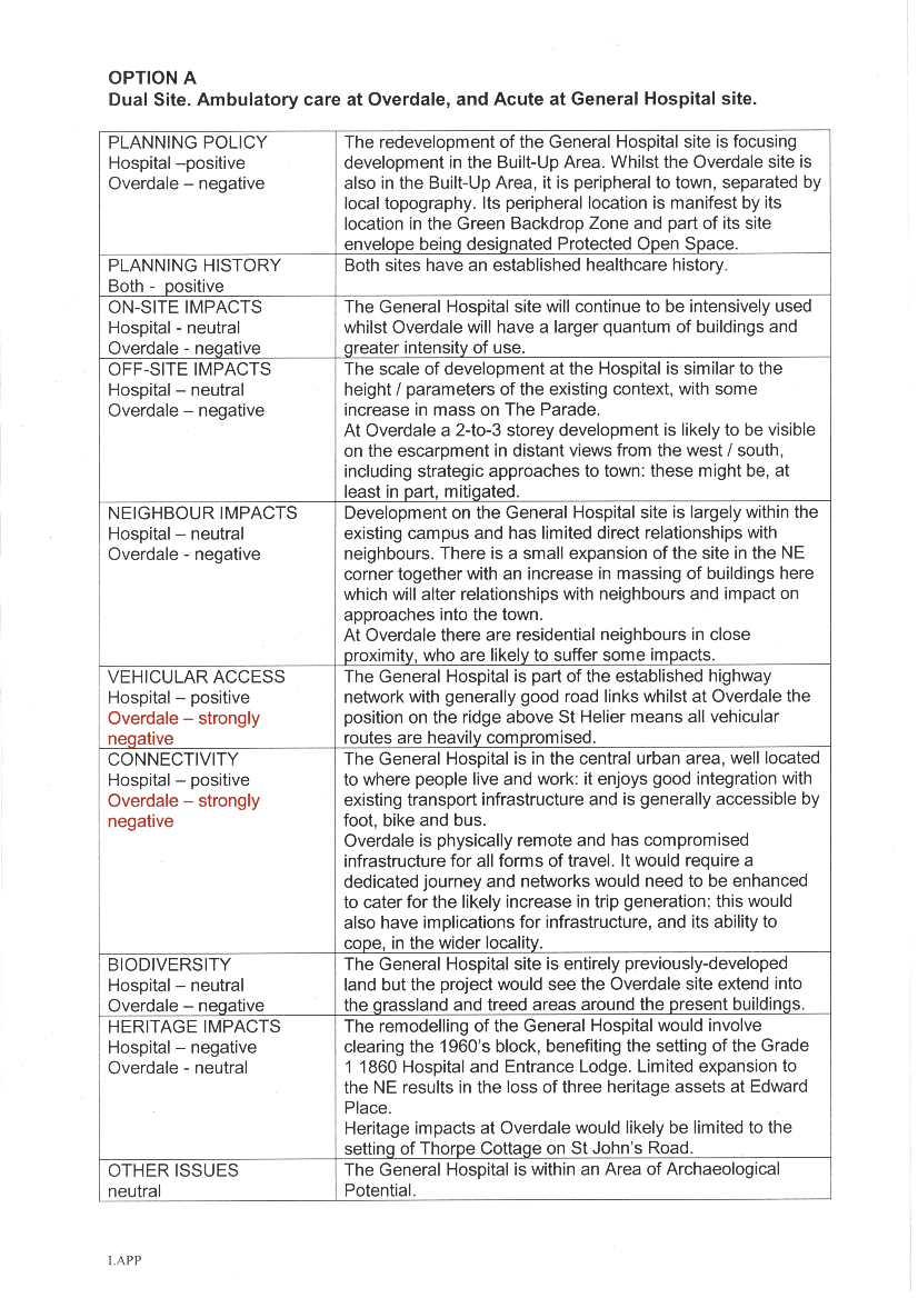
3 Option A: Dual Site Acute Services at General and Ambulatory Care at Overdale Key features: Overdale: Development retained on existing site owned and controlled by H&SSD. William Knott and Poplars buildings retained. New vehicular access onto Westmount Road. Location of development likely to require removal of trees on site and located in Westmount Park. Maximum number of floors will be two (at 4500mm floor to floor). General Hospital: Development retained on existing site owned and controlled by SOJ.. Retention of Granite Building consistent with planning requirement (listed building). Potential loss of existing listed buildings at Edward Place to be discussed with SOJ Planning and Environment. Building heights for all new developments) consistent with those noted in the SOC and as advised by SOJ Planning and Environment Department. Improvements to townscape and public realm. New emergency vehicle access arrangements. Assessment of key issues: Overdale Assessment of issues Issue Comment Low Medium High Policy No presumption against development in the Green Backdrop Zone. Removal of trees needs to be justified. Access Assessment needed to understand if the proposed use would result in an increase in trip generation. The road network serving the site is not ideal and mitigation measures are likely to be needed to improve blue light access, routes for emergency vehicles, the operation of junctions and improvement of the pedestrian environment. Connectivity to General Hospital and St Helier are issues that need to be resolved. Transport arrangements could be arranged to avoid peak hours. Parish of St Helier has indicated a requirement for a Hopper Bus. Investigation of sustainable transport choices needed to maximize choices for patients and users. Of all options, this location is likely to generate highest car use. Although staff likely to use hopper service, people who are ill, injured are likely to travel to the site by private car.. 2
4 Parking Baseline assessment needed to inform parking provision. Landscape & Visual Impact Loss of trees and height of new buildings. Any new building is likely to be approximately 8.4m (max); this height has the potential to be visible from distant locations from the west, south and east. Impact on neighbours The position of new buildings will require an assessment of trees in Westmount Park and on site. It is likely that existing trees will need to be removed to ensure a compatible relationship to be achieved. Although there appear to be no protected trees on the site, there is a commemorative oak planted when the hospital was opened, that has ecological and cultural value. The potential for the position and height of new buildings to have an adverse effect upon neighbours will require careful assessment. Locations where maximum building heights are needed will need to take into account the amenities of neighbours. General Hospital Policy No presumption against development. Access Rationalisation of access arrangements including new emergency vehicle access from Newgate Street. Details need to be agreed with TTS. Parking Existing parking arrangements retained. Heritage Presumption against the loss of potential listed buildings (2,3 & 4 Edward Place). The overall benefit to above ground society likely to outweigh concerns. Changes allow the setting of the existing listed building (part of the General Hospital site) to be improved. Heritage Assessment of any below ground heritage assets required. below ground Townscape Employment Removal of prominent, modern building allows improvement of setting of listed buildings; and strategy to improve public realm to be introduced. Any increase above existing height needs to be tested and justified against policy guidance for St Helier. Any loss of employment uses needs to be justified likely to be accepted on basis of over-riding strategic benefit. 3
5 Option B: Single Site Overdale Key features: Includes Jersey New Waterworks site and Field (opposite Overdale Hospital site east of Westmount Road).William Knott and Poplars buildings retained. New vehicular accesses onto Westmount Road and Tower Hill. Extent of new building occupies most of existing site. Location of development will require removal of trees located in Westmount Park and all trees on site. Maximum number of floors will be four (at 4500mm floor to floor) with one floor at lower ground (at 4500mm floor to floor). Car-parking proposed includes drop-off, short stay and disabled parking on site and main visitor parking in the above mentioned Field. Assessment of key issues: Assessment of issues Issue Comment Low Medium High Policy No presumption against development in the Green Backdrop Zone. Removal of trees needs to be justified. Potential for _small incursion onto land designated as Protected Open Space. Mitigation measures may need to be discussed and agreed with H&SSD and SOJ Planning and Environment. Loss of trees of high quality, commemorative flat oak and group of coastal pines will also need mitigation measures as above. Inclusion of Field to provide car-parking involves development of land designated as Green Zone overall benefits likely to outweigh policy presumption against. Access The proposed use is likely to result in an increase in trip generation. Continuous blue light access needed The road network serving the site is not ideal and mitigation measures are likely to be needed to improve blue light access, routes for emergency vehicles, the operation of junctions and improvement of the pedestrian environment. Connectivity to St Helier and wider island is an issue that will need to be resolved. Investigation of sustainable transport choices needed to maximize choices for patients and users. Of all options, this location is likely to generate highest car use. Although staff likely to use hopper service, people who are ill, injured are likely to travel to the site by private car.. Parking Baseline assessment needed to inform parking provision. Requires the loss of a green field. Landscape & This option requires maximization of site occupancy. This will require the loss of trees and has Visual Impact implications for the height of new buildings. 4
6 Impact on neighbours Any new building is likely to be approximately 4/5 storeys (as described above) in height (excluding any plant rooms); even with excavation this height has the potential to be extremely visible from locations from the west, south and east. The position of new buildings will require an assessment of trees in Westmount Park to understand how many will need to be removed to enable a compatible relationship to be achieved. The magnitude of loss may have an effect upon the ecological value of the woodland. Although there appear to be no protected trees on the site, there is a commemorative oak planted when the hospital was opened, that has ecological and cultural value. The potential for the position and height of new buildings to have an adverse effect upon neighbours will require careful assessment. Locations where maximum building heights are needed will need to take into account the amenities of neighbours. 5
7 Option C: Single Site General Hospital Key features: Includes development on land not owned and controlled by SOJ. Loss of listed buildings (2,3 & 4) Edward Place as mentioned above). Maximum number of floors will be seven (at 4500mm floor to floor). Improvements to townscape and public realm. Emergency vehicle access relocated to Newgate Street with extension of same to Kensington Place. Assessment of key issues: Assessment of issues Issue Comment Low High Policy No presumption against development Access Rationalisation of access arrangements including new emergency vehicle access from Newgate Street (as secondary route. Primary route will be via Gloucester Street and Newgate Street). Details need to be agreed with TTS. Parking Existing parking arrangements retained Heritage Presumption against the loss of listed buildings (2,3 & 4 Edward Place as described above). The overall above ground benefit to society likely to outweigh concerns. Heritage below ground Townscape Changes allow the setting of the existing listed building (part of the General Hospital site) to be improved. Assessment of any below ground heritage assets required. New buildings increase the height and mass of built form, which will have an impact upon the townscape character of the site and the surrounding area. The significance of the impact will depend upon design and massing choices. The height will require careful justification as it exceeds guidance provided by Tall Buildings policy and St Helier Design Guidance. However, the proposals are consistent with the guidance stated in the previous SOC as provided by SOJ Planning & Environment. New building arrangements will enable improvements to the public realm, particularly the setting of the Listed Building on site and the frontage of the site with The Parade. 6
8 Option D: Single Site Waterfront Key features: Development relies on the acquisition of sites not owned H&SSD. Development of part of the site has already been confirmed by a Masterplan approved as Supplementary Planning Guidance. Any change in development proposals will require a change in policy and the approval of the States. Further Supplementary Planning Guidance is provided by planning policy The Jersey Waterfront The scheme involves the loss of Les Jardins de La Mer, which is designated as Protected Open Space in the revised Island Plan, 2011 and is one of the island s popular public open spaces. Vehicle access from the west requires traffic management interventions to enable vehicles to cross the dual carriageway. Part of the site has been identified to provide temporary car-parking during the construction of The Esplanade Quarter Car-Park. Maximum number of floors is five (at 4500mm floor to floor). Building heights on Les Jardins de La Mer site are restricted by policy provided for by St Helier Design Guidance (2013). Building heights on other parts of the site are restricted to 6-storeys by other SPG. Assessment of issues Issue Comment Low Medium High Policy Development of this site will require new Supplementary Planning Guidance and approval by the SOJ. Access Transport Strategy ensure that any changes to road system can accommodate predicted vehicle volumes and provide required blue light access. Existing Masterplan has an approved Transport Assessment. The site is close to St Helier Town Centre and Liberation Bus Station. The site has easy access to Primary Route Network. Ensure that proposals are compatible with development proposals for Esplanade Quarter. Access via La Rue de L Eteau may be restricted as the road can get congested and vehicles currently park illegally, which causes congestion. Parking Temporary car-parking whilst The Esplanade Quarter is being constructed will need to be maintained or provided elsewhere. Patriotic Street retained for patient and staff parking. Number of spaces provided on site informed by baseline assessment of current transport modes by staff and visitors. 7
9 Contaminated Land Legacy issues cost and remediation implications. Potential risk that contamination found can t be remediated or disposed of see current local asbestos issue. Flooding Public space Townscape Building heights Townscape Vistas Heritage Housing Coastal and combined surface water drainage further assessment being prepared. The loss of Jardin de La Mer is likely to be viewed as contentious. Any replacement, which is likely to be on General Hospital site, would have to replicate quality. Question about resources already invested. Building on JdM contrary to St Helier Design Guidance and Policy SC04. The Jersey Waterfront 2006 SPG appears to provide for over 6-storeys in area (this excludes Jardin de la Mer) subject to excellent design may need to be off-set with provision of public open space. The proposed building height of five floors (at 4500mm floor to floor) exceeds policy guidance and will need to be justified. Extending onto Jardin de La Mer site moves the edge of town further west implications for important vistas and views any increased height and mass compared with context (over 6-storeys) loss of views down Gloucester Street and views from Millenium Court (although there are no legal rights to a view) Any alteration of granite sea-walls, slip-ways may cause concern there was an objection to impact of Esplanade Quarter upon The Esplanade sea-wall a Grade 3 Listed structure. Loss of approved residential development. However there is no identified shortage for this type of housing. 8
10
11
12
13
14
15
16
17
18
JERSEY FUTURE HOSPITAL CO025 PROOF OF CONCEPT SITE OPTION ADDENDUM APPENDIX 2 VERIFICATION OF PREVIOUS SITE DESELECTION
 JERSEY FUTURE HOSPITAL CO025 PROOF OF CONCEPT SITE OPTION ADDENDUM APPENDIX 2 VERIFICATION OF PREVIOUS SITE DESELECTION QUALITY ASSURANCE Sign off: Nigel Aubrey Position: Director: August 2016 1 Current
Jersey Future Hospital. Executive Summary of the Planning Application
 Jersey Future Hospital Executive Summary of the Planning Application Prepared on behalf of Department for Infrastructure April 2018 Jersey Future Hospital Executive Summary of the Planning Application
Proposed View - Summer. Existing View - Summer. Proposed View - Winter. Existing View - Winter
 Proposed View - Summer Existing View - Summer Proposed View - Winter Existing View - Winter CrownCopyrightADB CrownCopyrightADB Department Legend Second Floor First Floor Cardio-Respiratory, Diabetes &
80 residential units with associated garages, roads and sewers. Land off South Meadow Road, Northampton,
 PLANNING COMMITTEE: 30 September 2010 DIRECTORATE: Planning and Regeneration HEAD OF PLANNING: Susan Bridge N/2010/0301: WARD: APPLICANT: AGENT: REFERRED BY: REASON: DEPARTURE: 80 residential units with
Design Review Report Former YMCA Building, Bridgend DCFW Ref: N164 Meeting of 12th April 2018
 Design Review Report Former YMCA Building, Bridgend DCFW Ref: N164 Meeting of 12 th April 2018 Review Status PUBLIC Meeting date 12 th April 2018 Issue date 18 th April 2018 Scheme location Bridgend Scheme
Tall Buildings Strategy
 Chapter 8 Tall Building Strategy Mayor of London 115 existing & consented tall buildings effect on views of palace of westminster Chapter 8 Tall Buildings Strategy tall building cluster upto 150m with
Guide. Guide to Regional Planning Policies. Background
 Guide Guide to Regional Planning Policies January 2017 Background The Strategic Planning Policy Statement for NI - Planning for Sustainable Development - sets out the Department s regional planning policies
SITE ANALYSIS CALVARY HOSPITAL NORTH ADELAIDE LARGE INSTITUTIONS AND COLLEGES DPA CALVARY HOSPITAL
 SITE ANALYSIS Located at: 81-100 Strangways Terrace 55-79 Barnard Street 2-34 Hill Street 312-320 Ward Street HISTORY The Calvary Hospital was established in 1900 and is one of Adelaide's oldest hospitals.
GREENFORD HALL & ADJOINING LAND
 GREENFORD HALL & ADJOINING LAND CONTENTS 1. Introduction 1. Introduction 2. Urban Context 2.1 The Site and Surroundings 2.2 Urban Context Map 2.3 Access and Movement 3. Planning Context 3.1 Planning History
Tāhuhu whakaruruhau ā-taone The sheltering ridge pole
 B2. Tāhuhu whakaruruhau ā-taone - Urban growth and form B2.1. Issues Tāhuhu whakaruruhau ā-taone The sheltering ridge pole Auckland s growing population increases demand for housing, employment, business,
SITE ANALYSIS MEMORIAL HOSPITAL NORTH ADELAIDE LARGE INSTITUTIONS AND COLLEGES DPA MEMORIAL HOSPITAL
 SITE ANALYSIS KING WILLIAM RD Located at: 1-20 Sir Edwin Smith Avenue 1-10 Pennington Terrace 1-23 Kermode Street HISTORY The hospital is a private, not-for-profit hospital and was established as a memorial
Site north of Hattersley Road West (east of Fields Farm Road), Hattersley
, Hattersley") Application Number 17/00982/REM Proposal Site Applicant Recommendation Reason for report Application for the approval of reserved matters (means of access, landscaping, layout, scale and appearance) relating
Application Number 17/00982/REM Proposal Site Applicant Recommendation Reason for report Application for the approval of reserved matters (means of access, landscaping, layout, scale and appearance) relating
I615. Westgate Precinct
 I615. Westgate Precinct I615.1. Precinct Description The Westgate Precinct is located approximately 18km west of the Auckland city centre. There are seven Sub-precincts in the Westgate Precinct: Sub-precinct
BRIDGE OF DON MASTERPLAN & PLANNING SUMMARY
 BRIDGE OF DON MASTERPLAN & PLANNING SUMMARY SITE LOCATION The site of the existing AECC lies in an area of predominately residential and business use in Bridge of Don and extends approximately 50 acres.
LONDON BOROUGH OF WALTHAM FOREST
 LONDON BOROUGH OF WALTHAM FOREST Committee/Date: Planning 5th December 2006 Application reference: Applicant: Location: Proposed development: Wards affected: Appendices: 2006/1330/OUT Mr Z Ahmed Nita Villa
STATEMENT OF OBJECTION TO THE PROPOSED DEVELOPMENT OF LAND AT CHURCH CLIFF DRIVE FILEY
 STATEMENT OF OBJECTION TO THE PROPOSED DEVELOPMENT OF LAND AT CHURCH CLIFF DRIVE FILEY You will be aware that Scarborough borough council have adopted a new local plan that includes land at Church Cliff
Chapter 4. Route Window C12: Mile End Park and Eleanor Street Shafts
 Chapter 4 Route Window C12: Mile End Park and Eleanor Street Shafts 48 Crossrail Amendment of Provisions 4 Route Window C12: Mile End Park and Eleanor Street Shafts Location plan of Mile End Park and Eleanor
Carterton Construction Ltd is bringing forward plans for up to 85 new family homes and extra care facilities on land east of Burford.
 Welcome Carterton Construction Ltd is bringing forward plans for up to 85 new family homes and extra care facilities on land east of. We are at the early stages of designing our proposals and have a number
Description Details submitted pursuant to discharge of condition 5 (Design Code) attached to planning permission 13/01729/OUT.
 attached to planning permission 13/01729/OUT.") ITEM 9 Application Number: 18/00266/DISCON Description Details submitted pursuant to discharge of condition 5 (Design Code) attached to planning permission 13/01729/OUT. AT The Point, 602 Midsummer Boulevard,
ITEM 9 Application Number: 18/00266/DISCON Description Details submitted pursuant to discharge of condition 5 (Design Code) attached to planning permission 13/01729/OUT. AT The Point, 602 Midsummer Boulevard,
Application Recommended for Approval Hapton with Park Ward
 Application Recommended for Approval Hapton with Park Ward APP/2017/0036 Outline Planning Application Outline application for the construction of a new 3 bedroom dwelling (with all matters reserved for
ROCHFORD LOCAL DEVELOPMENT FRAMEWORK: Sustainability Appraisal/ Strategic Environmental Assessment. Rochford Core Strategy Preferred Options Document
 ROCHFORD LOCAL DEVELOPMENT FRAMEWORK: Sustainability Appraisal/ Strategic Environmental Assessment Non Technical Summary Rochford Core Strategy Preferred Options Document October 2008 SUSTAINABILITY APPRAISAL
Site off Hattersley Road West (bound by Hattersley Road West to the north west and Sandy Bank Avenue to the south and west), Hattersley
, Hattersley") Application Number 17/00984/REM Proposal Site Applicant Recommendation Reason for report Application for the approval of reserved matters (means of access, landscaping, layout, scale and appearance) relating
Application Number 17/00984/REM Proposal Site Applicant Recommendation Reason for report Application for the approval of reserved matters (means of access, landscaping, layout, scale and appearance) relating
Cardiff International Sports Village Waterfront Development Volume IV : Non-Technical Summary of the Environmental Statement
 Greenbank Partnerships Ltd October 2012 Cardiff International Sports Village Waterfront Development Volume IV : Non-Technical Summary of the Environmental Statement Environmental Statement - Non Technical
Newcourt Masterplan. November Exeter Local Development Framework
 Newcourt Masterplan November 2010 Exeter Local Development Framework Background The Exeter Core Strategy Proposed Submission sets out the vision, objectives and strategy for the development of Exeter up
Plan Modification to Chapter B2 of the Auckland Unitary Plan(AUP) Operative in part (15 November 2016)
 Operative in part (15 November 2016)") UNITARY PLAN UPDATE REQUEST MEMORANDUM TO FROM Phill Reid Linley Wilkinson DATE 25 September 2018 SUBJECT Plan Modification to Chapter B2 of the Auckland Unitary Plan(AUP) Operative in part (15 November
UNITARY PLAN UPDATE REQUEST MEMORANDUM TO FROM Phill Reid Linley Wilkinson DATE 25 September 2018 SUBJECT Plan Modification to Chapter B2 of the Auckland Unitary Plan(AUP) Operative in part (15 November
Sustainability Statement. Whitby Business Park Area Action Plan
 Sustainability Statement Whitby Business Park Area Action Plan November 2014 Contents Page 1. Introduction 1 2. Scoping 3 3. Sustainability Appraisal of Options 6 4. Assessment of Draft Area Action Plan
Land at Fiddington Hill Nursery, Market Lavington
 Land at Fiddington Hill Nursery, Market Lavington Briefing Report for Market Lavington Parish Council Persimmon Homes (Wessex) April 2016 Background This brief report has been prepared following the Market
Response to the London Bridge Area Vision and Site Allocations within the New Southwark Plan
 1 Melior Place London SE1 3SZ 020 7407 4701 teamlondonbridge.co.uk info@teamlondonbridge.co.uk 28 April 2017 Response to the London Bridge Area Vision and Site Allocations within the New Southwark Plan
11. ISLINGTON ROUTE SECTION ENVIRONMENTAL BASELINE AND ASSESSMENT OF IMPACTS OVERVIEW OF ISLINGTON ROUTE SECTION... 2
 11. ISLINGTON ROUTE SECTION ENVIRONMENTAL BASELINE AND ASSESSMENT OF IMPACTS... 2 11.1 OVERVIEW OF ISLINGTON ROUTE SECTION... 2 11.2 POLICIES RELEVANT TO ALL WORKSITES IN ISLINGTON... 3 11.3 FARRINGDON
SUB AREA 3 CENTRAL STRATFORD AND SOUTHERN QUEEN ELIZABETH OLYMPIC PARK
 191 ADOPTED LOCAL PLAN: THE SUB AREAS SUB AREA 3 CENTRAL STRATFORD AND SOUTHERN QUEEN ELIZABETH OLYMPIC PARK SECTION 12 Vision VISION Central Stratford and Southern Queen Elizabeth Olympic Park will become
2. The application, which is a full plans application, is for a commercial development comprising B1, D1, D2 and A3 uses.
 Former Taff Vale Shopping Centre, Taff Street, Pontypridd, CF37 4TR PLANNING APPLICATION SUPPORTING STATEMENT May 2017 Ref.11431/1 INTRODUCTION AND APPLICATION CONTEXT 1. This planning application statement
SOUTH EAST LINCOLNSHIRE LOCAL PLAN: HOUSING PAPER DONINGTON (JUNE 2016)
") SOUTH EAST LINCOLNSHIRE LOCAL PLAN: HOUSING PAPER DONINGTON (JUNE 2016) 1 DONINGTON S PLACE IN THE SPATIAL STRATEGY 1.1 Policy 2 of the South East Lincolnshire Local Plan 2011-2036 Draft for Public Consultation
SOUTH EAST LINCOLNSHIRE LOCAL PLAN: HOUSING PAPER DONINGTON (JUNE 2016) 1 DONINGTON S PLACE IN THE SPATIAL STRATEGY 1.1 Policy 2 of the South East Lincolnshire Local Plan 2011-2036 Draft for Public Consultation
Welcome to our exhibition
 Welcome to our exhibition housing development A46 Wildmoor Alcester Road Canal Quarter A422 Town Centre housing development Warwickshire-based IM Properties, one of the UK s largest privately owned property
Site 2 Development Brief
 a South Marketgait Site 2 b Union Street c Site 2 Development Brief Thomson Avenue (Northern Boulevard) Dundee Riverside Drive Discovery Plaza South Union Street Station Earl Grey Place West Site 5 Site
Rotherhithe Rotherhithe Area Vision Map
 Area Vision Map CWAAP1 Improved pedestrian and cycle links to the wider area Improved link from town centre to River Thames and docks CWAAP2 Brunel Museum NSP79 CWAAP3 Proposed Thames Crossing Station
List of Policies. SESPlan. None applicable. Consolidated Scottish Borders Local Plan 2011: POLICY G1 - QUALITY STANDARDS FOR NEW DEVELOPMENT
 List of Policies Local Review Reference: 15/00021/RREF Planning Application Reference: 15/00616/FUL Development Proposal: Installation of 16no solar photovoltaic (PV) panels to roof Location: Raebank,
Armourers Court, Woolwich
 Armourers Court, Woolwich Environmental Statement, Non-Technical Summary December 2013 DESIGN PACKAGE C158 WOOLWICH STATION East End Over Site Development (Armourers Court, Arsenal Way, Woolwich) Environmental
Welcome to our public exhibition
 About our development Welcome to our public exhibition This exhibition gives you the chance to view and comment on our proposals for a new residential development of 165 high-quality homes, along with
Schedule of Planning Applications Committee Date: 23 May Reference: 06/17/0726/F Parish: Hemsby Officer: Mr J Beck Expiry Date:
 Schedule of Planning Applications Committee Date: 23 May 2018 Reference: 06/17/0726/F Parish: Hemsby Officer: Mr J Beck Expiry Date: 22-05-2018 Applicant: Proposal: Site: Mr Gillett Change of use to the
PLANNING COMMITTEE REPORT
 PLANNING COMMITTEE REPORT TO: BY: Planning Committee South Head of Development DATE: 19 December 2017 DEVELOPMENT: SITE: WARD: APPLICATION: APPLICANT: Conversion of existing water storage reservoir to
Proposal: Proposed new access road. The application site is Council owned land and the decision level is at Planning and Licensing Committee.
 Reference: 16/01492/FUL Ward: Warley Site: Lion Lodge South The Avenue Warley Essex CM13 3RZ Proposal: Proposed new access road Plan Number(s): 1:1250 LOCATION PLAN; MB.DJA 1 OF 1; Applicant: Mr M Bryan
H1. Residential Large Lot Zone
 H1. Residential Large Lot Zone H1.1. Zone description The Residential Large Lot Zone provides for large lot residential development on the periphery of urban areas. Large lot development is managed to
EXTRACT FROM THE CUDDINGTON NEIGHBOURHOOD PLAN The Policies
 EXTRACT FROM THE CUDDINGTON NEIGHBOURHOOD PLAN The Policies Environment and Landscape Policy 1 - Landscape Setting Development should respect and wherever possible enhance the landscape setting of Cuddington
1. Listed Building and Conservation Area considerations 2. Protection of Known Archaeological Remains 3. Parking
 08/01222/FUL ERECTION OF SINGLE STOREY SIDE EXTENSION TO CHURCH TO PROVIDE FOR PARISH HALL (RESUBMISSION OF 08/00206/FUL) AT St Mary And St Giles Church, Church Street, Stony Stratford FOR Rev R Northing
Contents of Part 6. Part 6 Zones
 Contents of Part 6 Part 6 Zones... 6-1 6.1 Preliminary... 6-1 6.2 Zone codes... 6-3 6.2.1 Low density residential zone code... 6-3 6.2.1.1 Application... 6-3 6.2.1.2 Purpose and overall outcomes... 6-3
Appendix 1 Structure plan guidelines
 Appendix 1 Structure plan guidelines This appendix forms part of the regional policy statement [rps]. 1.1. Introduction Structure plans are an important method for establishing the pattern of land use
DEVELOPMENT MANAGEMENT REPORT
 ITEM A08-1 DEVELOPMENT MANAGEMENT REPORT TO: BY: DATE: DEVELOPMENT: SITE: WARD: APPLICATION: APPLICANT: Development Management Committee Development Manager Proposed live/work unit in connection with existing
LAND SECURITIES REDEVELOPMENT OF NEWNHAM COURT SHOPPING VILLAGE, MAIDSTONE
 LAND SECURITIES REDEVELOPMENT OF NEWNHAM COURT SHOPPING VILLAGE, MAIDSTONE Land at Environmental Statement: Non-Technical Summary Introduction Land Securities plc is applying to Maidstone Borough Council
SOUTH CAMBRIDGESHIRE DISTRICT COUNCIL. REPORT TO: Planning Committee 1 April 2015 Planning and New Communities Director
 SOUTH CAMBRIDGESHIRE DISTRICT COUNCIL REPORT TO: Planning Committee 1 April 2015 AUTHOR/S: Planning and New Communities Director Application Number: Parish(es): Proposal: Site address: Applicant(s): Recommendation:
THE WORTHING SOCIETY. 18 Mill Road Angmering BN16 4HT
 1 THE WORTHING SOCIETY 6 th January 2015 The Head of Planning, Regeneration and Well-being Portland House, Worthing. Dear Sir, Aquarena Redevelopment Application Reference: AWDM/1636/14 18 Mill Road Angmering
Planning Proposal Concurrent DA/LEP Amendment for Belmont North Pharmacy Amendment No. 24 to Lake Macquarie Local Environmental Plan (LMLEP) 2014
 2014") Planning Proposal Concurrent DA/LEP Amendment for Belmont North Pharmacy Amendment No. 24 to Lake Macquarie Local Environmental Plan (LMLEP) 2014 Local Government Area: Name of Draft LEP: Subject Land:
Planning Proposal Concurrent DA/LEP Amendment for Belmont North Pharmacy Amendment No. 24 to Lake Macquarie Local Environmental Plan (LMLEP) 2014 Local Government Area: Name of Draft LEP: Subject Land:
Peckham Peckham Area Vision Map
 Area Vision Map PNAAP13 PNAAP8 Sumner Road Surrey Canal Walk Bird in Bush Park Key: NSP Site Allocations PNAAP Allocations Greenspace Low Line Cycle Network Primary Shopping Areas Square Surrey Canal Walk
16. Peckham Peckham Area Vision
 16. 16.1. Area Vision 16.1.1. is: A lively town centre providing a range of daytime and night time activities on Rye Lane including a Library, a Leisure Centre and many independent retailers which specialise
Special Landscape Area (Great Orme and Creuddyn Peninsular). Agricultural land (grade 3a). TPO A14 (1982) - group of trees (G4) on east boundary.
. Agricultural land (grade 3a). TPO A14 (1982) - group of trees (G4) on east boundary.") TAN 24 and TAN 5: Technical Advice Note (TAN) 24: The Historic Environment (2017) Guidance on how the planning system considers the historic environment during development plan preparation and decision
TAN 24 and TAN 5: Technical Advice Note (TAN) 24: The Historic Environment (2017) Guidance on how the planning system considers the historic environment during development plan preparation and decision
Longbridge Town Centre Phase 2 Planning Application
 Longbridge Town Centre Phase 2 Planning Application Non-Technical Summary of the Environmental Statement December 2013 Introduction A full application for Planning Permission has been submitted to Birmingham
Approval for the layout, scale, appearance and landscaping details for a residential development comprising 44 dwellings.
 Application Number 17/00534/REM Proposal Site Applicant Recommendation Reason for report Approval for the layout, scale, appearance and landscaping details for a residential development comprising 44 dwellings.
Replacement Golf Course Facilities and Residential Development, Churston. Environmental Statement Non-Technical Summary
 Replacement Golf Course Facilities and Residential Development, Churston Environmental Statement Non-Technical Summary July 2011 Reproduced from the Ordnance Survey s map with the permission of the Controller
Redevelopment of the site, including demolition of existing buildings, for approximately 96 new dwellings and associated works - outline
 Application Number 15/00986/OUT Proposal Site Applicant Recommendation Redevelopment of the site, including demolition of existing buildings, for approximately 96 new dwellings and associated works - outline
Draft Hailey Neighbourhood Plan
 Persimmon Homes (Wessex) Draft Hailey Neighbourhood Plan Representations to West Oxfordshire District Council s Regulation 16 Consultation December 2018 2 Copyright 2018 Persimmon Homes Ltd. All rights
LETTER OF OBJECTION LAND TO THE SOUTH WEST OF FORGE GARAGE, HIGH STREET, PENSHURST, KENT, TN11 8BU
 Senior Planning Officer Andrew Byrne Sevenoaks District Council Community & Planning Services PO Box 183 Argyle Road Sevenoaks Kent TN13 1GN 04 November 2011 Your Ref: 11/02258/FUL For the attention of
Rochford District Council Allocations Development Plan Document: Discussion and Consultation Document Sustainability Appraisal
 Option SWH1 Balanced Communities Option SWH1 1 To ensure the delivery of high quality sustainable communities where people want to live and work Will it ensure the phasing of infrastructure, including
Parish of Repton NEIGHBOURHOOD DEVELOPMENT PLAN
 Parish of Repton NEIGHBOURHOOD DEVELOPMENT PLAN BASIC CONDITIONS STATEMENT December 2018 CEF 4 Legal Requirements This statement has been produced by the NDP Working Group on behalf of Repton Parish Council
Derry City and Strabane District Council Planning Committee Report
 Derry City and Strabane District Council Planning Committee Report COMMITTEE DATE: 23 rd March 2016 APPLICATION No: APPLICATION TYPE: PROPOSAL: LOCATION: APPLICANT: LA11/2015/0395/F Residential Development
PLANNING STATEMENT. Market House Market Place Kingston upon Thames KT1 1JS
 PLANNING STATEMENT To support planning and listed building consent applications for change of use from Class A1 shop and Class A3 cafe to Class A3 restaurant at: Market House Market Place Kingston upon
Our City Centre is a vibrant, creative and welcoming destination, with a modern business, cultural, shopping, leisure and residential offer
 3. Sheffield in 2034 Our City sits at the heart of a strong, distinctive and internationally successful City Region economy which supports innovation and enterprise Our City Centre is a vibrant, creative
Statement of Community Involvement LAND OFF SOUTHDOWN ROAD HORNDEAN, HAMPSHIRE
 LAND OFF SOUTHDOWN ROAD HORNDEAN, HAMPSHIRE CONTENTS Page 1. Introduction 3 2. Pre-application Discussions 4 3. The Consultation Process 5 4. Consultation Feedback 7 5. Responses to Consultation Feedback
SOUTH CAMBRIDGESHIRE DISTRICT COUNCIL. Planning and New Communities Director
 SOUTH CAMBRIDGESHIRE DISTRICT COUNCIL REPORT TO: Planning Committee 3 October 2012 AUTHOR/S: Planning and New Communities Director S/1723/12/OL CAXTON AND ELSWORTH OUTLINE APPLICATION FOR ERECTION OF RESTAURANT/TAKEAWAY
1. Creating a liveable, vibrant, safe and inclusive city centre for the benefit of people of all ages to live, work, learn and enjoy.
 City Centre Framework - Summary Bristol City Council has produced a draft City Centre Framework document. The Framework is a planning and transport document that outlines what the city centre could be
Planning and Sustainability Statement
 Land adjacent to Manor Farm, Catterick Village Pallett Hill Sand and Gravel Co Ltd Proposed 10 new dwellings, (6 No market dwellings and 4 No affordable dwellings) with access, associated car parking and
Perth and Kinross Council Development Management Committee 20 February 2013 Report of Handling by Development Quality Manager
 Perth and Kinross Council Development Management Committee 20 February 2013 Report of Handling by Development Quality Manager 4(4)(iii) 13/81 Erection of sports hall, associated changing facilities, offices
University Park, Worcester Non Technical Summary December 2011
 University Park, Worcester Non Technical Summary December 2011 Introduction UW Wrenbridge LLP, a Joint Venture Company of the University of Worcester and Wrenbridge Land Ltd (the Applicants ) intend to
MATURE SUBURBS RESIDENTIAL DEVELOPMENT GUIDELINES
 MATURE SUBURBS RESIDENTIAL DEVELOPMENT GUIDELINES DRAFT FEBRUARY 2005 BIRMINGHAM CITY COUNCIL 1 Introduction Mature Suburbs Residential Development Guidelines - Interim Supplementary Planning Advice -
Site 5 Development Brief
 Union Street Crichton Street South Crichton Street Thomson Avenue (Northern Boulevard) Site 5 South Union Street Earl Grey Place West Site 6 Riverside Esplanade (Southern Boulevard) South Crichton Street
an Inspector appointed by the Secretary of State for Communities and Local Government
 Appeal Decision Site visit made on 14 July 2015 by I Radcliffe BSc(Hons) MCIEH DMS an Inspector appointed by the Secretary of State for Communities and Local Government Decision date: 18 August 2015 Appeal
2014/0943 Reg Date 06/11/2014 Lightwater
 2014/0943 Reg Date 06/11/2014 Lightwater LOCATION: PROPOSAL: TYPE: APPLICANT: OFFICER: LAND REAR OF 4, 6 & 8 MACDONALD ROAD, LIGHTWATER, GU18 5TN Erection of 2 linked-detached two storey dwellings with
DEVELOPMENT MANAGEMENT REPORT
 ITEM A07-1 DEVELOPMENT MANAGEMENT REPORT TO: BY: Development Management Committee (South) Development Manager DATE: 21 June 2016 DEVELOPMENT: SITE: WARD: APPLICATION: APPLICANT: Outline application for
3.0 Area-Wide Strategies 30
 3.0 Area-Wide Strategies 30 3.6 Tourism Strategy This section of the plan aims to develop and improve the tourism potential of the area. Strategic Context The City Plan outlines the potential of Cork to
10. East Dulwich East Dulwich Area Vision
 10. 10.1. Area Vision 10.1.1. is: A predominantly residential area characterised by mostly medium density housing, including many family homes. Many parts of have retained historic character and it includes
Neighbourhood Planning Local Green Spaces
 Neighbourhood Planning Local Green Spaces Introduction... 2 1. Why green space is important... 4 2. Neighbourhood plans and green space... 6 3. Evidence... 8 Statutory designations... 9 Green space audit...
8. Camberwell 8.1. Camberwell Area Vision
 8. 8.1. Area Vision 8.1.1. is: Centred on a medieval village centre which has become a thriving modern town centre surrounded by residential streets laid out in the Georgian era; Linked by rail to central
It is recommended that the Committee resolve to APPROVE the application and grant planning permission subject to the following conditions:
 LOCATION: Phase 2A Millbrook Park (Site of Former Inglis Barracks), Mill Hill East, London, NW7 1PZ REFERENCE: H/04606/12 Received: 04 December 2012 Accepted: 17 December 2012 WARD: Mill Hill Expiry: 18
MINUTES OF THE PLANNING COMMITTEE MEETING HELD MONDAY 19 TH JANUARY PM BURBAGE MILLENNIUM HALL
 55 MINUTES OF THE PLANNING COMMITTEE MEETING HELD MONDAY 19 TH JANUARY 2015 7PM BURBAGE MILLENNIUM HALL Present: Cllr Mrs M Lynch (in the chair) Cllrs Mr S Deeming, Mr R Flemming, Mr P Hall, Mr K Lynch,
Item No: 4 Reference: B/16/00635/FUL. Parish: BENTLEY Ward Member: Cllrs Stephen William and John Hinton
 Item No: 4 Reference: B/16/00635/FUL Parish: BENTLEY Ward Member: Cllrs Stephen William and John Hinton Location: Proposal: Applicant: Bentley Plants Ltd, Bergholt Road, Bentley, IPSWICH IP9 2DQ Change
Derry City and Strabane District Council Planning Committee Report. Amended layout from approval A/2004/0462/F with reduction from 166 units
 Derry City and Strabane District Council Planning Committee Report COMMITTEE DATE: 1 st February 2017 APPLICATION No: APPLICATION TYPE: PROPOSAL: LOCATION: APPLICANT: AGENT: Full Planning application Amended
Birmingham Science Park Aston, Woodcock Street, Birmingham, B7 4BB
 Committee Date: 11/06/2015 Application Number: 2015/02024/PA Accepted: 23/03/2015 Application Type: Full Planning Target Date: 22/06/2015 Ward: Nechells Birmingham Science Park Aston, Woodcock Street,
Your ref: 1608 My ref: PA16/03150/PREAPP Date: 7 December 2016
 Redesign Architecture Ltd The Workbox Fourth Floor PZ360 St Marys Terrace Penzance Cornwall TR18 4DZ Your ref: 1608 My ref: PA16/03150/PREAPP Date: Dear Sir/Madam Pre-application enquiry reference Proposal
REFERENCE: B/03745/12 Received: 02 October 2012 Accepted: 05 October 2012 WARD(S): Totteridge Expiry: 30 November 2012.
: Totteridge Expiry: 30 November 2012.") LOCATION: 15A Pyecombe Corner, London, N12 7AJ REFERENCE: B/03745/12 Received: 02 October 2012 Accepted: 05 October 2012 WARD(S): Totteridge Expiry: 30 November 2012 Final Revisions: APPLICANT: PROPOSAL:
LOCATION: 15A Pyecombe Corner, London, N12 7AJ REFERENCE: B/03745/12 Received: 02 October 2012 Accepted: 05 October 2012 WARD(S): Totteridge Expiry: 30 November 2012 Final Revisions: APPLICANT: PROPOSAL:
Urban Design Manual PLANNING AROUND RAPID TRANSIT STATIONS (PARTS) Introduction. Station Study Areas
 Introduction. Station Study Areas") 111111 PLANNING AROUND RAPID TRANSIT STATIONS (PARTS) Introduction The ION rapid transit system will link Waterloo, Kitchener and Cambridge through a central transit corridor (CTC). There are a number
111111 PLANNING AROUND RAPID TRANSIT STATIONS (PARTS) Introduction The ION rapid transit system will link Waterloo, Kitchener and Cambridge through a central transit corridor (CTC). There are a number
URBAN DESIGN BRIEF 181 Burloak Drive, Oakville
 URBAN DESIGN BRIEF 181 Burloak Drive, Oakville February 2017 Our File: 1730B 230-7050 WESTON ROAD / WOODBRIDGE / ONTARIO / L4L 8G7 / T: 905 761 5588/ F: 905 761 5589/WWW.MHBCPLAN.COM TABLE OF CONTENTS
Kibworth Harcourt. Introduction. Introduction
 Introduction Introduction Welcome to this public exhibition on the proposals for the delivery of new homes on land at The Kibworths. The purpose of today s exhibition is to give you the opportunity to
PHASE III: Reserved Matters Submission
 Statement of Compliance with the outline approval for the proposed residential development of land at: BURGES LANE, WIVELISCOMBE PHASE III: Reserved Matters Submission Foreword Contents: This Statement
Welcome to our exhibition
 Welcome to our exhibition The Homes & Communities Agency (HCA) welcomes you to this public exhibition explaining our proposals for the redevelopment of the former Lea Castle Hospital site. About the Homes
Site Location Plan. Land on the North West of Epsom Road Waddon Croydon. 1 : A4 September The. Waddon. Waddon.
 138 140 44.3m MP 11.5 El Sub Sta EPSOM ROAD 13 Bank 1 to 5 154 Trough 19to21 1 to 5 156 The Waddon (PH) 23 FB Waddon Station 45.0m Posts 29to31 1 to 9 Stafford Court 39 37 Meridian Court 10 43 to 45 1
3.1 The hybrid planning application proposes the following description of development:
 CHAPTER 3: PROPOSED DEVELOPMENT 3.1 The hybrid planning application proposes the following description of development: Hybrid (part-outline/part-full) planning application for a single composite development
Smart Growth Development Checklist
 2004 Smart Growth Development Checklist Smart Growth Development Checklist Corporation of the City of New Westminster Guide and manage growth in a manner which is consistent with the principles of sustainable
BLACKHEATH SQUASH CLUB Blackheath Sports Club, Rectory Field, Charlton Road, London, SE7 7EY. Planning, Design and Access Statement
 Planning, Design and Access Statement Revised: 28 th Jan 2016 Peter Pendleton & Associates Ltd Introduction Planning permission will be sought for a refurbishment of existing courts and extension to provide
Milburngate House Site, Durham City. Design and Development Brief for Consultation. Summary for Public Consultation
 Milburngate House Site, Durham City Design and Development Brief for Consultation Summary for Public Consultation October 2011 Introduction to the Brief Background The Milburngate House site is a large
Droitwich Spa 6. Reasoned Justification
 87 Droitwich Spa 6 Reasoned Justification 6.1 Droitwich Spa is identified in the settlement hierarchy (Policy SWDP1) as a main town being the largest settlement in Wychavon District with an estimated population
Site: Essex Police & La Plata House London Road Brentwood Essex CM14 4QJ
 Reference: 16/01805/OUT Ward: Brentwood West Site: Essex Police & La Plata House London Road Brentwood Essex CM14 4QJ Proposal: Outline application for demolition of existing police station buildings,
ROYAL BOROUGH OF WINDSOR & MAIDENHEAD
 ROYAL BOROUGH OF WINDSOR & MAIDENHEAD 30 March 2017 Application No.: Location: Proposal: Applicant: Agent: Parish/Ward: 17/00188/FULL Roundabout Adjacent To Heatherwood Hospital London Road Ascot Installation