8. Identified significant sites in surrounding area within Orange Grove Precinct_Fellside
|
|
|
- Rachel Harvey
- 5 years ago
- Views:
Transcription


1 8. Identified significant sites in surrounding area within Orange Grove Precinct_Fellside Locality map and history of Fellside Fig. 179 Fellside is located along the north-western side of Louis Botha Avenue, bordering Orange Grove to the North and South, Houghton Estate and Victoria to the western side (Source: City Council of Johannesburg, GIS map) Fellside consists of mostly single storey freestanding residences which were built around the 1920s and forms part of the Heritage Impact Assessment study area. A number of sites were identified to show the existing original houses within the area and to give some examples of architectural styles in Fellside. Most of the houses were altered and added on over time and the original structure is not visible anymore. The boundary walls are a visual barrier to get a clear overview of the existing buidlings in the area. Fig. 180 Typical streetscape with rows of Plane trees in Fellside (Source: tsica heritage consultants, 2015) 281
2 Introduction to residential category Residential buildings are buildings that are generally used for residential purposes or have been zoned for residential usage. It must be noted the majority of residences are over 60 years, it was therefore imperative for detailed visual study to be done where the most significant buildings were mapped out. Their significance could be as a result of them being associated to prominent figures, association with special events, design patterns of a certain period in history, rarity or part of an important architectural school. Most of the sites identified in this category are of importance in their local contexts and are representative of the historical and cultural patterns that could be discerned from the built environment. All the identified sites were given a 3A category explained below. Grading 3A_Sites that have a highly significant association with a historic person, social grouping, historic events, public memories, historical activities, and historical landmarks (should by all means be conserved) 3B_ Buildings of marginally lesser significance (possibility of senstive alteration and addition to the interior) 3C_Buildings and or sites whose significance is in large part significance that contributes to the character of significance of the environs (possibility for alteration and addition to the exterior) Summary Table of identified sites in the residential category: Site/ Description Stand No. 67 Single storey freestanding building with centrally located stoep 125 Double storey residence with slate tiled roofing Provisional Grading 3A 3A Heritage Implications Conservation highly recommended Conservation highly recommended 282

3 8.1 Single storey freestanding building with centrally located stoep_stand 67 Address Stand No Castle Street Current Zoning Residential 1 Year of erection 1927 Architect Heritage Significance Statement of Significance (Heritage importance grading system due to the National Heritage Resources Act 25, 1999) Proposed SAHRA Grading Unknown Architectural 3A (a) its importance in the community, or pattern of South Africa s history; Site Description Single storey freestanding residence with centrally located front stoep with columns supporting the stoep roof. The three bedroomed house was designed in 1927 and is still in a very good original condition. It is a good example of the freestanding houses in close proximity to Louis Botha Avenue. Locality Map Fig. 181 Stand 67 is located north-eastern side of Castle Street and South of Davidson Street within the residential area of Fellside (Source: City Council of Johannesburg, GIS map) 283


4 Original plan for Stand 67 Fig. 182 Plan for proposed dwelling house on Stand 67 & 68 Typical example of single storey freestanding house with centrally located stoep, an additional stoep was built on side elevation (Source: City Council of Johannesburg, Plans Archive) Identifying Image Fig. 183 Single storey residence with corrugated iron roofing and centrally located front stoep covering the arched main entrance, face brick detailing like building edges and arched entrance are still in very good condition (Source: tsica heritage consultants, 2015) 284
5 Impact of Proposed Development Plan on Heritage Densities Medium to Low densities ( dph) new buildings suggested maximum scale is 4-6 and a minimum of 2 storeys Transport Sites fall out of main BRT route transit spine Social Cluster Development No social cluster development is ear marked for this area Mixed-use Development Site falls out of mixed-use development Recommendations Well preserved freestanding single storey residence from late 1920s forms part of a unique streetscape within Fellside and it is therefore recommended that the building needs to be preserved. Recommendations Not applicable. Recommendations Not applicable. Recommendations Site is surrounded by single storey residences and it is recommended to maintain building heights to maximum two storeys in close proximity to the residence. Conservation Management Policies_ Grade 3A_Residential sites Conservation management plans (CMPs) help to guide the management and running of heritage sites, scenarios, particularly if the heritage buildings or site are earmarked for development. The CMP particularly the policies and guidelines, should be used in the preparation of future expressions of interest, development and feasibility studies, as well as by consultants planning or documenting future work. In conjunction with the SWOT analysis it becomes a useful tool in assessing the opportunities that can arise from the development as well as identify potential risk or threat of the site. In case were development is earmarked for an area certain type of buildings can begin to diminish from a suburb, the purpose of the residential CMP is to make sure that certain type of residential buildings that exhibit, uniqueness, are aesthetically pleasing, or retain a high association with the social or cultural history are conserved and guidelines to their conservation and management are made known. 285
6 Swot Analysis Analysis Strength Weakness Result Typical freestanding residence with centrally located column supported stoep forms part of a unique streetscape and is in a very good condition and most of the original features are still in place Not applicable Risk/ Threat The site is located in an area of medium density development and it may change the character of the site if new buildings are erected near it Strength/Opportunity Well preserved 1920s freestanding residence could form part of architectural historical walking tour within Orange Grove Conservation Management Policies_Residential sites Views/Vistas Retain views of the aesthetically and architecturally significant building Ensure that all new buildings erected do not conflict or overpower the heritage buildings Fabric and Setting Retain and restore all the original materials, doors, window panels and other original features of the buildings if alterations are intended for the building If additions are to be made, then a contrasting modern materials to be used according to conservation principles Management Establish a team of heritage/conservation professionals which oversee the restoration of historical structures and the introduction of new buildings on site or near the site Future Development Adaptively re-use the buildings in a manner that will not diminish and will ideally enhance their historical or cultural integrity Integrate site into tourism route Ensure that alterations and additions are made only after consultation with the Provincial Heritage Resources Authority (Gauteng) and in accordance with the National Heritage Resources Act of 1999 section 34 or section 36 Public facilitation takes place prior to any development 286

7 8.2 Double storey residence with slate tiled roofing_stand 125 Address Stand No Unity Street Current Zoning Residential 1 Year of erection 1936 Architect Heritage Significance Statement of Significance (Heritage importance grading system due to the National Heritage Resources Act 25, 1999) Proposed SAHRA Grading A.R. Harris Architectural 3A (a) its importance in the community, or pattern of South Africa s history; Site Description Double storey residence which forms part of the residential area of Fellside along the north-eastern side of Louis Botha Avenue. The house was designed by the architect A.R. Harris which designed an octagonal shaped floor plan along the northern section of the house. The face brick decorated main entrance area is incorporating the chimney of the lounge and is still in a very good original condition. Locality Map Fig. 184 Stand 125 is located north-eastern side of Louis Botha Avenue and East of Unity Street within the residential area of Fellside (Source: City Council of Johannesburg, GIS map) 287

8 Original plan for Stand 125 Fig. 185 Plan for proposed residence on Stand 125 Double storey two bedroomed house with slate tiled roofing and octagonal floor plan in the northern part of the house (Source: City Council of Johannesburg, Plans Archive) 288


9 Identifying Images Fig. 186 Double storey slate tiled roofed residence in close proximity to Louis Botha Avenue in Fellside (Source: tsica heritage consultants, 2015) Fig. 187 Main entrance area with face brick decoration and chimney above along Unity Street (Source: tsica heritage consultants, 2015) 289
10 Impact of Proposed Development Plan on Heritage Densities Medium to Low densities ( dph) new buildings suggested maximum scale is 4-6 and a minimum of 2 storeys Transport Sites fall out of main BRT route transit spine Social Cluster Development No social cluster development is ear marked for this area Mixed-use Development Site falls out of mixed-use development Recommendations Well preserved freestanding double storey residence from 1930s forms part of a unique streetscape within Fellside and it is therefore recommended that the building needs to be preserved. Recommendations Not applicable. Recommendations Not applicable. Recommendations Site is surrounded by single storey residences and it is recommended to maintain building heights to maximum two storeys in close proximity to the residence. Conservation Management Policies_ Grade 3A_Residential sites Conservation management plans (CMPs) help to guide the management and running of heritage sites, scenarios, particularly if the heritage buildings or site are earmarked for development. The CMP particularly the policies and guidelines, should be used in the preparation of future expressions of interest, development and feasibility studies, as well as by consultants planning or documenting future work. In conjunction with the SWOT analysis it becomes a useful tool in assessing the opportunities that can arise from the development as well as identify potential risk or threat of the site. In case were development is earmarked for an area certain type of buildings can begin to diminish from a suburb, the purpose of the residential CMP is to make sure that certain type of residential buildings that exhibit, uniqueness, are aesthetically pleasing, or retain a high association with the social or cultural history are conserved and guidelines to their conservation and management are made known. 290
11 Swot Analysis Analysis Strength Weakness Risk/ Threat Result Double storey slate tiled roof residence forms part of a unique streetscape and is in a fairly good condition and most of the original features are still in place Not applicable The site is located in an area of medium density development and it may change the character of the site if new buildings are erected near it Strength/Opportunity Well preserved 1930s freestanding residence could form part of architectural historical walking tour within Orange Grove Conservation Management Policies_Residential sites Views/Vistas Retain views of the aesthetically and architecturally significant building Ensure that all new buildings erected do not conflict or overpower the heritage buildings Fabric and Setting Retain and restore all the original materials, doors, window panels and other original features of the buildings if alterations are intended for the building If additions are to be made, then a contrasting modern materials to be used according to conservation principles Management Establish a team of heritage/conservation professionals which oversee the restoration of historical structures and the introduction of new buildings on site or near the site Future Development Adaptively re-use the buildings in a manner that will not diminish and will ideally enhance their historical or cultural integrity Integrate site into tourism route Ensure that alterations and additions are made only after consultation with the Provincial Heritage Resources Authority (Gauteng) and in accordance with the National Heritage Resources Act of 1999 section 34 or section 36 Public facilitation takes place prior to any development 291


12 9. Identified significant sites in surrounding area within Orange Grove Precinct_Maryvale Locality map and history of Maryvale Fig. 188 Maryvale is a triangular shaped small suburb and is located along the eastern side of Louis Botha Avenue following Orange Grove in northern direction, the suburb borders Sydenham to the East, Orchards and Forbesdale to the West and Bagleston to the North (Source: City Council of Johannesburg, GIS map) The suburb Maryvale is well-known for the Maryvale College, Primary and High School which is located along the north-eastern side of the suburb east of Louis Botha Avenue and was established in Additonal school properties are located on the opposite side of Louis Botha Avenue in western direction. Most of the properties along the eastern side of Louis Botha Avenue in Maryvale are used for businesses and partly residential. Fig. 189 View along Louis Botha Avenue with Maryvale located on the left hand side (Source: tsica heritage consultants, 2015) 292
13 Introduction in the institutional category A detailed visual survey was done in the area and various institutions listed below were identified as having historical, architectural and social significance. Most of the residents lives or their histories are entwined with these sites and buildings. Most of the sites have well documented histories and most are in good condition with their integrity and character having been preserved throughout the decades. It was therefore for this reason that all the sites in this category were graded with a 3A grading explained below. We however also acknowledge that most of the private institutions mentioned below have a low risk profile as they cannot easily be changed however their immediate surroundings must continue to support the character of the significant sites. Public institutions being of different nature have a higher risk profile as development on the site could be attained more easily. Grading 3A_Sites that have a highly significant association with a historic person, social grouping, historic events, public memories, historical activities, and historical landmarks (should by all means be conserved) 3B_ Buildings of marginally lesser significance (possibility of senstive alteration and addition to the interior) 3C_Buildings and or sites whose significance is in large part significance that contributes to the character of significance of the environs (possibility for alteration and addition to the exterior) Summary Table of identified sites in the institutional category: Site/ Description Stand No. 79 Double storey educational facilities, Maryvale College Provisional Grading 3A Heritage Implications Conservation highly recommended 293
 Proposed")
14 9.1 Double storey educational facilities_maryvale College_Stand 79 Address Stand No. 79 Current Zoning Year of erection 1939 Architect Heritage Significance Statement of Significance (Heritage importance grading system due to the National Heritage Resources Act 25, 1999) Proposed SAHRA Grading 10 St. Mary s Road Educational Unknown Architectural 3A (a) its importance in the community, or pattern of South Africa s history; Site Description Double storey face brick building block used as school buildings from Maryvale College which was established in 1939 in that area. Further school facilities are located on the opposite side of Louis Botha Avenue. Historically the school plays an important role within the suburb and needs to be protected. Locality Map Fig. 190 Stand 79 is located along the north-eastern side of Maryvale, East of Louis Botha Avenue (Source: City Council of Johannesburg, GIS map) No original plans were sourced! 294


15 Identifying Images Fig. 191 School buildings consists of double storey face brick buildings with low pitched tiled roofing and classical decorative elements around the main entrance (Source: tsica heritage consultants, 2015) Fig. 192 The original red brick church from Maryvale was opened in 1938 and forms part of the Maryvale College school grounds (Source: tsica heritage consultants, 2015) 295
16 Impact of Proposed Development Plan on Heritage Densities Medium to Low densities ( dph) new buildings suggested maximum scale is 2-4 storeys Transport BRT Station is planned in the immediate surroundings of the site Social Cluster Development No social cluster development is ear marked for this area Mixed-use Development Recommendations The school building complex is located along the northern boundary line of Maryvale and forms part of a unique streetscape along St Mary s Road and it is therefore recommended that the building needs to be preserved. Recommendations Not applicable. Recommendations Not applicable. Recommendations Site not within a mixed-use development zone Site is already adjacent to residential and religious buildings and building heights in this area are one storey to maximum 2 storeys. Recommend to maintain building heights around the site. But development can be encouraged further from the site. Conservation Management Policies_Grade 3A_Instituitional sites Conservation management plans (CMPs) help to guide the management and running of heritage sites. scenarios, particularly if the heritage buildings or site are earmarked for development. The CMP particularly the policies and guidelines, should be used in the preparation of future expressions of interest, development and feasibility studies, as well as by consultants planning or documenting future work. In conjunction with the SWOT analysis it becomes a useful tool in assessing the opportunities that can arise from the development as well as identify potential risk or threat of the site. 3A institutional buildings are usually buildings located sometimes in the heart of suburbs surrounded by residential properties, there are also places were a lot of community programs and events take place they therefore occupy important spaces of historical and social significance where a lot of historical events can be traced back to. It is therefore imperative that any changes made to these institutions be in accordance with conservation principles. 296
17 Swot Analysis Analysis Strength Result The double storey face brick school is in very good condition and original features are still in place, it has architectural significance and forms part of a unique streetscape along the northern section of Maryvale Building structures have a unique well documented history. Weakness Not applicable Risk/ Threat Loss of the site s integrity and character if insensitive new buildings erected in close proximity to the site Strength/Opportunity High Density development may allow for increased usage to the site and economic and social significance of the site Conservation Management Policies_Institutional sites Views/Vistas Retain views of the aesthetically and architecturally significant buildings Ensure that all new buildings erected do not conflict or overpower the heritage buildings Fabric and Setting Retain and restore all the original materials, doors, window panels and other original features of the buildings if alterations are intended for the building If additions are to be made, then a contrasting modern materials to be used according to conservation principles Management Establish a team of heritage/conservation professionals which oversee the restoration of historical structures and the introduction of new buildings on site or near the site Incorporate site in local heritage tours Document all buildings and structures on the site Increase public awareness about the importance of cultural heritage and the re-use of old buildings 297
18 Future Development Adaptively re-use the buildings in a manner that will not diminish and will ideally enhance their historical or cultural integrity Ensure that alterations and additions are made only after consultation with the Provincial Heritage Resources Authority (Gauteng) and in accordance with the National Heritage Resources Act of 1999 section 34 or section 36 Public facilitation takes place prior to any development 298
19 Introduction in the residential category Residential buildings are buildings that are generally used for residential purposes or have been zoned for residential usage. It must be noted the majority of residences are over 60 years, it was therefore imperative for detailed visual study to be done where the most significant buildings were mapped out. Their significance could be as a result of them being associated to prominent figures, association with special events, design patterns of a certain period in history, rarity or part of an important architectural school. Most of the sites identified in this category are of importance in their local contexts and are representative of the historical and cultural patterns that could be discerned from the built environment. All the identified sites were given a 3A category explained below. Grading 3A_Sites that have a highly significant association with a historic person, social grouping, historic events, public memories, historical activities, and historical landmarks (should by all means be conserved) 3B_ Buildings of marginally lesser significance (possibility of senstive alteration and addition to the interior) 3C_Buildings and or sites whose significance is in large part significance that contributes to the character of significance of the environs (possibility for alteration and addition to the exterior) Summary Table of identified sites in the residential category: Site/ Description Stand No. 14 Single storey freestanding building with centrally located stoep Provisional Grading 3A Heritage Implications Conservation highly recommended 299

20 9.2 Single storey freestanding building with centrally located stoep_stand 14 Address Stand No Hathorn Avenue Current Zoning Residential 1 Year of erection 1939 Architect Heritage Significance Statement of Significance (Heritage importance grading system due to the National Heritage Resources Act 25, 1999) Proposed SAHRA Grading Theophile Schaerer Architectural 3A (a) its importance in the community, or pattern of South Africa s history; Site Description Single storey freestanding residence with centrally located front stoep with columns supporting the stoep roof. The three bedroomed house was designed in 1939 and is still in a very good original condition. It is a good example of the freestanding houses in close proximity to Louis Botha Avenue. Locality Map Fig. 193 Stand 14 is located north-eastern side of Castle Street and South of Davidson Street within the residential area of Fellside (Source: City Council of Johannesburg, GIS map) 300

 Identifying Image Fig.")
21 Original plan for Stand 14 Fig. 194 Plan for proposed new residence on Stand 14 in Maryvale from 1939 by the architect Theo Schaerer Typical example of single storey freestanding house with centrally located front stoep (Source: City Council of Johannesburg, Plans Archive) Identifying Image Fig. 195 Single storey residence with corrugated iron roofing and centrally located front stoep, all original design elements are still in a very good condition (Source: Google maps, 2015) 301
22 Impact of Proposed Development Plan on Heritage Densities Medium to Low densities ( dph) new buildings suggested maximum scale is 4-6 and a minimum of 2 storeys Transport Sites fall out of main BRT route transit spine Social Cluster Development No social cluster development is ear marked for this area Mixed-use Development Site falls out of mixed-use development Recommendations Well preserved freestanding single storey residence from late 1930s forms part of a unique streetscape within Maryvale and it is therefore recommended that the building needs to be preserved. Recommendations Not applicable. Recommendations Not applicable. Recommendations Site is surrounded by single storey residences and it is recommended to maintain building heights to maximum two storeys in close proximity to the residence. Conservation Management Policies_ Grade 3A_Residential sites Conservation management plans (CMPs) help to guide the management and running of heritage sites, scenarios, particularly if the heritage buildings or site are earmarked for development. The CMP particularly the policies and guidelines, should be used in the preparation of future expressions of interest, development and feasibility studies, as well as by consultants planning or documenting future work. In conjunction with the SWOT analysis it becomes a useful tool in assessing the opportunities that can arise from the development as well as identify potential risk or threat of the site. In case were development is earmarked for an area certain type of buildings can begin to diminish from a suburb, the purpose of the residential CMP is to make sure that certain type of residential buildings that exhibit, uniqueness, are aesthetically pleasing, or retain a high association with the social or cultural history are conserved and guidelines to their conservation and management are made known. 302
23 Swot Analysis Analysis Strength Weakness Result Typical freestanding residence with centrally located stoep forms part of a unique streetscape and is in a very good condition and most of the original features are still in place Not applicable Risk/ Threat The site is located in an area of medium density development and it may change the character of the site if new buildings are erected near it Strength/Opportunity Well preserved 1930s freestanding residence could form part of architectural historical walking tour within Orange Grove Conservation Management Policies_Residential sites Views/Vistas Retain views of the aesthetically and architecturally significant building Ensure that all new buildings erected do not conflict or overpower the heritage buildings Fabric and Setting Retain and restore all the original materials, doors, window panels and other original features of the buildings if alterations are intended for the building If additions are to be made, then a contrasting modern materials to be used according to conservation principles Management Establish a team of heritage/conservation professionals which oversee the restoration of historical structures and the introduction of new buildings on site or near the site Future Development Adaptively re-use the buildings in a manner that will not diminish and will ideally enhance their historical or cultural integrity Integrate site into tourism route Ensure that alterations and additions are made only after consultation with the Provincial Heritage Resources Authority (Gauteng) and in accordance with the National Heritage Resources Act of 1999 section 34 or section 36 Public facilitation takes place prior to any development 303

.")
24 10. Identified significant sites in surrounding area within Orange Grove Precinct_Sydenham Locality map and history of Sydenham Fig. 196 Sydenham as a residential area is located along the northern boundary line of Orange Grove east from Louis Botha Avenue, Maryvale is bordering along to the south-western boundary line (Source: City Council of Johannesburg, GIS map) Sydenham was laid out in 1904/5 (Smith 1971:519). According to Smith the suburb carries the name of a farm that used to be based here in the late 19 th century. The house Leith s View was an early residence of Sydenham dating back to before the Jameson Raid (ibid). By 1910, however the suburb was still largely rural in character as seen from this photograph taken in February of that year. Fig. 197 Sydenham was home to an airfield in the 1910s from where Alfred Kimmerling made a number of notable flights (Source: Shorten 1970:255) 304

25 The Sydenham flying ground was used by Alfred Kimmerling a well-known French aviator to prove that it was possible to fly many thousand feet above sea-level (Shorten 1970:255). In pictures from Kimmerling s flights, open veld and undeveloped ridges are discernable as well as large hangers for aircraft. By the 1940s Sydenham was home to a growing Jewish community with the synagogue for the Sydenham and Highlands North congregation completed in 1955 (Sydenham-Highlands North Hebrew Congregation website: History of the Shul). By 1950 however The Star reported that Sydenham was a tightly packed suburb with houses developed so closely together that residents considered the township is being spoiled (Clarke 1987:155). Today the suburb had also become home to an Italian community attracted to the nearby Catholic Church at Maryvale and the Orange Grove Primary School. Fig. 198 Photo in The Star depicting increasing densification. (Source: Clarke 1987:155) 305
26 Introduction in the institutional category A detailed visual survey was done in the area and various institutions listed below were identified as having historical, architectural and social significance. Most of the residents lives or their histories are entwined with these sites and buildings. Most of the sites have well documented histories and most are in good condition with their integrity and character having been preserved throughout the decades. It was therefore for this reason that all the sites in this category were graded with a 3A grading explained below. We however also acknowledge that most of the private institutions mentioned below have a low risk profile as they cannot easily be changed however their immediate surroundings must continue to support the character of the significant sites. Public institutions being of different nature have a higher risk profile as development on the site could be attained more easily. Grading 3A_Sites that have a highly significant association with a historic person, social grouping, historic events, public memories, historical activities, and historical landmarks (should by all means be conserved) 3B_ Buildings of marginally lesser significance (possibility of senstive alteration and addition to the interior) 3C_Buildings and or sites whose significance is in large part significance that contributes to the character of significance of the environs (possibility for alteration and addition to the exterior) Summary Table of identified sites in the institutional category: Site/ Stand No to 1682 Description Orange Grove Primary School, single storey red face brick educational facilities Provisional Grading 3A Heritage Implications Conservation highly recommended 306

27 10.1 Orange Grove Primary School_ single storey educational facilities_stand 1642 to 1682 Address 24 Pembroke Street Stand No to 1682 Current Zoning Educational Year of erection Around 1930 s Architect Heritage Significance Statement of Significance (Heritage importance grading system due to the National Heritage Resources Act 25, 1999) Proposed SAHRA Grading Unknown Architectural 3A (a) its importance in the community, or pattern of South Africa s history; Site Description Single storey face brick buildings with low pitched corrugated iron roof with air vents and original gabled entrance. (Further research in progress) Locality Map Fig. 199 Stands 1640 to 1682 are located along the northern side of Dunottar Street, North of Orange Grove boundary line (Source: City Council of Johannesburg, GIS map) No original plans were sourced! 307

28 Identifying Image Fig. 200 School buildings consists of single storey red face brick buildings with low pitched corrugated iron roofing and with air vents and gabled entrance (Source: tsica heritage consultants, 2015) 308
29 Impact of Proposed Development Plan on Heritage Densities Medium to Low densities ( dph) new buildings suggested maximum scale is 2-4 storeys Transport Sites fall out of main BRT route transit spine Social Cluster Development No social cluster development is ear marked for this area Mixed-use Development Site not within a mixed-use development zone Recommendations The Orange Grove primary school is centrally located within the residential area of Sydenham. Effort should be made to maintain the same building heights in direct surroundings of the site. Recommendations Not applicable. Recommendations Not applicable. Recommendations Site is already adjacent to residential buildings and building heights in this area are one storey. Recommend to maintain building heights around the site. But development can be encouraged further from the site. Conservation Management Policies_Grade 3A_Instituitional sites Conservation management plans (CMPs) help to guide the management and running of heritage sites. scenarios, particularly if the heritage buildings or site are earmarked for development. The CMP particularly the policies and guidelines, should be used in the preparation of future expressions of interest, development and feasibility studies, as well as by consultants planning or documenting future work. In conjunction with the SWOT analysis it becomes a useful tool in assessing the opportunities that can arise from the development as well as identify potential risk or threat of the site. 3A institutional buildings are usually buildings located sometimes in the heart of suburbs surrounded by residential properties, there are also places were a lot of community programs and events take place they therefore occupy important spaces of historical and social significance where a lot of historical events can be traced back to. It is therefore imperative that any changes made to these institutions be in accordance with conservation principles. 309
30 Swot Analysis Analysis Strength Weakness Risk/ Threat Result The site is in very good condition and original features are still in place, it has architectural significance and forms part of a unique streetscape along the northern section of Sydenham. Not applicable Loss of the site s integrity and character if insensitive new buildings erected Strength/Opportunity High Density development may allow for increased usage to the site and economic and social significance of the site Conservation Management Policies_Institutional sites Views/Vistas Retain views of the aesthetically and architecturally significant buildings Ensure that all new buildings erected do not conflict or overpower the heritage buildings Fabric and Setting Retain and restore all the original materials, doors, window panels and other original features of the buildings if alterations are intended for the building If additions are to be made, then a contrasting modern materials to be used according to conservation principles Management Establish a team of heritage/conservation professionals which oversee the restoration of historical structures and the introduction of new buildings on site or near the site Incorporate site in local heritage tours Document all buildings and structures on the site Increase public awareness about the importance of cultural heritage and the re-use of old buildings Future Development Adaptively re-use the buildings in a manner that will not diminish and will ideally enhance their historical or cultural integrity 310
31 Ensure that alterations and additions are made only after consultation with the Provincial Heritage Resources Authority (Gauteng) and in accordance with the National Heritage Resources Act of 1999 section 34 or section 36 Public facilitation takes place prior to any development 311
32 Introduction in the residential category Residential buildings are buildings that are generally used for residential purposes or have been zoned for residential usage. It must be noted the majority of residences are over 60 years, it was therefore imperative for detailed visual study to be done where the most significant buildings were mapped out. Their significance could be as a result of them being associated to prominent figures, association with special events, design patterns of a certain period in history, rarity or part of an important architectural school. Most of the sites identified in this category are of importance in their local contexts and are representative of the historical and cultural patterns that could be discerned from the built environment. All the identified sites were given a 3A category explained below. Grading 3A_Sites that have a highly significant association with a historic person, social grouping, historic events, public memories, historical activities, and historical landmarks (should by all means be conserved) 3B_ Buildings of marginally lesser significance (possibility of senstive alteration and addition to the interior) 3C_Buildings and or sites whose significance is in large part significance that contributes to the character of significance of the environs (possibility for alteration and addition to the exterior) Summary Table of identified sites in the residential category: Site/ Stand No. Description Provisional Grading Heritage Implications 1002 Single storey freestanding building with centrally located stoep 3A Conservation highly recommended 1026 & 1003 Double storey residence with clay tiled roofing 3A Conservation highly recommended 312

33 10.2 Single storey freestanding building with centrally located stoep_stand 1002 Address Stand No Current Zoning Residential 1 Year of erection 1922 Architect Heritage Significance Statement of Significance (Heritage importance grading system due to the National Heritage Resources Act 25, 1999) Proposed SAHRA Grading 26 Sneddon Street & cnr Ninth Avenue Che Hosring (sic) Architectural 3A (a) its importance in the community, or pattern of South Africa s history; Site Description Single storey freestanding residence with centrally located front stoep with columns supporting the stoep roof. The three bedroomed house was designed in 1939 and is still in a very good original condition. It is a good example of the freestanding houses in close proximity to Louis Botha Avenue. Locality Map Fig. 201 Stand 1002 is located on the south-eastern corner of Sneddon Street and Ninth Avenue within the residential area of Sydenham (Source: City Council of Johannesburg, GIS map) 313


34 Original plan for Stand 1002 Fig. 202 Plan for proposed residence on Stand 1002 in Sydenham from 1922 (Source: City Council of Johannesburg, Plans Archive) Identifying Image Fig. 203 Single storey residence with corrugated iron roofing and centrally located front stoep, all original design elements are still in a very good condition (Source: tsica heritage consultants, 2015) 314
35 Impact of Proposed Development Plan on Heritage Densities Medium to Low densities ( dph) new buildings suggested maximum scale is 4-6 and a minimum of 2 storeys Transport Site falls out of main BRT route transit spine Social Cluster Development No social cluster development is ear marked for this area Mixed-use Development Site falls out of mixed-use development Recommendations Well preserved freestanding single storey residence from the early 1920s forms part of a unique streetscape within Sydenham and it is therefore recommended that the building needs to be preserved. Recommendations Not applicable. Recommendations Not applicable. Recommendations Site is surrounded by single storey residences and it is recommended to maintain building heights to maximum two storeys in close proximity to the residence. Conservation Management Policies_ Grade 3A_Residential sites Conservation management plans (CMPs) help to guide the management and running of heritage sites, scenarios, particularly if the heritage buildings or site are earmarked for development. The CMP particularly the policies and guidelines, should be used in the preparation of future expressions of interest, development and feasibility studies, as well as by consultants planning or documenting future work. In conjunction with the SWOT analysis it becomes a useful tool in assessing the opportunities that can arise from the development as well as identify potential risk or threat of the site. In case were development is earmarked for an area certain type of buildings can begin to diminish from a suburb, the purpose of the residential CMP is to make sure that certain type of residential buildings that exhibit, uniqueness, are aesthetically pleasing, or retain a high association with the social or cultural history are conserved and guidelines to their conservation and management are made known. 315
36 Swot Analysis Analysis Strength Weakness Result Typical freestanding residence with centrally located stoep forms part of a unique streetscape and is in a very good condition and most of the original features are still in place Minimal alterations were done to the residence Risk/ Threat The site is located in an area of medium density development and it may change the character of the site if new buildings are erected near it Strength/Opportunity Well preserved 1920s freestanding residence could form part of architectural historical walking tour within Orange Grove Conservation Management Policies_Residential sites Views/Vistas Retain views of the aesthetically and architecturally significant building Ensure that all new buildings erected do not conflict or overpower the heritage buildings Fabric and Setting Retain and restore all the original materials, doors, window panels and other original features of the buildings if alterations are intended for the building If additions are to be made, then a contrasting modern materials to be used according to conservation principles Management Establish a team of heritage/conservation professionals which oversee the restoration of historical structures and the introduction of new buildings on site or near the site Future Development Adaptively re-use the buildings in a manner that will not diminish and will ideally enhance their historical or cultural integrity Integrate site into tourism route Ensure that alterations and additions are made only after consultation with the Provincial Heritage Resources Authority (Gauteng) and in accordance with the National Heritage Resources Act of 1999 section 34 or section 36 Public facilitation takes place prior to any development 316

37 10.3 Double storey residence with clay tiled roofing _Stand 1026 & 1003 Address 133 & 135 Ninth Avenue Stand No & 1003 Current Zoning Residential 1 Year of erection 1936 Architect Heritage Significance Statement of Significance (Heritage importance grading system due to the National Heritage Resources Act 25, 1999) Proposed SAHRA Grading Unknown Architectural 3A (a) its importance in the community, or pattern of South Africa s history; Site Description Two double storey residences from 1936 which form part of the residential area of Sydenham along the north-eastern side of Louis Botha Avenue. Good examples of 1930 s double storey building designs with low pitched roofing and arched entrance stoep with balcony above. Originally were five residences planned for that area. Locality Map Fig. 204 Stand 1026 & 1003 are located west of Ninth Avenue within the residential area of Sydenham (Source: City Council of Johannesburg, GIS map) 317


38 Original plans for Stand 1025/6/7 Fig. 205 Plan for proposed residences on Stands 1025/6/7 Double storey three bedroomed house with tiled roofing and sleeping porch on first floor level (Source: City Council of Johannesburg, Plans Archive) Fig. 206 Plan for proposed residences on Stands 1003/4 Double storey three bedroomed house with tiled roofing and sleeping porch on first floor level (Source: City Council of Johannesburg, Plans Archive) 318

 Fig.")

39 Identifying Images Fig. 207 Double storey tiled roofed residence within residential area of Sydenham_Stand 1026 (Source: tsica heritage consultants, 2015) Fig. 208 Detail of wooden trusses_stand 1026 (Source: tsica heritage consultants, 2015) Fig. 209 Italian style villa with low pitched tiled roof and arched entrance stoep_stand 1003 (Source: tsica heritage consultants, 2015) 319
40 Impact of Proposed Development Plan on Heritage Densities Medium to Low densities ( dph) new buildings suggested maximum scale is 4-6 and a minimum of 2 storeys Transport Sites fall out of main BRT route transit spine Social Cluster Development No social cluster development is ear marked for this area Mixed-use Development Site falls out of mixed-use development Recommendations Well preserved freestanding double storey residences from 1930s forms part of a unique streetscape within Sydenham and it is therefore recommended that the building needs to be preserved. Recommendations Not applicable. Recommendations Not applicable. Recommendations Site is surrounded by single storey residences and it is recommended to maintain building heights to maximum two storeys in close proximity to the residence. Conservation Management Policies_ Grade 3A_Residential sites Conservation management plans (CMPs) help to guide the management and running of heritage sites, scenarios, particularly if the heritage buildings or site are earmarked for development. The CMP particularly the policies and guidelines, should be used in the preparation of future expressions of interest, development and feasibility studies, as well as by consultants planning or documenting future work. In conjunction with the SWOT analysis it becomes a useful tool in assessing the opportunities that can arise from the development as well as identify potential risk or threat of the site. In case were development is earmarked for an area certain type of buildings can begin to diminish from a suburb, the purpose of the residential CMP is to make sure that certain type of residential buildings that exhibit, uniqueness, are aesthetically pleasing, or retain a high association with the social or cultural history are conserved and guidelines to their conservation and management are made known. 320
41 Swot Analysis Analysis Result Strength Typical freestanding residences with low pitched clay tilded roofing form part of a unique streetscape and is in a very good condition and most of the original features are still in place Weakness Added new windows changed character of original design Risk/ Threat The site is located in an area of medium density development and it may change the character of the site if new buildings are erected near it Strength/Opportunity Well preserved 1930s freestanding residences could form part of architectural historical walking tour within Orange Grove Conservation Management Policies_Residential sites Views/Vistas Retain views of the aesthetically and architecturally significant building Ensure that all new buildings erected do not conflict or overpower the heritage buildings Fabric and Setting Retain and restore all the original materials, doors, window panels and other original features of the buildings if alterations are intended for the building If additions are to be made, then a contrasting modern materials to be used according to conservation principles Management Establish a team of heritage/conservation professionals which oversee the restoration of historical structures and the introduction of new buildings on site or near the site Future Development Adaptively re-use the buildings in a manner that will not diminish and will ideally enhance their historical or cultural integrity Integrate site into tourism route Ensure that alterations and additions are made only after consultation with the Provincial Heritage Resources Authority (Gauteng) and in accordance with the National Heritage Resources Act of 1999 section 34 or section 36 Public facilitation takes place prior to any development 321

42 11. Identified significant sites in surrounding area within Orange Grove Precinct_Orchards Locality map and history of Orchards Fig. 210 The section of Orchards for the detailed heritage study is located along the western side of Louis Botha Avenue, Maryvale is bordering along the eastern side, Orange Grove and Norwood to the South and Forbesdale and The Gardens to the North (Source: City Council of Johannesburg, GIS map) The suburbs of Orchards and The Gardens were declared in March and July 1902 respectively, in the boom that followed the South African War. Orchards was advertised as having about 2,500 fruit trees, ornamental trees and a first class residence and a homestead on the estate. Evidence of these early plantations still exists in gnarly plum and lemon trees that produce copious crops year after year in ever diminishing suburban gardens. The suburbs were well suited for fruit farming due to an abundant supply of water: the Orange Grove Spruit separates Orchards and Gardens from Oaklands and Abbotsford, and is joined by numerous streams on its journey northwards. (Text by Brett McDougall, Member of The Johannesburg Heritage Foundation ) 322
43 Introduction in the residential category Residential buildings are buildings that are generally used for residential purposes or have been zoned for residential usage. It must be noted the majority of residences are over 60 years, it was therefore imperative for detailed visual study to be done where the most significant buildings were mapped out. Their significance could be as a result of them being associated to prominent figures, association with special events, design patterns of a certain period in history, rarity or part of an important architectural school. Most of the sites identified in this category are of importance in their local contexts and are representative of the historical and cultural patterns that could be discerned from the built environment. All the identified sites were given a 3A category explained below. Summary Table of identified sites in the residential category: Site/ Stand No. Description Provisional Grading 2/250 The Kraal by Hermann Kallenbach, 3A single storey residential building now used as a museum 144 & 145 The Good Shepherds Home_double storey red face brick building from A Heritage Implications Conservation highly recommended Conservation highly recommended Introduction in the religious category Historically, religious buildings are an important indicator of the societal make up, therefore churches often hold an important historical repository. The churches continue to hold a social and spiritual significance in the community as places of worship. A visual street by street survey was done and all of the churches in the area mapped singled out as significant these were either significant because of their historical and architectural significance or because of the social standing they may have in the community. All the sites in this category were graded with 3A grading explained below only were a church building structure is used for a different purpose grading could be 3B or 3C. We however also acknowledge that most of the religious buildings mentioned below have a low risk profile as they cannot easily be changed however their immediate surroundings must continue to support the character of the significant sites. 323
44 Summary Table of identified sites in the religious category: Site/ Description Stand No. 32 Pine Street Shul_concrete structure from 1959 by Abramowitch, Pinshaw and Schneider 17 Synagogue for the North Eastern Hebrew Congregation from 1946 by W. Percik_yellow face brick structure 86 St. Giles, Presbyterian Church from 1956_red face brick church building Provisional Grading 3A 3A 3A Heritage Implications Conservation highly recommended Conservation highly recommended Conservation highly recommended Introduction in the institutional category A detailed visual survey was done in the area and various institutions listed below were identified as having historical, architectural and social significance. Most of the residents lives or their histories are entwined with these sites and buildings. Most of the sites have well documented histories and most are in good condition with their integrity and character having been preserved throughout the decades. It was therefore for this reason that all the sites in this category were graded with a 3A grading explained below. We however also acknowledge that most of the private institutions mentioned below have a low risk profile as they cannot easily be changed however their immediate surroundings must continue to support the character of the significant sites. Public institutions being of different nature have a higher risk profile as development on the site could be attained more easily. Summary Table of identified sites in the institutional category: Site/ Description Stand No. 1/13 Electrical Substation_Spark Gallery from 1938_red face brick building Provisional Grading 3A Heritage Implications Conservation highly recommended Grading 3A_Sites that have a highly significant association with a historic person, social grouping, historic events, public memories, historical activities, and historical landmarks (should by all means be conserved) 324
 Current Zoning Residential 1 Year of erection 1907 Architect Heritage Significance Statement of Significance (Heritage importance grading system due to the National Heritage")
45 11.1 Single storey residential building_ The Kraal _Kallenbach residence_stand 2/250 Address 13 Pine Street Stand No. 2/250 (former Stand 33) Current Zoning Residential 1 Year of erection 1907 Architect Heritage Significance Statement of Significance (Heritage importance grading system due to the National Heritage Resources Act 25, 1999) Proposed SAHRA Grading Hermann Kallenbach & Reynolds Architectural, Cultural, Social (a) its importance in the community, or pattern of South Africa s history; (h) its strong or special association with the life or work of a person, group or organisation of importance in the history of South Africa; and 3A (Blue plaque site) Site Description The Kraal which was designed and built by Hermann Kallenbach in 1907 is located in close proximity to Louis Botha Avenue in Orchards. It is a single storey residence which consists of two rondavel buildings with thatched roofing and is connected with a communal rectangular shaped dining room. Now used as a museum and guest house it was originally intended to be the home for Kallenbach and his close friend Mohandas Gandhi who lived here from 1908 to Locality Map Fig. 211 Stand 2/250 is located along the western side of Pine Street, South of Garden Street in close proximity to Louis Botha Avenue (Source: City Council of Johannesburg, GIS map) 325
 Single storey residence with two separate rondavels used as bedrooms connected with")
46 Original plan for Stand 2/250 (former Stand 33)_The Kraal Fig. 212 Plan for proposed residences on Stand 33 (now Stand 2/250) Single storey residence with two separate rondavels used as bedrooms connected with a rectangular dining room (Source: City Council of Johannesburg, Plans Archive) 326


47 Identifying Images Fig. 213 View towards the main entrance of The Kraal building with the two rondavels used as bedrooms on either side (Source: tsica heritage consultants, 2015) Fig. 214 Also called the Satyagraha House after the philosophy of Gandhi s non-violent struggle (Source: tsica heritage consultants, 2015) 327
48 Impact of Proposed Development Plan on Heritage Densities Medium to Low densities ( dph) new buildings suggested maximum scale is 4-6 and a minimum of 2 storeys Transport Recommendations The site from 1907 was built by the well-known architect Hermann Kallenbach for his friend Gandhi. The site was awarded a blue plaque by the City Heritage and is recommended to be graded a Grade 1 site of national importance. All proposed new developments in close proximity to the site need to be approved by PHRA-G. Recommendations Not applicable. Social Cluster Development No social cluster development is ear marked for this area Mixed-use Development Site falls out of mixed-use development Recommendations Not applicable. Recommendations Not applicable. Conservation Management Policies_ Grade 3A_Residential sites Conservation management plans (CMPs) help to guide the management and running of heritage sites, scenarios, particularly if the heritage buildings or site are earmarked for development. The CMP particularly the policies and guidelines, should be used in the preparation of future expressions of interest, development and feasibility studies, as well as by consultants planning or documenting future work. In conjunction with the SWOT analysis it becomes a useful tool in assessing the opportunities that can arise from the development as well as identify potential risk or threat of the site. In case were development is earmarked for an area certain type of buildings can begin to diminish from a suburb, the purpose of the residential CMP is to make sure that certain type of residential buildings that exhibit, uniqueness, are aesthetically pleasing, or retain a high association with the social or cultural history are conserved and guidelines to their conservation and management are made known. 328
49 Swot Analysis Analysis Strength Weakness Risk/ Threat Result The site with his architectural and cultural significance is recommended to be declared a site of national importance and will uplift the surrounding sites by forming part of a historical cluster and draw international interest to the area. Not applicable The site is located in an area of medium density development and it may change the character of the site if new buildings are erected near it Strength/Opportunity Well preserved and documented museum site could form part of architectural historical walking tour within Orchards and direct surroundings Conservation Management Policies_Residential sites Views/Vistas Retain views of the aesthetically and architecturally significant building Ensure that all new buildings erected do not conflict or overpower the heritage buildings Fabric and Setting Retain and restore all the original materials, doors, window panels and other original features of the buildings if alterations are intended for the building If additions are to be made, then a contrasting modern materials to be used according to conservation principles Management Establish a team of heritage/conservation professionals which oversee the restoration of historical structures and the introduction of new buildings on site or near the site Future Development Adaptively re-use the buildings in a manner that will not diminish and will ideally enhance their historical or cultural integrity Integrate site into tourism route Ensure that alterations and additions are made only after consultation with the Provincial Heritage Resources Authority (Gauteng) and in 329
50 accordance with the National Heritage Resources Act of 1999 section 34 or section 36 Public facilitation takes place prior to any development 330

51 11.2 Religious institution_pine Street Shul_Stand 32 Address Stand No Pine Street Current Zoning Residential 1 Year of erection 1959 Architect Heritage Significance Statement of Significance (Heritage importance grading system due to the National Heritage Resources Act 25, 1999) Proposed SAHRA Grading Abramowitch, Pinshaw and Schneider Architectural, Cultural, Social, Religious (b) its importance in the community, or pattern of South Africa s history; (h) its strong or special association with the life or work of a person, group or organisation of importance in the history of South Africa; and 3A Site Description The Pine Street Shul building complex was built in 1959 by the architectural firm Abramowitch, Pinshaw and Schneider. The concrete structure mirrors the architectural language from the 1960s. An important artistic feature along the eastern façade are the stone friezes depicting the 12 tribes of Israel by Eduardo Villa. Locality Map Fig. 215 Stand 32 is located along the western side of Pine Street, North of Louis Road in close proximity to Louis Botha Avenue (Source: City Council of Johannesburg, GIS map) No original plans could be sourced! 331


52 Identifying Images consultants, 2015) Fig. 216 South-eastern elevations from the Pine Street Shul from 1959 (Source: tsica heritage Fig. 217 Stone friezes by Eduardo Villa & Fig. 218 foundation stone of the Pine Shul building from 1959 (Source: tsica heritage consultants, 2015) Fig. 219 Main entrance from the Pine Street Shul from 1959 (Source: tsica heritage consultants, 2015) 332
53 Impact of Proposed Development Plan on Heritage Densities Medium to Low densities ( dph) new buildings suggested maximum scale is 6-8 and a minimum of 2 storeys Transport Site falls out of main BRT route transit spine Recommendations Shul building from around 1960s forms an important building structure within the community. It is recommended that the building needs to be preserved and all proposed new development plans around the site need to be done in a sensitive way according to existing. Recommendations Not Applicable. Social Cluster Development Area is not identified as social cluster Mixed Use Development Site not within a mixed use development zone Recommendations Not Applicable. Recommendations Not Applicable. Conservation Management Policies_Grade 3A_Religious Buildings Conservation management plans (CMPs) help to guide the management and running of heritage sites. Scenarios, particularly if the heritage buildings or site are earmarked for development. The CMP particularly the policies and guidelines, should be used in the preparation of future expressions of interest, development and feasibility studies, as well as by consultants planning or documenting future work. In conjunction with the SWOT analysis it becomes a useful tool in assessing the opportunities that can arise from the development as well as identify potential risk or threat of the site. 3A religious buildings are identified as all buildings that are used for religious purposes either in the past or in the present. Note must be taken buildings that were recognised as having heritage or historical significance are those that are either architecturally, historically or unique in the suburb or have a significant standing locally. Churches hold a special place in the social cohesion of a community and special attention was given to oral histories. 333
54 Swot Analysis Analysis Strength Weakness Risk/ Threat Opportunity Result The site is in very good condition and original features are still in place, it has architectural significance with its association with the important architectural firm Abramowitch, Pinshaw and Schneider. It forms an important part of the community in Orchards and of the suggested historical cluster. No known weaknesses High density development around the site could increase pressure on the site by more people visiting the Shul. High density development may allow for increased usage to the site and economic and social significance of the site Historical cluster created that can form part of historically important sites, heritage routes/tourist routes Conservation Management Policies_Religious sites Views/Vistas Retain views of the aesthetically and architecturally significant buildings Ensure that all new buildings erected do not conflict or overpower the heritage buildings Make sure that no trees or structures introduced within a determined radius of the main building structures, obstruct or divert attention from the site Maintain a 360-degree view of the significant site Fabric and Setting Retain and restore all the original materials, doors, window panels and other original features of the buildings if alterations are intended for the building If additions are to be made, then a contrasting modern materials to be used according to conservation principles 334
55 Management Establish a team of heritage/conservation professionals which oversee the restoration of historical structures and the introduction of new buildings on site or near the site Incorporate site in local heritage tours Document all buildings and structures on the site if alterations or additions are to be made Increase public awareness about the importance of cultural heritage and the re-use of old buildings Future Development Adaptively re-use the buildings in a manner that will not diminish and will ideally enhance their historical or cultural integrity Ensure that alterations and additions are made only after consultation with the Provincial Heritage Resources Authority (Gauteng) and in accordance with the National Heritage Resources Act of 1999 section 34 or section 36 Public facilitation takes place prior to any development 335

56 11.3 Religious institution_original Synagogue_Stand 17 Address Stand No Pine Street Current Zoning Business 4 Year of erection 1946 Architect Heritage Significance Statement of Significance (Heritage importance grading system due to the National Heritage Resources Act 25, 1999) Proposed SAHRA Grading W. Percik Architectural, Cultural, Social, Religious (c) its importance in the community, or pattern of South Africa s history; 3A Site Description The originally designed Synagogue by architect W. Percik from 1946 shows the typical design features of the 1940 s. The yellow face brick building is structured with vertical openings to break the façade and open it up to the outside. Locality Map Fig. 220 Stand 17 is located on the south-eastern corner of Pine Street and Louis Road in close proximity to Louis Botha Avenue (Source: City Council of Johannesburg, GIS map) 336


57 Original plan for Stand 17_Synagogue for the North Eastern Hebrew Congregation Fig. 221 Plan for proposed Synagogue on Stand 17_used as Synagogue hall Single storey religious building with main entrance from Pine Street (Source: City Council of Johannesburg, Plans Archive) Fig. 222 Plan for proposed Synagogue on Stand 17 for North Eastern Hebrew Congregation Second single storey building on Stand 17 (Source: City Council of Johannesburg, Plans Archive) 337

58 Identifying Image Fig. 223 View towards the main entrance of The Kraal building with the two rondavels used as bedrooms on either side (Source: tsica heritage consultants, 2015) 338
59 Impact of Proposed Development Plan on Heritage Densities Medium to Low densities ( dph) new buildings suggested maximum scale is 6-8 and a minimum of 2 storeys Transport Site falls out of main BRT route transit spine Recommendations The original synagogue building from 1946 by W. Percik is not used as a synagogue anymore but still forms part of the historical cluster in the area. It is recommended that the building needs to be preserved and must be incorporated in new development plans for the area. Recommendations Not Applicable. Social Cluster Development Area is not identified as social cluster Mixed Use Development Site not within a mixed use development zone Recommendations Not Applicable. Recommendations Not Applicable. Conservation Management Policies_Grade 3A_Religious Buildings Conservation management plans (CMPs) help to guide the management and running of heritage sites. Scenarios, particularly if the heritage buildings or site are earmarked for development. The CMP particularly the policies and guidelines, should be used in the preparation of future expressions of interest, development and feasibility studies, as well as by consultants planning or documenting future work. In conjunction with the SWOT analysis it becomes a useful tool in assessing the opportunities that can arise from the development as well as identify potential risk or threat of the site. 3A religious buildings are identified as all buildings that are used for religious purposes either in the past or in the present. Note must be taken buildings that were recognised as having heritage or historical significance are those that are either architecturally, historically or unique in the suburb or have a significant standing locally. Churches hold a special place in the social cohesion of a community and special attention was given to oral histories. 339
60 Swot Analysis Analysis Strength Weakness Risk/ Threat Opportunity Result The site is in fairly good condition and could form part of new development plans for the area. New use of building changed original interior design High density development around the site could increase pressure on the site. High density development may allow for increased usage to the site and economic and social significance of the site Historical cluster created that can form part of historically important sites, heritage routes/tourist routes Conservation Management Policies_Religious sites Views/Vistas Retain views of the aesthetically and architecturally significant buildings Ensure that all new buildings erected do not conflict or overpower the heritage buildings Make sure that no trees or structures introduced within a determined radius of the main building structures, obstruct or divert attention from the site Maintain a 360-degree view of the significant site Fabric and Setting Retain and restore all the original materials, doors, window panels and other original features of the buildings if alterations are intended for the building If additions are to be made, then a contrasting modern materials to be used according to conservation principles Management Establish a team of heritage/conservation professionals which oversee the restoration of historical structures and the introduction of new buildings on site or near the site Incorporate site in local heritage tours Document all buildings and structures on the site if alterations or additions are to be made 340
61 Increase public awareness about the importance of cultural heritage and the re-use of old buildings Future Development Adaptively re-use the buildings in a manner that will not diminish and will ideally enhance their historical or cultural integrity Ensure that alterations and additions are made only after consultation with the Provincial Heritage Resources Authority (Gauteng) and in accordance with the National Heritage Resources Act of 1999 section 34 or section 36 Public facilitation takes place prior to any development 341
")
62 11.4 Religious institution_st. Giles, Presbyterian Church_Stand 86 Address Stand No. 86 Current Zoning Residential 1 Year of erection Architect Heritage Significance Statement of Significance (Heritage importance grading system due to the National Heritage Resources Act 25, 1999) Proposed SAHRA Grading 59 Garden Road & cnr Pine Street 1956 & 1965 later addition Kenneth Sievwright Architectural, Cultural, Social, Religious (a) its importance in the community, or pattern of South Africa s history; 3A Site Description Single storey face brick church buildings designed and built in 1956 for the Presbyterian Congregation in Orchards. Locality Map Fig. 224 Stand 86 is located on the north-western corner of Pine Street and Garden Road in close proximity to Louis Botha Avenue (Source: City Council of Johannesburg, GIS map) 342

 Identifying Image Fig. 226 St.")
63 Original plan for Stand 86_St. Giles, Presbyterian Church Fig. 225 Plan for proposed St. Giles new church, hall and classrooms (Source: City Council of Johannesburg, Plans Archive) Identifying Image Fig. 226 St. Giles Church building on the corner of Pine Street and Garden Road in Orchards (Source: tsica heritage consultants, 2015) 343
64 Impact of Proposed Development Plan on Heritage Densities Medium to Low densities ( dph) new buildings suggested maximum scale is 6-8 and a minimum of 2 storeys Transport Site falls out of main BRT route transit spine Recommendations Well preserved 1950s red face brick church building is located within a residential area of Orchards. Recommended lower densities to surrounding the building. Recommendations Not Applicable. Social Development Cluster Area is not identified as social cluster Mixed Use Development Site not within a mixed use development zone Recommendations Not Applicable. Recommendations Not Applicable. Conservation Management Policies_Grade 3A_Religious Buildings Conservation management plans (CMPs) help to guide the management and running of heritage sites. Scenarios, particularly if the heritage buildings or site are earmarked for development. The CMP particularly the policies and guidelines, should be used in the preparation of future expressions of interest, development and feasibility studies, as well as by consultants planning or documenting future work. In conjunction with the SWOT analysis it becomes a useful tool in assessing the opportunities that can arise from the development as well as identify potential risk or threat of the site. 3A religious buildings are identified as all buildings that are used for religious purposes either in the past or in the present. Note must be taken buildings that were recognised as having heritage or historical significance are those that are either architecturally, historically or unique in the suburb or have a significant standing locally. Churches hold a special place in the social cohesion of a community and special attention was given to oral histories. 344
65 Swot Analysis Analysis Strength Weakness Risk/ Threat Opportunity Result The site is in very good condition and original features are still in place. Corner site forms part of original streetscape along residential streets in Orchards. No known weaknesses Higher densities development around the site could increase pressure on the site as more people would attend services High density development may allow for increased usage to the site and economic and social significance of the site Conservation Management Policies_Religious sites Views/Vistas Retain views of the aesthetically and architecturally significant building Ensure that all new buildings erected do not conflict or overpower the heritage building Make sure that no trees or structures introduced within a determined radius of the church building, obstruct or divert attention from the site Maintain a 360-degree view of the significant site Fabric and Setting Retain and restore all the original materials, doors, window panels and other original features of the building if alterations are intended for the building If additions are to be made, then a contrasting modern materials to be used according to conservation principles Management Establish a team of heritage/conservation professionals which oversee the restoration of historical structures and the introduction of new buildings on site or near the site Document all buildings and structures on the site Increase public awareness about the importance of cultural heritage and the re-use of old buildings 345
66 Future Development Adaptively re-use the buildings in a manner that will not diminish and will ideally enhance their historical or cultural integrity Ensure that alterations and additions are made only after consultation with the Provincial Heritage Resources Authority (Gauteng) and in accordance with the National Heritage Resources Act of 1999 section 34 or section 36 Public facilitation takes place prior to any development 346

67 11.5 Double storey residential building_the Good Shepherds Home_Stand 144 & 145 Address Stand No. 144 & & 57 Oaklands Road Current Zoning Residential 1 Year of erection 1919 Architect Heritage Significance Statement of Significance (Heritage importance grading system due to the National Heritage Resources Act 25, 1999) Proposed SAHRA Grading Emley Williamson Architectural (a) its importance in the community, or pattern of South Africa s history; 3A Site Description Double storey face brick buildings designed and built in 1919 along Oaklands Road in Orchards. The building is part of a complex of buildings which were originally part of the Good Shepherds Home site. The original design was influenced by British 19 th century architecture and is still in very good condition. Locality Map Fig. 227 Stand 144 & 145 are located along the northern side of Oaklands Road in close proximity to Louis Botha Avenue (Source: City Council of Johannesburg, GIS map) 347

 Fig.")
68 Original plans for Stands 144 & 145 Fig. 228 Plan for proposed Good Shepherd Home on Stand 144 in Orchards Double storey face brick building with high pitched corrugated iron roof (Source: City Council of Johannesburg, Plans Archive) Fig. 229 Plan for proposed Good Shepherd Home on Stand 144 in Orchards Elevation, Section and floor plan (Source: City Council of Johannesburg, Plans Archive) 348

69 Identifying Image Fig. 230 Original Good Shepherd Home from 1919 along the northern side of Oaklands Road in Orchards (Source: tsica heritage consultants, 2015) 349
70 Impact of Proposed Development Plan on Heritage Densities Medium to Low densities ( dph) new buildings suggested maximum scale is 4-6 and a minimum of 2 storeys Transport Sites fall out of main BRT route transit spine Social Cluster Development No social cluster development is ear marked for this area Mixed-use Development Site falls out of mixed-use development Recommendations Well preserved freestanding double storey residence from 1919 used originally as the Good Shepherds Home forms part of a unique streetscape within Orchards and it is therefore recommended that the building needs to be preserved. Recommendations Not applicable. Recommendations Not applicable. Recommendations Site is surrounded by single storey residences and it is recommended to maintain building heights to maximum two storeys in close proximity to the residence. Conservation Management Policies_ Grade 3A_Residential sites Conservation management plans (CMPs) help to guide the management and running of heritage sites, scenarios, particularly if the heritage buildings or site are earmarked for development. The CMP particularly the policies and guidelines, should be used in the preparation of future expressions of interest, development and feasibility studies, as well as by consultants planning or documenting future work. In conjunction with the SWOT analysis it becomes a useful tool in assessing the opportunities that can arise from the development as well as identify potential risk or threat of the site. In case were development is earmarked for an area certain type of buildings can begin to diminish from a suburb, the purpose of the residential CMP is to make sure that certain type of residential buildings that exhibit, uniqueness, are aesthetically pleasing, or retain a high association with the social or cultural history are conserved and guidelines to their conservation and management are made known. 350
71 Swot Analysis Analysis Strength Weakness Risk/ Threat Result Double storey red face brick building forms part of a unique streetscape and is in a very good condition and most of the original features are still in place Not applicable The site is located in an area of medium density development and it may change the character of the site if new buildings are erected near it Strength/Opportunity Well preserved 1919 freestanding residence could form part of architectural historical walking tour within Orange Grove Conservation Management Policies_Residential sites Views/Vistas Retain views of the aesthetically and architecturally significant building Ensure that all new buildings erected do not conflict or overpower the heritage buildings Fabric and Setting Retain and restore all the original materials, doors, window panels and other original features of the buildings if alterations are intended for the building If additions are to be made, then a contrasting modern materials to be used according to conservation principles Management Establish a team of heritage/conservation professionals which oversee the restoration of historical structures and the introduction of new buildings on site or near the site Future Development Adaptively re-use the buildings in a manner that will not diminish and will ideally enhance their historical or cultural integrity Integrate site into tourism route Ensure that alterations and additions are made only after consultation with the Provincial Heritage Resources Authority (Gauteng) and in accordance with the National Heritage Resources Act of 1999 section 34 or section 36 Public facilitation takes place prior to any development 351

72 11.6 Electrical Substation_Spark Gallery_Stand 1/13 Address Stand No. 1/13 Current Zoning 10 Louis Road Special Year of erection 1938 Architect Heritage Significance Statement of Significance (Heritage importance grading system due to the National Heritage Resources Act 25, 1999) Proposed SAHRA Grading City Engineers Department Architectural (a) its importance in the community, or pattern of South Africa s history; 3A Site Description The electrical substation was built in 1938 along the southern side of Louis Road in Orchards. It was originally built in two parts with a roadway inbetween for trucks to access the building and the site. The face brick façade along Louis Road has outstanding design features like the circular windows and the vertical openings to underline the actual height of the building. In the 1960 s the use of the substation was no longer required and was closed down. In the 1990 s the Orchards Project gave the site with its buildings a new use as an art hub for the area and named it the Spark Gallery. (Information: Document on Electrical workshop, Author: Marian P. Laserson) Locality Map Fig. 231 Stands 1/13 is located along the southern side of Louis Road in close proximity to Louis Botha Avenue (Source: City Council of Johannesburg, GIS map) 352


73 Original plan and historical Image for Stand 1/13 Fig. 232 Plan for proposed Electrical Substation along Louis Road, Norwood (Source: City Council of Johannesburg, Plans Archive) Fig. 233 View in southern direction along Louis Road towards the Electrical substation in 1940 s (Source: City engineer s report, City Council, 1939) 353

 Fig.")
74 Identifying Images Fig. 234 Spark Gallery_originally used as the electrical substation of the City of Johannesburg along the southern side of Louis Road in Orchards (Source: tsica heritage consultants, 2015) Fig. 235 Spark Gallery_original main entrance to the electrical substation from Louis Road (Source: tsica heritage consultants, 2015) 354
75 Impact of Proposed Development Plan on Heritage Densities Medium to Low densities ( dph) new buildings suggested maximum scale is 2-4 storeys Transport Sites fall out of main BRT route transit spine Social Cluster Development No social cluster development is ear marked for this area Mixed-use Development Site not within a mixed-use development zone Recommendations The original electrical substation from 1938 is located along the southern side of Louis Road in close proximity to Louis Botha Avenue. Now used as the Spark Gallery it forms an essential part of the community activities in the area and it is recommended to keep the well re-used structure for the community in the area. Recommendations Not applicable. Recommendations Not applicable. Recommendations Not applicable. Conservation Management Policies_Grade 3A_Instituitional sites Conservation management plans (CMPs) help to guide the management and running of heritage sites. scenarios, particularly if the heritage buildings or site are earmarked for development. The CMP particularly the policies and guidelines, should be used in the preparation of future expressions of interest, development and feasibility studies, as well as by consultants planning or documenting future work. In conjunction with the SWOT analysis it becomes a useful tool in assessing the opportunities that can arise from the development as well as identify potential risk or threat of the site. 3A institutional buildings are usually buildings located sometimes in the heart of suburbs surrounded by residential properties, there are also places were a lot of community programs and events take place they therefore occupy important spaces of historical and social significance where a lot of historical events can be traced back to. It is therefore imperative that any changes made to these institutions be in accordance with conservation principles. 355
76 Swot Analysis Analysis Strength Weakness Result The site is in very good condition and original features are still in place, it has architectural significance and forms part of a unique streetscape along the southern side of Louis Road in Orchards Some original features were removed or replaced on site Risk/ Threat Loss of the site s integrity and character if insensitive new buildings erected around the existing building structures Strength/Opportunity High Density development may allow for increased usage as a gallery and will increase the economic and social significance of the site Conservation Management Policies_Institutional sites Views/Vistas Retain views of the aesthetically and architecturally significant buildings Ensure that all new buildings erected do not conflict or overpower the heritage buildings Fabric and Setting Retain and restore all the original materials, doors, window panels and other original features of the buildings if alterations are intended for the building If additions are to be made, then a contrasting modern materials to be used according to conservation principles Management Establish a team of heritage/conservation professionals which oversee the restoration of historical structures and the introduction of new buildings on site or near the site Incorporate site in local heritage tours Document all buildings and structures on the site Increase public awareness about the importance of cultural heritage and the re-use of old buildings Future Development Adaptively re-use the buildings in a manner that will not diminish and will ideally enhance their historical or cultural integrity 356
77 Ensure that alterations and additions are made only after consultation with the Provincial Heritage Resources Authority (Gauteng) and in accordance with the National Heritage Resources Act of 1999 section 34 or section 36 Public facilitation takes place prior to any development 357
78 12. Concluding Remarks The HIA and the CMP study was undertaken to fulfill the regulatory procedures that are contained in the NHRA 25 of 1999 in view of the strategic area framework. The report also serves the purpose of documenting the most culturally and significant sites found in the five HIA precincts and identifying historical clusters where such significant sites are clustered in one area. It is recognised that all the findings are based on the archival research and visual surveys that were done in these areas, the report will remain open ended until the conclusion of a public participation period in which all stakeholders interested and affected parties are welcome to contribute, comment to the report. It is important to regard and read this report as working document for both the client, Johannesburg Development Agency and the public. Many of the sites that are included in this report are representative sites as most suburbs have buildings that are older than 60 years which may to a certain extent have inherent cultural, social, architectural or historical significance. Because of the nature of the study it was not possible to include all 60 year old sites in the report so a criterion was developed to choose the most representative, rare, unique and culturally significant sites which were given a 3A grading. These sites become visible as locally important heritage sites in their respective areas. They were then assessed individually and conservation management guidelines allotted to each of them. Moving forward, the public participation procedure will consist of several public meetings to be held in each of HIA areas where the public will be presented with the combined HIA, CMP reports and asked for comment on the comment forms. The report will be available in the public libraries for each of the areas for 30 days after which, the period for submitting comments will be complete. All comments will then be addressed and compiled into a public participation report which will be part of the final HIA report. The final HIA report will be submitted to the PHRA_G for consideration and approval. 358
79 13. Paterson Park in Orange Grove and Norwood Address 12th Street Norwood Erection year of monument SAHRA Grading of monument Circa Opening of park Acquired by Council to use as a park in 1928 Heritage significance Statement significance Cultural and natural heritage resources Social, historical and ecological significance C Plan Rating Critical Biodiversity Area 2 Introduction and historical background Paterson Park is situated centrally in Orange Grove and Norwood. The park is split into different portions, but collectively these provide important recreational areas for the residents of these relatively high-density suburbs. The Paterson Park Recreation Centre provides an important hub of activities and programmes for the local residents, but continues to have vagrancy and crime problems. The park is approximately 13 hectares in extent. It comprises two distinct areas, namely the site portions to the south and the north of Paterson Road. The portion to the south of Paterson Road is used and developed as a City Sports and Recreation Complex while the area to the north is used as a council nursery, bowling club, informal soccer field and a well-developed public park. The demography of the suburbs surrounding Paterson Park has changed considerably over the last decade, and the suburbs of Norwood and Orange Grove included into one ward since 2011 (Ward 73) represent a heterogeneous mix of culture and socio-economic population groups. The importance of maintaining a central recreational centre becomes even more important in such situations, as the park and recreation centre have the potential to assist in integrating the community, but alternatively if badly managed could become a centre for crime and conflict. In addition, any increase in residential density in the surrounding areas would substantially increase the ecological and social value of the park. The park is also the site of the Sons of England War Memorial dedicated to men of the 3rd South African Infantry killed in France in 1916 at the Battle of the Somme. The memorial is registered as city-owned heritage site. The current condition of the monument is fairly good, having had restoration work done in 2010 (by the City of Johannesburg) and in 2014 (by the Norwood 359
 The Immovable Heritage Inventory Form for this monument states that the memorial, together with adjacent plantings,")

80 Orchards Residents Association). The wooden cross which forms the centre piece of the monument was brought back from France after the Battle of the Somme. Fig. 236 Original location of Sons of England War Memorial (Source: Museum Africa) The Immovable Heritage Inventory Form for this monument states that the memorial, together with adjacent plantings, should be retained in the event of any planned developments. Any development applications of potential threat to the memorial should be forwarded to the Deputy Director of Immovable Heritage. If no agreement is reached, the dispute should be referred to the provincial Heritage Resources Authority of Gauteng. The monument is currently protected under Section 37 of the Heritage Resources Act. A number of other buildings of heritage significance also occur in the park and adjacent to the park, which would also be potentially impacted by developments. For example, two sets of fine stone entrances at Paterson Road and Nellie Road, an ablution block dating back to the 1920s, and an industrial architecture dating from the 1930s to the 1950s. Fig. 237 Historical image of Sons of England War memorial in Paterson Park (Source: Museum Africa) 360

 Fig.")
81 Locality map of Paterson Park Fig. 238 The map location of Paterson Park in relation to the suburbs of Norwood and Orange Grove (Source: Fig. 239 Sons of England War Memorial in Paterson Park (Source: tsica heritage consultants, 2015) 361
 The park contains many valuable")

82 Fig. 240 Inscriptions on the plaque of the Sons of England War Memorial at Paterson Park (Source: tsica heritage consultants, 2015) Fig. 241 View in northern direction in Paterson Park with a number of valuable trees (Source: tsica heritage consultants, 2015) The park contains many valuable trees, some as old as 100 years. The trees are a mix of exotic and indigenous trees, both of which support urban wildlife. The trees were probably originally propagated in the first council nursery situated to the north of the park. All city trees are the property of Johannesburg City Parks and removal is subject to permission and reimbursement. 362
83 Proposed development plan(s) for Paterson Park North Currently two partially overlapping development plans for the Paterson Park precinct are in the public domain. One has been proposed by the Johannesburg Development Agency (JDA) and can be viewed within the Strategic Area Framework from the Louis Botha Avenue Development Corridor and the other by the Johannesburg Property Company (JPC) which forms part of the Louis Botha Corridor SACN Conference Document. They appear uncoordinated. Two separate HIA consultants are currently involved on the two separate projects. The consultants have made some attempt to coordinate efforts and currently serve on the same stakeholder committee. The consultants involved are tsica heritage consultants (for the JDA) and Aphane Wiew Architect for Paterson Park Precinct Development-North Side (for the JPC). This report will focus on the Louis Botha Development Corridor, as is our brief. However, mitigations and recommendations made below will, in the most part, apply to both. As a point of departure, A Paterson Park Precinct Plan does exist, which after a reportedly rigorous process of public participation was accepted by a joint oversight committee comprising members of the ratepayer/residents associations of Orange Grove and Norwood. The plan was presented to JPC at the end of 2005 and accepted by JPC as the comprehensive blueprint for the development of the precinct. The Regional Spatial Development Framework (RSDF) 09/10 clearly acknowledges the precinct. The full blueprint can be found on the following link: 20PRECINCT%20PLAN%20with%20pics-007.pdf?dl=0 Alternatively: orm&id=4196&itemid=198 The recent JPC development proposals, according to the Community Residents Associations OGRA (Orange Grove Residents Association), NORA (Norwood Orchards Residents Association) and VOGWRA (Victoria, Orange Grove West Residents Association), deviate substantively from this blueprint; threatening both natural and cultural heritage resources; as well as the fabric of the community. Their objections and the details of the government-gazetted notifications can be found on the following community website: The Louis Botha Development Corridor currently proposes general rather than specific upgrades to the park, but emphasises the importance of green spaces particularly with the increase in densification likely to occur along this BRT route; and suggests future infill around the park: 363
84 Paterson Park (Northern Sections) Reconfiguration of existing facilities and longer term infill development Paterson Park (Southern Sections) Upgrading of existing facilities, new public facilities, upgrade of park and pedestrian areas Relevant to this increase in densification; and thus the increased value of the park in terms of ecological and social services, is the Johannesburg Open Space Development Framework (Appendix A). This framework is usually updated every five years, but no updated document could be located. Of particular relevance in the report is the recommended use of the following instruments for the determination of land use changes to current green spaces within the Johannesburg Metropolitan area: Johannesburg Metropolitan Open Space System (JMOSS) Design Guidelines Johannesburg Open Space Framework COJ Wetland Audit COJ Catchment Management Policy COJ Biodiversity Strategy According to this Framework, the JMOSS: lays the foundation of an inter-connected and managed network of open spaces supporting interactions between social, economic and ecological activities, sustaining and enhancing both ecological processes and human settlements. In addition: The objectives of JMOSS are important considerations for spatial planning processes to ensure sustainable development. The objectives of Sustainable Environmental Management are stated as creating a network of green open spaces; and the protection of important environmental areas. The COJ Wetland audit is worth emphasising in this context since previous JPC development proposals, rejected before the 2005 blueprint was accepted, proposed the draining of the wetland for retail development. Not only are wetlands one of our most valuable and rapidly diminishing natural recourses, but such building would have been within the 100 year flood line. Wetlands are still widely misperceived as swampy or marshy areas that can and should be drained to reclaim productive land. Wetlands provide very effective carbon sinks; purify water and support urban wildlife. 364
85 Johannesburg Open Space Framework, together with the RSDF also has specific proposals which relate to the Open Space Framework; and which should be consulted. These are: Green Network and Protective Natural Area Extensive Land Uses Economic Nodes Industrial Rural Residential Residential Expansion Potential Planning Conflict Area Sufficient Open Space Shortage of Open Space Freeways Densification Corridors Recommendations and Impact of Proposed Development Plan Park and Street trees In disagreement with the Johannesburg Open Space Development Framework (Appendix A); residents groups report that there are significant avenues of trees surrounding the park on William Road, Nellie Road, Lucy Lane, Algernon Road, and Sidonia Avenue in Norwood, and on 12 th Street in Orange Grove. The northern part of Paterson Park was once a nursery, and there are several trees (including Cork and Willows) that appear to be at least 100 years old. The northern boundary of the southern part of Paterson Park is bordered by a group of eucalyptus trees that are visible on aerial photos dating back to the 1930s. The historical and natural resource value of these trees should be considered in development proposals. Johannesburg City Parks should be involved. Wetlands As with most public spaces, Paterson Park was saved as a park because it could not be developed in an economic manner. It is situated on low-lying wetland, and the Orange Grove Spruit is canalised through the park. Despite this, the park has an exceptionally high water table and many areas are too swampy to walk through. Any development needs to take cognisance of this. It is recommended that development only take place at its East and West borders, 365
86 and even there high density with a preponderance of hard and impermeable surfaces is not recommended. War memorial This most significant heritage structure is the Sons of England War Memorial. It is recommended that this be given a greater sense of place through appropriate landscaping around it. Thought needs to be given to the appropriate development of the space surrounding the memorial surrounding it with high-density blocks of apartments would ruin its sense of place. Residential concerns Though not intact, the residential character surrounding Paterson Park, in both Orange Grove and Norwood, is important and should inform any developments within the park. Any developments should respect the prevailing height of structures and not exceed two storeys on the borders of Orange Grove and Norwood. Mature trees bordering Norwood in Paterson Park should not be removed, and should be used as a natural buffer between high-density developments in the park and the existing fabric of Norwood. Conclusion Paterson Park appears to have remarkable potential social, ecological and historical. Densification will only increase the value of the park in these respects. The information presented and recommendations made above have been consolidated from a range of interested and affected parties, most of whom understand the local issues intimately. It is highly recommended that existing plans, policies and public opinion be taken into account. 366
87 14. Bibliography Aron, H. & Benjamin, A Parktown : A Social and Pictorial History. Johannesburg: Studio Thirty Five. Beavon, K Johannesburg: the making and shaping of the city. Pretoria: UNISA Press. Bodman, W The North Flowing Rivers of the Central Witwatersrand - A Visual survey by Wendy Bodman South African Council for Conservation and Anti-Pollution. Bonner, P. & Nieftagodien, Alexandra: A History. Wits University Press. Johannesburg. Brodie, N. & Friedman, M The Eastern Suburbs. In The Joburg Book: A guide to the city's history, people & places. Edited by Brodie, N. Johannesburg: Pan Macmillan. Chipkin, C Johannesburg Style - Architecture & Society 1880s s. Cape Town: David Philip. Gauteng Department of Sport, Recreation, Arts and Culture. Date unknown. Liberation Route Heritage Sites: List of sites that have been nominated. Unpublished Word document. Huchzermeyer, M Tenement Cities: From 19th Century Berlin to 21st Century Nairobi. Africa World Press, Inc. Küsel, U st phase heritage impact assessment along Louis Botha Avenue for the Johannesburg Metro s proposed Bus Rapid Transit System from WITS to Alexandra. Unpublished report. Hamilton, C., Mbenga, B.K., Ross, R. (Eds) The Cambridge History of SA Volume 1: From Early Times to Cambridge University Press. Leyds, G.A A History of Johannesburg. Cape Town. Marais Louw, J When Johannesburg and I were young. Johannesburg: Amagi Books. Martin, R (Ed) with Rive, R Olive Schreiner: Letters Cape Town: David Philip. 367
88 Norwich, I A Johannesburg Album: Historical Postcards. A.D. Donker Peberdy, S Selecting Immigrants: National Identity and South Africa's Immigration Policies Johannesburg: Wits University Press. Philip, H & Zack, T (2014). Between the ordinary and the extraordinary: socio-spatial transformations in the Old South of Johannesburg, South African Geographical Journal, DOI: / Rubin, M.W Doornfontein: A Shtetl on the Veld? In The Joburg Book: A guide to the city's history, people & places. Edited by Brodie, N. Johannesburg: Pan Macmillan. Scully, WC The ridge of the white waters ("Witwatersrand"); or, Impressions of a visit to Johannesburg, with some notes of Durban, Delagoa bay, and the low country. London: S. Paul & Co. Smith, A.H Johannesburg street names: A dictionary of street, suburb and other place-names. Cape Town: Juta. Todes, A., Wray, C., Gotz, G., Harrison, P. (Eds) Changing Space, Changing City: Johannesburg After Apartheid. Johannesburg: Wits University Press. Transformation from Below?: White Suburbia in the Transformation of... By Ursula Scheidegger Van Onselen, C New Babylon. Johannesburg: Ravan Press. Viljoen, MJ & Reimold, WU An Introduction to South Africa s Geological & Mining Heritage. Accessed websites and communications Arup, Undated: About Us. Accessed from on 25. September Arup, Undated: 55 Years in South Africa. Accessed from SouthAfrica_History.aspx on 25. September Cinema Treasures, Undated: Royal Cinerama, Louis Botha Avenue, Orange Grove, Johannesburg. Accessed from on 25. September City of Johannesburg, Undated. SACN Conference: How does mobility support inclusivity and efficiency in the city? City of Johannesburg Case 368
89 Study: Louis Botha Corridor Unpublished PowerPoint Presentation accessed from %20Botha%20Corridor%20SACN%20conference_lsptx.pdf on 24. September City of Johannesburg. 2015:Italo Bernicchi: A life in film accessed from view&id=808&itemid=52 on 25. September Dlamini, J Collaborators and the riven truth behind Zuma s Nkandla, Business Day. Retrieved from on 17 October Gasa, N King s culture call is all about land. Business Day. Retrieved from on 17 October Heritage Portal, 2013: Peeling back the layers of Orange Grove accessed on 24. September 2015 from Heritage Portal, 2013, The Radium Beer Hall accessed on 24. September 2015 from id=1653:city-owned-heritage-properties&catid=38:heritage&itemid=51 Joburg website. 2002: Rock around the block: stone houses of Mountain View. Retrieved from =925&Itemid=52 on 20 November 2015 Johannesburg Wordpress.com, Theatres in early Johannesburg. Accessed on 25. September 2015 from
90 Johannesburg 1912, 2013: Lost Churches of Early Johannesburg. Theatres in early Johannesburg. Accessed on 25. September 2015 from Learmont, T. Undated. The Radium Beer Hall: A brief history of the Radium Beer Hall accessed on 25 September 2015 from Lebon, JHG An Introduction to Human Geography, In Wooldrigde, W. & East, W.G. The Economies of Mankind at the Great Age of Discovery. Hutchinson s House: London. Retrieved from mbp_djvu.txt on 16 December Martinson, W. Undated. Kallenbach, Hermann. Accessed on 23. September 2015 from &countadd=1. OK Franchise Division, Undated: History. Accessed on 25. September 2015 from Paterson Park School: About Us. Accessed on 25. September 2015 from Alan Buff, Johannesburg City Parks, personal and communication: abuff@jhbcityparks.com Roger Chadwick, Bluerhino Design Consultants, personal and communication: roger@bluerhino-design.com Brett McDougall, Chairman, Norwood Orchards Residents Association, personal and communication: bmcdoug@massmart.co.za Images, Maps and Plans City of Johannesburg, GIS Department for all locality maps City of Johannesburg, Plans Department for all original plans Current photographs: tsica heritage consultants, 2015 Google maps 370
91 APPENDIX TO PATERSON PARK (Chapter 13) JOHANNESBURG OPEN SPACE DEVELOPMENT FRAMEWORK (2007) Park Suburb COJ Region RSDF Subarea & Guidelines Paterson Park Orange Grove/ Norwood E Paterson Park is classified as public open space. All open spaces in Region E need to be protected so as to retain the remaining ecological integrity of existing catchments and ridges within the region. Spatial Development Strategies for Region E include supporting Sustainable Environmental Management which promotes the effective management of the city s environmental resources to develop a sustainable and quality living environment for all. Defined open spaces function as ecological, social and institutional structuring elements that contribute directly to the preservation of the city s heritage. The instruments for doing this are listed as: JMOSS Design Guidelines Johannesburg Open Space Framework COJ Wetland Audit COJ Catchment Management Policy COJ Biodiversity Strategy The objectives of Sustainable Environmental Management are, inter alia, to: Create a network of green open spaces Protect important environmental areas The JMOSS lays the foundation of an inter-connected and managed network of open spaces supporting interactions between social, economic and ecological activities, sustaining and enhancing both ecological processes and human settlements. The objectives of JMOSS are important considerations for spatial planning processes to ensure sustainable development. In Region E the development and maintenance of memorable open spaces, especially at key 371
92 nodes and along key mobility roads, is critical. Similarly, the protection of existing ecological open spaces within the region, and the identification of potential ecological open space are also important. The environmental policy issues pertaining to development in watercourses, ridges and the provision and management of open space apply to Region E. Johannesburg Open Space Framework recognised the need to preserve and manage the finite open spaces as residential and population densities increase. Region E is experiencing rapid development and has a backlog of open spaces. The Open Space Framework Development identifies three types of networks for consideration with the RSDF, which include Ecological Network, Social Open Space Network and, and Open Space Network. Region E has specific proposals which relate to the Open Space Framework. These are: Green Network and Protective Natural Area Extensive Land Uses Economic Nodes Industrial Rural Residential Residential Expansion Potential Planning Conflict Area Sufficient Open Space Shortage of Open Space Freeways Densification Corridors SUB-AREA 26 INTERVENTIONS 1.5. Upgrade Paterson Public Park by facilitating pedestrian movement through the park linking the Paterson Park Recreation Centre, to Norwood, and the proposed community/ art precinct on Louis and Pine Roads GUIDELINES Construct Victoria Extension 3. The residential development should be integrated with the park. Demolish internal walls within the park. Provide defined walkways, lighting and park furniture. In existing structures on the park, permit social facilities, 372
93 small scale retail, restaurants and office uses in keeping with the scale and functioning of the park. Consolidate the uses within the art precinct on Louis and Pine Roads. Create safe pedestrian access over Paterson Road between the Recreation Centre and the park. Construct an additional access to Paterson Park recreation off Paterson Road / 9th Street. Maintain and upgrade the facilities at the Paterson Park Recreation Centre. 1.6 Protect and improve the environment Support initiatives to revitalise Orange Grove along Louis Botha Avenue. Louis Botha has been identified as an urban management hotspot in terms of the Regional Urban Management Plan. Apply zero tolerance to illegal land uses along Louis Botha Avenue. Revitalise and redevelop the Paterson Park Precinct as an important structuring element in the Sub- Area. Protect and enhance Parks within the Sub-Area. JMOSS & the Open Space Framework and Policy The Open Space Framework and Policy is a document of the Johannesburg City Parks & Environmental Management. The Open Space Framework expands on JMOSS I and II by introducing a decision support and management tool consisting of 373
94 a Geographic Information System (GIS) support tool and a policy framework which is linked with the GIS. Detailed data bases include GIS of the green and brown network spaces, road islands and street trees. The green network includes all ecological open space such as protected areas, nature reserves, botanical gardens, buffered rivers, water bodies, undeveloped ridges, GDACE Irreplaceable Sites and GDACE Important Sites. The brown network includes all social open space such as parks, play areas, sports and recreational facilities, green linkages, streetscapes and potential open spaces. Potential open spaces combine social and ecological open space to form open space linkages such as cemeteries, educational facilities, historical places, institutional uses, streetscapes, traffic islands, communication links, degraded sites, sports and recreational uses. Tree lines The only trees of any significance other than those on Paterson Park itself, are found on the south side of Paterson Road from the entrance to the SA Police Station up to the point the road becomes 9th Street i.e. along the sports field. 374

95 APPENDIX A_Historical overview of the Corridors of Freedom By Clive Chipkin Geology & Topography GEOLOGY and the 19-century World Market determined the locality of Johannesburg. TOPOGRAPHY contributes significantly to the sense of place, the genius loci, in a region of low hills and linear ridges. Gatsrand, 30 Km to the South; Suikerbosrand, 30 Km to the South East; the Klipriviersberg immediately to the South. In the foreground are the parallel East-West scarps and residue hills of the area magically named the Witwatersrand, looking northwards across a panorama of rolling country and gently sloping valleys to the Magaliesberg horizon all part of the multiple Johannesburg immersion. Fig. 1 Section of topographical map of Johannesburg. (Source: Office of Surveyor General, Cape Town, surveyed in 1939) The great plains of the continental plateau enters the town-lands: the Houghton- Saxonwold plain north of the ridges and Doornfontein to Turffontein plain occupying the space between the Braamfontein high ground and the Klipriviersberg. The spaciousness a word used by the visiting geographer JHG Lebon (1952:An Introduction to Human Geography) of the landscape means that Johannesburg, unlike Durban and Cape Town can expand in almost any direction but after a century plus decades of urban growth, it is our delectable ridges that remain repositories of ancientness. The north facing Parktown ridge with its extension on the Westcliff promontory and its continuation as the Houghton and Orange Grove escarpment to the east form a decisive topographical feature defining the major portion of the Northern Suburbs as well and the ancient routes of the wagon roads to the north. 375
. The Orange Grove escarpment is one of those prized ridge sites that constitute the north-flowing watershed of the Witwatersrand region.")
96 Olive Schreiner and her husband, Cronwright, had on a Sunday s outing on the as yet unnamed Parktown ridge, scrambled over this kopje out of town as if there was no civilisation for thousands of miles (Martin 1987:338). The Orange Grove escarpment is one of those prized ridge sites that constitute the north-flowing watershed of the Witwatersrand region. In fact, the perennial springs and small cascades that were once a feature here helped give this region of hills its magical 19-century name. Both the seasonal creek that creates a donga hazard at the 4 th hole of the Houghton Golf Course and then continues through Orchards, as well as the Lemoenplaats Spruit originate on the high ground nearby. Below the ridge is the line of the old wagon road to Pretoria via Halfway House. Fig. 2 Witwatersrand hills looking South from Halfway House 1889, Wagon Road: Johannesburg-Pretoria vaguely on left. The building was partly replaced by a 1930's modernistic hotel and the main tarmac road on the left in the 1930's 1960's. (Source: Clive Chipkin architectural archive) Spruits Johannesburg is crossed with numerous small seasonal watercourses either basically North to South or South to North from the original perennial springs of the Witwatersrand watershed. Many of our south spruits were blocked or diverted in marshy peripheries by the random placing of the gold tailings. These barely noticed irregular spruits are usually discounted except as donga, sloot or water hazards on our linear golf courses. These spruits frequently canalized or in storm water pipes and culverts that barely feature on our road maps but can be picked up as flood-plain gaps in our townscape as in the separation of Old Alex from the newer East Bank in Alexandra Township, off Louis Botha or as riverine servitudes in suburbs from Gardens to Craighall or in building gaps in City & Suburban where the origins of the south flowing Natalspruit occurs. Only three of our spruits have entered our consciousness the Jukskei in the east, the Braamfontein in the west (both north flowing) and the south flowing Klipspruit in the west. The Klipspruit as insignificant as it is, would become the locus of Johannesburg s black locations, the great marker of otherness in both the pre-apartheid and formal Apartheid eras. Both the Braamfonteinspruit and Jukskei are marked on early maps and were prominent as settlement places. We can assume the granite stepping-stones on the Craighall 376
97 branch of the Braamfonteinspruit are ancient trade crossing points. Upstream, van Onselen records the Amawasha presence at the San Souci hollow (Van Onselen 1982). An insignificant tributary (now partly canalized in Empire Road), fed by the flows off the Braamfontein ridge was in the 1916 inundation a raging torrent. This area was recorded in old maps as the Sources of the Limpopo, a designation that happily survives in the small Anglican chapel of St. Mary s-on-the-limpopo at Palmer Place adjacent to Clarendon Circle. The river-eye of the Jukskei is in the long valley of the original Doornfontein farm extending between the Yeoville-Observatory ridge and Langerman s Kop. The small stream explains the site of Bezuidenhout s farm. Game Trails In his book, The Ridge of White Waters, WC Scully (1912) describes the migratory game herds crossing the Yeoville Ridge. Terence Clarkson, a writer of Nature Notebook in the 1960s from a consciousness of place and recollection of conversations amongst his mother and old-timers wrote of game movements from the Empire Road tributary up the Twist Street rise and along Op de Bergen Street, Troyeville to the Jukskei spring in the long Doornfontein valley. From family observations, I conclude that there were once elephant tracks in the kloof between The Wilds and the Houghton ridge the route of the future Houghton Drive leading to waterholes and succulent veld grasses in the valley below the Yeoville ridge. Roads There were early tracks and veld paths on the Witwatersrand hills before the opening up of the gold fields. Two wagon tracks converged on Pretoria. The first was on the S-N route Scully records. This was the early route described in Johannesburg Style - Architecture & Society 1880s s as winding over the shoulder between the Parktown and the Westcliff promontory and on to the crossing of the Braamfonteinspruit below the Craighall kopje via the nearby hostelry, The Colony (Chipkin, C. 1993). This virtually follows the line of Jan Smuts Avenue today and dates from at least the early seventies (Scully 1912). The road northwards from Booysens was in 1886/7 known as the Kimberley Road (according to Hunter McLea (Chipkin 1993:9)). This provides the South West entry point to the new town. The route Booysens Market Square Braamfontein linked up, I suggest, with the principal South North route described above. There was a main North-West wagon track Potchefstroom Pretoria which skirted the Witwatersrand hills. In 1886 Sauer observed a rough turn-off from this route and took a track leading North by East to reach the farm Langlaagte on the Witwatersrand. This was the origin of the West entry to Johannesburg. The second wagon track to Pretoria, along what became the Louis Botha Avenue axis has a more complicated history, as I read it. 377
98 There was an East wagon route from the port of Durban to Pretoria via Heidelberg and the hostelry that became Halfway House, which Leyds (1964) dates from This is the route shown on Thomas Baine s map, With the establishment of Johannesburg in 1886 the main West wagon track Potchefstroom Pretoria and the main east route Heidelberg Pretoria both became diverted through the Randjeslaagte Mining camp centred on Market Square. To retrace our steps in 1886: The entry point to the new town of Johannesburg from Pretoria in the North East was via the self same Halfway House inn and then onto Lemoenplaats below the Orange Grove hill where hoards of vuilgoed fortune seekers were scrambling to reach the Johannesburg gold fields. A faded 1887 map showed a diagonal route North East from Market Square, labelled Road to Pretoria. This became the established route (using later names) Hospital Hill, Clarendon Circle East Avenue Louis Botha via death bend and the famous Orange Grove Hotel (the heir to Lemoenplaats) thus North North East as the Pretoria Road reached Halfway House onto the capital at Pretoria. This is the historic route of Louis Botha Avenue Pretoria Road which partly dates from Johannesburg s beginning and partly pre-dates those beginnings. A key destination was the establishment of Halfway House a decade earlier. The Main Reef Road, the principal East-West artery after the gold discoveries, which linked the mining towns of the Witwatersrand end to end, entered Johannesburg as Commissioner Street from Jeppestown to Fordsburg. Surprisingly, it may have pre-dated the mining revolution. A southern East-West track skirted the Witwatersrand hills and traversed the plains between the Witwatersrand and the Klipriviersberg. This was the presumed wagon track used by Meyer on his farm Elandsfontein before the gold discoveries when he transported his heavy loads of mielies for crushing at Potchefstroom milling ready for the Kimberley Market. A secondary South-North track ran along the continuity of Oxford and Rivonia roads that reached the Boer farms of the northern periphery if not beyond. The track West of Auckland Park is the rural track below the ridges to the rural landscape through Muldersdrift to pick up the main route Krugersdorp to Pretoria. Terrain of the mind People have lived in the region as long as there have been people on Earth The Cambridge History of SA Vol: (2012) Ed: Carolyn Hamilton, Bernard K Mbenga, Robert Ross (Intro XI) The Witwatersrand s mainly quartzite ridges are our most momentous architecture. They were home to our first humanness. This is the primordial landscape that Hamilton (Ibid) talks about and the view from here confirms the observation of the historian John Stoye 378
99 that the world is neither simple or small. If we turn from the early hominid hand-axe industries 45 minutes west from Johannesburg s 19 th century industrialization we can retrace our pre-colonial (including near-colonial and part-colonial) past. The occupation of the Witwatersrand ridges with icy winter winds and frost-belt slopes, patently less favourable for crop production than our mountain horizon of the Magaliesberg nevertheless provide a key context for our urbanization. Cattle and cereal farmers with stone kraals occupied the Orange Grove escarpment along the Linksfield and Mountain View terraces with homesteads in the adjacent Bezuidenhout Valley. Along the Northcliff high ground extending westwards. Gros in 1888 photographed village enclosures with veld-grass palisades on the Northcliff slopes. Nineteenth century visitors to the interior reported the harvests of the ancestral Sotho- Tswana language people of millet, pumpkins, gourds, calabashes, sorghum even exotic mielies and sugar-cane; enclosure pens for cattle, fat-tailed sheep, goats nourished on the veld-grasses, supervised by the herd-boys with their calls and strumming instruments. There was light industry of copper and iron products in the Pilanesberg and iron smelters on the Melville Koppies and at Lone Hill. Fanuel Motsepe writes that his family history lays claim to the late stone and iron age Tswana settlement ruins along the Baragwanath Koppies There were, too, ancestral stone walled villages thatched with tambotie grass from the vlei together with cattle kraals and sheep folds situated on the summits and slopes of the Klipriviersberg, dramatically poised, looking northwards to the Witwatersrand hills and towards the Vaal the old kagariep - in the south. Villages were linked with well tramped down trading routes crossing the seasonal spruits on stepping stones such as the significant smooth granite outcrops on the Braamfonteinspruit at Craighall Park, a natural stopping venue with its pools and waterskimmed rocks. Van Riet Lowe and BD Malan found implements indicating that San people had occupied strategic game-view sites on the Craighall Kopje and such high ground as the Parktown- Westcliff ridges and the Yeoville ridge. Juliet Marais Louw sister of Eric Rosenthal remembered the San shelter on the Yeoville ridge from 1914 before the embankments of Stewart Drive down to Doornfontein were constructed. (Marais 1991:2) Modernism in Johannesburg Pre-colonial and near colonial residues from what Jacob Dlamini (Business Day, 2015) has described as complex societies are essential components of Johannesburg s urbanism. Nomboniso Gasa (Business Day, 2015) refers to African cultural and customary systems distorted by colonialism but she indicates, too, that a plurality of voices have been part of the way many African societies build and expand knowledge. 379
100 In this context, it is important to recognize that Modernism is not a Euro-centric construct. It is part of the rich cultural awareness of Africa of the Magreb, of Dogon, of the historic modernism of Japan, of startling music from the Afro-American diasporas in the US, Caribbean and Brazil. In South Africa during the 20s and 30s and post-war periods the formative years of Oliver Tambo, Nelson Mandela and Walter Sisulu many of those engaged with aspects of modernity were not in segregated white suburbia but in the black townships, absorbing new ideas in back rooms by candle-light, listening to jazz music on gramophone records, picking up attitudes, lyrics, riffs from the black diasporas. Part of a continual process of change leading to In the same period, small coteries in the white suburbs were identified with the utopian Modern Movement in architecture. There was intermittent awareness between these groups and township intellectuals. A young architect like Kurt Jonas was aware of the need that the new architecture and fundamental social change in South Africa should be complimentary. Typologies Suburban Gables Curvilinear gables are suburban Semi-Dutch. They are sometimes referred to as Dutch gables but in fact, the provenance is more complex. Their impulse is essentially part of the Cape Dutch Revival that began with the Baker school and filtered down into suburbia from Edwardian times into the 20s and 30s. Like mock Tudor triangular gables, they form part of the eclectic diversity used by speculative builders, even incorporating Art Nouveau details and other fashionable oddities. In London Osbert Lancaster labelled an associated style Pont Street Dutch all essentially part of the intricacies that filter down from upper middle class to petit bourgeois suburbia. 380
 Pavement Shop Fronts In Johannesburg with sharp,")

101 Fig. 3 Semi-Dutch gabled houses along Hillbrow Street from s (Source: tsica heritage consultants, 2015) Fig. 4 House along St. Georges Street in Yeoville with projecting stoep, triangular half-timbered gable in mock Tudor and English bay windows (Source: Clive Chipkin Archive) Pavement Shop Fronts In Johannesburg with sharp, sudden downpours and cloudbursts it was necessary to provide shop fronts with covered pavement canopies as protection for shoppers and passing pedestrians. Four principal categories evolved and were in use throughout Johannesburg s town and suburbs. a) Victorian The typical use of roof afdakkies (pavement canopies) supported on cast iron columns and ornamental beam supports. These standardised cast iron components were selected from the pattern books and catalogues of British ironmongers. It was mainly the assemblage of cast iron balconies, balustrades and complete verandah fronts which, with their intricate silhouettes, gave Johannesburg its essentially provincial Victorian character. (Aron (ed) 1972: 75) 381


102 Fig. 5 Corner shop built in 1905 along 7th Street and 3rd Avenue in Melville, cast iron columns supporting the roof structure (Source: Museum Africa) Alternatively, there was the earlier tradition of machine cut standardised timber products from the saw and scroll mills of the Baltic countries and then the mass production of timberwork from the Pacific areas of Oregon and British Colombia. b) Edwardian & Post-Edwardian 1920s Cast iron became rapidly outmoded and so Victorian particularly as Baker influence spread. Baker strongly resented imported East Iron applique and sponsored a handmade site bound architecture using predominantly local materials and skills. For suburban and city shop-fronts this change of taste sponsored precast classical columns supported by roofing over the pavements. This was to sweep away the colonial Cast Iron verandah front and replace it with a simple and neat white Tuscan colonnade and classical parapet above the main building front. 1930s Where the colonnade was used, now frequently supporting a concrete pavement canopy, the columns were redesigned with Art Deco classical capitals. Fig. 6 Melville Mansions, 7 th Street in Melville_example for reinforced concrete cantilever, for Art Deco buildings slabs were supported on brackets with stepped or rounded edge forms. (Photograph: tsica heritage consultants, 2010) 382
103 But the advancement of reinforced concrete design also meant that the pavement colonnade was no longer necessary to provide vertical end support. This was superseded by the reinforced concrete cantilever. The pavement canopy now comprised a reinforced concrete slab cantilevered off the main building structure. In the case of Art Deco buildings these slabs were supported on brackets with stepped and rounded edge forms. 1930s 1960s In the case of Modern Movement design, the purism of the reinforced concrete cantilever remained intact without embellishment but elegantly shaped with the mathematical precision inherent in the brilliant structural principles of reinforced concrete design. Modern Movement thinking became the norm in the post 1945 period but by instinct these architects did not like canopies as disruptive elements. Thus the Carlton Centre buildings are pure forms without the weather protection for pedestrians, until the giant glass roof over the concourse was subsequently erected. The Carlton Centre also demonstrated building elements set back from the pavement boundary lines so as to create urban space and piazzettes. This avoided the blandness of Johannesburg s high corridor streets on the 1930 s. Johannesburg Prototypes for the future Johannesburg has a long tradition of local architecture Some superb Some mediocre Some bland Some pretentious Some appalling There are good examples of climatic and regional architecture, many noticeable projects influenced by our rich African cultural environment; some influenced by a strong response to our local and sub-continental climate; some faux feudalism in the old upper class precincts like Parktown; many seduced by a false Euro-centric identity as in the inappropriate but widespread Tuscan style influenced by a generalized Post Modernism, We can learn lessons from valuable prototypes for future nodal growth points in order to reinforce and articulate regional style. Here are some invaluable precedents: Prototype 1: Wits Student Housing, Junction Avenue Boundary and Jubilee Roads, Parktown. Architect Planner: Ludwig Hansen

 Prototype 2: African Star Housing Bellavista Road, Turffontein (1949) by Douglas Cowin. I have called this our first Siedlung.")
104 Medium to high-density 3 and 4 storey blocks incorporating surviving historical residences which were converted into social facilities. The planning has consistency, urbanity, green-belt space and historical resonance. Fig. 7 High density 3 & 4 storey blocks with residue historic blocks_a system of domestic units that creates urbanity, communal space, civic quality and an awareness of history on sensitive topography. (Drawings: Ludwig Hansen, 2009) Prototype 2: African Star Housing Bellavista Road, Turffontein (1949) by Douglas Cowin. I have called this our first Siedlung. The design flair of Douglass Cowin, with elegant, robust three storey row houses and separate semi-detached blocks, with green-belt open space and social facilities, is a planning exemplar. Prototype 3: Walkways, Courtyards on Rothesay and Buckingham, Craighall Park by Michael Sutton ( ). Two storey, compact row houses with private gardens a perfect example of high density living. 384
 Prototype 4: Yeoville Bellevue Maisonettes Beginning in 1920s but mainly in 1930s FLATTED")
 walk-up attached housing unit emerged, a Yeoville type that spread to other suburbs.")
105 Fig. 8 Walkway courtyards_two storey compact row houses, Craighall Park, Michael Sutton (Photograph: Clive Chipkin) Fig. 9 Interior view to private enclosed garden, Craighall Park, Michael Sutton (Photograph: Clive Chipkin) Prototype 4: Yeoville Bellevue Maisonettes Beginning in 1920s but mainly in 1930s FLATTED MAISONETTES were developed in Yeoville-Bellevue spreading to other suburbs_a highly economic, comfortable, high density residential type of 2/3 (even 4) walk-up floors. During the late 1920s but predominantly in the 1930s a 2 3 floor (even 4 floor) walk-up attached housing unit emerged, a Yeoville type that spread to other suburbs. This was a highly efficient and economic type with 2 attached flats per floor creating high density living. There were several iterations. In 1992 Clive Chipkin explored these prototypes and designed a high density housing scheme based on these Yeoville house-types. This project was examined by Wits Quantity Surveying Department who confirmed unit price was equal to RDP housing types but at 4 5 times the population density and with congenial accommodation. 385
 Prototype 5: Brookwood This townhouse complex comprises two storey row houses")

106 Fig. 10 Mass housing based on Yeoville type flatted maisonette. (Source: Drawing by Clive Chipkin, 1993) Prototype 5: Brookwood This townhouse complex comprises two storey row houses providing medium-high density in a green-belt setting with mature trees and private gardens. The open space is more than generous and could be reduced. Habitat, trees, verdure the Le Corbusier proposition realized. Fig. 11 Hyde Close, Hyde Park designed by Helmut Stauch 1967 (Photograph: Clive Chipkin) 386

 Fig.")
 Fig.")
107 Prototype 6: Balconies We can learn from balcony precedents where they are successful as valuable spatial extensions. The design flair of Douglass Cowin, with elegant, robust three storey row houses and separate semi-detached blocks, with green-belt open space and social facilities, is a planning exemplar. Fig. 12 Balconies as plant areas. Bosco Verticale, Milan. Architect: Boeri Studio. (Source: Earthworks journal, Issue 24/2015) Fig. 13 (Left) University Gate, Braamfontein, 1961 by Clive Chipkin_large deep balconies with box food planting areas. Projections act as summer sun protection. (left) Fig. 14 (Right) Reading Court on Louis Botha Avenue, Hillbrow, 1936 by Hanson, Tomkin & Finkelstein. Large balconies with sleeping porch. (Source: Clive Chipkin Archive) 387


108 Looking to urban precedents It is not Euro-centric to examine urban forms elsewhere. London described as the unique city by Danish planner Rasmussen, has in over more than four centuries of urbanisation produced countless case studies for mass population housing, many of universal application. The German cultural attaché in London at the beginning of the 20 th century, Herman Muthesius wrote Das Englische Haus to apply lessons for the fast growing new German cities. Marie Huchzermeyer s Tenement Cities compares 19 th century Berlin to 20 th century Nairobi. Compare, learn, digest. Prototype 7: Myddelton Square London So unexceptional are these 2/3/4 storey examples in London s vast townscape that Pevsner in his London Guides makes only brief mention of them. But to South African eyes, used to low density free-standing suburban housing with lack of social focus these examples are exhilarating. Prototype 8: House Kganakga, Phokeng These Highveld vernacular Sotho-Tswana dwellings linked into a spatial framework stir similar yearnings for architectural cohesion Fig. 15 Kganakga family house_spotless, immaculate old courts built by the family s grandparents in 1930s_verandahs, rectangular & circular shapes, screen walls establishing habitat, residence, address (also see Fig. 48 and Fig. 49) (Source: Clive Chipkin Archive, May 1963). Fig. 16 Kganakga family house Fig. 17 Kganakga family house 388

109 Concept drawing: The Corridors of Freedom Fig. 18 Concept drawing 15/821 (Source: Drawn by Clive Chipkin;
 This is the historic intersection of two major routes (East-West Empire-Perth route, North East Louis Botha corridor) with just sufficient remnants to")
 with St.")
, the essence of Clarendon Circle, remains.")
110 Index to Concept Drawing 15/821: Louis Botha Corridor (northwards from Clarendon Circle) 1. Clarendon Circle Zone (Parktown/ Hillbrow) This is the historic intersection of two major routes (East-West Empire-Perth route, North East Louis Botha corridor) with just sufficient remnants to recall its unrealised attempts at civic order and tour d horizon. 1.1 Twist Street and Paul Nel streets are principal entry points into Hillbrow 1.2 The crossing of Banket and Paul Nel reveals the essence of the Hillbrow Vernacular. Hermanna Court is an iconic building of international importance 1.3 Palmer Place (West side) with St. Mary s-on-limpopo 1.4 Circle Court: key Art deco Foyer 1.5 Majestic Mansions 1.6 Park Lane: adjacent to the Clarendon Circle hub Fig. 19 & Fig. 20 Clarendon Circle a hub of 1920s and 1930s blocks of flats. Majestic Mansions and Parktown Mansions are gone but Circle Court (1936), the essence of Clarendon Circle, remains. The Art Deco sub-theme reaches its full expression in an entrance foyer that is an Art Deco exemplar. (Photograph: Clive Chipkin) Fig. 21 Art Deco block on Louis Botha Avenue, on the east edge of Clarendon Circle. (Photograph: Clive Chipkin)
 Fig.")
 2.")
111 Fig. 22 Park Lane_Lyndon Hall_1930s block of flats with authentic Art Deco flair. The period feel of the entrance name says it all with the strong impulse to be Deco modern. Secluded Park Land and Princess Place are behind the street frontage of the Louis Botha-Empire Road axis_once a residential enclave. (Photograph: Clive Chipkin) Fig. 23 Park Lane_Victorian colonial residence with perimeter verandah and steep corrugated iron roofing. Once a prominent double storey landmark off the old wagon road to Pretoria, via Halfway House (Photograph: Clive Chipkin) 2. Architectural Enclave on Curve (Hillbrow/ Berea/ Houghton) One of the best illustrations of Johannesburg architectural virtuosity: 1.7 Royal Crescent 1.8 Reading Court 1.9 Ridgeview Mansions 1.10 Clarendon Court 1.11 Fire Station 1.12 Victorian Terrace Housing (Banket Street) 1.13 Chapmans Peak (1 Mitchell Street) These seven complexes, on or adjacent to the Louis Botha curve together raise the question of the mentality of 20 th century architecture. I would call this a world heritage site with a beguiling concentration of sequential architecture


 Fig. 25 & Fig.")

112 Fig. 24 Louis Botha Corridor_Clarendon Place beads into Louis Botha Avenue_Fire station precinct consists of Royal Crescent, Reading Court, Ridgeview Mansions, Clarendon Court, Berea Fire Station, Victorian Terrace, Curvilinear Le Roith flat block (Source: GIS map, City of Johannesburg) Fig. 25 & Fig. 26 Berea Fire Station 1910; adjacent architecture with reference to Victorian terraces of a decade earlier (Photographs: Clive Chipkin) 392
 Fig.")

 on the curve; Reading Court (left) which is a major example of")
113 Fig. 27 Clarendon Circle 1938: Circle Court (LH); Bus shelter; Majestic Mansions (RH); Trolley Busses; Empire Exhibition; Street lighting (Source: Museum Africa) Fig. 28 Ridge View Corner Banket Street (left); Reading Court (right), Ridge View is a setback flat block from the 1920's which creates a memorable urban space (Photograph: Clive Chipkin) Fig. 29 Royal Crescent (right) on the curve; Reading Court (left) which is a major example of a Modern Movement building, restoration work is needed (Photograph: Clive Chipkin) 393
114 3. Hillbrow Overview Hillbrow, originally a low-density residential suburb mainly of separate garden houses; with 20s and 30s blocks of flats along or adjacent to the tram route, was converted in the immediate postwar period into a high-rise, high density laissez-faire apartment zone, seemingly overnight in the Johannesburg manner. When the architectural historian, Nicholas Pevsner visited this area in 1952 the new architecture was extraordinarily consistent in its use of modern idiom. He came up with the description The Hillbrow Vernacular. Principal entry points into Hillbrow from the Louis Botha East Avenue corridor are via the Banket Street, Paul Nel and Bruce Street portals. Among the highest concentrations of buildings the very essence of the vernacular occur at the intersections of Banket and Paul Nel or Banket and Bruce. At the entrance to Bruce: Groot Drakenstein (1952), Clarendon Heights (1950). At the corners of Banket and Paul Nel: Stamford Hall (1948), Westbrook, Los Angeles large blocks with evidence of the pilot of the Modern Movement. Close-by is Plettenburg an archetype example of the post-war style. A classic Hillbrow block recognized as of international significance is Hermanna Court (1947) by the architects Cowin and Ellis, situated at the corner of Paul Nel and Claim, directly opposite the first Reform Synagogue referred to previously. A visit to Hillbrow in 2015 creates 2 impressions: Firstly, the embarrassment of street facing, west orientated window wall blocks in the most awful state of disrepair; secondly, the surprise of how many building representatives of the Hillbrow Vernacular have stood the test of time. Many of these Hillbrow prototypes have stood up to extreme dilapidation, stressful overcrowding, wear-and-tear over six and seven decades. They have ubiquitous face-brick cladding, sensible windows, robust detailing, rational planning with sun-trap balconies. All need major repairs and complete replacement of services but this may be achieved at half the costs of new buildings plus demolition of old. The Fire Station precinct at the north end of Banket Street (off Louis Botha) is described above East side of the Louis Botha East Avenue corridor has some noteworthy examples of Johannesburg Architecture Sunny Ridge on Yettah Street is a residential block by H.H. Le Roith, an early 1960s block linked to modernism but demonstrating the waning of the Hillbrow Vernacular Both Royal Crescent on the Louis Botha corner curve a work by Kallenbach, Kennedy & Furner (described as part of the Fire Station precinct) & King s Langley, a large block on the Paul Nel Street corner are 1930s examples of cautious modernism At the corner of Paul Nel and Claim is the first Reform Synagogue opened in 1936 and designed by Kallenbach, Kennedy and Furner, modern in moderation with Art Deco infiltrations. 394

115 4. High Ground View Site Over Valley Stone retaining wall creates this momentary spectacle. The bus shelter is intrinsic to wall. Edwardian boarding house/residential hotel. During the war this was requisitioned for families of servicemen up north. Intersection of Louis Botha and Bedford Road (the old tram terminus) forms a natural organic growth point of demographic significance. Adjacent to a rich cultural and social infrastructure this is a key nodal point for high density mixed development with green belt views. e.g. street blocks between St. Georges and Dunbar: near major schools, major church establishments, libraries and sports facilities. Suitable for four floor apartment blocks with five levels if duplex placed on upper level. Fig. 30 Yeoville terminus node intersection of Louis Botha Avenue and Bedford Road. Medium to high density node (Source: GIS map, City of Johannesburg) 5. Louis Botha Bend (Houghton) Where the original wagon road from Pretoria via Halfway House turned away from the cliff face of the Orange Grove escarpment at Lemoenplaats and ramped up to the Yeoville plateau. This was the route taken by the vuilgoed fortuinsoekers ( dirty fortune seekers) swarming to the new goldfields (Chipkin, C. 1993:7). A British blockhouse on the high ground commanded the Lemoenplaats route. 395
116 In the 1930s a luxury apartment cluster was developed in this area prompted partly by the nearby position of the up-market Houghton Golf Course. This included the major blocks Lauriston Court, Roxdale, Houghton Heights and in the 1950s by North Berwick. Above the golf course is the damaged, un-occupied kopje where a high quality apartment block could be developed. 6. Orange Grove A neat 1930s middle class suburb with some important landmarks such as the Methodist centre. West of Louis Botha is Sixth Street. The urban character is enhanced by street frontage greenery. Sixth Street begins with single storey early 20 th century terrace houses and four neighbouring houses altered by the architect Mira Fassler Kamstra with urban flair. The Radium Beer Hall (1929) at the corner of Louis Botha and Ninth Street is a noted landmark an old colonial pub with its long counter except we call it Bar-Kroeg, hard drinking without femininity. 7. Maryvale/ Rouxville/ Hawkins Estate This is a key historic Catholic enclave with the important post war church of Our Lady of the Wayside Harrock Heights (1950) by HH Le Roith an example of post-war street architecture with urbanity (Rouxville) 7.2. The Doll House on Louis Botha one in Johannesburg and one in Durban: a US style roadhouse with American milkshakes, chocolate malted, hot dogs with chips and vinegar; trays clipped onto half open car windows. The neon sign read, Flick Lights for Service. Cute romanticism and drive-in venue for the US style automobile age. (Hawkins Estate) 8. Orchards Area The Kraal (Satyagraha House) in Pine Street is the house occupied by MK Gandhi and designed by Hermann Kallenbach. Reinstated with additions by the architect Rocco Bosman a major example of historical empathy and clarity. 9. Balfour Park & Randjeslaagte Sculptured relief is by Edoardo Villa. The centre established the importance of this crossroad. Opposite is Randjeslaagte village, an exemplar of social housing and care centre. 10. Savoy Square/ Bramley Capri Hotel and a natural high-density future nodal point. Bramley House at No. 2 Forrest Road for the émigré sculptor Ernest Ullmann by the émigré Bauhaus architect Steffen Ahrends (late 1930 s). 11. Alexandra This is a well-documented poverty area. The area indicated is a natural interaction zone with the Sandton tax base to envisage condominium planning to take Alexandra out of the box. Extensive research in Changing Space, Changing City: Johannesburg After Apartheid, (Todes et al. 2014; see p.342 onwards). 396
117 Proclaimed in 1912 thus preceding the 1913 Land Act for African and Coloured occupation. This is the origin of the new class of Black property owners that later so antagonized the Apartheid authorities. The Alexandra Renewal Project (ARP) dates from December 2001 and Harrison et al (ibid) describes this as the largest area-based development project in South Africa, involved in dedensification as well as expansion across the flood plain of the Jukskei stream to the East Bank and Far East Bank. Clearly, like Kliptown, there is evidence of a clash of interest between State, Province and City. The authors Philip Harrison, Adrian Masson and Luke Sinwell come to the very strong conclusion that the planning is not informed by deep analysis. Fig. 31 Alexandra and its component parts, (Source: Harrison, Masson and Sinwell, p.349) The ARP has however assisted in brining to light the social and political history of one of South Africa s oldest townships. (See Bonner, P & Nieftagodien, N. 2008) 397

118 Index to Concept Drawing 15/821: Empire-Perth Corridor (westwards from Clarendon Circle (number 1)) 2. Series of architectural precincts (Parktown) 2.1 Queensgate on the corner of Empire and Queens roads is a significant post-war apartment block. 2.2 Princess Place a sequence of post-war apartment blocks, which provide precedents for high-density living adjacent to garden space in the Le Corbusier philosophical tradition. The entire precinct is of great importance. Fig. 32 Princess Place indicated in green_high density apartment block. Precinct with green-belt and private gardens (Source: GIS map, City of Johannesburg) 398

 Fig.")


119 Fig. 33 Princess Place precinct: a superb high density urban environment close to city life (Photograph: Clive Chipkin) Fig. 34, Fig. 35 & Fig. 36 Generally 5 floors (including ground floor parking) with Princess Towers set back for eight floors (Photographs: Clive Chipkin) 399
 3.")

120 Fig. 37 & Fig. 38 Princess Place: the large apartment blocks, generally 4-5 storeys high, including ground floor parking have large internal greenbelt gardens behind the street façades. Photos show mature trees lining the private garden as seen from Phoenix Place. (Photographs: Clive Chipkin) 3. WITS (East Campus & West Campus) Besides being a historic centre of international learning there is an amazing depth of architectural types many of international significance. The history of 20th century architecture can be studied here by analysing the extant standing examples and reading the ideological drives in the library collections. 4. Parktown & Westcliff Suburbs that encapsulate Johannesburg s Big Houses in English Garden Suburb layouts. These were the properties of the owners of the means of gold production romanticized in many histories as The Randlords. Many houses in these exclusive reserves, designed for the rich, look over vast panoramic views of the African sub-continent (Aron & Benjamin, 1973:53). 400

 _prototype for Colonial Garden Suburbs")

121 Fig. 39 Interior of a Parktown Great House, Dolobran, in its heyday. Art Nouveau Fanlight_part of the faux feudalism on the Parktown Ridge (Photograph: Clive Chipkin Archive) Fig. 40 Bedford Park, London ( ) _prototype for Colonial Garden Suburbs (Photograph: Clive Chipkin Archive) Fig. 41 Parktown, 1892 in its heyday. Bedford Lodge 1912_outside main gate. Loewenstein family in their new Talbot (Photograph: Clive Chipkin Archive) 401
.")
122 5. SABC Campus precinct Once a centre of Apartheid ideology and also Apartheid s attempt to project the Image of a modern state. The growth of Melville s café-society is explained by the presence of a large number of intellectuals working at the SABC and RAU (the fore-runner of UJ). The old Gasworks site is a huge example of dramatic industrial archaeology of the period when Britain was still the workshop of the world. 6. University of Johannesburg This highly significant campus in Auckland Park was created as a single project over the period The design was by Wilhelm Meyer and Partners, heavily influenced by the practice s mentor, Louis Kahn in Philadelphia. A major centre of learning and architecture. 7. Western Areas All the urban forms in these areas are the constructs of the old pre-democratic South Africa from the old white working class suburb of Westdene to the rigidly segregated townships of what in the 1950s were called the Western Areas comprising Western Native Township, Newclare and Martindale. The extraordinary history of Sophiatown is summarized in the name changes: Sophiatown Triomf Sophiatown. This area is overwhelmingly important in Johannesburg s urban history. 8. Sophiatown-Triomf- Sophiatown The WESTERN AREAS on the Johannesburg periphery comprised Sophiatown, Martindale, Newclare and further south, Klipspruit all areas adjacent to sewage sites. Fig. 42 The western areas and adjoining townships (Source: Chipkin, C, Johannesburg Style 1993, p. 201) The artist Gerard Sekoto arrived in Sophiatown in 1939 and his paintings do not show the subsequent over-crowding. By the time writers like Casey Motsisi and Can Themba were writing in the post-war era Sophiatown, in Casey s words, was always ticking a time bomb area, grossly overcrowded with secret shanty booze-joints rich with jazz groups, literary culture, artists like Feni, Sithole, 402
123 Matsoso, jazz at the Odin Cinema in Good Street, musicians like Dollar Brand, Kippie Moeketsi, Hugh Masekela. Forced removals moved people to Meadowlands. By 1963 Sophiatown was a white area named Triomf. Index to Concept Drawing 15/821: Turffontein Corridor (southwards from historic CBD) 1. Old South The major Southern routes are summarized below: 1.1. The Sauer Street Booysens Road Route. The South to South West route has been absorbed into the M1 motorway beyond Xavier Street 1.2. Eloff Street Extension was a natural addition leading southwards to the new suburb of Turffontein dominated by the large open space of the Turffontein Race Course. This route splits to accommodate the east and west boundaries of the racetrack 1.3. The route of von Weilligh Street and its southern extension was defined by active mining operations and the east perimeter of the Turffontein Race Course It is the intersection at the South East corner of the Race Course, which became the nerve centre of the southern suburbs with the new suburb of Rosettenville occupying a crucial position to create one of those untidy traffic nubs that are typical of 19th century industrial cities. This historic intersection forms a natural node for future developments. The general area has a busy urban layout with several important buildings to take note of. We see this in a time of growth as the centre of a large Southern Node, the counterpart to the Northern Node at Sandton. Population and income levels will determine the future of what is essentially a geographically favourable area. The core historic suburbs of La Rochelle and Regents Park will inevitably form part of the above nodal development. One day, we conclude, the economic benefits and financial possibilities of these urban areas will be discovered. When Johannesburg s population reaches 10 million this will be an area of fundamental importance. 403
 In summary: La Rochelle: with the")
124 Fig. 43 La Rochelle_hipped roof houses with stoeps facing street, disregarding climate orientation. There is no tradition of atriums or courts_only small, separate rectangular houses placed in the middle of the stand (Source: GIS map, City of Johannesburg) In summary: La Rochelle: with the idiomatic hip-roofed rectangular houses; with parks and urban open spaces; with surviving Victorian verandah houses and Catholic institutions as landmarks and Lusophone cultural atmosphere that enriches urban life. Regents Park: with crowded lower income entry-level houses (comparable to Soweto) with extensive open parks which are an invaluable resource. An area with distinct possibilities. The presence of Forest High School provides distinctiveness to the area with post-edwardian civic architecture. Some Victorian residue houses in the neighbourhood could contribute social amenities to new development. To the west of Bellavista Road, near a residue slimes dam, is a housing estate for ex-servicemen in Its original name was Africa Star a large complex with communal facilities. It is our first and only Siedlung, a term derived from pre-hitler Germany. African Star presents itself as a prototype for purposeful new housing solutions in this area. 2. New South Mondeor and Robertsham are post-war suburban developments dating from Similarly Linmeyer was laid out in 1948 but like its neighbouring suburb of Oakdene these rising middleclass suburbs are principally late 1950s and 1960s developments on southern slopes below the South Rand Road. Johan Meyer Street, for example offers incredible views southwards towards the Klipriviersberg. The higher property value suburbs of RIDGEWAY, MEREDALE, GLENVISTA, MULBARTON, BASSONIA began as 1970 s speculative developments laid out by property investment companies like Corlett Drive Estates which after a spectacular rise on the curve of the property boom c subsequently ended with a spectacular crash. Suburbs with Glen prefixes were 404
125 products of Glen Anil Estates which became a household name in the 60s and 70s but ended in the same way. These suburbs which traverse the slopes of the Klipriviersberg form the core of what Phillip Harrison & Tanya Zack have called the NEW SOUTH, mainly the product of the 25 township establishments in the 1970 s (Harrison & Zack, 2014). 405
126 APPENDIX B_Timeline and significant trends within Orange Grove Precinct 14 th c. Early groups of setswana and sesotho people settle on the Highveld 1853 Gold prospecting along the Jukskei river 1886 George Harrison finds the main reef on Langlaagte farm Founding of Johannesburg Survey of stands on Randjeslaagte 1894 Hut and poll taxes force rural men to seek work on the mines 1896 Modderfontein dynamite factory opens Italian community settles in Orange Grove 1899 Outbreak of the South African War Blockhouses built in Johannesburg vicinity including one along the Old Pretoria Road 1900 Johannesburg surrenders to the British 1902 Orchards, Mountain View & Norwood established 1903 Observatory established 1904 Orange Grove established 1905 Queen Alexandra Home founded by the Guild of Loyal Women Sydenham established 1907 Hermann Kallenbach owns Linksfield Ridge and establishes a house at The Kraal 15 Pine Road in Orchards Pre-1908 Orange Grove Hotel 1917 Louis Botha Avenue formally named after the first Prime Minister of South Africa 1919 The Good Shepherds Home c Paterson Park War Memorial 1922 Rand Revolt 1925 Scout Hall 1928 Paterson Park acquired by Council 1929 Radium Beer Hall 1930s Orange Grove Primary School 1936 St Augustine Anglican Church 1937 Vangelia Court 1938 Electrical substation, Spark Gallery 1939 Maryvale established Maryvale College 406
127 1943 Alexandra Commuters Boycott 1949 The Royal Cinerama by Kallenbach, Kennedy & Furner 1950s By the 1950s Orange Grove is known as Little Italy 1950 Harrock Heights built in Maryvale Orange Grove Library 1953 Paterson Park School 1956 OK Bazaars building on Louis Botha Ave St. Giles, Presbyterian Church 1957 Alexandra bus boycott 1959 Pine Street Shul 1994 First Democratic Elections 407
128 APPENDIX C_Recommended additional residential sites by JHF (Johannesburg Heritage Foundation) within the Orange Grove precinct and surroundings Further research and grading is recommended for these sites: Fellside Erf 29, Fellside (57 Davidson Street) a remarkably preserved bungalow circa Bagleyston Our Lady of the Wayside Church from 1959, designed by Voorveldt and containing the magnificent Armando Baldinelli mosaic on its southern façade. The interior is as remarkable as the exterior. Maryvale The Smollans complex at 25 Hathorn Avenue between Dunnottar Street and St Mary s Road originally the manufacturing premises of Hubbly Bubbly including excellent examples of 1930s bungalows converted to offices. 31 Hathorn Avenue, a very good 1930s bungalow in excellent condition. Sydenham 9 Dunnottar Street excellent and well preserved 1930s bungalow. Orchards Hilljay Court, at the corner of Louis Botha Avenue and Garden Road, though not of any particular architectural value, makes a contribution to the streetscape 408


129 Orange Grove (with accompanying photos where relevant): 1 st Street An important streetscape: fine jacarandas, important historic structures on the southern erven (situated in Mountain View) and sympathetic and not unimportant structures on the northern, Orange Grove erven. The extension eastwards leads into Fairwood, which has a number of significant bungalows dating from the 1910s to the 1930s. Densification should not occur on this street. 2 nd Street The corner of 2 nd Street and 4 th Avenue is important nd Street has been graded in the HIA, but its neighbours on the south-western and north-western corners of this intersection are attractive and well preserved too. They should be recognised for at least streetscape value. 5 th Street 42 5 th Street has been graded in the HIA, but its attractive and seemingly identical neighbours at 44, 46 and 48 have been omitted, and should receive the same grading. 6 th Street 6 th Street is amongst the most significant in Orange Grove. Sites are included from West to East: 16 6 th Street is nevertheless very attractive and well preserved. 409


130 Three Orange Grove houses (47, 50 and 52 6 th Street) re-imagined by the architectural practice of Fassler-Kamstra Holmes received the SAIA Award of Merit in They are important examples of post-modernism in Johannesburg and contribute to the streetscape, and should be included in the HIA. 9 th Street 9 th Street is amongst the most significant in Orange Grove. Sites are included from West to East: Semi-detached houses at 11 9 th Street: Intact streetscape in the vicinity of 36 9 th Street: 410


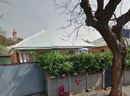
131 10 th Street th Street requires further investigation: 411


132 12 th Street th Street requires further investigation: 13 th Street The attractive 1930s bungalow at th Street should be considered for grading: 15 th Street The dwelling situated at erf 841 has a remarkable relationship with the corner, is not hidden behind high walls and is remarkably intact. It is one of the finest houses in Orange Grove and should be graded. 412


133 16 th Street The 16 th Street streetscape between Louis Botha Avenue and 8 th Avenue is remarkably intact and should be recognised. No 11 is particularly attractive. 17 th Street th Street should be considered for grading. 413


134 8 th Avenue 29 8th Avenue is an attractive and well preserved 1930s bungalow, and should be considered for grading: 77 8 th Avenue is an attractive and well preserved 1930s bungalow, and should be considered for grading: 82 8 th Avenue is an attractive and well preserved 1930s bungalow, and should be considered for grading: 414

135 6 th Ave No 8 6 th Avenue may warrant more research: 415
7.5 Identified sites of significance_residential buildings within Turffontein (Semi-detached, freestanding)
") 7.5 Identified sites of significance_residential buildings within Turffontein (Semi-detached, freestanding) Introduction Residential buildings are buildings that are generally used for residential purposes
7.5 Identified sites of significance_residential buildings within Turffontein (Semi-detached, freestanding) Introduction Residential buildings are buildings that are generally used for residential purposes
7.6 Identified sites of significance_residential buildings within Central Brixton Precinct (Semi-detached, freestanding)
") 7.6 Identified sites of significance_residential buildings within Central Brixton Precinct (Semi-detached, freestanding) Introduction Residential buildings are buildings that are generally used for residential
7.6 Identified sites of significance_residential buildings within Central Brixton Precinct (Semi-detached, freestanding) Introduction Residential buildings are buildings that are generally used for residential
National Character Area 70 Melbourne Parklands
 Summary The are a landscape of rolling farmland, parkland and woodland on the northern flanks of the ridge between Burton upon Trent and Swadlincote. The land slopes down to the River Trent, which borders
Morgan s Subdivision Historic District Character-defining Features
 Morgan s Subdivision Historic District Character-defining Features DISTRICT DESCRIPTION This small addition, designed as a neighborhood for those wishing to move east from Capitol Hill, was predominantly
NORFOLK RURAL SCHOOLS SURVEY
 1 Name of school Photo reference Thelveton Public Elementary School Thelveton 1-6 Grid Reference TM1615 8083 Is the building listed? No School Address The Old School House Norwich Road Thelveton Diss IP21
Orange Grove Precinct
 tsica the significance of cultural history Orange Grove Precinct Heritage Impact Assessment & Conservation Management Plan Report Phase 3 Louis Botha Avenue Development Corridor Prepared for: CITY OF JOHANNESBURG
Heritage Survey: Stellenbosch Rural Areas
 Heritage Survey: Stellenbosch Rural Areas by and Stewart Harris - June 2004 Sub Area Name Catalogue Number Jonkershoek 02.24 Property Name Konstanz, Jonkershoek, Stellenbosch District Farm Number 334/8
2: Bond Street, I.O.F Orphanage
 1. Description of Property 2: 37-53 Bond Street, I.O.F Orphanage Municipal Address 37-53 Bond Street ame (if applicable) Independent Order of Foresters (I.O.F.) Orphanage Legal Description PT LTS 15 &
30. Riverstown Mini-Plan
 County Development Plan 2017-2023 Consolidated Draft + Adopted Amendments August 2017 Volume 2, Chapter 30 Riverstown Mini-Plan 30. Riverstown Mini-Plan Village profile Riverstown is located approximately
Heritage Survey: Stellenbosch Rural Areas
 Heritage Survey: Stellenbosch Rural Areas by and Stewart Harris - June 2004 Sub Area Name Jonkershoek 02.01 Vergenoegd, Jonkershoek, Stellenbosch District Farm Number 321, 321/1, 1022 Heritage Resource
Architectural Inventory Form (page 1 of 5)
") OAHP1403 Rev. 9/98 COLORADO CULTURAL RESOURCE SURVEY (page 1 of 5) I. IDENTIFICATION 1. Resource number 5RT-2050 2. Temporary resource number: 145008005 3. County: Routt County 4. City: Steamboat Springs
OAHP1403 Rev. 9/98 COLORADO CULTURAL RESOURCE SURVEY (page 1 of 5) I. IDENTIFICATION 1. Resource number 5RT-2050 2. Temporary resource number: 145008005 3. County: Routt County 4. City: Steamboat Springs
7.1 Area 1: Haslemere Conservation Area
 7.1 Area 1: Haslemere Conservation Area Detailed map of Haslemere Town Conservation Area as of 2006 Crown copyright and database right 2011 Ordnance Survey LA100025451 27 The Conservation Area is characterised
Chapter 8: BEACH SOUTH OF ATLANTIC AVENUE NEIGHBORHOOD PLANNING AREA ANALYSIS
 Chapter 8: BEACH SOUTH OF ATLANTIC AVENUE NEIGHBORHOOD PLANNING AREA ANALYSIS The Beach South of Atlantic Avenue Neighborhood Planning Area includes the parcels adjacent to S Fletcher Avenue from Atlantic
Ordnance Street 110 Plan OS Lot 413 B202; parts of Lot 412 and portion of Lot 413
 Ordnance Street 110 Plan OS Lot 413 B202; parts of Lot 412 and portion of Lot 413 110 Ordnance Street has cultural heritage value under 3 categories Physical built in 1886, it is an example of late 19
HISTORICAL AND SOCIAL SIGNIFICANCE PHOTOGRAPH: M.VAIR-PIOVA, 2014
 DISTRICT PLAN LISTED HERITAGE PLACE HERITAGE ASSESSMENT STATEMENT OF SIGNIFICANCE HERITAGE ITEM NUMBER 487 DWELLING AND SETTING, IRONSIDE HOUSE 381 MONTREAL STREET/32 SALISBURY STREET, CHRISTCHURCH PHOTOGRAPH:
TSAWWASSEN TOWN CENTRE REDEVELOPMENT BLOCK A 004
 Current Context The context for the project includes storey multi-family residential to the northwest, a TD bank immediately north, highway oriented commercial to the east, a surface parking lot to the
Architectural Inventory Form (page 1 of 5)
") OAHP1403 Rev. 9/98 COLORADO CULTURAL RESOURCE SURVEY (page 1 of 5) Official eligibility determination (OAHP use only) Date Initials Determined Eligible- NR Determined Not Eligible- NR Determined Eligible-
OAHP1403 Rev. 9/98 COLORADO CULTURAL RESOURCE SURVEY (page 1 of 5) Official eligibility determination (OAHP use only) Date Initials Determined Eligible- NR Determined Not Eligible- NR Determined Eligible-
L 4-1. Heritage Report: Reasons for Heritage Designation. Kodors House. 35 Rosedale Avenue West
 L 4-1 Brampton Heritage Board Date: January 17, 2012 Heritage Report: Reasons for Heritage Designation Kodors House 35 Rosedale Avenue West December 2011 1 L 4-2 Profile of Subject Property Municipal Address
URBAN DESIGN BRIEF NORTHVIEW FUNERAL HOME HIGHBURY AVE N, LONDON, ON
 URBAN DESIGN BRIEF NORTHVIEW FUNERAL HOME - 1490 HIGHBURY AVE N, LONDON, ON 1.1Purpose The intent of the following report is to identify an opportunity for redevelopment of two residential properties within
HERITAGE STATEMENT AND IMPACT ASSESSMENT HILLBARK FARMHOUSE FRANKBY
 HILLBARK FARMHOUSE HERITAGE STATEMENT AND IMPACT ASSESSMENT HILLBARK FARMHOUSE FRONT ENTRANCE CONTENTS Executive summary 1.0 INTRODUCTION 1.1. Background to the report 1.2. Purpose of the Report 2.0 SIGNIFICANCE
ARCHITECTURAL GUIDELINES
 ARCHITECTURAL GUIDELINES 1. Introduction. The development of Raithby Vines adjacent to the village of Raithby has the overall goal of integrating the new residential units into the existing village, while
Lancaster Conservation Area Appraisal. Character Area 8. Cathedral
 Lancaster Conservation Area Appraisal Character Area 8. Cathedral March 2013 118 3.8 Character Area 8. Cathedral 3.8.1. Definition of Special Interest "This character area is distinctive for the fine group
Cathedrals. Cathedrals means chair and was the seat of the local bishop Cathedrals were built to take the worshipper to heaven.
 Cathedrals Cathedrals Cathedrals means chair and was the seat of the local bishop Cathedrals were built to take the worshipper to heaven. The Gothic period lasted from the late 1100's to the 1500's. Most
Memo. B R A Y H e r i t a g e
 6 1 3. 5 4 2. 3 3 9 3 6 1 3. 5 4 9. 6 2 3 1 c a r l @ b r a y h e r i t a g e. c o m Memo To: Jennifer Murray, Windmill Development Corporation From: Carl Bray, Bray Heritage Date: Monday, June 5, 2017
58: 1285 Sedgewick Crescent, Rotary Gardens
 1. Description of Property Municipal Address Name (if applicable) Legal Description Location of Property Ownership Access Current Use Existing Designation General Description Priority Level 58: 1285 Sedgewick
26 Park West Exploring Abergavenny
 26 Park West Exploring Abergavenny Cover: Park Avenue 2 park west EXPLORING ABERGAVENNY For several years the Abergavenny and District Civic Society has been studying the streets, spaces and buildings
Australian National University
 Study Item/ Area Acton Campus Precinct Building Nos. & Names Physics/Psychology DALEY Precinct 38 (Physics Building), 38A (Physics Link Building), 38B (Gravity Wave Building), 39 (Psychology Building)
County Development Plan Consolidated Draft + Adopted Amendments August 2017 Volume 2, Chapter 22 Easky Mini-Plan
 22. Easky Mini-Plan Village profile Easky is a coastal settlement located approximately 40 km to the west of Sligo City, in a designated Rural Area In Need of Regeneration. The nearby coastline is designated
Architectural Inventory Form
 COLORADO CULTURAL RESOURCE SURVEY Page 1 of 8 Official Eligibility Determination (OAHP use only) Rev. 9/98 OAHP1403 Date Initials Determined Eligible National Register Determined Not Eligible National
Friends Meeting House, Broughton. Meeting House Lane, Little Broughton, Cockermouth, CA13 0YQ. National Grid Reference: NY
 Friends Meeting House, Broughton Meeting House Lane, Little Broughton, Cockermouth, CA13 0YQ National Grid Reference: NY 07832 31740 Statement of Significance The modest building has medium significance
MULTIFAMILY RESIDENTIAL DESIGN PRINCIPLES Site Plan and Design Review Principles Checklist
 MULTIFAMILY RESIDENTIAL DESIGN PRINCIPLES Site Plan and Design Review Principles Checklist Applicant s Name: Project Address: Phone: Email: Applicant shall fill out the design guidelines checklist for
BORRISOKANE SETTLEMENT PLAN
 BORRISOKANE SETTLEMENT PLAN 1.0 General Introduction and Development Context Location Borrisokane is located 15km north of Nenagh on the N52. While the town is primarily residential, it acts as a market
Mountain Majesty. INDIA Trendy Tiles. A look At the latest styles And innovations in the tile industry
 www.dezigngenie.com VOL 9 No 6 February 2017 `150/uS$10/aeD 30 INDIA Trendy Tiles A look At the latest styles And innovations in the tile industry Mountain Majesty huus Gstaad hotel celebrates warmth and
Historic Resources Inventory Evaluation Form
 Evaluation Date September 12, 2017 Historic Resources Inventory Evaluation Form Community District Designation Downtown Grade 1 The place should be rated for each of the criteria below, in order to establish
CITY OF MIAMI CEMETERY 1800 N.E. 2 AVENUE
 CITY OF MIAMI CEMETERY 1800 N.E. 2 AVENUE Designation Report City of Miami REPORT OF THE CITY OF MIAMI PLANNING DEPARTMENT TO THE HERITAGE CONSERVATION BOARD ON THE POTENTIAL DESIGNATION OF CITY OF MIAMI
Name: Former Ornamental Garden and Trees at 1 Harestone Drive. Site is Grounds of 1 Harestone Drive formerly the Marie Curie Hospice.
 Name: Former Ornamental Garden and Trees at 1 Harestone Drive Location: Site is Grounds of 1 Harestone Drive formerly the Marie Curie Hospice. No.48 Coloured Red on plan. Description. Former site of Harestone
SUE ROSEN ASSOCIATES. Re: DA DA/485/2016. Thank you etc
 Re: DA DA/485/2016 Thank you etc I m an Epping based heritage consultant commissioned by the Epping Civic Trust to comment on the heritage aspects of the proposed development and on the reportage associated
ASSESSMENT OF LANDCAPE PROVISIONS FOR PROPOSED PLAN CHANGE 5. Local Business Zone PALMERSTON NORTH CITY COUNCIL FINAL
 Hawke s Bay Office: PO Box 8823 Havelock North john@hudsonassociates.co.nz Ph 06 877 9808 M 021 324 409 A division of Hudson Group Ltd ASSESSMENT OF LANDCAPE PROVISIONS FOR PROPOSED PLAN CHANGE 5 Local
DACORUM GOLDEN PARSONAGE Great Gaddesden Brief Description Principal Building: Approach: Stable block other utilitarian buildings: Walled Garden:
 HERTFORDSHIRE GARDENS TRUST LOCAL LIST: DACORUM Present Name of Site GOLDEN PARSONAGE Historic Name (if known) Parish/Town Great Gaddesden National Grid Reference of Principal Building: TL051 125 Present
Commercial Building Cuba Street. Images: Charles Collins, Summary of heritage significance
 Commercial Building 221-225 Cuba Street Summary of heritage significance Images: Charles Collins, 2014 221-225 Cuba Street is the remnant façade of an 1896 row of three two-storey shop/dwellings and is
Architectural Inventory Form
 COLORADO CULTURAL RESOURCE SURVEY Page 1 of 8 Official Eligibility Determination (OAHP use only) Rev. 9/98 OAHP1403 Date Initials Determined Eligible National Register Determined Not Eligible National
BERTRAMS PRIORITY BLOCK. Dra support documentation to the recommendations to SAHRA for the Priority Block, Bertrams, Johannesburg OCTOBER 2008
 BERTRAMS PRIORITY BLOCK Dra support documentation to the recommendations to SAHRA for the Priority Block, Bertrams, Johannesburg OCTOBER 2008 CONTENTS 1. Execu ve Summary 2. Report Structure 3. Background
The meeting house is of low-key design typical of the inter-war period. It has an attractive appearance with a spacious interior and good amenities.
 Friends Meeting House, Preston 189 St George s Road, Preston, PR1 6NQ National Grid Reference: SD 54314 30558 Statement of Significance The meeting house is of low-key design typical of the inter-war period.
1 of 1 1/31/2016 2:49 PM
 Guide to Residential Styles Realtor Magazine http://realtormag.realtor.org/home-and-design/guide-residential-styles 1 of 1 1/31/2016 2:49 PM Every house has a style. Sometimes it has two or more; because
Purpose of the Variation: The purpose of an ACA is to protect and enhance the special character of the ACA by:
 To the Lord Mayor and Report No. 201/2017 Members of Dublin City Council Report of the Assistant Chief Executive Proposed Draft Variation (No. 1) of Dublin City Development Plan 2016 2022 Designating Haddon
BLETCHLEY PARK AREA - DEVELOPMENT FRAMEWORK
 ANNEX A To Item 9 REVISED TEXT: additions shown bold and underlined, deletions in (brackets and in italics). BLETCHLEY PARK AREA - DEVELOPMENT FRAMEWORK This framework sets out the key objectives and requirements
Houses on the Forest Edge
 Houses on the Forest Edge Vivien Hill 1 Contents 3 Introduction 4 Pavilion Cottages 5 Oak Tree Cottage 6 Arts and Crafts Style 7 Laura House 8 Hillview 9 Bryle House 10 William Wells and the 1851 Census
What Style is My House?
 What Style is My House? -A Guide to Common House Styles in Decatur, GA- Contents American Small House.. p.2 Colonial Revival....p.3 Craftsman Cottage...p.4 English Vernacular Revival Cottage...p.5 American
Architectural Inventory Form
 OAHP1403 Rev. 9/98 COLORADO CULTURAL RESOURCE SURVEY Architectural Inventory Form Official eligibility determination (OAHP use only) Date Initials Determined Eligible- NR Determined Not Eligible- NR Determined
206 N. Colorado. 322 and 330 N. Colorado. 101 S. Colorado. The Country Rose, 121 S. Colorado. Municipal Power Plant
 This streetscape shows the west side of Colorado Ave. around 1905. The Drake Mercantile building is the only building still standing. Haxtun s early commercial buildings were primarily simple wood frame,
Authority: North York Community Council Item 31.7, as adopted by City of Toronto Council on May 6, 7 and 8, 2014 CITY OF TORONTO. BY-LAW No.
 Authority: North York Community Council Item 31.7, as adopted by City of Toronto Council on May 6, 7 and 8, 2014 CITY OF TORONTO BY-LAW No. 53-2015 To designate the property at 65 Centre Avenue (Alexander
Urban Design Brief 1576 Richmond Street City of London
 Urban Design Brief City of London Treadstone Developments October 31, 2014 Urban Design Brief October 31, 2014 TABLE OF CONTENTS Page No. INTRODUCTION... 1 SECTION 1 LAND USE PLANNING CONCEPT... 1 1.1
Built in 1984, the meeting house is the third meeting house on a site acquired in 1668 as a burial ground. The building has low heritage significance.
 Friends Meeting House, Reigate 47 Reigate Road, Reigate, Surrey, RH2 0QT National Grid Reference: TQ 26184 50219 Statement of Significance Built in 1984, the meeting house is the third meeting house on
URBAN DESIGN BRIEF 305, 309, & 315 SOUTHDALE ROAD WEST LONDON ONTARIO
 URBAN DESIGN BRIEF 305, 309, & 315 SOUTHDALE ROAD WEST LONDON ONTARIO CARVEST PROPERTIES LTD. December 2013 Section 1 - Land Use Planning Context 1.1 Subject Lands The subject lands are located immediately
4.3 Dudley Area Plan. Introduction. History and Existing Character. Desired Future Character for Dudley
 4.3 Dudley Area Plan Introduction The suburb of Dudley has developed as a result of various circumstances including its topography, history and mineral resources. Dudley development has been identified
Lincoln Townscape Assessment. Sherbrooke Inherited Character Area Statement
 Lincoln Townscape Assessment Sherbrooke Inherited Character Area Statement June 2008 Page 2 of 15 Table of Contents Page Overview 2 Historical Development 3 Urban form 4 Views 8 Condition of Buildings
Surlingham Primary School. Grid Reference TG Is the building listed? no. Walnut Hill Surlingham
 Name of school Surlingham Primary School Photo reference Surlingham 1-5 jpg Grid Reference TG31210648 Is the building listed? no Walnut Hill Surlingham The old (1837) school is incorporated in the village
FIRST COCONUT GROVE SCHOOLHOUSE
 FIRST COCONUT GROVE SCHOOLHOUSE 3429 DEVON ROAD Designation Report City of Miami REPORT OF THE CITY OF MIAMI PLANNING DEPARTMENT TO THE HERITAGE CONSERVATION BOARD ON THE POTENTIAL DESIGNATION OF THE FIRST
Ottawa Historic Resources Inventory: Commercial Historic District Building Information. Significance and Potential Eligibility
 C 01 1 Address: address 1 PIN: 21 11 218 001 Plan: Rectangular Stories: 2 Original Owner: Roof Type: Flat Building Names: Marquette School Foundation: Important Dates: ca 1955 Walls: BRICK Architect /
Sainte-Catherine Street West
 PACKARD BUILDING 4026-4032 Sainte-Catherine Street West Category: 1 Front North Façade South Façade: Garage Entrance North Façade: Entrance Portico South Facade Key Plan FOURNIER GERSOVITZ MOSS DROLET
CHAPTER 6 DESIGN GUIDELINES FOR INDIVIDUAL BUILDING ELEMENTS. Commercial Facades
 Design Guidelines for Historic Resources CHAPTER 6 DESIGN GUIDELINES FOR INDIVIDUAL BUILDING ELEMENTS This chapter presents design guidelines for the preservation of individual historic building elements
Design Guidelines. High Point Estates Design Guidelines April Gomberoff Bell Lyon Architects Group Inc.
 High Point Estates April 2006 Gomberoff Bell Lyon Architects Group Inc. 1 29 Contents Part One The Building Scheme Part Two Architectural Character and Siting Building Part One: The Building Scheme i 31
8. Camberwell 8.1. Camberwell Area Vision
 8. 8.1. Area Vision 8.1.1. is: Centred on a medieval village centre which has become a thriving modern town centre surrounded by residential streets laid out in the Georgian era; Linked by rail to central
Cookstown Heritage Conservation District Study Public Consultation March 26, 2013
 Public Consultation March 26, 2013 Funded by the Government of Ontario MMM Group Darryl Bird Project Manager, Senior Planner, CAHP Intern Shannon Baker Senior Landscape Architect, CAHP AREA Architects
WELLINGTON HOSPITAL DESIGN GUIDE TABLE OF CONTENTS
 WELLINGTON HOSPITAL DESIGN GUIDE TABLE OF CONTENTS 1.0 Introduction Page 2 The Place of Wellington Hospital 2 The Future of the Hospital 2 2.0 The Intention of the Design Guide 3 3.0 Analysis 4 General
1. Introduction _ 2. Theoretical Intention _ 3. Architectural Intention _ 4. Concept Statement 5. Conceptual Precedents _ 6.
 07 1. Introduction _ 2. Theoretical Intention _ 3. Architectural Intention _ 4. Concept Statement 5. Conceptual Precedents _ 6. Design Informants DESIGN CONCEPT FIGURE 7.1 Concept Development, Digital
Purchase Proposal Call for the Former St. Louis School 75 Allen Street East Addendum #3 12-June-2013
 Purchase Proposal Call for the Former St. Louis School 75 Allen Street East Addendum #3 12-June-2013 Closing Time and Date: 3:00 p.m. Local Time on Monday June 17, 2013 At the Monday May 27, 2013 Council
7 4. DESIGN GUIDELINES
 7 4. DESIGN GUIDELINES The following guidelines set forth design principles Each future project should be designed within a contin- intended to provide a framework for the design of future uum, with the
Chapter 6.2: Commercial Architectural Styles
 Chapter 6.2: Commercial Architectural Styles In this chapter you will find: Commercial, Civic, and Religious Styles Vernacular Commercial Victorian Commercial Moderne Gothic Revival COMMERCIAL ARCHITECTURAL
43: 2165 Dundas St. West, Smith-Carrique Barn and Shed
 1. Description of Property Municipal Address Name (if applicable) Legal Description Location of Property Ownership Access Current Use Existing Designation General Description Priority Level 43: 2165 Dundas
CHAPTER 3 DOWNTOWN COMMERCIAL DISTRICT CHARACTER AREA
 CHAPTER 3 DOWNTOWN COMMERCIAL DISTRICT CHARACTER AREA 3.1 INTRODUCTION The Downtown Commercial District Character Area of Grass Valley comprises all of the city's core historic commercial district, including
6. Ballintogher Mini-Plan
 County Development Plan 2017-2023 Consolidated Draft + Adopted Amendments August 2017 Volume 2, Chapter 6 Ballintogher Mini-Plan 6. Ballintogher Mini-Plan Village profile Ballintogher is located approximately
JOHANNESBURG METROPOLITAN MUNICIPALITY HERITAGE ASSESSMENT SURVEYING FORM
 CATALOGUE NO: AD-6 DATE RECORDED: July 2003/February 2004 JOHANNESBURG METROPOLITAN MUNICIPALITY HERITAGE ASSESSMENT SURVEYING FORM Compiled by: Dr JJ Bruwer, 2002-07-29 JJ Bruwer Cellphone: 082 325 5823
History of the Cranley Road Area. What is The Cranley Road Area
 History of the Cranley Road Area. What is The Cranley Road Area The Cranley Road Area lies to the east of Guildford. It was originally developed as large Victorian villas by the 4 th Earl of Onslow. It
This property contributes to the historic streetscape of Colborne Street and its striking architecture makes it a landmark along the street.
 Exhibit B Notice of Intention to Pass a By-Law to Designate 25 Colborne Street, also known as the Clark Wright House, To be of Cultural Heritage Value and Interest Pursuant to the Provisions of the Ontario
Introduction. Welcome to this consultation regarding the draft redevelopment proposals for the former CeramTec factory on Sidmouth Road, Colyton.
 Introduction Welcome to this consultation regarding the draft redevelopment proposals for the former CeramTec factory on Sidmouth Road, Colyton. We are currently considering options for the mixed-use redevelopment
CHAPTER 12 DESIGN GUIDELINES FOR PUBLIC IMPROVEMENTS
 CHAPTER 12 DESIGN GUIDELINES FOR PUBLIC IMPROVEMENTS Introduction This chapter provides design guidelines for public sector improvements in the downtown. This includes streetscape design, as well as the
Demolition of a Designated Heritage Property Roncesvalles Avenue
 REPORT FOR ACTION Demolition of a Designated Heritage Property - 421 Roncesvalles Avenue Date: March 8, 2018 To: Toronto Preservation Board Toronto and East York Community Council From: Acting Chief Planner
Key Concepts for Colonial Boston
 Key Concepts for Colonial Boston 1. 2. 3. 4. English Puritans founded Boston in 1630. The Puritans were officially members of the Church of England, but wanted to purify it of what they regarded as traditional
Monitoring Report No. 166
 Monitoring Report No. 166 No. 2a Loughadian Road Poyntzpass County Down AE/08/189 Nick Beer Site Specific Information Site Address: 2a Loughadian Road, Poyntzpass. Townland: Loughadian SMR No.: DOW 033:034
Eastcreek Farm. Planned Development Standards September, 2014
 Eastcreek Farm Planned Development Standards September, 2014 ekfarm Contents 01. General Standards 02. Residential Development Standards 03. Architectural Design Standards 04. Landscape Design Standards
URBAN DESIGN BRIEF Gordon Street City of Guelph. Prepared on behalf of Ontario Inc. March 25, Project No. 1507
 URBAN DESIGN BRIEF 1131 Gordon Street City of Guelph Prepared on behalf of 1876698 Ontario Inc. March 25, 2016 Project No. 1507 423 Woolwich Street, Suite 201, Guelph, Ontario, N1H 3X3 Phone (519) 836-7526
AREA 16: LITTLE OXFORD
 CHARACTER ASSESSMENT AREA 16: LITTLE OXFORD GENERAL DESCRIPTION OF THE AREA Little Oxford is bordered on the north by the corridor of trees and railings along Old Road, by Boundary Brook to the east, and
Lincoln Townscape Assessment. Boultham Park Inherited Character Area Statement
 Lincoln Townscape Assessment Boultham Park Inherited Character Area Statement January 2008 Page 2 of 12 Table of Contents Page Overview 2 Historical Development 2 Urban form 3 Views 5 Condition of Buildings
CHAPTER 2: HISTORIC BACKGROUND
 CHAPTER 2: HISTORIC BACKGROUND The historic town of Eastlake was created on June 22, 1911 when the Eastlake Subdivision was recorded at the Adams County Clerk and Recorder s Office. The Eastlake Investment
Public Consultation. Land at Monks Farm, North Grove. Welcome
 Welcome Welcome to our public exhibition for development on Land at Monks Farm, orth Grove. Gallagher Estates and Gleeson Strategic Land are preparing an outline planning application for new homes, open
Fig. 3.1 Three dimensional view of the site in its context in the CBD SITE AND RATIONALE 03
 44 Fig. 3.1 Three dimensional view of the site in its context in the CBD 45 SITE AND RATIONALE 03 46 Site Location The Site is located on the corner of Paul Kruger and Struben Street in the Tshwane/ Pretoria
17. Coolaney-Rockfield Mini-Plan
 County Development Plan 2017-2023 Consolidated Draft + Adopted Amendments - August 2017 17. Coolaney-Rockfield Mini-Plan Village profile Coolaney is located approximately 23 km to the south-west of Sligo
DESIGN & ACCESS STATEMENT
 . DESIGN & ACCESS STATEMENT Site Adjacent to The Manor House, Upper Street,, Kingsdown, Deal, Kent. DESIGNS ARCHITECTURE + PLANNING CONTENTS Design and Access Statement Introduction Site and Location Planning
BROADHEMBURY DESIGN STATEMENT
 BROADHEMBURY DESIGN STATEMENT As drawn up by Broadhembury Parish Council during the development of a Parish Plan and adopted at its meeting on 17 th May 2010 BROADHEMBURY DESIGN STATEMENT Contents Introduction
New York Deco. What Makes A New York Building Art Deco? this presentation was designed to offer a basic understanding of new york art deco
 We have made it easy for you to find a PDF Ebooks without any digging. And by having access to our ebooks online or by storing it on your computer, you have convenient answers with new york deco. To get
CAMPUS MASTER PLAN Appendix C Neighborhood Traffic and Parking Task Force
 CAMPUS MASTER PLAN 2004-2015 Appendix C Neighborhood Traffic and Parking Task Force Neighborhood Traffic and Parking Task Force Background The City, OSU, and the neighborhood associations in the vicinity
L 2-1 HERITAGE REPORT: REASONS FOR HERITAGE DESIGNATION. Cheyne Family Cemetery. Main Street South
 L 2-1 HERITAGE REPORT: REASONS FOR HERITAGE DESIGNATION Cheyne Family Cemetery Main Street South October 2013 L 2-2 PROFILE OF SUBJECT PROPERTY: Municipal Address Main Street South (Lot 14, Con 1, EHS)
Part 11 Heritage Area Plans West Wallsend / Holmesville
 TABLE OF CONTENTS: PART 1 WEST WALLSEND / HOLMESVILLE HERITAGE AREA PLAN... 3 1.1 INTRODUCTION... 3 1.2 BACKGROUND... 3 1.3 LAND TO WHICH THIS PLAN APPLIES... 3 PART 2 WEST WALLSEND / HOLMESVILLE HERITAGE
2bPlanning Scheme. Appendix. Conservation - Removal of Structures. Grangegorman
 Appendix 2bPlanning Scheme Grangegorman Conservation - Removal of Structures Innovative Urban Quarter Contemporary Healthcare Facilities Modern Education Hub Accessible Public Spaces Appendix 2b: Purpose
Chapter 4: Jordan Road Character District
 4: Jordan Road Character District 4.1 Introduction The Jordan Road character district encompasses much of the former Jordan orchard and farmstead, which was a significant part of Sedona s history. The
GMT 1-8. A high quality flint building built by the landlord (Charles Lombe) in the 1850s with a small extension in the 1890s. Now a private house.
 in the 1850s with a small extension in the 1890s. Now a private house.") 1 Name of school Great Melton National (Mied) School (1852) Photo reference GMT 1-8 Grid Reference TG 6129 3068 School Address (Now Private residence) Old School, Landlow Lane, Great Melton, Norwich, NR9
1 Name of school Great Melton National (Mied) School (1852) Photo reference GMT 1-8 Grid Reference TG 6129 3068 School Address (Now Private residence) Old School, Landlow Lane, Great Melton, Norwich, NR9
2154 Dundas Street West Intention to Designate under Part IV, Section 29 of the Ontario Heritage Act
 STAFF REPORT ACTION REQUIRED 2154 Dundas Street West Intention to Designate under Part IV, Section 29 of the Ontario Heritage Act Date: February 2, 2009 To: From: Toronto Preservation Board Toronto and
3(iv)(b) TCP/11/16(29)
(b) TCP/11/16(29)") 3(iv)(b) TCP/11/16(29) TCP/11/16(29) Planning Application 09/02229/AML Erection of a dwellinghouse, garage with upper floor accommodation and stables (Approval of Matters Specified by Conditions) at land
3(iv)(b) TCP/11/16(29) TCP/11/16(29) Planning Application 09/02229/AML Erection of a dwellinghouse, garage with upper floor accommodation and stables (Approval of Matters Specified by Conditions) at land
CHAPTER 1: INTRODUCTION
 CHAPTER 1: INTRODUCTION MAP OF OUTAGAMIE COUNTY, WI N 1 = 6 miles INTRODUCTION The Town and Village of Black Creek are located in central Outagamie County, Wisconsin. The Village is located in the north