Guidelines for the Protection and Enhancement of the Heritage Character and Vista of King George Highway
|
|
|
- Anis Poole
- 5 years ago
- Views:
Transcription


1 Guidelines for the Protection and Enhancement of the Heritage Character and Vista of King George Highway Surrey Heritage Register Site 214 Approved by Council on March 22, These guidelines are to be used to assist Owners, Developers and Staff to implement the protection of existing heritage English Oak trees and the planting of new heritage English Oak trees along King George Highway from the Nicomekl River to 8 Avenue. City Of Surrey May 2004
2 Guidelines for the Protection and Enhancement of The Heritage Character and Vista of King George Highway between the Nicomekl River and 8 th Avenue Approved by Council on March 22, 2004, Resolution No. RES.R Historical and Planning Context: In the original legal plans from the 1930's, the road connecting the Patullo Bridge with the Canada-US boarder crossing at Douglas was called the "Peace Arch Highway". Following the 1939 Royal Visit of King George VI and Queen Elizabeth, Surrey Council approved the renaming of this road to "King George VI Highway" in April 1940 by notice in the BC Gazette, now commonly known as King George Highway. The generally accepted historical account is that as a commemoration of the Coronation of King George VI in 1937, both sides of King George Highway from the Patullo Bridge to the Peace Arch were planted at approximately 100 foot intervals with English Oak trees imported from Great Windsor Park, England. Disease and the development of lands along King George Highway over the years have claimed many of these trees. The main remaining concentration is located in South Surrey between the Nicomekl River and 8 Avenue. Some maple and other species of trees were part of this same planting plan, some of which are located north from Highway No. 10 towards Newton. In recognition of their historical significance, all remaining trees are on Council's Significant Tree List, and in January 2004, Council added King George Highway from the Patullo Bridge to 8 Avenue and the heritage English Oak trees between the Nicomekl River and 8 Avenue to the Surrey Heritage Register. These same segments have been identified for recognition on the Federal Register of Historic Places, as described in a Statement of Significance authored by the City. When the City upgrades stretches of King George Highway in South Surrey, heritage Oak Trees will be planted in those locations where they are missing. Where a site along this stretch of King George Highway is subject to a development application, the developer will be encouraged to pay the cost of planting the sapling trees as part of their development. These guidelines are intended to assist in coordinating landscaping in the vicinity of existing or proposed heritage English Oaks, particularly when sites along the King George Highway are developed, subject to building permit applications or being considered for road widening, exchanges or closures, to insure that the heritage vista of the King George Highway in South Surrey is restored, maintained and protected in the future.
3 2. Tree Spacing along King George Highway: (1) A 30-meter (100 foot) spacing, that reflects the historical planting pattern, is established for the planting of heritage English Oaks (Quercus robur) along both sides of King George Highway from the Nicomekl River to 8 Avenue. (2) The portion of King George Highway subject to these guidelines is shown on the map attached as Appendix A. (3) The approximate location of the existing trees and the proposed location of future trees are shown on the plan in Appendix B. 3. Protection of Existing Trees: (1) Existing heritage English Oaks located along the King George Highway and any that may be located on intersecting streets for corner lots shall be preserved. (2) As part of all development or building permit applications along King George Highway, it is the responsibility of the developer or owner to ensure retention of the existing heritage English Oaks on the public road allowance lands fronting a subject property. (3) If a strip of King George Highway is being closed and consolidated with the lot(s) being developed, all existing heritage English Oaks shall remain on public road allowance lands. The diagrams in Appendix C show the possible options of achieving this requirement. (4) Underground services or connections and underground utilities such as natural gas lines, telephone or like telecommunications cables, and water or other City service, shall be situated no closer than 7.5 meters from heritage English Oak tree. Excavations for the installation and maintenance of these utilities will involve practices that avoid damaging a heritage Oak Tree or its root system. 4. Guidelines: Where a site along King George Highway is subject to development or building permit applications, road widening or road closure, and a heritage English Oak tree exists or is intended to be planted along the boulevard fronting the subject site, then the following guidelines apply:
4 (1) The long-term health and viability of the heritage English Oak trees is of primary importance to the City; (2) Underground structures, walls and landscaping in the root zone of all existing trees will be designed and installed using methods and techniques that shall not adversely affect the long-term health of the trees, in accordance with the standards and practices established and approved by the City; (3) Landscaping on private property, within 7.5 meters of the heritage English Oak is to consist of plant species and shrubs and other features that accord a suitable backdrop and heritage context, and shall be specified in a development permit, statutory building scheme or a restrictive covenant as may be required by the City in conjunction with development applications, heritage applications, subdivisions, road closure applications or building permit applications. (4) Underground services or connections and underground utilities such as natural gas lines, telephone or like telecommunications cables, and water or other City service, shall be installed no closer than 7.5 meters from a tree trunk where a heritage English Oak tree is planted or is proposed to be planted. (5) Landscaping on the boulevard within 7.5 meters of any heritage English Oak tree is to be in accordance with the standards and practices established and approved by the Parks, Recreation and Culture Department; (6) Alternating scarlet and pin oaks inside the property line, 10 cm. cal. at 6 m. o.c. to form a solid backdrop inside the property line. Where tree planting inside the property line is influenced by existing trees or services, the scarlet and pin oaks can be planted in a more naturalistic pattern, in larger islands away from overhead lines and the like, for streetscape continuity. (7) Driveways are to be consolidated where possible and located to eliminate the potential impact on: the health and the existing or planned locations of the heritage English Oak trees and the heritage character of the corridor. (8) Buildings and structure, including below grade structures, retaining walls and foundations, surface parking, signage, lighting and other features in the front yard are to be located and designed to minimise the impact on heritage character of the boulevard and to maintain and enhance an attractive heritage vista along the corridor.
5 (9) In all Development Permit Areas along King George Highway, the existing or future locations of heritage English Oak trees are to be shown on the landscaping plans. (10) Protective fencing shall be installed around any heritage English Oak tree in construction areas, such as development sites, and areas involving road works, or excavations. (11) Pruning shall only be done as approved by the City. 5. Notation in Documents and on Plans: (1) Plans and documents such as landscaping plans, Development Permit or construction drawings are to identify the location of existing and proposed heritage English Oak Trees and indicate what steps will be taken to protect them.

6 APPENDIX A Portion of King George Highway Subject to Heritage English Oak Planting Appendix A
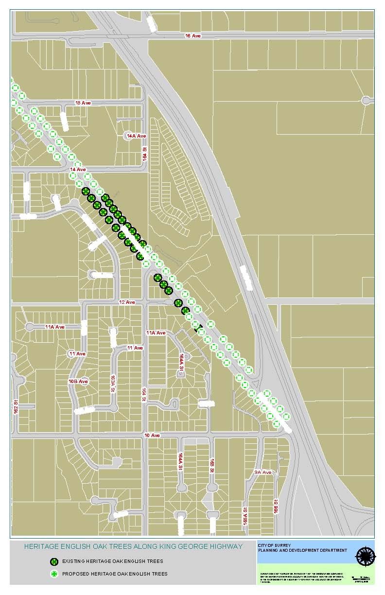
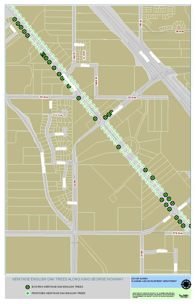
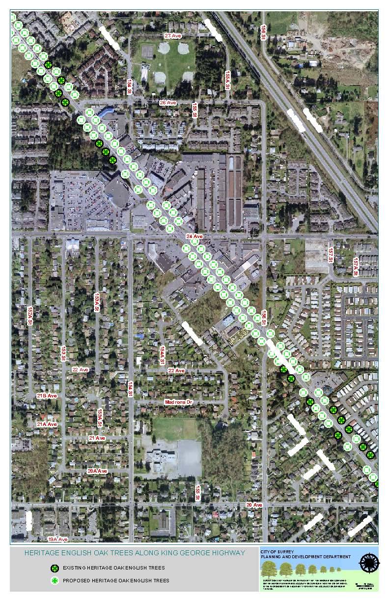
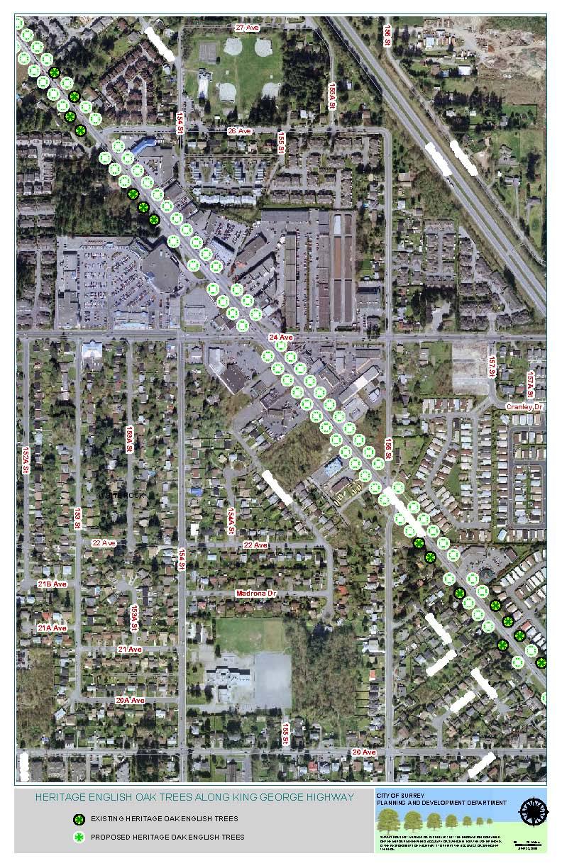
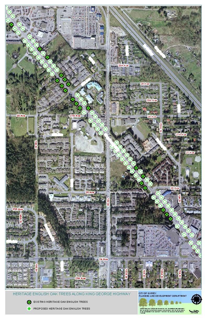
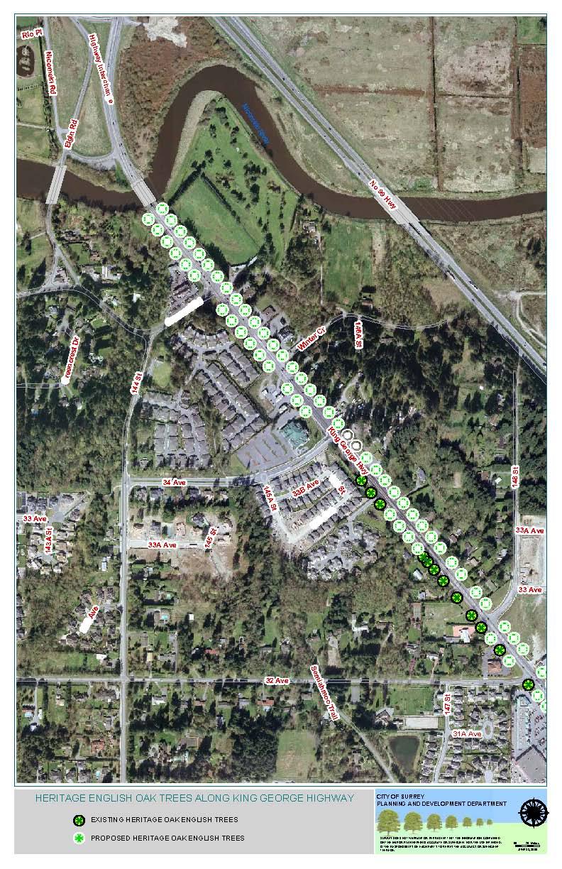
7 APPENDIX B Location of Existing and Future Planting of Heritage English Oaks Along the King George Highway in South Surrey (See colour maps attached separately)
8 APPENDIX C Examples of maintaining existing heritage English Oaks on the public road allowance lands Figure 1: Example of a development site involving three abutting heritage English Oaks. The figures that follow provide for two options for this site. Figure 2: Example of a developed site with widening along the King George Highway to retain the existing heritage English Oak the tree on public road allowance. Figure 3: Example of a developed site with jogs created along the King George Highway to retain the existing heritage English Oak the tree on public road allowance.
9 APPENDIX B Note: The first set of maps is on a legal base and the second is on an air photo base. Both contain the same information respecting existing heritage trees and those to be planted.
10

11

12

13

14

15
16

17

18

19

20
21
22
23

24
25
PART VII - SPECIAL BUILDING SETBACK
 A. GENERAL Amended B/L 10602 1. Notwithstanding the provisions of previous sections 11/10/90 of this By-law, setback of buildings and structures on a property abutting existing or future Provincial highways,
FROM: Acting General Manager, Planning and Development FILE:
 Corporate NO: R228 Report COUNCIL DATE: October 30, 2006 REGULAR COUNCIL TO: Mayor & Council DATE: October 25, 2006 FROM: Acting General Manager, Planning and Development FILE: 5400-80-10600 5400-01 SUBJECT:
Rezoning. Rezone from C-4 and RA to RF-9C and RF-12C to allow subdivision into approximately 47 small single family lots in East Clayton.
 City of Surrey PLANNING & DEVELOPMENT REPORT File: 7903-0275-00 Rezoning Proposal: Rezone from C-4 and RA to RF-9C and RF-12C to allow subdivision into approximately 47 small single family lots in East
City of Surrey PLANNING & DEVELOPMENT REPORT File:
 City of Surrey PLANNING & DEVELOPMENT REPORT File: 7910-0272-00 PROPOSAL: Planning Report Date: February 28, 2011 OCP Amendment from Industrial to Commercial Rezoning from CHI to CD Development Permit
City of Surrey PLANNING & DEVELOPMENT REPORT. OCP Amendment of a portion from Suburban to Urban
 City of Surrey PLANNING & DEVELOPMENT REPORT File: 7911-0119-00 Planning Report Date: November 7, 2011 PROPOSAL: OCP Amendment of a portion from Suburban to Urban Rezoning from RA to RH and RF in order
5.1.1 The streetscape along US Highway 64 (Brevard Road); and, The built environment within new residential developments; and,
; and, The built environment within new residential developments; and,") Article 5. Landscaping 5.1 Purpose The Town of Laurel Park s landscape standards are designed to create a beautiful, aesthetically pleasing built environment that will complement and enhance community
Article 5. Landscaping 5.1 Purpose The Town of Laurel Park s landscape standards are designed to create a beautiful, aesthetically pleasing built environment that will complement and enhance community
Rezoning. Rezone from A-1 to RH to create 9 suburban single family residential lots. Approval to Proceed
 City of Surrey PLANNING & DEVELOPMENT REPORT Rezoning Proposal: Rezone from A-1 to RH to create 9 suburban single family residential lots. Recommendation: Approval to Proceed Location: 18712 and Portion
City of Surrey PLANNING & DEVELOPMENT REPORT File:
 City of Surrey PLANNING & DEVELOPMENT REPORT File: 7915-0222-00 Planning Report Date: April 24, 2017 PROPOSAL: Rezoning from RF to C-5 Development Permit Development Variance Permit to permit the development
CITY VIEW OBJECTIVES
 SECTION 2: CITY VIEW OBJECTIVES CONTENTS 2.1 Introduction 1 2.2 Strategic Direction 1 2.3 The City View Resource Management Issues for the City 1 2.4 The Goal 3 2.5 The City View Objectives 3 Palmerston
City of Surrey. Special Heritage Advisory Commission Minutes. Absent: R. Cammack. 1. Heritage Advisory Commission Minutes January 28, 2004.
 City of Surrey Special Heritage Advisory Commission Minutes Executive Boardroom City Hall 14245-56 Avenue Surrey, B.C. TUESDAY, MARCH 9, 2004 Time: 9:00 a.m. Present: B. Paton - Chair D. Bowyer A. Clegg
Commissioners Road West Realignment Environmental Assessment
 City of London Commissioners Road West Realignment Environmental Assessment Public Information Centre No. 1 March 30, 2017 Welcome to the Public Information Centre This first Public Information Centre
URBAN DESIGN BRIEF Gordon Street City of Guelph. Prepared on behalf of Ontario Inc. March 25, Project No. 1507
 URBAN DESIGN BRIEF 1131 Gordon Street City of Guelph Prepared on behalf of 1876698 Ontario Inc. March 25, 2016 Project No. 1507 423 Woolwich Street, Suite 201, Guelph, Ontario, N1H 3X3 Phone (519) 836-7526
MEMORIAL DRIVE DESIGN DEVELOPMENT PLAN
 DESIGN DEVELOPMENT PLAN prepared for The City of Calgary Parks June 2005 cover images: Glenbow Alberta Archives Thomas Mawson Plan for Calgary c. 1914 panoramic view of Calgary from Crescent Heights c.1940
Clairtrell Area Context Plan
 Clairtrell Area Context Plan March 2005 Urban Development Services City Planning Contents 1. Introduction... 4 2. Development Structure... 6 2.1 Streets... 7 2.1.1 Sheppard Avenue and Bayview Avenue...
King s College Proposed Private Plan Change 41 Golf Avenue, Otahuhu URBAN DESIGN ASSESSMENT
 King s College Proposed Private Plan Change 41 Golf Avenue, Otahuhu URBAN DESIGN ASSESSMENT CONTENTS 1.0 EXCECUTIVE SUMMARY... 1 2.0 INTRODUCTION... 2 2.1 Purpose of document... 2 2.2 Report structure...
Issue 1 Protection of the special environmental qualities of the Hanmer Basin.
 Environments of special concern Issue 19 Hanmer Basin The Hanmer Basin is a special area, being a popular retirement and holiday destination as well as having considerable environmental and conservation
City of Surrey PLANNING & DEVELOPMENT REPORT File:
 City of Surrey PLANNING & DEVELOPMENT REPORT PROPOSAL: Development Permit Planning Report Date: March 10, 2008 Development Variance Permit in order to permit the development of a commercial building and
Raft Island Right of Way Vegetation and Tree Management Plan
 Raft Island Right of Way Vegetation and Tree Management Plan October 13, 2010 Introduction With the advent of underground utilities executed on the Island some 10 years ago, cessation of power line right
URBAN DESIGN BRIEF URBAN DESIGN BRIEF 721 FRANKLIN BLVD, CAMBRIDGE August 2018
 URBAN DESIGN BRIEF URBAN DESIGN BRIEF 721 FRANKLIN BLVD, CAMBRIDGE August 2018 DESIGN BRIEF CONTENTS PART A 1.0 INTRODUCTION 2.0 DESCRIPTION & ANALYSIS OF SITE CONTEXT 3.0 DESIGN CONSTRAINTS AND OPPORTUNITIES
Executive Summary. The goals of the Plan are to:
 Executive Summary The Wiscasset Bath Road Master Plan (Plan) seeks to maximize development opportunities along Bath Road through the strategic coordination of traffic infrastructure improvements, land
Ensure that development within the Arrowtown Urban Growth Boundary provides:
 URBAN DEVELOPMENT 4 4.2.5.2 Ensure that development within the Arrowtown Urban Growth Boundary provides: an urban form that is sympathetic to the character of Arrowtown, including its scale, density, layout
GUIDELINES BAYVIEW INSTITUTIONS CONTEXT PLAN LOCATION PLAN COMPONENTS URBAN DESIGN GUIDELINES
 Development in the Bayview Sunnybrook area will be consistent with the following urban design guidelines. They provide a framework for development in the area and are to be read in conjunction with the
Hockessin Community Redevelopment Plan
 Hockessin Community Redevelopment Plan 3.1 Introduction The Community Redevelopment Plan for the Village of Hockessin is the result of the people s vision for a distinct village center that serves as the
Regular Council - Land Use Minutes
 Regular Council - Land Use Minutes Council Chambers City Hall 13450-104 Avenue Surrey, B.C. MONDAY, FEBRUARY 5, 2018 Time: 5:38 p.m. Present: Mayor Hepner Councillor Gill Councillor Hayne Councillor LeFranc
PRELIMINARY PLAT DESIGN REQUIREMENTS Updated 4/8/2016
 PRELIMINARY PLAT DESIGN REQUIREMENTS Updated 4/8/2016 The following items are required for the preliminary plat. Numbers correspond with those on the example preliminary plat. RENO COUNTY SUBDIVISION REQUIREMENTS
Rezoning. Approval to Proceed. City of Surrey PLANNING & DEVELOPMENT REPORT File:
 City of Surrey PLANNING & DEVELOPMENT REPORT Rezoning Proposal: Rezone from RA to RF in order to permit subdivision into 24 single family residential lots and a park lot. Recommendation: Approval to Proceed
City of Surrey ADDITIONAL PLANNING COMMENTS File:
 City of Surrey ADDITIONAL PLANNING COMMENTS PROPOSAL: Development Permit Planning Report Date: May 4, 2009 in order to permit the expansion of the vehicle storage area for White Rock Honda. LOCATION: OWNER:
Royal Thai Embassy Ottawa. Major Zoning Amendment Proposal for 180 Island Park Drive. Planning Rationale
 Royal Thai Embassy Ottawa Major Zoning Amendment Proposal for INTRODUCTION This has been prepared in support of a Major Zoning Amendment for lands located at and currently occupied by Royal Thai Embassy.
GUIDELINES WESTON LOCATION: URBAN DESIGN GUIDELINES
 Development in the Weston area will be consistent with the following urban design guidelines. The guidelines correspond to Site and Area Specific Policies 45, 46, 47, 48, 49, 51, 52 and 232 in Chapter
Cookstown Heritage Conservation District Study Public Consultation March 26, 2013
 Public Consultation March 26, 2013 Funded by the Government of Ontario MMM Group Darryl Bird Project Manager, Senior Planner, CAHP Intern Shannon Baker Senior Landscape Architect, CAHP AREA Architects
Historic Heritage Historic Heritage Explanatory Statement Significant Issues Objectives and Policies...
 Section Contents Historic Heritage... 2 7. Historic Heritage... 2 Explanatory Statement... 2 7.1 Significant Issues... 3 7.2 Objectives and Policies... 3 7.3 Activity Lists... 4 7.4 Matters of Control
URBAN DESIGN BRIEF REPORT
 URBAN DESIGN BRIEF REPORT PREPARED FOR 2568401 ONTARIO INC NEW GASBAR, CONVENIENCE STORE & CARWASH DEVELOPMENT @ 1509 FANSHAWE PARK ROAD WEST LONDON, ONTARIO GAMA ENGINEERING INC. PROJECT NUMBER 1669 PREPARED
3.0 master plan concept
 3.0 master plan concept 3.1 introduction The purpose of the Huron Church Road Master Plan Concept is to provide an overview of the Master Plan design process, identify preliminary streetscape installations
DEVELOPMENT DESIGN GUIDELINES
 DEVELOPMENT DESIGN GUIDELINES Approved by Surrey City Council January 26, 2004 Campbell Heights Business Park - Development Design Guidelines TABLE OF CONTENTS 1.0 DEVELOPMENT CONCEPT... 1 2.0 DESIGN OBJECTIVES...
We d like to thank you for attending this Wekiva Parkway Section 8 Preliminary Design Update hosted by the Florida Department of Transportation.
 We d like to thank you for attending this Wekiva Parkway Section 8 Preliminary Design Update hosted by the Florida Department of Transportation. We will provide you information on the overall project and
Chapter 3: Natural Environment. Proposed Waikato District Plan Stage 1. (Notified version)
") Chapter 3: Natural Environment Proposed Waikato District Plan Stage 1 Page 2 of 7 Contents Chapter 3: Natural Environment... 3 3.1 Indigenous Vegetation and Habitats... 3 3.1.1 Objective Biodiversity and
Chapter 3: Natural Environment Proposed Waikato District Plan Stage 1 Page 2 of 7 Contents Chapter 3: Natural Environment... 3 3.1 Indigenous Vegetation and Habitats... 3 3.1.1 Objective Biodiversity and
THE CITY OF VAUGHAN BY-LAW BY-LAW NUMBER
 THE CITY OF VAUGHAN BY-LAW BY-LAW NUMBER 123-2013 A By-law to designate the whole of the City of Vaughan as a Site Plan Control Area, and to adopt site development guidelines and rules of procedure for
URBAN DESIGN BRIEF. 2136&2148 Trafalgar Road. Town of Oakville
 URBAN DESIGN BRIEF 2136&2148 Trafalgar Road Town of Oakville Prepared By: METROPOLITAN CONSULTING INC For 2500674 Ontario Inc November 2016 TABLE OF CONTENTS Page No. 1.0 Introduction/Description of Subject
Appendix E Preliminary Location Hydraulic Study
 Appendix E Prepared for: State of Alaska Department of Transportation and Public Facilities Prepared by: HDR Alaska, Inc. 2525 C Street, Suite 305 Anchorage, Alaska 99503 February 2014 This page intentionally
GUIDELINES REPLACEMENT HOUSING GUIDELINES LOCATION INTRODUCTION URBAN DESIGN GUIDELINES
 Replacement housing in the former City of North York will be consistent with the following urban design guidelines. They provide a framework for residential re-development in the former City of North York
Bel-Air Lexus Automobile Service Station
 Bel-Air Lexus Automobile Service Station Design Brief 443-447 McArthur Avenue Ottawa April 30, 2015 14-1299-MCA Site Details Application: Site Plan Control Legal Description and Municipal Addresses: 443
New-Cast Mixed-use Development Proposal King Street West, Newcastle, Ontario
 URBAN DESIGN BRIEF New-Cast Mixed-use Development Proposal King Street West, Newcastle, Ontario TABLE OF CONTENTS: 1.0 Executive Summary 2.0 Creating Vibrant and Sustainable Urban Places: Excerpts from
CA.1 Coastal Area. Index. CA.1.1 Description and Expectations
 Index.1.2.3.4 CA.2 CA.2.1 CA.2.2 CA.2.3 CA.3 CA.3.1 CA.3.2 CA.3.1 CA.4 CA.4.1 CA.4.2 CA.4.3 CA.4.4 CA.5 CA.5.1 CA.5.2 Description and Expectations Objectives Policies Guidance Note Landuse Eligibility
1. General Purpose. 3. Uses
 1. General Purpose The purpose of this DC1 Provision is to facilitate the development of a pedestrian friendly Community Commercial Centre that may accommodate a range of commercial, residential, office,
LANDSCAPE ORDINANCE 1. LANDSCAPE PLAN REVIEW REQUIREMENTS
 LANDSCAPE ORDINANCE PURPOSE A. The purpose of this chapter is to protect and promote the public health, safety, general welfare and beautification through the City of Kalispell s authority to regulate
East Bayshore Road Neighbourhood
 East Bayshore Road Neighbourhood Northridge Property Management Urban Design Brief 3195 East Bayshore Road City of Owen Sound January 2016 East Bayshore Road Neighbourhood Northridge Property Management
L 4-1. Heritage Report: Reasons for Heritage Designation. Kodors House. 35 Rosedale Avenue West
 L 4-1 Brampton Heritage Board Date: January 17, 2012 Heritage Report: Reasons for Heritage Designation Kodors House 35 Rosedale Avenue West December 2011 1 L 4-2 Profile of Subject Property Municipal Address
Capital Projects in and near Odenton Town Center
 Capital Projects in and near Odenton Town Center Map ID Anne Arundel County Department of Public Works This project provides for the design, right of way acquisition, and construction of approximately
City of Toronto. Emery Village Transportation Master Plan
 City of Toronto Emery Village Transportation Master Plan May 2009 Emery Village Transportation Master Plan Toronto, ON May 2009 Consulting Inc. 100 York Blvd., Suite 300 Richmond Hill, ON L4B 1J8 Tel:
CULTURAL HERITAGE RESOURCES POLICIES
 New Official Plan CULTURAL HERITAGE RESOURCES POLICIES Date March 6, 2009 Distributed at: Livable Oakville Committee, March 9, 2009 Planning Services Department March 2009 1 1 Policy Discussion Paper:
GUIDELINES EXHIBITION PLACE LOCATION: OBJECTIVES. Structure Plan URBAN DESIGN GUIDELINES
 Development in the Exhibition Place lands will be consistent with the following urban design guidelines. They provide a framework for new development of the lands and are to be read in conjunction with
PART XVI - R-H(G) HALF-ACRE RESIDENTIAL - GROSS DENSITY ZONE A. INTENT
 HALF-ACRE RESIDENTIAL - GROSS DENSITY ZONE A. INTENT") PART XVI - R-H(G) HALF-ACRE RESIDENTIAL - GROSS DENSITY ZONE PART XVI - R-H(G) HALF-ACRE RESIDENTIAL - GROSS DENSITY ZONE A. INTENT This zone is intended for single family housing on suburban Amended lots,
PART XVI - R-H(G) HALF-ACRE RESIDENTIAL - GROSS DENSITY ZONE PART XVI - R-H(G) HALF-ACRE RESIDENTIAL - GROSS DENSITY ZONE A. INTENT This zone is intended for single family housing on suburban Amended lots,
4 Residential and Urban Living Zones
 4 Residential and Urban Living Zones Refer to Chapters 11 to 20 for additional rules that may apply to these zones. 4.1 OBJECTIVES AND POLICIES Objective Res1 Policy 1 Policy 2 Policy 3 Policy 4 Policy
Potential Green Infrastructure Strategies May 6, 2015 Workshop
 Potential Green Infrastructure Strategies May 6, 2015 Workshop Background The City of Cortland is developing the Tioughnioga Urban Headwaters Green Infrastructure Action Plan with funding from the National
3. Urban Design in the Central Area
 3. Urban Design in the Central Area The Central Area Planning and Design Group assumes the responsibility to promote high quality urban and architectural design in the Central Area, plan and ensure the
Bylaw A Bylaw to amend Bylaw 12800, as amended, The Edmonton Zoning Bylaw Amendment No. 2239
 Bylaw 17672 A Bylaw to amend Bylaw 12800, as amended, The Edmonton Zoning Bylaw Amendment No. 2239 WHEREAS City Council at its meeting of February 22, 2001, gave third reading to Bylaw 12800, as amended;
4.500 Preston Road Overlay District
 Section 4.500 Preston Road Overlay District 2004 Zoning Ordinance 4.500 Preston Road Overlay District (ZC 98-29; Ordinance No. 98-9-12) 4.501 Purpose To provide appropriate design standards for the use
Director, Community Planning, North York District
 STAFF REPORT ACTION REQUIRED 36 and 37 Jane Osler Boulevard and 42 and 44 Cartwright Avenue Zoning By-law Amendment and Draft Plan of Subdivision Approval Applications - Preliminary Report Date: May 22,
Telecommunication Facility Policy
 Telecommunication Facility Policy September 26, 2016 Table of Contents SECTION 1 Purpose of the Policy SECTION 2 Principles SECTION 3 Designated Municipal Official SECTION 4 Design and Landscaping SECTION
Appendix 18F: Tauriko Business Estate Services Strategy Statement and Sequencing Schedule
 Appendix 18F: Tauriko Business Estate Services Strategy Statement and Sequencing Schedule This statement describes key proposals for the development of infrastructure at Tauriko Business Estate. Appendix
(blank page) WestConnex New M Roads and Maritime Services Environmental impact statement
 WestConnex New M Roads and Maritime Services Environmental impact statement") (blank page) WestConnex New M5 5-42 (blank page) WestConnex New M5 5-44 5.5 Tunnels 5.5.1 Main alignment tunnels The main alignment tunnels would be about nine kilometres long, with the western tunnel
(blank page) WestConnex New M5 5-42 (blank page) WestConnex New M5 5-44 5.5 Tunnels 5.5.1 Main alignment tunnels The main alignment tunnels would be about nine kilometres long, with the western tunnel
Parkway Tree Replacement Program
 Parkway Tree Replacement Program The Village of Romeoville is dedicated to providing a foundation which enhances the quality of life throughout the community. As part of this mission, the Village strives
7Page 91 CLEMMONS COMMUNITY COMPASS 7 COMMUNITY CHARACTER
 7 Community Character The beauty of Clemmons won t necessarily be a reflection of our past, but our future. This quote from Comprehensive Plan Steering Committee member Wayne Dodson captures the essence
AIRPORT BUSINESS PARK
 PIER MAC PETROLEUM INSTALLATION LTD. AIRPORT BUSINESS PARK DEVELOPMENT APPLICATIONS March 2003 4.1 Airport Business Park Development Permit Area 4.1.1 Justification/Design Concept The design concept envisioned
Toronto Complete Streets Guidelines
 Toronto Complete Streets Guidelines 108 110 7.1 Green Infrastructure Design Principles 112 7.2 Context-Sensitive Green Streets 114 7.3 Key Green Street Elements Green infrastructure refers to natural and
HURON COMMUNITY PLAN
 CITY OF KITCHENER DEPARTMENT OF DEVELOPMENT AND TECHNICAL SERVICES PD 94/7 HURON COMMUNITY PLAN Recommended by Planning and Economic Development Committee: October 31, 1994 Adopted by Kitchener City Council:
Integration of Trees into Roads Policy - the road to success -
 Integration of Trees into Roads Policy - the road to success - Trees, People and the Built Environment 3 City of Birmingham, UK April 5 th, 2017 Ian Buchanan Natural Heritage and Forestry Regional Municipality
LOW DENSITY RESIDENTIAL
 LOW DENSITY RESIDENTIAL Corner lots with coach houses to increase diversity, provide unity to the streetscape and increase eyes on the street. Garages and ancillary units accessed via rear lanes. Parking
DRAFT Northeast Quadrant of Kipling Avenue and Highway 7 DRAFT AUGUST 29, Goals Land Use. The goals of this Plan are to:
 AUGUST 29, 2017 12.15 Northeast Quadrant of Kipling Avenue and Highway 7 12.15.1 Goals 12.15.2 Land Use The goals of this Plan are to: 12.15.2.1 General Provisions: a) Ensure the development of a compact
STAFF REPORT TO COUNCIL PLANNING AND DEVELOPMENT
 DATE: April 29, 2013 STAFF REPORT TO COUNCIL PLANNING AND DEVELOPMENT 1100 Patricia Boulevard, Prince George, B.C., V2L 3V9 TO: FROM: SUBJECT: MAYOR AND COUNCIL JESSE DILL, PLANNER Development Variance
TABLE OF CONTENTS INTRODUCTION PLAN CONCEPT... 3
 TABLE OF CONTENTS BY-LAW NO. Z-1 INTRODUCTION... 1 1.0 PLAN CONCEPT... 3 1.1 Mission... 3 1.2 A Future Vision for Fredericton... 3 1.3 Growth Strategy Goals... 5 National Context... 5 Provincial Context...
Parkway Tree Replacement Program 9/25/2018
 Parkway Tree Replacement Program 9/25/2018 The Village of Romeoville is dedicated to providing a foundation which enhances the quality of life throughout the community. As part of this mission, the Village
Transportation Systems and Utility Infrastructure
 77 Audience Local and regional units of government, Landowners and developers, Community and citizen organizations, and Transportation/utility planners and engineers. Overview Transportation systems and
NOTICE OF MEETING CIVIC ASSET NAMING COMMITTEE AGENDA. DATE: Monday, November 25, PLACE: Town Hall Room 115 Main Floor, Vancouver City Hall
 NOTICE OF MEETING CIVIC ASSET NAMING COMMITTEE AGENDA DATE: Monday, November 25, 2013 TIME: 5 pm PLACE: Town Hall Room 115 Main Floor, Vancouver City Hall PLEASE NOTE: If you are unable to attend this
Appendix A. Planning Processes. Introduction
 1 Planning Processes Introduction This appendix outlines a number of planning processes which are used in the Auckland Region to support the effective management of development in the region s rural and
URBAN DESIGN BRIEF. Terms of Reference. Purpose. When is an Urban Design Brief Required
 Purpose An Urban Design Brief (UDB) is intended to describe and illustrate proposed designs for new development projects and demonstrate how the City s Urban Design Guidelines and other City policies have
Section Three, Part 11 Network Utilities, Transport and Roading ELECTRIC POWER, TELECOMMUNICATIONS, GAS, WATER, SEWERAGE, ROADING
 PART 11 NETWORK UTILITIES, TRANSPORT AND ROADING ELECTRIC POWER, TELECOMMUNICATIONS, GAS, WATER, SEWERAGE, ROADING 11.1 INTRODUCTION This part of the District Plan sets out the general provisions for a
Authority. any changes required as a result of the approved CHMP.
 PLANNING PERMIT Permit No. Planning Scheme Responsible Authority../2013 Greater Geelong Planning Scheme Greater Geelong City Council ADDRESS OF THE LAND 5, 15, 21, 23, 1/23, 25, 33, 40 and 50 Caddys Road;
Welcome. Northern Segment of Hwy 100 I-90 to South of Madison Street Meeting Goals:
 Welcome Northern Segment of Hwy 100 I-90 to South of Madison Street Meeting Goals: - Review Environmental Assessment - Share Preferred Alternative -Receive Public Comments 2003 EA Preferred Alternative
LANDSCAPING. Design. Development of the site shall not unreasonably impair the ability of adjoining properties to utilize solar energy.
 Landscape design is an integral component of Site Planning and Building. The current pattern of walkways, driveways and landscape elements such as fences, hedges, and retaining walls in the neighborhood
Planning Board Briefing
 Planning Board Briefing Why Now? The Sector Plan Implementation Chapter States: Before Stage 1 begins, the following must occur: Approval of the Sectional Map Amendment. Approval of the Greater Lyttonsville
Rolla Comprehensive Plan Update, 2005 COMMUNITY ISSUES MEMORANDUM 11/1/2004
 COMMUNITY ISSUES MEMORANDUM 11/1/2004 Introduction Throughout the planning process, but particularly during the early phases of the update, various individuals and groups will be asked to identify and
VISUAL QUALITY POLICIES
 VISUAL QUALITY POLICIES The County will: GOALS AND OBJECTIVES 4.1 Protection of Visual Quality a. Protect and enhance the natural visual quality of San Mateo County. b. Encourage positive visual quality
YONGE STEELES CORRIDOR SECONDARY PLAN. Young + Wright / IBI Group Architects Dillon Consulting Ltd. GHK International (Canada) Ltd.
 Ltd.") PART A: PREAMBLE 1.0 PURPOSE The purpose of this Secondary Plan is to provide a development framework for intensification of the Yonge/ Steeles corridor including the north side of Steeles Avenue West
PART A: PREAMBLE 1.0 PURPOSE The purpose of this Secondary Plan is to provide a development framework for intensification of the Yonge/ Steeles corridor including the north side of Steeles Avenue West
Master Site Development Plan (MSDP) Rocky View County Campus at Balzac East
 Rocky View County Campus at Balzac East") Master Site Development Plan (MSDP) Rocky View County Campus at Balzac East Balzac East, Alberta July 2009 CONTENTS 1.0 purpose 1 2.0 guiding principles 2 3.0 site description 3 4.0 site analysis and county
Master Site Development Plan (MSDP) Rocky View County Campus at Balzac East Balzac East, Alberta July 2009 CONTENTS 1.0 purpose 1 2.0 guiding principles 2 3.0 site description 3 4.0 site analysis and county
Bank Street Secondary Plan
 1.1 Introduction The is a guide to the long term design and development of the portion of Bank Street between Riverside Drive and Ledbury Park, and provides direction on land use, built form, design, parking,
DEPARTMENT OF PLANNING JEFFERSON PARISH, LOUISIANA
 DEPARTMENT OF PLANNING JEFFERSON PARISH, LOUISIANA DESIGN REVIEW REPORT DOCKET NO: CPZ--16 SUMMAR NO.: : : Paul D. Johnston AT LARGE: A: Christopher L. Roberts B: Cynthia Lee-Sheng ADVERTISING DATES: PAB
I403 Beachlands 1 Precinct
 I403. Beachlands 1 I403.1. Precinct Description Beachlands is a rural and coastal village located on the eastern side of Auckland, adjoining the Tamaki Strait coastline. The original Beachlands village
GEORGE DERBY COMMUNITY PLAN
 Planning and Building Department GEORGE DERBY COMMUNITY PLAN The following Council Report constitutes the George Derby Community Plan as adopted by Council in 1989. TO: MUNICIPAL MANAGER 1989 OCTOBER 17
MINUTES OAK BAY ADVISORY PLANNING COMMISSION TUESDAY, JUNE 6, 2017 AT 5:00 PM COUNCIL CHAMBERS, MUNICIPAL HALL, 2167 OAK BAY AVENUE
 MINUTES OAK BAY ADVISORY PLANNING COMMISSION TUESDAY, JUNE 6, 2017 AT 5:00 PM COUNCIL CHAMBERS, MUNICIPAL HALL, 2167 OAK BAY AVENUE MEMBERS PRESENT Andrew Appleton Rus Collins Pam Copley Virginia Holden
Section 12C Subdivision in the Rural Residential Zone
 Section 12C 12C Subdivision in the Rural Residential Zone The Rural Residential Zone provides part of the range of residential opportunities within the City. Land zoned rural residential is considered
South Dakota 100 Corridor Preservation
 South Dakota 100 Corridor Preservation Purpose of this Public Hearing Inform Receive Input SD100 Project Progress East Side Corridor 1993 East Side Corridor EA March 20, 2003 SD100 Corridor Preservation
2040 Long Range Transportation Plan
 2040 Long Range Transportation Plan Adopted: April 15, 2013 APPENDIX D HIGHWAY NEEDS PLAN PROJECTS FREDERICKSBURG Existing and Committed Projects Fall Hill Avenue/Mary Washington Blvd. (Fredericksburg)
Extract from Whitehorse Planning Scheme - LOCAL PLANNING POLICIES - CLAUSE Preferred Character Statements
 Extract from Whitehorse Planning Scheme - LOCAL PLANNING POLICIES - CLAUSE 22.03 22.03-5 Preferred Character Statements Bush Environment The streetscapes will be dominated by vegetation with subservient
City of Vaughan Urban Design Guidelines for Infill Development in Established Low-Rise Residential Neighbourhoods
 City of Vaughan Urban Design Guidelines for Infill Development in Established Low-Rise Residential Neighbourhoods DRAFT - September 2016 Contents 1. Introduction 1 2. Policy Context 3 3. Characteristics
AESTHETIC APPEARANCE. Design Guidelines for Grade-Separated Pedestrian, Cyclist and Equestrian Structures
 III. AESTHETIC APPEARANCE The aesthetic qualities of a grade-separated structure are as important as the specific design criteria. For example, a structure may be constructed to the exact criteria set
Urban Design Review Panel Submission. The Ottawa Train Yards - Office Development. 405 Terminal Avenue. 17 April Table of Contents.
 Table of Contents PHOTOGRAPHS OF EXISTING SITE CONDITION URBAN DESIGN BRIEF PART A: Summary and Response to City Urban Design Guidelines and Policies PART B: Site Specific Urban Design Objectives PART
ROYAL BOROUGH OF WINDSOR & MAIDENHEAD
 ROYAL BOROUGH OF WINDSOR & MAIDENHEAD 30 March 2017 Application No.: Location: Proposal: Applicant: Agent: Parish/Ward: 17/00188/FULL Roundabout Adjacent To Heatherwood Hospital London Road Ascot Installation
Tazewell Pike. Neighborhood Conservation Overlay District Design Guidelines
 Tazewell Pike Neighborhood Conservation Overlay District Design Guidelines Knoxville Knox County Metropolitan Planning Commission November 2, 2000 These design guidelines were: Adopted by the Knoxville
Master Land Use Plan Application
 Development Review Division Development Services Department CITY OF OVIEDO 400 Alexandria Boulevard Oviedo, Florida 32765 Application No. Date Received Phone: (407) 971-5775 Fax: (407) 971-5819 www.cityofoviedo.net