Rural Urban Boundary. Proposed Auckland Unitary Plan: Fact Sheet
|
|
|
- Willa Crawford
- 5 years ago
- Views:
Transcription


1 Rural Urban Boundary Proposed Auckland Unitary Plan: Fact Sheet BC2555 The Rural Urban Boundary (RUB) in the Proposed Auckland Unitary Plan replaces the Metropolitan Urban Limit. It defines the extent of urban development to 2041 and areas to be kept rural. Its purpose is to help achieve well-planned, efficient urban development, conservation of the countryside and its productive rural landscape, and improve certainty about the sequenced provision of infrastructure to support growth and development in existing urban areas and greenfield areas. Growth boundaries such as the RUB are commonly used by cities worldwide to achieve these goals. The RUB is one of a number of methods in the Proposed Auckland Unitary Plan to better manage Auckland s future development along with structure plans, zones, precincts, overlays and framework plans. What does it mean to be inside or outside the RUB? Being inside the proposed RUB means the land is earmarked for urban growth and the provision of urban services and infrastructure over the next 30 years. This land will be zoned future urban and will need to be structure planned before urban zones are applied to the land and developments can proceed. Not all land within the RUB will be developed for housing; parks, reserves, schools, town centres and a range of other activities will be provided for in these areas. How much new greenfield land supply is to be provided for Auckland in these new future urban zones? The supply of land for housing and development is an important planning issue for Auckland. The table below shows the estimated development capacity for the new greenfield areas within the RUB compared with the Greenfield Areas for Investigation capacity requirements identified in the Auckland Plan Development Strategy. The figures overpage do not include capacity for development in greenfield areas planned by previous Councils. Warkworth, a rural town that will experience population growth over the next 30 years. AUCKLAND
 employment capacity required Proposed Unitary Plan capacity housing capacity provided (dwellings)*")
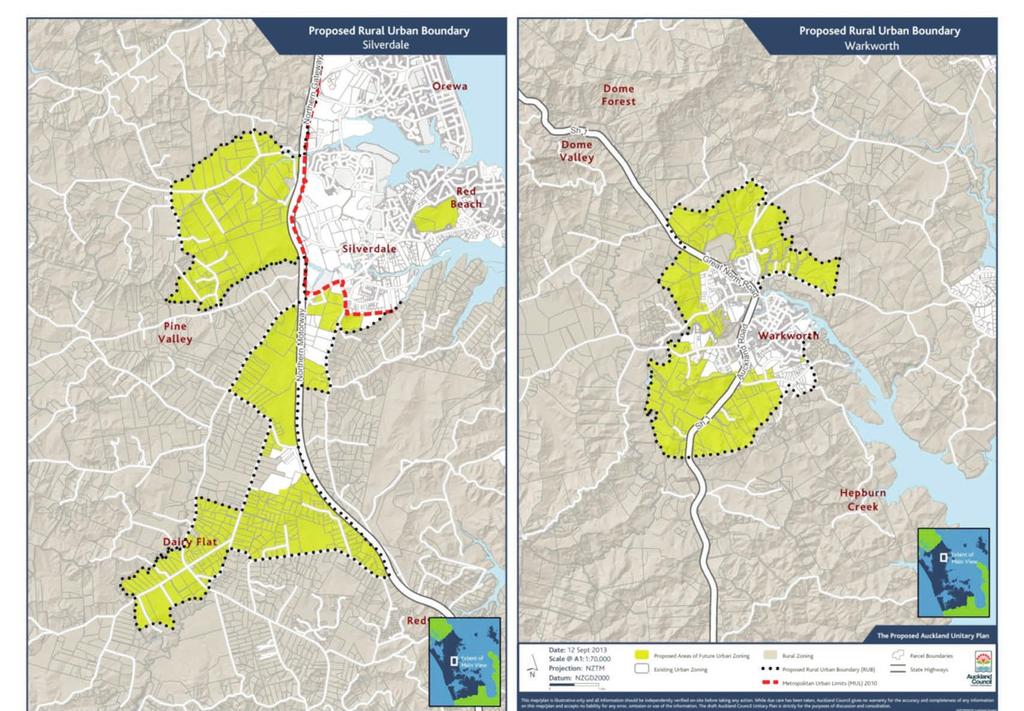
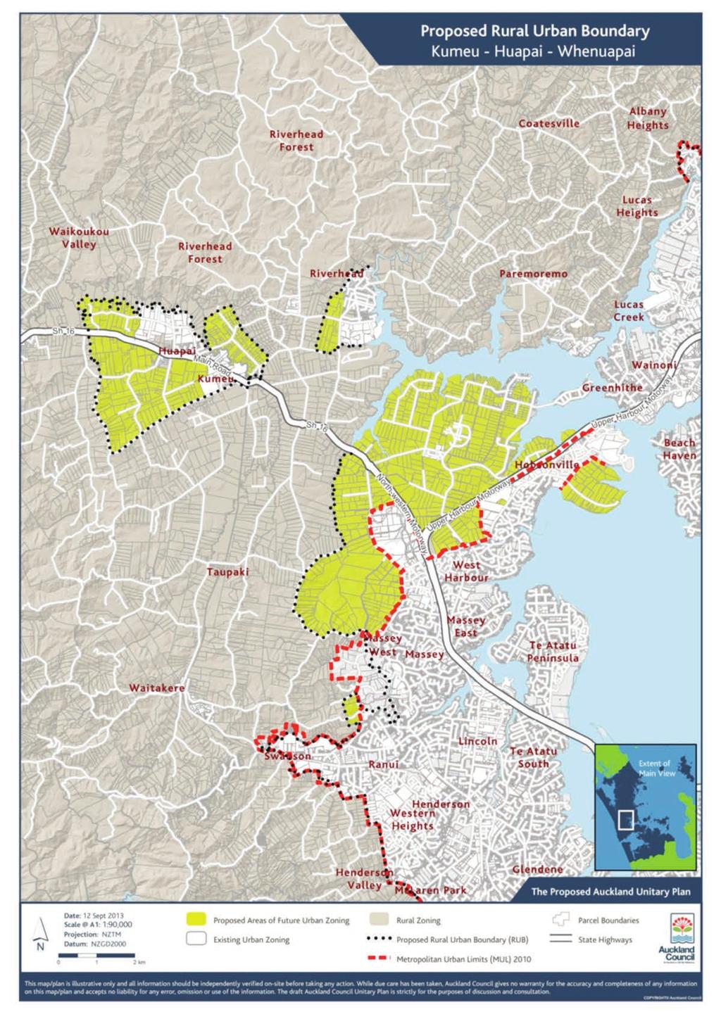
2 New Greenfield Areas South (Hingaia, Opaheke, Drury, Karaka, Paerata Pukekohe) North West (Kumeu Huapai, Riverhead, Brigham Creek, Red Hills) North (Dairy Flat, Silverdale, Warkworth) New Greenfield Growth Capacity to 2041 Auckland Plan growth projections housing capacity required (dwellings) employment capacity required Proposed Unitary Plan capacity housing capacity provided (dwellings)* employment capacity provided 55,000 35,000 33,000 42,000 35,000 19,000 14,000 12,000-14,000 13,000 16,000 8,000 16,000-20,000 11,000 Total 90,000 57,000 61,000 76,000 60,000 * Lower and higher density range Note: Figures may not sum due to rounding Figures in the table also do not include greenfield growth capacity in areas around towns and serviced villages and possible growth areas at Albany, Okura and Mangere/Puhinui as a suitable 30 year RUB is yet to be confirmed for these places. Where has the 30 year RUB been set in the Proposed Auckland Unitary Plan? The maps on the following pages show where new greenfield growth is provided for within the RUB. Further work to investigate a 30 year RUB for towns and serviced villages and areas where complex proposals to move the RUB have been received will continue after the Proposed Auckland Unitary Plan is notified.

3 How is the RUB being determined? The RUB proposals in the Proposed Auckland Unitary Plan were developed from extensive research into economic, cultural and environmental issues, careful analysis of physical constraints, and considering good urban form and efficient provision of infrastructure. Following consultation with iwi, stakeholders and communities, RUB proposals were refined and put to decision makers. Key changes to the indicative options that came out with the Draft Auckland Unitary Plan from this analysis, feedback and from political decisions are as follows: Warkworth: Additional urban growth to the north and northeast of the town, and not proceeding with the Hepburn Creek option. Removal of the area of Warkworth South adjacent to the Puhoi to Warkworth motorway alignment. Silverdale: Reduction of the Wainui East growth area in the northwest and some expansion in the southwest. Removal of the northern part of the Silverdale West Business/Pine Valley area. Removal of land west of Postman Road in the Dairy Flat growth area. Kumeu Huapai Whenuapai: Removal of the southern part of the Kumeu Huapai option and southern Future Business area, and addition of urban land to the northeast of Kumeu. Removal of the western part of Red Hills North option. Removal of the western Brigham Creek option. Addition of urban land to the west of Riverhead. South: Adoption of the Corridor Focus growth scenario, with modifications which remove large parts of the Alternative business option, the Ramarama south business option, remove Karaka North and Karaka West options, remove parts of the Whangapouri option, remove Pukekohe West and Pukekohe North East option, and add more urban land to the north of Paerata. Edge: The Stage 2 RUB (Edge) work resulted in the addition of 500ha bounded by Ranfurly and Mill Roads in Takanini, 26ha at Crows, Yelash and Birdwood Roads in Massey, 17.5ha at Fairhill Place and Chateau Rise in Flat Bush, and 6.6ha at Point View Drive, East Tamaki. The RUB was amended at Massey and Swanson to exclude the land subject to the Birdwood Structure Plan and to align with the Waikatere Ranges Heritage Area, which is subject to special legislation governing development in this area. View the plan and have your say:

4
5
6

7
For more information, go to
 For more information, go to www.shapeauckland.co.nz The draft Auckland Unitary Plan View the video: Shaping the world s most liveable city One simplified plan Where we live Where we work What we value
Appendix 1 Structure plan guidelines
 Appendix 1 Structure plan guidelines This appendix forms part of the regional policy statement [rps]. 1.1. Introduction Structure plans are an important method for establishing the pattern of land use
I609. Penihana North Precinct
 I609. Penihana North Precinct I609.1. Precinct description The Penihana North Precinct is located south of the Swanson Railway Station, adjacent to the Rural Urban Boundary (RUB) and Waitakere Ranges Heritage
I611. Swanson North Precinct
 I611. Swanson North Precinct I611.1. Precinct Description Swanson North is located in the north eastern foothills of the Waitakere Ranges. It is outside the Waitakere Ranges Heritage Area Act and the Waitakere
4 OVERVIEW. Contents. 4.1 Introduction. 4.2 Profile of the Rodney District Location The People Function of Places
 4 OVERVIEW Contents 4.1 Introduction 4.2 Profile of the Rodney District 4.2.1 Location 4.2.2 The People 4.2.3 Function of Places 4.3 Rodney District in the Regional Context 4.3.1 Rodney District 4.3.2
I602. Birdwood Precinct
 I602. Birdwood Precinct I602.1. Precinct description The Birdwood Precinct applies to an area west of Don Buck Road and south of Red Hills Road in west Auckland. It incorporates subdivision and development
Huapai North. Variation 127 DECISIONS VERSION. Variation 127 Special 29 Zone
 Huapai North Variation 127 DECISIONS VERSION DECISIONS VERSION The amendments to the Variation that have been made as a result of decisions on submissions are shown as strikethrough or underlined. RESOURCE
CONSULTING SERVICES FOR THE WHITEBELT VISIONING EXERCISE ADDENDUM TO THE GTA WEST LAND USE STUDY WORK PROGRAM
 CONSULTING SERVICES FOR THE WHITEBELT VISIONING EXERCISE ADDENDUM TO THE GTA WEST LAND USE STUDY 1. Introduction WORK PROGRAM The Town of Caledon is a large, local municipality located in the Greater Toronto
SH1 link to Matakana Road
 Future transport network for Warkworth Warkworth is expected to grow to a substantial satellite town of more than 20,000 people over the next few decades. To meet this anticipated growth, around 1,000
Unitary Plan Coding Framework
 Air Quality C5.1 Background, objectives and Air Quality H4.1 Auckland wide rules H4.1.2 Notification and H4.1.3 controls Air Quality H4.1 Auckland wide rules Chemical and metallurgical processes Air Quality
13 FUTURE DEVELOPMENT AND STRUCTURE PLANS
 13 FUTURE DEVELOPMENT AND STRUCTURE PLANS Contents 13.1 Introduction 13.2 Resource Management Issues 13.3 Objectives 13.4 Policies 13.5 Strategy 13.6 Implementation 13.6.1 District Plan Regulatory Methods
Topic Report Name: Land use planning
 Kumeu-Huapai Centre Plan Background research Specialist Input Topic Report Name: Land use planning Written By: Ryan Bradley, Joe Jeffries, Kimberley Edmonds Completed: March 2017 Existing environment (Land
TIDAPA Structure Plan
 TIDAPA Structure Plan Prepared by Tract Consultants 28 MARCH 2017 0217-0074 Table of Contents 01 STRATEGIC CONTEXT Executive Summary Regional Context Page 3 Page 4 02 LOCAL CONTEXT Aerial Photograph Local
MAYFIELD WEST SECONDARY PLAN PHASE 2
 MAYFIELD WEST SECONDARY PLAN PHASE 2 Public Open House #3 February 25, 2010 Draft Preferred Land Use Scenario TOWN OF CALEDON PLANNING & DEVELOPMENT DEPARTMENT Open House Agenda TOWN OF CALEDON 1. Welcome
The protection of the agricultural resources of the Province;
 PART II INTRODUCTION An Official Plan is a policy document, which is intended to serve as the basis for making land use decisions and managing change in any municipality in Ontario. According to the Planning
9 CITY OF VAUGHAN OFFICIAL PLAN AMENDMENT NO BOCA EAST INVESTMENTS LIMITED
 9 CITY OF VAUGHAN OFFICIAL PLAN AMENDMENT NO. 631 - BOCA EAST INVESTMENTS LIMITED The Planning and Economic Development Committee recommends the adoption of the recommendations contained in the following
CHAPTER 10 URBAN AUCKLAND CHAPTER 10 URBAN
 CHAPTER 10 URBAN UPOko 10 - Tāmaki ā TAONE 238 239 STRATEGIC DIRECTION 10 CREATE A STUNNING CITY CENTRE, WITH WELL-CONNECTED QUALITY TOWNS, VILLAGES AND NEIGHBOURHOODS TARGETS Supply 100,000 new dwellings
MERIDAN PLAINS SAND RESOURCE AREA
 MERIDAN PLAINS SAND RESOURCE AREA INFORMATION SHEET October 2010 BACKGROUND The Meridan Plains Extractive Resource Area is located on the western fringe of the coastal urban communities of Caloundra West
I403 Beachlands 1 Precinct
 I403. Beachlands 1 I403.1. Precinct Description Beachlands is a rural and coastal village located on the eastern side of Auckland, adjoining the Tamaki Strait coastline. The original Beachlands village
Tāhuhu whakaruruhau ā-taone The sheltering ridge pole
 B2. Tāhuhu whakaruruhau ā-taone - Urban growth and form B2.1. Issues Tāhuhu whakaruruhau ā-taone The sheltering ridge pole Auckland s growing population increases demand for housing, employment, business,
CITY OF FREMANTLE LOCAL PLANNING SCHEME NO. 4 AMENDMENT NO. 68 SCHEME AMENDMENT REPORT
 CITY OF FREMANTLE LOCAL PLANNING SCHEME NO. 4 AMENDMENT NO. 68 SCHEME AMENDMENT REPORT CITY OF FREMANTLE PLANNING AND DEVELOPMENT SERVICES 8 WILLIAM STREET FREMANTLE WA 6160 PLANNING AND DEVELOPMENT ACT
DRAFT FOR YOUR FEEDBACK DRAFT LOGAN RESERVE PLAN
 DRAFT FOR YOUR FEEDBACK CONTENTS INTRODUCTION... BACKGROUND... State Government... Council... PLANNING LEGISLATION AND RULES... CONSULTATION PROCESS...... ENVIRONMENT AND CONSERVATION... HOUSING... Proposed
Planning and Public Consultation Process for the Preparation of a General Land Use Plan for South Port Kells TERMS OF REFERENCE
 APPENDIX "B" Planning and Public Consultation Process for the Preparation of a General Land Use Plan for South Port Kells TERMS OF REFERENCE PURPOSE South Port Kells is located in the northeastern quadrant
Public Open House. Yonge Street and Bernard Avenue (Bernard KDA) Planning Study Update Town of Richmond Hill. March 30, 2017
 Planning Study Update Town of Richmond Hill. March 30, 2017") Public Open House Yonge Street and Bernard Avenue (Bernard KDA) Planning Study Update Town of Richmond Hill March 30, 2017 Open House Review of Project Purpose and Process Policy Refresher Highlights of
Public Open House Yonge Street and Bernard Avenue (Bernard KDA) Planning Study Update Town of Richmond Hill March 30, 2017 Open House Review of Project Purpose and Process Policy Refresher Highlights of
Urban Development Areas Bedford County
 5 Urban Development Areas Bedford County UDA Needs Profile: All UDAs Bedford County has designated two UDAs: areas just outside the Bedford City Limits (generally to the south and east of the city) and
The Proposed Auckland Unitary Plan (notified 30 September 2013)
") 3 Business zones Introduction There are 10 business zones in the Unitary Plan: City Centre Metropolitan Centre Town Centre Local Centre Neighbourhood Centre Mixed Use General Business Business Park Light
3 Business zones Introduction There are 10 business zones in the Unitary Plan: City Centre Metropolitan Centre Town Centre Local Centre Neighbourhood Centre Mixed Use General Business Business Park Light
Plan Modification to Chapter B2 of the Auckland Unitary Plan(AUP) Operative in part (15 November 2016)
 Operative in part (15 November 2016)") UNITARY PLAN UPDATE REQUEST MEMORANDUM TO FROM Phill Reid Linley Wilkinson DATE 25 September 2018 SUBJECT Plan Modification to Chapter B2 of the Auckland Unitary Plan(AUP) Operative in part (15 November
UNITARY PLAN UPDATE REQUEST MEMORANDUM TO FROM Phill Reid Linley Wilkinson DATE 25 September 2018 SUBJECT Plan Modification to Chapter B2 of the Auckland Unitary Plan(AUP) Operative in part (15 November
Integrated Urban Structuring in Australia An Overview of Principles and Practice
 ACNU08 Brisbane Integrated Urban Structuring in Australia An Overview of Principles and Practice Wendy Morris Ecologically Sustainable Design Pty Ltd Melbourne, Australia esdesign@netspace.net.au Ecologically
URBAN DEVELOPMENT QLDC PROPOSED DISTRICT PLAN [PART TWO] AUGUST 2015
![URBAN DEVELOPMENT QLDC PROPOSED DISTRICT PLAN [PART TWO] AUGUST 2015](/thumbs/80/81778199.jpg "URBAN DEVELOPMENT QLDC PROPOSED DISTRICT PLAN [PART TWO] AUGUST 2015") 4 URBAN VLOPMNT U R P QLC PROPO ITRICT PLAN [PART TWO] AUGUT 2015 4 ur b an de v elop ment QLC ITRICT PLAN [PART TWO] AUGUT 2015 4 urban development 4 2 4.1 Purpose The purpose of this Chapter is to set
4 URBAN VLOPMNT U R P QLC PROPO ITRICT PLAN [PART TWO] AUGUT 2015 4 ur b an de v elop ment QLC ITRICT PLAN [PART TWO] AUGUT 2015 4 urban development 4 2 4.1 Purpose The purpose of this Chapter is to set
LAND USE AMENDMENT CORNERSTONE (WARD 3) 60 STREET NE AND COUNTRY HILLS BOULEVARD NE MAP 26NE BYLAW 22D2017
 60 STREET NE AND COUNTRY HILLS BOULEVARD NE MAP 26NE BYLAW 22D2017") Page 1 of 14 EXECUTIVE SUMMARY This Land Use Amendment application covers an area of 43.76 hectares ± (108.14 acres ±) located in northeast Calgary, bound by Country Hills Boulevard NE to the south and
Page 1 of 14 EXECUTIVE SUMMARY This Land Use Amendment application covers an area of 43.76 hectares ± (108.14 acres ±) located in northeast Calgary, bound by Country Hills Boulevard NE to the south and
Urban Growth Management in Seven New World cities: Aligning visions and quality neighbourhood outcomes
 Urban Growth Management in Seven New World cities: Aligning visions and quality neighbourhood outcomes New Zealand Centre for Sustainable Cities 14 August 2013 Errol Haarhoff & Lee Beattie School of Architecture
1.0 PLANNING MARKHAM S FUTURE CONTENTS
 1-1 Planning Markham s Future 1.0 PLANNING MARKHAM S FUTURE CONTENTS 1.1 THE PURPOSE OF THE OFFICIAL PLAN 1.2 THE MARKHAM CONTEXT 1.3 THE REGULATORY CONTEXT 1.3.1 Province of Ontario 1.3.2 York Region
MAYFIELD WEST SECONDARY PLAN PHASE 2
 MAYFIELD WEST SECONDARY PLAN PHASE 2 Council Information Workshop February 16, 2010 Draft Preferred Land Use Plan TOWN OF CALEDON PLANNING & DEVELOPMENT DEPARTMENT Workshop Agenda TOWN OF CALEDON 1. Welcome
Redoubt Road-Mill Road Corridor Project. Notice of Requirement for Designation Volume 2:1 - Assessment of Environmental Effects
 Redoubt Road-Mill Road Corridor Project Notice of Requirement for Designation Volume 2:1 - Assessment of Environmental Effects Prepared for: Auckland Transport 2014 Redoubt Road to Mill Road Corridor List
Local Growth Planning in North Central Green Line Communities
 2018 April 30 Page 1 of 6 EXECUTIVE SUMMARY This report outlines a high-level scope for local growth planning for north central Green Line communities. The catalyst for this review is the significant investments
OUR GREATER SYDNEY A metropolis of three cities. OVERVIEW. connecting people. DRAFT Greater Sydney Region Plan
 OUR GREATER SYDNEY 2056. A metropolis of three cities. OVERVIEW. connecting people. DRAFT Greater Sydney Region Plan October 2017 This document is an overview of the draft Greater Sydney Region Plan. To
Whenuapai Structure Plan Neighbourhood Design Statement
 Whenuapai Structure Plan Neighbourhood Design Statement Yvonne Weeber, Auckland Design Office, Auckland Council Version 2.1 June 2016 This report has been prepared by: Yvonne Weeber, Principal Urban Design,
Rodney Greenways Paths and Trails Plan
 Rodney Greenways Paths and Trails Plan Pūhoi to Pakiri MAY 2017 Cover image: Aerial photo of Pakiri Contents Section 1 - Introduction 1.1 Purpose of the Document 6 1.2 Strategic Fit 6 1.3 What is a Greenways
I539. Smales 2 Precinct
 I539. Smales 2 Precinct I539.1. Precinct Description The Smales 2 Precinct applies to a 4.8 hectare block of land located on the southern side of Northcote Road and fronting Lake Pupuke, Takapuna. The
Presentation Outline. Southwest Area Plan. Slide 1. Slide 2. Presentation to the Committee of the Whole. September 20, 2011
 Slide 1 Southwest Area Plan Presentation to the Committee of the Whole September 20, 2011 Slide 2 Presentation Outline City-Wide Growth Planning Link Official Plan Policies Current Situation and Projections
6 Growth Management Challenges and Opportunities
 6 Growth Management Challenges and Opportunities The Town has established a goal of attaining a 50% participation rate with respect to employment opportunities versus residential population. The Town s
The Proposed Auckland Unitary Plan (notified 30 September 2013)
") 7 West 7.1 Avondale 1 The objectives and policies of the underlying Mixed Use zone apply in the following precinct unless otherwise specified. Refer to planning maps for the location and extent of the
7 West 7.1 Avondale 1 The objectives and policies of the underlying Mixed Use zone apply in the following precinct unless otherwise specified. Refer to planning maps for the location and extent of the
Western City District What we heard
 What we heard Vision to 2056 and Priorities Governance and implementation Infrastructure and funding The protection of the natural landscape including biodiversity and the Metropolitan Rural Area for food
AUCKLAND COUNCIL DISTRICT PLAN PAPAKURA SECTION
 AUCKLAND COUNCIL DISTRICT PLAN PAPAKURA SECTION OPERATIVE 16 JUNE 1999 D P Hawkins, Mayor T McLean, Chief Executive Officer Given under the Common Seal of the Papakura District Council this 16th day of
4 RESIDENTIAL ZONE. 4.1 Background
 4 RESIDENTIAL ZONE 4.1 Background The residential areas within the City are characterised by mainly lowrise dwellings sited on individual allotments. Past architectural styles, settlement patterns and
GREEN BELTS, GREEN WEDGES OR DISPUTED GROUND
 GREEN BELTS, GREEN WEDGES OR DISPUTED GROUND John Ginivan Department of Planning and Community Development State Government of Victoria Melbourne Australia Greenbelts: Local Solutions for Global Challenges
Blandford Forum Town Council, Blandford St Mary Parish Council and Bryanston Parish Council
 Blandford Forum Town Council, Blandford St Mary Parish Council and Bryanston Parish Council Blandford + Neighbourhood Plan 2 Pre-Submission Plan Consultation (November 2018) Representations submitted on
Draft Drury Structure Plan process
 Preliminary report September 2017 Draft Drury Structure Plan process Have your say in shaping Auckland s future together. shapeauckland.co.nz southernstructureplanning@aucklandcouncil.govt.nz 09 301 0101
HAYLE NEIGHBOURHOOD PLAN FUTURE HOUSING EXPANSION VISION DOCUMENT. Prepared for Hayle Neighbourhood Plan Steering Group by AECOM
 HAYLE NEIGHBOURHOOD PLAN FUTURE HOUSING EXPANSION VISION DOCUMENT Prepared for Hayle Neighbourhood Plan Steering Group by AECOM December 2015 1. Introduction Context Hayle is a linear town situated in
Draft Amendment Provides details regarding ROPA 47 s purpose and effect. Related Processes Highlights other ongoing processes of note in the area
 An Amendment to Address a Shortfall of Employment Lands in the Town of Halton Hills Premier Gateway Employment Area Public nformation Centre Wednesday November 1, 2017 6:30p.m. - 8:30p.m. Hillcrest United
9 BUSINESS. Contents. 9.1 Introduction Description of Business Activities Trends in Business Activity. 9.2 Resource Management Issues
 9 BUSINESS Contents 9.1 Introduction 9.1.1 Description of Business Activities 9.1.2 Trends in Business Activity 9.2 Resource Management Issues 9.3 Objectives 9.4 Policies 9.5 Strategy 9.6 Implementation
EXECUTIVE SUMMARY. Introduction
 Introduction EXECUTIVE SUMMARY The Urban Service Area Fort McMurray (hereafter referred to as the Urban Service Area) is currently experiencing a variety of development pressures. Unprecedented population
MACROC Submission on the Draft South West District Plan
 MACROC Submission on the Draft South West District Plan MACROC Cnr Queen & Broughton Streets CAMPBELLTOWN NSW 2560 MACROC Submission on the Draft South West District Plan. March 2017 Page 2 MACROC Submission
Cc~tporate Sers~ic:es
 tg * Cc~tporate Sers~ic:es Csrmcil and Adnrirristrativs Services April 26,201 1 ". RE(;lr?N (1;. 1q.1 i Town of Caledon Region of Peel ci E~iliS DEP? Attn: Karen Landry, Director of Attn: Carol Reig, Regional
Draft Ada Street Cardiff Area Plan
 Draft Ada Street Cardiff Area Plan (Draft Amendment to Lake Macquarie Development Control Plan 2014) Exhibition: The draft Area Plan is on public exhibition from 29 February 2016 to 29 March 2016. Submissions:
I Te Koti Taiao o Aotearoa Ōtautahi Rohe ENV-2018-CHC- Appellant. Queenstown Lakes District Council. Respondent
 In the Environment Court of New Zealand Christchurch Registry I Te Koti Taiao o Aotearoa Ōtautahi Rohe ENV-2018-CHC- Under In the matter of Between the Resource Management Act 1991 (RMA) An appeal under
SUBJECT: Proposed Downtown Mobility Hub Precinct Plan and Proposed Official Plan Policies
 Page 1 of Report PB-81-17 SUBJECT: Proposed Downtown Mobility Hub Precinct Plan and Proposed Official Plan Policies TO: FROM: Committee of the Whole Planning and Building Department Report Number: PB-81-17
SUSSEX COUNTY COMPREHENSIVE PLAN COUNTY PLANNING AND ZONING COMMISSION WORKSHOP
 SUSSEX COUNTY COMPREHENSIVE PLAN COUNTY PLANNING AND ZONING COMMISSION WORKSHOP August 21, 2017 TODAY S WORKSHOP Public Comment Utilities Update Economic Development Update Future Land Use Discussion Public
DOMINION BOULEVARD CORRIDOR STUDY AND ECONOMIC DEVELOPMENT STRATEGIC PLAN A MODEL FOR CHESAPEAKE S FUTURE
 DOMINION BOULEVARD CORRIDOR STUDY AND ECONOMIC DEVELOPMENT STRATEGIC PLAN A MODEL FOR CHESAPEAKE S FUTURE Overview I. Draft Plan Process II. Draft Plan Overview a. Market Analysis b. Master Land Use Plan
Edward R. Sajecki Commissioner of Planning and Building. SUBJECT: Draft Lakeview Local Area Plan (January 2014)
") Corporate Report Clerk s Files Originator s Files CD.03.LAK DATE: TO: FROM: Chair and Members of Planning and Development Committee Meeting Date: February 3, 2014 Edward R. Sajecki Commissioner of Planning
Corporate Report Clerk s Files Originator s Files CD.03.LAK DATE: TO: FROM: Chair and Members of Planning and Development Committee Meeting Date: February 3, 2014 Edward R. Sajecki Commissioner of Planning
open space environment
 This section updated August 09 GUIDELINE TO THE RULES The Open Space Environment Rules apply to activities on sites within the Open Space Environment as shown on the Human Environments Maps. Most of the
Welcome to our exhibition
 Welcome to our exhibition The Homes & Communities Agency (HCA) welcomes you to this public exhibition explaining our proposals for the redevelopment of the former Lea Castle Hospital site. About the Homes
Stakeholder Recommendations Voting Results
 Stakeholder Recommendations Voting Results Public Input Yes No Abstain Total Count 1. On the matters that are of the highest importance to the community, strengthen the related policy statements through
INCREMENTAL CHANGE AREA REVIEW March 2015 Page 1
 INCREMENTAL CHANGE AREA REVIEW March 2015 Page 1 Table of Contents Introduction... 3 Background to Review... 3 Comparison of the Schedules to the General Residential Zone... 7 Methodology... 7 Policy Context...
Welford-on-Avon Neighbourhood Plan Consultation Event Sunday, 6 April Your name Your address
 Welford-on-Avon Neighbourhood Plan Consultation Event Sunday, 6 April 2014 Your name Your email address Please either: - complete this feedback form and put it in the box before leaving the Memorial Hall
Draft Western District Plan
 Powered by TCPDF (www.tcpdf.org) Draft Western District Plan Submission_id: 31720 Date of Lodgment: 15 Dec 2017 Origin of Submission: Online Organisation name: Hawes and Swan Planning Organisation type:
The Proposed Auckland Unitary Plan (notified 30 September 2013)
") 8 Special Purpose zones 8.1 Airport zone The Airport zone applies to the Kaipara Flats Airfield, North Shore Airfield, Auckland International Airport and Ardmore Airport. Auckland International Airport
8 Special Purpose zones 8.1 Airport zone The Airport zone applies to the Kaipara Flats Airfield, North Shore Airfield, Auckland International Airport and Ardmore Airport. Auckland International Airport
Appendix A. Planning Processes. Introduction
 1 Planning Processes Introduction This appendix outlines a number of planning processes which are used in the Auckland Region to support the effective management of development in the region s rural and
Suffolk Coastal Local Plan Review Issues and Options, August 2017, Public Consultation
 Suffolk Coastal Local Plan Review Issues and Options, August 2017, Public Consultation Having reviewed the issues and options documents, the Society has made the following response: Part 1 - Strategic
MOUNT PLEASANT SECONDARY PLAN & VILLAGE BLOCK PLAN. Wednesday, March 5, 2008 Informal Public Open House
 MOUNT PLEASANT SECONDARY PLAN & VILLAGE BLOCK PLAN Wednesday, March 5, 2008 Informal Public Open House 1. Welcome & Introductions 2. Highlights of Provincial Growth Plan 3. Overview and Status Update -
THE CORPORATION OF THE TOWN OF OAKVILLE BY-LAW NUMBER
 THE CORPORATION OF THE TOWN OF OAKVILLE BY-LAW NUMBER 2017-120 A by-law to adopt an amendment to the Livable Oakville Plan, Official Plan Amendment Number 20 (Downtown Oakville Growth Area) WHEREAS the
South District What we heard
 What we heard Vision to 2056 and Priorities Governance and implementation Infrastructure and funding Feedback supported: The vision for a metropolis of three cities, but emphasised the importance of infrastructure
PART 02 HASTINGS POINT IN CONTEXT
 PART 02 HASTINGS POINT IN CONTEXT 2.1 Background 2.1.1 Demographic Information 2.1.2 Existing Locality Characteristics 2.2 The Planning Framework 2.2.1 The Far North Coast Regional Strategy 2006 2.2.2
B4. Te tiaki taonga tuku iho - Natural heritage
 B4. Te tiaki taonga tuku iho - Natural heritage Tuia I runga, tuia i raro, tuia ki te waonui a Tiriwa Bind the life forces of heaven and earth to the great realm of Tiriwa B4.1. Issues Auckland s distinctive
Subdivision Design Criteria. Penihana North GUIDELINES TO THE RULES
 Created September 2013 Penihana North Subdivision Design Criteria GUIDELINES TO THE RULES This part of the Plan sets out the design criteria for subdivision in Penihana North. The criteria will be considered
Foster Creek West Clarington, Ontario PLANNING JUSTIFICATION REPORT
 Foster Creek West Clarington, Ontario PLANNING JUSTIFICATION REPORT Official Plan Amendment Zoning By-law Amendment Neighbourhood Design Plan Amendment Draft Plan of Subdivision File No. 112092 February
TO: Mayor & Council DATE: April 12, The Planning and Development Department and the Engineering Department recommend that Council:
 CORPORATE REPORT NO: R080 COUNCIL DATE: April 12, 2010 REGULAR COUNCIL TO: Mayor & Council DATE: April 12, 2010 FROM: SUBJECT: General Manager, Planning and Development General Manager, Engineering Neighbourhood
9 Pershore. Introduction. Pershore Abbey
 118 Introduction 9.1 The historic town of Pershore lies on the River Avon and has a population of 7,000 (2009 Mid-Term Population Estimates). The main areas of the town are centred on the Abbey, the bustling
HARTENBOS NORTH (population: Census 2011)
") 5.8 HARTENBOS NORTH (population: + 184 Census 2011) Figure 5.8.1.1 Hartenbos North: Aerial photograph CNdV africa (Pty) Ltd DRAFT CONCEPTUAL DEVELOPMENT FRAMEWORK REPORT page 439 5.8.1 SPATIAL ANALYSIS,
5.8 HARTENBOS NORTH (population: + 184 Census 2011) Figure 5.8.1.1 Hartenbos North: Aerial photograph CNdV africa (Pty) Ltd DRAFT CONCEPTUAL DEVELOPMENT FRAMEWORK REPORT page 439 5.8.1 SPATIAL ANALYSIS,
North District What we heard
 What we heard Vision to 2056 and Priorities Governance and implementation Infrastructure and funding The vision for a metropolis of three cities, and the 30 minute city. Feedback emphasised: That for the
MILTON HEIGHTS COMMUNITY January 2006 Revised February 2015 Revised November 2015
 REVISED DRAFT MILTON HEIGHTS COMMUNITY January 2006 Revised February 2015 Revised November 2015 Urban Design Guidelines Milton Heights Landowners Group This page has been intentionally left blank. Contents
Summary of Changes for the Comprehensive Draft Proposed Official Plan Amendment
 Summary of Changes for the Comprehensive Draft Proposed Official Plan Amendment Note: Due to the broad scope of the Official Plan Review, this list is not exhaustive of the extent of changes in the comprehensive
SUBJECT: Revised proposed new official plan recommended for adoption
 Page 1 of Report PB-04-18 SUBJECT: Revised proposed new official plan recommended for adoption TO: FROM: Planning and Development Committee Department of City Building Report Number: PB-04-18 Wards Affected:
COLVER ROAD INDUSTRIAL CONCEPT PLAN
 COLVER ROAD INDUSTRIAL CONCEPT PLAN A CONCEPTUAL LAND USE AND TRANSPORTATION PLAN FOR TA-4 AN URBAN RESERVE AREA OF THE CITY TALENT City of Talent Adopted by City Council Resolution No., June, 2015 PART
I404 Beachlands 2 Precinct
 I404. Beachlands 2 I404.1. Precinct Description The Beachlands 2 precinct covers approximately 6 hectares of land at the corner of Beachlands and Whitford Maraetai Roads. Its purpose is to provide for
I615. Westgate Precinct
 I615. Westgate Precinct I615.1. Precinct Description The Westgate Precinct is located approximately 18km west of the Auckland city centre. There are seven Sub-precincts in the Westgate Precinct: Sub-precinct
Auckland City Council
 Auckland City Council Future planning framework version 3.0 9 September 2010 Find out more: Telephone (09) 379 2020 or visit www.aucklandcity.govt.nz www.itsmybackyard.co.nz Foreword Future planning framework
Urban Growth Boundaries
 Urban Growth Boundaries Discussion Document July 2008 Contents page Introduction... 3 What are urban growth boundaries?... 3 The need to manage growth... 3 Purpose of urban growth boundaries... 4 How will
Scope of Services. River Oaks Boulevard (SH 183) Corridor Master Plan
 Corridor Master Plan") Scope of Services River Oaks Boulevard (SH 183) Corridor Master Plan PROJECT AREA The project area consists of the River Oaks Boulevard (SH 183) corridor bounded by SH 199 at the northern end and the Trinity
Scope of Services River Oaks Boulevard (SH 183) Corridor Master Plan PROJECT AREA The project area consists of the River Oaks Boulevard (SH 183) corridor bounded by SH 199 at the northern end and the Trinity
Mark-up of the effect of the proposed Bronte Village Growth Area OPA No.18 on the text of section 24, Bronte Village, of the Livable Oakville Plan
 Mark-up of the effect of the proposed Bronte Village Growth Area OPA No.18 on the text of section 24, Bronte Village, of the Livable Oakville Plan Notes: This document is provided for information purposes
I326. Ōrākei 1 Precinct
 I326. Ōrākei 1 recinct I326.1. recinct Description The Ōrākei 1 recinct includes the land identified as hapu reservation (land held for the purposes of a marae, church, urupa and related hapu amenities)
Land Use Amendment in Southwood (Ward 11) at and Elbow Drive SW, LOC
 at and Elbow Drive SW, LOC") 2018 November 15 Page 1 of 10 EXECUTIVE SUMMARY This land use amendment application was submitted by Rick Balbi Architect on 2017 August 31 on behalf of Sable Developments Ltd, and with authorization from
2018 November 15 Page 1 of 10 EXECUTIVE SUMMARY This land use amendment application was submitted by Rick Balbi Architect on 2017 August 31 on behalf of Sable Developments Ltd, and with authorization from
11.4 Highway 400 North Employment Lands Secondary Plan APPROVED BY THE ONTARIO MUNICIPAL BOARD ON NOVEMBER 21, 2011
 11.4 Highway 400 North Employment Lands Secondary Plan APPROVED BY THE ONTARIO MUNICIPAL BOARD ON NOVEMBER 21, 2011 11.4.1 General 11.4.1.1. as approved by the Ontario Municipal Board on November 21, 2011,
HOROWHENUA DEVELOPMENT PLAN June create a safe crossing for children moving to and from the school and other areas. 7.8 Ohau
 7.8 Ohau create a safe crossing for children moving to and from the school and other areas. Ohau has a traditional village form with a collective of school, church and reserve at the main road intersection.
Public Consultation. Land at Monks Farm, North Grove. Welcome
 Welcome Welcome to our public exhibition for development on Land at Monks Farm, orth Grove. Gallagher Estates and Gleeson Strategic Land are preparing an outline planning application for new homes, open
PREPARED FOR: PLATTEVIEW ROAD CORRIDOR STUDY EXECUTIVE SUMMARY
 PREPARED FOR: PLATTEVIEW ROAD CORRIDOR STUDY EXECUTIVE SUMMARY SEPTEMBER 2016 Introduction The Platteview Road Corridor Study was led by the Metropolitan Area Planning Agency (MAPA) with assistance from
ATTACHMENT A 09/12/2011. Attachment A - 1. A. Preliminary Future Transit Station Sub-area
 ATTACHMENT A A. Preliminary Future Transit Station Sub-area The Centers, Corridors and Wedges Growth Framework describes Transit Station Areas, which are sub-areas within Growth Corridors, as areas surrounding
H10. Business Town Centre Zone
 H10. Business Town Centre Zone H10.1. Zone description The Business Town Centre Zone applies to suburban centres throughout Auckland, the satellite centres of Warkworth and Pukekohe, and the rural towns
Brampton. Secondary Plan. Review. Bram West. A New Direction in Planning & Public Consultation
 Brampton Bram West Secondary Plan Review A New Direction in Planning & Public Consultation Introduction The Bram West Secondary Plan Review offers an important opportunity for the community to define a
NEW REGIONAL OFFICIAL PLAN HIGH LEVEL PROCESS & FRAMEWORK
 NEW REGIONAL OFFICIAL PLAN HIGH LEVEL PROCESS & FRAMEWORK Why A New Official Plan Originally the role of Regionally Planning and content of Regional Official Plan (1970s) primarily focused on protecting