PLANNING COMMISSION STAFF REPORT Legislative Item
|
|
|
- Darrell Morgan
- 5 years ago
- Views:
Transcription

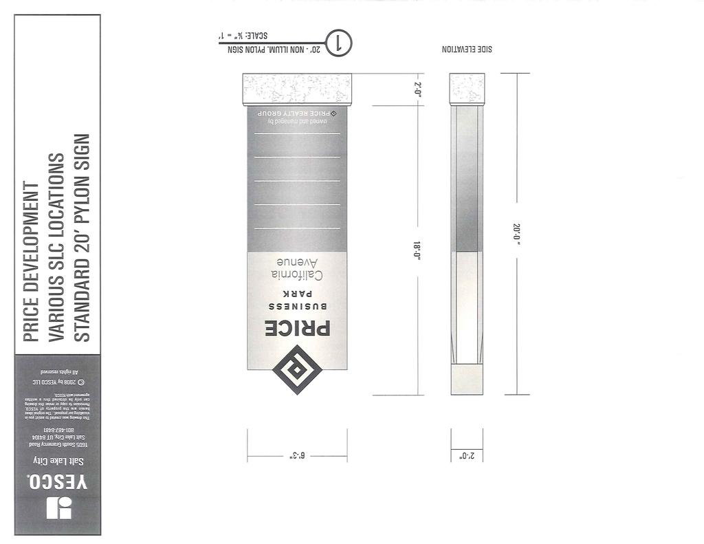
1 PLANNING COMMISSION STAFF REPORT Legislative Item Manufacturing Districts Monument Sign Height Zoning Text Amendment PLNPCM Citywide August 28, 2013 Planning Division Department of Community and Economic Development Applicant: Yesco, Deanne Leatherman Staff: Daniel Echeverria, , Tax ID: Citywide Council District: Citywide Community Council: Citywide Applicable Land Use Regulations: 21A Sign Regulations for Manufacturing Districts 21A.50 Amendments Attachments: A. Applicant Narrative B. Department Comments C. Regulation Illustrations D. Sign Examples Request Yesco, represented by Deanne Leatherman, has initiated a request to amend the Salt Lake City Zoning Ordinance to allow increased monument sign height in both the M-1 Light Manufacturing Zoning District and M-2 Heavy Manufacturing Districts. The existing regulations limit monument sign height to a maximum of 10 feet. The applicant is requesting that this limit be modified to 20 feet of height. The Planning Commission is required to transmit a recommendation to the City Council for Zoning Text Amendment requests. Recommendation Based on the findings in the staff report, Planning Staff finds the proposed amendment does adequately meet the standards for general text amendments and therefore recommends the Planning Commission transmit a positive recommendation to the City Council to adopt the proposed zoning ordinance text amendments related to increased monument sign height in Manufacturing zoning districts. Recommended Motion Consistent with Staff Recommendation: Based on the findings listed in the staff report, testimony and plans presented, I move that the Planning Commission transmit a favorable recommendation to the City Council to adopt the proposed zoning ordinance text amendment to modify the monument sign regulations for the Manufacturing zoning districts. 1

2 VICINITY MAP Background Project Description Yesco, represented by Deanne Leatherman, has initiated a request to amend the Salt Lake City Zoning Ordinance to allow increased monument sign height in both the M-1 Light Manufacturing Zoning District and M-2 Heavy Manufacturing Districts. The existing regulations limit monument sign height to a maximum of 10 feet. The applicant is requesting that this be modified to 20 feet. The applicant has had discussions with businesses and developers that indicate 20 tall monument signs would be preferred to pole signs for many properties in the Manufacturing districts. As discussed in the applicant s original submittal, the applicant believes that pole signs do not reflect the business types that are locating to the Manufacturing districts, particularly those locating along California Avenue. 2


3 Existing Regulations Types Of Signs Permitted Monument sign 5 Pole sign 5 Maximum Area Per Sign Face 1 square foot per linear foot of street frontage 1 square foot per linear foot of street frontage; 200 square feet maximum for a single business, 300 square feet maximum for multiple businesses Maximum Height Of Freestanding Signs 1 5 feet 10 feet Number Of Signs Permitted Per Sign Type 1 per street Minimum Setback 2 5 feet 10 feet frontage 25 feet 15 feet 1 per street frontage Limit On Combined Number Of Signs 3 1 sign per street frontage The existing regulations for monument signs in the Manufacturing districts require 5 setback for a sign that is 5 in height and 10 of setback for a sign that is 10 in height. Any sign that is setback between 5 and 10 can only extend to 5 in height. A 10 tall monument sign can be placed anywhere as long as it is setback from the front or corner side property lines by 10 feet. An illustration of the existing regulations for monument signs in the Manufacturing districts is located below. Building and pole sign height, as well as setback regulations are included for context. The monument signs illustrated below reflect a 50 square foot sign face area, but according to the current ordinance a property with 300 feet of frontage could build a monument sign with a 300 square foot sign face area, as there is no maximum limitation. Properties must have at least 100 feet of street frontage to have a pole or monument sign. Figure 1 Illustration of Existing Regulations 3
4 Proposal Considerations The applicant requested a change to the sign regulations for signs in the Manufacturing Districts in order to build monument signs up to 20 feet, but did not specify a particular preferred setback. Staff considered a variety of options in order to develop a proposal appropriate for the Manufacturing districts. The applicant s submission suggested that the monument sign standards in the Manufacturing Districts should more closely match the allowances in the General Commercial (CG), Downtown (D-1, D-2, & D-4) and Sugar House Business (CSHBD) districts. These commercial districts have generally similar rules for monument signs. As an example, the General Commercial (CG) District allows for monument signs up to 20 in height at a 4 setback from the front property line. However, the development pattern in the CG District is fundamentally different than patterns in the Manufacturing Districts. Whereas buildings in the CG District are often built as close to the front property line as permitted, usually 10 feet for new construction, in the Manufacturing Districts new development is usually setback significantly more than the minimum required front yard setback line of 15 feet. This is often done to incorporate at least two rows of parking between the front property line and the building. Due to the type of development and businesses in the Manufacturing Districts, paved areas behind and to the side of buildings are frequently kept clear for semitrailer loading and unloading areas. Though not always the case when development is on a large lot, in the CG or other commercial districts, car parking lots are generally provided to the rear or side of the building, rather than in front of the building. The difference in typical building setbacks means that CG properties have a small area in front of the building to place a monument sign, whereas in Manufacturing Districts there is often 60 feet or more of setback area where a monument sign could be placed. Development intensity thus scales gradually from the street in the Manufacturing Districts, but scales more rapidly in the CG District. Other commercial districts, such as the D-1, D-2, D-4 and CSHBD districts have height allowances similar to the CG District for monument signs due to their development intensity being located right at the street front with little to no required setback from the front property line. This being the case, a tall monument sign next to the street would not necessarily fit with the development pattern in the Manufacturing Districts, despite being permitted in many other commercial districts. Likewise, the existence of sign regulations that allow for tall monument signs in certain districts does not necessarily mean that the allowed height is always appropriate for development in these districts, and some of these regulations could be changed in the future to reflect new development and urban design expectations. A generalized table of existing regulations for monument signs across a sampling of commercial and manufacturing districts in Salt Lake City is located below. District Maximum Building Height Minimum Building Setback Maximum Sign Height Minimum Sign Setback Area Allowed M-1/M-2 65 /85 15 /25 5 ; 10 5 for 5 ; 10 for 10 1 sq ft per linear foot of street frontage CG ; 20 0 for 8 ; 4 for 20 1 sq ft per linear foot of street frontage CC ; 12 ; 20 (1 acre 0 for 6 ; 5 for sq ft minimum) or 20 D-1/D sq ft per linear foot of street frontage D sq ft per linear foot of street frontage 4
5 D sq ft TSA sq ft CSHBD sq ft RP/BP 45 / sq ft Proposed Regulations Staff developed the below proposal to allow for flexibility in monument sign size and placement, while still maintaining conformance with existing development regulations, and general City urban design expectations for areas zoned as Manufacturing. 21A A.3 Sign Type, Size And Height Standards: Standards for the M-1 and M-2 Districts Types of Permitted Signs Maximum Area Per Sign Face Maximum Height of Freestanding Signs 1 Monument sign square feet 5 feet at the minimum setback and increases 1 foot for each additional 1 foot of setback for a maximum of 20 feet Pole sign 5 1 square foot per linear foot of street frontage; 200 square feet maximum for a single business, 300 square feet maximum for multiple businesses Minimum Setback 2 Number of Signs Permitted Per Sign Type 5 feet 1 sign per street frontage 25 feet 15 feet 1 per street frontage Limit on Combined Number of Signs 3 1 sign per street frontage The changes are highlighted in red above. This proposal will allow for a 5 foot sign at a setback of 5 feet from the property line. The height allowance increases one foot with each additional foot of setback for a maximum sign height of 20 feet. This differs from the existing regulation in that it allows for a more gradual increase in monument sign height as the sign gets further from the street, as opposed to the current 5 step in the height increase. As the current regulation allows for 1 square foot of signage for every linear foot of street frontage, an increase in the height allowance opens up the potential for a 20 tall wall. As such, the above proposal limits the area of the sign to 150 square feet. This will allow for a 20 sign that is 7 6 wide. The monument sign example submitted by the applicant is approximately 125 square feet in area. This proposal allows for up to a 15 tall sign at the minimum building setback in the M-1 District, and a 20 foot tall monument sign at the minimum building setback in the M-2 District. The existing standards regulate the number of large signs by limiting properties to either one monument sign or one pole sign per street frontage and also limit monument signs to properties with at least 100 of street frontage. These limitations are not proposed to be changed. To provide some perspective, examples of tall monument signs in the Salt Lake metropolitan area, including some that would be permitted under the proposed regulations, are included in Attachment D. A rendering of a possible 20 sign in the M-1 District is also located in this attachment. An illustration of the proposed regulations is located below. 5
6 Figure 2 Illustration of Proposed Regulations Public Notice, Meetings and Comments The following is a list of public meetings that have been held related to the proposed project: Open House held on June 20 th, Community Councils were notified of the open house and the proposed changes. No comments were received. Notice of the public hearing for the proposal includes: Public hearing notice posted in newspaper on August 17, Public hearing notice posted on City and State websites on August 15, Public hearing notice ed to the Planning Division listserv on August 15, City Department Comments The comments received from pertinent City Departments / Divisions are attached to this staff report in Attachment B. The Planning Division has not received comments from the applicable City Departments / Divisions that cannot reasonably be fulfilled or that warrant denial of the petition. Analysis and Findings Findings 21A Standards for general amendments A decision to amend the text of this title or the zoning map by general amendment is a matter committed to the legislative discretion of the city council and is not controlled by any one standard. 6
7 A. In making its decision concerning a proposed text amendment, the city council should consider the following factors: 1. Whether a proposed text amendment is consistent with the purposes, goals, objectives, and policies of the city as stated through its various adopted planning documents; Analysis: The Salt Lake City Urban Design Element outlines policies and associated strategies to strengthen the city s urban form. This document specifically addressed the condition of Salt Lake City s industrial areas and recommended urban design policies to create a more pleasing environment. With regard to signs in the industrial areas of the city, the document suggests that signage throughout the commercial/industrial areas need not be overpowering. Patrons to such establishments are coming to the area to do business at a particular establishment; consequently, the signs do not have to compete with other establishment signs. Further, the document also includes a section specifically about signs that discusses the desire to prevent signs from being a dominant feature of the landscape along the city s major boulevards and gateways. This section also includes the following relevant policies: Provide ample opportunities for business to advertise products and service without having a detrimental effect on the community. Consider sign design and location as an integral part of all development, not as an afterthought. In conformance with the above policies, the proposed amendment will allow for ample sign area and height for properties and businesses in the Manufacturing districts, while limiting the ability to create an overpowering, distracting visual environment along street frontages. The proposal has been designed to limit the size and location of the monument signs to be compatible with the desired development of the Manufacturing districts of the city, preventing signs from being the dominant feature of development. The West Salt Lake Master Plan from 1995 refers to the above referenced Urban Design Element document in regard to sign policies for the industrial areas within the West Salt Lake planning community. The Capitol Hill Master Plan discusses the potential for attractive redevelopment of the existing Manufacturing zoned industrial areas in the north industrial area of the City, but does not address sign regulations directly. Finding: The proposed text change is consistent with adopted policy documents. 2. Whether a proposed text amendment furthers the specific purpose statements of the zoning ordinance; Analysis: The purpose of the regulations in Signs is as follows: 1. Eliminate potential hazards to motorists and pedestrians by requiring that signs are designed, constructed, installed and maintained in a manner that promotes the public health, safety and general welfare of the citizens of Salt Lake City; 2. Encourage signs which, by their good design, are integrated with and harmonious to the buildings and sites, including landscaping, which they occupy; 3. Encourage sign legibility through the elimination of excessive and confusing sign displays; 4. Preserve and improve the appearance of the city as a place in which to live and to work, and create an attraction to nonresidents to come to visit or trade; 5. Allow each individual business to clearly identify itself and the nature of its business in such a manner as to become the hallmark of the business which will create a distinctive appearance and also enhance the city's character; 7
8 6. Safeguard and enhance property values; 7. Protect public and private investment in buildings and open space; and 8. Permit on premises signs as provided by the specific zoning district sign regulations included in this chapter. (Ord , 2004: Ord (Exh. A), 1995) The proposed amendment generally furthers the above purposes by allowing for appropriately scaled monument signs that balance the need and desires of businesses for identification with the overall purpose of maintaining the City as an attractive place in which to live and work. Specifically, the proposed amendment regulates the size and location of monument signs in order to be harmonious with the buildings and expected landscaping in the Manufacturing districts and furthers the second purpose statement of the sign ordinance. These same regulations will further purpose 4 by allowing appropriately sized signs that will maintain and help positively shape the appearance of the industrial areas of the City. The current regulations limit the size and scale of monument signs to the extent that business in the industrial areas of the City may choose to implement up to 25 tall pole signs rather than more ground level oriented signs such as monument signs. Allowing for larger monument signs may encourage businesses to implement monument signs, rather than pole signs, reducing the potential for an excess of pole signs, furthering purpose 3 of the sign ordinance. Monument signs generally allow for a variety of design elements at the ground level that are able to visually integrate with property landscaping and address both pedestrian and automobile traffic. Pole signs do not usually address both pedestrian and automobile traffic by nature of being located on top of a tall pole and usually do not have any design elements at the ground level that would integrate with landscaping. Increasing the permitted monument sign size can better allow businesses to give their signs a more distinctive appearance that can integrate with landscaping at the ground level, while still accommodating the need for visibility and clear identification of businesses to automobile traffic. This would further both purposes 2 and 5 which address attractive business identification and landscaping integrating. The purpose of the Manufacturing District sign regulations of 21A is as follows: Sign regulations for the M-1 and M-2 districts are intended to provide for appropriate identification of industrial and manufacturing uses. Signage should enhance the aesthetics of the districts, rather than clutter the area. Supportive commercial signage should be in scale with industrial signage. In compliance with the purpose, this proposal aims to limit cluttering of signs along street frontages and maintain an appropriate scale of signs for this district, while still allowing for the necessary identification of businesses in the district. The general purpose statements for the M-1 and M-2 districts, as well as the overall purpose statement for the Manufacturing districts found in 21A speak to the desire of the City to improve the design quality of industrial areas while providing for economic development in the districts. The monument sign proposal furthers the purposes by allowing for businesses to appropriately identify themselves in the district while maintaining a compliance with urban design standards. Finding: The proposed text amendment furthers the purposes of the sign and manufacturing district ordinances by encouraging a sign type that can better promote the ordinance purposes through improved visual integration with the development of the Manufacturing district built environment. 8
9 3. Whether a proposed text amendment is consistent with the purposes and provisions of any applicable overlay zoning districts which may impose additional standards; and Analysis: The proposed text amendments are for the M-1 and M-2 districts city-wide and as such will affect properties within the Airport Flight Path Protection Overlay District (AFPP) that are zoned M-1 or M-2. The AFPP overlay prevents development over certain heights that would negatively impact airplane flight paths. The limited height of the monument sign proposal means that it is not impacted by the additional height restrictions of the AFPP overlay. Finding: The proposed text amendment is consistent with additional standards imposed by applicable overlay zoning districts and meets this standard. 4. The extent to which a proposed text amendment implements best current, professional practices of urban planning and design. Analysis: Sign regulations vary depending on local and regional preferences. Staff found no consistent standard for monument sign regulations for industrial areas across a wide sampling of different municipalities; however, all sampled municipal zoning ordinances regulated monument signs through a combination of overall square footage, height, and setback requirements. Current professional planning practice recognizes that opinions on sign regulations can vary and that different interest groups, including businesses and residents, may have conflicting preferences. The proposed monument sign regulations attempt to balance the need for business visibility and preference for monument signage type, while maintaining compliance with general urban design policies and practices that aim to encourage visually pleasing industrial development. The evolving business and land use mix in the industrial areas of the City, which is generally shifting away from intensive industrial uses, may no longer be as well served with the current monument sign limitation as they were in previous years and an increase in the monument sign height will provide businesses and property owners other options for large identification signs besides pole signs. Finding: The proposed text amendment implements common practices in urban planning and design. Alternatives The Planning Commission can consider alternatives to the proposal, including increased or reduced monument sign setback, height, or sign area limitations. For example, the Planning Commission may find that allowing for a 20 tall monument sign closer to the front property line than the recommended proposal is appropriate for the Manufacturing districts and more closely meets the applicable standards for this proposed text amendment. Alternatively, the Planning Commission may find that a 20 tall monument signs should be set further back from the front property line than the current proposal and more closely meets the standards. Commission Options The Planning Commission can: Recommend denial of the proposed text amendment. Recommend the text amendment be approved as proposed. Recommend modifications to the proposed text amendment, including increased or reduced monument sign setback, heights, or sign area limitations. Substantial changes may require the application to be re-noticed. The Planning Commission should focus on the request before them and should seek buy in from the applicant on any modifications. 9
10 The Planning Commission is a recommending body for the matter and this text amendment will be sent to the City Council following the Planning Commission recommendation. The City Council can choose to agree with the Planning Commission recommendation, modify the recommendation, or disagree with the recommendation. Potential Motions The motion recommended by the Planning Division is located on the cover page of this staff report. The recommendation is based on the above analysis. Below is a motion that may be used in cases where the Planning Commission determines that the text amendment should not be approved. Not Consistent with Staff Recommendation: Based on the testimony, plans presented and the following findings, I move that the Planning Commission transmit a negative recommendation to the City Council regarding the proposed zoning ordinance text amendment to modify the monument sign regulations for the Manufacturing zoning districts. 10
11 Attachment A Applicant Narrative 11
12
13
14
15 Attachment B Department Comments 12
16 Department Comments PLNPCM Transportation The proposed height change from 10 feet to 20 feet height does not change the impact to the public transportation corridor. All signs are subject to location review for possible conflict where located in required visibility restriction for the Clear Sight Zones etc. 13
17 Attachment C Regulation Illustrations 14
18 M-2 Current Sign Regulations 85 Business M-1 Current Sign Regulations 65 Business
19 M-2 Proposed Sign Regulations 85 Business 123 Business Park M-1 Proposed Sign Regulations 65 Business 123 Business Park
20 Attachment D Sign Examples 15


21 Monument Sign Examples ~20 ~20 ft 5 9 Approximate Sign Area: 200 sq ft 900 South & State Street Approximate Sign Area: 150 sq ft 4700 S Bangerter (Taylorsville) ~12 ~9 Approximate Sign Area: 90 sq ft Approximate Sign Area: 70 sq ft 900 South & Main Street 720 S Gladiola St


22 Monument Sign Examples ~12 Approximate Sign Area: 70 sq ft 979 S State Streetscape View ~12 Approximate Sign Area: 90 sq ft 150 E 500 South Streetscape View

23 20 Monument Sign Rendering ~20 20 sign is shown with a setback slightly over W California Avenue
PLANNING COMMISSION STAFF REPORT
 PLANNING COMMISSION STAFF REPORT AMENDMENTS TO CHAPTER 21A.46.120 Proposal to Create a Localized Alternative Sign Overlay for Library Square Case # 25 April 2012 Planning and Zoning Division Department
Staff Report CONDITIONAL USE
 Staff Report PLANNING DIVISION COMMUNITY & ECONOMIC DEVELOPMENT To: From: Salt Lake City Planning Commission Daniel Echeverria, (801) 535-7165, daniel.echeverria@slcgov.com Date: May 21, 2015 Re: PLNPCM2015-00139
Planned Development Review Revisions (Project No. PLNPCM )
") Planned Development Review Revisions (Project No. PLNPCM2014-00139) Standard residential development Planned Development Example: Smaller lot sizes than what is allowed to create open space amenity. What
Planned Development Review Revisions (Project No. PLNPCM2014-00139) Standard residential development Planned Development Example: Smaller lot sizes than what is allowed to create open space amenity. What
MEMORANDUM. Planning and Zoning Division Department of Community Development TO: FROM: DATE: July 23, SUBJECT: PLNSUB : Salt City Plaza
 MEMORANDUM 451 South State Street, Room 406 Salt Lake City, Utah 84111 (801) 535-7757 Planning and Zoning Division Department of Community Development TO: FROM: Planning Commission Doug Dansie, Planning
ORDINANCE WHEREAS, this Ordinance is consistent with the City of Winter Garden Comprehensive Plan; and
 ORDINANCE 17-06 AN ORDINANCE OF THE CITY COMMISSION OF THE CITY OF WINTER GARDEN, FLORIDA, CREATING ARTICLE XIV OF CHAPTER 118 OF THE CITY OF WINTER GARDEN CODE OF ORDINANCES PROVIDING FOR THE EAST PLANT
CHAPTER SPECIAL PURPOSE AND OVERLAY ZONING DISTRICTS
 Special Purpose and Overlay Zoning Districts 106.28.010 CHAPTER 106.28 - SPECIAL PURPOSE AND OVERLAY ZONING DISTRICTS SPECIAL PURPOSE AND OVERLAY ZONING DISTRICTS Sections: 106.28.010 - Purpose 106.28.020
Staff Report. Conditional Use PLANNING DIVISION COMMUNITY & ECONOMIC DEVELOPMENT. Salt Lake City Planning Commission
 Staff Report PLANNING DIVISION COMMUNITY & ECONOMIC DEVELOPMENT To: From: Salt Lake City Planning Commission Maryann Pickering, Principal Planner (801) 535-7660 Date: December 10, 2014 Re: Church of Scientology
Administrative Hearing Staff Report
 Administrative Hearing Staff Report Peck Striping Outdoor Storage Conditional Use PLNPCM2012-00413 1775 South Redwood Road Hearing date: August 23, 2012 Planning Division Department of Community & Economic
Urban Planning and Land Use
 Urban Planning and Land Use 701 North 7 th Street, Room 423 Phone: (913) 573-5750 Kansas City, Kansas 66101 Fax: (913) 573-5796 Email: planninginfo@wycokck.org www.wycokck.org/planning To: From: City Planning
HISTORIC LANDMARK COMMISSION STAFF REPORT. Front Yard Terracing PLNHLC South 1200 East Meeting Date: August 7, 2014
 HISTORIC LANDMARK COMMISSION STAFF REPORT Front Yard Terracing PLNHLC2014-00362 259 South 1200 East Meeting Date: August 7, 2014 Planning Division Department of Community and Economic Development Applicant:
HISTORIC LANDMARK COMMISSION STAFF REPORT
 HISTORIC LANDMARK COMMISSION STAFF REPORT Park Strip Raised Planter Boxes Minor Alteration PLNHLC2014-00603 163 D Street Meeting Date: November 6, 2014 Planning Division Department of Community and Economic
Griffin Garage SPECIAL EXCEPTION Petition #PLNBOA Oneida Street Administrative Hearing September 23 rd, 2010
 ADMINISTRATIVE HEARING STAFF REPORT Griffin Garage SPECIAL EXCEPTION Petition #PLNBOA2010-005 1099 Oneida Street Administrative Hearing September 23 rd, 2010 Planning and Zoning Division Department of
Request by Fareway Stores Inc. to Initiate Neighborhood Commercial Zoning Text Amendments
 ITEM: 26_ Staff Report Request by Fareway Stores Inc. to Initiate Neighborhood Commercial Zoning Text Amendments BACKGROUND: August 14, 2018 Fareway has an interest in redeveloping the site of their Downtown
CITY OF VACAVILLE PLANNING COMMISSION Agenda Item No. G.3 STAFF REPORT August 18, 2015 Staff Contact: Peyman Behvand (707)
") CITY OF VACAVILLE PLANNING COMMISSION Agenda Item No. G.3 STAFF REPORT August 18, 2015 Staff Contact: Peyman Behvand (707) 449-5140 TITLE: REQUEST: VISTA CROSSINGS PLANNED SIGN PROGRAM AMENDMENT PLANNED
CITY OF VACAVILLE PLANNING COMMISSION Agenda Item No. G.3 STAFF REPORT August 18, 2015 Staff Contact: Peyman Behvand (707) 449-5140 TITLE: REQUEST: VISTA CROSSINGS PLANNED SIGN PROGRAM AMENDMENT PLANNED
County of Loudoun. Department of Planning MEMORANDUM. SUBJECT: ZMOD , Dulles North Business Park Comprehensive Sign Plan, 2 nd Referral
 County of Loudoun Department of Planning MEMORANDUM DATE: May 30, 2014 TO: FROM: Ginny Rowen, Project Manager Land Use Review Pat Giglio, Planner III Community Planning SUBJECT: ZMOD 2013-0001, Dulles
Attachment 1 TOWN OF NEW TECUMSETH. Manual for the Preparation of an Urban Design Report
 Attachment 1 TOWN OF NEW TECUMSETH Manual for the Preparation of an Urban Design Report July 2010 TABLE OF CONTENTS Background, Policy Framework and the Preparation of Urban Design Reports 1. Introduction
PLNPCM Carl s Jr. Commercial Parking Lot at Redwood Road and 1700 South
 Staff Report PLANNING DIVISION COMMUNITY & NEIGHBORHOODS To: Salt Lake City Planning Commission From: Casey Stewart; 801-535-6260 Date: November 4, 2016 Re: PLNPCM2015-00874 Carl s Jr. Commercial Parking
VILLAGE OF CLEMMONS PLANNING BOARD DRAFT STAFF REPORT
 VILLAGE OF CLEMMONS PLANNING BOARD DRAFT STAFF REPORT PETITION INFORMATION Docket # C-226 Staff Megan Ledbetter Petitioner(s) JBJH Properties, LLC Owner(s) JBJH Properties, LLC Subject Property 5892-49-1766
Planning Commission Staff Report June 5, 2008
 Owner/Applicant Taylor Village Sacramento Investments Partners, LP c/o Kim Whitney 1792 Tribute Road #270 Sacramento, CA 95815 Staff Recommendation Planning Commission Staff Report Project: File: Request:
BE IT ORDAINED BY THE COUNCIL OF THE CITY OF NORWICH
 ORDINANCE 1769 ADOPTED 7/2/2018 PUBLISHED 7/4/2018 AN ORDINANCE AMENDING THE ZONING REGULATIONS OF THE CITY OF NORWICH, CONTAINED IN THE COMPREHENSIVE PLAN BY ADDING REGULATIONS FOR A VILLAGE DISTRICT
PLANNING COMMISSION. Agenda Item # 6.
 PLANNING COMMISSION Agenda Item # 6. LAND DEVELOPMENT CODE AMENDMENT Planning Commission: October 5, 2016 Case: LDC-6-1016 Staff Contact: Eryn K. Moller; eryn.moller@wilmingtonnc.gov 910-341-4695 Staff
22.15 OUTDOOR ADVERTISING SIGNAGE POLICY
 22.15 OUTDOOR ADVERTISING SIGNAGE POLICY This policy applies to all land where a planning permit is required to construct or display a sign under the provisions of the Kingston Planning Scheme. 22.15-1
POLICY AMENDMENT AND LAND USE AMENDMENT TUXEDO PARK (WARD 9) CENTRE STREET N AND 26 AVENUE NE BYLAWS 36P2017 AND 234D2017
 CENTRE STREET N AND 26 AVENUE NE BYLAWS 36P2017 AND 234D2017") Page 1 of 11 EXECUTIVE SUMMARY This application proposes to redesignate a single parcel of land in the Community of Tuxedo Park from Commercial Corridor 2 (C-COR2 f1h10) District to Mixed Use Active Frontage
Page 1 of 11 EXECUTIVE SUMMARY This application proposes to redesignate a single parcel of land in the Community of Tuxedo Park from Commercial Corridor 2 (C-COR2 f1h10) District to Mixed Use Active Frontage
City of San Juan Capistrano Agenda Report
 ITEM F1 City of San Juan Capistrano Agenda Report TO: FROM: DATE: SUBJECT: Planning Commission Development Services Department Submitted and Reviewed by Sergio Klotz, Al~ rector~ Prepared by Mathew Evans,
Table L-1 Summary Action Strategy. Action Item Timing Status Responsible Agency
 CHAPTER 4: CIRCULATION ELEMENT ISSUE #1: MAJOR THOROUFARES AND TRANSPORTATION ROUTES A balanced transportation system for Fontana is provided that meets the mobility needs of current and future residents
Urban Design Manual 2.0 DRIVE-THROUGH FACILITIES. Background. Urban Design Challenges
 222221 2.0 DRIVE-THROUGH FACILITIES Background In recent years, drive-through facilities have grown significantly in popularity with drive-through restaurants, in particular, being established on numerous
David J. Gellner, AICP, Principal Planner, , PLNSUB Harmons Brickyard Fuel Center Planned Development
 Staff Report PLANNING DIVISION COMMUNITY & NEIGHORHOOD DEVELOPMENT To: From: Salt Lake City Planning Commission David J. Gellner, AICP, Principal Planner, 801-535-6107, david.gellner@slcgov.com Date: January
CITY OF ALAMEDA PLANNING BOARD Draft RESOLUTION
 CITY OF ALAMEDA PLANNING BOARD Draft RESOLUTION A RESOLUTION OF THE PLANNING BOARD OF THE CITY OF ALAMEDA APPROVING DESIGN REVIEW AND DEVELOPMENT PLAN AMENDMENT APPLICATION PLN13-0157 TO CONSTRUCT ELEVEN
I Street, Sacramento, CA
 REPORT TO PLANNING COMMISSION City of Sacramento 12 915 I Street, Sacramento, CA 95814-2671 To: Members of the Planning Commission PUBLIC HEARING March 10, 2011 Subject: El Dorado Savings Sign Variance
Commercial Development Standards. City of Homestead
 Commercial Development Standards City of Homestead Presentation Outline Introductions Purpose and Intent Objectives Administrative Process Established Districts Design Standards Purpose and Intent Supplement
Queen Street West - Zoning Amendment Application - Preliminary Report
 STAFF REPORT ACTION REQUIRED 944-952 Queen Street West - Zoning Amendment Application - Preliminary Report Date: February 6, 2013 To: From: Wards: Reference Number: Toronto and East York Community Council
280 Manse Road - Official Plan Amendment, Zoning Amendment, Draft Plan of Subdivision Applications - Preliminary Report
 STAFF REPORT ACTION REQUIRED 280 Manse Road - Official Plan Amendment, Zoning Amendment, Draft Plan of Subdivision Applications - Preliminary Report Date: March 11, 2014 To: From: Wards: Reference Number:
Planning & Zoning Commission Staff Report
 Planning & Zoning Commission Staff Report Meeting Date: May 26, 2015 Drafted by: Katherine Harrison-Rogers CASE # Z2886 PROJECT NAME: APPLICANT/ REPRESENTATIVE: Shawna Runyan PROPERTY OWNER: 1840 (previously
MIDTOWN MIXED-USE VILLAGE. TECHNICAL DATA SHEET COMPONENT C-1 FOR PUBLIC HEARING - PETITION NUMBER Project No RZ1.1. Issued.
 N MIDTOWN MIXED-USE VILLAGE TECHNICAL DATA SHEET COMPONENT C- FOR PUBLIC HEARING - PETITION NUMBER 04-00 Project No. 496 Issued Revised SCALE: " = 0' N 0 0 0 40 RZ. c GENERAL PROVISIONS: a. SITE LOCATION.
Incentive Zoning Regulations Florida Municipal City of Orlando
 Topic: Resource Type: State: Jurisdiction Type: Municipality: Year (adopted, written, etc.): 2002 Community Type applicable to: Title: Incentive Zoning Regulations Florida Municipal City of Orlando Document
Official Plan Review: Draft Built Form Policies
 PG.30.1 REPORT FOR ACTION Official Plan Review: Draft Built Form Policies Date: May 15, 2018 To: Planning and Growth Management Committee From: Chief Planner and Executive Director, City Planning Division
Tim Heron, Design and Historic Resource Reviews ,
 SUMMARY MEMORANDUM DATE: May 3, 2018 TO: FROM: RE: Dannon Canterbury, Lever Architecture Tim Heron, Design and Historic Resource Reviews 503-823-7726, 30TUtim.heron@portlandoregon.govU30T EA 18-138980
Policies and Code Intent Sections Related to Town Center
 Policies and Code Intent Sections Related to Town Center The Town Center Vision is scattered throughout the Comprehensive Plan, development code and the 1994 Town Center Plan. What follows are sections
CITY OF KEIZER MASTER PLAN APPLICATION & INFORMATION SHEET
 CITY OF KEIZER MASTER PLAN APPLICATION & INFORMATION SHEET PRE-APPLICATION CONFERENCE Prior to the actual filing of a Master Plan application, it is strongly recommended that the applicant contact Planning
APPLICATION NUMBER A REQUEST FOR
 APPLICATION NUMBER 5488 A REQUEST FOR FRONT SETBACK, FRONTAGE LANDSCAPING, VEHICLE STACKING AND PROTECTION BUFFER VARIANCES TO ALLOW THE CONSTRUCTION OF A PHARMACY WITHIN 12.4 OF A FRONT PROPERTY LINE,
ARLINGTON COUNTY, VIRGINIA
 ARLINGTON COUNTY, VIRGINIA County Board Agenda Item Meeting of September 19, 2015 DATE: September 11, 2015 SUBJECTS: Outdoor Café at Citizen Burger Bar A. SP# 418 Site Plan Amendment to modify an approved
COUNTY OF ALBEMARLE STAFF REPORT SUMMARY
 COUNTY OF ALBEMARLE STAFF REPORT SUMMARY Project Name: SP201600015 Springhill/Towneplace Suites SP201600016 Springhill/Towneplace Suites Parking Structure Planning Commission Public Hearing: August 23,
CHAPTER ADDITIONAL REQUIREMENTS IN THE NC, NEIGHBORHOOD COMMERCIAL ZONE
 CITY OF MOSES LAKE MUNICIPAL CODE CHAPTER 18.31 ADDITIONAL REQUIREMENTS IN THE NC, NEIGHBORHOOD COMMERCIAL ZONE Sections: 18.31.010 Purpose 18.31.020 Minimum Lot Area 18.31.030 Setbacks 18.31.040 Maximum
4.0 AFFECTED ENVIRONMENT AND ENVIRONMENTAL CONSEQUENCES
 4.0 AFFECTED ENVIRONMENT AND ENVIRONMENTAL CONSEQUENCES The following sections discuss the impacts associated with environmental resources for the tunneling method Alternatives A and B. The construction
URBAN DESIGN BRIEF REPORT
 URBAN DESIGN BRIEF REPORT PREPARED FOR 2568401 ONTARIO INC NEW GASBAR, CONVENIENCE STORE & CARWASH DEVELOPMENT @ 1509 FANSHAWE PARK ROAD WEST LONDON, ONTARIO GAMA ENGINEERING INC. PROJECT NUMBER 1669 PREPARED
CITY-COUNTY PLANNING BOARD DRAFT STAFF REPORT
 CITY-COUNTY PLANNING BOARD DRAFT STAFF REPORT PETITION INFORMATION Docket # W-3174 Staff Aaron King Petitioner(s) O Reilly Auto Parts Owner(s) Glenn Crossing Associates, LLC Subject Property Portion of
Town of Portola Valley General Plan. Nathhorst Triangle Area Plan
 Town of Portola Valley General Plan Amended December 10, 1997 Table of Contents Introduction... 1 Planning Area... 1 Objectives... 2 Principles... 2 Standards... 4 Description... 4 Community Commercial...
17.11 Establishment of Land Use Districts
 17.11 Establishment of Land Use Districts 17.11.010 Purpose. To promote the health, safety, and general welfare of City residents and those who come to South Salt Lake to work, exchange commerce and recreate.
Staff Report to the North Ogden City Planning Commission
 Staff Report to the North Ogden City Planning Commission SYNOPSIS / APPLICATION INFORMATION Application Request: Concept review on a legislative application to rezone land located at approximately 1750
COMMUNITY DESIGN. GOAL: Create livable and attractive communities. Intent
 COMMUNITY DESIGN Intent An attractive, well-designed County will attract quality development, instill civic pride, improve the visual character of the community, and create a strong, positive image for
SUBDIVISION, REZONING, PLANNING APPROVAL, PUD & SIDEWALK WAIVER STAFF REPORT Date: May 3, 2007
 SUBDIVISION, REZONING, PLANNING APPROVAL, PUD & SIDEWALK WAIVER STAFF REPORT Date: May 3, 2007 APPLICANT NAME SUBDIVISION NAME LOCATION TOG Properties, LLC Highland Professional Park, Resubdivision of
C-I-10. The effect of establishing a comprehensive site review as follows will: B. Reduce the cluttered aspects of current development by:
 C-I-10 PART C SECTION I ARTICLE 10 GENERAL REGULATIONS PROJECT SITE REVIEW I. Purpose The effect of establishing a comprehensive site review as follows will: A. Protect streetscapes from projects that
Venice Neighborhood Council PO Box 550, Venice, CA / Phone:
 Case No: CEQA Case No: LAND USE AND PLANNING COMMITTEE STAFF REPORT Submitted to the VNC Board for its October 21, 2014 Meeting ZA-2014-1748-F ENV-2014-1749-CE Address of Project: 1235 E. Vienna Way, Venice,
McDonald s Restaurant - Purcellville Town of Purcellville Special Use Permit Statement of Justification July 24, 2014
 Introduction / Written Statement McDonald s Restaurant - Purcellville McDonald s Corporation is proposing to redevelop the existing McDonald s eating establishment with a drive-through located at 121 N
DESIGN REVIEW COMMITTEE AGENDA ITEM
 DESIGN REVIEW COMMITTEE AGENDA ITEM AGENDA DATE: OCTOBER 3, 2012 TO: Chair Woollett and Members of the Design Review Committee THRU: FROM: SUBJECT: Leslie Aranda Roseberry, Planning Manager Daniel Ryan,
Glenborough at Easton Land Use Master Plan
 Implementation 114 9.0 IMPLEMENTATION 9.1 OVERVIEW This chapter summarizes the administrative procedures necessary to implement the proposed land use plan, infrastructure improvements, development standards,
GENERAL INFORMATIONaaaaaaaaaaaaaaaaaaaaaaaaaaaaaaaa
 To: Planning and Zoning Commission From: City Staff Date: November 15, 2016 Re: Case #16026 Raymore Activity Center Site Plan GENERAL INFORMATIONaaaaaaaaaaaaaaaaaaaaaaaaaaaaaaaa Applicant/ Property Owner:
D3 January 14, 2015 Public Hearing
 D3 January 14, 2015 Public Hearing APPLICANT: DONALD J. BOUCHER, JR. PROPERTY OWNER: D.J.B. SERVICE CENTER, LLC STAFF PLANNER: Kristine Gay REQUEST: A. Conditional Change of Zoning (I-1 to B-2) B. Conditional
Request Conditional Use Permit (Automobile Repair Garage) Staff Planner Kevin Kemp
 Staff Planner Kevin Kemp") Request Conditional Use Permit (Automobile Repair Garage) Staff Planner Kevin Kemp Location 845 Lynnhaven Parkway GPIN 14963473030000 Election District Rose Hall Site Size 0.40 acre portion of a 6.35 acre
Request Conditional Use Permit (Automobile Repair Garage) Staff Planner Kevin Kemp Location 845 Lynnhaven Parkway GPIN 14963473030000 Election District Rose Hall Site Size 0.40 acre portion of a 6.35 acre
DEPARTMENT OF PLANNING JEFFERSON PARISH, LOUISIANA
 DEPARTMENT OF PLANNING JEFFERSON PARISH, LOUISIANA DESIGN REVIEW REPORT DOCKET NO: CPZ--16 SUMMAR NO.: : : Paul D. Johnston AT LARGE: A: Christopher L. Roberts B: Cynthia Lee-Sheng ADVERTISING DATES: PAB
CHAPTER 5 Public Realm Improvements
 5.1 OVERVIEW This chapter focuses on the public realm, that is, spaces within and directly adjacent to public rights-of-way (ROWs), including streets, Oso Creek, the rail corridor, and the freeway edge.
Public input has been an important part of the plan development process.
 Lakewood s Comprehensive Plan recognizes that transportation helps shape the community, and that the way the community provides for the safe and efficient movement of people affects the character of the
DESIGN REVIEW COMMITTEE AGENDA ITEM
 DESIGN REVIEW COMMITTEE AGENDA ITEM AGENDA DATE: OCTOBER 17, 2012 TO: Chair Woollett and Members of the Design Review Committee THRU: FROM: SUBJECT: Leslie Aranda Roseberry, Planning Manager Daniel Ryan,
CITY PLANNING COMMISSION AGENDA. ITEM NO: 6.a 6.b STAFF: LONNA THELEN
 Page 156 CITY PLANNING COMMISSION AGENDA ITEM NO: 6.a 6.b STAFF: LONNA THELEN FILE NO(S): A. - CPC ZC 08-00069 QUASI-JUDICIAL B. - CPC CU 08-00070 QUASI-JUDICIAL PROJECT: APPLICANT: OWNER: PHIL LONG VALUCAR
REQUEST FOR QUALIFICATIONS
 REQUEST FOR QUALIFICATIONS VILLAGE OF HAMBURG COMPREHENSIVE ZONING/LAND USE REGULATIONS UPDATE Prepared By: Village of Hamburg 100 Main Street Hamburg, New York 14075 Village of Hamburg RFQ Page 1 of 10
SECTION UNIFIED DEVELOPMENT ORDINANCE SECTION Part 1 Ordinance. ARTICLE 1 Zoning Districts
 SECTION 1-100 UNIFIED DEVELOPMENT ORDINANCE SECTION 1-300 Part 1 Ordinance SECTION 1-100. Introduction. ARTICLE 1 Zoning Districts Crystal Lake strives to maintain a balance of various land uses for a
Planning Division Department of Community & Economic Development. Applicants: Phil Winston, Highland Partners
 Planning Commission Staff Report Administrative Item Commercial Office Building Conditional Use PLNPCM2013-00450 Planned Development PLNSUB2013-00455 2816 & 2818 South Highland Drive Hearing date: August
VILLAGE OF SKOKIE Design Guidelines for Mixed-Use Districts NX Neighborhood Mixed-Use TX Transit Mixed-Use CX Core Mixed-Use
 VILLAGE OF SKOKIE Design Guidelines for Mixed-Use Districts NX Neighborhood Mixed-Use TX Transit Mixed-Use CX Core Mixed-Use TABLE OF CONTENTS CHAPTER 1 SITE DESIGN Purpose 1 CHAPTER 2 SITE DESIGN Streetscape
ARLINGTON COUNTY, VIRGINIA
 ARLINGTON COUNTY, VIRGINIA County Board Agenda Item Meeting of April 23, 2019 DATE: April 12, 2019 SUBJECT: SP #413 SITE PLAN AMENDMENT to permit a fixed bar in a private outdoor café space with associated
CPD Rules and Regulations. Arapahoe Square Zoning and Design Standards/Guidelines
 CPD Rules and Regulations Arapahoe Square Zoning and Design Standards/Guidelines Denver Planning Board May 4 th, 2016 Sponsor & Community Partners Sponsored by Albus Brooks, Council District 9 Developed
8 October 14, 2015 Public Hearing
 8 October 14, 2015 Public Hearing APPLICANT & PROPERTY OWNER: PRICE S HOLDINGS, LLC STAFF PLANNER: Karen Lasley REQUEST: A. Conditional Use Permit (Automobile Repair Garage) B. Change in Nonconforming
Urban Planning and Land Use
 Urban Planning and Land Use 701 North 7 th Street, Room 423 Phone: (913) 573-5750 Kansas City, Kansas 66101 Fax: (913) 573-5796 Email: planninginfo@wycokck.org www.wycokck.org/planning To: From: City Planning
Future Five. Design/ Development Guidelines. January 2008 Amended June 08 per City Council motion
 Future Five Design/ Development Guidelines January 2008 Amended June 08 per City Council motion 5-Points Design Guidelines Table of Contents I. Introduction 3 II. Area boundaries 4 III. Review Process
Chapter 2: Vision, Goals and Strategies
 Chapter 2: Vision, Goals and Lake Elmo Today & Tomorrow Comprehensive Plan 2040 2 VISION, GOALS & STRATEGIES - DRAFT 4-6-2018 INTRODUCTION Comprehensive Plan Purpose Perhapse the most important objective
section five BEAUTIFICATION PLAN
 section five BEAUTIFICATION PLAN BEAUTIFICATION PLAN Section Five Beautification Plan The goal of the Beautification Plan is to improve the Route 8-Sunnyland Corridor in terms of aesthetics and to create
2. Form and Character. 2.1 Introduction. 2.2 The Downtown Addition Plan. 2.1 Introduction
 2.1 Introduction 2.1 Introduction This section of the Specific Plan describes and illustrates the desired form, character and uses of the Downtown Addition and explains the underlying design principles.
ARLINGTON COUNTY, VIRGINIA
 ARLINGTON COUNTY, VIRGINIA County Board Agenda Item Meeting of March 10, 2012 DATE: February 29, 2012 SUBJECT: SP #197 SITE PLAN AMENDMENT to add a new condition #25 to allow a new use for a Yoga and Pilates
CITY OF PUYALLUP. Background. Development Services
 CITY OF PUYALLUP Development Services 333 South Meridian Puyallup WA 98371 To: City Council From: Katie Baker, AICP, Planning Division Re: South Hill Neighborhood Plan Adoption Date: (Meeting date: February
(APN: );
;") Gardnerville Town Board AGENDA ACTION SHEET 1. For Possible Action: Discussion to approve, approve with modifications or deny a project review application for Chase Bank located South of Lampe Drive, East
Gardnerville Town Board AGENDA ACTION SHEET 1. For Possible Action: Discussion to approve, approve with modifications or deny a project review application for Chase Bank located South of Lampe Drive, East
STAFF BRIEF. Design Guidelines for Lower Downtown Historic District, Appendix A: Standards and Guidelines for Signs (2014), pg.
, pg.") Community Planning and Development Denver Landmark Preservation 201 West Colfax, Dept. 205 Denver, CO 80202 p: 720.865.2709 f: 720.865.3050 www.denvergov.org/preservation STAFF BRIEF This document is the
Community Planning and Development Denver Landmark Preservation 201 West Colfax, Dept. 205 Denver, CO 80202 p: 720.865.2709 f: 720.865.3050 www.denvergov.org/preservation STAFF BRIEF This document is the
D1 September 11, 2013 Public Hearing APPLICANT:
 D1 September 11, 2013 Public Hearing APPLICANT: BEACH MUNICIPAL FEDERAL CREDIT UNION PROPERTY OWNER: SISTERS II, LLC STAFF PLANNER: Karen Prochilo REQUEST: Conditional Change of Zoning (AG-2 Agriculture
4.500 Preston Road Overlay District
 Section 4.500 Preston Road Overlay District 2004 Zoning Ordinance 4.500 Preston Road Overlay District (ZC 98-29; Ordinance No. 98-9-12) 4.501 Purpose To provide appropriate design standards for the use
Appendix D North Road/N. Leroy Street Subarea Plan
 North Road/N. Leroy Street Subarea Plan INTRODUCTION The City of Fenton Master Plan was updated in 1996 and included a subarea plan for the North Leroy Street area of the City. It was recognized at that
Regional Municipality of Wood Buffalo. Design Review Panel DRAFT REPORT
 Design Review Panel DRAFT REPORT March 1, 2012 Table of Contents 1. Introduction... 3 2. Report to Council... 3 3. Terms of Reference... 8 4. Design Review Panel Bylaw for the... 10 Page 2 Draft Report
D E S I G N R E V I E W B OA R D
 Agenda Report City of Great Falls D E S I G N R E V I E W B OA R D February 28, 2011 C O N T R A C T F L O O R I N G N EW B U I L D I N G Case Number DRB2011-2 Applicant Steve L Heureux (LPW Architects)
ORDINANCE NO. 14,767
 ORDINANCE NO. 14,767 AN ORDINANCE to amend the Municipal Code of the City of Des Moines, Iowa, 2000, adopted by Ordinance No. 13,827, passed June 5, 2000, amended by Ordinance No. 13,878 passed November
City of Tacoma Planning and Development Services
 Agenda Item D-3 City of Tacoma Planning and Development Services To: Planning Commission From: Stephen Atkinson, Associate Planner, Planning Services Division Subject: Land Use Designations - Phase 2 Meeting
PLANNING COMMISSION RESOLUTION NO GREEN LINE MIXED USE SPECIFIC PLAN
 PLANNING COMMISSION RESOLUTION NO. 2017-16 GREEN LINE MIXED USE SPECIFIC PLAN A RESOLUTION OF THE PLANNING COMMISSION OF THE CITY OF HAWTHORNE RECOMMENDING THAT THE CITY COUNCIL OF THE CITY OF HAWTHORNE,
PLANNING APPROVAL & PLANNED UNIT DEVELOPMENT Date: November 2, 2017
 PLANNING APPROVAL & PLANNED UNIT DEVELOPMENT Date: November 2, 2017 DEVELOPMENT NAME LOCATION Mobile Christian School 5900 Cottage Hill Road (North side of Cottage Hill Road, 230 ± West of Freemont Drive
DEPARTMENT OF PLANNING JEFFERSON PARISH, LOUISIANA
 DEPARTMENT OF PLANNING JEFFERSON PARISH, LOUISIANA DESIGN REVIEW REPORT : SUMMAR NO.: 4469 (S) Paul Johnston AT LARGE: A Chris Roberts B Cynthia Lee-Sheng ADVERTISING DATES: PAB PUBLIC HEARING: HEARING:
PLANNING AND ZONING COMMISSION AGENDA MEMORANDUM
 To: Planning and Zoning Commission From: John Hilgers, Planning Director Anna Bertanzetti, Principal Planner Meeting Date Agenda Category Agenda Item # March 14, 2016 Commission Business 4.c. 1. Public
To: Planning Commission From: Casey Stewart, Senior Planner Date: July 23, 2013 Re: Encl:
 Memorandum Planning Division Community & Economic Development Department To: Planning Commission From: Casey Stewart, Senior Planner Date: July 23, 2013 Re: Encl: Revisions to Marmalade Lofts Planned Development-
KEIZER STATION PLAN INTRODUCTION
 KEIZER STATION PLAN INTRODUCTION Planning for this area began in 1987 when the Keizer Comprehensive Plan established the Chemawa Activity Center and McNary Activity Center. The first Chemawa Activity Center
DEPARTMENT OF PLANNING JEFFERSON PARISH, LOUISIANA
 DEPARTMENT OF PLANNING JEFFERSON PARISH, LOUISIANA DESIGN REVIEW REPORT : CPZ-3-1 : (S) Cynthia Lee-Sheng AT LARGE: A Chris Roberts B Elton M. Lagasse ADVERTISING DATES: 06/03/1 06/10/1 06/17/1 PAB PUBLIC
Downtown / Ballough Road Redevelopment Board
 Agenda Item 5 CONDITIONAL USE DEV2014-095 Pai in the Sky Downtown / Ballough Road Redevelopment Board Staff Report TO: Downtown / Ballough Road Board Members FROM: Jason Jeffries, Project Manager DATE:
Request Conditional Use Permit (Automobile Service Station) Staff Recommendation Approval. Staff Planner Bill Landfair
 Staff Recommendation Approval. Staff Planner Bill Landfair") Applicant Property Owner RTR Real Estate Associates, Tidewater Investments, LLC, Bruce Ranomski Public Hearing December 12, 2018 City Council Election District Centerville Agenda Item 7 Request Conditional
Applicant Property Owner RTR Real Estate Associates, Tidewater Investments, LLC, Bruce Ranomski Public Hearing December 12, 2018 City Council Election District Centerville Agenda Item 7 Request Conditional
Request for Decision. Recommendation. Presented: Monday, Jul 07, Report Date Friday, Jun 20, Type: Public Hearings
 Presented To: Planning Committee Request for Decision Application for rezoning in order to permit a place of worship on a vacant lot zoned for C1, Local Commercial uses, Cam Street, Sudbury Sitiri Investments
and Richmond Street West - Official Plan Amendment Application - Preliminary Report
 STAFF REPORT ACTION REQUIRED 822-838 and 860-862 Richmond Street West - Official Plan Amendment Application - Preliminary Report Date: August 14, 2017 To: From: Wards: Reference Number: Toronto and East
SPECIFIC PLAN Requirements
 CITY OF LANCASTER PLANNING DEPARTMENT 44933 Fern Avenue, Lancaster, California 93534 (661) 723-6100 SPECIFIC PLAN Requirements Purpose The purpose of a specific plan is to provide for the logical development
SECTION II SECTION II STATEMENT OF GOALS, OBJECTIVES, PRINCIPLES, ASSUMPTIONS, POLICIES AND STANDARDS
 STATEMENT OF GOALS, OBJECTIVES, PRINCIPLES, ASSUMPTIONS, POLICIES AND STANDARDS 1 2 STATEMENT OF GOALS, OBJECTIVES, PRINCIPLES, ASSUMPTIONS, POLICIES AND STANDARDS INTRODUCTION The New Jersey Municipal