Craigieburn North Employment Area
|
|
|
- Sophia York
- 5 years ago
- Views:
Transcription

1 PSP 25.1 Craigieburn North Employment Area C198 Amendment to the Hume Planning Scheme Panel Hearing Commencing 16 November 2015 Heard at Melbourne November 2015
2 PART A INTRODUCTION PRELIMINARY MATTERS AND BACKGROUND TO THE AMENDMENT Formal response to all submissions Proposed changes to documents table Whittlesea C183 Panel report and Merri Creek road bridge Post directions hearing consent order Merri Creek road bridge engineering conclave STRATEGIC CONTEXT AND ASSESSMENT Surrounding land use and development Freeway and arterial road network Rail services and bus network Open space FRAMEWORK FOR GROWTH AREA DEVELOPMENT Planning interventions to facilitate the precinct as a growth area Melbourne Strategic Assessment under EPBC Act (Cth) The Strategic Assessment, the Program Report and controlled action approvals Biodiversity Conservation Strategy for Melbourne s Growth Corridors and species strategies Time Stamping Native Vegetation Habitat Compensation State and local planning policy BACKGROUND DOCUMENTS THE PRECINCT STRUCTURE PLAN Role and function of the Plan Description of the Plan Transport Network Creek Corridor Land Uses Local Parks and Recreation
3 7. THE AMENDMENT CONSULTATION Inception of the project Consultation and Exhibition APPENDICES 1. Formal Response to Submitters to Date ( 4 November 2015) 2. List of Unresolved Submissions and MPA Position (4 November 2015) since Exhibition 3. List of Changes to the PSP and DCP (4 November 2015) since Exhibition 4. Tracked Changes to Ordinance since Exhibition 5. Amendment C183- English Street PSP Hearing Consent Order July Merri Creek Road Bridge Engineering Conclave Results Table 7. Commonwealth Approval Notice September Amended Explanatory Report 9. DELWP Boundary Amendment Approval Letter November
4 PART A Introduction & amendment overview 3
5 1. Introduction This submission is made on behalf of the Growth Areas Authority (GAA) now known as the Metropolitan Planning Authority (MPA). This submission is provided to the Panel on Thursday 5 4 November 2015, one week in advance of the commencement of the hearing, at the request of the Panel. The MPA is the Planning Authority for Amendment C198 to the Hume Planning Scheme (the Amendment). The Amendment has been prepared by the MPA with the support of Hume City Council (Council), stakeholders, landowners, and government agencies. 2. Preliminary matters and Background to the Amendment 2.1. Formal response to all submissions The MPA provided a response to all outstanding submissions on the 16 th October. The correspondence set out the MPA s position in response to the matters raised by submission and indicated what changes, if any, would be made to the documents to address these issues. An updated table responding to matters raised by submission can be found at Appendix 1. This table outlines in broad terms the changes to the Amendment documentation that the MPA considers appropriate following receipt of submissions and further responses provided up to 26 October Any subsequent communications between the MPA and stakeholders since circulation of this Part A statement will be addressed on Day 1 of the Panel hearing. A list of unresolved issues is provided at Appendix Proposed changes to documents table The table of proposed changes to documents is provided at Appendix 3 which sets out all changes to the PSP and DCP since formal exhibition. The planning scheme provisions that have been changed since exhibition are provided as tracked change documents as part of Appendix Whittlesea C183 Panel report and Merri Creek road bridge Post directions hearing consent order The MPA recently, exhibited and received a panel report for Amendment Whittlesea C183. Following discussions between the City of Whittlesea, Hume City Council and the MPA at the Whittlesea C183 Directions Hearing it was agreed that a consent order be drafted to address a number of issues raised by Hume City Council. The purpose of the consent order was to resolve issues relating specifically to the Merri Creek road bridge costings and any required notice to affected parties. 4
6 A meeting was held between the MPA, City of Whittlesea, City of Hume and English Street Development Partners at the offices of Maddocks Solicitors (representing the City of Whittlesea) on Monday 03 August At the meeting a consent order was drafted that addressed the following: 1. Details of written notice forwarded to 18 affected land owners within the municipality of Hume City Council advising of the English Street Panel and its consideration of and recommendations regarding matters concerning the conservation land around the Merri Creek relevant to the Craigieburn North Employment Area Precinct; 2. Details and purpose of a conclave of experts to address the overall cost of the Merri Creek Road Bridge (BR ) be held prior to the Panel Hearing. 3. Acknowledgement by all parties that a further hearing day may be necessary shortly after the current Amendment hearing days in the event that further notice concerning the Bridge is required. The consent order initially prepared by Harwood Andrews and was signed by all parties on 3 August 2015 after extensive negotiation and revision. A copy of the signed consent order can be found at Appendix Merri Creek road bridge engineering conclave In accordance with the Consent Order, the engineering conclave was held on Monday, 10 August 2015 at the MPA offices. The purpose of the conclave was to find agreement on the costings of the Merri Creek road bridge (DCP item BR ). Representatives from the City of Whittlesea, Hume City Council and English Street Development Partners were in attendance to review the costings set out in a peer review report provided by Cardno commissioned by the MPA. The bridge design used was designed by SMEC. Cardno was requested to appear initially to explain the methodology adopted for the Peer review before leaving the representatives of the engineering conclave to determine the unit costing of each line item. Decisions on the cost of each line item were required to be: Agreed Unanimously; or Through a majority; or If parties could not agree, an explanation for the areas of disagreement was required and the different costings noted for presentation at the Panel Hearing. The outcome of the engineering conclave was unanimous agreement by all parties representatives as to all the line costings of the road bridge. The agreed cost estimate resulting from the engineering conclave for the bridge was $ 4,367,000. The following table is a summary of the costing differences between the SMEC, Cardno and the Engineering Conclave in relation to the road bridge: SMEC Cardno Engineering Conclave Overall Cost Estimate of Bridge $4,596, $4,104,697 $4,367,000 5
7 A copy of the engineering conclave results table can be found at Appendix Strategic Context and Assessment Located in Craigieburn, the Craigieburn North Employment Area (CNEA) comprises just over 488 hectares of land as illustrated on Plan 1 Regional Context of the draft Precinct Structure Plan (PSP). The precinct is bound by Donnybrook Road to the north, Melbourne-Sydney Rail line and the Merri Creek to the east, the Hume Freeway to the west and industrial land to the south Surrounding land use and development This precinct forms the northernmost extent of a large stretch of industrial land use extending north from the Metropolitan Ring Road between the east side of the Sydney Road & the Hume Highway/Freeway and the west bank of the Merri Creek. It is some 10 kilometres from Melbourne s northern state significant industrial precinct surrounding the intersection of Somerton and Sydney Roads. Land immediately west of the Hume Freeway is also identified for industrial development including the underconstruction Australian Quarantine Inspection Service post-entry facility and recently approved Dulux Paints factory. The proposed north-south E14 arterial road forms the western boundary of this area with the Mount Ridley conservation area beyond that. The future Mickleham town centre is further west again with a residential precinct wrapping around it to form the western extent of the growth area. The northern parts of Craigieburn residential neighbourhoods lie directly southwest of CNEA across the Hume Freeway. East of the Merri Creek and Melbourne-Sydney Railway Line are quarries, conservation areas and a planned sewerage treatment plant, while a small residential and commercial area known as the English Street PSP is planned between Merri Creek and the Sydney Rail Line (refer to Whittlesea Planning Scheme Amendment C183) Freeway and arterial road network This and other PSPs located within the North Growth Corridor plan for significant road works needed in the region. This includes upgrades to Donnybrook Road, Summerhill Road and English Street with a new connection to the Hume Freeway. Donnybrook Road is a declared arterial road managed by VicRoads and intersects with Brookville Drive and the English Street which will be redirected to provide access to the north of the CNEA precinct. Between Epping Road and the Hume Freeway Donnybrook Road will be widened to become a 6-lane arterial with an overpass constructed over the Melbourne-Sydney Railway. English Street is planned to provide major connections to surrounding precincts in the north at Lockerbie and will connect to the Hume Freeway via a southern half-diamond interchange. It is planned to extend into the western employment area via connections to Polaris Drive and to the E14 Arterial Road (Aitken Boulevard). Summerhill Road which currently connects the precinct with Epping Road in the east will link the future Wollert PSP and will ultimately connect up to Mt Ridley Road via a freeway overpass providing a significant through connection for the precinct that extends to Mickleham Road in the west. Brookville Drive becomes Amaroo Road south of Mount Ridley Road and connects straight into the Craigieburn Bypass at Grand Boulevard, Craigieburn. 6
8 3.3. Rail services and bus network The Sydney-Melbourne railway line, which forms the eastern boundary of CNEA provides passenger connection to the Melbourne city centre. The existing Donnybrook train station is accessible from the precinct, located only 1km (approximately) east of the precinct on Donnybrook road. Currently, no bus routes service operate in the area. However the provision of a future bus network across wider area is proposed as part of the urban development of the area Open space The Craigieburn North Employment Area adjoins the Merri Creek to the east. In addition to this, the existing Laffan Reserve, a 6.7ha reserve is located within the north eastern corner of the precinct. A number of local parks, sporting reserves and conservation areas are proposed for inclusion in the PSPs which surround the precinct. 4. Framework for growth area development Growth area planning is guided by a hierarchy of plans prepared by state and local governments at a municipal or precinct level. The hierarchy of plans provide the framework for growth area planning and development and seek to achieve the objectives of the State Planning Policy Framework. Victorian planning policy implementation State Planning Policy Framework + Ministerial Direction No. 12 Urban Growth Area + Ministerial Direction Development Contributions Plans Commonwealth biodiversity conservation implementation Melbourne Strategic Assessment + Endorsed Program Report Growth Corridor Plans Biodiversity Conservation Strategy + Species strategies + Prescriptions (fulfilled through BCS) Precinct Structure Plan + Precinct Infrastructure Plan Conservation Areas + conservation offsets Planning permits + s 173 agreements Conservation agreements + permit conditions + compensation 7
9 4.1. Planning interventions to facilitate the precinct as a growth area The Urban Growth Boundary (UGB) designates the long-term limits of urban development for metropolitan Melbourne; beyond which non-urban land use and development should prevail. The Craigieburn North Employment Area is within Melbourne s UGB. Timeline of Hume Planning Scheme amendments in the Craigieburn North Employment Area Date Am no. Outcome 14 November 2003 C48 UGB introduced and includes land south of Summerhill Road. 28 November 2005 C66 UGB reviewed and includes land north of Summerhill Road. 1 September 2006 VC41 Growth Area Framework Plans 2006 incorporated into the Hume Planning Scheme. 10 June 2008 VC48 Urban Growth Zone applied to the land. 6 August 2010 VC68 Land fronting Donnybrook Road (east of Brookville Drive) brought into the precinct. Rural Conservation Zone applied to Merri/Kalkallo Creek corridor. June Growth Corridor Plans: Managing Melbourne s Growth released. Land within the precinct south of Summerhill Road was brought within the UGB on 14 November 2003 by Amendment C48 to the Hume Planning Scheme at which time it was in the Rural Zone. Land within the precinct north of Summerhill Road, excepting properties with a frontage to Donnybrook Road between Brookville Drive and Merri Creek, were brought within the UGB on 28 November 2005 by Amendment C66 to the Hume Planning Scheme at which time it was in the Farming Zone Schedule 1 (FZ-1). The Growth Area Framework Plans 2006 (the State of Victoria) (2006 GAFP), designated the area as employment - proposed with Merri Creek as a significant waterway and the Hume Freeway and Donnybrook Road respectively as freeway and arterial road. The southeast corner of the plan area was marked Potential Environmental Sensitivity (subject to further investigation). With regard to land use, the (GAFP) plans note: A strong focus is placed on potential major employment and industrial growth close to the rail corridor and between the Hume Highway/Freeway and the railway (p11); and Preserving land along the Hume Highway/Freeway and railway corridor for further industrial and freight uses (p12). With regard to open space, the (GAFP) plans notes: The plan provides for regional open space by: supporting the development the development of Merri Creek as a bio-link and open space corridor and protecting all water courses draining through the area protecting woodlands and grasslands along the Merri Creek corridor 8
10 providing for the establishment of neighbourhood parks and waterway corridors with natural assets such as remnant native vegetation extending the principal bicycle network and the metropolitan trail network to key locations such as the upper Merri Creek valley identifying a number of other areas for further investigation on the basis of their potential significance for flora and fauna conservation. Amendment VC48 on 10 June 2008 zoned land in the precinct and already within the UGB to Urban Growth Zone (UGZ). No structure plan applied to the land and so the UGZ regulated land use and development in a similar manner to the Farming Zone. On 6 August 2010, Amendment VC68 saw the land with a frontage to Donnybrook Road between Brookville Drive and Merri Creek brought within the UGB. Land brought within the UGB was variously zoned: Rural Conservation Zone at widths between 30 and 80 metres west from the centre of Merri Creek; Urban Growth Zone to the majority of 310 Brookville Drive, Farming Zone to part of 700 Donnybrook Road. Land in the precinct further south along the Merri Creek corridor was zoned to Rural Conservation Zone. Amendment VC68 enacted the largest ever expansion of metropolitan Melbourne s urban area. To provide guidance for structure planning in this new urban area the GAA prepared, and the Victorian Government endorsed, Growth Corridor Plans: Managing Melbourne s Growth (GAA, 2012)( the GCP ). The GCP identifies the broad land use types, transport routes and major social and environment infrastructure needed to facilitate future urban development of Melbourne s growth areas. In Craigieburn North Employment Area the GCP identifies: The precinct primarily as industrial (p58 & p70) with a small portion of as Urban Land Use to be determined in the south east corner (p58); Land in the precinct along Merri Creek and Kalkallo Creek as biodiversity values, Waterway Corridor, Rivers & Creeks (p58), Regional Open Space (not all publicly accessible), Metropolitan Trail Network (p65) and Constrained land (p66 & p70); Brookville Drive, Mount Ridley Road and a section of road between Brookville Drive and Hume Freeway as Arterial Road with the unnamed section of arterial road is shown as connecting to the Hume Freeway via an off-ramp from, and on-ramp to, the south towards Melbourne (p58); The unnamed arterial road as aligned with an electricity transmission easement with the alignment east of Brookville Drive shown as non-urban-utilities (p58); and The Hume Freeway/Craigieburn Bypass and Donnybrook Road as Principal Freight Network (p58) and freight demand routes (p73). Corridor planning for the precinct has been considered in the development of the PSP. The PSP is consistent with the GCP with the following exceptions: The English Street precinct, adjacent to the northeast across Merri Creek, was identified as urban land use to be determined in the GCP. Further to structure planning in that area, it is now to be developed for residential and commercial uses. As such a decision has been taken to provide an arterial road connection via English Street to Donnybrook Road. This arterial road will cross Merri Creek into the CNEA and connect to the east-west arterial shown between Brookville Drive and the Hume Freeway. This route will replace the arterial connection of Brookville Drive to Donnybrook Road. This route allows for more orderly cross 9
11 intersection between English Street, Donnybrook Road and the planned arterial road continuation of English Street to the north toward the Lockerbie town centre. To allow for this route to cross Merri Creek at the most appropriate location with regard to cultural heritage and drainage needs, the proposed interchange with the Hume Freeway is to be moved north about 500 metres from the location shown in the GCP. This route and its intersection with the Hume Freeway is supported by VicRoads who have requested that land be set aside for the proposed freeway ramps as part of Hume C198. Brookville Drive will be mainly an arterial road, but will revert to a connector level road where it crosses over the Growling Grass Frog Corridor Conservation Area 34. The area of land shown on the corridor plans as urban land use to be determined was preserved further to the Potential Environmental Sensitivity (subject to further investigation) identification in the 2006 GAFP. Consistent with the approval of the Biodiversity Conservation Strategy this area is considered suitable for urban development. As such Hume C198 proposes the area to be industrial in line with its surrounding context in this part of the precinct. The more specific identification of a mixed industrial/commercial/large-format-retailing area in the northern quarter of the CNEA is shown as industrial in the GCP. It is considered that this designation is not inconsistent with the GCP as it anticipates the likely demand for complementary, higher amenity industrial/employment uses in the area. The PSP takes into consideration the need to provide a sensitive interface with areas of environmental significance and adjacent residential precinct and aims to provide a buffer of lighter employment uses, to the more conventional industrial uses anticipated in the southern portions of the precinct Melbourne Strategic Assessment under EPBC Act (Cth) The MSA delivers a single environmental approval for both Victorian and Commonwealth environmental regulation for the first time. The program represents a significant cost saving to landowners wishing to develop their land. Cost savings are estimated to be in the order of $500 million over the expected 30-year period of development, primarily arising from the reduction in holding costs, avoiding opportunity cost associated with land take in the growth corridors and a reduction in information costs and administrative burden The Strategic Assessment, the Program Report and controlled action approvals In June 2009, the Victorian and Commonwealth governments agreed to undertake a strategic assessment of the impacts of expanding Melbourne s urban footprint on Matters of National Environmental Significance (MNES) pursuant to Part 10 of the Commonwealth Environment Protection and Biodiversity Conservation Act 1999 (EPBC Act). The Assessment also described conservation outcomes to mitigate the impacts of urban development. This strategic assessment then informed the Victorian government s Program Report which described the actions necessary to achieve the conservation outcomes described in the strategic assessment. The assessment and program addressed impacts on MNES from urban development of the following areas: The existing 28 growth area precincts within the 2005 UGB ( 2005 land ); and Land brought within Melbourne s UGB by planning scheme amendment VC68 ( 2010 land ); and The Outer Metropolitan Ring/E6 Transport Corridor and the Regional Rail Link corridor. 10
12 Following a public consultation period and a review of the Strategic Assessment and Program Report, the Commonwealth endorsed the Program Report under Part 10 of the EPBC Act. The Program Report remains the overarching description of the conservation obligations resulting from urban development of Melbourne s growth areas. The Victorian government also determined to allow these obligations to be deemed to meet Victoria s vegetation clearing and habitat protection policies and legislation. The Program Report s endorsement allowed the Commonwealth to then permit the controlled action of urban development conditional on implementing the Program Report as follows: EPBC Act approvals Melbourne s Growth Areas Date Land affected Controlled action permitted 11 June 2010 Regional Rail Link Development and operation of the regional Rail Link. Conditions summary Compliance with endorsed Program Report; Compliance with prescriptions; Preparation of EIMP. 8 July land 5 September September land: Northern and Western growth corridors, and Any 2005 land not already subject to a Precinct Structure Plan before March land: southeast corridor All actions associated with urban development. Compliance with endorsed Program Report; Compliance with prescriptions; Program evaluation and monitoring. Compliance with approved BCS and species strategies; Limited discretion to amend conservation area boundaries and take action in a conservation area; Compliance with habitat compensation arrangements. Urban development of the Craigieburn North Employment Area is covered by the 5 September 2013 approval and must comply with the biodiversity conservation and species strategies and habitat compensation arrangements. This is provided at Appendix Biodiversity Conservation Strategy for Melbourne s Growth Corridors and species strategies A primary commitment of the Program Report was the preparation of a Biodiversity Conservation Strategy (BCS) to guide on the ground mitigation of biodiversity impacts within Melbourne s growth corridors. In addition a strategy was to be prepared for the Golden Sun Moth, Growling Grass Frog and Southern Brown Bandicoot. These strategies describe the on-the-ground outcomes that result after applying the prescriptions formulated as part of the 8 July 2010 approval. The strategies have been approved by the Commonwealth. As a result, while both the 8 July 2010 and the 5 September 2013 approvals apply to the 2005 land, compliance with the BCS 11
13 under the 2013 approval equates to compliance with the prescriptions under the 2010 approval. The Commonwealth requires compliance with the strategies through conditions in the 2013 and 2014 approvals. In CNEA the BCS, the Sub-Regional Species Strategy for the Growling Grass Frog and habitat compensation arrangements require: Land along and adjacent to Merri and Kalkallo Creeks to be zoned for the use and development of a conservation area to protect and establish habitat suitable for the threatened Growling Grass Frog; Surveys, salvage and translocation of animals discovered during development; Compensation for destruction of habitat to be provided by those developing land for urban purposes. The boundary of the conservation area shown in the BCS was amended with the approval of the Department of Environment Land Water and Planning (DELWP) so as to be more conducive to orderly urban development without any net change in the overall area of land to be used and developed for conservation. The amended boundary is that shown in the exhibited PSP. The Sub-Regional Species Strategy for Growling Grass Frog (DEPI, May 2013) is expressed through the BCS Time Stamping Native Vegetation The time-stamping project captured and time-stamped native vegetation information to establish a native vegetation dataset and maps showing the type, extent and condition of all native vegetation in the growth corridors. This information has been used, along with information on threatened species habitat from the conservation strategies, to calculate habitat compensation obligations and native vegetation offsets for urban development. The time-stamping data applies to the four growth corridors in the expanded 2010 Urban Growth Boundary and 16 of the existing 28 urban precincts in the 2005 Urban Growth Boundary covered by the BCS. The Victorian Government has undertaken extensive consultation for the time-stamping project, including providing opportunities for landowners to review the DELWP understanding of the native vegetation on their property and submit changes for consideration. The report Time-stamping native vegetation data Public Consultation Final Report (May 2013) outlines the growth corridor native vegetation survey, the public consultation process and explains how the data set was finalised Habitat Compensation For landowners undertaking urban development within Melbourne s growth corridors, the habitat compensation scheme provides the method for obtaining offsets for the removal of native vegetation and loss of habitat for threatened species protected under the EPBC Act. The introduction of a flat fee for native vegetation removal and loss of habitat for threatened species affected by urban development in Melbourne s growth corridors provides a streamlined, predictable and stable offset framework for landowners to make informed decisions about overall costs. It also means that landowners can meet their offset obligations with an in-lieu payment and will not be required to undertake assessments or enter into negotiations. The availability of staged fee payments acknowledges the scale and sequencing of 12
14 development in the growth corridors and responds to the request from industry for this flexible payment option to be made available. The document named Habitat Compensation under the Biodiversity Conservation Strategy August 2011 provides further details of the cost recovery model, the required fees and the obligations and means by which the habitat compensation system operates. Compliance with this document is a condition of the 5 September 2013 approval State and local planning policy The Explanatory Report accompanying the amendment outlines in detail how the amendment considers the relevant, State planning policies, Local planning policies and Ministerial Directions relevant to the amendment. This has been provided at Appendix Background Documents The Amendment is supported by a number of background and environmental reports including: PSP 25.1 Craigieburn North Employment Area, PSP25.2 English Street Precinct Structure Plan Background Report, MPA (April 2015) Growling Grass Frog Habitat Assessment and Mapping: PSP 25.1 and PSP 25.2, Craigieburn, Ecology Australia (9 August 2013) PSP 25.1 Craigieburn North and PSP 25.2 English Street: Infrastructure Costing Study - Report, Jacobs SKM (22 August 2014) Targeted Cultural Values Inspection of PSP25.1 Craigieburn Employment Area North and PSP 25.2 English Street, Wurundjeri Tribe Land & Compensation Cultural Heritage Council Inc. (August 2013) Precinct Structure Plan Area 25 Growth Areas Authority: Desktop Environmental, Hydrological and Geotechnical Study, Aurecon (September 2012) Drainage Strategy, Alluvium Consulting Pty Ltd (October 2012) Intersection Analyses, SKM (February 2014) Strategic Traffic Modelling: Craigieburn PSP 25, SKM (March 2014) Valuation Report: Craigieburn North Precinct Development Contributions Plan (DCP) Land Assessments, Charter Keck Cramer (October 2014) Craigieburn Restricted Retail / Showroom Precinct Demand Analysis, SGS Economics & Planning (draft report, December 2010) Restricted Retail Study: Craigieburn North, SGS Planning and Economics (Final Report, 14 April 2015) All of the above background studies were considered in the planning of the precinct. 13
15 6. The precinct structure plan 6.1. Role and function of the Plan The Craigieburn North Employment Area (CNEA) is planned as an integrated commercial and industrial business park. It establishes a precinct which combines a high amenity setting characterised by the landscape and biodiversity values associated with the Merri Creek environs and adjacent residential areas with a conventional industrial area suited to the development of local industry and business needs. Development of the precinct will form part of a future regional economic cluster. It will add to the supply of industrial and commercial land needed in the North Growth Corridor to meet demand for a variety of businesses and employment opportunities as the region develops from non-urban to urban. The northern part of the CNEA responds to the environmental significance of the Merri Creek and anticipates the need to develop a sensitive interface with the creek environs and the adjacent residential precinct. This will be achieved by encouraging the development of a contemporary business park that includes adaptable commercial floorspace suitable for modern manufacturing and technology based industries with high quality landscaping and built form standards. This area has been marked as Precinct A and B on the plans. The location of the Precinct A abutting the Hume Freeway provides an opportunity to establish some higher order large floor plate restricted retail development which can take advantage of the high exposure to passing traffic along the Hume Freeway and Donnybrook Road with direct connections to Melbourne. Precinct B provides an opportunity to establish the location for a commercial environment suitable for higher amenity office and 21 st century manufacturing. Linear trails, passive parks and a convenience centre will provide interesting recreation places for future employees as well as protecting existing significant trees. The remainder of CNEA located south of Precincts A and B, the Industrial Precinct, with less sensitive interfaces is intended to develop as an industrial area to meet local demand for the development of manufacturing, storage and distribution of goods services. Merri Creek provides a key conservation and landscape asset for the precinct, and draws its significance from its role as a continuous corridor supporting environmental, heritage and recreation values. The Creek corridor supports populations of critically endangered Growling Grass Frog (GGF) and habitat links will be preserved and enhanced in accordance with the BCS and the Sub-Regional Strategy for the GGF. As well as providing improved habitat for the GGF, the Merri Creek corridor supports a range of other biodiversity values that will be protected and enhanced, and will bestow local amenity through native plantings and provide informal recreation opportunities through the provision of linear trails and passive park areas. 14


16 Figure 2: Craigieburn North Employment Area Future Urban Structure 15
17 6.2. Description of the Plan Transport Network The precinct abuts the Hume Freeway for a distance of approximately 4 kilometres affording the site substantial exposure to passing traffic heading north and south along the national freight route. The PSP aims to take advantage of access to the existing road network, being located adjacent to the Donnybrook Road interchange and less than 1km from the Hume Freeway interchange at Amaroo Road. The precinct also benefits from direct proximity to the Donnybrook Train Station meaning that future workers located in the precinct can access employment via public transport as services utilising Donnybrook Station improve in the future. The CNEA PSP makes long term provision for the development of strong arterial road links needed to augment access to the wider northern metropolitan transport network, including the Hume Freeway and Hume Highway, Melbourne-Sydney rail line, Melbourne Airport, and planned OMR/E6 road. The precinct will also establish localised connections to the surrounding emerging communities of English Street, Lockerbie, Donnybrook / Woodstock, Mt Ridley, Craigieburn and Merrifield. Connection to the immediate locality will be achieved via an upgrade to Brookville Drive/Amaroo Road with a new road link to be constructed across Merri Creek to enable a connection to Donnybrook Road in the east and Hume Freeway in the west. These projects will provide a strong north-south connection through the precinct, connecting the Amaroo Business Park in the south to the Lockerbie Precinct to the north. Construction of a new half-diamond freeway interchange and bridge will provide improved connection with Melbourne via the Hume Freeway as well as to the new commercial, industrial areas and residential communities to the west of the Hume Freeway via Polaris Drive and Mt Ridley Road. These links will also promote integration with the Principal Public Transport Network (PPTN), including improved accessibility to the existing Donnybrook train station. A network of connector and access streets have been provided throughout the Precinct to demonstrate how the area can be built out, to identify locations for the off-road shared path and to demonstrate that a frontage street along most of the conservation area and train line will best manage interfaces. This is in line with objective 5 in the Precinct Structure Planning Guidelines, which aims to provide better transport choices Creek Corridor The Growling Grass Frog (GGF) corridor along the Merri Creek and Kalkallo Creek acts as the eastern and northern boundary of the PSP. The BCS specifies that the final boundaries of the GGF corridor may change slightly to deal with local site conditions during the precinct structure planning process, but any variation must not reduce the total area of the GGF corridor within the precinct and must be to the satisfaction of DELWP. In November 2014 the DELWP approved the proposed revised boundary with no net loss as is allowed under the conditions of the approval for urban development issued by the Commonwealth on 5 th September 2013 (Appendix 9). The BCS established that this section of the Merri Creek corridor is within Category 1 - Habitat meaning that the area is excluded from urban development and must be protected and managed for GGF in perpetuity. The MPA worked closely with DELWP to refine the boundary of the corridor in order to ensure the boundary provided a practical development outcome as the original boundary was unworkable with a bulbous boundary alignment that would have rendered many pockets undevelopable. 16
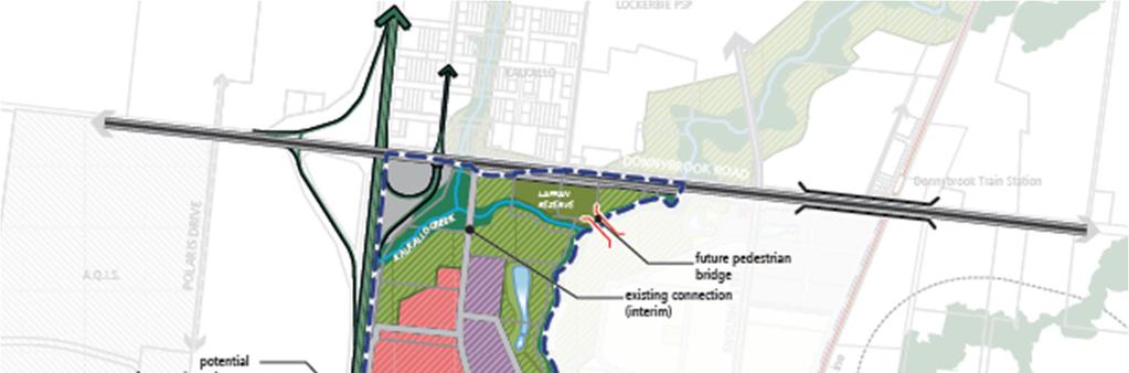
18 To ensure fairness, and in response to the both the Commonwealth approval and the Guidance Note: Implementing the BCS the MPA refined the boundary with no net loss of the overall area of GGF, but also ensured that each individual property maintained the same overall land area dedicated to BCS conservation reserve. A copy of the signed DELWP approval from November 2014 can be found at Appendix 9. Merri Creek provides a key conservation and landscape asset for the precinct that acts as a continuous corridor supporting environmental, heritage and recreational value. The result of the Conservation Area Concept Plan in the PSP provides foremost for the protection and enhancement of the GGF corridor, but also supports a range of other biodiversity values that will be protected and enhanced. The creek has enabled the integration of drainage assets within the corridor and provides informal recreational areas and shared trails to enable people to access the creek environs. This is consistent with objective 6 of the PSP guidelines which addresses responding to climate change and increasing environmental sustainability and in ensuring that waterways and ecologically significant areas of native vegetation habitat areas become key community assets Land Uses The net developable area within the Precinct is set at 488 ha with 261 ha being (54%) proposed predominantly for Industrial purposes, with ha (17%) of commercial land proposed in the north east section of the precinct to be used for a mix of employment uses such as larger floorplate commercial, including warehouse and restricted retail uses. The area includes a location for a local convenience centre to meet the needs of local workers, of approximately 1,500 sqm. The aim is to develop this precinct to meet needs of the nearby future residential precincts such as Lockerbie, English Street and Donnybrook Woodstock and provide the wider area with jobs. Additionally, the Precinct has been designed to capitalise on its prime location along the Hume Freeway and Donnybrook Road, as well as being located around a large mix of other services provided in the retail and activity centres in the adjacent Lockerbie and Donnybrook and Woodstock PSP, which link directly to the finer grain commercial area in English Street. The commercial area of the precinct should provide for higher amenity employment uses, to act as an appropriate buffer to the residential land use on the other side of the Merri Creek. This will achieve objectives 1, 4, 5 and 7 of the Precinct Structure Planning Guidelines by promoting a high quality and attractive employment location that will assist in maximising the diversity and provision of jobs in the region that is well connected to existing transport links Local Parks and Recreation Active recreation opportunities for workers and residents in the area will be provided by Laffan Reserve in the north of the precinct. The reserve will be linked by a shared trail and pedestrian bridge over the Merri Creek, or along Donnybrook Road. There will be another 4 local parks located throughout the Precinct that range in size between ha. These parks are intended to be distributed throughout the area at a catchment of approximately 400m to break up some of the commercial areas by providing opportunities for open space. Where possible, open spaces have been co-located adjacent to wetlands and the GGF corridor to capitalise on their higher value amenity areas and other recreational opportunities. Further, the Conservation Area 34 will provide for an additional 61.5ha of passive open space in the area. 17
19 This achieves objective 1 of the Precinct Structure Planning Guidelines in responding to provision for a variety of open spaces for relaxation and recreation. 7. The Amendment Amendment C198 proposes to make a number of changes to the planning scheme, as follows: Incorporates two new documents into the planning scheme by listing them in the Schedule to Clause 81.01: o Craigieburn North Employment Area Precinct Structure Plan, April 2015 o Craigieburn North Employment Area Development Contributions Plan, April 2015 Inserts Schedule 8 to the Urban Growth Zone (UGZ8) to the Hume Planning Scheme and applies UGZ8 to land in the amendment area. This zone sets out the land use and development controls for the precinct. The zone requires land use and development to be generally in accordance with the incorporated Craigieburn North Employment Area Precinct Structure Plan; Rezones land identified as Conservation Area 34 in the Biodiversity Conservation Strategy along the Merri Creek from Farming Zone to Rural Conservation Zone (RCZ); Inserts Schedule 2 to the Incorporated Plan Overlay (IPO2) to the Hume Planning Scheme and applies IPO2 to land within the Rural Conservation Zone identified as Growling Grass Frog conservation value; Inserts the Development Contributions Plan Overlay Schedule 8 (DCPO8) into the Hume Planning Scheme and applies DCPO8 to the amendment area for the purpose of levying contributions for the provision of works, services and facilities in relation to development within the Development Contributions Plan area; Amends the Public Acquisition Overlay (PAO1) to extend the PAO1 to land south of Donnybrook Road to allow for the widening and construction of the intersection and carriageway of English Street and to land to the west of the Hume Freeway to allow for a future off-ramp; Amends the Design and Development Overlay Schedule 1 (DDO1) from the land within the amendment area. This overlay is no longer required within the precinct area as the incorporated Craigieburn North Employment Area Precinct Structure Plan addresses interface issues along the Hume Freeway; Amends the Land Subject to Inundation (LSIO) within the amendment area to update maps in line with Melbourne Water mapping; Deletes the Rural Floodway Overlay (RFO) from the land within the amendment area. This overlay is no longer required as the Land Subject to Inundation Overlay (LSIO) addresses land which is subject to 1 in 100 year flooding along the Merri Creek; Deletes the Environmental Significance Overlay Schedule 2 & Schedule 10 (ESO2 & ESO10) from the land within the amendment area. This overlay is no longer required as the proposed Rural Conservation Zone, Incorporated Plan Overlay Schedule 2 and the Craigieburn North Employment Area Precinct Structure Plan designate and protect areas of environmental significance in the Merri Creek; Amends the schedule to Clause to require public open space contributions in the Craigieburn North PSP area when land is subdivided; Amends the schedule to Clause to identify native vegetation that can be removed without the need for a planning permit; and Amends the schedule to Clause 94 and Clause 95 to include VicSmart provisions for buildings and works in relation to industrial areas, car parking and signage. 18
20 8. Consultation The MPA has consulted appropriately with Council, relevant stakeholders, the landowners during the preparation of the English Street PSP. 8.1 Inception of the project Land within the precinct south of Summerhill Road was brought within the UGB on 14 November 2003 by Amendment C48 to the Hume Planning Scheme at which time it was in the Rural Zone. Land within the precinct north of Summerhill Road, excepting properties with a frontage to Donnybrook Road between Brookville Drive and Merri Creek, were brought within the UGB on 28 November 2005 by Amendment C66 to the Hume Planning Scheme at which time it was in the Farming Zone Schedule 1 (FZ-1). In 2010, the English Street precinct joined the Craigieburn North Employment Area to form one area until November 2012 when English Street was again separated as a result of consultation with stakeholders. Planning for the Precinct begins. 8.2 Consultation and Exhibition Consultation has been ongoing during the preparation of the PSP, consultation and exhibition periods. Interaction with Government agencies such as Melbourne Water, DELWP, Yarra Valley Water and VicRoads has been ongoing throughout the PSP process. Consultation with land owners during the preparation of the amendment documentation has also been thorough and constant. Consultation and exhibition periods enabled Council, the landowners, developers, Government agencies, Prescribed Ministers, and other stakeholders to provide comment on the PSP and amendment documentation. The following is a timeline of relevant dates and events undertaken over the development of the precinct in relation to consultation and exhibition of the PSP: Date Late October 2011 Event Circulation of Newsletter 1 Landowner Update 25 October 2011 Landowner Information Session Craigieburn Leisure Centre, Craigieburn January 2013 Circulation of Newsletter 2 Landowner update including information on Growth Corridor Plan and discussion of background reports 19
21 October 2013 October 2013 Circulation of Newsletter 3 Landowner update including first version of FUS Landowner Information Session Hume Global Learning Centre, Craigieburn 02 April 2015 Circulation of Newsletter 4 Exhibition commences 07 April 2015 Newspaper advertisement appears in Hume Leader 04 April 2015 Formal Exhibition period begins 09 April 2015 Gazette Notice appears in Government Gazette 22 April 2015 Public information session - City of Whittlesea Municipal Civic Chambers, South Morang 09 May 2015 Formal Exhibition Period Concludes This consultation has enabled the PSP to be a comprehensive amendment that seeks to balance the interests of all stakeholders. 20
22 Craigieburn North Emplyment Area Amendment to the Hume Planning Scheme - November 2015
C183 Amendment to the Whittlesea Planning Scheme
 PSP 25.2 English Street Precinct Structure Plan C183 Amendment to the Whittlesea Planning Scheme Panel Hearing Commencing 31 August 2015 Heard at Melbourne August 2015 PART A... 2 1. INTRODUCTION... 4
Whittlesea Planning Scheme Amendment C183 English Street Precinct Structure Plan
 Planning and Environment Act 1987 Panel Report Whittlesea Planning Scheme Amendment C183 English Street Precinct Structure Plan 28 October 2015 Planning and Environment Act 1987 Panel Report pursuant to
Panel Hearing Commencing 16 May 2016 Heard at Melbourne. PSP 1067 & 1096 Donnybrook / Woodstock. Precinct Structure Plan
 PSP 1067 & 1096 Donnybrook / Woodstock Precinct Structure Plan Part A Submission - GC28 Amendment to the Whittlesea and Mitchell Planning Scheme Panel Hearing Commencing 16 May 2016 Heard at Melbourne
Outcomes. Cross Section (Exhibition) Appendix (Exhibition) Requirement (Exhibition) Guideline (Exhibition) Table (Exhibition) Objective (Exhibition)
 Appendix (Exhibition) Requirement (Exhibition) Guideline (Exhibition) Table (Exhibition) Objective (Exhibition)") AMENDMENT C198 - Craigieburn North Employment Area Precinct Structure Plan Document changes matrix with reference to relevant submissions Version: 0.1 - Prepared for initial distribution October 2015 Note:
AMENDMENT C198 - Craigieburn North Employment Area Precinct Structure Plan Document changes matrix with reference to relevant submissions Version: 0.1 - Prepared for initial distribution October 2015 Note:
Beveridge Central PSP
 PSP 1062 Beveridge Central PSP Part A Submission - GC55 Amendment to the Mitchell and Whittlesea Planning Schemes May 2017 GC55 VPA submission to Planning Panels Victoria 24 May 2017 PART A... 3 1. INTRODUCTION...
Amendment to the Wyndham Planning Scheme
 PSP 1207.1 Lincoln Heath South Precinct Structure Plan C194 Amendment to the Wyndham Planning Scheme Panel Hearing Commenced 13 July 2015 Heard at Melbourne July 2015 PART A... 3 1. INTRODUCTION... 1 2.
C176. Amendment C176 Riverdale Precinct Structure Plan List of Document Changes for Planning Panels Victoria. Version th November 2013
 C176 Amendment C176 Riverdale Precinct Structure Plan List of Document Changes for Planning Panels Victoria Version 1.0 18 th November 2013 Amendment C176 Riverdale Precinct Structure Plan List of Document
CASEY PLANNING SCHEME AMENDMENT C188
 Who is the planning authority? Planning and Environment Act 1987 CASEY PLANNING SCHEME AMENDMENT C188 EXPLANATORY REPORT This amendment has been prepared by the Growth Areas Authority (now known as the
Beveridge Central PSP
 PSP 1062 Beveridge Central PSP Part B Submission - GC55 Amendment to the Mitchell and Whittlesea Planning Schemes May 2017 Contents PART ONE THE AMENDMENT... 2 INTRODUCTION... 2 THE LAND... 3 Relevant
Hume Planning Scheme Amendment C205 Lindum Vale Precinct Structure Plan
 Planning and Environment Act 1987 Panel Report Hume Planning Scheme Amendment C205 Lindum Vale Precinct Structure Plan 9 April 2018 Planning and Environment Act 1987 Panel Report pursuant to section 25
West Gate Tunnel Project. Incorporated Document May Incorporated document pursuant to section 6(2)(j) of the Planning and Environment Act 1987.
(j) of the Planning and Environment Act 1987.") West Gate Tunnel Project Incorporated Document May 2017 Incorporated document pursuant to section 6(2)(j) of the Planning and Environment Act 1987. Drafting Note: The planning control contained in this
West Gate Tunnel Project Incorporated Document May 2017 Incorporated document pursuant to section 6(2)(j) of the Planning and Environment Act 1987. Drafting Note: The planning control contained in this
Amendment C205. Expert Urban Design Evidence. Hume Planning Scheme. Julia Bell February 2018
 Julia Bell February 2018 Instructed by KING&WOOD MALLESONS On behalf of Hume City Council Contents 1.0 Introduction... 3 2.0 Context... 4 2.1 Physical Context... 4 2.2 Strategic Context... 8 3.0 Assessment...
Quarry Hills. Development Contributions Plan. June 2016 (Amended June 2017)
") Quarry Hills Development Contributions Plan June 2016 (Amended June 2017) Version Date Incorporated in the Planning Scheme by Amendment 1 June 2016 C188 N/A Description 2 June 2017 GC75 Incorporated changes
Quarry Hills Development Contributions Plan June 2016 (Amended June 2017) Version Date Incorporated in the Planning Scheme by Amendment 1 June 2016 C188 N/A Description 2 June 2017 GC75 Incorporated changes
9 CITY OF VAUGHAN OFFICIAL PLAN AMENDMENT NO BOCA EAST INVESTMENTS LIMITED
 9 CITY OF VAUGHAN OFFICIAL PLAN AMENDMENT NO. 631 - BOCA EAST INVESTMENTS LIMITED The Planning and Economic Development Committee recommends the adoption of the recommendations contained in the following
Whittlesea Planning Scheme Amendment C187 Wollert Precinct Structure Plan
 Planning and Environment Act 1987 Part A Panel Report Whittlesea Planning Scheme Amendment C187 Wollert Precinct Structure Plan 1 April 2016 Planning and Environment Act 1987 Part A Panel Report This is
1.0 Introduction. In preparing this statement I have:
 Table of Contents 1.0 Introduction... 3 2.0 Expert Witness Statement... 4 3.0 Summary of Evidence... 6 4.0.... 9 5.0 Planning history of land within the Precinct.... 11 6.0 The Draft Growth Corridor Plan
Clyde Creek & Casey Fields South PRECINCT STRUCTURE PLAN
 Clyde Creek & Casey Fields South PRECINCT STRUCTURE PLAN Major Town Centre at Clyde with potential future rail station, conservation of heritage and environmental values, diverse residential community,
Whittlesea Planning Scheme Amendment C188 Quarry Hills Precinct Structure Plan
 Planning and Environment Act 1987 Panel Report Whittlesea Planning Scheme Amendment C188 Quarry Hills Precinct Structure Plan 29 April 2016 Planning and Environment Act 1987 Panel Report pursuant to Section
Introduction Preliminary Issues (raised by Panel Direction) Potential Regional Park Status Formal response to all submissions...
 Potential Regional Park Status Formal response to all submissions...") Introduction... 3 Preliminary Issues (raised by Panel Direction)... 3 Potential Regional Park Status... 3 Formal response to all submissions... 3 Whole of Government Position... 4 Background and chronology
Introduction... 3 Preliminary Issues (raised by Panel Direction)... 3 Potential Regional Park Status... 3 Formal response to all submissions... 3 Whole of Government Position... 4 Background and chronology
DAREBIN PLANNING SCHEME AMENDMENT C137
 Who is the planning authority? Planning and Environment Act 1987 DAREBIN PLANNING SCHEME AMENDMENT C137 EXPLANATORY REPORT This amendment has been prepared by the Darebin City Council, who is the planning
DRAFT FOR YOUR FEEDBACK DRAFT LOGAN RESERVE PLAN
 DRAFT FOR YOUR FEEDBACK CONTENTS INTRODUCTION... BACKGROUND... State Government... Council... PLANNING LEGISLATION AND RULES... CONSULTATION PROCESS...... ENVIRONMENT AND CONSERVATION... HOUSING... Proposed
Re: Amendment C234 Cardinia Planning Scheme Pakenham East Precinct Submission by Earldean Pty Ltd and Auscare Commercial Pty Ltd
 23 February 2018 Victorian Planning Authority amendments@vpa.vic.gov.au Dear Sir / Madam Re: Amendment C234 Cardinia Planning Scheme Pakenham East Precinct Submission by Earldean Pty Ltd and Auscare Commercial
Amendment C146 Melton Planning Scheme Expert Evidence Statement Traffic & Transport Beattys Road, Plumpton
 235 311 Beattys Road, Plumpton 16585REP001C-F 21 November 2016 onemilegrid.com.au 1/59 Keele Street, Collingwood, VIC 3066 (03) 9939 8250 onemilegrid ABN: 79 168 115 679 (03) 9939 8250 1/59 Keele Street
SCHEDULE 10 TO THE URBAN GROWTH ZONE. Shown on the planning scheme map as UGZ10. Truganina Precinct Structure Plan. 1.0 The Plan
 SCHEDULE 10 TO THE URBAN GROWTH ZONE Shown on the planning scheme map as UGZ10 Truganina Precinct Structure Plan 1.0 The Plan Map 1 shows the future urban structure proposed in the Truganina Precinct Structure
sm` Planning Report in support of s96a application KINGFISHER ESTATE - FIRST DEVELOPMENT STAGES June 170 LANCEFIELD ROAD, SUNBURY
 sm` Planning Report in support of s96a application June 2015 KINGFISHER ESTATE - FIRST DEVELOPMENT STAGES 170 LANCEFIELD ROAD, SUNBURY TPG Ref: 1595 Client: Wincity Development Pty Limited ADVISE I PLAN
SCHEDULE THREE TO THE DEVELOPMENT PLAN OVERLAY EASTERN GOLF COURSE KEY REDEVELOPMENT SITE
 DD/MM/YY SCHEDULE THREE TO THE DEVELOPMENT PLAN OVERLAY Shown on the planning scheme map as DPO3 EASTERN GOLF COURSE KEY REDEVELOPMENT SITE 1.0 A permit may be granted before a development plan has been
Greater Shepparton Planning Scheme: Amendment C118 Shepparton North East: Precinct Structure Plan and Development Contributions Plan
 Planning and Environment Act 1987 Panel Report Greater Shepparton Planning Scheme: Amendment C118 Shepparton North East: Precinct Structure Plan and Development Contributions Plan 18 October 2018 Planning
Cardinia Planning Scheme Amendment C234 Pakenham East Precinct Structure Plan
 Planning and Environment Act 1987 Panel Report Cardinia Planning Scheme Amendment C234 Pakenham East Precinct Structure Plan 10 September 2018 Planning and Environment Act 1987 Panel Report pursuant to
INCREMENTAL CHANGE AREA REVIEW March 2015 Page 1
 INCREMENTAL CHANGE AREA REVIEW March 2015 Page 1 Table of Contents Introduction... 3 Background to Review... 3 Comparison of the Schedules to the General Residential Zone... 7 Methodology... 7 Policy Context...
Planning Proposal Charlestown Swim and Leisure Centre LEP Amendment
 Planning Proposal Charlestown Swim and Leisure Centre LEP Amendment Amendment No. 4 to Lake Macquarie Local Environmental Plan 2014 (PP_2014_LAKEM_005_00) Local Government Area: Name of Draft LEP: Lake
WALLAN STRUCTURE PLAN
 WALLAN STRUCTURE PLAN PART A: Project Overview and Vision MARCH 2015 Modified (Amendment C108 December 2015) Page 2 Acronyms AAV ABS ASL BIFT Aboriginal Affairs Victoria Australian Bureau of Statistics
Lake Macquarie City. A copy of the published amendment including the instrument and maps, is provided in Attachment 7 of this report.
 Planning Proposal Amendment No. 77 to Lake Macquarie Local Environmental Plan 2004 and proposed Amendment to Draft Lake Macquarie Local Environmental Plan 2013 Minor Zone Boundary Adjustment - Pasminco
WHITELEY TOWN COUNCIL NORTH WHITELEY DEVELOPMENT SEPTEMBER 2014
 WHITELEY TOWN COUNCIL NORTH WHITELEY DEVELOPMENT SEPTEMBER 2014 Dear Resident This Special Edition of the Whiteley Voice which has been prepared in conjunction with the North Whiteley Consortium is to
SCHEDULE 4 TO THE RURAL CONSERVATION ZONE
 --/--/2015 SCHEDULE 4 TO THE RURAL CONSERVATION ZONE Shown on the planning scheme map as RCZ4. Conservation Values The Merri Creek and its immediate surrounds host habitat and suitable potential habitat
HS2 Interchange Station Design
 Working on behalf of HS2 Interchange Station Design October 2018 www.hs2.org.uk 1 Interchange Station, Solihull Introduction In February 2018, HS2 Ltd appointed Arup to take forward the design of Interchange
Greater Geelong Planning Scheme Proposed Planning Scheme Amendment C and 5-19 Princes Highway, Norlane
 Greater Geelong Planning Scheme Proposed Planning Scheme Amendment C253 PLANNING SUBMISSION prepared for Bunnings Group Ltd by SJB Planning Pty Ltd Level 1, Building D 80 Dorcas Street SOUTHBANK VIC 3006
Correction to Panel Report
 Planning and Environment Act 1987 Correction to Panel Report Melton Planning Scheme Amendment C145 Rockbank PSP and DCP 15 June 2016 Planning and Environment Act 1987 Correction to Panel Report pursuant
Newcourt Masterplan. November Exeter Local Development Framework
 Newcourt Masterplan November 2010 Exeter Local Development Framework Background The Exeter Core Strategy Proposed Submission sets out the vision, objectives and strategy for the development of Exeter up
Introduction How to read this document Land to which this Precinct Structure Plan applies Background information...
 Introduction... 4 How to read this document... 6 Land to which this Precinct Structure Plan applies... 6 Background information... 6 Shepparton North East Development Contributions Plan... 7... 8 OUTCOMES...
PSP 25.2 English Street. Precinct Structure Plan. Appendix 1
 PSP 25.2 English Street Precinct Structure Plan Appendix 1 Submission Item Issue Submitter Comment / Proposed Outcome MPA response 1 EPA Victoria - Chris Bydder EPA1 No concerns raised. Due to the proximity
GREENBANK DEVELOPMENT MASTERPLAN
 DEVELOPMENT MASTERPLAN POTENTIAL TRAIN STATION COMMUNITY CENTRE Greenbank will be a connected masterplanned community providing easy access to local and surrounding amenity. Affordable quality homes, green
EAST VILLAGE STRATEGIC SITE NOVEMBER 2017
 EAST VILLAGE STRATEGIC SITE NOVEMBER 2017 East Village will be a sustainable, mixeduse precinct with a focus on innovative employment and education opportunities. Enhanced by green spaces and places for
Appendix H: Easement cross sections
 Appendix H: Easement cross sections SHARED PATH 1.5m FOOTPATH NATURE STRIP 7.3m CARRIAGEWAY 2.7m NATURE STRIP EXISTING PIPELINE 150mm DIA 5.0m (approx.) LOCAL ACCESS ROAD EXISTING PIPELINE 500mm DIA 2.7m
CITY OF FREMANTLE LOCAL PLANNING SCHEME NO. 4 AMENDMENT NO. 68 SCHEME AMENDMENT REPORT
 CITY OF FREMANTLE LOCAL PLANNING SCHEME NO. 4 AMENDMENT NO. 68 SCHEME AMENDMENT REPORT CITY OF FREMANTLE PLANNING AND DEVELOPMENT SERVICES 8 WILLIAM STREET FREMANTLE WA 6160 PLANNING AND DEVELOPMENT ACT
Kaufland supermarket and complementary uses, part 1550 Pascoe Vale Road, Coolaroo Incorporated Document (Insert date) 2019
 2019") Kaufland supermarket and complementary uses, part 1550 Pascoe Vale Road, Coolaroo Incorporated Document (Insert date) 2019 Page 1 of 7 Incorporated document pursuant to section 6(2)(j) of the Planning
Kaufland supermarket and complementary uses, part 1550 Pascoe Vale Road, Coolaroo Incorporated Document (Insert date) 2019 Page 1 of 7 Incorporated document pursuant to section 6(2)(j) of the Planning
I615. Westgate Precinct
 I615. Westgate Precinct I615.1. Precinct Description The Westgate Precinct is located approximately 18km west of the Auckland city centre. There are seven Sub-precincts in the Westgate Precinct: Sub-precinct
RE: AMENDMENT C375 GEELONG PLANNING SCHEME 1900 BARWON HEADS ROAD, BARWON HEADS
 Reference: #V157080 14 August 2018 Barwon Heads Lifestyle Group Pty Ltd C/- Best Hooper Lawyers Level 9, 451 Little Bourke Street MELBOURNE VIC 3000 Attention: Mr. Edward Mahony (Lawyer) Dear Edward RE:
Public Consultation. Land at Monks Farm, North Grove. Welcome
 Welcome Welcome to our public exhibition for development on Land at Monks Farm, orth Grove. Gallagher Estates and Gleeson Strategic Land are preparing an outline planning application for new homes, open
Sub-regional Species Strategy for the Growling Grass Frog. Draft for Public Consultation
 Sub-regional Species Strategy for the Growling Grass Frog Draft for Public Consultation Published by the Victorian Government Department of Sustainability and Environment Melbourne, November 2011 The State
Manor Lakes - Development Contributions Plan
 BALLAN RD FUTURE PSP RURAL CONSERVATION ZONE INVESTIGATION AREA Active Open Space Government Primary School P-6 AREA E EUREKA DRIVE Active Open Space MANOR LAKES BOULEVARD P-12 School and Special College
Amendment C147 Melton Planning Scheme Expert Evidence Statement Traffic & Transport , Taylors Road, Plumpton
 905 959, 961 1025 Taylors Road, Plumpton 16520REP001B-F 22 November 2016 onemilegrid.com.au 1/59 Keele Street, Collingwood, VIC 3066 (03) 9939 8250 onemilegrid ABN: 79 168 115 679 (03) 9939 8250 1/59 Keele
Casey Planning Scheme Amendment C207 Part 2 Evan and Margaret Street Precinct, Berwick
 Planning and Environment Act 1987 Panel Report Casey Planning Scheme Amendment C207 Part 2 Evan and Margaret Street Precinct, Berwick 14 January 2019 Planning and Environment Act 1987 Panel Report pursuant
4.0 Zones and Overlays
 4.0 Zones and Overlays The following section details the existing zones and overlays within the Mooroopna West Growth Corridor. Revision 1 7 July 2009 Page 27 Due to the overall size (260 ha) and geographical
Tāhuhu whakaruruhau ā-taone The sheltering ridge pole
 B2. Tāhuhu whakaruruhau ā-taone - Urban growth and form B2.1. Issues Tāhuhu whakaruruhau ā-taone The sheltering ridge pole Auckland s growing population increases demand for housing, employment, business,
Beveridge Central. Background Report. Precinct Structure Plan. November 2016
 1062 Beveridge Central Precinct Structure Plan Background Report November 2016 1 INTRODUCTION 1.1 INTRODUCTION The Metropolitan Planning Authority (MPA), in consultation with the Shire of Mitchell, is
TABLE OF CONTENTS. Human Habitats, 155 Dorcas St South Melbourne, Victoria 3205
 TARNEIT JUNCTION Town Planning Report DECEMBER 2013 TABLE OF CONTENTS Table of contents... 1 1 Introduction... 2 2 SIte context and surrounds... 4 2.1 Site Features... 4 2.2 Surrounding land uses... 4
Wingecarribee Shire Council
 Connell Wagner Pty Ltd ABN 54 005 139 873 2 Palmer Street North Parramatta New South Wales 2151 Australia Telephone: +61 2 8896 4100 Facsimile: +61 2 9890 3558 Email: cwpar@conwag.com www.conwag.com Moss
Planning Proposal Concurrent DA/LEP Amendment for Belmont North Pharmacy Amendment No. 24 to Lake Macquarie Local Environmental Plan (LMLEP) 2014
 2014") Planning Proposal Concurrent DA/LEP Amendment for Belmont North Pharmacy Amendment No. 24 to Lake Macquarie Local Environmental Plan (LMLEP) 2014 Local Government Area: Name of Draft LEP: Subject Land:
Planning Proposal Concurrent DA/LEP Amendment for Belmont North Pharmacy Amendment No. 24 to Lake Macquarie Local Environmental Plan (LMLEP) 2014 Local Government Area: Name of Draft LEP: Subject Land:
Draft Eastern District Plan
 Draft Eastern District Plan Submission_id: 31238 Date of Lodgment: 13 Dec 2017 Origin of Submission: Online Organisation name: Turrulla Gardens Pty Ltd C/- Mecone Organisation type: Industry First name:
Retain high quality habitat for the Growling Grass Frog along the Merri Creek corridor, and support other environmental habitat value.
 AMENDMENT C183 - ENGLISH STREET Document changes matrix with reference to relevant submissions Version: 0.1 - Prepared for initial distribution 31 August 2015 2 Contents 1.0 Introduction 4 P1 Local Access
LAND AT DALESTON, MAMBOURIN
 LAND AT DALESTON, MAMBOURIN Planning Report in Support of s96a Application Application for Subdivision Daleston, Mambourin October 2014 Daleston, Mambourin Our ref: 01486 Client: Phileo Australia Limited
Cranbourne North Development Contributions Plan Development Contribution Rates and Explanatory Material CITY OF CASEY JANUARY 2007
 s Plan Rates and Explanatory Material CITY OF CASEY JANUARY 2007 This Report has been prepared on behalf of: This report has been prepared by: SGS Economics and Planning Pty. Ltd. ACN 007 437 729 5 th
City of Hume Planning Scheme Amendment C207. Statement of Expert Evidence Provided to Planning Panels Victoria
 14 August 2017 Revision: 1 Reference: 1702 City of Hume Planning Scheme Amendment C207 Statement of Expert Evidence Provided to Planning Panels Victoria Stormwater Management Evidence for 35 Buckland Way
Planning Proposal under section 55 of the EP&A Act
 FOR PUBLIC EXHIBITION [Brief description] Monday 10 October to Monday 27 October 2014 Planning Proposal under section 55 of the EP&A Act Port Macquarie-Hastings LEP 2011 (Amendment No 32) Mixed land zone
Panel Report. Planning and Environment Act 1987
 Planning and Environment Act 1987 Panel Report Wyndham Planning Scheme Amendments C171 and C172 Ballan Road Precinct Structure Plan and Westbrook Precinct Structure Plan Interim Report 22 November 2013
Plan Modification to Chapter B2 of the Auckland Unitary Plan(AUP) Operative in part (15 November 2016)
 Operative in part (15 November 2016)") UNITARY PLAN UPDATE REQUEST MEMORANDUM TO FROM Phill Reid Linley Wilkinson DATE 25 September 2018 SUBJECT Plan Modification to Chapter B2 of the Auckland Unitary Plan(AUP) Operative in part (15 November
UNITARY PLAN UPDATE REQUEST MEMORANDUM TO FROM Phill Reid Linley Wilkinson DATE 25 September 2018 SUBJECT Plan Modification to Chapter B2 of the Auckland Unitary Plan(AUP) Operative in part (15 November
Planning Proposal Toronto Road, Booragul. Amendment to Lake Macquarie Local Environmental Plan (LMLEP) 2014
 2014") Planning Proposal Toronto Road, Booragul Amendment to Lake Macquarie Local Environmental Plan (LMLEP) 2014 Local Government Area: Name of Draft LEP: Subject Land: Land Owner: Applicant: Folder Number:
Planning Proposal Toronto Road, Booragul Amendment to Lake Macquarie Local Environmental Plan (LMLEP) 2014 Local Government Area: Name of Draft LEP: Subject Land: Land Owner: Applicant: Folder Number:
MERIDAN PLAINS SAND RESOURCE AREA
 MERIDAN PLAINS SAND RESOURCE AREA INFORMATION SHEET October 2010 BACKGROUND The Meridan Plains Extractive Resource Area is located on the western fringe of the coastal urban communities of Caloundra West
MAYFIELD WEST SECONDARY PLAN PHASE 2
 MAYFIELD WEST SECONDARY PLAN PHASE 2 Public Open House #3 February 25, 2010 Draft Preferred Land Use Scenario TOWN OF CALEDON PLANNING & DEVELOPMENT DEPARTMENT Open House Agenda TOWN OF CALEDON 1. Welcome
LAND USE AMENDMENT CORNERSTONE (WARD 3) 60 STREET NE AND COUNTRY HILLS BOULEVARD NE MAP 26NE BYLAW 22D2017
 60 STREET NE AND COUNTRY HILLS BOULEVARD NE MAP 26NE BYLAW 22D2017") Page 1 of 14 EXECUTIVE SUMMARY This Land Use Amendment application covers an area of 43.76 hectares ± (108.14 acres ±) located in northeast Calgary, bound by Country Hills Boulevard NE to the south and
Page 1 of 14 EXECUTIVE SUMMARY This Land Use Amendment application covers an area of 43.76 hectares ± (108.14 acres ±) located in northeast Calgary, bound by Country Hills Boulevard NE to the south and
DRAFT PLANNING SCHEME AMENDMENT GC81
 Outline of changes proposes to the Melbourne and Port Phillip Planning Scheme Fishermans Bend Fishermans Bend is one of several priority precincts identified in Plan Melbourne and plays a central role
Hume Planning Scheme Amendments C207 and C208 Sunbury South and Lancefield Road Precinct Structure Plans Permit Application Nos P18858, P18854, P18855
 Planning and Environment Act 1987 Panel Report Hume Planning Scheme Amendments C207 and C208 Sunbury South and Lancefield Road Precinct Structure Plans Permit Application Nos P18858, P18854, P18855 15
Casey Planning Scheme Amendment C221 McPherson Precinct Structure Plan
 Planning and Environment Act 1987 Panel Report Casey Planning Scheme Amendment C221 McPherson Precinct Structure Plan 4 December 2017 Planning and Environment Act 1987 Panel Report pursuant to section
AMENDMENTS. Date Effective. Amendment No. Council. DCP 14 Davidson St, Greenacre Page 2
 AMENDMENTS Amendment No. Description Adopted by Council Date Effective DCP 14 Davidson St, Greenacre Page 2 TABLE OF CONTENTS 1.0 INTRODUCTION... 4 1.1 NAME OF THIS PLAN... 4 1.2 COMMENCEMENT OF DEVELOPMENT
Welcome to our exhibition
 Welcome to our exhibition The Homes & Communities Agency (HCA) welcomes you to this public exhibition explaining our proposals for the redevelopment of the former Lea Castle Hospital site. About the Homes
WELCOME. Land North of STEVENAGE. We would like to thank you for attending our public exhibition today.
 WELCOME We would like to thank you for attending our public exhibition today. The purpose of this event is to share our proposals and hear your thoughts on our ideas. Members of the project team are on
Cardinia Creek South
 Cardinia Creek South Precinct Structure Plan March 2018 Your partner in planning great places for a growing Victoria Contents 1.0 INTRODUCTION 5 1.1 How to read this document 7 1.2 Land to which this PSP
Welcome to our exhibition
 Welcome to our exhibition housing development A46 Wildmoor Alcester Road Canal Quarter A422 Town Centre housing development Warwickshire-based IM Properties, one of the UK s largest privately owned property
The Illinois Department of Transportation and Lake County Division of Transportation. Route 173, including the Millburn Bypass
 The Illinois Department of Transportation and Lake County Division of Transportation welcome you to this Public Hearing for U.S. Route 45 from Illinois Route 132 to Illinois Route 173, including the Millburn
Barwon Heads Road. REGIONAL ACTIVE PUBLIC OPEN SPACE - Indicative Concept Only FIGURE C. Armstrong Creek East Precinct Structure Plan
 0 50 150 metres KEY Arterial Road (existing) Walking / Cycling link Residential Conventional Mixed Use Residential Medium Density Farming Drainage and Floodway Public Open Space Armstrong Creek Watercourse
Draft Ada Street Cardiff Area Plan
 Draft Ada Street Cardiff Area Plan (Draft Amendment to Lake Macquarie Development Control Plan 2014) Exhibition: The draft Area Plan is on public exhibition from 29 February 2016 to 29 March 2016. Submissions:
DRAFT TARNEIT WEST Outline Development Plan MAY 2007
 DRAFT TARNEIT WEST Outline Development Plan MAY 2007 Department of Strategy and Tourism Draft May 2007 Page 1 Table of Contents 1.0 Introduction...4 1.1 Overview...4 1.2 Land and Locality...4 1.3 Purpose
1 4 2 Dry stone wall along the boundary of property 7 and 9
 AMENDMENT GC28 - Donnybrook / Woodstock Precinct Structure Plan Document changes matrix with reference to relevant submissions Version: 3.0 - Conclusion Submission - June 2016 Note: where a change has
TOWN AND COUNTRY PLANNING ACT 1990 (AS AMENDED).
.") FAO: D. Williams Isle of Anglesey County Council Council Offices Llangefni Anglesey LL77 7TW 16 November 2017 DCRM Ref. No: WN0904-QUD-OS-LET-00002_English Dear Mr Williams TOWN AND COUNTRY PLANNING ACT
FAO: D. Williams Isle of Anglesey County Council Council Offices Llangefni Anglesey LL77 7TW 16 November 2017 DCRM Ref. No: WN0904-QUD-OS-LET-00002_English Dear Mr Williams TOWN AND COUNTRY PLANNING ACT
Draft Western District Plan
 Powered by TCPDF (www.tcpdf.org) Draft Western District Plan Submission_id: 31440 Date of Lodgment: 15 Dec 2017 Origin of Submission: Online Organisation name: Goodman Property Services Australia Pty Ltd
Melbourne Water. oria University. Sneydes Ro. ydes Road POINT COOK WEST DEVELOPMENT CONTRIBUTIONS PLAN. October 2012 (Amended July 2017)
") Sneydes Ro Melbourne Water oria University Princes Freeway POINT COOK WEST DEVELOPMENT CONTRIBUTIONS PLAN October 2012 (Amended July 2017) ydes Road Version Date Incorporated into the planning scheme by
Sneydes Ro Melbourne Water oria University Princes Freeway POINT COOK WEST DEVELOPMENT CONTRIBUTIONS PLAN October 2012 (Amended July 2017) ydes Road Version Date Incorporated into the planning scheme by
Regional Context Statement
 Regional Context Statement REGIONAL CONTEXT STATEMENT 3. REGIONAL CONTEXT STATEMENT In 1995, the Provincial Government passed into law the Growth Strategies Act. The purpose of this provincial initiative
Draft Riverdale Precinct Structure Plan Statement of Expert Evidence Development Delivery and Feasibility
 Riverdale Precinct Structure Plan Wyndham City Council Statement of Expert Evidence Development Delivery and Feasibility Prepared by Dominic Arcaro Structured Transactions & Advisory Services November
I539. Smales 2 Precinct
 I539. Smales 2 Precinct I539.1. Precinct Description The Smales 2 Precinct applies to a 4.8 hectare block of land located on the southern side of Northcote Road and fronting Lake Pupuke, Takapuna. The
Welcome. Walk Around. Talk to Us. Write Down Your Comments
 Welcome This is an information meeting introducing the applications for proposed redevelopment of the Yorkdale Shopping Centre site at 3401 Dufferin Street and 1 Yorkdale Road over the next 20+ years,
Ebbsfleet Development Corporation
 Title of Paper Planning and Housing Delivery Report September 2018 Presented by Sub-Committee Mark Pullin, Chief Planning Officer Planning Committee Purpose of Paper and Executive Summary This paper provides
Spatial Data Description. Melbourne s Greenfield Precinct Structure Plans
 Spatial Data Description Melbourne s Greenfield Precinct Structure Plans Version: 2.0 August 2016 Document Control Date Version Author Nature of Change January 2016 V1.0 Jamie Sheehan Initial document
Kibworth Harcourt. Introduction. Introduction
 Introduction Introduction Welcome to this public exhibition on the proposals for the delivery of new homes on land at The Kibworths. The purpose of today s exhibition is to give you the opportunity to
12 AMENDMENT NO. 149, TOWN OF MARKHAM HIGHWAY 404 NORTH SECONDARY PLAN
 12 AMENDMENT NO. 149, TOWN OF MARKHAM HIGHWAY 404 NORTH SECONDARY PLAN The Planning and Economic Development Committee recommends the adoption of the recommendation contained in the following report August
Rapid Transit Implementation Working Group September 14, 2017
 Rapid Transit Implementation Working Group September 14, 2017 BACKGROUND Council approved the Rapid Transit Master Plan and Updated Business Case on July 25, 2017. Approval of the RTMP confirmed the BRT
... on the draft Arden Vision & Framework
 April 2017 Integrated world-class urban renewal Feedback... on the draft Arden Vision & Framework On 1 September 2016 the Victorian Planning Authority (VPA) released the draft Arden Vision & Framework
Western Sydney Parklands Australia s Largest Urban Park
 Western Sydney Parklands Australia s Largest Urban Park 37 WLA 1 MAGAZINE 21 38 WESTERN SYDNEY PARKLANDS AUSTRALIA S LARGEST URBAN PARK Large urban parks have dual roles to play in meeting the demands
WELCOME GYPSY LANE. Wider Site Location plan. Proposals for the development of LAND OFF FOXLYDIATE LANE WEBHEATH. Proposals for the development of
 WELCOME The developers are preparing an outline planning application for a residential led development and need the community s views in order to develop the proposals further WHAT IS PROPOSED? A high
Appendix A. Planning Processes. Introduction
 1 Planning Processes Introduction This appendix outlines a number of planning processes which are used in the Auckland Region to support the effective management of development in the region s rural and
Planning Proposal Wangi Power Station Complex Administrative Amendment Lake Macquarie Local Environmental Plan 2014
 Planning Proposal Wangi Power Station Complex Administrative Amendment Lake Macquarie Local Environmental Plan 2014 (Post Exhibition Version) Local Government Area: Name of Draft LEP: Subject Land: Land