Design GuidelineThemes: Integrated Stormwater Detention and Landscape
|
|
|
- Madison Porter
- 5 years ago
- Views:
Transcription
1 Design GuidelineThemes: Integrated Stormwater Detention and Landscape


2 Design Integrated Stormwater Detention Detention/Flood Control Provide needed flood control while improving playability 100 year event Seamless incorporation into the design of the course Maintain playability to the greatest extent possible Must be dry outside of major events (approx. 10 year storm) Dell Urich Golf Course, Tucson, AZ Water Quality Support for opportunities to integrate a natural water treatment channel that enhances course playability A naturalized open channel will be integrated into the course as a design element and water hazard Design should handle minor events and serve water quality needs as well as minimizing damage to the course in smaller events Glacier Club, Durango, CO
3 Design Grading General Prefer high efficiency grading plan to ensure needed detention while minimizing impacts to existing trees, views and existing topography Minimize impacts to existing horizon lines Minimize impacts to existing trees whenever possible The sweeping vistas and parklike feel of the course should be maintained Grading should preserve the greatest number of trees possible Areas of fill should not exceed existing high point/ridgeline on the site Golf course edges should be similar slopes to existing conditions East/west topographical relationships should remain consistent Contractor should design and construct the golf course to incorporate all grading, drainage, and water quality components as attractive and naturally appearing strategy features Course Operations/Playability South Platte River Trail at Overland Golf Course Construction Grading should retain Grading should integrate stormwater existing look/feel and detention areas that allow golf holes to topography, as well remain playable within a reasonable Impacts to adjacent All grading practices should incorporate as enhance course timeframe following large storm events neighborhoods and businesses appropriate Best Management Practices (e.g., playability, operations and Grading should consider the existing from construction activities (e.g., dust and erosion control) to ensure minimal maintenance characteristics of the golf course dust, traffic, duration) should be impacts to neighbors The undulations and slight including view sheds and look and feel of mitigated whenever possible Options to haul dirt off-site may be considered shifts in topography are a parkland style course given opportunity to do so efficiently and with important to the course minimal impacts to neighboring communities, businesses and park users

4 Design Trees General Preservation of course trees is a top community priority As many trees as can be saved, should be saved Priority should be given to the protection of perimeter trees and large, healthy tree stands Tree preservation and new tree plantings should continue to contribute to the park-like look/feel of the course Species of replacement trees should be diverse and sustainable with reclaimed water irrigation and in Denver s climate Avoid/limit impact to high-priority perimeter and interior stands of trees; enhance and replace perimeter plantings where appropriate All efforts should be made to protect as many trees on the course as possible Tree preservation and protection should consider the existing characteristics of the golf course, grading, view sheds, contribution to the park-like feel of the course and playability of the golf course Tree replacement approach will follow the City s policy (replace impacted canopy coverage) and be approved by the City Forester and Denver Golf with the possibility to relocate existing trees into tree protection areas based upon cost, aesthetics, feasibility, playability and sustainability The most effective tree protection elements from all design submittals will be integrated into final design Course Operations/Playability Existing trees significantly contribute to the playability of the course Consideration should be given to species diversity and ultimate size of mature replacement trees Golf Course tree placement and species selection should consider long term effects on playability and turf health Tree placement around greens complexes must not interfere with southern sun exposure in winter and morning sunlight in the spring, summer, and/or fall Planting plan must account for variation in tree species, size/foliage, growth/maturation, and ease/ effectiveness of maintenance


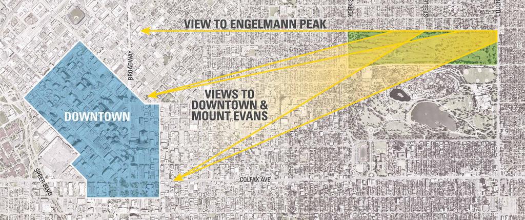


5 Views Distant Skyline/Mountain Views Local Views
Design Guideline Themes: Course and Community Facilities
 Design Course and Community Facilities Design Community Connectivity Connections Significant pedestrian traffic currently exists through and around the course perimeter Pedestrian connections should not
City of Lafayette Study Session Staff Report Design Review Commission
 ++ City of Lafayette Study Session Staff Report Design Review Commission Meeting Date: January 08, 2018 Staff: Subject: Chris Juram, Planning Technician SS12-17 Miramar Homebuilders, R-20 Zoning: Request
Stormwater Solutions for Residential Sites. Section 2 Stormwater Management Approach VERSION 1.0. EcoWater Solutions. Prepared for
 VERSION 1.0 Stormwater Solutions for Residential Sites Section 2 Stormwater Management Approach Prepared for EcoWater Solutions A Department of Waitakere City Council 113 Central Park Drive Henderson WAITAKERE
Site Design (Table 2) Fact Sheet & Focus Questions:
 Fact Sheet & Focus Questions:") Site Design (Table 2) Fact Sheet & Focus Questions: BACKGROUND WHAT IS SITE DESIGN? Site design refers to the arrangement of buildings and open spaces on adjacent sites to maximize the shared benefits
Site Design (Table 2) Fact Sheet & Focus Questions: BACKGROUND WHAT IS SITE DESIGN? Site design refers to the arrangement of buildings and open spaces on adjacent sites to maximize the shared benefits
When planning stormwater management facilities, the following principles shall be applied where possible.
 2.0 Principles When planning stormwater management facilities, the following principles shall be applied where possible. 2.0.1 Drainage is a regional phenomenon that does not respect the boundaries between
River Corridor Overlay Zone (RCOZ) Article 5
 Article 5") River Corridor Overlay Zone (RCOZ) Article 5 The site is in one of two designated districts. The first is the CBD (central business district) River District, which recognizes the urban character and unique
River Corridor Overlay Zone (RCOZ) Article 5 The site is in one of two designated districts. The first is the CBD (central business district) River District, which recognizes the urban character and unique
Green Gables. April 24, 2013
 Green Gables Preliminary and Final Plat April 24, 2013 Development Team Green Gables Development Corporation (Owner/Developer) DTJ Design (Planner/Landscape Architect) Enertia Consulting Group (Civil Engineer)
City of Lafayette Staff Report
 City of Lafayette Staff Report For: By: Design Review Commission Greg Wolff, Senior Planner Meeting Date: April 27, 2015 Subject: SS03-15 Gundi & Peter Younger (Owners), R-40 Zoning: Request for a Study
RESIDENTIAL GUIDELINES CHECKLIST
 RESIDENTIAL GUIDELINES CHECKLIST The following checklist was created to provide you with an easy way to ensure that your project complies with the Residential Design Guidelines. RESIDENTIAL DESIGN GUIDELINES
CHAPTER 26 LANDSCAPING (Chapter added in its entirety 05-08)
") CHAPTER 26 LANDSCAPING (Chapter added in its entirety 05-08) 26.01 DESCRIPTION AND PURPOSE. Landscaping is an important element of the use, development and preservation of land, and a significant factor
CHAPTER 26 LANDSCAPING (Chapter added in its entirety 05-08) 26.01 DESCRIPTION AND PURPOSE. Landscaping is an important element of the use, development and preservation of land, and a significant factor
STREAM BUFFERS
 88-415 STREAM BUFFERS 88-415-01 PURPOSE In the Kansas City region and throughout the nation, vegetated stream buffers have been clearly shown to protect stream stability and related infrastructure, improve
Design Specifications & Requirements Manual
 11 PARKS & OPEN SPACES 11.1 DEFINITIONS... 1 11.1.1 Neighbourhood Parks... 1 11.1.2 District Parks... 1 11.1.3. Sport Parks... 1 11.1.4 Urban Parks... 1 11.1.5 Civic Spaces... 1 11.1.6 Open Space System...
NAPA COUNTY PUBLIC WORKS Standards & Specifications
 Roadway Design & Construction Manual (Table of Contents) 1. Chapter 1: General Provisions 1.1 Short Title 1.2 Jurisdiction 1.3 Purpose and Effect 1.4 Enactment Authority 1.5 Amendment and Revisions 1.6
Landscaping Standards
 CHAPTER 29 ARTICLE 403 29.403 Landscaping Standards Purpose: The purpose of this section is to protect and promote the public health, safety and general welfare by requiring landscaping in relation to
CHAPTER 13 DESIGN GUIDELINES
 CHAPTER 13 DESIGN GUIDELINES Section 1300.00 Section 1300.01 Design Guidelines Purpose The purposes of this section are to: A. The purpose of this Section is to establish procedures and standards to serve
A: Downtown Diversion Pipe
 A: Downtown Diversion Pipe b c with modifications Map highlighting conservation easement. The diversion pipe would run along the railroad. Will divert 40-44% of total flow.; and Reduce the impact on Sand
Design Specifications & Requirements Manual
 11 PARKS & OPEN SPACES 11.1 DEFINITIONS... 1 11.1.1 Neighbourhood Parks... 1 11.1.2 District Parks... 1 11.1.3. Sport Parks... 1 11.1.4 Urban Parks... 1 11.1.5 Civic Spaces... 1 11.1.6 Open Space System...
SUBMITTAL REQUIREMENTS: FINAL PLAN REVIEW- PROJECT DEVELOPMENT PLAN (PDP)
") 1) Application form and filing fee. Application Form.pdf Development Review Guide STEP 6 of 8 SUBMITTAL REQUIREMENTS: FINAL PLAN REVIEW- PROJECT DEVELOPMENT PLAN (PDP) 2) Transportation Development Review
1) Application form and filing fee. Application Form.pdf Development Review Guide STEP 6 of 8 SUBMITTAL REQUIREMENTS: FINAL PLAN REVIEW- PROJECT DEVELOPMENT PLAN (PDP) 2) Transportation Development Review
ADOPTED CAPITAL IMPROVEMENT PROGRAM BUDGET ARROYO PROJECTS
 ADOPTED CAPITAL IMPROVEMENT PROGRAM BUDGET ARROYO PROJECTS HAHAMONGNA FY 212-216 Capital Improvement Program Priority Description Total Estimated Costs Appropriated Through FY 211 Adopted FY 212 FY 213
QUEENSTOWN LAKES DISTRICT COUNCIL SUBDIVISION DESIGN GUIDELINES
 Attachment C: Draft QLDC Subdivision Design Guidelines QUEENSTOWN LAKES DISTRICT COUNCIL DESIGN GUIDELINES A DESIGN GUIDE FOR AND DEVELOPMENT IN THE URBAN ZONES QUEENSTOWN OFFICE 10 Gorge Road Queenstown
Improve the appearance of off-street parking areas, vehicular use areas, and property abutting public and private roads;
 Bedford Township, MI (Monroe Co.) 2012 http://library.municode.com/index.aspx?clientid=02123 400.1907 - Landscaping and screening. Se 1907. 1. Intent. Landscaping, greenbelts, and screening are necessary
Plan Review Checklist
 Plan Review Checklist FOR EROSION AND SEDIMENT CONTROL PLANS _ Minimum Standards - All applicable Minimum Standards must be addressed. All minimum Standards must be adhered to during the entire project
Problem Understanding
 Introduction...2-1 Previous Data and Mapping...2-2 Known Problem Areas...2-3 Resident Survey.2-3 Introduction The Village of Downers Grove stormwater system includes storm sewers, streams, wetlands, roadway
ST. MARY S SOIL CONSERVATION DISTRICT (SMSCD) AND DPW&T CONCEPT EROSION AND SEDIMENT CONTROL AND STORMWATER MANAGEMENT GUIDELINES AND CHECKLIST
 AND DPW&T CONCEPT EROSION AND SEDIMENT CONTROL AND STORMWATER MANAGEMENT GUIDELINES AND CHECKLIST") St. Mary s Soil Conservation District 26737 Radio Station Way, Suite B Leonardtown, MD 20650 Phone: 301-475-8402 ext. 3 Fax: 301-475-8391 www.stmarysscd.com St. Mary s County Government Department of Public
St. Mary s Soil Conservation District 26737 Radio Station Way, Suite B Leonardtown, MD 20650 Phone: 301-475-8402 ext. 3 Fax: 301-475-8391 www.stmarysscd.com St. Mary s County Government Department of Public
ADDENDUM TO BIOLOGICAL SCOPING SURVEY REPORT, BOTANICAL SURVEY AND WETLAND DELINEATION
 ADDENDUM TO BIOLOGICAL SCOPING SURVEY REPORT, BOTANICAL SURVEY AND WETLAND DELINEATION FOR AVALON INN (APN 069-241-27 & -04) 1201 & 1211 NORTH MAIN STREET FORT BRAGG, CA MENDOCINO COUNTY prepared for:
MANUAL OF DESIGN, INSTALLATION, AND MAINTENANCE REQUIREMENTS FOR STORMWATER MANAGEMENT PLANS
 MANUAL OF DESIGN, INSTALLATION, AND MAINTENANCE REQUIREMENTS FOR STORMWATER MANAGEMENT PLANS May 2007 SECTION 1 Responsibility of Applicant TABLE OF CONTENTS A. Stormwater Management Plan Required Information
CHESAPEAKE LANDSCAPE ORDINANCE
 CHESAPEAKE LANDSCAPE ORDINANCE CONSERVATION PRESERVATION CZO 19-600 Effective October 16, 2008 BUFFER YARD C PARKING LOT REFORESTATION YEAR 1 REFORESTATION YEAR 4 BUFFER YARD F CBPA REFORESTATION Page
Shelbyville, KY Stormwater Best Management Practices. Section 2 EROSION PREVENTION AND SEDIMENT CONTROL PLAN
 Section 2 EROSION PREVENTION AND SEDIMENT CONTROL PLAN 2.1 Requirements The City of Shelbyville, KY will require an Erosion Prevention and Sediment Control (EPSC) Plan for most types of development construction.
HICKORY NUT FOREST DESIGN GUIDELINES
 HICKORY NUT FOREST DESIGN GUIDELINES Introduction Hickory Nut Forest is a "net-zero energy", conservation development that is designed to protect and celebrate the property s unique ecology. A conservation
ARTICLE IV: DEVELOPMENT STANDARDS 404 MASTER PLANNING
 IV 13 404 MASTER PLANNING Master Planning through the Site Analysis (Master Planning Site Analysis) or Planned Development (Master Planning Planned Development) is provided to encourage development which
Kearney Post-Construction Stormwater Program
 Kearney Post-Construction Stormwater Program Stormwater Treatment Facilities (STFs) Kearney Public Works Office August 10 and 17, 2017 Stormwater Treatment Facility (STF) Session Goals Understand STF Function
6.5 Lakewood Gulch. Basin Snapshot
 6.5 Lakewood Gulch The Lakewood Gulch Map Unit is comprised of both Lakewood Gulch and Dry Gulch (4800-01 and 4801-01) from the Denver Storm Drainage Master Plan (SDMP) and has a total drainage area of
ARTICLE 3 LANDSCAPING AND SCREENING REQUIREMENTS
 ARTICLE 3 CHAPTER 4 LANDSCAPING AND SCREENING REQUIREMENTS SEC 3.401 SEC 3.402 (D) (E) PURPOSE: The purpose of this Chapter is to establish minimum standards for the design, installation, and maintenance
5.0 Storm Water Landscape Guidance Introduction
 5.0 Storm Water Landscape Guidance Introduction Landscaping is a critical element to improve both the function and appearance of storm water management practices. Integrated storm water landscapes can
PAVING PARKING AREAS AND ROADS DESCRIPTION. Alternate Names: Pavement Practices, Impervious Paving
 4.2-i PAVING PARKING AREAS AND ROADS Alternate Names: Pavement Practices, Impervious Paving DESCRIPTION All roads, driveways, and parking lots proposed for year-round use shall be paved with a hard plowable
City of Lafayette Study Session Staff Report Design Review Commission
 City of Lafayette Study Session Staff Report Design Review Commission Meeting Date: April 24, 2017 Staff: Payal Bhagat, Senior Planner Subject: HDP18-15 & HDP31-15 Ramesh Patel & Melcor Development (Owners),
4.6. Low Impact and Retentive Grading
 4.6. Low Impact and Retentive Grading Low Impact Grading techniques focus on utilizing existing topography during Site layout to minimize cost. Proposing structures, roads, and other impervious surfaces
Toronto Complete Streets Guidelines
 Toronto Complete Streets Guidelines 108 110 7.1 Green Infrastructure Design Principles 112 7.2 Context-Sensitive Green Streets 114 7.3 Key Green Street Elements Green infrastructure refers to natural and
ORDINANCE NO. SECTION 1. This ordinance, due to its length and corresponding cost of
 Introduced by: ORDINANCE NO. AN ORDINANCE OF THE CITY OF PASADENA AMENDING CHAPTER 17.44 OF THE ZONING CODE (TITLE 17) TO INCORPORATE THE CALIFORNIA DEPARTMENT OF WATER RESOURCES MODEL WATER EFFICIENT
Stormwater Management Plan (SWMP) Revision Date: 11/05
 Revision Date: 11/05") Stormwater Management Plan (SWMP) Revision Date: 11/05 SWMP Purpose: Sustainable stormwater management principles are adopted as Portland State University s (PSU) preferred approach for the management
Stormwater Management Plan (SWMP) Revision Date: 11/05 SWMP Purpose: Sustainable stormwater management principles are adopted as Portland State University s (PSU) preferred approach for the management
County of Fairfax, Virginia
 County of Fairfax, Virginia To protect and enrich the quality of life for the people, neighborhoods and diverse communities of Fairfax County TO: SUBJECT: All Architects, Builders, Developers, Engineers,
DIVISION 32 EXTERIOR IMPROVEMENTS
 A. Standard DIVISION 32 EXTERIOR IMPROVEMENTS PARKING LOTS Layout: Layout parking lots with nine by eighteen foot (9 x18 ) stall perpendicular to the drive lane. Widths of all drive lanes will be twenty-four
Village of Glenview Appearance Commission
 Village of Glenview Appearance Commission STAFF REPORT July 23, 2014 TO: Chairman and Appearance Commissioners CASE #: A2014-059 LOCATION: 727 Harlem Avenue FROM: Community Development Department PROJECT
Red Fox Commercial Outline Plan
 Red Fox Commercial Outline Plan City of Cold Lake, Alberta Prepared by Durrance Projects Ltd and Ross W. Sharp & Associates Ltd October 2014 Rupert 1 Table of Contents 1. PURPOSE...3 1.1. Location...4
Parks, Recreation, and Open Space Land Use Goals
 Parks, Recreation, and Open Space Land Use Goals Issue: The preservation of open space and natural features will enhance the character of the built environment, promote public health and safety, provide
HUDSON VALLEY REGIONAL COUNCIL 3 Washington Center, Newburgh NY
 PROJECT AREA: HYDE PARK HUDSON VALLEY REGIONAL COUNCIL 3 Washington Center, Newburgh NY 12550 http://www.hudsonvalleyregionalcouncil Insert aerial site photo with streets labeled GREEN INFRASTRUCTURE CONCEPT
Project: Developer/Designer: Reviewer: I. Narrative: 1. Project Description: Describes the nature and purpose of the land disturbing activity.
 City of Charlottesville, Virginia Erosion and Sediment Control Plan Review Checklist 610 East Market Street, Charlottesville, VA 22902 Telephone 434-970-3182; Fax 434-970-3359 Project: Developer/Designer:
STORMWATER QUALITY MARION STREET GREEN INFRASTRUCTURE PROJECT COMMON SOURCES OF URBAN POLLUTANTS URBAN STORMWATER
 STORMWATER QUALITY COMMON SOURCES OF URBAN POLLUTANTS Fertilizers Litter Pet-waste COMMON POLLUTANTS FOUND IN URBAN STORMWATER BACTERIA TRASH METALS Dumpsters Vehicle exhaust, automotive fluids, etc. IMPACTS
Request for an Exception to the Napa County Road and Street Standards
 F Request for an Exception to the Napa County Road and Street Standards Shed Creek Winery Use Permit P16-327 and Use Permit Exception to the Conservation Regulations P17-178 Planning Commission Hearing
UCONN Athletic District Improvements Scoping Meeting
 UCONN Athletic District Improvements Scoping Meeting Paul Ferri, Environmental Compliance Professional, UCONN Scott Bighinatti, Lead Environmental Scientist, Milone & MacBroom, Inc. CEPA Scoping Meeting
Site Development Plan (SDP) Checklist
 Checklist") Development Services Department 100 N. Wilcox Street, Castle Rock CO 80104 303-660-1393 or CRGov.com Site Development Plan (SDP) Checklist A complete Site Development Plan (SDP) submittal will contain
Development Services Department 100 N. Wilcox Street, Castle Rock CO 80104 303-660-1393 or CRGov.com Site Development Plan (SDP) Checklist A complete Site Development Plan (SDP) submittal will contain
PLANNING APPROVAL & SIDEWALK WAIVER STAFF REPORT Date: December 1, 2016
 PLANNING APPROVAL & SIDEWALK WAIVER STAFF REPORT Date: December 1, 2016 NAME Dennis P. Wilkins LOCATION. CITY COUNCIL DISTRICT District 6 7078 Bruns Drive (Northeast corner of Bruns Drive and Cody Road)
Logan Gilbertsen, EI, CFM Phil Stuepfert, Sr. Project Manager
 Logan Gilbertsen, EI, CFM lgilbertsen@hrgreen.com Phil Stuepfert, Sr. Project Manager pstuepfert@hrgreen.com Project Overview Design Approach Water Modeling Landscape Approach Built Photos Questions September
City of Waco Stormwater Management Regulations
 1.0 Applicability: City of Waco Stormwater Management Regulations These regulations apply to all development within the limits of the City of Waco as well as to any subdivisions within the extra territorial
Caribbean Area PO Box San Juan, PR Page Topics
 Caribbean Area PO Box 364868 San Juan, PR 00936-4868 IBM Plaza 654 Muñoz Rivera Ave. Suite 604 Hato Rey, PR 00918-4123 Page Topics Guide to Erosion and Sediment Control in Urban Areas Erosion and Sedimentation
Perfect Building Site
 There s No Such Thing as a Perfect Building Site BY JEREMIAH ECK Of all the principles that govern house design, siting is the most underrated and most often ignored. You may have a functional plan or
Figure 1 Cypress Street Study Area Location Map
 July 20, 2016 TO: FROM: Jim Massarelli Director of Engineering Jeff Julkowski, PE Michael Burke, PE SUBJECT: Cypress Street Study Area Stormwater Analysis (CBBEL Project No. 16-0058) At the request of
Community Design Guidelines. Port Wallace DRAFT
 Community Design Guidelines Port Wallace DRAFT Energy 1 2 3 Nature Movement Connections Built Form DRAFT Layout Energy 1 Nature Community Design Guidelines GREAT COMMUNITIES PROTECT, CELEBRATE, AND CONSERVE
ARROYO PROJECTS ADOPTED CAPITAL IMPROVEMENT PROGRAM BUDGET
 A RROYO P ROJECTS ADOPTED CAPITAL IMPROVEMENT PROGRAM BUDGET FISCAL YEARS 214-218 HAHAMONGNA Priority Description 1 Hahamongna Watershed Park - Implement Master Plan 211,6 211,6 (77565) 2 Hahamongna -
Public Meeting #3 May 9, 2009 MVVA Team
 Public Meeting #3 May 9, 2009 MVVA Team Welcome to the third Public Meeting for the Lower Don Lands Municipal Class Environmental Assessment (EA) Infrastructure Master Plan and Keating Channel Precinct
Purpose of Open House #3
 Public Meeting #3 May 9, 2009 MVVA Team Purpose of Open House #3 The main purpose of this Open House is to present and seek input on the: Evaluation of transportation and infrastructure design alternatives
Kittson Parkway / Watershed Park Parking Lot
 Kittson Parkway / Watershed Park Parking Lot Date Constructed: Summer 2005 Site Location / Description: Kittson Parkway, North Delta, British Columbia. Permeable parking lot adjacent to Watershed Park;
LEGEND : FUTURE M18 CORKER OVERFLOW OFFICE OF PUBLIC WORKS REGRADING WORKS LAYOUT PLAN AT KILTARTAN PROPOSED WORKS AREA LIABLE TO FLOODING N18
 FUTURE M18 KILTARTAN TO COOLE RIVER SYSTEM - UNDERGROUND NATURAL OVERFLOW ROUTE UNDER FLOOD CONDITION LAYOUT OF FUTURE M18 UNDERGROUND CAVES & CONDUITS - APPROX LOCATION 08 PHOTOGRAPHS (REFER TO APPENDIX
IV. Development in the Rural Overlay District
 Intracoastal Waterway Route 17 Route 168 Great Dismal Swamp VIRGINIA NORTH CAROLINA IV. Development in the Rural Overlay District IV-1 Route 17 in Chesapeake s Rural Overlay District affords distant views
2.1 Principles & Objectives
 Designing With The Landform 2.1 Principles & Objectives Land planning which integrates the natural features of a site (i.e., designing with the landform ) into the site design is a major component of the
Policy & Procedure Effective Date: Parks Department Page of
 City of Arvada Policy & Procedure Effective Date: Parks Department Page of TITLE: City of Arvada Prairie Dog Habitat Plan APPROVAL: PURPOSE: To establish a plan for the preservation of black-tailed prairie
PRELIMINARY DRAINAGE REPORT LATHAM 200 MMSCFD GAS PROCESSING PLANT
 PRELIMINARY DRAINAGE REPORT LATHAM 200 MMSCFD GAS PROCESSING PLANT LOTS B, RECORDED EXEMPTION 1211-2-1, RECX13-0096 LOCATED IN THE NORTH 1/2 OF SECTION 2, TOWNSHIP 3 NORTH, RANGE 66 WEST, 6 TH PRINCIPAL
 Stormwater Management Plan Narrative Quality Fleet Services, Inc. SITE RE-DEVELOPMENT 548 New Ludlow Road South Hadley, MA The project proposed by Quality Fleet Services, Inc. consists of the site improvements
CHAPTER 22 Rural Open Space Community Developments
 CHAPTER 22 Rural Open Space Community Developments Section 22.1 Description and Purpose The intent of this Chapter is to offer property owners an alternative to traditional zoning requirements for rural
Key elements : Filter Strips must be designed within parameters required by the Fort Wayne s Development Standards/Criteria Manual.
 4.4. Filter Strips Filter Strips are densely vegetated lands that treat sheet flow storm water from adjacent pervious and impervious areas. They function by slowing runoff, trapping sediment and pollutants,
SITE PLAN REVIEW ITEMS - REFERENCE CHECKLIST
 City of Seminole 9199 113 th Street N. Seminole, FL 33772 Ph: (727) 392-1966 Fx: (727) 319-6583 SITE PLAN REVIEW ITEMS - REFERENCE CHECKLIST Note: This checklist is designed to aid designers in the review
6.1. INTRODUCTION AND SUMMARY OF FINDINGS
 Chapter 6: Stormwater Management 6.1. INTRODUCTION AND SUMMARY OF FINDINGS A Stormwater Pollution Prevention Plan (SWPPP) has been prepared for the Proposed Project in accordance with the requirements
PCE PRELIMINARY DRAINAGE ANALYSIS REPORT FOR WESTWOOD MIXED USE NEIGHBORHOOD PROJECT 772 NORTH FOREST ROAD TOWN OF AMHERST, ERIE COUNTY, NEW YORK
 PCE PRELIMINARY DRAINAGE ANALYSIS REPORT FOR WESTWOOD MIXED USE NEIGHBORHOOD PROJECT 772 NORTH FOREST ROAD TOWN OF AMHERST, ERIE COUNTY, NEW YORK MAY 19, 2014 Prepared By: Timothy M. Lavocat, P.E., CFM
Project Narrative For Fruita RV Resort Conditional Use Permit
 Project Narrative For Fruita RV Resort Conditional Use Permit Date: November 18, 2016 Prepared by: Robert W. Jones, II, P.E. Vortex Engineering & Architecture, Inc. 2394 Patterson Rd., Ste. 201 Grand Junction,
Tucson Koi & Water Gardens
 OV113-031 Tucson Koi & Water Gardens CONDITIONAL USE PERMIT SITE ANALYSIS 05.22.2014 Property Owners Walter & Jane Wong Family Investments, LLP 5437 East 3rd Street Tucson, Arizona 85711 Tucson Koi and
USF System Campus Master Plan Updates Goals, Objectives and Policies
 2015-2025 USF System Campus Master Plan Updates Goals, Objectives and Policies Tampa Goals, Objectives, and Policies Table of Contents Executive Summary 2015 2025 USF Campus Master Plan Update Introduction
PLANNED UNIT DEVELOPMENT STAFF REPORT Date: June 2, 2016
 # 9 ZON2016-01032 PLANNED UNIT DEVELOPMENT STAFF REPORT Date: June 2, 2016 DEVELOPMENT NAME JJT Properties LLC LOCATION 1147 & 1151 East I-65 Service Road South and 1180 Sledge Drive (Southeast corner
Specification and Construction Plans For: South Bethany Landscaping Improvement Plan Contract Number T
 Specification and Construction Plans For: South Bethany Landscaping Improvement Plan Contract Number T201220010 1 INDEX OF SHEETS Sheet Number Description 1 Title Sheet 2 Index of Sheets 3 Overview 4 General
Mississauga Waterfront. Parks Strategy - Draft
 Potential configuration for river s edge seating. Boating on Credit River: A regatta Boating on Credit River: Active enjoyment 5.2 Port Credit Memorial Park West Priority Park 5.2.1 Site Opportunities
SkyScape Built-In-Place (BIP) Systems WITH VEGETATIVE ROOFING OPTIONS, THE SKY S THE LIMIT.
 Systems WITH VEGETATIVE ROOFING OPTIONS, THE SKY S THE LIMIT.") SkyScape Built-In-Place (BIP) Systems WITH VEGETATIVE ROOFING OPTIONS, THE SKY S THE LIMIT. SkyScape Built-in-Place (BIP) Systems For the greatest assortment of pre-designed options, look no further than
SkyScape Built-In-Place (BIP) Systems WITH VEGETATIVE ROOFING OPTIONS, THE SKY S THE LIMIT. SkyScape Built-in-Place (BIP) Systems For the greatest assortment of pre-designed options, look no further than
North Oakville East Parks Facilities Distribution Plan. November, 2009
 North Oakville East November, 2009 POLICY CONTEXT 1) Purpose a) The purpose of this document is to be a guide for the location, configuration, design and development of the parks system for the North Oakville
Zoning Ordinance Chapter 10
 CHAPTER 10 - WASHES SECTION 10.0 GENERAL: A. The purpose of this Ordinance is to establish standards for development in or near Major and Minor Washes as defined in Appendix A Glossary of Terms and Definitions
MINUTES CHESAPEAKE BAY PRESERVATION AREA BOARD VIRGINIA BEACH, VIRGINIA JULY 24, 2017
 MINUTES CHESAPEAKE BAY PRESERVATION AREA BOARD VIRGINIA BEACH, VIRGINIA JULY 24, 2017 Chair Mr. Jester, called to order the Chesapeake Bay Preservation Area Board meeting in the City Council Chambers,
A District Council of the Urban Land Institute
 A District Council of the Urban Land Institute A District Council of the Urban Land Institute Thank you to our sponsors! Corporate Sponsors: Supporter Sponsors: Friend Sponsor: Thank you to our Community
Sun City Lincoln Hills ARC Application Checklist
 Sun City Lincoln Hills ARC Application Checklist Landscape Plants & Trees Checklist 19 It is recommended that the Owner or Landscape Architect/Designer/Contractor attend the ARC meeting to answer any questions
CITY OF VALPARAISO STORMWATER MASTER PLAN
 CITY OF VALPARAISO STORMWATER MASTER PLAN APPROVED BY THE VALPARAISO CITY UTILITIES BOARD OCTOBER, 2016 Prepared by the City of Valparaiso Engineering Department PLAN SUMMARY Major flash flooding in August
Public Information Centre # 2 Coronation Park Drainage Improvements Town of Oakville Municipal Class Environmental Assessment
 November 26, 2014 Public Information Centre # 2 Coronation Park Drainage Improvements Town of Oakville Municipal Class Environmental Assessment Study Area & Drainage System Legend Coronation Project Park
Northeast Quadrant Plan
 Northeast Quadrant Plan Northeast Quadrant Distinctive Features Land Use The Northeast Quadrant includes all the area within the planning area that is east of Interstate 5 and to the north of State Route
The following principles guide the development of goals and strategies to protect and promote these amenities:
 OPEN SPACE/PARKS/TRAILS/RECREATION GOALS/STRATEGIES Cherry Hills Village is a living environment that offers low density development, open areas, public scenic vistas, public trails and public parks. This
B L A C K D I A M O N D D E S I G N G U I D E L I N E S for Multi-family Development
 B L A C K D I A M O N D D E S I G N G U I D E L I N E S for Multi-family Development Adopted June 18, 2009 This section of the Design and focuses on site planning and design guidance for new multi-family
Prado Ranch North Common Open Space Tentative Map. Washoe County Planning Commission July 3, 2018
 Prado Ranch North Common Open Space Tentative Map Washoe County Planning Commission July 3, 2018 Site Characteristics Intersection of Chickadee and Lemmon Drive ~1 mile north of Deodar/Lemmon Drive intersection
DIVISION 32 EXTERIOR IMPROVEMENTS
 32 10 00 PARKING LOTS UTAH STATE UNIVERSITY DIVISION 32 A. Standard Layout: Layout parking lots with nine by eighteen foot (9 x18 ) stalls perpendicular to the drive lane. Widths of all drive lanes will
Red Hill Valley Project More Than A Road October 16, 2006
 Red Hill Valley Project Presented By: More Than A Road October 16, 2006 September, 2007 Gerry Davis, C.M.A., Senior Director, Capital Planning and Implementation Division Public Works Department City of
CITY OF TUCSON LAND USE CODE Sec ARTICLE III. DEVELOPMENT REGULATIONS DIVISION 7. LANDSCAPING AND SCREENING REGULATIONS
 Sec. 3.7.1 SECTIONS: 3.7.1 PURPOSE, INTENT, AND APPLICABILITY 3.7.2 LANDSCAPE REQUIREMENTS 3.7.3 SCREENING REQUIREMENTS 3.7.4 USE OF WATER 3.7.5 SPECIAL REQUIREMENTS 3.7.6 MAINTENANCE 3.7.7 ADMINISTRATION
Woodland Conservation and the Master Plan
 1 WHAT IS A MASTER PLAN? A Vision for the Future of Your Community Woodland Conservation and the Master Plan Goals Objectives Strategies 2 How Will Your Community Look? TREE PRESERVATION AND THE MASTER
LANDSCAPE STANDARDS PURPOSE AND INTENT OF LANDSCAPE ORDINANCE
 LANDSCAPE STANDARDS COMMUNITY DEVELOPMENT DEPARTMENT / PLANNING DIVISION 8130 Allison Avenue, La Mesa, CA 91942 Phone: 619.667-1177 Fax: 619.667-1380 PURPOSE AND INTENT OF LANDSCAPE ORDINANCE The regulations
Kingswood Site Development Preliminary Site Evaluation Report March 23, 2015
 By: Burgess & Niple, Inc. For: Deerfield Township Trustees Purpose: Kingswood Site Development Preliminary Site Evaluation Report March 23, 2015 This report will review the critical site issues that will
1.0 Circulation Element
 5/9/18 1.0 Circulation Element 1.1 Introduction As growth and development occur in Apache County, enhancements to its circulation system will be necessary. With time, more roads will be paved and air and
Rolla Comprehensive Plan Update, 2005 COMMUNITY ISSUES MEMORANDUM 11/1/2004
 COMMUNITY ISSUES MEMORANDUM 11/1/2004 Introduction Throughout the planning process, but particularly during the early phases of the update, various individuals and groups will be asked to identify and
I602. Birdwood Precinct
 I602. Birdwood Precinct I602.1. Precinct description The Birdwood Precinct applies to an area west of Don Buck Road and south of Red Hills Road in west Auckland. It incorporates subdivision and development