Landscape and Visual Sensitivity Study
|
|
|
- Brendan Wheeler
- 5 years ago
- Views:
Transcription
1 Landscape and Visual Sensitivity Study Rural Service Centres and Service Villages. Tewkesbury Borough Council November 2014 Final Report Toby Jones Associates Ltd.
2
3 Landscape and Visual Sensitivity Study Rural Service Centres and Service Villages. Tewkesbury Borough Council. Report For: Holly Jones Tewkesbury Borough Council Council Offices Gloucester Road Tewkesbury GL20 5TT Main Contributors: Toby Jones (Author) Ben Betts (GIS and Graphics) Approved By:.. Toby Jones BA Hon CMLI
4
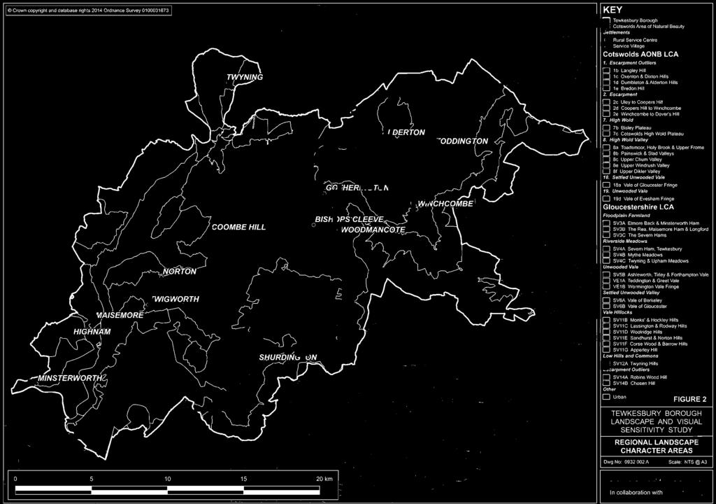
5 Table of Contents 1 Introduction Background Purpose of This Report Scope of This Study Context and Precedent Studies Approach and Methodology Defining Sensitivity Overview of Approach Defining Land Parcels Levels of Sensitivity Landscape Sensitivity Visual Sensitivity Summary of findings Overview Rural Service Centres Rural Service Villages FIGURE LIST Figure 1 Figure 2 Distribution of Settlements Landscape Character Areas APPENDICES Appendix A Appendix B Detailed Assessment Rural Service Centres Detailed Assessment Service Villages
6
7 Tewkesbury Borough Landscape and Visual Sensitivity Study 1 INTRODUCTION 1.1 Background The Joint Core Strategy (JCS) for Gloucester, Cheltenham and Tewkesbury contains strategic allocations for sites of 500 units or more. A lower tier plan for Tewkesbury Borough (The Tewkesbury Borough Plan) is to allocate appropriate sites to meet the needs of the rural areas as directed by JCS Policy SP2. This policy seeks to accommodate development in the rural parts of the borough through a strategy of identifying rural service centres and service villages. The settlements covered by this study are illustrated on a key plan at Figure 1. The rural service centres are at: Bishop s Cleeve and Winchcombe The Service Villages are at: Alderton Coombe Hill Gotherington nam Maisemore Minsterworth Norton Shurdington Toddington (including New Town) Twigworth Twyning Woodmancote The JCS sets out at policy SP2, that the Rural Service Centres will accommodate 1860 new homes and the service villages will accommodate 752 new homes. The actual allocations at each of these settlements will be determined on the basis of a raft of detailed considerations. Landscape and visual sensitivity to residential development will form part of that wide evidence base. Tewkesbury Borough Council commissioned Toby Jones Associates Ltd in September 2014 to evaluate all land surrounding rural service centres and service villages as identified in the Joint Core Strategy in terms of landscape and visual sensitivity to residential development. During the preparation of this study, Toby Jones Associates Ltd has drawn on the expertise of DSA to provide support with geographic information systems (GIS) and graphics. 1.2 Purpose of This Report This study identifies issues and sensitivities that should be taken in to account when considering new development around the Rural Service Centres and Service Villages. Whilst the primary focus is that of residential development, the findings can equally inform decisions about other types of development. 3
8 Tewkesbury Borough Landscape and Visual Sensitivity Study This report forms part of a wider evidence base that will ultimately inform the identification of the most suitable sites for new development through the Tewkesbury Borough Plan. This report provides an evaluation of landscape and visual sensitivity; it does not seek to make a definitive judgement on the suitability of sites for development. A package of studies and considerations, including infrastructure capacity, ecology, townscape sensitivity, heritage, flood risk and other detail site constraints, all need to be weighed up in selecting appropriate sites. This suite of evidence base studies will inform an understanding of the capacity and suitability for development as opposed to the sensitivity considered in this report. 1.3 Scope of This Study This study examines land around all of the rural service centres and service villages to evaluate the sensitivity of landscape and visual resources. It is not the intention or purpose of this report to identify land suitable or otherwise for development. The capacity for and suitability of land to accommodate development will be determined through a series of additional studies and the application of finer grain filters. It will also be determined in light of development needs and will be tested by consultation and examination in public. This report aims to provide a summary of landscape and visual issues that might be relevant around these various settlements. It is not meant to be definitive or exhaustive. Each specific site within a given land parcel and each particular development proposal will throw up specific issues. In this sense, this report may be considered to be a framework within which landscape and visual issues might be considered for the settlements within its scope. 1.4 Context and Precedent Studies A number of previous studies have informed the background to this study. They are: Natural England s National Character Area Profile 106 Severn and Avon Vales, The Gloucestershire Landscape Character Assessment (January 2006), and The Cotswold AONB Landscape Character Assessment (2008) These studies identify and describe areas of broadly consistent landscape character at the national scale (in the case of the Natural England study) and at the regional scale (in the case of the Gloucestershire and Cotswold AONB studies). They identify defining characteristics, trends and vulnerabilities. This study examines landscape character at a local level (land assessment parcels). For each land assessment parcel the study identifies the relevant regional and national landscape area in the previous studies. 4
9 Tewkesbury Borough Landscape and Visual Sensitivity Study 2 APPROACH AND METHODOLOGY 2.1 Defining Sensitivity This study has been undertaken with reference to Countryside Agency Topic Paper 6: Techniques and Criteria for Judging Capacity and Sensitivity [2004]. The following definitions have been adopted: Landscape Sensitivity The susceptibility and vulnerability of a landscape to change. It is a judgement about how well development (or other changes) might fit within a landscape without altering (or harming) the essential character. It is based upon judgements about the strength and value of the existing character. Visual Sensitivity A judgement about the susceptibility and vulnerability of views and the people seeing them to change and any specific values placed upon those views by society (either through cultural associations or designation etc). It is a judgement about how development (or other change) might be perceived in existing views and how it might influence the experience of the viewers. It is based upon judgements about the nature of the view and the nature and activity of the viewer. Overall Landscape Sensitivity A combination of the sensitivity of the landscape resource (both its character as a whole and the individual elements contributing to character) and the visual sensitivity assessed in terms of factors such as views, visibility and the number and nature of people perceiving the landscape and the scope to mitigate visual impact. It should be stressed that landscape and visual sensitivity to new development (the subject of this study) is not the same as the capacity of a place to accommodate development. An area identified as having a high sensitivity might in some circumstances have the capacity to absorb some sympathetic development. Conversely, unsympathetic or inappropriate development will be inappropriate in a land parcel, even if an area is deemed to have a low sensitivity. 2.2 Overview of Approach The process that has been followed to prepare this landscape and visual sensitivity study is summarised in the key stages below: 1. Desk Study: Policy review and review of preceding landscape character studies; 2. Definition of Land Parcels: Based upon a review of OS and other desk-based material; 3. Site Surveys: To ratify and refine the land parcels, to verify landscape character and condition, to define visual characteristics, to define tranquillity, to define the relationship between the land parcel and the settlement and to identify and define key visual receptors. 4. Assessment of Sensitivity: Using judgement to combine the findings. 5. Reporting and Presentation. 5
10 Tewkesbury Borough Landscape and Visual Sensitivity Study The outputs from this study for each of the 14 settlements covered are as follows: -level summary text describing settlement context and key landscape and visual sensitivities (provided in Section 3.), a drawing indicating the key visual receptors associated with the settlement, a drawing indicating the judgement as to landscape sensitivity of all land parcels associated with the settlement a drawing indicating the judgement as to visual sensitivity of all land parcels associated with the settlement; and pro-forma sheets setting out the evaluation of landscape and visual sensitivity for each land parcel. The detailed analysis and drawings for the two Rural Service Centres are provided in Appendix A and those for the 12 Service Villages are provided in Appendix B. 2.3 Defining Land Parcels This study examines land adjoining the Service Villages and Rural Service Centres (14 Settlements in all). To do this, the study breaks the surroundings of each settlement down into parcels of land that display shared and broadly similar characteristics. Initially land parcels were identified during a desk study based mainly on OS mapping at 1:25,000 and 1:10,000. At this desk-based stage the key characteristics used to identify land parcels included: Topography (including landform and aspect) Vegetation cover Relationship to the settlement form or pattern Enclosure pattern and scale This fist cut of the land parcels was tested and refined in the field by local observations including: Land use Landscape quality and condition Visibility (enclosure or exposure) The nature of the settlement edge Land parcels were consciously drawn at a scale appropriate for a strategic examination of landscape and visual sensitivity and not at a scale that might necessarily identify individual development sites. Land parcels were drawn to adjoin the settlement boundary on the one hand and to be contained by some recognisable landscape feature on the other, such as woodland, hedgerow or watercourse. The land parcels identified in this study do not represent suggested development areas, or future settlement boundaries. They are merely a convenient way of compartmentalising land around the Service Villages and Rural Service Centres for the purposes of describing shared landscape and visual characteristics. 2.4 Levels of Sensitivity The levels of sensitivity used in this study are defined in Table 1. 6
11 Tewkesbury Borough Landscape and Visual Sensitivity Study Table 1: Defining Sensitivity Level Low Definition The landscape or visual characteristics of the land parcel are very vulnerable to new residential development and / or the intrinsic values of the parcel are high and it is unlikely to be able to accommodate residential development without significant changes to the character or adverse effects. Thresholds for significant change are very low. Landscape and/or visual characteristics of the land parcel are susceptible to change and/or its intrinsic values are medium. The land parcel may be able to accommodate some development without significant adverse effects. The threshold for significant change is moderate Landscape and/or visual characteristics of the land parcel are robust and/or its intrinsic values are low. The land parcel is able to accommodate some development without significant change or the proposed development would deliver enhancement. The threshold for significant change is very high It should be stressed that landscape and visual sensitivity to new development (the subject of this study) is not the same as the capacity of a place to accommodate development. An area identified as having a high sensitivity to might in some circumstances have the capacity to absorb some sympathetic development. Conversely, unsympathetic or inappropriate development will not be suitable in a land parcel, even if an area is deemed to have a low sensitivity. 2.5 Landscape Sensitivity Landscape receptors include the landscape character as a whole and the individual elements that combine to create it. Judgements as to landscape sensitivity draw on the following considerations: Verification of landscape character and condition. Land use and function Visual characteristics Tranquillity and remoteness Functional visual relationships between the site and its surroundings and settlement The nature of the settlement edge and whether it has a negative or positive influence on the site The presence of sensitive landscape features or elements. ie those that might be susceptible to change and or be valued in some way The criteria used to define the level of landscape sensitivity are set out in Table 2. 7
12 Tewkesbury Borough Landscape and Visual Sensitivity Study Table 2: Landscape Sensitivity Criteria Level Low Definition Distinctive and/or representative landscape character. Valued landscape character intact with few detracting features or elements. Features and elements themselves in good condition. Evidence of extensive "Time Depth" (patterns and features representative of the evolution of the landscape through time.). Limited opportunities for mitigation without detrimental effects on the prevailing character. The presence of distinct, characteristic or valued landscape features and elements that are vulnerable to residential development and that may not be replaced or substituted. There are recognisable characteristics within the land parcel that relate to the wider landscape. There are landscape features and elements within the land parcel worthy of retention and enhancement. The land parcel displays a degree of time depth with patterns and features reflecting aspects of the evolution of the landscape. Some opportunities exist to mitigate residential development using characteristic features and elements. The prevailing character of the land parcel is not distinctive, nor typical. The character within the land parcel is fragmented with detracting features and elements. Features and elements are in poor or declining condition and are not in themselves "valued". Limited or no "time depth" apparent within the land parcel. Opportunities exist within the land parcel to mitigate residential development using characteristic features and elements of the landscape. 2.6 Visual Sensitivity Visual receptors are all people. The susceptibility of different people or groups of people to changes in views and visual amenity is a function of: The occupation or activity of people experiencing a view at a particular location The extent to which their attention or interest may be focused on the view The judgement as to value attached to views takes account of: Recognition of value attached to certain views through designation for example in relation to heritage assets, Indicators of value through for example inclusion in visitors books or guidebooks, established honeypot viewpoints, signage or interpretation facilities or references in literature or art. By the very nature of this study, many of the areas under consideration are adjacent to the existing settlement boundary and are overlooked by residential 8
13 Tewkesbury Borough Landscape and Visual Sensitivity Study properties. Effects of development on private property are frequently dealt with through residential amenity assessments. This would occur in relation to any development that might come forward or at the detailed site selection stage. This strategic level study does not include views from individual residential properties in the evaluation of visual sensitivity. It does however take account of shared, or community views where there is a collective outlook from a settlement or community. The criteria used to define the level of landscape sensitivity are set out in Table 3. Table 3: Visual Sensitivity Criteria Level Low Definition The land parcel is exposed or prominent. The land parcel is exposed to visual receptors with a medium to high sensitivity to new residential development in the view. The land parcel is exposed to a large number of visual receptors. There are limited opportunities for screening or mitigation within the land parcel or the screening would in itself cause adverse visual effects. Development within the land parcel would bring about a notable change in settlement form or pattern, which in turn would be prominent. Development within the land parcel might cause the loss of established views or views of valued features and elements in the landscape. Some screening is provided by existing settlement, vegetation or topography. The land parcel is exposed to some visual receptors including a limited number with medium and high sensitivity to new residential development. There is some limited visual mitigation potential within the land parcel (screening and precedent visual elements). Development within the land parcel might cause a slight perception of a change in settlement form and pattern but not notable or material. The land parcel is effectively screened by settlement, vegetation or topography from the majority of surrounding vantages. The land parcel is exposed to a limited number of low to medium sensitivity visual receptors. There is appropriate and effective mitigation potential within the land parcel where the mitigation will not in itself become prominent or cause adverse visual effects. The land parcel relates well to the existing settlement form and pattern. Opportunities exist for new residential development within the land parcel to deliver improvements in the visual environment. Development could occur within the land parcel with no or limited loss of established and valued views or views of valued features and elements 9
14 Tewkesbury Borough Landscape and Visual Sensitivity Study 3 SUMMARY OF FINDINGS 3.1 Overview This section presents the summary of findings from the study. Starting with the two rural service centres, Bishop s Cleeve and Winchcombe, then each of the service villages in alphabetical order. The detailed analysis and supporting drawings are presented in Appendix A. Appendix A contains the drawings for each settlement followed by a detailed analysis of each land parcel. The analysis is presented on two forms. The first covers landscape sensitivity and the second visual sensitivity. 3.2 Rural Service Centres Bishop s Cleeve Bishop s Cleeve lies at the base of the Cotswold Scarp beneath Cleeve Hill. It is sensitive to development that will reduce the perceived gap between Bishop s Cleeve and Gotherington. It is sensitive to development that is uncharacteristic of the existing settlement form and that protrudes into the open countryside on the expansive vale to the west. It is also sensitive to development that closes the gap between Bishop s Cleeve and Southam and Cheltenham to the south. This perception is most notable from elevated vantages in the AONB. Table 4: Bishop s Cleeve Summary Land Parcel Landscape Sensitivity Visual Sensitivity Bish-01 Bish-02 Bish-03 Low Low Bish-04 Bish-05 Low Winchcombe Winchcombe sits on the lower slopes of Langley Hill. It cascades down to the River Isbourne, which forms a distinct settlement boundary to the southeast. Beyond this boundary lies the parkland associated with Sudeley Castle. Key sensitivities include development that might harm this parkland setting, that might disrupt the established south-eastern settlement edge that forms a characteristic element of the Conservation Area. Another key sensitivity is to development that might reduce the sense of separation between Winchcombe and Greet (This gap is under substantial development pressure). It is also sensitive to development that might appear prominent and/or at odds with the established settlement pattern as perceived from the numerous elevated vantages around the town. 10
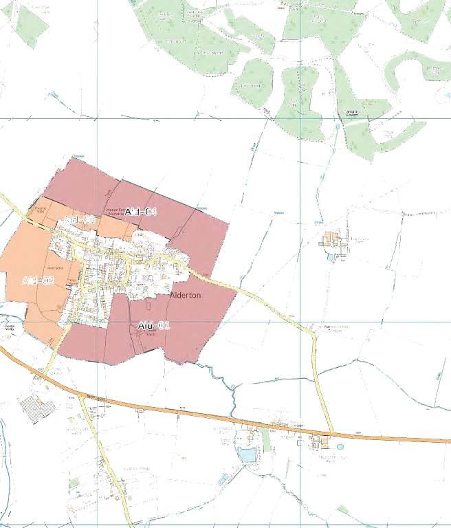
15 Tewkesbury Borough Landscape and Visual Sensitivity Study Table 5: Winchcombe Summary Land Parcel Landscape Sensitivity Visual Sensitivity Win-01 Win-02 Low Low Win-03 Win-04 Win-05 Win-06 Win Rural Service Villages Alderton Alderton sits at the base of Dumbleton Hill at the very edge of the AONB. Key sensitivities include the openness of these lower slopes and their role in creating the setting for the AONB. The sense of separation between Alderton and the B4077 is characteristic and vulnerable to insensitive development. There is also a sensitivity around development that does not respect the generally clustered settlement form and that might appear conspicuous and prominent in the vale. Table 6: Alderton Summary Land Parcel Landscape Sensitivity Visual Sensitivity Ald-01 Ald-02 Ald-03 Ald-04 Coombe Hill Coombe Hill occupies a prominent ridge at the junction of the A38 and A4019. It is sensitive to conspicuous development on the exposed side slopes of the ridge that would be visible in long distance views and would be at odds with the established settlement pattern (which is loosely cruciform). To the west of the village is the Coombe Hill Canal and surroundings, which represent a distinctive, and undeveloped landscape. It is valued for recreation, wildlife and heritage reasons and is sensitive to change. 11
16 Tewkesbury Borough Landscape and Visual Sensitivity Study Table 7: Coombe Hill Summary Land Parcel Landscape Sensitivity Visual Sensitivity Coo-01 Coo-02 Coo-03 Coo-04 Coo-05 Coo-06 Gotherington Gotherington lies at the base of Crane and Prescott Hills at the very edge of the open Vale of Gloucester. It is particularly sensitive to development that would over top the slight ridge that forms the northern settlement boundary. It is sensitive to development that might protrude onto the vale landscape and diminish the sense of separation between Gotherington and Bishop s Cleeve and between Gotherington and the A435. Gotherington is overlooked from the AONB Scarp and AONB Outliers. Table 8: Gotherington Summary Land Parcel Landscape Sensitivity Visual Sensitivity Goth-01 Goth-02 Goth-03 Goth-04 Low Low Goth-05 Goth-06 Low Low nam nam largely occupies a hilltop position and is sensitive to development that might occupy prominent and exposed hillsides. It is also sensitive to development that might encroach into the surrounding open countryside that currently appears isolated from the village. The parkland and garden setting of nam Court is particularly sensitive to residential development. Table 9: nam Summary Land Parcel Landscape Sensitivity Visual Sensitivity
17 Tewkesbury Borough Landscape and Visual Sensitivity Study Low Low -07 Maisemore Maisemore sits on a slight bluff at the confluence of the River Leadon and the River Severn. It is overlooked from the south by Lassington Hill (Near nam). Particular sensitivities here include development that might encroach onto the exposed hill top south of the village and onto prominent south and east facing slopes. Table 10: Maisemore Summary Land Parcel Landscape Sensitivity Visual Sensitivity Mais-01 Mais-02 Mais-03 Mais-04 Mais-05 Low Minsterworth Minsterworth is a settlement on a distinct ridge overlooking a meander in the River Severn. It is sensitive to development that might encroach onto exposed pastoral slopes down to the flood plain and onto the floodplain itself. Development here would be at odds with the established settlement pattern. Table 11: Minsterworth Summary Land Parcel Landscape Sensitivity Visual Sensitivity Min-01 Min-02 Low Min-03 Min-04 Min-05 13
18 Tewkesbury Borough Landscape and Visual Sensitivity Study Min-06 Min-07 Min-08 Norton Norton is a linear settlement off the A38. It is particularly sensitive to development that does not respect the pronounced limit to development east of the A38. Beyond the A38 development would appear in an open, rolling landscape and would appear at odds with the prevailing settlement pattern. Table 12: Norton Summary Land Parcel Landscape Sensitivity Visual Sensitivity Nor-01 Nor-02 Low Nor-03 Low Nor-04 Shurdington Shurdington sits at the base of Shurdington Hill at the very edge of the AONB. It is particularly sensitive to development encroaching onto the slopes of the AONB and development that might intrude into the open, undeveloped vale where the influence of the village is currently weak. Table 13: Shurdington Summary Land Parcel Landscape Sensitivity Visual Sensitivity Shur-01 Shur-02 Shur-03 Low Shur-04 Low Low Shur-05 Shur-06 Toddington and New Town Toddington and New Town are a paired settlement along the B4077. There is a key sensitivity associated with the valued and robust parkland and garden landscape associated with Toddington Manor. This dominates the land around Toddington itself. There is also a very clear and marked boundary 14
19 Tewkesbury Borough Landscape and Visual Sensitivity Study south of Toddington at the B4077. Beyond it to the south there is open countryside. This boundary is less marked south of New Town. Table 14: Toddington and New Town Summary Land Parcel Landscape Sensitivity Visual Sensitivity Tod-01 Tod-02 Tod-03 Tod-04 Low Tod-05 Tod-06 Low Twigworth Twigworth is a small wayside settlement on the A38. It is heavily influenced to the south by a caravan park. There are opportunities to enhance the landscape surrounding Twigworth. Table 15: Twigworth Summary Land Parcel Landscape Sensitivity Visual Sensitivity Twig-01 Low Twig-02 Low Low Twig-03 Low Low Twyning Twyning sits at the junction of a number of minor roads and fronts on to the River Avon. The combination of topography, the river environment and dissection by a number of roads has created a complex patchwork of landscape character around the village. Key sensitivities include development that might encroach into open countryside at odds with the established settlement pattern and development that might encroach the river frontage. A parkland landscape surrounding Twyning Manor is sensitive to change as are orchards and some common land planted with trees on exposed slopes and valued as a recreation resource. 15
20 Tewkesbury Borough Landscape and Visual Sensitivity Study Table 16: Twyning Summary Land Parcel Landscape Sensitivity Visual Sensitivity Twy-01 Twy-02 Twy-03 Twy-04 Twy-05 Twy-06 Twy-07 Twy-08 Twy-09 Twy-10 Twy-11 Low Twy-12 Twy-13 Woodmancote Woodmancote is a village adjoining Bishop s Cleeve tucked in at the very base of the Cotswold Scarp beneath Cleeve Hill. A key sensitivity here is development that might be seen to creep up these slopes affecting the setting of the AONB in views from the west. Table 17: Woodmancote Summary Land Parcel Landscape Sensitivity Visual Sensitivity Wood-01 Low Wood-02 Low Wood-03 Wood-04 16
21 FIGURES: Figure 1 Figure 2 Settlement Locations Landscape Character Areas
22


23


24
25 APPENDIX A: Rural Service Centres Bishop s Cleeve Winchcombe
26
27 Bishop s Cleeve (Rural Service Centre)
28


29

30

31
32 Settlement Name: Settlement Type Land Assessment Parcel Reference: Landscape Character Context National Character Area County Character Area Cotswolds AONB Character Area Natural Elements Landform Tree Cover Water Environment Cultural Elements Land Use Enclosure Pattern Field Boundaries Time Depth Existing Settlement Form Existing Settlement Edge Landscape Quality / Condition Representative of typical character Intactness State of individual elements Tranquility Noise Sources Level of movement and activity Bishops Cleeve Rural service Centre Bish-01 NCA 106 Severn and Avon Vales SV6B - Vale of Gloucester - (Settled Unwooded Vale) Gently undulating vale Sparse Dean Brook to northern boundary Arable Large rectilinear field pattern Mainly hedges Moderate Scattered farms beyond the settlement boundary Adjoins new (as yet unbuilt) new development Typical of the wider vale Yes Good Gotherington Lane Low Mitigation / Enhancement Potential There is limited potential to mitigate new development in this open landscape Landscape Character Summary An open arable landscape set beneath the imposing Cotswold scarp. It is influenced by both the open vale to the west and the steep slopes and high ground of the AONB to the east. New development is proposed to the south which will heavily influence the character of this remaining parcel of land between Bishops Cleeve and Gotherington. The Dean Brook forms the northern boundary to this land assessment parcel. It supports abundant trees and forms a distinctive sinuous feature through this landscape. Judgment as to Landscape Character Sensitivity
33 Visibility Key Visual Receptors A435 Gotherington Lane Nottingham Hill Cleeve Hill Heritage Railway Trunk Road Local Road Valued Recreation Resource (AONB) Valued Recreation Resource (AONB) Recreation Resource Sensitivity Visual Context and Prominence This land assessment parcel lies between Bishops Cleeve and Gotherington. It is visible both from surrounding road network (A435 and Gotherington Lane) and from elevated vantages in the AONB. The land assessment parcel forms a crucial gap between Gotherington and Bishops Cleeve. It that sense, it is prominent. Mitigation / enhancement Potential Abundant hedge and tree cover (especially roadside hedges and tree cover along Dean Brook) offer some mitigation potential. Visual Summary This is an open land assessment parcel characteristic of the open vale. It is overlooked from elevated vantages including valued national trails and popular view points in the AONB. It is prominent in views from the local road network (Gotherington Lane) and the A435. The parcel plays an important role in separating Bishops Cleeve from Gotherington and this represents the greatest visual sensitivity. Consented development will reduce the visual gap considerably. This land assessment parcel will increase in its sensitivity to new development that might reduce the perception of the gap further both locally and as seen from elevated vantages. This land assessment parcel is visible from the heritage railway which is a valued recreational resource. The visual sesnitivity of the railway is slightly moderated by the fact that views tend to be dynamic and momentary. Judgment as to Visual Sensitivity
34 Settlement Name: Settlement Type Land Assessment Parcel Reference: Landscape Character Context National Character Area County Character Area Cotswolds AONB Character Area Natural Elements Landform Tree Cover Water Environment Cultural Elements Land Use Enclosure Pattern Field Boundaries Time Depth Existing Settlement Form Existing Settlement Edge Landscape Quality / Condition Representative of typical character Intactness State of individual elements Tranquility Noise Sources Level of movement and activity Bishops Cleeve Rural service Centre Bish-02 NCA 106 Severn and Avon Vales SV6B - Vale of Gloucester - (Settled Unwooded Vale) Flat Vale Isolated field trees and abundant hedge trees esp. along Dean Brook Dean Brook to northern boundary Mainly arable with pasture close to settlement boundary Large scale rectilinear Mainly trimmed hedges Moderate Lies beyond the western settlement boundary Adjoins proposed development site, residential and commercial uses Typical of the wider vale Yes Good Stoke Orchard Road and A435 Moderate at southern edge, low elsewhere. Mitigation / Enhancement Potential Robust tree belts associated with the settlement edge and watercourses offer some limited opportunities for mitigation of landscape character in response to new residential development as well as the strong existing influence of settlement. Landscape Character Summary A wide open and expansive landscape stretching out onto the Vale of Gloucester. It is characterised by large scale rectilinear field pattern contained by trimmed hedges and tree belts. The most characteristic feature of this parcel are the expansive views across it to the AONB at Crane Hill, Nottingham Hill and Cleeve Hill as well as the openness of views across the vale itself to the west. The existing settlement edge exerts a strong influence to the east of this parcel, most notably to the south east where it abuts commercial and industrial uses. New consented development to the north east of this parcel will also exert a strong influence. Landscape character sensitivity to new residential development increases with distance from the existing settlement edge as the urban influence diminishes and the open vale prevails. Judgment as to Landscape Character Sensitivity
35 Visibility Key Visual Receptors A435 Stoke Orchard Road Nottingham Hill Cleeve Hill Trunk Road Local Rad Valued recreation resource (AONB) Valued recreation Resource (AONB) Sensitivity Visual Context and Prominence This land assessment parcel extends from Bishops Cleeve out onto the open Vale of Gloucester. It is visible from elevated vantages in the AONB and surrounding road network. It is prominent. Mitigation / enhancement Potential There are some opportunities for screening new development afforded by abundant tree cover and hedges especially along watercourses and near the settlement edge. The prominent existing settlement edge, particularly to the south east offers opportunities for enhancement. Visual Summary This is a wide open landscape; part of the Vale of Gloucester. It is overlooked from the surrounding road network and from elevated views including those in the AONB, views from national trails and recognised beauty spots such as Cleeve Hill. The key visual sensitivity that remains in this land assessment parcel is the sensitivity to inappropriate development that creates a perception of "sprawl" onto the open vale. This might arise if development is unsympathetic to the existing settlement edge or does not respect natural boundaries that exist in the landscape. Judgment as to Visual Sensitivity
36 Settlement Name: Settlement Type Land Assessment Parcel Reference: Landscape Character Context National Character Area County Character Area Cotswolds AONB Character Area Natural Elements Landform Tree Cover Water Environment Cultural Elements Land Use Enclosure Pattern Field Boundaries Time Depth Existing Settlement Form Existing Settlement Edge Landscape Quality / Condition Representative of typical character Intactness State of individual elements Tranquility Noise Sources Level of movement and activity Bishops Cleeve Rural service Centre Bish-03 NCA 106 Severn and Avon Vales SV6B - Vale of Gloucester - (Settled Unwooded Vale) Flat Vale with distinct man made hill associated with landfill Isolated field trees and abundant hedge trees esp. along watercourse Small stream, tributary to Dean Brook Pasture and land fill scale rectilinear Hedges, gappy in places with hedge trees (concentrated along stream) Limited This parcel is enclosed by residential development and landfill activity Adjoins typical residential estate-type edge and commercial Separated from the wide vale and influenced by urban edge Hedge structure in tact Good Stoke Orchard Road and A435 to the north and east Mitigation / Enhancement Potential The abundance of tree cover and the influence of the utilitarian settlement edge offer opportunities for mitigation and enhancement. Landscape Character Summary Parts of this land assessment parcel represent typical vale landscape close to settlement edges with pastures enclosed by hedges and an abundance of willow trees and ash along the stream corridor. This parcel has however become somewhat isolated from the wide open vale and is heavily influenced by commercial development at the settlement edge and landfill activity on the Stoke Orchard Road. Its sensitivity to new residential development reflects these influences and its relative isolation from the wider Vale of Gloucester. There is a sense that this land assessment parcel is enclosed by settlement, including utilitarian commercial and waste management land uses. This sense of enclosure diminishes from the northeast to southwest across the parcel. Judgment as to Landscape Character Sensitivity Low
37 Visibility Key Visual Receptors A435 Stoke Orchard Road Cleeve Hill Residents at the edge of Bishops Cleeve Trunk Road Local Road Recreational Resource (AONB) Individual residents Sensitivity Visual Context and Prominence This land assessment parcel is contained on three sides by existing residential development, commercial land uses and a conspicuous landfill. It is not prominent in the sense that it protrudes or is at odds with the current settlement form. The parcel is overlooked by a number of properties and can be seen from the A435 and Stoke Orchard Road Mitigation / enhancement Potential The abundance of tree cover and hedges, especially associated with the watercourse offer opportunities to filter views of new residential development. The parcel is overlooked and development would be visible Visual Summary A land assessment parcel visually and physically separated from the open Vale of Gloucester by commercial activity, landfill and sports pitches. It is not prominent in distant elevated views from Cleeve Hill and Nottingham Hill. The land assessment parcel is most visible from Stoke Orchard Road and the A435. It is however seen in the context of the existing settlement edge which is characterised by a typical residential development of side and rear elevations behind fences and walls with some highway planting to soften the built form in places. Along the A435, the dominant feature is the commercial buildings at The Grange. The final judgment as to visual sensitivity is driven by the existing strong influence of settlement and commercial activity along the road corridors, the relative isolation from the wider vale and the lack of prominence from elevated vantages. Judgment as to Visual Sensitivity Low
38 Settlement Name: Settlement Type Land Assessment Parcel Reference: Landscape Character Context National Character Area County Character Area Cotswolds AONB Character Area Natural Elements Landform Tree Cover Water Environment Cultural Elements Land Use Enclosure Pattern Field Boundaries Time Depth Existing Settlement Form Existing Settlement Edge Landscape Quality / Condition Representative of typical character Intactness State of individual elements Tranquility Noise Sources Level of movement and activity Bishops Cleeve Rural service Centre Bish-04 NCA 106 Severn and Avon Vales SV6B - Vale of Gloucester - (Settled Unwooded Vale) Flat Vale Hedgerow trees abundant along watercourse Small stream, tributary to River Swilgate Arable and pasture Large to medium scale rectilinear Hedges with hedge trees Weak This parcel is beyond the established settlement edge Adjoins residential edge of the settlement Representative of the wider vale Hedge structure in tact Good Road noise on the A435 Low within the parcel, high to the north east (A435) Mitigation / Enhancement Potential Abundant tree cover and the presence of the existing settlement edge offers a degree of mitigation and potential enhancement Landscape Character Summary This is a flat landscape and is part of the expansive Vale of Gloucester. Characteristic of this landscape are the long vistas out across the vale and up to the elevated skyline of the Cotswold Scarp at Cleeve Cloud, Cleeve Hill, Nottingham Hill and the outliers at Woolstone and Crane Hill. There are detracting elements at the edge of this land assessment parcel including commercial and industrial activity to the southeast. This land assessment parcel retains some of the character of the vale, but is clearly heavily influenced by the settlement edge especially to the east. Judgment as to Landscape Character Sensitivity
39 Visibility Key Visual Receptors A435 Cleeve Hill Trunk Road Recreational Resource (AONB) Sensitivity Visual Context and Prominence This parcel is visible from elevated vantages in the AONB, however it is not prominent in the sense that is at odds with the existing settlement pattern. The parcel is visible from the A435 but is seen in the context of the existing settlement edge and commercial and industrial activity. It is not prominent Mitigation / enhancement Potential There are opportunities to enhance the settlement edge Visual Summary This is a flat landscape with abundant hedgerows with hedge trees. Long views are available across it to the vast vale and to the AONB scarp and outliers. It is conversely visible from elevated vantages including Cleeve Hill. From there is it seen in the context of surrounding settlement and industrial activity and is not at odds with the prevailing settlement form. A key sensitivity is that new development should not be perceived as "sprawl" either locally or from afar. It should be sensitive to the existing settlement pattern and not appear at odds with it. New development should not remove the sense of separation between Bishops Cleeve and Brockhampton, nor affect the sense of separation between Bishops Cleeve and Cheltenham. In this sense, visual sensitivity increases across the land assessment parcel from the north east (close to the settlement edge) to the south west towards Brockhampton and the open vale. Judgment as to Visual Sensitivity
40 Settlement Name: Settlement Type Land Assessment Parcel Reference: Landscape Character Context National Character Area County Character Area Cotswolds AONB Character Area Natural Elements Landform Tree Cover Water Environment Cultural Elements Land Use Enclosure Pattern Field Boundaries Time Depth Existing Settlement Form Existing Settlement Edge Landscape Quality / Condition Representative of typical character Intactness State of individual elements Tranquility Noise Sources Level of movement and activity Bishops Cleeve Rural service Centre Bish-05 NCA 106 Severn and Avon Vales SV6B - Vale of Gloucester - (Settled Unwooded Vale) Flat Vale Woodland groups and hedge trees Stream and field edge ditches Mixed arable, paddock, pasture, sports facilities and rough ground. Irregular Hedges and occasional woodland blocks Moderate Enclosed by industrial uses and settlement edge Prominent and unsympathetic residential and industrial edges. Heavily influenced by settlement edge Field pattern intact although detractors associated with pony paddocks Good General traffic noise on local roads and distant background noise Low Mitigation / Enhancement Potential Abundant hedges, hedgerow trees and woodland blocks offer potential to mitigate new development. The unsympathetic settlement edge characteristic of this parcel provides some potential for enhancement Landscape Character Summary A flat landscape supporting mixed uses including paddocks, pasture, sports fields, a cemetery and arable. The various land uses are contained within a robust framework of mature hedges and tree belts with occasional woodland blocks. This parcel is heavily influenced by the existing settlement with harsh, and prominent views of unsympathetic residential development to the north and industrial uses to the west. This parcel is also influenced by the prominent hills to the east. This combination of potential for enhancement and opportunities for characteristic mitigation inform the judgment as to landscape sensitivity. There is a residual sensitivity to unsympathetic development that threatens the sense of separation between Bishops Cleeve and Southam to the south. Judgment as to Landscape Character Sensitivity
41 Visibility Key Visual Receptors A435 Cleeve Hill Local roads Heritage Railway Trunk Road Recreation resource (AONB) Local roads Recreation resource Sensitivity Visual Context and Prominence This land assessment parcel is bounded on two sides by Bishops Cleeve. To the west, views are contained by industrial and commercial scale development, whilst to the north the parcel is contained by prominent, and in some cases slightly elevated residential development. The parcel is visible from elevated vantages in the AONB. Mitigation / enhancement Potential Abundant trees and tree belts provide screening opportunities to mitigate new development. Visual Summary A diverse land assessment parcel with a wide range of uses contained within a robust framework of tall hedges, tree belts and woodland. Local views are restricted to the A435 immediately adjacent to the land assessment parcel and local roads passing through it. Even then, views are filtered through robust roadside hedges. There are views from adjacent properties. Elevated views are available of this land assessment parcel from the AONB at Cleeve Hill and Cleeve Cloud. A key sensitivity of this land assessment parcel is to prevent the perception or impression of "sprawl" from these valued elevated vantages. It is also to prevent the perception of Bishops Cleeve merging with Southam and Cheltenham to the south. This visual sensitivity associated with this land assessment parcel increases with distance from the existing settlement edge. Judgment as to Visual Sensitivity Low
42
43 Winchcombe (Rural Service Centre)
44


45

46


47
48 Settlement Name: Settlement Type Land Assessment Parcel Reference: Landscape Character Context National Character Area County Character Area Cotswolds AONB Character Area Natural Elements Landform Tree Cover Water Environment Cultural Elements Land Use Enclosure Pattern Field Boundaries Time Depth Existing Settlement Form Existing Settlement Edge Landscape Quality / Condition Representative of typical character Intactness State of individual elements Tranquility Noise Sources Level of movement and activity Winchcombe Rural service Centre Win-01 NCA 107 Cotswolds 1B - Langley Hill - (Escarpment Outlier) Convex slope foot locally incised Field trees with strong roadside and field hedgerows Stream with strong vegetation / woodland blocks Predominantly pasture Irregular, medium sized fields. Smaller closer to settlement edge Mature and trimmed hedges, post and wire and timber fences Strong Beyond the 20th century settlement edge Domestic gardens and domestic enclosures. Sheds and rear elevations Strong influence from settlement but still representative Away from settlement edge it is intact Generally good with some dilapidated sheds near town edge Very few agricultural and domestic Low Mitigation / Enhancement Potential Existence of precedent settlement edge and some dilapidation. Some improvement possible to settlement edge. Good tree cover in places. Landscape Character Summary Distinct topography and a good sense of enclosure in association with a diverse range of boundary types. There is a strong influence from the existing settlement edge in the form of paddocks, ramshackle sheds and buildings and domestic gardens. This influence diminishes rapidly with distance. Heavily influenced by the overlooking high ground to the west. It is peaceful and tranquil. Judgment as to Landscape Character Sensitivity
49 Visibility Key Visual Receptors Cotswolds Way (Cleeve Hill) Langley Road Various properties on settlement edge Winchcombe Way (Langley Hill) Valued Recreation. Local Road Individual Residents Valued Recreation (AONB) Sensitivity Visual Context and Prominence Close views in to this parcel are limited to local footpaths, adjacent properties and local roads. However, elevated vantages are available to the south west at Cleeve Hill. From these vantages including parts of the Cotswolds Way, this parcel of land is prominent and acts as a distinct foreground setting to Winchcombe. Mitigation / enhancement Potential This is a diverse landscape with abundant tree cover in places so there are some opportunities for mitigation. The existing settlement edge could benefit from enhancement in places. Visual Summary A diverse land assessment parcel at the settlement edge adjoining open and rising fields with a more enclosed and intimate landscape close to the settlement edge. Local views into the parcel are limited but include views from properties on the settlement edge and local footpaths. However, it is the role that this parcel plays in the visual setting of Winchcombe from elevated vantages within the AONB at Cleeve Hill that is the main influence in the visual sensitivity. Judgment as to Visual Sensitivity
50 Settlement Name: Settlement Type Land Assessment Parcel Reference: Landscape Character Context National Character Area County Character Area Cotswolds AONB Character Area Natural Elements Landform Tree Cover Water Environment Cultural Elements Land Use Enclosure Pattern Field Boundaries Time Depth Existing Settlement Form Existing Settlement Edge Landscape Quality / Condition Representative of typical character Intactness State of individual elements Tranquility Noise Sources Level of movement and activity Winchcombe Rural service Centre Win-02 NCA 107 Cotswolds 1B - Langley Hill - (Escarpment Outlier) Undulating lower escarpment slopes Strong surrounding tree cover and along stream corridor Stream Pasture Irregular, small sized fields following contours. Post and rail with some hedges within the parcel Some Adjacent to 20th century estate development Insensitive and harsh settlement edge of rear elevations and gardens Strong influence from settlement but still representative Away from settlement edge it is intact Generally good with some detractors close to the settlement edge Very few agricultural and domestic Low Mitigation / Enhancement Potential Opportunities exist to soften settlement edge with planting (although the built form will remain angular and linear). Opportunities to repair degraded hedges. Landscape Character Summary A parcel consisting pastures on the lower hill slopes immediately abutting the 20th century settlement edge of Winchcombe. Good tree cover surrounding the parcel, in particular associated with a stream corridor, in mature hedges and associated with various surrounding gardens and farms. Detracting elements are mainly associated with the settlement edge, which is somewhat harsh with inconsistent and weak boundary treatment. Judgment about landscape sensitivity is driven to a large extent by the prominence and nature of the existing settlement edge. The character here remains sensitive to inappropriately arranged or scaled development at odds with the existing settlement pattern. Judgment as to Landscape Character Sensitivity Low
51 Visibility Key Visual Receptors Properties on the Settlement Edge Local footpaths Elevated vantages from the east Winchcombe Way Individual Residents Local Recreation Various Valued Recreation Valued Recreation (AONB) Sensitivity Visual Context and Prominence The parcel occupies lower slopes immediately adjacent to a 20th century settlement edge. Views are extremely limited from local public vantages. There are views of the upper slopes within this parcel from valued and elevated vantages to the east, however the land assessment parcel fits well with the existing linear settlement pattern The visual influence increases as one rises up the slopes and land immediately to the west of this parcel begins to exert a wider visual influence in views across Winchcombe from the east. Mitigation / enhancement Potential There is abundant tree cover which provides screening opportunities. There are also opportunities to address a harsh settlement edge It is possible to align development along the existing settlement edge, to respond to topography by occupying the lowest ground and to deliver a new defensible feathered settlement edge. Visual Summary This is an enclosed and distinct land assessment parcel with very few views into and across it from public vantages. It is not prominent locally, nor in more distant views, where it appears foreshortened against the existing settlement edge. There are opportunities to filter views of development with existing mature tree cover. The parcel is overlooked by 20th century properties on the western edge of Winchcombe. The key visual sensitivity is to intrusive development rising up the hill slopes to be visible from the east. Sensitivity increases up the slopes away from the existing settlement edge. Judgment as to Visual Sensitivity Low
52 Settlement Name: Settlement Type Land Assessment Parcel Reference: Landscape Character Context National Character Area County Character Area Cotswolds AONB Character Area Natural Elements Landform Tree Cover Water Environment Cultural Elements Land Use Enclosure Pattern Field Boundaries Time Depth Existing Settlement Form Existing Settlement Edge Landscape Quality / Condition Representative of typical character Intactness State of individual elements Tranquility Noise Sources Level of movement and activity Winchcombe Rural service Centre Win-03 NCA 107 Cotswolds 19D - Vale of Evesham Fringe - (Unwooded Vale) Evenly sloping Vale Sparse tree cover mainly along stream, field trees and hedge trees River Isbourne Arable Large scale rectilinear Linear, gappy hedges with some trees Minimal Mainly institutional uses (school, sewage treatment) Muted residential edge of Greet and new development at Winchcombe Clearly open vale but heavily influenced by the school and infrastructure Slightly fragmented Reasonable Road and rail (as well as construction) Low to moderate Mitigation / Enhancement Potential This is an open landscape with few opportunities to mitigate new development. It is a landscape fragmented to an extent by existing uses (school sewage treatment station / rail uses and residential. It does have some tolerance to change. Landscape Character Summary An open landscape lying between Winchcombe and Greet characterised by evenly sloping large scale regular fields. A strong tree belt marks the line of the River Isbourne across the parcel. Elsewhere there are some relic field trees and some isolated hedgerow trees. This is a landscape heavily influenced by functional land uses such as the school, sewage treatment works, roads and rail. It is an open landscape with detracting features and elements. The key landscape sensitivity here is the sense of openness between Winchcombe and Greet. It has been diminished by development and further development could create a notable change to settlement form by effectively merging Winchcombe and Greet Judgment as to Landscape Character Sensitivity
53 Visibility Key Visual Receptors Winchcombe Way (east) Gloucestershire Way (east) Local Roads Valued Recreation (AONB) Valued Recreation (AONB) Local Roads Sensitivity Visual Context and Prominence This parcel is clearly visible from roads approaching Winchcombe from the north past Greet. It is apparent in these local views and in views from further afield as a distinct gap between Winchcombe and Greet. It is particularly evident in elevated views from the east. Mitigation / enhancement Potential There are limited mitigation opportunities in this open and overlooked landscape. These is potential for improving certain elements in views. Visual Summary An open vale landscape. Visual detractors exist in the form of new settlement edge and some functional land uses including a school and sewage treatment works. The land assessment parcel is overlooked from elevated vantages to the east including the Winchcombe Way and Gloucestershire Way. It is also very apparent from local roads on the northern approaches to Winchcombe. There are numerous detracting elements in views into and across this land assessment parcel. The value of this parcel is its openness and the sense of separation it provides between the two settlements of Greet and Winchcombe. Judgment as to Visual Sensitivity
54 Settlement Name: Settlement Type Land Assessment Parcel Reference: Landscape Character Context National Character Area County Character Area Cotswolds AONB Character Area Natural Elements Landform Tree Cover Water Environment Cultural Elements Land Use Enclosure Pattern Field Boundaries Time Depth Existing Settlement Form Existing Settlement Edge Landscape Quality / Condition Representative of typical character Intactness State of individual elements Tranquility Noise Sources Level of movement and activity Winchcombe Rural service Centre Win-04 NCA 107 Cotswolds 19D - Vale of Evesham Fringe - (Unwooded Vale) Flat river meadow Strong enclosure by surrounding willow and poplars River Isbourne is the dominant landscape feature Meadow Irregular enclosure corresponding to the River Isbourne Hedges Moderate None Some limited influence of the new development west of the stream Distinctive character (enclosed meadow) Intact but with some detractors in road and settlement edge Good Road (as well as construction) Moderate Mitigation / Enhancement Potential Limited mitigation or enhancement opportunities Landscape Character Summary A distinct river meadow contained by robust mature tree belt associated with the River Isbourne. A clear and strong sense of separation from the settlement of Winchcombe. Noise and visual intrusion from the road is a detractor. Beyond the road, open countryside rises up the slopes of Sudely Hill. It is the strong character and the relative lack of influences from Winchcombe that influence the judgment about landscape character sensitivity here. This parcel is separate from the town. Judgment as to Landscape Character Sensitivity
55 Visibility Key Visual Receptors Local Roads Local Footpaths Local Roads Local Recreation Sensitivity Visual Context and Prominence Visually this land assessment parcel is quite isolated with only local views available from the adjacent road and the local footpath that passes through it. Views from elevated land to the east are generally screened by existing trees and hedges such as Stancombe Wood. The land assessment parcel abuts new development, however the River Isbourne and associated tree belt ensure that this meadow is perceived to be distinct and separate from it. Mitigation / enhancement Potential Surrounding trees and hedgerows could prevent all but the closest of views into the parcel. Visual Summary A distinct river meadow visually isolated from Winchcombe by a mature tree belt along the River Isbourne. Views are limited to those from the road corridor immediately adjacent and a local footpath that passes through the parcel itself. The parcel is prominent from the road on the final approach to Winchcombe. It appears enclosed and free from detracting features or elements. This land assessment parcel plays an important role in creating the visual setting to Winchcombe. Development here would cause the settlement to intrude into a distinctly and resolutely rural view on the very edge of the town. Judgment as to Visual Sensitivity
56 Settlement Name: Settlement Type Land Assessment Parcel Reference: Landscape Character Context National Character Area County Character Area Cotswolds AONB Character Area Natural Elements Landform Tree Cover Water Environment Cultural Elements Land Use Enclosure Pattern Field Boundaries Time Depth Existing Settlement Form Existing Settlement Edge Landscape Quality / Condition Representative of typical character Intactness State of individual elements Tranquility Noise Sources Level of movement and activity Winchcombe Rural service Centre Win-05 NCA 107 Cotswolds 19D - Vale of Evesham Fringe - (Unwooded Vale) Sloping lower slopes Mature hedges and field trees River Isbourne Mixed arable and pasture Regular, medium sized rectilinear fields Post and Rail and hedges Strong reflected in field patterns and ridge and furrow None Predominantly 20th century edge (Silk Mill Lane) with garden vegetation. Typical settlement edge Intact and good condition Good Road and domestic Low Mitigation / Enhancement Potential Some detracting influence from domestic gardens beyond the River Isbourne to the west and the degraded field boundaries offer opportunities for mitigation or enhancement. Landscape Character Summary An open vale landscape sloping down to the River Isbourne and the predominantly 20th century settlement edge of Winchcombe. There is a strong influence from domestic gardens on the settlement edge. There is a strong relationship between this land assessment parcel and Winchcombe town whilst still maintaining the character of the open countryside to the east. Judgment as to Landscape Character Sensitivity
57 Visibility Key Visual Receptors Eastern edge of Winchcombe Gloucestershire Way Winchcombe Way Individual Residents Valued Recreation Valued Recreation Sensitivity Visual Context and Prominence The fact that this parcel dips downs towards Winchcombe and that Winchcombe too dips down to the River Isbourne accentuates the visual relationship between the two and hence the prominence of this land assessment parcel. It is also prominent in views from Cleeve Hill (including from the Cotswolds Way) where it clearly serves as the setting to the town. Mitigation / enhancement Potential Some improvements could be made to the existing settlement edge including the piecemeal influences from domestic gardens backing onto the River Isbourne. Visual Summary An open land assessment parcel on rising ground visible from the eastern (predominantly 20th century) edge of Winchcombe. A strong visual relationship between the two with detracting visual elements associated with diverse domestic gardens and residential properties. The parcel does feature in elevated views from Cleeve Hill as part of the distinct and abrupt and characteristic eastern edge of Winchcombe in these views. Sensitivity relates to the visual relationship with the existing settlement. This parcel is clearly beyond the River Isbourne and in open countryside, it is seen from several important long distance trails. Judgment as to Visual Sensitivity
58 Settlement Name: Settlement Type Land Assessment Parcel Reference: Landscape Character Context National Character Area County Character Area Cotswolds AONB Character Area Natural Elements Landform Tree Cover Water Environment Cultural Elements Land Use Enclosure Pattern Field Boundaries Time Depth Existing Settlement Form Existing Settlement Edge Landscape Quality / Condition Representative of typical character Intactness State of individual elements Tranquility Noise Sources Level of movement and activity Winchcombe Rural service Centre Win-06 NCA 107 Cotswolds 19D - Vale of Evesham Fringe - (Unwooded Vale) Lower slopes of Sudeley Hill Good woodland blocks and parkland trees Beesmore Brook, River Isbourne and ornamental lakes and ponds Parkland and gardens Irregular parkland Predominantly fences Extensive Historic house and buildings This parcel is largely remote from the existing settlement edge Distinctive and strong landscape character Intact and good condition Excellent Few Low Mitigation / Enhancement Potential Very limited enhancement potential or mitigation opportunities. Landscape Character Summary A parkland setting to Sudeley Castle. This historic landscape is intimately connected to the character of Winchcombe and its surroundings. It is in excellent condition with no notable detractors. New development within this land assessment parcel would be at odds with the prevailing character. Judgment as to Landscape Character Sensitivity
59 Visibility Key Visual Receptors Winchcombe Conservation Area Gloucestershire Way Winchcombe Way Cotswolds Way Sudeley Castle Collective Outlook Valued Recreation Valued Recreation Valued Recreation Valued Recreation / Heritage Sensitivity Visual Context and Prominence This land assessment parcel is visually set apart slightly from the settlement of Winchcombe. It is well treed in comparison with surrounding areas. Three nationally significant long distance footpaths converge on this land assessment parcel suggesting the level of value placed upon it. Mitigation / enhancement Potential There is very limited potential for mitigation or enhancement since there are so few detractors at present. Visual Summary This is a distinctive land assessment parcel valued for its scenic beauty and historic significance. It is culturally, physically and visually linked to the Winchcombe Conservation Area. Three long distance recreational trails converge on this land assessment parcel suggesting its value. Judgment as to Visual Sensitivity
60 Settlement Name: Settlement Type Land Assessment Parcel Reference: Landscape Character Context National Character Area County Character Area Cotswolds AONB Character Area Natural Elements Landform Tree Cover Water Environment Cultural Elements Land Use Enclosure Pattern Field Boundaries Time Depth Existing Settlement Form Existing Settlement Edge Landscape Quality / Condition Representative of typical character Intactness State of individual elements Tranquility Noise Sources Level of movement and activity Winchcombe Rural service Centre Win-07 NCA 107 Cotswolds 19D - Vale of Evesham Fringe - (Unwooded Vale) Gently rising Occasional orchard and hedgerow trees River Isbourne Predominantly pasture, recreation and conservation Large scale regular fields and smaller irregular close to town Mature hedges and some post and wire Extensive Beyond the settlement boundary Dominated by the Conservation area cascading down to the river A unique settlement edge environment Intact and good condition Good Limited to residential and domestic noise and agricultural activity Low Mitigation / Enhancement Potential Very few opportunities for mitigation or potential for enhancement Landscape Character Summary The eastern edge of Winchcombe is characterised by the distinctive Conservation Area including the conspicuous church. The town cascades down towards the River Isbourne at the bottom of the hill and this land assessment parcel forms an intimate and appropriate setting. This land assessment parcel slopes down to meet the town and creates a symbiotic relationship where the character of each feeds off the other. New residential development here would affect a distinctive and valued landscape. It would represent prominent development at odds with the established settlement pattern. It would significantly affect the character of the landscape setting to the conservation area. Judgment as to Landscape Character Sensitivity
61 Visibility Key Visual Receptors Winchcombe Conservation Area Valued Outlook Cotswolds Way Valued Recreation Elevated vantages from the south and east Valued Recreation Sensitivity Visual Context and Prominence The parcel immediately abuts the existing settlement edge however it is a key part of the setting of the Winchcombe Conservation Area (indeed it falls within it) The cascading buildings within Winchcombe on this eastern edge represent a true collective and shared settlement outlook (a conscious outlook from the settlement to the surrounding countryside). In that sense this parcel is prominent. It is also prominent in elevated and distant views from Cleeve Hill where this land assessment parcel clearly contributes to the foreground setting of the town. New residential development here would bring about a notable change in the relationship between Winchcombe and its countryside setting. Mitigation / enhancement Potential There is limited potential for mitigation Visual Summary A distinctive land assessment parcel intimately linked to (and part of) the Conservation Area. This is a key contributor to the setting of the town. It features on the Cotswolds Way and this point with its open views across to the Winchcombe Conservation Area with the AONB beyond is one of the highlights of that long distance route. New residential development here could bring about a notable change in the relationship between Winchcombe and its countryside setting. Views from this land assessment parcel to the town are valued and enjoyed by a large number of people. Judgment as to Visual Sensitivity
62
63 APPENDIX B: Service Villages Alderton Coombe Hill Gotherington nam Maisemore Minsterworth Norton Shurdington Toddington and New Town Twigworth Twyning Woodmancote
64
65 Alderton (Service Village)
66


67

68

69
70 Settlement Name: Settlement Type Land Assessment Parcel Reference: Landscape Character Context National Character Area County Character Area Cotswolds AONB Character Area Natural Elements Landform Tree Cover Water Environment Cultural Elements Land Use Enclosure Pattern Field Boundaries Time Depth Existing Settlement Form Existing Settlement Edge Landscape Quality / Condition Representative of typical character Intactness State of individual elements Tranquility Noise Sources Level of movement and activity Alderton Service Village Ald-01 NCA 106 Severn and Avon Vales VE1A - Teddington and Greet Vale - (Unwooded Vale) Undulating vale Mature willows associated with watercourse Pasture Irregular medium scale Hedges with some fences Moderate Isolated farm beyond settlement boundary 20th century residential contrasting the historic village core and church Characteristic of open Vale influenced by settlement edge Intact Good B4077 Moderate Mitigation / Enhancement Potential Detracting elements of the existing settlement edge offer some potential for enhancement Landscape Character Summary Undulating pasture enclosed by mature hedges. Mature tree cover associated with a watercourse. Land rises from the B4077 to the village edge making this land assessment parcel quite prominent from the south. There are characteristic views across this landscape to the settlement edge. This pastoral landscape relates well to the surrounding vale and there is reasonable time depth. The influence of the existing 20th century settlement edge does offer some precedent and mitigation for new residential development, however the openness between the settlement edge and the small stream remains an important characteristic. Judgment as to Landscape Character Sensitivity
71 Visibility Key Visual Receptors B4077 Elevated views from the south Dumbleton Hill Dibden Lane Local Road Various recreational vantages (AONB) Recreational resource (AONB) Local Road Sensitivity Visual Context and Prominence The parcel reflects the current clustered form of Alderton. It is prominent in that it is clearly visible from the B4077 and provides the foreground setting to the settlement edge including the historic core of the village and church. The AONB is clearly visible on Dumbleton Hill beyond and in that sense it forms part of the setting to the AONB from this busy road. Mitigation / enhancement Potential Mature trees offer some opportunities for mitigation and 20th century housing on the precedent influence of the settlement edge offers some opportunities for enhancement. Visual Summary This is a prominent land assessment parcel exposed to the B4077 and the large number of people passing along it. The landform clearly rises from the road to the village edge and provides a distinctive visual setting to the village and the AONB beyond. Much of the settlement edge is 20th century. The key sensitivity here is the preservation of views to the historic village core and church from the south and east and to protect the visual relationship between the historic village core and the slopes down to the stream and the visual link to the B4077. Development on this parcel could bring about a notable change in the settlement pattern and its relationship with the surrounding countryside. Development within this parcel might cause the loss of established views of the Church and historic settlement edge. Judgment as to Visual Sensitivity
72 Settlement Name: Settlement Type Land Assessment Parcel Reference: Landscape Character Context National Character Area County Character Area Cotswolds AONB Character Area Natural Elements Landform Tree Cover Water Environment Cultural Elements Land Use Enclosure Pattern Field Boundaries Time Depth Existing Settlement Form Existing Settlement Edge Landscape Quality / Condition Representative of typical character Intactness State of individual elements Tranquility Noise Sources Level of movement and activity Alderton Service Village Ald-02 NCA 106 Severn and Avon Vales VE1A - Teddington and Greet Vale - (Unwooded Vale) Flat Vale Limited to sparse hedgerow trees Drainage ditches to field margins Arable Large scale rectilinear Hedges, gappy in places with post and wire fences Minimal Beyond settlement boundary (although contains consented development) Currently 20th century residential. New development will be constructed Representative of Vale landscape Degraded hedges and influence from settlement edge and infrastructure Moderate with some degraded hedgerows Distant traffic and Beckford Road Low Mitigation / Enhancement Potential There is potential to enhance the settlement edge and to strengthen existing hedges Landscape Character Summary An open arable landscape with regular medium to large scale rectilinear field pattern. There are mature hedges that are gappy in places. The land assessment parcel is influenced by pylons and the existing settlement edge. It is clearly a vale landscape with higher ground of the AONB forming panoramic skylines. A substantial new development has been consented within this parcel which will increase the influence of settlement and development. A key character sensitivity here is the sense of the wide open vale contained by the Cotswold scarp and outliers. This land assessment parcel is also particularly sensitive to new residential development that might intrude into the open countryside and might appear at odds with the existing clustered settlement pattern. Local hedgerows do provide some mitigation opportunities to screen new development using characteristic landscape elements. Judgment as to Landscape Character Sensitivity
73 Visibility Key Visual Receptors Beckford Road Dumbleton Hill Winchcombe Way B4077 Local Road Valued recreational resource (AONB) Valued recreation resource Local Road Sensitivity Visual Context and Prominence This land assessment parcel features in views on the approach to Alderton along Beckford Road and in views from south and west on the B4077. It is also apparent in elevated views from Dumbleton Hill Mitigation / enhancement Potential There are opportunities to create a feathered edge between the settlement and the open countryside in place of the linear, "hard" existing edge. There are also opportunities to repair historic hedge losses. The visual prominence of new development within this land assessment parcel would increase with distance from the existing settlement edge. Development respecting the existing settlement form would be preferable. Visual Summary An open land assessment parcel that features in a number of views on the approach to and on routes passing Alderton. It has an important role in providing the visual setting to the village for a large number of people. It is clearly visible from elevated vantages within the AONB on Dumbleton Hill. From these vantages the existing settlement form is "clustered". Key visual sensitivities include avoiding the perception of "sprawl" and unchecked expansion at odds with the existing pattern and form of the village. There are some opportunities for mitigation in the form of mature hedgerows, opportunities to repair lost hedges and opportunities to "soften" the settlement edge in views from the south and west. Judgment as to Visual Sensitivity
74 Settlement Name: Settlement Type Land Assessment Parcel Reference: Landscape Character Context National Character Area County Character Area Cotswolds AONB Character Area Natural Elements Landform Tree Cover Water Environment Cultural Elements Land Use Enclosure Pattern Field Boundaries Time Depth Existing Settlement Form Existing Settlement Edge Landscape Quality / Condition Representative of typical character Intactness State of individual elements Tranquility Noise Sources Level of movement and activity Alderton Service Village Ald-03 NCA 106 Severn and Avon Vales 19D - Vale of Evesham Fringe - (Unwooded Vale) Flat to gently sloping vale Scattered field and hedge trees a wide variety including domestic. None Predominantly paddocks and rough grazing plus recreation facilities Small scale regular enclosures Mature hedges, post and wire and pony tape fences Moderate to strong (including WWII pill box) The parcel lies just beyond the northern settlement edge Diverse residential edge including 20th century houses and older manor Not typical of the Vale of Evesham Fringe. Settlement edge dominates Strong structure and intact Varies. Some detractors typical of pony husbandry Distant traffic Low Mitigation / Enhancement Potential Small scale enclosures and good tree and hedge cover offer some opportunities for mitigation of localised development. Landscape Character Summary A well enclosed, small scale and intricate landscape on the northern edge of Alderton. The diversity of land use and condition suggests a highly fragmented ownership. It is distinct from the adjacent wide open slopes of Dumbleton Hill and is separated from them by intact and mature hedges. It is a landscape heavily influenced by the settlement edge with influences from modern houses, the Manor House, pony paddocks and associated buildings. Parts of the land assessment parcel are semi-domestic and seem to form extensions to gardens. The parcel also includes the community sports and recreation facilities to the west. The landscape sensitivity of this land assessment parcel is influenced by the strong influence of the settlement edge, the clear and robust separation between this land assessment parcel and the wide open slopes of Dumbleton Hill. The parcel remains sensitive to new residential development that does not respect the generally linear settlement edge. Judgment as to Landscape Character Sensitivity
75 Visibility Key Visual Receptors Local footpaths The Manor House Dumbleton Hill Winchcombe Way Wychavon Way Local recreation Individual resident Valued recreation resource (AONB) Valued Recreation resource Valued Recreation resource Sensitivity Visual Context and Prominence The parcel is generally well enclosed and consists of a number of small scale paddocks and land holdings. It is consistent with the prevailing settlement form. It is not prominent Mitigation / enhancement Potential Small scale paddocks and mature trees and hedges offer some screening opportunities. Visual Summary A well enclosed land assessment parcel at the very edge of Alderton and separated from wider views by mature hedges and trees. Well screened from public roads by existing settlement. From elevated vantages, the land assessment parcel is contiguous with the existing settlement and is sympathetic to the existing "clustered" form and generally linear northern edge. There are views across the parcel from existing residential properties including the Manor. These properties currently enjoy clear views of Dumbleton Hill. If development were to take place in this parcel, views from the north would be particularly sensitive to piecemeal or ad hoc development that might fragment the linear settlement edge and increase the prominence of development. Any development should address the whole edge or deliver a consistent edge treatment. Another key sensitivity would be to maintain the open views across the recreation facilities to Dumbleton Hill from Beckford Road. Judgment as to Visual Sensitivity
76 Settlement Name: Settlement Type Land Assessment Parcel Reference: Landscape Character Context National Character Area County Character Area Cotswolds AONB Character Area Natural Elements Landform Tree Cover Water Environment Cultural Elements Land Use Enclosure Pattern Field Boundaries Time Depth Existing Settlement Form Existing Settlement Edge Landscape Quality / Condition Representative of typical character Intactness State of individual elements Tranquility Noise Sources Level of movement and activity Alderton Service Village Ald-04 NCA 106 Severn and Avon Vales 19D - Vale of Evesham Fringe - (Unwooded Vale) Gently sloping vale Isolated hedgerow trees Drainage ditches to field boundaries Arable Large scale rectilinear Predominantly managed hedgerows with occasional hedge trees Limited Beyond settlement boundary in open countryside Some 20th century rear gardens, and Dibden Lane. Typical of the vale fringes Strong structure and intact Good Distant traffic Low Mitigation / Enhancement Potential Limited opportunities for mitigation or enhancement in this large scale, open and distinctive landscape Landscape Character Summary A wide-open landscape of large scale rectilinear fields. An abundance of trimmed and maintained hedges with isolated trees. This land assessment parcel is clearly part of the lower slopes of Dumbleton Hill. The influences of the settlement edge are minimal by comparison and diminish further with distance and altitude. The AONB, surrounding high ground and elevated vistas are dominant in the character of this parcel. It is a strong and robust character and is important in creating the setting to the AONB on Dumbleton Hill. Judgment as to Landscape Character Sensitivity
77 Visibility Key Visual Receptors Local footpaths Dumbleton Hill Winchcombe Way Sensitivity Visual Context and Prominence The location and aspect of this parcel make it prominent. It occupies rising ground and is clearly part of the Dumbleton Hill slopes. It is important in the setting of the AONB. Mitigation / enhancement Potential There are limited opportunities for mitigation or enhancement Visual Summary A broad, open land assessment parcel on the lower slopes of Dumbleton Hill within the AONB. The large field sizes and the trimmed hedges contribute to the sense of openness and it is enhanced further by clear views to the surrounding Hills and across the expansive vale. There are strong visual links between the land assessment parcel and Dumbelton Hill and it is important in the setting of the AONB. The parcel is visually isolated from the existing settlement edge by mature hedges. This land assessment parcel is prominent and exposed. Development here would introduce settlement on the currently unoccupied lower slopes of Dumbleton Hill which would alter the settlement form and its relationship with the surrounding hills. New screen planting or new structure planting would of itself appear prominent and discordant in this open landscape. Judgment as to Visual Sensitivity
78
79 Coombe Hill (Service Village)
80


81


82
83
84 Settlement Name: Settlement Type Land Assessment Parcel Reference: Landscape Character Context National Character Area County Character Area Cotswolds AONB Character Area Natural Elements Landform Tree Cover Water Environment Cultural Elements Land Use Enclosure Pattern Field Boundaries Time Depth Existing Settlement Form Existing Settlement Edge Landscape Quality / Condition Representative of typical character Intactness State of individual elements Tranquility Noise Sources Level of movement and activity Coombe Hill Service Village Coo-01 NCA 106 Severn and Avon Vales SV6B - Vale of Gloucester - (Settled Unwooded Vale) Sloping to a distinct ridge Abundant Watercourses Pasture and paddocks scale rectilinear and Irregular associated with watercourses Hedges with hedge trees Moderate Beyond the loose cruciform settlement boundary Ridge line houses and outlying farmsteads at the base of the slope. Yes Strong but influenced by settlement edge Good Road at edges Mitigation / Enhancement Potential This is a robust landscape with few detracting elements. Landscape Character Summary A land assessment parcel supporting enclosed pastures and influenced by the meandering watercourse that crosses it. Tree cover is particularly strong along this watercourse. Land rises to a distinct ridge at the A38. Landform and the south easterly aspect are dominant characteristics and this land assessment parcel is clearly associated with the wider vale landscape to the south and east. It is intact with relatively few detracting elements albeit with only moderate time depth. Detracting elements include the influences of traffic and commercial activity along the A38 and A4019. The south easterly elevated aspect gives a sense that this land assessment parcel is somewhat separate from the village and more closely associated with the open countryside of the vale. This land assessment parcel is sensitive to new residential development that might encroach onto the ridge slopes and represent a notable change to the settlement pattern. Judgment as to Landscape Character Sensitivity
85 Visibility Key Visual Receptors A4019 A38 Residents on A38 and A4019 Local Footpaths Trunk Road Trunk Road Individual residents Local recreation Sensitivity Low Low Visual Context and Prominence This land assessment parcel is prominent in views from the east, including those from the local road network (the A4019 and the A38). It is prominent and exposed by virtue of its elevation and aspect.. Mitigation / enhancement Potential Some local potential for screening using the abundant tree cover offer some local mitigation opportunities. Visual Summary This is a prominent land assessment parcel clearly visible from the local road network (A38 and A4019). The upper slopes are also prominent in long distance views from the east. There are influences of 20th century development and some unsympathetic commercial premises along the road corridors. It is these existing visual detractors and local opportunities for screening that inform the judgment that visual sensitivity is "medium". Sensitivity increases from the north to the south with distance from the junction of the main roads and associated development. Judgment as to Visual Sensitivity
86 Settlement Name: Settlement Type Land Assessment Parcel Reference: Landscape Character Context National Character Area County Character Area Cotswolds AONB Character Area Natural Elements Landform Tree Cover Water Environment Cultural Elements Land Use Enclosure Pattern Field Boundaries Time Depth Existing Settlement Form Existing Settlement Edge Landscape Quality / Condition Representative of typical character Intactness State of individual elements Tranquility Noise Sources Level of movement and activity Coombe Hill Service Village Coo-02 NCA 106 Severn and Avon Vales SV6B - Vale of Gloucester - (Settled Unwooded Vale) Sloping to prominent ridge Woodland belt and hedge trees Field drains / ditches Pasture Rectilinear small scale field pattern Hedges Moderate This parcel lies beyond the settlement boundary Separated from Coombe Hill by topography and woodland Yes Intact Good A38 Low Mitigation / Enhancement Potential There are limited opportunities to mitigate the character of new development in this prominent and open landscape. Locally, woodland and tree cover offer some screening potential Landscape Character Summary In this land assessment parcel, the open pastures typical of the vale rise up to the A38 which follows a distinct ridge. The west-facing slopes offer long and panoramic views across the vale beyond the River Severn. The character of this land assessment parcel is not influenced by Coombe Hill since it is visually isolated from it by topography and woodland. This is open countryside. It is a robust character with few detracting elements. New development here would be at odds with the established settlement pattern in essentially open countryside Judgment as to Landscape Character Sensitivity
87 Visibility Key Visual Receptors A38 Distant views from the west Trunk Road Various including recreation Sensitivity Visual Context and Prominence This land assessment parcel occupies sloping land exposed to long distance views from the west and is visually isolated from Coombe Hill. It is prominent. Mitigation / enhancement Potential There are limited opportunities for mitigation with the exception of some local screening by robust woodland blocks near the A38. Visual Summary This is a prominent and open landscape formed by pastures as they rise up to meet the A38 on a distinct ridge. This land assessment parcel is exposed to views from the west and benefits from distant and panoramic views across the vale beyond the River Severn. The land assessment parcel is visually isolated from Coombe Hill by mature tree belts and woodland blocks. With the exception of individual farmsteads and residential properties, settlement does not feature in views across this land assessment parcel. New development here would be conspicuous and would be perceived as being detached from the existing settlement. Judgment as to Visual Sensitivity
88 Settlement Name: Settlement Type Land Assessment Parcel Reference: Landscape Character Context National Character Area County Character Area Cotswolds AONB Character Area Natural Elements Landform Tree Cover Water Environment Cultural Elements Land Use Enclosure Pattern Field Boundaries Time Depth Existing Settlement Form Existing Settlement Edge Landscape Quality / Condition Representative of typical character Intactness State of individual elements Tranquility Noise Sources Level of movement and activity Coombe Hill Service Village Coo-03 NCA 106 Severn and Avon Vales SV6B - Vale of Gloucester - (Settled Unwooded Vale) Flat vale landscape Abundant hedge trees and blocks associated with watercourses. Coombe Hill Canal, drains and wetlands Pasture Rectilinear and irregular associated with watercourse Hedges Strong Remote from the settlement (adjacent outlying properties) Isolated residential properties Yes Strong but influenced by settlement edge Good Distant road noise Low Mitigation / Enhancement Potential Limited potential for mitigation in this robust and strong landscape character Landscape Character Summary A wide, open landscape at the very edge of the vale. This land assessment parcel is heavily influenced by watercourses and associated abundant willows and poplars. Sounds of birds fill the air with only distant noise from the A38. The historic Coombe Hill Canal exerts a strong and unique character. This aspect is a valued wildlife and recreation resource. The land assessment parcel is overlooked and dominated by the landform to the east which provides a strong sense of enclosure. The settlement of Coombe Hill exerts very little influence here. There are glimpses of residential properties on the ridge but they are heavily screened by vegetation. The landscape character sensitivity of this parcel stems from its robust and unique character with few detractors and the minimal influence of settlement at present. Judgment as to Landscape Character Sensitivity
89 Visibility Key Visual Receptors Residents on A38 and A4019 Local Footpaths Coombe Hill Canal Individual residents Local recreation Heritage and recreation resource Sensitivity Visual Context and Prominence This is an open landscape. It is not particularly overlooked or prominent in views, however it is prominent in the sense that it is remote from and distinctly separate from the existing settlement of Coombe Hill. Mitigation / enhancement Potential There are few mitigation opportunities in this essentially open landscape. Visual Summary This is an open vale landscape with long views across to Apperley in the west. It is not particularly overlooked but it is crossed by a number of footpaths and the area is a valued wildlife and recreation resource. The footpaths are well used and served by a car park. The visual sensitivity of this land assessment parcel relates mainly to the visual separation from Coombe Hill and the strong visual connection with the wider vale rather than the settlement on the ridge. Judgment as to Visual Sensitivity
90 Settlement Name: Settlement Type Land Assessment Parcel Reference: Landscape Character Context National Character Area County Character Area Cotswolds AONB Character Area Natural Elements Landform Tree Cover Water Environment Cultural Elements Land Use Enclosure Pattern Field Boundaries Time Depth Existing Settlement Form Existing Settlement Edge Landscape Quality / Condition Representative of typical character Intactness State of individual elements Tranquility Noise Sources Level of movement and activity Coombe Hill Service Village Coo-04 NCA 106 Severn and Avon Vales SV6B - Vale of Gloucester - (Settled Unwooded Vale) Prominent slope from ridge to stream Isolated field trees and strong woodland belts Field drain at foot of slope and Coombe Hill Canal. Pasture Rectilinear and irregular associated with watercourse Hedges Strong Detached and isolated from linear edge by slope Individual properties along ridge and by the Wharf. Yes. A distinct ridge Strong Good Distant road noise Low Mitigation / Enhancement Potential The lower slopes are well screened, however they are remote and isolated from the existing settlement edge. Landscape Character Summary A parcel of land on a distinct west-facing slope to a ridge at the A38. A prominent orientation out across the vale towards Apperley where there are extensive views. Heavily enclosed by topography and vegetation to the east. To the west the lower slopes are enclosed by robust tree cover associated with a field drain and ponds. The character of this parcel is not currently influenced to a great extent by the settlement edge, which is mostly screened from view at the top of the ridge. There is evidence of ridge and furrow on the upper slopes. At the time of survey, there was evidence of setting out and construction of a new access road for new development within this land assessment parcel. Judgment as to Landscape Character Sensitivity
91 Visibility Key Visual Receptors Residents on A38 and near the Wharf Local Footpaths Coombe Hill Canal Individual residents Local recreation Valued heritage and recreation Sensitivity Visual Context and Prominence This land assessment parcel is virtually imperceptible from the east, however the upper slopes are prominent in views from the west. The lower slopes are screened from the west by robust vegetation along a field drain. Mitigation / enhancement Potential Development on the lower slopes would make use of the robust screening afforded by mature hedges and tree groups. There are limited mitigation opportunities on the upper slopes where it is prominent in views from the west. Visual Summary This is a land assessment parcel on a distinct west facing slope up to a ridge at the A38. It is not visible from the east as a result of topography and a robust tree belt. Views of the lower slopes from the west are filtered by coalescing hedges and trees including the robust tree cover along the adjacent drain. The upper slopes of this land assessment parcel remain prominent in long distance views from the west. There are few visual detractors at present (although construction appears to have started on new development). This land assessment parcel remains sensitive to prominent, unsympathetic development on the upper slopes Judgment as to Visual Sensitivity
92 Settlement Name: Settlement Type Land Assessment Parcel Reference: Landscape Character Context National Character Area County Character Area Cotswolds AONB Character Area Natural Elements Landform Tree Cover Water Environment Cultural Elements Land Use Enclosure Pattern Field Boundaries Time Depth Existing Settlement Form Existing Settlement Edge Landscape Quality / Condition Representative of typical character Intactness State of individual elements Tranquility Noise Sources Level of movement and activity Coombe Hill Service Village Coo-05 NCA 106 Severn and Avon Vales SV6B - Vale of Gloucester - (Settled Unwooded Vale) Prominent ridge N/A N/A Vineyard Rectilinear small scale field pattern Hedges Moderate At the centre of the loose cruciform settlement Adjoins a pub car park, a chapel and a dominant petrol filling station Not typical land use Moderate (boundaries appear degraded or weak) Moderate A38 and petrol filling station (car wash) Mitigation / Enhancement Potential A prominent position on the ridge and exposed to the A38. There are numerous detracting elements influencing the landscape character of this parcel. Detractors include visual and a high degree of activity (motion and noise) associated with the A38. Landscape Character Summary This exposed land assessment parcel is distinct from surrounding land uses and sits near the centre of this loosely cruciform settlement. It is exposed to and heavily influenced by the A38 road corridor. The petrol filling station is especially prominent and noise from the jet wash is a constant presence. The pub car park too exerts a strong and adverse influence upon the character of this land assessment parcel. In contrast to these detracting elements, the field itself is an established vineyard and there are clear distant views across the vale to the east to the Cotswold Scarp. This is a strong and unique character but heavily influenced by detracting land uses around it. Judgment as to Landscape Character Sensitivity
93 Visibility Key Visual Receptors A38 Trunk Road (But also village centre) Sensitivity Visual Context and Prominence Whilst this land assessment parcel sits at the heart of the village, it is still a prominent site that features in views from the vale to the east. Mitigation / enhancement Potential There is little to screen views of this prominent site, however there are numerous visual detractors surrounding it. Visual Summary This land assessment parcel is exposed in views from the east across the vale due to its prominent ridge top position. It is also prominent in views from the A38 (which here is also the heart of the village) although there are numerous visual detractors surrounding it. Overall, the prominence of this site is moderated somewhat by the existing visual context. Judgment as to Visual Sensitivity
94 Settlement Name: Settlement Type Land Assessment Parcel Reference: Landscape Character Context National Character Area County Character Area Cotswolds AONB Character Area Natural Elements Landform Tree Cover Water Environment Cultural Elements Land Use Enclosure Pattern Field Boundaries Time Depth Existing Settlement Form Existing Settlement Edge Landscape Quality / Condition Representative of typical character Intactness State of individual elements Tranquility Noise Sources Level of movement and activity Coombe Hill Service Village Coo-06 NCA 106 Severn and Avon Vales SV6B - Vale of Gloucester - (Settled Unwooded Vale) Sloping from the vale to a distinct ridge Abundant Leigh Brook Pasture Rectilinear and irregular associated with watercourse Hedges Strong One quadrant of a loosely cruciform settlement The rear of commercial activity on the A38 Yes Strong but influenced by settlement edge Good Road at edges along road corridors Mitigation / Enhancement Potential This is a robust landscape with few detracting elements. Those detractors are concentrated in the surrounding road corridors. Landscape Character Summary An east facing land assessment parcel on land rising up to a distinct ridge at the A38. This land assessment parcel is bisected by robust woodland blocks. The dominant character is that of open countryside. This in part is due to the orientation of the slope and the wide open views across the vale to the south and east. The village exerts a limited influence at the western and southern edges of this land assessment parcel. The key landscape character sensitivity here stems from the perceived separation from the village and the relative lack of detracting elements. New residential development would exert a strong influence on the character by altering the settlement form. It is sensitive to development that might occupy the prominent slopes. This sensitivity is moderated slightly by the clear presence of detracting elements associated with the settlement edge including the petrol filling station to the west and the somewhat isolated business park / industrial units to the east. Judgment as to Landscape Character Sensitivity
95 Visibility Key Visual Receptors A4019 A38 Residents on A38 and A4019 Local Footpaths Long distance views from the east Trunk Road (and local village) Trunk Road (and local village) Individual residents Local recreation Various Sensitivity Visual Context and Prominence The openness of this land assessment parcel and its elevated east facing aspect mean that it is overlooked. It is prominent in the sense that it is highly visible. It is however also prominent in the sense that it is distinctly separate from the existing settlement. It does feature in long distance views from the east. Mitigation / enhancement Potential Some local opportunities for screening offer some mitigation potential Visual Summary A land assessment parcel on land rising from the vale up to a distinct ridge at the A38. It is overlooked from the A4019, but only partially. From the A38 the land assessment parcel is partially screened by topography and existing development. There are still extensive views available across this parcel to the Cotswold Scarp to the East. New development here would alter the relationship between the settlement and these long distance views and the connection to the surrounding low ground of the vale. Judgment as to Visual Sensitivity
96
97 Gotherington (Service Village)
98
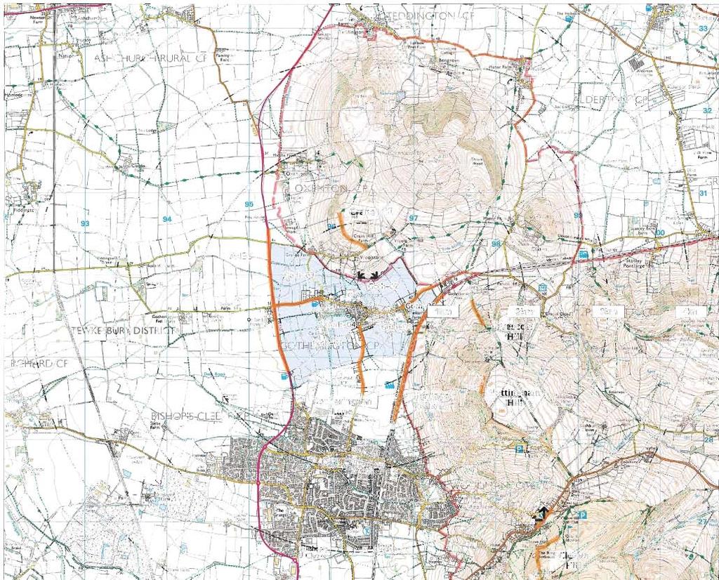

99


100
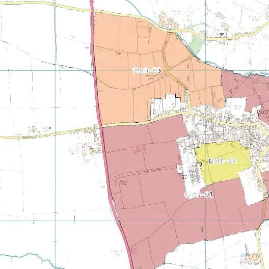
101
102 Settlement Name: Settlement Type Land Assessment Parcel Reference: Landscape Character Context National Character Area County Character Area Cotswolds AONB Character Area Natural Elements Landform Tree Cover Water Environment Cultural Elements Land Use Enclosure Pattern Field Boundaries Time Depth Existing Settlement Form Existing Settlement Edge Landscape Quality / Condition Representative of typical character Intactness State of individual elements Tranquility Noise Sources Level of movement and activity Gotherington Service Village Goth-01 NCA 106 Severn and Avon Vales SV6B - Vale of Gloucester - (Settled Unwooded Vale) Rolling / undulating Sparse Ditches and Dean Brook on southern boundary Arable scale rectilinear Mainly hedges with some post and wire Slight Between Gotherington and Bishops Cleeve Filtered views of 20th century residential Typical of the vale Yes Good Traffic on surrounding roads Mitigation / Enhancement Potential Limited tree cover with the exception of Dean Brook. Few opportunities to mitigate new development Landscape Character Summary A rolling, undulating arable landscape at the transition between the Cotswold scarp and the Vale of Gloucester. The land assessment parcel is contained between the Heritage Railway line to the east at the foot of the Cotswold scarp to the A435 in the west. Gotherington sits slightly elevated from much of this land assessment parcel to the north. The surrounding hills exert a strong influence and views to the AONB are an important characteristic of this landscape. The land assessment parcel becomes flatter and more open towards the west and the influence of the settlement edge including a park homes site becomes stronger Judgment as to Landscape Character Sensitivity
103 Visibility Key Visual Receptors A435 Heritage Railway Gloucestershire Way (Crane Hill) Cleeve Hill Nottingham Hill Local Roads Trunk Road Recreation resource Valued recreation Valued recreation Valued Recreation Local Road Sensitivity Visual Context and Prominence This land assessment parcel comprises an open arable landscape. It is overlooked from the A435 and surrounding elevated vantages including Crane Hill, Nottingham Hill and Cleeve Hill. The parcel serves to separate Gotherington from Bishops Cleeve. It is prominent Mitigation / enhancement Potential There are limited opportunities for mitigation in this open landscape Visual Summary An open, rolling landscape overlooked locally from the A435 and Gotherington. Views from Gotherington Lane are largely screened and filtered by mature hedgerows. It is overlooked from elevated vantages within the AONB at Crane Hill, Nottingham Hill and Cleeve Hill and it plays an important role in the separation of Gotherington from Bishops Cleeve. The parcel is also overlooked from the Heritage railway at the foot of the Cotswold Scarp. Promotional material for the railway highlights views across this land assessment parcel to the Vale of Gloucester as one of the highlights. To the west, the land assessment parcel serves to separate Gotherington from the A435. The village is not perceived to be on this main road but set back some distance from it. The character and form of the village would alter if it were to become noticeable from this main route. Judgment as to Visual Sensitivity
104 Settlement Name: Settlement Type Land Assessment Parcel Reference: Landscape Character Context National Character Area County Character Area Cotswolds AONB Character Area Natural Elements Landform Tree Cover Water Environment Cultural Elements Land Use Enclosure Pattern Field Boundaries Time Depth Existing Settlement Form Existing Settlement Edge Landscape Quality / Condition Representative of typical character Intactness State of individual elements Tranquility Noise Sources Level of movement and activity Gotherington Service Village Goth-02 NCA 106 Severn and Avon Vales SV6B - Vale of Gloucester - (Settled Unwooded Vale) Distinct ridge Abundant Tirle Brook Mixed arable, pasture and recreation small to medium scale rectilinear Mainly hedges with some post and wire Strong On northern edge of village just below a ridge line Mostly unsympathetic 20th century residential edge A-typical character formed by topography and village edge Yes Good Domestic Low Mitigation / Enhancement Potential There is abundant tree cover in this land assessment parcel offering screening opportunities. The strong influence of 20th century residential development also mitigates the principle of new development to some extent in terms of landscape character. Landscape Character Summary A land assessment parcel between Gotherington and Woolstone. This is a transition landscape between the Vale of Gloucester and Crane Hill (a Cotswold outlier). The character is defined to a large extent by the complex topography. Gotherington sits on a ridge rising up from the vale and then dropping back down to the Tirle Brook before once again rising onto Crane Hill. This land assessment parcel occupies the slopes between Gotherington and the Tirle Brook with its robust tree cover in the valley. Land use is diverse and reflects the settlement edge location. It includes pastures, paddocks, arable and recreation facilities. There is strong evidence of ridge and furrow. There is a strong influence from the largely unsympathetic residential edge of Gotherington which extends to the ridgeline from the south. Judgment as to Landscape Character Sensitivity
105 Visibility Key Visual Receptors Crane Hill (Gloucestershire Way) Prescott Hill (Winchcombe Way) Woolstone Residents Gotherington Residents Sports / recreation ground Valued recreation valued recreation Individual residents Individual residents Recreation Sensitivity Visual Context and Prominence This parcel occupies land between Gotherington and the Tirle Brook on a distinct ridge with north facing slopes.. The parcel is most exposed in views from the north and west Mitigation / enhancement Potential There is abundant tree cover along the Tirle Brook and there is an unsympathetic residential edge of Gotherington on the ridgeline facing north. This parcel does however occupy a prominent slope and mitigation is likely to be ineffective. Visual Summary This is a prominent land assessment parcel in views from the north and east. It lies on a north facing ridge that is currently characterised by 20th century residential development. This parcel is clearly visible from Crane Hill, Prescott Hill and from Woolstone to the north and from footpaths and the recreation ground to the north of Gotherington. The northern edge of Gotherington currently lies just below the ridgeline. Development within this land assessment parcel could represent a conspicuous change in the established settlement pattern that would see development spill out onto the ridge top and onto the slopes down to the Tirle Brook between Gotherington and Woolstone. Judgment as to Visual Sensitivity
106 Settlement Name: Settlement Type Land Assessment Parcel Reference: Landscape Character Context National Character Area County Character Area Cotswolds AONB Character Area Natural Elements Landform Tree Cover Water Environment Cultural Elements Land Use Enclosure Pattern Field Boundaries Time Depth Existing Settlement Form Existing Settlement Edge Landscape Quality / Condition Representative of typical character Intactness State of individual elements Tranquility Noise Sources Level of movement and activity Gotherington Service Village Goth-03 NCA 106 Severn and Avon Vales SV6B - Vale of Gloucester - (Settled Unwooded Vale) Flat Vale Abundant to the east, sparse to the west Stream Mixed arable, pasture and paddock small to medium scale rectilinear Hedges Strong Beyond current settlement boundary 20th century residential edge to the north of Gotherington Transition between vale and settlement edge Yes Good A435 Low Mitigation / Enhancement Potential There are some opportunities for mitigation close to the existing settlement edge where tree cover is strongest and field size smallest. These opportunities decrease further west with large open field pattern and sparse vegetation. Landscape Character Summary This is a mixed land assessment parcel occupying the very edge of the Vale of Gloucester as it meets the lower slopes of the Cotswolds at Crane Hill. Tree cover is notably stronger to the east associated with hedge trees and small, ancient enclosures (possible evidence of early oxen ploughing in the slight twist to the field boundaries here). Ridge and furrow is evident with a strong time depth. Landscape sensitivity is influenced by this robust and established character close to the settlement edge. Further west, it relates to the degree of separation and remoteness from the settlement and the characteristic separation between Gotherington and the A435. Judgment as to Landscape Character Sensitivity
107 Visibility Key Visual Receptors A435 Local Roads Gotherington Residents Trunk Road Local Roads Individual residents Sensitivity Visual Context and Prominence Parts of this parcel to the west are prominent in open views from the A435. Further east and closer to Gotherington, the landscape is more intimate and enclosed. Mitigation / enhancement Potential Abundant tree cover and the existing influence of 20th century residential properties would mitigate small-scale development close to the existing settlement edge. In particular to the east of the land assessment parcel. Visual Summary A diverse land assessment parcel on the very edges of the Vale of Gloucester. This parcel occupies flat land just before the undulations and hill slopes of the Cotswold Outliers. It is next to the A435 from which extensive views are available across this land assessment parcel to the AONB. To the east the parcel is less visible from surrounding roads and public vantages. Whilst it is overlooked by some properties at the edge of the village, the smaller scale enclosures and abundant hedges and trees create a far more enclosed and visually isolated environment. A key visual sensitivity in this land assessment parcel is the role it plays in separating Gotherington from Woolstone and separating Gotherington from the A435. Sensitivity to new residential development decreases to the east and south of the land assessment parcel. Judgment as to Visual Sensitivity
108 Settlement Name: Settlement Type Land Assessment Parcel Reference: Landscape Character Context National Character Area County Character Area Cotswolds AONB Character Area Natural Elements Landform Tree Cover Water Environment Cultural Elements Land Use Enclosure Pattern Field Boundaries Time Depth Existing Settlement Form Existing Settlement Edge Landscape Quality / Condition Representative of typical character Intactness State of individual elements Tranquility Noise Sources Level of movement and activity Gotherington Service Village Goth-04 NCA 106 Severn and Avon Vales SV6B - Vale of Gloucester - (Settled Unwooded Vale) Flat Vale Sparse, limited to hedgerow trees N/A Mixed arable and pasture (arable dominant) Large rectilinear and small pasture with marked left hand twist Hedges Strong Enclosed on three sides by settlement 20th century residential and park homes site. (Unsympathetic) Heavily influenced by settlement edge Yes Good A435 traffic and domestic Low Mitigation / Enhancement Potential The fact that this parcel is enclosed by the existing settlement offers a degree of mitigation in terms of the wider landscape character Landscape Character Summary This land assessment parcel is characterised by the dominant arable field surrounded by strong visual influences from the surrounding settlement. 20th century residential properties back on the three sides of this parcel. Air photographs reveal evidence of old ridge and furrow system with a distinct left twist suggesting early origin (Possibly Anglo Saxon). Little evidence remains on the surface since they have been ploughed out. A residual sensitivity remains in the heritage value of the intact ridge and furrow systems. To the west of the land assessment parcel is a small enclosed pasture with visible evidence of ridge and furrow. This too shows a slight sign of the reverse "S" form typical of early ridge and furrow systems. The judgment as to landscape character sensitivity is based upon the relatively isolated position, the existing heavy influence from surrounding settlement and the relationship between the parcel and the existing settlement form or pattern Judgment as to Landscape Character Sensitivity Low
109 Visibility Key Visual Receptors Local footpaths Neighbouring properties Local recreation individual residents Sensitivity Visual Context and Prominence This land assessment parcel is visually contained on three sides by existing settlement and on the remaining southern edge is contained with a robust hedgerow. It is not a prominent site and indeed recedes into the existing settlement pattern. Mitigation / enhancement Potential The relative seclusion of this land assessment parcel from surrounding vantages offers a degree of mitigation for new residential development. Properties on the edge of Gotherington have an outlook across this land and it is crossed by a number of local footpaths. Visual Summary A land assessment parcel that is relatively well screened from the surrounding area by the existing settlement and by mature hedges. The parcel is bounded on three sides by settlement and recedes into the existing settlement form. It is not prominent in terms of its relationship with the settlement pattern, nor is it prominent in terms of views from surrounding vantages such as roads or elevated recreational routes. A key visual sensitivity remains in this parcel to protect the visual gap between Gotherington and Bishops Cleeve. There will remain a sensitivity relating to residential amenity of neighbouring properties. (Right to light, avoiding overbearing development and preserving privacy. Judgment as to Visual Sensitivity Low
110 Settlement Name: Settlement Type Land Assessment Parcel Reference: Landscape Character Context National Character Area County Character Area Cotswolds AONB Character Area Natural Elements Landform Tree Cover Water Environment Cultural Elements Land Use Enclosure Pattern Field Boundaries Time Depth Existing Settlement Form Existing Settlement Edge Landscape Quality / Condition Representative of typical character Intactness State of individual elements Tranquility Noise Sources Level of movement and activity Gotherington Service Village Goth-05 NCA 106 Severn and Avon Vales SV6B - Vale of Gloucester - (Settled Unwooded Vale) Gently undulating Sparse, limited to hedgerow trees N/A Arable scale rectilinear truncated by Railway Hedges Limited beyond eastern boundary but enclosed on three sides Truman's Farm, properties on Manor Lane houses on Gretton Road Influenced by settlement and adjacent hill slopes. Yes Good Gretton Road Low Mitigation / Enhancement Potential The character is influenced to an extent (particularly to the west) by the existing settlement edge. This influence diminishes rapidly to the east away from the village where the influence of Nottingham Hill and open countryside are more dominant. Landscape Character Summary This is a gently undulating land assessment parcel consisting of two fields at the base of Nottingham Hill. Despite being cut off from the lower slopes by the Gloucestershire and Warwickshire Railway line on embankment, this parcel is closely associated with them. It is contained along Gretton Road behind a robust hedge with hedgerow trees. To the west, beyond the first houses on Gretton Road, the land assessment parcel becomes more influenced by the settlement edge of Gotherington. At this point, the parcel is enclosed to the north, south and west by settlement. Despite this influence, this land assessment parcel still performs an important role in providing the foreground setting to the AONB and Nottingham Hill. The character of this parcel is sensitive to development that might appear intrusive at the base of Nottingham Hill and that might give the perception of settlement encroaching out into the open countryside. There is some resilience to development to the west where the influence of settlement is stronger. Judgment as to Landscape Character Sensitivity
111 Visibility Key Visual Receptors Winchcombe Way Gretton Road Adjoining residential properties Local footpaths Valued recreation resource Local Road Individual residents Local recreation Sensitivity Visual Context and Prominence This land assessment parcel is seen from Gretton Road on the approach to Gotherington from the east. For the most part it sits behind mature hedges, however it does serve to provide the visual foreground in places for the AONB at Nottingham Hill and for the eastern edge of Gotherington that becomes more apparent as one approaches the village. Mitigation / enhancement Potential The land assessment parcel is more prominent and more important as the visual foreground to the AONB to the east. As one approaches Gotherington, the influence of the existing settlement edge increases and the influence of the hills diminishes. There are opportunities to avoid prominent, open locations and concentrate development to the west. This would also help to mitigate prominence of the site in surrounding elevated views Visual Summary From Gretton Road, this land assessment parcel is well contained within mature hedges with only occasional glimpses possible across the railway to the slopes of Nottingham Hill and across to the settlement edge of Gotherington. The visual influence of the settlement increases to the west of the parcel. To the east the visual influence of the village is nominal and the dominant influence is the neighbouring hill slopes and open countryside. As one approaches Gotherington the visual influence of the edge increases and so too does the sense of enclosure within the land assessment parcel. At its western most part this parcel is contained on three sides by settlement. From elevated vantages too, the influences of the existing edge increase to the west. To the east, this land assessment parcel is somewhat prominent and encroaches into open countryside. Judgment as to Visual Sensitivity
112 Settlement Name: Settlement Type Land Assessment Parcel Reference: Landscape Character Context National Character Area County Character Area Cotswolds AONB Character Area Natural Elements Landform Tree Cover Water Environment Cultural Elements Land Use Enclosure Pattern Field Boundaries Time Depth Existing Settlement Form Existing Settlement Edge Landscape Quality / Condition Representative of typical character Intactness State of individual elements Tranquility Noise Sources Level of movement and activity Gotherington Service Village Goth-06 NCA 106 Severn and Avon Vales SV6B - Vale of Gloucester - (Settled Unwooded Vale) Gently undulating Sparse, limited to hedgerow trees N/A Arable Part of large scale field contained by settlement edge Hedges (garden and field) Limited Contained on two sides by settlement Properties on Manor Lane, Gretton Road and the Lawns. Open arable field but heavily influenced by settlement edge Historic loss of field boundaries Good N/A Low Mitigation / Enhancement Potential This land assessment parcel is contained on two sides by settlement edge and the precedent influence of residential development offers mitigation potential. Landscape Character Summary This is a flat, open land assessment parcel, part of a larger arable field. The relatively featureless field is heavily influenced by the settlement edge that surrounds it. There are abundant garden hedges with hedgerow trees and ornamental garden tress in evidence. There are occasional clear views through to residential development. The character of this land assessment parcel is unmistakably associated with the edge of Gotherington, although this influence diminishes with distance to the south west where the influence of the wider vale landscape between Gotherington and Bishops Cleeve dominates. The character of this land assessment parcel is sensitive to development that might intrude into open countryside or diminish the perception of separation between Gotherington and Bishops Cleeve. This sensitivity reduces to the north and east across the land assessment parcel Judgment as to Landscape Character Sensitivity Low
113 Visibility Key Visual Receptors Winchcombe Way Elevated vantages on Nottingham Hill Adjoining residential properties Local footpaths Valued recreation Valued recreation (AONB) Individual Residents Local recreation Sensitivity Visual Context and Prominence This land assessment parcel is well screened from local views from publicly accessible vantages. Views are limited to Manor Lane, glimpses from Cleeve Road and local footpaths. It is visible from the front of a number of residential properties on Manor Road and from the rear of properties on The Lawns and Gretton Road. In local views, the land assessment parcel is seen in the context of the existing settlement edge that contains it on two sides. From elevated vantages, the land assessment parcel is sympathetic to the settlement form. Mitigation / enhancement Potential The strong influence of the settlement edge and the ability for new development to respect the settlement form without appearing prominent represent mitigation opportunities. Visual Summary This land assessment parcel is well screened from local views from publicly accessible vantages. Views are limited to Manor Lane, glimpses from Cleeve Road and local footpaths. It is visible from the front of a number of residential properties on Manor Road and from the rear of properties on The Lawns and Gretton Road. In local views, the land assessment parcel is seen in the context of the existing settlement edge that contains it on two sides. From elevated vantages, the land assessment parcel fits into the established settlement pattern without intruding into open countryside and without diminishing perception of the "gap between Gotherington and Bishops Cleeve. The visual sensitivity of this land assessment parcel increases to the south and west. It remains sensitive to inappropriately scaled and located development Judgment as to Visual Sensitivity Low
114
115 nam (Service Village)
116

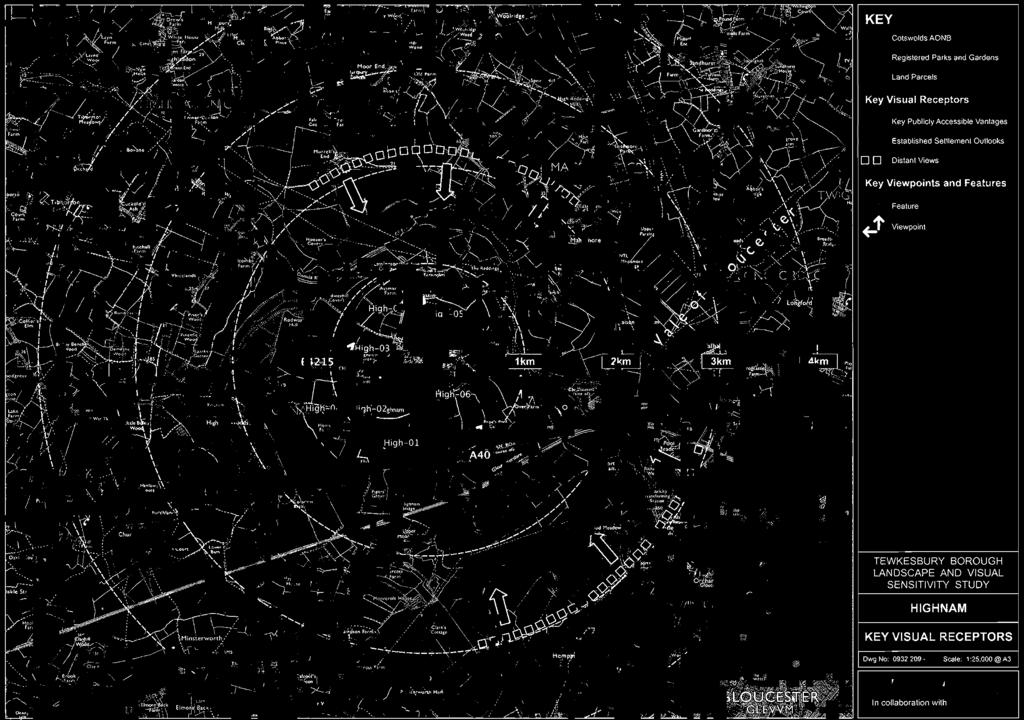
117

118

119
120 Settlement Name: Settlement Type Land Assessment Parcel Reference: Landscape Character Context National Character Area County Character Area Cotswolds AONB Character Area Natural Elements Landform Tree Cover Water Environment Cultural Elements Land Use Enclosure Pattern Field Boundaries Time Depth Existing Settlement Form Existing Settlement Edge Landscape Quality / Condition Representative of typical character Intactness State of individual elements Tranquility Noise Sources Level of movement and activity nam Service Village -01 NCA 106 Severn and Avon Vales SV11C - Lassington and Rodway Hills - (Vale Hillocks) Undulating Abundant parkland and ornamental species Ornamental lakes Historic garden / parkland Irregular Various Strong Beyond southern edge of village (isolated beyond B4215) nam Court heavily screened by hedges to the roadsides. Distinct local character (Park and garden) Yes Good A40 Low Mitigation / Enhancement Potential There are limited mitigation opportunities in this parkland setting. Landscape Character Summary A privately owned historic parkland setting to nam Court. Landscape sensitivity to new residential development reflects its strength of character, its value and lack of detracting features. Judgment as to Landscape Character Sensitivity
121 Visibility Key Visual Receptors A40 B4215 nam Court Trunk Road Local Road Private Residence and heritage asset Sensitivity Low Visual Context and Prominence The landscape setting to nam Court, visible from surrounding roads, but not prominent. Mitigation / enhancement Potential There are limited opportunities to mitigate new development in this parkland setting. Visual Summary A valued parkland garden. Views for the most part are screened by abundant hedges and trees. Glimpsed views are available across open parkland Judgment as to Visual Sensitivity
122 Settlement Name: Settlement Type Land Assessment Parcel Reference: Landscape Character Context National Character Area County Character Area Cotswolds AONB Character Area Natural Elements Landform Tree Cover Water Environment Cultural Elements Land Use Enclosure Pattern Field Boundaries Time Depth Existing Settlement Form Existing Settlement Edge Landscape Quality / Condition Representative of typical character Intactness State of individual elements Tranquility Noise Sources Level of movement and activity nam Service Village -02 NCA 106 Severn and Avon Vales SV11C - Lassington and Rodway Hills - (Vale Hillocks) Flat Evident to the edges but overall sparse N/A Arable Irregular large scale open field pattern Hedges Moderate To the southwest of village beyond B4215 Remote, separated by robust hedges along B4215 Yes of open vale arable landscape Yes Good B4215 Low Mitigation / Enhancement Potential This is an open arable landscape. The character is influenced on three sides by existing settlement Landscape Character Summary This is an open, flat arable landscape at the foot of Lassington Hill. There is some influence of the settlement edge of nam although this is muted by effective screening provided by hedges along the B4215. To the south, this parcel is influenced by the parkland at nam Court. To the west it is influenced by nam Business Centre. This is a land assessment parcel enclosed on three sides by settlement. This existing influence reduces the character sensitivity of this land assessment parcel to new residential development Judgment as to Landscape Character Sensitivity
123 Visibility Key Visual Receptors Two Mile Lane B4215 Hynam Court Properties at the edge of nam Local Road Local Road Private Residence and heritage asset Individual residents Sensitivity Visual Context and Prominence This land assessment parcel occupies flat ground at the base of Lassington Hill, It is not however particularly prominent in local or distant views. Mitigation / enhancement Potential The existing visual influence of the settlement particularly to the north of this land assessment parcel provides a degree of mitigation. Visual Summary An open, expansive arable landscape enclosed to the north east by Lassington Hill and nam village. It is enclosed to the south by strong vegetation and topography around nam Court and to the west by settlement and the Business Centre on Two Mile Lane. This land assessment parcel is visible from the surrounding road network. Visual sensitivity adjacent to the existing settlement edge is diminished by the strong visual influence of 20th century residential development. Judgment as to Visual Sensitivity
124 Settlement Name: Settlement Type Land Assessment Parcel Reference: Landscape Character Context National Character Area County Character Area Cotswolds AONB Character Area Natural Elements Landform Tree Cover Water Environment Cultural Elements Land Use Enclosure Pattern Field Boundaries Time Depth Existing Settlement Form Existing Settlement Edge Landscape Quality / Condition Representative of typical character Intactness State of individual elements Tranquility Noise Sources Level of movement and activity nam Service Village -03 NCA 106 Severn and Avon Vales SV11C - Lassington and Rodway Hills - (Vale Hillocks) Flat Some field and abundant hedge trees N/A Arable Irregular large scale field pattern Hedges and some "park" fencing Moderate Beyond the western edge of the village; North of Business Centre Adjacent to Business Centre and modern western edge of nam Yes of open vale arable landscape Yes Good B4215 Low Mitigation / Enhancement Potential Strong character influence of the existing settlement, in particular around the junction of the B4215 and Lassington Lane Landscape Character Summary This land assessment parcel is characterised by an open arable landscape on flat land at the base of Lassington Hill. nam village sweeps down the hill slopes and exerts a moderate influence. Houses are exposed in views, in particular towards the junction of the B4215 and Lassington Lane. Character sensitivity increases from south east to north west across this land assessment parcel. Landscape sensitivity is influenced by the relative lack of time depth and the influence of the linear 20th century settlement edge and the influence of surrounding roads. Judgment as to Landscape Character Sensitivity
125 Visibility Key Visual Receptors Lassington Lane B4215 Local footpaths Adjoining residential properties. Local Road Local Road Local recreation Individual residents Sensitivity Visual Context and Prominence A flat, open landscape that is visible from surrounding roads. Prominent from the B4215 and Lassington Lane Mitigation / enhancement Potential Visual influence of the existing settlement edge and the Business Centre on Two Mile Lane offers some potential mitigation particularly to the south east of the parcel at the junction of the B4215 and Lassington Lane. Visual Summary An open arable landscape at the base of Lassington Hill. There is strong visual influence from the existing settlement edge of nam, particularly at the junction of the B4215 and Lassington Lane. Visual sensitivity increases with distance from the existing settlement to the north and west. This land assessment parcel would be sensitive to the perception of sprawl or encroachment into open countryside. Some development that respected the existing settlement form and visual influence might be accommodated. Judgment as to Visual Sensitivity
126 Settlement Name: Settlement Type Land Assessment Parcel Reference: Landscape Character Context National Character Area County Character Area Cotswolds AONB Character Area Natural Elements Landform Tree Cover Water Environment Cultural Elements Land Use Enclosure Pattern Field Boundaries Time Depth Existing Settlement Form Existing Settlement Edge Landscape Quality / Condition Representative of typical character Intactness State of individual elements Tranquility Noise Sources Level of movement and activity nam Service Village -04 NCA 106 Severn and Avon Vales SV11C - Lassington and Rodway Hills - (Vale Hillocks) Flat Some field and abundant hedge trees N/A Arable and some pastures Irregular medium to large scale field pattern Hedges with mature trees Strong Beyond and detached from settlement boundary Tenuous connection with main village Yes of open vale arable landscape Yes Good B4215 Low Mitigation / Enhancement Potential There are limited opportunities to mitigate new residential development since a key aspect of this landscape is that it is separate and remote from the existing village. Landscape Character Summary This is a continuation of land assessment parcel -03. It shares many of the characteristics including large open arable fields on an open vale. Here however the influence of the existing settlement is much reduced and there is only a tenuous physical connection to the settlement. This is essentially open countryside with no detracting elements or features. There are some agricultural buildings and the church tower at Lassington. The key sensitivity here is the openness and clear separation from the village. Judgment as to Landscape Character Sensitivity
127 Visibility Key Visual Receptors Lassington Lane Two Mile Lane Local footpaths Adjoining residential properties. Three Choirs Way Local Road Local Road Local Recreation Individual Residents Valued Recreation Sensitivity Visual Context and Prominence This land assessment parcel is prominent in the sense that it is remote from the existing settlement edge of nam Mitigation / enhancement Potential No mitigation can address the physical separation between this land assessment parcel and the existing settlement edge Visual Summary An open, flat landscape at the base of Lassington Hill. It provides a visual setting to Lassington Court and the distinctive church tower. The Three Choirs Way passes through the parcel to the north. New residential development in this parcel would appear prominent and incongruous with the existing village form. Judgment as to Visual Sensitivity
128 Settlement Name: Settlement Type Land Assessment Parcel Reference: Landscape Character Context National Character Area County Character Area Cotswolds AONB Character Area Natural Elements Landform Tree Cover Water Environment Cultural Elements Land Use Enclosure Pattern Field Boundaries Time Depth Existing Settlement Form Existing Settlement Edge Landscape Quality / Condition Representative of typical character Intactness State of individual elements Tranquility Noise Sources Level of movement and activity nam Service Village -05 NCA 106 Severn and Avon Vales SV11C - Lassington and Rodway Hills - (Vale Hillocks) Steep North facing slopes Abundant hedge trees and tree belt N/A Pastures Irregular medium to large scale field pattern Hedges with mature trees Strong Beyond the distinct northern settlement boundary separated by distinct break slope and tree belt Locally distinctive Yes Good N/A Low Mitigation / Enhancement Potential There is a strong sense of separation between this land assessment parcel and the village by virtue of the robust woodland belt and the distinct break slope. There is no potential to mitigate new development on these prominent and steep slopes. Landscape Character Summary This land assessment parcel occupies steeply sloping fields on the northern flank of Lassington Hill. It is clearly separated from the village edge by the break slope and a robust tree belt. There is a strong northerly aspect from these fields out across a rolling pastoral landscape. The key character sensitivity here is that the slops are clearly free from settlement. New development here would adversely alter the relationship between nam and the topography of Lassington Hill. It would also adversely affect the character of land to the north by significantly increasing the influence of settlement on the overlooking slopes. Judgment as to Landscape Character Sensitivity
129 Visibility Key Visual Receptors Lassington Lane Three Choirs Way Local footpaths Adjoining residential properties. Local Road Valued Recreation Local Recreation Individual Residents Sensitivity Visual Context and Prominence This land assessment parcel is prominent in the sense that it occupies a highly visible, elevated position and is exposed in views from the north. It is also prominent in the sense that it is distinctly separate from nam Village Mitigation / enhancement Potential No mitigation potential due to prominence of the land assessment parcel Visual Summary A land assessment parcel occupying prominent north slopes of Lassington Hill. It is exposed in views from the north and west across an expansive, undulating pastoral landscape. The land assessment parcel is clearly separated from the existing village by the distinct break slope and a robust tree belt / woodland. The key visual sensitivity here would be increasing the perception of development in views from the north and creating widespread views of new settlement on a prominent hill side. Judgment as to Visual Sensitivity
130 Settlement Name: Settlement Type Land Assessment Parcel Reference: Landscape Character Context National Character Area County Character Area Cotswolds AONB Character Area Natural Elements Landform Tree Cover Water Environment Cultural Elements Land Use Enclosure Pattern Field Boundaries Time Depth Existing Settlement Form Existing Settlement Edge Landscape Quality / Condition Representative of typical character Intactness State of individual elements Tranquility Noise Sources Level of movement and activity nam Service Village -06 NCA 106 Severn and Avon Vales SV11C - Lassington and Rodway Hills - (Vale Hillocks) Sloping Sparse with some distinct mature copses N/A Arable Irregular large scale field pattern Hedges Moderate Beyond the south and eastern settlement edge Open views of 20th century estate development Yes Yes Good N/A Low Mitigation / Enhancement Potential The existing influence of the settlement edge does offer some mitigation potential for new development here as do isolated tree groups. Landscape Character Summary This is an open arable landscape occupying the south east facing slopes of Lassington Hill with a distinctive outlook across the vale and the River Severn to Gloucester. Locally there is a strong influence from the unsympathetic residential edge of nam which, aligned with local variations in topography and tree groups provide some character resilience to additional new residential development. The character of the land assessment parcel remains sensitive to development that sprawls out onto the hillside and encroaches into open countryside. Judgment as to Landscape Character Sensitivity
131 Visibility Key Visual Receptors B4215 Wysis Way Local footpaths Adjoining residential properties. A40 Local Road Recreation Local Recreation Individual Residents Trunk Road Sensitivity Low Visual Context and Prominence This land assessment parcel occupies prominent slopes with a south easterly aspect Mitigation / enhancement Potential Some localised screening from copses and local variations in topography aligned with a visual strong influence from the existing settlement edge offer some mitigation opportunities. Visual Summary This land assessment parcel occupies south east facing slopes of Lassington Hill. For the most part these open, arable fields are prominent in views from the south and east. However some local variations in topography aligned to the strong visual influence of the unsympathetic linear settlement edge and isolated tree groups present some local opportunities for additional new residential development without visual harm. There remains a sensitivity here to unsympathetic development that might intrude further in prominent views both locally from the A48 and B4215 and also in views from further afield. Judgment as to Visual Sensitivity
132 Settlement Name: Settlement Type Land Assessment Parcel Reference: Landscape Character Context National Character Area County Character Area Cotswolds AONB Character Area Natural Elements Landform Tree Cover Water Environment Cultural Elements Land Use Enclosure Pattern Field Boundaries Time Depth Existing Settlement Form Existing Settlement Edge Landscape Quality / Condition Representative of typical character Intactness State of individual elements Tranquility Noise Sources Level of movement and activity nam Service Village -07 NCA 106 Severn and Avon Vales SV11C - Lassington and Rodway Hills - (Vale Hillocks) Flat Some field and abundant hedge trees N/A Arable and some pastures Irregular medium to large scale field pattern Hedges with mature trees Strong Beyond and detached from settlement boundary Tenuous connection with main village Yes of open vale arable landscape Yes Good B4215 Low Mitigation / Enhancement Potential There are limited opportunities to mitigate new residential development since a key aspect of this landscape is that it is separate and remote from the existing village. Landscape Character Summary This is a continuation of land assessment parcel -03. It shares many of the characteristics including large open arable fields on an open vale. Here however the influence of the existing settlement is much reduced and there is only a tenuous physical connection to the settlement. This is essentially open countryside with no detracting elements or features. There are some agricultural buildings and the church tower at Lassington. The key sensitivity here is the openness and clear separation from the village. Judgment as to Landscape Character Sensitivity
133 Visibility Key Visual Receptors Lassington Lane Two Mile Lane Local footpaths Adjoining residential properties. Three Choirs Way Local Road Local Road Local Recreation Individual Residents Valued Recreation Sensitivity Visual Context and Prominence This land assessment parcel is prominent in the sense that it is remote from the existing settlement edge of nam Mitigation / enhancement Potential No mitigation can address the physical separation between this land assessment parcel and the existing settlement edge Visual Summary An open, flat landscape at the base of Lassington Hill. It provides a visual setting to Lassington Court and the distinctive church tower. The Three Choirs Way passes through the parcel to the north. New residential development in this parcel would appear prominent and incongruous with the existing village form. Judgment as to Visual Sensitivity
134
135 Maisemore (Service Village)
136
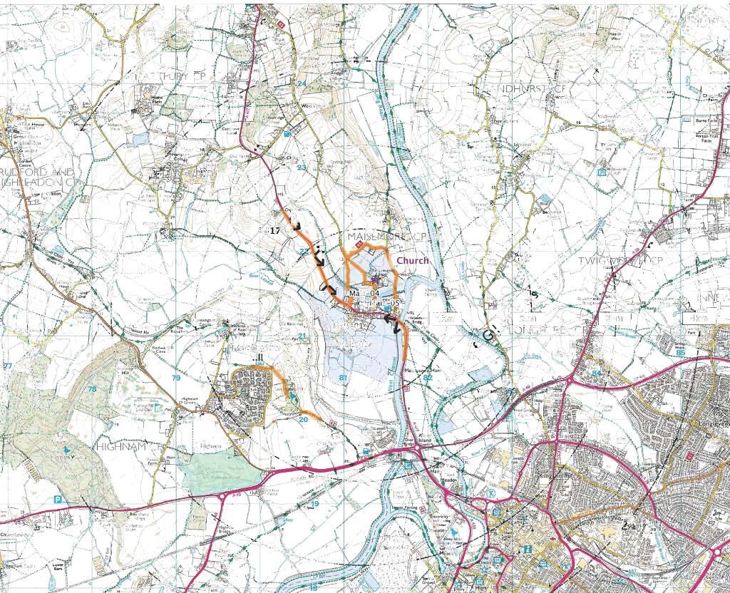

137
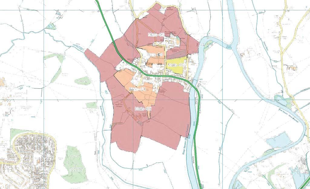

138

139
140 Settlement Name: Settlement Type Land Assessment Parcel Reference: Landscape Character Context National Character Area County Character Area Cotswolds AONB Character Area Natural Elements Landform Tree Cover Water Environment Cultural Elements Land Use Enclosure Pattern Field Boundaries Time Depth Existing Settlement Form Existing Settlement Edge Landscape Quality / Condition Representative of typical character Intactness State of individual elements Tranquility Noise Sources Level of movement and activity Maisemore Service Village Mai-01 NCA 106 Severn and Avon Vales SV11D - Woolridge Hill - (Vale Hillocks) Undulating ridge top Hedge trees N/A Pasture and paddocks Irregular small scale field pattern Hedges Moderate Beyond the southern settlement edge Beyond farm and assorted domestic gardens Locally distinctive pastures Yes Good N/A Low Mitigation / Enhancement Potential Robust hedges and the influence of 20th century settlement edge offer some mitigation opportunities Landscape Character Summary This is a small scale pastoral landscape heavily influenced by the existing settlement edge and equestrian activity. It occupies the flat top of a bluff formed at the confluence of the River Leadon with the River Severn (West Channel). Whilst it is clearly beyond the settlement boundary, it is influenced by the existing settlement edge and isolated dwellings and farmsteads. Judgment as to Landscape Character Sensitivity
141 Visibility Key Visual Receptors Lassington Hill Local footpaths Residential properties Valued recreation Local recreation Individual residents Sensitivity Visual Context and Prominence This land assessment parcel occupies the top of a distinct bluff. It is not readily visible from local publicly accessible vantages but is overlooked from Lassington Hill Mitigation / enhancement Potential The strong influence of the existing settlement edge provides some mitigation potential Visual Summary This land assessment parcel is well screened from local vantages in the village by settlement and by mature and robust hedges. It is visible only from Persh Lane and adjoining properties. It does however occupy the top of a distinct bluff formed by the confluence on the Rivers Leadon and Severn (West Channel). It is overlooked from higher ground on Lassington Hill to the south west. Views are available of this land assessment parcel from the Wysis Way as it crosses Lassington Hill. This land assessment parcel does retain some visual tolerance to new development if it were to respect the existing settlement form without appearing prominent, nor to intrude into open countryside. Judgment as to Visual Sensitivity
142 Settlement Name: Settlement Type Land Assessment Parcel Reference: Landscape Character Context National Character Area County Character Area Cotswolds AONB Character Area Natural Elements Landform Tree Cover Water Environment Cultural Elements Land Use Enclosure Pattern Field Boundaries Time Depth Existing Settlement Form Existing Settlement Edge Landscape Quality / Condition Representative of typical character Intactness State of individual elements Tranquility Noise Sources Level of movement and activity Maisemore Service Village Mai-02 NCA 106 Severn and Avon Vales SV11D - Woolridge Hill - (Vale Hillocks) Undulating ridge top Sparse N/A Arable Irregular large scale field pattern Hedges Low Beyond the southern settlement edge on bluff slopes Beyond Persh Farm Characteristic of wider arable landscape Yes Good N/A Low Mitigation / Enhancement Potential There are limited opportunities for mitigation in this open rolling landscape Landscape Character Summary Large angular arable fields within low hedges. Landform slopes gently away from the edge of Maisemore as these fields occupy the gentle slopes of a bluff formed by the confluence of the River Leadon and Severn (Western Channel). This is an expansive and open landscape crossed by pylons and overlooked from higher ground to the south west at Lassington Hill (nam). Maisemore exerts very little influence on this land assessment parcel. It is remote and shares characteristics with the wider countryside. A key character sensitivity here is the encroachment of settlement into this open and undeveloped landscape. Judgment as to Landscape Character Sensitivity
143 Visibility Key Visual Receptors Lassington Hill Local footpaths Residential properties A417 Valued recreation Local Recreation Individual Residents Trunk Road Sensitivity Low Visual Context and Prominence This land assessment parcel occupies the gentle slopes of a distinct bluff. It is prominent in views from the A417 approaching Maisemore from the north. It also features in views from the A417 on the Severn River crossing to the east of Maisemore. This land assessment parcel is also prominent in views from Lassington Hill to the south west Mitigation / enhancement Potential There are limited opportunities for mitigation in this open and prominent land assessment parcel Visual Summary A prominent land assessment parcel visible from Lassington Hill to the south west and from the A417 to the northern and southern approaches to the village. It appears as a wide open arable landscape free from visual influences of Maisemore and settlement. It is particularly prominent on the northern approach to Maisemore along the A417 as it drops towards the village from Overton (Overton Farm). This land assessment parcel has particular visual sensitivities to new development that would encroach into an open and prominent landscape currently free from development. Judgment as to Visual Sensitivity
144 Settlement Name: Settlement Type Land Assessment Parcel Reference: Landscape Character Context National Character Area County Character Area Cotswolds AONB Character Area Natural Elements Landform Tree Cover Water Environment Cultural Elements Land Use Enclosure Pattern Field Boundaries Time Depth Existing Settlement Form Existing Settlement Edge Landscape Quality / Condition Representative of typical character Intactness State of individual elements Tranquility Noise Sources Level of movement and activity Maisemore Service Village Mai-03 NCA 106 Severn and Avon Vales SV11D - Woolridge Hill - (Vale Hillocks) Undulating Robust tree belt associated with watercourse Stream Arable with some pasture Irregular medium scale field pattern Hedges Strong Beyond the north west settlement edge Beyond various farmsteads Characteristic of wider arable landscape Yes Good N/A Low Mitigation / Enhancement Potential There are limited opportunities to mitigate the sense of remoteness from the village of Maisemore. Landscape Character Summary This land assessment parcel is characterised by an undulating arable landscape with distinctive tree belts associated with the watercourse and a notable line of poplars along the A417. The influence of the existing settlement edge is slight and there is a sense of remoteness from the village. There are distinctive views to the church at The Steadings. This land assessment parcel serves as a foreground setting to the village from the north west free from development The character is sensitive to the introduction of new development where there is none now. It is remote from the village and essentially open countryside. The line of poplars next to the A417 provides a notable feature and is a strong characteristic of the village Judgment as to Landscape Character Sensitivity
145 Visibility Key Visual Receptors Lassington Hill Local footpaths Residential properties A417 Valued recreation Local Recreation Individual Residents Trunk Road Sensitivity Low Visual Context and Prominence This land assessment parcel occupies the gentle slopes of a distinct bluff. It is prominent in views from the A417 approaching Maisemore from the north. It also features in views from the A417 on the Severn River crossing to the east of Maisemore. This land assessment parcel is also prominent in views from Lassington Hill to the south west Mitigation / enhancement Potential There are limited opportunities for mitigation in this open and prominent land assessment parcel Visual Summary A prominent land assessment parcel visible from Lassington Hill to the south west and from the A417 to the northern and southern approaches to the village. It appears as a wide open arable landscape free from visual influences of Maisemore and settlement. It is particularly prominent on the northern approach to Maisemore along the A417 as it drops towards the village from Overton (Overton Farm). This land assessment parcel has particular visual sensitivities to new development that would encroach into an open and prominent landscape currently free from development. Judgment as to Visual Sensitivity
146 Settlement Name: Settlement Type Land Assessment Parcel Reference: Landscape Character Context National Character Area County Character Area Cotswolds AONB Character Area Natural Elements Landform Tree Cover Water Environment Cultural Elements Land Use Enclosure Pattern Field Boundaries Time Depth Existing Settlement Form Existing Settlement Edge Landscape Quality / Condition Representative of typical character Intactness State of individual elements Tranquility Noise Sources Level of movement and activity Maisemore Service Village Mai-04 NCA 106 Severn and Avon Vales SV11D - Woolridge Hill - (Vale Hillocks) Undulating shallow valley Robust tree belt associated with watercourse Stream Arable Irregular small to medium scale field pattern Hedges Moderate Part enclosed by the settlement Views to surrounding scattered houses and The Steadings Enclosed and influenced by the settlement Yes Good N/A Low Mitigation / Enhancement Potential Some localised influences of existing settlement edge Landscape Character Summary This land assessment parcel is characterised by sloping arable land surrounded on three sides by settlement and the business centre at The Steadings. Fields slope down to a stream which forms a characteristic feature throughout the village. It crosses Old Road, Church Road and The Rudge. The stream and associated tree belt is a unifying and orienting feature within the village. This land assessment parcel has a landscape sensitivity to development that might encroach into this stream corridor or crowd it, however, the containment and visual influence from the existing settlement edge does offer local mitigation opportunities. Judgment as to Landscape Character Sensitivity
147 Visibility Key Visual Receptors Church Road Local footpaths Residential properties Local Road Local Recreation Individual Residents Sensitivity Visual Context and Prominence The land assessment parcel is overlooked from a number of local roads, footpaths and by neighbouring residents. It is visible in local views but is not prominent. Mitigation / enhancement Potential Enclosure by settlement and the visual influence of the settlement edge provide some local mitigation opportunities Visual Summary This land assessment parcel is visible from the local roads and footpaths that cross it. It is also visible from residential properties that back onto it and from the village hall. It is not however prominent. It is contained by robust hedges / tree belts, topography and existing settlement. This land assessment parcel does have a bit of the qualities of a large village green. The openness, especially along the stream corridor is an important characteristic and visual feature of the village. This land assessment parcel remains sensitive to development that might encroach onto the stream corridor and reduce the sense of space around it. Despite this, local screening and existing visual detractors mean that there may be some localised opportunities for development in this land assessment parcel. Judgment as to Visual Sensitivity
148 Settlement Name: Settlement Type Land Assessment Parcel Reference: Landscape Character Context National Character Area County Character Area Cotswolds AONB Character Area Natural Elements Landform Tree Cover Water Environment Cultural Elements Land Use Enclosure Pattern Field Boundaries Time Depth Existing Settlement Form Existing Settlement Edge Landscape Quality / Condition Representative of typical character Intactness State of individual elements Tranquility Noise Sources Level of movement and activity Maisemore Service Village Mai-05 NCA 106 Severn and Avon Vales SV11D - Woolridge Hill - (Vale Hillocks) Sloping to stream and lake Robust tree belt associated with watercourse Stream Arable Irregular small to medium scale field pattern Hedges Moderate Part enclosed by the settlement 20th garden boundaries with Maisemore Court to the north Enclosed and heavily influenced by the settlement Yes Good N/A Low Mitigation / Enhancement Potential Strong enclosure and detracting influences of the existing settlement edge offer some mitigation potential Landscape Character Summary This land assessment parcel supports a single arable field that drops from the rear gardens of properties on the A417 to the stream and pond at Maisemore Court. The arable field is heavily influenced by the unsympathetic residential edge and there are few features of value or interest within the land assessment parcel itself. The land assessment parcel does have a local sensitivity to development that might encroach on or "crowd" the stream corridor or lake at Maisemore Court. These are distinctive and valued landscape features. Judgment as to Landscape Character Sensitivity Low
149 Visibility Key Visual Receptors Church Road Local footpaths Residential properties Local Road Local Recreation Individual Residents Sensitivity Visual Context and Prominence This land assessment parcel is contained on three sides by 20th century settlement. It is contained on the fourth side by topography and Maisemore Court. It is not prominent Mitigation / enhancement Potential The strong influence of the existing settlement edge and the high degree of screening from surrounding views offer some potential for mitigation. Visual Summary This land assessment parcel is surrounded on three sides by 20th century residential development and contained on the fourth side by trees and Maisemore Court. The settlement exerts a strong visual influence. It is a land assessment parcel that seems to be hidden away. In addition to the properties that back onto it, it is visible only from local footpaths and Church Road. The land assessment parcel retains a visual sensitivity to development that might encroach on or crowd the stream corridor. Here it is represented by the lake at Maisemore Court. This stream corridor is an important feature of the village Judgment as to Visual Sensitivity
150
151 Minsterworth (Service Village)
152

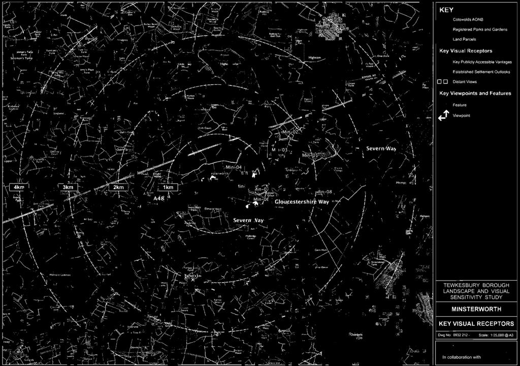
153

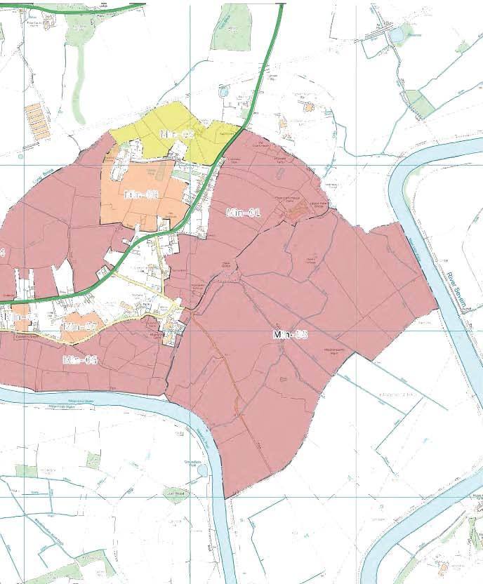

154
155
156 Settlement Name: Settlement Type Land Assessment Parcel Reference: Landscape Character Context National Character Area County Character Area Cotswolds AONB Character Area Natural Elements Landform Tree Cover Water Environment Cultural Elements Land Use Enclosure Pattern Field Boundaries Time Depth Existing Settlement Form Existing Settlement Edge Landscape Quality / Condition Representative of typical character Intactness State of individual elements Tranquility Noise Sources Level of movement and activity Minsterworth Service Village Min-01 NCA 106 Severn and Avon Vales SV5B - Ashleworth, Tirley and Forthampton Vale - (Unwooded Vale) Sloping Mature field and hedge trees (Oak and Ash) Drains and ponds Pasture Irregular field pattern with medium scale fields Strong hedges Strong Beyond eastern edge of village Predominantly rear elevations and garden fences. Large single property Yes Yes Good A48 Low Mitigation / Enhancement Potential This is an open, pastoral landscape with few mitigation opportunities Landscape Character Summary This land assessment parcel occupies sloping ground between the river floodplain and the edge of Minsterworth. It is characterised by pastures enclosed by mature hedgerows with abundant hedgerow trees and occasional mature field trees. It has a distinct south easterly aspect towards the river. Minsterworth occupies a distinct ridge. These slopes are distinctly separate from the village. The character sensitivity to new residential development is driven mainly by the openness and the extent to which the existing character reflects the open countryside on these exposed slopes. Judgment as to Landscape Character Sensitivity
157 Visibility Key Visual Receptors A48 Properties in Minsterworth Local Footpaths Severn Way Trunk Road Individual Residents Local Recreation Valued Recreation Resource Sensitivity Low Visual Context and Prominence This land assessment parcel occupies sloping and exposed slopes between the river and the settlement edge on a distinct ridge. It is exposed in views from the east including the wider vale, the River Severn and the Severn Way. Mitigation / enhancement Potential There are limited opportunities to mitigate views of residential development on this open and exposed site. Visual Summary This is an exposed, sloping landscape occupying rising ground overlooking the Severn Vale and the River Severn. The river follows a southward meander at this point taking it further away from Minsterworth. The visual sensitivity of this land assessment parcel is mitigated somewhat because views from the valued recreational route are at some distance. Judgment as to Visual Sensitivity
158 Settlement Name: Settlement Type Land Assessment Parcel Reference: Landscape Character Context National Character Area County Character Area Cotswolds AONB Character Area Natural Elements Landform Tree Cover Water Environment Cultural Elements Land Use Enclosure Pattern Field Boundaries Time Depth Existing Settlement Form Existing Settlement Edge Landscape Quality / Condition Representative of typical character Intactness State of individual elements Tranquility Noise Sources Level of movement and activity Minsterworth Service Village Min-02 NCA 106 Severn and Avon Vales SV5B - Ashleworth, Tirley and Forthampton Vale - (Unwooded Vale) Rolling Hedge trees N/A Pastures, paddocks and caravan park / storage Irregular medium scale Hedges Moderate Beyond northern edge Isolated farms and caravan parks / stores No, heavily influenced by caravans No, numerous character detractors Poor A48 Low Mitigation / Enhancement Potential This land assessment parcel is in poor condition with numerous detracting elements. There is potential for enhancement. Landscape Character Summary The character of this land assessment parcel is heavily influenced by caravan parks and storage yards that have developed around agricultural buildings. This is a landscape in decline with rough pastures and horse paddocks surrounding utilitarian compounds containing caravans, sheds and equipment. Judgment as to Landscape Character Sensitivity Low
159 Visibility Key Visual Receptors A48 Properties in Minsterworth Local Footpaths Trunk Road Individual Residents Local Recreation Sensitivity Low Visual Context and Prominence This land assessment parcel is visible from the A48, although it is not prominent. It does play a role in providing the visual setting for Hygrove House, although not to the main house frontage. Mitigation / enhancement Potential There are numerous visual detractors in this land assessment parcel associated with current uses. There are opportunities for enhancement. Visual Summary This land assessment parcel is not prominent in views from local or more distant vantages. It is heavily influenced by a number of visual detractors including utilitarian buildings and caravan parks / storage. This parcel does have a role to play in providing the visual setting for Hygrove House. It is also well removed from the northern end of the village. It is sensitive to the perception of sprawl and extending an already extended village. Judgment as to Visual Sensitivity
160 Settlement Name: Settlement Type Land Assessment Parcel Reference: Landscape Character Context National Character Area County Character Area Cotswolds AONB Character Area Natural Elements Landform Tree Cover Water Environment Cultural Elements Land Use Enclosure Pattern Field Boundaries Time Depth Existing Settlement Form Existing Settlement Edge Landscape Quality / Condition Representative of typical character Intactness State of individual elements Tranquility Noise Sources Level of movement and activity Minsterworth Service Village Min-03 NCA 106 Severn and Avon Vales SV5B - Ashleworth, Tirley and Forthampton Vale - (Unwooded Vale) Rolling Hedge trees, parkland field trees and avenue plantings. Ornamental pond Pastures (unused) Irregular medium scale Mature hedges Strong Lies between wayside settlement along the A48 and Hygrove House Dominated by Hygrove House Distinctive former parkland setting Yes There is evidence of decline and neglect. A48 Low Mitigation / Enhancement Potential There is evidence of declining landscape condition. There are opportunities for enhancement. Landscape Character Summary This land assessment parcel occupies the ridge top around the prominent Hygrove House. There is evidence of a former parkland setting with avenue trees along the approaches to the house and mature parkland trees. This land assessment parcel is clearly closely associated with Hygrove House and provides a distinctive setting to the front of the house. There is a sense of declining landscape condition due to a lack of management. The character sensitivity here derives from the close association with Hygrove House and the remnant parkland setting, despite the current declining condition. Judgment as to Landscape Character Sensitivity
161 Visibility Key Visual Receptors A48 Properties in Minsterworth Local Footpaths Hygrove House Trunk Road Individual Residents Local Recreation Vacant residence, Heritage asset Sensitivity Low Visual Context and Prominence This land assessment parcel occupies a ridge top position as the foreground setting to Hygrove House. The land assessment parcel is prominent in views from the A48 through Minsterworth. Mitigation / enhancement Potential There is evidence of decline (including the unused Hygrove House). There are clearly opportunities for enhancement. Visual Summary This land assessment parcel is visible from the A48 through Minsterworth and forms the important foreground setting to Hygrove House. The land assessment parcel has a formality and a parkland character associated with the house. The key visual sensitivity relates to the prominence of this land assessment parcel on an elevated position and the role it plays in creating a grand setting for Hygrove House. There is an important relationship between the historic village core down by the river and Hygrove House. They are linked by the prominent ridge that the A48 follows. Hygrove House occupies a plateau at the highest point of the ridge. Judgment as to Visual Sensitivity
162 Settlement Name: Settlement Type Land Assessment Parcel Reference: Landscape Character Context National Character Area County Character Area Cotswolds AONB Character Area Natural Elements Landform Tree Cover Water Environment Cultural Elements Land Use Enclosure Pattern Field Boundaries Time Depth Existing Settlement Form Existing Settlement Edge Landscape Quality / Condition Representative of typical character Intactness State of individual elements Tranquility Noise Sources Level of movement and activity Minsterworth Service Village Min-04 NCA 106 Severn and Avon Vales SV5B - Ashleworth, Tirley and Forthampton Vale - (Unwooded Vale) Sloping Sparse trees Long Brook Pasture and Arable Irregular with medium and large scale enclosures Hedges Moderate Lies beyond the A48 to the north of the wayside settlement Limited wayside settlement to the north of the A48 Yes (rolling vale) Yes Good A48 Low Mitigation / Enhancement Potential This is an open, rolling pastoral landscape with little potential for mitigation Landscape Character Summary This land assessment parcel occupies the north facing slopes of the distinctive ridge linking the historic village core by the river to Hygrove House. It supports open pastures with a distinct outlook to the north and west. The northerly outlook and the physical separation from the village by the A48 give a strong sense that this is open countryside. There are limited encroachments north of the A48, particularly to the south of this long linear village. Here, only the village hall and playing fields cross the road. The character sensitivity of this land assessment parcel to new residential development results from the distinct openness to the north of the A48 and the relative lack of influence from the settlement edge. Judgment as to Landscape Character Sensitivity
163 Visibility Key Visual Receptors A48 Properties in Minsterworth Local Footpaths Hygrove House Trunk Road Individual Residents Local Recreation Residence (vacant) and heritage asset Sensitivity Low Visual Context and Prominence This land assessment parcel is prominent in views from the north due to the orientation of the slopes. It is prominent in views from the A48 and distinctive because of its openness. It is prominent too because it is distinctly separate from the village. Mitigation / enhancement Potential Limited potential for mitigation. Visual Summary This is an open landscape occupying the north facing slopes of a distinct ridge. The existing settlement for the most part is tucked below the ridge line on the south facing slopes. There is little precedent for residential development here. There are open and distant views from the A48 across this land assessment parcel. Visual receptors include motorists on the A48, Hygrove House The visual sensitivity of this land assessment parcel stems form its prominence in views from the A48 and the relative lack of precedence for residential development in these northerly views. Judgment as to Visual Sensitivity
164 Settlement Name: Settlement Type Land Assessment Parcel Reference: Landscape Character Context National Character Area County Character Area Cotswolds AONB Character Area Natural Elements Landform Tree Cover Water Environment Cultural Elements Land Use Enclosure Pattern Field Boundaries Time Depth Existing Settlement Form Existing Settlement Edge Landscape Quality / Condition Representative of typical character Intactness State of individual elements Tranquility Noise Sources Level of movement and activity Minsterworth Service Village Min-05 NCA 106 Severn and Avon Vales SV5B - Ashleworth, Tirley and Forthampton Vale - (Unwooded Vale) Flat (Behind flood embankment) Abundant garden trees and orchards River Severn Orchards and gardens Irregular with small scale enclosures Assorted domestic hedges and fences Strong Intimate landscape between the village core and the river Scattered houses and church along the river frontage. A domestic landscape heavily influenced by settlement Yes Good N/A Low Mitigation / Enhancement Potential There are few opportunities for mitigation or enhancement in this distinct land assessment parcel. Landscape Character Summary This is an intimate landscape comprising some pasture, orchards and domestic gardens along the River Severn. This land assessment parcel provides a distinctive relationship between the historic village core and the river and therefore provides an important setting to the village. Whilst this landscape is essentially domestic, it provides important separation between the eclectic houses and the river bank. The orchards are an important and valued local landscape characteristic in their own right. Judgment as to Landscape Character Sensitivity
165 Visibility Key Visual Receptors Sensitivity Properties in Minsterworth Local Footpaths Severn Way and the River Severn Individual Residents Local Recreation Valued Recreation Visual Context and Prominence This land assessment parcel represents a number of important open spaces that create a unique and distinctive visual setting for the village from the River Severn and the Severn Way. This land assessment parcel is well screened from most local views and more distant views. The judgment about the visual sensitivity to new residential development here is based upon the visual setting these spaces provide to the village from the river Mitigation / enhancement Potential Limited potential for mitigation. Visual Summary This is an intimate landscape set between the river Severn and the settlement edge at the historic heart of the village. It is largely domestic with gardens and orchards. It is not prominent from the road network, it is however prominent from the River Severn and is important in providing the setting to the village. New development here would be at odds with a long established and characteristic settlement pattern and would adversely affect the relationship between the village and the river. It would be prominent from the Severn Way. Judgment as to Visual Sensitivity
166 Settlement Name: Settlement Type Land Assessment Parcel Reference: Landscape Character Context National Character Area County Character Area Cotswolds AONB Character Area Natural Elements Landform Tree Cover Water Environment Cultural Elements Land Use Enclosure Pattern Field Boundaries Time Depth Existing Settlement Form Existing Settlement Edge Landscape Quality / Condition Representative of typical character Intactness State of individual elements Tranquility Noise Sources Level of movement and activity Minsterworth Service Village Min-06 NCA 106 Severn and Avon Vales SV5B - Ashleworth, Tirley and Forthampton Vale - (Unwooded Vale) Flat Abundant orchards and hedge trees River Severn Pastures and grazed orchards Irregular with small and medium scale enclosures Hedges with hedge trees Strong Lies between the river and a distinct settlement boundary at Church Lane Scattered wayside houses along Church Lane Distinctive local landscape Yes Good N/A Low Mitigation / Enhancement Potential This is a flat and distinctive landscape free from development with no mitigation potential. Landscape Character Summary This landscape is the river floodplain. It is locally characterised by small to medium scale enclosures contained within robust hedges with abundant hedgerow trees and trees associated with watercourses. These are predominantly small pastures, but there are occasional orchards. This combination is locally distinctive and provides a characteristic relationship between the village and the river. The judgment about character sensitivity to new residential development here is based upon the local distinctiveness of this landscape, its strength of character and its condition. Judgment as to Landscape Character Sensitivity
167 Visibility Key Visual Receptors Sensitivity Properties on Church Lane Local Footpaths Severn Way and the River Severn Individual Residents Local Recreation Valued Recreation Resource Visual Context and Prominence This land assessment parcel lies beyond a distinct settlement boundary at Church Lane. It is not prominent in the sense that it is clearly and widely visible. It does however provide an important visual setting to the village from the Severn Way and the River Severn. Mitigation / enhancement Potential This land assessment parcel is distinctive and unspoilt. There are limited opportunities for mitigation Visual Summary This land assessment parcel is not widely visible from surrounding vantages. It is however clearly visible from Church Lane and from the River Severn and the Severn Way. From these vantages, it represents an unspoilt and distinctive visual setting to the village. The judgment as to the visual sensitivity of this parcel to new residential development stems from the lack of visual detractors and the distinctiveness of views across and into it. It also recognises the recreational value of the River Severn and the Severn Way Judgment as to Visual Sensitivity
168 Settlement Name: Settlement Type Land Assessment Parcel Reference: Landscape Character Context National Character Area County Character Area Cotswolds AONB Character Area Natural Elements Landform Tree Cover Water Environment Cultural Elements Land Use Enclosure Pattern Field Boundaries Time Depth Existing Settlement Form Existing Settlement Edge Landscape Quality / Condition Representative of typical character Intactness State of individual elements Tranquility Noise Sources Level of movement and activity Minsterworth Service Village Min-07 NCA 106 Severn and Avon Vales SV5B - Ashleworth, Tirley and Forthampton Vale - (Unwooded Vale) Sloping Predominantly trees in adjacent gardens N/A Pastures and paddocks scale rectilinear enclosures Mainly post and rail fences Moderate to low Remnant pastures left between wayside, linear settlement. Adjoins Isolated dwellings Locally distinctive and influenced by settlement Yes Good N/A Low Mitigation / Enhancement Potential The influence of existing settlement surrounding these pastures does offer some mitigation potential Landscape Character Summary These open pastures occupy rising ground overlooking the floodplain, which stretches south from Church Lane. They are enclosed by residential properties and small farmsteads. These pastures are heavily influenced by the surrounding settlement and support post and rail fences. They do contribute to the existing character of this village. Away from the historic core around the church, Minsterworth is an eclectic mix of wayside settlement, predominantly between the A48 and Church Lane. These pastures help to reinforce the sense of ad-hoc and incremental development of the village. They are the spaces left in the village form. They are clearly distinct from the floodplain that stretches away to the south of Church Lane. Judgment as to Landscape Character Sensitivity
169 Visibility Key Visual Receptors Sensitivity Properties on Church Lane Local Footpaths Church Lane Individual Residents Local Recreation Local Road Visual Context and Prominence This land assessment parcel (or parcels) occupy slightly higher ground, overlooking the floodplain. Due to the abundance of trees and hedges between Church Lane and the river, they are not prominent in views from the south (including those from the river and The Severn Way). This land assessment parcel is visible only from Church Lane and surrounding residential properties Mitigation / enhancement Potential Abundance of trees offer some mitigation potential. Visual Summary These pastures and paddocks occupy sloping ground above the floodplain. They are not prominent in views from the south due to an abundance of trees and hedges. They are surrounded by domestic land uses and heavily influenced by residential properties and small farmsteads. The judgment as to the visual sensitivity of this land assessment parcel is elevated somewhat by the fact that these relic pastures provide some important gaps in the village form that reflect the ad hoc evolution of this predominantly wayside settlement. Judgment as to Visual Sensitivity
170 Settlement Name: Settlement Type Land Assessment Parcel Reference: Landscape Character Context National Character Area County Character Area Cotswolds AONB Character Area Natural Elements Landform Tree Cover Water Environment Cultural Elements Land Use Enclosure Pattern Field Boundaries Time Depth Existing Settlement Form Existing Settlement Edge Landscape Quality / Condition Representative of typical character Intactness State of individual elements Tranquility Noise Sources Level of movement and activity Minsterworth Service Village Min-08 NCA 106 Severn and Avon Vales SV5B - Ashleworth, Tirley and Forthampton Vale - (Unwooded Vale) Flat Vale Mature trees mainly associated with watercourses and drains River Severn and field drains Arable Large scale irregular enclosures Hedges and ditches Moderate to strong Beyond settlement to the south east Adjoins Isolated farm (cross Farm) Characteristic vale Yes Good N/A Low Mitigation / Enhancement Potential A key characteristic here is the openness of the landscape. There is no mitigation potential for new residential development. Landscape Character Summary This is a wide open and expansive vale landscape occupying the fertile floodplain of the River Severn. It extends from the base of the distinctive ridgeline south and west to the river (within a distinct meander). This is a distinctive landscape that is free from development. New development here would be at odds with the age old relationship between Minsterworth the River Severn and local topography. Judgment as to Landscape Character Sensitivity
171 Visibility Key Visual Receptors Local Footpaths River Severn and The Severn Way Local Recreation Valued Recreation Resource Sensitivity Visual Context and Prominence This land assessment parcel is prominent in the sense that it occupies land well beyond the settlement boundary on low lying and overlooked floodplain. Mitigation / enhancement Potential There are no opportunities to mitigate new residential development on this prominent floodplain. Visual Summary This is a prominent and open landscape occupying low lying floodplain in a distinctive meander n the River Severn. As a consequence of its prominence, its openness and the complete freedom from development, the visual sensitivity to new residential development here is considered to be high. Judgment as to Visual Sensitivity
172
173 Norton (Service Village)
174
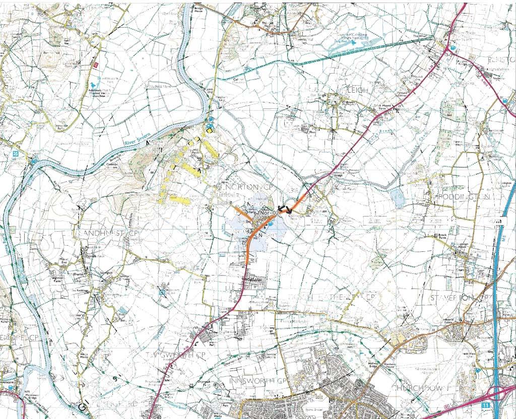
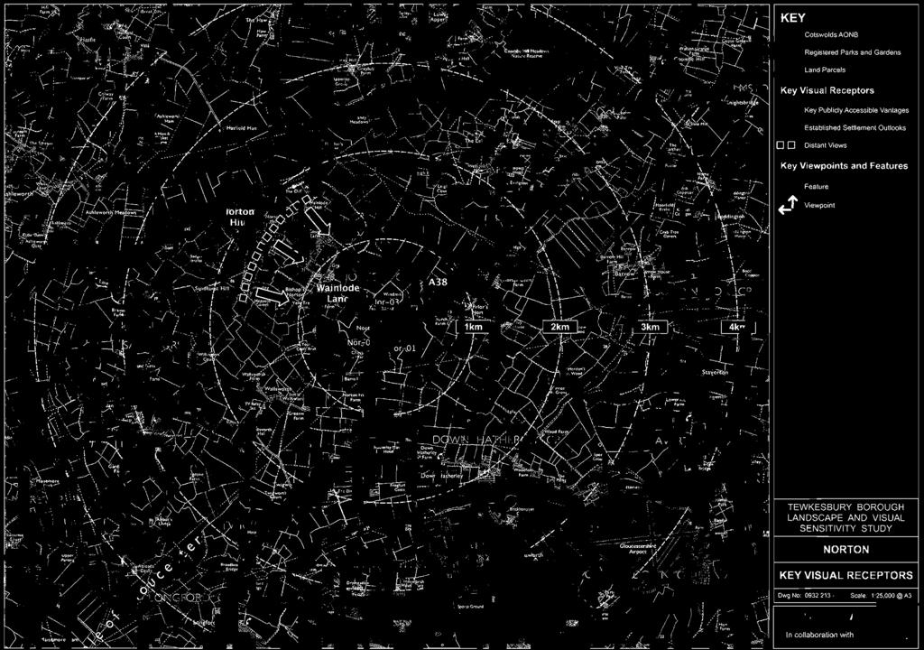
175


176
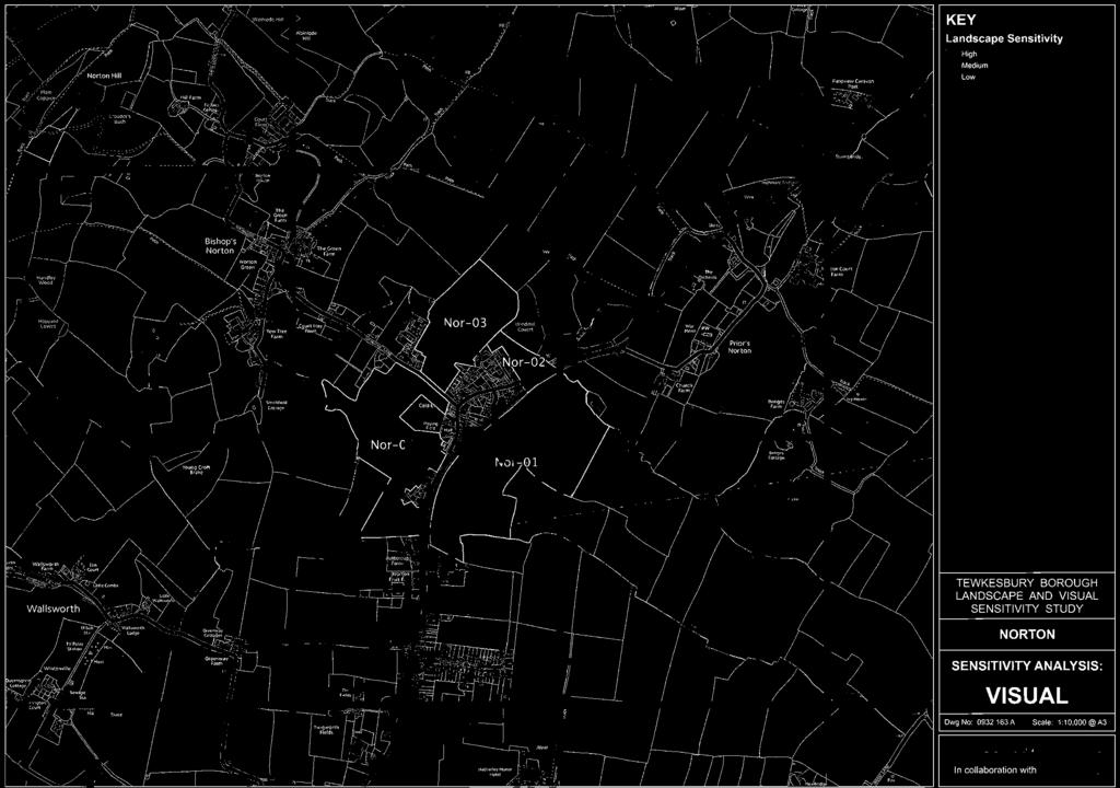
177
178 Settlement Name: Settlement Type Land Assessment Parcel Reference: Landscape Character Context National Character Area County Character Area Cotswolds AONB Character Area Natural Elements Landform Tree Cover Water Environment Cultural Elements Land Use Enclosure Pattern Field Boundaries Time Depth Existing Settlement Form Existing Settlement Edge Landscape Quality / Condition Representative of typical character Intactness State of individual elements Tranquility Noise Sources Level of movement and activity Norton Service Village Nor-01 NCA 106 Severn and Avon Vales SV6B - Vale of Gloucester - (Settled Unwooded Vale) Rolling Vale Sparse N/A Arable Large Scale Irregular field pattern Managed hedges Low Set beyond the A38. Distinctly separate from the village Filtered by vegetation, low density edge beyond the A38 Yes Yes Moderate A38 Low Mitigation / Enhancement Potential There is limited potential for mitigation. There is a distinct settlement edge at the A38. This is an open landscape free from development Landscape Character Summary This land assessment parcel is characterised by a rolling arable landscape with distinctive distant views to the south and east. The A38 marks a distinct boundary between this open and expansive landscape and the more enclosed, vegetated landscape with more marked topography of Windmill Hill to the north west. A strong characteristic of Norton is that it does not encroach beyond the A38 into the open arable landscape. This strength of character and well defined settlement edge is the main source of landscape sensitivity to new residential development here. Judgment as to Landscape Character Sensitivity
179 Visibility Key Visual Receptors A38 Trunk Road Local footpaths Trunk Road Local Recreation Sensitivity Low Visual Context and Prominence This land assessment parcel is prominent in the sense that it is highly visible from the A38 and is characteristically free from development. It is also prominent in the sense that this land assessment parcel is clearly separate and visually isolated from the existing village. Mitigation / enhancement Potential The openness and lack of precedent development in views mean that there are no opportunities for mitigation Visual Summary This is a wide open landscape within a gently rolling vale with low hedges. There are distinctive long distance views to the south and east away from the A38 and the edge of Norton. Whilst visual receptors are limited to the A38, local footpaths and some properties at the edge of the village, the judgment as to overall visual sensitivity of this land assessment parcel is influenced by its prominence and lack of visual influence from this or any other settlement. Development here would represent a significant change. Judgment as to Visual Sensitivity
180 Settlement Name: Settlement Type Land Assessment Parcel Reference: Landscape Character Context National Character Area County Character Area Cotswolds AONB Character Area Natural Elements Landform Tree Cover Water Environment Cultural Elements Land Use Enclosure Pattern Field Boundaries Time Depth Existing Settlement Form Existing Settlement Edge Landscape Quality / Condition Representative of typical character Intactness State of individual elements Tranquility Noise Sources Level of movement and activity Norton Service Village Nor-02 NCA 106 Severn and Avon Vales SV6B - Vale of Gloucester - (Settled Unwooded Vale) Sloping Robust mature hedges and adjacent to Windmill Covert (woodland) N/A Pasture Small scale Irregular Mature hedges, tree belts and woodland Strong Adjoins the eastern edge (abuts the side of two properties) The edge is defined by garden boundaries A specific character associated with Windmill Covert and Norton Yes Moderate A38 Low Mitigation / Enhancement Potential This is a robust and strong character with few detractors. Development here would adversely affect that character Landscape Character Summary Small scale, well enclosed pastures on the base slopes of Windmill Hill. The small enclosures are surrounded by mature hedges and woodland giving an intimate and enclosed character. There is some evidence of decline or neglect, particularly the dilapidated field buildings and ruderal vegetation. There is a strong time depth here. The judgment about landscape character sensitivity is based upon the strong, rural and historic character of the small enclosures and the lack of notable influences from the settlement edge. Judgment as to Landscape Character Sensitivity
181 Visibility Key Visual Receptors A38 Trunk Road Local footpaths Local Road Trunk Road Local Recreation Local Road Sensitivity Low Visual Context and Prominence This land assessment parcel, by virtue of its position and enclosure by robust hedge and tree cover, is not prominent. Mitigation / enhancement Potential The high degree of enclosure provides screening opportunities for new residential development. Visual Summary A visually isolated parcel of land consisting of small well enclosed fields. Sense of enclosure is provided by topography (Windmill Hill), mature hedges and Windmill Covert (Woodland) Local viewpoints are limited to the local road that skirts the land assessment parcel and local footpaths that cross it. The parcel appears fleetingly from the A38 but there are opportunities for appropriate and effective mitigation. Judgment as to Visual Sensitivity Low
182 Settlement Name: Settlement Type Land Assessment Parcel Reference: Landscape Character Context National Character Area County Character Area Cotswolds AONB Character Area Natural Elements Landform Tree Cover Water Environment Cultural Elements Land Use Enclosure Pattern Field Boundaries Time Depth Existing Settlement Form Existing Settlement Edge Landscape Quality / Condition Representative of typical character Intactness State of individual elements Tranquility Noise Sources Level of movement and activity Norton Service Village Nor-03 NCA 106 Severn and Avon Vales SV6B - Vale of Gloucester - (Settled Unwooded Vale) Flat Isolated tree groups and hedge trees N/A Pasture and paddock Irregular field pattern with small scale to medium scale fields Hedges (overgrown and gappy in places. Broken post and rail fencing. Moderate Between modern village edge (Mandalay Drive) and barn conversions Linear modern development and recent barn conversions Isolated character influenced by settlement Moderate Evidence of decline N/A Low Mitigation / Enhancement Potential There are opportunities to strengthen enclosure using hedges and tree groups. There is precedent influence from the settlement edge and a sense of decline Landscape Character Summary An area supporting small scale and medium scale pastures and paddocks contained within mature hedges and tree groups. The hedges are overgrown and gappy in places. Elsewhere there are broken post and rail fences and unsightly equestrian fencing. There are a number of unused farm buildings. The land assessment parcel suggests an air of decline. It sits between the 20th century settlement edge which is formed by rear elevations and garden boundaries of properties on Mandalay Drive, and a recent development of new build properties and barn conversions at Cook Lane, which is distinctly residential in character. This land assessment parcel is influenced by settlement, is in decline and does not in itself support distinctive features. The land assessment parcel does create a sense of separation between Norton and the isolated development at Cook Lane. This remains a sensitivity Judgment as to Landscape Character Sensitivity
183 Visibility Key Visual Receptors Wainlode Lane Properties in Norton and Cook Lane Local Footpath Local Road Individual Residents Local Recreation Sensitivity Visual Context and Prominence This land assessment parcel is visible from some local vantages but is not prominent Mitigation / enhancement Potential Visual detractors and opportunities for enclosure provide mitigation opportunities. Visual Summary A land assessment parcel that is not prominent that lies between the north western edge of Norton and new development at Cook Lane. Views into and across this parcel are fragmented by hedges and trees. Where views are available such as through gateways, there are visual detractors including dilapidated buildings and fences, equestrian activity and the influence of existing settlement. Norton and development at Cook Lane exert a strong visual influence on this land assessment parcel and there is a sense that it is enclosed by development. Visual sensitivity to new residential development increases across the land assessment parcel to the north away from the influence of the existing village. There is also a residual sensitivity relating to the perception of a gap between Norton and the outlying development / barn conversions at Cook Lane. This sensitivity might be addressed by detailed design/ siting. Judgment as to Visual Sensitivity Low
184 Settlement Name: Settlement Type Land Assessment Parcel Reference: Landscape Character Context National Character Area County Character Area Cotswolds AONB Character Area Natural Elements Landform Tree Cover Water Environment Cultural Elements Land Use Enclosure Pattern Field Boundaries Time Depth Existing Settlement Form Existing Settlement Edge Landscape Quality / Condition Representative of typical character Intactness State of individual elements Tranquility Noise Sources Level of movement and activity Norton Service Village Nor-04 NCA 106 Severn and Avon Vales SV6B - Vale of Gloucester - (Settled Unwooded Vale) Flat Sparse with distinctive poplars along Cox's Brook Cox's Brook to western edge. Arable Irregular field pattern with medium to large scale fields Low, trimmed hedges Low Lies to the west beyond a fragmented and filtered settlement edge Lies beyond the school, playing fields and agricultural buildings Yes Yes Good A38 Low Mitigation / Enhancement Potential There is some precedent influence from settlement at the edge of this land assessment parcel however it is essentially an open vale landscape with little opportunity to mitigate. Landscape Character Summary An arable landscape on the flat, open vale. There are characteristic expansive views to the north west to higher ground at Norton Hill. Tree groups, particularly those associated with Cox's Brook, form prominent and distinctive landmarks. This land assessment parcel is influenced by the settlement edge of Norton, however this influence diminishes rapidly with distance. The landscape sensitivity to new residential development is low along the existing settlement edge where existing visual influences are strong. The land assessment parcel has a sensitivity to new development that does not respect the linear form of the settlement or that protrudes into open countryside. Judgment as to Landscape Character Sensitivity
185 Visibility Key Visual Receptors Wainlode Lane Properties in Norton and Cook Lane Local Footpath A38 Local Road Individual Residents Local Recreation Trunk Road Sensitivity Low Visual Context and Prominence This land assessment parcel is visible from local vantages, but is not prominent Mitigation / enhancement Potential There are limited opportunities for mitigation, however there is some precedent visual influence from the village at the edge. Visual Summary An open vale landscape with low hedges. The and parcel is visible from local vantages in the immediate vicinity, but it is not prominent. Robust roadside hedges and existing development obscure many views from the local road network. The parcel is crossed by a local footpath and there are distinctive, long distance views across the vale to Norton Hill in the North west. Visual sensitivities here include the perception of sprawl across the vale to the north and west. Judgment as to Visual Sensitivity
186
187 Shurdington (Service Village)
188
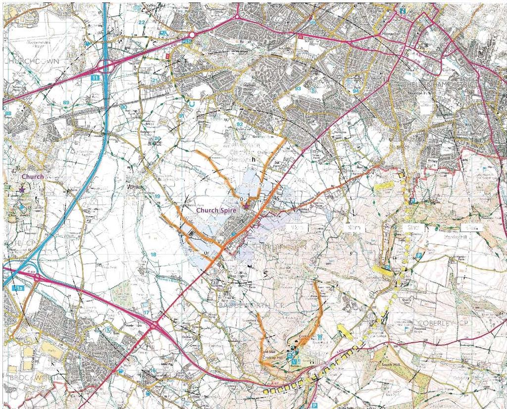

189


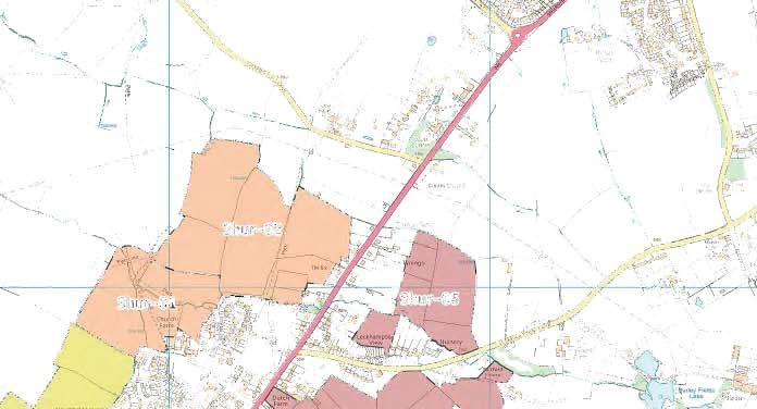
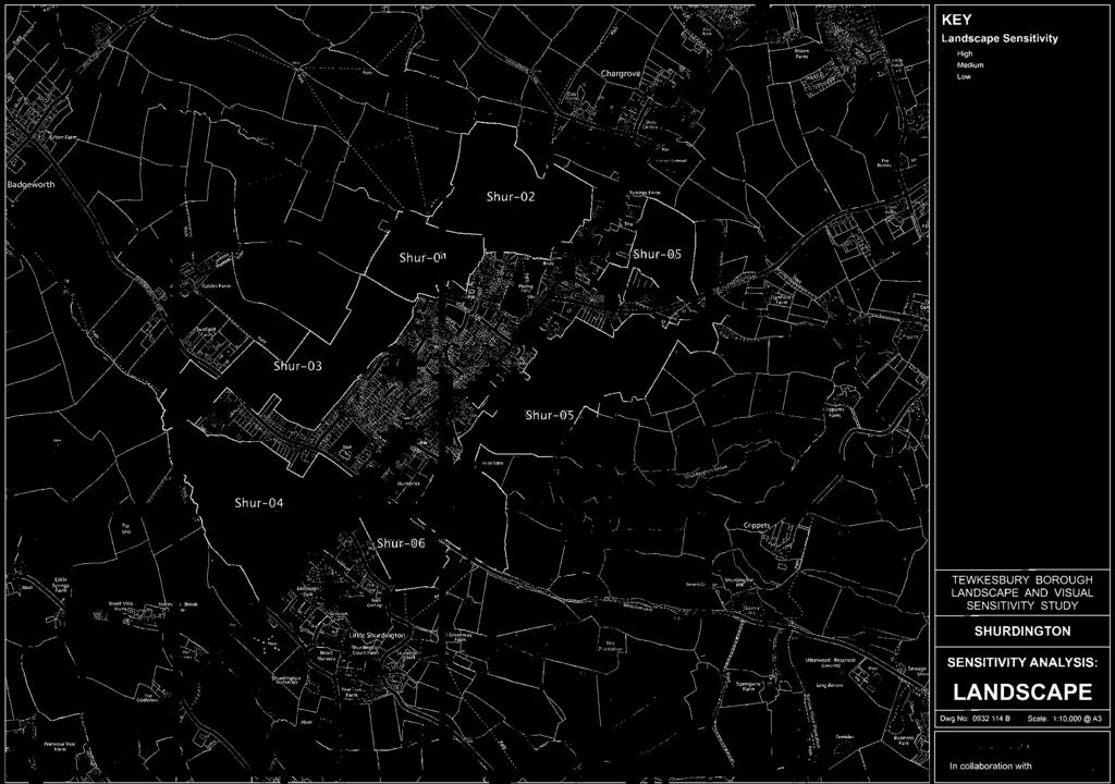
190

191
192 Settlement Name: Settlement Type Land Assessment Parcel Reference: Landscape Character Context National Character Area County Character Area Cotswolds AONB Character Area Natural Elements Landform Tree Cover Water Environment Cultural Elements Land Use Enclosure Pattern Field Boundaries Time Depth Existing Settlement Form Existing Settlement Edge Landscape Quality / Condition Representative of typical character Intactness State of individual elements Tranquility Noise Sources Level of movement and activity Shurdington Service Village Shur-01 NCA 106 Severn and Avon Vales SV6B - Vale of Gloucester - (Settled Unwooded Vale) Gently Undulating Abundant and mature trees in hedges, as tree belts and individually Ham Brook and springs Paddocks, pastures and rough ground Small scale well enclosed. Strong mature hedges and tree belts Strong Beyond the north west edge of the village Adjacent to the church, unsympathetic farm buildings and residential Locally distinctive Some disturbed waste ground and equestrian clutter Good N/A Low Mitigation / Enhancement Potential There are opportunities for enhancement. Landscape Character Summary There is a very robust and ancient structure to this land assessment parcel formed by small enclosures, mature hedges and abundant tree cover, especially associated with the brook. There is also a strong relationship with the distinctive village church. Within this strong landscape there are numerous detracting elements including unsympathetic and imposing farm buildings and clutter associated with equestrian activity. This heavily treed land assessment parcel supports a number of paddocks and pastures and an area of rough ground used for burning farm waste. This was possibly once a construction compound for the pipeline that crosses the brook at this point. The influences from the adjacent settlement are predominantly adverse, with imposing steel sheds and high steel fences and an unsympathetic boundary with 20th century development. The church and churchyard serve as a reminder of a once more sympathetic relationship. There is some evidence of late ridge and furrow Field trees to the north of this land assessment parcel are "stag head" and in decline. Judgment as to Landscape Character Sensitivity
193 Visibility Key Visual Receptors Sensitivity Cheltenham Circular Footpath Valued Recreation Church Lane Local Road Local footpaths Local Recreation Properties on School and Church Lane Individual Residents Visual Context and Prominence This land assessment parcel sits to the north west of the village and is not prominent in local or distant views Mitigation / enhancement Potential Small scale enclosures offer potential for local screening and abundant visual detractors offer opportunities for enhancement. Visual Summary This land assessment parcel is not prominent from the surrounding road network. It is crossed by a number of footpaths including the Cheltenham Circular Footpath long distance route. It is overlooked by a number of properties on Church Lane and School Lane. Within the enclosed paddocks and pastures there are numerous visual detractors associated with unsympathetic boundary treatments, vehicle storage and equestrian activity, however, from beyond its boundary, the robust tree cover coalesces to cover the blemishes and presents a fine view of Shurdington from the north west on the Cheltenham Circular Footpath. From here the distinctive church spire rises out of the trees and is seen against Leckhampton and Crickley Hills in the AONB. This represents an important and characteristic view of the AONB from the Vale of Gloucester. Judgment as to Visual Sensitivity
194 Settlement Name: Settlement Type Land Assessment Parcel Reference: Landscape Character Context National Character Area County Character Area Cotswolds AONB Character Area Natural Elements Landform Tree Cover Water Environment Cultural Elements Land Use Enclosure Pattern Field Boundaries Time Depth Existing Settlement Form Existing Settlement Edge Landscape Quality / Condition Representative of typical character Intactness State of individual elements Tranquility Noise Sources Level of movement and activity Shurdington Service Village Shur-02 NCA 106 Severn and Avon Vales SV6B - Vale of Gloucester - (Settled Unwooded Vale) Gently Undulating Mature trees in hedges, (Oak and Ash) Ham Brook and drains Pasture and arable Large scale. Irregular enclosures Mature hedges with hedge trees Moderate Lies to the north of Shurdington Adjacent dispersed wayside settlement beyond Ham Brook Typical of vale Yes Good N/A Low Mitigation / Enhancement Potential Some smaller enclosures close to the settlement edge offer some screening potential Landscape Character Summary Open pastures and some arable surrounded by predominantly low hedges with hedge trees. There is some influence from the settlement edge in the form of domestic gardens (some large) and dispersed, low density wayside settlement along Shurdington Road. To the south, this land assessment parcel is influenced by the Ham Brook and the robust tree belt. There is evidence of ridge and furrow within this predominantly open landscape. There is a sense of remoteness from the village, partly as a consequence of distance, but also the screening effect of vegetation along Ham Brook. Judgment as to Landscape Character Sensitivity
195 Visibility Key Visual Receptors Sensitivity Shurdington Road Local Road Local footpaths Local Recreation Residents on Shurdington Road Individual Residents Elevated vantages to the south east Various valued views Visual Context and Prominence This land assessment parcel is not prominent in views from the local road network. There are glimpsed views from Shurdington Road and from local footpaths. This land assessment parcel is prominent in the sense that it is visually remote from the settlement due to the strong visual boundary created by Ham Brook and associated tree cover. Mitigation / enhancement Potential Some local enclosures offer screening potential, however the sense of openness beyond Ham Brook cannot be mitigated. Visual Summary This land assessment parcel lies to the north of Shurdington beyond Ham Brook. The brook and the associated strong tree belt provides a robust settlement edge to the north. Beyond here there is little enclosure from low hedges and new development would be conspicuous. This effect would be most noticeable from elevated vantages such as from Leckhampton Hill and Crickley Hill. This land assessment parcel is sensitive to development that might alter the settlement form of Shurdington or create the perception of a prominent intrusion beyond a well established and natural settlement boundary to the north. Judgment as to Visual Sensitivity
196 Settlement Name: Settlement Type Land Assessment Parcel Reference: Landscape Character Context National Character Area County Character Area Cotswolds AONB Character Area Natural Elements Landform Tree Cover Water Environment Cultural Elements Land Use Enclosure Pattern Field Boundaries Time Depth Existing Settlement Form Existing Settlement Edge Landscape Quality / Condition Representative of typical character Intactness State of individual elements Tranquility Noise Sources Level of movement and activity Shurdington Service Village Shur-03 NCA 106 Severn and Avon Vales SV6B - Vale of Gloucester - (Settled Unwooded Vale) Flat Garden trees to edge and field hedge trees Springs and drains Pasture with some arable scale broadly rectilinear Field and garden hedges and post and wire fences Weak Lies to north west beyond distinct settlement edge Linear edge visually intrusive especially abundant conservatories Typical of pastoral vale but heavily influenced by settlement Yes Good N/A Low Mitigation / Enhancement Potential There is a strong influence on character from the settlement edge which adjoins it on two sides. Landscape Character Summary This is a landscape of open pastures contained within gappy and low hedges with occasional hedge trees and post and wire fences. There is a strong influence on the character from the adjoining residential edge. It is a harsh linear edge comprising rear gardens with a variety of boundary treatments including hedges and close board fences. Predominantly dormer bungalows with an abundance of assorted white conservatories. Wide views across the vale to the west and to the high ground of the AONB to the east are characteristic Whilst the influence of the settlement is obviously strong here, this land assessment parcel remains sensitive to development that might have an inappropriate settlement form. It remains sensitive to prominent intrusion into the open vale landscape. Judgment as to Landscape Character Sensitivity Low
197 Visibility Key Visual Receptors Sensitivity Long distance views from the AONB Valued Recreation (AONB) Local footpaths Local Recreation Long distance views from Churchdown Hill Valued Recreation Adjoining residential properties Individual Residents Visual Context and Prominence This land assessment parcel is adjacent to a stark linear settlement edge. It is not prominent from local public vantages. It does feature in elevated views form the AONB and from Churchdown Hill. Development that is clearly unsympathetic to the existing settlement form would be prominent here. Mitigation / enhancement Potential Development should respect the general settlement form without prominent or notable intrusions into the vale that would be noticeable from elevated vantages. There is potential for enhancement of the existing settlement edge. Visual Summary An open pastoral landscape visible from local footpaths that cross it, residential properties that back onto it and from elevated vantages to the east in the AONB and to the west at Churchdown Hill. This land assessment parcel is well screened by existing settlement from the local road network although views are available from Badgeworth Lane. There are characteristic wide open views from this land assessment parcel to the vale, to Churchdown Hill and to the AONB. There is a strong visual influence from the settlement edge that adjoins this land assessment parcel on two sides. There is a distinctly linear edge characterised by the rear elevations of dormer bungalows, a variety of conservatories and various boundary treatments including hedges and timber fences. The edge is somewhat piecemeal. This land assessment parcel remains sensitive to the visual perception (locally and in more distant views) of sprawl and prominent encroachment onto the vale. Judgment as to Visual Sensitivity
198 Settlement Name: Settlement Type Land Assessment Parcel Reference: Landscape Character Context National Character Area County Character Area Cotswolds AONB Character Area Natural Elements Landform Tree Cover Water Environment Cultural Elements Land Use Enclosure Pattern Field Boundaries Time Depth Existing Settlement Form Existing Settlement Edge Landscape Quality / Condition Representative of typical character Intactness State of individual elements Tranquility Noise Sources Level of movement and activity Shurdington Service Village Shur-04 NCA 106 Severn and Avon Vales SV6B - Vale of Gloucester - (Settled Unwooded Vale) Flat Mature hedge trees especially along the brook Drains. Ditches Pasture, bee keeping and waste management Irregular Gappy hedges, robust tree belt to the north east Low Lies to the south west of the settlement Effectively screened to the north by tree belt. Business park to the east Uncharacteristic disturbed ground Poor condition (possibly former workings) Poor Waste management activity Moderate (Lorry and digger movements) Mitigation / Enhancement Potential This is a degraded landscape that is a product of former workings and current uses. There is potential for enhancement. Landscape Character Summary This pastoral landscape appears to be a relic of former workings. It is surrounded by hedges which are themselves fragmented and gappy. There are robust mature hedges and a tree belt to the edge of this land assessment parcel, in particular to the north east. Here it provides a strong screen to the settlement edge along Badgeworth Lane. The character of this land assessment parcel is heavily influenced by the current waste management activity taking place. There are characteristic wide open views to the vale and Churchdown Hill to the west and extensive views of the AONB to the east. The roofscape of the business park to the east of the A46 is apparent. Judgment as to Landscape Character Sensitivity Low
199 Visibility Key Visual Receptors Sensitivity Long distance views from the AONB Valued Recreation (AONB) Gloucestershire Way Valued Recreation Long distance views from Churchdown Hill Valued Recreation Local footpaths Local Recreation Adjoining residential properties Individual Residents Visual Context and Prominence This land assessment parcel is not prominent. It is visible from elevated vantages but appears as a continuation of the existing settlement form. Mitigation / enhancement Potential There is potential to enhance this land assessment parcel Visual Summary This is an open land assessment parcel heavily influenced by its previous use and by utilitarian uses at present. There is visual intrusion from waste management activity and storage containers, bunds and large sheds. The business park to the east of the A46 is also visible. This land assessment parcel is visible from elevated vantages in the AONB and at Churchdown Hill. This land assessment parcel remains sensitive to development that appears at odds with the existing settlement form. However, could be a natural continuation of the existing settlement into this parcel. Judgment as to Visual Sensitivity Low
200 Settlement Name: Settlement Type Land Assessment Parcel Reference: Landscape Character Context National Character Area County Character Area Cotswolds AONB Character Area Natural Elements Landform Tree Cover Water Environment Cultural Elements Land Use Enclosure Pattern Field Boundaries Time Depth Existing Settlement Form Existing Settlement Edge Landscape Quality / Condition Representative of typical character Intactness State of individual elements Tranquility Noise Sources Level of movement and activity Shurdington Service Village Shur-05 NCA 106 Severn and Avon Vales 18A - Vale of Gloucester Fringe - (Settled Unwooded Vale) Sloping Hedge Trees N/A Pasture and paddocks to small scale irregular Mature hedges Strong Lies to the east beyond the settlement on hill foots Muted glimpses of feathered settlement edge Characteristic of the AONB slopes Good Moderate (some tipping and intrusive equestrian activity) N/A Low Mitigation / Enhancement Potential Equestrian activity is making a mark on the character here with unsightly field tape. There are signs of decline particularly to the southern end of this land assessment parcel. Landscape Character Summary A distinctive land assessment parcel comprising the lower slopes of Leckhampton Hill at the very edge of the AONB. There is strong field enclosure provided by robust hedges with occasional hedge trees. Close to the settlement edge there is a strong domestic influence and a high degree of enclosure. Further up the slopes the influence of the settlement edge diminishes and wide open views across the vale prevail. The small scale enclosures and influence from the settlement edge provide some localised opportunities for appropriate new development, however, overall the character sensitivity of this land assessment parcel is high due to its role in creating the setting for the AONB. It is sensitive to development that encroaches onto these important hill slopes. Judgment as to Landscape Character Sensitivity
201 Visibility Key Visual Receptors Sensitivity Long distance views from the AONB Valued Recreation (AONB) Gloucestershire Way Valued Recreation Resource Long distance views from Churchdown Hill Valued Recreation Local footpaths Local Recreation Adjoining residential properties Individual Residents Visual Context and Prominence This land assessment parcel is prominent (albeit prominence diminishes down the slopes) Mitigation / enhancement Potential Any local development should be low down adjacent to the existing settlement edge. Visual Summary This sloping pastoral landscape has a distinct aspect to the west. Close to the existing settlement edge, views are contained by buildings and vegetation. Further east and up the slopes of Leckhampton Hill views spill out to the west across the vale and to Churchdown Hill. There are local opportunities for development immediately adjacent to the existing settlement edge without them appearing prominent or at odds with the existing linear edge. This land assessment parcel is highly sensitive to development that might intrude on the slopes of the AONB in views from the west and that might adversely alter the established settlement pattern. This land assessment parcel is critical in contributing to the setting to the AONB in views from the west. Judgment as to Visual Sensitivity
202 Settlement Name: Settlement Type Land Assessment Parcel Reference: Landscape Character Context National Character Area County Character Area Cotswolds AONB Character Area Natural Elements Landform Tree Cover Water Environment Cultural Elements Land Use Enclosure Pattern Field Boundaries Time Depth Existing Settlement Form Existing Settlement Edge Landscape Quality / Condition Representative of typical character Intactness State of individual elements Tranquility Noise Sources Level of movement and activity Shurdington Service Village Shur-06 NCA 106 Severn and Avon Vales 18A - Vale of Gloucester Fringe - (Settled Unwooded Vale) Flat Open nursery land fringed to the east by mature parkland and garden trees N/A Nursery land enclosed to the east by hotel grounds and gardens to small scale irregular Various Strong Lies to the south east separating Shurdington from Little Shurdington Surrounded by commercial activities Distinctive garden landscape with open utilitarian nursery ground to the we Good Good N/A Low Mitigation / Enhancement Potential The nursery land is somewhat utilitarian. The Hotel to the east offers very little mitigation potential Landscape Character Summary A distinctive land assessment parcel comprising the mature gardens and grounds of The Greenway Hotel and utilitarian nursery land separating Shurdington from Little Shurdington. Judgment as to Landscape Character Sensitivity
203 Visibility Key Visual Receptors Sensitivity Long distance views from the AONB Valued Recreation (AONB) Gloucestershire Way Valued Recreation Resource Long distance views from Churchdown Hill Valued Recreation Local footpaths Local Recreation Hotel and grounds Individual Residents A46 Trunk road but with local traffic. Visual Context and Prominence This land assessment parcel is very effectively screened by surrounding hedges. It is not prominent. Mitigation / enhancement Potential Development should minimise visual intrusion onto the A46. Visual Summary This land parcel is effectively screened by a mature hedge from the A46 despite having a frontage with it. It occupies low-lying generally flat ground at the foot of the hills. It is not a prominent site either locally or in more distant, elevated views. The site does however serve to provide a sense of separation between Little Shurdington and Shurdington from the A46 Judgment as to Visual Sensitivity
204
205 Toddington and New Town (Service Village)
206


207

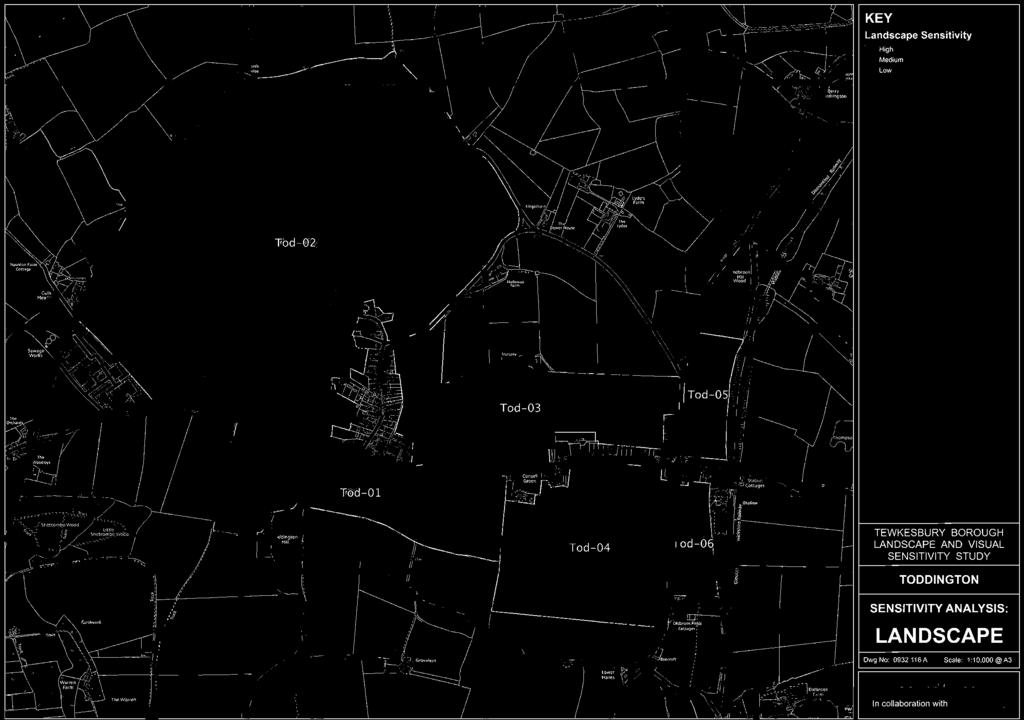
208
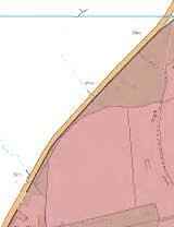

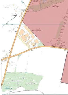
209
210 Settlement Name: Settlement Type Land Assessment Parcel Reference: Landscape Character Context National Character Area County Character Area Cotswolds AONB Character Area Natural Elements Landform Tree Cover Water Environment Cultural Elements Land Use Enclosure Pattern Field Boundaries Time Depth Existing Settlement Form Existing Settlement Edge Landscape Quality / Condition Representative of typical character Intactness State of individual elements Tranquility Noise Sources Level of movement and activity Toddington (including New Town) Service Village Tod-01 NCA 106 Severn and Avon Vales VE1A - Teddington and Greet Vale - (Unwooded Vale) Flat vale Tree groups and belts associated with watercourses. Mainly willow River Isbourne and associated streams Pasture Large scale rectilinear Fences and degraded hedges Slight Beyond settlement boundary A well screened with exception od farm and commercial buildings Typical of the open vale Degraded hedgerows Moderate Traffic noise on B4077 other farming and commercial activity Moderate along road corridor Mitigation / Enhancement Potential This open landscape is clearly separated from the settlement edge and beyond the B4077. It offers little in the way of mitigation or enhancement potential associated with new residential development. Landscape Character Summary A wide open landscape heavily influenced by the streams that cross it and the associated vegetation. It provides a setting for the distant AONB which forms a distinct skyline. It is influenced by activity along the road including commercial and commercial farming practices, however it remains distinctly separate from the settlement and the openness of this land assessment parcel contrasts the enclosure and abundant tree cover typical of the village to the north of the B4077. Judgment as to Landscape Character Sensitivity
211 Visibility Key Visual Receptors B4077 Local Road Sensitivity Visual Context and Prominence The land assessment parcel is prominent in the sense that it is clearly separate from the existing settlement and is overlooked by large numbers of people using the B4077 at the very edge of the AONB. Mitigation / enhancement Potential This open landscape offers little in the way of mitigation opportunities Visual Summary An open pastoral landscape crossed by rivers and streams marked by distinct tree belts and groups. There are clear views across the land assessment parcel and the wider vale to high ground in the AONB beyond. The land assessment parcel contributes to the setting of the AONB from this stretch of the B4077. The visual sensitivity of the this land assessment parcel is heightened by the lack of existing settlement south of the B4077 at this point. Development here would be without precedent and intrusive Judgment as to Visual Sensitivity
212 Settlement Name: Settlement Type Land Assessment Parcel Reference: Landscape Character Context National Character Area County Character Area Cotswolds AONB Character Area Natural Elements Landform Tree Cover Water Environment Cultural Elements Land Use Enclosure Pattern Field Boundaries Time Depth Existing Settlement Form Existing Settlement Edge Landscape Quality / Condition Representative of typical character Intactness State of individual elements Tranquility Noise Sources Level of movement and activity Toddington (including New Town) Service Village Tod-02 NCA 106 Severn and Avon Vales 19D - Vale of Evesham Fringe - (Unwooded Vale) Valley Abundant River Isbourne, ornaments lakes and ponds Parkland and gardens Parkland and gardens Extensive N/A N/A Unique Parkland Setting to Toddington Hal Intact Excellent N/A N/A Mitigation / Enhancement Potential Limited opportunities for mitigation exist in this parkland setting Landscape Character Summary A private estate and registered park and garden Judgment as to Landscape Character Sensitivity
213 Visibility Key Visual Receptors Toddington Manor Heritage asset and residence Sensitivity Visual Context and Prominence This parkland is visually self contained. Views into and across the estate are effectively precluded by topography and mature vegetation. Mitigation / enhancement Potential Limited mitigation or enhancement opportunities exist Visual Summary Very little visibility from public vantages. This is a private estate and forms the setting to the grade 1 listed Toddington Hall Judgment as to Visual Sensitivity
214 Settlement Name: Settlement Type Land Assessment Parcel Reference: Landscape Character Context National Character Area County Character Area Cotswolds AONB Character Area Natural Elements Landform Tree Cover Water Environment Cultural Elements Land Use Enclosure Pattern Field Boundaries Time Depth Existing Settlement Form Existing Settlement Edge Landscape Quality / Condition Representative of typical character Intactness State of individual elements Tranquility Noise Sources Level of movement and activity Toddington (including New Town) Service Village Tod-03 NCA 106 Severn and Avon Vales 19D - Vale of Evesham Fringe - (Unwooded Vale) Flat Sparse tree cover None Pasture Large scale rectilinear enclosure Mainly post and fire fences Minimal Currently beyond settlement boundary (effective gap) Toddington is well screened. Harsh edge to New Town Yes With some detractors Varied B4077 Low Mitigation / Enhancement Potential This is a large-scale open landscape and is perceived as a gap between Toddington and New Town. Mitigation opportunities include clustering any proposed development towards the existing settlement boundaries and softening the harsh edge of New Town. Landscape Character Summary This is a vast open landscape reminiscent of the wider vale. There are strong influences from the adjacent village and parkland at Toddington. There are some detracting elements including declining hedges and dieback in relic parkland trees. Home Farm exerts a strong influence over this land assessment parcel to the west with typical characteristics of utilitarian, commercial farming practices. Landscape sensitivity here is a balance between the open character and the influences of both New Town and Toddington. A part of this land assessment parcel is a part of the Registered Park and Garden associated with Toddington Manor. Judgment as to Landscape Character Sensitivity
215 Visibility Key Visual Receptors B4077 B4632 Local Footpaths Local Road Local Road Local Recreation Sensitivity Visual Context and Prominence The land assessment parcel is clearly visible from north the B4077 and the B4632. From the B4077 the land assessment parcel clearly serves to separate Toddington from New Town. Mitigation / enhancement Potential There are opportunities to mitigate new residential development by clustering it towards the existing settlement edges, thus maintaining the strong sense of separation between Toddington and New Town. There are opportunities to soften the edge of New Town. Visual Summary A wide and expansive landscape that clearly provides visual separation between Toddington and New Town. This land assessment parcel is clearly visible from the B632 and B4077. Visual sensitivity associated with new residential development increases with distance from the existing settlement edges. Judgment as to Visual Sensitivity
216 Settlement Name: Settlement Type Land Assessment Parcel Reference: Landscape Character Context National Character Area County Character Area Cotswolds AONB Character Area Natural Elements Landform Tree Cover Water Environment Cultural Elements Land Use Enclosure Pattern Field Boundaries Time Depth Existing Settlement Form Existing Settlement Edge Landscape Quality / Condition Representative of typical character Intactness State of individual elements Tranquility Noise Sources Level of movement and activity Toddington (including New Town) Service Village Tod-04 NCA 106 Severn and Avon Vales VE1A - Teddington and Greet Vale - (Unwooded Vale) Flat Sparse tree cover Ditches to field boundaries Pasture sized regular square enclosures Trimmed hedges Moderate Currently beyond settlement boundary Mainly road frontage but some rear gardens. A-typical due to scale and square enclosures Intact Good B4077 Moderate Mitigation / Enhancement Potential Small-scale and enclosed landscape offers some landscape character mitigation opportunities Landscape Character Summary Regular square enclosures supporting pasture and paddocks within low, maintained hedges. Landscape character sensitivity increases to the south as the influence of the B4077 and settlement edge diminishes and the land assessment parcel is more influenced by the wider vale to the south. New Town displays a somewhat fragmented and disparate character. It is a cruciform wayside settlement centered on the retail and pub facilities at the junction of the B4077 and the B4632. Whilst there are some fine buildings including estate cottages, building styles are diverse and the overall effect is that of a weak overall character. Judgment as to Landscape Character Sensitivity
217 Visibility Key Visual Receptors B4077 B4632 Local Road Local Road Sensitivity Visual Context and Prominence Mature roadside hedges provide effective screening and the land assessment parcel is not prominent in views from the B4077 or the B4632. Mitigation / enhancement Potential The scale of enclosure does offer the opportunity to develop new houses within clearly defined boundaries. Visual Summary This is an enclosed land assessment parcel well screened from the surrounding road network by mature hedgerows. It is not prominent nor does it currently perform a significant role in providing the visual setting for Toddington or New Town. Visual sensitivity increases with distance from the existing settlement edge and there remains a sensitivity to inappropriately scaled development or development that delivers a harsh new settlement edge. Judgment as to Visual Sensitivity Low
218 Settlement Name: Settlement Type Land Assessment Parcel Reference: Landscape Character Context National Character Area County Character Area Cotswolds AONB Character Area Natural Elements Landform Tree Cover Water Environment Cultural Elements Land Use Enclosure Pattern Field Boundaries Time Depth Existing Settlement Form Existing Settlement Edge Landscape Quality / Condition Representative of typical character Intactness State of individual elements Tranquility Noise Sources Level of movement and activity Toddington (including New Town) Service Village Tod-05 NCA 106 Severn and Avon Vales 19D - Vale of Evesham Fringe - (Unwooded Vale) Flat Tree cover associated with gardens and railway N/A Arable Large scale rectilinear Mainly post and wire fences Limited Outside settlement boundary between B46332 and the railway Farm buildings and terraced cottages across the B4632 Yes Yes Good B4632 and railway yard. Moderate Mitigation / Enhancement Potential There are opportunities to enhance the settlement edge, in particular to the south. Landscape Character Summary An open field between the railway and the B4632. The character is influenced by surrounding land uses including the railway yard and plant nursery and the busy B4632. Landscape sensitivity is low immediately adjacent to the settlement boundary and increases to the north. Judgment as to Landscape Character Sensitivity
219 Visibility Key Visual Receptors B4632 Heritage Railway Local Road Valued Recreation / Heritage Resource Sensitivity Visual Context and Prominence The parcel is visible from the B4632 and a number of residential properties fronting onto it. Portions of the area (to the south) close to the settlement edge, recede into the existing pattern of development and are not prominent. Mitigation / enhancement Potential There are opportunities to improve the visual quality of the settlement edge Visual Summary A land assessment parcel visible from the B4632, however not all of it is prominent. It does feature in views from the road on the approach to New Town and has a sensitivity in that it forms part of the setting to the village Judgment as to Visual Sensitivity
220 Settlement Name: Settlement Type Land Assessment Parcel Reference: Landscape Character Context National Character Area County Character Area Cotswolds AONB Character Area Natural Elements Landform Tree Cover Water Environment Cultural Elements Land Use Enclosure Pattern Field Boundaries Time Depth Existing Settlement Form Existing Settlement Edge Landscape Quality / Condition Representative of typical character Intactness State of individual elements Tranquility Noise Sources Level of movement and activity Toddington (including New Town) Service Village Tod-06 NCA 106 Severn and Avon Vales VE1A - Teddington and Greet Vale - (Unwooded Vale) Flat Mature hedgerows and tree groups N/A Pasture Regular small scale rectilinear Mature hedges and tree belts Moderate Lies between the Railway Centre and the B4632 Public House car park and utilitarian railway sheds and yard. Typical of settlement edge not wider vale Yes Good B4632 and railway yard. Moderate Mitigation / Enhancement Potential The strong enclosure provided by mature hedges provide opportunities for mitigation. Detracting elements associated with neighbouring land uses give potential for enhancement. Landscape Character Summary A small to medium scale landscape of pastures contained by tall rectilinear hedges. There are some detracting features associated with the neighbouring road, and railway centre. The land assessment parcel is also influenced by the noise and activity associated with the B4632. Judgment as to Landscape Character Sensitivity
221 Visibility Key Visual Receptors B4632 Heritage Railway Centre Local Road Functional Yard / Car Park Sensitivity Low Visual Context and Prominence This land assessment parcel is very well contained by mature hedges and is only visible from a few local vantages. These tend to be from the B4632 through small breaks in the hedge at gateways. In terms of settlement form, it is contained on three sides by existing development and on the fourth side by the B4632. It is not prominent. Mitigation / enhancement Potential Robust enclosure, mature hedges and containment by existing development provide opportunities for mitigation and enhancement. Visual Summary A well contained and visually isolated land assessment parcel between the railway Centre and the B4632. Views from publicly accessible vantages are restricted to the road where tall mature hedges preclude views except through gateways and breaks in the hedge.. This land assessment parcel is contained on three sides by existing development and is not prominent. Judgment as to Visual Sensitivity Low
222
223 Twigworth (Service Village)
224


225

226
227
228 Settlement Name: Settlement Type Land Assessment Parcel Reference: Landscape Character Context National Character Area County Character Area Cotswolds AONB Character Area Natural Elements Landform Tree Cover Water Environment Cultural Elements Land Use Enclosure Pattern Field Boundaries Time Depth Existing Settlement Form Existing Settlement Edge Landscape Quality / Condition Representative of typical character Intactness State of individual elements Tranquility Noise Sources Level of movement and activity Twigworth Service Village Twig-01 NCA 106 Severn and Avon Vales SV6B - Vale of Gloucester - (Settled Unwooded Vale) Flat vale Hedge Trees Ponds associated with Twigworth Court Arable and pasture Irregular field pattern with medium scale fields Hedges Moderate Beyond a distinct linear settlement edge Commercial farm unit and unsympathetic residential edge Yes but influenced by settlement edge Yes Good A38 Low Mitigation / Enhancement Potential There is a relatively unsympathetic settlement edge that offers some potential for enhancement Landscape Character Summary This land assessment parcel is clearly part of the wider vale that spreads out to the north and west. Typically there are high hedges along lanes surrounding medium to large scale arable fields. This land assessment parcel is influenced by the existing settlement edge, although that influence diminishes rapidly out onto the vale. Judgment as to Landscape Character Sensitivity
229 Visibility Key Visual Receptors A38 Properties in Twigworth Sandhups Lane Local Footpaths Trunk Road Individual Residents Local Road Local Recreation Sensitivity Low Visual Context and Prominence This land assessment parcel is not prominent. It is well contained and screened from the local road network by vegetation and existing settlement. Neither is this land assessment parcel conspicuous in long distance views Mitigation / enhancement Potential There is the precedent influence of the settlement edge Visual Summary This land assessment parcel is locally well contained by robust hedges and settlement. It is visible from the A38, from Sandhups Lane and local footpaths but it is not prominent. Coalescing vegetation limits views of the site from the north and west and the parcel is inconspicuous from elevated ground at Sandhurst Hill. There are a number of visual detractors including caravan parks and equestrian activity. The visual sensitivity of this land assessment parcel to new residential development increases with distance from the settlement edge out onto the vale. It is sensitive to the perception of sprawl, encroachment and to changes to the predominantly linear settlement form. Judgment as to Visual Sensitivity Low
230 Settlement Name: Settlement Type Land Assessment Parcel Reference: Landscape Character Context National Character Area County Character Area Cotswolds AONB Character Area Natural Elements Landform Tree Cover Water Environment Cultural Elements Land Use Enclosure Pattern Field Boundaries Time Depth Existing Settlement Form Existing Settlement Edge Landscape Quality / Condition Representative of typical character Intactness State of individual elements Tranquility Noise Sources Level of movement and activity Twigworth Service Village Twig-01 NCA 106 Severn and Avon Vales SV6B - Vale of Gloucester - (Settled Unwooded Vale) Flat vale Sparse N/A Arable Irregular field pattern with large scale fields Gappy hedges Low Beyond distinct southern edge Harsh, unsympathetic caravan park. Visually intrusive edge. Yes but heavily influenced by settlement edge Moderate Moderate to poor A38 Low Mitigation / Enhancement Potential The harsh settlement edge represents a significant detractor in the landscape character of this land assessment parcel Landscape Character Summary This is an open, arable landscape heavily influenced by the harsh settlement edge of Twigworth formed by the caravan park. There are few features or elements of value or interest in this land assessment parcel. Judgment as to Landscape Character Sensitivity Low
231 Visibility Key Visual Receptors A38 Properties in Twigworth Local Footpaths Trunk Road Individual Residents Local Recreation Sensitivity Low Visual Context and Prominence This land assessment parcel is visible from the A38 but is not prominent. It lies between the nursery and caravan park and settlement at The Elms. Mitigation / enhancement Potential The poor condition and numerous visual detractors within and around this land assessment parcel provide enhancement and mitigation opportunities, Visual Summary This is a well enclosed land assessment parcel surrounded by settlement and screened from local vantages by robust hedges. It is heavily influenced by views of the surrounding settlement edge including the unsympathetic caravan park and development at "The Elms". Judgment as to Visual Sensitivity Low
232 Settlement Name: Settlement Type Land Assessment Parcel Reference: Landscape Character Context National Character Area County Character Area Cotswolds AONB Character Area Natural Elements Landform Tree Cover Water Environment Cultural Elements Land Use Enclosure Pattern Field Boundaries Time Depth Existing Settlement Form Existing Settlement Edge Landscape Quality / Condition Representative of typical character Intactness State of individual elements Tranquility Noise Sources Level of movement and activity Twigworth Service Village Twig-03 NCA 106 Severn and Avon Vales SV6B - Vale of Gloucester - (Settled Unwooded Vale) Flat Sparse N/A Paddocks, rough pasture Irregular field pattern with small scale fields and enclosures Garden/ domestic hedges and fences Moderate Surrounded by settlement Rear of nursery and park homes type development Heavily influenced by settlement edges and informal activity Poor Poor A38 Low Mitigation / Enhancement Potential The poor state of this landscape suggest opportunities for enhancement Landscape Character Summary This land assessment parcel is in poor condition with evidence of decline and strong adverse influences from neighbouring land uses. It sits between commercial activity associated with a nursery and caravan park and seemingly unplanned low density development at "The Elms". There are small scale enclosures used for a range of "peri-urban" uses. Some material storage, some allotment / small holding activity. This is an unplanned and declining landscape. Brook Lane passes this land assessment parcel and links to The Elms. Design standards within this housing area suggest that it was not delivered as part of a planned development. Judgment as to Landscape Character Sensitivity Low
233 Visibility Key Visual Receptors A38 Properties in Twigworth Local Footpaths Trunk Road Individual Residents Local Recreation Sensitivity Low Visual Context and Prominence This land assessment parcel is visible from the A38 but is not prominent. Mitigation / enhancement Potential The harsh settlement edge formed by Orchard Park Mobile Home Park provides opportunities for enhancement. Visual Summary For the most part, this parcel is visually contained with few local views available. It does not feature in long distance views due to the screening effect of coalescing vegetation across the vale. The neighbouring caravan park and nursery exerts a strong adverse visual influence over this land assessment parcel. There are numerous visual detractors within this land assessment parcel including rough ground, material storage and smallholding activity. Judgment as to Visual Sensitivity Low
234
235 Twyning (Service Village)
236


237


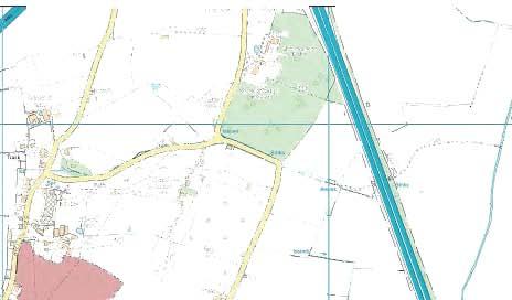
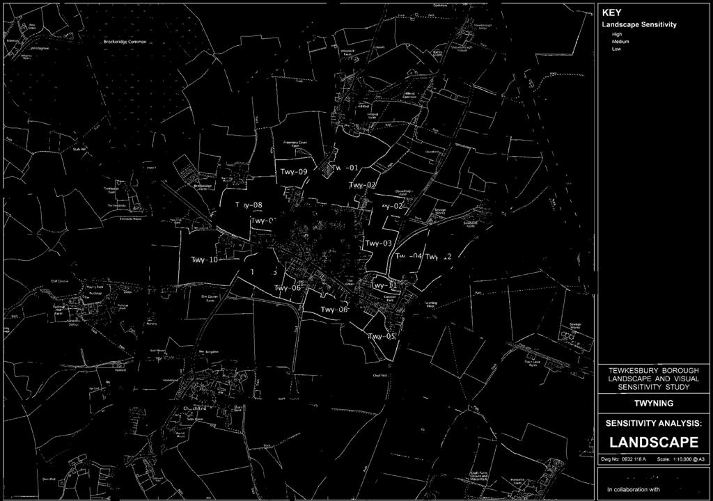
238

239
240 Settlement Name: Settlement Type Land Assessment Parcel Reference: Landscape Character Context National Character Area County Character Area Cotswolds AONB Character Area Natural Elements Landform Tree Cover Water Environment Cultural Elements Land Use Enclosure Pattern Field Boundaries Time Depth Existing Settlement Form Existing Settlement Edge Landscape Quality / Condition Representative of typical character Intactness State of individual elements Tranquility Noise Sources Level of movement and activity Twyning Service Village Twy-01 NCA 106 Severn and Avon Vales SV12A - Twyning Hills Distinctly sloping Abundant established and new planting N/A Common land scale rectilinear and irregular field pattern Mature field hedges and domestic gardens Strong Lies beyond Twyning and links with Hill End (wayside settlement) Predominantly dormer-type bungalows with gardens backing on. A-typical of wider character - common land with recreational use Yes Good Distant motorway noise Low Mitigation / Enhancement Potential N/A Landscape Character Summary A valued recreational resource crossed by well used footpaths linking into neighbouring residential areas. The parcel is dominated by recent tree planting to the south and mature tree cover to the north. Distinctive willows surround springs to the east. The elevated and sloping character of the parcel provides clear views to the east. This openness and expansive views to the east provide a strong sense that this parcel is separate from the village. This is a distinctive and valued landscape character in good condition and well used by the community. At the southern edge of this area some neighbouring residents have extended their gardens into the margins by creating domestic mown lawns and tipping cuttings. Judgment as to Landscape Character Sensitivity
241 Visibility Key Visual Receptors Properties on Hillview Lane Local footpaths Distant Vantages Individual Residents Local Recreation Various Sensitivity Visual Context and Prominence This parcel is beyond the settlement boundary on an elevated and sloping site. It is prominent Mitigation / enhancement Potential N/A Visual Summary A distinct hillside location with a strong easterly aspect out over the Severn Vale to Bredon Hill. Local views into this land assessment parcel are quite limited. They include glimpsed views from Hill End Road and from residential properties that back on to the area. Many of the residents have configured their gardens to maximise views across this land assessment parcel. The key visual sensitivity here is the fact that it is a well used recreational resource with distinctive views across the Severn Vale. It is also prominent in distant views from the Vale and from Bredon Hill. Judgment as to Visual Sensitivity
242 Settlement Name: Settlement Type Land Assessment Parcel Reference: Landscape Character Context National Character Area County Character Area Cotswolds AONB Character Area Natural Elements Landform Tree Cover Water Environment Cultural Elements Land Use Enclosure Pattern Field Boundaries Time Depth Existing Settlement Form Existing Settlement Edge Landscape Quality / Condition Representative of typical character Intactness State of individual elements Tranquility Noise Sources Level of movement and activity Twyning Service Village Twy-02 NCA 106 Severn and Avon Vales SV12A - Twyning Hills Shallow slopes at the base of the hill Mainly associated with surrounding farmsteads and hedges Springs and "issues" Pasture and paddocks (Equestrian uses) Small rectilinear field pattern Mature hedges Moderate Somewhat detached from the settlement Connected only by outlying properties and farms. Yes Yes Good Distant motorway noise Low Mitigation / Enhancement Potential There are some detracting features associated with equestrian activity and robust hedges would offer characteristic mitigation potential. Landscape Character Summary Small to medium scale paddocks and pastures occupying the lower slopes. The character here reflects the wider character of the vale to the east and there is a strong sense of connection away from the village. There is very little influence of Twyning on the character of this land assessment parcel. It is influenced by the few isolated properties and farmsteads that surround it. It is somewhat detached from the existing settlement. There is a strong sense of enclosure provided by the relatively small scale field pattern, but also by robust hedges, particularly along tracks and roads (Downfield Lane). There are some detracting elements associated with equestrian activity and some opportunities for mitigation. However, the rural and isolated character remains sensitive to change. Judgment as to Landscape Character Sensitivity
243 Visibility Key Visual Receptors Downfield Lane Local footpaths Residential properties Local Road Local Recreation Individual Residents Sensitivity Visual Context and Prominence This parcel is beyond the settlement boundary but sits on lower slopes contained for the most part by robust vegetation. It is not prominent. Mitigation / enhancement Potential Robust vegetation (existing tree and hedge cover) offers mitigation potential Visual Summary This land assessment parcel occupies lower slopes and is surrounded by mature hedges and tree cover. It does not feature in long distance views and local views are limited. This parcel can be seen from the rear elevations of a limited number of residential properties to the south and from a local footpath that follows the southern boundary. Hedges are mature and views into the parcel are glimpsed and fragmented. Whilst views are limited, a degree of sensitivity is afforded by the fact that this is a relatively unspoiled piece of countryside, visually isolated to a large extent from the existing settlement. Judgment as to Visual Sensitivity
244 Settlement Name: Settlement Type Land Assessment Parcel Reference: Landscape Character Context National Character Area County Character Area Cotswolds AONB Character Area Natural Elements Landform Tree Cover Water Environment Cultural Elements Land Use Enclosure Pattern Field Boundaries Time Depth Existing Settlement Form Existing Settlement Edge Landscape Quality / Condition Representative of typical character Intactness State of individual elements Tranquility Noise Sources Level of movement and activity Twyning Service Village Twy-03 NCA 106 Severn and Avon Vales SV12A - Twyning Hills Gently slopping to the east Hedge trees and scattered field trees N/A Pasture Small to medium scale rectilinear field pattern Mature hedges Strong Beyond linear settlement edge but contained within lanes and farmsteads Linear 20th century rear gardens Yes Yes Good Distant motorway noise Low Mitigation / Enhancement Potential The current character is influenced by the settlement edge to some extent. Landscape Character Summary A gently sloping land assessment parcel from the distinct linear eastern edge of Twyning down to Downfield Lane. Small to medium scale pastures enclosed by hedges and supporting scattered trees (remnant orchard). The slope emphasizes connections with the wider landscape character across the Severn Vale to the east, however, this parcel is influenced by the domestic settlement edge to the north. This is a strong landscape character but with some precedent influences from settlement. It would remain sensitive to unsympathetic loss of orchard trees and to the creation of a harsh and uncharacteristic new settlement edge. Judgment as to Landscape Character Sensitivity
245 Visibility Key Visual Receptors Downfield Lane Residential properties Local Footpaths Local Road Individual Residents Local Recreation Sensitivity Visual Context and Prominence This parcel lies beyond the southern edge of the settlement on low and gentle slopes. It is visible from the east, but is not prominent. Mitigation / enhancement Potential There are limited opportunities for visual mitigation or enhancement however, there are precedent views of 20th century development at the top of the slope. Visual Summary This land assessment parcel occupies sloping land that drops from the existing settlement edge to Downfield Lane. It is visible from the east, but it is relatively low lying and is not prominent. Views from the east are partially screened by robust tree belt associated with the camping and caravan park. Local views into this land assessment parcel are effectively screened by mature hedges along Downfield Lane, Fleet Lane and local footpaths. Views into this parcel are for the most part limited to those from the east. A key sensitivity would be how any new development might present itself in these views. Unsympathetic massing and harsh development edges should be avoided. New development might be clustered to the north or south to keep some of the slope open in views from the east. Judgment as to Visual Sensitivity
246 Settlement Name: Settlement Type Land Assessment Parcel Reference: Landscape Character Context National Character Area County Character Area Cotswolds AONB Character Area Natural Elements Landform Tree Cover Water Environment Cultural Elements Land Use Enclosure Pattern Field Boundaries Time Depth Existing Settlement Form Existing Settlement Edge Landscape Quality / Condition Representative of typical character Intactness State of individual elements Tranquility Noise Sources Level of movement and activity Twyning Service Village Twy-04 NCA 106 Severn and Avon Vales SV12A - Twyning Hills Flat Abundant in hedges and tree belts surrounding the parcel Ponds Pasture Irregular Hedges Moderate Somewhat detached from the established settlement edge Connected only at Fleet Farm. Yes Yes Good N/A Low Mitigation / Enhancement Potential There is some potential to address detracting elements in the character such as dilapidated farm buildings, otherwise, limited potential Landscape Character Summary A pasture contained by hedges that is somewhat separated from the established settlement edge. Prominent roadside tree planting provides a parkland or formal character to the northern edge. This processional planting is associated with the caravan park as is the robust tree belt visible to the east. Strong visual connection across the Severn and Avon Vale to the Cotswold Scarp emphasizes the rural aspect of this land assessment parcel and accentuates the separation from the settlement. There are some detracting elements in neighbouring farms. Judgment as to Landscape Character Sensitivity
247 Visibility Key Visual Receptors Downfield Lane Fleet Lane Residential properties (Fleet Lane) Local Road Local Road Individual Residents Sensitivity Visual Context and Prominence This is a generally well enclosed land assessment parcel, however it is exposed to some views from the east across the caravan park. It is visible from Fleet Lane and Downfield Lane, although views are limited by mature hedges. It is not prominent Mitigation / enhancement Potential Visual Summary This land assessment parcel is visible from only a few publicly accessible vantages. There are filtered views from surrounding lanes (Fleet Lane and Downfield Lane) although mature hedges provide effective screening in summer months. It is overlooked by isolated dwellings on Fleet Lane. A robust tree belt in the caravan park to the south west provides an effective screen, however there are views available into this land assessment parcel from the river corridor. The key visual sensitivity of this land assessment parcel to new development would be the prominence of development in these views from the east and the river corridor. There is also a sensitivity about views from Downfield Lane out across the vale to the Cotswold Scarp beyond. Judgment as to Visual Sensitivity
248 Settlement Name: Settlement Type Land Assessment Parcel Reference: Landscape Character Context National Character Area County Character Area Cotswolds AONB Character Area Natural Elements Landform Tree Cover Water Environment Cultural Elements Land Use Enclosure Pattern Field Boundaries Time Depth Existing Settlement Form Existing Settlement Edge Landscape Quality / Condition Representative of typical character Intactness State of individual elements Tranquility Noise Sources Level of movement and activity Twyning Service Village Twy-05 NCA 106 Severn and Avon Vales SV4C - Twyning and Upham Meadows. - (Riverside Meadows) Flat Abundant in hedges and associated with watercourses. streams and ditches Pasture Irregular Post and rail fences, metal parkland fences some hedges Moderate Beyond the established settlement edge Wraps around the rear of Twyning Park (grand Georgian House) Yes Yes Good N/A Low Mitigation / Enhancement Potential Limited mitigation potential Landscape Character Summary This land assessment parcel displays a strong landscape character. It is heavily influenced by the open landscape to the east, south and west as well as robust tree cover associated with watercourses. It is an open landscape used for pasture. There are influences from the settlement edge although they do not detract. The main influence is Twyning Park, a substantial river front house. Judgment as to Landscape Character Sensitivity
249 Visibility Key Visual Receptors Twyning Park Some residents on Fleet Road Local Footpaths Individual Residents Individual Residents Local Recreation Sensitivity Visual Context and Prominence This land assessment parcel is well screened from public vantages including the Shakespear's Avon Way along the river bank. The exception being the local footpath that passes through the parcel from the drive of Twyning Park. It is not prominent. Mitigation / enhancement Potential Limited mitigation potential Visual Summary A well enclosed land assessment parcel visible only from a small number of residential properties and a local footpath that crosses it. This land assessment parcel is not visible from the River Avon due to robust intervening trees and vegetation. Similarly, distant views from the south are prevented by coalescing trees and hedges. Despite the relative lack of views into and across this parcel, the visual sensitivity is heightened slightly by the fact that there are few visual detractors at present. Judgment as to Visual Sensitivity
250 Settlement Name: Settlement Type Land Assessment Parcel Reference: Landscape Character Context National Character Area County Character Area Cotswolds AONB Character Area Natural Elements Landform Tree Cover Water Environment Cultural Elements Land Use Enclosure Pattern Field Boundaries Time Depth Existing Settlement Form Existing Settlement Edge Landscape Quality / Condition Representative of typical character Intactness State of individual elements Tranquility Noise Sources Level of movement and activity Twyning Service Village Twy-06 NCA 106 Severn and Avon Vales SV4C - Twyning and Upham Meadows. - (Riverside Meadows) Flat Good cover including new plantings streams and ditches Paddocks and grazing Small to medium scale rectilinear and irregular (Streamside) field pattern Hedges, post and wire and orange plastic (pony paddock) fencing Strong with some denuded ridge and furrow. Beyond the established linear settlement edge Prominent linear edge of rear gardens and overlooking properties. No, Heavily influenced by settlement edge Fragmented due to settlement influences. Fine Domestic Low Mitigation / Enhancement Potential There is currently a strong influence from the settlement edge which offers some opportunities for enhancement. Landscape Character Summary This is a land assessment parcel beyond a prominent linear settlement edge. However, it is still strongly influenced by the vale landscape beyond. Groups of poplar and willow feature in the character. There is a well contained field pattern. The dominant characteristic is the settlement edge and land uses associated with the edge including Alpaca husbandry, pony paddocks and domestic gardens. It also contains community sports and recreation facilities A residual sensitivity will be to ensure that the settlement edge remains sympathetic to the wider vale landscape. Judgment as to Landscape Character Sensitivity
251 Visibility Key Visual Receptors Residents along Fleet Road Local Footpaths Individual Residents Local Recreation Sensitivity Visual Context and Prominence This land assessment parcel is screened from public vantages and is not prominent Mitigation / enhancement Potential Visual Summary A land assessment parcel that is screened from view from public vantages. It is overlooked from the rear of a number of properties along Fleet Road and is visible from the few local footpaths that cross it. It is visually isolated from the village and strong tree cover associated with the watercourse to the south provides strong visual enclosure from more distant vantages. This land assessment parcel exerts a very limited visual influence on the surrounding countryside, however a visual sensitivity remains associated with avoiding the creation of an unsympathetic, harsh settlement edge. Judgment as to Visual Sensitivity
252 Settlement Name: Settlement Type Land Assessment Parcel Reference: Landscape Character Context National Character Area County Character Area Cotswolds AONB Character Area Natural Elements Landform Tree Cover Water Environment Cultural Elements Land Use Enclosure Pattern Field Boundaries Time Depth Existing Settlement Form Existing Settlement Edge Landscape Quality / Condition Representative of typical character Intactness State of individual elements Tranquility Noise Sources Level of movement and activity Twyning Service Village Twy-07 NCA 106 Severn and Avon Vales SV12A - Twyning Hills Flat Abundant trees (Orchard) N/A Orchard and pasture Small rectilinear field pattern Hedges and hedge trees Strong Beyond boundary but contained on two sides by settlement Filtered and sensitive views across gardens to old houses. Yes Yes Good Domestic Low Mitigation / Enhancement Potential This is a strong landscape character with few detractors. Limited mitigation of enhancement opportunities Landscape Character Summary This is a distinctive and well enclosed orchard next to a fine and long established settlement edge characterised by views of fine established houses across gardens. Orchards represent a distinctive and declining landscape resource and this is a fine example. Judgment as to Landscape Character Sensitivity
253 Visibility Key Visual Receptors Residents along Brockeridge Road Local Footpaths Individual Residents Local Recreation Sensitivity Visual Context and Prominence This land assessment parcel is screened from public vantages and is not prominent Mitigation / enhancement Potential The parcel is well screened from views Visual Summary This land assessment parcel is screened from all but a few publicly accessible vantages. Views are available from the local public footpath immediately to the north. A tree belt screens views from Lynworth Lane to the east and houses and garden vegetation effectively screen views from Brockeridge Road to the south. Despite the relative lack of visual receptors, the lack of detracting features and the total lack of precedent for development in this location increases the visual sensitivity somewhat. Judgment as to Visual Sensitivity
254 Settlement Name: Settlement Type Land Assessment Parcel Reference: Landscape Character Context National Character Area County Character Area Cotswolds AONB Character Area Natural Elements Landform Tree Cover Water Environment Cultural Elements Land Use Enclosure Pattern Field Boundaries Time Depth Existing Settlement Form Existing Settlement Edge Landscape Quality / Condition Representative of typical character Intactness State of individual elements Tranquility Noise Sources Level of movement and activity Twyning Service Village Twy-08 NCA 106 Severn and Avon Vales SV12A - Twyning Hills Undulating with prominent ridge and furrow. Hedgerow trees and prominent parkland / field trees. Springs / issues Pasture to large rectilinear. Post and wire fences and mature hedges Strong Touches Brockeridge Road and development off Hill End Road Glimpsed views in places of settlement and views of Twyning Manor Yes Strong Good Agricultural Low Mitigation / Enhancement Potential Few mitigation opportunities in this robust and distinctive landscape Landscape Character Summary A robust and distinct pasture landscape with strong evidence of ridge and furrow. Prominent field trees add to the sense of history and the parkland feel. These historic associations link this land assessment parcel to the neighbouring Twyning Manor. This land assessment parcel provides a suitable and appropriate setting to this grand building. Landscape character here is distinctive, intact and valued as the setting for Twyning Manor. There is a strong sense of separation from the village caused both by physical separation and by robust intervening trees and hedges, Judgment as to Landscape Character Sensitivity
255 Visibility Key Visual Receptors Brockeridge Road Local Footpaths Twyning Manor Residents off Hill End Road Local Road Local Recreation Residence and Heritage Asset Individual Residents Sensitivity Visual Context and Prominence A well contained landscape with few publicly accessible vantages. It is not prominent. This land assessment parcel does however serve to provide the important visual setting for Twyning Manor. Mitigation / enhancement Potential Few opportunities to mitigate new development in this open landscape Visual Summary This is a distinctive landscape. It is not prominent in the sense that there are clear views into and across it from publicly accessible vantages, but it does serve to provide an important visual setting for Twyning Manor. This land assessment parcel occupies land slightly elevated from Twyning and it is therefore discernible above the settlement in distant views from the east. The key visual sensitivity is the setting to Twyning Manor and the sense of openness on the upper slopes above Twyning. Judgment as to Visual Sensitivity
256 Settlement Name: Settlement Type Land Assessment Parcel Reference: Landscape Character Context National Character Area County Character Area Cotswolds AONB Character Area Natural Elements Landform Tree Cover Water Environment Cultural Elements Land Use Enclosure Pattern Field Boundaries Time Depth Existing Settlement Form Existing Settlement Edge Landscape Quality / Condition Representative of typical character Intactness State of individual elements Tranquility Noise Sources Level of movement and activity Twyning Service Village Twy-09 NCA 106 Severn and Avon Vales SV12A - Twyning Hills Undulating Occasional field trees and tree groups associated with pond Spring-fed pond Pasture / grazing scale rectilinear field pattern. Post and wire fences and mature hedges Moderate Spans a gap between Twyning and Hill End Wayside cottages on Hill End Road and 20th Century development Yes Strong Some utilitarian farm buildings and activity Agricultural Low Mitigation / Enhancement Potential Landscape Character Summary An area of open pasture on rising ground with a south easterly aspect. To the north the area is characterised by utilitarian buildings and activity associated with Freemans Court Farm. To the south by the edge of Twyning represented by sensitive edge of a relatively recent development and a man made fishing lake. Judgment as to Landscape Character Sensitivity
257 Visibility Key Visual Receptors Hill End Road Local Footpaths Twyning Manor Residents off Hill End Road Local Road Local Recreation Residence and Heritage Asset Individual Residents Sensitivity Visual Context and Prominence The land assessment parcel is not prominent in long distant views. It is however visible from surrounding roads, footpaths and residential properties. Mitigation / enhancement Potential Limited opportunities for mitigation in this open landscape Visual Summary Overlooked by a number of residential properties in Hill End (On Hill End Road) and from a limited number of properties in the newer development off Hill End Road at the northern edge of Twyning. This land assessment parcel is visible from the adjacent local public footpath and from Twyning Manor. This is not a prominent site in long distance views, however there is a visual sensitivity in that new development to the east of the parcel might appear above the ridgeline broadly along the line of Hill End Road and might influence wider views from across the vale at Bredon Hill for instance. Another key visual sensitivity in this land assessment parcel is the visual separation of Twyning from Hill End. It is this issue that drives the visual sensitivity of this land assessment parcel. Judgment as to Visual Sensitivity
258 Settlement Name: Settlement Type Land Assessment Parcel Reference: Landscape Character Context National Character Area County Character Area Cotswolds AONB Character Area Natural Elements Landform Tree Cover Water Environment Cultural Elements Land Use Enclosure Pattern Field Boundaries Time Depth Existing Settlement Form Existing Settlement Edge Landscape Quality / Condition Representative of typical character Intactness State of individual elements Tranquility Noise Sources Level of movement and activity Twyning Service Village Twy-10 NCA 106 Severn and Avon Vales SV12A - Twyning Hills Flat Hedgerow trees and tree groups associated with gardens N/A Pasture / grazing to large scale rectilinear field pattern. Hedges Moderate Somewhat separate from the settlement Wraps around Duddage Manor Business Park Yes Strong Some utilitarian commercial buildings and activity Agricultural Low Mitigation / Enhancement Potential Landscape Character Summary An open pastoral landscape contained within mature hedges with hedge trees. Large and mature tree groups add to the sense of enclosure. They are largely associated with neighbouring commercial development and residential gardens. Few detractors from this simple, open landscape. New residential development would be at odds with this character, which is clearly separate from the village. Judgment as to Landscape Character Sensitivity
259 Visibility Key Visual Receptors Cherry Orchard Lane Local Footpaths Church End Road Local Road Local Recreation Local Road Sensitivity Visual Context and Prominence Despite the open character of this land assessment parcel, it is actually well screened from public vantages. It is not prominent. Mitigation / enhancement Potential The prominence of the business units along the settlement edge and robust woodland blocks offer mitigation opportunities. Visual Summary A land assessment parcel that is in itself an open, pastoral landscape adjoining Duddage Manor Business Park. Despite the open character, surrounding hedges and tree groups prevent views into and across it from surrounding publicly accessible vantages. Visually, this land assessment parcel is isolated from the surrounding road network and from Twyning. Key sensitivities include the potential for the perception of new settlement way beyond the established main settlement boundary of Twyning. Judgment as to Visual Sensitivity
260 Settlement Name: Settlement Type Land Assessment Parcel Reference: Landscape Character Context National Character Area County Character Area Cotswolds AONB Character Area Natural Elements Landform Tree Cover Water Environment Cultural Elements Land Use Enclosure Pattern Field Boundaries Time Depth Existing Settlement Form Existing Settlement Edge Landscape Quality / Condition Representative of typical character Intactness State of individual elements Tranquility Noise Sources Level of movement and activity Twyning Service Village Twy-11 NCA 106 Severn and Avon Vales SV12A - Twyning Hills Flat Hedges with occasional hedge trees N/A Rough Pasture Small rectilinear enclosure Hedges Slight Surrounded on three sides by settlement and Caravan Park Homes Rear of properties on the Green and caravans / park homes No Influenced by surrounding uses Some utilitarian caravan influences Domestic Low Mitigation / Enhancement Potential There are detracting elements in the form of views to surrounding caravans and park homes leading to some enhancement opportunities Landscape Character Summary A small rough pasture surrounded by the rear of properties fronting onto the Green off Fleet Lane, caravans and park homes. The small size and close proximity to neighbouring uses mean that the character is heavily influenced by the residential and caravan park uses. Judgment as to Landscape Character Sensitivity Low
261 Visibility Key Visual Receptors Residents on Fleet Lane Downfield Lane Caravan Park Individual Residents Local Road Local Recreation Sensitivity Visual Context and Prominence This small land assessment parcel is tucked away and surrounded on three sides by settlement. From publicly accessible vantages, it is only visible from Downfield Lane where it does have some prominence at the junction with Fleet Lane Mitigation / enhancement Potential There are detracting visual elements associated with caravans and park homes that could offer some enhancement potential Visual Summary A small land assessment parcel that is effectively screened from publicly accessible vantages. The exception is that it occupies a prominent position at the junction of Fleet Lane and Downfield Lane. Whilst for the most part the visual sensitivity of this land assessment parcel is low, there is some sensitivity in this view down Downfield Lane towards Twyning. Any development should not dominate this junction, which is currently relatively free from the visual influences of Twyning. Judgment as to Visual Sensitivity
262 Settlement Name: Settlement Type Land Assessment Parcel Reference: Landscape Character Context National Character Area County Character Area Cotswolds AONB Character Area Natural Elements Landform Tree Cover Water Environment Cultural Elements Land Use Enclosure Pattern Field Boundaries Time Depth Existing Settlement Form Existing Settlement Edge Landscape Quality / Condition Representative of typical character Intactness State of individual elements Tranquility Noise Sources Level of movement and activity Twyning Service Village Twy-12 NCA 106 Severn and Avon Vales SV4C - Twyning and Upham Meadows. - (Riverside Meadows) Flat Robust tree belts and isolated trees River frontage to the Avon Recreation and Caravan Park Irregular Tree belts and hedges Slight Occupies the relatively undeveloped river meadows Connected only to a few properties on Fleet Lane No Developed as a caravan park Some utilitarian caravan influences Domestic Low Mitigation / Enhancement Potential There are detracting elements in the form of views to surrounding caravans and park homes leading to some enhancement opportunities Landscape Character Summary A caravan site with some recreation open green space with an open river frontage to the River Avon. The character of this area is resolutely that of a caravan park. It is sensitive to the "permanence" of new residential development Judgment as to Landscape Character Sensitivity
263 Visibility Key Visual Receptors Fleet Lane (east of the river) The River Severn Local Footpaths Local Road / Recreation Valued Recreation Resource Local Recreation Sensitivity Visual Context and Prominence This parcel of land forms the river frontage to the immediate east of Twyning on the River Avon. It is prominent. Mitigation / enhancement Potential Some mitigation potential in the fact that the site is already developed as a caravan site. Visual Summary A prominent and parcel immediately to the east of Twyning with a river frontage to the River Avon. This land assessment parcel is prominent in views from the river and from public footpaths to the east. Judgment as to Visual Sensitivity
264 Settlement Name: Settlement Type Land Assessment Parcel Reference: Landscape Character Context National Character Area County Character Area Cotswolds AONB Character Area Natural Elements Landform Tree Cover Water Environment Cultural Elements Land Use Enclosure Pattern Field Boundaries Time Depth Existing Settlement Form Existing Settlement Edge Landscape Quality / Condition Representative of typical character Intactness State of individual elements Tranquility Noise Sources Level of movement and activity Twyning Service Village Twy-13 NCA 106 Severn and Avon Vales SV12A - Twyning Hills Gently undulating Hedgerow trees and tree groups associated with gardens N/A Pasture / grazing to large scale rectilinear field pattern. Hedges Moderate Linear residential edge (softened by garden vegetation) 20th century residential Yes Strong Good Agricultural Low Mitigation / Enhancement Potential There are few mitigation opportunities in this open and exposed pastoral landscape. Landscape Character Summary An open pastoral landscape contained within low hedges with hedge trees. There are prominent hedgerow trees in an otherwise open landscape. The settlement edge is visible but does not dominate. It appears quite muted with the residential properties partially screened by hedges and garden trees. A key characteristic of this land assessment parcel is the wide and expansive view to the east. The judgment as to landscape sensitivity is informed by the good condition of this landscape, its openness and the liited existing influence of the settlement edge Judgment as to Landscape Character Sensitivity
265 Visibility Key Visual Receptors Properties on Brockeridge Road Local Footpaths Church End Road Individual Residents Local Recreation Local Road Sensitivity Visual Context and Prominence This land assessment parcel is prominent in views from Church End Road. It is open with expansive views to the east. Mitigation / enhancement Potential There are limited opportunities to mitigate the openness of this land assessment parcel Visual Summary This is a prominent land assessment parcel clearly cisible from the Church End Road and with expansive wide open views to the east Judgment as to Visual Sensitivity
266
267 Woodmancote (Service Village)
268


269


270


271
Toddington Central Bedfordshire Stage 3 Green Belt Study December 2017
 Toddington Central Bedfordshire Stage 3 Green Belt Study December 2017 Site: ALP086 - Middle Lakes, Toddington Site size (ha): 2.83 Site: ALP086 - Middle Lakes, Toddington Site size (ha): 2.83 Site description
Warwickshire County Council. Upper and Lower Brailes. Landscape Study
 Warwickshire County Council Upper and Lower Brailes Landscape Study Produced by WCC Landscape Architects March 2016 Landscape Assessment of Potential Development Sites within the parish of Brailes 1.0
Landscape Guidelines. Landscape type: Valley Pasture Character areas: Frome Valley Pasture Stour Valley Pasture. Landscape change
 Landscape type: Valley Pasture Character areas: Frome Valley Pasture Stour Valley Pasture The valley pasture landscape type is found along the lower reaches of the Stour and Frome, formed from alluvial
B - Coalfield River Corridor Landscape Character Type
 B - Coalfield River Corridor Landscape Character Type Landscape Character Type - Coalfield River Corridor The Coalfield River Corridors Landscape Character Type is located in the two converging valleys
The analysis of key visual characteristics and attributes that contribute to variations in the
 15.0 CHIGWELL/CHIGWELL ROW 15.1 Overview 15.1.1 Chigwell and Chigwell Row settlements are situated in the south of Epping Forest District, to the south of Abridge and southwest of Stapleford Abbotts. Both
Viewpoint 1. Location: View from Murch Road on the north eastern boundary of Application Site. Viewing south / southwest.
 Application Site (eastern field) Former site of St. Cyres Lower School Murch Road 1 Location: View from Murch Road on the north eastern boundary of Application Site. Viewing south / southwest. Baseline
Oxford Green Belt Study. Summary of Final Report Prepared by LUC October 2015
 Oxford Green Belt Study Summary of Final Report Prepared by LUC October 2015 Project Title: Oxford Green Belt Study Client: Oxfordshire County Council Version Date Version Details Prepared by Checked by
APP/G1630/W/15/
 Appeal Decision Site visit made on 20 October 2015 by William Fieldhouse BA (Hons) MA MRTPI an Inspector appointed by the Secretary of State for Communities and Local Government Decision date: 20 November
Rolling Wooded Pasture Lulworth Wooded Pasture Rempstone Wooded Pasture
 Landscape type: Character areas: Rolling Wooded Pasture Lulworth Wooded Pasture Rempstone Wooded Pasture The rolling wooded pasture landscape type is found around the margins of the Dorset Heaths. Although
Warwickshire County Council. Wellesbourne & Walton Parish. Landscape Study
 Warwickshire County Council Wellesbourne & Walton Parish Landscape Study Produced by WCC Landscape Architects January 2016 Contents LANDSCAPE ASSESSMENT FOR THE PARISH OF WELLESBOURNE & WALTON 1.0 The
Neighbourhood Planning Local Green Spaces
 Neighbourhood Planning Local Green Spaces Introduction... 2 1. Why green space is important... 4 2. Neighbourhood plans and green space... 6 3. Evidence... 8 Statutory designations... 9 Green space audit...
S08 Dyffryn Y Ddwyryd
 S08 Dyffryn Y Ddwyryd Reproduced from the Ordnance Survey map with the permission of Ordnance Survey on behalf of the Controller of Her Majesty s Stationery Office, Crown copyright Licence No. 100023387
Tables of Criteria and Matrices for Landscape Assessment (LSCA & LVIA)
") Carly Tinkler CMLI Environmental, Landscape and Colour Consultancy 46 Jamaica Road, Malvern, Worcestershire WR14 1TU Tel +44 (0)7711 538854 carlytinkler@hotmail.co.uk Tables of Criteria and Matrices for
Carly Tinkler CMLI Environmental, Landscape and Colour Consultancy 46 Jamaica Road, Malvern, Worcestershire WR14 1TU Tel +44 (0)7711 538854 carlytinkler@hotmail.co.uk Tables of Criteria and Matrices for
LONGDEN VILLAGE DEVELOPMENT STATEMENT
 LONGDEN VILLAGE DEVELOPMENT STATEMENT 2017-2027 1 Longden Development Statement 2017-2027 15/01/18 1. Background 1.1 Longden Village Longden village is a very rural and traditional community first mentioned
CHAPTER 18 - Strategy Area: Dundry and River Valleys
 This south-eastern part of the Community Forest is a complex area with a wide variety of different landscapes close together, including the Chew Valley, the southern part of the Avon Valley and the eastern
Babergh and Mid Suffolk Joint Draft Local Plan Consultation, August 2017, Public Consultation
 Babergh and Mid Suffolk Joint Draft Local Plan Consultation, August 2017, Public Consultation Having reviewed the documents, the Society has made the following response: Housing Delivery Q 7. Do you agree
Totternhoe Central Bedfordshire Stage 3 Green Belt Study December 2017
 Totternhoe Central Bedfordshire Stage 3 Green Belt Study December 2017 Site description The site is comprised of a single arable field on the southern side of the washed over settlement of Totternhoe.
STATEMENT OF OBJECTION TO THE PROPOSED DEVELOPMENT OF LAND AT CHURCH CLIFF DRIVE FILEY
 STATEMENT OF OBJECTION TO THE PROPOSED DEVELOPMENT OF LAND AT CHURCH CLIFF DRIVE FILEY You will be aware that Scarborough borough council have adopted a new local plan that includes land at Church Cliff
SITE ASSESSMENT FORM
 Appendix 2 SITE ASSESSMENT FORM 1. Site information Settlement: Colwall Main Village Site name: SITE 1 Part of vacated Colwall school site and adjacent area Site address: Walwyn Road Site area (hectares):
Lower Sensitivity. VS Classification Level 2: Hills, Lower Plateau & Scarp Slopes (74%)/ Lowland Valleys (17%) / Exposed Upland/Plateau (7%)
/ Lowland Valleys (17%) / Exposed Upland/Plateau (7%)") S06 Coedwig Gwydyr Reproduced from the Ordnance Survey map with the permission of Ordnance Survey on behalf of the Controller of Her Majesty s Stationery Office, Crown copyright Licence No. 100023387 Location
S06 Coedwig Gwydyr Reproduced from the Ordnance Survey map with the permission of Ordnance Survey on behalf of the Controller of Her Majesty s Stationery Office, Crown copyright Licence No. 100023387 Location
LANDSCAPE AND VISUAL IMPACT ASSESSMENT
 HARE STREET ROAD BUNTINGFORD LANDSCAPE AND VISUAL IMPACT ASSESSMENT Prepared by ACD Chartered Landscape Architects for Written By: SJD Checked By: JS Date: Document File Ref: TWNT18550lvia Revision: A-
GUILDFORD BOROUGH GREEN BELT AND COUNTRYSIDE STUDY
 GUILDFORD BOROUGH GREEN BELT AND COUNTRYSIDE STUDY Volume II - Addendum On behalf of Guildford Borough Council PPG Ref : BNL.0287 April 2014 COPYRIGHT The conents of this document must not be copied or
LEEDS SITE ALLOCATIONS PLAN MATTER 3 GREEN BELT KCS DEVELOPMENT AUGUST 2017
 LEEDS SITE ALLOCATIONS PLAN MATTER 3 GREEN BELT KCS DEVELOPMENT AUGUST 2017 Smith Limited Suite 9C Joseph s Well Hanover Walk Leeds LS3 1AB T: 0113 2431919 F: 0113 2422198 E: planning@peacockandsmith.co.uk
Lower Sensitivity. VS Classification Level 2: Exposed Upland/Plateau
 S04 Moel Hebog Reproduced from the Ordnance Survey map with the permission of Ordnance Survey on behalf of the Controller of Her Majesty s Stationery Office, Crown copyright Licence No. 100023387 Location
viii Figure ES1: Recommended changes to Green Belt boundaries in Waverley
 viii Figure ES1: Recommended changes to Green Belt boundaries in Waverley 50 3.4 Elstead (segments W5, W11, W18, W19) 3.4.1 Area of search 51 3.4.2 Assessment against Green Belt criteria Segment W5: land
INTRODUCTION. Land south of Bishopswood Lane, Tadley
 0 INTRODUCTION THE SITE Introduction Gladman Developments Ltd. has successfully invested in communities throughout the UK over the past 0 years, developing high quality and sustainable residential, commercial
an Inspector appointed by the Secretary of State for Communities and Local Government
 Appeal Decision Site visit made on 6 November 2017 by Rachel Walmsley BSc MSc MA MRTPI an Inspector appointed by the Secretary of State for Communities and Local Government Decision date: 19 th January
Site Assessment Technical Document Appendix A: Glossary
 Central Bedfordshire Council www.centralbedfordshire.gov.uk Site Assessment Technical Document Appendix A: Glossary July 2017 1.1.11-1 - ii Appendix A: Glossary Term Agricultural Land Classification AONB
Wind energy development in the South Pennines landscape
 Wind energy development in the South Pennines landscape Programme for today Background Policy context South Pennines landscape Impacts of wind energy development The South Pennines Wind Energy Landscape
Pebworth Parish Neighbourhood Plan Evidence Base
 Pebworth Parish Neighbourhood Plan Evidence Base ASSESSMENT OF IMPORTANT VIEWS IN PEBWORTH PARISH Working document July 2018 Produced by BPA and Pebworth Neighbourhood Development Plan Steering Group 1.
DEVELOPMENT MANAGEMENT REPORT
 ITEM A08-1 DEVELOPMENT MANAGEMENT REPORT TO: BY: DATE: DEVELOPMENT: SITE: WARD: APPLICATION: APPLICANT: Development Management Committee Development Manager Proposed live/work unit in connection with existing
Genex Kidston Connection Project: Draf t Environmental Assessment Report Powerlink Queensland
 : Draf t Environmental Assessment Report Powerlink Queensland Chapter 14 \\autsv1fp001\projects\605x\60577456\6. Draft Docs\6.1 Reports\4. Compiled draft 17 September\Covers\Chapters\Ch 14.docx Rev ision
There are two assessment methods used. The first is according to the criteria set out in the Neighbourhood Plan which are set out below.
 Background Paper 4 Site Assessments Context This background paper has been compiled to support the Gotham Neighbourhood Plan and is intended to document the viability of sites around Gotham with respect
- - - Key Characteristics
 S23 Dyffryn Dysynni Reproduced from the Ordnance Survey map with the permission of Ordnance Survey on behalf of the Controller of Her Majesty s Stationery Office, Crown copyright Licence No. 100023387
ASSESSMENT OF LOCAL GAPS IN BREDON PARISH
 ASSESSMENT OF LOCAL GAPS IN BREDON PARISH Revised May 2016 1. Introduction 1.1 Bredon Parish Council has set out to identify s along the connecting roads between settlements in the parish, which either
Landscape Assessment CEUGP/SR9B
 Landscape Assessment CEUGP/SR9B TABLE OF CONTENTS 1 STUDY PHILOSOPHY... 3 2 GENERAL DESCRIPTION OF SITE... 4 3 LANDSCAPE THEMES... 8 TABLE OF FIGURES Table 1: Landscape... 5 Table 2: Landscape Themes...
18 South of St Pegas Rd including west of Foxcovert Rd, south of Werrington parkway and east to the Car Dyke
 18 South of St Pegas Rd including west of Foxcovert Rd, south of Werrington parkway and east to the Car Dyke Information reviewed Historical background: SAJ ver2 June 2016 Classification Comments NCA 75
Suffolk Coastal Local Plan Review Issues and Options, August 2017, Public Consultation
 Suffolk Coastal Local Plan Review Issues and Options, August 2017, Public Consultation Having reviewed the issues and options documents, the Society has made the following response: Part 1 - Strategic
Neighbourhood Plan Representation
 Date: 10 th November 2017 Neighbourhood Plan Representation Land to the east of Callow Hill Road, Alvechurch Introduction This representation has been prepared by RPS Planning and Development on behalf
Droitwich Spa 6. Reasoned Justification
 87 Droitwich Spa 6 Reasoned Justification 6.1 Droitwich Spa is identified in the settlement hierarchy (Policy SWDP1) as a main town being the largest settlement in Wychavon District with an estimated population
WELCOME GYPSY LANE. Wider Site Location plan. Proposals for the development of LAND OFF FOXLYDIATE LANE WEBHEATH. Proposals for the development of
 WELCOME The developers are preparing an outline planning application for a residential led development and need the community s views in order to develop the proposals further WHAT IS PROPOSED? A high
Lower Sensitivity. VS Classification Level 2: Exposed Upland/Plateau
 S02 Y Carneddau Reproduced from the Ordnance Survey map with the permission of Ordnance Survey on behalf of the Controller of Her Majesty s Stationery Office, Crown copyright Licence No. 100023387 Location
Evesham 7. Reasoned Justification
 95 Reasoned Justification 7.1 Evesham is situated within the Vale of Evesham and has an estimated population of 22,800 (2009 Mid-Term Population Estimates). As a main town it provides a wide range of services
LandscapeCollective. Dorothy House, Winsley. Landscape and Visual Appraisal. On behalf of Dorothy House Hospice Care.
 Project Ref: LC/00043 Project Number: 00043A Authored by: Stuart Hocking Reviewed by: Stephen Wadsworth Date: August 2016 Document version P:\Landscape Collective\Admin\Templates\LC Report Template Jan
Cotswolds AONB Landscape Strategy and Guidelines. June 2016
 Cotswolds AONB Landscape Strategy and Guidelines June 2016 Cotswolds AONB Landscape Strategy and Guidelines Introduction The evolution of the landscape of the Cotswolds AONB is a result of the interaction
Lower Sensitivity. VS Classification Level 2: Exposed Upland/Plateau
 S05 Y Moelwynion Reproduced from the Ordnance Survey map with the permission of Ordnance Survey on behalf of the Controller of Her Majesty s Stationery Office, Crown copyright Licence No. 100023387 Location
Welford-on-Avon Neighbourhood Plan Consultation Event Sunday, 6 April Your name Your address
 Welford-on-Avon Neighbourhood Plan Consultation Event Sunday, 6 April 2014 Your name Your email address Please either: - complete this feedback form and put it in the box before leaving the Memorial Hall
About 10% of the Borough's population lives in the seven rural parishes. Population figures from the 1991 census are given below:-
 8. THE DISTRICT VILLAGES 8.1 Population About 10% of the Borough's population lives in the seven rural parishes. Population figures from the 1991 census are given below:- Village No. of Persons Cottingham
Planning and Regulatory Committee 20 May Applicant Local Councillor Purpose of Report
 Planning and Regulatory Committee 20 May 2014 7. APPLICATION FOR PLANNING PERMISSION FOR THE CARRYING-OUT OF DEVELOPMENT PURSUANT TO PLANNING PERMISSION REFERENCE NUMBER 603451 DATED 28 FEBRUARY 2007 WITHOUT
Proposed Sheffield City Region Combined Green Belt Review A Common Approach August 2014
 Proposed Sheffield City Region Combined Green Belt Review A Common Approach August 2014 1.1 Purpose To achieve the principles of Duty to Cooperate, it is beneficial for all Local Authorities within the
Impact of proposed developments on North Banbury
 Press Release 122 Impact of proposed developments on North Banbury A recently published report Banbury Landscape Sensitivity and Capacity Assessment gives us a better picture of the terrible impact any
National Character Area 70 Melbourne Parklands
 Summary The are a landscape of rolling farmland, parkland and woodland on the northern flanks of the ridge between Burton upon Trent and Swadlincote. The land slopes down to the River Trent, which borders
LANDSCAPE AND VISUAL ASSESSMENT
 Hertfordshire County Council LAND AT BALDOCK SITE 2 LANDSCAPE AND VISUAL ASSESSMENT JULY 2008 Jon Etchells Consulting Barn A, Dixies High Street Ashwell Herts SG7 5NT 01462 744662 HERTFORDSHIRE COUNTY
Landscape Character and Capacity Study
 Landscape Character and Capacity Study Doncaster Metropolitan Borough Council Further Investigations - Employment and Housing Sites June 2010 Golder Associates (UK) Ltd Golder House Tadcaster Enterprise
8.0 Design and Form of Development 43/
 42/ 8.0 Design and Form of Development 43/ Rothwells Farm, Golborne/ Development Statement Figure 7. Site Constraints Key 44/ Site Boundary 360 Bus Route/Stops Existing Trees Underground Water Pipe Sensitive
DUNSFOLD NEIGHBOURHOOD PLAN Site Selection Policies
 DUNSFOLD NEIGHBOURHOOD PLAN Site Selection Policies The criteria for assessing sites for future housing and business development in Dunsfold are set out below. (Development criteria, covering what it is
Settlement Boundaries Methodology North Northumberland Coast Neighbourhood Plan (August 2016)
") Introduction This background paper sets out a methodology for the definition of settlement boundaries in the North Northumberland Coast Neighbourhood Plan. The neighbourhood plan is planning positively
Introduction This background paper sets out a methodology for the definition of settlement boundaries in the North Northumberland Coast Neighbourhood Plan. The neighbourhood plan is planning positively
LANDSCAPE AND VISUAL ASSESSMENT
 Hertfordshire County Council LAND AT BALDOCK SITE 3 LANDSCAPE AND VISUAL ASSESSMENT JULY 2008 Jon Etchells Consulting Barn A, Dixies High Street Ashwell Herts SG7 5NT 01462 744662 HERTFORDSHIRE COUNTY
Neighbourhood Planning Site Assessment Pro-forma and Guide Version 2
 Neighbourhood Planning Site Assessment Pro-forma and Guide Version 2 September 2014 Site HNP 006 Land East of Stanbridge Road and North of Lower Road 1. Background information Site location and use Site
Central Bedfordshire and Luton Green Belt Study Appendix 1
 Central Bedfordshire Council www.centralbedfordshire.gov.uk Central Bedfordshire and Luton Green Belt Study Appendix 1 July 2017-1 - Appendix 1 Stage 1 assessments Central Bedfordshire and Luton Green
Development in the setting of the Cotswolds AONB
 COTSWOLDS CONSERVATION BOARD POSITION STATEMENT Development in the setting of the Cotswolds AONB.1. Introduction Areas of Outstanding Natural Beauty (AONBs) are designated by the Government for the purpose
PONTELAND NEIGHBOURHOOD PLAN LANDSCAPE QUALITY ASSESSMENT
 PONTELAND NEIGHBOURHOOD PLAN LANDSCAPE QUALITY ASSESSMENT UPDATED CONSULTATION ISSUE NOVEMBER 2016 CONTENTS 2 Introduction 2 Methodology 4 Landscape Quality Areas Plan 5 Landscape Quality Area 1 SMALLBURN
MATURE SUBURBS RESIDENTIAL DEVELOPMENT GUIDELINES
 MATURE SUBURBS RESIDENTIAL DEVELOPMENT GUIDELINES DRAFT FEBRUARY 2005 BIRMINGHAM CITY COUNCIL 1 Introduction Mature Suburbs Residential Development Guidelines - Interim Supplementary Planning Advice -
University Park, Worcester Non Technical Summary December 2011
 University Park, Worcester Non Technical Summary December 2011 Introduction UW Wrenbridge LLP, a Joint Venture Company of the University of Worcester and Wrenbridge Land Ltd (the Applicants ) intend to
Ashtead Neighbourhood Forum Site Assessment AS03 Lime Tree Lodge, Farm Lane. Site address: Lime Tree Lodge, Farm Lane. Proposed Land Use:
 Site ref: AS03 Site address: Lime Tree Lodge, Farm Lane Proposed Land Use: Total Site Area (Ha): Housing 1.25ha Description The site is located off Farm Lane at the junction with Park Lane. To the north
CHAPTER 10 AESTHETICS
 CHAPTER 10 AESTHETICS CHAPTER 10 AESTHETICS This section identifies and evaluates key visual resources in the project area to determine the degree of visual impact that would be attributable to the project.
THAMES VALLEY PARK & RIDE
 REPORT N O 70012699_V1 THAMES VALLEY PARK & RIDE LANDSCAPE AND VISUAL APPRAISAL PUBLIC JANUARY 2016 THAMES VALLEY PARK & RIDE LANDSCAPE AND VISUAL APPRAISAL Wokingham Borough Council V1 Public Project
Guidance for Wind Turbine Development in the Dorset AONB
 Photo 1: Rew Manor Farm, West Dorset, chalk downland landscape (Planning application ref: 1/D/09/001280 1 ) Scale & siting: 12m to hub / 16m to blade tip. A well sited small scale turbine, grouped with
Landscape considerations in Forests & Woodlands. Jill Bullen, Senior Landscape Specialist
 Landscape considerations in Forests & Woodlands Jill Bullen, Senior Landscape Specialist UK Forestry Standard (UKFS) Sustainable forest management Landscape sub-section (S6.4, page 96) Standards and requirements
A payment of 1080 is due in this instance, for a meeting and follow up written response, and will be made by card over the phone.
 JPPC ref: AG/6002 18 th September 2014 Planning Services Vale of White Horse District Council Benson Lane Crowmarsh Gifford Wallingford OX10 8ED Dear Sir/Madam REQUEST FOR PRE-APPLICATION ADVICE RE: RESIDENTIAL
Lower Sensitivity. VS Classification Level 2: Exposed Upland/Plateau (86%)/ Upland Valleys (10%)
/ Upland Valleys (10%)") S09 Y Mignient Reproduced from the Ordnance Survey map with the permission of Ordnance Survey on behalf of the Controller of Her Majesty s Stationery Office, Crown copyright Licence No. 100023387 Location
S09 Y Mignient Reproduced from the Ordnance Survey map with the permission of Ordnance Survey on behalf of the Controller of Her Majesty s Stationery Office, Crown copyright Licence No. 100023387 Location
Welcome. Land adjacent Sandy Lane WALTHAM CHASE THE PROPOSED SITE
 Land adjacent Sandy Lane WALTHAM CHASE Existing Linden Homes developments Welcome Welcome to Linden Homes Southern s ( Linden ) public exhibition about its proposals for a range of high-quality homes for
Cookham Parish Council s Response to The Draft Local Borough Plan
 Cookham Parish Council s Response to The Draft Local Borough Plan As Agreed at the Planning Committee Meeting on 10 th January 2017. Designation of Poundfield as a Local Green Space The Parish Council
GREEN BELT ASSESSMENT OF HOLLANDS FARM, BOURNE END AND SURROUNDING AREA
 27 November 2017 SHF/AC P17-1325 KBEG OF HOLLANDS FARM, BOURNE END AND SURROUNDING AREA PREPARED ON BEHALF OF KEEP BOURNE END GREEN (KBEG) Prepared by: SARAH HAMILTON FOYN BSc (Hons) Dip TP MRTPI ANDREW
Guidance for Wind Turbine Development in the Dorset Area of Outstanding Natural Beauty
 DRAFT January 2012 Guidance for Wind Turbine Development in the Dorset Area of Outstanding Natural Beauty Photo 1: Rew Manor Farm, West Dorset, chalk downland landscape (Planning application ref: 1/D/09/001280
Cranbrook EXPANSION ENVIRONMENTAL STATEMENT: NON-TECHNICAL SUMMARY PRODUCED BY DAVID LOCK ASSOCIATES
 Cranbrook EXPANSION ENVIRONMENTAL STATEMENT: NON-TECHNICAL SUMMARY PRODUCED BY DECEMBER 2014 CRANBROOK EXPANSION AREAS ENVIRONMENTAL STATEMENT NON TECHNICAL SUMMARY Submitted in support of Outline Planning
East Harptree Landscape & Character Assessment
 East Harptree Landscape & Character Assessment Produced by East Harptree Parish Council in consultation with local residents September 2014 Contents The Parish of East Harptree: Objective Introduction
Site ref: AS06 Site Name or Address: Murreys Court, Agates Lane
 Site ref: AS06 Site Name or Address: Murreys Court, Agates Lane Proposed Land Use: Total Site Area (Ha): Housing 1.85 Ha Description: It is understood that the owner has no plans to dispose of the site
LOGGERHEADS NEIGHBOURHOOD PLAN LOCAL GREEN SPACE DESIGNATION OCTOBER 2016
 DRAFT LOGGERHEADS NEIGHBOURHOOD PLAN LOCAL GREEN SPACE DESIGNATION OCTOBER 2016 1. Introduction For many local communities, green infrastructure in and around their neighbourhood is an important issue,
Sustainability Statement. Whitby Business Park Area Action Plan
 Sustainability Statement Whitby Business Park Area Action Plan November 2014 Contents Page 1. Introduction 1 2. Scoping 3 3. Sustainability Appraisal of Options 6 4. Assessment of Draft Area Action Plan
Ipswich Issues and Options for the Ipswich Local Plan Review, August 2017, Public Consultation
 Ipswich Issues and Options for the Ipswich Local Plan Review, August 2017, Public Consultation Having reviewed the issues and options documents, the Society has made the following response: Part 1 Strategic
22.15 OUTDOOR ADVERTISING SIGNAGE POLICY
 22.15 OUTDOOR ADVERTISING SIGNAGE POLICY This policy applies to all land where a planning permit is required to construct or display a sign under the provisions of the Kingston Planning Scheme. 22.15-1
ROCHFORD LOCAL DEVELOPMENT FRAMEWORK: Sustainability Appraisal/ Strategic Environmental Assessment. Rochford Core Strategy Preferred Options Document
 ROCHFORD LOCAL DEVELOPMENT FRAMEWORK: Sustainability Appraisal/ Strategic Environmental Assessment Non Technical Summary Rochford Core Strategy Preferred Options Document October 2008 SUSTAINABILITY APPRAISAL
4 RESIDENTIAL ZONE. 4.1 Background
 4 RESIDENTIAL ZONE 4.1 Background The residential areas within the City are characterised by mainly lowrise dwellings sited on individual allotments. Past architectural styles, settlement patterns and
S18 Mynyddoedd Yr Aran
 S18 Mynyddoedd Yr Aran Reproduced from the Ordnance Survey map with the permission of Ordnance Survey on behalf of the Controller of Her Majesty s Stationery Office, Crown copyright Licence No. 100023387
WELCOME. Land North of STEVENAGE. We would like to thank you for attending our public exhibition today.
 WELCOME We would like to thank you for attending our public exhibition today. The purpose of this event is to share our proposals and hear your thoughts on our ideas. Members of the project team are on
Visual Impact Rating Form - Instructions
 Visual Impact Rating Form Instructions Project Name: Baron Winds Project EDR Project No: 13039 Date: 05.16.17 Reference: Visual Impact Rating Form - Instructions These instructions are intended to guide
A428 Cambourne to Cambridge Segregated Bus Route
 A428 Cambourne to Cambridge Segregated Bus Route Consideration of Green Belt Issues August 2017 A 17 Minster Precincts Peterborough PE1 1XX United Kingdom T +44 (0) 1733 310 471 F +44 (0) 1733 553 661
SOUTH EAST LINCOLNSHIRE LOCAL PLAN: HOUSING PAPER DONINGTON (JUNE 2016)
") SOUTH EAST LINCOLNSHIRE LOCAL PLAN: HOUSING PAPER DONINGTON (JUNE 2016) 1 DONINGTON S PLACE IN THE SPATIAL STRATEGY 1.1 Policy 2 of the South East Lincolnshire Local Plan 2011-2036 Draft for Public Consultation
SOUTH EAST LINCOLNSHIRE LOCAL PLAN: HOUSING PAPER DONINGTON (JUNE 2016) 1 DONINGTON S PLACE IN THE SPATIAL STRATEGY 1.1 Policy 2 of the South East Lincolnshire Local Plan 2011-2036 Draft for Public Consultation
SUSTAINABLE MANAGEMENT
 . Sustainable Management.1 The Concept of Sustainable Management The concept of sustainable management recognises there are limits to the use of natural and physical resources and there is a need to balance
Welcome to our Public Consultation
 About our development This exhibition gives you the chance to view and comment on our emerging plans for a proposed residential development located on land to the West of Alwyn Road, Rugby. Welcome to
CA//17/02777/FUL. Scale 1:1,250. Planning Services Canterbury City Council Military Road Canterbury Kent CT1 1YW
 O CA//17/02777/FUL Scale 1:1,250 Map Dated: 15/03/2018 Planning Services Canterbury City Council Military Road Canterbury Kent CT1 1YW AGENDA ITEM NO 16 PLANNING COMMITTEE APPLICATION NUMBER: SITE LOCATION:
RURAL ZONE - POLICY. Rural Zone Policy. Issue: Rural Environment. Ruapehu District Plan Page 1 of 8
 Rural Zone Policy RU2 RURAL ZONE - POLICY RU2.1 Introduction The natural resources of the rural environment in the Ruapehu District provide the basis for the existing and potential character, intensity
Public Consultation. Land at Monks Farm, North Grove. Welcome
 Welcome Welcome to our public exhibition for development on Land at Monks Farm, orth Grove. Gallagher Estates and Gleeson Strategic Land are preparing an outline planning application for new homes, open
4.3 Dudley Area Plan. Introduction. History and Existing Character. Desired Future Character for Dudley
 4.3 Dudley Area Plan Introduction The suburb of Dudley has developed as a result of various circumstances including its topography, history and mineral resources. Dudley development has been identified
Parish of Repton NEIGHBOURHOOD DEVELOPMENT PLAN
 Parish of Repton NEIGHBOURHOOD DEVELOPMENT PLAN BASIC CONDITIONS STATEMENT December 2018 CEF 4 Legal Requirements This statement has been produced by the NDP Working Group on behalf of Repton Parish Council
Longhorsley Neighbourhood Plan
 Site Assessment 1. The availability of the site 1.1 Is the land owner willing for their site to be made available for development? 1.2 If yes, do you have any written evidence to back this up? Planning
ENVIRONMENTAL AND LANDSCAPE MAPPING
 APPENDIX IV : Environmental and Landscape Mapping ENVIRONMENTAL AND LANDSCAPE MAPPING Calveley Neighbourhood Plan November 2016 ENVIRONMENTAL AND LANDSCAPE MAPPING Calveley Neighbourhood Plan Calveley
SETTLEMENT ASSESSMENT PROFORMA
 SETTLEMENT ASSESSMENT PROFORMA Surveyors(s):Clare Sheridan Character Area: Park Estate = Midland Rd, Severn Rd, Festival Rd, Park Rd, Willow Rd, Rylands Rd. Date: Feb Weather: cloudy Look through all the
WILMCOTE NEIGHBOURHOOD PLAN
 WILMCOTE NEIGHBOURHOOD PLAN 1. Introduction. 1.1 David Holmes Planning Ltd has been instructed to advise Wilmcote Parish Council, who wish to prepare a Neighbourhood Plan. In particular we are asked to