PLANNED UNIT DEVELOPMENT & SUBDIVISION STAFF REPORT Date: March 15, 2012
|
|
|
- Nathaniel Dixon
- 5 years ago
- Views:
Transcription
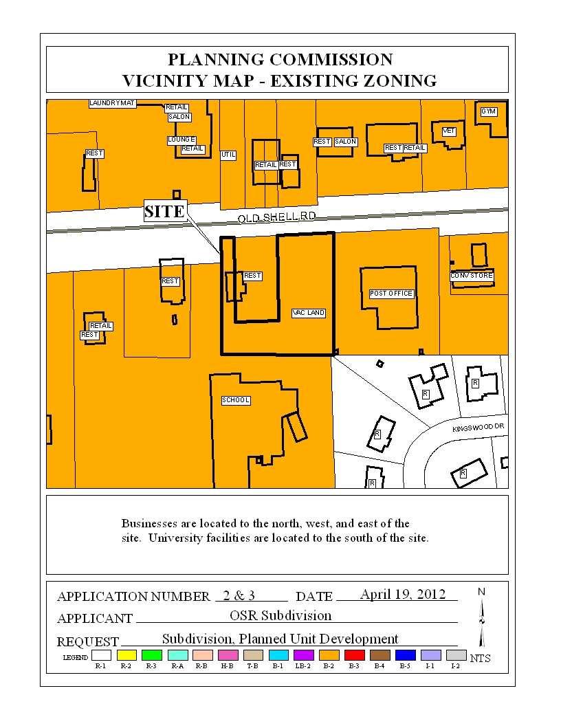
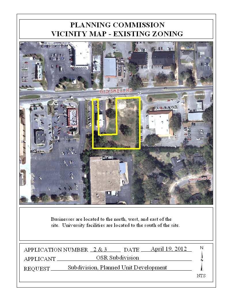
1 PLANNED UNIT DEVELOPMENT & SUBDIVISION STAFF REPORT Date: March 15, 2012 DEVELOPMENT NAME SUBDIVISION NAME LOCATION OSR Subdivision OSR Subdivision 5559 Old Shell Road (South side of Old Shell Road, 570 ± East of University Boulevard South) CITY COUNCIL DISTRICT District 5 AREA OF PROPERTY 1 Lot / 1.4 ± acres CONTEMPLATED USE Planned Unit Development approval to allow multiple buildings on a single building site and shared access between two building sites, and Subdivision approval to create 1 lot. TIME SCHEDULE FOR DEVELOPMENT Immediately ENGINEERING COMMENTS 1.) Any work performed in the existing ROW (right-ofway) such as driveways, sidewalks, utility connections, drainage, irrigation, or landscaping will require a ROW permit from the City of Mobile Engineering Department ( ) and must comply with the City of Mobile ROW code and ordinances. 2.) On-site detention is required and must be in conformance with the City of Mobile Storm Water Management and Flood Control Ordinance. TRAFFIC ENGINEERING COMMENTS Driveway number, size, location and design to be approved by Traffic Engineering and conform to AASHTO standards. A physical barrier, such as curbing and/or grassing, must be provided between the proposed site and the existing Subway restaurant property, as it concerns with non-standard circulation (driving on the left as opposed to the right). The adjacent property contains only pavement and grass, and it is not obvious how cross access will be prohibited. Revised for the April 19 th meeting: Revised site plan does not address the concern of the non-standard circulation adjacent to the Subway restaurant property. A physical barrier, such as curbing and/or grassing, must be provided between the two drive-through lanes. The adjacent property contains only pavement and grass, and it is not obvious how cross access will be prohibited. It
2 appears that the site configuration is not adequate for a large tractor trailer to maneuver through or access the site. Even a single unit truck (standard delivery-type truck) would be limited to access only from the driveway on the western easement, circulating counterclockwise around the building. URBAN FORESTRY COMMENTS Property to be developed in compliance with state and local laws that pertain to tree preservation and protection on both city and private properties (State Act and City Code Chapters 57 and 64). Preservation status is to be given to the 50 Live Oak Tree located on the South side of Lot 1 between proposed buildings. Any work on or under this tree is to be permitted and coordinated with Urban Forestry; removal to be permitted only in the case of disease or impending danger. Granting Perseveration status to this 50 Live Oak Tree will require the applicant to redesign the site. Revised for the April 19 th meeting: Property to be developed in compliance with state and local laws that pertain to tree preservation and protection on both city and private properties (State Act and City Code Chapters 57 and 64). Preservation status is to be given to the 50 Live Oak Tree located on the South side of Lot 1 behind proposed building. Any work on or under this tree is to be permitted and coordinated with Urban Forestry; removal to be permitted only in the case of disease or impending danger. Granting Preservation status to this 50 Live Oak Tree will require the applicant to redesign the site. The revised site plan lists this tree as a 25 Live Oak Tree. FIRE DEPARTMENT COMMENTS All projects within the City of Mobile Fire Jurisdiction must comply with the requirements of the 2009 International Fire Code, as adopted by the City of Mobile. REMARKS The applicant is seeking Planned Unit Development approval to allow multiple buildings on a single building site and shared access between two building sites, and Subdivision approval to create 1 lot. The site is located in Council District 5, and according to the applicant is served by public water and sanitary sewer. The purpose of this application is to create one lot, and create a PUD that allows two new commercial buildings to be constructed on the lot, which shares access to an adjacent access easement. Planned Unit Development review examines the site with regard to its location to ensure that it is generally compatible with neighboring uses; that adequate access is provided without generating excess traffic along minor residential streets in residential districts outside the PUD; and that natural features of the site are taken into consideration. PUD review also examines the design of - 2 -
3 the development to provide for adequate circulation within the development; to ensure adequate access for emergency vehicles; and to consider and provide for protection from adverse effects of adjacent properties as well as provide protection of adjacent properties from adverse effects from the PUD. PUD approval is site plan specific, thus any changes to the site plan / Subdivision plat will require approval by the Planning Commission. Subdivision review examines the site with regard to promoting orderly development, protecting general health, safety and welfare, and ensuring that development is correlated with adjacent developments and public utilities and services, and to ensure that the subdivision meets the minimum standards set forth in the Subdivision Regulations for lot size, road frontage, lot configuration, etc. The site is zoned B-2, Neighborhood Business District, and is abutted on all sides by commercial properties within the same zoning district, with the exception of a portion of the Southeast corner that touches a residential subdivision. The applicant proposes to construct two buildings. Each building will contain six (6) tenant spaces, and combined will have a total of 13,200 square feet of space. A drive-through is proposed adjacent to the building closest to Old Shell Road, however, there is no indication of the use associated with the drive-through. A dumpster area is also depicted on the site plan, however, no enclosure is depicted. Parking for the 13,200 square feet of commercial space will require at least 44 spaces: 73 parking spaces are depicted on the site plan. All parking spaces and aisles appear to meet minimum dimensions, however, there are several dimensional labeling errors of the parking area. Old Shell Road is a proposed major street at this location, thus dedication sufficient to provide 50-feet from the centerline will be required. It appears that the required property dedication is depicted on the site plan and plat, however, it also appears that frontage trees and landscaping are proposed within the dedicated area. Since multiple tenant spaces will be provided, there is a possibility that a tenant will receive deliveries via tractor-trailer or 18-wheeler. If such service is anticipated, the site plan should be revised to include turning templates sufficient to document that the site is accessible for large trucks. One curb-cut is proposed along Old Shell Road, and an additional access point will be via the adjacent non-exclusive easement for ingress and egress to the West. As PUD approval is site plan specific, the site should be limited to one curb-cut to Old Shell Road and one curb-cut to the easement, as depicted. The size and design of any curb-cuts must be approved by Traffic Engineering, and conform to AASHTO standards. The site plan does not provide adequate information for staff to determine compliance with the tree and landscaping requirements of the Zoning Ordinance: trees are depicted, but they are shown in an area proposed for dedication as right-of-way for Old Shell Road. Landscape area calculations on the site plan indicate sufficient area will be provided to comply, however, it appears that too much landscaping area in the right-of-way is being claimed as part of the required landscaping for the site. Additionally, there are at minimum two 24-inch or larger live - 3 -
4 oak trees on the site not depicted on the site plan (as required), yet the application erroneously states that there are NO trees 24-inches or larger on the site. A total of 40 trees will be required on site, thus the site plan should be revised to show that all trees and landscape area can be provided in a manner compliant with the Zoning Ordinance. It should be noted that trees placed in drainage and utility easements cannot count towards meeting the overall tree requirement. A fence should be depicted, along with a 10-foot buffer, where the site abuts residentially zoned property. No lighting is indicated on the site plan, however, any lighting on the site must comply with Sections 64-4.A.2. and 64-6.A.3.c. of the Zoning Ordinance. The parking area must be illuminated due to the presence of more than 10 parking spaces. A billboard exists on the site. There is no indication if it will remain on site or be removed. If the billboard will remain on site, the site plan should be revised to depict the billboard. No storm water detention is depicted on the site plan, however, it may be required. If a portion of the site will be dedicated to storm water detention, it should be indicated on the site plan. The geographic area defined by the city of Mobile and its planning jurisdiction, including this site, may contain Federally-listed threatened or endangered species as well as protected nongame species. Development of the site must be undertaken in compliance with all local, state and Federal regulations regarding endangered, threatened or otherwise protected species. It should also be pointed out that the Americans with Disabilities Act may require the provision of an accessible route from any adjacent public rights-of-way to the proposed buildings on the site, and between the buildings. The applicant should verify any site design requirements of the Federal law, and accordingly revise the site plan. Finally, it appears that the adjacent parcel containing a Subway restaurant is not a legal lot, and in fact should be included with this application for Subdivision compliance: research by staff was not able to identify any deed or similar document justifying its exclusion from the Subdivision application. However, as no shared access or new construction is proposed with the restaurant site, its inclusion in the PUD is not required at this time (a PUD or Administrative PUD will be required at such time as the site is additionally improved). RECOMMENDATION Subdivision: Based upon the preceding, this application is recommended for Holdover until the April 19th meeting, with revisions due by March 23, so that the applicant can undertake the following: 1) Include the adjacent Subway restaurant parcel in the Subdivision application, to include additional postage, notification labels, revised applications and revised plats
5 Planned Unit Development: Based upon the preceding, this application is recommended for Holdover until the April 19th meeting, with revisions due by March 23, so that the applicant can undertake the following: 1) Correction of dimensional errors in the parking areas; 2) Revision of the site plan to clearly show full compliance with the tree and landscaping requirements of the Zoning Ordinance; 3) Revision of the site plan to depict and label all existing trees on the site that are 24-inches DBH or larger, to include the DBH and tree species; 4) Revision of the site plan to show proper screening for the dumpster area; 5) Revision of the site plan to comply with Urban Forestry comments (Property to be developed in compliance with state and local laws that pertain to tree preservation and protection on both city and private properties (State Act and City Code Chapters 57 and 64). Preservation status is to be given to the 50 Live Oak Tree located on the South side of Lot 1 between proposed buildings. Any work on or under this tree is to be permitted and coordinated with Urban Forestry; removal to be permitted only in the case of disease or impending danger. Granting Perseveration status to this 50 Live Oak Tree will require the applicant to redesign the site.); 6) Revision of the site plan to comply with Traffic Engineering comments (Driveway number, size, location and design to be approved by Traffic Engineering and conform to AASHTO standards. A physical barrier, such as curbing and/or grassing, must be provided between the proposed site and the existing Subway restaurant property, as it concerns with non-standard circulation (driving on the left as opposed to the right). The adjacent property contains only pavement and grass, and it is not obvious how cross access will be prohibited.); 7) Revision of the site plan to comply with Engineering comments ( 1. Any work performed in the existing ROW (right-of-way) such as driveways, sidewalks, utility connections, drainage, irrigation, or landscaping will require a ROW permit from the City of Mobile Engineering Department ( ) and must comply with the City of Mobile ROW code and ordinances. 2. On-site detention is required and must be in conformance with the City of Mobile Storm Water Management and Flood Control Ordinance.); 8) Revision of the site plan to comply with Fire comments (All projects within the City of Mobile Fire Jurisdiction must comply with the requirements of the 2009 International Fire Code, as adopted by the City of Mobile.); 9) Revision of the site plan to include verification that tractor trailers can service the site, if such truck access is anticipated; 10) Revision of the site plan to depict a fence and 10-foot buffer where the site abuts residentially-zoned property; 11) Revision of the site plan to indicate compliance with Sections 64-4.A.2. and 64-6.A.3.c. of the Zoning Ordinance regarding site and parking area lighting; 12) Revision of the site plan to depict the existing billboard, if it will remain on site; 13) Revision of the site plan to depict any storm water detention facilities that are proposed for the site; and 14) Revision of the site plan, if necessary, to comply with accessible route and other requirements of the Americans with Disabilities Act
6 Revised for the April 19 meeting: The applicant submitted a revised narrative and site plan for the applications. The revised site plan depicts one building with 6 tenant spaces and 61 parking spaces. The applicant states that the Subway site cannot be included in the Subdivision application due to an existing lease agreement. The applicant states that inclusion in the Subdivision application, if approval requires dedication of right-of-way for Old Shell Road, will violate the existing lease agreement with the Subway tenant. The applicant states that they wish to remove the two live oak trees on the main part of the site in order to maintain visibility from Old Shell Road, as the sight slopes from the street: Urban Forestry had requested preservation status for one of the trees, requiring a redesign, however the applicant did not submit a new design to accommodate the tree, as requested. Regarding tree and landscape compliance, the revised site plan only shows 6 trees along the Old Shell Road frontage (5 of which are proposed in the area to be dedicated to the City), and three existing trees on the rear of the property within a drainage and utility easement. The applicant states that many existing trees will be left on the rear of the site. No other trees, existing or proposed, are depicted, thus staff cannot determine tree compliance. Calculations on the site plan indicate that the site will meet the overall landscape area requirement, but that it will fall slightly short on the frontage landscape area requirement: staff calculations of front landscape area show that the information depicted on the site plan is either incorrect, or includes landscape area in the portion of land that will be dedicated for Old Shell Road right-of-way. Thus, the plan as proposed will not comply with the landscape area requirements of the Zoning Ordinance. Dimensional errors still exist on the site plan, as they relate to the parking area access aisles. The two large live oak trees on the site are still not correctly identified with their diameter breast height, per a site visit by Urban Forestry. No buffers are depicted between the site and adjacent residential properties, as requested. No information is provided regarding access to the site by tractor-trailers, as requested. No information is provided regarding provision of storm water detention facilities, as requested. The Americans with Disabilities Act, a federal law, requires a total of 3 accessible parking spaces for a parking lot with 61 parking spaces, as proposed (also required by the 2009 International Building Code, Chapter 11, Accessibility). The site plan only depicts 2 accessible parking spaces, thus it does not meet the federal requirements or the local building code requirements. Finally, regarding the Subdivision request, the applicant agrees to dedicate land sufficient to provide 40-feet from centerline for an 80-foot wide Old Shell Road right-of-way, even though the Major Street Plan component of the Comprehensive Plan calls for a 50-feet from centerline, - 6 -
7 100-foot wide right-of-way at this location, and by Section V.B.14. of the Subdivision Regulations. It should also be pointed out that three Subdivision applications for properties across the street from the site included the required dedication, thus a waiver of a similar dedication requirement for a site being developed for the first time would be inconsistent with previous Planning Commission decisions in the vicinity. RECOMMENDATION Subdivision: Based upon the preceding, the application is recommended for Denial for the following reasons: 1) The Subdivision, as proposed, is contingent upon the Planned Unit Development; and 2) Dedication sufficient to provide a right-of-way 50-feet from centerline for Old Shell Road is not proposed, as required by Section V.B.14. of the Subdivision Regulations. Planned Unit Development: Based upon the preceding, this application is recommended for Denial for the following reasons: 1) The development will not comply with the minimum landscape and tree requirements of Section 64-4.E. of the Zoning Ordinance; 2) The site will not comply with the right-of-way requirements of the Major Street Plan component of the Comprehensive Plan; 3) Information on the site plan is erroneous or not correctly depicted, for which corrections were previously requested; 4) Residential adjacency buffers are not depicted on the site plan, as required by Section 64-4.D.1 of the Zoning Ordinance; and 5) Preservation status has been requested by Urban Forestry for the 50-inch live oak on the site, and the design, as proposed, will require the removal of the tree
8
9
10
11
SUBDIVISION, PLANNED UNIT DEVELOPMENT, PLANNING APPROVAL, REZONING & SIDEWALK WAIVER STAFF REPORT Date: February 7, 2013
 SUBDIVISION, PLANNED UNIT DEVELOPMENT, PLANNING APPROVAL, REZONING & SIDEWALK WAIVER STAFF REPORT Date: February 7, 2013 APPLICANT NAME SUBDIVISION NAME DEVELOPMENT NAME LOCATION S. E. Cemeteries of AL
SUBDIVISION, REZONING, PLANNING APPROVAL, PUD & SIDEWALK WAIVER STAFF REPORT Date: May 3, 2007
 SUBDIVISION, REZONING, PLANNING APPROVAL, PUD & SIDEWALK WAIVER STAFF REPORT Date: May 3, 2007 APPLICANT NAME SUBDIVISION NAME LOCATION TOG Properties, LLC Highland Professional Park, Resubdivision of
PLANNED UNIT DEVELOPMENT & PLANNING APPROVAL STAFF REPORT Date: April 4, 2013
 PLANNED UNIT DEVELOPMENT & PLANNING APPROVAL STAFF REPORT Date: April 4, 2013 NAME LOCATION The North American Islamic Trust, Inc. 63 East Drive (East side of East Drive, 400 South of Old Shell Road, and
ZONING AMENDMENT, PLANNED UNIT DEVELOPMENT & SUBDIVISION STAFF REPORT Date: March 20, 2008
 ZONING AMENDMENT, PLANNED UNIT DEVELOPMENT & SUBDIVISION STAFF REPORT Date: March 20, 2008 NAME SUBDIVISION NAME LOCATION Joseph Mramor Mramor s Addition to Weinacker Avenue Subdivision 900 Weinacker Avenue
PLANNED UNIT DEVELOPMENT STAFF REPORT Date: June 2, 2016
 # 9 ZON2016-01032 PLANNED UNIT DEVELOPMENT STAFF REPORT Date: June 2, 2016 DEVELOPMENT NAME JJT Properties LLC LOCATION 1147 & 1151 East I-65 Service Road South and 1180 Sledge Drive (Southeast corner
PLANNED UNIT DEVELOPMENT Date: April 5, 2018
 PLANNED UNIT DEVELOPMENT Date: April 5, 2018 DEVELOPMENT NAME SUBDIVISION NAME LOCATION Robert Myers Robert Myers 2955 and 2989 Dauphin Street (Southeast corner of Dauphin Street and Sage Avenue) CITY
ZONING AMENDMENT & PLANNED UNIT DEVELOPMENT STAFF REPORT Date: April 4, 2013
 ZONING AMENDMENT & PLANNED UNIT DEVELOPMENT STAFF REPORT Date: April 4, 2013 NAME DEVELOPMENT NAME LOCATION DIP Exchange, LLC DIP Exchange, LLC 93 Sidney Phillips Drive (West side of Sidney Phillips Drive,
# 17 & 18 ZON & ZON PLANNED UNIT DEVELOPMENT & PLANNING APPROVAL STAFF REPORT Date: February 5, Mobile Carnival Association
 PLANNED UNIT DEVELOPMENT & PLANNING APPROVAL STAFF REPORT Date: February 5, 2009 NAME LOCATION Mobile Carnival Association South side of Bloodgood Street at its West terminus CITY COUNCIL DISTRICT District
PLANNING APPROVAL & PLANNED UNIT DEVELOPMENT Date: April 6, 2017
 PLANNING APPROVAL & PLANNED UNIT DEVELOPMENT Date: April 6, 2017 DEVELOPMENT NAME LOCATION Mobile Christian School 5900 Cottage Hill Road (North side of Cottage Hill Road, 230 ± West of Freemont Drive
PLANNED UNIT DEVELOPMENT & SUBDIVISION STAFF REPORT Date: May 18, 2017
 & PUD-0000102-2017 PLANNED UNIT DEVELOPMENT & SUBDIVISION STAFF REPORT Date: May 18, 2017 NAME SUBDIVISION NAME Dauphin Creek Estates Subdivision Dauphin Creek Estates Subdivision LOCATION CITY COUNCIL
PLANNING APPROVAL & PLANNED UNIT DEVELOPMENT Date: November 2, 2017
 PLANNING APPROVAL & PLANNED UNIT DEVELOPMENT Date: November 2, 2017 DEVELOPMENT NAME LOCATION Mobile Christian School 5900 Cottage Hill Road (North side of Cottage Hill Road, 230 ± West of Freemont Drive
# 3 & 4 HOLDOVER ZON & ZON PLANNED UNIT DEVELOPMENT & PLANNING APPROVAL STAFF REPORT Date: June 4, 2009
 PLANNED UNIT DEVELOPMENT & PLANNING APPROVAL STAFF REPORT Date: June 4, 2009 NAME LOCATION Mobile Carnival Association, Inc. 561 Stuart Circle (South side of Bloodgood Street at its West terminus) CITY
PLANNING APPROVAL & SIDEWALK WAIVER STAFF REPORT Date: December 1, 2016
 PLANNING APPROVAL & SIDEWALK WAIVER STAFF REPORT Date: December 1, 2016 NAME Dennis P. Wilkins LOCATION. CITY COUNCIL DISTRICT District 6 7078 Bruns Drive (Northeast corner of Bruns Drive and Cody Road)
PLANNING APPROVAL STAFF REPORT Date: November 17, 2011
 # 11 ZON2011-02680 PLANNING APPROVAL STAFF REPORT Date: November 17, 2011 NAME LOCATION Alabama Power Company East side of Navco Road 130 ± South of Columbus Avenue CITY COUNCIL DISTRICT District 4 PRESENT
MOBILE CITY PLANNING COMMISSION LETTER OF DECISION. October 22, 2010
 MOBILE CITY PLANNING COMMISSION LETTER OF DECISION Archbishop of Mobile 400 Government St. Mobile, AL 36602 Re: Case #SUB2010-00075 (Subdivision) 3650 Springhill Avenue (Northwest corner of Springhill
PLANNING APPROVAL STAFF REPORT Date: October 5, 2006
 PLANNING APPROVAL STAFF REPORT Date: October 5, 2006 NAME LOCATION Corpus Christi School 6300 McKenna Drive (North side of McKenna Drive at the North termini of Evergreen Road and Hillview Road) CITY COUNCIL
THE CITY OF MOBILE, ALABAMA
 THE CITY OF MOBILE, ALABAMA LETTER OF DECISION Ark of Safety, Inc. Mobile, AL 36617 Re: (Northwest corner of Main Street and First Avenue, extending to the Southwest corner of Esau Avenue and Main Street.)
SUBDIVISION PLANNED UNIT DEVELOPMENT & REZONING STAFF REPORT Date: May 5, 2016
 SUBDIVISION PLANNED UNIT DEVELOPMENT & REZONING STAFF REPORT Date: May 5, 2016 DEVELOPMENT NAME LOCATION LOCATION Midtown Mobile Subdivision IRC-Mobile Midtown, LLC 100 North Florida Street & 2518, 2524,
PLANNED UNIT DEVELOPMENT Date: May 4, 2017
 PLANNED UNIT DEVELOPMENT Date: May 4, 2017 DEVELOPMENT NAME LOCATION Sarah & Michael Stashak 2165 & 2167 Old Shell Road (South side of Old Shell Road, at the Southern terminus of Frazier Court) CITY COUNCIL
CITY OF ZEELAND PLANNING COMMISSION
 APPLICATION FOR SITE PLAN REVIEW AND SPECIAL LAND USE Date City Official App. Filing Fee Rec'd ($350) NOTE TO APPLICANT: Please submit this application for Site Plan Review along with twenty (20) copies
CITY OF MOBILE MOBILE CITY PLANNING COMMISSION LETTER OF DECISION. November 5, 2012
 SAMUEL L. JONES MAYOR CITY OF MOBILE LETTER OF DECISION OFFICE OF THE CITYCOUNCIL COUNCIL MEMBERS REGGIE COPELAND, SR. PRESIDENT-DISTRICT 5 FREDRICK D. RICHARDSON, JR. VICE PRESIDENT-DISTRICT 1 WILLIAM
8 8 CITY OF MOBILE MOBILE CITY PLANNING COMMISSION LETTER OF DECISION. November 5, 2012
 SAMUEL L. JONES 8 8 November 5, 2012 PRESIDENT-DISTRICT S FREDRICK D. RICHARDSON, JR. VICE PRESIDENT-DISTRICT I JOHN C. WILLIAMS DISTRICT4 DISTRICT6 DISTRICT 7 Cummings Architecture Corporation Case #SUB2012-00087
ARTICLE 17 SITE PLAN REVIEW
 ARTICLE 17 SITE PLAN REVIEW 17.01 INTENT AND PURPOSE The intent of this section is to provide for consultation and cooperation between the applicant and the township planning commission so that the applicant
ARTICLE RRCO RED ROCK CORRIDOR OVERLAY DISTRICT
 ARTICLE 11.10 RRCO RED ROCK CORRIDOR OVERLAY DISTRICT (adopted 11/22/2011 MC16-116-11) SECTIONS: 11.10.01 Intent 11.10.02 Boundaries of District 11.10.03 Development Standards 11.10.04 Variance 11.10.01
Application for Site Plan Review
 Application for Site Plan Review City of Pontiac Office of Land Use and Strategic Planning 47450 Woodward Ave, Pontiac, MI 48342 T: 248.758.2800 F: 248.758.2827 Property/Project Address: Sidwell Number:
TOWNSHIP OF LOGAN SOIL & FILL IMPORTATION AND PLACEMENT APPLICATION SUBMITTAL CHECKLIST
 TOWNSHIP OF LOGAN SOIL & FILL IMPORTATION AND PLACEMENT APPLICATION SUBMITTAL CHECKLIST Applications: 5 copies of application - Applicant will reproduce the copies at his/her costs. The Township Clerk
SUBMITTAL REQUIREMENTS
 WHEN PROCESS TYPE III IS USED References to Process Type III applications are found in several places in the Milton Municipal Code (MMC), indicating that the development, activity, or use, is permitted
Asbury Chapel Subdivision Sketch Plan
 Asbury Chapel Subdivision Sketch Plan PART 1: PROJECT SUMMARY Applicant: NVR Inc. Project Size: +/- 76.13 acres Parcel Numbers: 02101112,02116101,02116112, 02116113 Current Zoning: Transitional Residential
PLANNED UNIT DEVELOPMENT APPLICATION
 PLANNED UNIT DEVELOPMENT APPLICATION CITY OF THE DALLES Community Development Department 313 Court Street The Dalles, OR 97058 (541) 296-5481, ext. 1125 Fax (541) 298-5490 www.ci.the-dalles.or.us Date
The petition proposes to rezone 3.17 acres to allow all uses in the TOD-M (transit oriented development mixed-use) district.
 district.") Rezoning Petition 2018-053 Pre-Hearing Staff Analysis December 17, 2018 REQUEST Current Zoning: R-5 (single family), B-1 (neighborhood business), I-1 (light industrial), and I-2 (general industrial) Proposed
Rezoning Petition 2018-053 Pre-Hearing Staff Analysis December 17, 2018 REQUEST Current Zoning: R-5 (single family), B-1 (neighborhood business), I-1 (light industrial), and I-2 (general industrial) Proposed
Improve the appearance of off-street parking areas, vehicular use areas, and property abutting public and private roads;
 Bedford Township, MI (Monroe Co.) 2012 http://library.municode.com/index.aspx?clientid=02123 400.1907 - Landscaping and screening. Se 1907. 1. Intent. Landscaping, greenbelts, and screening are necessary
DEPARTMENT OF PLANNING JEFFERSON PARISH, LOUISIANA
 DEPARTMENT OF PLANNING JEFFERSON PARISH, LOUISIANA DESIGN REVIEW REPORT DOCKET NO: CPZ--16 SUMMAR NO.: : : Paul D. Johnston AT LARGE: A: Christopher L. Roberts B: Cynthia Lee-Sheng ADVERTISING DATES: PAB
F. Driveways. Driveways which provide access to off-street parking or loading from public streets shall comply with the following:
 Section 20.945.040 General Design Standards for Surface Parking Areas. A. Review Authority. Parking lot design and drainage shall be subject to review and approval of the City Transportation Manager. B.
SEPA Modification Application
 SEPA Modification Application 6000 Main St. SW, Lakewood, WA 98499 Application Fee: $200.00 Number of Copies Required: Description of Required Documents: Required: A=always; M=may be 1 SEPA Modification
12 January 12, 2011 Public Hearing APPLICANT: TAILWIND DEVELOPMENT GROUP,LLC PROPERTY OWNER: CITY OF VIRGINIA BEACH
 12 January 12, 2011 Public Hearing APPLICANT: TAILWIND DEVELOPMENT GROUP,LLC PROPERTY OWNER: CITY OF VIRGINIA BEACH STAFF PLANNER: Faith Christie REQUEST: Conditional Change of Zoning (from PD-H1 Planned
SITE PLAN REVIEW APPLICATION AND CHECKLIST
 SITE PLAN REVIEW APPLICATION AND CHECKLIST PROJECT SUMMARY: Project Name: City/ETA Location: City ETA (Application fee & number of copies needed are based on location) Property Location (Legal Description
DEPARTMENT OF PLANNING JEFFERSON PARISH, LOUISIANA
 DEPARTMENT OF PLANNING JEFFERSON PARISH, LOUISIANA DESIGN REVIEW REPORT : CPZ-3-1 : (S) Cynthia Lee-Sheng AT LARGE: A Chris Roberts B Elton M. Lagasse ADVERTISING DATES: 06/03/1 06/10/1 06/17/1 PAB PUBLIC
Camden County Development Regulations. Updated February 2017
 Camden County Development Regulations Updated February 2017 GENERAL MEETING SCHEDULE OF THE CAMDEN COUNTY PLANNING BOARD All meetings will convene at 6:00 PM on the 4th Tuesday of each month and will be
City of Mt. Juliet Planning & Zoning Department. Site Plan Checklist. Site plan cklist v1.18
 City of Mt. Juliet Planning & Zoning Department Site Plan Checklist Site Plan approval is required for all specified community facilities, all commercial, industrial, and multi-family residential activities
D1 September 11, 2013 Public Hearing APPLICANT:
 D1 September 11, 2013 Public Hearing APPLICANT: BEACH MUNICIPAL FEDERAL CREDIT UNION PROPERTY OWNER: SISTERS II, LLC STAFF PLANNER: Karen Prochilo REQUEST: Conditional Change of Zoning (AG-2 Agriculture
ARTICLE 3 LANDSCAPING AND SCREENING REQUIREMENTS
 ARTICLE 3 CHAPTER 4 LANDSCAPING AND SCREENING REQUIREMENTS SEC 3.401 SEC 3.402 (D) (E) PURPOSE: The purpose of this Chapter is to establish minimum standards for the design, installation, and maintenance
Watertown City Council
 City of Watertown Watertown City Council April 14 th, 2015 Agenda Item: City Comment on Sun Share CUP Application Request for Action: Motion to Approve City Comments regarding CUP Application Department:
Design Review Application *Please call prior to submittal meeting to determine applicable fees*
 CITY OF EAGLE 660 E. Civic Lane, Eagle, ID 83616 Phone#: (208) 939-0227 Fax: (208) 938-3854 Design Review Application *Please call prior to submittal meeting to determine applicable fees* FILE NO.: CROSS
CHESAPEAKE LANDSCAPE ORDINANCE
 CHESAPEAKE LANDSCAPE ORDINANCE CONSERVATION PRESERVATION CZO 19-600 Effective October 16, 2008 BUFFER YARD C PARKING LOT REFORESTATION YEAR 1 REFORESTATION YEAR 4 BUFFER YARD F CBPA REFORESTATION Page
TOP TEN LIST OF COMMUNITY CONCERNS REGARDING PROPOSED AMENDMENTS TO CHAPTER 42
 TOP TEN LIST OF COMMUNITY CONCERNS REGARDING PROPOSED AMENDMENTS TO CHAPTER 42 1. Extend the urban area to Beltway 8 in stages, over say a three-year period, prioritizing development in transit and declining
CITY OF KEIZER MASTER PLAN APPLICATION & INFORMATION SHEET
 CITY OF KEIZER MASTER PLAN APPLICATION & INFORMATION SHEET PRE-APPLICATION CONFERENCE Prior to the actual filing of a Master Plan application, it is strongly recommended that the applicant contact Planning
Zoning Ordinance Chapter 10
 CHAPTER 10 - WASHES SECTION 10.0 GENERAL: A. The purpose of this Ordinance is to establish standards for development in or near Major and Minor Washes as defined in Appendix A Glossary of Terms and Definitions
Town of Portola Valley General Plan. Nathhorst Triangle Area Plan
 Town of Portola Valley General Plan Amended December 10, 1997 Table of Contents Introduction... 1 Planning Area... 1 Objectives... 2 Principles... 2 Standards... 4 Description... 4 Community Commercial...
Rezoning Petition Post-Hearing Staff Analysis February 5, 2019
 Rezoning Petition 2018-053 Post-Hearing Staff Analysis February 5, 2019 REQUEST Current Zoning: R-5 (single family), B-1 (neighborhood business), I-1 (light industrial), and I-2 (general industrial) Proposed
November 2, 2015 at 5:15pm City Council Chambers, 3rd Floor, City Hall, 1737 Main Street Columbia, South Carolina 29201
 Subject Property: PLANNING COMMISSION SITE/SUBDIVISION PLAN CASE SUMMARY 10.21 ACRES, WESTSIDE OF CLIF KINDER BOULEVARD COTTAGES AT BURNSIDE FARM BURNSIDE FARMS ASSOCIATES, LLC November 2, 2015 at 5:15pm
APPLICATION FOR REZONING PROPERTY CITY OF HOLLAND, MICHIGAN. Name of Applicant. Address, and Phone # of Applicant
 APPLICATION FOR REZONING PROPERTY CITY OF HOLLAND, MICHIGAN Name of Applicant Address, Email and Phone # of Applicant Name and Address of Owner (if other than applicant) Ownership Interest of Applicant
P: Site Plan Approval
 STAFF REPORT 2016-39P: Site Plan Approval Community Development Department Council Chambers, 7:30 PM, January 5, 2017 To: From: Re: Paul Luke, Plan Commission Chairperson Steve Marciani, AICP, Planning
PRELIMINARY PLAT DESIGN REQUIREMENTS Updated 4/8/2016
 PRELIMINARY PLAT DESIGN REQUIREMENTS Updated 4/8/2016 The following items are required for the preliminary plat. Numbers correspond with those on the example preliminary plat. RENO COUNTY SUBDIVISION REQUIREMENTS
At Your Disposal CUP Amendment, Lot 20, Village Service Commercial, at 128 Bastille Dr. (PLN17-208)
") MEMORANDUM Archuleta County Development Services Planning Department 1122 HWY 84 P. O. Box 1507 Pagosa Springs, Colorado 81147 970-264-1390 Fax 970-264-3338 TO: Archuleta County Planning Commission FROM:
MEMORANDUM Archuleta County Development Services Planning Department 1122 HWY 84 P. O. Box 1507 Pagosa Springs, Colorado 81147 970-264-1390 Fax 970-264-3338 TO: Archuleta County Planning Commission FROM:
PLANNING REPORT CITY OF EAGAN. APPLICANT: Cedar Grove Hospitality, LLC HEARING DATE: December 18, 2014
 PLANNING REPORT CITY OF EAGAN REPORT DATE: December 8, 2014 CASE: 19-PA-11-11-14 APPLICANT: Cedar Grove Hospitality, LLC HEARING DATE: PROPERTY OWNER: The Flats at Cedar APPLICATION DATE: Nov. 21, 2014
ARTICLE 9: LANDSCAPING AND FENCING REQUIREMENTS
 ARTICLE 9: LANDSCAPING AND FENCING REQUIREMENTS Section 9.01 Intent The intent of the landscaping requirements are to improve the appearance of lot areas and soften paved areas and buildings; to provide
M E M O R A N D U M July 27, 2018
 M E M O R A N D U M July 27, 2018 To: Southlake 2035 Corridor Planning Committee From: Kenneth Baker, Sr. Director of Planning and Development Services Subject: Item #6 First National Bank Purpose Review,
Baumgarten MPUD. Exhibit 3 Evaluation Criteria
 Pursuant to LDC subsections 10.02.13 B, 10.02.08 F and Chapter 3 G. of the Administrative Code, staff s analysis and recommendation to the Planning Commission, and the Planning Commission s recommendation
Drexel, Barrell & Co.
 Drexel, Barrell & Co. June 18, 2018 Engineers/Surveyors Boulder Colorado Springs Greeley 3 South 7 th Street Colorado Springs, Colorado 80905-1501 719 260-0887 719 260-8352 Fax El Paso County Planning
PART 1: PROJECT SUMMARY. Proposed Land Use: 120 single-family lots. The application is Attachment A. The site plan is Attachment B.
 PART 1: PROJECT SUMMARY Applicant: JBH Development, LLC and Hopper Communities, INC Project Size: +/- 80.48 acres Parcel Number: 01513107, 01513108, 01513109, 01513113, 01513120, 01513121, 01513122, 01513124,
SITE PLAN REVIEW PROCESS
 BOWNE TOWNSHIP PO Box 35, 8240 Alden Nash Road, Alto, Michigan 49302 Ph. 616-868-6846 Fax 616-868-0110 http://www.bownetwp.org SITE PLAN REVIEW PROCESS 1. Application Form and Fee Schedule Site Plan Review
A BILL FOR AN ORDINANCE TO AMEND CHAPTER 9, KAUAI COUNTY CODE 1987, RELATING TO STREET REQUIRE:MENTS FOR SUBDIVISIONS
 ORDINANCE NO. BILL NO. { vy"yj1j A BILL FOR AN ORDINANCE TO AMEND CHAPTER 9, KAUAI COUNTY CODE 1987, RELATING TO STREET REQUIRE:MENTS FOR SUBDIVISIONS BE IT ORDAINED BY THE COUNCIL OF THE COUNTY OF KAUA'I,
R E S O L U T I O N. 2. Development Data Summary:
 R E S O L U T I O N WHEREAS, the Prince George s County Planning Board has reviewed Departure from Design Standards DDS-631 requesting a departure to allow the loading space and the driveway to the loading
CARVER COUNTY DIVISION OF PUBLIC WORKS LANDSCAPE POLICY. Adopted by the Carver County Board of Commissioners March 3, 2015
 CARVER COUNTY DIVISION OF PUBLIC WORKS LANDSCAPE POLICY Adopted by the Carver County Board of Commissioners March 3, 2015 Policy Statement Goals It is the goal of Carver County Public Works to provide
 NOTES: 1.) THE BOGGY CREEK RD. AND SIMPSON RD. IMPROVEMENTS DEPICTED ON THIS PLAN ARE BASED ON RECORD CONSTRUCTION PLANS AND HAVE NOT BEEN SURVEYED. 2.) EXISTING RESIDENTIAL BUILDING STRUCTURES AND ANCILLARY
PRELIMINARY CONDITIONAL USE SUBMITTAL CHECKLIST REQUIREMENTS
 This checklist must accompany your submittal as the cover page. CONDITIONAL USE Application Submittal Checklist for PRELIMINARY AND FINAL APPROVAL Per Winter Park Land Development Code Sec. 58-90 PRELIMINARY
Kingfisher Planned Development (PLNSUB ) and Special Exception (PLNPCM ) Planned Development and Special Exception
 and Special Exception (PLNPCM ) Planned Development and Special Exception") Staff Report PLANNING DIVISION COMMUNITY & ECONOMIC DEVELOPMENT To: From: Salt Lake City Planning Commission Maryann Pickering, Principal Planner (801) 535-7660 Date: October 22, 2014 Re: Kingfisher Planned
Staff Report PLANNING DIVISION COMMUNITY & ECONOMIC DEVELOPMENT To: From: Salt Lake City Planning Commission Maryann Pickering, Principal Planner (801) 535-7660 Date: October 22, 2014 Re: Kingfisher Planned
STORMWATER MANAGEMENT CODES ANALYSIS RICHLAND COUNTY, SC SITE PLANNING ROUNDTABLE
 STORMWATER MANAGEMENT CODES ANALYSIS RICHLAND COUNTY, SC SITE PLANNING ROUNDTABLE Codes analyses for each subcommittee were completed to assist participants of the Richland County Site Planning Roundtable.
Drexel, Barrell & Co.
 Drexel, Barrell & Co. December 21, 2018 Engineers/Surveyors Boulder Colorado Springs Greeley 3 South 7 th Street Colorado Springs, Colorado 80905-1501 719 260-0887 719 260-8352 Fax El Paso County Planning
ARTICLE 6: Special and Planned Development Districts
 ARTICLE 6: Special and Planned Development Districts 6-10 Traditional Neighborhood Development (TND) District 6-10.10 Purpose and Intent The Traditional Neighborhood Development (TND) District provides
4. To assure that adequate screening and buffering will be provided between the planned project and contiguous properties;
 CHAPTER V. SITE PLAN REGULATIONS 5.1. Purpose and intent/applicability. 5.2. Procedures for review of site plans. 5.3. Required submittals. 5.1. Purpose and intent/applicability. 5.1.1. Purpose and intent.
BUFFERS, TREE PROTECTION AND LANDSCAPING. Sec Purpose and Intent.
 ARTICLE 20 BUFFERS, TREE PROTECTION AND LANDSCAPING Sec. 20.1. Purpose and Intent. Trees improve air and water quality, reduce soil erosion, reduce noise and glare, provide habitat for desirable wildlife,
AWH REPORT OF THE PLANNING AND DEVELOPMENT DEPARTMENT FOR APPLICATION FOR REZONING ORDINANCE TO PLANNED UNIT DEVELOPMENT
 AWH REPORT OF THE PLANNING AND DEVELOPMENT DEPARTMENT FOR APPLICATION FOR REZONING ORDINANCE TO PLANNED UNIT DEVELOPMENT MAY 8, 2014 The Planning and Development Department hereby forwards to the Planning
Subdivision Staff Report
 Subdivision Staff Report Name: Bridgewalk Subdivision Date: December 8, 2004 File: SUB04-00089 Meeting: December 14, 2004 Approval: Preliminary To: City Council Lead Agency: Boise City From: Richard Beck
DEPARTMENT OF PLANNING JEFFERSON PARISH, LOUISIANA
 DEPARTMENT OF PLANNING JEFFERSON PARISH, LOUISIANA DESIGN REVIEW REPORT : SUMMAR NO.: 4469 (S) Paul Johnston AT LARGE: A Chris Roberts B Cynthia Lee-Sheng ADVERTISING DATES: PAB PUBLIC HEARING: HEARING:
November 21, Planning Commission Charter Township of Lyon Grand River Ave. New Hudson, MI 48165
 Planning Commission Charter Township of Lyon 58000 Grand River Ave. New Hudson, MI 48165 Subject: AP-18-68; 11 Mile and Milford Road Park, Site Plan Review #1 Based on site plan dated 11/12/18 Location:
The Illinois Department of Transportation and Lake County Division of Transportation. Route 173, including the Millburn Bypass
 The Illinois Department of Transportation and Lake County Division of Transportation welcome you to this Public Hearing for U.S. Route 45 from Illinois Route 132 to Illinois Route 173, including the Millburn
SITE PLAN REVIEW ITEMS - REFERENCE CHECKLIST
 City of Seminole 9199 113 th Street N. Seminole, FL 33772 Ph: (727) 392-1966 Fx: (727) 319-6583 SITE PLAN REVIEW ITEMS - REFERENCE CHECKLIST Note: This checklist is designed to aid designers in the review
Urban Planning and Land Use
 Urban Planning and Land Use 701 North 7 th Street, Room 423 Phone: (913) 573-5750 Kansas City, Kansas 66101 Fax: (913) 573-5796 Email: planninginfo@wycokck.org www.wycokck.org/planning To: From: City Planning
ITEM # _ 41 _ DATE: COUNCIL ACTION FORM MAJOR FINAL PLAT FOR MENARDS SUBDIVISION BACKGROUND:
 ITEM # _ 41 _ DATE: 06-12-18 COUNCIL ACTION FORM SUBJECT: MAJOR FINAL PLAT FOR MENARDS SUBDIVISION BACKGROUND: The City s subdivision regulations are included in Chapter 23 of the Ames Municipal Code.
City of Fort Lupton Site Plan Process
 Form WKBK001 City of Fort Lupton Site Plan Process Purpose The Site Plan process is meant to promote orderly and sound development standards as they apply to the City. These site development standards
Sec Development Standards in the Environmental Overlay (EO) District
 District") Sec. 4-12 Development Standards in the Environmental Overlay (EO) District a. Applicability. The Environmental Overlay District applies to areas identified on the official Zoning Map. Environmental Overlay
Sec. 4-12 Development Standards in the Environmental Overlay (EO) District a. Applicability. The Environmental Overlay District applies to areas identified on the official Zoning Map. Environmental Overlay
HISTORIC LANDMARK COMMISSION STAFF REPORT
 HISTORIC LANDMARK COMMISSION STAFF REPORT Park Strip Raised Planter Boxes Minor Alteration PLNHLC2014-00603 163 D Street Meeting Date: November 6, 2014 Planning Division Department of Community and Economic
CITY PLANNING COMMISSION AGENDA. ITEM NO: 6.a 6.b STAFF: LONNA THELEN
 Page 156 CITY PLANNING COMMISSION AGENDA ITEM NO: 6.a 6.b STAFF: LONNA THELEN FILE NO(S): A. - CPC ZC 08-00069 QUASI-JUDICIAL B. - CPC CU 08-00070 QUASI-JUDICIAL PROJECT: APPLICANT: OWNER: PHIL LONG VALUCAR
CITY PLANNING COMMISSION AGENDA ITEM: C STAFF: ROBERT TEGLER FILE NO: CPC PUD QUASI-JUDICIAL
 CPC AGENDA June 8, 2006 Page 37 CITY PLANNING COMMISSION AGENDA ITEM: C STAFF: ROBERT TEGLER FILE NO: CPC PUD 05-294 - QUASI-JUDICIAL PROJECT: APPLICANT: OWNER: PARKWOOD AT WOLF RANCH NASS DESIGN ASSOCIATES
MONTGOMERY COUNTY PLANNING DEPARTMENT THE MARYLAND-NATIONAL CAPITAL PARK AND PLANNING COMMISSION
 MONTGOMERY COUNTY PLANNING DEPARTMENT THE MARYLAND-NATIONAL CAPITAL PARK AND PLANNING COMMISSION MCPB Item No. Date: 12-10-15 Leisure World Clubhouse II Addition Fitness Center, Limited Site Plan Amendment
1173 W. University Dr. Request to construct a new Alumni Center.
 John S. Franden, President Mitchell A. Jaurena, Vice President Rebecca W. Arnold, Commissioner Sara M. Baker, Commissioner Jim D. Hansen, Commissioner Date: May 22, 2014 To: Jennifer Wheeler Boise State
Woodburn Comprehensive Plan Growth Management Goals and Policies
 Goal Woodburn Comprehensive Plan Growth Management Goals and Policies G-1. The City's goal is to manage growth in a balanced, orderly and efficient manner, consistent with the City s coordinated population
Planned Development Review Revisions (Project No. PLNPCM )
") Planned Development Review Revisions (Project No. PLNPCM2014-00139) Standard residential development Planned Development Example: Smaller lot sizes than what is allowed to create open space amenity. What
Planned Development Review Revisions (Project No. PLNPCM2014-00139) Standard residential development Planned Development Example: Smaller lot sizes than what is allowed to create open space amenity. What
Chapter 19.5 LANDSCAPING REQUIREMENTS
 Chapter 19.5 LANDSCAPING REQUIREMENTS Sec. 19.5-1. Intent The intent of the landscaping requirements stated herein are as follows: To aid in stabilizing the environment's ecological balance by contribution
VILLAGE OF CLEMMONS PLANNING BOARD DRAFT STAFF REPORT. Single Family Residential, Townhomes
 VILLAGE OF CLEMMONS PLANNING BOARD DRAFT STAFF REPORT PETITION INFORMATION Docket # C-212 Staff Megan Ledbetter Petitioner(s) Peacehaven Development LLC Owner(s) Larry Jarvis, William Alexander and Peacehaven
DEPARTMENT OF PLANNING JEFFERSON PARISH, LOUISIANA
 DEPARTMENT OF PLANNING JEFFERSON PARISH, LOUISIANA DESIGN REVIEW REPORT DOCKET NO: : : : Paul D. Johnston AT LARGE: A: Christopher L. Roberts B: Cynthia Lee-Sheng ADVERTISING DATES: PAB PUBLIC HEARING:
CASE NUMBER: 16SN0701 APPLICANT: Hanky, LLC
 STAFF S ANALYSIS AND RECOMMENDATION Planning Commission (CPC) Public Hearing Date: MAY 17, 2016 CPC Time Remaining: 100 DAYS Applicant s Agent: DANIEL L. CASKIE (804-569-7060) Applicant s Contact: MICHAEL
McDonald s Restaurant - Purcellville Town of Purcellville Special Use Permit Statement of Justification July 24, 2014
 Introduction / Written Statement McDonald s Restaurant - Purcellville McDonald s Corporation is proposing to redevelop the existing McDonald s eating establishment with a drive-through located at 121 N
ARTICLE IX SPECIAL PERMIT USES
 ARTICLE IX SPECIAL PERMIT USES All special permit uses cited in Article IX and Attachment A of this Ordinance or any other Section of this Ordinance shall be subject to Site Plan Review. The procedures
CHEBOYGAN COUNTY PLANNING COMMISSION
 CHEBOYGAN COUNTY PLANNING COMMISSION 870 SOUTH MAIN ST. PO BOX 70 CHEBOYGAN, MI 49721 PHONE: (231)627-8489 FAX: (231)627-3646 CHEBOYGAN COUNTY PLANNING COMMISSION MEETING & PUBLIC HEARING WEDNESDAY, NOVEMBER
Article 7.05 Manufactured Home Park Districts
 Article Manufactured Home Park Districts.01 Intent The purpose of the MHP Manufactured Home Park District is to give recognition to the fact that manufactured homes can provide satisfactory living conditions
APPENDIX J PERFORMANCE STANDARDS FOR GRAVEL MINE, PIT MINE, OR QUARRY
 APPENDIX J PERFORMANCE STANDARDS FOR GRAVEL MINE, PIT MINE, OR QUARRY A. Purpose: 1. Regulatory Requirement and Use Mitigation: The purpose of this appendix is to provide a regulatory context (standards)
TO: Glynn County Islands Planning Commission. Karl Bursa, AICP, Planner II. SP3124 Aviator Plaza. DATE: November 17, 2015
 COMMUNITY DEVELOPMENT DEPARTMENT Planning and Zoning Division 1725 Reynolds Street, Suite 200, Brunswick, GA 31520 Phone: 912-554-7428/Fax: 1-888-252-3726 TO: Glynn County Islands Planning Commission MEMO
Project phasing plan (if applicable) 12 copies of site plan
 12 copies of site plan") SITE PLAN REVIEW PERMIT APPLICATION City of Grand Haven, 11 N. Sixth Street, Grand Haven, MI 49417 Phone: (616) 847-3490 Fax: (616) 844-2051 Website: www.grandhaven.org 1. Project Information Address/location
SITE PLAN REVIEW PERMIT APPLICATION City of Grand Haven, 11 N. Sixth Street, Grand Haven, MI 49417 Phone: (616) 847-3490 Fax: (616) 844-2051 Website: www.grandhaven.org 1. Project Information Address/location