River Kleine Nete : Creating ecological flooding zones at recreation areas
|
|
|
- Bonnie Fields
- 5 years ago
- Views:
Transcription


1 Stoffel Moeskops Lange Kievitstraat bus 64 B-2018 ANTWERPEN T s.moeskops@vmm.be River Kleine Nete : Creating ecological flooding zones at recreation areas \\\\\\\\\\\\\\\\\\\\\\\\\\\\\\\\\\\\\\\\\\\\\\\\\\\\\\\\\\\\\\\\\\\\\\\\\\\\\\\\\\\\\\\\\\\\\\\\\\\\\\\ Interreg North Sea Region Project: Building with Nature WP4: Natural Catchment Laboratories \\\\\\\\\\\\\\\\\\\\\\\\\\\\\\\\\\\\\\\\\\\\\\\\\\\\\\\\\\\\\\\\\\\\\\\\\\\\\\\\\\\\\\\\\\\\\\\\\\\\\\\ 1 Kleine Nete river restoration The Kleine Nete is a rain river which winds across the sandy north-east of Flanders as a blue-green ribbon. It is one of the most natural rivers in the dense populated Flanders. On the one hand, the agriculture sector, which is the principal land user along the Kleine Nete, bears the water in case of high floods. Buildings are rare and so the valley is hydrological seen mainly unspoilt. On the other hand, the valley of the Kleine Nete is ecologically very valuable, protected by Flemish and European legislation. Significant populations of rare fish species can still be found here. Figure 1: Location of Kleine Nete river in Flanders, the northern region of Belgium However, the river itself has endured some changes in the seventies. In order to make the wet valley grounds more suitable for large-scale agriculture, the river has been straightened, broadened and deepened. This has several consequences. The water is evacuated more efficiently, which increases the flood risk in downstream areas. The groundwater levels went down by the enhanced drainage, causing a loss of groundwater dependent habitat species. It also meant a loss of natural habitat and migration facilities of biotic communities within the water system and by so a decline of the ecological value of the Kleine Nete valley. As the embankments are located very close to the river, they are vulnerable to erosion. By so, they need continuous pagina 1 van 13


2 maintenance. Also there is loss of water storage capacity caused by for example the building of dikes, cutting off meanders and elevation of grounds by landfills owing to several sectors (agriculture, recreation,...). Figure 2: Course of the Kleine Nete in the past To mitigate the major disturbance of the river system, a river restoration program was set up. Goals are: Creation of more water storage capacity Realisation of ecological added value Restoration of the structure of the water course The following projects are fitted within the river restoration program: Fish passages at the weirs of Grobbendonk, Herentals, Kasterlee and Retie (established) Dike replacement near the city of Grobbendonk (established) Excavation of a former sand deposal area of 15 ha, known as Hellekens near the city of Herentals (works in progress) Remeandering in the nature reserve Olens Broek near the city of Olen (design finished) Creating ecological flooding zones at recreation areas near the city of Kasterlee (pre design phase) Dike replacement and construction of a winter bed near the cities of Geel and Kasterlee (building permit delivered) Remeandering and construction of a swamp area near the city of Geel (works will start summer 2018) River Kleine Nete: creating ecological flooding zones at recreation areas page 2 van 13
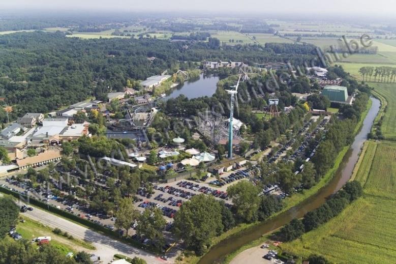
3 2 Recreation areas Three recreation areas are situated along the Kleine Nete at the municipality of Kasterlee. These recreation areas have an economic function. It is not evident making alterations to the water course here. The economic sector is on the one hand vulnerable to the consequences of climate change, e.g. increased flood risk, and on the other hand not willingly to cede space with an economic function to river adaptation works, e.g. water storage areas. A challenge is present to find innovative solutions for multifunctional use of space. By rearranging the bank zone of the Kleine Nete, we intent to create a win-win situation for both the river and the recreation areas. It means that we are looking for an innovative solution in which the functions of the water course and the recreation are combined. This is understood as multifunctional use of space. The project can be considered as a pilot project / laboratory on how hard, rather economic allocations can be conformed to water and ecological systems. The recreation areas attract lots of people, which provides opportunities to install educational and sensitization facilities. For most people, enterprises and even local authorities, climate change and his consequences is something they have heard from, but they don t know how it affects them and which actions should be done concretely. It is not considered a priority. The challenge is not only to inform the different stakeholders (population, local authorities, enterprises,...), but also to involve them actively in the elaboration of adaptation measures. In this manner we can create more awareness, responsibility and understanding for the needed public works. The 3 recreation areas are camping site Korteheide, amusement park Bobbejaanland and recreation site Ark van Noë. Together, they represent 1,6 km of banks. The main reasons to integrate these areas into the river restoration program are: - Comprehensiveness: if these areas are included, the Kleine Nete river will we adjusted for a continuous 10 km - Public support: lots of owners in the neighbourhood had to cede land. It concerns mainly agriculture, forestry, pasture. It would be difficult to accept if the harder economic sites would not be affected. 3 Characteristics of the Kleine Nete near the recreation areas The section of the Kleine Nete near the recreation areas has a width at the bottom of 9 meter. The width between the banks is 17 meter. The bottom lies more or less 3,5 meter under the surface level. The average discharge is 4 m³/s which can increase to 33 m³/s for a storm with return period 100 years. The catchment area of the Kleine Nete is 573 km² and belongs to the Scheldt basin. Return period Discharge Water depth Average 4 m³/s 1,7 meter 2 years 23 m³/s 3,6 meter 10 years 29 m³/s 3,7 meter 100 years 33 m³/s 3,8 meter River Kleine Nete: creating ecological flooding zones at recreation areas page 3 van 13
, used as swimming pool.")

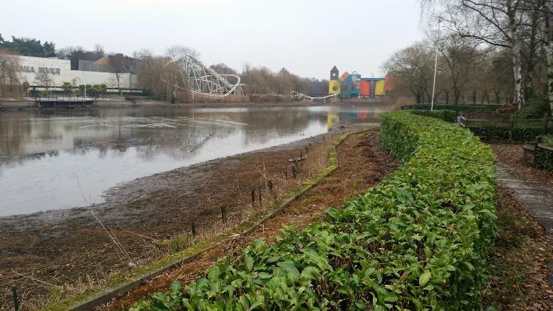
4 4 Camping site Korteheide 4.1 Description Figure 3: Section Kleine Nete Camping site Korteheide is adjacent to the Kleine Nete for a distance of 400 meter. Roughly 40 meter inland, an historical cut off meander is still present in the landscape. It is in use as fishpond. More northly a pond is located (seepage water), used as swimming pool. A limiting condition for the rearrangement of the bank zone is the preservation of the camping facilities, i.e. number and quality of the standings for caravans. North of the camping site two areas are present on which new standings for caravans can be allocated as compensation for a possible loss in the bank zone. These two compensation zones can only be brought into use for a surface area equal to the camping site surface area given to nature or water. In other words: a compensation is allowed, a bare extension of the camping site is not allowed. River Kleine Nete: creating ecological flooding zones at recreation areas page 4 van 13


5 4.2 Design proposal The design consists of: - Reconnection of a part of the old, cut-off meander to the river. The other part will be kept in use as fishing pond as it is more difficult to create a new fish pond further from the river where the ground level is higher - The area between the meander and the river will be turned into an ecological, inundatable place. Summer camping is still allowed, but there will be no infrastructure. It is needed to remove 58 campers to the compensation areas. - Two compensation zones will be used to relocate the 58 campers. At the moment, these zones are covered with conifers, which will be cut down ( m²) - A small stream around the camping site will be upgraded and connected to the Kleine Nete river system. The estimated costs are: - Construction of new camping terrain and relocation of the caravans: euro - Construction of green area, including side works on bank Kleine Nete: euro - Construction of meander: euro - Upgrading small stream: euro - TOTAL: euro River Kleine Nete: creating ecological flooding zones at recreation areas page 5 van 13

6 River Kleine Nete: creating ecological flooding zones at recreation areas page 6 van 13

7 5 Amusement park Bobbejaanland 5.1 Description Amusement park Bobbejaanland is adjacent to the Kleine Nete for a distance of 850 meter. The area between the amusement park and the Kleine Nete is in use as parking places for visitors. Offering sufficient parking places to visitors is already a problem for Bobbejaanland at the moment. A limiting condition for the rearrangement of the bank zone is a preservation of the number of parking places. The rearrangement should imply an improvement of the landscape experiencing. The rather bare car park can be transformed into a nice place by which the visit starts with a pleasant walk from car to amusement park. The strong separation between Kleine Nete and recreation area should be abandoned. River Kleine Nete: creating ecological flooding zones at recreation areas page 7 van 13


8 River Kleine Nete: creating ecological flooding zones at recreation areas page 8 van 13

9 5.2 Design proposal The design consists of: - Lay a 10m buffer strip between parking and river (loss of 50 parking places) - Digging of a new meander: 4,50m bottom width (loss of 164 parking places) - Reconversion of inundatable parking island between meander and Kleine Nete - Construction of new two storey parking garage to compensate loss of parking places. The garage will implicate a loss of 96 parking places on the ground level. One level of the garage can store 307 cars. By so, the loss in parking places is compensated by one level. If the amusement park wishes to increase the parking capacity, it is possible to make a two storey parking garage. The estimated costs are: - One level garage of 307 parking places: euro - Construction of meander: euro - Construction of parking island including 4 bridges and green area: euro - TOTAL: euro River Kleine Nete: creating ecological flooding zones at recreation areas page 9 van 13


10 6 Recreation site Ark van Noë 6.1 Description Recreation site Ark van Noë is adjacent to the Kleine Nete for a distance of 300 meter. Roughly 60 meter inland, an historical cut off meander is still present in the landscape. It is in use as fishpond. Between the Kleine Nete river and the meander there is an artificial pond which was used for swimming in the past. River Kleine Nete: creating ecological flooding zones at recreation areas page 10 van 13

11 6.2 Design proposal The design consists of: - Dike improvement works along the Kleine Nete using natural materials - Reconnection to the river of the old, cut-off meander - Re-organisation of the entrance to the site to increase the water experience. Parking places will be relocated to the north of the meander. Visitors will enter the site by a new footbridge. The estimated costs are: - Construction of meander, bank works on meander and Kleine Nete, including land purchase: euro - 3 new bridges: euro - TOTAL: euro River Kleine Nete: creating ecological flooding zones at recreation areas page 11 van 13

12 7 Questions We would like to know your opinion about this project. Here are some guiding questions: General Do you have any experience with similar cases? Which points of attention do you see? The realisation of the project is accelerated by pressure from neighbouring farmers who had to cede land and had a hard time accepting that more popular areas would not be affected. Do you think the water manager as a public service has to take this into account? The recreation areas are surrounded by farmland. Here, the water manager has expropriated a 15m strip along the Kleine Nete to create a two stage channel and new dikes. Designing concepts with meanders or compensatory parking places and caravans in agriculture areas would be cheaper, but affects again the agricultural sector. Would you consider such solutions? Design concept What do you find positive / negative about the design proposals? Which other solutions do you propose? Do you think too much importance is set to the interests of the private companies who own the recreation sites? The recreation areas have to adapt themselves more to a new natural river system. The meanders are not considered as free meandering water courses. Which bank protection do you propose? How would you conceive the embankments? River Kleine Nete: creating ecological flooding zones at recreation areas page 12 van 13
13 Financial The redevelopment of both sites will have little impact in reducing the flood risk, but there will be positive effects on other goals of river restoration. Which are the main benefits you think of and how can they financial be valued? Do you think comparing costs and benefits, the investments are worth it? Who has to pay for the realisation of the project? Do you think the government has to bear all the costs? Do you propose a certain distribution key? For the case of the amusement park: should they increase the price of a parking ticket in order to finance the project? What is an acceptable price? Educational Which educational / sensitization possibilities do you see to promote the Kleine Nete river and water management? Which concrete measures do you propose and on which themes? River Kleine Nete: creating ecological flooding zones at recreation areas page 13 van 13
Lake and Stream Restoration Project
 Pre-project Fact Sheet May 2012 Toledo Botanical Garden (TBG) is a 60 acre public garden visited by more than 120,000 people annually. It is located in Toledo, Ohio in the Ottawa River watershed within
Sectoral workshop on Green infrastructure implementation. Multiple benefits of Green Infrastructure
 Sectoral workshop on Green infrastructure implementation Multiple benefits of Green Infrastructure Kristin Faurest Arad October 2015 Contents Green infrastructure as an integrated solution: social, ecological
Policy for management and protection of the coast
 Policy for management and protection of the coast Policy for management and protection of the coast Mona Ohlsson Samhällsbyggnadsförvaltningen Ystads kommun, 2008 3 THE MUNICIPALITY GUIDELINES REGARDING
THE SEINE- SCHELDT PROJECT Design & Build Harelbeke. ir. Ellen Maes, project engineer SMART Rivers 2011, 15th of September 2011
 THE SEINE- SCHELDT PROJECT Design & Build Harelbeke ir. Ellen Maes, project engineer SMART Rivers 2011, 15th of September 2011 OVERVIEW Waterwegen en Zeekanaal NV Seine-Scheldt an inland navigation project
The climatic weather forecast
 The climatic weather forecast More mild winters with more and heavier rainfall. Warmer and drier summers with more intense thunderstorms. The Netherlands: general policy on mitigation measures against
Biodiversity Conservation
 Biodiversity Conservation and Site Plan Review Biodiversity conservation principles Threats to biodiversity Location of development Reviewing site plans Lunch Reviewing site plans (continued) LEED and
SECTION 5: REACH RECOMMENDATIONS/MAPS
 SECTION 5: REACH RECOMMENDATIONS/MAPS This section describes areas of concern and provides specific recommendations for each project reach. Locations of stormwater drains were from GIS coverage supplied
Urban runoff in my neighborhood (Capitol Hill) is heavy with trash and other debris.
 is heavy with trash and other debris.") South Platte River Meeting Comments & s #1 I am a huge fan of river areas and would love the Platte and surrounding waterways to improve to allow habitat for wildlife and recreation opportunities for citizens.
South Platte River Meeting Comments & s #1 I am a huge fan of river areas and would love the Platte and surrounding waterways to improve to allow habitat for wildlife and recreation opportunities for citizens.
North Branch of Cypress Creek Ecological Restoration: A Comprehensive Approach to Stream Restoration
 North Branch of Cypress Creek Ecological Restoration: A Comprehensive Approach to Stream Restoration Rocky Powell Clear Creeks Consulting, LLC Keith D. Tate, P.E. BayLand Consultants & Designers, Inc.
Step by step, the construction of a coherent overall restoration on the Seine estuary the role of GIP Seine-Aval
 Step by step, the construction of a coherent overall restoration on the Seine estuary the role of GIP Seine-Aval Stéphanie Moussard GIP Seine-Aval Seine estuary - France I-Introduction to the Seine estuary
Sustainable Urban Drainage Systems (SuDs)
") Sustainable Urban Drainage Systems (SuDs) Brendan Colgan, Chartered Engineer Hydrological Cycle - managing the entire cycle is the goal Disruption of the Hydrological Cycle Why use SuDS? G Traditional
Sustainable Urban Drainage Systems (SuDs) Brendan Colgan, Chartered Engineer Hydrological Cycle - managing the entire cycle is the goal Disruption of the Hydrological Cycle Why use SuDS? G Traditional
Green Infrastructure Case Study Template
 Green Infrastructure Case Study Template The aim of the exercise is to provide information on how the elements of the Green Infrastructure Strategy are implemented at national level and to provide case
Schedule of Planning Applications Committee Date: 23 May Reference: 06/17/0726/F Parish: Hemsby Officer: Mr J Beck Expiry Date:
 Schedule of Planning Applications Committee Date: 23 May 2018 Reference: 06/17/0726/F Parish: Hemsby Officer: Mr J Beck Expiry Date: 22-05-2018 Applicant: Proposal: Site: Mr Gillett Change of use to the
Weston s Wetlands, Stormwater, & Open Space
 Weston s Wetlands, Stormwater, & Open Space Weston s Wetlands, Stormwater, & Open Space Conservation Commission Role and Responsibilities Laws that protect wetlands What residents can do to protect wetlands
SUMMER VILLAGE OF SUNRISE BEACH
 SUMMER VILLAGE OF SUNRISE BEACH Municipal Development Plan Bylaw No. 132-13 ~ 2 ~ Summer Village of Sunrise Beach Municipal Development Plan 1 INTRODUCTION 1.1 SETTING The Summer Village of Sunrise Beach
Water Sensitive Urban Design results and principles
 3rd SWITCH Scientific Meeting Belo Horizonte, Brazil 30 November 4 December 2008 Water Sensitive Urban Design results and principles Prof. Heike Langenbach, Dipl.-Ing. Jochen Eckart and Dipl.-Ing. Gerko
elbridge Core Strategy
 C elbridge Core Strategy Celbridge is designated as a Moderate Growth Town in the RPGs. The County Development Plan reinforces this designation in its settlement strategy. Moderate Growth Towns within
Rotterdam Climate Proof
 Rotterdam Climate Proof Connecting water with opportunities Towards Rotterdam Resilient Delta City Jorg Pieneman Programme manager Water www.rotterdamclimateinitiative.nl Rotterdam ROTTERDAM REGION THE
Green Infrastructure. IENE 2012 International Conference
 Green Infrastructure IENE 2012 International Conference Marco Fritz, DG Environment Potsdam, 22/10/2012 Content 1) Green Infrastructure why does it matter? 2) Added value 3) Policy development framework
Overview Report. Proposed Development
 Overview Report Proposed Development the construction of a 1km cycle/pedestrian trail including a new footbridge, new car park and entrance road at Drumshanbo Lock and a new pedestrian/cycle road crossing,
CITY COUNCIL AGENDA REPORT
 CITY COUNCIL AGENDA REPORT Subject: DESIGNATED FLOOD LINE CARROT CREEK Recommendation(s) That Administration bring forward a Land Use Bylaw amendment in October 2014 establishing the Designated Flood Line
GREEN NETWORK APPLICATIONS IN ESTONIA
 GREEN NETWORK APPLICATIONS IN ESTONIA Kalev Sepp, Tuuli Veersalu, Martk Külvik Estonian University of Life Sciences 1 WHY? BACKGROUND - POLITICAL By adopting the Pan-European Biological and Landscape Diversity
Infrastructure, Development and Enterprise Services. Natural Heritage Action Plan (NHAP) Project Initiation
 Project Initiation") Staff Report To Service Area Committee of the Whole Infrastructure, Development and Enterprise Services Date Monday, March 6, 2017 Subject Natural Heritage Action Plan (NHAP) Project Initiation Report
Staff Report To Service Area Committee of the Whole Infrastructure, Development and Enterprise Services Date Monday, March 6, 2017 Subject Natural Heritage Action Plan (NHAP) Project Initiation Report
TERRESTRIAL NATURAL HERITAGE SYSTEM STRATEGY APPENDIX F: MODEL POLICIES FOR THE IMPLEMENTATION OF THE TARGET TERRESTRIAL NATURAL HERITAGE SYSTEM
 TERRESTRIAL NATURAL HERITAGE SYSTEM STRATEGY APPENDIX F: MODEL POLICIES FOR THE IMPLEMENTATION OF THE TARGET TERRESTRIAL NATURAL HERITAGE SYSTEM C H A P T E R 1 M O D E L P O L I C I E S F O R I M P L
Name of Action: Arrangement of beach locations on the River Vikhra
 COMUS PROJECT PILOT TOWN: MSCISLAŬ REFERENCE PLAN ACTION N 3.1 Name of Action: Arrangement of beach locations on the River Vikhra Location Image Summary: To develop recreation sites on the beaches of the
Welcome to our public exhibition
 About our development Welcome to our public exhibition This exhibition gives you the chance to view and comment on our proposals for a new residential development of 165 high-quality homes, along with
Just The Basics: Illicit Discharge. What does it mean to me?
 Just The Basics: Illicit Discharge What does it mean to me? What is an Illicit Discharge? An illicit discharge is the discharge of pollutants or non-storm water materials to storm water drainage systems
Making the case for Sustainable Transport Project Potential
 Making the case for Sustainable Transport Project Potential The Structural Investment Fund (SIF) Strategy for Greater Lincolnshire identifies the barriers to growth identified by having poor transport
Dr.- Ing. Andreas Hendricks Land consolidation and land development more than reorganizing land property
 Dr.- Ing. Andreas Hendricks Land consolidation and land development more than reorganizing land property Tartu, May 2015 Structure Structural data Objectives Procedures Main stages and features Costs and
Poisoned Park? How Exide s Lead Contamination Risks Frisco s Grand Park
 Frisco City Hall has big plans to transform Stewart Creek into a Grand Park with lots of water features for kids to play in. Poisoned Park? How Exide s Lead Contamination Risks Frisco s Grand Park But
WRC in Mechelen (Belgium)
") Water Resilient Cities WRC in Mechelen (Belgium) General overview Location Location Partners in the Mechelen project City of Mechelen Historically important city of art, railroad, 80 000 inhabitants Former
Water Resilient Cities WRC in Mechelen (Belgium) General overview Location Location Partners in the Mechelen project City of Mechelen Historically important city of art, railroad, 80 000 inhabitants Former
Peoria has a tremendous opportunity to get sewer overflows under control and fight stormwater runoff head-on
 Peoria has a tremendous opportunity to get sewer overflows under control and fight stormwater runoff head-on The time is right to find funding solutions that address our aging infrastructure. We can enable
SHORELINE, FLOOD AND COASTAL DEFENCE MANAGEMENT PLANS
 These plans may provide opportunities as well as concern for recreational boating. They are currently being revised and consulted on. This document explains how we can engage in the process. Shoreline,
Overview of Development Plan in Guyana, South America. Prepared by Stefan John Director of D&J Invesments. October, 2016
 1 Overview of Development Plan in Guyana, South America. Prepared by Stefan John Director of D&J Invesments. October, 2016 2 Executive Summary D&J Investments is a young, innovative and pioneering Real
Development of green infrastructure in EU regions Nature-based solutions delivering multiple benefits
 Development of green infrastructure in EU regions Nature-based solutions delivering multiple benefits A Policy Brief from the Policy Learning Platform on Environment Introduction What is green infrastructure?
Appendix I. Checklists
 Appendix I Checklists Town of Greenwich Drainage Manual Department of Public Works - Engineering Division Town Hall - 101 Field Point Road, Greenwich, CT 06836-2540 Phone 203-622-7767 - Fax 203-622-7747
River Restoration in Urban Areas. Petra Podraza
 River Restoration in Urban Areas Petra Podraza 1 Rivers for the Life of Towns 2007 Main Problems in Urban Rivers water quality discharge volume (floods and peak flow condition) technical constructed river
Why the workshop, why the cases?
 Green Infrastructure in Central and Eastern Europe Cases from the Czech Republic, Poland and Romania Kristijan Civic, ECNC and Agnes Zolyomi, Zolyomi, CEEweb Workshop on redesigning the landscape, connecting
ADDENDUM TO BIOLOGICAL SCOPING SURVEY REPORT, BOTANICAL SURVEY AND WETLAND DELINEATION
 ADDENDUM TO BIOLOGICAL SCOPING SURVEY REPORT, BOTANICAL SURVEY AND WETLAND DELINEATION FOR AVALON INN (APN 069-241-27 & -04) 1201 & 1211 NORTH MAIN STREET FORT BRAGG, CA MENDOCINO COUNTY prepared for:
FLOOD ISSUE 62 INTRODUCTION
 V I S I O N 2 0 3 0 Southwest Missouri is known for its extreme range in weather that can cause flash flooding in a moment s notice. This flooding can unfortunately lead to extreme damage and serious injury,
STREAM BANK STABILIZATION THORPS MORTIMER RECREATION AREA Grandfather Ranger District SITE LOCATION & DRAINAGE AREA
 STREAM BANK STABILIZATION THORPS CREEK @ MORTIMER RECREATION AREA SITE LOCATION & DRAINAGE AREA SITE LOCATION Drainage Area = 1.14 sq. miles STREAM BANK STABILIZATION THORPS CREEK @ MORTIMER RECREATION
Natura 2000 network or a sum of sites
 Natura 2000 network or a sum of sites Analysis of the connectivity of target zones with other Natura 2000 sites Summary Goal of the analysis Analysis was made within project Restoration and conservation
7.0 SOCIAL, ECONOMIC, AND ENVIRONMENTAL ISSUES
 7.0 SOCIAL, ECONOMIC, AND ENVIRONMENTAL ISSUES The following list of social, economic, and environmental issues have been identified based on a preliminary inventory of resources in the project area, an
Edgeley Pond + Park Public Meeting
 Edgeley Pond + Park Public Meeting February 21, 2017 Purpose of the meeting This Public Meeting is an opportunity for you to review the project background, process and provide input. City of Vaughan staff
Green Roofs and Stormwater Management Virginia Stovin
 Green Roofs and Stormwater Management Virginia Stovin Department of Civil and Structural Engineering Pennine Water Group University of Sheffield Outline Urban stormwater management Conventional solutions,
Upper Dean Landscape Character Area: A1 Landscape Character Type: River Valley
 Upper Dean Landscape Character Area: A1 Landscape Character Type: River Valley Key characteristics A well wooded river valley landscape Strong human influence with urban development and sections of engineered
Green Infrastructure Enhancing Europe's Natural Capital
 Green Infrastructure Enhancing Europe's Natural Capital Marco Fritz DG ENV.B.2, Biodiversity CIS Working Group on Programmes of Measures 13/11/13 All (c) belong to the authors of the used material. Target
Introducing Green Infrastructure for Coastal Resilience
 Introducing Green Infrastructure for Coastal Resilience National Oceanic and Atmospheric Administration (NOAA) Office for Coastal Management Gloucester, MA Office of Travel Courtesy, Tim Grafft What Is
Christchurch City Council Civic Offices 53 Hereford Street Christchurch. Submission on: The Draft Annual Plan 2014/15
 City Council Civic Offices 53 Hereford Street Submission on: The Draft Annual Plan 2014/15 Response by: Avon-Ōtākaro Network 9 Stable Way Belfast The Avon-Ōtākaro Network [AvON], is a network of individuals
Town of Peru Comprehensive Plan Executive Summary
 Town of Peru Comprehensive Plan Executive Communities that plan grow by choice, not by chance. A plan makes growth thoughtful, understandable, and predictable. A plan shows that a community is managing
DEALING WITH STORM WATER MANAGEMENT
 December 2012 DEALING WITH STORM WATER MANAGEMENT This fact sheet provides information on the guiding principles of storm water management practices, explains the difference between structural and non-structural
Old Mill Community Association Bioretention Facility
 Project Overview This project will install a bioretention facility in a community recreation area owned by the Old Mill Community Association, Inc. Drainage from the area is currently unmanaged and has
Town of Windham. Planning Department 8 School Road Windham, ME voice fax
 Town of Windham Planning Department 8 School Road Windham, ME 04062 voice 207.864-5960 fax 207.892.1916 MEMO DATE: TO: Staff Review Committee FROM: Amanda Lessard, Planner Cc: Ellen Rathbone, St. Germain
Reconnecting rivers in urban areas; challenges and considerations
 River Forth Fisheries Trust Reconnecting rivers in urban areas; challenges and considerations RAFTS-ASFB conference 2016 Currently five morphology project sites in the Forth District with three informing
THE BASQUE DECLARATION TRANSFORMATIVE ACTIONS TO CREATE MORE PRODUCTIVE, SUSTAINABLE AND RESILIENT CITIES
 THE BASQUE DECLARATION TRANSFORMATIVE ACTIONS TO CREATE MORE PRODUCTIVE, SUSTAINABLE AND RESILIENT CITIES Historical Background The Basque Declaration and global agreements Transformative actions The process
Sustainable Urban Drainage Systems (SuDS): Design and Implementation
: Design and Implementation") Sustainable Urban Drainage Systems (SuDS): Design and Implementation Climate Northern Ireland in collaboration with Institution of Civil Engineers and Business in the Community/Arena Network Thursday 5th
Sustainable Urban Drainage Systems (SuDS): Design and Implementation Climate Northern Ireland in collaboration with Institution of Civil Engineers and Business in the Community/Arena Network Thursday 5th
POLICY SRT/D4 STORMWATER MANAGEMENT
 POLICY SRT/D4 STORMWATER MANAGEMENT BACKGROUND Increasing population, decreasing rainfall and increasing community expectations regarding environmental issues have led to increasing recognition of the
WILLIAM STREET STORM SEWER OUTFALL. PUBLIC INFORMATION CENTRE March 23, 2017
 WILLIAM STREET STORM SEWER OUTFALL Municipal Class Environmental Assessment PUBLIC INFORMATION CENTRE March 23, 2017 ACCESSIBILITY Under the Accessibility Standards 2015 for Customer Service Regulation
Welcome to our public exhibition
 About Our Scheme Welcome to our public exhibition This exhibition gives you the chance to view and comment upon our emerging proposals for a new residential development of 68 new homes on the site of the
Putting a LID on Stormwater Pollution. Michele Loudenback, RPES Stormwater Enforcement Water Quality Division
 Putting a LID on Stormwater Pollution Michele Loudenback, RPES Stormwater Enforcement Water Quality Division Outline Brief Regulatory History Conventional vs. Green Practices LID/GI Controls in Use Clean
INTRODUCTION PLANNING HISTORY
 INTRODUCTION The Upper Rock Creek Master Plan Area lies in the east central part of Montgomery County. The Master Plan Area is adjacent to the City of Rockville to the south, the Olney Planning Area to
PRESENTATION ON JOHANNESBURG S BIODIVERSITY PROGRAMME
 PRESENTATION ON JOHANNESBURG S BIODIVERSITY PROGRAMME Member of Mayoral Committee: Cllr Prema Naidoo Environmental Management & Johannesburg City Parks PRESENTATION OVERVIEW Jo burg Overview & Context
PICTURE CANYON Planning Riparian-Wetland Refugia in an Urban Setting
 PICTURE CANYON Planning Riparian-Wetland Refugia in an Urban Setting Rio De Flag Existing Conditions. Ephemeral stream; Limited riparian plants, habitats.. & Opportunities Water (effluent) available Restore
3-2 Environmental Systems
 3-2 Environmental Systems 3.0 ENVIRONMENTAL SYSTEMS CONTENTS 3.1 GREENWAY SYSTEM 3.1.1 General Policies 3.1.2 Natural Heritage Network 3.1.3 Natural Heritage Network Enhancement Lands 3.1.4 Rouge Watershed
COMMUNITY LED REGENERATION CURRENT & FUTURE INITIATIVES FRANK RALLINGS - UNIVERSITY OF BRIGHTON
 COMMUNITY LED REGENERATION CURRENT & FUTURE INITIATIVES FRANK RALLINGS - UNIVERSITY OF BRIGHTON Community Led Regeneration Current & Future Initiatives Neighbourhood Planning Campaigns Community Inspired
Guiding Landowners in Stream Restoration. The Science, Practice & Art of Restoring Native Ecosystems 2015
 Guiding Landowners in Stream Restoration The Science, Practice & Art of Restoring Native Ecosystems 2015 January 24, 2015 Guiding Landowners in Stream Restoration January 24, 2015 Agenda 1Watershed Planning
IDENTIFICATION TO IMPLEMENTATION THE JOURNEY OF CITY RESILIENCE
 IDENTIFICATION TO IMPLEMENTATION THE JOURNEY OF CITY RESILIENCE Cities are dynamic, living and growing entities. They are centers of art, heritage and cultural pride and their vibrancy attracts visitors,
RIVER RECREATION AND CONSERVATION: LESSONS FROM COLORADO S 2013 FLOODS
 RIVER RECREATION AND CONSERVATION: LESSONS FROM COLORADO S 2013 FLOODS SORP RMIS May 2016 L O G A N S I M P S O N Agenda Why Are You Here? Land Use Resiliency Public Outreach Dialogue Recreation and Land
Samuel E. Paul War Memorial Recreation Area Natural Resource Inventory
 Samuel E. Paul War Memorial Recreation Area Natural Resource Inventory Created By: Timothy Rosadini Keene State College Environmental Studies Acknowledgments I would like to acknowledge the following people
Roeshot & Burton SANG. Hinton Admiral Estate
 Who we are? The Hinton Admiral is the home of the Meyrick family and the Estate today is a 300-year old organisation. The Estate enjoys very diverse land types which range from heathland and river valley
Chapter 3 Site Planning and Low Impact Development
 CHAPTER 3 Site Planning and Low Impact Development Chapter 3 Site Planning and Low Impact Development 3.0 Introduction The City of Charleston requires that major residential, large commercial (>1 acre),
Rainwater Management an issue for the 21 st Century. Hydrological Cycle
 Canadian Society of Landscape Architects CONGRESS 2014 Rainwater Management an issue for the 21 st Century Don Crockett, BCSLA, CSLA Principal, Golder Associates Ltd. May 2014 Hydrological Cycle PRE- URBAN
UNIVERSITY TOWN NEIGHBOURHOODS 5.2 ECO-CORRIDOR MELBOURNE CAMPUS MASTER PLAN 2014
 5.2 ECO-CORRIDOR 37 ECO-CORRIDOR EXISTING CONDITIONS & VISION NEIGHBOURHOOD VISION Investment in the Eco-corridor Neighbourhood will signify the University s commitment to supporting local ecology and
ENVIRONMENTAL ISSUES and TEN-T PROJECTS Key elements for a sustainable network development
 ENVIRONMENTAL ISSUES and TEN-T PROJECTS Key elements for a sustainable network development TEN-T Project Management Workshop 2010 George Kremlis DG ENV B4, European Commission 13 January 2010 Environmental
SITE ASSESSMENT CHECKLIST
 1. Site Details a. What is the site s name/reference? CR3 FORUM NEIGHBOURHOOD PLAN SITE ASSESSMENT CHECKLIST CR3NPCOH3016 Douglas Brunton Centre Park Rd b. Where is the site located? Caterham Hill urban
Green Infrastructure Basics
 1 Green Infrastructure Basics Emily Vail Hudson River Estuary Program NYS Department of Environmental Conservation New York State Water Resources Institute at Cornell University December 8, 2016 2 Presentation
Christine Toner, Consultation Leader
 9. FAIRVIEW STREET FOOTBRIDGE REBUILD General Manager responsible: General Manager, City Environment Group, DDI 941-8608 Officer responsible: Unit Manager, Transport and Greenspace Author: Christine Toner,
Urban Water Management and Soils (ESRM 311 & SEFS 507)
") Urban Water Management and Soils (ESRM 311 & SEFS 507) Cougar Mtn Regional Wildland Park & Lakemont Blvd, Bellevue WA Lecture Today Some Urban Water management terms Examples of water management in urban
Urban Water Management and Soils (ESRM 311 & SEFS 507) Cougar Mtn Regional Wildland Park & Lakemont Blvd, Bellevue WA Lecture Today Some Urban Water management terms Examples of water management in urban
Town of Lyons Parks Flood Recovery Planning Process. Photograph courtesy of Ed Bruder
 Town of Lyons Parks Flood Recovery Planning Process Photograph courtesy of Ed Bruder Lyons Parks and Recreation Flood Recovery Update 1. Meadow Park Phase II - Project PW20B1 Estimated Completion: Summer
Urban Conservation Practice Physical Effects ESTABLISHMENT, GROWTH, AND HARVEST NUTRIENT MANAGEMENT
 NOT WELL 800 - Urban Stormwater Wetlands A constructed system of shallow pools that create growing conditions for wetland plants to lessen the impacts of stormwater quality and quantity in urban areas.
Green Streets An Innovative Street Design Approach
 Green Streets An Innovative Street Design Approach Great streets do not just happen. Overwhelmingly, the best streets derive from a conscious act of conception and creation of the street as a whole. The
Smart Growth Development Checklist
 2004 Smart Growth Development Checklist Smart Growth Development Checklist Corporation of the City of New Westminster Guide and manage growth in a manner which is consistent with the principles of sustainable
Use of Best Management Practices
 Use of Best Management Practices Presented at the ANJEC Flood Hazard Workshop Bordentown, NJ March 13, 2008 Stormwater BMPs "a technique, measure or structural control that is used for a given set of conditions
Stormwater in a Liveable City Towards an Evidence Based Policy Framework. Associate Professor Phillip Johnstone
 Stormwater in a Liveable City Towards an Evidence Based Policy Framework Associate Professor Phillip Johnstone Stormwater in a Liveable City Define the stormwater system Stormwater impacts and their mitigation
Stream Corridor Management Plan
 Stream Corridor Management Plan A unified and comprehensive approach to protecting, restoring and managing the Upper Delaware River Graydon Dutcher Delaware County Soil and Water Conservation District
Once Upon a Gravel Pit: Reconnecting Floodplain through Aggregate Extraction
 Once Upon a Gravel Pit: Reconnecting Floodplain through Aggregate Extraction 5 th International Conference on Natural Channel Systems September 26, 2016 1 The Story of Snyder s Flats Historical influences
Empowering Local Action for Coastal Resilience in Massachusetts. Bruce K. Carlisle MA Office of Coastal Zone Management
 Empowering Local Action for Coastal Resilience in Massachusetts Bruce K. Carlisle MA Office of Coastal Zone Management Context Coastal communities continue to face both chronic and acute storm surge, erosion,
Implementing sustainable water strategy through development industry engagement
 Implementing sustainable water strategy through development industry engagement Ian Director, Organica Engineering, Melbourne, Australia E-mail: iadams@organicaeng.com.au Edward Cotter Sustainability Leader,
POND Construction. Perry L. Oakes, PE State Conservation Engineer Natural Resources Conservation Service
 POND Construction Perry L. Oakes, PE State Conservation Engineer Natural Resources Conservation Service DdY Did You Know? Alabama is the only state without any safe dams legislation. Alabama has a very
LOUISIANA STATE UNIVERSITY COMPREHENSIVE & STRATEGIC CAMPUS MASTER PLAN. APPENDIX G - Stormwater Study Findings & Stormwater Solutions
 LOUISIANA STATE UNIVERSITY COMPREHENSIVE & STRATEGIC CAMPUS MASTER PLAN APPENDIX G - Stormwater Study Findings & Stormwater Solutions LSU: MP Narrative July 2017 3.5 Open Space Existing Conditions The
Lake O the Pines Master Plan Revision Public Information Meeting April 25 & 27, 2017
 Lake O the Pines Master Plan Revision Public Information Meeting April 25 & 27, 2017 Presented By Matthew Like, Lake Manager U.S. Army Corps of Engineers Fort Worth District US Army Corps of Engineers
Rochford District Council Allocations Development Plan Document: Discussion and Consultation Document Sustainability Appraisal
 Option SWH1 Balanced Communities Option SWH1 1 To ensure the delivery of high quality sustainable communities where people want to live and work Will it ensure the phasing of infrastructure, including
Woodland Conservation and the Master Plan
 1 WHAT IS A MASTER PLAN? A Vision for the Future of Your Community Woodland Conservation and the Master Plan Goals Objectives Strategies 2 How Will Your Community Look? TREE PRESERVATION AND THE MASTER
Arkansas River Corridor
 Planning for Access Welcome to the Access Project. This project is a recreational planning effort in response to an interest by regional communities along the Arkansas River corridor. The project plan
PROJECTS OF DUBRUTO URBAN PLANNING 22 February 2016 Centurion Lake Redevelopment - Symbio City
 PROJECTS OF DUBRUTO URBAN PLANNING 22 February 2016 Centurion Lake Redevelopment - Symbio City Background This is the well-known project to redevelop erf 53 Verwoerdburg Stad. DUBRUTO URBAN PLANNING Inc.
ENBRIDGE GAS DISTRIBUTION INC. Proposed Relocation for Ninth Line, Markham and Whitchurch-Stouffville. Environmental Screening Report
 Page 1 of 18 ENBRIDGE GAS DISTRIBUTION INC. Proposed Relocation for Ninth Line, Markham and Whitchurch-Stouffville Environmental Screening Report July 2011 Page 2 of 18 Table of Contents 1.0 INTRODUCTION
Nature & Biodiversity
 Nature & Biodiversity Urban ecosystems are key to protecting biodiversity in cities and other urban areas. Cities can play an important role in hosting rare and endangered species and habitat types. Biodiversity
Rain Gardens. A Welcome Addition to Your Landscape
 Rain Gardens A Welcome Addition to Your Landscape Where Does The Rainwater Go? Naturally, forests provide a way for rainwater to percolate into the soil, filtering pollutants while trees are allowed to
Libby Zemaitis October 18, 2017 Climate Outreach Specialist, NYS DEC Hudson River Estuary Program
 1 Supporting Hudson Riverfront communities as Climate-Adaptive Leaders Libby Zemaitis October 18, 2017 Climate Outreach Specialist, NYS DEC Hudson River Estuary Program The Hudson River Estuary Program
RURAL ZONE - POLICY. Rural Zone Policy. Issue: Rural Environment. Ruapehu District Plan Page 1 of 8
 Rural Zone Policy RU2 RURAL ZONE - POLICY RU2.1 Introduction The natural resources of the rural environment in the Ruapehu District provide the basis for the existing and potential character, intensity