Auckland City Operative District Plan (Isthmus 1999) Private Plan Change: Three Kings Precinct PA372
|
|
|
- Polly Houston
- 5 years ago
- Views:
Transcription
1 Auckland City Operative District Plan (Isthmus 1999) Private Plan Change: Three Kings Precinct Under Part 2 of Schedule 1 of the Resource Management Act 1991 PA372 1
2 2
3 3
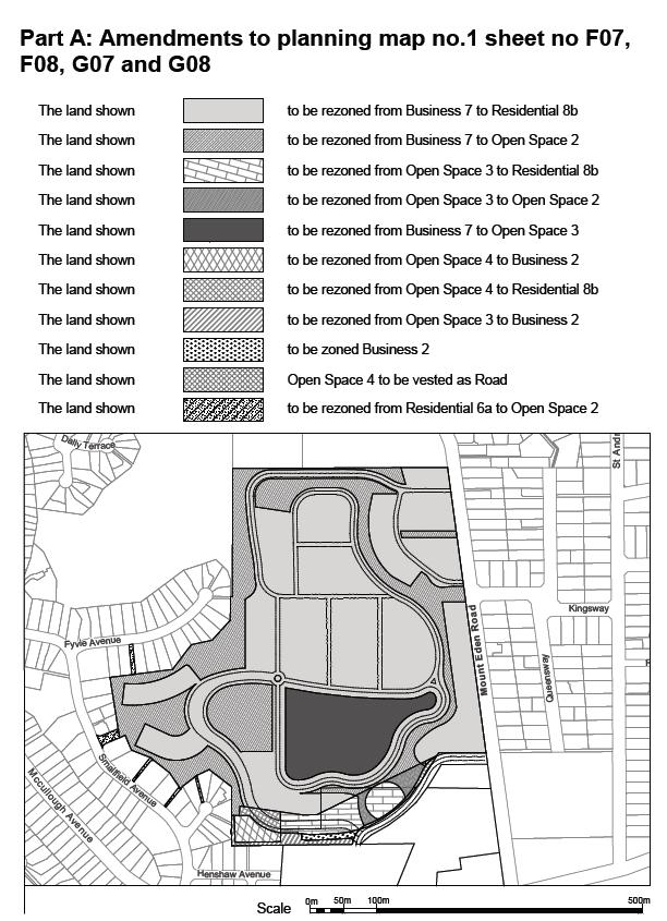
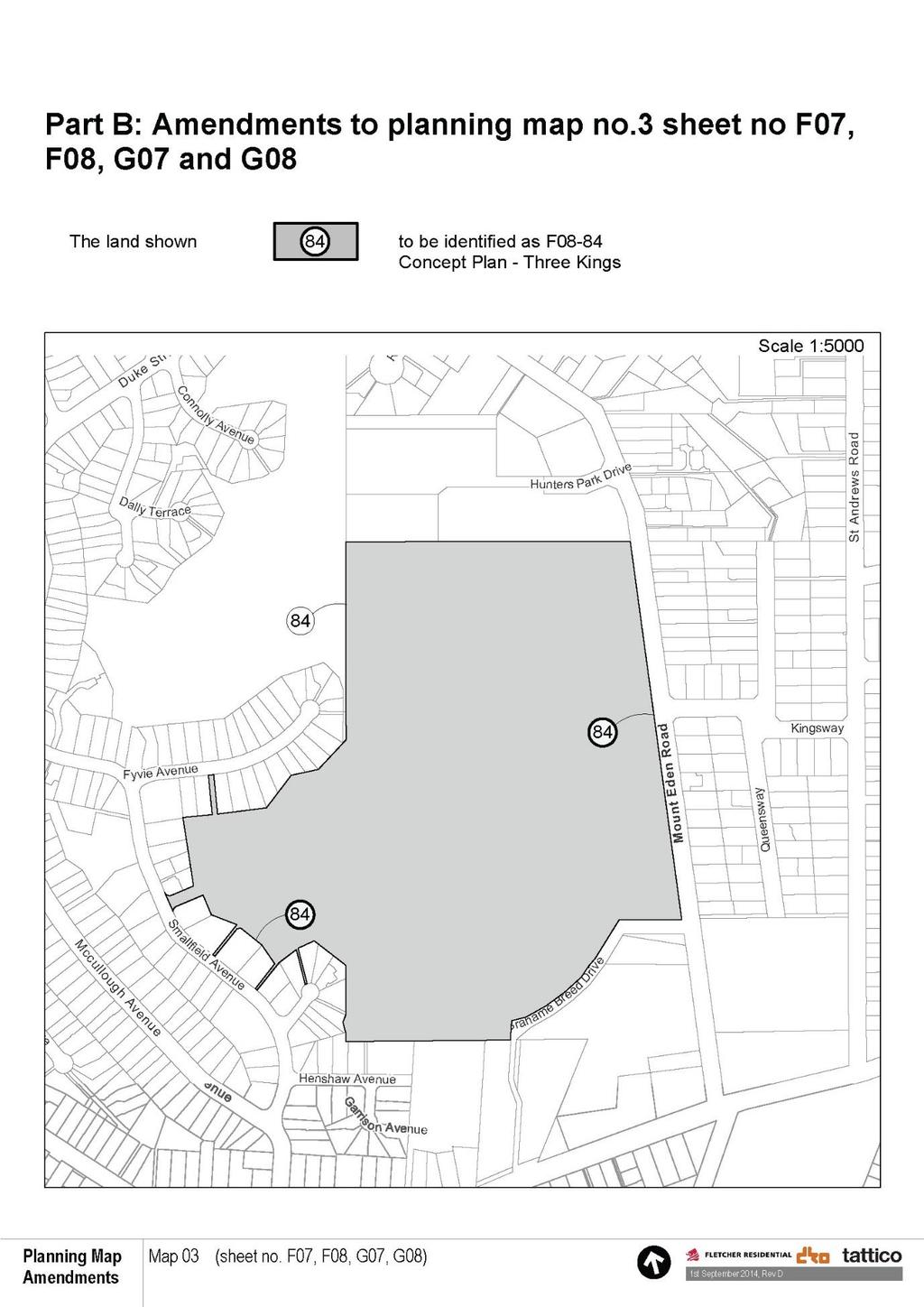
4 Part C: Insert the following in Appendix A to the Planning Maps F08-84 B Concept Plan Three Kings Precinct (refer Appendix B) Part D: Amendment to Appendix B to the Planning Maps Insert the following diagrams and text into an appropriate location of Appendix B to the Planning Maps: F08-84 Three Kings Precinct Concept Plan A. INTRODUCTION 1. This Concept Plan provides for the development of a vibrant, sustainable urban village on the former Winstone Aggregates and Mt Roskill Borough Council quarries and the adjacent land at Three Kings. The total land parcel within the Concept Plan is 21.6ha, of which 15.2ha is owned by Fletcher Concrete and Infrastructure Limited and the remainder by the Crown. 2. The purpose of the Concept Plan is to enable the integrated redevelopment of key sites within the Three Kings area in a way that will ensure high quality outcomes that support a compact city. It will promote legacy developments that support the viability of this emerging centre and integrate the Town Centre, residential, open space and community facilities. 3. The proposed urban village is the result of an extensive Master Planning process undertaken by Fletcher Residential. This Concept Plan has been prepared in order to ensure that development proceeds in accordance with the planning parameters established through the Master Planning process. 4. The overall development will offer residents a unique lifestyle choice; residential living on the doorstep of an existing town centre, connected to high quality recreational facilities on a major public transport route. The expected outcomes of the Concept Plan are set out below: High amenity residential areas that will provide 1,200 to 1,500 additional homes to Auckland. There will be a number of housing typologies, including apartments and terrace housing. An open space network comprised of 2 high quality/high use sports fields and a broader network of walkways and cycleways. This network will provide for both 4
5 (iii) (iv) (v) (vi) (vii) active and passive recreation and also achieve important connections between the residential development and the town centre and the broader community. Sightlines to Te Tatua a Riukiuta (Big King). In addition the nature of development will offer distant some views of Maungawhau (Mt Eden) and all of Maungakiekie (One Tree Hill) from two vantage points. On-site management of all stormwater through the use of a series of wetlands and soakage. Reinforcement of public transport by providing direct connections from the new residential development to the major transport corridor of Mt Eden Road. Assist in achieving higher functionality of the emerging Three Kings town centre by integrating the residential development with the centre. A high quality of urban design to ensure that the overall development provides an attractive and functional environment. 5. Diagram F08-84(a) below illustrates the broad development patterns within the Concept Plan. In particular, the residential, open space and business areas are shown along with the transport network (comprised of the primary road network, the primary and secondary access points, bus connections and the walkways and cycleways). The sightlines to the volcanic cones are also shown. 5
")
6 Diagram F08-84(a) Concept Plan 6
7 B. OVERVIEW The planning provisions that apply within this Concept Plan are summarised below: 1. The objectives and policies relating to the Concept Plan are set out in Section C below. 2. The residential areas within the Concept Plan are zoned Residential 8b and are therefore subject to the provisions of Part 7 Residential except where identified in Sections D-G below. 3. The open space areas are zoned either Open Space 2 (Informal Recreation) or Open Space 3 (Organised Recreation) and are therefore subject to the provisions of Part 9 Open Space except where identified in Sections D-G below. 4. The area of land immediately adjoining the Three Kings town centre is zoned Business 2 (Town Centre) and is therefore subject to the provisions of Part 8 - Business. 5. The land on the north western side of the Concept Plan is subject to the provisions of E05 29 View Protection Volcanic Cones Affected Areas. The Concept Plan contains a site specific rule which establishes the relative level (RL) from which the height will apply. This is the natural ground level prior to quarrying. 6. In addition to the above provisions, the Concept Plan includes Particular Rules in order to ensure that development is appropriate to the characteristics of the site and also reflects the master plan that has been prepared. The Particular Rules are contained in Sections D-G below. C. CONCEPT PLAN OBJECTIVES AND POLICIES The following objectives and policies are in addition to the objectives and policies of the Residential 8b zone: Objective To enable higher density residential development which integrates with surrounding open spaces and community facilities and which supports the viability of the adjoining town centre. Policies 1. By providing for a density of development which results in an efficient use of land and which makes a significant contribution to growth within the region. 2. By using Planned Unit Development(s) to ensure that development is integrated and provides the required open spaces and infrastructure. 7
8 3. By ensuring that the finished contours of the land supports intensive residential redevelopment and achieves integration between the redeveloped Concept Plan area and surrounding land uses. 4. By locating apartments and other higher density residential along the Mt Eden Road frontage and in the southern portion of the Concept Plan so as to provide easy access to public transport and the activities located within the Town Centre. 5. By enabling a range of housing types in order to create a variety of built form and diversity at the scales of the site, street and block, including terrace housing and apartments. 6. By ensuring that the built form of development interacts positively with and improves the quality and safety of streets, public areas and Open Spaces. 7. By enabling the provision of quality open spaces which: a. Include provision for active, passive recreation (including sports fields) b. Create quality linkages and connections between the Town Centre, Te Tātua a Riukiuta and the surrounding area. c. Are designed to reinforce ecological values and linkages. d. Are designed and located to create a coherent network. 8. By providing for the works and activities necessary to facilitate the network of walkways, cycleways and connections and to ensure a high level of amenity and public enjoyment in the open space areas. 9. By enabling high levels of walkability and pedestrian amenity with reduced reliance on private vehicles and greater use of alternative modes of transport such as walking, cycling and public transport. 10. By enabling the optimization of open space location and configuration through zoning and/or land exchange. 11. By ensuring that the layout and design of roads and connections is legible and permeable and includes the following: A western route through to Mt Eden Road A north south route that connects to the Town Centre A high quality street environment that promotes walking and cycling via direct, safe and well-designed pedestrian and cycle provision. Objective To ensure that redevelopment within the concept plan respects the volcanic landscape of Te Tatua a Riukiuta, the cultural heritage of the area and the history of the quarry lands. 8
9 Policies 1. By protecting locally significant views through the location of roads and open space. 2. By ensuring the landmark of Te Tātua a Riukiuta and opportunities for its restoration are central to the design of redevelopment. 3. By protecting Te Tatua a Riukiuta through the creation of an Open Space buffer and appropriate native planting. 4. By ensuring that the design and form of the redevelopment integrates reference to and celebrates the following: The cultural heritage of the area The history of the quarry site The character of the wider area The original volcanic form of the land. 5. By promoting the principles of Te Aranga in the urban renewal of the area. Objective To enable the infrastructure and siteworks that are necessary to support development within the Concept Plan and to ensure that such infrastructure is effective, robust, sustainable in the long term and meets sound environmental practice 1. By providing for additional stormwater and wastewater capacity through the introduction of a wetland system and controlled access to the aquifer. 2. By providing for a high level of flood protection to the 100 year ARI rainfall event, in particular the provision of greater than standard heights of freeboard between flood levels and habitable floors. 3. By ensuring that the stormwater management system is well maintained and includes the use of sediment treatment systems (including rain gardens and tree pits) to protect soakage. 4. By putting in place methods to manage water quality, including controls on roofing materials. 5. By ensuring any contaminated land and / or other hazards are made safe and suitable for urban renewal in accordance with the Concept Plan. 6. By providing for rehabilitation and filling of the former Quarry areas and ensuring that appropriate compaction standards for residential and open space areas are met. 9
10 D. ACTIVITIES 1. Activity Table Residential 8b In addition to the activities provided for in the Residential 8b zone the following applies. Where an activity status is different in this Concept Plan to that in clause 7.7.5, then the provisions of this Concept Plan take precedence. Activity Status Construction and/or relocation of residential units or any new building (including accessory building) Alterations and additions to residential units built after September 2013 C* Residential units within an area identified as active use at street level on Concept Plan F08 84(a) Development that does not comply with the density control in 3 below Planned unit development Park and ride Earthworks and/or filling associated with a development which has been granted a resource consent (including subdivision consent) Earthworks of up to 500m 2 and 250m 3 where they are not part of a planned unit development Earthworks (to any level) as part of a planned unit development Earthworks associated with the creation of open space Earthworks associated with the creation of roading and other infrastructure Rehabilitation of land within the Concept Plan area.# Dairy with a gross floor area under 250m 2 per individual facility, provided that the total gross floor area within the Concept Plan area (excluding the area subject to the active uses at street level control) does not exceed a total of 500m 2 gross floor area. Retail with a gross floor area under 250m 2 per individual facility, provided that the total gross floor area within the Concept Plan area (excluding the area subject to the active uses at street level control) does not exceed a total of 1500m 2 gross floor area. Educational and cultural facilities Restaurants, cafés and other eating places with a gross floor area under 250m 2, provided that the total gross floor area within the Concept Plan area (excluding the area subject to the active uses at street level control) does not exceed a total of 1500m 2 gross floor area. Health care facilities with a gross floor area under 250m 2 per individual facility. Domestic storage within apartment buildings Subdivision for the purpose of: Subdivision of different areas within the Concept Plan Subdivision for the creation of superlots Which are consistent with the concept plan shown in F08-84(a). C* D D P P P P P P P 10
11 Subdivision for the purpose of creating lots for infrastructure, including roading C* Subdivision of land consistent with an approved planned unit development or the provisions of Part 11 Any roading related or in-ground infrastructure works or works on land that is consistent with the concept plan shown in F08-84(a) or is part of an approved Planned Unit Development. Any infrastructure works or works not provided for as a permitted activity Any activity, development or subdivision not otherwise provided for in the Residential 8b zone or in this Concept Plan C* P D * Restricted controlled or restricted discretionary activities may be considered without the need for notification. # For the purposes of this Concept Plan rehabilitation means the process to prepare the land for future alternate land uses and includes: Necessary operations, works and extraction to modify rock faces and to recontour land to ensure it is suitable for future uses. The extraction, processing and removal of rock, earth or other material as part of the process of finalising ground levels and rock faces and contours. Fill operations including earthworks, compaction and storage of material. Necessary temporary and permanent drainage, stormwater and roading services to enable rehabilitation. Protection of future soakage areas from sedimentation during earthworks. Establishment of such roading and services suitable for future long term uses. The permitted activities identified in the above tables are allowed without resource consent where they comply in all respects with the relevant development controls. The controlled and restricted discretionary activities in the above tables must comply with the density control set out in (3) below, the subdivision controls set out in (E) below and will be assessed against the criteria in (H) below. 2. Activity Table Open Space 2 and Open Space 3 In addition to the activities provided for in the Open Space 2 and Open Space 3 zones the following applies. Where an activity status is different in this Concept Plan to that in clause 9.7.1, then the provisions of this concept plan take precedence. Activity Status Earthworks and/or filling associated with a development which has already been granted a resource consent (including subdivision consent) Earthworks associated with the creation of open space P 11
12 Earthworks associated with the creation of roading and other infrastructure Rehabilitation of land within the Concept Plan area# Accessory buildings for any permitted activity Educational and cultural facilities for kaitiaki purposes Buildings used for recreational or community purposes Carparking areas associated with open space activities Community gardens Information centres C* Restaurants, cafés, kiosks and other eating places with a gross floor area under 250m 2 Subdivision for the purpose of: Creating lots for infrastructure, including roading Subdivision of different zones Which are consistent with the concept plan shown in F08-84(a). Any infrastructure works or works on land that is consistent with the concept plan shown in F08-84(a) Any activity, development or subdivision not otherwise provided for in this Concept Plan Stormwater retention ponds C* P P P D * Restricted controlled or restricted discretionary activities may be considered without the need for notification (refer ). # For the purposes of this Concept Plan rehabilitation means the process to prepare the land for future alternate land uses and includes: Necessary operations, works and extraction to modify rock faces and to recontour land to ensure it is suitable for future uses. The extraction, processing and removal of rock, earth or other material as part of the process of finalising ground levels and rock faces and contours. Fill operations including earthworks, compaction and storage of material. Necessary temporary and permanent drainage, stormwater and roading services to enable rehabilitation. Protection of future soakage areas from sedimentation during earthworks. Establishment of such roading and services suitable for future long term uses. The permitted activities identified in the above tables are allowed without resource consent where they comply in all respects with the relevant development controls. 12
13 3. Density The construction and/or relocation of residential dwellings and planned unit developments must not exceed 1500 dwellings within the Concept Plan area. Development in excess of this is a discretionary activity. E SUBDIVISION 1. The subdivision controls in Part 11 apply in the Concept Plan area unless otherwise specified below. 2. Subdivision and redevelopment shall take place in accordance with a planned unit development for each site. Subdivision not in accordance with a planned unit development is deemed to be a Discretionary Activity. F DEVELOPMENT CONTROLS 1. The development controls set out in the Residential 8b zone (Clause 7.8.2) apply except for the following: Maximum Height Height in Relation to Boundary Maximum Building Coverage and Impermeable Surface Minimum Stormwater Permeable Surface Yards A Private Open Space Residential Units Driveways and Carparking (d) amount of Road Frontage Taken Up by Accessways Integrated Housing Developments Communal Open Space Daylight 2. The controls set out below apply in place of the above. For the purpose of these controls the Concept Plan Area is defined as all that land contained within the Concept Plan (Residential 8b and Open Space 2 and Open Space 3) being 21.6ha. 2.1 Height The maximum building height (storeys) above deemed ground level is as shown on Diagram F08 84(b). It is stated as a maximum number of storeys (as defined in Part 13) above the identified RL. For the purpose of this control deemed ground level is the RL shown on Diagram F08 84(b). For the purpose of this control, ground level shall be deemed to be the RL level shown in Figure F08-84(b) Building Height below. The Height control above replaces the Height control in the Residential 8 zone in its entirety. 13

14 Figure F08 84(b): Building Height 14
15 2.2 Impervious area, Building Coverage and Landscaping: Approved Planned Unit Development The following control applies to that area of land approved as a Planned Unit Development. Max Impervious area Max building coverage 70% 65% for buildings of four or more storeys 70% for buildings 1-3 storeys Minimum landscaping 30% Provided that increased maximum impervious area and reduced minimum required landscaping area may be achieved through Open Space Areas in alternative parts of the 21.6 ha Concept Plan Area provided they are to an equivalent area as set out above. (iii) The above percentages are applied once a stormwater management plan has been approved which demonstrates that the development can meet the requirements of clause b. (iv) This control does not apply to the cascading apartments. Cascading apartments are assessed as controlled activity under Part H 1.2 Assessment Criteria for Cascading Apartments. 2.3 Height in Relation to Boundary Rule shall only apply to the external boundary of the Concept Plan Area where that land abuts or faces land zoned Residential or Open Space. For the avoidance of doubt this control shall not apply to the internal boundaries within the site, including land to boundaries zoned Residential 8b, Open Space 2, Open Space 3 or Business 2 or Minimum stormwater permeable area: Concept Plan Area The minimum stormwater permeable area is 50% as applied to all land forming part of the Concept Plan Area. The minimum stormwater permeable surface control under clause (b) shall apply. 15
16 2.5 Yards A 3m minimum yard shall only be provided along the external boundaries of the Concept Plan where it abuts or faces land zoned Residential or Open Space. Provided that balconies 3 metres or more above ground level, may protrude into the yard for distances no greater than 1 metre. For the avoidance of doubt this control shall not apply to the internal boundaries within the site including street frontages and land adjoining land zoned Open Space. 2.6 Private Open Space Private Open Space shall apply except: that any development which has a balcony with an area of 8m2 and a minimum width of 1.6 metres which has convenient access from the living room shall be deemed to meet the requirements of this clause. The minimum exclusive area for residential units and housing developments for the elderly and disabled shall be 18m2 2.7 Road Frontage taken up by accessways For the purposes of clause (d) the amount of road frontage taken up by accessways is limited to a maximum of 50% where the total road frontage is 20m or less. 2.8 Daylight For the purposes of control Daylight," principle habitable room" is deemed to mean the primary living room within a dwelling. 2.9 Communal Open Space The provisions of Clause shall not apply 2.10 Special Height Limit: Volcanic Cones For the purposes of determining whether the volcanic sight lines special height limits are exceeded under Rule 5C.7.6.5, ground level on the western terrace shall be deemed to be RL 78 as shown in Figure F08-84(b) and height for the purpose of Rule 5C7.6.5 shall be measured from RL 78 using the rolling height method Te Tatua a Riukiuta Sightlines No building shall protrude into the Te Tatua Riukiuta sightlines shown on Figure F08 84(c) Any building which intrudes into these sightlines shall be considered a discretionary activity. 16

17 Figure F08 84(c): Te Tatua a Riukiuta Sightlines 17
18 Stormwater Wastewater Transport Urban Design Landscaping Te Aranga Earthworks Buildings Reverse Sensitivity Consistency with PUD Consistency with Concept Plan Rehabilitati on Stormwater Wastewater Transport Urban Design Landscaping Te Aranga Earthworks Buildings Reverse Sensitivity Consistency with PUD Consistency with Concept Plan Rehabilitati on 2.12 Roading Related and In-ground Infrastructure a) Any roading related works as a permitted activity shall satisfy the Auckland transport standards for roading or such other standard as approved by Auckland Transport b) Any in ground infrastructure shall comply with the controls of Part 4A as if the roading identified on the Concept Plan was vested as road. G MATTERS FOR DISCRETION For the Controlled and Restricted Discretionary activities in the Residential 8b and Open Space zones, the Council will restrict its discretion to the following matters as specified for the relevant activity below: Residential 8 Rehabilitation * * * * Planned Unit Development New Residential building Additions and Alterations * * * * * * * * * * * * * * * * Park and Ride * * * * Earthworks * * Education and * * * * * Cultural Facilities Healthcare * * * * Subdivision associated with PUD Lots * * * * Open Space Earthworks * * * * Rehabilitation * * * * 18
19 Education and Cultural Facilities Buildings Recreation for Carparking * * * * * * * * * * * * * * Information Centre * * * * Subdivision * * * * * * * * Stormwater Ponds * * * * H ASSESSMENT CRITERIA : RESIDENTIAL 8B ZONED LAND The assessment criteria for activities/development within the Concept Plan that require resource consent, are set out below. The assessment criteria relevant to each activity/development are identified in the tables set out in G Matters of Discretion above. 1.0 New Buildings All new buildings shall be assessed against: Concept plan criteria for buildings set out in 1.1 The additional criteria relating to cascading apartments set out in 1.2 (iii) The specific criteria of the Residential Design Guide in Residential zones in the Strategic Growth Management Areas ( refer Appendix 10 to the operative Plan text) set out in 1.3 below. The development control rules set out in Appendix 10 do not apply. 1.1 Buildings The degree to which: (iii) (iv) (v) The building(s) ensure that the design, appearance and impact of all buildings and structures will be compatible in terms of the Concept Plan and zoning, including elements of height, architectural treatment of building facade and overall scale with the natural and physical landscape. The building(s) complies with the development controls of the Concept Plan The building(s) is designed in a manner which creates a positive interface with open space, roads and other elements of the public realm. The proposed building utilises low contaminant yielding roofing materials Views of the rock face between the major buildings are retained in order to acknowledge the quarrying origins of the site. 19
20 (vi) (vii) (viii) (ix) (x) (xi) The proposed non-residential activity will have adverse effects on the amenity values of other activities on the site and the surrounding neighbourhood (This will include consideration of the scale and operation of the proposal, numbers of people involved in the proposed activity, the traffic generated and the hours of the activity). The development is landscaped and designed to minimise its impact on the site and abutting or facing residential or open space land. Access to sunlight and daylight Facilities are created to enable people to enjoy the open space. The site is geotechnically appropriate for the proposed structure. The proposed building(s) are located so as to enable the views identified on F08 84(a) Concept Plan across public roads and open space, between buildings and above buildings in the Riu. For the purposes of this criteria assessment, low contaminant load roofing is treated, sealed or painted roofing material, except that untreated, sealed or painted architectural features or roofing or spouting material of up to 25m 2 can be incorporated within the site. 1.2 Cascading Apartments The cascading apartment typology is designed to respond to the unique topography of the site. The apartment design makes use of the height difference on the quarry slope to accommodate on-site carparking, whilst providing activated residential frontages to both the high and low streets. The extent to which: Residential Frontages Activated residential frontages (such as balconies, terraces or other habitable spaces) address public spaces, including ground level dwellings being setback from the street frontage to accommodate frontyards and outdoor living spaces. Solar Amenity Residential units are designed to take advantage of northerly, or east/westerly aspects to optimise daylight access to internal spaces. Units with solely south-facing aspect are minimised. Cascading apartments located against Grahame Breed Drive on the southern portion of the site are designed with apartments that orientate north as much as possible. Cascading apartments along Mt Eden Road should maximise east and west orientations. 20
21 (iii) Natural Ventilation Habitable spaces are designed with direct access to fresh air and to assist in providing thermal comfort to occupants. Where possible, corner apartments or units with double-frontages should be encouraged. These apartment types take advantage of natural breezes to allow the building to respond more appropriately to the local climate. (iv) Overshadowing Impacts Overshadowing impacts onto adjoining dwellings and open spaces are minimised through the placement of these apartments. These apartment buildings are not placed to the north of other low rise dwellings to prevent overshadowing onto private open spaces. (v) Traffic & Carparking On-site carparking is provided in the form of sleeved carparking levels built against the quarry slope. Carparks are sleeved by residential units facing the street. Carparks are accessed on both high and low streets to diffuse traffic through the proposed development and the existing street network. Apartment buildings against Mt Eden Road have primary carpark access off Mt Eden Road because this is the most direct path of access for vehicles arriving at the development. (vi) Heights and Setbacks Appropriate (2-3m) setbacks are provided from both the high and low street. The upper portion (Level 6-9) of the cascading apartment are set further back from the podium (Level 1-5) to reduce the bulk of the building when viewed from the low side. Consideration has been given to an additional setback on the top levels of some of these apartments to present a recessive element on the topmost storey to reduce the overall bulk. (vii) Building Coverage The plan contemplates significant additional building coverage for cascading apartments beyond the 65% and 70% contemplated for other typologies. The following criteria ensure appropriate amenity, and recognises the benefit of encapsulating parking within the building structure behind sleeved apartments. Building coverage is appropriate given: The objectives of the zone relating to enabling higher density residential development. The overall open space within the concept plan area. The extent of landscaping adjacent to the specific development. 21
22 The benefits of creating parking incorporated within the building and not seen from public spaces, recognising that this significantly increases building coverage. (viii) Building Frontage Activated residential frontages are presented onto all facades against public spaces. This can be achieved by having habitable spaces or outdoor terraces onto streets, laneways and parks. Excessively long building frontages are avoided to allow gaps in the built form that would afford views through Grahame Breed Drive and Mt Eden Road frontages. These gaps are located in line with the proposed key view shafts to maximise opportunities of views towards the maunga. (ix) Housing Mix Each apartment building contains a mixture of unit sizes depending on the local housing market demand and demography. This would encourage the opportunity for a diverse range of residents and family types that would occupy the proposed development. (x) Safety and Visual Privacy Ground level apartments have frontyards that orientate onto adjacent streets and laneways to provide passive surveillance to these spaces. Visual privacy to units within the development as well as adjoining dwellings is considered in the façade design of these apartment buildings. A degree of user control of any screening elements is enabled to suit a variety of lifestyles and user preferences. 1.3 Residential Design Guide Criteria The extent to which developments address the following criteria from the Residential Design Guide for Developments in Residential Zones in the Strategic Growth Management Areas (Refer Appendix 10). Element 1 Neighbourhood Character Criteria C4-C11 (refer Appendix 10). Element 2 Site Layout Criteria C1-C3 and C7 C10 (refer Appendix 10). Element 3 Density Criteria C1- C3 (refer Appendix 10). Element 4 Energy Efficiency Criteria C1-C5 (refer Appendix 10). Element 5 Building Envelop Criteria C1, C3, C5, C7, C12, C13 (refer Appendix 10). Element 6 Visual Privacy 22
23 Criteria C1-C3 (refer Appendix 10). Element 7 Acoustic Privacy Criteria C1-C3 (refer Appendix 10). Element 8 Landscaping Criteria C1, C3-C7 (refer Appendix 10). Element 9 Driveways & Carparking Criteria C1, C3 C7(refer Appendix 10). Element 10 Private Open Space Criteria C3, C5, C6 (refer Appendix 10). Element 11 Site Facilities Criteria C1-C8 (refer Appendix 10). Crime Prevention through Environmental Design (a)whether the main entrances and exits of buildings are clearly visible from the street. (b)whether potential concealment and entrapment areas (where people can hide) are avoided, or illuminated if they are unable to be removed. (c)whether buildings are designed to overlook public spaces and streets to provide passive surveillance of these areas. (d)whether the site layout, buildings, fences, landscaping and other features clearly define territory and ownership of all public, semi-private, and private space (e.g. dwellings and private open space) to discourage illegitimate entry and use of these spaces (e)whether appropriate lighting is provided to all pedestrian paths between public and shared areas, parking areas and building entrances. (f)whether site access and car parking are clearly defined, appropriately lit, and visible. (g)whether landscaping, fencing and other structures present a security risk by screening doors, windows and pedestrian routes. (h)whether individual buildings are clearly identifiable by visitors and emergency vehicles. Where these criteria conflict with the criteria in 1.1 and 1.2 above, the criteria in 1.1 and 1.2 prevail. For the avoidance of doubt, the Development Controls in Appendix 10 do not apply. 2. Urban Design and Landscaping The extent to which the proposal provides for the following elements where appropriate: (iii) An integrated comprehensive development of land which provides for quality residential development that integrates with the Maunga, Town Centre, Open Space network and the surrounding residential area. Consistency with the Concept Plan in F08 84(a). Connections from the Riu (valley floor) to the Town Centre. 23
24 (iv) (v) (vi) (vii) (viii) (ix) (x) (xi) (xii) (xiii) (xiv) A plaza which integrates with the Town Centre. A series of views from key public places as generally shown on F08 84(a) Concept Plan. These views are across roads and open space linkages and above development within the Riu. Quality pedestrian walkways and cycleways throughout the concept plan area and connecting public transport routes, Mt Eden Road and residential areas to the west and north. Bush landscaping and fencing at the toe of remnant quarry faces within the redevelopment areas. The planting of native vegetation on the slope adjoining the eastern side of Te Tatua a Riukiuta to enhance the cultural and visual amenity of the Maunga. Landscaping and sculptural elements in line with the Te Aranga principles below. A network of connections through the Concept Plan area which makes the area accessible to residents and visitors. The location of high intensity housing along the public transport corridor of Mt Eden Road and the Town Centre. To create a mix of high intensity terrace housing and apartment typologies with the larger apartment buildings focussed on the western and southern parts of the Concept Plan area. The use of innovative housing typologies such as the cascading apartments which provide for a housing form which responds to the specific circumstances of the site and provides quality development. Measures to successfully integrate the different relative level from the Town Centre and Mt Eden Road to the sports fields and lower levels of the development. 3. Te Aranga The extent to which the proposal provides for the successful application of the principles of Te Aranga as embodied within the Concept Plan, including: (iii) (iv) (v) (vi) (vii) Bush landscaping of the boundary to the Te Tatua a Riukiuta to successfully create an interface between the Maunga and the adjacent residential community. The development of wetlands to serve as a functional stormwater management device and also to create a high amenity with native planting within the area. The use of culturally appropriate public art to celebrate the history and cultural dimensions of the area. The use of stone walls and other landscape forms that reflect early Maori occupation of the area. The use of native planting specific to the area. The acknowledgement of the four Maunga that were previously quarried through signage, landscaping and other appropriate forms. The use of cultural narrative and names to celebrate the history and culture of the site and its people. 24
25 4. Active use at street level For the area identified on Concept Plan F08.84(a), the extent to which the proposal provides for the provision of active uses at street level. Including: (iii) (iv) (v) (vi) (vii) the location of retail, restaurants, cafes and other eating places within the defined street level floor space; the integration of these activities with the street and public spaces including outdoor seating and dining areas; the degree to which the activities provide visibility into the business activity and give a sense of connection with the street; the creation of outdoor dining and plaza areas which enable outlook of the street, public spaces and views; the extent to which lobby and other access spaces to the upper and lower floors within buildings has been successfully integrated with retail and food and beverage activities; the degree to which access to parking is managed so as to prevent parking spaces being visible from street level and only the required access to parking decks below street level provided; the provision of loading facilities on street so as to minimise the nonretail activity at street level. For the purposes of this assessment control, active uses at street level include: dairies, retail, restaurants, cafes and other eating places, lobby access to the upper and lower floors of buildings necessary vehicle access to parking decks in other parts of the building, public through site links, outdoor dining, eating and viewing area(s). 25
26 5 Rehabilitation of Former Quarry Land The extent to which: (iii) (iv) (v) (vi) (vii) (viii) Noise, lighting and hours of quarry operation comply with the existing hours of operation and noise and vibration control as approved for the site through previous quarrying or filling resource consents. Any matters of reverse sensitivity recognise the finite life of quarrying operations. Any adverse visual amenity effects are mitigated through the use of screening and landscaping. The bund along Mt Eden Road is removed at a time when redevelopment of that part of the land is ready to proceed. Any buildings associated with the quarry are designed to enable removal on completion of quarrying activity. Quarry slopes and batters during construction and in finished state, local stability treatments for cut slopes, engineering filling criteria and foundation criteria for structure design have been adequately addressed. Treatment of the toe of remnant quarry faces within the redevelopment area in terms of landscaping, use and public access. Permitted infrastructure provided as part of the rehabilitation should meet the criteria outlined in 6. Stormwater and 7. Wastewater below. 6. Stormwater The extent to which: (iii) (iv) (v) (vi) (vii) (viii) The proposal provides for the effective management of stormwater, including groundwater levels, overland flow paths, design and implementation of the wetland, soakage capacity and monitoring and maintenance requirements. The development gives effect to the stormwater management concept plan shown in FO8 84(d) or such other management concept that will achieve a similar or better water quality outcome. The proposal avoids flooding by addressing issues relating to flood levels, flood storage, groundwater levels, soakage capacity and required freeboard above the 100 year ARI flood level to habitable floor levels; 75mm above the flood level in the main storage areas, or 500mm above flood levels in the eastern wetland. The proposal includes an effective monitoring and maintenance programme which addresses sediment loads, treatment required for the protection of long term soakage capacity and the monitoring and maintenance required to maintain soakage capacity. Development provides for stormwater treatment through the use of rain gardens and tree pits in appropriate circumstances. Stormwater treatment is provided for higher contaminant load generating activities. Development provides for stormwater treatment through the use of rain gardens and tree pits in appropriate circumstances. Any proposal which is in accordance with the overall stormwater management plan set out in F08 84(d) shall be deemed to comply with these criteria. 26

27 FO8 84(d) Stormwater Management Concept 27
28 7. Wastewater The extent to which the proposal provides for the effective development and management of the wastewater network including: Provision for a minimum of eight hours holding capacity at any pump station. Diversion of stormwater from the existing public wastewater network to provide additional capacity for wastewater. (iii) The location and design of the pump station and connections to the wastewater network. 8. Transport The extent to which: (iii) (iv) (v) (vi) (vii) (viii) (ix) The expected traffic generated by the activity has an effect on the safe and efficient functioning of the surrounding road network. The road layout provides for local traffic and traffic using the site, but discourages use of the network as a bypass from Mt Albert Road to Mt Eden Road. Entry and exit points to the site are designed to suitably accommodate all traffic movements, and in doing so, limit as much as possible disruption to traffic flows on the adjoining road network. The proposal includes adequate pedestrian connections to public transport nodes and cycleways and walkways to the Town Centre, Te Tatua a Riukiuta, Mt Eden Road and residential areas to the west and north. Any building fronting Mt Eden Road has a single, direct access from Mt Eden Road The location of activity on a major public transport route, and traffic demand management measures, enable a reduced level of required on-site parking. Any carparking associated with the cascading apartment typology is provided within buildings below Mt Eden Road / Grahame Breed Drive street level and is screened from other parts of the site. The proposal includes the creation of two new roads serving the site; the primary access to Grahame Breed Drive with a second access at the northern end of the site. The proposal includes the creation of a light controlled intersection at Grahame Breed Drive which provides vehicle and pedestrian access. 28
29 I ASSESSMENT CRITERIA : OPEN SPACE ZONED LAND For activities/development that are zoned open space and are restricted controlled or restricted discretionary activity in the Concept Plan area, the assessment criteria set out in clauses and (criteria for controlled activities and discretionary activities) shall apply with the exception of the following criteria set out in 3.1 and 3.2 below: 1 Earthworks In considering any application for a restricted discretionary activity, the proposal will be considered against the following criteria: The degree to which the earthworks: Enable the creation of connections through the site. Provide for the creation of paths, cycleways and linkages. Enable the creation of sportsfields. Enable the sculpturing of the landform to create areas of open space amenity and evoke the historic and current landscape forms. Enable applicant s to undertake the earthworks in order to allow for proper functioning of the dominant activity of the site. Appropriate conditions may be imposed in relation to these matters including the preparation and management of the site in accordance with an erosion and sediment control plan. 2 Rehabilitation of Land Within the Concept Plan Area The assessment criteria set out in H5 above shall apply. 3 Educational and Cultural Facilities (iii) The building(s) is designed in a manner which creates a positive interface with open space, roads and other elements of the public realm. The proposed building utilises low contaminant yielding roofing materials The development is landscaped and designed to minimise its impact on the site and abutting or facing residential or open space land. 29
30 J. SPECIAL INFORMATION REQUIREMENTS 1. An application for a Planned Unit Development must be accompanied by the following supporting documents. These are in addition to what would otherwise be required for a planned unit development: (iii) (iv) (v) Outline of any particular infrastructure requirements that are unique to the Concept Plan area including the detailed assessment of stormwater, flooding, wastewater and transport. Cultural assessment and integration of the development to Te Tatua a Riukiuta. Geotechnical assessment to include details of cut slope assessments during construction, development of specific local stability treatments for cut slopes, engineering filling criteria, and foundation criteria for structure design. Landscape assessment and proposals to integrate aspects with the volcanic landscape. Contamination assessment if not previously provided. This assessment shall be at PSI level. However if the Preliminary Site Investigation demonstrates a probable presence of contaminated material then a detailed site investigation report is required. Part E: Amendments to Text: Part 7 Residential: 1. Add the following underlined words below the final paragraph in clause Strategy for the Residential 8 zone: Discrete sections of Residential 8 zoned land may be subject to a concept plan, a growth area structure plan or another similar mechanism identified in the planning maps. These plans may set additional or modified planning provisions in the form of objectives and policies, activities, rules, development controls and the like. 2. Amend the description in the strategy section of height in the Residential 8b zone multiunit development in this zone can reach 3-4 storeys high, or greater heights as specified in a concept plan, consistent with existing Town Centre commercial buildings. 3. Amend B Density by adding the words or such density limits specified in an approved Concept Plan outlined in the appendix to the planning maps below the table. 4. Add the following underlined words to the introductory clause in Development Controls for the Residential 8a, 8b and 8c zones: The following shall be the development controls for permitted activities in the Residential 8a, 8b and 8c zones, except where development controls are set out within a concept plan, growth area structure plan or other similar mechanism applying to particular sites zoned Residential 8 30
I333 Three Kings Precinct
 I333. Three Kings I333.1. Precinct description The Three Kings Precinct provides for the development of a vibrant, sustainable urban village on the former quarries and the adjacent land at Three Kings.
THREE KINGS RENEWAL DESCRIPTION OF URBAN DESIGN / ARCHITECTURAL ELEMENTS AND PROCESS. prepared by dko Architecture
 THREE KINGS RENEWAL DESCRIPTION OF URBAN DESIGN / ARCHITECTURAL ELEMENTS AND PROCESS prepared by dko Architecture THESE PLANS OUTLINE THE VISION OF FLETCHER RESIDENTIAL LTD AND ARE NOT ENDORSED BY AUCKLAND
I615. Westgate Precinct
 I615. Westgate Precinct I615.1. Precinct Description The Westgate Precinct is located approximately 18km west of the Auckland city centre. There are seven Sub-precincts in the Westgate Precinct: Sub-precinct
I539. Smales 2 Precinct
 I539. Smales 2 Precinct I539.1. Precinct Description The Smales 2 Precinct applies to a 4.8 hectare block of land located on the southern side of Northcote Road and fronting Lake Pupuke, Takapuna. The
Section Three, Appendix 16C Medium Density Housing, Design Assessment Criteria (Residential 8A zone)
") APPENDIX 16C MEDIUM DENSITY HOUSING, DESIGN ASSESSMENT CRITERIA (RESIDENTIAL 8A ZONE) PURPOSE OF APPENDIX 16C (RESIDENTIAL 8A ZONE) In the Residential 8A Zone the following are defined as restricted discretionary
APPENDIX 16C MEDIUM DENSITY HOUSING, DESIGN ASSESSMENT CRITERIA (RESIDENTIAL 8A ZONE) PURPOSE OF APPENDIX 16C (RESIDENTIAL 8A ZONE) In the Residential 8A Zone the following are defined as restricted discretionary
Three Kings Private Plan Change Request 15-H1
 Three Kings Private Plan Change Request 15-H1 31 August 2014 TABLE OF CONTENTS 1.0 INTRODUCTION... 4 2.0 OVERVIEW... 5 3.0 LAND SUBJECT TO THIS PRIVATE PLAN CHANGE REQUEST... 8 4.0 CURRENT USE... 11 5.0
4 Residential and Urban Living Zones
 4 Residential and Urban Living Zones Refer to Chapters 11 to 20 for additional rules that may apply to these zones. 4.1 OBJECTIVES AND POLICIES Objective Res1 Policy 1 Policy 2 Policy 3 Policy 4 Policy
SECTION 7A: WHAKARONGO RESIDENTIAL AREA
 SECTION 7A: WHAKARONGO RESIDENTIAL AREA CONTENTS 7A.1 Introduction 1 7A.2 Resource Management Issues 1 7A.3 Objectives and Policies 1 7A.4 Methods 4 7A.5 Residential Zone 4 7A.5.1 Rules: Controlled Activities
RESIDENTIAL ACTIVITY PERFORMANCE STANDARDS
 Preferred Options Consultation Q&A Sheet RESIDENTIAL ACTIVITY PERFORMANCE STANDARDS What are the key goals for managing the design of residential buildings in the Second Generation Plan (2GP)? The key
11.3 SPECIAL CHARACTER ZONE HAWKE S BAY REGIONAL SPORTS PARK
 11.3 SPECIAL CHARACTER ZONE HAWKE S BAY REGIONAL SPORTS PARK 11.3.1 INTRODUCTION The availability of sports and recreation activities and facilities is important for the maintenance and enhancement of
SCHEDULE 12 TO THE DESIGN AND DEVELOPMENT OVERLAY GLEN WAVERLEY ACTIVITY CENTRE STRUCTURE PLAN
 DD/MM/YY Proposed C120 SCHEDULE 12 TO THE DESIGN AND DEVELOPMENT OVERLAY Shown on the planning scheme map as DDO12. GLEN WAVERLEY ACTIVITY CENTRE STRUCTURE PLAN 1.0 Design objectives DD/MM/YY Proposed
15 Rural Residential Zone
 15 Rural Residential Zone Section 15A 15A Purpose of the Rural Residential Zone... 1 15A.1 Objectives and Policies of the Rural Residential Zone... 1 15A.2 Activity Status Rules... 5 15A.3 Permitted Activity
I611. Swanson North Precinct
 I611. Swanson North Precinct I611.1. Precinct Description Swanson North is located in the north eastern foothills of the Waitakere Ranges. It is outside the Waitakere Ranges Heritage Area Act and the Waitakere
Three Kings Private Plan Change Request 15-H2
 Three Kings Private Plan Change Request 15-H2 31 August 2014 TABLE OF CONTENTS 1.0 INTRODUCTION... 3 2.0 OVERVIEW 4 3.0 LAND SUBJECT TO THIS PRIVATE PLAN CHANGE REQUEST... 6 4.0 CURRENT USE 8 5.0 FLETCHER
I209 Quay Park Precinct
 I209. Quay Park I209.1. Precinct description The Quay Park Precinct is located on reclaimed land at the eastern end of the city centre and along the City Centre waterfront. It is dissected to the east
QUEENSTOWN LAKES DISTRICT COUNCIL SUBDIVISION DESIGN GUIDELINES
 Attachment C: Draft QLDC Subdivision Design Guidelines QUEENSTOWN LAKES DISTRICT COUNCIL DESIGN GUIDELINES A DESIGN GUIDE FOR AND DEVELOPMENT IN THE URBAN ZONES QUEENSTOWN OFFICE 10 Gorge Road Queenstown
open space environment
 This section updated August 09 GUIDELINE TO THE RULES The Open Space Environment Rules apply to activities on sites within the Open Space Environment as shown on the Human Environments Maps. Most of the
4 RESIDENTIAL ZONE. 4.1 Background
 4 RESIDENTIAL ZONE 4.1 Background The residential areas within the City are characterised by mainly lowrise dwellings sited on individual allotments. Past architectural styles, settlement patterns and
Section 12C Subdivision in the Rural Residential Zone
 Section 12C 12C Subdivision in the Rural Residential Zone The Rural Residential Zone provides part of the range of residential opportunities within the City. Land zoned rural residential is considered
Section Three, Appendix 17C Multiple Unit Housing Design Assessment Criteria
 APPENDIX 17C MULTIPLE UNIT HOUSING DESIGN ASSESSMENT CRITERIA Purpose of Appendix 17C In the Residential 9 Zone the construction and use of multiple household units located within the Multiple Household
Subdivision Design Criteria. Penihana North GUIDELINES TO THE RULES
 Created September 2013 Penihana North Subdivision Design Criteria GUIDELINES TO THE RULES This part of the Plan sets out the design criteria for subdivision in Penihana North. The criteria will be considered
Chapter 13 Residential Areas: Appendices APPENDIX 1 Residential Areas
 Chapter 13 Residential Areas: Appendices Page 1 Chapter 13 Residential Areas: Appendices APPENDIX 1 Residential Areas Design Code for Intensive Housing INTRODUCTION DESIGN ELEMENTS A NEIGHBOURHOOD DESIGN
64 Mineral Extraction Area Rules
 64 Mineral Extraction Area Rules 64.1 Introduction For the purposes of this Chapter: Active Area, in relation to a Mineral Extraction Area (MEA), is that part of the Mineral Extraction Area which is owned
I403 Beachlands 1 Precinct
 I403. Beachlands 1 I403.1. Precinct Description Beachlands is a rural and coastal village located on the eastern side of Auckland, adjoining the Tamaki Strait coastline. The original Beachlands village
I331. St John s Theological College Precinct
 I331. St John s Theological College Precinct I331.1. Precinct Description The precinct contains the existing St John s Theological College which is a residential college for the Anglican Church in New
I602. Birdwood Precinct
 I602. Birdwood Precinct I602.1. Precinct description The Birdwood Precinct applies to an area west of Don Buck Road and south of Red Hills Road in west Auckland. It incorporates subdivision and development
Rural (Urban Expansion) Environment
 Environment") RUEE.1 Rural (Urban Expansion) Environment Index RUEE.1 RUEE.1.1 RUEE.1.2 RUEE.1.3 RUEE.1.4 RUEE.2 RUEE.2.1 RUEE.2.2 RUEE.2.3 RUEE.2.4 RUEE.3 Rural (Urban Expansion) Environment Description and Expectations
RUEE.1 Rural (Urban Expansion) Environment Index RUEE.1 RUEE.1.1 RUEE.1.2 RUEE.1.3 RUEE.1.4 RUEE.2 RUEE.2.1 RUEE.2.2 RUEE.2.3 RUEE.2.4 RUEE.3 Rural (Urban Expansion) Environment Description and Expectations
6.6.2 Emerging Community Zone Code Application Purpose and overall outcomes. s6 Zone Codes Emerging Community and Township Zone Codes
 6.6.2 Emerging Community Zone Code 6.6.2.1 Application This code applies to assessable development:- (1) within the Emerging Community Zone as identified on the zoning maps contained within Schedule 2
H7 Open Space zones. (a) provide for the needs of the wider community as well as the needs of the community in which they are located;
 provide for the needs of the wider community as well as the needs of the community in which they are located;") H7. Open Space zones H7.1. Background The majority of land zoned as open space is vested in the Council or is owned by the Crown. However some areas zoned open space are privately owned. While the open
H7. Open Space zones H7.1. Background The majority of land zoned as open space is vested in the Council or is owned by the Crown. However some areas zoned open space are privately owned. While the open
H10. Business Town Centre Zone
 H10. Business Town Centre Zone H10.1. Zone description The Business Town Centre Zone applies to suburban centres throughout Auckland, the satellite centres of Warkworth and Pukekohe, and the rural towns
H9. Business Metropolitan Centre Zone
 H9. Business Metropolitan Centre Zone H9.1. Zone description The Business Metropolitan Centre Zone applies to centres located in different subregional catchments of Auckland. These centres are second only
AOTEA SUPERMARKET ZONE. Zone Introduction
 C18 AOTEA SUPERMARKET ZONE Zone Introduction C18.1 Objective This zone identifies a specific area in Aotea for a stand alone supermarket. The zone is site specific and has a range of objectives, policies
Rural (Urban Expansion) Environment
 Environment") RUEE.1 Rural (Urban Expansion) Environment Subsequent to the receipt of appeals, a 'marked up' version of the Proposed District Plan was prepared. The provisions of the Proposed Version of the Plan subject
RUEE.1 Rural (Urban Expansion) Environment Subsequent to the receipt of appeals, a 'marked up' version of the Proposed District Plan was prepared. The provisions of the Proposed Version of the Plan subject
I422. Māngere Gateway Precinct
 I422. Māngere Gateway Precinct I422.1. Precinct description The Māngere Gateway Precinct is comprised of land generally north of the Auckland International Airport and west of George Bolt Memorial Drive
I609. Penihana North Precinct
 I609. Penihana North Precinct I609.1. Precinct description The Penihana North Precinct is located south of the Swanson Railway Station, adjacent to the Rural Urban Boundary (RUB) and Waitakere Ranges Heritage
The Proposed Auckland Unitary Plan (notified 30 September 2013)
") 3 Business zones Introduction There are 10 business zones in the Unitary Plan: City Centre Metropolitan Centre Town Centre Local Centre Neighbourhood Centre Mixed Use General Business Business Park Light
3 Business zones Introduction There are 10 business zones in the Unitary Plan: City Centre Metropolitan Centre Town Centre Local Centre Neighbourhood Centre Mixed Use General Business Business Park Light
THREE PARKS ZONE Three Parks Special Zone The process of applying for resource consents in the zone.
 .25 Three Parks Special Zone The purpose of this zone is to provide for growth and to give effect to the Wanaka 2020 Community (2002) and the more recent Wanaka Structure (2007) and Wanaka Transport Strategy
D18. Special Character Areas Overlay Residential and Business
 D18 Overlay Residential and Business D18. Overlay Residential and Business D18.1. Background The Overlay Residential and Business seeks to retain and manage the special character values of specific residential
Three Kings Precinct. Plan Change 11 to Auckland Unitary Plan Operative in Part Section 32 Report
 Three Kings Precinct Plan Change 11 to Auckland Unitary Plan Operative in Part Section 32 Report Updated 12 February 2018 2 TABLE OF CONTENTS 1.0 EXECUTIVE SUMMARY... 4 2.0 CONTEXT AND HISTORY OF THE THREE
I404 Beachlands 2 Precinct
 I404. Beachlands 2 I404.1. Precinct Description The Beachlands 2 precinct covers approximately 6 hectares of land at the corner of Beachlands and Whitford Maraetai Roads. Its purpose is to provide for
The Proposed Auckland Unitary Plan (notified 30 September 2013)
") 8 Special Purpose zones 8.1 Airport zone The Airport zone applies to the Kaipara Flats Airfield, North Shore Airfield, Auckland International Airport and Ardmore Airport. Auckland International Airport
8 Special Purpose zones 8.1 Airport zone The Airport zone applies to the Kaipara Flats Airfield, North Shore Airfield, Auckland International Airport and Ardmore Airport. Auckland International Airport
Part 9 Specific Land Uses - Housing on Small and Narrow Lots
 19 HOUSING ON SMALL AND NARROW LOTS This section of the DCP applies where development for the purpose of a dwelling house, attached dwellings, or semi-detached dwellings is or are proposed in the R2 Low
39 WALLACEVILLE STRUCTURE PLAN
 39 WALLACEVILLE STRUCTURE PLAN PRECINCT DESCRIPTIONS, INTENTIONS AND OUTCOMES Wallaceville Living Precinct Area A At approximately 13.4ha, this precinct is the largest precinct and the precinct provides
I412. Flat Bush Precinct
 I412. Flat Bush Precinct I412.1. Precinct description The Flat Bush precinct covers approximately 1730ha of land adjacent to the Rural Urban Boundary. The Flat Bush Precinct incorporates the provisions
SPECIAL 35 (HIBISCUS COAST GATEWAY) ZONE
 ZONE") `` 12.8.35 SPECIAL 35 (HIBISCUS COAST GATEWAY) ZONE 12.8.35.1 Issues The following provisions relate to the Hibiscus Coast Gateway Zone. This zone is located at Silverdale in the area bounded by State
`` 12.8.35 SPECIAL 35 (HIBISCUS COAST GATEWAY) ZONE 12.8.35.1 Issues The following provisions relate to the Hibiscus Coast Gateway Zone. This zone is located at Silverdale in the area bounded by State
medium desnity housing
 This section updated September 2013 This part of the Plan sets out the assessment criteria for medium density housing. The criteria are designed to give designers and builders flexibility and to provide
King s College Proposed Private Plan Change 41 Golf Avenue, Otahuhu URBAN DESIGN ASSESSMENT
 King s College Proposed Private Plan Change 41 Golf Avenue, Otahuhu URBAN DESIGN ASSESSMENT CONTENTS 1.0 EXCECUTIVE SUMMARY... 1 2.0 INTRODUCTION... 2 2.1 Purpose of document... 2 2.2 Report structure...
H13. Business Mixed Use Zone
 H13. Business Mixed Use Zone H13.1. Zone description The Business Mixed Use Zone is typically located around centres and along corridors served by public transport. It acts as a transition area, in terms
H14. Business General Business Zone
 H14. Business General Business Zone H14.1. Zone description The Business General Business Zone provides for business activities from light industrial to limited office, large format retail and trade suppliers.
FRANKTON FLATS (B) ZONE - RULES
 ZONE - RULES") .19.3 Implementation Methods.19.3.1 District Plan and Other Methods The Objectives and Policies will be implemented through: i District Plan Specific Zone rules, including the use of the Structure Plan
.19.3 Implementation Methods.19.3.1 District Plan and Other Methods The Objectives and Policies will be implemented through: i District Plan Specific Zone rules, including the use of the Structure Plan
Cape Cabarita (Formerly known as the Wellcome Site) Development Control Plan. Date of Adoption: 4 September 2007 Effective Date: 7 March 2008
 Development Control Plan. Date of Adoption: 4 September 2007 Effective Date: 7 March 2008") Cape Cabarita (Formerly known as the Wellcome Site) Development Control Plan Date of Adoption: 4 September 2007 Effective Date: 7 March 2008 Development Control Plan Index 1 INTRODUCTION...3 1.1 LAND TO
Cape Cabarita (Formerly known as the Wellcome Site) Development Control Plan Date of Adoption: 4 September 2007 Effective Date: 7 March 2008 Development Control Plan Index 1 INTRODUCTION...3 1.1 LAND TO
Northern Territory Compact Urban Growth Policy
 Northern Territory Compact Urban Growth Policy A Reference Policy Document to clause 2.7 (Reference to Policy) of the NT Planning Scheme May 2015 Table of Contents 1 Policy Setting... 3 1.1 Context for
H1. Residential Large Lot Zone
 H1. Residential Large Lot Zone H1.1. Zone description The Residential Large Lot Zone provides for large lot residential development on the periphery of urban areas. Large lot development is managed to
Section 12B 12B Subdivision in Residential Zones
 Section 12B 12B Subdivision in Residential Zones The Residential Zones provide for a range of infill and greenfield living opportunities across the City for the community to accommodate current and future
Section 6A 6A Purpose of the Natural Features and Landscapes Provisions
 Section 6A 6A Purpose of the Natural Features and Landscapes Provisions This Chapter addresses the protection and management of natural features and landscapes within the City. The City has a number of
REMARKABLES PARK ZONE
 .10 Remarkables Park Zone.10.1 Resources, Activities and Values The Remarkables Park Area comprises approximately 150 hectares of perimeter urban land in the vicinity of Frankton and occupies a strategic
1. Assessment of Environmental Effects
 1. Assessment of Environmental Effects Table of Contents 1. Introduction and Overview 1 2. Statutory Assessment 3 3. Site Description 5 4. Proposal Description 7 5. Assessment of Effects on the Environment
Chapter 5 Urban Design and Public Realm
 5.1 Introduction Public realm is all areas of the urban fabric to which the public have access. It is where physical interaction takes place between people. It therefore, includes buildings and their design,
RLE.1 Rural Living Environment
 Index.1 Description and Expectations.2 Objectives.3 Policies.4 Guidance RLE.2 Landuse RLE.2.1 Eligibility Rules RLE.2.2 Notification Rules RLE.2.3 Discretionary Activities RLE.3 Subdivision RLE.3.1 Eligibility
Development Control Plan
 Development Control Plan Liberty Grove Development Control Plan Date of Adoption: 4 September 2007 Effective Date: 7 March 2008 Index 1 INTRODUCTION... 3 1.1 NAME OF PLAN... 3 1.2 AREA TO WHICH THIS PLAN
Nelson Residential Street Frontage Guideline
 DRAFT 22-06-2012 Nelson Residential Street Frontage Guideline June 2012 1317273 Contents and purpose Residential s are important Residential s are much more than corridors which move traffic. Streets allow
SCHEDULE 10 TO THE URBAN GROWTH ZONE. Shown on the planning scheme map as UGZ10. Truganina Precinct Structure Plan. 1.0 The Plan
 SCHEDULE 10 TO THE URBAN GROWTH ZONE Shown on the planning scheme map as UGZ10 Truganina Precinct Structure Plan 1.0 The Plan Map 1 shows the future urban structure proposed in the Truganina Precinct Structure
Section Three, Part 16 Takanini Structure Plan Area
 PART 16 TAKANINI STRUCTURE PLAN AREA 16.1 Residential 8 zone 16.1.1 Objectives and Policies 16.1.2 Rules: General 16.1.3 Rules: Activity Status Subdivision (Except within the Addison Neighbourhood Centre)
Division 13 Local Business and Industry Buffer Zone: Assessment Criteria and Assessment Tables
 Division 13 Local Business and Industry Buffer Zone: Assessment Criteria and Assessment Tables 4.13.1 Local Business and Industry Buffer Zone The provisions in this division relate to the Local Business
I207. Learning Precinct
 I207. Learning Precinct I207.1. Precinct description The Learning Precinct is centred on the Symonds Street ridge where the University of Auckland and Auckland University of Technology have the majority
Gulf Harbour Non-Regulatory Design Guidelines. For Golf Residential Developments Including Integrated Residential Developments
 Design Guidelines For Golf Residential Developments Including Integrated Residential Developments Table of Contents Page 1 Introduction. 02 2 Structure of Guidelines.... 03 3 Non-Regulatory Design Guidelines
Appendix 1 Structure plan guidelines
 Appendix 1 Structure plan guidelines This appendix forms part of the regional policy statement [rps]. 1.1. Introduction Structure plans are an important method for establishing the pattern of land use
KWE.1 Kamo Walkability Environment
 KWE.1 Kamo Walkability Environment Index KWE.1 Kamo Walkability Environment KWE.1.1 Description and Expectations KWE.1.2 Eligibility Rule KWE.1.3 Objectives KWE.1.4 District Wide Note KAP.1 Kamo Activity
Keystone Business Park Precinct Structure Plan North East Industrial Precinct. Part 2 Design Principles
 Keystone Business Park Precinct Structure Plan North East Industrial Precinct Part 2 Design Principles Context Issues Services Landform Issues Geotech and contamination Ecology Traffic and access Issues
I604. Hobsonville Marina Precinct
 I604. Hobsonville Marina Precinct I604.1. Precinct description Hobsonville Marina Precinct is located at Clearwater Cove, Hobsonville in Auckland s upper Waitemata Harbour. The precinct includes the coastal
I334. Wairaka Precinct
 I334. Wairaka Precinct I334.1. Precinct Description The Wairaka Precinct extends from the north western motorway at Point Chevalier in the north, through to Woodward Road in the south, and from Oakley
Section 3b: Objectives and Policies Rural Environment Updated 19 November 2010
 Page 1 of Section 3b 3b RURAL ENVIRONMENT 3b.1 Introduction The Rural Environment comprises all the land outside of the Residential, Town Centre and Industrial Environments. Most land within the District
Comparison of Council provisions. Regarding external building design & private amenity within higher density residential & mixed use zones
 Comparison of Council provisions Regarding external building design & private amenity within higher density residential & mixed use zones Allison Tindale September 2018 Contents Summary of Findings...
Next Steps / Development Process. Structure Plan. June submitted to City of Fremantle. Structure Plan. July supported for advertising
 overview What is today about? In July 0, the City of Fremantle resolved that the be advertised for public comment. Today is about: Understanding the history and context of the site Having your say on the
PART 6 - HUMAN ENVIRONMENT
 CONTENTS...PAGE 6.1 INTRODUCTION...3 6.2 ISSUES AND STRATEGY...3 ISTHMUS SECTION - OPERATIVE 1999 Page 1 Page 2 ISTHMUS SECTION - OPERATIVE 1999 PART 6 - HUMAN ENVIRONMENT 6.1 INTRODUCTION The Plan seeks
WELLINGTON HOSPITAL DESIGN GUIDE TABLE OF CONTENTS
 WELLINGTON HOSPITAL DESIGN GUIDE TABLE OF CONTENTS 1.0 Introduction Page 2 The Place of Wellington Hospital 2 The Future of the Hospital 2 2.0 The Intention of the Design Guide 3 3.0 Analysis 4 General
Guidance Notes Completing an AEE
 Guidance Notes Completing an AEE The purpose of this guidance note is to assist you with completing your Assessment of Environmental Effects (AEE) for your land-use consent application. If you do not provide
MVRC ARCHITECTURAL DESIGN STATEMENT
 11251 MOONEE VALLEY RACING CLUB MAY 201 CONTENTS 0 Contents Introduction 1 Site Analysis a. Site Features b. Built form Interfaces c. Existing Streetscape d. Site Opportunities and Constraints 2 Masterplan
I326. Ōrākei 1 Precinct
 I326. Ōrākei 1 recinct I326.1. recinct Description The Ōrākei 1 recinct includes the land identified as hapu reservation (land held for the purposes of a marae, church, urupa and related hapu amenities)
PROPOSED AUCKLAND UNITARY PLAN, PART 2 - REGIONAL AND DISTRICT OBJECTIVES AND POLICIES, CHAPTER F: PRECINCT OBJECTIVES AND POLICIES, 6: SOUTH
 1 PROPOSED AUCKLAND UNITARY PLAN, PART 2 - REGIONAL AND DISTRICT OBJECTIVES AND POLICIES, CHAPTER F: PRECINCT OBJECTIVES AND POLICIES, 6: SOUTH 6.15: Mangere Gateway The objectives and policies of the
APPENDIX 10 THE RESIDENTIAL DESIGN GUIDE FOR DEVELOPMENTS IN RESIDENTIAL ZONES IN SPECIFIED GROWTH AREAS
 THE RESIDENTIAL DESIGN GUIDE FOR DEVELOPMENTS IN RESIDENTIAL ZONES IN SPECIFIED GROWTH AREAS ISTHMUS SECTION - OPERATIVE 1999 Page 1 CONTENTS... PAGE 1.0 INTRODUCTION... 4 1.1 Growth Management Strategy...
RESIDENTIAL. QLDC PROPOSED DISTRICT PLAN [PART THREE] DECISIONS VERSION 8 medium density residential
![RESIDENTIAL. QLDC PROPOSED DISTRICT PLAN [PART THREE] DECISIONS VERSION 8 medium density residential](/thumbs/84/89275880.jpg "RESIDENTIAL. QLDC PROPOSED DISTRICT PLAN [PART THREE] DECISIONS VERSION 8 medium density residential") 8 MEDIUM DENSITY RESIDENTIAL QLDC PROPOSED DISTRICT PLAN [PART THREE] DECISIONS VERSION 8 medium density residential QLDC PROPOSED DISTRICT PLAN [PART THREE] DECISIONS VERSION 8 medium density residential
8 MEDIUM DENSITY RESIDENTIAL QLDC PROPOSED DISTRICT PLAN [PART THREE] DECISIONS VERSION 8 medium density residential QLDC PROPOSED DISTRICT PLAN [PART THREE] DECISIONS VERSION 8 medium density residential
22.15 OUTDOOR ADVERTISING SIGNAGE POLICY
 22.15 OUTDOOR ADVERTISING SIGNAGE POLICY This policy applies to all land where a planning permit is required to construct or display a sign under the provisions of the Kingston Planning Scheme. 22.15-1
THREE KINGS RENEWAL MASTER PLAN REPORT. Final H-2
 THREE KINGS RENEWAL MASTER PLAN REPORT Final 01.08.2014 15H-2 1.0 EXECUTIVE SUMMARY 4.0 analysis 6.0 Master plan Study Area Master plan Objectives Background and Purpose Master plan Structure Process Principles
UNITARY PLAN. Your Easy Guide to understanding the Residential Standards. Version 35. waste. outlook. landscapes. context. parking
 UNITARY PLAN Your Easy Guide to understanding the Residential Standards waste outlook landscapes height context fencing parking street interface daylight Version 35 June March 2017 2018 The Easy Guide
Proposed Kapiti Coast District Plan
 5 This Chapter primarily implements Objectives 2.1 Tāngata Whenua, 2.3 Development Management, 2.11 Character and Amenity Values, and 2.12 Housing Choice and Affordability as set out in Chapter 2. The
MASTER PLAN NO. 60 (SITE DEVELOPMENT PLAN EASTBANK/REGATTA NORTH PRECINCTS 2 4) 2008
 2008") Page 2 TABLE OF CONTENTS PAGE 1 PRELIMINARY... 5 1.1 CITATION... 5 1.2 TYPE OF MASTER PLAN... 5 1.3 LEGAL REQUIREMENT FOR MASTER PLAN... 5 1.4 LEGAL EFFECT OF THE MASTER PLAN... 5 2 DESCRIPTION OF LAND...
Page 2 TABLE OF CONTENTS PAGE 1 PRELIMINARY... 5 1.1 CITATION... 5 1.2 TYPE OF MASTER PLAN... 5 1.3 LEGAL REQUIREMENT FOR MASTER PLAN... 5 1.4 LEGAL EFFECT OF THE MASTER PLAN... 5 2 DESCRIPTION OF LAND...
Tāhuhu whakaruruhau ā-taone The sheltering ridge pole
 B2. Tāhuhu whakaruruhau ā-taone - Urban growth and form B2.1. Issues Tāhuhu whakaruruhau ā-taone The sheltering ridge pole Auckland s growing population increases demand for housing, employment, business,
APPENDIX MATAKANA COMMERCIAL URBAN DESIGN GUIDELINES
 APPENDIX MATAKANA COMMERCIAL URBAN DESIGN GUIDELINES 1.0 INTRODUCTION The following urban design guidelines are to be utilised by landowners, planners and other persons involved in development at early
6 PORT SYDNEY SETTLEMENT AREA
 Section 6 Port Sydney Page 61 6 PORT SYDNEY SETTLEMENT AREA 6.1 Basis and Principles Village of Port Sydney Waterfront Community Existing Services 6.1.1 Port Sydney is an historic settlement that has developed
MASTER PLAN NO. 62 (SITE DEVELOPMENT PLAN BIRTINYA VILLAGE CENTRE) 2009
 2009") Development Agreement, Development Control Plan 1 - Kawana Waters and Section 6.1.45A (Development Control Plans under Repealed Act) of the Integrated Planning Act 1997 MASTER PLAN NO. 62 (SITE DEVELOPMENT
Development Agreement, Development Control Plan 1 - Kawana Waters and Section 6.1.45A (Development Control Plans under Repealed Act) of the Integrated Planning Act 1997 MASTER PLAN NO. 62 (SITE DEVELOPMENT
2A District-wide Policies
 2A Introduction This Chapter contains policies which are relevant to subdivision, use and development activities occurring across all zones and areas of the District. The policies in this Chapter implement
PINE HARBOUR MARINA ZONE PLAN CHANGE NO
 PINE HARBOUR MARINA ZONE PLAN CHANGE NO. 34 TO THE AUCKLAND COUNCIL DISTRICT PLAN (MANUKAU SECTION) PURSUANT TO THE FIRST SCHEDULE TO THE RESOURCE MANAGEMENT ACT 1991 1 REPLACE Planning Map No. 57 with
Memorial Business Park Site. Proposed Future Development. Design guidelines. August
 Memorial Business Park Site Proposed Future Development Design guidelines August 2014 www.designenvironment.co.nz 0064 3 358 3040 Contents 1.0 Background 1.1 Introduction 3 1.2 Objectives 4 2.0 Context
Draft Ada Street Cardiff Area Plan
 Draft Ada Street Cardiff Area Plan (Draft Amendment to Lake Macquarie Development Control Plan 2014) Exhibition: The draft Area Plan is on public exhibition from 29 February 2016 to 29 March 2016. Submissions:
12 Subdivision, Services and Infrastructure
 12 Subdivision, Services and Infrastructure Section 12A 12A Purpose of Subdivision Provisions... 1 12A.1 General Subdivision Objectives and Policies... 2 12A.2 Activity Status Rules... 4 12A.3 General
[PLANNING RATIONALE] For Site Plan Control and Lifting of Holding Zone By-Law 101 Champagne Avenue. May 23, 2014
![[PLANNING RATIONALE] For Site Plan Control and Lifting of Holding Zone By-Law 101 Champagne Avenue. May 23, 2014](/thumbs/75/71599615.jpg "[PLANNING RATIONALE] For Site Plan Control and Lifting of Holding Zone By-Law 101 Champagne Avenue. May 23, 2014") [PLANNING RATIONALE] For Site Plan Control and Lifting of Holding Zone By-Law 101 Champagne Avenue May 23, 2014 Contents 1.0 Introduction... 2 2.0 Site Context... 2 2.1 Adjacent Uses... 2 Figure 1: Site
[PLANNING RATIONALE] For Site Plan Control and Lifting of Holding Zone By-Law 101 Champagne Avenue May 23, 2014 Contents 1.0 Introduction... 2 2.0 Site Context... 2 2.1 Adjacent Uses... 2 Figure 1: Site
THREE KINGS RENEWAL MASTER PLAN REPORT H-1
 THREE KINGS RENEWAL MASTER PLAN REPORT 02.09.2014 15H-1 THESE PLANS OUTLINE THE VISION OF FLETCHER RESIDENTIAL LTD AND ARE NOT ENDORSED BY AUCKLAND COUNCIL 1.0 EXECUTIVE SUMMARY 4.0 analysis 6.0 Master
18 Industrial Zones. Section 18A. Appendices
 18 Industrial Zones Section 18A 18A Purpose of the Industrial Zones... 1 18A.1 Purpose of the Industry Zone... 1 18A.2 Purpose of the Port Industry Zone... 1 18A.3 Purpose of the Tauriko Industry Zone...
Mark-up of the effect of the proposed Bronte Village Growth Area OPA No.18 on the text of section 24, Bronte Village, of the Livable Oakville Plan
 Mark-up of the effect of the proposed Bronte Village Growth Area OPA No.18 on the text of section 24, Bronte Village, of the Livable Oakville Plan Notes: This document is provided for information purposes