Three Kings Private Plan Change Request 15-H1
|
|
|
- Noreen Stephany Flynn
- 5 years ago
- Views:
Transcription
1 Three Kings Private Plan Change Request 15-H1 31 August 2014
2 TABLE OF CONTENTS 1.0 INTRODUCTION OVERVIEW LAND SUBJECT TO THIS PRIVATE PLAN CHANGE REQUEST CURRENT USE FLETCHER RESIDENTIAL EXISTING ZONING VISION MASTER PLAN REQUESTED REZONING STATUTORY TESTS PURPOSE OF THE RESOURCE MANAGEMENT ACT RESIDENTIAL 8 AND CONCEPT PLAN: OBJECTIVES AND POLICIES RESIDENTIAL 8 AND CONCEPT PLAN: RULES EFFECTS OF THE PRIVATE PLAN CHANGE HOUSING OPEN SPACE/PARKS URBAN DESIGN / ARCHITECTURE LANDSCAPE CULTURAL EFFECTS TRANSPORT STORMWATER INFRASTRUCTURE CONSTRUCTION ECONOMIC IMPACTS PRECINCT PLAN CONSULTATION ENGAGEMENT WITH IWI RESERVES ACT CONCLUSION
3 LIST OF DIAGRAMS PAGE Diagram 1 Land subject to private plan change request 10 Diagram 2 Aerial photo of land subject to private plan change request 11 Diagram 3 Existing Zoning 15 Diagram 4 View Protection Map 16 Diagram 5 Fletcher Residential Three Kings Master Plan 22 Diagram 6 Requested rezoning 25 Diagram 7 Concept Plan Map 27 Diagram 8 Open Space Network 74 Diagram 9 Transport Connections 86 Diagram 10 Stormwater Management Plan 90 Diagram 11 - Reserve Land 110 Diagram 12 Proposed Land Exchange 112 Attachments Attachment 1 Private Plan Change: Three Kings Attachment 2 Analysis of how the Three Kings Precinct Plan Initiatives relate to the Flectcher Residential proposal Attachment 3 Sportsfield options 3
4 1.0 INTRODUCTION 1.1 This is a private plan change request under the Resource Management Act 1991 ( the Act ) by Fletcher Residential Ltd ("Fletcher Residential"). The request seeks to amend the zoning and district plan provisions applying in the Auckland District Plan: Operative Auckland City Isthmus section 1999 ( Isthmus District Plan ) to the former Winstone Aggregates and Mt Roskill Borough Council quarries and adjacent land at Three Kings. 1.2 This document comprises the planning report, assessment of effects, statutory analysis, and associated reports contained in the private plan change package. 1.3 The reports forming part of this plan change request are: a) Planning report Tattico (this report) b) Report from the General Manager of Fletcher Developments, Bernie Chote b) Urban design report dko Architecture c) Landscape report SurfaceDesign, Inc d) Cultural review Design Tribe e) Transport report Traffic Design Group (TDG) f) Infrastructure report Harrison Grierson g) Stormwater management report Pattle Delamore Partners Ltd h) Geotechnical report Tonkin and Taylor i) Management of contaminated land report Pattle Delamore Partners Ltd j) Economic assessment Property Economics. 1.4 This private plan change request demonstrates that this proposal meets the statutory obligations of the Act, including the assessment required under section 32 of the Act. This document is the evaluation report that is required to be prepared by section 32. The document also provides technical analysis and information that will enable a full understanding of the plan change and its effects. 1.5 This planning report should be read in conjunction with the other technical reports and urban design analysis forming part of this private plan change request. 4
5 2.0 OVERVIEW 2.1 The private plan change request relates to 15.2 ha of land ("Fletcher land") owned by Fletcher Concrete and Infrastructure Ltd ("FCIL") and a further 6.4 ha of reserve land owned by the Crown at Three Kings ("Crown land"). Historically, the vast majority of the land has been used for quarrying purposes. The Crown component of the land is held under the Reserves Act and is vested in trust in Auckland Council, with underlying Crown ownership. 2.2 Quarry operations on the Crown land were completed some time ago. Part of this land has been used for a sports field and a carpark. Auckland Council Parks Services uses approximately 2728m 2 for a service depot and the remainder is vacant land previously used as a disposal site for waste from Auckland Council parks. 2.2 The Fletcher land is a recently completed quarry operation. The filling operation is well advanced as part of the rehabilitation of the quarry. Trimming of rock faces is in the final stages to leave the quarry ready for redevelopment. 2.3 Parts of the Fletcher land will be ready for redevelopment from 2015, with other parts progressively becoming available for redevelopment over the next five years. 2.4 After an extensive analysis in 2012, Fletcher came to the conclusion that an integrated, comprehensive redevelopment of both the Crown and Fletcher land (21.6 ha) would result in a better outcome than a simple independent redevelopment of the 15.2ha Fletcher land. This is because a comprehensive redevelopment would enable integration of the town centre, Crown land, the wider open space network and residential community into an urban village. This outcome is consistent with the objectives of the Auckland Plan and is a better result for the wider Three Kings area. 2.5 Fletcher has been in discussions with Auckland Council since late 2012 over this approach. 2.6 In early 2013, the Auckland Council initiated a precinct plan process to identify the future planning framework for the Three Kings area. 2.7 Fletcher Residential has modified its proposal to take on board the evolving precinct plan for Three Kings. As a result this private plan change request is substantially in accordance with the Three Kings Plan June 2014 (Draft) and the officer s report to the Local Board on community feedback to the recently released Three Kings Plan. 5
6 2.8 The Fletcher land is zoned Business 7 (quarrying) under the Isthmus District Plan. The Crown land is zoned a mix of Business 7 (quarrying) and open space. 2.9 Quarry zoning is demonstrably inappropriate for a property that has completed quarry operations This private plan change request seeks to apply a residential zone and open space zones to the 21.6 ha block The requested open space zoning provides significantly enhanced opportunity for sports fields within the block, provides a landscaped buffer against Te Tatua a Riukiuta (Big King), and provides open space linkages throughout the area Residential 8 zoning is applied to the remaining land area to provide for intensive residential development with a mix of typologies This zoning provides the appropriate form and intensity of development to give effect to the key strategies of the Auckland Plan, and to the growth management strategy embodied within the Isthmus District Plan An area of Business 2 zoning is introduced adjacent to the town centre to facilitate an appropriate interface between this emerging town centre, and the new residential and open space development to the north The private plan change request proposes particular planning controls and assessment criteria which will drive the comprehensive redevelopment of this area to meet the key requirements identified in the Auckland Plan and the work the Auckland Council has been doing on the Three Kings draft Precinct Plan. These are part of the Isthmus District Plan s Residential 8 zoning approach. The proposed plan change is a combination of adoption of the standard assessment criteria within the Residential 8 zone together with additional site specific criteria which address the unique circumstances of the Three Kings area The Isthmus District Plan objectives for managing growth promote a targeted urban consolidation policy for the Auckland Isthmus, with growth focused around town centres and along major public transport corridors. 6
7 2.17 This plan change request is in accordance with these objectives. It provides for a range of housing typologies, to provide significant residential growth opportunity adjacent to the Three Kings town centre, and along the high frequency public transport corridor of Mt Eden Road The plan change also meets the environmental objectives of the Isthmus District Plan in terms of providing for the recognition and protection of the important Auckland volcanic cones. This plan change protects the existing view shafts to the cones, and adds additional view corridors to further open up public views of the cones The plan change embodies sustainable stormwater treatment methods and provides the opportunity for the Council to better manage stormwater issues within the Three Kings area generally If approved, this plan change request will provide for comprehensive redevelopment of this Three Kings block, which will: Deliver 1,200 to 1,500 additional homes in accordance with the Auckland Plan s urban consolidation policies. Deliver two high quality / high use sports fields to assist in satisfying the demand for additional, functional sporting facilities within Auckland, and deliver these in a manner which provides flexibility for both winter and summer codes. Protect existing identified views to Te Tatua a Riukiuta, and introduce new view shafts to Te Tatua a Riukiuta, Maungawhau and Maungakiekie through the Three Kings Concept Plan promoted as part of this plan change request. Integrate the residential development at Three Kings with the emerging Three Kings town centre, and provide both an additional residential catchment, and better connections from both the new Three Kings residential area and the existing communities. This will assist this emerging town centre to achieve higher functionality within the Three Kings community. Establish an open space network providing public amenity to the broader Three Kings community, and enabling significant connections from the town centre to the new residential community, the Big King Reserve, and the surrounding residential areas. Fully manage stormwater within the 21.6 ha block through a series of wetlands. This will give a robust stormwater management system in terms of both capacity and quality. It will 7
8 also enhance the amenity and increase the biodiversity of the area through the wetland and associated native plantings. Reinforce public transport and provides direct connections from the new residential community to the major public transport corridor of Mt Eden Road and Mt Albert Rd. Create a broad network of walkways and cycleways linking the town centre to the new residential community, Mt Eden Road, the residential suburbs to the north and west, and to the open space network particularly, Big King Reserve. Provide high amenity residential areas within an area of high quality urban design. 3.0 LAND SUBJECT TO THIS PRIVATE PLAN CHANGE REQUEST 3.1 Diagram 1 below shows the land subject to this private plan change request. 3.2 For completeness, the plan also shows the critical adjacent land of the Big King Reserve (Te Tatua a Riukiuta, being the Maunga which forms the central focus of this reserve), the adjacent Three Kings town centre, and the Auckland Council land comprising community facilities and sports field at Three Kings. 3.3 The land subject to this private plan change comprises: a) The 15.2 ha Fletcher land. This is the former Three Kings quarry and is shown on the attached diagram as Parcel A. b) The 3.3 ha reserve land to the south of the Fletcher land. This land is vested in trust in Auckland Council with the Crown having underlying ownership. This is a former block of land that was quarried by the Council and subsequently used as a disposal area for excess material from works on Auckland Council parks and reserves. It has also suffered from illegal dumping. This land is shown as Parcel B on Diagram 1 below. c) The 3.1 ha reserve land to the west of the Fletcher block is in two parts. The western portion is vested in trust in Auckland Council with the Crown having underlying ownership. The eastern portion is Crown land which was to transfer to Mt Roskill Borough Council and therefore Auckland Council. There is uncertainty as to the actual completion of transfer and therefore the status of this land. However, for the purposes of this plan change 8
9 request, Fletcher is viewing this eastern portion of parcel C as Council owned land. This land is shown on diagram 1 below as Parcel C. The whole of parcel C is former quarry land which has been developed for a single sports field. Diagram 2 below is an aerial photograph of the area showing these same three parcels of land. 9

10 Diagram 1 Land Subject to Private Plan Change Request and adjoining lands 10

11 Diagram 2 Aerial Photograph Showing the Land Subject this Private Plan Change Request 4.0 CURRENT USE 4.1 FLETCHER LAND The Fletcher land comprises 15.2 ha. FCIL, through its predecessor companies, has been quarrying this land since There may have been some quarrying operations prior to that FCIL has operated the quarry as part of the Winstone Aggregates division Quarry operations are now largely complete. The primary quarrying operation is finished As part of the rehabilitation of the quarry, there needs to be stabilisation of the rock faces and trimming of faces to achieve the final gradients and benches to allow reuse. The only remaining quarrying operation is this trimming activity. 11
12 4.1.5 Fletcher cannot complete this trimming until there is a reasonable understanding of the future reuse of the quarry. This private plan change request will give the certainty Fletcher Residential needs to plan and finalise the location and profile of the former quarry faces and ultimately enable the redevelopment of the site In 2009, Winstone Aggregates obtained a land use consent for the filling operations associated with rehabilitation of the quarry. The fill operation is well underway Timing to fill the quarry depends on the supply of fill material and the final fill level The 2009 consent sets a maximum fill level which was set at Mt Eden Road and graded away to the south and west. This plan change request is based on a fill level which is shown on the drawings forming part of this request, but is essentially 15m-17m below Mt Eden Road level. The reason for this is the significant advantage this final fill level brings in enabling Fletcher Residential to achieve a mix of housing typologies and achieve the densities targeted in the draft Three Kings Precinct Plan. This proposal helps deliver the urban consolidation strategies of the Auckland Plan, achieving appropriate intensification in this part of the isthmus, but still keeping the height of development to a maximum of four levels above the rim of the quarry There is also the added advantage of requiring significantly less fill to bring the former quarry to its final state, and therefore complete operations within a 4 to 5 year period, as opposed to the 12 to 15 year period were the quarry to be filled to the rim. There is obvious significant advantage in terms of reduced disruption in the community and significantly reduced trucking movements Of the Fletcher land, 1.2 ha is the former Vibrapac Block Plant. This plant was built in the late 1940 s and was New Zealand s first concrete masonry manufacturing plant until it was disestablished in the late 1960 s. The land was then used for a builder s yard and subsequently converted to a mixed retail operation, including a café, veterinary facility and retail outlet The land used by the former Vibrapac Block Plant was never quarried below Mt Eden Road level. It requires some minor trimming work and will then be available for redevelopment. 12
13 4.2 SOUTHERN CROWN BLOCK Parcel B comprises 3.34 ha of reserve land vested in trust in Auckland Council with underlying Crown ownership This land was historically quarried by the former Mt Roskill Borough Council. Quarrying ceased in the 1970 s. The land was left fallow In 1990, the Council established a parks depot operation in the former Mt Roskill Borough Council works depot on the part of the subject land. The former quarried area was then used as a disposal site for waste from Auckland Council parks and reserves a mix of organic material and spoil. This is un-compacted material There is also evidence of some illegal dumping It is likely that this land is contaminated. A preliminary site investigation has been undertaken in this regard The southern portion of this land is used as a carpark associated with the adjacent town centre and community uses. The carpark provides 139 spaces. The transport report forming part of this private plan change applications sets out the provision of parking as proposed in the master plan The carpark is primarily used when the Fickling Centre or the adjacent sports fields are in full use. 4.3 WESTERN CROWN LAND Parcel C comprises 3.06ha of land This land was also formerly quarried by the Auckland Council (former Mt Roskill Borough Council). Quarry operations ceased in the 1970 s. Part of this land is used as a sports field. The rest of the land has been grassed but undeveloped This area has difficult access and is somewhat removed from the Three Kings centre and the existing sports field adjacent to the Fickling Centre. 13
14 5.0 FLETCHER RESIDENTIAL 5.1 The applicant for this private plan change request is Fletcher Residential. 5.2 Fletcher Residential has accountability for the Three Kings development, which will be a range of typologies including apartments and terrace housing, and a range of storeys from two and three storey developments through to significant apartment buildings. 5.3 The Three Kings land is owned by FCIL. Winstone Aggregates, a division of FCIL, is responsible for completion of the fill and trimming operation of the former quarry. 6.0 EXISTING ZONING 6.1 PLANNING MAPS The planning map set out below shows the current zonings which apply to the land within the Isthmus District Plan The land is zoned as follows: Parcel A: Fletcher land - Business 7 Parcel B: Southern land - Business 7, Open Space 3 and Open Space 4 Parcel C: Western land - Business 7 14

15 Diagram 3 Existing Zoning None of the above land is subject to designation A small sliver of land in the north western corner of Parcel A (Fletcher land), and the majority of Parcel C (western land), are subject to control E05 29 View Protection Volcanic Cones Affected Areas. E05-29 limits the allowable building height on Parcel C to 7.3m. This is shown on the map contained below. It should be noted that the 7.3m height limit was not amended by Plan Change 339 which updated the volcanic view protection controls. 15

16 Diagram 4 View Protection Map This private plan change request does not change the volcanic view shaft identification but does seek to amend the provisions so that the height limit applies from the natural ground level prior to quarrying. This is further discussed in section 13 of this report. 6.2 OBJECTIVES, POLICIES AND STRATEGIES The zone strategy for Business 7 zone is set out in clause of the Isthmus District Plan This states: The Business 7 zones are applied to long-established quarry operations within the city: the Mt Wellington and Three Kings quarries which supply a significant portion of the region s quarried stone The Mt Wellington and Three Kings quarries are worked 16
17 continuously as major quarry operations involving the frequent use of explosives and on-site crushing and screening of stone. These rock quarries are zoned Business 7 in the Plan The built nature of the Isthmus, together with environmental and amenity concerns, to a large extent precludes any new quarry operation in the district. Therefore the deposits in these existing quarries are acknowledged as scarce and valuable regional resources. The continued and efficient extraction of the existing deposits until they are exhausted is thus an important resource issue. The zone is therefore designed to facilitate the extraction operations and allied activities The magnitude of the problem represented by the reuse of any major quarry or clay extraction area ensures that the Council will require that extensive economic land use, engineering and environmental studies are carried out by the landowners, and in collaboration with the appropriate public authorities, before it considers any rezoning proposals, affecting land now zoned for quarry operations [Emphasis added] The objectives for the Business 7 zone are: (a) (b) (c) To provide for the careful management and extraction of mineral resources; To impose controls which protect neighbouring environmental and amenity standards; and To prevent the conversion of exhausted or disused quarries to indiscriminate and unsuitable activities At the time the Isthmus District Plan was published, there were three quarries within the Auckland area. In addition to Three Kings, there was the Mt Wellington basalt quarry and the Avondale clay quarry The Mt Wellington and Avondale quarries were exhausted some time previously. Both these quarries have gone through rezoning processes and are now zoned for residential activity In both cases, the plan change process occurred when the quarrying operation was complete and trimming, filling and rehabilitation of the quarry land was being undertaken. 17
18 6.2.7 In each case, the Council correctly worked through the future zoning pattern during rehabilitation so that the final configuration of the rehabilitated quarry was known. This is critical so that landowners know the future zoning and can undertake remediation appropriate to this future zoning This is exactly the position for the Three Kings quarry. The mineral extraction process is complete. Fletcher Residential needs to understand the future zoning of the area so that appropriate filling, trimming and remediation processes can occur The zone strategy makes it clear that there was a balancing act by the Council, in the determination of the Business 7 zone, between the needs to utilise a scarce mineral resource for the benefit of the region, and the issues of amenity and environmental considerations for surrounding properties Because the quarries were established prior to residential development in the area, the Isthmus District Plan came down in favour of the continuation of the quarry operation. However, this was seen as a finite time and one which when exhausted, would see the land carefully considered for appropriate reuse The Business 7 zone provides for a very limited range of non-mineral extraction uses, primarily associated with the quarrying operation. Quarrying on the subject land (Parcels A, B and C) is a permitted or controlled activity. Offices, buildings and residential accommodation for persons required to work or live at the quarry are permitted activities The only permitted non-quarrying activities are horticulture and grazing, which do not apply at Three Kings Sports fields are discretionary activities The Plan also provides for some activities which are seen as interim/temporary activities which could apply at the quarry. These activities have a discretionary activity status A good example of this is the interim use of the former Vibrapac Block Plant buildings in the north eastern corner of the Fletcher land. This land is used for a food and beverage use (coffee shop), an animal veterinary clinic, a retail bedding store and a homewares store The Isthmus District Plan does not provide for the range of commercial activities appropriate for a worked-out and rehabilitated quarry. The Plan clearly contemplates the 18
19 examination of future long-term uses for the quarry being tested through the plan change process. That is what this application will do. It is the process that Council has set up for quarry owners to determine the long-term use of the rehabilitated land The objective of the Open Space 3 (organised recreation) zone is: To provide for organised sport and recreation activities which are compatible with the physical characteristics of the land and which do not impact adversely on the amenity and quality of the surrounding environment. (Clause ) The zone strategy states: The Open Space 3 zone is applied to those sites in the district which are used primarily for organised sports and recreation. These sites represent a valuable resource to the City. The scale and physical requirements of land used for organised sport limits significant further acquisition. Therefore a strategy is adopted which seeks to ensure that these sites are used to their full potential in a manner beneficial to the community, and which does not impact adversely on the amenity or quality of the surrounding environment Parking for local sports facilities should generally be provided on-site. (Clause ) None of this Open Space 3 zoned land is used for sports fields or active recreation. In fact, the only active recreation field in the area is on land zoned Business The land is used for a carpark associated with the adjacent town centre, community use of the Fickling Centre, and by people using the adjacent sports fields The objective of the Open Space 4 (community) zone is: To provide for community buildings and activities (Clause ) The zone strategy states: The purpose of this zone is to provide for community facilities which serve the needs of the local community while ensuring that the effects of such activity do not adversely impact on the surrounding environment. (Clause ) 19
20 The Open Space 4 zone applies to the current Auckland Council Parks Services depot The Open Space 4 zoning is appropriate for this use while it remains an Auckland Council Parks depot The Business 7 zoning applied to this block is not appropriate in terms of the future prospective/appropriate use of this land The open space zoning applied to this block is not appropriate to the multi-use carpark associated with the town centre and the community hub. It does however reflect the casual use associated with the sports fields The land has reached the stage where the quarrying operation is complete and rehabilitation is underway. The zoning applied to these areas is now demonstrably inappropriate. Consistent with the Council s approach to the other worked out Business 7 quarry zoned areas, it is appropriate for the future development of Three Kings to be determined through the plan change process. 7.0 VISION 7.1 Fletcher Residential's vision is to create a vibrant, sustainable urban village that is an exemplar for sustainable approaches to urban living; a community created within a highly permeable and widely connected open space network. 7.2 Three Kings will be a world class community that Aucklanders are proud of, want to live in and invest in. Revitalisation of the quarry site will restore the area s natural and physical infrastructure. This development will assist Three Kings to become a thriving town centre. 7.3 This is consistent with the Auckland Council vision for the Three Kings area as set out in the public engagement document Three Kings Plan - June 2014 (Draft). 20
21 8.0 MASTER PLAN 8.1 Fletcher Residential has developed a master plan for the Three Kings quarry site and adjoining former Mt Roskill Borough Council quarry land which is the basis on which the rezoning and zone provisions of this private plan change are sought. 8.2 This master plan has been developed through the extensive consultation process set out in sections 26.0 and 27.0 below and described in the report prepared by Bernie Chote, the General Manager of Fletcher Developments. 8.3 The master plan Fletcher Residential has developed delivers on the vision. In particular: It contributes to the Council s urban consolidation growth strategy by providing quality housing on a major public transport route adjoining a town centre. The proposal embraces a high level of urban design to ensure the development of quality neighbourhoods. The cultural and amenity significance of Te Tatua a Riukiuta (Big King) is recognised and embraced within the design of the master plan, as well as protecting and creating new significant view corridors to the Maunga. The single existing western sports field characterised by poor access and low usage, is replaced by two adjoining high quality fields with good access and integrated into the open space network. The creation of wetlands and quality open space network within the quarry provides a high level amenity, as well as addressing stormwater management issues. The development is designed to reinforce public transport and alternative transport methods through a combination of locating growth along the major public transport route of Mt Eden Road, providing quality connections from the housing area to the public transport connections, and providing an extensive network of walkways and cycleways through the precinct connecting uses within the precinct and beyond. Opening up access and connections to the town centre, the Maunga, public transport routes and residential neighbourhoods through an extensive network of cycleways and walkways. 21

22 Reinforcing the town centre through creating a successful interface between the town centre and the quarry, and keeping open the option of providing a main street from Mt Albert Rd connecting into Grahame Breed Drive. Providing the opportunity for the Council to better manage the broader Three Kings-wide stormwater network by utilising the established stormwater pumping facilities to effectively increase capacity in the aquifer. The Fletcher land is self-contained in dealing with its stormwater. But there is an opportunity for the Council to leverage off this and gain benefits outside the former quarry. This will enable land use outside the quarry to use the stormwater capacity benefits the new development brings. 8.4 Diagram 5 illustrates the master plan for this area proposed by Fletcher Residential. Diagram 5 Fletcher Residential Three Kings Master Plan 22
23 8.4 The master plan vision celebrates the locality, history, cultural heritage and natural environment of Three Kings. 8.5 The newly-created community will offer residents a unique lifestyle choice: residential living areas on the doorstep of an existing town centre, connected to high quality recreational facilities, and on a major public transport route. 8.6 The quality and quantum of public open space is both increased and enhanced. 8.7 Two co-located soccer fields will be positioned on the lower level of the development, and can be configured for a cricket oval use during the summer season. The sports fields will be strongly visually and physically connected to the Maunga. 8.8 A public ramp together with stairs and a public lift transcend the metre height differential connecting the town centre, new residential community and sports fields. At the Grahame Breed Drive level there are views of Te Tatua a Riukiuta. 8.9 Public parking for the use of the park areas will be provided along Grahame Breed Drive adjacent Three Kings Oval and adjacent to the lower level sports fields Grahame Breed Drive will be slightly reconfigured to clearly identify the new civic precinct and the Three Kings town centre The sports fields are positioned on an open space axis that is aligned with the volcanic view shaft line looking towards One Tree Hill. This axis also contains other open space facilities that provide linkages through the site and to adjacent communities In the north western corner of the site an approximately 1.4ha green zone has been provided as suggested in the Three Kings Precinct Plan discussion document, to provide a buffer to Te Tatua a Riukiuta Te Tatua a Riukiuta is fundamental to the character and identity of Three Kings. The master plan embraces this in a number of ways including as a protected view and landmark. All other viewing opportunities as suggested in the Three Kings Precinct Plan have been adopted and enhanced A comprehensive network of cycling and pedestrian trails crosses the site and links into and strengthens adjoining networks. As previously noted the visual and physical linkages to Te Tatua a Riukiuta are of paramount significance. Fletcher Residential proposes the current staircase on the 23
24 south side of the Maunga be upgraded with a ramping and stairway system integrated with the landscape. This will also provide a Greenway connection through to the sports fields, Three Kings Oval and the Three Kings town centre. An additional connection through to Te Tatua a Riukiuta on the northern edge of the former quarry is planned. This stairway connection is envisioned as a postindustrial relic that would incorporate contemporary architecture. This connection would further open up the Maunga to the communities east of Mt Eden Road A much enhanced pedestrian and cycle trail will run east west from Smallfield Ave through the former western soccer field and the sports fields providing connections to Mt Eden Road and beyond. Adjacent to the Kingsway intersection with Mt Eden Road is an open plaza providing additional viewing opportunities of the Maunga. This plaza also incorporates some of the industrial remnants left on the site and will have stairs and a lift that will connect the quarry floor to the relocated bus stop adjacent to the plaza. Public transport is embraced by the development and the pathway systems will connect with multiple bus stops The public space on the quarry floor is flanked by a mixture of 3 and 4 level residential terrace house typology units, providing surveillance and safety to the public realm. The building form is designed in a manner to address the civic nature of the street. Almost all carparking is rear loaded through laneways maximizing the civic nature of streets. Rainwater gardens, swales and other water and stormwater urban design features will add to the high quality streetscapes Fletcher Residential's intention is that Three Kings is seen to be an exemplar development with a high regard for the public realm. All aspects of the proposal will respect the cultural, historical values that make this site special. The recognition and enhancement of Te Tatua a Riukiuta through the design, land use and additional open space and connections provide this site with a strong sense of place The attached urban design analysis by dko Architecture and landscape analysis by Surfacedesign, Inc, forming part of this plan change request, outlines the proposed approach to development of this area in detail This plan change request provides the planning framework to deliver either this master plan or a master plan of similar intent and urban design quality. 24

25 9.0 REQUESTED REZONING AND CHANGES TO THE PLANNING PROVISIONS OF THE ISTHMUS DISTRICT PLAN 9.1 REZONING Diagram 6 below sets out the new zonings requested by Fletcher Residential. Diagram 6 New Zones requested by Fletcher Residential It can be seen that Fletcher Residential is seeking four basic zones. 25
26 a) The predominantly residential development portions of the precinct are zoned Residential 8b. This reflects the strategy of the zone which seeks to provide for intensive residential development within five minutes walking distance of major public transport centres, routes and town centres. b) Open Space 2 (informal recreation) is applied to the extensive passive and amenity open space areas throughout the block. c) Open Space 3 (organised recreation) is applied to the proposed two new sports fields provided as part of this development. d) Business 2 (town centre) is applied to an area of land immediately adjoining the Three Kings town centre. This provides the opportunity to sleeve the buildings forming part of the town centre and create an active frontage to the access road to the new residential community. 9.2 CONCEPT PLAN In addition to the new zonings sought above, the private plan change request also introduces a concept plan for the Three Kings area. The concept plan map is shown in Diagram 7 below. 26

27 Diagram 7 Concept Plan Map 27
28 9.2.2 The concept plan provisions are summarised below: A concept plan map F08-84(a) which shows where residential development will be located and where areas of open space will be developed. In addition, viewshafts, access points, walkways and cycleways, bus connections and the road network area shown. A set of objectives and policies which are intended to achieve the purpose of the Act and to adapt the provisions of the Residential 8 zone to reflect the particular characteristics of, and development proposal for, this site. Activity tables for the Residential 8b zone and the Open Space 2 and 3 zones. These tables have been prepared to reflect the specific activities that are intended to occur on the site e.g. planned unit developments, rehabilitation of land, earthworks required and the construction of infrastructure. The activity status of these activities has been applied on the basis of the extensive amount of work that has already been undertaken. For example, a restricted discretionary activity status has been applied to planned unit developments as the master plan work and the specialist reports have enabled the potential effects of this activity to be clearly identified and related to a confined set of issues. A density control which ensures that the number of dwellings within the concept plan area does not exceed This control reflects the development provided for in the master plan. Subdivision provisions which promote subdivision in accordance with planned unit developments. The use of planned unit development(s) will allow work on the site to be staged according to the development of infrastructure and as the works on the quarry rehabilitation are completed. The development controls of the Residential 8b zone apply except for the following controls: Maximum Height Height in Relation to Boundary Maximum Building Coverage and Impermeable Surface 28
29 Minimum Stormwater Permeable Surface Yards A Private Open Space Residential Units Driveways and Carparking (d) amount of Road Frontage Taken Up by Accessways Integrated Housing Developments Communal Open Space Daylight The above controls have been replaced with the site specific controls which are appropriate to development on this site and the concept plan framework. For example, the height controls have been amended so that they relate to the finished RL levels of the quarry and the building coverage, impervious area and landscaping controls have been related to the area of the Planned Unit Development as opposed to the area of the site as a whole. The height in relation to boundary controls and the private open space controls have also been amended so as to be appropriate to the form of development promoted in the master plan. Assessment Criteria have been included to ensure that proposals for controlled and restricted discretionary activities are assessed in a consistent and comprehensive manner. The matters contained in the assessment criteria reflect the master plan and the work done by the various specialists including urban design, stormwater and the Te Aranga principles. It should also be noted that the development control rules contained in the Appendix 10 (which are used to assess the construction or relocation of residential units) are not applied to this development as it is considered that the development controls proposed are sufficient to ensure high quality development. Special Information requirements have been included to ensure that the information provided with any application is appropriate to development on this site and reflects the work already undertaken. For example, information is required in respect of the integration of development into Te Tatua a Ruikiuta. Amendments are required to Part 7 Residential to reflect the concept plan and to ensure that there is no ambiguity as to the provisions which apply. 29
30 A special height limit for the purpose of calculating volcanic sightlines is included for the former Crown/Council quarry on the western sportsfield (parcel C) The purpose of the concept plan is to ensure development proceeds in accordance with the key planning parameters as identified through the master plan process for Three Kings. This will enhance the quality of urban development of the land STATUTORY TESTS 10.1 The following sections of this report undertake a detailed evaluation of the statutory requirements or tests the Council must address in considering any plan change request. The assessment includes the necessary considerations the Council must address in terms of section 32 of the Act. Section 32 was amended by the Resource Management Amendment Act 2013 and this report addresses the revised requirements for evaluation reports introduced by the amendment section The Environment Court, in considering a major plan change redevelopment for Long Bay, Auckland outlined a series of requirements the Council needs to address when determining a proposed new district plan, public plan change, or private plan change (Long Bay-Okura Great Park Society Inc v North Shore City Council (A078/08)). While section 32 has been amended since this time, nevertheless the Long Bay decision provides a useful framework around the appropriate principles to consider in evaluating a private plan change request. The following sections address the matters set out by the Court in that decision. Where the statutory test has been amended this is addressed The next sections evaluate the extent to which and how this private plan change gives effect to the purposes of the Resource Management Act and achieves the statutory tests for a supportable plan change PURPOSE OF THE RESOURCE MANAGEMENT ACT 11.1 SECTION 5 OF THE RESOURCE MANAGEMENT ACT The Environment Court in the Long Bay decision stated: A district plan (change) should be designed to accord with and assist the territorial authority to carry out its functions so as to achieve the purpose of the Act. 30
31 Section 5 of the Resource Management Act sets out the purpose as follows: 5 Purpose (1) The purpose of this Act is to promote the sustainable management of natural and physical resources. (2) In this Act, sustainable management means managing the use, development, and protection of natural and physical resources in a way, or at a rate, which enables people and communities to provide for their social, economic, and cultural wellbeing and for their health and safety while (a) (b) (c) Sustaining the potential of natural and physical resources (excluding minerals) to meet the reasonably foreseeable needs of future generations; and Safeguarding the life-supporting capacity of air, water, soil, and ecosystems; and Avoiding, remedying, or mitigating any adverse effects of activities on the environment This plan change request enables the comprehensive and integrated use and development of the physical resource which is the former quarry lands at Three Kings A key driver for Auckland is the sustainable management of the metropolitan area and providing for the significant population growth and the associated demand for housing which Auckland faces. Adequate accommodation, in terms of number, quality and affordability, is a key determinant of a community being able to provide for its social and economic wellbeing, including in terms of the health and safety of the community The Council has clearly identified growth management as a key issue for Auckland Auckland continues to experience significant population growth and faces a range of planning issues, including where and how this growth is accommodated, providing the physical and social/community infrastructure to support growth, and providing for growth in a manner which achieves the purpose of section 5, including the protection of natural and physical resources, safeguarding the life supporting capacity of air, water, soil and ecosystems, and avoiding, remedying or mitigating adverse effects. 31
32 These key growth management matters are outlined in a number of Council and government policies and approaches. They all reflect how critical the Council considers successful growth management is to Auckland s future and to achieving the purposes of section 5 of the Resource Management Act. The particular initiatives which demonstrate this are: a) The Auckland Plan identifying that housing Aucklanders in secure, healthy homes that they can afford as being one of the 15 strategic directions in Auckland s Development Strategy. b) The government passing the Housing Accord and Special Housing Areas Act 2013, targeted at addressing significant housing shortages in Auckland and other New Zealand areas in terms of both the quantum of housing and issues of affordability. c) The Council and the government entering a housing accord: intended to result in increased housing supply and improved housing affordability in Auckland. d) The Council promoting a Unitary Plan which underpins the Auckland Plan concept of providing for growth along major public transport corridors and around town centres. e) The Local Government (Auckland) Amendment Act In some ways, this was the predecessor to the Auckland Plan growth issues and was an attempt to get an integrated and consolidated view across the region. f) Development of the Auckland growth strategy by the relevant then Auckland councils and its inclusion within the Regional Policy Statement This plan change will assist the Council in achieving the purposes of the Act. Fundamentally, this block of land which has historically been focused on mineral extraction, will be transformed into a vibrant residential community which will contribute to sustainability. In particular: Rehabilitation of the quarry and development for an integrated urban community will contribute to Auckland s growth. It will enable sustainable use of the land resource for foreseeable needs and future generations. The land, having been rehabilitated, will assume a productive use. 32
33 The quarry will be filled to appropriate levels and all aspects made safe. A high quality urban community will be developed. A significant focus will be put on accessibility to, and through, the land connecting the town centre to the Maunga, residential community and Mt Eden Road. Extensive walking and cycling trails are created. Strong accessibility links are created to the high frequency public transport routes. A range of housing typologies are created to encourage and provide for a diverse community. Fletcher Residential is committed to providing a range of pricing products, including the Council s targets for affordable housing as set out in the proposed Unitary Plan Further, the private plan change will assist the Council in safeguarding the life-supporting capacity of air, water, soil and ecosystems by: Development of a wetland network and stormwater management system. Filling and compaction of the former quarry land to create robust development sites. Careful control of sedimentation, runoff and other road-based issues, to control contaminants entering the aquifer. Significant native planting to promote biodiversity within what is currently a barren site. A strong focus on landscaping of this former quarry land. This is further explained in the sections below and the reports accompanying this private plan change request The Council must be satisfied that the private plan change will meet the purpose of section 5, and that it will avoid, remedy or mitigate any adverse effects of activities on the environment. 33
34 For the reasons set out later in this report and in the accompanying assessments forming part of this private plan change request, this private plan change fundamentally is a strategy which will return this worked-out quarry to a sustainable high quality urban community which achieves the purposes and principles of the Act MATTERS OF NATIONAL IMPORTANCE Section 6 of the Resource Management Act states In achieving the purpose of this Act, all persons exercising functions and powers under it, in relation to managing the use, development, and protection of natural and physical resources, shall recognise and provide for the following matters of national importance: (b) The protection of outstanding natural features and landscapes from inappropriate subdivision, use, and development: (e) (f) The relationship of Maori and their culture and traditions with their ancestral lands, water, sites, waahi tapu, and other taonga. The protection of historic heritage from inappropriate subdivision, use, and development This private plan change will assist the Council to achieve the purpose of the Act in regard to matters of national importance. This private plan change: a) Recognises the cultural and landform/landscape importance of the area including Te Tatua a Riukiuta. Consequently, this plan change: Provides a significant buffer of land on the eastern side of Te Tatua a Riukiuta to provide a landscape transition from the Maunga to the residential community. Provides a landscape feature to the south of Te Tatua a Riukiuta. 34
35 Enhances public accessibility to the area via a series of upgraded walkways. Provides five critical views to enhance the amenity and signal the importance culturally, and from a landscape perspective, of the Maunga. Provides additional view shafts to Maungawhau and Maungakiekie. Introduces the cultural importance of wetland and natural stormwater management processes of water prior to its recharging the aquifer. Introduces extensive landscaped areas within the land. Extensively returns native planting to the land, to recognise the importance of the natural landscape OTHER MATTERS Section 7 of the Resource Management Act states: In achieving the purpose of this Act, all persons exercising functions and powers under it, in relation to managing the use, development, and protection of natural and physical resources, shall have particular regard to (a) Kaitiakitanga; (aa) The ethic of stewardship; (b) The efficient use and development of natural and physical resources; : (c) The maintenance and enhancement of amenity values; (f) Maintenance and enhancement of the quality of the environment; (g) Any finite characteristics of natural and physical resources; This plan change will assist the Council in achieving the purpose of the Act and in particular section 7. In particular: 35
36 Fletcher Residential recognises that this area was historically five dominant volcanic cones of cultural significance to Maori. This landscape has been highly modified with only one Maunga remaining and the impossibility to return the natural landform. As set out in the report by Bernie Chote, Fletcher is working with iwi to tell the stories of the five Maunga that once made up the volcanic complex and to ensure that the development of this area takes account of the key Maori perspectives as set out in the Auckland Design Manual. These matters are addressed in the report by Rau Hoskins of Design Tribe. This private plan change will facilitate the rehabilitation of this quarry and its development for an integrated urban community. It will be for a broad range of typologies which will introduce and facilitate a diverse community which will contribute to meeting Auckland s growth targets. This will promote the efficient use and development of the natural and physical resources of this land. The concept plan embodied as part of this private plan change request, and the package of design controls of the Residential 8 zone, will ensure that the redevelopment will achieve a high amenity environment. It will be transformed from an area of very low amenity to one which fully contributes to urban Auckland and provides quality living spaces for the community which will be housed in Three Kings. The private plan change will achieve a high level of urban design as described in the report of dko Architecture. The area will achieve a high landscape amenity as described in the report by Surfacedesign, Inc. The management of stormwater and the quality of wetlands will ensure high quality management of the aquifer and stormwater management on-site as outlined in the reports of Harrison Grierson and Pattle Delamore Partners Ltd SECTION 8 TREATY OF WAITANGI This private plan change has taken into account matters relating to the Treaty of Waitangi, and in particular issues relating to the Tamaki Collective and the Auckland Settlement. 36
37 Te Tatua a Riukiuta will transfer to the Tamaki Collective under this settlement Critically, land on the eastern fringe of Te Tatua a Riukiuta will be landscaped with high quality native planting, as requested through the hui leading up to this private plan change request NATIONAL POLICY STATEMENT OR NZ COASTAL POLICY STATEMENT There are no relevant national policy statements or New Zealand coastal policy statements applying to this plan change request REGIONAL POLICY STATEMENTS The Environment Court in the Long Bay decision stated that: When preparing its district plan (change), the territorial authority shall: (a) Have regard to any proposed regional policy statement. (b) Not be inconsistent with any operative regional policy statement The statutory test has since been amended. Pursuant to section 75 of the Act a district plan change must "give effect to" any regional policy statement. This is a stronger requirement than to "not be inconsistent" Both the proposed and operative regional policy documents identify growth and built environment as key matters to be addressed for a development such as Three Kings. Each of these matters is addressed in turn below. a) Growth The Operative Regional Policy Statement and the Proposed Regional Policy Statement (as embodied within the proposed Unitary Plan), promote a balanced strategy for managing Auckland s growth. These strategies rely on significant growth being targeted within existing metropolitan urban areas. This is a fundamental change to what was Auckland s planning approach in the 1960s, 1970s and 1980s which enabled a predominance of growth by way of peripheral expansion The compact form of growth sought by these documents is reflected in the following objectives and policies: 37
38 Objectives: 3. To achieve a compact well designed more sustainable urban form served by an integrated multimodal (private vehicles, public transport, walking and cycling) transport system (Operative Auckland Regional Policy Statement Strategic Objectives) 1. A quality, urban, compact form within a clearly defensible limit (rural urban boundary RUB) 2. Urban growth is primarily focused within the metropolitan area Land within and adjacent to centres, frequent public transport routes and facilities is the primary focus for residential intensification (Proposed Unitary Plan: Chapter B Regional Policy Statement : Clause 2.1) Policies: Enable higher residential densities and efficient use of land in neighbourhoods: (a) Within and around centres and within moderate walking distances from the city, metropolitan, town and local centres; (b) In areas close to the frequent public transport route and facilities; (c) In close proximity to existing or proposed large open spaces, community facilities, education and healthcare facilities; (d) Adequately serviced by existing physical infrastructure or where infrastructure can be efficiently upgraded. (Proposed Unitary Plan: Chapter B Regional Policy Statement : Clause 2.1) The plan change gives effect to the above objectives and policies as it is: adjacent to a town centre; on a major high frequency/high quality bus public transport route; 38
39 adjacent to the community facilities of the Three Kings town centre; in close proximity to the existing open space of Three Kings Reserve; a proposal that includes significant new open space facilities including active sports fields; and fully serviced by adequate infrastructure or infrastructure that will be provided as part of the development The plan change also gives effect to policies of the Operative Auckland Regional Policy Statement which relate to development outside areas that are identified as High Density Centres (Three Kings was not identified as a High Density Centre in this plan as the quarry was still operating when the plan was prepared and made operative). In particular, the development will assist in creating a compact, mixed use environment at Three Kings which is focussed around the commercial core of the town centre and the public transport routes The Auckland Plan also provides objectives relating to the management of growth within the region. In particular, it includes a target for urban consolidation, compared to greenfields development, of between 60% and 70% of growth within existing metropolitan urban areas. The Auckland Plan seeks to achieve these significant urban intensification policies through a strategy which focuses growth close to town centres and along major public transport routes. The Auckland Plan notes that the benefits of a quality, compact Auckland include increased productivity and growth, more efficient use of infrastructure, protection of rural character, improved public transport and greater social and cultural vitality Overall, it can be seen that the Three Kings Quarry provides a unique opportunity to meet and give effect to the Council s urban intensification policies without the need to change the character of existing established residential areas. To the contrary, the quarry provides the opportunity to allow a considerable amount of growth while at the same time significantly improving the amenity of the area and town centre. 39
40 b) Built Environment Achieving a quality built environment is also a key aim of the Auckland Plan, the Operative Regional Policy Statement and the regional policy statement as contained within the Proposed Unitary Plan. In this regard, following objectives and policies are highlighted: Objectives: To achieve a built environment within the region s metropolitan area and rural and coastal settlements that has a sense of identity and character, has a range of densities and uses, maintains or enhances its amenity values, and is visually pleasant, functionally efficient, environmentally sustainable and economically vibrant. Objective of the Auckland Regional Policy Statement A quality built environment where development including subdivision, across the site, street, block, neighbourhood and city scales: (a) Recognises Auckland s sense of place and enriches its landscape, character, heritage and legibility (identity); (b) Provides for a rich mix of choice and opportunity for our communities and can adapt to changing needs (diversity); (c) Considers and reinforces use, activity centres, energy systems and movement networks which are well-connected and provide convenient and equal access for all (integration); (d) Supports and optimises the full potential of a site s intrinsic qualities, including its shape, landform, outlook and relationship to its surroundings (efficiency). (Proposed Unitary Plan: Chapter B Regional Policy Statement : Clause 2.2) Policies 1. The design of Future Urban Areas and the management and promotion of change in existing urban areas is to occur so that: (i) There is a diversity of urban environments (including building types and densities) and living choices for individuals and communities; (ii) Buildings, public spaces and road corridors contribute to a vibrant, liveable and attractive environment with a sense of place; 40
41 (iii) Buildings and places with heritage and cultural value are protected; (iv) Urban environments have a logical permeable and safe structure of connected routes for all modes of transport, including walking and cycling; (v) Public transport, roading, cycling and walking networks are integrated with each other and the land uses they serve; (vi) Roads (including new roads) and road improvements within higher density areas should be designed to provide a pleasant environment for cyclists, pedestrians and residents and minimise adverse effects on urban amenities; (vii) There is long term protection of public open space, and improvement in the quality, quantity and distribution of local open space; (viii)iconic and outstanding Auckland landscapes are protected; and in existing urban areas other urban landscapes that contribute to local character and identity are managed to ensure critical values remain; Operative Auckland Regional Policy Statement 1999 clause Require development to be designed to integrate all elements of a place, buildings, or space into a coherently designed solution. Design development to respond positively to the site, its context and the planned future character of the place, and to reinforce the role of the public realm as the primary place for public interaction. Require development to contribute to the safety of the street and neighbourhood. Design development with a level of amenity that enables long-term options for living and working. Encourage development to be designed to have equal access for people of all ages and abilities. Require a high standard of design in areas of residential and business intensification. Enable the development of a range of built forms within neighbourhoods to support maximum choice and recognise different lifestyles. 41
42 Design streets and block patterns that maximise connectivity, provide for a range of travel options and have a high standard of amenity and safety for pedestrians and cyclists to promote walking and cycling. Balance the place and movement functions of streets while emphasising their role as places for people over movement of vehicles in centres and areas of residential intensification. Require large-scale development and encourage all other development to minimise its environmental impact through best practice sustainable design, which incorporates energy efficiency, renewable energy generation, waste minimisation and water sensitive design. (Proposed Unitary Plan: Chapter B Regional Policy Statement : Clause 2.2) The Three Kings development provides the unique opportunity to give effect to these objectives and policies. In particular: The proposed concept plan responds to the unique location, landscape and character which is dominated by Te Tatua a Riukiuta. The development provides for a mix of different residential typologies and housing opportunities, to give a range of lifestyle choice and encourage a diverse community. Quality connections to public transport are provided. An extensive network of walkways and cycleways throughout the block and connecting to the town centre and surrounding areas is provided. High quality design is secured through the mechanisms in the Residential 8 zoning. A street layout and access point has been designed to carefully manage vehicle movements within the land and maximise safety for pedestrians and cyclists Three Kings provides for a range of apartment and terrace housing typologies. The unique nature of the quarry gives the opportunity to build multi-level apartment buildings within the Three Kings area, but ensuring the buildings are only four levels above the rim of the quarry. Intensification for apartment buildings can be achieved while giving the external 42
43 appearance of only moderate height. This is achieved through the innovative cascading apartment typologies referenced in the master plan because the floor of the quarry is generally 15-17m below the rim, the apartments achieve 4-6 storeys before they reach rim level. Therefore their perceived height is only the 4 levels above the rim. Furthermore this typology allows the parking areas to be hidden alongside the quarry face and hence behind and below the apartments. There is no negative visual impact from the parking levels of a building A key factor in the Auckland Plan promotion of urban intensification is to ensure absolute quality of the development. This is both in terms of the built environment and the placemaking nature of the neighbourhood Fletcher Residential is committed to achieving this. The unique attributes of the Three Kings land provides the opportunity to create high amenity and an attractive neighbourhood. Fletcher Residential will be undertaking the built development. The quality of urban design and architecture, and the robustness of the construction itself, will be of very high quality The Development Strategy of the Auckland Plan is relevant to the Three Kings area. It identifies that Three Kings is an emerging town centre and that the area will be subject to moderate change. It also provides that new housing will be mostly attached, low-rise apartments and terrace housing up to 3 or 4 storeys The Fletcher Residential proposal is generally consistent with this vision in that it provides for apartments and terrace housing in a range of typologies. Additionally, the increased population base of the development will support the emergence of the Three Kings centre as sought in the strategy The Local Government (Auckland) Amendment Act 2004 (LGAAA) provided a statutory base to ensure inclusion of the Auckland Regional Council growth strategy into the regional policy statement, and to include an integrated approach amongst the then eight Auckland councils for RMA plan changes to apply this growth strategy throughout the region For the then Auckland City Council, this strategy reinforced the principle of intensification and growth around town centres and along public transport corridors. 43
44 11.7 REGIONAL PLANS The Long Bay Environment Court decision states: In relation to regional plans: (a) The district plan (change) must not be inconsistent with an operative regional plan for any matter specified in section 30(1) [or a water conservation order]; and (b) Must have regard to any proposed regional plan or any matter of regional significance etc Two regional plans are relevant to this proposal. The first is the Regional Plan: Air, Land and Water. The second is the Regional Plan: Sediment Control Part 1 of the Regional Plan: Air, Land and Water sets out the values relating to air, land and water that need to be taken account of and how these are affected by use and development The Fletcher Residential proposal is considered to be consistent with the objective of this section which seeks to sustainably manage the quality and diversity of Auckland s natural values by enhancing degraded areas. In this regard it is noted that the site was an industrial quarry with little or no biodiversity and that the proposal will put in place significant green spaces, planting and a wetland system The proposal is also considered to be consistent with the objectives in clause of the Regional Plan: Air, Land and Water relating to use and development. This is because the proposal enables the efficient use of land in a manner which is consistent with the relevant growth management provisions and which enhances the amenity and cultural heritage of the site and wider area. The particular objectives are set out below: 44
45 To enable appropriate use and development of air, land and freshwater resources, while recognising the characteristics, constraints and availability of these resources. To manage the use and development of natural and physical resources in a sustainable, efficient and integrated manner that is consistent with the strategic growth management provisions of the Auckland Regional Policy Statement and the Auckland Regional Growth Strategy. To enable the use and development of air, land and water in a way that provides for the efficient use of land and supports increased urban densities within the Urban Areas To maintain and where practicable to enhance the quality and amenity values of Auckland s air, land and freshwater resources. To protect the values of significant cultural heritage sites, buildings, places or areas from inappropriate use and development and to retain a diverse and representative range of cultural heritage resources The objectives of the Regional Plan: Sediment Control are set out below: To maintain or enhance the quality of water in waterbodies and coastal water. To sustain the mauri of water in waterbodies and coastal waters, ancestral lands, sites, waahi tapu and other taonga. To reduce the exposure of land to the risk of surface erosion leading to sediment generation. To minimise sediment discharge to the receiving environment The proposal is consistent with the above objectives for the following reasons: The mauri of water will be sustained through the use of a wetland system to treat stormwater prior to recharging the aquifer. In addition, a water feature will be included in the proposal which will celebrate the importance of wairoa (the highest purity water) on the Three Kings site. The siteworks that will be undertaken on the site will be managed through the use of silt and sediment control plans to minimise silt and sediment runoff. 45
46 11.8 OTHER MANAGEMENT PLANS AND STRATEGIES The Environment Court in the Long Bay decision stated: When preparing its district plan (change), the territorial authority must also: Have regard to any relevant management plans and strategies under other Acts, and to any relevant entry in the Historic Places Register, and to various Fisheries regulations; and to consistency with plans and proposed plans of adjacent territorial authorities; Take into account any relevant planning document recognised by an iwi authority; and Not have regard to trade competition The Auckland Plan discussed in previous sections is the Spatial Plan for Auckland and a strategy prepared under another Act (the Local Government (Auckland Council) Amendment Act 2010) which applies to the land The Crown land (Parcel B and Parcel C) is held under the Reserves Act, but neither block has been classified There is no building or feature on the site which is on the Historic Places Register, nor are there any known archaeological sites on the subject land There is no relevant planning document by an iwi authority that affects the subject land The adjacent land feature of Te Tatua a Riukiuta is of critical importance to iwi and the community, and is subject to a range of plans and strategies. Relevant to this is the reserve management plan for Big King Reserve, and the extensive discussions under the Tamaki Collective and the future ownership and governance of Te Tatua a Riukiuta While these matters do not directly affect the land subject to this private plan change request, nevertheless the plan change and concept plan have been developed in recognition of the significance of Big King Reserve and Te Tatua a Riukiuta. The open space zoning and other initiatives are intended to appropriately connect to this major open space, and to respect the cultural and spiritual significance of the Maunga. A significant landscape buffer is provided to the eastern side of the Maunga. 46
47 11.9 DISTRICT PLAN The Long Bay decision stated that a district plan or plan change must include: The formal requirement that a district plan (change) must also state its objectives, policies, and the rules (if any) and may state other matters The Isthmus District Plan at Part 2 dealing with the core resource management strategy for urban growth states: To manage urban growth and development in a manner that: a) supports compact town centres, passenger transport and business areas b) facilitates integrated transport management and a multi-modal transport network c) integrates land transport and land use provisions to support a quality, compact sustainable and contained urban form d) encourages higher density residential and commercial activity as a priority in and around specific high density town centres and sub-regional centres (urban living communities), and enables such activities in intensive corridors (which should have good access to passenger transport, a variety of housing types, jobs, services, recreational, cultural, entertainment and other activities) and in other locations (having regard to Policies and of the Regional Policy Statement). f) promotes high standards for urban amenity, form and design which are applied appropriately to the circumstances to facilitate a range of quality environments around town centres, transport nodes and growth areas. To enhance the visual amenity and urban identity and character of identified growth areas, by encouraging well designed buildings, lively streetscapes, safe and attractive public spaces, convenient pedestrian linkages and good access to transport facilities. (Clause 2.3.5) 47
48 This approach sets the framework which promotes urban growth around town centres and along major transport corridors The strategy of this portion of the Isthmus District Plan dealing with urban growth goes on to state: The population of the Auckland Region is expected to grow from around one million to over two million people over the next 50 years. The Auckland Regional Growth Strategy was adopted in 1999 " to ensure that growth is accommodated in a way that meets the best interest of people in the Auckland Region". The Auckland Regional Growth Strategy contains a Regional Growth Concept, which is a snapshot of how the region could look in 2050 if growth is managed according to the vision, outcomes and principles of the regional growth strategy. Key features of the Regional Growth Concept are; growth will be managed by promoting quality, compact urban environments (intensification) most growth will be within the existing metropolitan urban area urban growth will be focussed around town centres and major transport routes to create higher density communities with a variety of housing, jobs, services, recreational, and other activities much less emphasis on general infill throughout suburban areas development of the most highly valued and sensitive natural areas in the region is avoided new greenfield development is contained in identified growth areas in the north, south and west of the region. Overall the Regional Growth Concept provides for around 70% of future growth to occur within the regions existing urban areas and around 30% elsewhere in the region in rural areas and towns. The Council supports the vision and outcomes of the Auckland Regional Growth Strategy, and has signed a memorandum of understanding that commits the Council to implementing the Regional Growth Strategy within the city. 48
49 Together, with the Auckland Regional Council, the Council has adopted the Central Sector Agreement that sets out how capacity to cater for the next twenty years of projected growth will be planned for. In addition the Local Government (Auckland) Amendment Act 2004 requires all councils in the Auckland region to integrate their land transport and land use provisions to give effect in an integrated manner to the Regional Growth Concept in the Auckland Regional Growth Strategy. The population of Auckland City could grow by another 141,800 people by 2021(based on 2001 projections). While the majority of this population growth is from natural increase, the growth also comes from people moving to Auckland from other parts of New Zealand and international migration. Much of the Isthmus is built up but to a low density. Its central location within the greater Auckland region, its proximity to major areas of work and recreation, and the high standard of amenity found in many of its suburbs, have made the Isthmus a popular place to live. The demand for more housing on some parts of the Isthmus is placing considerable pressure on the existing infrastructure and services, particularly the drainage system. To ensure that the demand does not result in adverse effects on the environment, especially the Isthmus' coastal environment, a comprehensive strategy towards residential growth is adopted. This comprehensive strategy is based on two premises; The need to manage future growth through more compact living in appropriate residential and mixed use areas of the City; and The need to maintain a range of housing types in order to provide for a variety of lifestyles throughout the City The Council, as recorded in its planning strategy documents recognises the importance of managing future growth in the city in a sustainable manner which coordinates areas of growth with improvements to physical and social infrastructure, passenger transport and amenities. In order to manage the effects of population growth on the City, the Council adopted a Growth Management Strategy dated December 2003 as one of its key planning documents. The Growth Management Strategy integrates land use development with transport planning and infrastructure improvements to achieve a sustainable and accessible urban form. It concentrates 49
50 population growth in specified growth areas, which are located around transport nodes and around town centres with good passenger transport access. (Clause 2.4) The planning instruments of the region have consistently identified a key premise for Auckland to achieve the purpose of Section 5 and sustainable management of Auckland s natural and physical resources is providing for growth and housing to meet Auckland s growing population needs Consistently, this has focused on an urban consolidation policy, with growth focused around town centres and along major transport routes This approach has been adopted within the Auckland Plan and is proposed to be carried forward as a key planning principle in the proposed Unitary Plan This private plan change provides for an integrated development of 21.6 ha of land in the central Auckland isthmus adjacent to an emerging town centre and on a major public transport corridor. It addresses issues of housing, open space and amenity, and provides a comprehensive urban development of the area. It assists the Council in achieving its function of addressing the growth needs of Auckland RESIDENTIAL 8 AND CONCEPT PLAN: OBJECTIVES AND POLICIES 12.1 The Long Bay Environment Court decision outlined that the objectives in a proposed plan change should be evaluated by the extent to which they are the most appropriate way to achieve the purpose of the Act. The decision further states that the policies should implement the objectives and should be: examined, having regard to its efficiency and effectiveness, as to whether it is the most appropriate method for achieving the objectives of the district plan taking into account: (a) The benefits and costs of the proposed policies and methods (including rules); and (b) The risk of acting or not acting if there is uncertain or insufficient information about the subject matter of the policies, rules, or other methods. 50
51 12.2 This has been expanded by the amendments made to section 32 by the Resource Management Amendment Act Section 32 now requires that: 32 Requirements for preparing and publishing evaluation reports (1) An evaluation report required under this Act must (a) examine the extent to which the objectives of the proposal being evaluated are the most appropriate way to achieve the purpose of this Act; and (b) examine whether the provisions in the proposal are the most appropriate way to achieve the objectives by (i) identifying other reasonably practicable options for achieving the objectives; and (ii) assessing the efficiency and effectiveness of the provisions in achieving the objectives; and (iii) summarising the reasons for deciding on the provisions; and (c) contain a level of detail that corresponds to the scale and significance of the environmental, economic, social, and cultural effects that are anticipated from the implementation of the proposal. (2) An assessment under subsection (1)(b)(ii) must (a) identify and assess the benefits and costs of the environmental, economic, social, and cultural effects that are anticipated from the implementation of the provisions, including the opportunities for (i) economic growth that are anticipated to be provided or reduced; and (ii) employment that are anticipated to be provided or reduced; and (b) if practicable, quantify the benefits and costs referred to in paragraph (a); and (c) assess the risk of acting or not acting if there is uncertain or insufficient information about the subject matter of the provisions The requirements of section 32 are addressed in sections of this report and within the accompanying reports listed in paragraph 1.3 above. Specifically the assessment of costs and benefits required by section 32(2)(a) is covered in the report prepared by Property Economics, and summarised in section 24 below The private plan change request largely adopts the objectives, policies, rules and methods of the Residential 8 zone. These provisions have been extensively tested through the statutory process when this new zoning was introduced into the Isthmus District Plan The following section therefore outlines and demonstrates why this zoning is applicable to the circumstance at Three Kings. 51
52 12.6 An evaluation of the possible alternative zonings that could be applied to the site is set out in the table below. The options considered in the table include a standard mixed use or residential zone, the status quo and the Residential 8 zone which is targeted at providing for growth This evaluation demonstrates that the Residential 8 zone is the most appropriate zone as it provides for the optimal amount of residential development in a manner which effectively and efficiently takes account of the characteristics of the site, achieves the best built outcome and provides the necessary infrastructure, including open spaces. 52
53 Alternative 1 - Mixed Use Alternative 2 - Residential 7 Alternative 3 - Status Quo Business 7 Preferred option - Residential 8b and concept plan Appropriateness Providing for residential activity is appropriate given the Auckland Plan directions to increase the quality and quality of housing in the region. Providing for a range of activities to occur throughout the site is less appropriate as business / retail activities in this location could detract from the Three Kings town centre. Residential activity is appropriate given the Auckland Plan directions to increase the quality and quantity of housing in the region. The density of development provided for under this zone (1:200) is inappropriate given it will not yield the optimal number of residential units on the site. The generic nature of the zone is less appropriate as it does not take account of the characteristics of the Three Kings site, particularly in terms of the layout of development and the infrastructure to be provided. The objectives, policies and rules of this zone provide for quarrying operations. This is not appropriate for land on which quarrying has ceased and trimming of the land has begun. Zoning land for a use that can no longer occur does not meet the Council s obligations to provide for reasonable use and development. Residential activity is appropriate given that the Auckland Plan directions to increase the quality and quantity of housing in the region. Higher density residential activity is appropriate given the location of the site in close proximity to Three Kings town centre and public transport routes. This is consistent with the growth management strategy in the Isthmus District Plan. The density and scale of development is appropriate for the location having regard to the characteristics of the site, landscape, visual amenity and transport and infrastructure requirements. The use of a concept plan will ensure that development is the most appropriate it can be for the site. Effectiveness The Mixed Use zone is focussed on facilitating and managing activities located within established areas or smaller undeveloped sites. As such, it would not be effective in facilitating or controlling the development of a brownfields site of this size. The design controls would not be sufficient to address the urban design issues relating to residential development on this scale. The provisions would not be effective in ensuring that mix of activities occurs on site as there are no limits on the amount of residential or business or retail activities that can be established in a particular location/site. While this zone is a proven mechanism for delivering residential development, it is a generic zone in that it is applied to many areas around the city. This means that it will not be effective in achieving specific outcomes for the Three Kings site such as open space, views and infrastructure. The design controls of the zone will not be effective in ensuring the best built outcome for the site as they are not specific to the site. Retaining a quarry zone is ineffective as quarry can no longer happen on this land. Such a zoning is also ineffective as it gives no clear indication to the public as to how the land is intended to be used in the future as any development would need to happen through ad hoc resource consent applications. The zone is a proven mechanism for delivering higher density residential, particularly as it contains provision for planned unit developments. The development controls and design criteria of the zone and, the specific amendments through this plan change, will be effective in ensuring that a quality and high amenity built environment is created. 53
54 Alternative 1 - Mixed Use Alternative 2 - Residential 7 Alternative 3 - Status Quo Business 7 Preferred option - Residential 8b and concept plan Efficiency The Mixed Use zone would be inefficient at managing the development of such a large scale brownfields site as it does not contain sufficient controls to manage the overall layout of development, the staging of infrastructure and other such matters. This zone will not achieve the most efficient use of the site as the density provision of 1:200 will not make optimal use of the site. As the quarrying operations have been completed, retaining this zone would result in a very inefficient use of a scarce land resource. The controlled activity consent requirement for new residential units is an efficient mechanism for facilitating development of individual buildings on the site. The discretionary activity consent process for planned unit developments is an efficient mechanism for facilitating development across larger sites within an overall development. Costs The development of other activities on the land will mean that less land will be used for residential purposes. This will detract from the ability of the Council to meet growth projections. The unplanned nature of development in this zone means that additional areas of open space may not be provided, nor may views of the Maunga be provided or a high amenity urban environment created. The business and /or retail development may compromise the growth of Three Kings town centre. The density provisions of this zone would not result in the optimal amount of residential units on the site. The application of this zoning would not give effect to the masterplan or precinct plan work that has already been undertaken. The application of this zoning would not result in the open spaces The application of this zoning would not result in the additional views and connections will be made to the Te Tatua a Riukiuta (Big King), Maungwhau and Maungakiekie. This is a known and well understood zone 750 new homes would be added to Auckland s housing stock The increased population will help to stimulate the revitalisation of the Three Kings Town Centre. The costs of retaining a Business 7 zone relate to the lost opportunities for enabling comprehensive and integrated development and not achieving the objectives and policies relating to growth as set out in the Auckland Plan, the Auckland Growth Strategy and the Unitary Plan. Significant investment will have to be made in creating the infrastructure to support such a development. This includes the roads, landscaping, public open spaces, transport connections and stormwater and wastewater facilities. Residential development to the scale and density provided for will mean that there is no opportunity to use the site for industrial or business activity. Benefits Mixed use developments are often described as having vitality and interest because of the varied nature of activities occurring Increased land would be available for business / retail purposes in the region. New homes would be added to Auckland s housing stock. There would be no costs associated with the rezoning of the site. 1,200 to 1,500 new homes will be added into Auckland s housing stock The existing quarry will be transformed into a high amenity environment for residents and other users Additional views and connections will be made to the Te Tatua a Riukiuta (Big King), Maungwhau and Maungakiekie Biodiversity of the area will be increase, particularly through the creation of the wetland Significant areas of open space will be created for both organised sport and informal recreation. The increased population will help stimulate the revitalisation of the Three Kings town centre. 54
55 Alternative 1 - Mixed Use Alternative 2 - Residential 7 Alternative 3 - Status Quo Business 7 Preferred option - Residential 8b and concept plan Risks A mixed use development is more uncertain in its shape and form than a residential development. This creates more of a risk that the future development may fail to create a high amenity environment which integrates well with the surrounding community. Because of the uncertain nature of the activities, there is a risk that the optimal infrastructure will not be provided. That the necessary infrastructure will not be provided in the optimal form due to the lack of controls for large scale development such as this. There is a risk that the master plan is not implemented through the planning and construction process. Retaining the Business 7 zone could result in the land being developed in an ad hoc manner and as such not achieving positive outcomes in terms of amenity, traffic, infrastructure and the protection of the Maunga. 55
56 12.8 The proposed concept plan for Three Kings does introduce particular policies and rules that are unique to the Three Kings site The following sections outline the nature of these provisions and undertake the examination required by statute. RESIDENTIAL 8 OBJECTIVES, POLICIES AND STRATEGIES The objectives and policies of the Residential 8 as set out in the Isthmus District Plan are: Objective To provide opportunities for a more compact lifestyle, in appropriate locations, while catering for future population growth within the Auckland Isthmus. Policies By promoting the development of higher density apartment, terraced housing and townhouse residential development within specified growth areas, through the application of the Residential 8 zone, in a manner which respects the surrounding built and natural environment and protects neighbouring sites from the adverse effects of development. By directing compact residential living to appropriate locations which will have sufficient infrastructure capacity to accommodate such growth and which avoid compromising significant natural, historic or cultural features. By promoting growth within locations which are within walking distance of major transport nodes, existing town centres zoned Business 2 and 3 and recreational opportunities. By promoting quality, and innovative design solutions for developments, by requiring the application of urban design criteria Urban development with a residential focus on the Three Kings land fully accords with the objective for the Residential 8 zone. It provides for a more compact lifestyle catering for Auckland s growth on the isthmus in a location identified as appropriate in the Auckland Plan and in accordance with the intent of the Regional Growth Strategy as embodied in the Isthmus Auckland Regional Policy Statement Rezoning this land Residential 8 is consistent with the policies for the Residential 8 zone. In particular: a) All the land is within easy walking distance of major transport nodes and/or the existing Three Kings town centre which is zoned Business 2. 56
57 b) The proposed apartment typology buildings are all within 5 minutes walk of the major public transport corridor along Mt Eden Road and in many cases the Three Kings town centre. c) The concept plan proposed as part of this private plan change request sets in place mechanisms which respect the surrounding built and natural environment and protects neighbouring sites from adverse effects. In particular: Significant buffer land is created around Te Tatua a Riukiuta. Significant landscaping is introduced as part of the development. Internal sports fields are created. The nature of development within the quarry means that no building is greater than four levels above the rim of the former quarry View corridors of the Maunga are preserved. Walking and cycling connections are put in place, together with easy access for residents to public transport d) The area has been carefully developed and designed to meet infrastructure requirements. In particular: The report by TDG forming part of this plan change request undertakes a detailed traffic analysis which demonstrates that this development will provide extensive walking and cycling opportunities, provide a living environment which will support public transport use, and provides a roading pattern which will service the community and which will successfully integrate into the surrounding street system. The report by Harrison Grierson forming part of this application demonstrates that in terms of water, energy and telecommunications, there is ample capacity within the infrastructure. In terms of stormwater, the entire development is self-contained and will manage its own stormwater, treating it through a wetland system before recharging the aquifer. In terms of wastewater, there is adequate capacity within the infrastructure. This is created by retention of wastewater in a storage tank(s) on the site during heavy rainfall 57
58 and peak usage times, and the release of wastewater during times of low volume within the network. In addition, some benefit is derived from extracting existing stormwater overload from the combined system to create capacity for additional wastewater. This is fully explained in section 22 of this report. e) The controls set out in the concept plan, and the standard urban design controls in the Residential 8 zone, will ensure a high quality of urban design and amenity in this part of this development The zone strategy for the Residential 8 zone as set out in the Isthmus District Plan states: The Residential 8 zone is applied to residential land close to the Central Area, adjacent to existing centres, or main transport nodes, which is located within a specified growth areas. The purpose of the zone is to facilitate the outcomes of Council s adopted growth management strategy through the provision of more liberal densities than found in the other residential areas of the City. To create quality neighbourhoods, and to avoid or mitigate any adverse effects arising from more compact development, specific development controls and design criteria are applied. The zone allows for a range of housing choice and lifestyles including apartment, terrace house and townhouse living. Planning frameworks for managing future growth are developed for each community within the specified growth areas in consultation with the community and local stakeholders. The development of the planning framework for each area will be an ongoing process which will vary depending on factors such as capacity to accommodate growth, budget, infrastructure capacity and public acceptance of process. The principal outcomes of the growth management strategy through the identification of specified growth areas, are to: accommodate expected population growth in appropriate locations reduce vehicle dependence for access to employment, retail and community facilities by promoting walkable neighbourhoods clustered around centres of compatible mixed uses, ensure walkable neighbourhoods are designed to promote access to all users, including those with disabilities, foster a sense of community and strong local identity, 58
59 promote access generally by a series of interconnected network of streets which facilitate safe, efficient and pleasant walking, cycling and driving promote developments, which support safe and direct access to public transport for residents. promote the development of a variety of housing types to cater for the diverse housing needs of the community protect areas with environmental, cultural and historic significance The actual location of each Residential 8 zone is usually determined through the consultative process of developing the planning framework. The zone may also be applied to land, which is located within a specified growth area, but not subject to an adopted planning framework, where the land s characteristics satisfies the above stated outcomes. The Residential 8 zone is applied to parcels of land with an area of one hectare or more. Parcels of land zoned Residential 8 will usually comprise a number of sites held either in individual or multiple ownership, and will be applied within distinctive urban boundaries. These boundaries could be defined by topography, built form, character, street edges or a combination. The Residential 8b zone, is usually applied to parcels of residential land that are within a five minute or less walking distance of the town centre or major transport node. Multi unit development in this zone can reach 3-4 storeys high consistent with existing town centre commercial buildings. Within all the Residential 8 zones, developments are required to be sensitive to the amenity of the existing residential neighbourhoods. Development Controls are applied to avoid overshadowing, over looking, visual domination and loss of privacy. The Residential Design Guide is also applied to these Residential 8 zoned areas in order to achieve quality medium to high density residential developments, which display vitality and interest while integrating into the local neighbourhood. Pedestrian and cycleway linkages between developments within this zone and town centres / the central area, local reserves / recreation areas and transport nodes are encouraged, so as to offer people choices in how they may move around and travel. 59
60 12.14 The private plan change request: Meets the minimum size requirements; Meets the locational requirements as set out in strategy; and Achieves the outcomes set out in the strategy section. The achievement of these outcomes is as set out in this report and the consultant reports forming part of this private plan change request. In particular: a) This development will provide 1,200 to 1,500 homes accommodating a population between 3,420 to 4,275 people. b) It will provide a mix of typologies which will foster a diverse community. c) The roading connections provide strong linkages to the town centre and to Mt Eden Road. d) The walking and cycling network provides alternative means for people to move around and through the site. In particular, there are strong connections to the town centre, the Maunga and the public transport corridor of Mt Eden Road. This includes the offer of a public lift. e) Residents within major apartment buildings have direct lift access to Mt Eden Road/Grahame Breed Drive level and therefore direct access to public transport. f) High landscape and design measures are included to create a high quality environment and to recognise and celebrate the critical importance and location of Te Tatua a Riukiuta. g) As part of this development, enhancement of the town centre is encouraged, creating a community hub, retail servicing for the community, and employment opportunities. This enhancement is fostered both by creating a residential catchment for the centre where virtually none exists to the north at present, with strong connections by road and pedestrian access to the centre. It also provides a sleeving of the northern end of the centre so it can better integrate with the Three Kings facilities. 60
61 12.15 These objectives and rules have been tested through the statutory process when the residential 8 plan change was introduced and worked through the process of becoming operative. This was a key policy initiative that underpinned the regional growth strategy Overall, the proposed private plan change for the Three Kings site demonstrably meets the objectives, policies and strategies of the Residential 8 zone. Like the application of the Residential 8 zone to the Stonefields former quarry in Glen Innes, Residential 8 is the appropriate and logical zoning to be applied to this former quarry at Three Kings. CONCEPT PLAN OBJECTIVES, POLICIES AND STRATEGIES The objectives and policies of the Concept Plan are set out in the plan change contained in Attachment These objectives and policies are considered to be most appropriate way of achieving the purpose of the Act. This is because: Providing for comprehensive development of the site is an efficient way of providing for development which enables people and communities to provide for the social, economic and cultural wellbeing and is effective in ensuring that the potential adverse effects are avoided or mitigated. The objectives relating to the enhancement of Te Tatua a Riukiuta will ensure that cultural well-being and the landscape value of the cone is maintained and enhanced The provision of an open space network will provide for social wellbeing of people and communities The urban design and landscape analysis will ensure that the amenity values or the area are enhanced and that a quality environment is created. The provision for homes on the site represents an efficient use of land, particularly in the context of the growth provisions of the relevant statutory documents RESIDENTIAL 8 AND CONCEPT PLAN: RULES 13.1 In considering this private plan change request, the Council must be satisfied that the rules will give effect to the objectives and policies of the Plan. 61
62 13.2 RESIDENTIAL 8 RULES The Council has previously tested the Residential 8 rules, including the design controls and assessment criteria. These controls were tested through the plan change process that introduced the Residential 8 zone provisions. Since the introduction of the Residential 8 zone, the application of the provisions has proven appropriate to development of higher density residential development in places like Stonefields At Stonefields, an intensive form of residential development with mix of typologies in a former quarry, has been achieved by the application of these rules CONCEPT PLAN RULES 13.4 The concept plan promoted by this private plan change introduces a number of key rules additional to those within the Residential 8 zone. a) View shafts Five view shafts of Te Tatua a Riukiuta, one of Maungawhau, and one of Maungakiekie are identified and preserved through the layout of development sought by this private plan change request. This gives effect to the environmental, cultural and landform objectives and policies of the concept plan and the Isthmus District Plan. This has the benefit of recognising the importance of these iconic cultural and landscape elements to Maori and to Auckland. It helps create an identity and preserve the character of the Three Kings area. The imposition of the view shafts does impact the development capacity of the block. However, if the plan change package is approved, then the level of development across the site will make a significant contribution to the Council s growth strategy, while still preserving these views. A balance between the benefit of development and the cost of reduced growth potential is achieved. There is significant risk in not identifying these controls in that there is a loss of identity and cultural significance to the Three Kings area. 62
63 b) Walkways and Cycleways The concept plan identifies an extensive network of walkways and cycleways connecting the town centre to the new residential area to the north, to the open space network, the residential suburbs to the west and south, and Mt Eden Road to the east. This network gives effect to the policy within the Residential 8 zone provisions to promote walking and cycling and interconnectivity to adjacent public transport routes and town centres. The benefit of introducing these controls is to secure this network and ensure its implementation as part of the rollout of the Three Kings development. The applicant accepts that this is a critical part of developing a quality urban community and the costs associated with this are appropriate. There is reasonable risk in not establishing this cycle and walkway network in that it increases car dependency within this community. c) Transport The concept plan identifies key roading and public transport connections to the land. These meet the policies of the Isthmus District Plan promoting the use of public transport and having a planned approach to the roading network, such that capacity issues are fully satisfied. The benefit of this is to ensure that as growth proceeds in stages, the entire network is planned upfront to successfully manage traffic generation from the Three Kings community. There are obvious costs associated with establishing the road network early in the process. However, these are the inevitable costs of development, and appropriate to this community. The risk of not identifying these controls now, is to lead to future debate and uncertainty as to the location and form of the major road connections. It is beneficial to all parties if these are determined upfront. The report of TDG attached to this application sets out in some length the analysis and appropriate development of the actual transport controls, including roading, passenger transport, walkways and cycleways. 63
64 d) Open Space The concept plan identifies upfront the key open space network for the land. This is reinforced through the zoning of this land to Open Space. This brings significant benefit, as the master planning exercise ensures a comprehensive development of open space in terms of both function and required areas of open space. The objectives and policies of this concept plan are complementary to the general objectives and policies of the Open Space 2 and 3 zones. The colocation of two sports fields is critical to the Council s objectives of providing quality active open space within the area. The current sports field is poorly located with difficult access. It lacks sufficient area to provide a functional facility with sustainable maintenance costs. The single field also limits the flexibility of use of the sports activities. The colocation of two fields enables various winter codes to be played and gives options for different summer codes including cricket. The concept plan also identifies key landscaped land along the eastern side of Te Tatua a Riukiuta to provide an appropriate buffer and cultural respect for the importance of this Maunga. It also identifies key landscape features in various parts of the precinct. There is significant benefit in the amenity these open space and landscaped areas bring, both in terms of active recreation, passive recreation and general amenity levels. It is also noted that provision for activities such as communal gardening and cultural facilities for kaitiaki will not only provide interest and amenity for residents and visitors but will also give effect to the principles of Te Aranga which are further discussed in section 27 of this report. The report by Rau Hoskins identified the cultural importance of community gardens. There is a cost in terms of developable land being committed to open space and significant cost in the establishment of the sports fields. The balance of the land rationalisation rezonings and application of development contributions to sports field development within the area means the cost of achieving the significant benefits are reasonable. 64
65 Several options in terms of open space were examined as part of the master planning exercise leading to this private plan change request. The evaluation of these options is set out in section 16 below. There is significant risk in not identifying open space and development land as part of this concept plan. These areas should be determined now to ensure that development proceeds in a planned in integrated manner, and investment decisions can be made in the staging and provision for housing. The issue has been raised as the effects of the use of the sports fields on the adjacent residential properties. These buildings will be designed to meet noise attenuation standards. Furthermore, Fletcher is offering to impose a no complaints covenant on those properties which directly face the sports fields as part of any land exchange agreement. e) Stormwater The concept plan sets out the system for management of stormwater and the development of the wetland system through this area. This approach is consistent with the general objectives and policies of the Regional Plan: Air, Land and Water. The methods below give effect to the stormwater policies of the concept plan and the general intent of the Isthmus District Plan. The wetland system brings significant benefits in terms of the natural management of stormwater before it enters the aquifer. It enables the land to be totally self-sufficient in terms of stormwater management. The nature and operation of stormwater management has been a key consideration of this plan change. This is outlined at length in the reports by Pattle Delamore Partners Ltd attached to this plan change request. It has also been a significant aspect for iwi and the response has been developed through a series of hui as outlined in the attached report by Bernie Chote. The wetland system brings significant benefits, both in terms of stormwater management, overland flow path, water quality, and amenity. There is a significant cost to this development, with the wetland system. However, the cultural and functional drivers for this, and the fact that it is a fully self-contained system and hence enables stormwater development contributions to be targeted to development of the wetland system, makes this a preferred approach. 65
66 Different alternatives were looked at including two lakes within the development. However, the strong view of iwi was that the wetland system was preferable to lakes. Fletcher Residential has accepted this cultural perspective. The topography of this development means that failure to deal adequately with stormwater and overland flow path issues does have significant risk to the development. The approach outlined in the Pattle Delamore Partners Ltd report provides a robust, low risk solution which also achieves high amenity and cultural advantages for the land This plan change request also entails some modifications to the general development controls in the Residential 8 zone customising these to the Three Kings situation. A summary of the reasons for the key changes is set out below: a) Maximum height The maximum height in the 8b zone is four storeys or 14m. The rule modification forming part of this plan change request sets that maximum height of buildings be measured in the number of storeys only and that the height in storeys is effectively measured above Mt Eden Road and Grahame Breed Drive street levels. A specific plan has been prepared to assist in the implementation of this control. The maximum height provided for above street level is 4 storeys. The terrain of Three Kings offers a unique opportunity to provide for intensive housing development and apartment typologies in a suburban location, while giving the perception of only four storey development above the rim of the quarry. The cascading apartments as outlined in the report by dko Architecture forming part of this plan change request demonstrates the significant benefits of the cascading apartment typology being that higher density apartment buildings can be constructed, with only four levels above and adjacent to Mt Eden Road and Grahame Breed Drive. This brings significant benefit because it allows Three Kings to reach intensification levels and significantly contribute to the Council s urban consolidation policies as outlined in the Unitary Plan, Regional Policy Statement and Auckland Plan; without the perception of medium and high rise development. By holding the fill level 15m below Mt Eden Road level, then development can be constructed below Mt Eden Road which provides significant housing capacity. 66
67 This approach contributes to delivering on the Isthmus District Plans policies of providing for growth around transport corridors while at the same time providing a scale of development above Mt Eden Road which is appropriate to this area of Three Kings. Alternatives were looked at, including bringing the fill to Mt Eden Road level. However, the consequence of this is that medium to high rise housing typology would be required to achieve the same yield and that, in turn this would result in a loss of viewshafts to Te Tatua a Riukiuta. While it may be argued that the yield should simply be dropped, this is not justifiable in terms of the need to ensure an efficient use of land (s7 of the RMA) and the Council s urban consolidation policies. The topography of the site posed through the master plan creates an advantage for the block in terms of housing typologies, intensification of development, and the opportunity to use the rock faces as part of the character and development of the area. It also enables direct connection to the aquifer for stormwater and the development of the wetland system. The cost of not proceeding with the intensification model is to significantly reduce the development potential of the site, or accept much more dominant building forms in Three Kings. In addition, by not proceeding with the intensification model the development would not generate the financial ability to create the extensive developed landscape and sports field facilities. The level of intensity drives the ability to fund the public amenity within the land. Overall, this amendment is consistent with the objectives and policies for the Residential 8 zone as it will enable higher density living while providing a balance between achieving the required densities and integrating with the character and form of surrounding development. It is also noted that the amendment to the height control will enable a diverse range of typologies, including apartments and terrace housing and the high quality built form sought by the policies of the zone. b) Height in relation to boundary The concept plan applies Rule Height in relation to boundary to the external boundary of the concept plan area. This amendment is considered to be consistent with the policies of the Residential 8 zone relating to the protection of neighbouring sites from the adverse effects of development. 67
68 The sites within the concept plan area are not subject to the height in relation to boundary control, but are all subject to integrated comprehensive development. The subdivision itself and all buildings in excess of three units will trigger detailed urban design controls which can evaluate customise treatment of height in relation to boundary factors within the concept plan area. The current height in relation to boundary rule is not set up for apartment buildings that exceed four levels. As stated previously in this report, the Three Kings land offers a unique opportunity to provide more intensive apartment development as measured from the filled quarry floor and using the terrain to achieve the Auckland Plan intensification objectives, while still creating a normal scale of development of the Residential 8 zone above the rim of the quarry. The benefits of this development are to ensure protection of the amenity of adjacent land, but allow flexibility for design innovation within the concept plan area. The cost of the alternative of applying the standard controls is to trigger in each case for apartment development discretionary activity resource consents beyond those necessary for urban design evaluation purposes. There is minimal risk in this approach, because all developments are subject to restricted discretionary resource consent for urban design reasons which promote and ensure integrated, appropriate, quality urban design. c) Maximum Building Coverage, Impervious Area and Landscaping This plan change request applies these controls to the area of the planned unit development rather than on a site by site basis. This is a logical and efficient as it is expected that development on the site will largely proceed through a series of planned unit developments. The change in percentage building coverage depending on the number of storeys within a building directly relates back to the building typologies and the stormwater work undertaken. These provisions reflect the design philosophy of the proposal as it is better to allow for intensification in particular areas and offset this with significant areas of quality open space. This creates a better outcome than dissipated development spread over a larger area. The provisions are also considered to be consistent with the policies relating to innovative design solutions and enabling higher density development while protecting the environment. d) Minimum stormwater permeable area 68
69 This plan change includes a minimum permeable area control of 50% of all land forming part of the Concept Plan Area. This is the corollary of the building coverage control above. The purpose of the permeable surface area is to manage stormwater and to give effect to the policy which relates to respecting the surrounding built and natural environment and to protecting neighbouring sites from the adverse effects of development. The location of the permeable space is not critical, particularly in this land which, because of its unique terrain, requires a comprehensive approach to stormwater management and all drains to the aquifer within the site. Furthermore, because of its location above the aquifer and its connections to the aquifer, it enables a self-contained fully manageable stormwater network. The benefits of this is to ensure that all stormwater occurring within the concept plan area is managed on site, and none of it needs access to the public stormwater network. The cost of this is in fact a significant saving in terms of avoiding costs associated with a major public stormwater piped system. e) Yards This plan change request seeks that the Rule relating to the effectively 3m front yard apply to the external boundaries of the concept plan. This is consistent with the policy of the Residential 8 zone protecting neighbouring sites from the adverse effects of development. For similar reasons outlined above, site layout within the concept plan area is better managed through a master planning and urban design analysis as part of the restricted discretionary activities which will flow from subdivision and major development within the area. On a number of local roads in the floor of the valley, front yards less than 3m can be achieved. The urban design controls of the Residential 8 zone, and the common ownership / development of the block, means that quality development suitable to this area can be achieved. The benefits are to allow flexibility in the form of typology. The urban design assessment will ensure that there is no amenity cost to the community. There is however significant cost savings in terms of having to apply for full discretionary activity resource consents for each development. 69
70 13.6 VOLCANIC HEIGHT LIMITS This private plan change request accepts the volcanic view corridor application to the site. This affects Te Tatua a Riukiuta, and in particular, Parcel C (Western Crown land), and the north western corner of Parcel A (Fletcher land) Parcel C is subject to a 7.3m maximum height relating to this view corridor. This height is currently measured from actual ground level, including the former quarry floor now used as a sports field The surrounding land on all three sides has a volcanic height limit of 9m measured effectively from the height of the rim of the former quarry It is this 9m height which governs the actual views and visibility of Te Tatua a Riukiuta It is illogical to measure the volcanic view corridor height on Parcel C significantly below the height that can be built on all three sides around this development The concept plan makes it clear that the height of this control is measured at the rim of the former quarry. It could well be argued that the height should be increased to 9m and this would be logical. However, this private plan change accepts the 7.3m height limit but as measured from the surrounding quarry rim the same benchmark from which the 9m height limit is measured There is no change in the community benefit of views of the Maunga and the intent of the relevant objectives and policies is met, because these are governed by the 9m height on the surrounding residentially zoned land. There is benefit however in allowing realistic residential development on this part of the site The cost of continuing the status quo is that only two level development can be built in the floor of the former quarry land, whereas every other surrounding property is able to build to three storeys above the rim of the quarry. The effective difference between the floor of the quarry and the rim is two storeys. What the status quo controls suggest is that development on Parcel C should be three storeys shorter than land on the surrounding properties for reasons of protecting views to the cone, when the view corridors are determined by the 9m height of surrounding properties This is illogical and unnecessary. 70
71 This plan change request introduces a site specific rule for the western terraces (Parcel C) which amends the application of the general special height limit rules for this specific site only. It makes it clear that the height level for the purpose of calculating the rule shall be measured at the rim of the former quarry rather than the base of the former quarry on the land EFFECTS OF THE PRIVATE PLAN CHANGE 14.1 The final element the Council needs to satisfy itself with in considering this private plan change request are the actual and potential effects of the development enabled by the plan change These actual and potential effects are seen as: a) Housing b) Open space/parks c) Urban Design / architecture d) Landscape e) Cultural f) Transport g) Stormwater h) Infrastructure i) Construction j) Economic Impacts The following sections address these elements HOUSING 15.1 The effects in terms of housing are addressed throughout this report and the accompanying reports as part of this private plan change package This private plan change request significantly contributes towards the Auckland Plan objectives of promoting urban consolidation within the existing urban area. It provides for high quality housing in a planned comprehensive community, with extensive housing and open space areas This is one of the few brownfields areas remaining on the isthmus, and one of only a couple of areas where significant urban intensification can take place on vacant land. 71
72 15.4 This development and the unique terrain offers the opportunity to provide a broad range of housing typologies which in turn will promote a diverse community The unique opportunity of this land, and the option of developing multi-storey cascading apartments, provides significant benefit and positive effects. Required housing densities can be achieved with the surrounding community s perception of four storey development above the rim of the quarry, when in actual fact 9 and 10 storey apartment buildings line the western and southern edge of the block As outlined in the urban design report by dko Architecture, the visual effects of these buildings are largely internalised to the people who live within the valley floor or those who move through the area The potential negative effects of the development around issues like transport and stormwater are all fully mitigated in terms of the measures incorporated within this private plan change and outlined in the attached specialist reports This plan change request contains a range of planning controls and assessment criteria that in part adopt the standard controls of the residential 8 zone, and in part provide site specific controls and design criteria. The effect of these planning provisions is to manage development of the subject land for comprehensive high quality development. 72
73 16.0 OPEN SPACE/PARKS 16.1 One of the key drivers of this plan change request is to create a network of quality open spaces. This network will open up the block to the surrounding area by: providing new connections from the town centre to the Maunga; creating a series of open space areas which frame the eastern edge of the Maunga; and providing two sand carpeted playing fields that can be used for winter and summer codes This network of open spaces is achieved by an exchange of currently low value open space zoned land on the Council s holdings, for a more strategically located and far higher quality of land spanning across the Council and Fletcher land While the Council land is zoned open space, half of it is still in its raw state following quarrying operations, and half converted to a single sports field with poor connections to the Three Kings area. Part is used as a carpark for the sports and community facility at the Three Kings centre, and a small portion is used by Auckland Council Parks Services. 73
 demonstrates how the open space to be provided as part of this development is fundamental to creating connections and linkages into the broader open space network of the Three")
74 Diagram 8 Open Space Network 16.4 Diagram 8 (above) demonstrates how the open space to be provided as part of this development is fundamental to creating connections and linkages into the broader open space network of the Three Kings and Puketepapa area Three important objectives for open space were identified through discussions with the Local Board and Council and the consultation process in general. These objectives are set out below: a) To expand the area of open space along the eastern flank of the Maunga to protect its landscape dominance. In particular there was a strong call for a significant area of open space in the northwestern corner of the Fletcher land to provide a strong interface and buffer between future uses and the Maunga. 74
75 b) To provide strong linkages variously connecting the town centre, the Maunga, Mt Eden Road and the existing open space network. This was seen as a broad integrated open space network which provided connections culturally and physically between these important areas. c) The creation of two sports fields Fletcher has spent considerable time exploring options for the creation of sports fields at Three Kings Six options were identified and evaluated with the Council parks officers The Auckland Council parks and open space planners wanted land with the following characteristics: a) two adjoining fields for maintenance and administration efficiencies; b) preferably the fields side by side to enable two winter sports and cricket in summer; c) separation from adjacent residents to minimise issues of reverse sensitivity; d) the opportunity for artificial turf; and e) provide a minimum of 78 carparks associated with the sports field Attachment 3 sets out the six options Fletchers developed to identify different sportsfields configurations. This analysis demonstrated that: (i) two full size sportsfields could not be constructed within the Council owned land without very significant alteration to the existing landform on both the western field and southern block; (ii) two fields side by side in a form that allowed for summer cricket could not be constructed on Council land; (iii) that sportsfields placed end to end could be achieved, and this did to an extent reinforce the significant corridor through to Te Tatua a Riukiuta. However this end on end approach did not meet the Council requirements for the configuration of the fields side by side so as to enable summer cricket; (iv) only options 1 and 4 create this colocation The urban design analysis has identified that the sports fields at the southern end of the block are significantly preferable to the northern end. The southern location is critical to meeting the Council s 75
76 other prime objective of strong connectivity between the existing Three Kings green / town centre and the Maunga. It means that the open space network is significantly enhanced and becomes part of the broader network In addition, so as to manage issues of reverse sensitivity, Fletcher Residential has modified the master plan by: (i) increasing the size of the field to exceed that requested by the Auckland Council; (ii) placing a ring road around the field to help separate it from adjacent residential properties; (iii) offering a no complaints covenant on all properties which face on to the sports fields so that household owners are fully informed of the implications of the sports field and are prevented from complaining about its active use; (iv) providing for the required 78 carparks associated with the sports field as roadside parking; (v) imposing a heavy weight glazing on those units which face out on to the sports field, again to reduce noise and manage reverse sensitivity effects As part of the agreement, Fletcher Residential will create the sports field to a high sand carpeted turf standard, and vest these in Auckland Council. This would be part of, and dependent on, a land exchange The effects of the development is to create a high quality public open space network through the area which meets the objectives and policies of the Residential 8 zone and, as outlined later in this report, meets the objectives of the Council s draft precinct plan for Three Kings. The nature and diversity of open space creates spaces which: respect the cultural significance of the Te Tatua a Riukiuta in terms of a heavily native vegetated buffer between the Maunga and the residential areas; creates extensive areas of passive recreation, creates amenity areas including the wetland areas; and creates active sports area in terms of a logical sports field configuration The following table sets out the land areas for the different forms of future open space. These land areas are more particularly shown on Diagram 4 in Part 28 of this report. 76
77 Purpose Location Land area Future ownership Sportsfields Part parcel A and part 2.04ha Auckland Council parcel B Passive open space Part parcel A and part 2.64ha Auckland Council parcel C Public access Grahame Breed Drive to sportsfields Parcel B 0.3ha Auckland Council Landscape area on eastern side of Te Tatua a Riukiuta Parcel A 0.904ha TBC Wetland Parcel A 1.38ha TBC All open space land that is currently owned by Fletcher that will transfer to Auckland Council has the following characteristics: (a) The sportsfields will transfer as completed compacted formed sportsfield and open space areas. (b) The passive open space areas will transfer as formed, compacted, landscaped areas. This land adjoins the level of the sportsfield and slopes up to provide ready access to Te Tatua a Riukiuta and the current western sportsfield area. This is addressed by Figure 12 in the report by Surfacedesign. (c) The wetland will transfer as fully formed and developed wetland. (d) The only steep sloping Fletcher owned land which will transfer, is the slope on the eastern side of Te Tatua a Riukiuta. The future ownership of this land is under discussion. All other land transferring to Auckland Council will be fully developed usable open space or the wetland This plan change request uses the zoning technique to identify and commit to the core open space network within the precinct. Whereas other planning approaches would generally zone the whole area 77
78 (say) Residential 8, and then require a certain percentage of that land to be set aside for public open space; Fletcher is committing to the location and formation of this public open space. This has significant advantage for the Council and community. It locks in the open space network including the functionality of the sportsfields and the key connections from the town centre to the Maunga and other communities within the Three Kings area All land zoned open space will be accessible to the public, with the exception of the slope on the eastern side of Te Tatua a Riukiuta. The steepness of this slope means that it will be a heavily vegetated passive open space area The existing Fletcher land which will transfer to the Council will all be fully accessible recognising that people will be able to walk along and beside the wetland Some of the existing Crown/Council owned land is currently not practically accessible or has a relatively steep slope. This is particularly around the slopes of the former quarry on the western sportsfield (parcel C) and parts of the land on the former quarry face areas in parcel B. These areas are currently difficult to access. That situation will remain the same in terms of the sloping land on the western sportsfield. Improved access will be created along some of the former quarry faces within parcel B Notwithstanding the comment above about accessibility across the future Tamaki Collective/iwi land on the eastern side of Te Tatua a Riukiuta, Fletcher and iwi are working together to determine whether practical access can be obtained from Mt Eden Road along the northern boundary of the Three Kings block to connect on to the existing walkway on the lower slopes of the Maunga. Fletcher and iwi are looking at a proposal to relocate the former cement silo from the Mt Eden Road frontage to the northwestern corner of parcel A. This would give public access along the northern boundary to this industrial feature. People would then be able to go up a staircase to the upper level and across a gantry bridge to join the footpath. This would, for the first time, bring public access from Mt Eden Road direct to the Maunga and Big King Reserve. Fletcher, Council and iwi are working through logistical and cultural issues associated with this access URBAN DESIGN / ARCHITECTURE 17.1 The attached report by dko Architecture describes the urban design process and the architectural elements of the Three Kings renewal project. 78
79 17.2 The report identifies that the process for the preparation of the master plan has been iterative and is the result of a collaboration between Fletcher, Auckland Council, Housing New Zealand, local businesses, local board representatives, Iwi representatives and other local community stakeholders The report outlines the key moves that resulted in the final master plan. These are summarised below: The use of a holistic approach which involves looking at the surrounding land beyond the Fletcher land. This approach provides the opportunity to stitch together existing open spaces and facilities around the quarry and thereby create a network which better serves the future community of the development and also the wider Three Kings community. The creation of an activated Town Square which is a civic space linking the Three Kings town centre, the Fickling Centre and Three Kings oval with the development. A series of walkways, stairs and a potential public lift will connect the plaza to the open spaces in the development. The high quality open spaces that will be created in the development to accommodate both active and passive recreation Expanding the footprint of the Maunga so that Te Tatua a Riukiuta is recognised as a protected view and landmark. Rehabilitation and remediation of the quarry in a sustainable, sensitive and responsible manner. In this regard, architectural elements and vegetation that respect and take advantage of the quarry topography will be introduced to enable the site to be redeveloped for housing and parklands Wetlands and stormwater systems are designed to work in concert with existing on-site infrastructure to manage drainage and natural recharging of the aquifer. Connections through the site will link the sports fields and the wetland parks into the wider open space network. The master plan also opens up the site through the key spaces of the Town Square, the Plaza on Mt Eden Road and the western and north-western walkways. Western Terraces are defined by the sculptural landscape feature and the terraced housing form. The original quarry edge is reshaped and graded to stabilise the slope, creating an informal series of stepped lawn spaced cascading down to the original quarry floor. Diversity of housing and affordability is promoted by delivering housing typologies that address current housing needs without compromising on liveability and quality. Cascading apartments are first introduced on either side of the town square as framing elements to the northerly Maunga view shaft. The buildings are designed to take account of the height difference between Grahame Breed Drive and the proposed final level of the quarry floor. 79
80 Construction of low rise apartments and terrace homes in the Hilltop (Winstone Precinct) and The Riu Precinct so as to extend the residential nature of Mt Eden Road onto the site. The Hilltop (Winstone Precinct) is characterised by a pedestrian entry plaza from Mt Eden Road and strong views to Big King. On the filled former quarry floor low rise 3 storey apartments and 2-3 storey terrace homes are located towards the quarry slopes and The Green The key moves set out above have culminated in an overall master plan which is an exemplar for sustainable approaches to urban living; a community created with a highly permeable and widely connected open space network and a design of development which celebrates local history, cultural heritage and the natural environment of Three Kings Ultimately, the master plan achieves a balance of delivering the vision for Three Kings, embracing significant elements of the public and stakeholder feedback, reflecting the local board precinct plan and achieving a commercially viable project LANDSCAPE 18.1 Fletcher engaged James Lord of Surfacedesign, Inc to be part of a collaborative team tasked with integrating the proposed residential development with the existing landscape and historical context Surfacedesign, Inc were given a flexible brief to propose landscape design outcomes within wide parameters. The landscape vision was to include a roading network for the development, pedestrian and cycle connections and connections into the existing and proposed open space There are five key elements to the resulting vision by Surfacedesign, Inc, these are summarised below: From a cultural perspective, the landscape of the Three Kings master plan takes cognisance of how the Maunga has been shaped by Maori occupation and industrial quarrying. This has been realised by pulling the circular shapes of the Maunga into the language of pathways, roads, access routes and sculptural play and by the inclusion of exposed quarry rock to punctuate the landscape. The landform of the site is a defining and key feature of the development and is utilised in many ways. This includes the use of apartment typologies which cascade, terraced gardens to create useable open space and gradually sloping roads. The report by Surfacedesign, Inc and the 80
81 appendices also detail how the grade differences over the site will be managed in a way which is both accessible and interesting to the eye. The landscape overlay for Three Kings includes a planting palette which reflects the unique ecology of the area by pairing landscape typologies with regional plant species and species with cultural significance. The specific planting schemes will reflect the different ways native New Zealand flora interacts with volcanic slopes and wetlands. The use of open spaces for stormwater management and drainage is an important part of this development as they will act as retention ponds during large flood events. To aid in the matter, the master plan seeks to employ a wetland ring that runs along the inner face of the former quarry edge to hold stormwater runoff and provide preliminary filtration. The wetland will also provide habitat and amenity for pedestrians and will also provide the opportunity for a new water feature to celebrate the importance of wairoa (highest purity ground water) on the Three Kings site. In terms of open space and recreation, the master plan provides the opportunity to create an open space network that connects the existing fragmented network of parks and reserves by adding 8.9km of public pathways to the existing routes. The development will also provide a central park, known as The Green, which represents the heart of the open space network on the site. This space was further discussed in section 16 above Overall, the report by Surfacedesign, Inc concludes that the master plan offers a legible road network and unique landscape features that: Heal the current site environmentally Educate the community Produce engaging spaces for play and leisure Create cultural connections between Maori and European understandings of the site CULTURAL EFFECTS 19.1 The Three Kings area has cultural significance to iwi As set out in the consultation section below, Fletcher has had extensive engagement over several hui with iwi. 81
82 19.3 From this, particular cultural elements of significance were identified. These are: a) The importance of the Maunga in terms of spiritual and cultural respect, landscape protection and views to the Maunga. b) Landscape treatment generally throughout the site. c) Water management, particularly relating to the successful development of a wetland network to treat stormwater prior to recharging the aquifer. d) Driving development of the land, taking into account critical Maori design issues as set out in the Auckland design manual. e) Telling the story of the area The single most critical factor identified through the discussions with iwi and through the local board s public engagement process has been the importance of Te Tatua a Riukiuta. The importance relates to the cultural and landscape significance as well as view to the cone The Council s draft precinct plan (not included in the notified Unitary Plan) called for two view shafts; one from Mt Eden Road and one from the town centre Fletcher has initiated four hui with iwi to work through the master plan. These hui have worked through the important cultural aspects of the precinct plan and the Maunga The culmination of this work is that: An important buffer on the eastern flank of the Maunga is to be established. This area of land is in the north western corner of the Fletcher land. The buffer will be heavily vegetated with native planting and will create a landscape buffer and frame the eastern flank of the Maunga. Symbolic and actual linkages are created between The Green and the town centre and the Maunga. These improved connections will give people greater access to the area. Critical view shafts of Te Tatua a Riukiuta are established. These are: - At the northern end of the site from Mt Eden Road; - From Mt Eden Road opposite Kingsway Rd; - At the corner of Grahame Breed and Mt Eden Roads 82
83 - From the plaza at the end of the town centre main street - From within the significant open space on the Green In addition, a view of Maungawhau (Mt Eden) is created from The Plaza and a view of Maungakiekie is created from the western portion of the site Fletcher has committed to work with iwi and the local board to tell the story of the area, both in terms of a spiritual, cultural and historical sense Te Tatua a Riukiuta means the belt of Riukiuta, who was an important priest on an early Tainui canoe. Fletcher has worked with iwi to reflect this important cultural element within the layout of the master plan. The open space areas and the roading pattern are designed to evoke the concept of the belt All landscaping in the area will be driven off native plantings in accordance with the work identified through the various hui There are two exceptions to this: Fast growing exotics will be planted to screen the industrial properties to the north. This planting is being instigated now and will be underpinned with native planting. The exotics will eventually be felled when the native species mature. The other exception is the use of London Plane trees along the extension of Grahame Breed Drive. This is to provide a continuity of planting with the existing London Plane trees along this roadway The attached report by Design Tribe (Rau Hoskins) provides an assessment of how iwi design inputs have been integrated into the Fletcher Residential proposal. In particular the report evaluates the proposal against the Te Aranga principles which are incorporated into the Auckland Design Manual The report commends the use of wetlands for ground / stormwater management and also notes the appropriateness of the viewshafts identified in master plan. Mr Hoskins also identifies other opportunities for iwi involvement as the development progresses e.g. the use of ancestral names for parts of the development and kaitiaki roles The report by Bernie Chote details Fletcher's commitments to these opportunities. 83
84 19.15 Overall, the report concludes that the master plan has captured a wide range of iwi values and cultural narratives and that iwi feel an affinity for the project and the design work and consultation undertaken TRANSPORT 20.1 Attached to this report is an Integrated Traffic Assessment by Traffic Design Group (TDG) of the development enabled by this private plan change A review of the existing transport environment surrounding the site found that the road network provides good connectivity for vehicles and also accommodates high frequency bus services which will offer residents a viable alternative to driving. There are numerous services and amenities located within a short walk of the site including a school and a shopping centre. There are no road safety issues evident on the surrounding road network and facilities exist for pedestrians, although less so for cyclists Critical transport components are contained within the concept plan, including the road layout, access points, walkway network, connections to the town centre and public transport linkages The key transport elements are summarised below PUBLIC TRANSPORT Auckland Transport has identified the importance of the Mt Eden corridor as one of their critical high frequency public transport bus routes. It will shortly be upgraded in terms of services and bus fleet. There is also the opportunity for residents to catch a bus to Mt Eden Station where interchange with rail is possible Correspondingly, Auckland Transport is looking for Fletcher Residential to develop the site in a manner which reinforces public transport To achieve this, the master plan provides for the following transport connections (these are also shown on Diagram 9 below): All of the development will be within a 5 minute walk of the bus stop locations. Fletcher Residential will introduce a high quality stop at the northern end of the Fletcher Residential block, at the location desired by Auckland Transport. 84
85 Depending on the location of bus stops, an additional pedestrian refuge crossing may be provided on Mt Eden Road. All the apartment buildings either connect to Mt Eden Road or the town centre. More than 70% of the units within the development will have direct lift access to Mt Eden Road or Grahame Breed Drive, i.e. they will move from their apartment and take a lift to the Mt Eden Road or Grahame Breed Drive level. Public accessways will be provided from the floor of the quarry to the town centre and Mt Eden Road. There is an opportunity to utilise a public lift, to assist those with mobility issues or who prefer the convenience of a lift. Multiple accesses will be provided to Mt Eden Road from the development. Three of these will be road accesses, and a further three walkway accesses. This is in addition to the direct access from the apartment buildings themselves The opportunity has been provided for parking and ride facilities should Auckland Transport wish to develop such a facility within the area. There would be appropriate locations for such a facility along the Mt Eden Road frontage within the carpark areas of the cascading apartments. These carparks have been carefully designed to ensure that the carparking is placed behind the apartments so as to ensure that they are not visible from the public realm. 85

86 Diagram 9 Transport Connections 86
87 20.6 ROADING The following work will be undertaken to the roading network in order to avoid and manage the traffic effects of development on the site: a) There will be road connections with Grahame Breed Drive to the south of the site. b) The existing driveway connection with Mt Eden Road will be upgraded to form a new access road to the site. This connection is to the north of the site. c) The Grahame Breed Drive connection will also provide access directly to Mt Albert Road via Plaza Drive (which will be upgraded for two-way access). d) A signalised intersection will be provided at the intersection with Grahame Breed Drive and Mt Eden Road as part of the development. This intersection will also provide an additional formal pedestrian crossing of Mt Eden Road in between the site and Three Kings School. e) Apartment buildings alongside Mt Eden Road will have driveways directly to/from Mt Eden Road, three in total. These apartment buildings will be designed to integrate with the Mt Eden Road frontage rather than presenting a blank façade. Carparking on site for residents and visitors will be provided at a rate in line with the Proposed Auckland Unitary Plan. f) Diagram 9 (above) shows the layout of the street system within the precinct. All roads within the site are intended to be adopted as local roads which have 6m wide carriageways and 2.2m wide parallel parking spaces. Footpaths throughout the site are 2m wide and 1.8m wide cycle lanes are provided on both sides of the main road into the site The traffic modelling demonstrates that all intersections near the site will continue to operate with an acceptable level of service with full development in place. Even under a sensitivity test scenario all intersections, including the signalised intersection of Mt Eden and Mt Albert Roads, continue to operate satisfactorily. This is in part attributable to the reductions in traffic on Mt Eden Road and Mt Albert Road as a result of the Waterview connection WALKING AND CYCLING: Diagram 9 (above) illustrates the extensive network of walkways and cycleways Fletcher Residential will provide as part of this development. This was one of the key features identified through the public engagement process. It reinforces the Puketapapa Local Board s walkway 87
88 and cycleway plan This network provides good connections variously connecting: the town centre; the Maunga; Mt Eden Road; development on the western side of the site; connections north to Duke Street The walking and cycling connections will be provided within internal road corridors via footpaths and on road cycling as well as via off road shared walking and cycling paths through the site Fletcher Residential will put these connections as part of the development of the site Overall, the TDG report concludes that the residential development as proposed by the Concept Plan supports many of the aims and objectives of Council and Government policy to provide residential accommodation in an area of high public transport accessibility and within easy walking distance to many services, amenities and schools The TDG report also concludes that the master plan can be achieved without significant investment in transport infrastructure STORMWATER 21.1 Essentially, all of the quarry is directly connected into the aquifer through the walls of the former quarry area. Because the water flows into the aquifer through the scoria walls, the area is selfmanaging in terms of the stormwater Fletcher Residential will create a network of wetlands around the lower face of the former quarry which will connect directly into the groundwater. This provides a mechanism to manage stormwater as well as create high amenity. It was an aspect particularly sought by iwi as part of the various hui hosted by Fletcher Residential to develop the master plan. Diagram 10 below shows this network of wetlands and swales. 88
89 21.3 The natural water table level, given the geology of the site, stabilises at RL 56.5 under normal conditions, peaking above that in extreme events. Between RL 48 and 56.5, the water naturally flows through the rock face to the aquifer and flows north into the Meola catchment The quarry will be filled between RL 60 to 63, so that at all times, the stormwater issues within the quarry will self-manage in terms of access to the aquifer. This is designed to be above the maximum event level Following extensive consultation with iwi and discussions with the Council, a series of wetlands is proposed around the lower rim of the former quarry faces. These wetlands will create a high amenity area which will manage stormwater and provide the access points to recharge the aquifer Fletcher Residential did look at the alternative of a single small stormwater management pond. However, iwi were strongly supportive of a necklace of connected small wetlands which could become a dominant visual feature of the neighbourhood, as well as creating the functionality of access to the aquifer Fletcher Residential understands that the Council has a significant issue with stormwater in other parts of Three Kings, because of the issues associated with the combined sewer stormwater systems As part of the quarry operations, Fletcher has major bore and pumping facilities that can hold the water at RL 34. Holding the water table below its natural level has significant benefit for the Council as it provides a significant sink for stormwater in the Three Kings area outside of the master plan block. This enables the Council to achieve greater soakage capacity in the broader Three Kings area because of the aquifer s ability to rapidly absorb this additional water This broader opportunity is of neutral impact on the master plan area. It is neither a benefit nor disbenefit. It will not improve the ability of the master plan area to manage stormwater. This is fully catered for by the current proposal. However, it will significantly increase the ability of the Council to manage stormwater in the Three Kings area surrounding the master plan location. 89
90 21.10 The Pattle Delamore Partners Ltd report outlines the stormwater management concept for the development. This concept requires a combination of soakage, reticulated networks, stormwater treatment and overland flow. The overall stormwater management plan is shown in Diagram 10 below 90
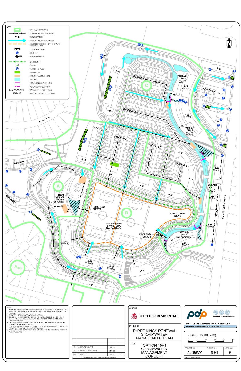
91 91
92 21.11 Treatment will include sedimentation ponds, a wetland channel with four cells on the eastern side of the site, swales and rain-gardens. Surface water which does not infiltrate and is not directly discharged to soakage will be conveyed to soakage areas adjacent to the wetland and three main storage areas toward the south of the site Stormwater Pond A utilises both below and above ground storage. Field B and Area C uses below ground stormwater storage up to the 10-year event and will provide additional above ground storage during greater events. Additional sites for underground storage will be provided and large soakage chambers adjacent / under the eastern wetland channel will provide significant storage volumes The stormwater management plan concludes: The groundwater rise due to infiltration of water during the 10-year and 100-year ARI rainfall events is 1.3 and 2m respectively. It has therefore been assumed that soil is saturated up to RL57.8 and 58.5 for the 10-year and 100-year events respectively and no flood storage is used below these levels. Stormwater runoff from the 10 year and 100 year ARI rainfall events can be appropriately managed through soakage and floor storage on site. Flood storage can be provided so as to manage 100 year ARI runoff volumes while making conservative assumptions about the amount of soakage available. The amount of freeboard to all habitable floors is such that all of the rainfall volume from a 100 year ARI rainfall event can be accommodated below all habitable floors. In order to avoid flooding on the field in a 10-year ARI rainfall event, the field was raised to RL59.0. With this adjustment, the 10-year storm can be stored below RL 59.0 in Area B and raising to RL60.0 in the northern cell of the eastern wetland channel, though some overland flow paths may be higher than this. Stormwater quality treatment is provided in Pond A, swales, tree pits, the eastern wetland cells and in individual raingardens for some paved areas and roads. Roof water quality will be managed through the use of non-exposed metal products such as pre-painted steel. 92
93 21.14 It is recognised that the discharge of stormwater to the aquifer will need a discharge resource consent. This will be applied for as part of any development which proceeds once the outcome of this private plan change request is known INFRASTRUCTURE 22.1 The transport and stormwater infrastructure are key to this development. These matters have been assessed above In addition to the above, it is also important to ensure that the development can be adequately serviced in terms of utilities, including wastewater, potable water, energy and telecommunications. These matters are addressed in the report by Harrison Grierson The report by Harrison Grierson provides an assessment of the utilities that will be required to service development on the site. In the case of wastewater a particular customised response is proposed given the future topography of this area. The report concludes that with these particular mechanisms, wastewater can be successfully managed for development of this land. For other utilities, the report concludes that the development can be appropriately serviced in a standard manner using normal engineering designs consistent with developments of this nature in Auckland. In particular, the report notes: A new Watercare Services Ltd wastewater pumping station with appropriate storage, storage tank and rising main to existing infrastructure. New wastewater extensions to the existing WSL 300mm sewer will be required to service the proposed development. Adequate provision of wastewater storage capacity to enable management of the wastewater network. Essentially, wastewater will be stored during times of heavy rain and peak flow and released to the broader wastewater network during times of low flow and sufficient capacity. New connections to the existing water supply infrastructure for both potable and firefighting purposes. New connections to existing electrical, gas and telecommunication infrastructure. 93
94 23.0 CONSTRUCTION 23.1 The most significant construction effect is the filling of the former 15.2ha quarry land. This fill operation is managed under the 2009 consent for the controlled filling of the quarry Fletcher Residential proposes to advance consents for the Parcel B land (Southern Crown block) following the same methodologies and framework as that applying to Parcel A Fletcher Residential will fill the floor of the valley to between RL 60 and 63m. This is well within the maximum fill level of RL 77m This in turn will have positive effects, because it will significantly reduce the volume of fill, and hence the time required to fill the quarry and associated truck and noise issues It has a very significant beneficial effect in that it provides an interesting terrain which enables the cascading apartment typology and hence an achievement of urban intensification policies of the Auckland Plan within this area If the private plan change is approved, it will lead to significant development of this area All development will comply with the normal construction methods in terms of noise, dust, traffic management, etc All construction will be subject to subsequent resource consents which will fully address construction effects. GEOTECHNICAL MATTERS 23.9 The report by Tonkin & Taylor addresses geotechnical issues. This report identifies that the potential issues have already been addressed through the design which creates safe and stable building platforms and quarry cut slopes. Ultimately, there are no geotechnical constraints that preclude the construction of the development as depicted in Option 15H1. MANAGEMENT OF CONTAMINATED LAND Matters relating to possible contaminated land are addressed in the report by Pattle Delamore Partners Ltd. This report identifies that the redevelopment of the site will be subject to the National Environmental Standard and the contaminated land rules in the Auckland Council Regional Plan: Air, Land Water and the Proposed Auckland Unitary Plan due to the historic and current HAIL land use. 94
95 23.11 The report concludes that the requirements of these plans will ensure that any contaminated land issues are identified and managed appropriately during the development of the site and ultimately there will be no risk to future residential occupants. A detailed site investigation of the contaminated land in parcels B and C will be necessary prior to the development of the site. These matters including a detailed site management plan will be required as part of future resource consent under the provision of the Operative Plan ECONOMIC IMPACTS 24.1 Fletcher engaged Property Economics to assess the costs and benefits associated with the development at Three Kings. The economic impact assessment includes both the initial economic injections during the construction phase through to the on-going annual benefits to the local economy of establishing residential development in this location. The assessment also includes the potential costs associated with the proposal including the opportunity costs of the identified location and activity The Property Economics report identifies that there are four primary issues that relate to the net economic benefit of the proposed development, being: The potential gains in amenity that may result from the development e.g. views and visual amenity. Congestion: the potential effects on the existing transport and servicing infrastructure. Efficiencies: the potential economies of scale that may result from the development. Opportunity cost: the assessment of the next best alternative to this activity and the relative economic costs and benefits associated with it. In this situation the assessment takes account of the potential costs and benefits of providing for this level of residential activity elsewhere Having considered these issues in detail, the report by Property Economics report sets out the following summary: Overall quantified net economic benefits: Additional initial Regional economic injection $217m Additional employment generation (construction) of 156 employee count 95
96 Additional on-going localised (Three Kings catchment) impact $21.5m per annum Additional on-going localised employment generation 435 employee count Reduced land use 65ha (minimal productivity value $380,000 per annum) Additional wealth creation as a proxy for amenity / efficiency gains $64m Reduced total infrastructure capital costs (up to 35% lower) Reduced total infrastructure maintenance costs (up to 9%) Qualified economic benefits including but not limited to: Reduced travel time Reduced travel costs Greater travel options Improved safety Greater housing diversity and affordability Improved labour productivity through increased densities and agglomeration effects Potential qualified Costs: Although the net economic position to the wider community (especially given the existing infrastructure provision) is undoubtedly positive the distribution of these impacts may not be entirely even. There exists the potential, as with any new development, that the development (of any number of new dwellings) of additional housing in this area may have a minimal negative impact on existing properties. It is however important to note that with the improved transport, employment and infrastructure efficiencies this is more likely to improve the overall attractiveness and value of the area. The proposed development at Three Kings offers the local community a valuable economic opportunity. In terms of the local area the potential to increase employment, retail and amenity levels provides increased well-being and efficiencies that are likely to continue to grow the property, as well as community, values in the area. With no real marginal impacts on infrastructure and other community assets the proposed development is likely to produce significant economic benefits without the corresponding economic costs. 96
97 24.4 Overall, it can be seen that there are significant economic benefits to be gained from the proposal and that these benefits extend over a wide range of areas. It should also be noted that the economic benefits increase at a greater rate as the density increases PRECINCT PLAN 25.1 This section refers to the Precinct Plan for Three Kings. It should be noted that the Council changed the name of the June 2014 draft of this document from the Three Kings Precinct Plan to the Three Kings Plan. This section refers to the evolution of this plan In December 2012, the Puketapapa Local Board resolved to prepare a precinct plan for the Three Kings area. In May 2013, the Three Kings Precinct Plan discussion document was released by Auckland Council The Fletcher Residential master plan and resulting concept plan have been significantly modified over the last 18 months to take account of the Council initiatives within the Three Kings Precinct Plan discussion document, particularly options 3, 4, and 5 which had strong public support. Attachment 2 contains an analysis of how the Fletcher Residential proposal relates to the initiatives in the Three Kings Precinct Plan discussion document Subsequently, Auckland Council has released the Three Kings Plan dated June The table below sets out an analysis of the Fletcher Residential proposal against the initiatives in this plan. 97
98 Auckland Council Key Moves and Outcomes Key Move: Enhance Te Tatua a Riukiuta and the public open space network Outcome 1: Te Tatua a Riukiuta/Big King is recognised as a site of immense cultural and historical value by rehabilitating the landscape, improving access, providing appropriate access and protecting views. Outcome 2: A high quality open space network is created that integrates surrounding land use and supports cycle and walking links. Key Move: Revitalise the Three Kings Town Centre Outcome 3: Three Kings is a people-orientated town centre with a vibrant mainstreet, quality public spaces and legible commercial, civic and open space quarters. Outcome 4: Residents have access to adequate community facilities and services that meet their needs. Key Move: Encourage high quality residential development Outcome 5: New residential development is well integrated, and connected to the surrounding environment, responds to the appropriately rehabilitated landscape, built character and heritage features Outcome 6: Development is serviced by adequate provision of sustainable physical and social infrastructure Fletcher Residential Proposal The cultural value of Te Tatua a Riukiuta is respected through the: protection of critical views to the Maunga, the creation of a heavily vegetated buffer on the eastern side of the Maunga Symbolic and actual linkages between the Three Kings green and the Maunga A commitment to tell the story of the area in terms of a spiritual, cultural and historical sense The use of a design guideline which reflects the histories of each Iwi in the built forms on the site The majority of the landscaping will be native Reflecting the belt of Ruikiuta in the layout of development The use of the Te Aranga principles in the overall master plan. A high quality open space network will be created through the development of walkways and cycle links which connect the site to the town centre, the Maunga and the wider area. In total there will be 8.9km of open space connections added to the network. In addition, the creation of two sand carpeted sports fields will ensure that the open space network provides for active recreation as well as passive recreation. The proposal will help to re-vitalise the Three Kings town centre by the creation of a critical mass of housing which will bring a strong population base within the immediate catchment of the town centre. The town centre has always suffered from having no residential catchment to the north. The proposed connections into the town centre will provide residents with ready access to community facilities and services. The proposal will result in a high quality residential development which is well connected into the landscape and which responds to the heritage of the area and wider environment. This is achieved by: Taking account of how Maori occupation and industrial quarrying has shaped the existing landscape. This is reflected in the layout of development and particularly the layout of development and sculptural elements. The use of the landform to define development such as terraced gardens. The use of planting which reflects the volcanic landscape and cultural associations with the site. The use of a wetland ring for habitat and amenity as well as stormwater management. A significant amount of infrastructure will be provided as part of the Fletcher Residential proposal. In terms of 98
99 Auckland Council Key Moves and Outcomes Outcome 7: Fill levels of the quarry should avoid physical segregation with adjacent land and enable strong and highly accessible connections. Fletcher Residential Proposal social and community infrastructure, the open space network and the sports fields will be provided. In terms of physical infrastructure, the roading, wastewater and stormwater networks will be created by Fletcher Residential. The fill levels of the quarry have been designed so as to enable accessible connections to be created. In particular, a major road and associated footpaths and steps will connect the town centre and the filled former quarry floor. A public lift may also be created to give good access for members of the public. There are currently a number of examples of such lifts at rail stations and at the end of Jacobs Ladder connecting St Marys Bay to Westhaven. Attached to this private plan change application is an assessment of a number of New Zealand and overseas examples where high quality urban design solutions have achieved the integration between a change in levels. Key Move: Improve connections between people and places Outcome 8: Development supports alternative modes of transportation and reduces reliance on the private car Outcome 9: The street and movement network creates a permeable, legible and accessible environment for all The proposal will improve connections between people and places in Three Kings. This is because: The open space network within the development will provide for walking and cycling and will connect the development with the town centre, the Maunga and the wider area. An example of this is the green space on the western side of Three Kings reserve linking into the new sports fields and then up the ceremonial staircase to the existing green and town centre. The transport network within the development is connected into Mt Eden Road in a safe and efficient manner The proposal provides for ready access to bus stops The proposal provides accessible connections with the town centre The parking to be provided within the development is set at a level which encourages the use of public transport. Key Move: Develop Local Character and Identity Outcome 10: Three Kings is a vibrant attractive place that meets the needs of the community. Outcome 11: Three Kings has an identity that reflects local culture, history and heritage The proposal will transform a barren, industrial landscape into a high amenity development providing homes. The population base and the built development will significantly increase the vibrancy and attractiveness of the area. The development will add to the local culture, history and identity by protecting views to the Maunga and including many elements of cultural heritage alongside elements which reflect the past quarrying of the site. 99
100 25.4 In addition to the amendments made in response to the precinct plan process, the Fletcher Residential proposal has: Created a series of wetlands around the base of the quarry face. The wetlands perform the function of providing access for stormwater to the aquifer and provide significant amenity for the public and residents. This was a critical element requested by iwi. Ensured that all roads and public spaces will be open to the public and will vest in the Council. Provided for the roading network to build off Grahame Breed Drive. It provides a traffic light-controlled intersection on Mt Eden Road. It also provides access to Mt Albert Rd to ensure the connectivity of the surrounding road network. This intersection also provides safe access for the school across to the proposed two sports fields. Carefully designed the apartment buildings to keep the height of these buildings which reflects adjacent zonal heights under the draft Unitary Plan. Turned the old quarry haul road into a slow speed two-way connection providing for pedestrians, cyclists and vehicles. This will be heavily vegetated to provide high amenity to the area and as an important buffer to the Maunga In February 2014, the Puketapapa Local Board lodged its submission to the proposed Unitary Plan. This called for a precinct plan for the Three Kings area and outlined the key elements the Board is seeking as part of the precinct plan. While this relates to the proposed Unitary Plan, nevertheless Fletcher Residential has taken this fully into account in the development of this private plan change request CONSULTATION 26.1 The Three Kings Precinct Plan and the master plan forming the basis of this private plan change request has been the subject of extensive consultation. The full extent of this consultation is detailed in the attached report by Bernie Chote Fletcher engaged with Council and the Community in 2008 when a series of strategic planning sessions were held to establish a series of principles for the future development of the area. 100
101 26.3 Fletcher approached the Council in late 2012 to inform the Council of the completion of quarry operations and Fletcher's desire to identify the reuse of the Fletcher land. In particular, Fletcher sought feedback on whether the Council supported an integrated study of the full former quarry lands, including the Crown land, or whether Fletcher should advance its thinking independently The Council advised that the Puketepapa Local Board was considering preparing a precinct plan for the Three Kings area and requested that Fletcher engage in this process Fletcher agreed to this and has fully participated throughout this process The Council, through the precinct plan, has run a series of workshops, community meetings, stakeholder meetings, and published a draft precinct plan with further workshops over a more detailed approach As outlined in section 25 above, Fletcher has fundamentally changed its concept based on the draft Three Kings Precinct Plan/Three Kings Plan and feedback on this plan The local board has established a community reference and stakeholder group, of which Fletcher has been a part, and presented its master plan and views The draft Three Kings precinct plan/three Kings Plan focussed broadly across the Three Kings area but with a particular focus on redevelopment of the quarry land and the town centre. Fletcher, throughout this process, has fully engaged and at the request of the Board and community meetings, have outlined its master plan for the development of the area This has been done through a series of stakeholder meetings set out below, but also through a major public open day in early Fletcher received significant and varied feedback from the open day from strong support for the master plan and proposal, through to detailed comments on specific issues, through to opposition to the development Fletcher has also had significant stakeholder engagement over the Three Kings proposal This has included: Auckland Council Parks Services Auckland Council Stormwater 101
102 Auckland Council Regional & Local Planning Auckland Council Housing Policy Office Watercare Services Ltd Auckland Transport Three Kings Primary School South Epsom Planning Group Three Kings United Group Puketapapa Local Board Housing New Zealand Key changes have been made to the private plan change request as a result of this consultation These changes have included: Reconfiguration of the sports fields to provide two fields side by side. The introduction of a number of view corridors in addition to those provided within the Isthmus District Plan and proposed Unitary Plan. Five new view shafts of Te Tatua a Riukiuta are promoted through this private plan change request, together with a view of Maungakiekie and a view of Maungawhau. The proposal to place two lakes within the area has been deleted in favour of a continuous wetland around the northern and eastern perimeter of the valley floor. Multiple access ways between the town centre and new community have been introduced, including road access with associated footpaths and cycleways, public stairs, and a potential public lift. Significant open space has been created in the southern portion of the block so as to provide a green corridor between the existing Three Kings open space and Te Tatua a Riukiuta. Access to Big King Reserve has been provided in the north western corner of the site. An opportunity for a public plaza adjacent to the Three Kings town centre has been introduced. 102
103 The current Watercare pump station within a character residential building is identified for retention and adaptive reuse, possibly as a restaurant/café. The form of development has been realigned to take account of the preferred options identified through the Council s precinct plan/three Kings Plan process In terms of the consultation associated with this private plan change, Fletcher has developed the concept plan to embrace the key planning parameters within the master plan. As stated above, the master plan evolved through the Council s precinct plan development and Fletcher's direct consultation ENGAGEMENT WITH IWI 27.1 Engagement Fletcher has a long-established relationship with the seven key iwi for Three Kings. These are: Ngāti Whātua Ngāi Tai ki Tāmaki Ngati te Ata Tamaoho Te Akitai Waiohua Te Kawarau a Maki Ngati Maru Fletcher has been on a journey with iwi over the development of the master plan that underpins this plan change, and in terms of the approach embodied within the plan change itself. This has involved working with iwi groups individually as well as collectively Fletcher has had five hui with these iwi groups over the development of the master plan and private plan change Significant changes were made to the master plan as a result of feedback from the various hui. 103
104 The following sections set out the key messages from iwi to Fletcher over the master plan and proposed private plan change This journey that Fletcher, iwi and the Council representatives have been travelling has resulted in significant changes and refinement to the master plan. Among these key changes have been: A strong recognition of the cultural significance of this area. The agreement by iwi for a compendium of the stories and history of Te Tatua a Riukiuta and the Three Kings area. This process is outlined below. Recognition of the importance of Te Aranga principles and the retaining of Rau Hoskins to assist the hui and Fletcher in how Te Aranga principles can be reflectedin the actual master plan and in this private plan change request. These matters are addressed more fully below. A fundamental change in the landscape and stormwater management approaches within the quarry. Earlier proposals suggested the creation of two lakes within the quarry area. Iwi very strongly supported a wetland approach. The integrated stormwater management and wetlands forming part of this proposal were developed as a result of the hui. The significance of the Fletcher land which is on the eastern side of Te Tatua a Riukiuta and iwi s identifying the strong importance of this land. As a result this land has been cleared of noxious weeds and is in the process of being planted in native vegetation. It will become a heavily vegetated area. A strong commitment to the long-term planting and landscaping of the area in native species. Using the landscape form and features to reflect the cultural aspirations of iwi. The April hui and June hui have worked through the Te Aranga principles put forward by Rau Hoskins and adopted these, including land ownership issues relating to the eastern side of Te Tatua a Riukiuta, refinements to the final master plan and this plan change request. All these elements have been supported by iwi through these hui. 104
105 Fletcher wrote to the Chair of the Tamaki Collective, who in turn circulated to all members of the Tamaki Collective the invitation to join the various hui on the Three Kings area. Although five iwi chose to take an interest in the development, Fletcher remains open to consult with any iwi who claims Mana whenua status over the area The report of Rau Hoskins of Design Tribe was also presented at the April hui and worked through The following key themes emerged through the hui DESIGN PRINCIPLES Through the hui, iwi spoke of the importance of including Maori design principles (Te Aranga) within the master plan for the 21.6 ha block Fletcher has worked with Council representatives and iwi through these hui to embrace these Maori design principles as part of the development of the master plan The key issue is the cultural expression through the design and process Iwi requested that the design strongly take account of the urban design principles for Maori outlined in the Auckland Design manual In response, Fletcher has modified the master plan to take account of these principles. The urban design elements of the master plan drive heavily off Te Tatua a Riukiuta (Big King). The views and cultural importance of the Maunga is recognised. Te Tatua a Riukiuta means the belt of Riukiuta. The urban design layout is intended to evoke the symbol of the belt. The view corridors and open space connections profile Te Tatua a Riukiuta as the dominant landscape feature within Three Kings development Attached to this private plan change request is a report by Rau Hoskins on Te Aranga principles as they can and should apply to the Three Kings area The key elements of this report that relate to district plan matters have been embedded in the overall master plan/concept plan. These include the use of wetlands and the prominence and protection given to the Maunga. Further elements have been included in the plan change. These include the provision for communal gardening and a physical base for kaitiaki and the assessment criteria relating to: 105
106 The use of stone walls in landscaping The use of culturally appropriate public art The use of native planting in landscaping The use of cultural narrative and names to celebrate the history of the site and its people Acknowledgement of the four Maunga that were previously quarried through signage and landscaping TELLING THE STORY The second key message was the importance of telling the multiplicity of stories for Te Tatua a Riukiuta and its environs Fletcher needs to recognise that there are a multiplicity of stories and perhaps even different perspectives. There is no single integrated story but rather a series of stories from individual iwi Retaining the Maori names is an important element Fletcher has responded by: a) Commissioning the different iwi to develop and express the different stories. b) Agreeing the compilation of these stories and a consensus that these may in fact be contradictory. Telling the story is the critical part. c) Recognising that some aspects will remain confidential and the property of iwi. Other aspects iwi may agree can be made public. d) Fletcher will commission a children s story to encapsulate the Maori presence at Te Tatua a Riukiuta drawing from those parts of the compendium that are public. e) Fletcher has commissioned a GIS study which will recreate in 3D computer model the original topography of the five maunga which made up this area It was agreed through the hui between iwi and the Council that the Council s senior cultural heritage adviser would work with iwi to compile the history and stories of the area. This process is well advanced with the Council officer meeting with each of the iwi groups and bringing the stories together into a single document which has been worked through at the April and June hui. 106
107 This document is a living expression of iwi culture and is still being developed. These stories are a critical cultural dimension of this area. It will be for iwi who are the owners of the stories to determine which elements of this cultural dimension are turned into a public process and when WATER Throughout the hui the criticality of water and the treatment of water was identified as fundamental to the success of the design This related particularly to water quality and how it is treated before entering the aquifer Fletcher's response to this has been: a) To capture and treat all stormwater associated with the precinct within the precinct itself. b) To treat and then discharge stormwater back into the aquifer, rather than entering any of the Council s stormwater network systems. c) To develop an extensive network of wetlands to treat the stormwater. The original Fletcher Residential proposal promoted two lakes forming part of the development. These were seen as high amenity areas. Iwi rejected this appraisal and instead advocated for a wetland approach. Consequently, Fletcher Residential significantly redesigned its master plan to create an extensive line of naturally vegetated wetland to manage stormwater Iwi have strongly supported the wetland approach. Fletcher has committed to work with iwi throughout this project including as the details of the design and management of the wetland are developed LANDSCAPING The Fletcher Residential master plan has used landscaping as a critical element of the area. In particular: 107
108 (i) The eastern side of Te Tatua a Riukiuta is left in its current state and heavily vegetated with native plantings to provide an interface between the Maunga and new community. (ii) The landscaping has been used to achieve strong connections to the Maunga and through the area. (iii) The landscape has been sculptured as set out in the report of Surfacedesign, Inc, to evoke the physical and cultural history of the area. Terracing and landscaping of the area to evoke cultural aspects such as the koru have been built into the design Through the hui, iwi strongly supported the landscaped interface between the Maunga and new community. Iwi wanted the area redeveloped with exotic trees removed and new native planting to agreed specification. The hui also supported the landscaping connections and sculpturing, and evoking traditional art forms and habitation Iwi wanted the landform to reflect the traditional nature of these areas and not be too manicured The Fletcher response has been to: a) Confirm the eastern interface and to immediately commission work on weed management and re-plantings. b) Be committed to native tree landscaping throughout the area. The only exceptions to this is along the northern boundary against the Kennards large storage building, where some quick growing exotics will be planted with native understorey. The exotics will be removed when the native plants gain reasonable height. The second exception is for the extension of London Plane Trees along the new Grahame Breed Drive c) Work with iwi to enable them to be directly involved in the supply and planting of these areas, to ensure the landscaping fully reflects appropriate Maori forms The land on the eastern side of Te Tatua a Riukiuta is owned by Fletchers. Fletchers original proposal was to vest this as public open space in the Council Through the process of the hui and in consultation with Council over development of the master plan and the Three Kings Precinct Plan, it became clear that the Council did not 108
109 want ownership of this land, but that iwi believed this land to be of strategic importance to the cultural framing of Te Tatua a Riukiuta Fletcher is committed to significant landscaping of this area. Works are currently underway with removal of noxious weeds and an underplanting of flax SUSTAINABILITY The hui have discussed the importance of sustainability to the project. Iwi were focused on a broad sustainability agenda Fletcher has: a) Dealt with all stormwater in a sustainable manner. b) Provided for appropriate on-site storage to enable management of the sites wastewater network so that wastewater is stored on-site during periods of high rainfall and peak flows within the network, and released to the broader wastewater network during periods of low flow and sufficient capacity. c) Future proofed the ability for the Council to further improve capacity within the combined network by diverting stormwater from the combined system to the aquifer. d) Promote an extensive network of walkways and cycleways through the area, enabling access from this community to public transport, town centre and park areas. This walkway and cycleway network will also allow connections to the broader Three Kings network. e) Provide direct access and growth along the public transport corridors. f) Promote Crime Prevention through Environmental Design principles in all design. g) Promote the major apartment buildings within northerly or westerly aspect, with a minimum number of apartments south-facing Iwi have supported these initiatives through the hui. 109
110 28.0 RESERVES ACT 28.1 The existing open space land is held subject to the Reserves Act A key element of the proposal involves the exchange of reserve land for parts of the Fletcher land, under the process set out in section 15 of the Reserves Act The reserve land to the south of the Fletcher land affected by the proposals (Parcel B) is described as: a) Part Allotments 85A and 85B Section 10 Suburbs of Auckland marked B on SO 61151, classified as a recreation reserve and vested in trust in Auckland Council for that purpose; b) Part Allotment 85B Section 10 Suburbs of Auckland marked A on SO 61151, classified as a local purpose (depot) reserve and vested in trust in Auckland Council for that purpose Diagram 11 below shows the location of these titles. 110
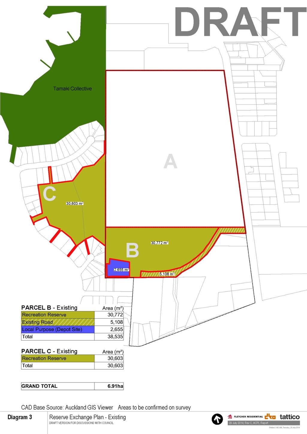
111 111
112 28.5 The two parcels that form the sports field area to the west (Parcel C) of the Fletcher land, are understood to have underlying Crown ownership: a) Allotment 261 Section 10 Suburbs of Auckland. This is vested in trust in Auckland Council, as an unclassified recreation reserve; b) Lot 268 DP This is also vested in trust in Auckland Council, as an unclassified recreation reserve The proposed exchange will result in reserve land being provided that is of at least the same area as, and of significantly higher quality and functionality than, than the existing reserve land. It will also result in additional land being included in the area of the Maunga. The proposed exchange is shown on Diagram 12 below: 112
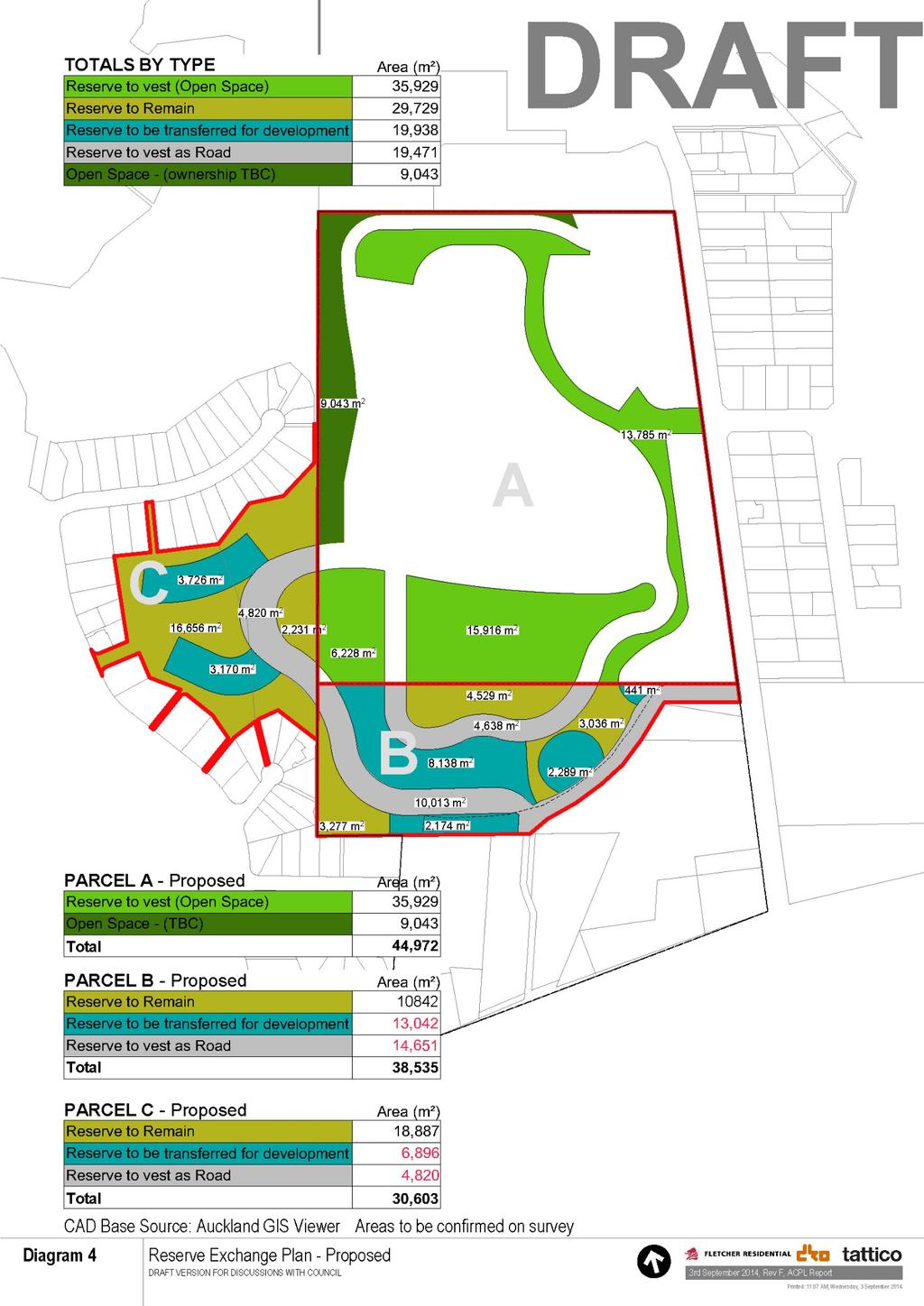
113 113
114 28.7 The process set out in section 15 of the Reserves Act allows the Minister of Conservation to authorise the exchange of reserve, following the request of the administering body (Auckland Council). For this purpose: (a) Auckland Council is required to advertise its intention to pass a resolution to request the proposed exchange, with one month allowed for objections. (b) At the same time the Council should engage with local Iwi so that the Department of Conservation may be satisfied that that the exchange process has been administered to give effect to the principles of the Treaty of Waitangi. (c) The Council is required to consider any objections received as a result of its advertising. (d) If the Council decides to pass the necessary resolution, it then forwards the resolution with the objections and its comments on the objections to the Department of Conservation. (e) The Department of Conservation will then consider seeking the Minister or the Minister's delegate's approval to the exchange. (f) If the exchange is approved the necessary notice in the New Zealand Gazette will be published, once the areas to be exchanged have been defined by survey. (g) The exchange can then be given effect to by registration of the necessary transfers at Land Information New Zealand In conjunction with the exchange, it will be possible for the Council to seek the classification or re-classification, under the Reserves Act 1977, as may be appropriate, of parts of the reserve land for their intended future purpose and use PROPOSED AUCKLAND UNITARY PLAN 29.1 This is a request for a private plan change under the Operative District Plan. From a legal technical assessment, the proposed Auckland Unitary Plan is not relevant to the consideration of this private plan change request. 114
115 29.2 Nevertheless Fletcher recognises that the development of the Three Kings area is a year project. Consequently a significant portion of the programme will proceed under the future provisions of the proposed Auckland Unitary Plan The proposed Auckland Unitary Plan (Unitary Plan) zones the Fletcher land Special Purchase Quarrying and zones the Crown/Council land Open Space. The Three Kings Shopping Centre is zoned Town Centre with a special additional height limit of 24.5m The land is not subject to a precinct overlay under the Unitary Plan. The same view protection mechanisms as apply in the Operative District Plan have effectively been carried over into the Unitary Plan Fletcher has lodged a submission to the Unitary Plan seeking: (a) A rezoning of the 21.6ha land which reflects the appropriate zones as requested in this private plan change. It requests Terrace House and Apartment Building zoning on land requested to be zoned Residential 8 under this plan change request. It similarly requests Open Space zoning on the currently requested Open Space land, and it applies a Town Centre zone to the land currently requested to be zoned Business 2 in this plan change request. If this private plan change request is adopted, then the Fletcher submission will give the independent hearings panel the jurisdictional ability to deal with the Fletcher submissions and the range of further submissions applying to this land. (b) Fletcher is seeking a precinct overlay to be applied to the subject land. This embodies the key elements identified in the concept plan forming part of this private plan change request. The objectives and policies, and planning controls of the requested precinct overlay, are similar in principle to the mechanisms requested under this private plan change request. They recognise the particular circumstances of the Three Kings area and provide a planning mechanism for the comprehensive quality development of the Three Kings Precinct As stated earlier in this planning report, the Auckland Plan identifies the key growth areas for Auckland should be focused around town centres and along major public transport corridors. The Auckland Plan identifies Three Kings as an emerging town centre and Mt Eden Road as a major public transport corridor. 115
116 29.7 The Unitary Plan embraces this planning approach. Mt Eden Road is seen as a major transport corridor and Three Kings Shopping Centre is zoned as a town centre The Terrace House and Apartment Building zone is therefore in Fletchers view the logical and appropriate zoning for the residential areas within the Three Kings precinct The Special Purpose Quarry zone is demonstrably inappropriate for this area for the reasons outlined in section 6 of this planning report The Fletchers rationale for the rezonings and planning mechanisms it seeks as part of the Unitary Plan, is set out in the Fletcher submission to the Proposed Auckland Unitary Plan CONCLUSION 30.1 This report provides a comprehensive assessment of the private plan change application by Fletcher Residential It can be seen that Fletcher Residential has worked through a long and iterative process to achieve a form of development which not only meets its commercial objectives but which will: Be respectful of the cultural and historical significance of the area and the Maunga in particular Provide positive benefits to the community of Three Kings through the provision of a quality open space network and the reinvigoration of the town centre Make a significant contribution to the provision of housing in the locality and region in general Manage the potential effects of the development in an manner which is environmentally sensitive Use a high level of urban design to ensure the creation of a quality built environment and high amenity neighbourhoods The proposal is considered to meet the relevant tests set out in the Act and is consistent with the objectives and policies of the relevant statutory documents. The primary reasons for this are: The proposal provides for the efficient use of land for a residential purpose in an appropriate location (close to public transport and a town centre); and 116
117 The extensive design and development work undertaken will ensure that any adverse effects of the development will be effectively managed in an environmentally sensitive manner; and The proposed Residential 8 zoning and the associated concept plan will provide an effective and efficient basis for ensuring that the proposal will give effect to objectives of the Isthmus District Plan and the purpose of the Act. The provisions of the plan change will also ensure that the development is constructed in a planned and comprehensive manner and will give full effect to the master plan prepared by Fletcher Residential. 117
118 ATTACHMENT 1 Private Plan Change: Three Kings 118
119 119
120 ATTACHMENT 2 Three Kings Precinct Plan Discussion Document 120
121 121
122 Precinct Plan Assessment Explanatory notes: Diagrams 5, 6 and 7 replicate Options 3, 4 and 5 from the Three Kings Precinct Plan. The elements numbered 1 to 14 are the actual initiatives put forward within the Council s Three Kings precinct plan related to Options 3, 4 and 5. The second column quotes and in some cases elaborates the initiatives within the precinct plan. The third column sets out how Fletcher Residential has reflected these initiatives within its proposal. The matters lettered A to C are drawn from the general principles within the Council s Three Kings precinct plan (entitled Discussion Document Three Kings Precinct Plan May 2013 ). Auckland Council Precinct Plan Initiatives Fletcher Residential Proposal A. Mix of housing typologies The proposal is to develop the quarry for a range of intensive housing typologies. There will be a mix of apartment housing and terrace housing. There will also be a range of home/apartment configuration, sizes, and number of bedrooms. B. Achievable yield within the range 700 to 1,800 dwellings. The current proposal is to be in the 1,200 to 1,500 range. C. The assumption is that 60% to 70% of the quarry will be available for development, with the remainder required for the roading network and public spaces. 1. Addition of large open space buffer area adjacent to Big King. Option 5 showed a significant open space area in the north western corner of the former quarry land. Option 4 did not provide for this open space, but provided a linear open space connection down the western boundary of the quarry. The final configuration is still being worked through. The proposal definitely will not exceed 70% and is more likely to be in the lower end of 60-70% range. The Fletcher Residential proposal provides for a large open space in the NW corner of the site similar to option 5. The Fletcher Residential proposal provides for this linear connection on the western side of the boundary, in addition to the large open space in the north western corner. The Fletcher Residential proposal provides for both initiatives. 122
123 Auckland Council Precinct Plan Initiatives 2. View to Big King protected by street layout, orientation and open space configuration Option 5 showed a view shaft from Mt Eden Road just north of Kingsway Rd to Big King. Option 4 showed this view shaft plus a view shaft from the end of the extended town centre main street to the Big King. Fletcher Residential Proposal The Fletcher Residential proposal provides for these two view shafts. In addition, three other view shafts are introduced on Mt Eden Road and two other view shafts introduced from Grahame Breed Drive. 3. North/South connection between possible main street in town centre and local road network and redeveloped quarry site This was shown as an indicative road in a north-south direction aligned to the main street. The topography of the site puts constraints on the form of this connection. The Fletcher Residential proposal provides for this connection as a series of steps and ramps, connecting to the park and roading in the floor of the precinct. This gives the strong north-south connection. In addition, Grahame Breed Drive is extended to provide a roading connection at the accepted roading standards gradient (3%) into the quarry. To achieve the gradient, the road follows the perimeter of the quarry in a location similar to the current service access way. 4. Sports fields repositioned Option 4 places the sports field in the south western area of the site, within ACPL land. Option 5 pushes the sports field further north onto Fletcher Residential land, but also in the southern portion of the site. 5. Water treatment building referred to in the precinct plan as the historic pump house included in or near open space The Fletcher Residential proposal creates a full size summer cricket field and winter soccer field in the southern portion of the sites, straddling the ACPL and Fletcher Residential land. It is in a similar location to the sports field shown on Option 5 and has the same functionality in terms of providing for a full-sized cricket oval in summer and winter soccer field. The site of the decommissioned water treatment plant is proposed for mixed use development and may include a food and beverage element Initially it may also have a function for public information about the development. 123
124 Auckland Council Precinct Plan Initiatives 6. Town centre expanding in northerly direction with mix of town centre and residential activity at the northern edge Options 4 and 5 show various expansion of the town centre for these business and residential activities north across the ACPL land. Fletcher Residential Proposal The Fletcher Residential proposal relates only to the Fletcher Residential and ACPL land. The Fletcher Residential proposal by pushing the open space north, partly on ACPL land and partly on Fletcher Residential land, enables the proposed extension of the northern edge of the town centre. The retail business activity can extend northwards as far as Grahame Breed Drive. Town centre zoning is suggested to enable active uses fronting onto Grahame Breed Drive and sleeving the blank northern wall of the existing town centre. North of Grahame Breed Drive, provision is made for apartments as part of the residential aspiration of this initiative. The apartment market will create a critical mass of housing, which will bring a strong population base within the immediate catchment of the town centre. The town centre has always suffered from having no residential catchment to the north. 7. Redevelopment of the Three Kings plaza site This redevelopment takes place outside Fletcher Residential land. The Fletcher Residential proposal takes full account of the Council s aspiration for redevelopment of the plaza site. In particular, the new proposed main street and its alignment to Grahame Breed Drive and Mt Albert Rd is explicitly provided for within the Fletcher Residential proposal. 8. New open space link between the Three Kings reserve, the town centre, and Big King The Fletcher Residential proposal provides for significant pedestrian and cycleway links throughout the precinct. In particular, a green space on the western side of the Three Kings reserve linking into the new sports field and then up the ceremonial staircase to the existing green and town centre is provided. In addition, there are links through to the north and Mt Eden Road. 9. Possible land exchange with Housing NZ We understand that the Council has deleted the suggestion of a land exchange between Housing New Zealand and private land in Fyvie Avenue and the western field, 124
125 Auckland Council Precinct Plan Initiatives The precinct plan suggested a land exchange between Housing NZ land adjacent to Big King and the western sports field. Fletcher Residential Proposal due to public feedback against this aspect. The Fletcher Residential proposal does provide for a land exchange on part of the western playing field. It enables two quality fields to be formed on the Fletcher Residential land. It also opens up better tracks and connections from the western residential area and the town centre to the Maunga. 10. New civic space created in the heart of the redeveloped town centre providing connections between surrounding open space The town centre is outside the Fletcher Residential land and proposal. However, the Fletcher Residential proposal does provide for the connections between the town centre and the Three Kings precinct. In addition, the Fletcher Residential proposal creates a significant public plaza at the northern end of the main street providing connections to the sports fields and Three Kings Reserve as well as significant views of the volcanic cones. 11. New connection to Big King created through possible land exchange with Housing NZ The same comment as for Item 9 applies. 12. Grahame Breed Drive reconfigured The proposal retains the London Plane trees on the southern side of Grahame Breed Drive, but widens the road to create parking on both sides and a proper footpath, with the road connecting from Mt Eden Road to the town centre and down into the floor of the Three Kings precinct area. 13. Additional access to Mt Albert Rd from the redeveloped Three Kings plaza This initiative relates more to the plaza than the Fletcher Residential land. The Fletcher Residential proposal does take account of the intended new main street linking Mt Albert Rd to Grahame Breed Drive. The road connections and alignment have been configured into the Fletcher Residential proposal so that they will facilitate this initiative. 14. Southern extension of town centre activities along Mt Albert Rd This part of the development is on the southern side of Mt Albert Rd and removed from the Fletcher Residential land. The Fletcher Residential proposal does not compromise or impact the ability for this initiative. 125
126 ATTACHMENT 3 Sports field options 126


127 1 2 3 Diagram 10 Sports Field Configuration Options th December 2013, Rev A, ACPL Report
Three Kings Private Plan Change Request 15-H2
 Three Kings Private Plan Change Request 15-H2 31 August 2014 TABLE OF CONTENTS 1.0 INTRODUCTION... 3 2.0 OVERVIEW 4 3.0 LAND SUBJECT TO THIS PRIVATE PLAN CHANGE REQUEST... 6 4.0 CURRENT USE 8 5.0 FLETCHER
THREE KINGS RENEWAL DESCRIPTION OF URBAN DESIGN / ARCHITECTURAL ELEMENTS AND PROCESS. prepared by dko Architecture
 THREE KINGS RENEWAL DESCRIPTION OF URBAN DESIGN / ARCHITECTURAL ELEMENTS AND PROCESS prepared by dko Architecture THESE PLANS OUTLINE THE VISION OF FLETCHER RESIDENTIAL LTD AND ARE NOT ENDORSED BY AUCKLAND
Auckland City Operative District Plan (Isthmus 1999) Private Plan Change: Three Kings Precinct PA372
 Private Plan Change: Three Kings Precinct PA372") Auckland City Operative District Plan (Isthmus 1999) Private Plan Change: Three Kings Precinct Under Part 2 of Schedule 1 of the Resource Management Act 1991 PA372 1 2 3 Part C: Insert the following in
Auckland City Operative District Plan (Isthmus 1999) Private Plan Change: Three Kings Precinct Under Part 2 of Schedule 1 of the Resource Management Act 1991 PA372 1 2 3 Part C: Insert the following in
I333 Three Kings Precinct
 I333. Three Kings I333.1. Precinct description The Three Kings Precinct provides for the development of a vibrant, sustainable urban village on the former quarries and the adjacent land at Three Kings.
Three Kings Precinct. Plan Change 11 to Auckland Unitary Plan Operative in Part Section 32 Report
 Three Kings Precinct Plan Change 11 to Auckland Unitary Plan Operative in Part Section 32 Report Updated 12 February 2018 2 TABLE OF CONTENTS 1.0 EXECUTIVE SUMMARY... 4 2.0 CONTEXT AND HISTORY OF THE THREE
Appendix 1 Structure plan guidelines
 Appendix 1 Structure plan guidelines This appendix forms part of the regional policy statement [rps]. 1.1. Introduction Structure plans are an important method for establishing the pattern of land use
I539. Smales 2 Precinct
 I539. Smales 2 Precinct I539.1. Precinct Description The Smales 2 Precinct applies to a 4.8 hectare block of land located on the southern side of Northcote Road and fronting Lake Pupuke, Takapuna. The
THREE KINGS RENEWAL MASTER PLAN REPORT H-1
 THREE KINGS RENEWAL MASTER PLAN REPORT 02.09.2014 15H-1 THESE PLANS OUTLINE THE VISION OF FLETCHER RESIDENTIAL LTD AND ARE NOT ENDORSED BY AUCKLAND COUNCIL 1.0 EXECUTIVE SUMMARY 4.0 analysis 6.0 Master
THREE KINGS RENEWAL MASTER PLAN REPORT. Final H-2
 THREE KINGS RENEWAL MASTER PLAN REPORT Final 01.08.2014 15H-2 1.0 EXECUTIVE SUMMARY 4.0 analysis 6.0 Master plan Study Area Master plan Objectives Background and Purpose Master plan Structure Process Principles
I615. Westgate Precinct
 I615. Westgate Precinct I615.1. Precinct Description The Westgate Precinct is located approximately 18km west of the Auckland city centre. There are seven Sub-precincts in the Westgate Precinct: Sub-precinct
H7 Open Space zones. (a) provide for the needs of the wider community as well as the needs of the community in which they are located;
 provide for the needs of the wider community as well as the needs of the community in which they are located;") H7. Open Space zones H7.1. Background The majority of land zoned as open space is vested in the Council or is owned by the Crown. However some areas zoned open space are privately owned. While the open
H7. Open Space zones H7.1. Background The majority of land zoned as open space is vested in the Council or is owned by the Crown. However some areas zoned open space are privately owned. While the open
Tāhuhu whakaruruhau ā-taone The sheltering ridge pole
 B2. Tāhuhu whakaruruhau ā-taone - Urban growth and form B2.1. Issues Tāhuhu whakaruruhau ā-taone The sheltering ridge pole Auckland s growing population increases demand for housing, employment, business,
PART 5 - NATURAL AND PHYSICAL ENVIRONMENT
 CONTENTS...PAGE 5.1 INTRODUCTION...3 5.2 NATURAL RESOURCES...4 5.3 PHYSICAL RESOURCES...4 5.4 COASTAL ENVIRONMENT...4 5.5 HERITAGE FEATURES...4 5.6 HAZARDS...4 5.7 SUMMARY...4 ISTHMUS SECTION - OPERATIVE
SECTION 2.4 URBAN DEVELOPMENT AND STRATEGIC URBAN DIRECTIONS
 SECTION 2.4 URBAN DEVELOPMENT AND STRATEGIC URBAN DIRECTIONS 2.4.1 INTRODUCTION In 1993/94 the Hastings District Council completed the Hastings Urban Development Strategy. The purpose of this study was:
PART 3 - RESOURCE MANAGEMENT
 CONTENTS... PAGE 3.1 INTRODUCTION... 3 3.2 NATURAL AND PHYSICAL ENVIRONMENT... 3 3.3 URBAN SUSTAINABLE MANAGEMENT... 5 3.4 RESOURCE MANAGEMENT ISSUES... 5 3.5 RESOURCE MANAGEMENT OBJECTIVES AND POLICIES...
Plan Modification to Chapter B2 of the Auckland Unitary Plan(AUP) Operative in part (15 November 2016)
 Operative in part (15 November 2016)") UNITARY PLAN UPDATE REQUEST MEMORANDUM TO FROM Phill Reid Linley Wilkinson DATE 25 September 2018 SUBJECT Plan Modification to Chapter B2 of the Auckland Unitary Plan(AUP) Operative in part (15 November
UNITARY PLAN UPDATE REQUEST MEMORANDUM TO FROM Phill Reid Linley Wilkinson DATE 25 September 2018 SUBJECT Plan Modification to Chapter B2 of the Auckland Unitary Plan(AUP) Operative in part (15 November
The Proposed Auckland Unitary Plan (notified 30 September 2013)
") 3 Business zones Introduction There are 10 business zones in the Unitary Plan: City Centre Metropolitan Centre Town Centre Local Centre Neighbourhood Centre Mixed Use General Business Business Park Light
3 Business zones Introduction There are 10 business zones in the Unitary Plan: City Centre Metropolitan Centre Town Centre Local Centre Neighbourhood Centre Mixed Use General Business Business Park Light
DAREBIN PLANNING SCHEME AMENDMENT C137
 Who is the planning authority? Planning and Environment Act 1987 DAREBIN PLANNING SCHEME AMENDMENT C137 EXPLANATORY REPORT This amendment has been prepared by the Darebin City Council, who is the planning
B4. Te tiaki taonga tuku iho - Natural heritage
 B4. Te tiaki taonga tuku iho - Natural heritage Tuia I runga, tuia i raro, tuia ki te waonui a Tiriwa Bind the life forces of heaven and earth to the great realm of Tiriwa B4.1. Issues Auckland s distinctive
Section Three, Part 16 Takanini Structure Plan Area
 PART 16 TAKANINI STRUCTURE PLAN AREA 16.1 Residential 8 zone 16.1.1 Objectives and Policies 16.1.2 Rules: General 16.1.3 Rules: Activity Status Subdivision (Except within the Addison Neighbourhood Centre)
Appendix A. Planning Processes. Introduction
 1 Planning Processes Introduction This appendix outlines a number of planning processes which are used in the Auckland Region to support the effective management of development in the region s rural and
REMARKABLES PARK ZONE
 .10 Remarkables Park Zone.10.1 Resources, Activities and Values The Remarkables Park Area comprises approximately 150 hectares of perimeter urban land in the vicinity of Frankton and occupies a strategic
THREE PARKS ZONE Three Parks Special Zone The process of applying for resource consents in the zone.
 .25 Three Parks Special Zone The purpose of this zone is to provide for growth and to give effect to the Wanaka 2020 Community (2002) and the more recent Wanaka Structure (2007) and Wanaka Transport Strategy
AOTEA SUPERMARKET ZONE. Zone Introduction
 C18 AOTEA SUPERMARKET ZONE Zone Introduction C18.1 Objective This zone identifies a specific area in Aotea for a stand alone supermarket. The zone is site specific and has a range of objectives, policies
GREENBANK DEVELOPMENT MASTERPLAN
 DEVELOPMENT MASTERPLAN POTENTIAL TRAIN STATION COMMUNITY CENTRE Greenbank will be a connected masterplanned community providing easy access to local and surrounding amenity. Affordable quality homes, green
I609. Penihana North Precinct
 I609. Penihana North Precinct I609.1. Precinct description The Penihana North Precinct is located south of the Swanson Railway Station, adjacent to the Rural Urban Boundary (RUB) and Waitakere Ranges Heritage
WELLINGTON HOSPITAL DESIGN GUIDE TABLE OF CONTENTS
 WELLINGTON HOSPITAL DESIGN GUIDE TABLE OF CONTENTS 1.0 Introduction Page 2 The Place of Wellington Hospital 2 The Future of the Hospital 2 2.0 The Intention of the Design Guide 3 3.0 Analysis 4 General
[PLANNING RATIONALE] For Site Plan Control and Lifting of Holding Zone By-Law 101 Champagne Avenue. May 23, 2014
![[PLANNING RATIONALE] For Site Plan Control and Lifting of Holding Zone By-Law 101 Champagne Avenue. May 23, 2014](/thumbs/75/71599615.jpg "[PLANNING RATIONALE] For Site Plan Control and Lifting of Holding Zone By-Law 101 Champagne Avenue. May 23, 2014") [PLANNING RATIONALE] For Site Plan Control and Lifting of Holding Zone By-Law 101 Champagne Avenue May 23, 2014 Contents 1.0 Introduction... 2 2.0 Site Context... 2 2.1 Adjacent Uses... 2 Figure 1: Site
[PLANNING RATIONALE] For Site Plan Control and Lifting of Holding Zone By-Law 101 Champagne Avenue May 23, 2014 Contents 1.0 Introduction... 2 2.0 Site Context... 2 2.1 Adjacent Uses... 2 Figure 1: Site
4 RESIDENTIAL ZONE. 4.1 Background
 4 RESIDENTIAL ZONE 4.1 Background The residential areas within the City are characterised by mainly lowrise dwellings sited on individual allotments. Past architectural styles, settlement patterns and
Wairaka Zoning and Precinct Section 32 evaluation for the Proposed Auckland Unitary Plan
 Wairaka Zoning and Precinct Section 32 evaluation for the Proposed Auckland Unitary Plan 1.0 OVERVIEW AND PURPOSE This document provides an assessment of the proposed Wairaka Zoning and Precinct Provisions
I404 Beachlands 2 Precinct
 I404. Beachlands 2 I404.1. Precinct Description The Beachlands 2 precinct covers approximately 6 hectares of land at the corner of Beachlands and Whitford Maraetai Roads. Its purpose is to provide for
RURAL ZONE - POLICY. Rural Zone Policy. Issue: Rural Environment. Ruapehu District Plan Page 1 of 8
 Rural Zone Policy RU2 RURAL ZONE - POLICY RU2.1 Introduction The natural resources of the rural environment in the Ruapehu District provide the basis for the existing and potential character, intensity
For more information, go to
 For more information, go to www.shapeauckland.co.nz The draft Auckland Unitary Plan View the video: Shaping the world s most liveable city One simplified plan Where we live Where we work What we value
11.3 SPECIAL CHARACTER ZONE HAWKE S BAY REGIONAL SPORTS PARK
 11.3 SPECIAL CHARACTER ZONE HAWKE S BAY REGIONAL SPORTS PARK 11.3.1 INTRODUCTION The availability of sports and recreation activities and facilities is important for the maintenance and enhancement of
Part F: Three Kings Residential Design Guide
 Part F: Three Kings Residential Design Guide Contents A. Background and Purpose 2 B. Context Te Tātua a Riukiuta / Three Kings 2 C. Three Kings Renewal Project Vision 3 D. Three Kings Renewal Project Components
INCREMENTAL CHANGE AREA REVIEW March 2015 Page 1
 INCREMENTAL CHANGE AREA REVIEW March 2015 Page 1 Table of Contents Introduction... 3 Background to Review... 3 Comparison of the Schedules to the General Residential Zone... 7 Methodology... 7 Policy Context...
Three Kings Residential Design Guide
 Three Kings Residential Design Guide Contents A. Background and Purpose... 2 B. Context Te Tātua a Riukiuta / Three Kings... 2 C. Three Kings Renewal Project Vision... 3 D. Three Kings Renewal Project
Planning Proposal Charlestown Swim and Leisure Centre LEP Amendment
 Planning Proposal Charlestown Swim and Leisure Centre LEP Amendment Amendment No. 4 to Lake Macquarie Local Environmental Plan 2014 (PP_2014_LAKEM_005_00) Local Government Area: Name of Draft LEP: Lake
I403 Beachlands 1 Precinct
 I403. Beachlands 1 I403.1. Precinct Description Beachlands is a rural and coastal village located on the eastern side of Auckland, adjoining the Tamaki Strait coastline. The original Beachlands village
The Proposed Auckland Unitary Plan (notified 30 September 2013)
") 8 Special Purpose zones 8.1 Airport zone The Airport zone applies to the Kaipara Flats Airfield, North Shore Airfield, Auckland International Airport and Ardmore Airport. Auckland International Airport
8 Special Purpose zones 8.1 Airport zone The Airport zone applies to the Kaipara Flats Airfield, North Shore Airfield, Auckland International Airport and Ardmore Airport. Auckland International Airport
Northern Territory Compact Urban Growth Policy
 Northern Territory Compact Urban Growth Policy A Reference Policy Document to clause 2.7 (Reference to Policy) of the NT Planning Scheme May 2015 Table of Contents 1 Policy Setting... 3 1.1 Context for
Land Use Amendment in Southwood (Ward 11) at and Elbow Drive SW, LOC
 at and Elbow Drive SW, LOC") 2018 November 15 Page 1 of 10 EXECUTIVE SUMMARY This land use amendment application was submitted by Rick Balbi Architect on 2017 August 31 on behalf of Sable Developments Ltd, and with authorization from
2018 November 15 Page 1 of 10 EXECUTIVE SUMMARY This land use amendment application was submitted by Rick Balbi Architect on 2017 August 31 on behalf of Sable Developments Ltd, and with authorization from
178 Carruthers Properties Inc.
 178 Carruthers Properties Inc. Planning Rationale for 178 Carruthers Avenue Site Plan Control Application June 2014 Table of Contents 1.0 Introduction 2.0 Overview of Subject Property 3.0 Current Zoning
I611. Swanson North Precinct
 I611. Swanson North Precinct I611.1. Precinct Description Swanson North is located in the north eastern foothills of the Waitakere Ranges. It is outside the Waitakere Ranges Heritage Area Act and the Waitakere
open space environment
 This section updated August 09 GUIDELINE TO THE RULES The Open Space Environment Rules apply to activities on sites within the Open Space Environment as shown on the Human Environments Maps. Most of the
6 PORT SYDNEY SETTLEMENT AREA
 Section 6 Port Sydney Page 61 6 PORT SYDNEY SETTLEMENT AREA 6.1 Basis and Principles Village of Port Sydney Waterfront Community Existing Services 6.1.1 Port Sydney is an historic settlement that has developed
2A District-wide Policies
 2A Introduction This Chapter contains policies which are relevant to subdivision, use and development activities occurring across all zones and areas of the District. The policies in this Chapter implement
LAND USE AMENDMENT CORNERSTONE (WARD 3) 60 STREET NE AND COUNTRY HILLS BOULEVARD NE MAP 26NE BYLAW 22D2017
 60 STREET NE AND COUNTRY HILLS BOULEVARD NE MAP 26NE BYLAW 22D2017") Page 1 of 14 EXECUTIVE SUMMARY This Land Use Amendment application covers an area of 43.76 hectares ± (108.14 acres ±) located in northeast Calgary, bound by Country Hills Boulevard NE to the south and
Page 1 of 14 EXECUTIVE SUMMARY This Land Use Amendment application covers an area of 43.76 hectares ± (108.14 acres ±) located in northeast Calgary, bound by Country Hills Boulevard NE to the south and
I326. Ōrākei 1 Precinct
 I326. Ōrākei 1 recinct I326.1. recinct Description The Ōrākei 1 recinct includes the land identified as hapu reservation (land held for the purposes of a marae, church, urupa and related hapu amenities)
1. Assessment of Environmental Effects
 1. Assessment of Environmental Effects Table of Contents 1. Introduction and Overview 1 2. Statutory Assessment 3 3. Site Description 5 4. Proposal Description 7 5. Assessment of Effects on the Environment
CITY OF FREMANTLE LOCAL PLANNING SCHEME NO. 4 AMENDMENT NO. 68 SCHEME AMENDMENT REPORT
 CITY OF FREMANTLE LOCAL PLANNING SCHEME NO. 4 AMENDMENT NO. 68 SCHEME AMENDMENT REPORT CITY OF FREMANTLE PLANNING AND DEVELOPMENT SERVICES 8 WILLIAM STREET FREMANTLE WA 6160 PLANNING AND DEVELOPMENT ACT
Town of Cobourg Heritage Master Plan. Statutory Public Meeting
 Town of Cobourg Heritage Master Plan Statutory Public Meeting April 25 th 2016 Presentation Overview 1. Introduction 2. Project background and schedule overview 3. Review of strategic direction content
Welcome. Walk Around. Talk to Us. Write Down Your Comments
 Welcome This is an information meeting introducing the applications for proposed redevelopment of the Yorkdale Shopping Centre site at 3401 Dufferin Street and 1 Yorkdale Road over the next 20+ years,
North District What we heard
 What we heard Vision to 2056 and Priorities Governance and implementation Infrastructure and funding The vision for a metropolis of three cities, and the 30 minute city. Feedback emphasised: That for the
Subdivision Design Criteria. Penihana North GUIDELINES TO THE RULES
 Created September 2013 Penihana North Subdivision Design Criteria GUIDELINES TO THE RULES This part of the Plan sets out the design criteria for subdivision in Penihana North. The criteria will be considered
Woodbrook - Shanganagh
 Section 4: Key Sites Framework Strategy Woodbrook - Shanganagh Local Area Plan 2017-2023 4. Site Framework Strategies The Master Plans shall have regard to the thematic objectives under the LAP Development
2136 & 2148 Trafalgar Road Town of Oakville Region of Halton
 PLANNING JUSTIFICATION REPORT 2136 & 2148 Trafalgar Road Town of Oakville Region of Halton Zoning By-Law Amendment Application 2500674 Ontario Inc. November 2016 Table of Contents Page 1.0 Location/Summary
Section 3b: Objectives and Policies Rural Environment Updated 19 November 2010
 Page 1 of Section 3b 3b RURAL ENVIRONMENT 3b.1 Introduction The Rural Environment comprises all the land outside of the Residential, Town Centre and Industrial Environments. Most land within the District
Regency Developments. Urban Design Brief. Holyrood DC2 Rezoning
 Regency Developments Urban Design Brief Holyrood DC2 Rezoning Stantec Consulting Ltd. 7-31-2017 1. Overview Regency Developments intends to rezone the lands located at 8510 and 8511 93 Avenue, within the
WELLINGTON CITY DISTRICT PLAN
 Section 32 Report WELLINGTON CITY DISTRICT PLAN PROPOSED DISTRICT PLAN CHANGE 54 REZONING 178 AND 180 OWHIRO BAY PARADE 1 Introduction Before a Proposed District Plan change is publicly notified the Council
SECTION 7A: WHAKARONGO RESIDENTIAL AREA
 SECTION 7A: WHAKARONGO RESIDENTIAL AREA CONTENTS 7A.1 Introduction 1 7A.2 Resource Management Issues 1 7A.3 Objectives and Policies 1 7A.4 Methods 4 7A.5 Residential Zone 4 7A.5.1 Rules: Controlled Activities
9.1 ISSUES OBJECTIVES RULES - Class B - Heritage Items RULES - Class C - Heritage Items RULES - Old Town Overlay Area 18
 9 HISTORIC HERITAGE 9.1 ISSUES 7 9.2 OBJECTIVES 7 9.3 POLICIES 8 9.4 RULES - Class A - Heritage Items 13 9.5 RULES - Class B - Heritage Items 15 9.6 RULES - Class C - Heritage Items 17 9.7 RULES - Old
Unitec Proposed Auckland Unitary Plan Submission. Wairaka Zoning and Precinct Planning Report
 Unitec Proposed Auckland Unitary Plan Submission Wairaka Zoning and Precinct Planning Report 29 October2015 1 2 TABLE OF CONTENTS 1.0 EXECUTIVE SUMMARY... 4 2.0 INTRODUCTION... 7 3.0 WAIRAKA STRATEGY...
Appendix C: Interim Mixed-Use Evaluation Criteria
 Appendix C: Interim Mixed-Use Evaluation Criteria C-1 Appendix C: Interim Mixed-Use Evaluation Criteria PURPOSE: The implementation of numerous policies contained within the Master Plan hinges on the creation
Section 32 Evaluation Report Variation 1 - Arrowtown Design Guidelines, 2016 Contents
 Section 32 Evaluation Report Variation 1 - Arrowtown Design Guidelines, 2016 Contents Section 32 Evaluation Report: Variation 1 - Arrowtown Design Guidelines, 2016 (ADG, 2016)... 3 1. Strategic Context...
ONTARIO MUNICIPAL BOARD
 PL 120483 ONTARIO MUNICIPAL BOARD Applicant/Appellant: 2124123 Ontario Limited Subject: OPA, Rezoning and Draft Plan of Subdivision Municipal Address: 3940 Highway 7 East Municipality: City of Markham
Welcome to the Oakridge Centre Open House
 Welcome to the Oakridge Centre Open House Why is the City hosting this event? This open house is to inform you of a rezoning application submitted to the City of Vancouver to amend the existing CD-1 (Comprehensive
I209 Quay Park Precinct
 I209. Quay Park I209.1. Precinct description The Quay Park Precinct is located on reclaimed land at the eastern end of the city centre and along the City Centre waterfront. It is dissected to the east
Section 12C Subdivision in the Rural Residential Zone
 Section 12C 12C Subdivision in the Rural Residential Zone The Rural Residential Zone provides part of the range of residential opportunities within the City. Land zoned rural residential is considered
Chapter 2: OUTLINE PLANNING APPLICATION PROPOSALS. A New Garden Neighbourhood Matford Barton 17
 Chapter 2: OUTLINE PLANNING APPLICATION PROPOSALS A New Garden Neighbourhood Matford Barton 17 2.1. SUMMARY AND STATUS OF THE PROPOSALS 2.1.1. The parameter plans and associated wording in this chapter
STRATEGIC DIRECTION. QLDC PROPOSED DISTRICT PLAN [PART TWO] DECISIONS VERSION 3 strategic direction
![STRATEGIC DIRECTION. QLDC PROPOSED DISTRICT PLAN [PART TWO] DECISIONS VERSION 3 strategic direction](/thumbs/79/79711764.jpg "STRATEGIC DIRECTION. QLDC PROPOSED DISTRICT PLAN [PART TWO] DECISIONS VERSION 3 strategic direction") 3 STRATEGIC DIRECTION QLDC PROPOSED DISTRICT PLAN [PART TWO] DECISIONS VERSION 3 strategic direction QLDC DISTRICT PLAN [PART TWO] AUGUST 2015 3 strategic direction 3.1 Purpose This chapter sets out the
3 STRATEGIC DIRECTION QLDC PROPOSED DISTRICT PLAN [PART TWO] DECISIONS VERSION 3 strategic direction QLDC DISTRICT PLAN [PART TWO] AUGUST 2015 3 strategic direction 3.1 Purpose This chapter sets out the
PART 6 - HUMAN ENVIRONMENT
 CONTENTS...PAGE 6.1 INTRODUCTION...3 6.2 ISSUES AND STRATEGY...3 ISTHMUS SECTION - OPERATIVE 1999 Page 1 Page 2 ISTHMUS SECTION - OPERATIVE 1999 PART 6 - HUMAN ENVIRONMENT 6.1 INTRODUCTION The Plan seeks
I602. Birdwood Precinct
 I602. Birdwood Precinct I602.1. Precinct description The Birdwood Precinct applies to an area west of Don Buck Road and south of Red Hills Road in west Auckland. It incorporates subdivision and development
10.0 Open Space and Public Realm
 10.0 Open Space and Public Realm 10.0 Open Space and Public Realm The Public Open Space System is comprised of: outdoor spaces available for public use that are either publicly owned (e.g., parks and
PART AOTEA PRECINCT
 CONTENTS... PAGE AOTEA PRECINCT...4 14.5.1 INTRODUCTION...4 14.5.2 RESOURCE MANAGEMENT ISSUES...4 14.5.3 RESOURCE MANAGEMENT OBJECTIVES AND POLICIES... 4 14.5.4 RESOURCE MANAGEMENT STRATEGY...5 14.5.5
Official Plan Review: Draft Built Form Policies
 PG.30.1 REPORT FOR ACTION Official Plan Review: Draft Built Form Policies Date: May 15, 2018 To: Planning and Growth Management Committee From: Chief Planner and Executive Director, City Planning Division
Keystone Business Park Precinct Structure Plan North East Industrial Precinct. Part 2 Design Principles
 Keystone Business Park Precinct Structure Plan North East Industrial Precinct Part 2 Design Principles Context Issues Services Landform Issues Geotech and contamination Ecology Traffic and access Issues
Section 6A 6A Purpose of the Natural Features and Landscapes Provisions
 Section 6A 6A Purpose of the Natural Features and Landscapes Provisions This Chapter addresses the protection and management of natural features and landscapes within the City. The City has a number of
and services The protection and conservation of environmentally significant and sensitive natural heritage features and functions.
 6. Land Use 6.0 Preamble A healthy and livable city is one in which people can enjoy a vibrant economy and a sustainable healthy environment in safe, caring and diverse neighbourhoods. In order to ensure
A Growing Community Rural Settlement Areas
 Town of Huntsville Official Plan Review - POLICY BACKGROUND PAPER A Growing Community Rural Settlement Areas BACKGROUND: In addition to the fully municipally-serviced Urban Settlement Area and the Hidden
Complete Neighbourhood Guidelines Review Tool
 Complete Neighbourhood Guidelines Review Tool Prepared By: City of Regina Planning Department October 2014 Page 1 of 14 Community Development Review Checklist for Secondary Plans and Concept Plans The
Next Steps / Development Process. Structure Plan. June submitted to City of Fremantle. Structure Plan. July supported for advertising
 overview What is today about? In July 0, the City of Fremantle resolved that the be advertised for public comment. Today is about: Understanding the history and context of the site Having your say on the
PROPOSED AUCKLAND UNITARY PLAN, PART 2 - REGIONAL AND DISTRICT OBJECTIVES AND POLICIES, CHAPTER F: PRECINCT OBJECTIVES AND POLICIES, 6: SOUTH
 1 PROPOSED AUCKLAND UNITARY PLAN, PART 2 - REGIONAL AND DISTRICT OBJECTIVES AND POLICIES, CHAPTER F: PRECINCT OBJECTIVES AND POLICIES, 6: SOUTH 6.15: Mangere Gateway The objectives and policies of the
URBAN DESIGN BRIEF. 2136&2148 Trafalgar Road. Town of Oakville
 URBAN DESIGN BRIEF 2136&2148 Trafalgar Road Town of Oakville Prepared By: METROPOLITAN CONSULTING INC For 2500674 Ontario Inc November 2016 TABLE OF CONTENTS Page No. 1.0 Introduction/Description of Subject
Section Three, Appendix 16C Medium Density Housing, Design Assessment Criteria (Residential 8A zone)
") APPENDIX 16C MEDIUM DENSITY HOUSING, DESIGN ASSESSMENT CRITERIA (RESIDENTIAL 8A ZONE) PURPOSE OF APPENDIX 16C (RESIDENTIAL 8A ZONE) In the Residential 8A Zone the following are defined as restricted discretionary
APPENDIX 16C MEDIUM DENSITY HOUSING, DESIGN ASSESSMENT CRITERIA (RESIDENTIAL 8A ZONE) PURPOSE OF APPENDIX 16C (RESIDENTIAL 8A ZONE) In the Residential 8A Zone the following are defined as restricted discretionary
CITY VIEW OBJECTIVES
 SECTION 2: CITY VIEW OBJECTIVES CONTENTS 2.1 Introduction 1 2.2 Strategic Direction 1 2.3 The City View Resource Management Issues for the City 1 2.4 The Goal 3 2.5 The City View Objectives 3 Palmerston
The West Vaughan Employment Area Secondary Plan Policies
 Part 2: The West Vaughan Employment Area Secondary Plan Policies 2.1 General Policies It is the policy of Council: 2.1.1. That the West Vaughan Employment Area (the WVEA), identified on Schedule 1, will
Town Center (part of the Comprehensive Plan)
") Town Center (part of the Comprehensive Plan) Mercer Island Town Center Looking North (2014) In 1994, a year-long process culminated in a set of design guidelines and code requirements for the Town Center
Town Center (part of the Comprehensive Plan) Mercer Island Town Center Looking North (2014) In 1994, a year-long process culminated in a set of design guidelines and code requirements for the Town Center
I309. Cornwall Park Precinct
 I309. Cornwall Park Precinct I309.1. Precinct Description Cornwall Park is a privately owned and managed landscaped park designed for public recreation and enjoyment and is a highly used and valued open
PORT WHITBY COMMUNITY
 PORT WHITBY COMMUNITY SECONDARY PLAN UPDATE COMMUNITY IMPROVEMENT PLAN URBAN DESIGN GUIDELINES September 2015 DRAFT PROPOSED AMENDMENT NUMBER # to the Whitby Official Plan PURPOSE: The intent of this Amendment
EVALUATION OF MASTER PLAN ALTERNATIVES
 7 The Environmental Report is required to identify, describe and evaluate reasonable alternatives, taking into account the objectives and geographical scope of the Master Plan 2008. Three plan alternatives
Local Growth Planning in North Central Green Line Communities
 2018 April 30 Page 1 of 6 EXECUTIVE SUMMARY This report outlines a high-level scope for local growth planning for north central Green Line communities. The catalyst for this review is the significant investments
Urban Design Guidelines
 Urban Design Guidelines These Urban Design Guidelines comprise the Key Design Objectives below, the Roads Design Guidelines overleaf and Neighbourhood Framework Plans. Together with Section 3: Urban Design
4 Residential and Urban Living Zones
 4 Residential and Urban Living Zones Refer to Chapters 11 to 20 for additional rules that may apply to these zones. 4.1 OBJECTIVES AND POLICIES Objective Res1 Policy 1 Policy 2 Policy 3 Policy 4 Policy
Downtown Streetscape Manual & Built Form Standards
 City of Guelph Downtown Streetscape Manual & Built Form Standards July 2014 Prepared by Brook McIlroy Inc. in association with Unterman McPhail Associates and McCormick Rankin Inc. City of Guelph Downtown
Neighbourhood Planning Local Green Spaces
 Neighbourhood Planning Local Green Spaces Introduction... 2 1. Why green space is important... 4 2. Neighbourhood plans and green space... 6 3. Evidence... 8 Statutory designations... 9 Green space audit...
13 FUTURE DEVELOPMENT AND STRUCTURE PLANS
 13 FUTURE DEVELOPMENT AND STRUCTURE PLANS Contents 13.1 Introduction 13.2 Resource Management Issues 13.3 Objectives 13.4 Policies 13.5 Strategy 13.6 Implementation 13.6.1 District Plan Regulatory Methods
Planning & Development. Background. Subject Lands
 Planning & Development APPLICATION BRIEFING Prepared For: Planning Advisory Committee Submitted by: Jason Fox, Director of Planning & Development Date: Subject: Development Agreement Application by Brentwood
I331. St John s Theological College Precinct
 I331. St John s Theological College Precinct I331.1. Precinct Description The precinct contains the existing St John s Theological College which is a residential college for the Anglican Church in New
EXECUTIVE SUMMARY DRAFT CHAPTER 1 INTRODUCTION EXECUTIVE SUMMARY
 CHAPTER 1 EXECUTIVE SUMMARY INTRODUCTION Through the joint efforts of the City of Tulsa planning staff and the Land Services division of Indian Nations Council of Governments (INCOG), the Berryhill Land