Fire Mapping Chapter. Working Paper
|
|
|
- Esmond Robinson
- 5 years ago
- Views:
Transcription


1 Fire Mapping Chapter Working Paper Version 1.0 as of September 2018
2 International Working Group on Satellite-based Emergency Mapping (IWG-SEM) Contents 1. FOREWORD IWG-SEM Fire delineation section Fire Severity Mapping Procedure with SWIR channels Procedure without SWIR channels Interpretation guide to fire severity classification Acknowledgements International Working Group on Satellite-Based Emergency Mapping 2
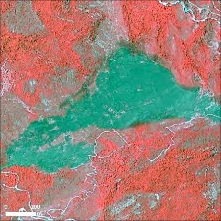
3 1. FOREWORD This chapter is aimed at providing definitions and guidelines on how to map fire extents and to indicate fire severity using satellite imagery. There a two sections to this chapter: A fire extent or delineation section A fire severity section The main goal is to propose simple but standard approaches that can be internationally adopted, especially to increase consistency of the thematic information provided by different SEM entities for the same event, streamlining the exploitation of the crisis information by the end users. The methodology proposed in this document does not mention radiometric calibration or atmospheric correction which could be applied to the imagery before interpreting or processing the imagery for fire severity. Given the time constraints, in rapid mapping this step is rarely carried out. Furthermore, a Fire working group (WG) was set up within Copernicus EMS Rapid Mapping to try to establish standard methods especially in fire severity mapping. The WG benefitted from ICube-SERTIT s past experiences in the European Framework Program R&D project called PREFER. Finally, the IWG-SEM Chair, reviewed and discussed the document within the group In its present state the document should be completed with IWG-SEM membership comments, if any. Hence, at present this document constitutes an initial proposition for an IWG-SEM Fire Chapter, an additional chapter associated with the Guidelines. Below you will find this concise best practices interpretation guide. A section on continent-wide fire hot spot and fire mapping services could be added in the near future. 2. IWG-SEM Fire delineation section Satellites are particularly adapted to mapping fire extents with their synoptic yet precise view, over vast areas, where depending on the size of a fire or group of fires low to very high resolution data can play their part. This leads to continental to local detail mapping. Furthermore, satellites at different viewing scales enable repetitive viewing or monitoring. Fires change the vegetative state of the affected area with spectral changes reflecting this removal or altering of vegetative cover. This is easily recorded by satellite with changes in reflectance depending on the density of the original vegetal cover with ash and soil components coming to the fore after the fire. This depends also on their being a more or less arid climate in the fire affected area. Spectrally speaking there is generally a big decrease in the NIR reflectivity. 3
 channels and dramatic decrease in values within the Near Infrared channel.")

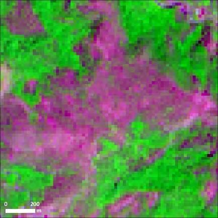
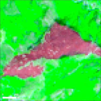
4 Figure 1: Digital number counts used to compare healthy vegetation (green) with a burnt area (purple) within the same image. One can note a relative increase in the visible and Short Wave InfraRed (MIR) channels and dramatic decrease in values within the Near Infrared channel. The values are derived from a SPOT 5 image acquired the 02 September 2007, CNES 2007, distribution AIRBUS DS, all rights reserved. This shows that a spectral image processing approach can work to map burnt areas. This is very true but it will never be perfect in areas of sparse vegetation and unfortunately other areas can get mixed up. A validation phase is essential. In rapid mapping the civil security/protection agencies have often asked service providers to encompass all affected areas into an envelope. They have preferred a simplified low number of burnt area polygons, avoiding too much detail and definitely not at the pixel level. This has led to an emphasis on manually digitizing the outside perimeter of burnt areas. Even if they are manually digitized it is often preferable to calculate differential Normalised Difference Vegetation Indices or Normalised Burn Ratio (see description below) to highlight the fire affected areas. Hence, there are two standard ways of deriving a fire delineation or extent mapping. The choice of method depends on the user and, perhaps, the geometric complexity of (a) burnt area(s). 4

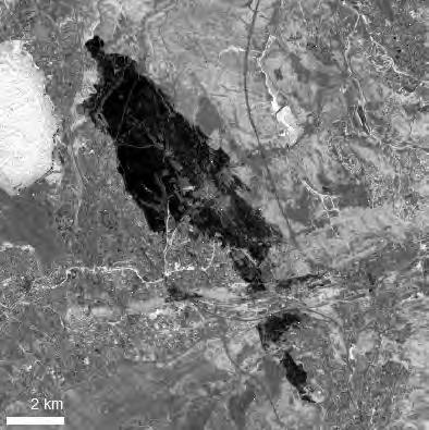
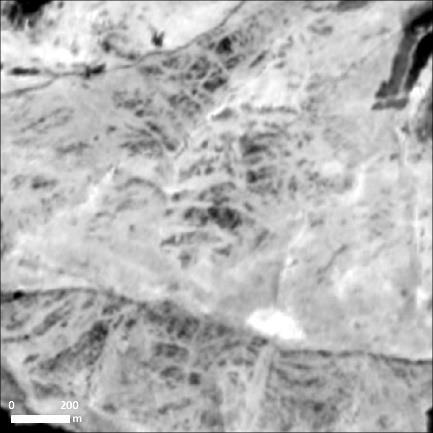
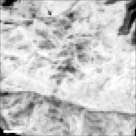
5 Figure 2: Fire delineation/extent map over Kontodespoti, Greece. The complex fire limit was manually interpreted. 5
6 3. Fire Severity Mapping Firstly, 2 different approaches to mapping fire severity need to be distinguished depending on the characteristics of the images being used: - Images with SWIR channel (Sentinel-2, Landsat-8, Worldview-4 in some cases, ) - Images without SWIR channels (SPOT 6/7, Pléiades, Wv-2, WV-3, WV-4 in most of the cases). The method with SWIR channels is straight forward and widely used in the scientific community; the method without SWIR is a stop gap that indicates vegetation presence or not within the fire affected areas before and after a fire. This is the burn scar and its neighbourhood. Unfortunately, the vast majority of agile, rapidly available satellite images do not have a SWIR channel. 3.1 Procedure with SWIR channels As already stated, to optimize the step of digitising the burn scar you can use the result of the severity method described below to help you. Furthermore, you can combine this with the best band combination with which to observe this kind of event is SWIR-NIR-RED ( for Sentinel-2 for example) (Fig. 3). The workflow given below as an example taken from a fire mapping activation in France. a) Use Pre and Post fire images acquired as close as possible to the fire event. b) Calculate Normalised Burn Ratio (NBR) 1 index for pre and post-fire images: c) Then calculate the difference dnbr: NBR = NIR - SWIR / NIR + SWIR dnbr = NBRpre-fire - NBR post-fire 1 Key, C.H.; N. Benson; D. Ohlen; S. Howard; R. McKinley; Zhu Z., 2002, The normalized burn ratio and relationships to burn severity: ecology, remote sensing and implementation, Proceedings of the Ninth Forest Service Remote Sensing Applications Conference. American Society for Photogrammetry and Remote Sensing, Bethesda, MD, J.D. Greer, ed. Rapid Delivery of Remote Sensing Products 6
")
")
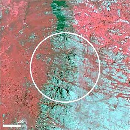
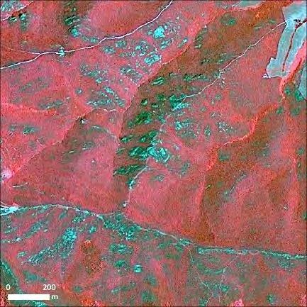
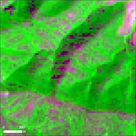
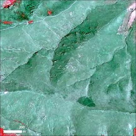
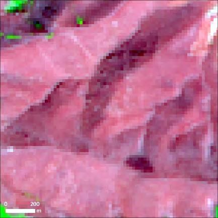
7 Sentinel-2A (24/07/2016) Sentinel-2A (13/08/2016) Sentinel-2A-NBR (24/07/2016) Sentinel-2A-NBR (13/08/2016) 7
8 dnbr derived from Sentinel-2A acquired the 24/07/2016 and the 13/08/2016 Figure 3: Optimal pre and post Sentinel 2 band combinations, resulting pre and post NBR s and resulting dnbr to help in digitising the fire affected areas. d) Classify with the predetermined classes by US Forest Service The dnbr was calculated and classified according to the US Forest Service classification illustrated in the table 1 below and figure 4. Table 1: US Forest Service dnbr fire severity classification dnbr Fire severity <= 0.1 Unburned 0.1 to 0.27 Severity low 0.27 to 0.44 Severity low to moderate 0.44 to 0.66 Severity moderate to high > 0.66 High severity 8
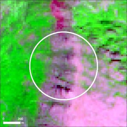
.")

9 dnbr before classification dnbr after classification Figure 4: Deriving a dnbr based fire severity index e) Clip the Severity result by the fire extent. Either the images are pre-clipped or clipped after dnbr calculation (Fig. 4). The authors of this IWG-SEM guide recommend reducing the number of fire severity classes in order to simplify the product, corresponding to this rapid mapping production environment. The unburnt class has been removed and the low to moderate and moderate to high classes are grouped into a Damaged class. The removal of the unburnt class indicates that when doing the fire extent product only burnt areas should be mapped. To help understand the relationship between the dnbr classes and the proposed IWG-SEM classes, they are illustrated below in figure 5. dnbr Fire severity <= 0.1 Unburned 0.1 to 0.27 Severity low 0.27 to 0.44 Severity low to moderate 0.44 to 0.66 Severity moderate to high > 0.66 High severity EMS classes Unburned Possibly damaged Damaged (low to moderate and moderate to high) Destroyed Figure 5: Comparison between dnbr and EMS severity classes 9
10 3.2 Procedure without SWIR channels The aim of this exercise was to propose, if possible, a method that involved less subjectivity in presenting a fire severity map using indices and thresholds in images not containing a Short Wave Infrared (SWIR) band. The class grouping is specific to Copernicus EMS Rapid Mapping and can of course be adapted to circumstances. The testing of NDVI s and difference NDVI s (dndvi) are analysed and illustrated below. A test was carried out on a wild fire affected area dealt with during the EMSR-221and EMSR-252 over Corsica: The activation s delineation vector was used to delimit the area to be analysed. Furthermore, to complement the fire severity analysis, enabling a comparison between non-swir/swir data, Sentinel- 2 imagery were sourced that cover the area close to the events (table 2). The operator validated fire severity results derived from the Sentinel-2 data are considered to be the layer of reference. Table 2: List of satellite data used for the EMSR-221 and EMSR-252 Corsica test Activation Sensor Date Resolution Sentinel /10/ m EMSR 252 Sentinel /10/ m SPOT6/7 24/10/ m Sentinel /10/ m EMSR221 Sentinel /10/ m SPOT6/7 30/05/ m SPOT6/7 15/08/ m The results of the image processing and classification, which as displayed in figures 5 & 6, indicate that the simple use of the post fire NDVI has the worst results with large shadowed areas being classed as badly affected contrary to the classic post image classification and the dnbr results. Otherwise, the dndvi results look promising when compared to the dnbr results. Moreover, the dndvi seems to be a good alternative helping to detect if vegetation is still photosynthetic in shadowy areas. Furthermore, the correlation of the dndvi and the dnbr has been noted through scatterplots that show that they are someway related. Hence, dndvi is a good way of calculating fire severity and could be used in a fire severity classification procedure when no SWIR is available. 10
 High severity Low severity")
 High severity Low severity Figure 6: Results of different fire severity")

11 Methodology TEST over EMSR 221 Corsica Classic EMS based on post event VHR image using supervised classification High severity Low severity Classification based on pre and post-event Sentinel-2 NBR data (dnbr) High severity Low severity Classification based on SPOT 6/7 NDVIs differences (NDVI pre-ndvi post) High severity Low severity Classification based on S2 NDVIs differences (NDVI pre-ndvi post) High severity Low severity Figure 6: Results of different fire severity methodologies applied to the EMSR 221 Corsica fire delineation area. Furthermore, comparison of dndvi values obtained from Sentinel-2 and Spot-6 dndvi in the burn scar shows a high similarity which for rapid mapping purposes they can be used in combination (Fig. 7). The 11
12 three classes correspond to dnbr derived nomenclatures and classes used in Copernicus EMS Rapid Mapping and their dndvi correspondences are described in table % dndvi values Sentinel-2 SPOT 6/7 Possibly damaged Damaged Destroyed Figure 7: Results of fire severity dndvi methodology applied to the EMSR 221 Corsica fire delineation area. The two middle classes are regrouped afterwards Table 3: Fire severity class description and corresponding dndvi values which work for Sentinel-2 and SPOT 6/7 dndvi calculation (values can be adjusted depending the images used) dndvi per fire severity class Class description Colour dndvi <= 0.3 Possibly damaged 0.3 > dndvi <=0.55 Damaged dndvi >0.55 Destroyed 12
13 4. Interpretation guide to fire severity classification To help in understanding the fire severity classification on the following page image extracts of fire affected landscapes are arranged according to fire severity levels: - Pre-fire imagery, both with and without SWIR - Post-fire imagery, both with and without SWIR - dndvi and dnbr indices which indicate fire severity 13


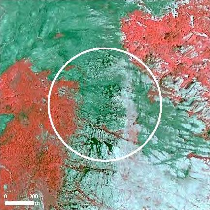
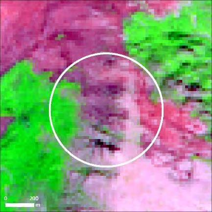
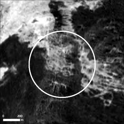
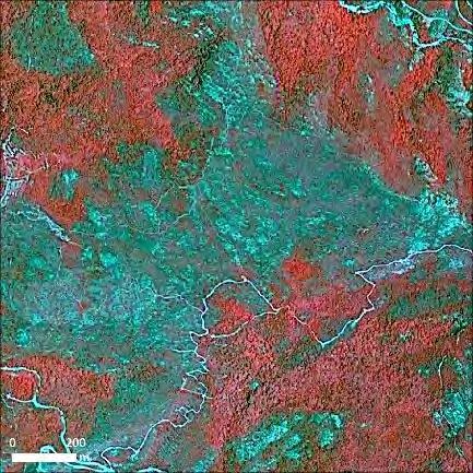
14 Class Pre-Fire Post-Fire Fire severity indices Spot 6/7 (r: 4 g:3 b:2) Sentinel-2 (r:12 g:8 b:4) Spot 6/7 (r: 4 g:3 b:2) Sentinel-2 (r:12 g:8 b:4) Spot 6/7 dndvi Sentinel-2 dnbr Unburned Possibly damaged Damaged Destroyed 14
15 5. Acknowledgements The IWG-SEM Chair and Members would like to acknowledge the following members for their contribution to this IWG-SEM Guidelines Building Damage Assessment Chapter: Fire mapping Lead: ICube-SERTIT, University of Strasbourg ( Contributors: European Commission, Directorate-General Joint Research Centre, Disaster Risk Management Unit ( e-geos, an ASI/TELESPAZIO Company ( GAF AG, an e-geos (ASI/TELESPAZIO) Company ( ITHACA - Information Technology for Humanitarian Assistance, Cooperation and Action ( Any further contributions or comments should be addressed to the IWG-SEM Chair at: members@iwg-sem.org EMERGENCY MAPPING GUIDELINES v1.0 (published) Working Paper
NEAR REAL TIME DETECTION OF BURNED SCAR AREA USING LANDSAT-8 IMAGERIES
 NEAR REAL TIME DETECTION OF BURNED SCAR AREA USING LANDSAT-8 IMAGERIES Danang Surya Candra Kustiyo - Indonesian National Institute of Aeronautics and Space (LAPAN) - Outline INTRODUCTION: Background, Problems,
CROWD-SOURCED REMOTE ASSESSMENTS OF REGIONAL-SCALE POST-DISASTER DAMAGE
 Eleventh U.S. National Conference on Earthquake Engineering Integrating Science, Engineering & Policy June 25-29, 2018 Los Angeles, California CROWD-SOURCED REMOTE ASSESSMENTS OF REGIONAL-SCALE POST-DISASTER
Semi-automated extraction of Landscape Features from VHR satellite data
 Semi-automated extraction of Landscape Features from VHR satellite data Lukas Brodsky, Katerina Jupova, Lubos Kucera GISAT www.gisat.cz lukas.brodsky@gisat.cz Goals and motivations Landscape Features:
Monitoring Weed Growth in Forest Stands using QuickBird Imagery
 Monitoring Weed Growth in Forest Stands using QuickBird Imagery Mark Norris-Rogers; Fethi Ahmed*; Pol Coppin**; Jan van Aardt** (*University of KwaZulu-Natal; **Katholiek Universiteit Leuven) Outline Introduction
Maurice Borgeaud. Directorate of Earth Observation Programmes. Head of Science, Applications and Futures Technologies Department
 Maurice Borgeaud Directorate of Earth Observation Programmes Head of Science, Applications and Futures Technologies Department ESRIN ESA s Earth Observation HQ Personnel on site: ~ 550 Payload operations
DETECTION AND MONITORING OF ACTIVE FIRES USING REMOTE SENSING TECHNIQUES
 DETECTION AND MONITORING OF ACTIVE FIRES USING REMOTE SENSING TECHNIQUES Source: Unknown n.d., http://www.hotrodsandclassics.net/featuredpictures/featurepictures2.htm. by Claire Riddell DETECTION AND MONITORING
A CASE STUDY OF LANDSCAPE ANALYSIS WITH HIGH-RESOLUTION SATELLITE IMAGERY IN OLEIROS (A CORUÑA, SPAIN)
") A CASE STUDY OF LANDSCAPE ANALYSIS WITH HIGH-RESOLUTION SATELLITE IMAGERY IN OLEIROS (A CORUÑA, SPAIN) Gil Docampo, Mª Luz a ; Corbelle Rico, Eduardo b ; López Rodríguez, Andrés c a, b, c Departamento
A CASE STUDY OF LANDSCAPE ANALYSIS WITH HIGH-RESOLUTION SATELLITE IMAGERY IN OLEIROS (A CORUÑA, SPAIN) Gil Docampo, Mª Luz a ; Corbelle Rico, Eduardo b ; López Rodríguez, Andrés c a, b, c Departamento
Long-term Inventory of Fire Burned Areas and Emissions of North America s Boreal and Temperate Forests
 Long-term Inventory of Fire Burned Areas and Emissions of North America s Boreal and Temperate Forests P.Gong, Z. Li, I. Csiszar, W. Hao, R. Fraser J.Z. Jin, R. Pu Objectives 1. Map burn scars in boreal
Smart City Governance URBIS Solutions. David Ludlow, Assoc. Professor European Smart Cities University of the West of England, Bristol
 Smart City Governance URBIS Solutions David Ludlow, Assoc. Professor European Smart Cities University of the West of England, Bristol Integrated smart city model Smart Mobility Services focused on decreasing
1.1. SYSTEM MODELING
 1 INTRODUCTION Electro-optical imaging system analysis is a mathematical construct that provides an optimum design through appropriate trade studies. A comprehensive model includes the target, background,
LANDMAP Methodology Overview
 LANDMAP Methodology Overview June 2017 Jill Bullen, Senior Landscape Specialist jill.bullen@cyfoethnaturiolcymru.gov.uk 0300 065 4706 (Please note this is an information document and not a training presentation)
Physical concepts. Remote sensing of fires and vegetation. Applications of SEVIRI channels.
 Physical concepts Remote sensing of fires and vegetation Applications of SEVIRI channels jose.prieto@eumetsat.int Contents Applications of SEVIRI channels Characteristics of the 3.9µm channel Differences
Band Selection & Algorithm Development for Remote Sensing of Wildland Fires
 Band Selection & Algorithm Development for Remote Sensing of Wildland Fires Andy Fordham Chester F. Carlson Center for Imaging Science Rochester Institute of Technology Rochester, New York 14623-5604 ajf8207@cis
ONDULUS IR SIMULATION MATERIALIZE. CUSTOMIZE. SIMULATE
 SIMULATION ONDULUS IR MATERIALIZE. CUSTOMIZE. SIMULATE Ondulus IR gives simulations and training scenarios a critical component: physics-based infrared sensors. By adding real-time, high-quality materials-based
FIRE DETECTION AND MONITORING USING AVHRRA AND MSG SYSTEMS. Version Tuesday, 1.0, 1530 November Slide: 1
 FIRE DETECTION AND MONITORING USING AVHRRA AND MSG SYSTEMS Version Tuesday, 1.0, 1530 November 2005 2004 Slide: 1 Botswana early warning system Version Tuesday, 1.0, 1530 November 2005 2004 Slide: 2 Objectives
Using Remote sensing technique for estimation of real evapotranspiration
 Using Remote sensing technique for estimation of real evapotranspiration Hassan Fathizad, Bijan Azad, Ali Yousefi, Azin jafarian Abstract Evapotranspiration is not easy to measure; Specific devices and
SUSTAINABLE CONSERVATION SYSTEMS FOR PRESERVATION OF MONUMENTS, SITES IN THEIR SETTINGS
 SUSTAINABLE CONSERVATION SYSTEMS FOR PRESERVATION OF MONUMENTS, SITES IN THEIR SETTINGS Staneva Hristina / Bulgarian National Correspondent of the HEREIN Project Associated member of the ICVA This paper
DEMONSTRATION OF A SEMI-OPERATIONAL FIRE RECOGNITION SERVICE USING BIRD MICRO- SATELLITE - DEMOBIRD
 DEMONSTRATION OF A SEMI-OPERATIONAL FIRE RECOGNITION SERVICE USING BIRD MICRO- SATELLITE - DEMOBIRD Jesús Gonzalo, Gonzalo Martín de Mercado Ingeniería y Servicios Aeroespaciales, S.A. (INSA), Spain Paseo
THE LANDSCAPE ECOLOGICAL ASSESSMENT MODEL AND ITS APPLICATIONS
 The 5 th International Conference of the International Forum on Urbanism (IFoU) 2011 National University of Singapore, Department of Architecture Global Visions: Risks and Opportunities for the Urban Planet
Tools for Evaluating and Monitoring the Effectiveness of Urban Landscape Water Conservation Interventions and Programs
 Tools for Evaluating and Monitoring the Effectiveness of Urban Landscape Water Conservation Interventions and Programs Diana T. Glenn with Joanna Endter-Wada Roger Kjelgren IMS - AWWA ANNUAL CONFERENCE
Chapter 1 Introduction
 Chapter 1 Introduction This chapter presents an introductory background to the research work undertaken, the problem statement, research issues involved and objectives of the research work. The contribution
Fire Detection and Monitoring
 Fire Detection and Monitoring Akli Benali Forest Research Center, University of Lisbon aklibenali@gmail.com Conference & Summer School on Forest Fire Management Istituto Superiore Antincendi, Rome, September
Strategic Research Agenda for. High-Altitude Aircraft and Airship. Remote Sensing Applications
 Strategic Research Agenda for USE HAAS High-Altitude Aircraft and Airship Remote Sensing Applications Christian Barbier (CSL, B), Bavo Delauré (VITO, B), Arie Lavie (CTI, Is) 1 OUTLINE 1. The USE HAAS
Hybrid Classification Pervious vs. Impervious Surfaces
 Project Summary Hybrid Classification Pervious vs. Impervious Surfaces Morgan Neal A hybrid classification approach (i.e., use of supervised and unsupervised classification methods) in ArcGIS 10 was used
OPPORTUNITIES OF LOCAL PLANNING OF STREET GREENERY IN ECOPHYSIOGRAPHIC STUDIES AND STUDIES OF CONDITIONS AND DIRECTIONS OF SPATIAL MANAGEMENT 1
 Opportunities of local planning of street greenery in ecophysiographic studies... Człowiek i Środowisko 39 (3) 2015, p. 75-96 Leszek Sobczyński OPPORTUNITIES OF LOCAL PLANNING OF STREET GREENERY IN ECOPHYSIOGRAPHIC
1 Introduction - The rating level. 3 Subjective or objective analysis? 2 Determination of the adjustment for annoying tones
 Noise can be said to be tonal if it contains a distinguishable, discrete, continuous note. This may include a whine, hiss, screech, hum, etc., and any such subjective finding is open to discussion when
APEN GROUP SPA is a leading manufacturer of heating systems, who is active both in national and international ambits.
 APEN GROUP SPA is a leading manufacturer of heating systems, who is active both in national and international ambits. Our Vision We consider caring for the environment (environment, persons, relationships,
Recent Developments and Prospects for Innovative Remote Sensing of High-Temperature Events and Vegetation Fire Impacts
 Recent Developments and Prospects for Innovative Remote Sensing of High-Temperature Events and Vegetation Fire Impacts by D. Oertel, E. Lorenz, B. Zhukov German Aerospace Center, (DLR-OS) Berlin Adlershof
Earth Observation & GeoSpatialBig Data for Monitoring SDG Indicators
 Earth Observation & GeoSpatialBig Data for Monitoring SDG Indicators Yifang Ban, Professor Director, Division of Geoinformatics Vice Chair, Department for Urban Planning and Environment KTH Royal Institute
SEVIRI/MSG sensor early fire detection performances assessment
 SEVIRI/MSG sensor early fire detection performances assessment G. Laneve, E. Cadau CRPSM Università di Roma La Sapienza e-mail: laneve@psm.uniroma1.it 2 nd GOFC/GOLD Workshop on GEO Fire Monitoring, Darmstadt,
PARALLEL USE OF SEVIRI LSA SAF FRP AND MPEF FIR PRODUCTS FOR FIRE DETECTION AND MONITORING
 PARALLEL USE OF SEVIRI LSA SAF FRP AND MPEF FIR PRODUCTS FOR FIRE DETECTION AND MONITORING C. G. Georgiev, J. S. Stoyanova National Institute of Meteorology and Hydrology, Bulgarian Academy of Sciences
ANALYSIS AND EVALUATION OF NATURE SPACE POTENTIAL IN PERI-URBAN SPACES USING REMOTE SENSING DATA AND GIS
 ANALYSIS AND EVALUATION OF NATURE SPACE POTENTIAL IN PERI-URBAN SPACES USING REMOTE SENSING DATA AND GIS Ellen BANZHAF UFZ-Centre for Environmental Research Leipzig-Halle, Permoserstr. 15, D-04318 Leipzig
Standardization of Remote Sensing Technology. Yuan-Yuan Jia. Academy of Opto-Electronics (AOE), CAS
, CAS") WGCV-36 Shanghai, China May 13-17, 2013 Standardization of Remote Sensing Technology Yuan-Yuan Jia 1 Academy of Opto-Electronics (AOE), CAS 2 Secretariat of National Technical Committee 327 on RS of Standardization
WGCV-36 Shanghai, China May 13-17, 2013 Standardization of Remote Sensing Technology Yuan-Yuan Jia 1 Academy of Opto-Electronics (AOE), CAS 2 Secretariat of National Technical Committee 327 on RS of Standardization
GIS to Estimate Archaeological Site Loss and Develop Conservation Strategies
 GIS to Estimate Archaeological Site Loss and Develop Conservation Strategies Terry Jackson Office of Decision Support Systems Planning and Environmental Management Division Georgia Department of Community
There are various resources and toolkits available to perform this task.
 Hands-On Exercise: Wildfires in Chile, January 2017 Task description Imagine you are analyst that has been assigned to the fire Las Maquinas burning in the vicinity of Constitución, in the Maule region
Study on paddy rice planting area and yield monitoring
 Study on paddy rice planting area and yield monitoring based on MODIS A case study of the Jianghan Plain Xin Mei 1,2, Hai Liu 3,1,2,* (1 Key Laboratory of Resources Remote Sensing and Digital Agriculture,
RESEARCH HIGHLIGHT. Technical Series Urban Heat Island Mitigation Measures and Regulations in Montréal and Toronto
 RESEARCH HIGHLIGHT May 2014 Technical Series 14-100 Urban Heat Island Mitigation Measures and Regulations in Montréal and Toronto INTRODUCTION The Heat Island Research Group of the Department of Geography
Particle Tracking Analysis for particle counting
 Particle Tracking Analysis for particle counting Dr Chairman of ISO TC229 (Nanotechnologies) Director of BREC Solutions ltd RSC Workshop (London,. UK) 24 April 2018 1 Introducing myself Expert duties Chair
Construction Products Directive
 Construction Products Directive Evaluation of conformity of Coated glass to he N 1096-4 ( September 2006) G E P V P, T H E E U R O P E A N A S S O C I AT I O N O F F L AT G L A S S M A N U FA C T U R E
Submitted to Northern Coalfields Limited. Singrauli Coalfield 2015
 Land Restoration / Reclamation Monitoring of more than 5 million cu. m (Coal+OB) Capacity Open Cast Coal Mines of Northern Coalfields Limited based on Satellite Data for the Year 2015 Singrauli Coalfield
2017 CTS and other technical guidance updates
 The European Commission s science and knowledge service Joint Research Centre 2017 CTS and other technical guidance updates 2017 IACS workshop 29-31 May 2017 Ghent - Belgium Philippe LOUDJANI DG JRC D5
Directorate of the National Archive of Monuments
 Directorate of the National Archive of Monuments MINISTRY OF CULTURE NATIONAL ARCHIVE OF MONUMENTS Profile The Directorate of the National Archive of Monuments (DEAM) is a division of the General Directorate
Automated Fire and Flood Hazard Protection System
 De la Riva, J., Pérez-Cabello, F. & Chuvieco, E. (Eds) 2005 Proceedings of the 5 th International Workshop on Remote Sensing and GIS Applications to Forest Fire Management: Fire Effects Assessment: 167-172
INTERNATIONAL STANDARD
 INTERNATIONAL STANDARD IEC 61508-2 First edition 2000-05 BASIC SAFETY PUBLICATION Functional safety of electrical/electronic/ programmable electronic safety-related systems Part 2: Requirements for electrical/electronic/
Digital soil mapping from legacy data and hyperspectral imagery in CapBon (Tunisia) First results and perspectives.
 First results and perspectives.") Digital soil mapping from legacy data and hyperspectral imagery in CapBon (Tunisia) First results and perspectives. Philippe Lagacherie 1, Cécile Gomez 2, Sinan Bacha 4, Rossano Ciampalini 2, Hedi Hamrouni
Digital soil mapping from legacy data and hyperspectral imagery in CapBon (Tunisia) First results and perspectives. Philippe Lagacherie 1, Cécile Gomez 2, Sinan Bacha 4, Rossano Ciampalini 2, Hedi Hamrouni
Water Resources and Policy Initiatives CSU Campus Water Use Calculations Standard Operating Procedures February 26, 2016
 Water Resources and Policy Initiatives CSU Campus Water Use Calculations Standard Operating Procedures February 26, 2016 Project Background California State University (CSU) campuses face a challenge in
Green Cities: An A-to-Z Guide
 Green Cities: An A-to-Z Guide Heat Island Effect Contributors: Nevin Cohen & Paul Robbins Print Pub. Date: 2011 Online Pub. Date: May 04, 2010 Print ISBN: 9781412996822 Online ISBN: 9781412973816 DOI:
The development of seat fire testing for EN Richard Nowell
 The development of seat fire 2017 Introduction Introduction This presentation will examine the development of a new standard for complete seat fire testing that will plug into EN 45545-2 to replace Annexes
My name is Zack Holden, co-instructor for this course. Many people associate severe fire with catastrophic, stand-destroying forest fires.
 My name is Zack Holden, co-instructor for this course. Many people associate severe fire with catastrophic, stand-destroying forest fires. But fire can have profound effects on soils and the below ground
INTERNATIONAL TELECOMMUNICATION UNION SERIES L: CONSTRUCTION, INSTALLATION AND PROTECTION OF CABLES AND OTHER ELEMENTS OF OUTSIDE PLANT
 INTERNATIONAL TELECOMMUNICATION UNION ITU-T L.36 TELECOMMUNICATION STANDARDIZATION SECTOR OF ITU (10/98) SERIES L: CONSTRUCTION, INSTALLATION AND PROTECTION OF CABLES AND OTHER ELEMENTS OF OUTSIDE PLANT
Mandate M/118 WASTE WATER ENGINEERING PRODUCTS
 Mandate M/118 Page 1 sur 13 Mandate M/118 TO CEN/CENELEC CONCERNING THE EXECUTION OF STANDARDISATION WORK FOR HARMONIZED STANDARDS ON CReatE RELATED TO THE FOLLOWING END USES 18/33 : DRAINAGE (INC. HIGHWAS)
The assessment of exploitation process of power for access control system
 The assessment of exploitation process of power for access control system Michał Wiśnios,*, and Jacek Paś Military University of Technology, Faculty of Electronic, Institute of Electronic Systems, -98
Lecture: Landscape Ecology
 Borderland: Border Landscapes Across Europe 2013 Lecture: Landscape Ecology Dr Iwona Markuszewska Department of Landscape Ecology iwmark@amu.edu.pl Presentation schedule: Landscape ecology as a scientific
Evaluating Chicago s Urban Heat Island Policy with Remote Sensing. Chris Mackey
 Evaluating Chicago s Urban Heat Island Policy with Remote Sensing Chris Mackey The Heat Island Effect When a large urban area is a few degrees warmer than its surrounding rural area. Composed from LANDSAT
RE-ORIENTATION OF THE FUEGOSAT CONSOLIDATION PROGRAMME
 RE-ORIENTATION OF THE FUEGOSAT CONSOLIDATION PROGRAMME DESIRE Workshop (1 st & 2nd October 2008 RMS, Brussels) Amanda Regan Earth Observation Future European Space Agency 1 Fuegosat Consolidation The Fuegosat
remote sensing ISSN
 Remote Sens. 2015, 7, 4473-4498; doi:10.3390/rs70404473 Article OPEN ACCESS remote sensing ISSN 2072-4292 www.mdpi.com/journal/remotesensing Forest Fire Smoke Detection Using Back-Propagation Neural Network
T2SL technology for Mid-IR detectors
 T2SL technology for Mid-IR detectors Linda Höglund Minerva Workshop June, 30 th 1 Outline Introduction Tasks in MINERVA Starting point: MW detectors 320 256 on 30 µm pitch Technologies developed in MINERVA
The European Landscape Convention Florence, 20 October 2000
 The European Landscape Convention Florence, 20 October 2000 Maguelonne DEJEANT-PONS Spatial Planning and Landscape Division Council of Europe Introduction «The landscape...... has an important public interest
ISO/TC 211 GEOGRAPHIC INFORMATION AND GEOMATICS A FRAMEWORK AND REFERENCE MODEL
 ISO/TC 211 GEOGRAPHIC INFORMATION AND GEOMATICS A FRAMEWORK AND REFERENCE MODEL Kian FADAIE Canada Centre for Remote Sensing Natural Resources Canada Fadaie@nrcan.gc.ca Paper number 1734 KEY WORDS: ISO/TC211,
The Research and Prospect of Science of Human Settlements. Shi Yuxue Shanghai Science Institute of Human Settlements
 The Research and Prospect of Science of Human Settlements Shi Yuxue Shanghai Science Institute of Human Settlements Preface A. Scientific research can not do without public participation B. The application
Rapid Prototyping of NASA Next Generation Sensors for the SERVIR System of Fire Detection in Mesoamerica
 Rapid Prototyping of NASA Next Generation Sensors for the SERVIR System of Fire Detection in Mesoamerica Joel S. Kuszmaul, Henrique Momm, Greg Easson University of Mississippi, University, MS 38677 Timothy
GOFC/GOLD Fire IT Strategic Planning. Day 1 - Break Out Group Discussion
 GOFC/GOLD Fire IT Strategic Planning Day 1 - Break Out Group Discussion Aims of the Fire IT refining and articulating the international requirements for fire related observations making the best possible
The Initiative Landscape Character Assessment as a tool for the Conservation of Natural Values in the Eastern Mediterranean
 The Initiative Landscape Character Assessment as a tool for the Conservation of Natural Values in the Eastern Mediterranean Sixteenth Council of Europe Meeting of the Workshops for the Implementation of
A temporal active fire detection algorithm applied to geostationary satellite observations
 8 th 10 th June LSA-SAF Workshop 2015 A temporal active fire detection algorithm applied to geostationary satellite observations Gareth Roberts (University of Southampton) Outline Active fire detection
Verification and Validation of OOV-TET1 Multispectral Camera Observations within the FireBIRD Project
 DLR.de Chart 1 Verification and Validation of OOV-TET1 Multispectral Camera Observations within the FireBIRD Project O. Frauenberger **, A. Börner *, E. Borg **, W Halle *, E. Lorenz *, S. Mitchell *,
Case Studies of Master Planning for Sustainable Urban Underground Space Utilization
 Case Studies of Master Planning for Sustainable Urban Underground Space Utilization Zhu Wenjun 1, Wang Hui 1, Li Chuanbin 2, Wei Lijun 3 1 Department of Civil Engineering, Tsinghua University, Beijing,
Sentinel Asia Wildfire Monitoring
 Sentinel Asia Wildfire Monitoring Masami FUKUDA Institute of Low Temp. Sci. Hokkaido Univ. 3rd Sentinel Asia JPT Meeting 13 March 2007, Singapore Objective of Sentinel Asia Wildfire Monitoring Contribution
Radar technology in surveillance
 White paper Radar technology in surveillance November 2018 Summary Using radar technology for detection can reduce the number of false alarms and increase detection efficiency in conditions with poor visibility.
Consolidated Workshop Proceedings Report
 United Nations International Strategy for Disaster Reduction Regional Office for Arab States THE WORLD BANK Syrian Ministry of Local Administration Consolidated Workshop Proceedings Report Regional Workshop
Position of ECOS, EEB, Friends of the Earth Europe, WWF EPO and INFORSE Europe
 Brussels, September 2010 Position of ECOS, EEB, Friends of the Earth Europe, WWF EPO and INFORSE Europe on the Working document on the Ecodesign & Energy Labelling of Water heaters & Hot water tanks of
Dynamic Lights Towards Dynamic, Intelligent and Energy Efficient Urban Lighting
 Newsletter Edition 02 July 2017 Dynamic Lights Towards Dynamic, Intelligent and Energy Efficient Urban Lighting THE 8 PILOT PROJECTS The main focus of the Dynamic Light project is on how to improve quality
CITY CLERK. Parkland Acquisition Strategic Directions Report (All Wards)
") CITY CLERK Clause embodied in Report No. 10 of the, as adopted by the Council of the City of Toronto at its meeting held on November 6, 7 and 8, 2001. 10 Parkland Acquisition Strategic Directions Report
CITY CLERK Clause embodied in Report No. 10 of the, as adopted by the Council of the City of Toronto at its meeting held on November 6, 7 and 8, 2001. 10 Parkland Acquisition Strategic Directions Report
INFLUENCE OF SOLAR RADIATION AND VENTILATION CONDITIONS ON HEAT BALANCE AND THERMAL COMFORT CONDITIONS IN LIVING-ROOMS
 INFLUENCE OF SOLAR RADIATION AND VENTILATION CONDITIONS ON HEAT BALANCE AND THERMAL COMFORT CONDITIONS IN LIVING-ROOMS Staņislavs GENDELIS, Andris JAKOVIČS Laboratory for mathematical modelling of environmental
ICSV14. Cairns Australia 9-12 July, Noise reduction of handheld vacuum cleaners according to geometric optimization of air passages
 ICSV14 Cairns Australia 9-12 July, 2007 Noise reduction of handheld vacuum cleaners according to geometric optimization of air passages M.J. Mahjoob and H.Ashrafi Noise, Vibration, Acoustics (NVA) research
The Arboretum s Labels:
 The Arboretum s Labels: A Valuable Teaching Aid The living collections of the Arnold Arboretum are used by visitors for diverse purposes which range from sheer enjoyment to serious study. An understanding
Use of new spatially refined satellite remote sensing fire detection data in support of advanced wildfire mapping and modeling
 Use of new spatially refined satellite remote sensing fire detection data in support of advanced wildfire mapping and modeling Dr. Wilfrid Schroeder 1 Dr. Janice Coen 2 Dr. Patricia Oliva 1 Dr. Louis Giglio
Development of Open BIM-based Code Checking Modules for the Regulations of the Fire and Evacuation
 Development of Open BIM-based Code Checking Modules for the Regulations of the Fire and Evacuation Jungsik Choi 34, Junho Choi 35, Geunha Cho 36 and Inhan Kim 37 34 buildingsmart Korea 35,36,37 Kyung Hee
GOES-R AWG Land Team: Fire Detection and Characterization
 GOES-R AWG Land Team: Fire Detection and Characterization June 8, 2010 Presented By: Christopher C. Schmidt 1 1 UW-Madison/SSEC/CIMSS 1 FIRE Product Team AWG Land Team Chair: Yunyue (Bob) Yu FIRE Product
ARCHITECTURAL ANALYSIS
 ARCHITECTURAL ANALYSIS YR12 GRAPHICS WHANGAREI GIRLS HIGH SCHOOL INFORMATION TO HELP WITH DESIGN PROCESS, NOTATIONS, & DESIGN HISTORY ARCHITECTURAL ANALYSIS When we analyse a building, we begin by scanning
UBC Social Ecological Economic Development Studies (SEEDS) Sustainability Program. Student Research Report
 Sustainability Program. Student Research Report") UBC Social Ecological Economic Development Studies (SEEDS) Sustainability Program Student Research Report UBC Botanical Gardens Mapping Manual Amanda Leslie, Emma Cunningham, Gary Pinneo, Lauren Tekano,
UBC Social Ecological Economic Development Studies (SEEDS) Sustainability Program Student Research Report UBC Botanical Gardens Mapping Manual Amanda Leslie, Emma Cunningham, Gary Pinneo, Lauren Tekano,
Integrating fire-spread and household-level trigger modeling to stage wildfire evacuation warnings
 Integrating fire-spread and household-level trigger modeling to stage wildfire evacuation warnings Dapeng. Li 1, Thomas. J. Cova 1, Philip. E. Dennison 1 1 Department of Geography, University of Utah,
National Research Infrastructure Roadmapping in Europe
 www.inroad.eu info@inroad.eu @InRoadproject @InRoad_Project National Research Infrastructure Roadmapping in Europe Drivers and Trends InRoad Isabel Bolliger University of Lausanne Swiss Graduate Institute
01.02 Impervious Soil Coverage (Sealing of Soil Surface) (Edition 2007)
 (Edition 2007)") Senate Department for Urban Development 01.02 Impervious Soil Coverage (Sealing of Soil Surface) (Edition 2007) Overview Data on impervious soil coverage are regularly used in the offices of the Berlin
Senate Department for Urban Development 01.02 Impervious Soil Coverage (Sealing of Soil Surface) (Edition 2007) Overview Data on impervious soil coverage are regularly used in the offices of the Berlin
01.02 Impervious Soil Coverage (Sealing of Soil Surface) (Edition 2012)
 (Edition 2012)") Senate Department for Urban Development and the Environment 01.02 Impervious Soil Coverage (Sealing of Soil Surface) (Edition 2012) Overview Data on impervious soil coverage are regularly used in the offices
Senate Department for Urban Development and the Environment 01.02 Impervious Soil Coverage (Sealing of Soil Surface) (Edition 2012) Overview Data on impervious soil coverage are regularly used in the offices
Fire Detection Using Image Processing
 Fire Detection Using Image Processing Ku. R.A.Agrawal ME Student Department of CSE Babasaheb Naik college of Engineering Pusad, India rachanaagrawal90@gmail.com Prof. S.T.Khandare Associate professor Department
IMAGE PROCESSING BASED FIRE DETECTION ANDALERT SYSTEM
 IMAGE PROCESSING BASED FIRE DETECTION ANDALERT SYSTEM Pranali Bedase, Mansi Chaudhari, Dnyaneshwari Patil, S.M.Kulkarni Department Of Electronics and Telecommunication, MAEER s MIT College of Engineering,
American National Standard
 American National Standard Approved : 06/19/2014 Secretariat: National Electrical Manufacturers Association for Electric Lamps Assigned LED Lamp Codes ANSI C78.50-2014 An American National Standard implies
Clarification Proposal Annex 1, PDA: A Global. Cleanroom and. Association. Clean Air Devices. Hasim Solmaz Lighthouse Worldwide Solutions
 Clarification Proposal Annex 1, PDA: A Global Cleanroom and Association Clean Air Devices Hasim Solmaz Lighthouse Worldwide Solutions Agenda GMP Annex 1 Definitions Cleanroom and Clean Air Device Classification
Presentation to Planning Committee, DMM
 District Municipality of Muskoka Muskoka Official Plan Review Background Study: Natural Heritage Review of Urban Centres and Species At Risk Dale Leadbeater 1 September 2011 Presentation to Planning Committee,
ANALYSIS OF OTDR MEASUREMENT DATA WITH WAVELET TRANSFORM. Hüseyin ACAR *
 ANALYSIS OF OTDR MEASUREMENT DATA WITH WAVELET TRANSFORM Hüseyin ACAR * Department of Electrical and Electronics Engineering, Faculty of Engineering, Dicle University * hacar@dicle.edu.tr ABSTRACT: In
The FireBird mission - a scientific mission for Earth observation and hot spot detection
 The FireBird mission - a scientific mission for Earth observation and hot spot detection Terzibaschian, Thomas Reile, H., Lorenz, E. DLR, Germany 9th IAA SYMPOSIUM ON SMALL SATELLITES FOR EARTH OBSERVATION,
Chapter XV Maps. The map is not the territory ~Alfred Korzybski
 Chapter XV Maps The map is not the territory ~Alfred Korzybski Chapter XV Maps 15.1 DISCLAIMER These maps are intended for use with the Tamworth Master Plan. The information presented is to be used for
Final Business Plan for a CEN Workshop on
 1/6 Final for a CEN Workshop on Humanitarian Mine Action - Test and evaluation - Metal detectors - Part 2: Soil characterisation for metal detector and ground penetrating radar performance TABLE OF CONTENTS
Product data sheet Palas Fidas 200 S
 Product data sheet Palas Fidas 200 S Applications Regulatory environmental monitoring in measuring networks Ambient air measurement campaigns Oriented indicative measurements (spot checks) Long-term studies
Stock-Taking on Integrated Coastal Zone Management (ICZM) in the Black Sea IMPLEMENTATION AUDIT QUESTIONNAIRE 2010
 in the Black Sea IMPLEMENTATION AUDIT QUESTIONNAIRE 2010") Stock-Taking on Integrated Coastal Zone Management (ICZM) in the Black Sea IMPLEMENTATION AUDIT QUESTIONNAIRE 2010 PURPOSE The purposes of this questionnaire are: (a) to perform the policy, legal and institutional
Stock-Taking on Integrated Coastal Zone Management (ICZM) in the Black Sea IMPLEMENTATION AUDIT QUESTIONNAIRE 2010 PURPOSE The purposes of this questionnaire are: (a) to perform the policy, legal and institutional
Excellencies, Dear colleagues from other agencies and organizations, Ladies and Gentlemen,
 Address by Dr Mechtild Rossler Deputy Director of UNESCO s World Heritage Centre The UNESCO Recommendation on the Historic Urban Landscape on the occasion of the European Heritage Heads Forum Leuven, Belgium,
This document is a preview generated by EVS
 TECHNICAL REPORT RAPPORT TECHNIQUE TECHNISCHER BERICHT CEN/TR 16798-4 June 2017 ICS 91.120.10; 91.140.30 English Version Energy performance of buildings - Ventilation for buildings - Part 4: Interpretation
An Experimental Study on Variation of Shear Strength for Layered Soils
 An Experimental Study on Variation of Shear Strength for Layered Soils Mr. Hemantkumar Ronad 1 DCE, M.Tech in Geotechnical Engg. Department of Civil Engineering 1, Basaveshwar Engineering College, Bagalkot-587102.
Drought and Drought Mitigation in Europe
 Drought and Drought Mitigation in Europe J. V. Vogt and F. Somma (Eds.) Drought is one of the major natural hazards, resulting in significant economical, social, and environmental costs. In Europe water
A Cost Effective Multi-Spectral Scanner for Natural Gas Detection
 A Cost Effective Multi-Spectral Scanner for Natural Gas Detection Semi-Annual Progress Report No. 1 Reporting Period Start Date: October 1, 2003 Reporting Period End Date: March 31, 2004 Principal Authors: