Presentation to Planning Committee, DMM
|
|
|
- April Potter
- 5 years ago
- Views:
Transcription


1 District Municipality of Muskoka Muskoka Official Plan Review Background Study: Natural Heritage Review of Urban Centres and Species At Risk Dale Leadbeater 1 September 2011 Presentation to Planning Committee, DMM
 The natural environment was again identified as a key priority through the 2011 visioning")
2 The Natural Environment in Muskoka the task of planning in Muskoka k is primarily to conserve the area s natural environment and assets (Paterson Report, 1969) The natural environment was again identified as a key priority through the 2011 visioning exercise
3 Value of Natural Heritage Environmental Climate Regulation Toxin Absorption Flood Control Water Storage Water Quality Improvement Nutrient Cycling Food Chain Support Habitat, including Species at Risk Air quality Improvement Carbon Sequestration/storage Spiritual and Recreational Benefits
4 Official Plan Review To identify regionally significant natural heritage in Muskoka; and To identify how existing policy needs to be updated d or enhanced to protect t regionally significant natural heritage and to be consistent with the Provincial Policy Statement.

5 Species At Risk Planning Act Provincial Policy Statement Endangered Species Act
6 The Land Between and Species At Risk


7 Urban Centres Completion of Growth Strategy Need to identify regionally significant natural heritage within the urban centres
8 First phase of a Natural Heritage Review Two main components : a landscape level review of potential suitable habitat for Species At Risk, and a more detailed review of regionally significant natural heritage within Muskoka s urban centres.
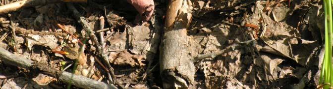
9 SAR Study Resources Technical Committee Area Planners, Ministry of Natural Resources and Ministry of Municipal Affairs and Housing staff, Representatives from Watershed Council, the Muskoka Heritage Foundation, and the Muskoka Field Naturalists. American Ginseng
10 SAR Study Resources High resolution, recent aerial photography Workshop of experts Natural Heritage Information Centre (NHIC) was consulted in order to obtain historical documentation of species occurrences in Muskoka Georgian Bay Island National Park
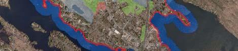
11
12
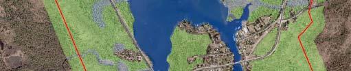
13
14 Outcome Enhanced wetland layer for DMM List of terrestrial SAR as of 2009 Probability mapping for DMM SAR
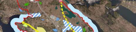
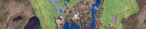
15 Urban Centres Natural Heritage Review Derived from SAR: Potentially Suitable Habitat Mapping Finer scale Ecological Classification of vegetation and accurate wetland delineation
16 Analysis Components Provincially Significant Wetlands (PSWs), Significant wildlife habitat, Non-provincially significant wetlands**, Stream and river corridors, Muskoka Heritage Areas, Potential rich and/or significant forests and Wildlife corridors. ** made possible due to high-res aerial imagery from DMM Geomatics


17 Interest of the Province in Natural Heritage Planning the diversity and connectivity of natural features in an area, and the long-term ecological function and biodiversity of natural heritage systems, should be maintained, restored or, where possible, improved, recognizing linkages between and among natural heritage features and areas, surface water features and groundwater features. (Policy 2.1.2) 2)
18 Summary of Approaches Used to Identify PPS Components Natural heritage feature 1 Significant habitat of endangered and threatened species Significant wildlife habitat Significant areas of natural and scientific interest (ANSIs) Significant wetlands Approach Habitat models based on air photo interpretation results were used to identify potentially suitable habitat (Glenside 2009; expert opinion) Habitat t models based on air photo interpretation t ti results were used to identify potentially suitable habitat for Species of Special Concern (Glenside 2009; expert opinion, existing mapping of deer wintering grounds) No ANSIs occur within urban boundaries, however existing mapping of Muskoka Heritage Areas were treated with the same level of importance All wetlands identified through air photo interpretation of enhanced resolution DMM aerial photography.
19 Criteria for Determination of Potential SAR Sites in Urban Centres Resource Landscape models Use Determined which urban centres contained potential habitat for individual species modelled in Glenside Note that some species could not be modelled because their habitat requirements are very broad and could not be focussed through this study. Published range maps Determined which h urban centres fell within ranges published on Royal Ontario Museum Species at Risk site ( NHIC and GBNP Acquired georeferenced NHIC observations in Muskoka and within 25 km of Muskoka to calibrate the landscape model. Expert opinion Development Application Reports (Environmental Impact Studies; Environmental Assessments, etc.) Met with local and provincial experts (Dec 2009) and presented other resources. Vegetation descriptions from reports were used to classify ELC layer; wildlife reports were used to verify the habitat model and calibrate the range maps.
20 List for Urban Centres Branched Bartonia ato a Bartonia paniculata ssp. paniculata Golden-winged Warbler Vermivora chrysoptera Least Bittern Peregrine Falcon Spotted Turtle Eastern Musk Turtle Five-lined Skink Eastern Foxsnake Massassauga Rattlesnake Milksnake Eastern Ribbonsnake Ixobrychus exilis Falco peregrinus anatum Clemmys guttata Sternotherus odorata Eumeces fasciatus Elaphe gloydi Sisturus catenatus Lampropeltis triangulum Thamnophis sauritus


21 Bala


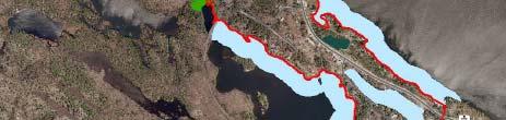
22 Bala

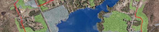
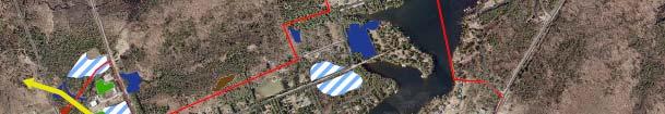
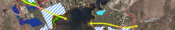
23 Baysville

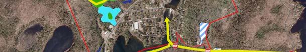
24 Baysville

25 User Guide

26 User Guide Identifies SAR potential for occurrence Describes SAR habitat Documents primary threats to SAR Recommends site specific approaches Identifies limitations it ti to data Intended to assist planners and environmental consultants


27 Three products SAR: Potentially Suitable Habitat Mapping Urban Centres Natural Heritage Review User Guide


 Update work plan")
28 Next Steps Share products with Area Municipalities Screening tools for development applications Official Plan reviews and other initiatives Review other initiatives Watershed Council District of Muskoka Province Identify any remaining information gaps (eg. updated species at risk lists) Update work plan including policy update
29 Recommendation That the Muskoka Official Plan Review Background Study: Urban Centres Natural Heritage Review and the Species At Risk: Potentially ti Suitable Habitat t Mapping reports be accepted.
Infrastructure, Development and Enterprise Services. Natural Heritage Action Plan (NHAP) Project Initiation
 Project Initiation") Staff Report To Service Area Committee of the Whole Infrastructure, Development and Enterprise Services Date Monday, March 6, 2017 Subject Natural Heritage Action Plan (NHAP) Project Initiation Report
Staff Report To Service Area Committee of the Whole Infrastructure, Development and Enterprise Services Date Monday, March 6, 2017 Subject Natural Heritage Action Plan (NHAP) Project Initiation Report
THE CORPORATION OF THE CITY OF WINDSOR Office of the City Solicitor Planning Department
 THE CORPORATION OF THE CITY OF WINDSOR Office of the City Solicitor Planning Department REPORT TO THE CITY OF WINDSOR PLANNING ADVISORY COMMITTEE DATE OF REPORT: August 19, 2010 SUBJECT: Official Plan
TRCA Field Staking Protocol December 2016
 Page 1 of 6 TRCA Field Staking Protocol December 2016 This Protocol describes TRCA staff s current practice for field staking the physical top of bank, the physical toe of slope, and the limit of existing
4. What are the goals of the Kawarthas, Naturally Connected project? 7. What are watersheds and why are they being used as the project boundaries?
 Frequently Asked Questions (FAQs) 1. What are Natural Heritage Systems (NHS)? 2. Why are they important? 3. Which areas of the province have undertaken NHS projects? 4. What are the goals of the Kawarthas,
Subject: Identification and Confirmation Procedure for Areas of Natural and Scientific Interest Compiled by Branch Ontario Parks
 Subject: Identification and Confirmation for Areas of Natural and Scientific Interest Compiled by Branch Ontario Parks Replaces Directive Title ANSI 2000 Section Planning & Research Number No. Date Issued
Sustainable Natural Environment Wetlands
 Town of Huntsville Official Plan Review - POLICY BACKGROUND PAPER Sustainable Natural Environment Wetlands BACKGROUND: Wetlands are an important natural resource. The ecological, social and economic benefits
Central Lake Ontario Conservation Conservation Lands Master Plan
 Conservation Lands Master Plan Top 13 Frequently Asked Questions 1. What are conservation lands? Where are these conservation lands located in the Central Lake Ontario Conservation watershed? Conservation
Township of Adjala-Tosorontio Official Plan Review. Natural Heritage
 Township of Adjala-Tosorontio Official Plan Review 13 Natural Heritage Introduction What is an Official Plan? An official plan is a municipal policy document which sets out the community s vision and strategies
APPENDIX I Presentations
 APPENDIX I Presentations Workshop Summary Report 11 Peel Region Official Plan Review May 5, 2010 Compatible Active Recreation Workshop July 29, 2010 Components of PROPR Sustainability Planning Tools/Updates
A Proposed Modelling and Scenariobased Approach for Identifying Natural Heritage Systems in Southern Ontario Discussion Paper
 A Proposed Modelling and Scenariobased Approach for Identifying Natural Heritage Systems in Southern Ontario Discussion Paper Ministry of Natural Resources Draft - October 2006 Executive Summary Under
TERRESTRIAL NATURAL HERITAGE SYSTEM STRATEGY APPENDIX F: MODEL POLICIES FOR THE IMPLEMENTATION OF THE TARGET TERRESTRIAL NATURAL HERITAGE SYSTEM
 TERRESTRIAL NATURAL HERITAGE SYSTEM STRATEGY APPENDIX F: MODEL POLICIES FOR THE IMPLEMENTATION OF THE TARGET TERRESTRIAL NATURAL HERITAGE SYSTEM C H A P T E R 1 M O D E L P O L I C I E S F O R I M P L
PDS June 1, 2016 Page 1. Planning and Development Committee. MEETING DATE: Wednesday, June 01, 2016
 Page 1 REPORT TO: Planning and Development Committee MEETING DATE: Wednesday, June 01, 2016 SUBJECT: ROPA 12: Project Initiation Report Regional Official Plan Amendment (ROPA # 12) Watercourse Policies
3-2 Environmental Systems
 3-2 Environmental Systems 3.0 ENVIRONMENTAL SYSTEMS CONTENTS 3.1 GREENWAY SYSTEM 3.1.1 General Policies 3.1.2 Natural Heritage Network 3.1.3 Natural Heritage Network Enhancement Lands 3.1.4 Rouge Watershed
Blue/Green Infrastructure Study Accomack County, VA
 Blue/Green Infrastructure Study Accomack County, VA Draft Asset Maps March 8-9, 2010 Green Infrastructure Center, Inc. 2 Overview What is Green and Blue Infrastructure Project Timeline & Tasks Literature
Peel Region. Greenbelt Plan Conformity. Plan Review. Background & Approach
 Peel Region Plan Review Background & Approach Greenbelt Plan Conformity November 2008 Page 2 of 13 2 COMMENT SHEET Region of Peel Greenbelt Plan Policy Review This comment sheet is to be used to provide
Great Lakes Conservation Blueprint for Terrestrial Biodiversity on the Canadian Shield
 Great Lakes Conservation Blueprint for Terrestrial Biodiversity on the Canadian Shield Bonnie L. Henson 1, Kara E. Brodribb 2 and John L. Riley 3 1 Ontario Ministry of Natural Resources 2,3 The Nature
Natural Heritage Features In Eastern Ontario
 Natural Heritage Features In Eastern Ontario Summary Report 8 July 2003 Eastern Ontario Natural Heritage Working Group Eastern Ontario Natural Heritage Working Group, July 2003 Page 1 Natural Heritage
Regional Context Statement
 Regional Context Statement REGIONAL CONTEXT STATEMENT 3. REGIONAL CONTEXT STATEMENT In 1995, the Provincial Government passed into law the Growth Strategies Act. The purpose of this provincial initiative
APPENDIX F: EXTERNAL APPROVALS
 1.0 RESPONSIBILITIES When the City is constructing the Park or Open Space Development lands (OPTION I), after the subdivision construction process is completed by the Developer, Open Space Development
An Introduction to the Far North Land Use Strategy
 An Introduction to the Far North Land Use Strategy December, 2013 Ministry of Natural Resources Table of Contents PREFACE... 3 About the Far North... 3 Evolution of Land Use Planning in the Far North...
Chairman and Members of the Planning and Development Committee. Thomas S. Mokrzycki, Commissioner of Planning and Building
 LA.09.TOR (Toronto) DATE: TO: FROM: SUBJECT: Chairman and Members of the Planning and Development Committee Thomas S. Mokrzycki, Commissioner of Planning and Building Central Waterfront Secondary Plan
Town of Peru Comprehensive Plan Executive Summary
 Town of Peru Comprehensive Plan Executive Communities that plan grow by choice, not by chance. A plan makes growth thoughtful, understandable, and predictable. A plan shows that a community is managing
APPENDIX 1. Long Range Planning and the Vision for the Future of the Town
 APPENDIX 1 Long Range Planning and the Vision for the Future of the Town Long Range Planning and the Vision for the Future of the Town Given the requirements of the Provincial Policy Statement and Growth
NEW REGIONAL OFFICIAL PLAN HIGH LEVEL PROCESS & FRAMEWORK
 NEW REGIONAL OFFICIAL PLAN HIGH LEVEL PROCESS & FRAMEWORK Why A New Official Plan Originally the role of Regionally Planning and content of Regional Official Plan (1970s) primarily focused on protecting
Planning Primer Legislative Background, Policy Documents and Development Review Processes. Presented by: Planning Services Date: April 6, 2017
 Planning Primer Legislative Background, Policy Documents and Development Review Processes Presented by: Planning Services Date: April 6, 2017 Agenda Legislative Background 7:30 to 8:00 pm Questions 8:00
APPENDIX 1: SCOPED ENVIRONMENTAL IMPACT STATEMENT (EIS) FORM
 FORM") APPENDIX 1: SCOPED ENVIRONMENTAL IMPACT STATEMENT (EIS) FORM This form is intended for use by applicants (primarily private landowners) who need to conduct a Scoped EIS in support of minor development
APPENDIX 1: SCOPED ENVIRONMENTAL IMPACT STATEMENT (EIS) FORM This form is intended for use by applicants (primarily private landowners) who need to conduct a Scoped EIS in support of minor development
Rapid Transit Implementation Working Group September 14, 2017
 Rapid Transit Implementation Working Group September 14, 2017 BACKGROUND Council approved the Rapid Transit Master Plan and Updated Business Case on July 25, 2017. Approval of the RTMP confirmed the BRT
One River Environmental Assessment. Welcome!
 One River Environmental Assessment Welcome! One River Environmental Assessment Welcome to the One River Environmental Assessment Public Information Centre. Please explore each presentation area to learn
STEWARDSHIP OF LONG ISLAND SOUND S ECOLOGICAL AND RECREATIONAL RESOURCES
 STEWARDSHIP OF LONG ISLAND SOUND S ECOLOGICAL AND RECREATIONAL RESOURCES Robin Kriesberg, Save the Sound, Inc. Thomas Halavik, US Fish and Wildlife Service Coastal Program An Initiative to Identify, Protect
Green Infrastructure Policies and Ordinances
 Green Infrastructure Policies and Ordinances October 23, 2013 By Karen Firehock, Green Infrastructure Center 2013 Georgia Urban Forest Council s 23 rd Annual Conference The mission of the nonprofit Green
CITY OF VAUGHAN EXTRACT FROM COUNCIL MEETING MINUTES OF DECEMBER 10, 2013
 Item 1, Report No. 55, of the Committee of the Whole (Working Session), which was adopted without amendment by the Council of the City of Vaughan on December 10, 2013. Regional Councillor Di Biase declared
Big Picture Protected Areas Strategy Collaborating to Protect and Conserve Nature in Ontario s Carolinian Zone
 Big Picture Protected Areas Strategy Collaborating to Protect and Conserve Nature in Ontario s Carolinian Zone Jarmo Jalava Protected Areas Consultant Carolinian Canada Coalition National Workshop October
Master Environmental Servicing Plan & Secondary Plan
 East Side Lands Stage 2 1 Master Environmental Servicing Plan & Secondary Plan Public Information Centre #1 June 16, 2016 Welcome! Today s Agenda Please sign in at the front desk. 5:30 pm 6:30 pm: Open
Green Infrastructure. by Karen Engel, NYS DEC. NYS Department of Environmental Conservation
 Green Infrastructure by Karen Engel, NYS DEC What is Green Infrastructure? For some it s all about water Green Infrastructure techniques use soils and vegetation to infiltrate, evapotranspirate, and/or
The protection of the agricultural resources of the Province;
 PART II INTRODUCTION An Official Plan is a policy document, which is intended to serve as the basis for making land use decisions and managing change in any municipality in Ontario. According to the Planning
ELIGIBILITY CRITERIA CHECKLIST OPEN SPACE CLASSIFICATION
 THURSTON COUNTY DEVELOPMENT SERVICES OPEN SPACE TAX PROGRAM ELIGIBILITY CRITERIA CHECKLIST OPEN SPACE CLASSIFICATION Use this checklist to help you determine whether your property is eligible for open
A Growing Community Rural Settlement Areas
 Town of Huntsville Official Plan Review - POLICY BACKGROUND PAPER A Growing Community Rural Settlement Areas BACKGROUND: In addition to the fully municipally-serviced Urban Settlement Area and the Hidden
Presentation August 20, 2013
 Presentation August 20, 2013 St. Vital Transmission Complex Stakeholder Workshop WELCOME! Manitoba Hydro 9:00am to 1:50pm Purpose of Workshop Share current project information Including outcomes of the
OFFICIAL PLAN FOR THE TOWN OF NEW TECUMSETH
 OFFICIAL PLAN FOR THE TOWN OF NEW TECUMSETH Approved by Simcoe County- March 10, 2010 TABLE OF CONTENTS PAGE# 1.0 TITLE AND COMPONENTS... 5 2.0 INTRODUCTION... 6 2.1 Purpose... 6 2.2 Organization of the
Conservation Corridor Planning and Green Infrastructure Themes
 Conservation Corridor Planning and Green Infrastructure Themes Prepared by the Green Infrastructure Center Inc. and the Northern Virginia Regional Commission February 22, 2011 Brief Overview Project Background
AMENDMENT NO. 30 TO THE OFFICIAL PLAN OF THE TOWN OF MILTON
 AMENDMENT NO. 30 TO THE OFFICIAL PLAN OF THE TOWN OF MILTON Subject: Boyne Survey Secondary Plan and Related Official Plan Amendments The following text and schedules constitute Amendment No. 30 to the
Workshop #1 Outcomes. The Planning Partnership
 Workshop #1 Outcomes The Planning Partnership 1 Background Review Planning Provincial Policy Statement Greenbelt Plan Places to Grow: Growth Plan York Region Official Plan York Region Draft Official Plan
THE GREENBELT ACT AND PLAN
 Ontarians have come to value the Greenbelt since it was created in February 2005. It protects 1.8 million acres of environmentally sensitive and agricultural land around the Greater Golden Horseshoe. Growing
Environment and Sustainability. Environment and Sustainability
 4 Environment and Sustainability Environment and Sustainability ENVIRONMENT AND SUSTAINABILITY 4.1 CLIMATE CHANGE AND AIR QUALITY... 4-5 4.1.1 OBJECTIVES... 4-6 4.1.2 POLICIES... 4-6 4.2 NATURAL HERITAGE
Rob Panzer. Page 1 of 2 AMENDMENT NO. OFFICIAL PLAN FOR THE CITY OF LONDON A. PURPOSE OF THIS AMENDMENT
 Rob Panzer Page 1 of 2 A. PURPOSE OF THIS AMENDMENT AMENDMENT NO. to the OFFICIAL PLAN FOR THE CITY OF LONDON The purpose of this Amendment is to amend Schedule "A - Land Use and Schedule " B - Flood Plain
Natural Heritage areas are characterized by one or more of the following values:
 SECTION 6: LAND USE POLICIES - NATURAL HERITAGE The Natural Heritage policies reference features and areas that provide ecological functions critical to the survival of all species - including humans.
20 & 30 Frank Nighbor Place
 Engineering Land / Site Development Municipal Infrastructure Environmental / Water Resources Traffic / Transportation Structural Recreational Planning Land / Site Development Planning Application Management
OFFICIAL PLAN CITY OF THUNDER BAY OFFICIAL PLAN A
 2 0 1 8 OFFICIAL PLAN CITY OF THUNDER BAY OFFICIAL PLAN A TABLE OF CONTENTS PART 1 INTRODUCTION...2 PART 2 - NATURAL HERITAGE SYSTEM.... 10 PART 3 - RESOURCES... 22 PART 4 - DEVELOPMENT CONSTRAINTS AND
Albion Hills Conservation Area Master Plan: Project Summary
 Albion Hills Conservation Area Master Plan- Project Summary December 9, 2014 Albion Hills Conservation Area Master Plan- Project Summary December 9, 2014 Albion Hills Conservation Area Master Plan: Project
County of Haliburton. Effective March 14, 2006
 County of Haliburton Effective March 14, 2006 Council Adopted Update under Section 26 of the Planning Act : February 17, 2010 Ministerial Approval: October 7, 2010, Date Effective: November 5, 2010 County
HALIFAX GREEN NETWORK PLAN
 HALIFAX GREEN NETWORK PLAN Community Planning & Economic Development Standing Committee June 21, 2018 Photo credit: Vlastimil Koutecky, Flickr Creative Commons HGNP PROCESS PHASE 1 FOUNDATIONS PHASE 2
Appendices. Contents. Appendices - Sep 1997 CP-1 AP-1
 Appendices Contents 1. Goals for Protected Areas in British Columbia... AP-3 2. Guiding Principles for Protected Areas... AP-4 3. Resource and Recreation Use Guidelines for Protected Areas... AP-5 4. Aboriginal
Terms of Reference for Environmental Impact Study South End Recreation Complex 25 Poppy Drive, Guelph, Ontario
 Terms of Reference for Environmental Impact Study South End Recreation Complex 25 Poppy Drive, Guelph, Ontario Prepared for Applicant: City of Guelph Principal Author: Holly Dodds February 6, 2017 North-South
Community Conservation Workshop. Saranac River Basin Communities
 Community Conservation Workshop Saranac River Basin Communities 2 Community Conservation Program Welcome! We have designed a Community Conservation Program that listens to the needs of community members.
At the Heart of the Great Lakes
 Walpole Island Heritage Centre May 2010 At the Heart of the Great Lakes Bkejwanong: Where the Waters Divide Bkejwanong s Ecosystems OVERVIEW Walpole Island supports a rich mosaic of natural areas including
Summary of Changes for the Comprehensive Draft Proposed Official Plan Amendment
 Summary of Changes for the Comprehensive Draft Proposed Official Plan Amendment Note: Due to the broad scope of the Official Plan Review, this list is not exhaustive of the extent of changes in the comprehensive
DEVELOPMENT PERMIT SENSITIVE ECOSYSTEMS
 DEVELOPMENT PERMIT SENSITIVE ECOSYSTEMS What is the Sensitive Ecosystem Development Permit Area (SEDPA)? Surrey s SEDPA is made up of two distinct classifications of the natural environment: Streamside
PARKS AND RECREATION
 PARKS AND RECREATION WHAT YOU WILL FIND IN THIS CHAPTER: Background information on the development of the Park, Recreation, and System Plan (PRSP). General overview of Ellensburg s parks and recreation
Cherry Beach Shoreline Protection Infrastructure Conceptual Design and Class EA
 Welcome Cherry Beach Shoreline Protection Infrastructure Conceptual Design and Class EA May 3, 2012 Study Area Cherry Beach neighbourhood is located in lower Stoney Creek on Lake Ontario, east of Millen
Visioning Background Report: Goals and Objectives
 Visioning Background Report: Goals and Objectives Review of Conservation Plans VISIONING BACKGROUND SUMMARY REPORT: Goals and Objectives 1. Introduction The City of Edmonton, through the Office of Natural
Green Infrastructure Case Study Template
 Green Infrastructure Case Study Template The aim of the exercise is to provide information on how the elements of the Green Infrastructure Strategy are implemented at national level and to provide case
OFFICIAL COMMUNITY PLANS (OCPs) AND ZONING BYLAWS (ZBs): PLANNING FOR THE FUTURE
 AND ZONING BYLAWS (ZBs): PLANNING FOR THE FUTURE") OFFICIAL COMMUNITY PLANS (OCPs) AND ZONING BYLAWS (ZBs): PLANNING FOR THE FUTURE Official Community Plan Workshop January 20, 2016 Frontier, SK SARM Community Planning Services SARM the voice of rural
OFFICIAL COMMUNITY PLANS (OCPs) AND ZONING BYLAWS (ZBs): PLANNING FOR THE FUTURE Official Community Plan Workshop January 20, 2016 Frontier, SK SARM Community Planning Services SARM the voice of rural
Countywide Green Infrastructure
 Montgomery County s Countywide Green Infrastructure F U N C T I O N A L M A S T E R P L A N The Maryland National Capital Park and Planning Commission INFRASTRUCTURE An underlying base or foundation especially
AMENDMENT NO. 41 TO THE OFFICIAL PLAN FOR THE TOWN OF MONO
 AMENDMENT NO. 41 TO THE OFFICIAL PLAN FOR THE TOWN OF MONO This Amendment to the Official Plan for the Town of Mono, which has been adopted by the Corporation of the Town of Mono, is hereby approved in
Greenspace Master Plan
 Greenspace Master Plan Strategies for Ottawa's Urban Greenspaces August 2006 ottawa.ca Greenspace Master Plan Strategies for Ottawa s Urban Greenspaces Publication: 4-01 City of Ottawa, 2006 Aussi disponible
Presentation Outcomes
 Green Infrastructure Rappahannock-Rapidan Living Lands Planning Workshop September 17, 2009 Presentation Outcomes Define green infrastructure principles and concepts (video). How are green infrastructure
Describing the Integrated Land Management Approach
 Describing the Integrated Land Management Approach ISBN No. 978-0-7785-8902-0 (Online Edition) Pub No. I/422 What is Integrated Land Management? Integrated land management (ILM) is the strategic, planned
10.0 Open Space and Public Realm
 10.0 Open Space and Public Realm 10.0 Open Space and Public Realm The Public Open Space System is comprised of: outdoor spaces available for public use that are either publicly owned (e.g., parks and
1 Introduction. Chapter. In this chapter:
 Chapter 1 Introduction In this chapter: 1.1 A Snapshot of the Region 1.2 Towards a Sustainable Region 1.3 The Provincial Context 1.4 Purpose and Organization The Regional Municipality of York Official
Scottish Natural Heritage. Better places for people and nature
 Scottish Natural Heritage Better places for people and nature Contents Summary... 3 SNH approach... 5 Place-making in policy and practice... 6 Developing the contribution of the natural heritage to place-making...
TOWN OF SAUGEEN SHORES OFFICIAL PLAN
 TOWN OF SAUGEEN SHORES OFFICIAL PLAN Adopted by Council: December 10, 2012 Approved by County of Bruce: March 26, 2014 (Office Consolidation September 2014) Town of Saugeen Shores 1 Table of Contents Saugeen
GEOMETRIC IMPROVEMENTS AND WATERMAIN LOOPING MUNICIPAL CLASS ENVIRONMENTAL ASSESSMENT
 GEOMETRIC IMPROVEMENTS AND WATERMAIN LOOPING MUNICIPAL CLASS ENVIRONMENTAL ASSESSMENT Veterans Way (previously Powerline Road) and Klondike Park Road Wasaga Beach Welcome Please sign in Take a comment
Public Information Centre No. 1 King-Vaughan Road Bridge Replacement Municipal Class Environmental Assessment City of Vaughan
 Public Information Centre No. 1 King-Vaughan Road Bridge Replacement Municipal Class Environmental Assessment City of Vaughan Date: April 7, 2016 Location: Al Palladini Community Centre, Meeting Room #1
Section 3 Designations and Land Use
 Section 3 The previous section of this Plan laid out the City s broad policies that will govern growth and change in Ottawa over the coming decades. This section of the Plan provides more detailed direction
Preface. Erie. Scranton. Allentown. Pittsburgh. Harrisburg. Philadelphia
 The Southern Alleghenies Region The Southern Alleghenies Region spans the Laurel Highlands and Allegheny Front in the west across the Appalachians to the east. It is comprised of Blair, Bedford, Cambria,
City of Surrey Ecosystem Management Study. Integration of ecological processes with land use
 City of Surrey Ecosystem Management Study Integration of ecological processes with land use Natural areas in Surrey are changing as the City grows and evolves. Many important natural areas remain or may
Template for Restoration in a Lake Superior Area of Concern. Template for Restoration in a Lake Superior Area of Concern
 Keith Bowers, Principal Ivette Bolender, Great Lake Bioregion Team Leader Presentation outline: Project background Master planning process Habitat restoration approach Lessons learned Hog Island and Newton
MAYFIELD WEST SECONDARY PLAN PHASE 2
 MAYFIELD WEST SECONDARY PLAN PHASE 2 Council Information Workshop February 16, 2010 Draft Preferred Land Use Plan TOWN OF CALEDON PLANNING & DEVELOPMENT DEPARTMENT Workshop Agenda TOWN OF CALEDON 1. Welcome
CITY OF VAUGHAN EXTRACT FROM COUNCIL MEETING MINUTES OF DECEMBER 10, 2013
 CITY OF VAUGHAN EXTRACT FROM COUNCIL MEETING MINUTES OF DECEMBER 10, 2013 Item 1, Report No. 55, of the Committee of the Whole (Working Session), which was adopted without amendment by the Council of the
CONSULTING SERVICES FOR THE WHITEBELT VISIONING EXERCISE ADDENDUM TO THE GTA WEST LAND USE STUDY WORK PROGRAM
 CONSULTING SERVICES FOR THE WHITEBELT VISIONING EXERCISE ADDENDUM TO THE GTA WEST LAND USE STUDY 1. Introduction WORK PROGRAM The Town of Caledon is a large, local municipality located in the Greater Toronto
YONGE STEELES CORRIDOR SECONDARY PLAN. Young + Wright / IBI Group Architects Dillon Consulting Ltd. GHK International (Canada) Ltd.
 Ltd.") PART A: PREAMBLE 1.0 PURPOSE The purpose of this Secondary Plan is to provide a development framework for intensification of the Yonge/ Steeles corridor including the north side of Steeles Avenue West
PART A: PREAMBLE 1.0 PURPOSE The purpose of this Secondary Plan is to provide a development framework for intensification of the Yonge/ Steeles corridor including the north side of Steeles Avenue West
Planning for Staten. Habitat Restoration and Green Infrastructure. Island s North Shore
 Habitat Restoration and Green Infrastructure Planning for Staten Island s North Shore Walker Park December 7, 2017 NYC Parks Forestry, Horticulture, and Natural Resources Funded by the NYS Department of
Uusimaa Regional Land Use Plan Summary
 Uusimaa Regional Land Use Plan Summary The regional land use plan for the Uusimaa region was approved by Uusimaa Regional Council on 14.12.2004 and confirmed by the Ministry of the Environment on 8.11.2006.
APPENDIX K WINDSOR OFFICIAL PLAN
 CEAA ENVIRONMENTAL ENVIRONMENTAL IMPACT ASSESSMENT AMBASSADOR BRIDGE ENHANCEMENT PROJECT Replacement Span and Plaza Expansion APPENDIX K WINDSOR OFFICIAL PLAN Avalon Consulting Professionals of Ontario,
1. Planning and Development Approvals Commissioner s report dated 06 Oct 2000 is immediately attached.
 3. STATUS UPDATE ON PETRIE ISLAND COMMITTEE RECOMMENDATION AS AMENDED That Council approve that: the status quo continue with the annual lease with the Sand extraction operations (Grandmaitre); and further
COMMUNITY SUSTAINABILITY AND ENVIRONMENTAL MASTER PLAN IMPLEMENTATION UPDATE
 Attachment 1 COMMUNITY SUSTAINABILITY AND ENVIRONMENTAL MASTER PLAN IMPLEMENTATION UPDATE Priorities and Key Initiatives Committee May 2013 Page E-1 How we grow Goal 2: To ensure sustainable development
Toronto Complete Streets Guidelines
 Toronto Complete Streets Guidelines 108 110 7.1 Green Infrastructure Design Principles 112 7.2 Context-Sensitive Green Streets 114 7.3 Key Green Street Elements Green infrastructure refers to natural and
New Official Plan Quest November 2013
 City of Markham New Official Plan Quest November 2013 Building Markham s Future Together - 6 Key Strategic Priorities 1. Growth - Managing our Growth 2. Transportation/Transit - Improving transportation
RECOMMENDED DIRECTIONS REPORT FOR THE TOWN OF RICHMOND HILL
 RECOMMENDED DIRECTIONS REPORT ENVIRONMENTAL POLICY REVIEW FOR THE TOWN OF RICHMOND HILL Prepared for: Town of Richmond Hill 225 East Beaver Creek Road Richmond Hill, ON, L4B 3P4 Prepared by: SENES Consultants
World Heritage Cultural Landscapes
 International Expert Workshop on Integrity & Authenticity of World Heritage Cultural Landscapes Dec 11, 2007 - Dec 12, 2007 Aranjuez, Spain Patricia M. O Donnell, FASLA, AICP, IFLA, ICOMOS Heritage Landscapes,
5. Spring Garden Planning Area (Secondary Plan added by OPA #05 11/29/2002)
") 5. Spring Garden Planning Area (Secondary Plan added by OPA #05 11/29/2002) 5.0 Preamble THE PLANNING AREA FRAGMENTED OWNERSHIP PATTERN EMERGING LAND USE ISSUES IMPLEMENT STUDY FINDINGS The Spring Garden
5. Spring Garden Planning Area (Secondary Plan added by OPA #05 11/29/2002) 5.0 Preamble THE PLANNING AREA FRAGMENTED OWNERSHIP PATTERN EMERGING LAND USE ISSUES IMPLEMENT STUDY FINDINGS The Spring Garden
Green Infrastructure. NYS Department of Environmental Conservation
 Green Infrastructure Green infrastructure is an interconnected network of natural areas and open spaces that sustains ecosystems. Benedict, M.A. and E.T. McMahon. 2006. Green Infrastructure Linking Landscapes
Lawrencetown Beach & Rainbow Haven Beach
 Lawrencetown Beach & Rainbow Haven Beach Public Engagement Session Wednesday, September 27 th, 2017 6:00pm 8:00pm Cole Harbour Place 51 Forest Hills Pkwy, Dartmouth Agenda Welcome & Introductions Overview
July 9, Adèle Labbé Environmental Planner City of Guelph 1 Carden Street Guelph, Ontario N1H 3A1. Dear Ms. Labbé.
 July 9, 2014 Adèle Labbé Environmental Planner City of Guelph 1 Carden Street Guelph, Ontario N1H 3A1 Dear Ms. Labbé. Re: 132 Clair Road West EIS Terms of Reference North-South Environmental Inc. (hereafter,
Key Elements of Successful Conservation Planning. John Paskus October 17, 2013 Pierce Cedar Creek Institute Michigan Natural Features Inventory
 Key Elements of Successful Conservation Planning John Paskus October 17, 2013 Pierce Cedar Creek Institute Michigan Natural Features Inventory What is Conservation Planning? Pressey et al (2008): The process
Town of Cobourg Heritage Master Plan. Statutory Public Meeting
 Town of Cobourg Heritage Master Plan Statutory Public Meeting April 25 th 2016 Presentation Overview 1. Introduction 2. Project background and schedule overview 3. Review of strategic direction content
Phase I Ecological Network Report Terms of Reference
 Phase I Ecological Network Report Terms of Reference INTRODUCTION In 2007, the City of Edmonton created a new Natural Area Systems Policy (C-531) and a strategic plan, Natural Connections. Together, these
Wetland Design Manual. A1: Vision, core outcomes and aspirational outcomes
 Wetland Design Manual A1: Vision, core outcomes and aspirational outcomes Table of contents Introduction 5 Vision 6 Core outcomes 7 Effective pollutant removal and flow management... 7 Community safety...
On the way to HARMONY. Ewa Kaczmarczyk
 On the way to HARMONY Ewa Kaczmarczyk 1 The structure of Poland The transport network Road s influence on a landscape Recent political changes in Poland What was done in previous years The SWOT analyses
A Master Plan for High Park s Hillside Garden and other Ornamental Gardens: Recommendations from the High Park Natural Environment Committee
 www.highparknature.org mail@highparknature.org A Master Plan for High Park s Hillside Garden and other Ornamental Gardens: Recommendations from the High Park Natural Environment Committee September 2015