Greenspace Master Plan
|
|
|
- Lucinda Patterson
- 5 years ago
- Views:
Transcription
1 Greenspace Master Plan Strategies for Ottawa's Urban Greenspaces August 2006 ottawa.ca
2 Greenspace Master Plan Strategies for Ottawa s Urban Greenspaces Publication: 4-01 City of Ottawa, 2006 Aussi disponible en Français Information Tel. : Department of Planning and Growth Management
3
4 Index Index Summary...iii 1 A Greenspace Master Plan Setting the Context The Greenspace Master Plan and the Ottawa Official Plan What is Greenspace? Natural Land Open Space and Leisure Land Other Open Space Objectives for Ottawa s Greenspace Ottawa 20/ Greenspace Objectives The Structure of this Plan Identifying Ottawa s Greenspaces and the Urban Greenspace Network Taking Inventory Data Sources and Assigned Values Ottawa s Natural Lands Wetlands Forests and Woodlands River, Stream and Creek Corridors Escarpments and Steep Slopes The Policy and Regulatory Framework for Natural Lands Current Initiatives to Secure Ottawa s Natural Lands Ottawa s Open Space and Leisure Lands Public Parks, Sports Fields, and Multi-Use Pathways Other Publicly Owned Lands Privately Owned Lands The Policy and Regulatory Framework for Open Space and Leisure Lands Ongoing Initiatives for Securing Open Space and Leisure Lands Ottawa s Urban Greenspace Network A Network Approach Building on Past Experience What is the Urban Greenspace Network? Building the Urban Greenspace Network Strategies to Build the Urban Greenspace Network Multi-Use Pathways Green Streets Strategies for Ottawa s Urban Greenspaces i
5 Index 3 Achieving the Vision Introduction Adequate Greenspace Current Provisions - Targets and Challenges Keeping Pace with Change Summary - Strategies for Achieving an Adequate Amount of Greenspace Accessible Greenspace Strategies for Achieving Accessible Greenspace Quality Greenspace Strategies for Achieving Quality Greenspace Connected Greenspace Strategies for Achieving Connected Greenspaces Sustainable Greenspace Strategies for Achieving Sustainable Greenspace Implementation Implementation: Policies Land Use Planning Development Review Process Undertaking Public Works and Building Infrastructure Partnering with Others Managing Land Land Acquisition Monitoring and Building Our Knowledge Base Implementation: A Three-Year Plan Appendices Appendix A - Land Securement Tools Appendix B Greenspace Acquisition Policy ii Strategies for Ottawa s Urban Greenspaces

6 Summary Summary Ottawa residents are passionate about their greenspaces because the city s parks and forests are the source of a great deal of the pleasure that comes from living here. These greenspaces are the legacy of visionary community builders in the past: federal planners who constructed scenic parkways radiating outwards from Parliament Hill, homebuilders who built communities for returning veterans around central parks and playgrounds, local municipal councillors who assembled land along rivers and other waterways well before the first houses appeared. While Ottawa can be proud of this green heritage, it cannot be complacent. With a population projected to increase by almost 50 per cent by 2021, the City will be hard-pressed to maintain the high standards of the past as new neighbourhoods are built and established ones redevelop. Fortunately, the City has never been better positioned to meet this challenge: with amalgamation of 11 local municipalities and a regional government in 2001, a single municipal government is now in place to provide leadership and pursue a greenspace vision in partnership with other levels of government, the private sector and the community. The purpose of the Greenspace Master Plan - Strategies for Ottawa s Urban Greenspaces is to express Council s vision for greenspace in the urban area and set policies for how this vision can be pursued over the next three years and beyond. That vision is firmly rooted in the principles residents expressed in 2001 when they developed the Ottawa 20/20 plans to manage the city s future growth. As the city grows, there is to be an adequate supply of greenspace, accessible to all residents. It will be linked, to allow for movement through green corridors, and it will be high quality and sustainable, minimizing the need for human intervention and public spending. Council s vision for greenspace is broad and takes in a continuum of lands, ranging from waterways and remnant woodlands to manicured downtown pocket parks. It also includes lands that are not usually considered as greenspace, such as stormwater management ponds and other infrastructure lands, plus the landscaped lands around major institutions and business parks. One of the major accomplishments of the Greenspace Master Plan - Strategies for Ottawa s Urban Greenspaces is that it inventories all the greenspaces in the urban area and shows which spaces are the most valuable in terms of their contribution to natural lands or open space and leisure uses. An Urban Greenspace Network is the focal point of Council s greenspace vision. Building on the land inventory, the Urban Greenspace Network is a continuum of natural lands and open space and leisure lands that in time could connect every home in Ottawa to a larger network of greenspace that spans the Strategies for Ottawa s Urban Greenspaces iii
7 Summary urban area. Much of this network now exists but many key linkages and features are yet to be secured. The Greenspace Master Plan - Strategies for Ottawa s Urban Greenspaces proposes two strategies to advance this work: Implement key sections of the recreational pathway system identified in the Pathway Network for Canada s Capital Region:2006 Strategic Plan and request staff to prepare a plan and budget estimate to do so. Prepare a Green Street Strategy to explore ways that Green Streets could be used to provide connections within the Urban Greenspace Network and contribute to the greening of municipal infrastructure. Several ongoing initiatives will potentially help build the Urban Greenspace Network and add to the city s greenspace lands. These include an evaluation of all natural areas remaining in the urban area completed in 2006 that will serve as a basis for a strategy to secure the priority sites through acquisition and other means. Also, a shortfall in large sports fields has been identified through past studies and a strategy has been developed to create more sites through partnerships. In addition to these and other ongoing initiatives, the City can build the Urban Greenspace Network and pursue its greenspace objectives by adopting a Greenspace Also approach to municipal business. The Greenspace Master Plan - Strategies for Ottawa s Urban Greenspaces proposes that the City conduct many of its day-to-day municipal functions with a view to expanding the amount of greenspace in the city, increasing its quality, and enhancing residents access to it. For example, it proposes that in fulfilling its responsibilities for land use planning, the City pursue its greenspace objectives through official plan policies and the zoning bylaw, and by setting targets for greenspace and ensuring these are met through plans for new and redeveloping communities. Through the development review process, the City can pursue landscaping and open space features that support a high quality of urban design. As a builder of public works and infrastructure, the City can ensure that projects such as stormwater management ponds and other infrastructure contribute to greenspaces by incorporating pathways or providing natural habitat. It can manage its own natural land wisely and evaluate whether surplus land has a greenspace contribution before releasing it for sale. The City can partner with local communities to prepare management plans for natural areas and with the federal government and others to achieve common goals. It can commit to acquiring greenspace using established criteria and a public process, and it can explore alternatives to acquisition. The City s requirements for greenspace and opportunities to provide it will continue to evolve as the city grows and changes. While greenspace planning will need to keep pace with that change, as a set of strategies and as a way of doing city business, the Greenspace Master Plan - Strategies for Ottawa s Urban Greenspaces provides a way forward for the City to achieve its greenspace vision. iv Strategies for Ottawa s Urban Greenspaces

8 Section 1 A Greensp ace Master Plan 1 A Greenspace Master Plan 1.1 Setting the Context Ottawa is distinguished as a capital city by the abundance of parks, rivers, and woodlands that contribute to the high quality of life enjoyed by its residents. However, growth projections anticipate that by 2021, Ottawa s population will increase by 50 per cent to almost 1.2 million people. Accommodating this growth poses significant challenges to conserving the city s natural resources and maintaining its high standard of parkland. The contribution that greenspace makes to the overall quality of life will become even more important as the city grows. Ottawa has never been better positioned to meet this challenge. With the amalgamation of 11 municipalities and one regional government in 2001, the new City of Ottawa has a unique opportunity to develop a view of greenspace that is comprehensive in its reach and that can be co-ordinated with other greenspace partners. It can build on the strong foundation of greenspace created in the past by the former municipalities and senior levels of government. Many of the former local municipalities extended their mandates for parks and recreation facilities to preserve woodlands and river features within their boundaries. The former Region of Ottawa-Carleton acquired environmental features, such as the Marlborough Forest and portions of the Carp Hills. Provincial parks were established around other natural features, such as Fitzroy Harbour, while provincial agencies such as the Conservation Authorities and provincial ministries managed other public lands. At the federal level, the National Capital Commission used greenspace as the fundamental, defining element of the National Capital Region, bounding the urban area of the 1950s with a 20,000 ha Greenbelt and introducing green parkways along the city s canals and riverfronts. With so many levels of government involved in greenspace, however, there was no common strategy for providing greenspace in the city. Each party had its own mandate, priorities and ability to contribute to greenspace. With amalgamation, there is now one municipality to take the lead in delivering greenspace to Ottawa communities and to partner with other levels of government, the private sector, and the community to provide greenspace for the future. But with this opportunity for leadership comes responsibility: the onus for building on the legacy of the past and maintaining high standards into the future rests with the City of Ottawa. One of Ottawa s early greenspaces, Major s Hill Park, provides views to the Capital s prominent landmarks. Courtesy of the National Capital Commission The purpose of the Greenspace Master Plan - Strategies for Ottawa s Urban Greenspaces is to express Council s policy on greenspace in the urban area of the city. The Plan describes the lands that can be considered as greenspace and sets strategic Strategies for Ottawa s Urban Greenspaces 1
9 Section 1 A Greenspace Master Plan directions for managing and extending this supply in order to achieve the community s vision for greenspace. This vision is expressed in terms of five objectives that guide this plan: adequacy of supply, accessibility to all communities, quality in design and character, connectivity among greenspaces, and sustainability through management plans. The City has a range of tools to achieve these objectives; many are associated with the City s land use planning responsibilities but others are available through the City s own public works and projects undertaken with other partners. Adoption of the Greenspace Master Plan - Strategies for Ottawa s Urban Greenspaces is timely, as the new City evaluates the remaining natural features within the urban area and contemplates new capital projects for parks and leisure areas. This is a master plan for the greenspaces in the urban area of Ottawa, a small portion of the city s overall land mass defined in the Ottawa Official Plan as the greenbelt and the adjacent lands where urban development is permitted. Throughout the plan, however, reference is made to greenspaces that extend beyond the urban boundary or exist outside it, since natural areas do not respect planning boundaries. A work program for natural lands and open space and leisure lands in the rural area will be prepared in 2007, coordinating with other studies in the rural area. 1.2 The Greenspace Master Plan and the Ottawa Official Plan In June 2001, the City initiated the Ottawa 20/20 consultation with residents on their vision for the new city, culminating in City Council s adoption of five plans for managing the City s economy, human services, arts and heritage, environment and land use. The City s Official Plan for land use is supported by master plans for transportation and piped infrastructure, and calls for development of a master plan to create a blueprint for the city s greenspaces. More specifically, the Official Plan sets the following tasks for this plan: 1. Characterize and map Ottawa s greenspaces What do we consider to be greenspace? Where is it? What is the role of each piece - recreational, environmental or both? 2. Review the greenspace identified in the Official Plan Does the Official Plan accurately show all the different types of greenspace in the city? Are the designations in the Official Plan applied consistently to the same kinds of land? 3. Review the greenspace that is not identified in the Official Plan Are there parks, woodlands, wetlands and ravines in the urban areas that are not in the Plan and should be? 4. Establish targets for greenspace Is there enough? What is enough? 5. Establish a network of greenspaces How much of the city s greenspace is connected? Where are there gaps? How do we fill the gaps and extend the network? 6. Look at management of City-owned greenspaces - How do we find the balance between sustaining environmental lands and permitting public use? 2 Strategies for Ottawa s Urban Greenspaces

10 Section 1 A Greensp ace Master Plan 7. Develop a strategy for securing public access to greenspace, including guidelines for public acquisition - What are the tools available to the City? How should the City decide where to spend its money? This master plan complements other Ottawa 20/20 plans in addition to the City s Official Plan. The Human Services Plan includes parks and recreation facilities as one of the basic municipal services that build healthy and safe communities and contributes to individual well-being. The City s Environmental Strategy recognizes the value of identifying connected natural systems and greenspaces as a means of achieving Council s environmental goals. These goals include developing a green city; developing in harmony with nature; focusing on walking, cycling and transit; and supporting clean air and water. The multi-use pathway proposed in this plan also supports the objectives for walking and cycling in the Transportation Master Plan. 1.3 What is Greenspace? The Greenspace Master Plan - Strategies for Ottawa s Urban Greenspaces looks at the broadest spectrum of urban land that contributes to greenspace, and looks more widely than many other Canadian municipalities. Most jurisdictions look at a segment of lands, either natural or man-made, and usually publicly owned. In addition to these lands, this plan considers the ravine lands and other remnant natural landscapes tucked in behind homes and urban development; the green and open parklands and school grounds in the suburbs and inner city; and even the parkway roads, parks and plazas that provide relief in a concrete environment. The plan also considers the greenspace contribution of commercial lands such as golf courses, campgrounds and marinas; institutional lands such as university grounds; and infrastructure lands such as utility corridors and storm water management ponds where these are secured for public access. In its simplest form, greenspace is considered in this Plan to be land that serves one of two purposes: Provision of recreation and leisure opportunities for the use and benefit of the public Preservation of the natural environment and environmental systems Some lands can be valued for both their recreational and environmental contributions. Figure 1 demonstrates how the values ascribed to natural lands and recreational or leisure lands vary along a continuum defined by different levels of human intervention, accessibility and biodiversity. Many of the city s parks complement the functions of adjacent natural areas, and many natural areas Figure 1 The values ascribed to natural lands and open space and leisure lands vary depending on their location, accessibility, biodiversity and other qualities. Strategies for Ottawa s Urban Greenspaces 3


11 Section 1 A Greenspace Master Plan provide recreational opportunities. At the extremes, however, these two types of land are very different Natural Land Natural lands such as wetlands, forests, and waterway corridors are tied to established ecosystems that are essential to their existence. If these ecosystems are healthy, these greenspaces are self-regulating and require little human intervention. In an urban context, this is rarely the case. Planning for these greenspaces is opportunistic, in the sense that these spaces cannot be artificially created or easily recreated once they are destroyed. The City and the federal government own large areas of land that serve environmental functions, but many significant areas are privately owned or have a mixture of private and public ownership. Healthy natural lands are generally self regulating and require little human intervention Open Space and Leisure Land Open space and leisure land can be created in a variety of landscapes and requires human intervention to maintain it for recreational use. Public parks, gardens, play areas and outdoor sports fields are the largest and most obvious examples of these lands. Land containing pathways and trails also provide for informal relaxation and serve other social and community purposes. These lands are characterized by a cultured landscape with trees, turf and other vegetation, along with buildings. As open lands, they contribute to hydrological functions. Although plant and animal diversity is limited, plant and animal species that can adapt to urban conditions flourish and create a natural setting for urban residents. The public has full access to this land. In most cases, the land is publicly owned, although increasingly, the private sector or private-public Open space and leisure land can be created in a variety of landscapes and requires human intervention to maintain it for recreational use. partnerships are delivering sport fields and facilities. Recreation land such as parks and sports fields is provided in response to community growth and community expectations regarding service delivery. 4 Strategies for Ottawa s Urban Greenspaces

12 Section 1 A Greensp ace Master Plan Other Open Space In addition to these two types of greenspaces, there are many other types of land that contribute to the overall sense of greenspace in the city. These are landscaped lands available for public use, such as the grounds surrounding public institutions, and land associated with infrastructure, such as hydro corridors and city parkways. If properly planned and managed, these lands can restore or extend natural environment functions, enhance recreation opportunities, and add to the beauty of the city. Extensive open landscaped areas that contribute to the city s greenspace surround large institutions and business campuses. Public access may be permitted in some cases and leisure activities and environmental benefits may be ancillary to the main function of the land. Examples include the Central Experimental Farm, where some lands are accessible to the public and others are reserved for research; the campuses of the city s three universities; and the grounds surrounding suburban office parks. Others may include privately owned recreation land such as golf courses and marinas where access is conditional. In these cases, soft surface landscaping contributes to the hydrological function of the area and urban wildlife and plants may flourish. A constructed wetland in Kanata provides stormwater management and community pathways. The facilities and corridors used for major infrastructure, such as stormwater management ponds and hydro corridors, also provide opportunity for greenspaces for recreational use and wildlife movement. Corridor lands accommodate linear infrastructure such as hydroelectric facilities, gas, sewer, and major wire and fibre optics, as well as linear transportation facilities such as parkways, railways and rapid transit corridors. These lands also include facility sites such as water and wastewater treatment plants. Some corridors, such as hydroelectric or transportation corridors, can be highly managed landscapes with limited plant and animal diversity. In other situations, such as stormwater management ponds, habitats may be created through facility design and managed naturalization. Depending on its location, the corridor can provide links for animal movement and plant dispersion and pathways for walking and cycling. These lands are primarily in government, public and private agency or corporate ownership, and where they are developed and secured for public access, they are included in the plan s assessment of greenspace. Many vacant, undeveloped properties provide greenspace benefits, in the short term. In order to secure all or part of these lands, the City must identify these lands and their greenspace role and work with their public or private sector owners to ensure their long-term use. In order to plan for such a diverse landmass, a computer-based mapping and information system was used to identify and analyse the various types of greenspaces in the city. This system can be Strategies for Ottawa s Urban Greenspaces 5
13 Section 1 A Greenspace Master Plan continuously updated and used for a variety of purposes, including monitoring of greenspace targets and achievement of other objectives. 1.4 Objectives for Ottawa s Greenspace Ottawa 20/20 Over the course of the Ottawa 20/20 consultation in 2001, residents created seven principles to guide the major growth management plans adopted by Ottawa Council in All of them can be filtered through a green lens, as shown below, and used to set objectives for Ottawa s greenspace. A Caring and Inclusive City The basics in Ottawa include recreation, along with food, clothing and shelter. Diversity is celebrated, and everyone feels safe in the community. Ottawa s greenspaces are safe, abundant and accessible, and meet a variety of needs. A Creative City Rich in Heritage, Unique in Identity - The people of Ottawa are proud of their city and recognize its role as a national capital. Greenspace is integral to Ottawa s image as a national and international capital and colours how residents and visitors see the city. A Green and Environmentally Sensitive City - Trees are valued as individual specimens lining city streets or as clusters in woodlands and ravines. Residents value the protection of natural lands and seek to improve the quality of the environment including travelling by walking and cycling along multi-use pathways. A City of Distinct, Liveable Communities Each community has a unique identity but they all are beautiful, made complete with parks and an abundance of trees. They are also easy to get around and barrier-free for the disabled. An Innovative City where Prosperity is Shared Among All Local businesses thrive on opportunities for tourism. Ottawa s greenspaces help make it an attractive tourist destination and an ideal place to live and work. A Responsible and Responsive City - The City looks for innovative ways to deliver services and makes efficient use of its resources. Partnerships with other levels of government and the community help create greenspaces and manage them through affordable and sustainable strategies. A Healthy and Active City Ottawa s greenspaces facilitate residents participation in a broad range of recreational pursuits and their enjoyment of a healthy lifestyle. 6 Strategies for Ottawa s Urban Greenspaces
14 Section 1 A Greensp ace Master Plan Greenspace Objectives Working from the seven principles, the objectives for greenspace listed below were set in consultation with the public and interested organizations to guide the policies in this Plan. Adequacy - The City will ensure that there is enough greenspace to meet the needs of a growing and diverse community and will maintain natural systems, biodiversity and habitat. Accessibility - Ottawa residents will have ready access to greenspaces in close proximity to their homes and communities. Connectivity - Ottawa s greenspaces will be linked to provide improved access to a variety of greenspaces and recreational facilities, better connections between homes and schools or workplaces, and improved biodiversity and the movement of native plants and animals. Quality - Greenspaces will be attractive, safe and well-designed, serving the multiple needs of users while defining the unique identity of communities. Where greenspaces are primarily natural areas, they will be preserved in a manner that maintains or improves natural features and functions. Sustainability - Greenspaces will be planned and managed in a way that minimizes human intervention and public spending over time, through reliance on natural processes as well as innovative methods for protecting greenspace. 1.5 The Structure of this Plan The Greenspace Master Plan - Strategies for Ottawa s Urban Greenspaces begins with an inventory of all the parks and leisure lands, natural lands and other lands that together constitute greenspace in the urban area of the city. Drawing on previous municipal studies, zoning by-laws, and other sources, the inventories not only identify existing greenspaces, but also map them as natural lands or open space and leisure land, and shows the level of contribution they make to each of these functions. This contribution, to a large degree, reflects evaluations made in other, more detailed studies from the past. The City s greenspace objectives are advanced when greenspace is considered as a network that exists on the ground as a series of inter-linked greenspaces and also serves as an organizing principle for structuring the city. An Urban Greenspace Network has been identified as part of this Plan, incorporating linked natural lands and open space and leisure lands in the previous municipalities, the landscaped lands plus the infrastructure lands available for public use, plus the parkways and river corridors that link them. By planning for greenspace with reference to an Urban Greenspace Network: Accessibility to greenspace throughout the city is improved Priorities for acquiring new greenspaces to fill gaps or extend the network are apparent A context for neighbourhood planning and larger community design plans is created The sustainability of natural environment lands within the network is supported Section 2.0 of this Plan presents the inventories of natural lands and open space and leisure lands, and the proposed Urban Greenspace Network described above. The inventory identifies natural land that Strategies for Ottawa s Urban Greenspaces 7
15 Section 1 A Greenspace Master Plan serves significant environmental functions needing protection, as well as the open space and leisure land that provides opportunities for outdoor recreation. The Urban Greenspace Network is the City s vision for greenspace in 2020, a continuous greenway connecting homes and neighbourhoods into a larger system that extends into the countryside. Most of this land is already available for public use, but there are gaps in the network that need to be filled. New projects are proposed to build the network, to complement ongoing municipal initiatives to add to the city s greenspace. Section 3.0 considers Council s objectives for greenspace and the issues surrounding each one. Adequacy of greenspace is paramount: is there enough? The quality of the greenspace and whether it can be readily accessed and used are also important, along with connectivity among natural areas and sustainable strategies for maintenance. Municipal policies to achieve these objectives are proposed. Section 4.0 sums up the project and policies proposed to build the Urban Greenspace Network and pursues Council s objectives for greenspace. To a large degree, the City can advance its greenspace objectives and complete the Urban Greenspace Network in the normal course of its planning, development review and capital works projects in the urban area. But at the same time, key projects will accelerate the extension of the network. 8 Strategies for Ottawa s Urban Greenspaces

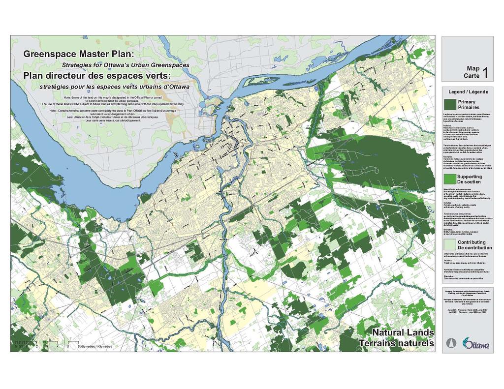
16 Section 2 I dentifying Ottawa s Greensp aces and the Urban Greenspace Network 2 Identifying Ottawa s Greenspaces and the Urban Greenspace Network 2.1 Taking Inventory In 2001, more than 850 parks and thousands of hectares of municipal forests, wetlands or other natural lands were consolidated under one administration. Each of the former municipalities treated these lands differently in local zoning by-laws and for the most part, pursued different plans for greenspace within their boundaries. In addition to the municipal lands, federal lands in Ottawa include more than 20,000 ha of land within the National Capital Greenbelt, plus parks, parkways and recreational trails. National monuments and other high-profile buildings provide spaces for public gatherings and other greenspaces. The federal government and the Conservation Authorities own and maintain woodlands and other environment lands that bring nature into the city. The Greenspace Master Plan - Strategies for Ottawa s Urban Greenspaces sets the table for planning all of these greenspaces in the urban area by: Identifying all natural greenspaces and open space and leisure lands in Ottawa and mapping them as natural lands and as open space and leisure lands, or in some cases, as both types of land; some spaces are shown on both maps Categorizing these lands based on their contribution to either natural features and functions, or to open space and leisure opportunities Identifying an Urban Greenspace Network that combines both kinds of greenspaces into a single system In order to plan for such a diverse landmass, a computer-based mapping and information system was used to analyse data on various types of greenspaces in the city. This system can be updated and used for a variety of purposes, including monitoring of greenspace targets and achievement of other objectives. In the process of identifying all of Ottawa s urban greenspaces, the Official Plan designation and the zoning were reviewed. It was found that natural lands, and open space and leisure lands are not always designated in the Official Plan or zoned consistently. Appropriate designation of greenspaces is a basic implementation strategy outlined in Section 4.0 of this Plan. This section describes strategies for securing natural lands, and open space and leisure lands, and proposes to build the Urban Greenspace Network through multi-use pathways and Greens Streets. While the Urban Greenspace Network is a central, organizing element in the city s greenspace system, land that is located off the network is also Strategies for Ottawa s Urban Greenspaces 9
17 Section 2 Identifying Ottawa s Greenspaces and the Urban Greenspace Network valued. In particular, natural lands occur where they occur and several of the most significant natural areas remaining in the urban area are not connected to the network. Strategies for securing these lands and other natural land will be proposed through the Urban Natural Features Strategy. The role of the Urban Natural Features Strategy is to identify specific natural lands that Council intends to secure for their environmental value through acquisition and other means over the next five to 10 years. The strategy builds on the Urban Natural Areas Environmental Evaluation Study, which established the environmental values of woodlands, wetlands and ravines in the urban area. The inventories of land shown in this section on Map 1 Natural Land and Map 2 Open Space and Leisure Land reflect the present use of the land. Both maps include lands where the zoning and Official Plan designations permit development for urban purposes. The use of these lands for greenspace will be subject to further studies, development applications and planning decisions in the future, with the maps updated periodically. Map 3 shows how these lands could be linked in a network, and includes potential linkages that do not reflect the current use. The network and the inventories will not have a direct effect on the Official Plan designation or zoning of the lands shown on the maps. Rather, the network and the inventories will be used to guide future land acquisitions, to plan future parks and leisure facilities, and to inform review of development applications and proposals for public works Data Sources and Assigned Values Greenspaces were identified using a variety of sources, including former municipal plans and zoning by-laws, land use inventories, scientific studies, ongoing planning studies, and the provincial property database. Several studies described below were particularly critical in assembling the inventory. These studies were prepared at different times and for different purposes; where they addressed the same landscapes, the study undertaken with the most scientific rigour was given preference. Further, where the studies yielded a ranking of the value or importance of certain lands, such as natural greenspaces, these rankings were carried forward into the inventory. In some cases, the studies required updating to reflect changes in land use and commitments for development. These sources include: The Natural Environment System Strategy, NESS (1997). The former Regional Municipality of Ottawa-Carleton undertook this comprehensive analysis for the 1997 Regional Official Plan. NESS combined existing regional vegetation and landform mapping with fieldwork to assess the relative significance of natural areas in the rural area and the Greenbelt. It evaluated forested and wetland areas, using standardised criteria to rank the natural landscapes as high, medium and low in significance. NESS also suggested a network of core natural areas and terrestrial and aquatic linkages among them. The NESS evaluation informed the environmental designations for the rural area in the 2003 Ottawa Official Plan. Ministry of Natural Resources information. The Ministry is responsible for the identification and evaluation of wetlands in Ontario. It also maps the location of Areas of Natural and Scientific Interest (ANSIs), comprising earth science ANSIs such as rare 10 Strategies for Ottawa s Urban Greenspaces
18 Section 2 I dentifying Ottawa s Greensp aces and the Urban Greenspace Network landforms, and life science ANSIs such as habitats of rare or unique species. This information is continually being updated. Life science ANSIs and Provincially Significant Wetlands are included in environmental designations in the 2003 Ottawa Official Plan; earth science ANSIs are identified as landform features in the Plan. Greenbelt Master Plan. In 1995, the National Capital Commission undertook this plan to identify greenbelt lands as rural landscapes, areas for future development (such as the Ottawa International Airport and federal employment areas) and natural landscapes with environmental value. The natural landscapes included forested lands, wetlands such as Mer Bleue, and linkages such as river and stream corridors. A network of outdoor destinations and recreational pathways was also proposed. Many of the natural landscapes were confirmed as having a high level of environmental significance in the Natural Environment System Strategy (NESS). The Greenbelt Master Plan is reflected in the designations in the 2003 Ottawa Official Plan. Urban Natural Areas Environmental Evaluation Study (UNAEES) The City of Ottawa undertook this study to identify and to assess the relative environmental value of natural areas in the urban area. This study established a consistent environmental rating system and made recommendations regarding the management of these lands. Nine criteria were used to rank municipal, NCC, and private lands as high, moderate and low in environmental value. Some of these sites were already identified in an environmental and open space designation in the Official Plan and others were not. The study, which also yielded more accurate mapping than previously available, will provide a basis for setting priorities for acquisition or other means of securing these lands as natural areas. Watershed and Subwatershed Studies. The Conservation Authorities and the City undertake watershed and subwatershed studies and continue to refine information on natural environment systems, river and stream corridors, and surface and ground water connections. These studies have been used to update earlier studies, such as NESS, where appropriate. Cycling and Pathway Studies. The NCC is updating the 1994 study, The Integrated Network of Recreational Pathways for the National Capital Region, in partnership with the Cities of Ottawa and Gatineau. The current study, the Pathway Network for Canada s Capital Region: 2006 Strategic Plan, identifies pathway corridors throughout the National Capital Region that embraces Gatineau and Ottawa. These pathways are the primary offroad connections among open spaces in the National Capital Region. The City is also undertaking a Cycling Plan to identify an on-road and off-road system for cyclists. Both studies were in progress in 2006 and information from this master plan contributed to their development. Municipal Park Inventories. The City has prepared a database of all the City-owned and managed parks, identifying all park facilities of the former municipalities. The database is updated regularly and is linked to the City s Geographic Information System (GIS). Strategies for Ottawa s Urban Greenspaces 11


19 Section 2 Identifying Ottawa s Greenspaces and the Urban Greenspace Network In addition to these studies, the parks and recreation plans of the former municipalities classified parks and identified future park locations; community design plans and secondary plans have also identified lands intended for future parks and other greenspace. These have been included where sufficient information exists to do so. The 1999 Plan for Canada s Capital and the Official Plan also provided context. In addition, land assessment data, topographic mapping, and mapping from the City s land use surveys in 2001 and 2005 were consulted. Altogether, these studies and evaluations have been used to identify greenspaces and assign greenspace values in this Plan. Information on natural lands included evaluation and ranking of the relative environmental value of individual sites, and these rankings have been carried forward into this Plan. Such rankings may need to be updated as additional information becomes available. Information on open space and leisure land was primarily descriptive and the ranking in this plan represents the level of public access and use. The Greenspace Master Plan - Strategies for Ottawa s Urban Greenspaces recognizes that not all environmental lands or all open space and leisure lands have the same intrinsic value or value to the public, based on their function, either within a natural environment system or within a system of open space and leisure lands. This Plan ranks both types of land generally in terms of their role or function, as described in three broad categories: Primary lands include the natural landscapes and major rivers that are recognised as having high environmental quality or rarity, as well as the public parks and open spaces specifically designed to provide sport and leisure functions. Supporting lands refine, complement and expand the primary lands. They include tributaries to rivers, isolated natural features, and habitats that link the primary areas. In the open space and leisure system, they are public lands that potentially contribute to leisure opportunities because they permit public access. Contributing lands enhance or augment the primary or supporting lands. They include steep slopes, low-value natural areas or treed areas, as well as institutional, commercial recreational and other lands that permit varying levels of public access and use. As discussed in Section 1.0, many parcels of land contribute to both natural and recreation functions and where this occurs; these lands have been included in both inventories. 2.2 Ottawa s Natural Lands Wetlands Woodlands River Corridors Steep Slopes Ottawa s natural lands comprise the city s significant wetlands and forests, and the rivers and their tributaries that run between them. Natural lands and features in Ottawa s urban and Greenbelt areas are 12 Strategies for Ottawa s Urban Greenspaces

 attempted to capture the natural systems extending from the rural area into the Greenbelt and parts")
20 Section 2 I dentifying Ottawa s Greensp aces and the Urban Greenspace Network shown on Map 1, along with the priority assigned to each component. Natural functions occur within the physical limits of a forest, wetland or other natural feature and extend beyond the feature to adjacent lands, forming a natural system. Understanding natural systems and identifying their extent is complex, although data is available from previous studies. In particular, the former Region of Ottawa- Carleton s Natural Environment Systems Strategy (NESS) attempted to capture the natural systems extending from the rural area into the Greenbelt and parts of the urban area. Also, the Urban Natural Areas Environmental Evaluation Study (UNAEES) evaluated and accurately mapped the remaining natural lands within the urban boundary. Natural watercourses, urban wetlands and other elements of the NESS system within the urban area, plus the lands evaluated in the UNAEES, provide the basis of a natural environment system in the inventory in this Plan Wetlands Wetlands are among the most productive ecosystems on earth. With an abundance of food and vegetative cover, they are a unique habitat for many different types of plants and animals. They also filter surface waters and thus help protect the quality of rivers and streams. They also regulate flooding and act as recharge or discharge areas for ground water resources. The Ontario Ministry of Natural Resources has identified more than ha of wetlands in Ottawa that are Wetlands are unique habitat for many provincially significant. Seven provincially significant different plants and animals and also wetlands are within the urban area or adjacent to it. Mer regulate flooding and water recharge areas. Bleue, Leitrim, Stony Swamp, Shirley s Bay, Mud Lake and Petrie Island are the largest of these wetlands. All provincially significant wetlands are included as primary lands in the natural landscapes and features shown on Map 1. There are few other wetlands in the urban area. Most of these are associated with woodlands and river corridors and add to their value. These wetlands are generally ranked as supporting lands on Map 1. However, where these wetlands are part of a woodland or other feature ranked high in the UNAEES or NESS, they are considered primary Forests and Woodlands Large, complex systems of forests and wetlands in the rural area and the Greenbelt form the city s core natural landscapes and these structure an overall natural landscape system. These core landscapes contain Areas of Natural and Scientific Interest identified by the Ministry of Natural Resources and most ranked as high and medium significance in the Natural Environment System Strategy (NESS). Many of these landscapes lie within the Greenbelt or are located adjacent to the urban area (e.g. the South March Highlands). These lands are Remnant Shield woodlands in Kanata add to the quality of life valued in that community. Strategies for Ottawa s Urban Greenspaces 13

21 Section 2 Identifying Ottawa s Greenspaces and the Urban Greenspace Network identified as primary on Map 1. Inside the urban area, remnant woodlands are small and isolated but act as anchors for natural features and functions. These wooded lands were identified, mapped and reviewed in detail by the Urban Natural Areas Environmental Evaluation Study (UNAEES). Woodlands that are rated as high or moderate by the UNAEES, such as McCarthy Woods and Trillium Woods, are identified as having a primary role on Map 1. Other forested areas of varying quality play a supportive role to overall landscape biodiversity by buffering or joining more primary landscapes and providing linkages. Isolated woodlands play a supporting role in overall landscape biodiversity. In the urban area, UNAEES identified several sites as having low significance and these areas are shown as fulfilling a supporting role on Map 1. Other treed areas in the urban area have not been evaluated from a natural environment perspective because they are smaller than the 0.8 ha minimum size set for the UNAEES evaluation. Map 1 identifies these lands as playing a contributing role in the overall greening of the city River, Stream and Creek Corridors Six major rivers come together in Ottawa. Four of these run through the urban area: the Ottawa, Rideau, Jock, and Carp Rivers. Creeks and streams that stretch out across the landscape feed these rivers, carving valley lands, floodplains and escarpments as they go. In the rural area, valley and river systems act as habitat and corridors for aquatic and terrestrial wildlife that lead into the Greenbelt. These systems strengthen forest and wetland areas by joining them and supporting overall biodiversity. In the urban area, river corridors, steep slopes, flood plains and watercourses are among the most consistently visible fragments of natural Shirley s Brook provides a natural quality to the community and manages stormwater from adjacent development. landscapes because they are unsuitable for development. They provide habitat for fish and wildlife. Urban river and stream systems also perform hydrological functions, including conveyance of urban storm water. In some cases, waterfront land is retained in private ownership and public access is not permitted. Smaller watercourses often disappear completely into development. The rivers and the largest creeks have been identified as primary on Map 1. All other creeks, lakes and ponds are in supporting roles. 14 Strategies for Ottawa s Urban Greenspaces
22
23 Section 2 I dentifying Ottawa s Greensp aces and the Urban Greenspace Network Escarpments and Steep Slopes There are several escarpments in Ottawa that mark the edge of ancient shorelines and the passage of the glaciers. Escarpments skirt Parliament Hill and form the boundary of the Fallingbrook Community in Cumberland, for example, while others stand out only as local landmarks within neighbourhoods. Many of these escarpments are linked with sites identified by the Urban Natural Areas Environmental Evaluation Study and are identified as contributing features on Map The Policy and Regulatory Framework for Natural Lands Most of the primary and supporting lands identified in the urban area on Map 1 are included in one of four land use designations in the Official Plan. These designations are Natural Environment Area and Significant Wetlands South and East of the Canadian Shield in the Greenbelt, plus Urban Natural Features and Major Open Space elsewhere in the urban area. Lands designated Significant Wetlands and Natural Environment Area are publicly owned. Most of the lands designated as Urban Natural Features and Major Open Space are publicly owned and the designation restricts development. Throughout Ontario, conservation authorities take the lead role in planning for watercourses and implement much of the legislation in effect to protect them. There are three conservation authorities with responsibilities within the City of Ottawa: the Mississippi Valley CA, the Rideau Valley CA, and the South Nation CA. These conservation authorities take the lead in implementing the legislation that protects aquatic corridors. Legislation includes the Federal Fisheries Act, the Conservation Authority Act, and the Lakes and Rivers Improvement Act. Conservation authorities are the lead agencies in the watershed planning process, which provides the natural environment basis for land use planning in the Ottawa Official Plan. Conservation authorities also provide flood plain mapping and manage site alteration and fill regulations adjacent to many of the City s watercourses, and within and adjacent to provincially significant wetlands. Official Plan policies and the regulations administered by conservation authorities seek to protect setback areas from all watercourses. The designation of some parcels of natural land and open space land in the Official Plan require amendment. Much of the river-front land is identified as Major Open Space, whereas an environmental designation may be more appropriate in some locations. Also, community design plans approved since 2001 have identified significant greenspaces associated with urban watercourses and these can be designated in the Official Plan. Land along the Jock River is identified in a secondary plan in Volume 2 of the Official Plan, and should also be shown in Volume 1. Strategies for Ottawa s Urban Greenspaces 15


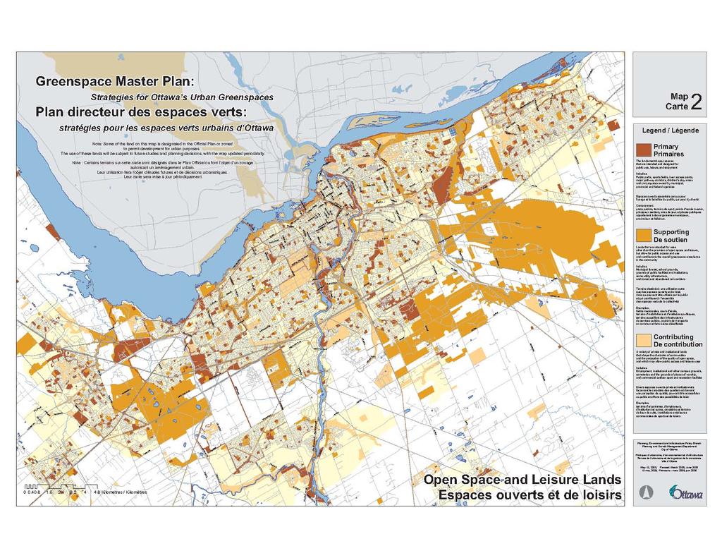
24 Section 2 Identifying Ottawa s Greenspaces and the Urban Greenspace Network Current Initiatives to Secure Ottawa s Natural Lands The City is at a crossroads regarding protection of natural areas. By 2006, evaluation of 192 sites of 0.8 ha or more will be completed through the Urban Natural Areas Environmental Evaluation Study, and Council and the community will need to decide which of these are worthy of protection as Urban Natural Features. Urban Natural Features are natural lands designated in the Official Plan to preserve the feature so that it can be used for conservation or passive leisure uses. An Urban Natural Features Strategy will be brought forward for consultation to consider which new sites will be designated and protected over the long term, and how this can be accomplished. While some sites may be secured through partnerships with other levels of government, others will require acquisition. While the UNAEES looked at large wooded sites across the urban areas, a Forest Strategy, now in progress, is evaluating forest cover in the urban and rural contexts. Forest and tree canopy targets for specific areas of the City will form part of that strategy. In addition, Council approved new Official Plan policies on setback provisions from waterbodies in The policies identify appropriate setbacks to protect water quality, aquatic and fish habitat, and the riparian environment, as well as provide an element of protection from hazards associated with unstable slopes and flooding. Further work on implementation guidelines is proposed to help interpret the new policies. 2.3 Ottawa s Open Space and Leisure Lands Ottawa s open space and leisure lands are the greenspaces that provide for the open space, recreation and leisure needs of the community and may be accessed by the public. These are the places where residents congregate, play games, swim and lie in the sun, celebrate with others at festivals, ride bicycles, and sit and read under a shady tree. Much of this land is public park or civic space, but other open space and leisure lands, such as golf courses, are privately owned. In addition, other lands contribute to open space, including landscaped lands available for public use, such as the grounds of major institutions, and land associated with infrastructure, such as stormwater management ponds. Public Parks Sport Fields Pathways Other Open Spaces Mapping all the land that contributes to open space and leisure use reveals the pattern that they form and the relationships among them. As well, by mapping the inventory of leisure lands, the distribution of public parks in different communities is more evident and standards of delivery for new communities and older communities are more readily monitored. 16 Strategies for Ottawa s Urban Greenspaces
25

26 Section 2 I dentifying Ottawa s Greensp aces and the Urban Greenspace Network In building the inventory of Ottawa s open space and leisure land, shown on Map 2, several characteristics have been used to assess the contribution that each parcel of land makes to the overall open space and leisure system in the urban area. These characteristics are: Ownership and level of public access Current and planned land use Topography and inherent natural qualities Cultural heritage value (i.e., as associated with a heritage site) Ability of municipal government and other partners to increase the open space and leisure use Three types of land contribute to open space and leisure land in the city. They are ranked below, based upon their planned purpose and their open space and leisure contribution Public Parks, Sports Fields, and Multi-Use Pathways Public parks, sports fields, and multi-use pathways are the primary and most important lands that provide for the recreational needs of the community. The City owns most of these lands and compared with other public bodies, has the most direct mandate for open space, recreation and leisure. New public parks, sports fields, and multi-use pathways are provided through public acquisition and through parkland dedication required under the Planning Act at the time of development. Federal parks and recreation areas add to Ottawa s urban parkland resources; they Open space and leisure lands are the accessible beautify the city and support its role as the greenspaces that provide for the recreational and National Capital. The Province focuses its leisure needs of the community. parkland contributions on two parks in the rural area. All these lands are ranked as primary lands on Map Other Publicly Owned Lands Other publicly owned lands developed or maintained for other purposes expand opportunities for public recreation and leisure. They play a supportive role in the open space and leisure system when public access is facilitated by pathways or other facilities, and agreements are in place with the public owner to permit public use. These lands include institutional lands such as school grounds; infrastructure land, such as storm water management ponds; and utility and other corridors such as hydro lands and major roadway corridors. For example, the City programs sports facilities on school sites and secures opportunities for walking, cycling or other recreation by agreement on some provincially owned hydro corridors and some federally owned land. The NCC Strategies for Ottawa s Urban Greenspaces 17


27 Section 2 Identifying Ottawa s Greenspaces and the Urban Greenspace Network Other public lands expand opportunities for public recreation and leisure. has also developed pathways and other recreation areas on federal property such as the parkway corridors and Greenbelt lands. Some natural areas, such as those managed by the Conservation Authorities, are also developed to provide for informal recreation. These lands are identified as supporting land on Map 2. All levels of government and several public agencies also own vacant lands where public recreation may not be facilitated but public access is rarely restricted. These lands, such as lands associated with the Airport Parkway and provincially owned hydro corridors, are intended for other purposes. However, these public lands play a contributing role by expanding the visual greenspace of the city and the amount of land available for public use in the future. These lands are identified as contributing on Map Privately Owned Lands Privately owned lands such as cemeteries, golf courses and the grounds of public and private institutions also provide open space and leisure opportunities. In these cases, private decisions determine land use and public access is by permission only. These lands play a contributing role in the City s open space and leisure system. Privately owned golf courses are greenspaces that contribute to the character and identity of communities The Policy and Regulatory Framework for Open Space and Leisure Lands The primary and supporting lands identified on Map 2 have various designations in the Official Plan. The Official Plan designates most of the large parks, open space corridors along the major watercourses, parkway corridors, and corridors reserved for rapid transit and major roads. Some large parks and waterfront lands shown on Map 2 have been identified in community design plans approved by Council since 2003 and are not designated in the Official Plan. Unlike the policy framework for natural lands, there is less guidance or regulatory direction from senior levels of government for open spaces and leisure lands. The Planning Act provides the framework for the dedication of parkland during the development process. The Municipal Act provides the parameters for the provision of municipal facilities required to meet new growth, including indoor and outdoor sport and leisure facilities. The Provincial Policy Statement (2005) introduces provincial policies for public spaces, parks and open space. 18 Strategies for Ottawa s Urban Greenspaces
28 Section 2 I dentifying Ottawa s Greensp aces and the Urban Greenspace Network Ongoing Initiatives for Securing Open Space and Leisure Lands The City has adopted a strategy to respond to the need for additional sports fields. In 2004 Council approved a Sports Fields Strategy Strategic Options and Recommendations (2003), which recommended standards for providing sports fields throughout the city on a per capita basis and an approach to partnering with school boards, private sports associations and other partners to meet current and future needs. A subsequent study, A Study of Potential Sports Fields Sites, reviewed the potential of vacant lands within the urban area and the Greenbelt to be developed as sports fields, as a guide to future partnerships and acquisition. In 2006 Council approved the acquisition of a new sports field and in 2007 will consider a proposal for ongoing capital funding for sports field acquisition. An update of the City s parkland dedication by-law is also in progress. The new by-law will standardize the way in which the parkland dedication is calculated throughout the city and establish criteria for the use of cash taken in lieu of the land dedication. 2.4 Ottawa s Urban Greenspace Network A Network Approach The idea of a network approach to greenspaces is based on the principles of landscape ecology and an ecosystems approach to land use planning and management. A systems perspective frames decisions for one element of the system on an understanding of the implications for other elements of the system. Greenspaces function on different levels and as a result have different, but compatible, ecological and social functions that together create a system that is more effective and stronger than if it were fragmented. When the system is compromised, fragmented habitats decline and animal populations are lost; dispersed parks and open spaces are not easily accessible; and environmental mitigation by natural processes Figure 2 A systems perspective frames decisions for one element of the system on an understanding of the implications for other elements of the system. is weakened and requires significant intervention and public investment to restore. A city that keeps its natural areas healthy also keeps its inhabitants healthy. Where people have ample room and can easily access the elements of a greenspace network for recreation and leisure, healthy living becomes part Strategies for Ottawa s Urban Greenspaces 19
29 Section 2 Identifying Ottawa s Greenspaces and the Urban Greenspace Network The Elements of the Network From the natural land on Map 1, the Greenspace Network takes in the primary lands that can be connected by water or land corridors, plus the secondary and contributing elements that connect the primary lands. The natural lands carried into the Greenspace Network comprise: The primary landscapes identified on Map 1, such as Mer Bleue, Stony Swamp, South March Highlands and Shirley s Bay. Most of these are large and self-sustaining The woodlots, rivers, streams and creeks that connect these large landscapes From the open space and leisure lands on Map 2, the Greenspace Network takes in the primary elements of the system, such as the major parks and outdoor destinations, plus the secondary and contributing elements that are adjacent to the primary elements and that connect them. As a result, not all primary elements shown on Maps 1 and 2 are carried forward, but only those that are or can be connected and that are self-sustaining as part of the City-wide network. of daily routines and nature becomes an important, visible part of city living. Where an Urban Greenspace Network is fostered, flora and fauna can also thrive in connected habitats. With proper places to grow throughout the Urban Greenspace Network, trees provide enormous benefit by filtering pollutants and cooling the air. When woodlots and forests are preserved and linked, water quality is enhanced, soil is retained, and wildlife can thrive. People are able to move through and between communities more easily and get access to more facilities, which in turn are used more efficiently. The whole network becomes resilient and, as a result, is enhanced so that its benefits exceed the contribution of the individual parts Building on Past Experience Outdoor recreation and leisure destinations that are accessible from the network are also shown on Map 4. Many of these destinations are associated with a significant natural feature, often with associated programming, and attract both residents and visitors to the city. Destinations located in proximity to each other form complexes, such as the complex formed by Dick Bell Park, Andrew Hayden Park and Britannia Park. Other destinations are the launching point into a larger natural landscape such as Mer Bleue or the South March Highlands. Greenspace is a powerful planning element that has shaped the character and quality of Ottawa for more than a century. Early in the 19th century, Fredrick Todd was one of the first to prepare plans for the Capital that were inspired by the image of an urban area juxtaposed within a wild natural landscape. This image influenced many successive plans that set the framework for the current pattern of parkway and greenspace development. These visions were best expressed in the 1950 plan for the National Capital prepared by Jacques Gréber. Through the 1960s and 1970s, Ottawa neighbourhoods such as Glen Cairn and Greenboro were structured around greenspaces, providing alternative means for getting around and a wider range of recreational opportunities for residents, making these communities popular places to live. In the 1990s the National Capital Commission brought this concept forward, updating it with ecological planning principles in the Master Plan for Canada s Capital. The concept of a network of greenspace has been a key organizing principle of recent municipal land use planning. In the 1990s the former City of Ottawa incorporated a Greenway System into its official plan and zoning by-law, identifying a network of natural and open spaces. The Greenway System was opportunistic in that it sought to connect spaces in a city that was already largely 20 Strategies for Ottawa s Urban Greenspaces

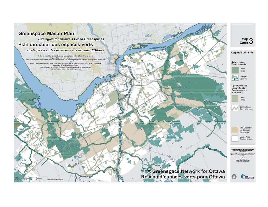
30 Section 2 I dentifying Ottawa s Greensp aces and the Urban Greenspace Network developed. In 1994, the former City of Ottawa, the Regional Municipality and other area municipalities within the National Capital Region worked with the National Capital Commission to plan and develop a system of recreational pathways through the Integrated Network of Recreational Pathways for the National Capital Region. In the 1997 Regional Official Plan, this pathway system formed part of a regional open space network that connected land in the Greenbelt, the Central Experimental Farm and large public parks with scenic corridors and over 300 kms of recreational pathways. The suburban municipalities also had plans and strategies to create networks of green spaces. In these rapidly growing communities, planners, politicians and community leaders sought to protect elements of the natural landscape as suburban development proceeded. Each municipality used various means to protect natural areas and to provide parks, sports fields and quiet places for community residents. Each also sought to expand traditional parks and open space lands by innovative means, for example, by designing naturalistic storm water management ponds such as the Monahan Drain constructed wetland that not only enhances water quality, but also provides habitats for urban wildlife and opportunities for leisure. Transportation and utility corridors such as West Hunt Club Road and the abandoned rail corridor have been designed to include recreational pathways to link communities and support cycling. The City s Official Plan continues with this tradition of greenspace planning, proposing that a comprehensive greenspace network be developed What is the Urban Greenspace Network? The Urban Greenspace Network is a connected and protected network of natural lands and open spaces and leisure lands that structures the urban area; strengthens distinct communities; incorporates natural features; provides opportunities to improve environmental quality; and increases accessibility to open air recreation. Figure 3 The Urban Greenspace Network demonstrates how the city can be shaped through the physical connection of natural lands and open spaces. The proposed Urban Greenspace Network shown on Map 3 is both a physical entity and a core concept that can be used to plan the city. As a connected and protected physical network of natural lands and open spaces, the network can constitute the permanent, defining feature of the city s physical form where it may grow and what areas should be protected. As a concept, it can guide public decision-making and creation of the network. Strategies for Ottawa s Urban Greenspaces 21
31 Section 2 Identifying Ottawa s Greenspaces and the Urban Greenspace Network As a physical entity, the Urban Greenspace Network is greenspace drawn from the natural lands inventory on Map 1 and the open space and leisure lands on Map 2, and the existing and potential connections among these lands. The connections take the form of streams and other natural corridors that sustain ecological functions and multi-use recreational pathways that increase accessibility. Thus, the network provides access to environmental areas as well as recreation destinations. It also connects large ecological areas and linkages (such as wetlands, river corridors, and large woodlands) in the rural area and the Greenbelt with small and more fragmented urban environment features such as woodlots, creeks, and landscapes that are important for social as well as environmental reasons. As a core concept, the Urban Greenspace Network provides a frame of reference for land use planning and comprehensive decision-making. Where lands serve environmental and leisure purposes, future management plans for the land can reflect both roles. Reference to the Urban Greenspace Network will help the City to: Identify the land that physically connects greenspaces from urban parks and natural areas, through the Greenbelt, to the larger natural landscapes in Ottawa s countryside Maintain the sustainability of Ottawa s urban natural areas by maintaining a diversity of natural features and functions and providing or enhancing links between habitats Incorporate and protect cultural heritage landscapes, such as the Ottawa and Rideau waterways, that define the city and contribute to the health and vitality of the Greenbelt s diverse natural, rural and cultural landscapes Improve access to greenspaces through pathways and other linkages that accommodate the growing interest in outdoor recreation, contact with natural places, and healthy lifestyles Guide decisions on the management and acquisition of greenspace Provide opportunities for community participation and partnership in the development and management of network components Locate new recreation facilities as destinations within the network, and upgrade and connect existing facilities where possible Building the Urban Greenspace Network Much of the Urban Greenspace Network already exists but other components are still conceptual. It includes lands that are privately owned and lands that are not currently designated in the Official Plan or zoned for open space or environmental purposes. Although public ownership at times is viewed as the most expedient way of securing greenspace land for public use, public ownership is not always necessary or desirable. Public ownership is usually reserved to protect the most fragile of natural environment areas such as Trillium Woods, or to secure public access to a special area such as a waterfront or urban woodland. There are many other ways land can be added to the Urban Greenspace Network, including: covenants, easements, agreements with landowners, and through progressive land management techniques. Some of these techniques are described in detail in Appendix A. 22 Strategies for Ottawa s Urban Greenspaces
32
33 Section 2 I dentifying Ottawa s Greensp aces and the Urban Greenspace Network Other conceptual components are the proposed citywide and community pathways on Map 4. These multi-use pathways are a defining feature of the Urban Greenspace Network. Lands were chosen for the network in part on the basis of their access to an existing pathway or their potential to be linked in the future to the larger pathway network. In many locations, the pathway forms the link between greenspaces and affords access to the heart of larger areas. Map 4 shows proposed additions to the pathway systems, which would complete the missing pieces of the Urban Greenspace Network Strategies to Build the Urban Greenspace Network Not all of the network can be achieved at once. Several initiatives described previously in this section to protect natural lands and secure greenspaces also contribute to completing the Urban Greenspace Network. These initiatives include acquisition of natural areas through the Urban Natural Features Strategy, planning for new sports fields, and standardizing parkland dedication provisions through the new Parkland Dedication by-law. The network can also be built through day-to-day functions of municipal government. The City can build the network through development review, community planning, and cooperation with other levels of government and other organizations. Through these functions, the City can act on the premise that greenspace lands that are on or adjacent to the network make the most progress towards achieving the City s greenspace objectives: connectivity, adequacy, quality, accessibility and sustainability. These lands should therefore have priority above other lands that make a similar contribution to the open space and leisure system or natural system, but are not on the Urban Greenspace Network. The City can build the Urban Greenspace Network through the actions listed below. 1. When planning new parks and open spaces in existing and new communities, give priority to land on the Urban Greenspace Network by: Situating new district and community parks on the network or as extensions to the existing network Using new local and neighbourhood parks to address network gaps and to provide connections to facilities that are not on the network Situating new recreation facilities and other public facilities on the network 2. When developing plans for new and existing communities, ensure that recreation facilities and lands dedicated for public purposes are connected to the Urban Greenspace Network and its multi-use pathway system. 3. When considering development applications, build the Urban Greenspace Network by: Ensuring that the applications implement the community design plan for the area and its plan for greenspace Where no community design plan exists, seek opportunities where appropriate to fill gaps and extend the network Strategies for Ottawa s Urban Greenspaces 23
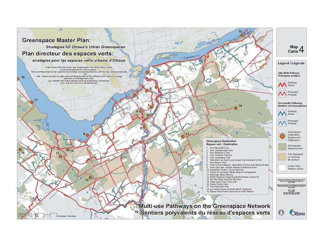
34 Section 2 Identifying Ottawa s Greenspaces and the Urban Greenspace Network Being explicit in reports to Council about the effects of the planning decisions on the Urban Greenspace Network 4. Use partnerships and agreements with other public agencies and the private sector to: Develop or enhance the contribution of their lands to the Urban Greenspace Network Explore alternatives to public acquisition to provide public access to additional greenspace 5. Give priority to locations on the Urban Greenspace Network for partnership projects, such as stewardship projects or new capital projects, undertaken with community groups, sports clubs, the business community and other stakeholders. 6. When considering the disposal of City-owned land, ensure that any network function is retained. 7. Where transit, road, rail and utility corridors are part of the Urban Greenspace Network or cross the network, accommodate the network in the design of the infrastructure. Where corridors cross the network, for example, a safe crossing should be provided so that passageways through the greenspace network are not severed. Where these corridors have potential to improve connectivity, recreational pathways and other linkages can be provided. In addition to these ongoing municipal activities, the Urban Greenspace Network can be built through new initiatives to create the on-road and off-road connections that form the backbone of the network. The Greenspace Master Plan recommends that Council: 1. Implement key sections of the recreational pathway system identified in the Pathway Network for Canada s Capital Region: 2006 Strategic Plan and request staff to prepare a plan and budget estimate to do so 2. Prepare a Green Street Strategy to explore ways that Green Streets could be used to provide connections within the Urban Greenspace Network and contribute to the greening of municipal infrastructure Multi-Use Pathways Much of the city is well-connected by a multi-use pathway built by the National Capital Commission and the former municipalities. The Greenspace Master Plan Strategies for Ottawa s Urban Greenspaces proposes to extend this network by creating a city-wide grid of pathways and filling in the grid with community pathways and Green Streets that link neighbourhoods to the citywide system. Map 4 shows the existing pathway systems within the Urban Greenspace Network and how they could be extended. The groundwork for the citywide pathway system is being laid by the Pathway Network for Canada s Capital Region: 2006 Strategic Plan. This is a joint project of the NCC and the Cities of Ottawa and Gatineau. This study, due for completion in 2007, inventories and proposes extensions 24 Strategies for Ottawa s Urban Greenspaces
35
36 Section 2 I dentifying Ottawa s Greensp aces and the Urban Greenspace Network to the existing pathway system in the National Capital Area. Much of the mapping used to create the Urban Greenspace Network was provided as a backdrop for this study. Following Council receipt of this study, a capital budget and implementation plan for priority sections will be prepared for Council consideration. The proposed community networks shown in new communities on Map 4 reflect provisions of community design plans approved by the City and will be developed as the community grows. The proposed community network in established communities may also be secured through community design plans in the future, as well as through review of development applications. Components of the Multi-Use Pathway The pathway will take its character from the surrounding lands, natural in some areas and more designed in others. Integration with the system built by the NCC will be achieved through common construction and safety standards, with interpretive signs identifying the pathway as an urban amenity. A Pathway Clearance Zone 6.0 metres wide free and clear for safe use, including a 3.0 metre wide pathway and a 1.5 metre shoulder on either side. A Pathway Corridor Where opportunity exists, a corridor of 6.0 meters on either side of the clearance zone is desirable. The width of the pathway corridor will be defined for each segment in more detailed area planning and design studies that consider the pathway s context. A Pathway Context Zone Varying in width according to the pathway corridor s immediate environment and defined by view sheds. Elements that define the view shed s limits may include buildings, fences and other site features, vegetation and landforms. The optimum width of the pathway context zone should also be defined for each segment in more detailed area planning and design studies Green Streets Green Streets offer an alternative to off-road pathways and are an attractive amenity in their own right. In older communities, connection of parks to the Urban Greenspace Network may only be possible by converting some streets to green streets, following a community design plan or other planning study. A Green Street is a street right-of-way that, through its design and operation: Strategies for Ottawa s Urban Greenspaces 25

37 Section 2 Identifying Ottawa s Greenspaces and the Urban Greenspace Network Strengthens accessibility to destinations such as schools, culture and leisure facilities, parks and open spaces, transit stops, work places and other destinations within and adjacent to the community Creates an enhanced environment in the right-of-way that is attractive and safe for all pedestrians and cyclists Improves overall environmental quality and the greening of infrastructure by cleansing runoff, increasing water infiltration, reducing urban heat island effects and improving air quality Improves the overall visual and environmental quality of the community and the city Maximizes the opportunity for trees and other landscaping to flourish Improves connectivity of the Urban Greenspace Network and community access to the Network Characteristics of a Green Street Green Streets include many enhancements designed to support walking and cycling in an attractive, open space environment such as wider boulevards, sidewalks, multi-use pathways, street trees and other landscaping, and roadway features. Each Green Street would have its own character and design based on its context, the types of users, the right-of-way dimensions, and its transportation role. A Green Street Strategy is needed to explore the opportunities in Ottawa to build Green Streets in new communities as public capital works or to create them in established communities at various scales. In established communities, Green Streets could be built as part of a roadway rehabilitation program or scaled down to focus on the improvement of barren traffic islands and road verges with planting, flowers, benches and other communitysponsored elements. Such projects could be initiated by local communities and funded from such sources as: City grant programs; public, private and not-for-profit partners; or special local improvement levies. Examples of City funding programs include the Adopt-A-Road Program and the Green Partnership Pilot Program. Funding and support partners include Trees Canada, Evergreen Foundation, and Go-for-Green. 26 Strategies for Ottawa s Urban Greenspaces
38 Section 3 Achieving the Vision 3 Achieving the Vision 3.1 Introduction Ottawa s 20/20 objectives for managing growth lend themselves to five objectives for managing and expanding greenspace in the urban area. Adequacy is the objective that sparks the most public interest and controversy. Is there enough greenspace? How can we get more? But achieving an adequate amount of greenspace, as measured by hectares per thousand population, does not necessarily mean that the community s needs for greenspace are satisfied. The amount of greenspace provided does not reflect whether that greenspace meets the recreational needs of the community or whether the most important environmental lands have been secured. The quality of the greenspace, its sustainability, and the access to it that the community enjoys are all important. This section explores the meaning of each objective, the issues associated with achieving it, and the actions the City can take to pursue it. The Five Greenspace Objectives Adequacy - The City will provide enough greenspace to meet the needs of a growing and diverse community and to maintain natural systems, biodiversity and habitat. Accessibility - Ottawa residents will have ready access to greenspace in close proximity to their homes and communities. Connectivity - Ottawa s greenspaces will be linked to provide for variety and improved access to recreational facilities, and to improve biodiversity and the movement of species. Quality - Greenspaces will be attractive, safe and welldesigned, serving the multiple needs of users while defining the unique identity of communities. Where greenspaces are primarily natural areas, they will be preserved in manner that maintains or improves natural features and functions. Sustainability - Greenspaces will be planned and managed in a way that minimizes human intervention and public spending over time, through reliance on natural processes as well as innovative methods for protecting greenspace. 3.2 Adequate Greenspace Current Provisions - Targets and Challenges The City s Official Plan sets a target of 4.0 ha of total greenspace (i.e., natural land and open space and leisure land) for every 1000 residents and this target has been achieved throughout most of the urban area. In new communities, the target for total greenspace includes a target of at least 2 ha of park and leisure land for every 1000 residents. This target, which reflects the amount of park space in established communities, is ambitious in that the parkland dedication provided under the Planning Act yields about 1.2 ha per thousand population, and the balance must be created through land acquisition and negotiation. These targets have guided the development of recently approved community design plans for the expanding suburban areas. Strategies for Ottawa s Urban Greenspaces 27
39 Section 3 Achieving the Vision Figure 4 shows the population of large districts of the city and the amount of park and total greenspace within each district. Figure 4 also shows the amount of park and total greenspace per thousand population. In this table, park space comprises city-owned parks and federal land recognized by the NCC as a park. These lands comprise the primary lands shown on Map 2 in Section 2. Total greenspace, for this analysis, includes all park space plus active and passive open space in public ownership identified in the 2005 Land Use Survey. These lands are generally shown as the supporting lands on Map 2 in Section 2. School property and land in the Greenbelt is not included in this analysis. In general, most communities achieve the targets of the Official Plan. While some of the older neighbourhoods have less park land than newer suburban areas, they meet or exceed the target for total greenspace because communities inside the Greenbelt on the whole have access to a considerable amount of federally owned greenspace. The exception is the densely populated Inner Area, which does not achieve the Official Plan target for total greenspace or park space. The greenspace characteristics of each area are unique and reflect its natural features, location within the Ha/1000 Pop Central Area Inner Area city, and past planning decisions. Overall greenspace may be higher in communities with an abundance of natural features or development constraint lands such as flood plains. Other areas may have more or less land used for infrastructure such as stormwater management facilities. Some former municipalities provided public parks in excess of the current Official Plan target through a combination of developer contributions, partnerships and land acquisition. Many of the former municipalities had capital funds to purchase parkland, leaving a generous supply in some areas. Some areas have access to nearby federally owned or municipally owned landscapes. In Leitrim, a large park has been purchased ahead of population growth, yielding a disproportionate amount of park per thousand population. The presence or absence of these various elements can significantly change the makeup of parks and greenspace in a community, and no two communities are alike in this regard. Further, it is more important to consider the quality of all greenspaces in a community than to pursue achievement of targets. Ottawa East/est Beacon Hill Alta Vista Hunt Club Merivale Ottawa West/ouest Bayshore Cedarview Kanata Stittsville South Nepean sud Public Open Space and Leisure Lands Public Parks Figure 4 Distribution of parks and other greenspace in sub-areas of urban Ottawa. As neighbourhoods outside the Greenbelt continue to develop and older neighbourhoods inside the Greenbelt intensify, the ratio of park per thousand population is expected to decrease in some areas. In new communities, new subdivisions will be bringing on new parkland as they develop. However, where South Gloucester sud Leitrim Orleans 28 Strategies for Ottawa s Urban Greenspaces
40 Section 3 Achieving the Vision the larger parks have already been provided, the move towards build-out of the suburb will entail a decrease in the park-to-population ratio. In older neighbourhoods, parkland will not be lost to development; rather, the population it serves will increase. In these areas, it may be desirable to compensate for the increased use of parks by providing new facilities on other open spaces and cityowned land, in order to increase recreational opportunities. The City can also acquire additional lands inside the Greenbelt as parkland, although costs are high and opportunities are few. While the City has set a target of 2.0 ha of park and leisure land per thousand population, there is no target for the amount of natural land in Ottawa, although natural land is counted towards the total greenspace target. As in other Canadian cities, environmental areas are preserved on an opportunity basis, where they still exist. Regardless of whether targets are achieved, the City will continue to pursue the acquisition of natural lands and additional park space. In order to improve adequacy of Ottawa s urban greenspaces, the City will: Continue to pursue its overall targets for publicly owned and accessible greenspace, and expand the application of its overall park and leisure land targets across the urban area Keeping Pace with Change As Ottawa pushes past the million-population mark and approaches 2020, both suburban growth areas and the inner city will experience change and pressures on the greenspace supply. New communities will be challenged to provide a full range of natural lands and open space and leisure lands, while as the inner city intensifies and the population increases, the ratio of parkland to population will fall from current levels. Although these pressures are experienced locally within neighbourhoods, they also extend across communities and across the city. Many of the greenspace issues experienced now will only become more challenging in the future: Inadequacy of the parkland dedication under the Planning Act to provide sufficient greenspace, particularly sports fields and pathways Funding shortfall for the acquisition of natural lands and other greenspaces Lack of clarity on what lands are greenspace and what lands are simply vacant Redevelopment of privately owned open space and leisure land The changing role of school grounds The pinch on constraint land and other infrastructure land Inadequacy of the parkland dedication The parkland dedication required under the Planning Act cannot be relied upon to provide all future open space and leisure land needs in either new or established communities. The Planning Act provides for parkland dedication as part of the development review process, at no cost to the City. In certain circumstances, cash is paid in lieu of the land dedication. In established communities, infill development typically occurs on small sites and taking land through the parkland dedication is not feasible and may not provide land that is well located. The alternative, to Strategies for Ottawa s Urban Greenspaces 29
41 Section 3 Achieving the Vision accept cash-in-lieu of parkland, does not go far since the available land supply is in the form of expensive, serviced inner-urban land. In new communities, the dedication is the primary means of creating parks and is generally sufficient to meet neighbourhood demands for parks close to home. However, not all of the parkland identified in some community plans can be acquired in this manner. Also, the dedication is not sufficient to provide these parks as well as sports fields and natural lands identified for protection. In particular, the popularity of organized field sports today is increasing and demand for time on large sports fields has outstripped the existing supply (Sports Field Strategy, IBI 2003). The City needs to address the existing under-supply of sports fields and prepare for the future demand created by a growing population. The current shortfall leads to the over-use of some sports fields, resulting in a deterioration of play surface quality and the inability to respond to the needs of sporting groups in a timely manner. Furthermore, neighbourhood parks are usually not large enough to have one or more sports fields, nor can they handle the impacts of sport league players and spectators from beyond a neighbourhood. The most efficient distribution of sports fields for organized league or tournament play is in large, multi-field parks that can meet the needs of players drawn from a community or from across the city, including new downtown communities. Development Charges can finance a substantial portion of the construction of new sports field facilities to meet demand created by urban growth, but these charges cannot be used to acquire land, under the terms of the Development Charges Act. The City has initiated an enhanced sports field acquisition program by allocating $1 million in the 2006 budget for sports field acquisition and will consider additional funding in the 2007 long-range financial plan. It will also continue to pursue long-term land leases and partnerships with sports groups willing to create fields for their own and public use. In order to pursue the objective of maintaining an adequate supply of greenspace throughout the urban area, the City will: Continue to pursue the target, across the city, of 2 ha per 1000 population of park space or eight to ten per cent of developable land area Use community design plans as a means to identify all greenspace opportunities in new and redeveloping neighbourhoods and propose strategies to meet the Official Plan targets and provide links to the Urban Greenspace Network Implement the open space and urban forest provisions of The Downtown Ottawa Urban Design Strategy 2020 adopted by Ottawa Council and use the development review process, partnerships and public works to secure potential open spaces identified in the plans for the various precincts within the downtown Not consider any land surplus to its needs until it has been evaluated in the context of its contribution to the Urban Greenspace Network, its protection or enhancement of the natural environment, or its contribution to the City's recreational open space, prior to divesting of the property. When considering the disposal of City-owned land, the City will ensure that any network function is retained 30 Strategies for Ottawa s Urban Greenspaces
42 Section 3 Achieving the Vision Funding shortfall Before amalgamation, several local municipalities had innovative programs and parkland acquisition funds that identified and secured new parks well in advance of urban growth. The former Region of Ottawa-Carleton also had a fund to acquire environmental lands in the rural area and along major waterways. This fund has been carried into the budget of the City of Ottawa. Ottawa has also expanded its greenspace acquisition strategies beyond reliance on the parkland dedication; for example, by leveraging tax credits for donated lands as part of acquisition strategy for natural environment areas. The City already has a land acquisition policy to aid in the protection of lands currently designated in the City s Official Plan. This policy is included in Appendix B. Notwithstanding this, as the City moves towards 2020, it needs to consider its greenspace priorities and develop a strategy for meeting funding shortfalls. Funding for the acquisition of large district parks as well as natural lands can come from a variety of sources, including cash-in-lieu of parkland dedication, capital budgets (the tax base), and partnerships with city-wide sports leagues. Establishment of a fund for new acquisitions would enhance opportunities for the City to buy land earlier in the development process at a lower cost rather than at a later date when servicing is available and the land is ready to develop. Relying on cash-in-lieu for major purchases does not provide sufficient funds in greenfields in a timely manner, before the property achieves its full urban value. Council s next decision in the urban area will be whether to fund the acquisition of the remaining privately owned environmental areas identified through the Urban Natural Areas Environmental Evaluation Study and the proposed Urban Natural Features Strategy. While some of the priority sites may be secured through partnerships and other mechanisms, many will need to be acquired by the City if they are to be protected. In order to create a more comprehensive view of the adequacy of greenspace funding, the City will: Review all sources of funding for the acquisition of natural and open space and leisure lands, including the Environmental Land Acquisition Fund, the cash-in-lieu of parkland fund, and other capital programs approved or proposed in the long-range financial plan Propose a consistent and coordinated approach to managing the funds and reporting to Council and communities on how they are used Lack of clarity on what lands are greenspace and what lands are simply vacant Throughout the city, there are large parcels of publicly owned land that are used as open space by the community for dog-walking and other leisure activities, yet these lands are not planned as parks and their future use is uncertain. Some of these lands are corridors that were protected for infrastructure that is no longer needed or has been delayed. Other lands are near or adjacent to planned open spaces but are not planned as part of the open space. In some cases, the knowledge that the municipality or the federal government owns a parcel of vacant land is sufficient to cast it as park in the minds of residents, who are aware of the greenspace needs of their community. In Strategies for Ottawa s Urban Greenspaces 31
43 Section 3 Achieving the Vision many cases, the role of these lands only becomes apparent when the owner seeks to sell or redevelop the property for another purpose. People who use the space are concerned about the loss and any planning process may lead to an Ontario Municipal Board decision. Studies of the future use of these sites may be the best vehicle for the NCC and other public landowners, the City, and the adjacent communities to determine the future use of these lands. Many of these undeveloped sites now are zoned to permit development, subject to completion of a study of future use in the area and consultation with the public. Smaller in scale than a community design plan, such a study could be initiated through a terms of reference approved by Council and supported by the landowner. It could also be co-ordinated with planning for additional pathways identified through the Pathway Network for Canada s Capital Region:2006 Strategic Plan, since many of the sites are located within the proposed Urban Greenspace Network. Until such time as an agreement on the future use is secured through approval of the plan, the current zoning and Official Plan designations would remain in place. The City will endeavour to clarify the greenspace role of undeveloped, publicly owned land by: Initiating planning studies on the future use of undeveloped, publicly owned lands in partnership with the NCC and other public owners, and in consultation with the community and other stakeholders, in order to determine the future greenspace functions of these lands that are now used as open space but are not planned or managed by the owner for that purpose The City will also protect land that is planned and developed for conservation and recreation or leisure purposes through the Official Plan and the Comprehensive Zoning By-law by: Designating all major municipal parks and Urban Natural Features consistently in the Official Plan Zoning all city-owned parks in an open space or equivalent zoning and ensure that there is public consultation where a municipal park is to be sold or changed to another use Redevelopment of privately owned open space and leisure land The public has an interest in maintaining the open space or leisure function of institutional sites and privately owned but accessible open spaces such as marinas, campgrounds and golf courses. As the City grows and land values rise, the economic feasibility of maintaining some privately owned leisure facilities is reduced to the point where redevelopment is a viable option. In such cases, the City needs to consider the open space function of the site to see whether a greenspace function can be retained even as the land redevelops. When considering applications to amend the zoning by-law or to redevelop privately owned open space and leisure land, the City will: Consider opportunities to maintain the continuity of the Urban Greenspace Network Seek opportunities to maintain public access to a waterfront or otherwise provide additional greenspace to the community 32 Strategies for Ottawa s Urban Greenspaces
44 Section 3 Achieving the Vision The changing role of school grounds School grounds have historically been the focus of neighbourhood activity. School grounds were among the few greenspaces provided in a grid pattern of streets and houses in older, inner-city communities. Since the 1950s, school grounds have continued to play a central role in the community as one of the key organising features in community planning. In many communities, school grounds have been co-located with parks to create large, community greenspaces with facilities for sport and leisure. The City and school boards have been working together for many years in the planning, design and operation of shared outdoor recreation and leisure facilities. Fiscal pressures, changing demographics, and the high cost of land have challenged these traditional relationships. The inner city faces school closures and the potential loss of accessible greenspace in areas that are already sparsely or underserved with parks and sports fields. Older suburban areas also face school closures that have the potential to fragment established greenspaces created by coordinated park and school locations. The high costs of land in rapidly growing suburban areas has also resulted in some instances of school boards acquiring smaller school properties, which reduces their ability to meet their own recreation demands and their contribution to the community s accessible greenspaces. Smaller school properties contribute to intensified use of nearby parks and increased maintenance and lifecycle costs for the City. The closure of schools and the proposed sale of these properties are of keen interest to the communities that have grown up around these facilities. Schools in good condition usually get traded to another school board. Generally, those that are offered for sale require major capital investment to bring them up to today s standards and additional cost to re-adapt to other uses. The challenge facing the City is whether to acquire the school to preserve the facility functions of the building, to acquire the land to preserve the greenspace functions of the school yard, or to acquire both or neither. Council has asked staff to prepare a policy on the disposition of surplus school sites and such a policy will be brought forward in This master plan assists with that policy by proposing criteria for Council to use in assessing the merit of school sites and other land proposed for acquisition as greenspace, in Section 4. These criteria include the site s location with respect to the Urban Greenspace Network, the amount of greenspace in the community, and future need as the community population increases. In addition to planning for total parkland requirements through the community design process and other strategies to secure an adequate amount of greenspace, as described above, the City will: Adopt clear criteria to guide decisions on the acquisition of natural lands, schoolyards, and other greenspaces, and make sure that the rationale for any recommendation on a proposed acquisition is clear Strategies for Ottawa s Urban Greenspaces 33
45 Section 3 Achieving the Vision The pinch on constraint land and other infrastructure land During the development review process, the City requests that stream valleys and corridors be dedicated to a public authority for environmental land management. Plans for some new communities have included trails within these lands, as well as along stormwater management facilities. These lands are not considered as parkland, although they contribute to greenspace. Although public use is permitted, these lands cannot be developed to support programmed recreation. At the same time as land costs rise, it has become increasingly difficult to secure constraint lands. Land developers are seeking engineering solutions to mitigate the development constraint around these lands and increase the developable land area, or are proposing to turn these lands into private property assets. Public safety issues complicate use of these lands for recreation purposes and human activity can impact on features such as plant communities, fish habitat and waterway function. In order to make the best use of the greenspace role of constraint land and infrastructure land, the City will: Design stormwater ponds and utility corridors in such a way that they can also function as greenspace in new communities and redevelopment areas, and hazard lands will be incorporated in the overall greenspace plan. These lands will not be considered as part of the public dedication required under the Planning Act, although adjacent, developable lands proposed for paths or parks may be purchased or included in the public dedication Summary - Strategies for Achieving an Adequate Amount of Greenspace In order to pursue the objective of maintaining an adequate supply of greenspace throughout the urban area, the City will: Use community design plans as a means to identify all greenspace opportunities in new and redeveloping neighbourhoods and propose strategies to meet the Official Plan targets and provide links to the Urban Greenspace Network Implement the open space and urban forest provisions of The Downtown Ottawa Urban Design Strategy 2020 adopted by Ottawa Council and use the development review process, partnerships and public works to secure potential open spaces identified in the plans for the various precincts within the downtown Not consider any land surplus to its needs until it has been evaluated in the context of its contribution to the Urban Greenspace Network, its protection or enhancement of the natural environment, or its contribution to the City's recreational open space, prior to divesting of the property. When considering the disposal of City-owned land, the City will ensure that any network function is retained Review all sources of funding for the acquisition of natural and open space and leisure lands, including the Environmental Land Acquisition Fund, the cash-in-lieu of parkland fund, and other capital programs approved or proposed in the long-range financial plan Propose a consistent and coordinated approach to managing the funds and reporting to Council and communities on how they are used 34 Strategies for Ottawa s Urban Greenspaces
46 Section 3 Achieving the Vision Endeavour to clarify the greenspace role of undeveloped, publicly owned land by initiating planning studies on the future use of undeveloped, publicly owned lands in partnership with the NCC and other public owners, and in consultation with the community and other stakeholders, in order to determine the future greenspace functions of these lands that are now used as open space but are not planned or managed by the owner for that purposes The City will designate all major municipal parks and Urban Natural Features consistently in the Official Plan, by: - Designating as Major Open Space all municipal parks of 7 ha or more that contain a diversity of facilities, including those identified in community design plans - Designating all parkway corridors as Major Open Space - Updating the Major Recreational Pathways schedules in the Official Plan to reflect the Urban Greenspace Network and the recommendations of the Pathway Network for Canada s Capital Region: 2006 Strategic Plan Protect land that is planned and developed for conservation and recreation or leisure purposes through the Comprehensive Zoning By-law by zoning all city-owned parks in an open space or equivalent zone and ensure that there is public consultation where a municipal park is to be sold or changed to another use When considering applications to amend the zoning by-law or to redevelop privately owned open space and leisure land, the City will: - Consider opportunities to maintain the continuity of the Urban Greenspace Network - Seek opportunities to maintain public access to a waterfront or otherwise provide additional greenspace to the community Adopt clear criteria to guide decisions on the acquisition of natural lands, schoolyards, and other greenspaces, and make sure that the rationale for any recommendation on a proposed acquisition is clear Design stormwater ponds and utility corridors in such a way that they can also function as greenspace in new communities and redevelopment areas, and incorporate hazard lands in the overall greenspace plan. Such land will not be considered as part of the public dedication required under the Planning Act, although adjacent, developable lands proposed for paths or parks will be purchased or included in the public dedication 3.3 Accessible Greenspace The principle of accessibility speaks to issues of social equity and community design arising from the distribution of parks and greenspaces. Communities without ready access to nearby greenspace are as deficient as communities that fall short of an adequate supply. Physical constraints such as distance, intervening barriers such as major roads that are difficult to cross, and the user s degree of mobility can hinder access. Barriers also arise from concerns about individual security in the space, cultural norms about how public open space can be used, and any costs involved in accessing the space or using its facilities. Access can be enhanced by good design that opens the space visually and physically to users and that co-locates it with complementary uses. Multiple uses within the space and linkages to other open spaces expand the experience. Strategies for Ottawa s Urban Greenspaces 35
47 Section 3 Achieving the Vision In its narrowest sense, access is usually measured as walking distance or walking time. As a rule of thumb, a four- or five-minute walk is considered sufficient to travel between 250 m to 400 m (see Figure 5). The Official Plan sets as a target that in residential areas, all homes will be within 400 metres of a greenspace, or roughly within a five-minute walk. This target was tested using the 2005 Land Use Survey, by drawing a 400-metre buffer around active and passive recreation lands owned by a public body. The results illustrated in Figure 6 show that most of the City s urban residential areas achieve this target. Figure 5 A four or five-minute walk is considered sufficient to travel between 250 m to 400 m. While 400 metres is a good, basic target for accessibility, true walking distance may be greater, and more refined targets could be explored that reflect different types of activity and the needs of community residents. For younger and older populations, for example, a shorter distance to greenspace is a more appropriate measure of accessibility. A shorter distance may also be appropriate in areas of higher density, where there may be less private outdoor space and an increased need to access public greenspace. A more robust target of a 250 metres walking distance was also tested and is illustrated in Figure 6. The city does remarkably well when measured against this higher standard, since most of the residential areas in urban Ottawa have some form of open space or leisure land within 250 metres. Other targets could be explored for specific community plans or for citywide analysis of park needs in the future. Like all targets, though, targets for accessibility and total greenspace are only broad indicators and may not tell the whole story. They do not address the quality of parks and natural areas, and how well these greenspaces serve community needs or preserve natural features or functions, as discussed below. Accessibility to natural lands raises several issues. Natural lands provide opportunities for unstructured recreational uses, such as walking, and can offer an alternative to urban parks and corridors. They add value to adjacent residential properties and provide an escape from the bustle and concrete of city living. However, public accessibility must be weighed against the need to sustain the natural features that make the area attractive and worthy of preservation as a natural area. Some sites are very popular and without proper facilities for public use, are being used informally in ways that may create impacts on fragile natural features or raise significant land management issues. As the urban area grows, potentially greater pressure will be placed on these lands. The City now has management plans for such areas as the Marlborough Forest and Torbolton Forest that combine environmental protection with managed public access. The Forest Strategy, to be completed in 2007, will establish priorities for the preparation of management plans for the remaining municipal forests and management policies for city-owned natural lands in the urban area. These policies will be prepared in partnership with the City Forester and interested community groups to enhance environmental quality and define public access to the area. 36 Strategies for Ottawa s Urban Greenspaces
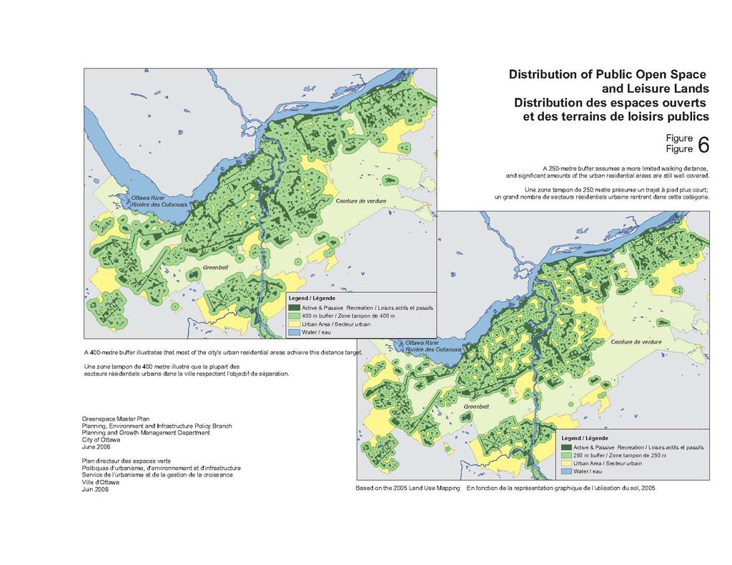
48
49 Section 3 Achieving the Vision Strategies for Achieving Accessible Greenspace In order to improve accessibility to Ottawa s urban greenspaces, the City will: Continue to ensure that residential areas are within 400 metres of publicly owned greenspace that is generally accessible to the public Explore alternate targets for accessibility to greenspace within the context of plans for specific communities or locations, including targets for areas with higher population densities or targets for access to different types of facilities Manage City-owned lands in a manner consistent with the long-term maintenance of greenspace values identified in the Urban Natural Areas Environmental Evaluation Study by preparing management plans and policies for City-owned natural areas that focus on the protection of environmental features and functions while accommodating public access and leisure uses where appropriate 3.4 Quality Greenspace Quality refers to the features and characteristics of a greenspace that determine its ability to satisfy a given need or to perform a specified function well. Council s objective is to enhance the quality of greenspaces to improve their carrying capacity and their role in the community, and to maintain or enhance the quality of natural lands to improve habitats and biodiversity. The quality of natural lands is measured differently than the quality of open space and leisure lands that are intended for public recreation. The quality of a natural area, when evaluated from a purely intrinsic, natural environment perspective, includes an assessment of the size (bigger is better), shape (approaching a square or circle is better to minimize edge effects), connectivity, species composition (sites with a diversity of species that are relatively undisturbed are favoured) and function (hydrologic functions are the most important). These characteristics can be used to assess the quality of natural areas in both urban and rural settings. All other things being equal, the quality of natural features in the rural area, rated against these criteria, will far exceed the quality of urban natural features. The relatively lower quality of urban natural features must, however, be balanced with an appreciation of the additional functions and values imparted by natural areas in an urban setting. What is rare is valued and natural features are unique within the urban landscape and thus highly valued. Natural land in the urban area also imparts individual and community health benefits, including development of strong neighbourhood ties, environmental awareness among urban residents, and a sense of tranquility and well-being. At the same time, natural land improves water quality, air quality and carbon absorption, and generally mitigates environmental degradation in the urban environment, doing so efficiently and at a low cost. Developing a sense of stewardship in the surrounding community or among community groups with a conservation interest is one of the best ways to protect natural land and its features and functions, and thus enhance its quality. A sense of stewardship and responsibility can be fostered through interpretive, on-site signage and information and education about the site, working in partnership with schools and interest groups. Strategies for Ottawa s Urban Greenspaces 37

50 Section 3 Achieving the Vision The City supports several programs that foster stewardship by community groups. For example, the City s Green Partnership Pilot Program creates opportunities for stewardship of natural areas. The program will be providing $1 million to fund innovative projects that further clean and green the city. Individuals, community organizations, service groups, business associations and non-profit organizations are encouraged to undertake projects that green communities, restore natural habitat, or create sustainable green spaces. An Environmental Achievement Award Program has been recommended that recognizes annually the exemplary contributions of private individuals and groups that sustain the environment. Quality considerations for open space and leisure lands include its location, size, and relationship to other land uses or natural features. Natural features are unique Done well, the design of open spaces increases their carrying capacity within the urban landscape and and can compensate for an overall shortfall in supply. Done well, park thus highly valued. planning in coordination with overall community planning yields a network of accessible greenspaces that physically structures the community and contributes to a high quality of life. Community planning that coordinates many potential partners and projects can result in a system of greenspaces that work together and have a greater impact than each of the individual elements would have in isolation. Well-designed park and leisure land exhibits the following qualities: Character - a place with its own identity Continuity and enclosure - a place where public and private spaces are clearly distinguished Quality of the public realm a place with attractive, well-constructed, well-maintained and successful outdoor spaces Ease of movement - a place that is easy to get around and through Legibility - a place that is easy to interpret and understand Adaptability a place that can handle change easily Diversity a place with variety and choice Strategies for Achieving Quality Greenspace In order to support the development of quality greenspaces in Ottawa, the City will: Support community initiatives to take on stewardship roles for natural land in the urban area, through the Green Partnership Program Pilot and through the city s management policies for these lands Adopt plans and policies for natural lands that will: - Identify measures to preserve, enhance and manage natural lands in a manner consistent with the purpose for which the land is acquired 38 Strategies for Ottawa s Urban Greenspaces

51 Section 3 Achieving the Vision - Inventory and update the City's information on the environmental assets of the land and identify potential issues and opportunities, both on and off-site, for the ongoing management of the land - Incorporate opportunities for public access and recreation - Identify the bodies responsible for the implementation of the management plans and the ongoing cost of doing so - Incorporate opportunities for community participation in the preparation of the management plan and identify opportunities for community partnerships in the ongoing implementation of the plan Develop design guidelines for public parks in new communities and redeveloping areas, to be implemented through community design plans and through the development review process Seek opportunities to enhance the quality of design and construction of parks and public places to improve the carrying capacity of these lands as a means to meet leisure needs of the community in particular in areas where adequacy target may not be met 3.5 Connected Greenspace The connectivity of greenspaces is as important as the connectivity of transportation systems and other systems that structure a well-designed city. Connectivity is the networking of greenspaces by connecting local parks with natural areas with recreational areas. As outlined in Section 2, creating networks of greenspace reduces the importance of the amount of open space at any specific location because it increases access to others nearby. Connecting open spaces improves accessibility, reduces the need for additional land where it is difficult to provide, and adds to the sustainability of greenspaces. Compared with individual greenspaces, connected greenspaces are more enjoyable to use and explore. Multi-use pathways are a primary means of creating connectivity within Ottawa. These pathways have grown from a Capital tourist novelty and disjointed lengths of suburban paths to a truly region-wide network. These offroad, multi-use pathways in green corridors have also become part of an increasingly viable mode of transportation, creating a network for cyclists and pedestrians en route to work and educational and leisure destinations in their community and across communities. With more than 300 km of pathways in the National Capital Region embracing parts of Ottawa and Gatineau, the NCC has been the champion and by far the most significant planner and builder of pathways in Ottawa. It continues to implement an impressive program, including over 56 km though the Greenbelt. The NCC builds pathways only on federal lands, and has almost completed this portion Connected greenspaces reduce the importance of the amount of open space at any specific location because it increases the potential to safely access others nearby. of the network. The City will be responsible for creating the network of pathways on its own land and on land such as Hydro corridors where agreements have been reached to allow pathway construction. Strategies for Ottawa s Urban Greenspaces 39
52 Section 3 Achieving the Vision In addition to pathways, other connections are provided by roadway, rapid transit and parkway corridors, hydro corridors, abandoned rail rights-of-way and unopened road allowances. These connections can provide the land base for pathway systems, and where they link natural areas, they may also support ecological functions. Roads and other infrastructure are the primary use in most corridors, but many also include greenspace elements such as multi-use pathways in landscaped boulevards. Where off-road connections between parks do not exist and are not feasible, reconstruction of roads as Green Streets can incorporate green pedestrian corridors focused on pedestrian use as well as cars. Connectivity through natural linkages between natural areas maintains ecological functions such as biodiversity and wildlife habitat. Linkages provide passage for animals requiring a variety of habitats to complete their life cycle. Linkages provide for movement and reproductive interchange between populations of plant and animal species, and they buffer natural areas and processes from adjacent land uses. Streams and creeks provide the best connections among natural areas, because they provide upland and riparian habitat for a diversity of plant and animal species. Streams that are vegetated add to the value of the connected core areas because vegetation protects migrating species from predation and improves the aquatic habitat. Connections that are shorter (less distance for an organism to travel from one area to another) and continuous (less risk of mortality and predation) are best. Most urban natural areas are no longer connected, and naturalized corridors need to be created or maintained to support them. The same pathways and corridors that link parks and open spaces can also connect natural areas if appropriately landscaped and buffering is provided to reduce impacts on the natural areas. Map 3 in Section 2, showing the Urban Greenspace Network, includes examples of natural lands that are connected by open space and leisure land corridors or could be connected by such corridors Strategies for Achieving Connected Greenspaces In order to foster connectivity among Ottawa s urban greenspaces, the City will give priority to land that fills gaps in the Urban Greenspace Network or extends the network, with respect to: Acquisition of natural land or new parkland Situating new district and community parks The location of new recreation facilities and land designated for public purposes in new and existing communities Sites for new partnership projects such as stewardship projects and capital projects with community groups, sports clubs and other partners Building the multi-use pathway Managing City owned land and encouraging design of development to improve linkages between natural land and ecological functions 40 Strategies for Ottawa s Urban Greenspaces

53 Section 3 Achieving the Vision 3.6 Sustainable Greenspace Sustainability is a management issue for both open space and leisure lands and for natural land. Resources for managing parks and recreation facilities are decreasing, which, coupled with an increasing demand on these facilities, has resulted in a steady decline in the quality of urban parks and sports facilities. Given the generally high cost of maintaining property, there is a growing unwillingness to acquire land and take on the responsibility to maintain it. There is also a shift towards larger parks that can accommodate a variety of recreational activities and a move away from the provision of a range of open space opportunities in the community. The former is a more economic approach to providing recreation facilities but works against access and engagement at the local level. Sustainable maintenance practices offer an alternative. The City has banned the use of pesticides on municipal property for cosmetic purposes, and along with the NCC, has adopted a naturalized approach to landscape maintenance where appropriate. Sustainable maintenance practices offer a cost-effective alternative to the management of land. Sustainability of natural areas is directly linked to disturbance factors; the greater the disturbance, the greater the potential to jeopardize the sustainability of the natural area over the long term. Humans disturb natural areas by encouraging invasive species by dumping yard wastes or by tracking in seeds. People who create informal pathways or mountain bike trails within natural areas encourage soil compaction, thereby decreasing the ability for oxygen to reach tree roots. Some species habitat may be compromised by human disturbance and removal of plants. Since the public invariably uses urban natural areas in public ownership, management of these areas to minimize the disturbance is key to their sustainability. An adequate buffer should be created on adjacent lands and managed so that dumping and other human activities do not impact on the natural site Strategies for Achieving Sustainable Greenspace In order to support sustainable greenspace in Ottawa, the City will: Adopt plans and policies for natural lands owned by the City that: - Identify measures to preserve, enhance and manage natural lands in a manner consistent with the purpose for which the land is acquired - Inventory and update the City's information on the environmental assets of the land and identify potential issues and opportunities, both on and off-site, for the ongoing management of the land - Incorporate opportunities for public access and recreation - Identify the bodies responsible for the implementation of the management plans and the ongoing cost of doing so Strategies for Ottawa s Urban Greenspaces 41
54 Section 3 Achieving the Vision - Incorporate opportunities for community participation in the preparation of the management plan and identify opportunities for community partnerships in the ongoing implementation of the plan Encourage public and private owners of natural lands to retain the land s natural features and functions through stewardship and design with nature principles, where any development is planned so as to minimize impacts on the natural qualities of the land 42 Strategies for Ottawa s Urban Greenspaces

55 Section 4 Implementation 4 Implementation The Greenspace Master Plan - Strategies for Ottawa s Urban Greenspaces will never be complete, in that the city s requirements for greenspace within the urban area and opportunities to provide it will continue to evolve as new communities develop and older communities redevelop. Council s objectives for greenspace are pursued in this context, on an ongoing basis across a broad range of municipal functions. These functions include responsibilities assigned under the Planning Act, Council decisions on municipal public works, and projects undertaken in partnership with others. Through these functions, Council can pursue a Greenspace Also approach in its decision-making so that greenspace objectives are considered at the same time as other objectives for managing the city s growth and development. The tools that Council will use to pursue Greenspace Also are listed below. Actions, large and small, are required to achieve the City s objectives for Greenspace. Land Use Planning Council will identify and protect greenspace in the Official Plan and Zoning Bylaw, and through Community Design Plans and other planning studies. Development Review Process As individual parcels come forward for subdivision, zoning or site plan approval, Council will act on opportunities to protect and acquire greenspace. Undertaking Public Works and Building Infrastructure Council will find ways to provide and protect greenspace when building roads and other infrastructure. Partnering with Others Council will work with the private sector, the NCC and provincial partners, conservation authorities, and community groups to provide and manage greenspace. Managing Land Council will model stewardship on city-owned land and maintain or enhance its greenspace function. Land Acquisition Council will ensure public ownership of greenspaces through acquisition and other mechanisms where appropriate and practical. In 2005, Council adopted an acquisition policy that commits it to purchase those significant greenspace lands that are designated in the City s Official Plan. These policies establish the actions that trigger Council acquiring land and the mechanisms to establish fair compensation. The Ontario Municipal Board approved this policy with the exception of sub-policy 5(f). The outstanding component deals Strategies for Ottawa s Urban Greenspaces 43
56 Section 4 Implementation with acquisition and compensation for surplus public land and is being reviewed. The whole policy adopted by the City is provided in Appendix B. 4.1 Implementation: Policies Council s policies for implementing its greenspace objectives are listed below, and include the strategies and policies in Section 2 and Land Use Planning 1. The City will adopt an Urban Natural Features Strategy to identify the priority natural areas that remain in the urban area that are worthy of protection, and to propose how these areas can be secured for the long-term through partnerships, acquisition, and other means. 2. The City will designate all major municipal parks and Urban Natural Features consistently in the Official Plan, by: Designating as Major Open Space all municipal parks of 7 ha or more that contain a diversity of facilities, including those identified in community design plans Designating all parkway corridors as Major Open Space Updating the Major Recreational Pathways schedules in the Official Plan to reflect the Urban Greenspace Network and the recommendations of the Pathway Network for Canada s Capital Region: 2006 Strategic Plan 3. The City will use community design plans and other plans as a means to: Identify all greenspace opportunities in new and redeveloping neighbourhoods Propose strategies to meet the Official Plan targets Demonstrate that the area can be linked to the Urban Greenspace Network 4. The City will implement the open space and urban forest provisions of The Downtown Ottawa Urban Design Strategy 2020 adopted by Ottawa Council and use the development review process, partnerships and public works to secure potential open spaces identified in the plans for the various precincts within the downtown. 5 When developing plans for new and existing communities, the City will give priority to land on the Urban Greenspace Network by: Situating new district and community parks on the network or as extensions to the existing network Using new local and neighbourhood parks to address network gaps and to provide connections to facilities that are not on the network Situating new recreation facilities and other public facilities on the network 6 The City will continue to pursue targets for greenspace as follows: 2 ha per 1000 population of park space or eight to ten per cent of developable land area 4 ha per 1000 population of total greenspace or 16 to 20 per cent of gross land area 44 Strategies for Ottawa s Urban Greenspaces
57 Section 4 Implementation Homes in every residential area to be within 400 m of publicly owned greenspace that is generally accessible to the public 7. Within the context of plans for specific communities or locations, the City will explore alternate targets for accessibility to greenspace, including targets for areas with higher population densities or targets for access to different types of facilities. 8. The City will endeavour to clarify the greenspace role of undeveloped, publicly owned land by initiating planning studies on the future use of undeveloped, publicly owned lands in partnership with the NCC and other public owners and in consultation with the community and other stakeholders, in order to determine the future greenspace functions of these lands that are now used as open space but are not planned or managed by the owner for that purpose. 9. The City will protect land that is planned and developed for conservation and recreation or leisure purposes through the Comprehensive Zoning By-law by zoning all city-owned parks in an open space or equivalent zoning and ensuring that there is public consultation where a municipal park is to be sold or changed to another use. 10. The City will develop design guidelines for public parks in new communities and redeveloping areas, to be implemented through community design plans and through the development review process. 11. The City will design stormwater ponds and utility corridors in such a way that they can also function as greenspace in new communities and redevelopment areas, and will incorporate hazard lands in the overall greenspace plan. These lands will not be considered as part of the public dedication required under the Planning Act, although adjacent, developable lands proposed for paths or parks may be purchased or included in the public dedication. 12. The City will adopt a Forest Strategy in 2007 that will: Evaluate forest cover in the urban and rural contexts and set targets for the forest and tree canopy for specific areas of the city Establish priorities for management plans for large municipal forests in the urban and rural area, and management policies for city-owned natural lands in the urban area, where individual management plans are not warranted by the size of the site or its features Development Review Process 1. When considering development applications, the City will build the Urban Greenspace Network by: Ensuring that the applications implement the community design plan for the area and its plan for greenspace Where no community design plan exists, seeking opportunities, where appropriate, to fill gaps and extend the network Being explicit in reports to Council about the effects of the planning decisions on the Urban Greenspace Network Strategies for Ottawa s Urban Greenspaces 45
58 Section 4 Implementation 2. When considering applications to amend the zoning by-law or to redevelop institutional sites and privately owned open spaces such as marinas, campgrounds and golf courses that allow public access, the City will: Consider opportunities to maintain the continuity of the Urban Greenspace Network Seek opportunities to maintain public access to a waterfront or otherwise provide additional greenspace to the community 3. The City will set guidelines to help interpret Official Plan policies on setbacks from watercourses within the urban area, where these are not already established in watershed, subwatershed and environmental management plans. The guidelines will include direction on minor tributaries where objectives for environmental health and protection from erosion and flood hazard can be achieved through a flexible interpretation of requirements. 4. The City will encourage a high quality of urban design that respects natural features and functions through design with nature and other strategies identified in the Official Plan, and that features landscaping and open space to achieve the urban design principles of the Plan Undertaking Public Works and Building Infrastructure 1. The City will adopt a Green Street Strategy to explore ways that Green Streets could be used to provide connections within the Urban Greenspace Network and contribute to the greening of municipal infrastructure. 2. The City will prepare an implementation plan and budget estimate for key sections of the recreational pathway system identified in the Pathway Network for Canada s Capital Region: 2006 Strategic Plan as a means of implementing parts of the Greenspace Network. 3. The City will seek opportunities to develop a connected Urban Greenspace Network through the design and location of major infrastructure by: Designing and locating stormwater management ponds so that they contribute to or enhance natural systems within the urban area, and form connections with other greenspaces in the community, where feasible and appropriate Using the lifecycle reconstruction of older roads to provide greenspace linkages to the Urban Greenspace Network, through such means as the provision of wide boulevards or landscaping treatments, where no opportunities exist to provide new greenspace land Retaining ownership of road allowances where these may maintain the potential for public access to water, public waterfront land or other important greenspaces Restoring and enhancing natural processes, natural landscapes, habitats and vegetation cover as an integral part of the utilities, works projects and maintenance of City properties and facilities Providing multi-use pathways as part of the construction of arterial roads and rapid transit facilities where appropriate 46 Strategies for Ottawa s Urban Greenspaces
59 Section 4 Implementation 4. Where transit, road, rail and utility corridors are part of the Urban Greenspace Network or cross the network, the City will accommodate the network in the design of the infrastructure. Where corridors cross the network, for example, a safe crossing should be provided so that passageways through the greenspace network are not severed. Where these corridors have potential to improve connectivity, pathways and other linkages can be provided within the corridor Partnering with Others 1. The City will support community initiatives to take on stewardship roles for natural land in the urban area, through the Green Partnership Program Pilot and through the City s management policies for these lands. 2. The City will use partnerships and agreements with other public agencies to: Develop or enhance the contribution of their lands to the Urban Greenspace Network Encourage other agencies to locate any leisure or recreation uses on the Urban Greenspace Network wherever possible 3. The City will give priority to locations on the Urban Greenspace Network for partnership projects, such as stewardship projects or new capital projects, undertaken with community groups, sports clubs, the business community and other stakeholders. 4. The City will encourage public and private owners of natural lands to retain the land s natural features and functions through stewardship and design with nature principles, where any development is planned so as to minimize impacts on the natural qualities of the land Managing Land 1. The City will manage city-owned lands in a manner consistent with the long-term maintenance of greenspace values identified in the Urban Natural Areas Environmental Evaluation Study by preparing management plans and policies for City-owned natural lands. These will focus on the protection of environmental features and functions while accommodating public access and leisure uses where appropriate. Plans and policies for natural lands will: Identify measures to preserve, enhance and manage natural lands in a manner consistent with the purpose for which the land is acquired Inventory and update the City's information on the environmental assets of the land and identify potential issues and opportunities, both on and off-site, for the ongoing management of the land Incorporate opportunities for public access and recreation Strategies for Ottawa s Urban Greenspaces 47
60 Section 4 Implementation Identify the bodies responsible for the implementation of the management plans and the ongoing cost of doing so Incorporate opportunities for community participation in the preparation of the management plan and identify opportunities for community partnerships in the ongoing implementation of the plan. 2. The City will prepare a management plan for any newly acquired natural land where the size or management requirements warrant. Where the land does not warrant an individual plan, the City will incorporate the land within an existing management plan or common management process that addresses a number of sites with common characteristics. 3. The City will not consider any land surplus to its needs until it has been evaluated in the context of its contribution to the Urban Greenspace Network, its protection or enhancement of the natural environment, or its contribution to the City's recreational open space, prior to divesting of the property. When considering the disposal of City-owned land, the City will ensure that any network function is retained. 4. The City may divest itself of parkland where it can be demonstrated that the park no longer provides a public benefit and it cannot be adapted, redeveloped or expanded to meet current public needs. In such a case, the City will inform the local community and give the community an opportunity to provide input into the decision. The money gained from the sale of the park may only be used for the purchase of new parkland or the expansion or redevelopment of an existing park in the vicinity. 5. The City will seek opportunities to enhance the quality of design and construction of parks and public places to improve the carrying capacity of these lands as a means to meet leisure needs of the community in particular in areas where adequacy target may not be met Land Acquisition 1. The City will acquire greenspace land where public ownership is required to maintain the land as greenspace by: Exploring a variety of means to acquire greenspace including: land donations for tax rebates; securing easements; and similar methods as documented in Appendix A, prior to considering the purchase or exchange of land; Acquiring greenspace land prior to urbanisation or prior to development, and to this end may initiate acquisition of land where land is valued for leisure, open space or environmental reasons; Securing public access to the shorelines of the Ottawa River, Rideau River, Rideau Canal, and other watercourses that contribute to environmental health, cultural heritage, and scenic and recreational opportunities. 48 Strategies for Ottawa s Urban Greenspaces
61 Section 4 Implementation 2. The City will pursue the acquisition of greenspace in the urban area generally with the following priorities: Land in greenspace designations in the City s Official Plan, natural lands identified as priorities based on the Urban Natural Areas Environmental Evaluation Study, waterfront land, and land identified as priorities in community design plans where there is a willing buyer / willing seller Land that fills gaps in the Urban Greenspace Network or extends the network Greenspace lands declared surplus by another public body that are identified as greenspace on Map 1 or Map 2 of this Plan Land identified in watershed or sub-watershed plans or other comprehensive study as having natural significance and that are proposed for development Land on Map 1 and Map 2 that may help to consolidate existing City land holdings or secure strategic parcels in advance of development 3. The City will adopt clear criteria to guide decisions on the acquisition of natural lands, schoolyards, and other greenspaces, and make sure that the rationale for any recommendation on a proposed acquisition is clear. 4. When considering the acquisition of greenspace, the City will consider their merit on the basis of the following criteria: Value Cultural value (e.g. association with a historic site) or inherent environmental value Current Supply - Will it meet a current shortfall? Will it address a future need, as the neighbourhood intensifies? Connectivity - Does it complete or extend the Urban Greenspace Network? Threat/Risk Will the land be used in the near term for another purpose that precludes a greenspace function? Strategic Does the acquisition build upon existing resources or commitments, or has an advantage in terms of timing or partnership opportunity? Cost and Value Is the expenditure warranted in terms of its achievement of Council s objectives? In addition, when considering acquisition of school sites, Council will consider whether the land is already being used for activities programmed by the City. 5. The City will review its current sources of funding for acquiring greenspace by: Reviewing all sources of funding for the acquisition of natural and open space and leisure lands, including the Environmental Land Acquisition Fund, the cash-in-lieu of parkland fund, and other capital programs approved or proposed in the long-range financial plan Proposing a consistent and coordinated approach to managing the funds and reporting to Council and communities on how they are used Strategies for Ottawa s Urban Greenspaces 49
62 Section 4 Implementation Monitoring and Building Our Knowledge Base 1. The City will monitor progress in achieving greenspace targets in all communities by: Assessing the greenspace identified in community design plans against City targets and confirming the land delivery as the community develops Monitoring the total area of natural land secured for environmental purposes through public ownership or other means Reporting at five-year intervals on the number of kilometres of multi-use pathway provided by the City and partners and the number of parks and other greenspaces networked by the pathway 4.2 Implementation: A Three-Year Plan Much of the Greenspace Master Plan - Strategies for Ottawa s Urban Greenspaces will be implemented on an ongoing basis, through Council decisions on plans for new communities or redevelopment sites, for example, or through the design of new municipal infrastructure and buildings. In addition, specific actions are proposed to implement the Plan and advance Council s greenspace objectives. These actions are summarized below. Notes: PGM RPAM PWS CPS Planning and Growth Management Real Property and Asset Management Public Works and Services Community and Protective Services Immediate Action For completion in 2006 Lead Department In order of priority PGM PGM/RPAM PGM PGM 1. Amend Official Plan to: - Ensure consistent designation of greenspaces - Update references to Greenspace Master Plan - Reflect policies in the Greenspace Master Plan (e.g. greenspace targets) - Update references to UNAEES and add a reference to the Urban - Natural Features Strategy 2. Adopt an Urban Natural Feature Strategy to secure priority natural land 3. Ensure that municipal parks and other publicly owned open space and leisure land is appropriately zoned 4. Promote the Greenspace Master Plan and the Urban Natural Feature Strategy within the public and private sector 50 Strategies for Ottawa s Urban Greenspaces
63 Section 4 Implementation Short-Term Actions For completion in Lead Department In order of priority PGM/RPAM PGM & RPAM PGM/PWS PGM/ PGM/CPS PGM PGM/RPAM PGM/RPAM/ CPS PGM PGM 1. Initiate Urban Natural Features Strategy as approved by Council, in consultation with other City departments and other stakeholders 2. Initiate plans to define the greenspace role and other functions of lands that are publicly owned but that are not zoned for greenspace or currently planned for that purpose 3. Extend the multi-use pathway system by preparing an implementation strategy for priority areas that complete or extend the existing network 4. Prepare a work program to plan for the natural environment areas and parks and leisure areas in the rural area 5. Prepare design guidelines for the development of Green Streets in new communities and as a means of extending the Urban Greenspace Network into older communities where other greenspace corridors may not exist 6. Prepare design guidelines for parks and open spaces for use in Community Design Plans, plans for local area and development review 7. Amend the Official Plan to update the Major Recreational pathways to incorporate the pathway associated with the City s Urban Greenspace Network and the recommendations of the NCC s Pathway Network for Canada s Capital Region: 2006 Strategic Plan 8. Preparing procedures to ensure that the City retains ownership of any of its surplus lands that have a Greenspace function 9. Develop procedures for ensuring public participation in decisions to acquire greenspace land 10. Establish guidelines in consultation with the development industry, the community, and other stakeholders to help establish appropriate setbacks from waterbodies Strategies for Ottawa s Urban Greenspaces 51

64 Section 4 Implementation Long-term Action For completion in 2009 and beyond Lead Department In order of priority PGM/PWS PGM/PWS/ CPS PGM 1. Review sources of funding for acquiring greenspace and report to Council for the 2010 budget 2 Prepare management plans for natural lands secured through the Urban Natural Features Strategy 3. Report on monitoring of Greenspace indicators 52 Strategies for Ottawa s Urban Greenspaces
Section 1 Introduction
 Section 1 Section 1,, describes the role of the Official Plan. The Official Plan is one of five growth management plans that was completed under the umbrella of Ottawa 20/20. 1.1 The Role of the Official
1 Introduction. Chapter. In this chapter:
 Chapter 1 Introduction In this chapter: 1.1 A Snapshot of the Region 1.2 Towards a Sustainable Region 1.3 The Provincial Context 1.4 Purpose and Organization The Regional Municipality of York Official
3-2 Environmental Systems
 3-2 Environmental Systems 3.0 ENVIRONMENTAL SYSTEMS CONTENTS 3.1 GREENWAY SYSTEM 3.1.1 General Policies 3.1.2 Natural Heritage Network 3.1.3 Natural Heritage Network Enhancement Lands 3.1.4 Rouge Watershed
Animating the Rideau Canal December 2013
 Executive Summary Animating the Rideau Canal December 2013 Why study the Rideau Canal? The Rideau Canal has been an important part of Ottawa throughout its history, and has shaped and been shaped by the
SECTION ONE: INTRODUCTION. introduction
 introduction 1 INTRODUCTION Since it was first established in 1843 as a trading post for the Hudson s Bay Company, Victoria has evolved into a Provincial capital city that is recognized across Canada and
Arlington, Virginia is a worldclass
 EXECUTIVE S U M M A RY Arlington maintains a rich variety of stable neighborhoods, quality schools and enlightened land use policies, and received the Environmental Protection Agency s highest award for
10.0 Open Space and Public Realm
 10.0 Open Space and Public Realm 10.0 Open Space and Public Realm The Public Open Space System is comprised of: outdoor spaces available for public use that are either publicly owned (e.g., parks and
The protection of the agricultural resources of the Province;
 PART II INTRODUCTION An Official Plan is a policy document, which is intended to serve as the basis for making land use decisions and managing change in any municipality in Ontario. According to the Planning
NEW REGIONAL OFFICIAL PLAN HIGH LEVEL PROCESS & FRAMEWORK
 NEW REGIONAL OFFICIAL PLAN HIGH LEVEL PROCESS & FRAMEWORK Why A New Official Plan Originally the role of Regionally Planning and content of Regional Official Plan (1970s) primarily focused on protecting
Municipal Development Plan 2013
 UNIQUELY STONY PLAIN: Municipal Development Plan 2013 Quick Reference Guide What is a Municipal Development Plan (MDP)? The Town s highest-level planning document Sets the long-term vision and key themes
AMENDMENT NO. 30 TO THE OFFICIAL PLAN OF THE TOWN OF MILTON
 AMENDMENT NO. 30 TO THE OFFICIAL PLAN OF THE TOWN OF MILTON Subject: Boyne Survey Secondary Plan and Related Official Plan Amendments The following text and schedules constitute Amendment No. 30 to the
Preface. Erie. Scranton. Allentown. Pittsburgh. Harrisburg. Philadelphia
 The Southern Alleghenies Region The Southern Alleghenies Region spans the Laurel Highlands and Allegheny Front in the west across the Appalachians to the east. It is comprised of Blair, Bedford, Cambria,
Sustainable Growth. Sustainable Growth
 2 Sustainable Growth Sustainable Growth SUSTAINABLE GROWTH 2.1 COMMUNITY VISION... 2-5 2.2 THE CITY SYSTEM... 2-7 2.2.1 AREAS... 2-7 2.2.2 CITY-WIDE SYSTEMS... 2-8 2.2.3 PROVINCIAL PLAN BOUNDARIES AND
A Growing Community Rural Settlement Areas
 Town of Huntsville Official Plan Review - POLICY BACKGROUND PAPER A Growing Community Rural Settlement Areas BACKGROUND: In addition to the fully municipally-serviced Urban Settlement Area and the Hidden
APPENDIX L3. Table of Contents. SWP EA Information Sheets
 E N V I R O N M E N T A L A S S E S S M E N T APPENDIX L3 SWP EA Information Sheets Table of Contents EA Info Sheet 1... L3-1 EA Info Sheet 2... L3-3 EA Info Sheet 3... L3-5 EA Info Sheet 4... L3-7 SCARBOROUGH
APPENDIX K WINDSOR OFFICIAL PLAN
 CEAA ENVIRONMENTAL ENVIRONMENTAL IMPACT ASSESSMENT AMBASSADOR BRIDGE ENHANCEMENT PROJECT Replacement Span and Plaza Expansion APPENDIX K WINDSOR OFFICIAL PLAN Avalon Consulting Professionals of Ontario,
Infrastructure, Development and Enterprise Services. Natural Heritage Action Plan (NHAP) Project Initiation
 Project Initiation") Staff Report To Service Area Committee of the Whole Infrastructure, Development and Enterprise Services Date Monday, March 6, 2017 Subject Natural Heritage Action Plan (NHAP) Project Initiation Report
Staff Report To Service Area Committee of the Whole Infrastructure, Development and Enterprise Services Date Monday, March 6, 2017 Subject Natural Heritage Action Plan (NHAP) Project Initiation Report
TERRESTRIAL NATURAL HERITAGE SYSTEM STRATEGY APPENDIX F: MODEL POLICIES FOR THE IMPLEMENTATION OF THE TARGET TERRESTRIAL NATURAL HERITAGE SYSTEM
 TERRESTRIAL NATURAL HERITAGE SYSTEM STRATEGY APPENDIX F: MODEL POLICIES FOR THE IMPLEMENTATION OF THE TARGET TERRESTRIAL NATURAL HERITAGE SYSTEM C H A P T E R 1 M O D E L P O L I C I E S F O R I M P L
CITY CLERK. Parkland Acquisition Strategic Directions Report (All Wards)
") CITY CLERK Clause embodied in Report No. 10 of the, as adopted by the Council of the City of Toronto at its meeting held on November 6, 7 and 8, 2001. 10 Parkland Acquisition Strategic Directions Report
CITY CLERK Clause embodied in Report No. 10 of the, as adopted by the Council of the City of Toronto at its meeting held on November 6, 7 and 8, 2001. 10 Parkland Acquisition Strategic Directions Report
Objectives and Strategies for the Integration of Recreation, Parks and Open Space in Regional Plans
 BULLETIN 2 Objectives and Strategies for the Integration of Recreation, Parks and Open Space in Regional Plans TABLE OF CONTENTS Introduction 3 Land-use Framework Outcomes 1 4-8 Land-use Framework Outcomes
Annotated version of the. including OPA 150. Showing proposed changes as per Amendment No. 150 DRAFT FOR INFORMATION PURPOSES ONLY
 Annotated version of the including OPA 150 Showing proposed changes as per Amendment No. 150 DRAFT FOR INFORMATION PURPOSES ONLY FOR LEGAL PURPOSES REFER TO THE ORIGINAL AMENDMENT ADOPTED BY COUNCIL ottawa.ca
1. MAKING CHOICES. What kind of city will Toronto be in the 21st century?
 1. MAKING CHOICES Toronto is a great city! It has evolved into a special place that people care about deeply. It is a wonderful city in which to live, offering a diversity and richness of urban life that
Environment and Sustainability. Environment and Sustainability
 4 Environment and Sustainability Environment and Sustainability ENVIRONMENT AND SUSTAINABILITY 4.1 CLIMATE CHANGE AND AIR QUALITY... 4-5 4.1.1 OBJECTIVES... 4-6 4.1.2 POLICIES... 4-6 4.2 NATURAL HERITAGE
RECREATION, OPEN SPACE AND GREENWAYS ELEMENT GOALS, OBJECTIVES, AND POLICIES
 RECREATION, OPEN SPACE AND GREENWAYS ELEMENT GOALS, OBJECTIVES, AND POLICIES GOAL R-1: DEVELOP A RECREATION, OPEN SPACE AND GREENWAYS SYSTEM AS AN INTEGRAL COMPONENT OF AN OVERALL, COUNTY-WIDE ECONOMIC
This page intentionally blank.
 This page intentionally blank. Parks, Recreation, and Open Space Chapter Relationship to Vision Vision Parks, Recreation and Open Space Chapter Concepts County Government. County government that is accountable
Mark-up of the effect of the proposed Bronte Village Growth Area OPA No.18 on the text of section 24, Bronte Village, of the Livable Oakville Plan
 Mark-up of the effect of the proposed Bronte Village Growth Area OPA No.18 on the text of section 24, Bronte Village, of the Livable Oakville Plan Notes: This document is provided for information purposes
HAZARD MITIGATION GOALS AND OBJECTIVES
 SEWRPC Community Assistance Planning Report No. 282, 2nd Edition CITY OF MILWAUKEE ALL HAZARDS MITIGATION PLAN UPDATE Chapter IV HAZARD MITIGATION GOALS AND OBJECTIVES [NOTE: Throughout this plan update
Great Lakes Conservation Blueprint for Terrestrial Biodiversity on the Canadian Shield
 Great Lakes Conservation Blueprint for Terrestrial Biodiversity on the Canadian Shield Bonnie L. Henson 1, Kara E. Brodribb 2 and John L. Riley 3 1 Ontario Ministry of Natural Resources 2,3 The Nature
This page has been intentionally left blank.
 This page has been intentionally left blank. Chapter 3 3-2 3. Employment 3.A Niagara Economic Gateway 3.A.1 General The Niagara Economic Gateway comprises: a) The Gateway Economic Zone which includes all
OFFICIAL PLAN FOR THE TOWN OF NEW TECUMSETH
 OFFICIAL PLAN FOR THE TOWN OF NEW TECUMSETH Approved by Simcoe County- March 10, 2010 TABLE OF CONTENTS PAGE# 1.0 TITLE AND COMPONENTS... 5 2.0 INTRODUCTION... 6 2.1 Purpose... 6 2.2 Organization of the
North Oakville East Parks Facilities Distribution Plan. November, 2009
 North Oakville East November, 2009 POLICY CONTEXT 1) Purpose a) The purpose of this document is to be a guide for the location, configuration, design and development of the parks system for the North Oakville
THE CORPORATION OF THE CITY OF WINDSOR Office of the City Solicitor Planning Department
 THE CORPORATION OF THE CITY OF WINDSOR Office of the City Solicitor Planning Department REPORT TO THE CITY OF WINDSOR PLANNING ADVISORY COMMITTEE DATE OF REPORT: August 19, 2010 SUBJECT: Official Plan
RECREATION AND OPEN SPACE ELEMENT GOALS, OBJECTIVES, AND POLICIES
 RECREATION AND OPEN SPACE ELEMENT GOALS, OBJECTIVES, AND POLICIES Goal 7 To provide park facilities, recreation programs, and open space resources that are safe, adequate, and accessible to all City residents,
RECOMMENDED DIRECTIONS REPORT FOR THE TOWN OF RICHMOND HILL
 RECOMMENDED DIRECTIONS REPORT ENVIRONMENTAL POLICY REVIEW FOR THE TOWN OF RICHMOND HILL Prepared for: Town of Richmond Hill 225 East Beaver Creek Road Richmond Hill, ON, L4B 3P4 Prepared by: SENES Consultants
2.0 A FRAMEWORK FOR SUSTAINABLE GROWTH CONTENTS
 2-2 A Framework for Sustainable Growth 2.0 A FRAMEWORK FOR SUSTAINABLE GROWTH CONTENTS 2.1 MANAGING SUSTAINABLE GROWTH THE VISION TO 2031 2.2 GOALS AND OBJECTIVES 2.2.1 Protecting the Natural Environment
CONTENTS 2.0 A FRAMEWORK FOR SUSTAINABLE GROWTH 2.1 MANAGING SUSTAINABLE GROWTH THE VISION TO GOALS AND OBJECTIVES 2.3 MARKHAM STRUCTURE
 2 A Framework for Sustainable Growth 2.0 A FRAMEWORK FOR SUSTAINABLE GROWTH CONTENTS 2.1 MANAGING SUSTAINABLE GROWTH THE VISION TO 2031 2.2 GOALS AND OBJECTIVES 2.2.1 Protecting the Natural Environment
Parks, Open Space and Trails
 Introduction Parks have often been referred as the lungs of our cities, cleansing the air of pollutants and particulate matter. Parks are also gathering places for families and community. They offer spaces
Whitemarsh Township Greenway Plan
 Whitemarsh Township Greenway Plan Prepared for: Whitemarsh Township August 16, 2007 Table of Contents Table of Contents... i Introduction... 1 Study Area Setting... 2 Regional Setting... 2 Township Character...
1.0 PLANNING MARKHAM S FUTURE CONTENTS
 1-1 Planning Markham s Future 1.0 PLANNING MARKHAM S FUTURE CONTENTS 1.1 THE PURPOSE OF THE OFFICIAL PLAN 1.2 THE MARKHAM CONTEXT 1.3 THE REGULATORY CONTEXT 1.3.1 Province of Ontario 1.3.2 York Region
Summary of Changes for the Comprehensive Draft Proposed Official Plan Amendment
 Summary of Changes for the Comprehensive Draft Proposed Official Plan Amendment Note: Due to the broad scope of the Official Plan Review, this list is not exhaustive of the extent of changes in the comprehensive
Table 8-4: Road Classification Local Roads, second table, of Chapter 8 Create a Multi-Modal City, be amended by adding the following:
 1 Port Street East Official Plan Amendment APPENDIX 3 Amendments to Mississauga Official Plan Table 8-4: Road Classification Local Roads, second table, of Chapter 8 Create a Multi-Modal City, be amended
Former Rockcliffe Airbase Community Design Plan Guiding Design Vision and Principles December 4, 2013
 APPENDIX 5 - Guiding Design Vision and Principles Former Rockcliffe Airbase Community Design Plan Guiding Design Vision and Principles December 4, 2013 Vision Statement The redevelopment of the former
Parks Master Plan Implementation: Phase I Waterfront Use and Design REPORT #: September 7, 2016 File #
 0 'O DI Lan-171-14 1 - THE CORPORATION OF THE TOWN OF COBOURG..,. STAFF REPORT TO: FROM: Mayor and Members of Council Dean A. Hustwick, Director of Recreation and Culture DATE OF MEETING: Committee of
SECTION FOUR: MISSION STATEMENT, GOALS & OBJECTIVES
 SECTION FOUR: MISSION STATEMENT, GOALS & OBJECTIVES Chapter Summary Chapter Ten: Mission Statement, Goals & Objectives To fulfill its mission, the Parks and Recreation Commission has identified four basic
Draft Amendment to the City of Ottawa Official Plan
 Draft Amendment to the City of Ottawa Official Plan showing proposed text changes How to read this document Added or altered text (June 25, 2013) is highlighted Deleted text (June 25) is shown in strike
Official Plan Review
 Official Plan Review Summary Report - The Built Environment August 2014 Part 1: Introduction Planning for a healthy, prosperous and sustainable community is an important goal for our municipality. From
Edward R. Sajecki Commissioner of Planning and Building
 Corporate Report Clerk s Files Originator s Files CD.03.POR DATE: TO: FROM: SUBJECT: Chair and Members of Planning and Development Committee Meeting Date: February 27, 2012 Edward R. Sajecki Commissioner
Comprehensive Plan ADOPTED APRIL 2014
 Comprehensive Plan ADOPTED APRIL 2014 8 8. Outstanding Recreational & Cultural Opportunities We are proud of our community s parks and recreation system. Our community will ensure that the legacy of our
THE CORPORATION OF THE TOWN OF OAKVILLE BY-LAW NUMBER
 THE CORPORATION OF THE TOWN OF OAKVILLE BY-LAW NUMBER 20012-08530 A by-law to adopt an amendment to the Official Plan of the Oakville Planning Area (Official Plan Amendment 198) Land North of Dundas Street.
Township of Adjala-Tosorontio Official Plan Review. Natural Heritage
 Township of Adjala-Tosorontio Official Plan Review 13 Natural Heritage Introduction What is an Official Plan? An official plan is a municipal policy document which sets out the community s vision and strategies
Town of Cobourg Heritage Master Plan. Statutory Public Meeting
 Town of Cobourg Heritage Master Plan Statutory Public Meeting April 25 th 2016 Presentation Overview 1. Introduction 2. Project background and schedule overview 3. Review of strategic direction content
APPENDIX I Presentations
 APPENDIX I Presentations Workshop Summary Report 11 Peel Region Official Plan Review May 5, 2010 Compatible Active Recreation Workshop July 29, 2010 Components of PROPR Sustainability Planning Tools/Updates
Draft Stillwater 2030 Comprehensive Plan- Goals and Policies
 Draft Stillwater 2030 Comprehensive Plan- Goals and Policies Instructions- Review each goal and policy and discuss with group any changes, deletions for additions to the list using your groups pen. Keep
ELK GROVE GENERAL PLAN VISION
 2-1 CHAPTER 2: 2-2 CREATING OUR The Community Vision for Elk Grove, expressed through a Vision Statement and a series of Supporting Principles, is a declaration of the kind of community that Elk Grove
Town of Peru Comprehensive Plan Executive Summary
 Town of Peru Comprehensive Plan Executive Communities that plan grow by choice, not by chance. A plan makes growth thoughtful, understandable, and predictable. A plan shows that a community is managing
OPEN SPACE CHAPTER 7: OVERVIEW. Preserve open space to protect natural resources, enhance character and provide passive recreation opportunities
 CHAPTER 7: OPEN SPACE OVERVIEW Ridgefield has made tremendous progress permanently preserving areas of town as open space. Open space preservation can serve many important purposes, including: protect
Master Environmental Servicing Plan & Secondary Plan
 East Side Lands Stage 2 1 Master Environmental Servicing Plan & Secondary Plan Public Information Centre #1 June 16, 2016 Welcome! Today s Agenda Please sign in at the front desk. 5:30 pm 6:30 pm: Open
The West Vaughan Employment Area Secondary Plan Policies
 Part 2: The West Vaughan Employment Area Secondary Plan Policies 2.1 General Policies It is the policy of Council: 2.1.1. That the West Vaughan Employment Area (the WVEA), identified on Schedule 1, will
THE STRUCTURE OF THE PLAN...
 TABLE OF CONTENTS THE STRUCTURE OF THE PLAN... 1 A1 THE COMMUNITY VISION... 3 A2 GOALS AND OBJECTIVES... 3 A2.1 THE NATURAL ENVIRONMENT... 3 A2.1.1 Goal... 3 A2.1.2 Objectives... 3 A2.2 GROWTH AND SETTLEMENT...
Chapter 1. Community Context. Vision Statement Population and Housing Trends Legislative Context Regional Context Statement
 Chapter 1 Community Context Vision Statement Population and Housing Trends Legislative Context Regional Context Statement 1.1 VISION STATEMENT CORPORATE MISSION STATEMENT To promote a safe and livable
Report to: Development Services Committee Report Date: April 24, 2017
 SUBJECT: Cornell Rouge National Urban Park Gateway - Report on Design Charrette and Next Steps PREPARED BY: Lilli Duoba, MES, MCIP, RPP, Manager, Natural Heritage (ext. 7925) REVIEWED BY: Marg Wouters,
PORT WHITBY COMMUNITY
 PORT WHITBY COMMUNITY SECONDARY PLAN UPDATE COMMUNITY IMPROVEMENT PLAN URBAN DESIGN GUIDELINES September 2015 DRAFT PROPOSED AMENDMENT NUMBER # to the Whitby Official Plan PURPOSE: The intent of this Amendment
Uptown Rideau Street Secondary Plan [Amendment #166, January 12, 2016]
![Uptown Rideau Street Secondary Plan [Amendment #166, January 12, 2016]](/thumbs/76/73760497.jpg "Uptown Rideau Street Secondary Plan [Amendment #166, January 12, 2016]") [Amendment #166, January 12, 2016] The policies of this Secondary Plan are in effect, save and except for the property at 560 Rideau Street, for which there remains a site specific appeal to this Secondary
[Amendment #166, January 12, 2016] The policies of this Secondary Plan are in effect, save and except for the property at 560 Rideau Street, for which there remains a site specific appeal to this Secondary
4 Sustainability and Growth Management
 4 Sustainability and Growth Management Introduction Traditionally, has assumed growth and development with limited consideration for the long-term negative social, environmental or economic impacts on
THREE-STEP DESIGN PROCESS FOR OPEN SPACE SUBDIVISIONS
 00216106.DOC NMA/RRK 1/30/14 THREE-STEP DESIGN PROCESS FOR OPEN SPACE SUBDIVISIONS Open space subdivisions, sometimes called cluster developments, maintain a significant portion of a development site in
OFFICIAL PLAN of the TOWN of BRADFORD WEST GWILLIMBURY Adopted February 15, 2000
 OFFICIAL PLAN of the TOWN of BRADFORD WEST GWILLIMBURY Adopted February 15, 2000 OFFICE CONSOLIDATION (Consolidated to October 1, 2002) J. Ross Raymond & Associates Ltd Gravenhurst, Ontario Building Community
Surrey Ecosystem Management Study
 Surrey Ecosystem Management Study Green Infrastructure Network Opportunities Public Open House & Information Session June 24 th, 2010 EMS Process Ecological Inventory Ecological Assessment Management Policy
TRCA Field Staking Protocol December 2016
 Page 1 of 6 TRCA Field Staking Protocol December 2016 This Protocol describes TRCA staff s current practice for field staking the physical top of bank, the physical toe of slope, and the limit of existing
{Best Practices. Summary of Tools, Strategies and Best Practices from 11 Michigan Case Study Communities
 Case Studies Michigan Coastal Community Working Waterfronts { Summary of Tools, Strategies and from 11 Michigan Case Study Communities Table of Contents Zoning...2 Community and Stakeholder Collaboration
City of Surrey Ecosystem Management Study. Integration of ecological processes with land use
 City of Surrey Ecosystem Management Study Integration of ecological processes with land use Natural areas in Surrey are changing as the City grows and evolves. Many important natural areas remain or may
DAVENPORT VILLAGE SECONDARY PLAN
 27 DAVENPORT VILLAGE SECONDARY PLAN 27. DAVENPORT VILLAGE SECONDARY PLAN 1. VISION FOR THE DAVENPORT VILLAGE SECONDARY PLAN Davenport Village, municipally known as 830, 940, 980 and 1100 Lansdowne Avenue,
section 3: Vision, Values and Goals
 Vision, Values and Goals 3 2041 Vision: Victoria is an urban sustainability leader inspiring innovation, pride and progress towards greater ecological integrity, livability, economic vitality, and community
Western Sydney Parklands Australia s Largest Urban Park
 Western Sydney Parklands Australia s Largest Urban Park 37 WLA 1 MAGAZINE 21 38 WESTERN SYDNEY PARKLANDS AUSTRALIA S LARGEST URBAN PARK Large urban parks have dual roles to play in meeting the demands
4. What are the goals of the Kawarthas, Naturally Connected project? 7. What are watersheds and why are they being used as the project boundaries?
 Frequently Asked Questions (FAQs) 1. What are Natural Heritage Systems (NHS)? 2. Why are they important? 3. Which areas of the province have undertaken NHS projects? 4. What are the goals of the Kawarthas,
Ottawa County Parks, Recreation & Open Space Plan. February, 2006
 2006 Ottawa County Parks, Recreation & Open Space Plan February, 2006 TABLE OF CONTENTS ACKNOWLEDGMENTS.................................................... v PLAN ADOPTION..........................................................vi
20 & 30 Frank Nighbor Place
 Engineering Land / Site Development Municipal Infrastructure Environmental / Water Resources Traffic / Transportation Structural Recreational Planning Land / Site Development Planning Application Management
CITY OF LANGLEY OFFICIAL COMMUNITY PLAN BYLAW, 2005, NO APPENDIX II - REGIONAL CONTEXT MAP
 CITY OF LANGLEY OFFICIAL COMMUNITY PLAN BYLAW, 2005, NO. 2600 APPENDIX II - REGIONAL CONTEXT MAP ± Legend Agricultural Mixed Employment Industrial Conservation & Recreation Regional City Centre Urban Containment
G. RECREATION AND OPEN SPACE ELEMENT. The following summarizes the Recreation and Open Space Element:
 G. RECREATION AND OPEN SPACE ELEMENT The purpose of the Element is to provide the framework and direction for a comprehensive system of public and private sites for recreation, including, but not limited
City of Surrey Ecosystem Management Study. Integration of ecological processes with land use
 City of Surrey Ecosystem Management Study Integration of ecological processes with land use Natural areas in Surrey are changing as the City grows and evolves. Many important natural areas remain or may
Central Lake Ontario Conservation Conservation Lands Master Plan
 Conservation Lands Master Plan Top 13 Frequently Asked Questions 1. What are conservation lands? Where are these conservation lands located in the Central Lake Ontario Conservation watershed? Conservation
Complete Neighbourhood Guidelines Review Tool
 Complete Neighbourhood Guidelines Review Tool Prepared By: City of Regina Planning Department October 2014 Page 1 of 14 Community Development Review Checklist for Secondary Plans and Concept Plans The
FORMER CANADIAN FORCES BASE (CFB) ROCKCLIFFE SECONDARY PLAN. Official Plan Amendment XX to the Official Plan for the City of Ottawa
 ROCKCLIFFE SECONDARY PLAN. Official Plan Amendment XX to the Official Plan for the City of Ottawa") FORMER CANADIAN FORCES BASE (CFB) ROCKCLIFFE SECONDARY PLAN Official Plan Amendment XX to the Official Plan for the City of Ottawa 1 INDEX THE STATEMENT OF COMPONENTS PART A THE PREAMBLE PAGE Purpose...
FORMER CANADIAN FORCES BASE (CFB) ROCKCLIFFE SECONDARY PLAN Official Plan Amendment XX to the Official Plan for the City of Ottawa 1 INDEX THE STATEMENT OF COMPONENTS PART A THE PREAMBLE PAGE Purpose...
Section 3 Designations and Land Use
 Section 3 The previous section of this Plan laid out the City s broad policies that will govern growth and change in Ottawa over the coming decades. This section of the Plan provides more detailed direction
DRAFT FOR PUBLIC REVIEW. Game Plan for a Healthy City
 DRAFT FOR PUBLIC REVIEW 2018 Game Plan for a Healthy City 2 Denveright. Parks & Recreation Game Plan Draft for Public Review Draft for Public Review Executive Summary Game Plan Overview Executive Summary
HALIFAX GREEN NETWORK PLAN
 HALIFAX GREEN NETWORK PLAN Community Planning & Economic Development Standing Committee June 21, 2018 Photo credit: Vlastimil Koutecky, Flickr Creative Commons HGNP PROCESS PHASE 1 FOUNDATIONS PHASE 2
WASHINGTON COUNTY OREGON
 WASHINGTON COUNTY OREGON LONG RANGE PLANNING DIVISION North Bethany Subarea Stream Corridors: Existing Regulations In Oregon, there is a distinct difference between the land use rules that apply in rural
THE GARDEN CITY PLAN. City of St. Catharines Official Plan. City of St. Catharines
 THE GARDEN CITY PLAN City of St. Catharines Official Plan City of St. Catharines August 2010 APPROVAL INFORMATION This Official Plan of the City of St. Catharines Planning Area, known as the Garden City
Executive Summary Purpose of the Plan Defining Open Space and Greenways
 Executive Summary Bucks County possesses a vast array of open space resources including natural areas, parks, farmland and historic and cultural resources that contribute to a high quality of life valued
CITY OF COLWICH COMPREHENSIVE PLAN LAND USE LAND USE 1
 LAND USE LAND USE 1 WHAT YOU WILL FIND IN THIS CHAPTER: Discussion of today s conditions and tomorrow s projections Discussion of challenges and opportunities Discussion of the environmental quality goals,
2.0 A FRAMEWORK FOR SUSTAINABLE GROWTH CONTENTS
 2-2 A Framework for Sustainable Growth 2.0 A FRAMEWORK FOR SUSTAINABLE GROWTH CONTENTS 2.1 MANAGING SUSTAINABLE GROWTH THE VISION TO 2031 2.2 GOALS AND OBJECTIVES 2.2.1 Protecting the Natural Environment
I. STAFF POLICY RECOMMENDATIONS. The following RMP policy strategies are proposed by staff in support of a Scenic Resource Protection Program:
 Policy Consideration: Scenic Resource Protection Program Status: For Consideration by the Highlands Council at September 14, 2006 Work session Date: September 12, 2006 I. STAFF POLICY RECOMMENDATIONS The
Welcome. Walk Around. Talk to Us. Write Down Your Comments
 Welcome This is an information meeting introducing the applications for proposed redevelopment of the Yorkdale Shopping Centre site at 3401 Dufferin Street and 1 Yorkdale Road over the next 20+ years,
DEFINED VILLAGE CENTRES & NEIGHBOURHOODS
 DEFINED VILLAGE CENTRES & NEIGHBOURHOODS residents in Nanoose Bay support focusing attractive, planned future development in Red Gap Centre and the Area s neighbourhood centres. In addition, the development
City of Missoula and Missoula County Open Space Planning Open House
 City of Missoula and Missoula County Open Space Planning Open House FEBRUARY 6, 2018 The following slides contain the display board content from the open house. Please use boards to answer questions in
NORTHERN LANDS NORTHERN LEADERSHIP
 NORTHERN LANDS NORTHERN LEADERSHIP The GNWT Land Use and Sustainability Framework Our Lands, Our Interests, Our Future ii Land is Life MESSAGE FROM THE PREMIER Land is life. It is the link to our past.
Regional Context Statement
 Regional Context Statement REGIONAL CONTEXT STATEMENT 3. REGIONAL CONTEXT STATEMENT In 1995, the Provincial Government passed into law the Growth Strategies Act. The purpose of this provincial initiative
CONTENTS 8.0 LAND USE 8.1 GENERAL LAND USE 8.2 RESIDENTIAL 8.3 MIXED USE 8.4 COMMERCIAL 8.5 EMPLOYMENT LANDS
 8-2 Land Use 8.0 LAND USE CONTENTS 8.1 GENERAL LAND USE 8.1.1 Uses provided for in all Land Use Designations 8.1.2 Uses prohibited in Hazardous Lands, Hazardous Sites and Special Policy Areas 8.1.3 Uses
OPEN SPACE AND RECREATION
 OPEN SPACE AND RECREATION The Town celebrates and maintains the spectacular visual character of our Sonoran Desert setting and we value our open space, mountain views, washes, vegetation, and wildlife.
Chairman and Members of the Planning and Development Committee. Thomas S. Mokrzycki, Commissioner of Planning and Building
 LA.09.TOR (Toronto) DATE: TO: FROM: SUBJECT: Chairman and Members of the Planning and Development Committee Thomas S. Mokrzycki, Commissioner of Planning and Building Central Waterfront Secondary Plan
WINCHESTER TOWN 3.1 LOCATION, CHARACTERISTICS & SETTING
 WINCHESTER TOWN 3.1 LOCATION, CHARACTERISTICS & SETTING 3.1.1 The area referred to by the City Council, as Winchester Town, consists of the Winchester Wards plus the adjoining built up areas of Badger