Erosion Control and Re-spread Depths
|
|
|
- Cecily Hamilton
- 5 years ago
- Views:
Transcription
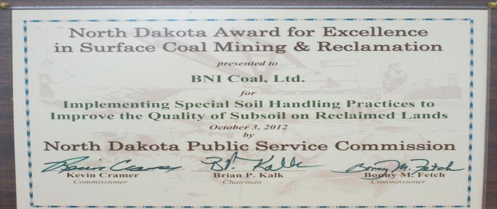
1 Erosion Control and Re-spread Depths Jay M. Volk, Ph.D. Environmental Manager, BNI Coal
2 My Time With You Today: Myself and BNI Coal, who we are Soil Erosion Land Management View Sediment Transport Erosion Control Data Review of Soil Re-spread Depths


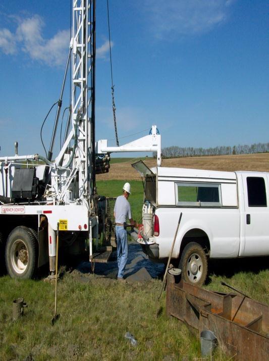
3 Center Mine Location Center, ND.
 Unit 2 started in 1977 (4.2 4.")
4 QUICK FACTS Started mining in Center in 1970 Unit 1 (1.5 million tons/yr) Unit 2 started in 1977 ( million tons/yr) Deliver approximately 90,000 tons/week


5 WHO IS BNI COAL? North Dakota Operations: BNI Coal, Allete Renewable Resources, Inc, MP, Allete Clean Energy, and Rendfield Land Company, Inc. 5
6 6

7

8 8


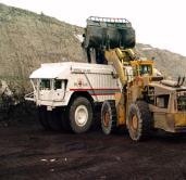
9 Dragline Bench A DAY AT THE MINE Mining Direction Reclaimed Land Re-spread Topsoil/Subsoil Pre-Mine Pre-strip topsoil and subsoil (grids) Stock Pile Spoil Clean Water Diversion
10 On to Today s Topics We all know the basics of erosion processes, sediment transport, and erosion control and most know the basics of what to do to minimize, prevent, or be proactive/reactive to these (or our permits tell us).. But: Do we understand the root cause and the land management side? Do we understand the landscape water flow?
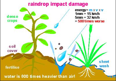
11 Erosional Factors Rainfall erosivity Amount and Intensity Soil erodibility spend time on this How the soil responds to rainfall energy texture, aggregation, clays harder to detach sands harder to move, silts worst Topography Slope length defines energy runoff will have to transport Steepness the steeper = more energy Management Reduce local erosion leave cover on surface promote infiltration Change runoff path Diversions (eliminate amount of water) Slow down and spread out runoff => dissipates energy and lets sediment settle out = better water quality downstream
12 LANDSCAPE WATER FLOW I I P Pe i Ho Tf Dp I =infiltration P= precipitation Ho=Runoff Ro=reflow Tf=throughflow Dp=deep water flow Ro Ro=Return Flow Pe i =evaporation Cant control P, can work on slowing down Ho, increasing I and Dp...We are stuck with Texture and slope
13 Soil classes & particle sizes Texture EX: 50% sand, 20% silt 30% clay? Sandy Loam

")

14 Soil Texture 1) water flow potential, 2) water holding capacity, 3) vegetation direct effects Shallow Gravel Thin Upland Silty


15 Vegetation How does percent cover, species diversity, or land use affect vegetation and runoff?

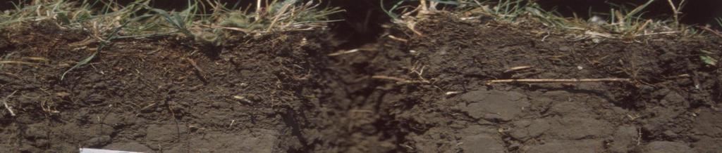
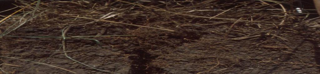
16 Does Localized Management Affect Runoff?

17 Infiltration Rates Correlate with Management
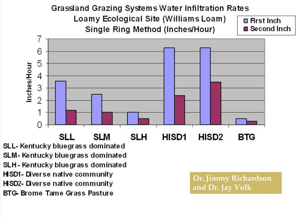
18 Infiltration Rates
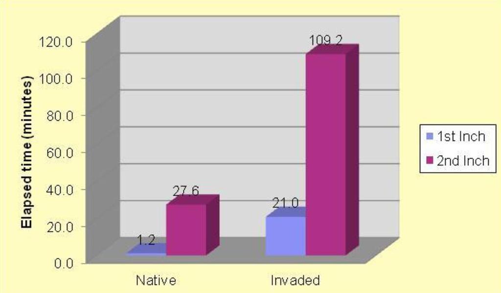

19 Infiltration Native vs. Invaded
20 % STABLE AGGREGATES SURFACE 6 IDLE ROTATION SEASON PLOWED LONG Disturbed Lands? 95% 95% 95% 73% Soil in jar example?

21 DEPTH OF WATER PENETRATION AN EVEN VOLUME OF WATER ADDED Runoff & Evaporation STRUCTURE WELL AGGREGATED STRUCTURE AGGREGATED STRUCTURE POORLY AGGREGATED Aggregation: What kind of structure does a disturbed soil have?

22 I Would Argue These Soils Have Different Structure How s Ho/I Affected Can anybody tell me about these soils?
23 Structure
24 So How Does Knowing About Landscape Water Help me Understand Erosion? Pro active Verses Reactive Understand how much and how fast water Many modeling methods are excellent tools but more insight can be gained by understanding localized management Slow water prior to the point of disturbance Buffers (what kinds), what utilization of these buffers, what species (broad leaf or grasses) ect. Landscapes can work with you to dissipate water quicker
25 Understanding Management Can Only Help You So Much, You Still Have To Be Smart About Your Disturbance and How You Manage It

26 Four Types of Soil Erosion on Exposed Slope Point of Management Detachment Raindrop impact Sheet Flow Transport Raindrop impa Sheet Flow Your permit likely tells what bmp to use in a slope as this, but does it tell you what you can do above the point of disturbance? Buffers, diversions, ponds, ect. Deposition
 will occur somewhere")
27 The Erosion Process Soil erosion is a multi-step process: Soil particle/aggregate detachment Soil particle/aggregate transport Soil particle/aggregate deposition There must be detachment and transport for erosion to occur Deposition (sedimentation) will occur somewhere downstream
28 Control of Soil Erosion by Water Detachment limiting strategies Reduce raindrop impact ( Stop the Drops ) Reduce runoff Reduce detachment capacity of runoff Increase soil resistance to erosive forces Transport limiting strategies Reduce runoff volume Reduce runoff transport capacity ( Slow the Flow ) How do we transport less?
29 Example No-Till or Mulched Area Detachment how limited Raindrop impact detachment is very low due to high surface cover percentage stop the drops Flow shear detachment is low due to slower water movement caused by residue obstructing flow path Soil is resistant to erosion because of low disturbance Transport how limited Raindrop transport is limited by surface residue Flow transport is limited by increased infiltration, lessening runoff slow the flow Flow transport is further limited by small dams created by surface residue
30 What Side Is Limiting Detachment and Transport *Over tillage breaks macropores

31 Detachment There are many sources of force and energy required to detach soil particles & aggregates: Raindrop impact Shallow surface flow shear Concentrated flow shear Many more, at larger scales Rain drops average 1-7mm and can hit ground at 20+ mph; can dislodge particles 3-5 away (USDA)

32 Detachment USDA-NRCS
33 Transportation Many of the same processes contribute force and energy for soil particle & aggregate transport: Raindrop impact Shallow surface flow Concentrated surface flow Channelized flow Others
34 Transportation Vegetated Diversions Rock Rip-Rap


35 Reduce Transport Capacity Slow the flow Barriers Must let water pass, though slowly Must be flow-stable, even after use Must be where maintenance is possible Reduce slope steepness Channel must be of adequate capacity Increase infiltration
36 Three Basic Take Home Points On Erosion Focus on Understanding 3 Areas Know your permit..did not talk about this, but in this holds a key to success Understand how specific land management affects infiltration, runoff, and ultimately erosion potential Focus on strategies that limit the detachment of soil and transport of soil particles
37 DATA REVIEW of SOIL RE-SPREAD and DEPTHS Sarah Flath The Coteau Properties Company Beulah, ND 2009 ASMR Meeting Billings, MT


38 SPGM Removal Overview Salvage all topsoil and enough subsoil to meet required re-spread depth


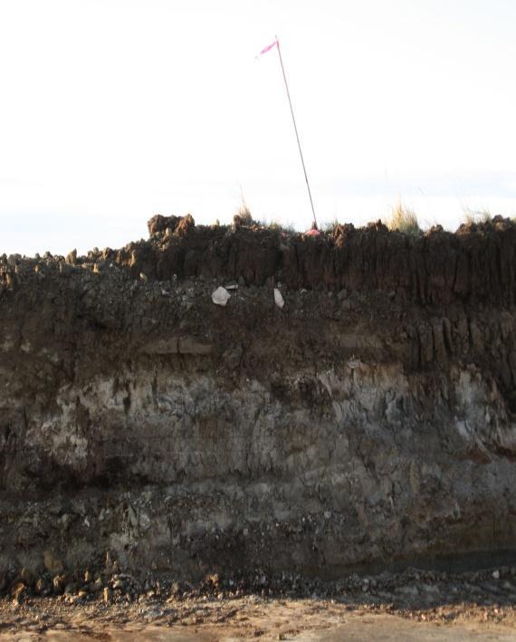
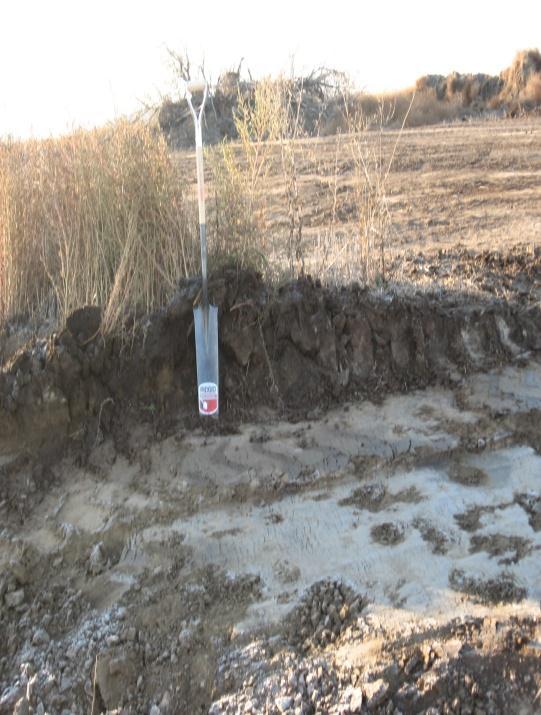
39 Re-Spread - Overview Approximate Original Contour (AOC) SPGM Re-spread Thickness Texture SAR TS/SS inches Medium <12 24 inches Coarse <12 36 inches NA inches NA >20 48 inches Based on recommendations made by Doll et al. (1984)?
40 Introduction Three decades of research on soil salvage and replacement Soil respread may be the most important part of the restoration process but also the most costly The optimal depth is the minimum amount of soil necessary to maximize reclamation success Our regulations developed 20+ years ago (Flath, 2009)
. Long term site development has been studied (Bowen et al., 2005; Redente et al., 1997; Wick et al., 2005). (Flath, 2009)")
41 Background (Re-spread Depths) Researchers have suggested that shallower depths may be acceptable (Fox, 1993; Kirby et al., 1993; Redente et al., 1997; Schladweiler et al, 2005). Long term site development has been studied (Bowen et al., 2005; Redente et al., 1997; Wick et al., 2005). (Flath, 2009)
42 Data Review - Rangelands Rangeland Diversity is often higher with shallower respread depths (Bowen et al., 2005; Redente et al., 1997; Schladweiler et al., 2005; Wick et al., 2005). Seasonality is improved by shallower depths because it allows C4 grasses to be able to compete with C3 grasses (Wick et al., 2005). Production and cover increase linearly with soil thickness to an optimal depth, after which additional soil has no marked increase (Power et al., 1981; Merrill et al., 1998; Redente and Hargis, 1985). Production sets the lower limit for respread depths (Merrill et al., 1998), is a good indicator of many site characteristics (Hargis and Redente, 1984), is widely used by research and is the primary concern for most landowners. Multiple studies included native and introduced species and concluded the same depth was necessary for both (Introduced verses native and C3 verses C4) (Flath, 2009)
.")
43 Data Review - Cropland Cropland Depth necessary to maximize cropland production may be greater than for perennial grasses (Merrill et al., 1998 and Power et al., 1981). (Flath, 2009)
44 Data Review Do Depth Requirements Change With Time? Three studies Study 1 Redente et al. (1997) revisited a 10 year old site with varying soil depths (15, 30, 45 and 60 cm) respread over generic spoil. Results were the same as earlier (Redente and Hargis, 1985), with 60 cm maximizing production. Site maturation did not affect the appropriateness of respread depth recommendations (Flath, 2009)
 of varying topsoil depths (0, 20, 40, 60 cm) respread over generic spoil Respread depth recommendations didn t change after 24 years.")
45 Data Review Do Depth Requirements Change With Time? Study 2 Bowen et al. (2005) follow up study of Schuman et al. (1985) of varying topsoil depths (0, 20, 40, 60 cm) respread over generic spoil Respread depth recommendations didn t change after 24 years. Although shallower respread depths improved diversity and species richness, 40 cm was still necessary to maximize production and cover. (Flath, 2009)
46 Data Review Do Depth Requirements Change With Time? Study 3 Wick et al. (2005) follow up study of Merrill et al. (1998) with moderately sodic spoil (SAR = 14.6) and Power et al. (1981) with sodic spoil (SAR = 25) After 30 years there was only a weak relationship between soil depth, soil properties, production, cover and diversity (Wick et al., 2005). Changes in soil properties as the site matured did not make initial respread recommendations inadequate. (Flath, 2009)
47 Data Review: Generic Spoil (SAR <12) Spoil without negative properties can act as a rooting medium (Redente and Hargis, 1985) so shallow soil depths are adequate. Spoil acts as the subsoil of the reclaimed site (DePuit, 1984). Depth of soil doesn t determine the depth of the root zone, but may effect nutrient and water status of the upper portion (Redente and Hargis, 1985). (Flath, 2009)
48 Data Review: Generic Spoil (SAR <12) 40 cm may be adequate (Bowen et al., 2005; Pinchak et al., 1985; Schuman et al., 1985). Greenhouse and field trials found that a minimum of 46 cm is required (McGinnies and Nicholas 1980, 1983). Barth and Martin (1984) recommended 50 cm of soil. Redente and Hargis (1985) reported a slight increase in production from 45 cm to 60 cm of soil but later found similar production between respread depths (Redente et al., 1997). Shallower depths had higher diversity. (Flath, 2009)
49 Data Review: Generic Spoil (SAR <12) Other than Redente and Hargis s (1985) research, 50 cm maximized production. Their research found that some depth between 45 and 60 cm is necessary. Data suggests the optimal soil depth over generic spoil for maximum productivity, diversity, and operational efficiency is 50 cm (Flath, 2009)
50 Data Review: Coarse Textured (SAR <12) Spoil If spoil is coarse textured, soil is necessary to increase the water holding capacity of the root zone (Omodt et al., 1975). A minimum of 70 cm of soil is necessary (Halvorson et al., 1986). 81 cm maximized perennial grass production (Merrill et al., 1998). 69 cm resulted in 85% productivity of annual crops, so through extrapolation, cm is necessary (Halvorson and Doll, 1985). (Flath, 2009)
51 Data Review - Sodic Spoil (SAR >20) Sodic spoil is unfavorable for plant growth (Sandoval and Gould, 1978) A layer of soil over spoil can act as a buffer against negative effects, if it is thick enough for the root zone of plants (Hargis and Redente, 1984) 70 cm maximized perennial grass production, but 90 cm was required for annual crops (Power et al., 1981; Barth and Martin, 1984). (Flath, 2009)
52 Data Review - Sodic Spoil Other research found 90 cm may be necessary, no matter the vegetation type (Power et al, 1976; Redente et al., 1982). When 25, 50, 75 and 100 cm of soil were respread, 100 cm was necessary (Power et al., 1985; Merrill et al., 1985). Maximum production may have been reached at some depth in between 75 and 100 cm Roots of native grasses are not found abundantly below 90 cm (Power et al., 1982; Coupland and Johnson, 1965). (Flath, 2009)
53 Conclusions Re-spread Depth Review Diversity and seasonality shown to increase with lower re-spreads Depth requirements stable long term SAR < 12 Approximately 50 cm SAR <12 (Coarse texture) Approximately cm Sodic Spoil (SAR >20) cm or approximately 90 cm
54 Quantity Verses Quality Don t focus strictly on soil volume but keep in mind soil quality Is there better material? Remember, what is easy today, likely wont make tomorrow as easy. Time is money Do it right today.
55 Quality Verses Quantity People reclaiming land have to be equally in tune to quality as quantity Soil signs pulling, color, dried color, vegetation Sometimes it is better not to take the soil Positive benefits Long term productivity of land Data indicates that higher quality material may minimize stresses in non-normal years. Reclaimed soils when wet/dry Vegetation stresses compounded wet/dry
56 Questions
57
58
59 What can you tell me about these soils?
60
61
62
63
64 Critical to Soil Reclamation Best available soil material handling methods Moisture content Re-spread paths Equipment selection Minimize Compaction
65 Compaction - Definition Compaction typical silt loam contains about 50% pore space (25% water and 25% air volume at field moisture capacity); remaining 50% is soil particles and organic matter Soil Compaction is a process that first occurs when the force from wheel traffic pushes aggregates together. If the applied force is great enough the aggregates are destroyed. Some data show axle loads of 10 tons - subsoil Result dense soil with few large pores
and very low hydraulic conductivity Usually see negative yield responses in years of weather stresses (high and low precip) As bulk densities increase, porosity and pore")
66 How Does Compaction Effect Reclamation Zone directly below the topsoil has higher bulk densities ( Mg m -3 )and very low hydraulic conductivity Usually see negative yield responses in years of weather stresses (high and low precip) As bulk densities increase, porosity and pore size decrease Decreased infiltration, permeability, and rooting depth lateral rooting


67 Soil Handling Scraper Truck/Shovel Is Compaction Different Between Equipment?


68 Methods to Minimize Compaction End dumps without traffic Most Literature* End dumps with traffic Scrapers Most Literature* Darmody et al. 2002) Darmody et al. 2002)

69 Re-Spread with 20 Lifts 35 acre Tract Area re-spread with intention of minimizing bulk densities using scrapers. 34 bulk densities samples taken Bottom Lift Ranged from 1.13 g/cm^3 to 1.39 g/cm^3 Average of 1.29 g/cm^3 Middle Lift Ranged from 0.98 g/cm^3 to 1.55 g/cm^3 Average of 1.27 g/cm^3

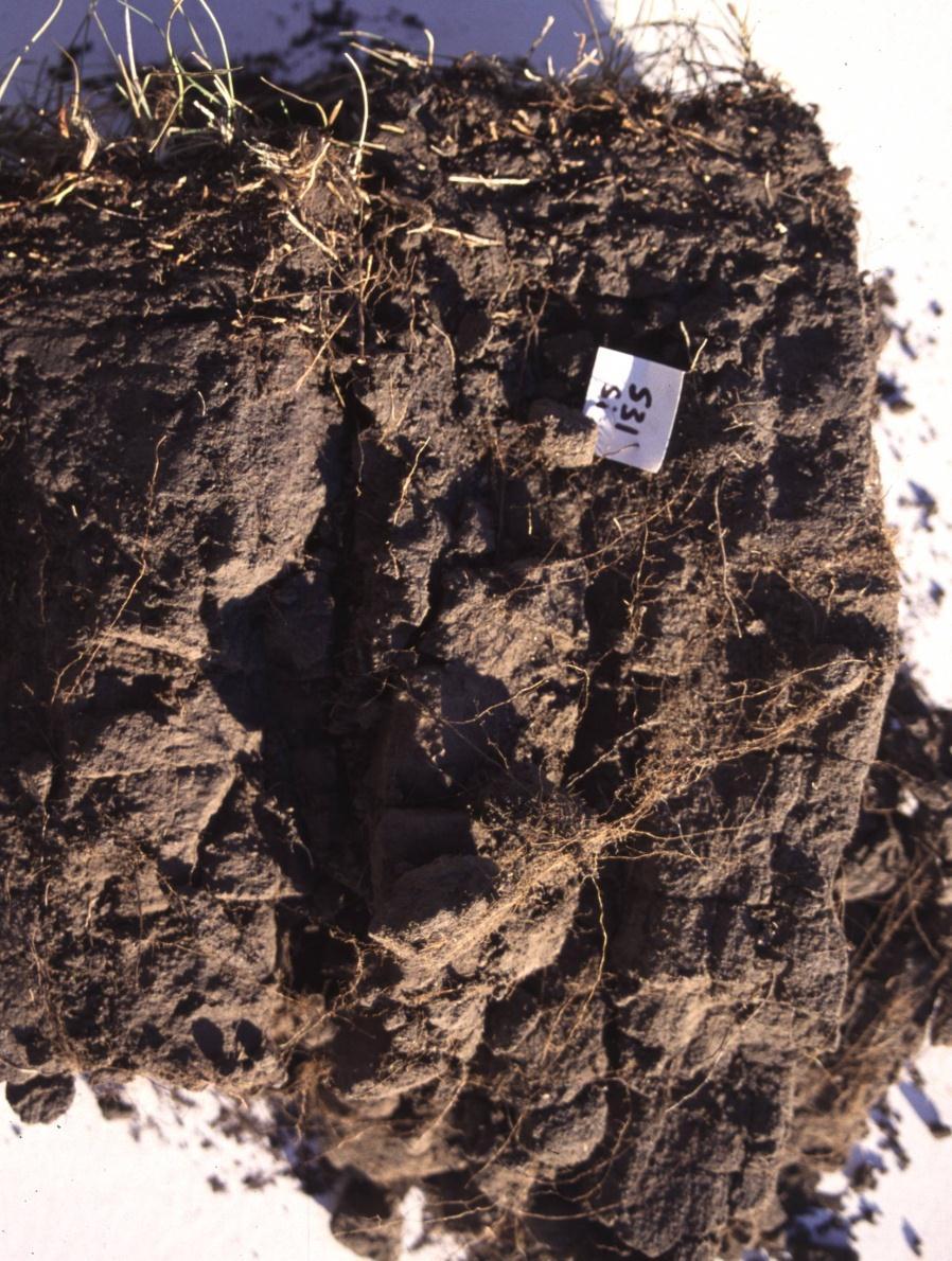
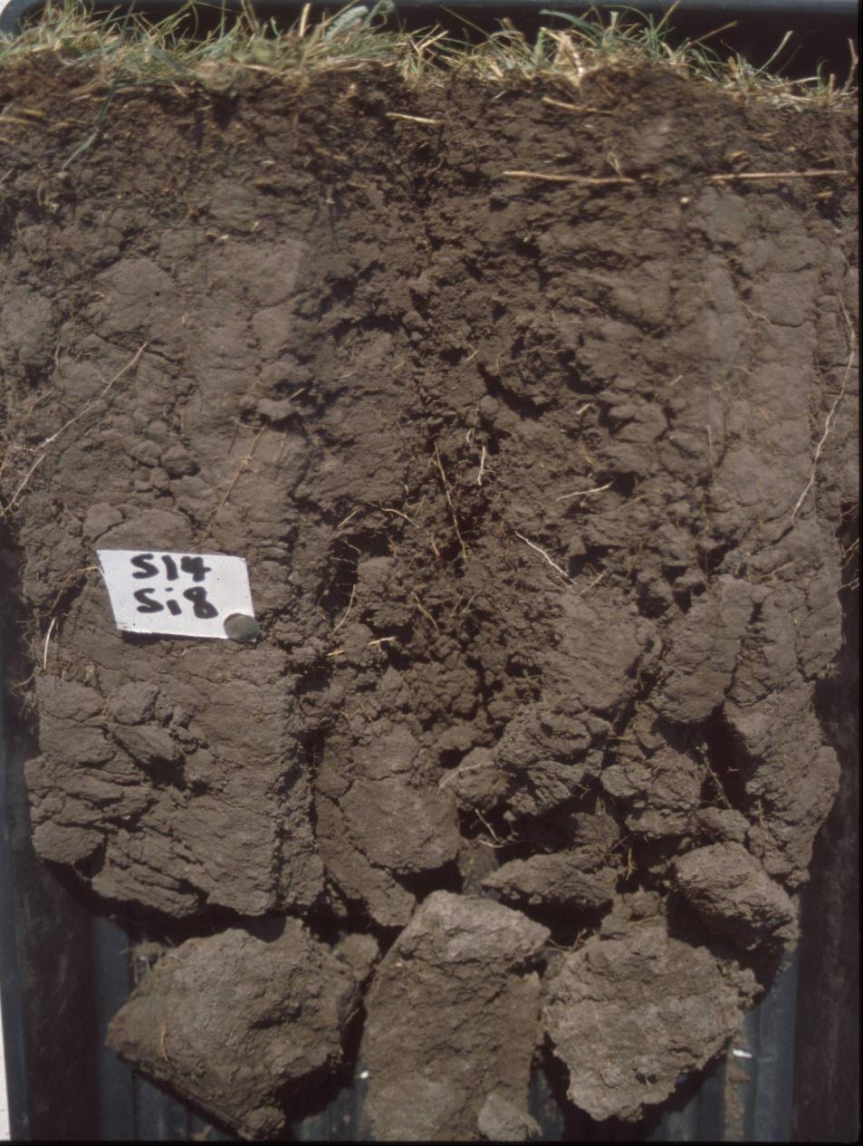
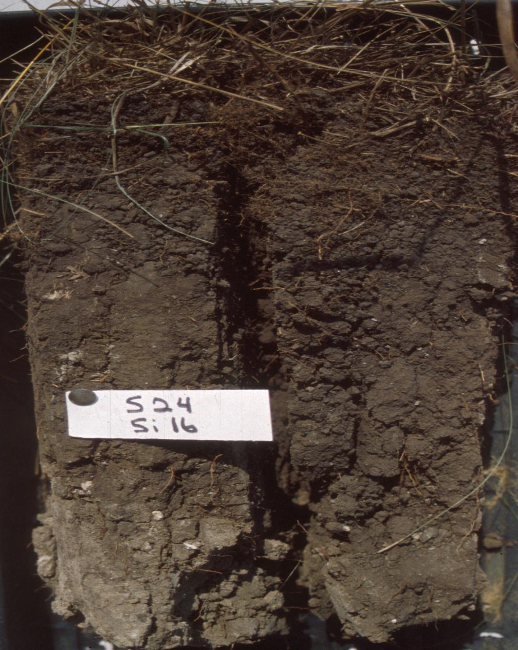
70 Soil Depth (cm) Bulk Density - Undisturbed (g/cm 3 ) * * * Idle * * * Rotational ** * * * * * * * Season Long * *
2014 Iowa FFA Soil Judging CDE Exam
 2014 Iowa FFA Soil Judging CDE Exam 1. Landscape position is one aspect of evaluating the surface features of a certain tract of land. Identifying the correct landscape position will indicate: a. If the
Loam: About 40% sand, 40% silt, 20% clay. Mixture of pore sizes to balance water retention and aeration. Considered the best soil for growing crops.
 Soil Characteristics Soil is formed from a combination of two Primary sources: Weathering of Parent Rock ( ) = material introduced by plants, animals, and decomposers Minor sources: Nutrients incorporated
Components of Soil. Humus: (a carbon sink) Dark brown or black color indicates high nitrogen content.
 Dark brown or black color indicates high nitrogen content.") Components of Soil Humus: (a carbon sink) Dark brown or black color indicates high nitrogen content. Inorganic Soil Components: Particle Size: Clay- Very fine Silt- Fine Sand- Medium Gravel- Large Discuss
Components of Soil Humus: (a carbon sink) Dark brown or black color indicates high nitrogen content. Inorganic Soil Components: Particle Size: Clay- Very fine Silt- Fine Sand- Medium Gravel- Large Discuss
Soil Water Relationships
 Soil Water Relationships Dr. Aimee Taylor Soil Particles Particle Sand Silt Clay Size in mm < 2mm 0.05 mm 0.05-0.002 mm
Surface Coal Mining and Reclamation in ND. Guy Welch ND Public Service Commission
 Surface Coal Mining and Reclamation in ND Guy Welch ND Public Service Commission Surface Coal Mines in North Dakota Approximately 1500 acres are disturbed each year History of Reclamation in ND First surface
2018 Iowa FFA Soil Judging CDE Exam 1. Landscape positions characterizes the location of the soil on the landscape and identifies potential risks.
 2018 Iowa FFA Soil Judging CDE Exam 1. Landscape positions characterizes the location of the soil on the landscape and identifies potential risks. Which landscape position is considered the floodplain
Infiltration. Keep Water Where it Falls. Frank Franciosi Novozymes
 Keep Water Where it Falls Frank Franciosi Novozymes Defined refers to the movement of water into the soil layer. The rate of this movement is called the infiltration rate. If rainfall intensity is greater
Soil Quality / Understanding Soil Health what are we missing?
 Soil Quality / Understanding Soil Health what are we missing? Soil Quality Test Kit Clarence Chavez Soil Scientist The USDA is an Equal Opportunity Provider and Employer Soils are not machines: It s an
The Nature of Soil Soil Conservation Sustainable Ag.
 Chapter 6 & 7 The Nature of Soil Soil Conservation Sustainable Ag. Climate Soil Forming Factors Parent material Organisms Topography Time Value of Soil Soil is under appreciated Condition of soil affects
ON LANDSCAPING, SOILS, SOIL AMENDMENTS AND PROPER SEED ESTABLISHMENT (BOTH GRASS LAWNS AND MEADOWS).
.") ON LANDSCAPING, SOILS, SOIL AMENDMENTS AND PROPER SEED ESTABLISHMENT (BOTH GRASS LAWNS AND MEADOWS). John D. Chibirka USDA-NRCS Resource Soil Scientist 1238 County Welfare Road, Suite 220 Leesport, PA
ON LANDSCAPING, SOILS, SOIL AMENDMENTS AND PROPER SEED ESTABLISHMENT (BOTH GRASS LAWNS AND MEADOWS). John D. Chibirka USDA-NRCS Resource Soil Scientist 1238 County Welfare Road, Suite 220 Leesport, PA
Soil characteristics that influence nitrogen and water management
 Section C Soil characteristics that influence nitrogen and water management Soil characteristics vary across the landscape Soils vary from one field to another, and often within the same field. Soil differences
CCA Exam Prep Intro to Soil & Water
 CCA Exam Prep Intro to Soil & Water Franz Niederholzer, UCCE Farm Advisor Colusa/Sutter/Yuba Counties fjniederholzer@ucanr.edu and Sharon Benes, Professor CSU, Fresno Physical soil properties Texture Structure
Soil Restoration in Accordance with. The NYSDEC 2015 Stormwater Management Design Manual
 Soil Restoration in Accordance with The NYSDEC 2015 Stormwater Management Design Manual William Buetow CPESC, CPSS TRC Solutions Clifton Park, NY Implementation of Soil Restoration as a Green Infrastructure
NYC Envirothon 2017 Soil Science Review. Richard K Shaw USDA-NRCS
 NYC Envirothon 2017 Soil Science Review Richard K Shaw USDA-NRCS Introduction Who Are We? U.S. Department of Agriculture (1862) Natural Resources Conservation Service (1935) What Do We Do? Provide leadership
Soil Interpretations Erosion and Sedimentation Control Planning and Design Workshop
 Soil Interpretations Erosion and Sedimentation Control Planning and Design Workshop Presented by Richard Brooks Presentation prepared by Kristin May Resource Soil Scientists USDA-Natural Resources Conservation
BMP 6.7.3: Soil Amendment & Restoration
 BMP 6.7.3: Soil Amendment & Restoration Soil amendment and restoration is the process of improving disturbed soils and low organic soils by restoring soil porosity and/or adding a soil amendment, such
Why do soils differ across the landscape?
 Today s Objectives: Elements of soil formation Describe important soil physical & chemical properties Describe the ability to use and interpret soil survey information (printed and digital) List some site
Sandy Soils. Sand. Silt. Sandy soils. Silty soils. Wind blown and alluvial parent materials. Low water holding capacity
 Sand Large particles you can see Large spaces between particles Rapid water flow Non cohesive Small surface area Low water holding capacity Susceptible to drought Small surface area Low CEC Infertile Easily
IOWA FFA STATE SOILS CDE SATURDAY, OCTOBER 13, 2007 AMES, IOWA
 IOWA FFA STATE SOILS CDE SATURDAY, OCTOBER 13, 2007 AMES, IOWA 1. Moderately sloping has what percent slope: a. 9-14% b. 2-5% c. 5-9% d. over 14% 2. Which of the following horizons is the loose underlying
2016 Iowa FFA Soils Evaluation CDE Exam
 2016 Iowa FFA Soils Evaluation CDE Exam 1. Which of the following is true regarding soil horizons? a. A horizon is darker in color and has more organic matter b. B horizon is darker in color and has more
Learning Objectives Part 1. Chapter 4 Soil Physical Properties. Soil Physical Properties. Color. Physical properties part 1
 Learning Objectives Part 1 Chapter 4 Soil Physical Properties Know what color tells you about a soil Describe the concept of soil texture and its importance Use the textural triangle to determine a soil
Examining soils in the field. Examining soils in the field. Environment Agency thinksoils examining soils in the field
 Examining soils in the field thinksoils Examining soils in the field Environment Agency thinksoils examining soils in the field 31 Examining soils in the field 32 Environment Agency thinksoils examining
2017 Iowa FFA Soil Judging CDE Exam
 2017 Iowa FFA Soil Judging CDE Exam 1. Landscape positions vary in soil composition and makeup. What landscape position would be characterized by having strata and lenses of different textures in the profile:
Saline and Sodic Field Demonstration project
 Saline and Sodic Field Demonstration project 2007-2013 Tile drainage will help decrease the soluble salt level over time but does not address parts of the field that have sodium issues as well. Reclamation
Soil Resources. Soil Horizons
 Soil Resources Soil Uppermost layer of earth s crust that supports plants, animals and microbes Soil Forming Factors Parent Material Time Climate Organisms Topography Soil Composition Mineral Particles
4/23/2018. Soil John Wiley & Sons, Inc. All rights reserved. Lecture 14
 Lecture 14 Soil Lecture 14 1. The Soil System 2. Soil Properties and Major Soil Types 3. Environmental Problems Related to Soil 4. Soil Conservation and Regeneration 1 The Soil System Soil Uppermost layer
4.0 EROSION AND SEDIMENT PROCESS. 4.1 Mechanics of Erosion
 4.0 EROSION AND SEDIMENT PROCESS 4.1 Mechanics of Erosion SECTION 4 - EROSION AND SEDIMENT PROCESS Erosion is the wearing away of material by naturally occurring agents through the detachment and transport
2012 FINAL SOILS AREA 2 Envirothon Questions Answer KEY
 2012 FINAL SOILS AREA 2 Envirothon Questions Answer KEY Questions 1-6 to be answered at the soil pit: 1. Soil scientists categorize soils by drainage classes. What is the drainage class of the soil at
Soil Management: the basis of sustainable agriculture
 Soil Management: the basis of sustainable agriculture FAB-465 Lecture 11 Lecture Outline Soil Formation Soil Structure/Texture Indicators of Soil Health or Fertility Soil Conservation Practices 1 Soil
Iowa FFA Soil Career Development Event 2008
 Iowa FFA Soil Career Development Event 2008 1. In Iowa, corn suitability ratings for soil mapping units specifies a. natural weather conditions b. surface and subsurface drainage installed where needed
Basic Soil Science. Fundamentals of Nutrient Management. Melissa L. Wilson
 Basic Soil Science Fundamentals of Nutrient Management Melissa L. Wilson Department of Environmental Science & Technology Ag Nutrient Management Program University of Maryland, College Park Photo credit:
HORT 102: Soil Properties. Cultivated Plants: Lecture 15. [Teresa Koenig] Slide #: 1 Slide Title: Intro Information Slide
![HORT 102: Soil Properties. Cultivated Plants: Lecture 15. [Teresa Koenig] Slide #: 1 Slide Title: Intro Information Slide](/thumbs/76/74082590.jpg "HORT 102: Soil Properties. Cultivated Plants: Lecture 15. [Teresa Koenig] Slide #: 1 Slide Title: Intro Information Slide") HORT 102: Soil Properties Cultivated Plants: Lecture 15 [Teresa Koenig] Slide #: 1 Slide Title: Intro Information Slide Title: Lecture 15 Soil Properties Speaker: Teresa Koenig Created by: Teresa Koenig,
HORT 102: Soil Properties Cultivated Plants: Lecture 15 [Teresa Koenig] Slide #: 1 Slide Title: Intro Information Slide Title: Lecture 15 Soil Properties Speaker: Teresa Koenig Created by: Teresa Koenig,
THE TENNESSEE VEGETABLE GARDEN
 THE BACKYARD SERIES BACKYARD VEGETABLES W 346-A THE TENNESSEE VEGETABLE GARDEN SITE SELECTION AND SOIL TESTING Natalie Bumgarner, Assistant Professor and UT Extension Residential and Consumer Horticulture
Appendices: Glossary. General Terms. Specific Terms. Low Impact Development Approaches Handbook
 67 67 General Terms Specific Terms 66 Low Impact Development Approaches Handbook The vocabulary of low impact development is evolving, and many terms are used interchangeably and to describe the same or
Overview of Chapter 14
 14 Soil Resources Overview of Chapter 14 The Soil System Soil Properties and Major Soil Types Environmental Problems Related to Soil Soil Conservation and Regeneration Soil Uppermost layer of earth s crust
Soil, Water & Plant Relationships. Lecture note for Soil and Water Management Course Prepared by Dr ND Nang
 Soil, Water & Plant Relationships Lecture note for Soil and Water Management Course Prepared by Dr ND Nang Soil-Plant-Atmosphere Continuum (SPAC) The SPAC is defined as the movement of water from the soil,
Specifying Soils for Plant Growth
 Specifying Soils for Plant Growth Which by coincidence reduces runoff Timothy A. Craul, CPSSc President, Craul Land Scientists The soil must be plant friendly. The soil is a natural system. All soils are
EARTH SCIENCE CONCEPTS -Geologic time scale
 EARTH SCIENCE CONCEPTS -Geologic time scale -Plate Tectonics -Earthquakes *result of vibrations (often due to plate movement) deep in the Earth that release energy *often occur at transform boundaries
1 Describe the concept of soil texture and its importance. 2 Determine the texture of a soil sample.
 Interest Approach Provide students with various samples of soil. One sample should be nearly all sand, one nearly all clay, and one nearly all silt. Ask students to determine how the samples differ. Would
Soil Health Practices in the Landscape
 Soil Health Practices in the Landscape Salvatore Mangiafico Rutgers Cooperative Extension Environmental and Resource Management Agent In this session... Benefits of healthy soils in the landscape Plant
Soil Structure, Density, and Porosity. Laboratory #4
 Soil Structure, Density, and Porosity Laboratory #4 Objectives Understand the concept of soil structure and how it differs from soil texture. Understand how soil structure influences other soil properties.
Raingardens. Conserving and Protecting Water L
 L-5482 08-08 Raingardens Justin Mechell, Extension Assistant, and Bruce Lesikar, Extension Program Leader for Biological and Agricultural Engineering,The Texas A&M University System A raingarden is an
Introduction to Environmental Science. Soil Characteristics. Chapter 11 Soil
 Chapter 11 Soil Soil Characteristics It s more than dirt Most soils are 100s of years old Weathering breaks down parent rock Soil Separates (particle types) Sand (largest) Silt Clay (smallest) Plants contribute
RAIN GARDEN ILLINOIS URBAN MANUAL PRACTICE STANDARD. (feet) CODE 897 DEFINITION
 CODE 897 DEFINITION") ILLINOIS URBAN MANUAL PRACTICE STANDARD RAIN GARDEN (feet) CODE 897 Source: Kendall County Soil and Water Conservation District DEFINITION Rain gardens are small, shallow, flat bottomed depressions constructed
ILLINOIS URBAN MANUAL PRACTICE STANDARD RAIN GARDEN (feet) CODE 897 Source: Kendall County Soil and Water Conservation District DEFINITION Rain gardens are small, shallow, flat bottomed depressions constructed
Mature basalt volcanic soils
 MANAGING NORTHLAND SOILS Mature basalt volcanic soils 8.1.2 Soil types in this group Kerikeri friable clay (KE) Kerikeri friable clay with large boulders (KEb) Matarau friable clay (MC, MCH*) Matarau friable
Chapter 15 Soil Resources
 Chapter 15 Soil Resources Overview of Chapter 15 What is Soil? Soil Horizons Nutrient Cycling Soil Properties and Major Soil Types Soil Problems Soil Conservation and Regeneration Soil Uppermost layer
Restoration of Degraded Soils
 Restoration of Degraded Soils Saline Soils Electrical Conductivity (EC) 4dS m -1 Sodic Soils EC
Scheduling Irrigation for Horticultural Crops. Patrick Byers Regional Horticulture Specialist Greene County
 Scheduling Irrigation for Horticultural Crops Patrick Byers Regional Horticulture Specialist Greene County Outline Soil characteristics Soil water characteristics Basic watering facts Scheduling irrigation
Scheduling Irrigation for Horticultural Crops
 for Horticultural Crops Patrick Byers Regional Horticulture Specialist Greene County Outline Soil characteristics Soil water characteristics Basic watering facts Scheduling irrigation What is Soil? Soil
Homework Activity Jar Test for Soil Texture
 Homework Activity Jar Test for Soil Texture Background: 1. What is soil? 2. What natural factors influence the formation of soil? 3. How will the depth of each horizon in your soil profile affect your
Soil Structure and the Physical Fertility of Soil
 12 17 th December 2015 Soil Structure and the Physical Fertility of Soil Christopher Johns Research Manager Northern Australia Key Points The physical properties of soil are at least as important as the
Soil Horizons cont. Oa- highly decomposed Oi-undecomposed
 Soils Soil Basics Soil Horizons Soil Horizons cont. O Horizon: Or organic layer Organic layer of decomposing plant and animal tissue. Wooded upland areas have thin O horizons Wetlands may have thick O
Soil aggregates-significance-soil consistency-soil crusting
 Soil aggregates-significance-soil consistency-soil crusting Soil aggregates Soil aggregates are clumps of soil particles that are held together by moist clay, organic matter (such as roots), by organic
SOIL BASICS & CONSERVATION
 SOIL BASICS & CONSERVATION What Is Soil? Soil is a mix of eroded rock, minerals, water, air, living things, and decaying matter. Ecosystem Services of Soil Provides nutrients for plants Provides support
Soil Notes. General Soil Information
 Soil Notes General Soil Information Definition Soil relatively thin surface layer of the Earth s crust consisting of mineral and organic matter that is affected by agents such as weather, wind, water,
Building and Maintaining Healthy Soils
 Building and Maintaining Healthy Soils Trish Steinhilber psteinhi@umd.edu extension.umd.edu/anmp Montgomery County Master Gardeners Training November 6, 2014 Soil Health capacity of a soil to function
Why Control and Prevent Erosion?
 Mark Risse, Rills are often obvious on steep or unprotected banks. Development of soil crust reduces infiltration, causing more runoff and erosion. This rill could easily turn into a gully if erosion is
Secondary Consumer (Carnivore or Omnivore)
") Chapter 8 - Water and Soil Conservation Benefits of Living Organisms for Water and Soil 1. plants break fall of rain and reduce damage to the soil 2. plant materials on the soil provide a rain absorbing
Chapter 8 - Water and Soil Conservation Benefits of Living Organisms for Water and Soil 1. plants break fall of rain and reduce damage to the soil 2. plant materials on the soil provide a rain absorbing
Image: Montana NRCS USDA
 Vegetated Swale Vegetated Swales are broad shallow channels topped with vegetation, also known as bioswales. Swales are designed to slow runoff, promote infiltration, and filter out pollutants and sediments.
Lecture 3: Soil Microclimatology
 Lecture 3: Soil Microclimatology Introduction to Soils Heat Transfer Through Soils Water Transfer Through Soils What is a Soil? Soil is a complex mixture of mineral matter, organic matter and living organisms
LANDPKS TEACHING MANUAL
 LANDPKS TEACHING MANUAL IMPLICATIONS FOR LAND DEGRADATION and RESTORATION FOR THE LandPKS LandInfo MODULE Contents: A description of LandPKS application indicators Indicators and how they impact land degradation
Wisconsin Contractors Institute Continuing Education
 Wisconsin Contractors Institute Continuing Education Erosion & Sediment Control Course # 12775 2 hours Wisconsin Contractors Institute N27 W23953 Paul Road, Suite 203 Pewaukee, WI 53072 Website: www.wicontractorsinstitute.com
Tilth: Tilth: Soil Structure and its Management. Tilth: Soil Structure and its Management
 Tilth: Soil Structure and its Management Sonoma County Vineyard Technical Group May 18, 2017 Tilth: Soil Structure and its Management Paul R. Anamosa, Ph.D. Viticultural Soil Scientist www.vineyardsoil.com
Name. There are three main types of soils called textures. They are: sand, silt, and clay. Sand has the largest particles and clay has the smallest.
 Introduction Name What Soil is: Soil is a natural body made up of minerals (rock), organic (living and dead) materials, air, and water. Soil has living and dead parts in it. There are three main types
Urban Conservation Practice Physical Effects ESTABLISHMENT, GROWTH, AND HARVEST NUTRIENT MANAGEMENT
 NOT WELL 800 - Urban Stormwater Wetlands A constructed system of shallow pools that create growing conditions for wetland plants to lessen the impacts of stormwater quality and quantity in urban areas.
Pipeline Reclamation at the Williston Research Extension Center - NDSU. Austin Link Agronomy Research Specialist
 Pipeline Reclamation at the Williston Research Extension Center - NDSU Austin Link Agronomy Research Specialist Reclaiming a 36 Pipeline with Crop Rotations Introduction May 15 th, 2015, installation of
2016 Area 3 Envirothon Muskingum County Soils Test ANSWER KEY
 2016 Area 3 Envirothon Muskingum County Soils Test ANSWER KEY 1. The majority of the bedrock in Muskingum County is. a. sedimentary bedrock b. glacial bedrock c. igneous bedrock d. metamorphic bedrock
Alluvium Bedrock Chemical Weathering Climate Glacial Till Loess Native Vegetation
 1 Alluvium Bedrock Chemical Weathering Climate Glacial Till Loess Native Vegetation Organic Matter Outwash Parent Material Physical Weathering Prairie Soils Timber Soils Topography 2 There are five primary
Soils and Land Use Test
 SOIL PROPERTIES Total Score /50 1) List two of the five main functions of soil. (2 points) Habitat for organisms, Engineering medium, Filters and stores water, Anchor for plants, Cycles nutrients 2) Small
CHECKLIST BMPs for FIELD NURSERIES REGULATIONS, SITE SELECTION, WATER MANAGEMENT
 CHECKLIST BMPs for FIELD NURSERIES REGULATIONS, SITE SELECTION, WATER MANAGEMENT Regulations For information on the Wetlands Protection Act or the Water Management Act, contact the Massachusetts Department
Vegetated Filter Strips and Buffers
 3.15 Sediment Control Description: Buffer strips (existing vegetation) and filter strips (planted vegetation) are sections of vegetated land adjacent to disturbed areas. They are designed with low slopes
There are different types of weathering weathering and weathering. Both types work together to change Earth s surface.
 Weathering effects Classifying Sediment The surface processes that break down rock are called. Weathering breaks rock into smaller and smaller pieces. Tiny moss plants, earthworms, wind, rain, and even
27/01/2017. This event is being run by SAC Consulting. What is Soil?
 This event is being run by SAC Consulting What is Soil? 1 Soil Texture It describes the physical composition of the soil % of sand, silt and clay Refers to the mineral fragments of the soil only water
Land Capability Classifications
 Land Capability Classifications Unit: Soil Science Problem Area: Basic Principles of Soil Science Student Learning Objectives. Instruction in this lesson should result in students achieving the following
Subsoiling to Reduce Compaction
 Subsoiling to Reduce Compaction Tom Jensen PhD Agronomy, CCA, PAg Director in the North America Program International Plant Nutrition Institute (IPNI) tjensen@ipni.net Calgary, AB 9-Jan-2018, Alberta Agronomy
Soil Health & Assessment
 Soil Health & Assessment National Association of Conservation Districts (NACD) Urban and Community Development Webinar Series Presented by, Eileen Miller, Soil Health Specialist USDA NRCS NJ January 15,
WEATHERING AND SOIL FORMATION. 8th Grade- Mr. Stelma
 WEATHERING AND SOIL FORMATION 8th Grade- Mr. Stelma WEATHERING EFFECTS The surface processes that break down rock are called weathering. Weathering breaks rock into smaller and smaller pieces. Tiny moss
Effects of Erosion. Grades 6-8
 Effects of Erosion Grades 6-8 This activity was designed as a companion for the song Don t Treat Mother Earth Like Dirt. Background The song Don t Treat Mother Earth Like Dirt is all about respecting and
CHAPTER 8 SLOPE STABILITY ANALYSIS
 TM 5-818-1 / AFM 88-3. Chap. 7 CHAPTER 8 SLOPE STABILITY ANALYSIS 8-1. General. This chapter is concerned with characteristics and critical aspects of the stability of excavation slopes; methods of designing
Cover Crops Can Help Maximize Available Soil Moisture. Rachel Stout Evans Soil Scientist USDA-NRCS Metcalfe Soil Survey Office
 Cover Crops Can Help Maximize Available Soil Moisture Rachel Stout Evans Soil Scientist USDA-NRCS Metcalfe Soil Survey Office When the earth will drink up the rain as fast as it falls. -H.D. Thoreau, The
Pits 1 & 3 Questions. 7. Subsurface: Texture (5 pts) A. Coarse B. Moderately course C. Medium D. Fine E. Very Fine
 A. Coarse B. Moderately course C. Medium D. Fine E. Very Fine") Minnesota Soils Scorecard Questions for Pits 1-4 Scantron # 105481 Use your soils scorecard to fill out the answers on your scantron Bubble in the front side of the sheet for Pit 1 (# 1-45) and Pit 2 (#51-95)
Minnesota Soils Scorecard Questions for Pits 1-4 Scantron # 105481 Use your soils scorecard to fill out the answers on your scantron Bubble in the front side of the sheet for Pit 1 (# 1-45) and Pit 2 (#51-95)
DIRT! APES Laboratory Activity
 Name: Part I: Soil Texture DIRT! APES Laboratory Activity Can one determine the texture of soil by examining the particles found in a particular sample? The purpose of this activity is to determine the
MANAGING SALT AFFECTED SOILS
 MANAGING SALT AFFECTED SOILS Jim Millar Soil Scientist, NRCS 25½ West 6 th Ave Redfield, SD 57469 (605) 472-3860, ext. 4 jame s.millar@sd.usda.gov The abundance of precipitation in the 1990 s has increased
The relationship between soil (growing
 4 Plant, Soil and Water Relationships The relationship between soil (growing media), air, and water is one of the least understood aspects in production and maintenance of plants. As a result, a significant
SOIL DATA: Avondale. in Allen, TX. This information was taken from NRCS web soil survey of Collin County, Texas.
 SOIL DATA: Avondale in Allen, TX This information was taken from NRCS web soil survey of Collin County, Texas. United States Department of Agriculture Soil Conservation Service in cooperation with Texas
Team number Page 1 of Canon Envirothon Soils Station Test. Soils and Climate Change
 Team number Page 1 of 9 2006 Canon Envirothon Soils Station Test Soils and Climate Change There are many kinds of soil on the surface of the earth. The kind of soil that is present at a given location
STATE TAX COMMISSION OF MISSOURI ASSESSOR MANUAL
 STATE TAX COMMISSION OF MISSOURI ASSESSOR MANUAL CHAPTER: REVISION DATE: 10/1/2008 Page 1 of 18 7.3 The purpose of this section of the Assessor s Manual is to supplement the State Tax Commission s published
SOILS OF SAGE-GROUSE HABITAT: DEGRADATION AND RESTORATION. Jay Norton Extension Soil Scientist, Dept. of Ecosystem Science & Management
 SOILS OF SAGE-GROUSE HABITAT: DEGRADATION AND RESTORATION Jay Norton Extension Soil Scientist, Dept. of Ecosystem Science & Management OVERVIEW Soils of quality sage-grouse habitat; Effects of chronic
Vegetation Management
 Vegetation Management GENERAL CONSTRUCTION PRACTICE Best practice vegetation management involves giving appropriate consideration to the following issues. Not all the issues will be relevant on every site.
Mechanisms of Nutrient Uptake: Is Fertilization Enough?
 Mechanisms of Nutrient Uptake: Is Fertilization Enough? Fabián G. Fernández & Water Quality Specialist Department of Soil, Water, and Climate fabiangf@umn.edu Conference 09 Feb. 2016, Morton, MN Justice
5/15/2013. Basin Area. Vegetation. Rainfall & Runoff. Soil Type. Topics. Factors Influencing Erosion. Factors Influencing Erosion
 Topics Erosion, TESC and Construction sequencing Procedures and timing Remedies for failing sites Curtis Hinman WSU Extension and Bio Systems Eng. Faculty Low Impact Development Specialist chinman@wsu.edu
URBAN SOILS & SEATTLE EXAMPLES
 Class Results - Mystery Soil #1 14 12 10 8 6 4 2 0 Sandy Clay Loam Sandy Loam Silty Loam Class Results - Mystery Soil #2 6 5 4 3 2 1 0 Silty Clay Clay Loam Sandy Sandy Silty Sandy Silty Loamy Loam Clay
DO YOU KNOW YOUR SOILS? (Rev. 10/11)
") DO YOU KNOW YOUR SOILS? (Rev. 10/11) Circle all the correct answers. 1. What is the layer normally present on the surface of the soil in cropped fields? a. O c. Ap e. B g. R b. A d. E f. C 2. Available
DO YOU KNOW YOUR SOILS? (Rev. 10/11) Circle all the correct answers. 1. What is the layer normally present on the surface of the soil in cropped fields? a. O c. Ap e. B g. R b. A d. E f. C 2. Available
Bell Ringer. d) Erosion e) Decomposition of organic compounds
 Erosion e) Decomposition of organic compounds") Bell Ringer 1) A rock exposed to high winds, over a long period of time, loses half of its original size. This is an example of a) Physical weathering b) Chemical weathering c) Biological weathering d)
Bell Ringer 1) A rock exposed to high winds, over a long period of time, loses half of its original size. This is an example of a) Physical weathering b) Chemical weathering c) Biological weathering d)
Eric Konzelmann, CPESC, CPSWQ Assistant District Manager. Montgomery County Conservation District
 Eric Konzelmann, CPESC, CPSWQ Assistant District Manager Montgomery County Conservation District Topics Covered E&S Conveyance & Inlet Protection Soil Stabilization Requirements & Effectiveness Soil Compaction
Urban Water Management and Soils (ESRM 311 & SEFS 507)
") Urban Water Management and Soils (ESRM 311 & SEFS 507) Cougar Mtn Regional Wildland Park & Lakemont Blvd, Bellevue WA Lecture Today Some Urban Water management terms Examples of water management in urban
Urban Water Management and Soils (ESRM 311 & SEFS 507) Cougar Mtn Regional Wildland Park & Lakemont Blvd, Bellevue WA Lecture Today Some Urban Water management terms Examples of water management in urban
Soil Issues in Urban Farming
 Soil Issues in Urban Farming Stephanie Murphy, Ph.D. Director of Soil Testing Rutgers/NJAES Topics Soil quality Soil testing Risks posed to urban farmers/consumers high levels of lead Ways to mitigate
Bioengineering Shoreline Protection
 Insert Company Logo Here (first slide only) Bioengineering Shoreline Protection Agrecol LLC Evansville WI rob.walker@agrecol.com A little about Agrecol 1,100 acres in production in SC WI Produce 3.5 million
SECTION 6. Routine Maintenance Activity Details
 SECTION 6 Routine Maintenance Activity Details 80. DEBRIS REMOVAL When Deadfall, and other objects, such as shopping carts, tires, appliances, and mattresses have accumulated in the drain. Why To prevent
Quantifying the Effectiveness of Soil Amendments in Compact Urban Soils. By Nick Olson
 Quantifying the Effectiveness of Soil Amendments in Compact Urban Soils By Nick Olson Funding provided by... Soil Compaction Residential and commercial developments requires large equipment to grade and