The New England Hydric Soils Technical Committee (NEHSTC) consists of the following members:
|
|
|
- Cori Casey
- 6 years ago
- Views:
Transcription
1
2
3 Acknowledgements This manual reflects the collective effort and vision of the New England Hydric Soils Technical Committee. The Committee consists of soil scientists, wetland scientists, and regulatory authorities. Its members represent the private sector, universities, organizations, societies, and state, local,and federal governments. We want to express our appreciation to these individuals and to all others who participated in the development and review of this manual. Special thanks go to the staff of the New England Interstate Water Pollution Control Commission (NEIWPCC) for producing and distributing this manual, and to EPA-New England for funding the production and distribution. Although this revised publication of Field Indicators for Identifying Hydric Soils in New England reflects current science and is representative of hydric soil morphologies in the region, the Technical Committee recognizes that this manual will undergo continuous field review and testing which will likely require future revisions. Comments on this manual should be sent to: NEIWPCC Wetlands Workgroup Boott Mills South 100 Foot of John St. Lowell, MA Phone: FAX: For information and updates to this document, visit hydricsoils.htm. Also available at this website are downloadable PDFs of this document and its supplement, as well as a form for ordering hard copies.
4 The New England Hydric Soils Technical Committee (NEHSTC) consists of the following members: Peter Fletcher (Chair), Retired from USDA - Natural Resources Conservation Service Stephen Gourley, USDA - Natural Resources Conservation Service - Vermont James Gove, Gove Environmental Services Peter Hammen, New Hampshire Dept. of Environmental Services Wayne Hoar, USDA - Natural Resources Conservation Service - Maine Joseph Homer, USDA - Natural Resources Conservation Service New Hampshire Steven Hundley, USDA - Natural Resources Conservation Service New Hampshire Kenneth Kettenring, New Hampshire Dept. of Environmental Services Rebekah Lacey, New England Interstate Water Pollution Control Commission Ruth Ladd, US Army Corps of Engineers Raymond Lobdell, Lobdell and Associates Harvey Luce, University of Connecticut Wende Mahaney, US Fish and Wildlife Service Joseph Noel, Maine Association of Professional Soil Scientists Thomas Peragallo, Peragallo Associates Jeff Peterson, Vanasse Hangen Brustlin Sidney Pilgrim, University of New Hampshire David Rocque, Maine Dept. of Agriculture, Food and Rural Resources Matthew Schweisberg, US Environmental Protection Agency Michael Sheehan, US Army Corps of Engineers Lori Sommer, New Hampshire Dept. of Environmental Services Mark Stolt, University of Rhode Island Steven Tessitore, Connecticut Dept. of Environmental Protection James Turenne, USDA Natural Resources Conservation Service Rhode Island Peter Veneman, University of Massachusetts, Amherst Thomas Villars, USDA Natural Resources Conservation Service - Vermont Michael Whited, USDA Natural Resources Conservation Service David Wilkinson, USDA Natural Resources Conservation Service - Maine This manual should be cited as follows: New England Hydric Soils Technical Committee rd ed., Field Indicators for Identifying Hydric Soils in New England. New England Interstate Water Pollution Control Commission, Lowell, MA.
5 Table of Contents Introduction...1 Regional Indicators For Hydric Soils... 2 How To Use This Manual Key to Hydric Soil Indicators Diagrams of Soil Profiles of Field Indicators Appendices Appendix 1: Chart for Estimating Percent Redoximorphic Feature Appendix 2: Chart for Estimating 2 Percent Redoximorphic Features Appendix 3: Chart for Estimating Size of Redoximorphic Features Appendix 4: Table for Estimating Contrast of Redoximorphic Features Appendix 5: Tabular Key for Contrast Determination using Munsell Notation Appendix 6: Chart for Determining Type of Soil Structure Appendix 7: Table for Estimating Grade of Soil Structure Appendix 8: Chart for Estimating Size of Granular Structure Appendix 9: Chart for Estimating Size of Blocky Structure Glossary Notes i
6
7 Introduction In the mid-1980s, staff from the New England Division of the Army Corps of Engineers, with technical assistance provided by the United States Department of Agriculture (USDA) Natural Resources Conservation Service (then the Soil Conservation Service), began developing New England-wide soil drainage class criteria to make field identification of hydric soils easier and more standardized. Several years of exhaustive field testing were conducted, involving a myriad of consulting firms, academic experts, professional societies, and federal, state, and local agencies. Over the years, the soil drainage class criteria were revised many times as the knowledge base and experience grew. To gather data and obtain opinions, detailed questionnaires were circulated to soil scientists, wetland ecologists, and others in regulatory agencies, private consulting firms, and universities. Despite significant improvements, the criteria for the drainage classes were still confusing at times, and some of the region s soil scientists had reservations about using them. In 1992, in response to efforts at the federal level to develop field indicators of hydric soils on a nationwide basis, a group of federal, state, private and academic experts in wetland and soil sciences (many of the same individuals from the earlier effort) convened to develop regional field indicators for identifying hydric soils in New England. Numerous drafts were produced, circulated for review, revised, and recirculated. The proposed field indicators were tested throughout New England by a variety of soil scientists and others in the wetlands profession. This manual is the culmination of those efforts. Following the release of Version 1, the New England Hydric Soils Technical Committee and representatives from the National Technical Committee for Hydric Soils (NTCHS) had several joint meetings and field trips to develop consistency between the New England and National Indicators. As a result of that cooperative 1
8 effort, Version 2 of Field Indicators for Identifying Hydric Soils in New England included revisions in terminology to more nearly parallel the national indicators and additional clarification of indicators which increased both accuracy and consistency. Likewise, the NTCHS has made, and continues to make, revisions to the National Indicators that better reflect hydric soil morphologies indicative of the New England Region. Version 3 of the Field Indicators for Identifying Hydric Soils in New England continues this process. The purpose of this field indicators guide is to make it easier for field personnel to identify and document hydric soils and to provide consistent and reliable evidence as to whether a certain soil meets the definition of a hydric soil. To correctly interpret and apply this guide, however, users must have practical experience and a working knowledge of soils. When properly applied, this field guide yields results that are consistent with the identification of hydric soils as per the 1987 Army Corps of Engineers Wetland Delineation Manual. While this field guide is the culmination of more than fifteen years of work, it is by no means a final product. Practical application, experience and continuing academic research provide sufficient reason to continue to periodically revise and update the field guide. Much of the supporting documentation for those revisions will come from you, the user. Regional Indicators For Hydric Soils References Childs, C.W Field test for ferrous iron and ferric-organic complexes (on exchange sites or in water-soluble forms) in soils. Aust. J. Soil. Res. 19: Federal Register. July 13, Changes in Hydric Soils of the United States. Washington, DC (current Hydric Soil Definition). Glossary of Soil Science Terms Soil Science Society of America, Madison, WI. Richardson, J.L. and M.J. Vepraskas (editors) Wetland Soils: Genesis, Hydrology, Landscapes, and Classification. Lewis Publishers CRC Press LLC, 2000 N.W. Corporate Blvd., Boca Raton, Florida. U.S. Department of Agriculture, Natural Resources Conservation Service Field Book for Describing and Sampling Soils, Version 2.0. P.J. Schoeneberger, D.A. Wysocki, E.C. Benham, and W.D. Broderson (eds.). National Soil Survey Center, Lincoln, NE. U.S. Department of Agriculture, Natural Resources Conservation Service Field Indicators of Hydric Soils in the United States, Version 5.0. G.W. Hurt, P.M. Whited, and R.F. Pringle (eds.). USDA-NRCS in cooperation with the National Technical Committee for Hydric Soils, Fort Worth, TX. U.S. Department of Agriculture, Natural Resources Conservation Service New Edition of the Keys to Soil Taxonomy, Ninth Edition. C. Ditzler, National Soil Survey Center, Lincoln, NE. U.S. Department of Agriculture, Soil Survey Division Staff, Soil Survey Manual, Handbook No. 18. US Government Printing Office, Washington, DC. U.S. Department of Agriculture, Soil Survey Division Staff Soil Taxonomy, Second Edition. Handbook Number 436. US Government Printing Office, Washington, DC. Vepraskas, M.J Redoximorphic Features for Identifying Aquic Conditions. Technical Bulletin 301. North Carolina Agricultural Research Service, North Carolina State University, Raleigh, NC. Ahydric soil is a soil that formed under conditions of saturation, flooding, or ponding long enough during the growing season to develop anaerobic conditions in the upper part (Federal Register, July 13, 1994). As a result of soil saturation and reducing conditions, hydric soils undergo chemical reactions and physical processes which differ from those found in upland soils. The field indicators of hydric soils contained within this guide are observable soil morphologies that have developed as a result of those chemical reactions and physical processes. Field indicators are also a historic record of cycles
9 Top of the Mineral Soil Material Typically the top of the uppermost mineral soil horizon. An exception may be an area of organic soil material buried beneath mineral soil material. See Keys to Soil Taxonomy (2003) for complete discussion. This was referred to as the mineral soil surface in previous versions of this key. Upper Part of the Soil That portion of the soil that supports the majority of plant roots. In general, in wetlands this zone is limited to the upper 12 inches (30 cm). Very Dark A or Ap Horizon Refer to A or Ap Horizon, Very Dark. Very Long Duration This is a duration class in which inundation for a single event is greater than 30 days. Very Thick, A and Ap Horizons For the purposes of this manual, very thick means greater than 15 inches (38 cm). Well-Decomposed Organic Soil Material Refers to sapric soil material. 82 of soil saturation and reduction that have been observed and documented by field soil scientists and validated through testing. For many hydric soils, saturation and reduction in the upper part of the soil are seasonal and not continuous throughout the growing season. When the soil morphologies observed at a site meet the criteria for one of the New England field indicators, this specifies a hydric soil. Users are cautioned that when working in areas where the hydrology has been altered, the presence or absence of hydric soil indicators may not reflect the current hydrologic conditions. How To Use This Manual This key is specifically designed to address the hydric soil conditions common to New England and may not be applicable to other regions of the United States. Soils identified as hydric soils using this key meet the definition of a hydric soil. This key begins with soil conditions associated with the wettest soils those with extended periods of saturation in the upper part and/or inundation. As the user progresses through this key, the soils have shorter periods of saturation in the upper part and the evidence of wetness may not be as clearly expressed in the soil morphology. To avoid misinterpretation when evaluating these soils, other than histosols, this key requires the user to identify a combination of soil morphologies observed within specified depths. Because of the unique soil morphology associated with spodic horizons, these are addressed separately in this key. In addition, some indicators are grouped by soil texture. To use this key properly, a user must start with Hydric Soil Indicator I and progress through the key systematically. If the soil conditions observed in the field match one of the hydric soil indicators, that soil is considered to be hydric. This key was designed to be an easy-to-use field guide that would apply throughout the New England Region. With the myriad of soil conditions found in New England, it became evident early on that 82 3
10 one key could not address all hydric soil conditions without becoming very complex and difficult to use. Hence, this key addresses soil conditions most commonly associated with hydric soils in New England. It also recognizes that there are problem soils for which this key may not work properly. Indicator XIII has been greatly expanded to help the user understand some of the types of problem soils that may be encountered in New England. A separate supplement to this manual is planned, which will reference regional maps to be located on the NEIWPCC website showing the approximate extent of problem soil areas and a list of reliable field indicators for them. When documenting hydric soils in the field, it is recommended that soil profiles be observed in test holes dug to a depth of two feet or more using a tile spade. The soil conditions observed in each test hole should then be described and documented using standards and terminology developed by the USDA. Depth measurements should always be made from the soil surface, but it is important to note that some indicators refer to the distance below the top of the mineral soil material or some other reference point as noted in the Indicators. Soil conditions and features that need to be observed and documented in order to use this key effectively include: Soil horizons and layers list the horizon designation plus thickness and depth for each. Soil texture note the textural class. Soil color list the Munsell Notation for matrix color and other features as described under redoximorphic features below. Redoximorphic features: Redoximorphic concentrations/depletions - Describe each type and document their color, abundance, size, contrast, and location (e.g., ped interiors). Field identification of redoximorphic features is most reliable when their contrast is distinct or prominent, and their abundance is 2 percent or more. When features are faint and/or less than 2 percent, extra care and professional 4 1. a hue 5YR or redder (i.e., 2.5YR, etc.); or 2. a hue of 7.5YR, color value 5 or less and chroma 4 or less (a hue of 7.5YR with value 5 and chroma 6 does not qualify without additional chemical properties); or 3. a hue of 10YR or neutral and color value and chroma 2 or less; or 4. a color of 10YR 3/1. See Keys to Soil Taxonomy (2003) for complete definition. Spodic Materials Mineral soil materials that are dominated by illuvial active amorphous materials composed of organic matter and aluminum with or without iron. Color criteria are given in the definition of spodic horizon above. See Keys to Soil Taxonomy (2003) for complete definition. Stripped Matrix A layer with features associated with wetness in which iron/manganese oxides and/or organic matter have been stripped, exposing the primary base color of the soil materials. The stripped areas and translocated oxides and/or organic matter form a diffuse splotchy pattern of two or more colors. Commonly the splotches of color are shades of gray or grayish brown. See Field Indicators (2002). Strong Structure Peds are distinct in undisturbed soil. They separate cleanly when soil is disturbed, and the soil material separates mainly into whole units when removed. Sulfidic Materials Mineral or organic soil material that contains oxidizable sulfur compounds. Sulfidic materials most commonly accumulate in coastal marshes, but they may occur in freshwater marshes if there is sulfur in the water. Presence of hydrogen sulfide gas is a field indicator for identifying sulfidic materials. It is detected in the field by a rotten egg smell. See Keys to Soil Taxonomy (2003) for a complete definition. Thick, A and Ap Horizons For the purposes of this manual, thick means greater than 10 inches and less than or equal to 15 inches. 81
11 Slightly Decomposed Organic Soil Material Refer to fibric soil material. Soil Soil is a natural body comprised of mineral and organic matter, liquid, and gases that occurs on the land surface. Soils are characterized by one or both of the following: 1) horizons, or layers, that are distinguishable from the initial material as a result of additions, losses, transfers, and transformations of energy and matter or 2) the ability to support rooted plants in a natural environment. Soil Horizon A relatively uniform layer of soil or soil material approximately parallel to the land surface and differing from adjacent genetically related layers in physical, chemical, and biological properties or characteristics such as color, structure, texture, consistence, degree of acidity, and presence or absence of redoximorphic features, etc. Soil Morphology The physical constitution of a soil profile as exhibited by the kinds, thicknesses, and arrangements of the horizons in the profile, and by the texture, structure, consistence, porosity and color of each horizon. Soil Structure The combination or arrangement of primary soil particles into secondary units or peds. The secondary units are characterized on the basis of size, shape, and grade (degree of distinctness). See Appendix 5. Soil Surface The top of the uppermost soil horizon (ground surface). Fresh leaf or needle fall that has not undergone observable decomposition is excluded from soil and may be described separately. Solum A set of horizons that are related through the same cycle pedogenic processes; the solum may include the O, A, E, and B horizons. Spodic Horizon An illuvial layer that is 1 in. (2.5 cm) or more thick, is not part of an Ap horizon, and contains 85 percent or more spodic materials. For field conditions where an albic (E) horizon extends horizontally through 50 percent or more of each pedon, the moist, crushed and smoothed colors directly under the albic horizon are as follows: 80 judgment should be exercised as to whether or not they are an indication of a hydric soil. Other redoximorphic features Depleted or gleyed matrix, nodules, pore linings, etc. Soil structure describe type (shape), size, and grade. Carbon-based features histic epipedon, histosols, thick mucky surface layers, and stripped matrix. Other soil features may be required depending upon the situation (e.g., depth of rooting, soil consistence). This manual includes a series of diagrams which illustrate each hydric soil indicator. The scales on either side of the diagram show the reference point of measurement. Soil textures are depicted using contrasting patterns. Notes highlight important characteristics and morphologies. Some features are difficult to show graphically and if there is a perceived difference in interpretation between the diagrams and narrative key, the narrative key takes precedence. User Notes are shown on the page opposite the diagram and below the indicator that they refer to. Their purpose is to provide additional information which may help in identifying an indicator in the field, or to alert users to possible exceptions and/or situations where professional judgment may be needed. User Notes are identified by the symbol shown on the left. In addition to User Notes, soil features designated as Field Testing Only are soil morphologies which may be helpful when identifying field indicators, but users are cautioned that these features have not had the field testing needed to substantiate their reliability. People who have observed these soil features in the field should document their findings and forward them to the NEIWPCC Wetlands Group. Your active participation is greatly appreciated and will improve and strengthen this manual. Field Testing Only criteria are depicted by the symbol shown on the left. Standards for defining a functionally hydric soil are maintained by the National Technical Committee at the following website: 5
12 This manual also includes a Glossary of Terms. The terms included in the Glossary are in bold and italicized throughout the narrative text. Some definitions have been simplified to facilitate a field interpretation. Users who want complete definitions should refer to the references cited. Please note that this manual does not address all hydric soil conditions found in New England, and professional judgment by a qualified individual is needed in unusual or problem soil areas. Included with this version of the Field Indicators is a separate document entitled Supplement to the Field Indicators of Hydric Soils in New England. The supplement explains some of the nuances of assessing soils; it is intended as an aide for less experienced individuals. The supplement also includes guidance to assist in the evaluation of problem soils. References Federal Register. February 24, Hydric Soils of the United States. Washington, DC (current Hydric Soil Criteria). Federal Register. July 13, Changes in Hydric Soils of the United States. Washington, DC (current Hydric Soil Definition). Glossary of Soil Science Terms Soil Science Society of America, Madison, WI. Tiner, R.W., Jr., and P.L.M. Veneman Hydric Soils of New England. University of Massachusetts Extension, Revised Bulletin C-183R, Amherst, MA. U.S. Department of Agriculture, Natural Resources Conservation Service Field Indicators of Hydric Soils in the United States, Version 5.0. G.W. Hurt, P.M. Whited, and R.F. Pringle (eds.). USDA-NRCS in cooperation with the National Technical Committee for Hydric Soils, Fort Worth, TX. U.S. Department of Agriculture, Natural Resources Conservation Service, National Soil Survey Handbook, title 430-VI. [Online] Available: U.S. Department of Agriculture, Soil Survey Division Staff Soil Survey Manual. Handbook No. 18. U.S. Government Printing Office. Washington, DC. U.S. Department of Agriculture, Soil Survey Division Staff Soil Taxonomy, Second Edition. Handbook No U.S. Government Printing Office, Washington, DC. Vepraskas, M.J Redoximorphic Features for Identifying Aquic Conditions. Technical Bulletin 301. North Carolina Agricultural Research Service, North Carolina State University, Raleigh, NC. 6 6 Fe-Mn oxides and clay have been stripped. Redox depletions include features that would formerly have been called gray mottles. See Richardson and Vepraskas (2001) for more complete discussion. Redoximorphic Features Features associated with wetness formed by the processes of reduction, translocation, and/or oxidation of Fe and Mn oxides. Formerly called mottling and low chroma colors. edoximorphic features include: soft masses, pore linings, nodules and concretions, iron depletions, clay depletions, depleted matrices, gleyed matrices, and reduced matrices. See Vepraskas (1996) for more complete discussion. Redoximorphic Features, Abundance of See Abundance, Redoximorphic Features. Redoximorphic Features, Contrast of See Contrast, Redoximorphic Features. Redoximorphic Features, Size of See Size, Redoximorphic Features. Reduced Matrix Soil matrices that have low chroma and high value colors, but whose color changes in hue or chroma when exposed to air. See gleyed matrix. See Richardson and Vepraskas (2001) for complete discussion. Restrictive feature A root-limiting layer in the soil profile such as a lithic contact (bedrock) or densic materials. See Keys to Soil Taxonomy (2003) for complete definition. Sapric Soil Material Organic soil material that has a fiber content after rubbing of less than one sixth (by volume), excluding live roots. The soil horizon notation for sapric soil material is Oa. Shallow E Horizon An E horizon which does not extend below a depth of 6 inches. Measurement is made from the top of the mineral soil material. Size, Redoximorphic Features The size of redoximorphic features (fine, medium, coarse, very coarse, and extremely coarse). Refer to the Chart for Estimating Size of Redoximorphic Features, located in Appendix 2. 79
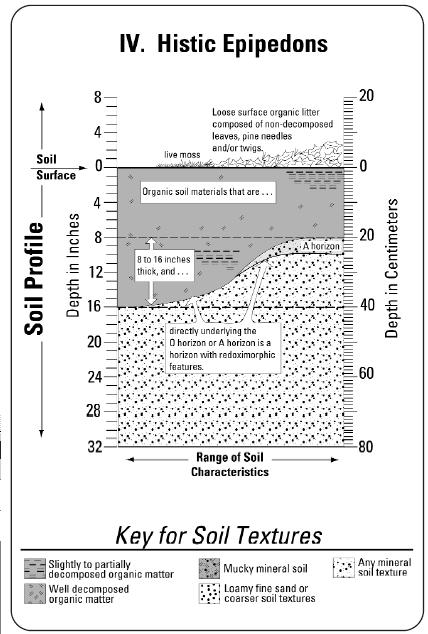
13 Parent Material The unconsolidated and more or less chemically weathered mineral or organic material from which the solum of soils has developed by pedogenic processes. Ped A unit of soil structure such as a block, column, granule, plate, or prism, formed by natural processes (in contrast with a clod, which is formed artificially). Ped Interior The interior of a soil structural unit or ped such as a block or a plate. Pedon A three-dimensional body of soil with lateral dimensions large enough to permit the study of horizon shapes and relations. See Soil Survey Manual (1993) for a complete definition. Ponded A condition in which water stands in a closed depression. The water is removed only by percolation, evaporation and/or transpiration. Pore Linings Zones of accumulation of Fe and/or Mn that occur as either coatings on a pore surface or impregnations of the matrix adjacent to the pore. See Vepraskas (1996) or Richardson and Vepraskas (2001) for complete discussion. Some pore linings are strongly expressed oxidized rhizospheres. Profile A vertical exposure of the soil. Prominent, Redoximorphic Feature A term used to describe the contrast in color between a redoximorphic feature and the matrix color. Refer to both the chart and tabular key for estimating contrast of redoximorphic features, located in Appendices 4 and 5. Redox Concentrations Features formed when Fe [or Mn] oxides or hydroxides have accumulated at a point or around a large pore such as a root channel. They appear to have formed by Fe or Mn moving into an area, oxidizing, and precipitating. Redox concentrations contain more Fe3+ [or Mn4+] than were found in the soil matrix originally. Three groups of redox concentrations are recognized: 1) Fe [or Mn] masses, 2) pore linings, and 3) nodules and concretions. See Richardson and Vepraskas (2001) Redox Depletions Zones of low chroma (2 or less) having value 4 or more where Fe-Mn oxides have been stripped or where both 78 KEY TO HYDRIC SOIL INDICATORS Version 3 April 2004 CAUTION: The field indicators in this book should not be considered all-inclusive. Although an attempt has been made to list the most relevant indicators, there are cases (see Problem Soils discussion on p. 54) where hydric soils exist that do not meet any of the currently listed indicators. Therefore, not meeting one of the indicators does not preclude a soil from being determined as hydric. In addition, there are rare occasions when a soil has one or more relevant field indicators but is not a hydric soil. Field indicators will continue to be revised as problem areas and exceptions to these keys become known or additional interpretation tools are developed. When soil morphology seems inconsistent with the landscape, vegetation, or observable hydrology, the assistance of an experienced soil or wetland scientist may be needed to determine whether the soil is hydric. The following conditions and soil morphologies are recognized as field indicators of soils that have formed under conditions of saturation, flooding, or ponding long enough during the growing season to develop anaerobic conditions in the upper part: 1. Ponded or Flooded Soils. Any soil that is frequently ponded or flooded for a long or very long duration during the growing season; or II. Tidal Soils. Soils that are flooded daily by tides and/or have sulfidic materials within 12 inches of the soil surface; or III. Histosols. Soils having organic soil materials at or near the soil surface that are greater than 16 inches thick (i.e., classify as Histosols) 1 ; or Folists and soils with folistic epipedons are excluded from Hydric Soil Indicator III. User Note/Field Testing Only: refer to page opposite the diagram depicting this indicator. 7
14 IV.Histic Epipedons. Soils having a layer of organic soil materials at or near the soil surface that is 8 to 16 inches thick (i.e., histic epipedon); and directly underlying the O horizon or, if present, the A horizon is a horizon with redoximorphic features;2 or V.Mineral Histic. Any mineral soil having a layer 4 to 8 inches thick of slightly to well-decomposed organic soil material and/ or a mucky A or Ap horizon, and is directly underlain by a horizon with a depleted or gleyed matrix;2 or VI. Depleted or Gleyed Matrix. Within 10 inches of the top of the mineral soil material and directly underlying an A or Ap horizon (or, if they are not present, an O horizon), is a horizon with a depleted or gleyed matrix (for soils with moderate to strong structure, the matrix color is recorded for ped interiors); or VII. Depleted Below Dark Surface. Beginning within 20 inches of the top of the mineral soil material and directly underlying a thick or very thick, dark A or Ap horizon is a horizon with a depleted or gleyed matrix that is 4 inches or more thick (for soils with moderate to strong structure, the matrix color is recorded for ped interiors); or VIII. Dark Mineral Soils. Soils with a matrix chroma of 2 or less that extends to a depth of 20 inches below the top of the mineral soil material, and that have a dark A or Ap horizon (with or without an O horizon) that is directly underlain by a horizon with a matrix value of less than 4, and within 12 inches of the top of the mineral soil material or directly underlying an A or Ap horizon, whichever is shallower, 2 percent or more redoximorphic features that extend to either: 2. Soils with folistic epipedons are excluded from Hydric Soil Indicators IV and V. User Note: refer to page opposite the diagram depicting this indicator. content). See Soil Survey Manual (1993) for complete definition. See Top of the Mineral Soil Material. Moderate Structure Well-formed distinct peds evident in undisturbed soil. When disturbed, soil material parts into a mixture of whole units, broken units, and material that is not in units. See Soil Survey Manual (1993) and Field Book for Describing and Sampling Soils (2002) for further description. Mottling: 1) A defunct term no longer used; previously used to describe certain redoximorphic features. 2) Current usage: areas of color that differ from the matrix color or attributes retained from the geologic source rather than from pedogenesis. See Field Book for Describing and Sampling Soils (2002). Muck Sapric soil material that formed under wet conditions. Mucky A USDA soil texture modifier (e.g., mucky sand). Mucky modified mineral soil with 0 percent clay has between 5 and 12 percent organic carbon. Mucky modified mineral soil with 60 percent clay has between 12 and 18 percent organic carbon. Soils with an intermediate amount of clay have intermediate amounts of organic carbon. Nodule (Fe/Mn) A cemented concentration of a chemical compound of iron and manganese that can be removed from the soil intact and that has no orderly internal organization. O Horizon Soil horizon consisting of organic soil material. Organic Soil Material Soil material usually formed under wet conditions that has a minimum of 12 to 18 percent organic carbon by dry weight, depending upon the percent of clay content. See Soil Taxonomy (2001). Organic Streaking See stripped matrix. Ortstein Spodic materials that are 50% or more cemented. See Keys to Soil Taxonomy (2003). 8 77
15 Hydric Soil Definition (1994) A soil that formed under conditions of saturation, flooding, or ponding long enough during the growing season to develop anaerobic conditions in the upper part. See Federal Register, July 13, Standards for defining a functionally hydric soil are maintained by the National Technical Committee at the following website: Loamy Fine Sand or Coarser Includes USDA Textural Classes: sands (except very fine sand) and loamy sand textures excluding loamy very fine sand. Long Duration A duration class in which inundation for a single event ranges from 7 to 30 days. Low Chroma Colors Any soil color, when using the Munsell Color System, with a chroma of 2 or less. Many, Redoximorphic Features Redoximorphic features comprising 20 percent or more of the observed surface area. Masses, Soft Redox that are not cemented and whose shapes are variable. Soft masses include features that formerly would have been called high chroma mottles. Matrix Color Dominant soil color as determined by 50 percent or more with two colors, or the highest percentage with more than two colors. Mesic Temperature Regime A soil temperature regime that has a mean annual soil temperature of greater than or equal to 8 C but lower than 15 C and the difference between mean summer and mean winter soil temperatures is more than 6 C at a depth of 50 cm from the soil surface or at a restrictive feature in the soil. See Keys to Soil Taxonomy (2003) for complete definition. Mineral Soil Horizon Soil horizon consisting of mineral soil material (e.g., A, E, and B horizons). Mineral Soil Material Soil comprised mostly of mineral material with a relatively low content of organic matter (less than 12 to 18 percent of organic carbon by dry weight, depending upon the clay A. a depth of 20 inches below the top of the mineral soil material; or B. a depleted or gleyed matrix, whichever is shallower; or IX. Spodosols. Mineral soils having a spodic horizon and one of the following morphologies: A. within 6 inches of the top of the mineral soil material have an E horizon (eluvial horizon) with 2 percent or more redoximorphic features and/or have a stripped matrix that is directly underlain by a spodic horizon with either: 1. a Bh, Bhs, or Bs horizon with 2 percent or more redoximorphic features; or a Bh and/or Bhs horizon that is directly underlain, but within 20 inches of the top of the mineral soil material, by a horizon with 2 percent or more redoximorphic features; or B. beginning within 10 inches of the top of the mineral soil material and directly underlying a dark A or Ap horizon and/or a shallow E horizon (or if neither is present, an O horizon), there is a Bh and/or Bhs horizon3 that is greater than 2 inches thick that is directly underlain, but within 20 inches of the top of the mineral soil material, by a horizon with 2 percent or more redoximorphic features; or This morphology can develop as a result of wetness, or in the cryic temperature regime, as a result of climate. See Section XIII for problem soil areas due to cold temperatures. User Note: refer to page opposite the diagram depicting this indicator. 9
16 C. beginning within 10 inches of the top of the mineral soil material and directly underlying a dark A or Ap horizon, is one of the following: 1. an E horizon with 2 percent or more redoximorphic features... and/or a stripped matrix directly underlain by a Bh, Bhs, or Bs horizon with 2 percent or more redoximorphic features; or a Bh and/or Bhs horizon that is directly underlain, but within 20 inches of top of the mineral soil material, by a horizon with 2 percent or more redoximorphic features; or a Bs horizon with 2 percent or more redoximorphic features; or X. Sandy With Redox. Soils that do not have a spodic horizon and: A. have a layer 4 to 8 inches thick of slightly to welldecomposed organic soil material and/or a mucky A or Ap horizon; and are directly underlain by a horizon with a loamy fine sand or coarser texture with 2 percent or more redoximorphic features; or B. beginning within 10 inches of the top of the mineral soil material and directly underlying a dark A or Ap horizon (with or without an O horizon) is a horizon with a loamy fine sand or coarser texture with a matrix color due to wetness of chroma 3 or less, value 4 or more, with 2 percent or more redoximorphic features; or C. beginning within 15 inches of the top of the mineral soil material and directly underlying a thick, very dark A or Ap horizon there is a horizon with a loamy fine sand or coarser texture with a matrix color due to wetness of chroma 3 or less, value 4 or more, with 2 percent or more redoximorphic features; or User Note: refer to page opposite the diagram depicting this indicator. 10 Growing Season The portion of the year when the soil temperature is at or above biological zero at a depth of 50 cm (19.7 inches) below the soil surface (Reference: NRCS Hydric Soil Criteria as posted on soils.usda.gov/use/hydric/criteria.html). For purposes of this manual (specifically Category I in the Key to Hydric Soil Indicators ), the growing season may be approximated by calculating the number of frostfree days. This information is available through local offices of the Natural Resources Conservation Service. This can include published county soil survey reports (USDA-NRCS) in the table(s) entitled Freeze Dates in Spring and Fall. Using this method (Row: 5 of 10 years, Column 28 F or lower), the length of the growing season would extend from the last freezing temperature in spring through the first freezing temperature in fall. (Reference: Memorandum for Distribution, subject: Clarification and Interpretation of the 1987 Manual, U.S. Army Corps of Engineers, Washington, D.C., March 6, 1992, Section 3.b. Hydrology ). Hemic Soil Material Organic soil material with a fiber content after rubbing ranging from greater than one sixth (by volume) to less than two fifths, excluding live roots. The soil horizon notation for hemic soil material is Oe. It is intermediate decomposition between fibric and apric. High Value Color values of 4 or more. Histic Epipedon An organic layer generally between 8 (20 cm) and 16 inches (40 cm) thick (one or more horizons) that is characterized by saturation (for 30 days or more, cumulative, in a normal year) and reduction for some time during normal years. Refer to Keys to Soil Taxonomy (2003) for complete definition. Histosols Organic soils that have organic soil material in more than half of the upper 80 cm (32 inches), or that are of any thickness if overlying rock or fragmental materials have interstices filled with organic soil material. When overlying unconsolidated mineral soil material, organic soils are typically greater than 16 inches thick. Refer to Keys to Soil Taxonomy (2003) for complete definition. Horizon See Soil Horizon
17 greater and intermediate organic carbon contents for intermediate clay contents. See Keys to Soil Taxonomy (2003). Frequently Flooded A frequency class in which flooding is likely to occur, often under usual weather conditions (more than 50 percent chance in any year, or more than 50 times in 100 years). Frequently Ponded A frequency class in which ponding is likely to occur, often under usual weather conditions (more than 50 percent chance in any year, or more than 50 times in 100 years). Frigid Temperature Regime A soil temperature regime that is warmer in the summer than a soil with a cryic regime, but has a mean annual soil temperature lower than 8 C. The difference between mean summer and mean winter soil temperatures is more than 6 C at a depth of 50 cm from the soil surface or at a restrictive feature in the soil. See Keys to Soil Taxonomy (2003) for complete definition. Gleyed Matrix A soil horizon matrix color resulting from prolonged periods of wetness that makes up more than 50% of the horizon or subhorizon where iron has been reduced and removed, or where saturation with stagnant water has preserved a reduced state. Gley colors include: 1. 10Y, 5GY, 10GY, 10G, 5BG, 10BG, 5B, 10B, or 5PB with value 4 or more and chroma is 1; or XI. Any Texture. Soils that do not have a spodic horizon and A. beginning within 10 inches of the top of the mineral soil material and directly underlying a dark A or Ap horizon (with or without an O horizon) is a horizon with 5 percent or more redox depletions, and within 20 inches of the top of the mineral soil material there is a horizon with a depleted or gleyed matrix (for soils with moderate to strong structure, the matrix color and percent redox depletions are recorded for ped interiors); or B. beginning within 15 inches of the top of the mineral soil material and directly underlying a thick, very dark Ap horizon is a horizon with 5 percent or more redox depletions and within 20 inches of the top of the mineral soil material there is a horizon with a depleted or gleyed matrix (for soils with moderate to strong structure, the matrix color and percent redox depletions are recorded for ped interiors); or XII. Any Texture. Soils that have a very dark A or Ap horizon less than 10 inches thick (with or without an O horizon) that are directly underlain by a horizon with a matrix color due to wetness of chroma 3 or less, with 10 percent or more redoximorphic features; and within 6 inches of the top of the mineral soil material have 2 percent or more redoximorphic features; and within 18 inches of the top of the mineral soil material have 2 percent or more redox depletions; or G with value 4 or more and chroma is 1 or 2; or 3. N with value 4 or more. In some places, the gleyed matrix may change color upon exposure to air. This is called a reduced matrix. This phenomenon is included in the concept of gleyed matrix in this manual. NOTE: g is a horizon suffix indicating the horizon has low chroma colors due to wetness, but does not necessarily have gleyed matrix colors. All gleyed matrices should have the suffix g ; however, all horizons that have the g suffix are not gleyed. For example, a horizon with the color 10YR 6/2 that is at least seasonally wet, with or without other redoximorphic features, may have the g suffix
18 XIII. Problem Soil Areas. This category addresses a variety of conditions for which definitive indicators have yet to be developed. The term problem area wetlands was coined in the 1987 U.S. Army Corps of Engineers Wetland Delineation Manual and is used to describe environments where one or more of the wetland parameters are missing or difficult to interpret. The final evaluation of hydric status of these soils is left to professional judgment In Version 2 of this manual, the need was recognized to identify general locations of these unique soils and to develop reliable field indicators for identifying hydric soils within them. This need is also recognized by the U.S. Army Corps of Engineers (Wakeley, 2002). Information from the USDA-STATSGO maps available for the New England region provide a reasonable picture of where many of the problem soils may be encountered. Regional soil maps identify the general location of problem soil areas at a scale of 1:250,000. They are available at the NEIWPCC website: In 2002 the New England Hydric Soils Technical Committee (NEHSTC) established sub-committees to begin research and development of keys for identifying hydric soils in the problem soil areas. Soil scientists with specific experience and expertise in respective problem areas lead the sub-committees. The subcommittees are investigating: 1) Disturbed soils 2) Folists and Soils with Folistic Epipedons 3) Soils formed in Dark Parent Material and 4) Soils formed in Red Parent Material. All subcommittees have been assigned three principal tasks: summarizing the principal difficulties in making hydric soil determinations in these areas, developing appropriate research and monitoring of bench mark sites, and producing a key that will be useable in the professional wetland science community. A detailed description of these areas is found in the section on Problem Soil Areas starting on page 54 of this manual. color. Refer to both the chart and tabular key for estimating contrast of redoximorphic features, located in Appendices 4 and 5. Fe/Mn Concretion See Concretion. Fe/Mn Nodule See Nodule. Few, Redoximorphic Features Redoximorphic features comprising less than 2 percent of the observed surface area. Fibers (Organic) Pieces of plant tissue in organic soil material, excluding live roots. The amount of fibers after rubbing (rubbed fiber content) is used to differentiate fibric, hemic and sapric organic soil materials. See Keys to Soil Taxonomy (2003) for complete description. Fibric Soil Material Organic soil material with a fiber content after rubbing of two fifths or more recognizable fibers of undecomposed plant remains, excluding live roots. The soil horizon notation for fibric soil material is Oi. See Soil Survey Manual (1993) for complete definition. Finer Than Loamy Fine Sand Includes USDA Textural classes: very fine sand, loamy very fine sand, all sandy loam textures, loam, silt loam, silt, sandy clay loam, silty clay loam, clay loam, sandy clay, silty clay, and clay. Flooded A condition in which the ground surface is temporarily covered with flowing water from sources such as streams overflowing their banks, runoff from adjacent or surrounding slopes, inflow from high tides, or any combination of sources. Folists Histosols which are saturated with water for less than 30 cumulative days during normal years (and are not artificially drained). See Keys to Soil Taxonomy (2003) for complete definition. Folistic epipedon A surface layer that is saturated for less than 30 days cumulatively in a normal year and consists of either organic soil material or is an Ap horizon that, when mixed to a depth of 10 inches (25 cm), has an organic carbon content of 8 percent or more if the mineral fraction contains no clay, at least 16 percent organic carbon content of the clay content is 60 percent or 12 73
; this phenomenon is included in the concept of depleted matrix.")
19 for a depleted matrix; however, they are excluded from the definition, unless, in the case of an E horizon, it has 2 percent or more redoximorphic concentrations. In some places the depleted matrix may change color upon exposure to air (reduced matrix); this phenomenon is included in the concept of depleted matrix. The following combinations of value and chroma identify a depleted matrix: 1. Matrix value 4 or more and chroma 1 with or without other redoximorphic features;or 2. Matrix value 6 or more and chroma 1 or 2 with or without other redoximorphic features; or 3. Matrix value 4 or 5 and chroma 2 or less with 2 percent or more redoximorphic features. When features are faint, extra care and professional judgment should be exercised as to whether or not they are an indication of a hydric soil. For matrix color matching those on the color pages labeled Gley, refer to gleyed matrix definition. Directly Underlain, Horizon A soil horizon which lies immediately beneath, and is in direct contact with, another soil horizon. When such a horizon is required to have specific soil morphological features, those features must be present throughout that horizon. Distinct, Redoximorphic Feature A term used to describe the contrast in color between a redoximorphic feature and the matrix color. Refer to both the chart and tabular key for estimating contrast of redoximorphic features, located in Appendices 4 and 5. E Horizon A mineral soil horizon in which the main feature is loss of organic matter, silicate clay, iron, or aluminum, or some combination of these, leaving a concentration of sand and silt particles. See Soil Survey Manual (1993) for complete definition. This horizon designation is often used to identify and describe albic horizons. Faint, Redoximorphic Feature A term used to describe the contrast in color between a redoximorphic feature and the matrix 72
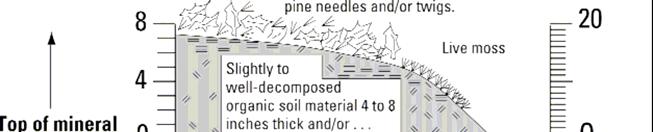
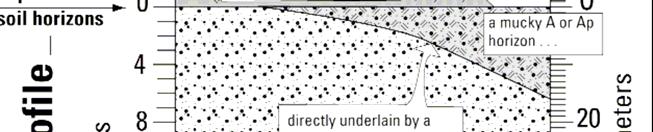
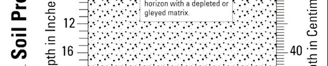
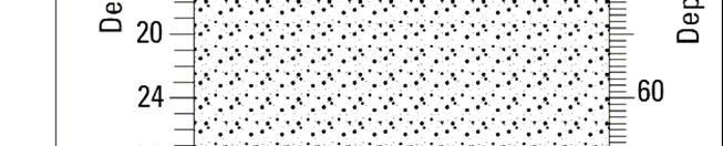
20 I. PONDED OR FLOODED SOILS. Any soil that is frequently ponded or flooded for a long or very long duration during the growing season; or Bs Horizon B horizon with an accumulation of illuvial, amorphous, dispersible organic matter sesquioxide complexes if both the organic matter and sesquioxide components are significant, and if either the moist color value or chroma of the horizon is more than 3. This horizon designation is often used to identify and describe spodic horizons. See Soil Survey Manual (1993) for complete definition. Common, Redoximorphic Features Redoximorphic features comprising from 2 to 20 percent of the observed surface area. Concretion (Fe/Mn) A cemented concentration of a chemical compound of iron and manganese that can be removed from the soil intact and that has a crude internal symmetry organized around a point, a line, or a plane. Contrast, Redoximorphic Features The contrast in color between the redoximorphic feature and the matrix color. See faint, distinct, and prominent redoximorphic features. Refer to both the Chart and the Table for Estimating Contrast of Redoximorphic Features, located in Appendices 3 and 4. Crushed and Smoothed Color A soil color recorded for a moist soil sample that has been broken up, and then lightly compressed and smoothed with one s thumb. This is used when documenting colors of spodic horizons. USER NOTE: Landscape position is a critical element when assessing an area for its susceptibility to, and frequency of, flooding or ponding. Landforms that are prone to flooding or ponding include, but are not limited to: floodplains, meander scars, backswamps, oxbows and closed depressions.. FIELD TESTING ONLY: After verification of landscape position, soil morphologies that indicate long and very long durations of flooding or ponding may include, but are not limited to: 1. 5% or more redoximorphic features within the upper 6 inches of the soil surface; or 2. Stratified layers starting within the upper 6 inches of the soil surface with one or more of the layers being either very dark, organic soil material and/or mucky mineral material; and within 12 inches of the soil surface there is a layer with a depleted or gleyed matrix. 14 Cryic Temperature Regime A soil temperature regime that has mean annual soil temperatures of less than 8 oc. Mean summer soil temperature for saturated mineral soils with O horizons is lower than 6 oc. See Keys to Soil Taxonomy (2003) for complete definition. Dark A or Ap Horizon6 Refer to A or Ap Horizon, Dark. Depleted Matrix6 A depleted matrix makes up more than 50% of the horizon or subhorizon from which iron has been removed or transformed by processes of reduction and often translocation to create colors of low chroma and high value. A and E horizons may have low chromas and high values and may therefore be mistaken Definition has been modified to better reflect the conditions common to New England and may vary from the National definition. 71
21 Aquic Conditions Soils with aquic conditions are those that currently undergo continuous or periodic saturation and reduction. The presence of these conditions is indicated by redoximorphic features, except in Histosols, and can be verified except in artificially drained soils by measuring saturation and reduction. See Keys to Soil Taxonomy (2003) for complete discussion. The three elements of aquic conditions are: 1. Saturation Characterized by zero or positive pressure in the soil-water and can generally be determined by observing free water in an unlined auger hole. 2. Reduction The degree of reduction in a soil can be characterized by the direct measure of redox potential. The a,a dipyridyl test (Childs, C.W., 1981) may be used in the field to determine the presence of reduced iron (ferrous, Fe+2) ions. 3. Redoximorphic features Associated with wetness; result from the reduction and often oxidation of iron and manganese compounds in the soil after saturation with water and desaturation, respectively. B Horizon Horizon that forms below an A, E, or O horizon that shows evidence of soil formation, i.e. illuviation, development of soil color, formation of soil structure, etc. See Soil Survey Manual (1993) for complete definition. Bh and Bhs Horizons B horizons with an accumulation of illuvial, amorphous, dispersible organic matter (sesquioxide complexes). The sesquioxide component coats sand and silt particles. The symbol h is used in combination with s as Bhs if the amount of sesquioxide component is significant but value and chroma of the horizon are 3 or less. These horizon designations are often used to identify and describe spodic horizons. See Soil Survey Manual (1993) for complete definition. Biological Zero the soil temperature, at a depth of 50 cm (19.7 ), below which the growth and function of locally adapted plants are negligible. (Reference: NRCS Hydric Soil Criteria as posted on For the purposes of this manual, a temperature of 5 C (41 F) is used
22 II. TIDAL SOILS. Soils that are flooded daily by tides and/or have sulfidic materials within 12 inches of the soil surface; or Glossary of Terms A Horizon Mineral soil horizons which have formed at the surface or below an O horizon which show an accumulation of humified organic matter intimately mixed with the mineral fraction. An A horizon has a morphology distinct from the C layer, although the mineral fraction is unaltered or slightly altered by weathering. Such a horizon is designated A because it is at the surface; however, recent alluvial or eolian deposits that retain rock structure are not considered to be an A horizon unless cultivated. See Soil Survey Manual (1993) for complete definition. A or Ap Horizon, Dark 5 A or Ap horizon that has moist colors with chromas 2 or less and values 3 or less. A or Ap Horizon, Very Dark A or Ap horizon that has moist colors with chromas 2 or less and values less than 3. Abundance, Redoximorphic Features The percent of the surface area covered by redoximorphic features. Refer to Chart for Estimating Percent Redoximorphic Features, located in Appendix 1. Albic Horizon An eluvial horizon 0.4 inches (1 cm) or more thick that has 85% or more (by volume) albic materials. See Keys to Soil Taxonomy (2003). Albic Materials Mineral soil materials from which clay and free iron oxides have been removed or in which the oxides have been segregated to the extent that the color of the horizon is determined primarily by the color of the primary sand and silt particles rather than by the coatings on these particles. See Keys to Soil Taxonomy (2003). Anaerobic Conditions A condition when molecular oxygen is essentially absent from the soil. USER NOTE: The presence of hydrogen sulfide gas (rotten egg smell) indicates the presence of sulfidic materials. Be aware that there may be other strong odors present in hydric soils. Ap Horizon An A horizon with properties resulting from cultivation, pasturing, or similar kinds of disturbance. 5. Definition has been modified to better reflect the conditions common to New England and may vary from the National definition
23 68 17
24 III. HISTOSOLS. Soils having organic soil materials at or near the soil surface that are greater than 16 inches thick (i.e., classify as Histosols); 1 or 18 USER NOTE: Within frigid and cryic soil temperature regimes and typically associated with areas having climatic conditions that favor the accumulation of organic material (e.g. maritime influence or high elevation), there are organic soils (i.e., Folists) that are never saturated with water except for a few days following heavy rains. Soils having these conditions are not hydric. 1. Folists and soils with folistic epipedons are excluded from Hydric Soil Indicator III

25 APPENDIX 7 Table for Estimating Grade of Soil Structure Grade Code Criteria Structureless 0 No discrete units observable in place or in a hand sample. Weak 1 Units are barely observable in place or in a hand sample. Moderate 2 Units well-formed and evident in place or in a hand sample. Strong 3 Units are distinct in place (undisturbed soil), and separate cleanly when disturbed
26 IV. HISTIC EPIPEDONS. Soils having a layer of organic soil materials at t or near the soil surface that is 8 to 16 inches thick (i.e., histic epipedon); and directly underlying the O horizon or, if present, the Ahorizon, is a horizon with redoximorphic features; 2 or USER NOTE: Excludes soils with folistic epipedons. In order to distinguish between a folistic and histic epipedon, look at the underlying mineral soil morphology. A histic epipedon develops due to anaerobic conditions related to wetness whereas a folistic epipedon develops due to reduced microbial activity related to cool temperatures. 2. Soils with folistic epipedons are excluded from Hydric Soil Indicator IV
27 64 21
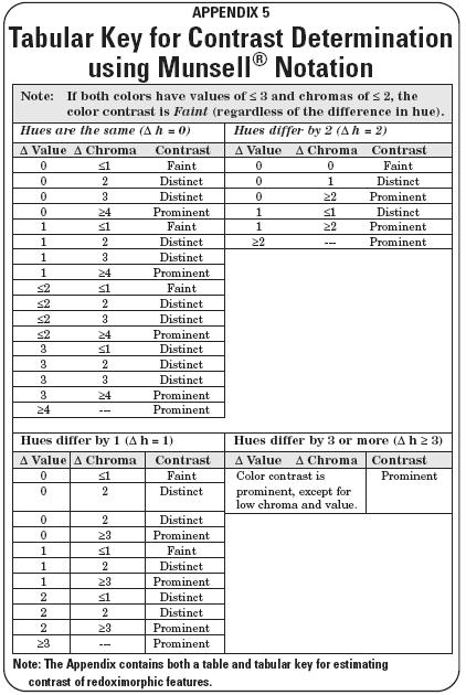
28 63 V. MINERAL HISTIC. Any mineral soil having a layer 4 to 8 inches thick of slightly to welldecomposed organic soil material and/or a mucky A or Ap horizon,3 and is directly underlain by a horizon with a depleted or gleyed matrix; or APPENDIX 4 Table for Estimating Contrast of Redoximorphic Features Record the color difference between the redoximorphic feature (RMF) and the matrix color. Use this table or the tabular key on next page to determine the contrast. Note: If the mottle and matrix both have values of = 3 and chromas of the color contrast is Faint, regardless of the difference in hue. 22 Faint Evident only on close examination. The contrast is faint if the: 1) difference in hue = 0, difference in value is =2, and difference in chroma is =1, or 2) difference in hue = 1, difference in value is =1, and difference in chroma is =1, or 3) difference in hue = 2, difference in value = 0, and difference in chroma = 0, or 4) difference in hue is = 3 and both colors have values of =3 and chromas of =2. USER NOTE: An E horizon usually has low chroma colors as a result of an eluvial process and only qualifies as a depleted or gleyed matrix if it has 2 percent or more redoximorphic concentrations. For soils with E horizons, refer to Indicators IX.A, IX.B, and IX.C. 3. Soils with folistic epipedons are excluded from Hydric Soil Indicator V. 22 Distinct Readily seen but contrast only moderately with the color to which compared. The contrast is distinct if the: 1. difference in hue = 0, and a. difference in value is <2 and difference in chroma is >1 to <4, or b. difference in value is >2 to <4 and difference in chroma is <4. 2. difference in hue = 1, and a. difference in value is =1 and difference in chroma is >1 to <3, or b. difference in value is >1 to <3, and difference in chroma is <3. 3) difference in hue = 2, and a. difference in value = 0 and difference in chroma is >0 to <2, or b) difference in value is >0 to <2 and difference in chroma is <2. Prominent Contrasts strongly with the color to which compared. Color contrasts that are not faint or distinct are prominent. Table contents compiled from the Soil Survey Technical Note 2. For more information visit: Note: The Appendix contains both a table and tabular key for estimating contrast of redoximorphic features. 63

29 62 23
30 VI. DEPLETED OR GLEYED MATRIX. Within 10 inches of the top of the mineral soil material and directly underlying an A or Ap horizon (or, if they are not present, an O horizon), is a horizon with a depleted or gleyed matrix (for soils with moderate to strong structure, the matrix color is recorded for ped interiors); or USER NOTE: An E horizon usually has low chroma colors as a result of an eluvial process and only qualifies as a depleted or gleyed matrix if it has 2 percent or more redoximorphic concentrations. For soils with E horizons, refer to Indicators IX.A, IX.B, and IX.C

31 60 25
32 VII. DEPLETED BELOW DARK SURFACE. Beginning within 20 inches of the top of the mineral soil material and directly underlying a thick or very thick, dark A or Ap horizon is a horizon with a depleted or gleyed matrix that is 4 inches or more thick (for soils with moderate to strong structure, the matrix color is recorded for ped interiors); or Table of Contents Appendix Appendix 1 Chart for Estimating Percent Redoximorphic Features Appendix 2 Chart for Estimating 2 Percent Redoximorphic Features Appendix 3 Chart for Estimating Size of Redoximorphic Features Appendix 4 Table for Estimating Contrast of Redoximorphic Features Appendix 5 Tabular Key for Contrast Determination using Munsell Notation. 64 Appendix 6 Chart for Determining Type of Soil Structure Appendix 7 Table for Estimating Grade of Soil Structure Appendix 8 Chart for Estimating Size of Granular Structure Appendix 9 Chart for Estimating Size of Blocky Structure
.")
33 References Stolt. M.H., Lesinski, B.C. and Wright, W Micromorphology of Seasonally Saturated Soils in Carboniferous Glacial Till. Soil Science 166:6. U.S. Department of Agriculture, Natural Resources Conservation Service Field Indicators of Hydric Soils in the United States, Version 5.0. G.W. Hurt, P.M. Whited, and R.F. Pringle (eds.). USDA-NRCS in cooperation with the National Technical Committee for Hydric Soils, Fort Worth, TX. U.S. Department of Agriculture, Soil Survey Staff Soil Taxonomy, Second Edition. Handbook No U.S. Government Printing Office,Washington, D.C. Wakeley, J.S. August Developing a Regionalized Version of the Corps of Engineers Wetlands Delineation Manual: Issues and Recommendations. U.S. Army Corps of Engineers, Engineer Research and Development Center, 3909 Halls Ferry Road, Vicksburg, MS ERDC/EL TR-02-20,
34 VIII. DARK MINERAL SOILS. Soils with a matrix chroma of 2 or less that extends to a depth of 20 inches below the top of the mineral soil material, and that have a dark A or Ap horizon (with or without an O horizon) that is directly underlain by a horizon with a matrix value of less than 4, and within 12 inches of the top of the mineral soil material or directly underlying an A or Ap horizon, whichever is shallower, 2 percent or more redoximorphic features that extend to : A. a depth of 20 inches below the top of the mineral soil material; or B. a depleted or gleyed matrix, whichever is shallower; or 28 The National Technical Committee for Hydric Soils has developed a hydric soil Test Indicator for soils developed in these red parent materials. The NEHSTC is recommending that the test indicator be tested in New England: TF2. Red Parent Material. In parent material with a hue of 7.5YR or redder, a layer at least 10 cm (4 in) thick with a matrix value 4 or less and chroma 4 or less and 2 percent or more redox depletions or redox concentrations as soft masses or pore linings, or both. The layer is entirely within 30 cm (12in) of the soil surface. The minimum thickness requirement is 5 cm (2 in) if the layer is the mineral surface layer.(usda, 2002) Development of soil morphology keys for identifying hydric soils in these problem areas must be correlated with actual field measurements of hydrology. All of the NEHSTC subcommittees will be establishing research sites for this purpose. Detailed soil descriptions and vegetative data will be collected at each site. Saturation (monitoring wells), redox potential (Eh electrodes), precipitation, and insitu ph will be measured through the wet-dry cycle. The current need is to locate at least three sites representative of any proposed indicator. The sites must include locations that are obviously wetland, obviously upland and transitional. All three locations are to be monitored. Anyone who would like to nominate a site is encouraged to contact the NEHSTC. Subcommittee chairmen are: Disturbed soils: Tom Peragallo (Peragallo@stompit.net) Folists and Soils with Folistic Epipedons: TBD Soils formed in Dark Parent Material: Mark Stolt (mstolt@uri.edu) Soils formed in Red Parent Material: Harvey Luce (harveyluce@uconn.edu) 28 57

35 Soils formed in Dark Parent Materials These soils formed in dark-colored (gray and black) parent materials derived from dark-colored carboniferous and phyllitic bedrock. These soils occur in the Narragansett basin of Rhode Island, parts of southeastern and western Massachusetts, throughout Vermont and in extreme western New Hampshire. The soil colors commonly are low chroma and a low value. The inherited colors make it difficult to assess soil wetness using conventional models of morphology. Low chroma colors, depleted matrices, redox depletions, etc. are typically masked by the dark mineralogy. Some features may be observable under magnification (Stolt et al, 2001). Indicator VIII. (Dark Parent Materials) was developed to address many of the soils forming in dark parent materials, however, this indicator does not solve the identification problems in all areas. Soils formed in Red Parent Material Soils formed in red parent materials are generally found in areas of Mesozoic geologic materials. Their most common occurrence is in the Connecticut River valley and adjacent highlands, extending from Long Island Sound north into southern Massachusetts. Typical soil series associated with red parent materials include: Cheshire, Hartford, Holyoke, Ludlow, Manchester, Meckesville, Menlo Penwood, Sunderland, Yalesville, Watchaug, Wethersfield and Wilbraham. If one is in an area where these soils are mapped you are likely to be dealing with red parent materials (see STATSGO map). Soils developed in red parent materials challenge hydric soil identification because the iron-rich materials inhibit or mask the development of gray colors normally associated with hydric soils. Examination of soils along transects that bisect the drainage catena, should be the first step to making an informed decision. Relative changes in the soil matrix chroma along the transect may help in identifying a soil boundary. Conventional models of soil morphology sometimes may be applied where the red mineralogy is not intensely expressed
36 IX. SPODOSOLS. Mineral soils having a spodic horizon and one of the following morphologies: A. within 6 inches of the top of the mineral soil material have an E horizon (eluvial horizon) with 2 percent or more redoximorphic features and/or have a stripped matrix, that is directly underlain by a spodic horizon with either: 1. a Bh, Bhs, or Bs horizon with 2 percent or more redoximorphic features; or USER NOTE: Soils with an E horizon that have dark brown to reddish brown colors in the horizon directly underlying it are considered to have evidence of spodic development. The E horizon is often discontinuous across the landscape because of natural disturbances. Some soils will have a dark A or Ap horizon overlying a dark brown to reddish brown spodic horizon. Not all soils that show evidence of spodic development will classify taxonomically as having a spodic horizon. These soils are considered problem soils. When soil morphology seems inconsistent with the landscape, vegetation, or observable hydrology, the assistance of an experienced soil or wetland scientist may be needed to determine whether the soil is hydric. USER NOTE: Check Appendix 1 Chart for Estimating Percent Redoximorphic Features. The variability of soil fill material makes establishing a reliable key for every possible situation extremely difficult. The principal challenge for hydric soil classification at excavated sites is the lack of a definite reference to the original ground surface elevation coupled with the relatively short time the soil has been exposed to weathering and profile development. Filled or excavated sites that have been re-graded present additional complexity. Guidelines and indicators developed for disturbed soils will focus on interpretation of sites where alteration has occurred within the last few decades. Folists and Soils with Folistic Epipedons Folists are more or less freely drained Histosols that consist primarily of O horizons derived from leaf litter, twigs and branches resting on rock or on fragmental materials that consist of gravel, stones and boulders in which the interstices are filled or partly filled with organic material (USDA, 1999). Folists are saturated with water for less than 30 cumulative days during normal years (USDA, 1999). Folistic Epipedons are surface horizons that consist of organic material in a natural state or plowed horizons that have high organic carbon content as a result of mixing an organic soil surface with underlying mineral horizons. Both Folists and Folistic Epipedons occur in cool (Frigid and Cryic temperature regimes) humid regions of the world. In New England they have significant distribution in high mountain elevations (usually above 2500 feet) and along the immediate coast of Maine and islands in the Gulf of Maine. These soils occur in upland areas but they have thick organic surfaces that may be easily mistaken for the saturated Histosols (Folists are a Suborder of Histosols) or mineral soils with a histic epipedon. Often Folists and soils with Folistic epipedons lie adjacent to their wetter cousins (Fibrists, Saprists and Hemists) with very subtle changes in topography and vegetation
37 XIII. PROBLEM SOIL AREAS Disturbed soils Specific map location of disturbed soils is impractical, since they occur throughout the region. The USDA STATSGO map on the NEIWPCC website ( is based on soil survey data, so that only significant acreage of mapped disturbed soils (such as the city of Boston) would be legible. In many places soils have been altered by human activity, and such soils are referred to as human-influenced, anthropogenic, or disturbed. Altered soils are typically the result of earthmoving activities where: 1) soil material is removed from its natural position; 2) soil material is placed over existing soil; and/or 3) soil material has been re-graded from on-site material or material transported from other locations. Fill is common to construction sites, lawns, parking lots, highway and railroad embankments, refuse landfill, and dams. Sand and gravel pits, quarries, ditches, and highway and railroad cuts are examples of excavated soils. Other sources of disturbance include agricultural and forestry practices, motorized vehicles, and any practice that promotes accelerated erosion or deposition and mass wasting. Changes that affect local water tables and drainage may result in hydric soils lacking saturation or conversely soils that are saturated and anaerobic showing no morphologic evidence of wetness. There are very few sites in New England that have not seen anthropogenic alterations of some kind. Much of the region was deforested for agriculture and non-sustainable forestry during the 19th Century. The effects of those activities can still be observed throughout our landscape. From a practical point of view, the older the disturbance the more difficult it is to recognize in the field. Fortunately, soil morphologies develop with time allowing the use of Field Indicators for Identifying Hydric Soils in New England for most soils without regard to whether they have been altered. Section VII., for instance, is intended to capture hydric soils with deep plow layers (Ap horizons)
 with 2 percent or more redoximorphic features and/or have a stripped matrix, that is directly underlain by")
38 IX. SPODOSOLS. Mineral soils having a spodic horizon and one of the following morphologies: A. within 6 inches of the top of the mineral soil material have an E horizon (eluvial horizon) with 2 percent or more redoximorphic features and/or have a stripped matrix, that is directly underlain by a spodic horizon with either: 2. a Bh and/or Bhs horizon that is directly underlain, but within 20 inches of the top of the mineral soil material, by a horizon with 2 percent or more redoximorphic features; or USER NOTE: Soils with an E horizon that have dark brown to reddish brown colors in the horizon directly underlying it are considered to have evidence of spodic development. The E horizon is often discontinuous across the landscape because of natural disturbances. Some soils will have a dark A or Ap horizon overlying a dark brown to reddish brown spodic horizon. Not all soils that show evidence of spodic development will classify taxonomically as having a spodic horizon. These soils are considered problem soils. When soil morphology seems inconsistent with the landscape, vegetation, or observable hydrology, the assistance of an experienced soil or wetland scientist may be needed to determine whether the soil is hydric. USER NOTE: Check Appendix 1 Chart for Estimating Percent Redoximorphic Features
 that are directly underlain by a horizon with a matrix color due to wetness of chroma 3 or less,")
39 XII. ANY TEXTURE. Soils that have a very dark A or Ap horizon less than 10 inches thick (with or without an O horizon) that are directly underlain by a horizon with a matrix color due to wetness of chroma 3 or less, with 10 percent or more redoximorphic features; and within 6 inches of the top of the mineral soil material have 2 percent or more redoximorphic features; and within 18 inches of the top of the mineral soil material have 2 percent or more redox depletions; or 52 33
, there is a Bh")
40 IX.SPODOSOLS. Mineral soils having a spodic horizon and one of the following morphologies: B. beginning within 10 inches of the top of the mineral soil material and directly underlying a dark A or Ap horizon and/or a shallow E horizon (or if neither is present, an O horizon), there is a Bh and/or Bhs horizon 4 that is greater than 2 inches thick that is directly underlain, but within 20 inches of the top of the mineral soil material, by a horizon with 2 percent or more redoximorphic features; or USER NOTE: Soils with an E horizon that have dark brown to reddish brown colors in the horizon directly underlying it are considered to have evidence of spodic development. The E horizon is often discontinuous across the landscape because of natural disturbances. Some soils will have a dark A or Ap horizon overlying a dark brown to reddish brown spodic horizon. Not all soils that show evidence of spodic development will classify taxonomically as having a spodic horizon. These soils are considered problem soils. When soil morphology seems inconsistent with the landscape, vegetation, or observable hydrology, the assistance of an experienced soil or wetland scientist may be needed to determine whether the soil is hydric. 4. This morphology can develop as a result of wetness, or in the cryic temperature regime, as a result of climate. See Section XIII for problem soil areas

41 XI. ANY TEXTURE. Soils that do not have a spodic horizon and B. beginning within 15 inches of the top of the mineral soil material and directly underlying a thick, very dark Ap horizon, is a horizon with 5 percent or more redox depletions and within 20 inches of the top of the mineral soil material there is a horizon with a depleted or gleyed matrix (for soils with moderate to strong structure, the matrix color and percent redox depletions are recorded for ped interiors); or 50 35

42 IX. SPODOSOLS. Mineral soils having a spodic horizon and one of the following morphologies: C. beginning within 10 inches of the top of the mineral soil material and directly underlying a dark A or Ap horizon, is one of the following: 1. an E horizon with 2 percent or more redoximorphic features and/or a stripped matrix directly underlain by a Bh, Bhs, or Bs horizon with 2 percent or more redoximorphic features; or USER NOTE: Soils with an E horizon that have dark brown to reddish brown colors in the horizon directly underlying it are considered to have evidence of spodic development. The E horizon is often discontinuous across the landscape because of natural disturbances. Some soils will have a dark A or Ap horizon overlying a dark brown to reddish brown spodic horizon. Not all soils that show evidence of spodic development will classify taxonomically as having a spodic horizon. These soils are considered problem soils. When soil morphology seems inconsistent with the landscape, vegetation, or observable hydrology, the assistance of an experienced soil or wetland scientist may be needed to determine whether the soil is hydric
 is a horizon with 5 percent or more redox depletions,")
43 XI. ANY TEXTURE. Soils that do not have a spodic horizon and A. beginning within 10 inches of the top of the mineral soil material and directly underlying a dark A or Ap horizon (with or without an O horizon) is a horizon with 5 percent or more redox depletions, and within 20 inches of the top of the mineral soil material there is a horizon with a depleted or gleyed matrix (for soils with moderate to strong structure, the matrix color and percent redox depletions are recorded for ped interiors); or 48 37

44 IX. SPODOSOLS. Mineral soils having a spodic horizon and one of the following morphologies: C. beginning within 10 inches of the top of the mineral soil material and directly underlying a dark A or Ap horizon, is one of the following: 2. a Bh and/or Bhs horizon that is directly underlain, but within 20 inches of the top of the mineral soil material, by a horizon with 2 percent or more redoximorphic features; or USER NOTE: Soils with an E horizon that have dark brown to reddish brown colors in the horizon directly underlying it are considered to have evidence of spodic development. The E horizon is often discontinuous across the landscape because of natural disturbances. Some soils will have a dark A or Ap horizon overlying a dark brown to reddish brown spodic horizon. Not all soils that show evidence of spodic development will classify taxonomically as having a spodic horizon. These soils are considered problem soils. When soil morphology seems inconsistent with the landscape, vegetation, or observable hydrology, the assistance of an experienced soil or wetland scientist may be needed to determine whether the soil is hydric

45 X. SANDY WITH REDOX. Soils that do not have a spodic horizon and: C. beginning within 15 inches of the top of the mineral soil material and directly underlying a thick, very dark A or Ap horizon there is a horizon with a loamy fine sand or coarser texture with a matrix color due to wetness of chroma 3 or less, value 4 or more, with 2 percent or more redoximorphic features; or USER NOTE: Field investigations have documented some situations where the conditions for a hydric soil are present and the matrix chroma directly underlying the A or Ap horizon is greater than 3. These soil conditions are associated with iron-enriched groundwater discharge areas. These soils are considered problem soils. When soil morphology seems inconsistent with the landscape, vegetation, or observable hydrology, the assistance of an experienced soil or wetland scientist may be needed to determine whether the soil is hydric
46 IX. SPODOSOLS. Mineral soils having a spodic horizon and one of the following morphologies: C. beginning within 10 inches of the top of the mineral soil material and directly underlying a dark A or Ap horizon, is one of the following: 3. a Bs horizon with 2 percent or more redoximorphic features; or USER NOTE: Soils with an E horizon that have dark brown to reddish brown colors in the horizon directly underlying it are considered to have evidence of spodic development. The E horizon is often discontinuous across the landscape because of natural disturbances. Some soils will have a dark A or Ap horizon overlying a dark brown to reddish brown spodic horizon. Not all soils that show evidence of spodic development will classify taxonomically as having a spodic horizon. These soils are considered problem soils. When soil morphology seems inconsistent with the landscape, vegetation, or observable hydrology, the assistance of an experienced soil or wetland scientist may be needed to determine whether the soil is hydric

47 X. SANDY WITH REDOX. Soils that do not have a spodic horizon and: A. have a layer 4 to 8 inches thick of slightly to well-decomposed organic soil material and/or a mucky A or Ap horizon; and are directly underlain by a horizon with a loamy fine sand or coarser texture with 2 percent or more redoximorphic features; or 42 43
 is a horizon with a loamy fine sand or coarser texture")
48 X. SANDY WITH REDOX. Soils that do not have a spodic horizon and: B. beginning within 10 inches of the top of the mineral soil material and directly underlying a dark A or Ap horizon (with or without an O horizon) is a horizon with a loamy fine sand or coarser texture with a matrix color due to wetness of chroma 3 or less, value 4 or more, with 2 percent or more redoximorphic features; or USER NOTE: Soil profiles may have soil textures that are stratified, requiring the use of multiple color criteria. When, for example, a soil has a layer of loamy fine sand or coarser overlying a layer with a texture of finer than loamy fine sand, color criteria for indicators associated with the Sandy Soils shall apply to the upper layer while color criteria for indicators associated with Loamy or Clayey Soils shall apply to the lower layer. USER NOTE: Field investigations have documented some situations where the conditions for a hydric soil are present and the matrix chroma directly underlying the A or Ap horizon is greater than 3. These soil conditions are associated with iron-enriched groundwater discharge areas. These soils are considered problem soils. When soil morphology seems inconsistent with the landscape, vegetation, or observable hydrology, the assistance of an experienced soil or wetland scientist may be needed to determine whether the soil is hydric
icators for Identif icators for Identi y ldief Hydric Soils Iin NNeew England Version 3 April 2004
 Field Indicators Indicators in New In New for for Identifying Identifying Hydric Soils England England Version 3 April 2004 Field Indicators for Identifying Hydric Soils in New England Version 3 April
icators for Identif icators for Identi y ldief Hydric Soils Iin NNeew England Version 3 April 2004
 Hydric Hydric Soils Soils Field Version 3 April 2004 in New In New England England Identifying Identifying Indicators Indicators for for Field Indicators for Identifying Hydric Soils in New England Version
Field Indicators of Hydric Soils in the United States: For All Soils. Field Indicators. Indicators for all soils regardless of texture
 Field Indicators of Hydric Soils in the United States: For All Soils From Vasilas, L.M., G.W. Hurt, and C.V. Noble. 2010. Field indicators of hydric soils in the United States (Version 7.0), USDA, NRCS,
Field Indicators of Hydric Soils in the United States: Sandy Soils
 Field Indicators of Hydric Soils in the United States: Sandy Soils From: Vasilas, L.M., G.W. Hurt, and C.V. Noble. 2010. Field indicators of hydric soils in the United States (Version 7.0), USDA, NRCS,
S9. Thin Dark Surface
 Dominant Field Indicators of Hydric Soils in Florida S9. Thin Dark Surface For use in LRRs R, S, U, and T; for testing in LRRs K and L. A layer 5 cm (2 inches) or more thick within the upper 15 cm (6 inches)
Field Indicators for Identifying Hydric Soils in New England Version 4
 Field Indicators for Identifying Hydric Soils in New England Version 4 May 2017 New England Hydric Soil Technical Committee 1 The New England Hydric Soils Technical Committee (NEHSTC) consists of the following
Overview of Soil Properties
 Willie Harris apatite@ufl.edu Acknowledgments: Wade Hurt Mike Vepraskas FAESS Soil Scientists Overview of Soil Properties Website to download files of talks: wgharris.ifas.ufl.edu.hsw.htm Meaning of Soil
Overview of Soil Properties
 Willie Harris apatite@ufl.edu Acknowledgments: Wade Hurt Mike Vepraskas FAESS Soil Scientists Overview of Soil Properties Website to download files of talks: wgharris.ifas.ufl.edu.hsw.htm Meaning of Soil
3 Hydric Soil Indicators
 ERDC/EL TR-12-1 32 3 Hydric Soil Indicators Introduction The National Technical Committee for Hydric Soils (NTCHS) defines a hydric soil as a soil that formed under conditions of saturation, flooding,
Reference Card S-2, Side A: Delineating Horizon Boundaries
 Reference Card S-2, Side A: Delineating Horizon Boundaries Distinguishing Soil Horizons Soil horizons are delineated based on differences in: Texture Color Structure and Consistence Redoximorphic Features
Whole Landscape Hydrology: Application to Restore or Create Wetlands. Introduction SOLUTION
 Whole Landscape Hydrology: Application to Restore or Create Wetlands by: Wade Hurt, USDA, NRCS, NSSC/University of Florida and Jimmie Richardson, North Dakota State University. Problem: Wetland construction
Field Indicators of Hydric Soils in the United States Guide for Identifying and Delineating Hydric Soils, Version 5.0, 2002
 Natural Resources Conservation Service Wetland Science Institute Soil Survey Division Field Indicators of Hydric Soils in the United States Guide for Identifying and Delineating Hydric Soils, Version 5.0,
Field Indicators of Hydric Soils in the United States A Guide for Identifying and Delineating Hydric Soils, Version 7.0, 2010
 United States Department of Agriculture Natural Resources Conservation Service In cooperation with the National Technical Committee for Hydric Soils Field Indicators of Hydric Soils in the United States
Hydric Soils - Overview
 Hydric Soils - Overview The Hydric Soils section presents the most current information about hydric soils. It updates information that was previously published in "Hydric Soils of the United States" and
Inconsistencies in terminology and definitions of organic soil materials
 Inconsistencies in terminology and definitions of organic soil materials Mineral soil material (less than 2.0 mm in diameter) either: 1. Is saturated with water for less than 30 days (cumulative) per year
AGRONOMY 255, 251, 270 SOIL DIFFERENCES
 Name AGRONOMY 255, 251, 270 SOIL DIFFERENCES Soils differ strikingly from each other. This week we illustrate the great differences and ask you to learn how they differ and to become skilled in describing
Horner-McLaughlin Woods: Soil Types
 Horner-McLaughlin Woods: Soil Types Not present at HMW Adrian Muck Conover Loam 0-4% Slopes Houghton Muck Miami Loam 2-6% Slopes Miami Loam 6-12% Slopes Miami Loam 12-18% Slopes t 0 0.125 0.25 Miles Mary
zone long enough to affect yield; gray colors below 48 in. horizon thick, dark gray or black
 Wetland & Sub baqueous Soils NRE M 665 Coastal & Wetland Ecology & Management 1 Soil Drainage Classes (USDA) Well Drained = Seasonal high water table (SHWT) not w/i root zone long enough to affect yield;
zone long enough to affect yield; gray colors below 48 in. horizon thick, dark gray or black
 Wetland & Sub baqueous Soils NRE M 665 Coastal & Wetland Ecology & Management 1 2 Soil Drainage Classes (USDA) Well Drained = Seasonal high water table (SHWT) not w/i root zone long enough to affect yield;
12/11/2008. HYDRIC SOILS: Soil Parameters Used for Jurisdictional Delineation. Objectives
 HYDRIC SOILS: Soil Parameters Used for Jurisdictional Delineation Andrew Harley, Ph.D. andrew.harley@wspgroup.com & Lyndon C. Lee, Ph.D., PWS lyndon.lee@wspgroup.com Objectives Introduce concepts & procedures
Soil Colors, Texture & Structure
 Application Soil Colors, Texture & Structure Limiting conditions Soil color type/depth of system Bedrock type/depth of system Soil texture, structure, percolation rate size and type of system Sara Heger,
SOIL CHARACTERIZATION USING DIAGNOSTIC PROPERTIES
 SOIL CHARACTERIZATION USING DIAGNOSTIC PROPERTIES The following are the characters of the pedologically important properties used in categorizing soils: SOIL CHARACTERIZATION Soil Profile Description:
Supplement. Hydric Soils. Hydric Soils
 Field Supplement to to Version 3 April 2004 in New In New England England Hydric Soils Hydric Soils Identifying Identifying Indicators Indicators for for Supplement to Field Indicators for Identifying
Buzzards Bay National Estuary Program and the Massachusetts Association of Conservation Commissions. The BBNEP and MACC have been cooperating,
 This workshop is a cooperative venture between the Buzzards Bay National Estuary Program and the Massachusetts Association of Conservation Commissions. The BBNEP and MACC have been cooperating, coordinating
Soil Horizons cont. Oa- highly decomposed Oi-undecomposed
 Soils Soil Basics Soil Horizons Soil Horizons cont. O Horizon: Or organic layer Organic layer of decomposing plant and animal tissue. Wooded upland areas have thin O horizons Wetlands may have thick O
DO YOU KNOW YOUR SOILS? (Rev. 10/11)
") DO YOU KNOW YOUR SOILS? (Rev. 10/11) Circle all the correct answers. 1. What is the layer normally present on the surface of the soil in cropped fields? a. O c. Ap e. B g. R b. A d. E f. C 2. Available
DO YOU KNOW YOUR SOILS? (Rev. 10/11) Circle all the correct answers. 1. What is the layer normally present on the surface of the soil in cropped fields? a. O c. Ap e. B g. R b. A d. E f. C 2. Available
ASCE - Philadelphia. Soils & Stormwater Management. Matthew C. Hostrander, CPSS, SEO Soil Scientist. Gilmore & Associates, Inc.
 ASCE - Philadelphia Soils & Stormwater Management Matthew C. Hostrander, CPSS, SEO Soil Scientist Gilmore & Associates, Inc. Course Overview COURSE OUTLINE Soil Science Fundamentals Discuss United States
Today. Climate. Role of water. Rainfall: Intensity and duration. Effective precipitation. (1)Parent materials + 4 other factors of soil formation
Parent materials + 4 other factors of soil formation") Today Models of soil formation Soil taxonomy Horizon descriptions (1)Parent materials + 4 other factors of soil formation Climate Topography Time Biota Can be interrelated and interact Climate Moisture
Today Models of soil formation Soil taxonomy Horizon descriptions (1)Parent materials + 4 other factors of soil formation Climate Topography Time Biota Can be interrelated and interact Climate Moisture
Soils and the Environment. A Summary of RI Envirothon Study Materials Compiled by Sally Paul
 Soils and the Environment A Summary of RI Envirothon Study Materials Compiled by Sally Paul Why Soils Food and water resources Disposing of waste Support for human structures Growing timber and fibers
TAXONOMIC CLASS: Loamy-skeletal, mixed, mesic Vitrandic Durochrepts
 ESRM311/SEFS507 Important Soil Series in Seattle Area ALDERWOOD SERIES The Alderwood series consists of moderately deep, moderately well drained soils formed in glacial till. Alderwood soils are on glacially
Soil & Site Evaluator - Need to Know
 Soil & Site Evaluator - Need to Know I. The professional will understand the factors of soil development and demonstrate their importance to site evaluations. A. Topography 1. Landscape & landform description
3. What are the five master horizons? Give distinguishing features of each. 5. List three means by which plant roots come into contact with nutrients.
 Study Questions Exam 1 1. What are the four general components of soil? 2. Define regolith and solum. 3. What are the five master horizons? Give distinguishing features of each. 4. What is meant by an
Soil characteristics that influence nitrogen and water management
 Section C Soil characteristics that influence nitrogen and water management Soil characteristics vary across the landscape Soils vary from one field to another, and often within the same field. Soil differences
SOIL DATA: Avondale. in Allen, TX. This information was taken from NRCS web soil survey of Collin County, Texas.
 SOIL DATA: Avondale in Allen, TX This information was taken from NRCS web soil survey of Collin County, Texas. United States Department of Agriculture Soil Conservation Service in cooperation with Texas
Soil Maps for Production Agriculture. Jarrod O. Miller, Extension Agronomist
 Soil Maps for Production Agriculture Jarrod O. Miller, Extension Agronomist Origination of Soil Mapping Originally mapped by Division of Soils Federal Bureau of Soils Soil Conservation Service (SCS) started
Lecture 5: Introduction to Soil Classification; Soil Physical Properties
 Lecture 5: Introduction to Soil Classification; Soil Physical Properties Soil Classification Argillic Horizon Alfisols Moderately leached soils with a clay-rich B-horizon Typically found in forests Andisols
a. OVERALL PROFILE DEPTH: Assess the depth to the first restrictive layer, which can be a tree root, a rock or an
 OBSERVING SOIL PROCEDURE Using a shovel, soil probe, or soil auger, collect a soil profile. (Go as deep as you can with the equipment). Arrange the soil you remove from the ground on newspaper or in a
Soil Physical Properties
 Soil Physical Properties ESRM 311 SEFS 507 Some examples of mineral soil development eg, Rock Weathering Types of Weathering Physical/Mechanical Chemical Biological Photo by D Vogt CO 2 + H 2 O H 2 CO
Do You Dig Wetland Soil?
 Do You Dig Wetland Soil? [Soil texture flow chart adapted from Steve Thein, 1979. Source unknown.] Grade Level K-12, as indicated Subject Areas Earth Science Duration Part I, 30-40 minutes; Part II, 60
LAB 12: Soils. Name School. Patrich Physical Geography Lab 1
 Name School LAB 12: Soils Soil is a mixture of weathered rock & organic matter that usually covers bedrock (solid rock that underlies all soil). Both chemical & mechanical processes are involved in the
Learning Objectives Part 1. Chapter 4 Soil Physical Properties. Soil Physical Properties. Color. Physical properties part 1
 Learning Objectives Part 1 Chapter 4 Soil Physical Properties Know what color tells you about a soil Describe the concept of soil texture and its importance Use the textural triangle to determine a soil
Soil Physical Properties I: Outline
 Soil Physical Properties I: Outline Soil color See plates between pages 114 and 115 in textbook. Soil texture Soil structure Soil color Soil color provides clues to other soil properties and to soil conditions.
2018 Iowa FFA Soil Judging CDE Exam 1. Landscape positions characterizes the location of the soil on the landscape and identifies potential risks.
 2018 Iowa FFA Soil Judging CDE Exam 1. Landscape positions characterizes the location of the soil on the landscape and identifies potential risks. Which landscape position is considered the floodplain
2014 Iowa FFA Soil Judging CDE Exam
 2014 Iowa FFA Soil Judging CDE Exam 1. Landscape position is one aspect of evaluating the surface features of a certain tract of land. Identifying the correct landscape position will indicate: a. If the
2012 FINAL SOILS AREA 2 Envirothon Questions Answer KEY
 2012 FINAL SOILS AREA 2 Envirothon Questions Answer KEY Questions 1-6 to be answered at the soil pit: 1. Soil scientists categorize soils by drainage classes. What is the drainage class of the soil at
Examining soils in the field. Examining soils in the field. Environment Agency thinksoils examining soils in the field
 Examining soils in the field thinksoils Examining soils in the field Environment Agency thinksoils examining soils in the field 31 Examining soils in the field 32 Environment Agency thinksoils examining
Special Assignment for Wednesday: Watch video on soil texture analysis https://youtu.be/ioyabxj767s
 Special Assignment for Wednesday: Watch video on soil texture analysis https://youtu.be/ioyabxj767s Lecture 3: Soil Physical Properties Important Physical Properties Soil Color: Most obvious physical property;
The Soils That We Classify
 The Soils That We Classify 2 Abstract Soil is the natural medium for the growth of land plants, whether or not it has discernible soil horizons. People consider soil important because it supports plants
Soil compaction Soil Colour
 Soil compaction Soil compaction is defined as the method of mechanically increasing the density of soil. In construction, this is a significant part of the building process. If performed improperly, settlement
Global Soils. The Nature of Soil The Soil Water Balance Soil Development The Global Scope of Soils Global Climate Change and Agriculture
 Global Soils The Nature of Soil The Soil Water Balance Soil Development The Global Scope of Soils Global Climate Change and Agriculture Soil is a mixture of The Nature of Soil 1) inorganic material derived
Soil & Site Evaluator - Need to Know
 Soil & Site Evaluator - Need to Know I. The professional will understand the factors of soil development and demonstrate their importance to site evaluations. A. Topography 1. Landscape description 2.
This definition is from the Soil Science Glossary (Soil Science Society of America).
.") What is Soil? This definition is from the Soil Science Glossary (Soil Science Society of America). soil - (i) The unconsolidated mineral or organic material on the immediate surface of the earth that serves
What is Soil? This definition is from the Soil Science Glossary (Soil Science Society of America). soil - (i) The unconsolidated mineral or organic material on the immediate surface of the earth that serves
SUBSURFACE DRIP DISPERSAL OF EFFLUENT for LARGE SYSTEMS. Presented by: David Morgan and Rodney Ruskin
 SUBSURFACE DRIP DISPERSAL OF EFFLUENT for LARGE SYSTEMS Presented by: David Morgan and Rodney Ruskin Program Map Making Program Soil Parent material, Relief, Time. Organisms, Color, Texture, Depth, Profile
Iowa FFA Soil Career Development Event 2008
 Iowa FFA Soil Career Development Event 2008 1. In Iowa, corn suitability ratings for soil mapping units specifies a. natural weather conditions b. surface and subsurface drainage installed where needed
EXAMPLE Point A: Sandy Loam: 65% Sand _ 20% Silt _ 15% Clay. Point B: %Sand % Silt % Clay. Point C: %Sand % Silt % Clay. Point D: %Sand % Silt % Clay
 SOIL TEXTURE Refers to proportions of sand, silt and clay size particles. These proportions determine water infiltration rates, permeability rates, and water holding rates. Using a soil texture triangle.
2014 Envirothon Georgia Soil Study Guide
 2014 Envirothon Georgia Soil Study Guide In addition to materials in this document, 2014 Georgia Envirothon contestants are responsible for materials found in the following documents: From The Surface
Unit II Soil Management
 Unit II Soil Management Lesson 2: Using Soil Survey Manuals Soil survey manuals provide useful information for grassland management. Soil scientists evaluate the soil for chemical and physical properties,
1. Position (2 pts.) 2. Parent Material (2 pts.) 3. Slope Characteristics (2 pts.) 4. Surface Stoniness or Rockiness (2 pts.)
 2. Parent Material (2 pts.) 3. Slope Characteristics (2 pts.) 4. Surface Stoniness or Rockiness (2 pts.)") Maryland Envirothon SOILS Exam Guidance Information (revised 2017) Objective: To test students' knowledge and awareness of basic soil science and its application in wise land-use planning and therefore
Maryland Envirothon SOILS Exam Guidance Information (revised 2017) Objective: To test students' knowledge and awareness of basic soil science and its application in wise land-use planning and therefore
Soils and Land Use Test
 SOIL PROPERTIES Total Score /50 1) List two of the five main functions of soil. (2 points) Habitat for organisms, Engineering medium, Filters and stores water, Anchor for plants, Cycles nutrients 2) Small
Land Capability Classifications
 Land Capability Classifications Unit: Soil Science Problem Area: Basic Principles of Soil Science Student Learning Objectives. Instruction in this lesson should result in students achieving the following
2016 Iowa FFA Soils Evaluation CDE Exam
 2016 Iowa FFA Soils Evaluation CDE Exam 1. Which of the following is true regarding soil horizons? a. A horizon is darker in color and has more organic matter b. B horizon is darker in color and has more
Parent Material & some of Seattle s soils
 Parent Material & some of Seattle s soils ESRM 311/SEFS 507 Week 3 SOILS = f(cl, r, o, p, t) Parent Materials 1) Sedentary a) residual (bedrock weathered in place) b) organic 2) Transported by a) gravity
IOWA FFA STATE SOILS CDE SATURDAY, OCTOBER 13, 2007 AMES, IOWA
 IOWA FFA STATE SOILS CDE SATURDAY, OCTOBER 13, 2007 AMES, IOWA 1. Moderately sloping has what percent slope: a. 9-14% b. 2-5% c. 5-9% d. over 14% 2. Which of the following horizons is the loose underlying
HAVE YOU NOTICED at construction sites how a
 Explaining a Soil Profile HAVE YOU NOTICED at construction sites how a cross section of soil has a layered look? Soil near the top of the cross section is often dark, and soil below appears lighter. What
Homework Activity Jar Test for Soil Texture
 Homework Activity Jar Test for Soil Texture Background: 1. What is soil? 2. What natural factors influence the formation of soil? 3. How will the depth of each horizon in your soil profile affect your
Glossary of Wetland Terminology
 Glossary of Wetland Terminology Common wetland terms defined Active water table A condition in which the zone of soil saturation fluctuates, resulting in periodic anaerobic soil conditions. Soils with
2011 Wisconsin Envirothon Soils and Land Use Exam
 2011 Wisconsin Envirothon Soils and Land Use Exam USE THE OCONTO COUNTY SOIL SURVEY TO ANSWER QUESTIONS 1-4 The Pensaukee River Wetland Complex is a mixture of state (Pensaukee Wildlife Area) and privately
3.44b. Soil Classification AK & BR
 3.44b Soil Classification AK & BR Why look at soil? Because soil and its constituents are the base material for growing trees. History Why a Forestry Commission soil classification? There is a need for
2016 Area 3 Envirothon Muskingum County Soils Test ANSWER KEY
 2016 Area 3 Envirothon Muskingum County Soils Test ANSWER KEY 1. The majority of the bedrock in Muskingum County is. a. sedimentary bedrock b. glacial bedrock c. igneous bedrock d. metamorphic bedrock
Soil Notes. General Soil Information
 Soil Notes General Soil Information Definition Soil relatively thin surface layer of the Earth s crust consisting of mineral and organic matter that is affected by agents such as weather, wind, water,
Soil Taxonomy. A Basic System of Soil Classification for Making and Interpreting Soil Surveys. Second Edition, 1999 By Soil Survey Staff
 Soil Taxonomy A Basic System of Soil Classification for Making and Interpreting Soil Surveys Second Edition, 1999 By Soil Survey Staff United States Department of Agriculture Agriculture Handbook Natural
SOILS IN URBAN / SUBURBAN LANDSCAPES. Lisa Krall Soil Scientist CT USDA NRCS Tolland, CT
 SOILS IN URBAN / SUBURBAN LANDSCAPES Lisa Krall Soil Scientist CT USDA NRCS Tolland, CT What is Urban Soil? Is This Soil? Is This Soil? active gravel pit pavement and buildings vegetated roadside areas
O horizon: the O-horizon is made up of organic material. The horizon is found at the soil surface.
 A Good Dirty n Soil Lab: References: Wagner & Sanford. Environmental Science. Wiley & Sons, 2005. Molnar. Laboratory Investigations for AP* Env. Science. Peoples Ed, 2005. Soil Porosity & Permeability
Soil Texture = %Sand, Silt & Clay in a soil.
 Soils Soil Texture = %Sand, Silt & Clay in a soil. Soil texture is the single most important physical property of the soil. Knowing the soil texture alone will provide information about: 1) water flow
1 Describe the concept of soil texture and its importance. 2 Determine the texture of a soil sample.
 Interest Approach Provide students with various samples of soil. One sample should be nearly all sand, one nearly all clay, and one nearly all silt. Ask students to determine how the samples differ. Would
Understanding Soils. 1. What is Soil? 2. What does soil do for us?
 Understanding Soils 1. What is Soil? Soil: (i) The unconsolidated mineral or organic material on the immediate surface of the earth that serves as a natural medium for the growth of land plants. (ii) The
3 PHYSICAL PROPERTIES
 3 PHYSICAL PROPERTIES 3.1 Introduction Physical properties are those which deal with aspects of the material that are related to the bulk properties of the material. In other words, if chemical properties
2017 Iowa FFA Soil Judging CDE Exam
 2017 Iowa FFA Soil Judging CDE Exam 1. Landscape positions vary in soil composition and makeup. What landscape position would be characterized by having strata and lenses of different textures in the profile:
Unknown 1. Unknown 2 TEXTURE ANALYSIS
 Unknown 1 Unknown 2 TEXTURE ANALYSIS 1 5 8 11 1 22 1 12 10 Parent Material & some of Seattle s soils ESRM 311/SEFS 507 Week 3 SOILS = f(cl, r, o, p, t) Parent Materials 1) Sedentary a) residual (bedrock
2 Older farm homes on the land
 2 Older farm homes on the land LAND RANCHES EXCHANGES This ranch consists of 70 +/_ acres of level farmland. Prime 13700 POWERHOUSE RD POTTER VALLEY agricultural land at an attractive price. This property
URBAN SOILS & SEATTLE EXAMPLES
 Class Results - Mystery Soil #1 14 12 10 8 6 4 2 0 Sandy Clay Loam Sandy Loam Silty Loam Class Results - Mystery Soil #2 6 5 4 3 2 1 0 Silty Clay Clay Loam Sandy Sandy Silty Sandy Silty Loamy Loam Clay
2010 CSSS Soil Judging Competition Manual. Manual Prepared by: Darwin Anderson Angela Bedard Haughn Louis Comeau Rich Farrell Ryan Hangs Tom Yates
 2010 CSSS Soil Judging Competition Manual Manual Prepared by: Darwin Anderson Angela Bedard Haughn Louis Comeau Rich Farrell Ryan Hangs Tom Yates Preface Soil judging is a fun, educational and friendly
DIRT! APES Laboratory Activity
 Name: Part I: Soil Texture DIRT! APES Laboratory Activity Can one determine the texture of soil by examining the particles found in a particular sample? The purpose of this activity is to determine the
Soil Classification: Outline
 Soil Classification: Outline Introduction Soil moisture regimes Soil temperature regimes The Soil Taxonomy Diagnostic horizons soil orders Why Classify? Organize knowledge in an attempt to find order in
ON LANDSCAPING, SOILS, SOIL AMENDMENTS AND PROPER SEED ESTABLISHMENT (BOTH GRASS LAWNS AND MEADOWS).
.") ON LANDSCAPING, SOILS, SOIL AMENDMENTS AND PROPER SEED ESTABLISHMENT (BOTH GRASS LAWNS AND MEADOWS). John D. Chibirka USDA-NRCS Resource Soil Scientist 1238 County Welfare Road, Suite 220 Leesport, PA
ON LANDSCAPING, SOILS, SOIL AMENDMENTS AND PROPER SEED ESTABLISHMENT (BOTH GRASS LAWNS AND MEADOWS). John D. Chibirka USDA-NRCS Resource Soil Scientist 1238 County Welfare Road, Suite 220 Leesport, PA
Tools to facilitate the use of Soil Maps in Emilia-Romagna region (Italy) Paola Tarocco
 Paola Tarocco") Tools to facilitate the use of Soil Maps in Emilia-Romagna region (Italy) Paola Tarocco Soil maps Vs Thematic maps Soil maps are not easy to manage. Legends are usually based on soil classifications (e.g.
Tools to facilitate the use of Soil Maps in Emilia-Romagna region (Italy) Paola Tarocco Soil maps Vs Thematic maps Soil maps are not easy to manage. Legends are usually based on soil classifications (e.g.
SOIL SEPARATES. Soil Evaluator Day 2, Presentation 3-3/27/2018. Soil Texture, Page 1 TITLE 5 SOIL EVALUATOR CERTIFICATION TRAINING SOIL TEXTURE
 Soil Evaluator Day 2, Presentation 3-3/27/18 TITLE 5 SOIL EVALUATOR CERTIFICATION TRAINING SOIL TEXTURE Prepared for: Commonwealth of Massachusetts Department of Environmental Protection By L.A. Spokas,
Making Sense of Soil Series
 Making Sense of Soil Series Larry A. Morris Forest Soils Professor UGA WSF&NR The type, organization, and degree of development of soil horizons (layers) we observe in a soil profile such as pictured below
Lecture 5 SOIL FORMING PROCESSES
 Lecture 5 SOIL FORMING PROCESSES Soil horizons Horizons in the soil profile are the results of soil formation processes PROCESS OF SOIL FORMATION The layers in soil, called soil horizons, develop their
If you are not able to turn in your notebook see me or Dan ASAP
 Notebook Collection Collecting hard copies now OR Electronic versions using Catalyst drop box Due by 5:30 pm today Use website for link If you are not able to turn in your notebook see me or Dan ASAP URBAN
Lesson 3: Understanding Soil Color
 Lesson 3: Understanding Soil Color 1 Bright colored Color Dull colored Humus Mottle colored Native vegetation Structure Tall prairie grass Texture Deciduous hardwood forest 2 I. Soils have many features
NYC Envirothon 2017 Soil Science Review. Richard K Shaw USDA-NRCS
 NYC Envirothon 2017 Soil Science Review Richard K Shaw USDA-NRCS Introduction Who Are We? U.S. Department of Agriculture (1862) Natural Resources Conservation Service (1935) What Do We Do? Provide leadership
GEOL 408/508 INTRODUCTORY SOILS
 GEOL 408/508 INTRODUCTORY SOILS Lecture = 3 hrs/week Lab = 3hrs/week Course = 4 credits Name/Define the Following 1. N 2 2. NH 3 3. NH + 4 4. NO - 2 5. NO - 3 6. protein 7. organics 8. organic matter 9.
Soil Drainage. Dr. Jim Walworth Dept. of Soil, Water & Environmental Sci. University of Arizona
 Soil Drainage Dr. Jim Walworth Dept. of Soil, Water & Environmental Sci. University of Arizona Yield (kg kernel/cm 2 ) Y = (0.04*sand) + 0.79 R 2 = 0.57 Percent Sand Pecans like well-drained soil. In Arizona
Soil Characterization Protocol
 Soil Characterization Protocol Purpose To characterize the physical and chemical properties for each horizon in a soil profile and prepare samples for further analysis Overview Students identify the horizons
List of Equipment, Tools, Supplies, and Facilities:
 Unit A: Principles of Soil Lesson 3: Horizons of Soil Student Learning Objectives: Instruction in this lesson should result in the students achieving the following objectives: 1. Explain a soil profile
Great Soil-Great Gardens I Basic Soil Science Brad Park, Rutgers University Materials developed by: Karen A. Plumley, Ph.D.
 Great Soil-Great Gardens I Basic Soil Science Brad Park, Rutgers University Materials developed by: Karen A. Plumley, Ph.D. Research Director, Alliance for Low Input Sustainable Turf Soils Instructor,
List of Equipment, Tools, Supplies, and Facilities:
 Unit C: Traits of Soil Lesson 3: Understanding Soil Color Student Learning Objectives: Instruction in this lesson should result in the students achieving the following objectives: 1. Identify physical
Custom Soil Resource Report for Fond du Lac County, Wisconsin
 United States Department of Agriculture Natural Resources Conservation Service A product of the National Cooperative Soil Survey, a joint effort of the United States Department of Agriculture and other
Soil Reference Groups of WRB (and related diagnostic criteria)
") Soil Reference Groups of WRB (and related diagnostic criteria) Discussion of Reference Groups will be based on the FAO World Soil Resources Report # 94 LECTURE NOTES ON THE MAJOR SOILS OF THE WORLD available
Soil Reference Groups of WRB (and related diagnostic criteria) Discussion of Reference Groups will be based on the FAO World Soil Resources Report # 94 LECTURE NOTES ON THE MAJOR SOILS OF THE WORLD available