S9. Thin Dark Surface
|
|
|
- Brandon Hill
- 5 years ago
- Views:
Transcription
 or more thick within the upper 15 cm (6 inches) of the surface, with value 3 or less and chroma 1 or less.")
 with value 4 or less and chroma 1 or less to a depth of 30 cm (12 inches) or to the")
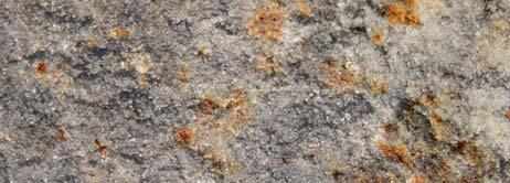
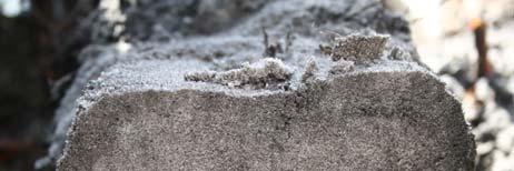
1 Dominant Field Indicators of Hydric Soils in Florida S9. Thin Dark Surface For use in LRRs R, S, U, and T; for testing in LRRs K and L. A layer 5 cm (2 inches) or more thick within the upper 15 cm (6 inches) of the surface, with value 3 or less and chroma 1 or less. Using a 10X or 15X hand lens, at least 70 percent of the visible soil particles in this layer must be masked with organic material. Observation without a hand lens appears to be close to 100 percent masked This layer is underlain by a layer(s) with value 4 or less and chroma 1 or less to a depth of 30 cm (12 inches) or to the spodic horizon, whichever is less. Thin Dark Surface User Notes: This indicator describes soils with a very dark gray or black near-surface layer at least 5 cm (2 inches) thick underlain by a layer where organic matter has been carried downward by flowing water. The mobilization and translocation of organic matter results in an even distribution of organic matter in the eluvial (E) horizon. The chroma 1 or less is critical because it limits application of this indicator to only those soils which are depleted of iron. This indicator commonly occurs in hydric Spodosols; however, a spodic horizon is not required. 1
 of the soil surface that is at least 10 cm (4 inches) thick, and has a matrix with 60% or more chroma 2 or less with 2% or more distinct or prominent redox")
 and pore linings (Vepraskas 1992).")
2 S5. Sandy Redox For use in all LRRs except Q,V, W, X, and Y. A layer starting within 15 cm (6 inches) of the soil surface that is at least 10 cm (4 inches) thick, and has a matrix with 60% or more chroma 2 or less with 2% or more distinct or prominent redox concentrations as soft masses and/or pore linings. Sandy Redox User Notes: Distinct and prominent are defined in the Glossary (Appendix A). Redox concentrations include iron and manganese masses (reddish mottles) and pore linings (Vepraskas 1992). Included within the concept of redox concentrations are iron/manganese bodies as soft masses with diffuse boundaries. Common (2 to less than 20 percent) to many (20 percent or more) redox concentrations (USDA Natural Resources Conservation Service 2002) are required. If the soil is saturated at the time of sampling, it may be necessary to let it dry to a moist condition for redox features to become visible. This is a very common indicator of hydric soils and is often used to identify the hydric/non-hydric soil boundary in sandy soils. 2
3 3
4 S8. Polyvalue Below Surface For use in LRRs R, S, T, and U; for testing in LRRs K and L. A layer with value 3 or less and chroma 1 or less starting within 15 cm (6 inches) of the soil surface. Using a 10X or 15X hand lens, at least 70 percent of the visible soil particles in this layer must be masked with organic material. Observation without a hand lens appears to be close to 100 percent masked. Immediately below this layer, 5% or more (up to 100%) of the soil volume has value 3 or less and chroma 1 or less and the remainder of the soil volume (if any) has value 4 or more and chroma 1 or less to a depth of 30 cm (12 inches) or to the spodic horizon, whichever is less. User Notes: This indicator describes soils with a very dark gray or black surface or near surface layer less than 10 cm (4 inches) thick underlain by a layer where organic matter has been differentially distributed within the soil by water movement (figure 26). The mobilization and translocation of organic matter results in splotchy coated and uncoated soil. 4
5 5
6 6
7 7
8 S7. Dark Surface For use in LRRs K, L, M, N,Q, P, R, S, T, U, V, and Z; for testing in LRR K, L and M. A layer 10 cm (4 inches) thick starting within the upper 15 cm (6 inches) of the soil surface with a matrix value 3 or less and chroma of 1 or less. Using a 10X or 15X hand lens, at least 70 percent of the visible soil particles must be masked with organic material. Observation without a hand lens appears to be close to 100 percent masked. The matrix color of the layer immediately below the dark layer must have the same colors as those described above or any color that has chroma of 2 or less. Dark Surface User Notes: The organic carbon content of this indicator is slightly less than required for mucky. An undisturbed sample must be observed. A 10X or 15X hand lens is an excellent tool to help aid this decision. Many wet soils have a ratio of about 50 percent soil particles that are covered or coated with organic matter and about 50 percent uncoated or uncovered soil particles, giving the soil a salt and pepper appearance. Where the percent of coverage is less than 70 percent, a Dark Surface indicator is not present. 8
9 S6. Stripped Matrix For use in all LRRs, except for Q, V, W, X, and Y. A layer starting within 15 cm (6 inches) of the soil surface in which iron-manganese oxides and/or organic matter have been stripped from the matrix and the primary base color of the soil material has been exposed. The stripped areas and translocated oxides and/or organic matter form a faintly contrasting pattern of 2 or more colors with diffuse boundaries. The stripped zones are 10 percent or more of the volume and are rounded. S6. Stripped Matrix User Notes User Notes: This indicator includes the indicator previously named polychromatic matrix as well as the term streaking. Common or many areas of stripped (uncoated) soil materials are required. The stripped areas are typically 1 to 3 cm (0.5 to 1 inch) in size but may be larger or smaller (figure 24). Commonly, the stripped areas have value of 5 or more and have chroma of 1 and/or 2 and unstripped areas have chroma of 3 and/or 4. The matrix (predominant color) may not have the material with 3 and/or 4 chroma. The mobilization and translocation of oxides and/or organic matter is the important process and should result in splotchy coated and uncoated soil areas. This may be a difficult pattern to recognize and is more evident when observing a horizontal slice. 9
10 10
11 11
12 12
. A8. Muck Presence. For use in LRRs U, V and Z.")

13 A8 (Muck Presence) and A9 (1 cm Muck) Because the only differences are the required thickness of muck, these two indicators are presented together (note LRRs). A8. Muck Presence. For use in LRRs U, V and Z. A layer of muck with value 3 or less and chroma 1 or less starting within 15 cm (6 inches) of the soil surface. A9. 1 cm Muck. For use in LRRs D, F, G, H, P, and T; for testing in LRRs I, J, and O. A layer of muck 1 cm (0.5 inches) or more thick with value 3 or less and chroma 1 or less starting within 15 cm (6 inches) of the soil surface. 13
14 F2. Loamy Gleyed Matrix For use in all LRRs except W, X, and Y. A gleyed matrix that occupies 60% or more of a layer starting within 30 cm (12 inches) of the soil surface. Loamy Gleyed Matrix User Notes: Gley colors are not synonymous with gray colors. Gley colors are those colors that are found on the gley pages (Gretag/Macbeth. 2000). They have hue N, 10Y, 5GY, 10GY, 5G, 10G, 5BG, 10BG, 5B, 10B, or 5PB, with value 4 or more. The gleyed matrix only has to be present within 30 cm (12 inches) of the surface. Soils with gleyed matrices are saturated for a significant duration, this is why no thickness of the layer is required. See glossary for the definition of gleyed matrix. Note there is no required thickness of the gleyed matrix. This is because any amounts of gleying within the upper 12 inches would indicate a very wet soil that is reduced for long periods. 14
15 A7. 5 cm Mucky Mineral For use in LRRs P, T, U, and Z. A mucky modified mineral surface layer 5 cm (2 inches) or more thick starting within 15 cm (6 inches) of the soil surface. 5 cm Mucky Mineral User Notes: "Mucky" is a USDA texture modifier for mineral soils. The organic carbon content is at least 5 and ranges to as high as 18 percent. The percentage requirement is dependent upon the clay content of the soil; the higher the clay content, the higher the organic carbon requirement. An example is mucky fine sand, which has at least 5 percent organic carbon but not more than about 12 percent organic carbon. Another example is mucky sandy loam, which has at least 7 percent organic carbon but not more than about 14 percent organic carbon. When soils with this indicator are saturated or nearly saturated individual soil particles are not visible nor can they be felt, however, after 2 rubs with slightly firm pressure individual soil particles can be felt. 15
16 A6. Organic Bodies. For use in LRRs P (except for MLRA 136), T, U, and Z. Presence of 2 percent or more organic bodies of muck or a mucky modified mineral texture starting within 15 cm (6 inches) of the soil surface. User Notes: Organic bodies are typically found at the tips of fine roots. The content of organic carbon in organic bodies is the same as in the Muck or Mucky Texture Indicators. The Organic Bodies indicator includes the indicator previously named accretions (Florida Soil Survey Staff, 1992). The size of the organic body is not critical, however the organic carbon content is (figures 11 and 12). The bodies are commonly 1 to 3 cm (0.5 to 1 inch) in diameter, and the organic carbon requirement in the organic bodies must meet those of muck or mucky modified. Many organic bodies lack the required amount of organic carbon and are not indicative of this indicator. Organic bodies of hemic material (mucky peat) and/or fibric material (peat) do not meet the requirements of this indicator, nor does material consisting of partially decomposed root tissue. 16
17 17
18 A5. Stratified Layers For use in LRRs C, F, K, L, M, N, O, P, R, S, T, and U; for testing in LRRs V and Z. Several stratified layers starting within the upper 15 cm (6 inches) of the soil surface. At least one of the layers has value 3 or less with chroma 1 or less or it is muck, mucky peat, peat, or mucky modified mineral texture. The remaining layers have chroma 2 or less. Any sandy material that constitutes the value 3 or less and chroma 1 or less layer using a 10X or 15X hand lens, must have at least 70 percent of the visible soil particles masked with organic material. Observation without a hand lens appears to be close to 100 percent masked. A5. Stratified Layers User Notes User Notes: Use of this indicator may require assistance from a trained soil scientist with local experience. The minimum organic carbon content of at least one layer of this indicator is slightly less than required for indicator A7 (Mucky Modified Mineral Texture). An undisturbed sample must be observed. Individual strata are dominantly less than 2.5 cm (1 inch) thick. A hand lens is an excellent tool to aid in the identification of this indicator. Many alluvial soils have stratified layers at greater depths; these soils do not meet this indicator. Many alluvial soils have stratified layers at the required depths but lack chroma 2 or less; these do not meet the requirements of this indicator. Stratified Layers occur in any soil texture (figure 10). 18
19 19
20 What Indicator would you expect to find here? 20
21 Value 3 or less and chroma 1 or less 70% not required S7 S8 S9 6 Any value and Chroma 2 or 1 4 Value 4 or more and Chroma 1 Any color Value 4 or less and Chroma 1 12 spodic value 3 or less and chroma 1 or less. At least 70% of the visible soil particles in this layer must be covered, coated, or masked with organic material. 21
22 Additional USACE Guidance Where hydrology and vegetation provide overriding wetland evidence and the only hydric soil indicator present is one of the test indicators, the presence of a hydric soil may be assumed. 22
Field Indicators of Hydric Soils in the United States: Sandy Soils
 Field Indicators of Hydric Soils in the United States: Sandy Soils From: Vasilas, L.M., G.W. Hurt, and C.V. Noble. 2010. Field indicators of hydric soils in the United States (Version 7.0), USDA, NRCS,
Field Indicators of Hydric Soils in the United States: For All Soils. Field Indicators. Indicators for all soils regardless of texture
 Field Indicators of Hydric Soils in the United States: For All Soils From Vasilas, L.M., G.W. Hurt, and C.V. Noble. 2010. Field indicators of hydric soils in the United States (Version 7.0), USDA, NRCS,
Field Indicators of Hydric Soils in the United States Guide for Identifying and Delineating Hydric Soils, Version 5.0, 2002
 Natural Resources Conservation Service Wetland Science Institute Soil Survey Division Field Indicators of Hydric Soils in the United States Guide for Identifying and Delineating Hydric Soils, Version 5.0,
3 Hydric Soil Indicators
 ERDC/EL TR-12-1 32 3 Hydric Soil Indicators Introduction The National Technical Committee for Hydric Soils (NTCHS) defines a hydric soil as a soil that formed under conditions of saturation, flooding,
Field Indicators for Identifying Hydric Soils in New England Version 4
 Field Indicators for Identifying Hydric Soils in New England Version 4 May 2017 New England Hydric Soil Technical Committee 1 The New England Hydric Soils Technical Committee (NEHSTC) consists of the following
Field Indicators of Hydric Soils in the United States A Guide for Identifying and Delineating Hydric Soils, Version 7.0, 2010
 United States Department of Agriculture Natural Resources Conservation Service In cooperation with the National Technical Committee for Hydric Soils Field Indicators of Hydric Soils in the United States
Reference Card S-2, Side A: Delineating Horizon Boundaries
 Reference Card S-2, Side A: Delineating Horizon Boundaries Distinguishing Soil Horizons Soil horizons are delineated based on differences in: Texture Color Structure and Consistence Redoximorphic Features
Whole Landscape Hydrology: Application to Restore or Create Wetlands. Introduction SOLUTION
 Whole Landscape Hydrology: Application to Restore or Create Wetlands by: Wade Hurt, USDA, NRCS, NSSC/University of Florida and Jimmie Richardson, North Dakota State University. Problem: Wetland construction
Overview of Soil Properties
 Willie Harris apatite@ufl.edu Acknowledgments: Wade Hurt Mike Vepraskas FAESS Soil Scientists Overview of Soil Properties Website to download files of talks: wgharris.ifas.ufl.edu.hsw.htm Meaning of Soil
Overview of Soil Properties
 Willie Harris apatite@ufl.edu Acknowledgments: Wade Hurt Mike Vepraskas FAESS Soil Scientists Overview of Soil Properties Website to download files of talks: wgharris.ifas.ufl.edu.hsw.htm Meaning of Soil
Soil Colors, Texture & Structure
 Application Soil Colors, Texture & Structure Limiting conditions Soil color type/depth of system Bedrock type/depth of system Soil texture, structure, percolation rate size and type of system Sara Heger,
The New England Hydric Soils Technical Committee (NEHSTC) consists of the following members:
 consists of the following members:") Acknowledgements This manual reflects the collective effort and vision of the New England Hydric Soils Technical Committee. The Committee consists of soil scientists, wetland scientists, and regulatory
Acknowledgements This manual reflects the collective effort and vision of the New England Hydric Soils Technical Committee. The Committee consists of soil scientists, wetland scientists, and regulatory
DO YOU KNOW YOUR SOILS? (Rev. 10/11)
") DO YOU KNOW YOUR SOILS? (Rev. 10/11) Circle all the correct answers. 1. What is the layer normally present on the surface of the soil in cropped fields? a. O c. Ap e. B g. R b. A d. E f. C 2. Available
DO YOU KNOW YOUR SOILS? (Rev. 10/11) Circle all the correct answers. 1. What is the layer normally present on the surface of the soil in cropped fields? a. O c. Ap e. B g. R b. A d. E f. C 2. Available
12/11/2008. HYDRIC SOILS: Soil Parameters Used for Jurisdictional Delineation. Objectives
 HYDRIC SOILS: Soil Parameters Used for Jurisdictional Delineation Andrew Harley, Ph.D. andrew.harley@wspgroup.com & Lyndon C. Lee, Ph.D., PWS lyndon.lee@wspgroup.com Objectives Introduce concepts & procedures
Horner-McLaughlin Woods: Soil Types
 Horner-McLaughlin Woods: Soil Types Not present at HMW Adrian Muck Conover Loam 0-4% Slopes Houghton Muck Miami Loam 2-6% Slopes Miami Loam 6-12% Slopes Miami Loam 12-18% Slopes t 0 0.125 0.25 Miles Mary
TAXONOMIC CLASS: Loamy-skeletal, mixed, mesic Vitrandic Durochrepts
 ESRM311/SEFS507 Important Soil Series in Seattle Area ALDERWOOD SERIES The Alderwood series consists of moderately deep, moderately well drained soils formed in glacial till. Alderwood soils are on glacially
Soil Horizons cont. Oa- highly decomposed Oi-undecomposed
 Soils Soil Basics Soil Horizons Soil Horizons cont. O Horizon: Or organic layer Organic layer of decomposing plant and animal tissue. Wooded upland areas have thin O horizons Wetlands may have thick O
zone long enough to affect yield; gray colors below 48 in. horizon thick, dark gray or black
 Wetland & Sub baqueous Soils NRE M 665 Coastal & Wetland Ecology & Management 1 Soil Drainage Classes (USDA) Well Drained = Seasonal high water table (SHWT) not w/i root zone long enough to affect yield;
Supplement. Hydric Soils. Hydric Soils
 Field Supplement to to Version 3 April 2004 in New In New England England Hydric Soils Hydric Soils Identifying Identifying Indicators Indicators for for Supplement to Field Indicators for Identifying
Inconsistencies in terminology and definitions of organic soil materials
 Inconsistencies in terminology and definitions of organic soil materials Mineral soil material (less than 2.0 mm in diameter) either: 1. Is saturated with water for less than 30 days (cumulative) per year
ASCE - Philadelphia. Soils & Stormwater Management. Matthew C. Hostrander, CPSS, SEO Soil Scientist. Gilmore & Associates, Inc.
 ASCE - Philadelphia Soils & Stormwater Management Matthew C. Hostrander, CPSS, SEO Soil Scientist Gilmore & Associates, Inc. Course Overview COURSE OUTLINE Soil Science Fundamentals Discuss United States
Do You Dig Wetland Soil?
 Do You Dig Wetland Soil? [Soil texture flow chart adapted from Steve Thein, 1979. Source unknown.] Grade Level K-12, as indicated Subject Areas Earth Science Duration Part I, 30-40 minutes; Part II, 60
zone long enough to affect yield; gray colors below 48 in. horizon thick, dark gray or black
 Wetland & Sub baqueous Soils NRE M 665 Coastal & Wetland Ecology & Management 1 2 Soil Drainage Classes (USDA) Well Drained = Seasonal high water table (SHWT) not w/i root zone long enough to affect yield;
Unit E: Basic Principles of Soil Science. Lesson 3: Understanding Soil Color
 Unit E: Basic Principles of Soil Science Lesson 3: Understanding Soil Color 1 Important Terms Bright-colored Color Deciduous hardwood forest Dull-colored Humus Mottle-colored Native vegetation Structure
Lesson 3: Understanding Soil Color
 Lesson 3: Understanding Soil Color 1 Bright colored Color Dull colored Humus Mottle colored Native vegetation Structure Tall prairie grass Texture Deciduous hardwood forest 2 I. Soils have many features
SOIL CHARACTERIZATION USING DIAGNOSTIC PROPERTIES
 SOIL CHARACTERIZATION USING DIAGNOSTIC PROPERTIES The following are the characters of the pedologically important properties used in categorizing soils: SOIL CHARACTERIZATION Soil Profile Description:
Buzzards Bay National Estuary Program and the Massachusetts Association of Conservation Commissions. The BBNEP and MACC have been cooperating,
 This workshop is a cooperative venture between the Buzzards Bay National Estuary Program and the Massachusetts Association of Conservation Commissions. The BBNEP and MACC have been cooperating, coordinating
Soil Physical Properties I: Outline
 Soil Physical Properties I: Outline Soil color See plates between pages 114 and 115 in textbook. Soil texture Soil structure Soil color Soil color provides clues to other soil properties and to soil conditions.
AGRONOMY 255, 251, 270 SOIL DIFFERENCES
 Name AGRONOMY 255, 251, 270 SOIL DIFFERENCES Soils differ strikingly from each other. This week we illustrate the great differences and ask you to learn how they differ and to become skilled in describing
3.44b. Soil Classification AK & BR
 3.44b Soil Classification AK & BR Why look at soil? Because soil and its constituents are the base material for growing trees. History Why a Forestry Commission soil classification? There is a need for
icators for Identif icators for Identi y ldief Hydric Soils Iin NNeew England Version 3 April 2004
 Hydric Hydric Soils Soils Field Version 3 April 2004 in New In New England England Identifying Identifying Indicators Indicators for for Field Indicators for Identifying Hydric Soils in New England Version
icators for Identif icators for Identi y ldief Hydric Soils Iin NNeew England Version 3 April 2004
 Field Indicators Indicators in New In New for for Identifying Identifying Hydric Soils England England Version 3 April 2004 Field Indicators for Identifying Hydric Soils in New England Version 3 April
EXAMPLE Point A: Sandy Loam: 65% Sand _ 20% Silt _ 15% Clay. Point B: %Sand % Silt % Clay. Point C: %Sand % Silt % Clay. Point D: %Sand % Silt % Clay
 SOIL TEXTURE Refers to proportions of sand, silt and clay size particles. These proportions determine water infiltration rates, permeability rates, and water holding rates. Using a soil texture triangle.
a. OVERALL PROFILE DEPTH: Assess the depth to the first restrictive layer, which can be a tree root, a rock or an
 OBSERVING SOIL PROCEDURE Using a shovel, soil probe, or soil auger, collect a soil profile. (Go as deep as you can with the equipment). Arrange the soil you remove from the ground on newspaper or in a
Lesson 1: Recognizing the Characteristics of Soils and the Soil Requirements for Fruit and Nut Crops
 Lesson 1: Recognizing the Characteristics of Soils and the Soil Requirements for Fruit and Nut Crops 1 Mineral matter Organic matter Pore spaces Tilth Hygroscopic water Soil aeration 22 I. Soil is a layer
Soils and the Environment. A Summary of RI Envirothon Study Materials Compiled by Sally Paul
 Soils and the Environment A Summary of RI Envirothon Study Materials Compiled by Sally Paul Why Soils Food and water resources Disposing of waste Support for human structures Growing timber and fibers
Lecture 5: Introduction to Soil Classification; Soil Physical Properties
 Lecture 5: Introduction to Soil Classification; Soil Physical Properties Soil Classification Argillic Horizon Alfisols Moderately leached soils with a clay-rich B-horizon Typically found in forests Andisols
Soil Texture = %Sand, Silt & Clay in a soil.
 Soils Soil Texture = %Sand, Silt & Clay in a soil. Soil texture is the single most important physical property of the soil. Knowing the soil texture alone will provide information about: 1) water flow
2011 Wisconsin Envirothon Soils and Land Use Exam
 2011 Wisconsin Envirothon Soils and Land Use Exam USE THE OCONTO COUNTY SOIL SURVEY TO ANSWER QUESTIONS 1-4 The Pensaukee River Wetland Complex is a mixture of state (Pensaukee Wildlife Area) and privately
2014 Iowa FFA Soil Judging CDE Exam
 2014 Iowa FFA Soil Judging CDE Exam 1. Landscape position is one aspect of evaluating the surface features of a certain tract of land. Identifying the correct landscape position will indicate: a. If the
IOWA FFA STATE SOILS CDE SATURDAY, OCTOBER 13, 2007 AMES, IOWA
 IOWA FFA STATE SOILS CDE SATURDAY, OCTOBER 13, 2007 AMES, IOWA 1. Moderately sloping has what percent slope: a. 9-14% b. 2-5% c. 5-9% d. over 14% 2. Which of the following horizons is the loose underlying
Soil Structure, Density, and Porosity. Laboratory #4
 Soil Structure, Density, and Porosity Laboratory #4 Objectives Understand the concept of soil structure and how it differs from soil texture. Understand how soil structure influences other soil properties.
HAVE YOU NOTICED at construction sites how a
 Explaining a Soil Profile HAVE YOU NOTICED at construction sites how a cross section of soil has a layered look? Soil near the top of the cross section is often dark, and soil below appears lighter. What
SITE TOPSOIL & FINISH GRADING
 CITY OF BRAMPTON LANDSCAPE SPECIFICATIONS SECTION 02911-1 PART 1 GENERAL 1.1 Related Work.1 Section 02311 Site Grading.2 Section 02315 Excavating, Trenching, & Backfilling.3 Section 02906 Planting of Trees,
Soil Maps for Production Agriculture. Jarrod O. Miller, Extension Agronomist
 Soil Maps for Production Agriculture Jarrod O. Miller, Extension Agronomist Origination of Soil Mapping Originally mapped by Division of Soils Federal Bureau of Soils Soil Conservation Service (SCS) started
3. What are the five master horizons? Give distinguishing features of each. 5. List three means by which plant roots come into contact with nutrients.
 Study Questions Exam 1 1. What are the four general components of soil? 2. Define regolith and solum. 3. What are the five master horizons? Give distinguishing features of each. 4. What is meant by an
LAB 12: Soils. Name School. Patrich Physical Geography Lab 1
 Name School LAB 12: Soils Soil is a mixture of weathered rock & organic matter that usually covers bedrock (solid rock that underlies all soil). Both chemical & mechanical processes are involved in the
Recommended Resources: The following resources may be useful in teaching
 Unit B: Establishing a Fruit Garden Lesson 1: Recognize the Characteristics of Soils and the Soil Requirements for Fruit and Nut Crops Student Learning Objectives: Instruction in this lesson should result
Soils and Land Use Test
 SOIL PROPERTIES Total Score /50 1) List two of the five main functions of soil. (2 points) Habitat for organisms, Engineering medium, Filters and stores water, Anchor for plants, Cycles nutrients 2) Small
SUBSURFACE DRIP DISPERSAL OF EFFLUENT for LARGE SYSTEMS. Presented by: David Morgan and Rodney Ruskin
 SUBSURFACE DRIP DISPERSAL OF EFFLUENT for LARGE SYSTEMS Presented by: David Morgan and Rodney Ruskin Program Map Making Program Soil Parent material, Relief, Time. Organisms, Color, Texture, Depth, Profile
AGRICULTURAL LAND CLASSIFICATION AND STATEMENT OF PHYSICAL CHARACTERISTICS
 AGRICULTURAL LAND CLASSIFICATION AND STATEMENT OF PHYSICAL CHARACTERISTICS DALE PIT FARM. HATFIELD VOODHOUSE PROPOSED EXTRACTION OF SAND AHD GRAVEL ADAS April 1989 Leeds Regional office File Ref: 2FCS
Lecture 3: Soil Microclimatology
 Lecture 3: Soil Microclimatology Introduction to Soils Heat Transfer Through Soils Water Transfer Through Soils What is a Soil? Soil is a complex mixture of mineral matter, organic matter and living organisms
3 PHYSICAL PROPERTIES
 3 PHYSICAL PROPERTIES 3.1 Introduction Physical properties are those which deal with aspects of the material that are related to the bulk properties of the material. In other words, if chemical properties
Soil & Site Evaluator - Need to Know
 Soil & Site Evaluator - Need to Know I. The professional will understand the factors of soil development and demonstrate their importance to site evaluations. A. Topography 1. Landscape description 2.
PHYSICAL CHAtlACTERISTICS REPORT FOR THE PROPOSED SAND AND GRAVEL SITE AT MANOR FARM, UFFINGTON
 PHYSICAL CHAtlACTERISTICS REPORT FOR THE PROPOSED SAND AND GRAVEL SITE AT MANOR FARM, UFFINGTON Introduction Following the" request for detailed information on the physical characteristics of soil at Manor
Iowa FFA Soil Career Development Event 2008
 Iowa FFA Soil Career Development Event 2008 1. In Iowa, corn suitability ratings for soil mapping units specifies a. natural weather conditions b. surface and subsurface drainage installed where needed
Understanding Soils. 1. What is Soil? 2. What does soil do for us?
 Understanding Soils 1. What is Soil? Soil: (i) The unconsolidated mineral or organic material on the immediate surface of the earth that serves as a natural medium for the growth of land plants. (ii) The
2016 Area 3 Envirothon Muskingum County Soils Test ANSWER KEY
 2016 Area 3 Envirothon Muskingum County Soils Test ANSWER KEY 1. The majority of the bedrock in Muskingum County is. a. sedimentary bedrock b. glacial bedrock c. igneous bedrock d. metamorphic bedrock
Soil Physical Properties
 Soil Physical Properties ESRM 311 SEFS 507 Some examples of mineral soil development eg, Rock Weathering Types of Weathering Physical/Mechanical Chemical Biological Photo by D Vogt CO 2 + H 2 O H 2 CO
Special Assignment for Wednesday: Watch video on soil texture analysis https://youtu.be/ioyabxj767s
 Special Assignment for Wednesday: Watch video on soil texture analysis https://youtu.be/ioyabxj767s Lecture 3: Soil Physical Properties Important Physical Properties Soil Color: Most obvious physical property;
Bell Ringer. d) Erosion e) Decomposition of organic compounds
 Erosion e) Decomposition of organic compounds") Bell Ringer 1) A rock exposed to high winds, over a long period of time, loses half of its original size. This is an example of a) Physical weathering b) Chemical weathering c) Biological weathering d)
Bell Ringer 1) A rock exposed to high winds, over a long period of time, loses half of its original size. This is an example of a) Physical weathering b) Chemical weathering c) Biological weathering d)
SOIL SCIENCE 101 FUNCTIONS OF SOIL SOIL FORMATION
 SOIL SCIENCE 101 By Dawn Pettinelli UConn Soil Nutrient Analysis Lab CT Envirothon Training, 2014 dawn.pettinelli@uconn.edu FIVE CRUCIAL ECOLOGICAL ROLES OF SOILS FUNCTIONS OF SOIL Regulate water flow
STATEMENT OF PHYSICAL CHARACTERISTICS AND AGRICULTURAL LAND CLASSIFICATION
 STATEMENT OF PHYSICAL CHARACTERISTICS AND AGRICULTURAL LAND CLASSIFICATION BIRKWOOD FARM, ALTOFTS WEST YORKSHIRE Proposed Opencast Extraction of Clay and coal ADAS January 1990 Leeds Regional Office File
SOIL SCIENCE 101. By Dawn Pettinelli UConn Soil Nutrient Analysis Lab CT Envirothon Training, 2015
 SOIL SCIENCE 101 By Dawn Pettinelli UConn Soil Nutrient Analysis Lab CT Envirothon Training, 2015 dawn.pettinelli@uconn.edu Soil is the collection of natural bodies in the earth s surface, in places modified
1 Describe the concept of soil texture and its importance. 2 Determine the texture of a soil sample.
 Interest Approach Provide students with various samples of soil. One sample should be nearly all sand, one nearly all clay, and one nearly all silt. Ask students to determine how the samples differ. Would
OHIO STATE UNIVERSITY EXTENSION. Soil and Nutrients. OSUE Master Gardeners Mahoning County Class of Bill Snyder March 21, 2017
 OHIO STATE UNIVERSITY EXTENSION Soil and Nutrients OSUE Master Gardeners Mahoning County Class of 2017 Bill Snyder March 21, 2017 Soil vs DIRT Ecological Roles of Soil 1. Medium for plant growth 2. Recycling
Soil & Site Evaluator - Need to Know
 Soil & Site Evaluator - Need to Know I. The professional will understand the factors of soil development and demonstrate their importance to site evaluations. A. Topography 1. Landscape & landform description
Soil Taxonomy. A Basic System of Soil Classification for Making and Interpreting Soil Surveys. Second Edition, 1999 By Soil Survey Staff
 Soil Taxonomy A Basic System of Soil Classification for Making and Interpreting Soil Surveys Second Edition, 1999 By Soil Survey Staff United States Department of Agriculture Agriculture Handbook Natural
Erosion and Deposition & Land Use. Erosion & Deposition 2/18/2016. Soil Conservation Safeguarding soil from depletion and/or deterioration
 Soils & Land Use ESRM311- SEFS507 Erosion and Deposition & Land Use Redmond Ridge & Snoqualmie Valley Erosion & Deposition Definitions of erosion and deposition Examples of erosion and deposition Examples
List of Equipment, Tools, Supplies, and Facilities:
 Unit C: Traits of Soil Lesson 3: Understanding Soil Color Student Learning Objectives: Instruction in this lesson should result in the students achieving the following objectives: 1. Identify physical
AGRICULTURAL USE & QUALITY OF LAND NEAR MINDALE HOUSE PRESTATYN. Report 762/1
 AGRICULTURAL USE & QUALITY OF LAND NEAR MINDALE HOUSE PRESTATYN Report 762/1 11 th April, 2012 AGRICULTURAL USE & QUALITY OF LAND NEAR MINDALE HOUSE PRESTATYN F W Heaven, BSc, MISoilSci Report 762/1 Ltd
Parent Material & some of Seattle s soils
 Parent Material & some of Seattle s soils ESRM 311/SEFS 507 Week 3 SOILS = f(cl, r, o, p, t) Parent Materials 1) Sedentary a) residual (bedrock weathered in place) b) organic 2) Transported by a) gravity
Do Now: From which materials do you think soil is made? Are all soils the same? Think of some ways that they are different?
 Do Now: From which materials do you think soil is made? Are all soils the same? Think of some ways that they are different? Basics Soil is a major component of the biosphere It contains solids, liquids
California FFA Soil and Land Evaluation Manual
 California FFA Soil and Land Evaluation Manual Sixth Edition Kelly S. Carter Brent G. Hallock Terence H. Cooper Logan S. Carter Copyright 1980, 1986, 1989, 1997, 2017 California Polytechnic State University
Hydric Soils - Overview
 Hydric Soils - Overview The Hydric Soils section presents the most current information about hydric soils. It updates information that was previously published in "Hydric Soils of the United States" and
Soil Drainage. Dr. Jim Walworth Dept. of Soil, Water & Environmental Sci. University of Arizona
 Soil Drainage Dr. Jim Walworth Dept. of Soil, Water & Environmental Sci. University of Arizona Yield (kg kernel/cm 2 ) Y = (0.04*sand) + 0.79 R 2 = 0.57 Percent Sand Pecans like well-drained soil. In Arizona
DIRT! APES Laboratory Activity
 Name: Part I: Soil Texture DIRT! APES Laboratory Activity Can one determine the texture of soil by examining the particles found in a particular sample? The purpose of this activity is to determine the
Soil characteristics that influence nitrogen and water management
 Section C Soil characteristics that influence nitrogen and water management Soil characteristics vary across the landscape Soils vary from one field to another, and often within the same field. Soil differences
Learning Objectives Part 1. Chapter 4 Soil Physical Properties. Soil Physical Properties. Color. Physical properties part 1
 Learning Objectives Part 1 Chapter 4 Soil Physical Properties Know what color tells you about a soil Describe the concept of soil texture and its importance Use the textural triangle to determine a soil
SOIL DATA: Avondale. in Allen, TX. This information was taken from NRCS web soil survey of Collin County, Texas.
 SOIL DATA: Avondale in Allen, TX This information was taken from NRCS web soil survey of Collin County, Texas. United States Department of Agriculture Soil Conservation Service in cooperation with Texas
2010 CSSS Soil Judging Competition Manual. Manual Prepared by: Darwin Anderson Angela Bedard Haughn Louis Comeau Rich Farrell Ryan Hangs Tom Yates
 2010 CSSS Soil Judging Competition Manual Manual Prepared by: Darwin Anderson Angela Bedard Haughn Louis Comeau Rich Farrell Ryan Hangs Tom Yates Preface Soil judging is a fun, educational and friendly
SOIL SCIENCE 101. By Dawn Pettinelli UConn Soil Nutrient Analysis Lab CT Envirothon Training, 2016
 SOIL SCIENCE 101 By Dawn Pettinelli UConn Soil Nutrient Analysis Lab CT Envirothon Training, 2016 dawn.pettinelli@uconn.edu Soil is the collection of natural bodies in the earth s surface, in places modified
Agricultural Land Classification and Statement of Physical Characteristics Higbfield Farm Whitley Bridge North Yorkshire October 1996
 Agricultural Land Classification and Statement of Physical Characteristics Higbfield Farm Whitley Bridge North Yorkshire October 1996 Resource Planning Team ADAS Reference: 82/96 Leeds Statutory Group
5.1 Introduction to Soil Systems IB ESS Mrs. Page
 5.1 Introduction to Soil Systems IB ESS Mrs. Page 2015-2016 I Am Soil Thinking Routine: See, Think, Wonder Look at the following images. For each image write down what you see Then write down what you
AGRONOMY NOTES. Vol. 29, No. 5, 1996
 AGRONOMY NOTES Vol. 29, No. 5, 1996 Differential Black Walnut Growth on a Recommended Soil Map Unit: Investigation of Related Soil Chemical and Physical Properties D.C. Ditsch, J. Stringer and D. McIntosh
2018 Iowa FFA Soil Judging CDE Exam 1. Landscape positions characterizes the location of the soil on the landscape and identifies potential risks.
 2018 Iowa FFA Soil Judging CDE Exam 1. Landscape positions characterizes the location of the soil on the landscape and identifies potential risks. Which landscape position is considered the floodplain
Glossary of Wetland Terminology
 Glossary of Wetland Terminology Common wetland terms defined Active water table A condition in which the zone of soil saturation fluctuates, resulting in periodic anaerobic soil conditions. Soils with
AGRICULTURAL LAND CLASSIFICATION AND STATEMENT OF PHYSICAL CHARACTERISTICS
 AGRICULTURAL LAND CLASSIFICATION AND STATEMENT OF PHYSICAL CHARACTERISTICS SEGHILL, NORTHUMBERLAND PROPOSED VASTE DISPOSAL SITE ADAS January 1989 Leeds Regional Office REF: 3/89 2FCS 4191 lds.rpg3.seghill
EDULABZ. Ans. (b) 7. The soft, porous layer with a good water-retaining capacity forms the
 7. The soft, porous layer with a good water-retaining capacity forms the") 3 SOIL I. Multiple choice questions: Tick ( ) the correct choice. 1. The process of soil formation is called (a) conservation (b) weathering (c) erosion (d) none Ans. (b) 2. Soil profile consists of (a)
3 SOIL I. Multiple choice questions: Tick ( ) the correct choice. 1. The process of soil formation is called (a) conservation (b) weathering (c) erosion (d) none Ans. (b) 2. Soil profile consists of (a)
The entire site supports grass on which sheep had been grazing recently.
 PHYSICAL CHARACTERISTICS REPORT FOR LAND AT HORSEHAY A^ Agricultural Land Classification of approximately 14 hectares of land to the southwest of Horsehay was undertaken in November 1989. The site lies
Soil is. Pieces of rock Minerals Decaying organic matter Water Air Living organisms All mixed together!
 Soil is. Pieces of rock Minerals Decaying organic matter Water Air Living organisms All mixed together! Soil Horizons the layers of soil O-horizon: the surface litter. Mainly black or brown A-horizon:
P/2014/00830 Received 27/06/2014 SOIL RESOURCES AND AGRICULTURAL USE & QUALITY OF LAND AT ROLLESTON PARK FARM TUTBURY, STAFFORDSHIRE.
 P/2014/00830 Received 27/06/2014 SOIL RESOURCES AND AGRICULTURAL USE & QUALITY OF LAND AT ROLLESTON PARK FARM TUTBURY, STAFFORDSHIRE Report 953/1 28 th May, 2014 SOIL RESOURCES AND AGRICULTURAL USE & QUALITY
Soil Notes. General Soil Information
 Soil Notes General Soil Information Definition Soil relatively thin surface layer of the Earth s crust consisting of mineral and organic matter that is affected by agents such as weather, wind, water,
SOILS AND AGRICULTURAL USE & QUALITY OF LAND OFF HOLT ROAD, ROSSETT. Report 1067/1
 SOILS AND AGRICULTURAL USE & QUALITY OF LAND OFF HOLT ROAD, ROSSETT Report 1067/1 2 nd March, 2015 SOILS AND AGRICULTURAL USE AND QUALITY OF LAND OFF HOLT ROAD, ROSSETT M W Palmer, MSc, PhD, MISoilSci
ASTOUNDING as it may seem, a shovelful of soil
 The Nature of Soil ASTOUNDING as it may seem, a shovelful of soil holds more living things than all the humans that have ever been born. Living things are just one component of soil, a material undervalued
STATEMENT OF PHYSICAL CHARACTERISTICS AND AGRICULTURAL LAND CLASSIFICATION WITTON PARK, COUNTY DURHAM PROPOSED QUARRY EXTENSION DECEMBER 1992

Soil Damage From Compaction
 Soil Damage From Compaction by Dr. Kim D. Coder, University of Georgia July 000 Having reviewed the primary means by which soils become compacted, the results of compaction can be estimated for tree and
2012 FINAL SOILS AREA 2 Envirothon Questions Answer KEY
 2012 FINAL SOILS AREA 2 Envirothon Questions Answer KEY Questions 1-6 to be answered at the soil pit: 1. Soil scientists categorize soils by drainage classes. What is the drainage class of the soil at
Soil 1/18/2012. Soils, Nutrients and Fertilizers Part I. Soil Profile
 Soils, Nutrients and Fertilizers Part I Handouts: Soil Texture Triangle ph Nutrient Availability Soil Diverse combination of weathered rock fragments and minerals, with decaying remains of plants and animals
EARTH SCIENCE CONCEPTS -Geologic time scale
 EARTH SCIENCE CONCEPTS -Geologic time scale -Plate Tectonics -Earthquakes *result of vibrations (often due to plate movement) deep in the Earth that release energy *often occur at transform boundaries