Field Indicators for Identifying Hydric Soils in New England Version 4
|
|
|
- Justin Shelton
- 6 years ago
- Views:
Transcription

1 Field Indicators for Identifying Hydric Soils in New England Version 4 May 2017 New England Hydric Soil Technical Committee 1
2 The New England Hydric Soils Technical Committee (NEHSTC) consists of the following members: Mark Stolt (Chair), University of Rhode Island Thomas Peragallo (Vice-Chair), LEC Environmental Consultants Inc. James Turenne, (Secretary) USDA Natural Resources Conservation Service Members: Art Allen, EcoTec, Inc. Al Averill, USDA Natural Resources Conservation Service Chris Coppi, Albert Frick Associates, Inc. (formerly of Maine DEP) Chris Dorion Maine Association of Professional Soil Scientists Karen Dudley, USDA Natural Resources Conservation Service Peter Fletcher, Retired from USDA - Natural Resources Conservation Service James Gove, Gove Environmental Services Greg Granger, USDA Natural Resources Conservation Service Joseph Homer, Retired, USDA - Natural Resources Conservation Service Gino Infascelli, New Hampshire Department of Environmental Services Jacob Isleib, USDA Natural Resources Conservation Service Ruth Ladd, US Army Corps of Engineers Jim McManus, JMM Wetland Consulting Services LLC Paul Minkin, US Army Corps of Engineers Michael Narcisi, US Army Corps of Engineers Joseph Noel, Private Consultant Donald Parizek, USDA Natural Resources Conservation Service Maggie Payne, USDA Natural Resources Conservation Service Jeff Peterson, VHB Sidney Pilgrim, University of New Hampshire (Emeritus) David Rocque, Maine Dept. of Agriculture, Conservation and Forestry Erica Sachs Lambert, U.S. EPA Matt Schweisberg, Wetland Strategies and Solutions, LLC Michael Sheehan, BlueFlags Ecological Services LLC Mickey Spokas, University of Massachusetts Thomas Villars, USDA Natural Resources Conservation Service Julie W. Howard, editorial assistance This manual should be cited as follows: New England Hydric Soils Technical Committee Version 4, Field Indicators for Identifying Hydric Soils in New England. New England Interstate Water Pollution Control Commission, Lowell, MA. Cover Photo: Soil catena of (L-R) moderately well drained Deerfield soil, poorly drained Mashpee soil, and very poorly drained Rainberry soil. The use of problem soil indicator TA-6 mesic spodic would key out the Mashpee soil at this site. 2
3 Table of Contents Introduction 4 Development of Version Context for Hydric Soils Indicators.. 5 User Notes..5 Using this Field Guide..7 Depth Measurements 8 Combining Indicators....8 A Final Word of Caution..8 Indicators All Soils 9 Sandy Soil...13 Loamy Soils 16 Problem Soils..19 Glossary..23 References..33 Appendix 1 Field Test for Determining Amount of Organic Material...35 Appendix 2 Guidelines for Identifying Human Altered Hydric Soils Appendix 3 Maps Depicting Problem Soil Areas..44 Appendix 4 Charts for Estimating Soil Features and Texture 52 Appendix 5 Identifying Spodic Hydric Soils..56 Appendix 6 Combining Soil Indicators for Sandy and Loamy Textures 58 3
4 Introduction In the mid-1980s, staff from the New England District (then Division) of the Army Corps of Engineers (USACE), with technical assistance provided by the United States Department of Agriculture (USDA) Natural Resources Conservation Service (NRCS; then the Soil Conservation Service), began developing New England-wide soil drainage class criteria to make field identification of hydric soils easier and more standardized. Several years of field testing was conducted, involving a number of consulting firms, academic experts, professional societies, and federal, state, and local agencies. Over the years, the soil drainage class criteria were revised several times as the knowledge base and experience grew. To gather data and obtain opinions, detailed questionnaires were circulated to soil scientists, wetland ecologists, and others in regulatory agencies, private consulting firms, and universities. Despite significant improvements, the criteria for the drainage classes were still confusing at times, and some of the region s soil scientists had reservations about using them. In 1992, in response to efforts at the federal level to develop field indicators of hydric soils on a nationwide basis, a group of federal, state, private and academic experts in wetland and soil sciences, including many of the same individuals from the earlier effort, convened to develop field indicators for identifying hydric soils in New England. This led to the formation of the New England Hydric Soils Technical Committee (NEHSTC). Numerous drafts were produced, circulated for review, revised, and recirculated. The proposed field indicators were tested throughout New England by a variety of soil scientists and others in the wetland science profession. The culmination of those efforts: Field Indicators for Identifying Hydric Soils in New England, Version 1, was released on May 1, Following the release of Version 1, the NEHSTC and representatives from the National Technical Committee for Hydric Soils (NTCHS) had several joint meetings and field trips to develop consistency between the New England and national indicators. As a result of that cooperative effort, Field Indicators for Identifying Hydric Soils in New England Version 2 was released in July, Version 2 included revisions in terminology to better align the New England indicators with the national indicators. Field Indicators for Identifying Hydric Soils in New England Version 3 was released in April, 2004 to provide additional indicators and revisions of several older indicators. Version 3 included a supplement explaining how to make a hydric soil determination. Concurrently, the NTCHS made revisions to the National Field Indicators of Hydric Soils in the United States, the current Version 8, released in 2016, better reflects some hydric soil morphologies applicable to New England. Development of Version 4 A common complaint from users of Field Indicators for Hydric Soils in New England, Version 3, and educators teaching hydric soils and wetland delineation, was the confusion of having three guides to hydric soil indicators in New England: 1) Field Indicators of Hydric Soils in the United States; 2) Regional Supplement to the Corps of Engineers Wetland Delineation Manual: Northcentral and Northeast Region; and 3) Field Indicators for Identifying Hydric Soils in New England. In response, the NEHSTC began to develop a guide to Field Indicators for Identifying Hydric Soils in New England which merged these three documents. Version 4 of Field Indicators for Identifying Hydric Soils in New England reflects conditions specific to New England by taking all of the applicable national indicators and adding indicators found in the region that are not addressed in the Regional Supplement to the Corps of Engineers Wetland 4
5 Delineation Manual: Northcentral and Northeast Region Version 2.0 (2012) [further noted as Regional Supplement Version 2.0 ] or Field Indicators of Hydric Soils in the United States Version 8.0 (2016) [further noted as USDA-NRCS, 2016 ]. In Field Indicators for Identifying Hydric Soils in New England Version 4.0 (2017) [further noted as NE Soil Version 4.0], additional hydric soil indicators, specific to New England are located in the Problem Soil section. Also included are additional guides, charts, diagrams and detailed user notes to better interpret and understand the indicators. This edition serves as a one-stop guide for identifying hydric soils in New England. While this field guide is the culmination of more than 25 years of work, it is by no means a final product. Practical application, experience and continuing academic research provide sufficient reasons to continue to periodically revise and update the field guide. Much of the supporting documentation for those revisions will come from you, the user. Context for Hydric Soils Indicators A hydric soil is a soil that formed under conditions of saturation, flooding, or ponding long enough during the growing season to develop anaerobic conditions in the upper part (Federal Register, July 13, 1994). As a result of soil saturation and reducing conditions, hydric soils undergo different physicochemical processes than soils in non-wetland soils. The field indicators of hydric soils contained within this guide are observable soil morphologies that have developed over time as a result of these chemical and physical processes. Thus, the field indicators are a historic record of cycles of soil saturation and reduction. Through monitoring and field testing, soil scientists have been able to validate the relationship between these conditions and their associated morphologies. When the soil morphologies observed at a site meet the criteria for one of the New England field indicators, the soil is identified as a hydric soil. This field guide is designed for use only in New England which includes the states of Connecticut, Maine, Massachusetts, New Hampshire, Rhode Island, and Vermont. This area falls within parts of Land Resource Regions (LRR) R and S, and Major Land Resource Areas (MLRA) 144A, 144B, 145B, 142, 143, 146, and 149B (Figure 1). User Notes Since the goal of this manual was to produce a single document for identifying hydric soils in New England, emphasis was placed on user notes as an important part of understanding the indicator. The user notes provided in this manual are adapted from the Field Indicators of Hydric Soils in the United States, Version 8.0 (2016) combined with notes from the Regional Supplement to the Corps of Engineers Wetland Delineation Manual: Northcentral and Northeast Region (2012) and notes by the NEHSTC. User notes are shown below the indicator to which they refer. Their purpose is to provide additional information to help identify an indicator in the field, or to alert users to possible exceptions and/or situations where professional judgment may be needed. This manual also includes a glossary of terms. Some definitions have been simplified to facilitate field interpretations. Users who want complete definitions should refer to the references cited. Users are advised to consult the appendices for additional guidance in hydric soil determinations. 5
 and Major Land Resource Areas")
6 Figure 1: Map of Land Resource Area (LRR) and Major Land Resource Areas (MLRA). 6
7 Using this Field Guide The indicators included in this field guide are those approved for use in LLR R and S in New England and those indicators approved specifically for problem soils, by the National Technical Committee for Hydric Soils (NTCHS) (USDA-NRCS, 2016). The national indicators are divided for use into three groups: sandy soil materials (i.e. S1, S4), loamy soil materials (i.e. F2, F3), and those that can be used regardless of the soil texture (i.e. A1, A2). The indicators approved by the NTCHS include indicators A1, A2, A3, A4, A5, A11, A12, S1, S4, S5, S6, S7, S8, S9, F2, F3, F6, F7, F8. The indicators applicable to problem soils include indicators A10, A16, S3, F12, F19, F21, test indicators TA6 and TF12, and indicators recommended for testing by the NEHSTC: NE-S1, NE-F1, NE-A1. Appendix 2 provides a key for disturbed soils (Human Altered and Transported Material) and the morphologies that indicate hydric soil conditions in fill and excavated soils. When documenting hydric soils in the field, it is recommended that soils be observed in test holes dug to a depth of two feet or more using a tile spade. In order to use this key effectively, any soil conditions or features that are part of an indicator or serve a purpose in identifying a hydric soil should be described and documented using standards and terminology developed by the National Cooperative Soil Survey (Schoeneberger et al., 2012; Soil Survey Staff, 2014). Important soil morphologies to document include types of horizons or layers, soil texture, color, and the distribution of redoximorphic features. Horizons or layers should be assigned appropriate designations and the thickness and depth should be recorded. Soil texture (see Appendix 4 for the USDA textural triangle), along with rock fragment content and size, should be noted. The matrix color of each layer or horizon should be described using Munsell notation, colors should be given for percentage of masked (with organic material) and un-masked material. Both redox concentrations and depletions should be identified and their color, abundance, size, contrast, and location (e.g., ped interiors) documented. Redoximorphic features are critical morphologic indices of saturation and reduction in the soil and need careful consideration. Depletions are zones of low chroma colors where iron (Fe) and/or manganese (Mn) coatings have been removed and the grayish color observed is the base color of the primary particles. Depleted, reduced, or gleyed matrices are also included as depletions. Concentrations include nodules, concretions, masses, and pore linings. Nodules and concretions are hardened forms of Fe and/or Mn concentrations which may not be indicative of current soil hydrologic conditions unless they have a diffuse (halo-like) boundary. Thus, nodules and concretions have a limited value in identifying hydric soils, and the use of masses (soft) and pore linings are emphasized in the indicators. Redoximorphic features should be estimated and recorded to the nearest percent and not the standard abundance class (few, common, many). Field identification of redoximorphic features is most reliable when their contrast is distinct or prominent, and their abundance is 2 percent or more. When features are faint and/or less than 2 percent, users should exercise extra care and professional judgment in their application in identifying a hydric soil. Other hydromorphic features such as histic epipedons, Histosols, thick mucky surface layers, and mucky modified mineral layers should be clearly noted. In sandy soils evidence of a stripped matrix should be documented and the degree of masking by organic matter should be recorded as a percentage of masking. Other conditions may also require documentation depending upon the situation (e.g., depth of rooting, soil structure, soil consistence, and depth to and type of restrictive layers). 7
8 Depth Measurements A critical step in applying hydric soil indicators is deciding the reference point for depth measurements, referred to here as the relevant soil surface. It is important to note that the starting point for measuring depths in LRR-R is not always the same point used in LRR-S (see Figure 1). In LRR R, depth measurements start at the actual surface for indicators A1, A2, and A3; start at the muck or mineral surface for A11, A12, and start at the mineral surface for all other indicators. In LRR S, depth measurements start at the top of the muck or mineral surface (underneath any peat and/or mucky peat material), except for areas of indicators A1, A2, and A3, where measurements begin at the actual soil surface. Fresh litter is excluded from being part of the soil for any depth measurements. Combining Indicators (for soils with different textures) Both Sandy layers and Loamy layers can occur in the same soil profile. Therefore, a soil that has a loamy surface layer over sand is hydric if it meets all of the requirements of matrix color, amount and contrast of redox concentrations, depth, and thickness for any single indicator or combination of indicators (see Appendix 6 for an example of combining indicators for multiple textures). A Final Word of Caution In general, a hydric soil is identified with one or more indicators (USDA-NRCS, 2016). Please note, however, that this guide does not address all hydric soil conditions found in New England. Although an attempt has been made to list the most relevant indicators, there are cases (see Problem Soils discussion and indicators) where hydric soils exist that do not meet any of the currently listed indicators. For many hydric soils, saturation and reduction in the upper part of the soil are seasonal and not continuous throughout the growing season. Users are cautioned when working in areas where the hydrology has been altered, in such case, the presence or absence of hydric soil indicators may not reflect the current hydrologic conditions. If a soil meets the technical standard (see Technical Note 11 at: or the definition of a hydric soil (Federal Register, 1994), it is a hydric soil regardless of the lack of an indicator. When soil morphology seems inconsistent with landscape, vegetation, or observable hydrology, it may be necessary to obtain assistance from a qualified individual to determine whether the soil is hydric. 8
9 Applicable Indicators for Land Resource Regions R and S in New England All Soils (A) All soils refers to soils with any USDA soil texture. All mineral layers above any of the layers meeting the requirements of any A indicator(s), have a dominant chroma of 2 or less, or the thickness of the layer(s) with a dominant chroma of more than 2 is less than 15 cm (6 in). In addition, nodules and concretions are not considered to be redox concentrations. Use the following indicators regardless of texture. A1. - Histosol Technical Description: Classifies as a Histosol (except Folists) User Notes: Histosols are organic soils typically having 40 cm (16 in) or more organic soil materials in the upper 80 cm (32 in) of the soil (Soil Survey Staff, 2014). Organic soil materials have organic carbon contents (by weight) of 12 to 18 percent or more, depending on the clay content of the soil. Users should consult the glossary for a complete description of defining criteria. These materials include sapric (muck), hemic (mucky peat), and fibric (peat) organic soil materials. Users should consult Appendix 1 for the field tests for determining the kinds of organic soil materials. In New England, Histosols are relatively abundant and are often found in wetlands that are ponded or saturated to the ground surface nearly all of the growing season in most years. Users should keep in mind that although 40 cm (16 in) of organic soil materials are typically required for Histosols, in cases where the organic materials rest on bedrock or fragmental materials, less organic soil materials are requires (see Soil Survey Staff, 2014 for complete criteria for Histosols). This indicator should be used with caution in areas where folistic epipedons and Folists may occur because by definition soils having these morphologies are not hydric. Users should consult Appendix 3 for areas that may contain folistic epipedons and Folists. A2. - Histic Epipedon Technical Description: A histic epipedon underlain by mineral soil material with a chroma of 2 or less. User Notes: Most histic epipedons are surface horizons composed of organic soil materials 20 to 40 cm (8 to 16 in) in thickness. Aquic conditions or artificial drainage is required. This indicator does not include folistic epipedons. In New England, these soils are relatively abundant and are often found in wetlands that are ponded or saturated to the ground surface nearly all of the growing season in most years. Aquic conditions can be assumed if indicators of hydrophytic vegetation and wetland hydrology are present. Organic carbon requirements are the same as Indicator A1, however, slightly lower organic carbon contents are allowed in plowed fields. Users should consult Appendix 1 for field tests for determining kinds of organic soil materials. 9
10 This indicator should be used with caution in areas where folistic epipedons and Folists may occur because by definition soils having these morphologies are not hydric. Users should consult Appendix 3 for areas that may contain folistic epipedons and Folists. A3. - Black Histic Technical Description: A layer of peat, mucky peat, or muck 20 cm (8 in) or more thick that starts less than or equal to 15 cm (6 in) from the soil surface; has a hue of 10YR or yellower, value of 3 or less, and chroma of 1 or less; and is underlain by mineral soil material with a chroma of 2 or less. User Notes: Unlike indicator A2, this indicator does not require proof of aquic conditions or artificial drainage. This indicator does not include folistic epipedons. Muck (sapric soil material), mucky peat (hemic soil material) and peat (fibric soil material) have a minimum organic carbon content of 12 to 18 percent by weight, depending on the clay content of the materials. Users should consult Appendix 1 for a complete criteria. Fibric soil materials (Oi horizons) show minimal evidence of decomposition and are define as having >40% rubbed fiber content by volume (Schoeneberger 2012). Hemic soil materials (Oe horizons) show an intermediate stage of decomposition and are defined as having between 17 and 40% rubbed fiber content. Sapric (Oa horizons) soil materials have nearly complete decomposition of plant materials and are defined as having <17% rubbed fiber content (Soil Survey Staff, 2014). In New England, these soils are relatively abundant and are often found in wetlands that are ponded or saturated to the ground surface nearly all of the growing season in most years. Organic carbon requirements are the same as Indicator A1. Users should consult Appendix 1 for field tests for determining kinds of organic soil materials. A4. - Hydrogen Sulfide Technical Description: A hydrogen sulfide (rotten egg smell) odor starting at a depth less than or equal to 30 cm (12 in) from the soil surface. User Notes: Hydrogen sulfide (H2S), which has the characteristic odor of rotten eggs, is produced during the microbial reduction of sulfate (SO4-2 ). In some soils, this hydrogen sulfide odor may be pronounced or very fleeting as the gas dissipates rapidly. If in doubt, open several small holes in the area of concern to confirm that hydrogen sulfide odor is present. Hydrogen sulfide gas is only produced in very reducing environments suggesting that this indicator should only be applied in very wet soils that have been inundated or saturated for extended periods. A source of sulfate is also necessary for the formation of hydrogen sulfide gas. Thus, the use of this indicator is typically restricted to tidal marshes and coastal areas where there is an abundance of sulfate from the associated marine waters. Sulfate may be introduced to wetlands through runoff of agriculturally applied sulfur in the form of fertilizer and may produce hydrogen sulfide gas if highly reducing conditions exist. Keep in mind that many other organic compounds can be found in wetland soils that have a strong odor, and these should not be mistaken for hydrogen sulfide. 10
11 A5. - Stratified Layers Technical Description: Several stratified layers starting at a depth less than or equal to 15 cm (6 in) from the soil surface. At least one of the layers has a value of 3 or less with a chroma of 1 or less or it is muck, mucky peat, peat, or mucky modified mineral texture. The remaining layers have chroma of 2 or less. Any sandy material that constitutes the layer with a value of 3 or less and a chroma of 1 or less, when viewed with a 10x or 15x hand lens, must have at least 70 percent of the visible soil particles masked with organic material. When viewed without a hand lens, the material appears to be nearly 100 percent masked. User Notes: Use of this indicator may require assistance from a trained soil scientist with local experience. A stratified layer is depositional and not pedogenic. Keep in mind that one layer has to be value 3 or less, chroma 1 or darker, or composed of organic soil material (i.e., muck/sapric material), or have a mucky modified texture class (i.e., mucky sandy loam). An undisturbed sample must be observed. Individual strata are dominantly less than 2.5 cm (1 in) thick. A hand lens is an excellent tool to aid in the identification of this indicator. Many alluvial soils have stratified layers at greater depths; these soils do not meet the requirements of this indicator. Many alluvial soils have stratified layers at the required depths but do not have chroma of 2 or less; these do not meet the requirements of this indicator. The stratified layers may have any soil texture. Stratified layers generally occur on floodplains and other areas where wet soils are subject to rapid and repeated burial with thin deposits of sediment. A11. - Depleted Below Dark Surface Technical Description: A layer with a depleted or gleyed matrix that has 60 percent or more chroma of 2 or less, starting at a depth less than or equal to 30 cm (12 in) from the soil surface, and having a minimum thickness of either: a) 15 cm (6 in), or b) 5 cm (2 in) if the 5 cm (2 in) consists of fragmental soil material. Organic, loamy, or clayey layer(s) above the depleted or gleyed matrix must have value of 3 or less and chroma of 2 or less starting at a depth less than or equal to 15 cm (6 in) from the soil surface and extend to the depleted or gleyed matrix. Any sandy material above the depleted or gleyed matrix must have value of 3 or less and chroma of 1 or less starting at a depth less than or equal to 15 cm (6 in) from the soil surface and extend to the depleted or gleyed matrix. Viewed through a 10x or 15x hand lens, at least 70 percent of the visible sand particles must be masked with organic material. Observed without a hand lens, the sand particles appear to be close to 100 percent masked. User Notes: This indicator often applies to soils with mollic, umbric, or dark colored ochric epipedons. For soils with dark colored epipedons more than 30 cm (12 in) thick, use indicator A12. A depleted matrix requires value of 4 or more and chroma of 2 or less. Two percent or more distinct or prominent redox concentrations, including iron-manganese masses and/or pore linings, are required in soils with matrix colors of 4/1, 4/2, or 5/2. A and E horizons may have low chromas and high values and may therefore be mistaken for a depleted matrix; however, they are excluded from the concept of depleted matrix unless the soil has common or many 11
12 distinct or prominent redox concentrations occurring as masses or pore linings. If the soil is saturated at the time of sampling, it may be necessary to let it dry to a moist condition for redoximorphic features to become visible. In some places, the gleyed matrix may change color upon exposure to air (reduced matrix). This phenomenon is included in the concept of a gleyed matrix. This indicator is often found in soils subject to ponding. In New England, A11 is a common indicator. A12. Thick Dark Surface Technical Description: A layer at least 15 cm (6 in) thick with a depleted or gleyed matrix that has 60 percent or more chroma of 2 or less starting below 30 cm (12 in) of the surface. The layer(s) above the depleted or gleyed matrix and starting at a depth 15 cm (6 in) from the soil surface must have value of 2.5 or less and chroma of 1 or less to a depth of at least 30 cm (12 in) and value of 3 or less and chroma of 1 or less in any remaining layers above the depleted or gleyed matrix. In any sandy material above the depleted or gleyed matrix, at least 70 percent of the visible soil particles must be masked with organic material, viewed through a 10x or 15x hand lens. Observed without a hand lens, the particles appear to be close to 100 percent masked. User Notes: This indicator applies to soils that have a black layer 30 cm (12 in) or more thick and have value of 3 or less and chroma of 1 or less in any remaining layers directly above a depleted or gleyed matrix. This indicator is most often associated with over-thickened soils in concave landscape positions. A depleted matrix requires value of 4 or more and chroma of 2 or less. Redox concentrations, including iron-manganese masses and/or pore linings, are required in soils with matrix colors of 4/1, 4/2, or 5/2. A and E horizons may have low chromas and high values and may therefore be mistaken for a depleted matrix; however, they are excluded from the concept of depleted matrix unless the soil has common or many distinct or prominent redox concentrations occurring as masses or pore linings. In New England, this indicator is often applicable to soils that have been modified by agriculture, or areas that have thickening of the A horizon and/or Ap horizon, and some soils formed in dark parent materials. Users should consult Appendix 3 for areas that may have dark parent materials. 12
13 Sandy Soils (S) Sandy soils refers to soil materials with a USDA soil texture of loamy fine sand and coarser. Use the following indicators in soil layers consisting of sandy soil materials. It is permissible to combine indicators for soils that have both loamy and sandy textures in the upper part if it meets all the requirements of matrix color, amount and contrast of redox concentrations, depth, and thickness for any single indicator or combination of indicators. Refer to Appendix 6 for an example of combining indicators based on texture. All mineral layers above any of the layers meeting an S indicator, except for indicator S6, must have a dominant chroma of 2 or less, or the layer(s) with a dominant chroma of more than 2 must be less than 15 cm (6 in) thick to meet any hydric soil indicator. Nodules and concretions are not considered to be redox concentrations unless otherwise noted. S1. - Sandy Mucky Mineral Technical Description: A layer of mucky modified sandy soil material 5 cm (2 in) or more thick starting at a depth less than or equal to 15 cm (6 in) from the soil surface. User Notes: Mucky is a USDA texture modifier for mineral soils. These soil materials have significant organic carbon, but not enough to meet the requirement of organic soil materials. The organic carbon content by weight is at least 5% and ranges up to 14% for sandy soils. The percentage requirement is dependent upon the clay content of the soil. Users should consult the glossary and Appendix 1 for the definition of mucky modified mineral texture. In New England, this indicator is not common but may be found in localized areas. User should consult Appendix 1 for field tests for determining the kinds of organic soil materials. S4. Sandy Gleyed Matrix Technical Description: A gleyed matrix that occupies 60 percent or more of a layer starting at a depth less than or equal to 15 cm (6 in) from the soil surface. User Notes: Gley colors are not synonymous with gray colors. They are the colors on the gley color pages in the Munsell color book (X-Rite, 2009) that have hue of N, 10Y, 5GY, 10GY, 5G, 10G, 5BG, 10BG, 5B, 10B, or 5PB and value of 4 or more. For this indicator, the gleyed matrix only has to be present at a depth less than or equal to 15 cm (6 in) from the surface. Soils with gleyed matrices are saturated for periods of a significant duration; as a result, there is no thickness requirement for the layer. This indicator is most frequently found in tidal marshes and is not generally found at the boundaries between wetlands and non-wetlands. S5. Sandy Redox Technical Description: A layer starting at a depth less than or equal to 15 cm (6 in) from the soil surface that is at least 10 cm (4 in) thick and has a matrix with 60 percent or more chroma of 2 or less with 2 percent or more distinct or prominent redox concentrations occurring as soft masses and/or pore linings. 13
14 User Notes: Redox concentrations include iron and manganese masses and pore linings. At least 2% (common or many) redox concentrations are required. Included within the concept of redox concentrations are iron-manganese bodies occurring as soft masses with diffuse boundaries. If the soil is saturated, it may be necessary to let it dry to a moist condition for redoximorphic features to become visible. This is a very common indicator of hydric soils and is often used to identify the hydric/non-hydric soil boundary in sandy soils. S6. Stripped Matrix Technical Description: A layer starting at a depth less than or equal to 15 cm (6 in) from the soil surface in which iron/manganese oxides and/or organic matter have been stripped from the matrix and the primary base color of the soil material has been exposed. The stripped areas and translocated oxides and/or organic matter form a faintly contrasting pattern of two or more colors with diffuse boundaries. The stripped zones are 10 percent or more of the volume and are rounded. User Notes: This indicator includes the indicator previously named polychromatic matrix as well as the term organic streaking. Common or many areas of stripped (unmasked) soil materials are required. The stripped areas are typically 1 to 3 cm (0.5 to 1 in) in size, but may be larger or smaller. Commonly, the stripped areas have a value of 5 or more and chroma of 2 or less, with unstripped areas having a chroma of 3 or 4. The matrix color does not necessarily have to have a chroma of 3 or 4. The translocation of oxides and/or organic matter is the likely process resulting in a splotchy pattern of masked and unmasked soil areas. This may be a difficult pattern to recognize in the typical vertical exposure of the soil and may be more evident when a horizontal slice is observed. In New England, proper application of this indicator requires a determination that the features observed in the horizon with the stripped matrix (typically an E horizon) are indicative of wetness. Very commonly, immediately underlying the horizon with the stripped matrix is a thick dark spodic horizon which may be cemented. Users should be aware that this indicator may lead to false positive interpretations that a soil is hydric when it is not. Careful analysis of the topography, evidence of wetness, presence of hydrophytic vegetation, and morphological adaptations should be considered when applying this indicator. S7. Dark Surface Technical Description: A layer 10 cm (4 in) thick starting at a depth less than or equal to 15 cm (6 in) from the soil surface with a matrix value of 3 or less and chroma of 1 or less. When viewed with a 10x or 15x hand lens, at least 70 percent of the visible soil particles must be masked with organic material. When viewed without a hand lens, the material appears to be nearly 100 percent masked. The matrix color of the layer immediately below the dark layer must have the same colors as those described above or any color that has a chroma of 2 or less. User Notes: An undisturbed sample must be observed. Many wet soils have a ratio of about 50% soil particles that are masked with organic matter and about 50% unmasked soil particles, giving the soils a salt-and-pepper appearance. These cases are under the minimum of 70% masked criteria and the S7 Dark Surface indicator does not apply. 14
15 If the dark layer is greater than 10 cm (4 in) thick, then the indicator is met, because any dark soil material in excess of 10 cm (4 in) meets the requirement that the layer immediately below the dark layer must have the same colors as those described above. If the dark layer is exactly 10 cm (4 in) thick, then the material immediately below must have a matrix chroma of 2 or less. Horizons meeting the dark surface criteria are rich in soil organic carbon. S8. - Polyvalue Below Surface Technical Description: A layer with a value of 3 or less and chroma of 1 or less starting at a depth less than or equal to 15 cm (6 in) from the soil surface. When viewed with a 10x or 15x hand lens, at least 70 percent of the visible soil particles in this layer must be masked with organic material. When viewed without a hand lens, the material appears to be nearly 100 percent masked. Immediately below this layer, 5 percent or more of the soil volume has a value of 3 or less and chroma of 1 or less and the remainder of the soil volume has a value of 4 or more and chroma of 1 or less to a depth of 30 cm (12 in) or to the spodic horizon, whichever is less. User Notes: This indicator applies to soils with a very dark gray or black surface or near-surface layer that is less than 10 cm (4 in) thick and is underlain by a layer in which organic matter has been differentially distributed within the soil. The translocation of organic matter result in splotchy coated and uncoated soil areas, as described in the Sandy Redox (S5) and Stripped Matrix (S6) indicators, except that for S8 the whole soil is in shades of black and gray. The chroma of 1 or less is critical because it limits application of this indicator to only those soils that are depleted of iron. S9. Thin Dark Surface Technical Description: A layer 5 cm (2 in) or more thick, starting at a depth less than or equal to 15 cm (6 in) from the soil surface, with a value of 3 or less and chroma of 1 or less. When viewed with a 10x or 15x hand lens, at least 70 percent of the visible soil particles in this layer must be masked with organic material. When viewed without a hand lens, the material appears to be nearly 100 percent masked. This layer is underlain by a layer(s) with a value of 4 or less and chroma of 1 or less to a depth of 30 cm (12 in) or to the spodic horizon, whichever is less. User Notes: This indicator applies to soils with a very dark gray or black near-surface layer that is at least 5 cm (2 in) thick and is underlain by a layer with strong evidence of eluviation of organic matter (E horizon). The chroma of 1 or less is critical because it limits application of this indicator to only those soils that are depleted of iron. This indicator commonly occurs in hydric Spodosols, but a spodic horizon is not required. 15
16 Loamy and Clayey Soils (F) Loamy and clayey soils refers to soil materials with USDA textures of loamy very fine sand and finer. Use the following indicators in soil layers consisting of loamy or clayey soil materials. All mineral layers above any of the layers meeting an F indicator, except for indicator F8 must have a dominant chroma of 2 or less, or the layer(s) with a dominant chroma of more than 2 must be less than 15 cm (6 in) thick to meet any hydric soil indicator. Nodules and concretions are not considered to be redox concentrations unless otherwise noted. F2. Loamy Gleyed Matrix Technical Description: A gleyed matrix that occupies 60 percent or more of a layer starting at a depth less than or equal to 30 cm (12 in) from the soil surface. User Notes: Gley colors are not synonymous with gray colors. They are the colors on the gley color pages of the Munsell color book that have hue of N, 10Y, 5GY, 10GY, 5G, 10G, 5BG, 10BG, 5B, 10B, or 5PB and value of 4 or more. The gleyed matrix only has to be present at a depth less than or equal to 30 cm (12 in) from the surface. Soils with gleyed matrices are saturated for periods of a significant duration; as a result, there is no thickness requirement for the layer. Soils that meet this indicator are typically inundated or saturated nearly all of the growing season in most years and are not usually found at the boundaries between wetlands and non-wetlands. F3. Depleted Matrix Technical Description: A layer that has a depleted matrix with 60 percent or more chroma of 2 or less and that has a minimum thickness of either: a) 5 cm (2 in) if the 5 cm (2 in) starts at a depth less than or equal to 10 cm (4 inches) from the soil surface, or b) 15 cm (6 in) starting at a depth less than or equal to 25 cm (10 in) from the soil surface. User Notes: A depleted matrix requires a value of 4 or more and chroma of 2 or less. Redox concentrations, including iron-manganese masses and/or pore linings, are required in soils with matrix colors of 4/1, 4/2, or 5/2. Concentrations are not required if the color is 5/1 or those with values of 6. A and E horizons may have low chromas and high values and may therefore be mistaken for a depleted matrix; however, they are excluded from the concept of depleted matrix unless the soil has common or many distinct or prominent redox concentrations occurring as soft masses or pore linings. The low-chroma matrix must be the result of wetness and not weathering, parent material, or relict feature. If the soil is saturated at the time of sampling, it may be necessary to let it dry to a moist condition for redoximorphic features to become visible. This is one of the most commonly observed hydric soil indicators at wetland boundaries. 16
17 F6. Redox Dark Surface Technical Description: A layer that is at least 10 cm (4 in) thick, starting at a depth less than or equal to 20 cm (8 in) from the mineral soil, and has: a) Matrix value of 3 or less and chroma of 1 or less and 2 percent or more distinct or prominent redox concentrations occurring as soft masses or pore linings, or b) Matrix value of 3 or less and chroma of 2 or less and 5 percent or more distinct or prominent redox concentrations occurring as soft masses or pore linings. User Notes: Redox concentrations in mineral soils with a high content of organic matter and a dark surface layer are commonly small and difficult to see. The organic matter masks some or all of the concentrations that may be present. Careful examination is required to see what are commonly brownish concentrations in the darkened materials. If the soil is saturated at the time of sampling, it may be necessary to let it dry at least to a moist condition for redoximorphic features to become visible. Soils that are wet because of ponding or that have shallow perched water, may have any color below the dark surface. This morphology has been observed in soils that have been compacted by tillage and other means. It is recommended that delineators evaluate the hydrologic source, and examine and describe the layer below the dark colored surface layer. A hand lens may be helpful for observing and describing small concentrations. Care should be taken to examine the interior of soil peds for concentrations. Dry colors, if used, must also have matrix chromas of 1 or 2, and the concentrations must be distinct or prominent. In soils that are wet because of subsurface saturation, there is a high likelihood that the layer immediately below the dark epipedon will have a depleted or gleyed matrix. In New England, soils formed in dark parent materials, and certain calcareous parent materials, may also lack an underlying depleted/gleyed matrix. Users should consult Appendix 3 for locations where these parent materials may be present. Field measurement of soil ph, observations of the kind of coarse fragments, and reference to the applicable NRCS soil surveys may be used to support the identification of calcareous parent material. F7. Depleted Dark Surface Technical Description: Redox depletions with a value of 5 or more and chroma of 2 or less in a layer that is at least 10 cm (4 in) thick, starting at a depth less than or equal to 20 cm (8 in) from the mineral soil surface, and has: a) Matrix value of 3 or less and chroma of 1 or less and 10 percent or more redox depletions, or b) Matrix value of 3 or less and chroma of 2 or less and 20 percent or more redox depletions. User Notes: Care should be taken not to mistake mixing of an E horizon into the surface layer as depletions. Knowledge of local conditions is required in areas where E horizons may be present. In soils that are wet because of subsurface saturation, the layer directly below the dark surface layer should have a depleted or gleyed matrix. Depletions should have associated concentrations that occur as pore linings or masses within or surrounding the depletions. 17
18 F8. Redox Depressions Technical Description: In closed depressions subject to ponding, 5 percent or more distinct or prominent redox concentrations occurring as soft masses or pore linings in a layer that is 5 cm (2 in) or more thick and starts at a depth less than or equal to 10 cm (4 in) from the soil surface. User Notes: This indicator occurs in soils of depressions such as vernal pools and kettle holes. This indicator is not meant to be applied to micro-depressions (approximately 1 m in diameter) on convex or plane landscapes. If the soil is saturated at the time of sampling, it may be necessary to let it dry to a moist condition for redoximorphic features to become visible. This is a common, but often overlooked, indicator for identifying the wetland/ non-wetland boundary in landscape depressions. Indicators for Problem Hydric Soils This guide lists all the current indicators recognized by the National Technical Committee for Hydric Soils (USDA-NRCS, 2016) for application in New England. There are cases, however, where hydric soils exist that do not meet any of the currently listed indicators. These may be considered problem hydric soils. The New England Hydric Soil Technical Committee has recognized several national indicators (TA6, A10, A16, S3, F12, F19, F21, F22), or other regionwide specific soil morphologies (NE-S1, NE-F1, NE-A1) that field experience suggest are indicative of a hydric soil in New England. These indicators may be used in problem wetland situations in New England where there is evidence of wetland hydrology and hydrophytic vegetation, and the soil is believed to meet the definition of a hydric soil. To use these indicators, follow the procedure described in the section on Problematic Hydric Soils in Chapter 5 of the Regional Supplement to the Corps of Engineers Wetland Delineation Manual: Northcentral and Northeast Region (USACOE, 2011). Assistance from an experienced soil scientist may be required. TA6. Mesic Spodic Technical Description: A layer 5 cm (2 in) or more thick, starting at a depth less than or equal to 15 cm (6 in) from the mineral soil surface that has value of 3 or less and chroma of 2 or less and is underlain by either: a) One or more layers 8 cm (3 in) or more thick occurring at a depth less than or equal to 30 cm (12 in) from the mineral soil surface, having value and chroma of 3 or less, and showing evidence of spodic development; or b) One or more layers 5 cm (2 in) or more thick occurring at a depth less than or equal to 30 cm (12 in) from the mineral soil surface, having value of 4 or more and chroma of 2 or less, and directly underlain by a layer(s) 8 cm (3 in) or more thick having value and chroma of 3 or less and showing evidence of spodic development. User Notes: For use with problem soils in the New England portions of MLRA 144A and 145 of LRR R and in MLRA 149B of LRR S. This indicator is used to identify wet soils that have spodic materials or that meet the definition of Spodosols. The layer (b) above, that has value of 4 18
19 or more and chroma of 2 or less is typically described as an E or Eg horizon. The layers (a) above, with evidence of the accumulation of translocated organic matter, iron, aluminum and other oxides are typically described as Bh, Bhs, or Bhsm horizons. These layers typically have several color patterns and/or cementation. Users should consult Appendix 5 for identifying spodic hydric soils. A10. 2 cm Muck Technical Description: A layer of muck 2 cm (0.75 in) or more thick with a value of 3 or less and chroma of 1 or less, starting at a depth less than or equal to 15 cm (6 in) from the soil surface. User Notes: In New England, this indicator only applies to MLRA 149B of LRR S and is of limited extent. This indicator should only be considered if there is strong evidence of wetland hydrology and hydrophytic vegetation. Muck has a horizon designation of Oa. The muck layer is typically at the ground surface, but it may occur at any depth less than or equal to 15 cm (6 in) from the ground surface. Muck is sapric soil material with a minimum content of organic carbon that ranges from 12 to18 percent, depending on the content of clay (see Appendix 1). Sapric materials (muck) are virtually so decomposed that little of the plant fibers are observable. By definition, these materials have <17% rubbed fiber contents (Soil Survey Staff, 2014). Generally, muck is black and has a greasy in feel; sand grains should not be evident. Users should consult Appendix 1 for the field test for determining the kind of organic soil materials. A16. Coast Prairie Redox Technical Description: A layer starting at a depth less than or equal to 15 cm (6 in) from the soil surface that is at least 10 cm (4 in) thick and has a matrix chroma of 3 or less with 2 percent or more distinct or prominent redox concentrations occurring as soft masses and/or pore linings. User Notes: These soils occur mainly in depressions on the landscape. Concentrations occur mainly as iron-dominated pore linings. Common or many concentrations are required. Chroma 3 matrix colors are allowed because they may be the color of stripped sand grains or because few or common sand-sized reddish course fragments occur and may prevent obtaining chroma of 2 or less. This indicator is NOT for use in MLRA 149B of LRR S. NE-S1. - Three Chroma Sands Technical Description: A layer 10 cm (4 in) or more thick with value 3 or less and chroma 1 or less that is directly underlain by a layer that begins starting at a depth less than or equal to 30 cm (12 in) from the soil surface that has a matrix value 4 or more, chroma 3 or less with 2% or more redox features that are prominent or distinct. User Notes: This indicator is of limited extent in New England and should only be considered if there is strong evidence of wetland hydrology and a plant community dominated by wetland plants (hydrophytic vegetation). This indicator may lead to false positive interpretations that a 19
20 soil is hydric when it is not. Careful analysis of the topography, evidence of wetness, presence of hydrophytic vegetation and morphological adaptations should be considered when applying this indicator. S3. 5 cm Mucky Peat or Peat Technical Description: A layer of mucky peat or peat 5 cm (2 in) or more thick with a value of 3 or less and chroma of 2 or less, starting at a depth less than or equal to 15 cm (6 in) from the soil surface, and underlain by sandy soil material. User Notes: In New England, this indicator is of limited application because of the possibility of false positive interpretations and should only be considered if there is strong evidence of wetland hydrology and a hydrophytic vegetation. Mucky peat (hemic soil material) and peat (fibric soil material) have a minimum organic carbon content of 12 to 18 percent, depending on the clay content of the materials. Users should consult Appendix 1 for a complete criteria. Fibric soil materials show minimal evidence of decomposition and are defined as having >40% rubbed fiber contents. Hemic soil materials show an intermediate stage of decomposition and are defined as having between 17 and 40% rubbed fiber content (Soil Survey Staff, 2014). Users should consult Appendix 1 for the field test for determining the kind of organic soil materials and Stolt and Bakken (2012) for discussion on organic soil materials. NE-F1. - Glaciated Northeast Red Parent Material Technical Description: A layer derived from red parent materials that is at least 15 cm (6 in) thick, starting at a depth less than or equal to 25 cm (10 in) from the soil surface with a hue of 7.5YR or redder, with a matrix that has a value and chroma of 2 through 4. The layer must contain 5 percent or more distinct or prominent depletions and/or redox concentrations occurring as soft masses or pore linings. User Notes: This indicator in intended for use in areas of glaciated soils with parent material derived from red Triassic-Jurassic sedimentary rock, typically in the Connecticut River Valley. This indicator is applicable in soils having Color Change Propensity Index (CCPI) values below 30 (Rabenhorst and Parikh, 2000). This index is required because it cannot be assumed that all soil layers overlying red-colored bedrock or red surficial deposits are derived solely from this one source. Where these soils have developed in glacial till: 1) the morphology is often associated with footslopes and lower concave landscape positions; 2) there is, typically, a perched water table; and 3) the most apparent redoximorphic features are typically found near the upland soil/hydric soil boundary, as masses of manganese or iron-manganese that are black or dark reddish brown with diffuse boundaries. If the soil is saturated at the time of sampling, it may be necessary to let it dry to a moist condition for redoximorphic features to become visible. Small black concretions and nodules of manganese should not be considered as redoximorphic features when applying this indicator. Several observations should be made within lateral proximity of the initial observation before making a final determination. Observation of redoximorphic features in the layer directly below a surface layer meeting this indicator, is advised as a confirmation of saturation. 20
21 NE-A1. - Frigid Spodic Technical Description: A layer starting at a depth less than or equal to 15 cm (6 in) from the soil surface that has value of 4 or more and chroma of 2 or less in which iron, manganese and other oxides have been stripped from the soil matrix and the primary base color of the soil material has been exposed, and there are 2 percent or more redox concentrations occurring as soft masses or pore linings. The stripped areas and translocated oxides and/or organic matter form a faintly contrasting pattern of two or more colors with diffuse boundaries. The layer immediately below the stripped layer must have value 3 or less and chroma 2 or less due to the accumulation of translocated organic matter, iron (and other oxides), and be at least 8 cm (3 in) thick. User Notes: This indicator is used to identify hydric soils in frigid or cryic soil temperature regimes that have spodic materials. The color of the eluvial layer should represent the base color of the primary particles and be described as an Eg horizon suggesting saturation and reduction occurring within the layer. The layers with evidence of translocated iron, aluminum, and organic matter are typically described as Bh, Bhs, or Bhsm horizons. Caution should be exercised when using this indicator because very similar morphologies can result from podzolization without saturation and reduction in non-hydric soils. Careful attention should be paid to landscape setting and other parameters outside the profile. A professional soil scientist with experience in the Land Resource Region should be consulted. Refer to Appendix 5 for more discussion on the difficulties in identifying hydric spodic soils. F12. Iron-Manganese Masses Technical Description: On floodplains, a layer 10 cm (4 in) or more thick with 40 percent or more chroma of 2 or less and 2 percent or more distinct or prominent redox concentrations occurring as soft iron and manganese masses with diffuse boundaries. The layer starts at a depth less than or equal to 20 cm (8 inches) from the soil surface. Iron-manganese masses have value and chroma of 3 or less. Most commonly, they are black. The thickness requirement is waived if the layer is the mineral surface layer. User Notes: These iron-manganese masses are generally 2 to 5 mm in size and have value and chroma of 3 or less. They can be dominated by manganese and therefore have a color approaching black. The low matrix chroma must be the result of wetness and not be a weathering or parent material feature. Iron-manganese masses should not be confused with the larger and redder iron nodules or concretions that have sharp boundaries. F19. - Piedmont Floodplain Soils Technical Description: On floodplains, a mineral layer at least 15 cm (6 in) thick starting at a depth less than or equal to 25 cm (10 in) from the soil surface, with a matrix (60 percent or more of the volume) chroma of less than 4 and 20 percent or more distinct or prominent redox concentrations occurring as soft masses or pore linings. 21
22 User Notes: This indicator is for use or testing on flood plains and does not apply to stream terraces associated with a historic stream levels or representative of an abandoned flood plain. While these soils are found on flood plains, flooding may be rare and groundwater is often the source of hydrology. In New England, this indicator is of limited extent and should only be considered if there is strong evidence of wetland hydrology and hydrophytic vegetation. F21. Red Parent Material Technical Description: A layer, derived from red parent materials (see glossary), is at least 10 cm (4 in) thick, starting at a depth less than or equal to 25 cm (10 in) from the soil surface with a hue of 7.5YR or redder. The matrix has a value and chroma greater than 2 and less than or equal to 4. The layer must contain 10 percent or more depletions and/or distinct or prominent redox concentrations occurring as soft masses or pore linings. Redox depletions should differ in color by having: a) A minimum difference of one value higher and one chroma lower than the matrix, or b) Value of 4 or more and chroma of 2 or less. User Notes: This indicator is intended for use in soils formed in transported red parent material such as glacial till. Soils potentially derived from red parent materials should be evaluated to determine the Color Change Propensity Index (CPPI) and be shown to have CCPI values below 30 (Rabenhorst and Parikh, 2000). In landscapes where mixing or stratification of parent materials occur, it cannot be assumed that sediment overlying red parent material is derived solely from that parent material. The total percentage of all concentrations and depletions must add up to at least 10 percent to meet the threshold for this indicator. This indicator is typically found at the boundary between hydric and non-hydric soils. Other, more common indicators may be found in the interior of the wetland. It may be helpful to involve a soil scientist familiar with these soils to determine if they qualify for this indicator. Users should also consider applying NE-F1 if there is strong evidence of wetland hydrology and hydrophytic vegetation. F22. Very Shallow Dark Surface In depressions and flood plains subject to frequent ponding and/or flooding, one of the following must be observed: a) If bedrock occurs between 15 cm (6 in) and 25 cm (10 in) of the soil surface, a layer at least 15 cm (6 in) thick starting at a depth less than or equal to 10 cm (4 in) from the soil surface with a value of 2.5 or less and chroma of 1 or less, and the remaining soil to bedrock must have the same colors as above or any other color that has a chroma of 2 or less. b) If bedrock occurs at a depth less than or equal to 15 cm (6 in) from the soil surface, more than half of the soil thickness must have a value of 2.5 or less and chroma of 1 or less, and the remaining soil to bedrock must have the same colors as above or any other color that has a chroma of 2 or less. User Notes: In New England, this indicator is of limited extent and should only be considered if there is strong evidence of wetland hydrology and hydrophytic vegetation. 22
23 Glossary of Terms The definitions in this Glossary are intended to assist users of this document and are not intended to add to or replace definitions in the referenced materials. Users should consult references if a more complete definition is required. A Horizon. A mineral soil horizon that formed at the surface or below an O horizon where organic material is accumulating (Soil Survey Staff, 2014). Abundance (redoximorphic features). The percent of the surface area covered by redoximorphic features. Refer to the Chart for Estimating Percent Redoximorphic Features located in Appendix 4 for illustrations of abundance. Albic Horizon. A light colored eluvial (E) horizon that is at least 1 cm thick (Soil Survey Staff, 2014). An albic horizon typically overlies a spodic horizon. By definition, 15 to 85% (by volume) of the albic horizon has colors of either: a) chroma 2 or less; and either a value of 3 moist, and 6 or more, dry; or a value of 4 or more and 5 or more dry; or b) chroma of 3 or less; and either a moist value of 6, or a dry value of 7. Alluvial Soils. Soils developed in deposits associated with stream beds and flooding of the streams. In this manual alluvial hydric soils are typically on floodplains. Ap Horizon. An A horizon with properties resulting from cultivation, pasturing, or similar kinds of disturbance. Aquic Conditions. Soils with aquic conditions are those that undergo continuous or periodic saturation and reduction. The presence of these conditions is typically indicated by redoximorphic features in mineral soil materials. Soils that currently have aquic conditions can be established by measuring saturation and reduction (Soil Survey Staff, 2014). Artificial drainage. The use of human efforts and devices to remove free water from the soil surface or from the soil profile. The hydrology may also be modified by levees and dams, which keep water from entering a site (USDA-NRCS, 2016). Calcareous Parent Material. A general term for material derived from calcium carbonate bearing rocks such as limestone, dolomite, or marble. These materials have a high ph and the carbonates typically react when hydrochloric acid is added. In New England calcareous parent materials can be found in western Connecticut, Massachusetts and Vermont typically in valleys associated with Litchfield Hills the Berkshire Mountains (Stockbridge Marble) and Green Mountains, and in limited areas of eastern Aroostook County Maine. Color Change Propensity Index (CCPI). An index of the change in chroma and hue after treating samples for one hour and 4 hours with dithionite citrate bicarbonate at 80 0 C (Rabenhorst and Parikh, 2000). The intention of this index is to identify soils that do not easily change color under reducing conditions such as those considered problematic red parent materials. 23
24 Common. Abundance class for redoximorphic features where from 2 to 20 percent of the observed surface area is covered with redoximorphic features. Refer to the Chart for Estimating Percent Redoximorphic Features located in Appendix 4 for estimating common abundance. Concave Landscapes. Landscapes in which the land surface curves or dips inward (downward) (Schoeneberger et al., 2012). Concentrations (redoximorphic features). Accumulations of Fe and/or Mn oxides, hydroxides, or oxyhydroxides as a result of redox reactions. These features have formed as reduced Fe and/or Mn moves into an area, oxidizes, and reprecipitates. Redox concentrations contain more Fe +3 (or Mn +4 ) than found in the soil matrix. Three groups of redox concentrations are recognized: 1) masses, 2) pore linings, and 3) nodules and concretions (Soil Survey Staff, 2014). Concretion. A type of redox concentration that is cemented with Fe and/or Mn that has a crude internal symmetry and when removed from the soil stays intact (Soil Survey Staff, 2014). Consistence. The degree and kind of cohesion and adhesion that soil exhibits and/or resistance of soil to deformation or rupture under applied stress (Schoeneberger et al., 2012).. Contrast. The color difference between a redoximorphic feature and the dominant matrix color. Contrast classes include faint, distinct, or prominent. See Appendix 4 for determining color contrast. Cryic Temperature Regime. A soil temperature regime that is colder in summer than a soil with a frigid regime, but does not have permafrost. The mean annual soil temperature is 0 to 8º C (32 to 47º F) at a depth of 50 cm (20 in) from the ground surface or at a densic, lithic, or paralithic contact, whichever is shallower. If the soil is organic, the mean annual soil temperature is between 0 and 6º C (32 to 43º F) (Soil Survey Staff, 2014). Dark Parent Materials. Are mineral parent materials derived from carboniferous and phyllitic bedrock that have gray or black colors. In New England, soils developed from these materials occur in the Narragansett Basin of Rhode Island, parts of southeastern and western Massachusetts, in extreme western New Hampshire and throughout Vermont. The soil colors commonly have low chroma and value, making it difficult to assess wet soil morphology such as low chroma colors, depletions, and depleted matrices. Depleted Matrix. A depleted matrix refers to the volume of a soil horizon or subhorizon in which the processes of reduction and translocation have removed or transformed iron, creating colors of low chroma and high value (USDA-NRCS, 2016). The low-chroma matrix must be the result of wetness and not a weathering or parent material feature. A, E, and calcic horizons that have low chromas and high values are excluded from the concept of depleted matrix unless these soil horizons have common or many distinct or prominent redox concentrations occurring as masses or pore linings. In some areas, the depleted matrix may change color upon exposure to air (see reduced matrix); this phenomenon is included in the concept of depleted matrix. The following combinations of value and chroma identify a depleted matrix: 24
25 1. Matrix value of 5 or more and chroma of 1 or less with or without redox concentrations occurring as masses and/or pore linings; OR 2. Matrix value of 6 or more and chroma of 2 or less with or without redox concentrations occurring as masses and/or pore linings; OR 3. Matrix value of 4 or 5 and chroma of 2 and 2 percent or more distinct or prominent redox concentrations occurring as masses and/or pore linings; OR 4. Matrix value of 4 and chroma of 1 and 2 percent or more distinct or prominent redox concentrations occurring as masses and/or pore linings. Depletions (redoximorphic features). Bodies of low chroma (2 or less) having value of 4 or more where Fe-Mn oxides have been removed or where both Fe-Mn oxides and clay have been stripped under reducing conditions (Vepraskas, 1994; Soil Survey Staff, 2014). Diffuse Boundary. Used to describe redoximorphic features that grade gradually from one color to another. The color gradation is commonly more than 2 mm wide (USDA-NRCS, 2016). Directly Underlain. Used to describe a soil horizon which lies immediately beneath, and is in direct contact with, another soil horizon. When such a horizon is required to have specific soil morphological features, those features must be present throughout that horizon. Distinct. Color contrast class that is readily seen but contrasting only moderately with the color to which compared. See Appendix 4 for tabular key to identify distinct color contrast. E Horizon. A mineral soil horizon in which organic matter, silicate clay, iron, aluminum, or some combination of these have moved out of the horizon (eluviated) leaving uncoated sand and silt particles (Soil Survey Staff, 2014). E horizons typically have lighter colors than the overlying and underlying horizons. Faint. A color contrast class that is evident only on close examination. See Appendix 4 for tabular key to identify faint color contrast. Few. An abundance class for redoximorphic features. Few represents less than 2 percent of the observed surface area. Refer to the Chart for Estimating Percent Redoximorphic Features located in Appendix 4 for estimating few abundance. Fibric Soil Material. Least decomposed stage of soil organic materials. Defined as organic soil material with a fiber content after rubbing of two fifths (40%) or more recognizable fibers of undecomposed plant remains, excluding live roots. Horizon designation for layers dominated by fibric soil material is Oi (Soil Survey Staff, 2014). See Stolt and Bakken (2012) for complete discussion of organic soil materials. Folistic Epipedon. A thick surface layer of organic soil materials that is not associated with hydric soils. By definition, a folistic epipedon must be 15 cm (6 in) or more thick (20 cm or more for materials dominated by sphagnum or with a bulk density <0.1 g cm -3 ) that is saturated for less than 30 days cumulatively in a normal year (Soil Survey Staff, 2014). 25
26 Fragmental Soil Material. Soil material that consists of 90 percent or more rock fragments. Less than 10 percent of the soil consists of particles 2 mm or smaller. Frigid Temperature Regime. A soil temperature regime that is warmer in the summer than a soil with a cryic regime, but has a mean annual soil temperature lower than 8 C (47º F). The difference between mean summer and mean winter soil temperatures is more than 6 C (43º F) at a depth of 50 cm from the soil surface or at a restrictive feature in the soil (Soil Survey Staff, 2014). Gleyed Matrix. A soil horizon matrix color resulting from prolonged periods of wetness that makes up more than 50% of the horizon or subhorizon where iron has been reduced and removed, or where saturation with stagnant water has preserved a reduced state. Gley colors include: 1. 10Y, 5GY, 10GY, 10G, 5BG, 10BG, 5B, 10B, or 5PB with value 4 or more and chroma is 1; or 2. 5G with value 4 or more and chroma is 1 or 2; or 3. N with value 4 or more. In some places, the gleyed matrix may change color upon exposure to air. This is referred to as a reduced matrix (USDA-NRCS, 2016). This phenomenon is included in the concept of gleyed matrix in this manual. NOTE: g is a horizon suffix indicating the horizon has low chroma colors due to wetness (i.e. Cg). All gleyed matrices should have the suffix g ; however, all horizons that have the g suffix do not meet the criteria of a gleyed matrix. For example, a seasonally wet horizon with the color 10YR 6/2 has a g suffix but does not meet one of the gley colors listed above. Ground Surface. One of the points of reference for making depth measurements for applying indicators (see Relevant Soil Surface). The ground surface is the interface between air and the upper limit of the soil (i.e. the top of the uppermost soil horizon). Fresh litter is excluded from any depth measurements. Growing Season. In the New England, growing season dates are determined through onsite observations of the following indicators of biological activity in a given year: (1) above-ground growth and development of vascular plants and/or (2) soil temperature measured at 30 cm (12 in) depth is 5 C (41 F) or higher (USACE, 2012). If onsite data gathering is not practical, growing season dates may be approximated by using WETS tables available from the NRCS National Water and Climate Center to determine the median dates of -2.2 C (28 F) air temperatures in spring and fall based on long-term records gathered at the nearest appropriate National Weather Service meteorological station. Hemic Soil Material Intermediate stage of the decomposition of soil organic materials. Organic soil material with a fiber content after rubbing ranging from greater than one sixth (by volume) to less than two fifths, excluding live roots (Soil Survey Staff, 2014). The soil horizon notation for hemic soil material is Oe. See Stolt and Bakken (2012) for complete discussion of organic soil materials. 26
27 High Value. Color values of 4 or more. Histic Epipedon. A thick organic soil horizon, at or near the surface of a mineral soil, that is saturated with water at some period of the year (>30 cumulative days unless the soil is artificially drained). By definition, a histic epipedon must be 20 to 40 cm (8 to 16 in) thick, unless it is composed of sphagnum fibers or has a bulk density <0.1, then it can be as much as 60 cm (24 in) thick (Soil Survey Staff, 2014). Histosols. Soil order in Soil Taxonomy dominated by organic soil materials. These are soils that have organic soil material in more than half of the upper 80 cm (32 in), or that are of any thickness if overlying rock or fragmental materials have interstices filled with organic soil material (Soil Survey Staff, 2014). Horizon. A layer, approximately parallel to the surface of the soil, distinguishable from adjacent layers by a distinctive set of properties produced by soil-forming processes (Soil Survey Staff, 2014). Hydric soil (Definition 1994). A soil that formed under conditions of saturation, flooding, or ponding long enough during the growing season to develop anaerobic conditions in the upper part. Hydrogen Sulfide Odor. The odor of H2S is similar to the smell of rotten eggs and is typically found in tidal marsh environments. Hydromorphic Features. Features in the soil caused or formed by water (USDA-NRCS, 2016). Hydrophytic Vegetation. The community of macrophytes that occurs in areas where inundation or soil saturation is either permanent or of sufficient frequency and duration to influence plant occurrence. Layer(s). A horizon, subhorizon, or combination of contiguous horizons or subhorizons sharing at least one property referred to in the indicators. Loamy Fine Sand or Coarser. Includes USDA textural classes: fine sand, sand, coarse sand, loamy fine sand, loamy sand, and loamy coarse sand. Very fine sand and loamy very fine sand are excluded. Low Chroma Colors. Any soil color, when using the Munsell Color System, with a chroma of 2 or less. LRR. Land Resource Region. LRRs are geographic areas characterized by a particular pattern of soils, climate, water resources, and land use. Each LRR is assigned a different letter of the alphabet (A-Z). LRRs are defined in U.S. Department of Agriculture Handbook 296 (USDA, NRCS, 2006b). This manual is designed only for use in the parts of LRRs R and S that fall within the states of Connecticut, Maine, Massachusetts, Maine, New Hampshire, Rhode Island, and Vermont (this manual is not for use in New York or other states outside New England). 27
28 Many. Abundance class for redoximorphic features where >20 percent of the observed surface area is covered with redoximorphic features. Refer to the Chart for Estimating Percent Redoximorphic Features located in Appendix 4 for estimating many in abundance. Masked. Soil conditions where the color of individual soil particles is hidden by organic material, silicate clay, iron, or some combination of these. Masses. Redoximorphic features that are not cemented (soft) and whose shapes are variable. Masses include features that formerly would have been called high chroma mottles. Matrix. The dominant soil volume that is continuous in appearance and envelops microsites. When three colors occur, such as when a matrix, depletions, and concentrations are present, the matrix may represent less than 50 percent of the total soil volume (USDA-NRCS, 2016). Mesic. A soil temperature regime where the mean annual soil temperature is 8 o C (47º F) or higher but lower than 15 o C (59º F), and the difference between mean summer and mean winter is 6 o C (43º F) or more either at a depth of 50 cm (20 in) below the soil surface or a restrictive contact, whichever is shallower (Soil Survey Staff, 2014). Mineral Soil Material. Soil materials dominated by mineral material with a relatively low content of organic carbon. The amount of organic carbon allowed depends on the clay content. Mineral soil material that has 0 percent clay has <12 percent organic carbon; mineral soil material that has 60 percent clay has <18 percent organic carbon (Soil Survey Staff, 2014). See Appendix 1 for soils with clay contents between 12 and 18%. MLRA. Major Land Resource Areas. MLRAs are geographically associated divisions of land resource regions. MLRAs are defined in U.S. Department of Agriculture Handbook 296 (USDA, NRCS, 2006b). This manual is designed for use in the parts of MLRAs that fall within the states of Connecticut, Maine, Massachusetts, Maine, New Hampshire, Rhode Island, and Vermont. Mollic Epipedon. A mineral surface horizon that is relatively thick, dark colored, humus rich, and has high base saturation (Soil Survey Staff, 2014). Morphology (soil). Visual and physical expression of soil materials that have been acted upon by the pedogenic processes that occur in the soil over time. These physical, chemical, and biological processes result in gains, losses, transformations and translocations of the various soil constituents. This appearance is described by the kinds, thicknesses, and arrangements of the horizons and features in the profile, and by the texture, structure, consistence, porosity and color of each horizon. Mottles. Term used to describe color patterns not related to saturation and reduction such as differences in lithochromatic colors (Schoeneberger et al., 2012). Previously (prior to 1992), the term mottles was used to describe redoximorphic features. Muck. Term used in lieu of texture class in wetland soils to describe organic soil materials that have <17% rubbed fibers (Schoeneberger et al., 2012). The soil horizon notation for muck (sapric) soil materials is Oa. See Stolt and Bakken (2012) for complete discussion of organic soil materials. 28
29 Mucky Modified Mineral Texture. A USDA soil texture modifier, e.g., mucky sand. Mucky modified mineral soil material that has 0 percent clay has between 5 and 12 percent organic carbon. Mucky modified mineral soil material that has 60 percent clay has between 12 and 18 percent organic carbon (USDA-NRCS, 2016). Soils with an intermediate amount of clay have intermediate amounts of organic carbon (see Appendix 1). Mucky Peat Term used in lieu of texture class in wetland soils to describe organic soil materials with between 17 and 40% rubbed fibers (Schoeneberger et al., 2012). The soil horizon notation for mucky peat (hemic) soil materials is Oe. See Stolt and Bakken (2012) for complete discussion of organic soil materials. Nodule. A type of redox concentration that is cemented with Fe and/or Mn that that has no orderly internal organization and when removed from the soil stays intact (Soil Survey Staff, 2014). Ochric Epipedon. A surface soil horizon (A horizon) that fails to meet the definitions for a mollic, umbric, or histic epipedons because it is too thin or too dry, has too high a color value or chroma, or contains too little organic carbon (Soil Survey Staff, 2014). Organic Carbon. Organic carbon is the amount of carbon contained within soil organic matter. Approximately 50% of the organic matter is organic carbon. Organic matter. Plant and animal residue in the soil in various stages of decomposition. Organic Soil Materials. Soil material that has >20% organic carbon if the materials are never saturated, or if saturated have 18 percent or more organic carbon with 60 percent or more clay or 12 percent or more organic carbon with 0 percent clay (Soil Survey Staff, 2014). Soils with an intermediate amount of clay have an intermediate amount of organic carbon (see Appendix 1). These materials include muck (sapric soil material), mucky peat (hemic soil material), and peat (fibric soil material). Parent Material. The unconsolidated and more or less chemically weathered mineral or organic material from which the soil has developed. Peat. Term used in lieu of texture class in wetland soils to describe organic soil materials with >40% rubbed fibers (Schoeneberger et al., 2012). The soil horizon notation for peat (fibric) soil materials is Oi. See Stolt and Bakken (2012) for a more complete discussion of organic soil materials. Ped. A unit of soil structure such as a block, column, granule, plate, or prism, formed by natural processes (in contrast with a clod, which is formed artificially). Ped Interior. The interior of a soil structural unit or ped such as a block or a plate. Perched Water. Water that accumulates above a restrictive layer in the soil. This type of saturation is referred to as episaturation (Soil Survey Staff, 2014). Podzolization. Classic term used to describe the formation of the albic and underlying spodic horizon (Stolt et al., 2016). This process involves the eluviation of organic materials in complex 29
30 with of aluminum and/or iron in the albic horizon and an accumulation of those compounds in the illuvial spodic horizon (Bhs, Bhsm, or Bs). Ponding. Standing water in a closed depression that lasts for more than 7 days and is only removed by percolation, evaporation, or transpiration (USDA-NRCS, 2016). Pore Linings. Zones of accumulation of Fe and/or Mn that occur as either coatings on a pore surface or impregnations of the matrix adjacent to the pore (Soil Survey Staff, 2014). See Vepraskas (1994) and Richardson and Vepraskas (2001) for a more complete discussion. Profile (soil). A vertical exposure of the soil showing the collection of soil horizons in situ. Prominent. A color contrast class where there is a strongly contrasting difference between the color of the matrix and the redoximorphic feature. See Appendix 4 for tabular key to identify prominent color contrast. Red Parent Material. The parent material with a natural inherent reddish color attributable to the presence of iron oxides, typically hematite (Elless and Rabenhorst, 1994; Elless et al., 1996; Rabenhorst and Parikh, 2000), occurring as coatings on and occluded within mineral grains. Soils that formed in red parent material have conditions that greatly retard the development and extent of the redoximorphic features that are normally observed in typical soils (USDA-NRCS, 2016). Redoximorphic Features. Features associated with wetness formed by the processes of reduction, translocation, and/or oxidation of Fe and Mn oxides. Formerly called mottling and low chroma colors. Redoximorphic features include: masses, pore linings, nodules and concretions, iron depletions, clay depletions, and reduced matrices (Vepraskas, 1994; Soil Survey Staff, 2014). Reduced Matrix. A soil matrix that has a low chroma in situ due to saturation and reduction, but whose color changes in hue or chroma when exposed to air as reduced iron Fe +2 is oxidized to Fe +3 (Vepraskas, 1994; USDA-NRCS, 2016). Reduction. The chemical or biogeochemical process of a change in redox state from oxidized to reduced for redox elements such as Fe and Mn. For the purposes of the hydric soil indicators, reduction occurs when the redox potential (Eh) is below the ferric-ferrous iron threshold. This Eh value is ph dependent and marks the transformation of ferric iron (Fe +3 ) to ferrous iron (Fe +2 ) (USDA-NRCS, 2016). Relevant Soil Surface. The starting point for depth measurements when applying the hydric soil indicators. This point varies by the indicator and Land Resource Region (LRR). In LRR R, depth measurements start at the actual surface for indicators A1, A2, and A3; start at the muck or mineral surface for A11, A12, and start at the mineral surface for all other indicators. In LRR S, depth measurements start at the top of the muck or mineral surface (underneath any peat and/or mucky peat material), except for areas of indicators A1, A2, and A3, where 30
31 measurements begin at the actual soil surface. Fresh litter is excluded from being part of the soil for any depth measurements Relic Features. Soil morphological features that reflect past hydrologic conditions of saturation and anaerobic conditions (USDA-NRCS, 2016). See Vepraskas (1994) for discussion of relic features. Restrictive Layer A root-limiting layer in the soil such as a lithic, paralithic, or densic contact (Soil Survey Staff, 2014). This term can also include any soil layer or horizon that is compacted or described as having firm to extremely firm soil consistence. Sapric Soil Material. Most decomposed stage of soil organic materials. Sapric organic soil material has a fiber content after rubbing of less than one sixth (by volume), excluding live roots (Soil Survey Staff, 2014). The soil horizon notation for sapric soil material is Oa. See Stolt and Bakken (2012) for discussion of organic soil materials. Saturation/Saturated. Soil-water conditions where wetness is characterized by a zero or greater water pressures (Soil Survey Staff, 2014). In general, a soil layer is saturated if virtually all pores are filled with water which is typically identified by observing free water in an un-lined auger hole. Size. The size of redoximorphic features. Sizes are broken into classes of fine, medium, coarse, very coarse, and extremely coarse (Schoeneberger et al., 2012). Soft Masses. See masses. Soil. Soil is a natural body comprised of mineral and organic matter, liquid, and gases that occurs on the land surface. Soils are characterized by one or both of the following: 1) horizons, or layers, that are distinguishable from the initial material as a result of additions, losses, transfers, and transformations of energy and matter or 2) the ability to support rooted plants in a natural environment (Soil Survey Staff, 2014). Soil Horizon. A relatively uniform layer of soil or soil material approximately parallel to the land surface and differing from adjacent genetically related layers in physical, chemical, and biological properties or characteristics such as color, structure, texture, consistence, degree of acidity, and presence or absence of redoximorphic features, etc. Soil Structure. The combination or arrangement of primary soil particles into secondary units or peds. The secondary units are characterized on the basis of size, shape, and grade (degree of distinctness). Soil Surface. See Relevant Soil Surface. Soil Texture. Classes assigned to soil materials based on particle size distribution of rock fragments and relative proportions by weight of sand, silt, and clay particles in the fine-earth fraction (<2 mm in size). Fine-earth fraction classes typically identified using a USDA textural triangle (Schoeneberger et al., 2012). 31
32 Spodic Horizon. A mineral soil horizon that is characterized by the illuvial accumulation of amorphous materials consisting of aluminum and organic carbon with or without iron typically underlying an O, A, or E horizon. Horizon designations include Bh, Bhs, Bs, and Bhsm. The spodic horizon has a minimum thickness of 2.5 cm (1 in) and contains at least 85% spodic materials (defined below; Soil Survey Staff, 2014). Spodic Materials. Mineral soil materials that are dominated by illuvial active amorphous materials composed of organic matter and aluminum with or without iron. Spodic materials have ph of 5.9 or less, at least 0.6% organic carbon, and meet specific color, morphological, or chemical criteria (see Soil Survey Staff, 2014 for the complete criteria). Color criteria if immediately below an albic horizon are: 1. A hue 5YR or redder (i.e., 2.5YR, etc.); or 2. A hue of 7.5YR, color value 5 or less and chroma 4 or less (a hue of 7.5YR with value 5 and chroma 6 does not qualify without additional chemical properties); or 3. A hue of 10YR or neutral and color value and chroma 2 or less; or 4. A color of 10YR 3/1. Spodosol. A mineral soil that typically has spodic horizon at least 10 cm thick. If the soil has a cryic temperature regime and an albic horizon the spodic horizon only needs to be 2.5 cm (1 in) thick. See Keys to Soil Taxonomy (Soil Survey Staff, 2014) for complete taxonomic criteria for Spodosols. Structure (See soil structure). Till. Unstratified glacial drift deposited directly by the ice and consisting of particles ranging from clay to boulders, intermingled in any proportion. In New England, glacial till typically has a soil texture of sandy loam to loam, with gravelly, cobbly, and stony analogs. Translocated. Organic matter, clay, iron, aluminum, or other soil constituents that have moved from one horizon to another as the result of eluviation. For example, spodic horizons have an accumulation of humic materials, aluminum, and/or iron that were translocated from higher in the profile. Umbric Epipedon. A thick, dark mineral surface horizon with base saturation of less than 50 percent. See Soil Survey Staff (2014) for a complete definition. Vernal Pool. Small, seasonal water bodies that often pond water from winter into early to midsummer. They are common throughout New England; mostly in forested settings. Vernal pools may be wetlands or non-wetlands. Wetland. Wetlands are areas that are inundated or saturated by surface or ground water at a frequency and duration sufficient to support, and that under normal circumstances do support, a prevalence of vegetation typically adapted for life in saturated soil conditions. Wetlands generally include swamps, marshes, bogs, and similar areas (Definition of wetlands used by the U.S. Army Corps of Engineers (Corps) and the U.S. Environmental Protection Agency (EPA) for regulatory purposes). 32
33 References Elless, M. P. and Rabenhorst, M. C., 1994, Hematite in the Shales of the Triassic Culpeppr Basin of Maryland, Soil Science, Elless, M. P., M. C. Rabenhorst, and B. R. James. "Redoximorphic Features in Soils of the Triassic Culpeper Basin1." Soil science (1996): Federal Register. February 24, Hydric Soils of the United States. Washington, DC (current Hydric Soil Criteria). Federal Register. July 13, Changes in Hydric Soils of the United States. Washington, DC (current Hydric Soil Definition). Freeze, Allan R. and John A. Cherry Groundwater. Prentice-Hall, Englewood Cliffs, N.J. Glossary of Soil Science Terms Soil Science Society of America, Madison, WI. National Research Council, Wetlands: characteristics and boundaries. Washington, DC: National Academy Press. New England Hydric Soil Technical Committee (NEHSTC), Field Indicators for Identifying Hydric Soils in New England, Version 3, New England Interstate Water Pollution Control Commission (NEIWPCC), 100 Foot of John St., Lowell, MA 01852, April Rabenhorst, M. C. and S. Parikh Propensity of soils to develop redoximorphic color changes. Soil Sci. Soc. Am J. 64: Richardson, J.L. and M.J. Vepraskas (eds.) Wetland Soils: genesis, hydrology, landscapes, and classification. Lewis Scientific Publ., Boca Raton, FL. Schoeneberger, P.J., D.A. Wysocki, E.C. Benham, and Soil Survey Staff Field book for describing and sampling soils, Version 3.0. Natural Resources Conservation Service, National Soil Survey Center, Lincoln, NE. Soil Survey Staff Soil Survey Manual. Handbook No. 18. U.S. Government Printing Office. Washington, DC. Soil Survey Staff Soil Taxonomy: A basic system of soil classification for making and interpreting soil surveys. 2 nd edition. Natural Resources Conservation Service. U.S. Department of Agriculture Handbook 436. Soil Survey Staff Keys to Soil Taxonomy, 12 th ed. USDA - Natural Resources 33
34 Conservation Service, Washington, DC. Stolt, M.H, and J. Bakken Inconsistencies in terminology and definitions of organic soil materials. Soil Science Society of America Journal 78: Stolt, M.H., M.C. Rabenhorst, E.A. Ghabbour, and G. Davies, Soil Color and US Northeast Aquods. Soil Science Society of America Journal 80: Tiner, R.W., Jr., and P.L.M. Veneman Hydric Soils of New England. University of Massachusetts Extension, Revised Bulletin C-183R, Amherst, MA. U.S. Army Corps of Engineers Regional Supplement to the Corps of Engineers Wetland Delineation Manual: Northcentral and Northeast Region (Version 2.0), ed. J. S. Wakeley, R. W. Lichvar, C. V. Noble, and J. F. Berkowitz. ERDC/EL TR Vicksburg, MS: U.S. Army Engineer Research and Development Center. U. S. Army Corps of Engineers Technical standard for water-table monitoring of potential wetland sites. ERDC TN-WRAP Vicksburg, MS: U.S. Army Engineer Research and Development Center. ( United States Department of Agriculture, Natural Resources Conservation Service Field Indicators of Hydric Soils in the United States, Version 8.0. L.M. Vasilas, G.W. Hurt, and J.F. Berkowitz (eds.). USDA, NRCS, in cooperation with the National Technical Committee for Hydric Soils. U.S. Department of Agriculture, Natural Resources Conservation Service. National soil survey handbook, title 430-VI. accessed April 4, 2016 USDA, NRCS 2006 Land Resource Regions and Major Land Resource Areas of the United States, the Caribbean, and the Pacific Basin. U.S. Department of Agriculture Handbook 296. Vepraskas, M.J Redoximorphic Features for Identifying Aquic Conditions. Technical Bulletin 301. North Carolina Agricultural Research Service, North Carolina State University, Raleigh, N.C. Vepraskas, M.J. and S.W. Sprecher (eds.) Aquic conditions and hydric soils: The problem soils. SSSA Special Publication No. 50, Soil Sci. Soc. Amer., Inc., Madison, WI. X-Rite Munsell soil color charts: Revised edition. X-Rite. Grand Rapids, MI. 34
35 Appendix 1: Field Tests for Determining the Kind of Organic Matter Being able to estimate the amount and describe the kind of organic matter in the soil are essential skills needed by a wetland scientist when making a hydric soil determination. The organic matter content in a soil is expressed as either organic carbon or organic matter (by dry weight). Soil organic matter is roughly 50% carbon, thus, estimating soil organic carbon content can be done by multiplying soil organic matter by 0.5. Soil material is divided into 3 categories depending upon the organic matter content within the soil: organic soil material, mineral soil material, and mucky mineral soil. Organic soil material associated with wetland soils and, excluding live roots, has 18 percent or more organic carbon with 60 percent or more clay or 12 percent or more organic carbon with 0 percent clay. Soils with an intermediate amount of clay have an intermediate amount of organic carbon. Mineral soil material has a higher mineral content and less organic matter than organic soil material. Mucky mineral soil is a mineral soil material that has an unusually high amount of sapric organic matter. Mucky modified mineral soil material that has 0 percent clay has between 5 and 12 percent organic carbon. Mucky modified mineral soil material that has 60 percent clay has between 12 and 18 percent organic carbon. In cases with intermediate amounts of clay, mucky modified materials have intermediate amounts of organic carbon. Where the organic component is not as decomposed as sapric material, the use of mucky mineral soil material is not appropriate. Soil Organic Carbon (%) Organic Soil Materials Mucky Mineral Soil Materials Mineral Soil Materials Clay % 35

36 Undecomposed litter is plant material that has not begun to decompose and has no observable evidence of decomposition. This most often occurs in woodland areas as a surface layer of loose, fluffy leaves and/or needles that can be easily brushed aside with one s hand or blown from one area to another by a strong wind. Undecomposed litter is not considered part of the soil. When present, depth measurements for a profile description start below the undecomposed litter and at the top of the organic material that has observable evidence of decomposition (i.e., fibric, hemic, or sapric). The thickness of the litter layer may be recorded as cm to zero (e.g., +3 cm to 0). Fibric material is slightly decomposed organic material. Most often the original source of the organic matter (e.g., red maple) can be identified. Fibric material has a rubbed fiber content of 40 percent or more (by volume). Soil horizons composed of fibric material are designated Oi. Hemic material is partially decomposed (intermediate decomposition) organic material. It often has the look and feel of mature compost. Hemic material has a rubbed fiber content of 17 to 40 percent (by volume). Soil horizons composed of hemic material are designated Oe. Sapric material is highly decomposed organic material. It most often has a black or a very dark reddish black color with a massive or solid appearance. Sapric material has rubbed fiber content of less than 17 percent (by volume). Soil horizons composed of sapric material are designated Oa. Peat, Mucky Peat, and Muck Peat, mucky peat, and muck are terms used in lieu of texture to describe fibric, hemic, and sapric materials associated with wetness. These terms should only be considered in areas where there is a high probability of soil saturation, flooding, and/or ponding. Key factors to consider when making this determination are landscape position and presence of indicators of wetland hydrology. Soils with organic horizons comprised of peat, mucky peat, and muck are most often found within depressions, swales, at the base of long slopes (footslope and toeslope), or in low areas adjacent to water bodies. Organic surface horizons (Oi, Oe, and/or Oa horizons) associated with Histosols, histic epipedons, and soils that are gleyed in the upper part of the subsoil are almost always peat, mucky peat, and/or muck. These areas most often have indicators of wetland hydrology (e.g., water-stained leaves, sediment deposits, etc.). There are some situations where the surface organic layers of a hydric soil are comprised of fibric, hemic, and/ or sapric material. These typically occur in transitional areas. Field Tips Another form of the strength test is to clean the face of a test pit and probe the soil. A finger or trowel will easily penetrate an organic horizon but there is strong resistance when probing a mineral horizon. Never assume that a thick black surface layer is the same soil texture throughout. In many situations, a black surface layer of well decomposed organic matter (Oa horizon) is underlain by a black mineral soil (A horizon). Always check to confirm whether there is a dark mineral horizon (A horizon) directly underlying the surface organic layers (O 36
37 horizon). Before trying to estimate the kind (sands, silt, and/or clay) or amount of mineral soil in an organic rich surface layer, first determine the soil texture of the mineral horizon (E, B, or C) that directly underlies the organic rich layer. Assuming the mineral component of the soil is similar throughout the upper part of the soil, this makes for a good comparison (gritty feel and/or strength) when estimating the mineral content in an organic rich layer. The highest amount of soil organic carbon (SOC) one might expect in soil organic matter is about 50 percent, and in most situations it is 40 percent. Although there are always exceptions, SOC contents of fibric material (Oi horizon) is most often less than 40 percent; SOC content for hemic material (Oe horizon) is typically 30 percent, and the SOC content for sapric material (Oa horizon) is 25 percent or less. For additional guidance on describing, documenting and estimating the amount and kind of organic material in a soil refer to the following documents: - U.S. Army Corps of Engineers, Regional Supplement to the Corp of Engineers Wetland Delineation Manual: Northcentral and Northeast Region - National Soil Survey Center, U.S. Department of Agriculture, Field Book for Describing and Sampling Soils, Version
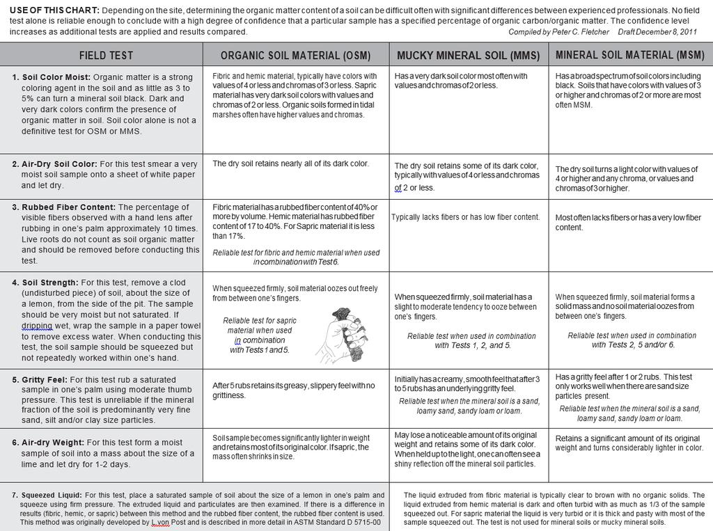
38 38
39 Appendix 2. Guidelines for Identifying Human Altered Hydric Soils In many places the soil has been altered by human activity and such soils are referred to as human-altered, anthropogenic, or disturbed soils. Altered soils are typically the result of earth moving activities where: 1) soil material is removed from its natural position; 2) soil material is placed over existing soil; or 3) soil material has been re-graded from on-site sources or transported from other locations. Other sources of disturbance include agricultural and forestry practices, motorized vehicles, and any practice that promotes accelerated erosion or deposition and mass wasting. Changes that affect local water tables and drainage can transform a nonhydric soil into a hydric soil or visa-versa. There are very few sites in New England that have not seen human alteration. Much of the region was deforested for agriculture and non-sustainable forestry during the 19 th Century, and the effects of those activities can still be observed throughout our landscape. From a practical point of view, the older the disturbance, the more likely the criteria established for identifying hydric soils in this manual can be applied. Thus, the guidelines set forth in this section are designed to assist in the interpretation of sites where the alteration occurred within the last few decades. Cautionary Note The purpose of these guidelines is to aid in making a determination of the hydric or nonhydric status of an altered soil. This question is distinctly different than the question of whether there is federal, state, or local regulatory jurisdiction or whether the site is a wetland or not. Most New England regulatory agencies specifically require that wetland scientists follow the methodology outlined in Chapter 5 of the Regional Supplement to the Corps of Engineers Wetland Delineation Manual (ACOE, 2011) when delineating wetlands on altered sites. Unauthorized dredging or filling in wetland areas does not necessarily eliminate jurisdiction. Users of these guidelines should be aware of the policies of the U.S. Army Corps of Engineers, U.S. Environmental Protection Agency and state environmental agencies, relative to their jurisdiction at altered sites. Using Off-Site Resources Developing an understanding of the land-use history of a site before starting fieldwork can save considerable time. If possible, practitioners should start by interviewing landowners about past land use and associated changes. USDA-NRCS web soil survey reports (websoilsurvey.nrcs.usda.gov/app; are important resources for providing a regional perspective and identifying the range of soils at the site. A collection of aerial photos taken over the course of several years can often provide a time scale for land use changes. Google Earth ( allows access to imagery from the last twenty years. There are a number of private companies that provide historic aerial photography and others that will perform custom flights. Sometimes specific activities can be observed or interpreted when these aerial photos are carefully examined under magnification or with a stereoscope. Aerial photographs are also available in the files of local state and federal agencies. Some NRCS field offices have aerial imagery from as early as The UDSA, Farm Service Agency, has been inventorying cropland by aerial photography on a yearly basis since the 1990s and individual copies can be purchased from their national office. 39
40 Other sources of historic information include old USGS topographic maps and old county soil surveys (1930s-1970s). Preliminary Site Evaluation Evidence in the field of significant site and soil alteration can come in many forms. Linear features are uncommon in the natural environment. Abrupt changes in topography or vegetative community can often indicate an unnatural landform. Early succession plant communities, or domination by invasive species, may be indicators of an altered landscape. When factors influencing plant growth change suddenly, there may be signs of plant stress. Such signs often deserve additional investigation and may help reveal areas where hydrologic regimes have been significantly disturbed. Plant stress should not be used exclusively, but it can serve as corroborative evidence when considered with other indicators. Understanding the sites hydrology is critical to any hydric soil determination. Evidence of flooding or ponding is often observable on the ground surface in the form of: silt stains; sediment deposits; water marks on trees; water-stained leaves; drift lines; rooting above the ground surface; or oxide stains (Fe and Mn) on coarse fragments or sand grains at the ground surface. If there is evidence of flooding or ponding, practitioners should identify the source of the surface water and how it exits the site. Plants quickly respond to changes in hydrology, especially the herbaceous layer. If the plant community is dominated by facultative wet species (FACW) there is a strong probability that the soil is hydric. Where all dominants in the plant community are obligate species (OBL), the soil is assumed to be hydric and no further analysis is required (USACOE, 2011). Some of the strongest evidence of land alteration is changes in the land surface shape. Both human transported material (HTM), formerly called fill, and excavated areas are typically characterized by flat surfaces with sudden steep slopes along the perimeter. In some cases, excavated material from one side of the site is used to fill the other side. There may be terracing on the slopes of HTM or the banks of an excavation, and the edges of HTM or an excavation site may coincide with or be parallel to property boundaries. The toe of an HTM slope often ends abruptly at a wetland boundary. Examples of excavation include sand and gravel pits, quarries, ditches, and highway and railroad cuts. Some areas where HTM may be found include construction sites, lawns, parking lots, highway embankments, railroad embankments, and dams. Likewise, current or historical agricultural practice may have resulted in alterations such as drainage systems, ditches, land leveling, or terracing resulting in scalped land surfaces or deposits of HTM. Other forms of soil and landscape alteration may result in soil compaction, soil erosion, or water impoundment. Timber harvesting activities may result in areas that have been compacted or filled. Such disturbances are most commonly associated with forest road construction and log landings. Soil compaction by vehicles may result in small-localized patches of hydric soil while debris piles may obscure wet depressions. Structures such as roads, dams or embankments may result in impacts at a significant distance from the structure due to impoundment of water for significant periods. Dug ponds, detention basins, and cellar holes may also impound water. Clear cuts sometimes result in the erosion of surface soil horizons, and deposition of the eroded material down slope. Areas down slope from construction, or other activities involving land clearing, may experience accumulation of soil material. Because the receiving area is relatively low lying, this accumulation may be on top of hydric soils. Soil Morphology of Altered Sites 40
41 Most alterations to a site will result in a disruption of the normal sequence of soil horizons. Clues within the soil that suggest a site has been altered include: foreign objects within the soil such as pieces of glass, bricks, asphalt, etc, ( artifacts in HTM terminology); inverted soil horizons; missing or duplicated soil horizons; textural discontinuities; randomly oriented redoximorphic features; or soil horizons that are not parallel to the ground surface. Excavation removes all or portions of the natural soil horizons resulting in a highly altered soil. Soils at fresh excavation sites typically lack an A horizon and the B horizon may be absent as well. B horizon material or unweathered material from the C horizon may be exposed at the surface, or be buried immediately below HTM from local or distant sources. Many human altered soils have formed in HTM; soil parent material that was purposely deposited on top of a soil by human activities. HTM can occur over existing natural soils or excavated surfaces. The principle component of HTM is mineral material, but organic materials may also occur as layers, bodies, or even dominate. Rock fragments and other non-soil components (i.e. bricks) may be mixed into HTM. Human transported material may have slow permeability if it has been compacted by heavy equipment or if dredged materials are particularly fine textured. A perched water table can develop above these dense layers and lie above the regional water table or former seasonal high water table. Stratified layers of contrasting materials or textures may also slow water movement in the soils. When describing soil profiles in HTM, the caret prefix (^) is used in front of the master horizon designation, such as ^C, indicating HTM parent material (Soil Survey Staff, 2014). The soil morphology of horizons developing in human altered soils may exhibit characteristics quite different than their natural counterparts. A horizons developed at altered sites are often thin and light colored. The rate at which a new A horizon develops, however, is strongly influenced by the frequency and duration of soil saturation. In some cases topsoil may have been added to the ground surface of an altered site to encourage re-vegetation. This might result in an A horizons thicker and darker than expected. B horizons seldom have time to develop in altered soil. When a B horizon is present in either HTM or newly exposed parent material, it is typically cambic, with colors that do not contrast greatly with the C horizon. The characteristics of C horizons of a human-altered soil will depend on if the site was altered by excavation or deposition of HTM, or both. If the C horizon is exposed during excavation the characteristics will likely not be much different than before the excavation. C horizons for HTM will vary depending on the materials that were deposited and their mode of deposition. For example, dredged materials that were sprayed on the land surface often exhibit stratification or layering if the materials were sequentially applied. HTM that was moved by a bull dozer will likely be a random mixture of whatever was deposited and possibly compacted from the heavy machinery. Application of Redoximorphic Features in Human-Altered Soils Where Human Transported Material (HTM) Overlies Natural Soil In most cases, non-soil information (evidence of ponding or flooding or presence of hydrophytic vegetation, etc.) will be required to obtain a reasonable level of confidence that a hydric soil developed in HTM. When enough time has passed for the soil to develop morphologies that meet one of indicators found in the basic part of this manual, the following morphologies should not be used. The following morphologies are considered to have a high probability of occurring in soils formed in HTM that have wetland hydrology. Careful 41
42 observation and analysis of the site should be made to ensure that the current soil colors were formed in-place rather than being inherent of HTM deposited on the site. HTM-A. A layer starting less than or equal to 30 cm (12 in) from the relevant soil surface, with a chroma of 2 or less with more than 2% redoximorphic features. If redoximorphic features are not present, the layer must have a matrix chroma of 1 or less. User Notes: This indicator can be applied to HTM of any soil texture. HTM-S. A layer starting less than or equal to 30 cm (12 in) from the relevant soil surface, with a chroma of 3 or less, and more than 2% redoximorphic features within 20 cm (8 in) of the relevant soil surface. If redoximorphic features are not present, the layer must have a matrix chroma of 2 or less. User Notes: This indicator should only be applied to HTM dominated by a soil texture of loamy fine sand or coarser. Application of Redoximorphic Features in Human-Altered Soils Where Natural Soil Has Been Removed The principle challenge for hydric soil classification on sites where the natural soil has been removed, is the lack of a definite reference to the original ground surface. There is additional complexity when these excavated sites have been re-graded and HTM has been added. Non-soil information is necessary to obtain a higher level of confidence in understanding the soil morphologies. Careful observation and analysis of the site should be made to insure current soil colors were formed in place rather than being inherent of HTM deposited over an excavated site. The following soil morphologies have a high probability of occurring in excavated soils that have wetland hydrology. EX-1. Two-percent or more redoximorphic features directly underlying an A horizon, or starting less than or equal to 15 cm (6 in) of the relevant soil surface if no A horizon is present, and there is undisturbed mineral soil material starting less than or equal to 30 cm (12 in) below the relevant soil surface and extending to a depth of 100 cm (40 in) or more. User Notes: These soils are saturated by water rising from an unconfined water table below. There is no restrictive layer in the upper 100 cm (40 in) of the soil that would impede vertical movement of water. The undisturbed lower layer is typically glacio-fluvial parent material. This indicator can be applied to soils of any texture. EX-2. A layer with two percent or more redoximorphic features and undisturbed mineral soil materials that have a restrictive layer, both layers starting less than or equal to 30 cm (12 in) below the relevant soil surface. User Notes: These soils are in landscape positions where lateral water movement is impeded or reduced by landscape features and/or slopes are less than 3%. These soils are saturated with water held up by soil restrictive layers. 42
43 Monitoring to Establish Saturation and Reducing Conditions The process for identifying human altered hydric soils requires an interpretive history of the site, plant analysis, and recognition of earth moving and accompanying alterations to the landscape and hydrology, and finally assessment of the soil morphology for evidence of wetland hydrology. Much of this will require professional judgement. Even with strong evidence of hydric soil conditions, users may also want to consider monitoring to establish the extent of both saturated and reducing conditions. U.S. Army Corps of Engineers (2005) provides a technical standard for monitoring hydrology on such sites. This standard requires 14 or more consecutive days of flooding, ponding, and/or a water table 30 cm (12 in) or less below the soil surface, during the growing season, at a minimum frequency of 5 years in 10 (50% or higher probability) (National Research Council 1995) unless an alternative standard has been established for a particular region or wetland type. A disturbed or problematic site that meets this standard has wetland hydrology. This standard is not intended (1) to overrule an indicator-based wetland determination on a site that is not disturbed or problematic, or (2) to test or validate existing or proposed wetland indicators (USACOE Regional Supplement, 2012). 43
44 Appendix 3 Maps Depicting Problem Soil Areas (Soils Requiring Special Evaluation for Hydric Conditions) The maps included here show the areas where identified problem soils are likely to be found in New England. See the section titled Hydric Soil Indicators For Problem Soils in Field Indicators for Identifying Hydric Soils in New England, Version 4 for a description of problem soils. These maps are only predictive based on general associations between certain soil series and certain problem morphologies; see the Metadata section below for an explanation on how they were generated. Not all problem soil areas are shown on these maps. For example, small areas of red soils have been observed in southeastern Massachusetts (North Attleboro), these are not shown on the red soil parent material map but the use of indicator NE-F1 can be used if the red soils are identified. In addition, not all of the areas depicted will have only problem soils. The maps are provided to identify the general location of five main categories of problem soils in New England. Map 1: Folists and Folistic Epipedons Folists and folistic epipedons in New England form under cool and moist conditions but are by definition saturated less than 30 cumulative days during normal years. Geographically, New England Folists are found in two populations: those on cool rocky inland upland landforms (mountains and hills) stretching across Vermont, New Hampshire and Maine and those of rocky coastal landforms of Down East Maine. Folists are typically found on summit, shoulder, and backslope positions of these landforms, and form primarily under forests dominated by conifers. Folists and folistic epipedons are referenced in user notes for indicator A1, A2, and test indicators S3, and F22. These notes caution users for the potential misinterpretation of Folists and folistic epipedons as wet Histosols or histic epipedons (i.e. a false positive indicator). Map 2: Soils Formed in Dark Parent Materials Soils formed in dark parent materials refer specifically to glacial parent materials derived from dark phyllite, slate, shale, and/or schist. These soils are found in the Narragansett and Boston basins of Rhode Island and Massachusetts (associated with Paleozoic age sedimentary and meta-sedimentary rocks high in carbon) and across the northern New England hills and mountains in Vermont, New Hampshire, and Maine (associated primarily with phyllite found in belts of Ordovician, Silurian, and Devonian igneous and metamorphic rock across New England). Because the region has been subject to continental glaciation, there are varying degrees of geographic fidelity between dark parent materials and the bedrock they originate from. These dark parent materials often have low value (3 or less) matrix colors below the surface and as a result fail to meet depleted matrix criteria. Specifically, these dark colors often preclude meeting criteria for the otherwise common A11, A12, and F3 indicators. Indicator F6 is commonly used in dark parent materials. The F6 indicator does not solve the hydric soil identification problem in all areas. Map 3: Soils Formed in Red Parent Materials Soils formed in red parent materials are found in the Connecticut Valley, which is a Triassic-Jurassic-aged rift valley spanning Connecticut and Massachusetts. The sedimentary rocks found in this valley are red in color, and the soils formed in parent materials derived primarily from this rock has been measured to have a low propensity for color change. Hydric 44
45 soils formed in this parent material often do not meet indicator criteria associated with depleted matrixes. Indicators F21, and NE-F1 were developed specifically for hydric soils formed in problematic red parent materials. Other indicators are typically not used in hydric soils formed in red parent materials near wetland boundaries. Map 4: Soils Formed in Calcareous Parent Material Problematic calcareous parent materials refer to soils identified in vicinity of northwest Connecticut that are formed in loamy till derived primarily from dolomitic limestone, schist, and quartzite. Many areas of these soils do not readily form low chroma depleted matrixes below the surface epipedon in hydric soils found near wetland boundaries. The lack of a depleted matrix inhibits the use of indicators A11. Depleted Below Dark Surface, A12. Thick Dark Surface, and F3. Depleted Matrix. This is a similar problem to that of dark parent materials described above. The source of the problem in calcareous soils, however is different, and is likely the effect of neutral to alkaline ph limiting reduction to relatively low redox potential. Other local soil chemical properties and/or mineralogy may also play a role, as other areas with calcareous soils (e.g. Vermont) have not been observed to lack depleted matrix morphology. As in dark parent materials, the F6. Redox Dark Surface indicator is commonly used in problematic calcareous parent materials near wetland boundaries, but may not solve the hydric soil identification problem in all areas. Map 5: Soils Formed in Marine Sediments Glaciomarine parent materials were deposited in Maine, New Hampshire, and Massachusetts during a period of marine submergence resulting from depression of the land mass under weight of glacial ice. As the glacier receded, the land mass lifted through a process known as isostatic rebound. This caused a significant extent of submerged marine areas to rise above sea level and thereby exposed these glaciomarine parent materials. Metadata A list of soil series associated with problem morphology for evaluating hydric conditions was developed by the New England Hydric Soils Technical Committee (NEHSTC). The series used to generate each map are listed below. The coverages on the maps are not necessarily limited to soil series meeting hydric soil criteria. The entire coverage of the catena associated with the respective problem parent material or soil properties may be provided to account for areas with potential hydric inclusions. This list was developed based on the collective best professional judgment of the New England Hydric Soils Technical Committee. These soil series were queried in the Soil Survey Geographic Database (SSURGO; latest versions as of April 27, 2016) for the New England states and adjacent states (overlapped in the maps). In the case of the map for Soils formed in dark parent materials, Brayton series map units from the State Soil Geographic (STATSGO) Database for Maine (Version 2.3.2) were used to supplement SSURGO data. STATSGO was supplemented in the following non-mlra Soil Survey Areas: ME011 Kennebec County, Maine, ME602 Somerset County, Maine, Southern Part, ME606 - Androscoggin and Sagadahoc Counties, Maine, ME608 - Aroostook County, Maine, Southern Part, and ME614 - Penobscot County, Maine. ArcGIS was used to generate shapefiles and jpeg files for the following coverages: 45
46 1. Folists and folistic epipedons; Knob Lock; Mahoosuc; and Ricker. 2. Soils formed in dark parent materials: (Narragansett Basin)--- Mansfield, Newport, Pittstown, Stissing; (Phyllitic Lithology)--- Bernardston (exclude areas mapped in CT), Brayton, Buckland (exclude areas mapped in CT), Cabot, Dummerston, Dutchess, Fullam, Glover, Hubbardton, Kearsarge, Lanesboro, Macomber, Mansfield, Nassau, Peacham (exclude areas mapped in MA), Pennichuck, Pittstown, Shelburne (exclude areas mapped in MA and CT), Stissing, Taconic, and Vershire. 3. Soils formed in red parent materials: Cheshire, Ludlow, Menlo, Holyoke, Yalesville, Wethersfield, and Wilbraham. 4. Soil formed in calcareous parent materials: Mudgepond. 5. Soils formed in marine sediments: Boxford, Buxton, Lamoine, Scantic, and Scitico. Credits; These maps were prepared by Jacob Isleib of the USDA-NRCS Tolland CT MLRA Soil Survey Office to accompany the NEHSTC Field Indicators for Identifying Hydric Soils in New England, Version 4. They are based on previous maps and metadata that accompanied the Field Indicators for Identifying Hydric Soils in New England, Version 3, by Al Averill and Darlene Monds of the NRCS Massachusetts office. 46

47 Map 1: Folists and Folistic Epipedons 47

48 Map 2: Soils formed in dark parent materials 48
49 Map 3: Soil formed in red parent materials 49
50 Map 4: Soils formed in calcareous parent materials 50

51 Map 5: Soils formed in glaciomarine parent material 51
S9. Thin Dark Surface
 Dominant Field Indicators of Hydric Soils in Florida S9. Thin Dark Surface For use in LRRs R, S, U, and T; for testing in LRRs K and L. A layer 5 cm (2 inches) or more thick within the upper 15 cm (6 inches)
Field Indicators of Hydric Soils in the United States: For All Soils. Field Indicators. Indicators for all soils regardless of texture
 Field Indicators of Hydric Soils in the United States: For All Soils From Vasilas, L.M., G.W. Hurt, and C.V. Noble. 2010. Field indicators of hydric soils in the United States (Version 7.0), USDA, NRCS,
Field Indicators of Hydric Soils in the United States: Sandy Soils
 Field Indicators of Hydric Soils in the United States: Sandy Soils From: Vasilas, L.M., G.W. Hurt, and C.V. Noble. 2010. Field indicators of hydric soils in the United States (Version 7.0), USDA, NRCS,
3 Hydric Soil Indicators
 ERDC/EL TR-12-1 32 3 Hydric Soil Indicators Introduction The National Technical Committee for Hydric Soils (NTCHS) defines a hydric soil as a soil that formed under conditions of saturation, flooding,
Field Indicators of Hydric Soils in the United States Guide for Identifying and Delineating Hydric Soils, Version 5.0, 2002
 Natural Resources Conservation Service Wetland Science Institute Soil Survey Division Field Indicators of Hydric Soils in the United States Guide for Identifying and Delineating Hydric Soils, Version 5.0,
Field Indicators of Hydric Soils in the United States A Guide for Identifying and Delineating Hydric Soils, Version 7.0, 2010
 United States Department of Agriculture Natural Resources Conservation Service In cooperation with the National Technical Committee for Hydric Soils Field Indicators of Hydric Soils in the United States
Whole Landscape Hydrology: Application to Restore or Create Wetlands. Introduction SOLUTION
 Whole Landscape Hydrology: Application to Restore or Create Wetlands by: Wade Hurt, USDA, NRCS, NSSC/University of Florida and Jimmie Richardson, North Dakota State University. Problem: Wetland construction
Overview of Soil Properties
 Willie Harris apatite@ufl.edu Acknowledgments: Wade Hurt Mike Vepraskas FAESS Soil Scientists Overview of Soil Properties Website to download files of talks: wgharris.ifas.ufl.edu.hsw.htm Meaning of Soil
Overview of Soil Properties
 Willie Harris apatite@ufl.edu Acknowledgments: Wade Hurt Mike Vepraskas FAESS Soil Scientists Overview of Soil Properties Website to download files of talks: wgharris.ifas.ufl.edu.hsw.htm Meaning of Soil
icators for Identif icators for Identi y ldief Hydric Soils Iin NNeew England Version 3 April 2004
 Hydric Hydric Soils Soils Field Version 3 April 2004 in New In New England England Identifying Identifying Indicators Indicators for for Field Indicators for Identifying Hydric Soils in New England Version
icators for Identif icators for Identi y ldief Hydric Soils Iin NNeew England Version 3 April 2004
 Field Indicators Indicators in New In New for for Identifying Identifying Hydric Soils England England Version 3 April 2004 Field Indicators for Identifying Hydric Soils in New England Version 3 April
The New England Hydric Soils Technical Committee (NEHSTC) consists of the following members:
 consists of the following members:") Acknowledgements This manual reflects the collective effort and vision of the New England Hydric Soils Technical Committee. The Committee consists of soil scientists, wetland scientists, and regulatory
Acknowledgements This manual reflects the collective effort and vision of the New England Hydric Soils Technical Committee. The Committee consists of soil scientists, wetland scientists, and regulatory
Reference Card S-2, Side A: Delineating Horizon Boundaries
 Reference Card S-2, Side A: Delineating Horizon Boundaries Distinguishing Soil Horizons Soil horizons are delineated based on differences in: Texture Color Structure and Consistence Redoximorphic Features
Inconsistencies in terminology and definitions of organic soil materials
 Inconsistencies in terminology and definitions of organic soil materials Mineral soil material (less than 2.0 mm in diameter) either: 1. Is saturated with water for less than 30 days (cumulative) per year
Supplement. Hydric Soils. Hydric Soils
 Field Supplement to to Version 3 April 2004 in New In New England England Hydric Soils Hydric Soils Identifying Identifying Indicators Indicators for for Supplement to Field Indicators for Identifying
Soil Colors, Texture & Structure
 Application Soil Colors, Texture & Structure Limiting conditions Soil color type/depth of system Bedrock type/depth of system Soil texture, structure, percolation rate size and type of system Sara Heger,
Horner-McLaughlin Woods: Soil Types
 Horner-McLaughlin Woods: Soil Types Not present at HMW Adrian Muck Conover Loam 0-4% Slopes Houghton Muck Miami Loam 2-6% Slopes Miami Loam 6-12% Slopes Miami Loam 12-18% Slopes t 0 0.125 0.25 Miles Mary
12/11/2008. HYDRIC SOILS: Soil Parameters Used for Jurisdictional Delineation. Objectives
 HYDRIC SOILS: Soil Parameters Used for Jurisdictional Delineation Andrew Harley, Ph.D. andrew.harley@wspgroup.com & Lyndon C. Lee, Ph.D., PWS lyndon.lee@wspgroup.com Objectives Introduce concepts & procedures
zone long enough to affect yield; gray colors below 48 in. horizon thick, dark gray or black
 Wetland & Sub baqueous Soils NRE M 665 Coastal & Wetland Ecology & Management 1 Soil Drainage Classes (USDA) Well Drained = Seasonal high water table (SHWT) not w/i root zone long enough to affect yield;
zone long enough to affect yield; gray colors below 48 in. horizon thick, dark gray or black
 Wetland & Sub baqueous Soils NRE M 665 Coastal & Wetland Ecology & Management 1 2 Soil Drainage Classes (USDA) Well Drained = Seasonal high water table (SHWT) not w/i root zone long enough to affect yield;
DO YOU KNOW YOUR SOILS? (Rev. 10/11)
") DO YOU KNOW YOUR SOILS? (Rev. 10/11) Circle all the correct answers. 1. What is the layer normally present on the surface of the soil in cropped fields? a. O c. Ap e. B g. R b. A d. E f. C 2. Available
DO YOU KNOW YOUR SOILS? (Rev. 10/11) Circle all the correct answers. 1. What is the layer normally present on the surface of the soil in cropped fields? a. O c. Ap e. B g. R b. A d. E f. C 2. Available
Soil Horizons cont. Oa- highly decomposed Oi-undecomposed
 Soils Soil Basics Soil Horizons Soil Horizons cont. O Horizon: Or organic layer Organic layer of decomposing plant and animal tissue. Wooded upland areas have thin O horizons Wetlands may have thick O
TAXONOMIC CLASS: Loamy-skeletal, mixed, mesic Vitrandic Durochrepts
 ESRM311/SEFS507 Important Soil Series in Seattle Area ALDERWOOD SERIES The Alderwood series consists of moderately deep, moderately well drained soils formed in glacial till. Alderwood soils are on glacially
2014 Iowa FFA Soil Judging CDE Exam
 2014 Iowa FFA Soil Judging CDE Exam 1. Landscape position is one aspect of evaluating the surface features of a certain tract of land. Identifying the correct landscape position will indicate: a. If the
SOIL CHARACTERIZATION USING DIAGNOSTIC PROPERTIES
 SOIL CHARACTERIZATION USING DIAGNOSTIC PROPERTIES The following are the characters of the pedologically important properties used in categorizing soils: SOIL CHARACTERIZATION Soil Profile Description:
Buzzards Bay National Estuary Program and the Massachusetts Association of Conservation Commissions. The BBNEP and MACC have been cooperating,
 This workshop is a cooperative venture between the Buzzards Bay National Estuary Program and the Massachusetts Association of Conservation Commissions. The BBNEP and MACC have been cooperating, coordinating
ASCE - Philadelphia. Soils & Stormwater Management. Matthew C. Hostrander, CPSS, SEO Soil Scientist. Gilmore & Associates, Inc.
 ASCE - Philadelphia Soils & Stormwater Management Matthew C. Hostrander, CPSS, SEO Soil Scientist Gilmore & Associates, Inc. Course Overview COURSE OUTLINE Soil Science Fundamentals Discuss United States
Hydric Soils - Overview
 Hydric Soils - Overview The Hydric Soils section presents the most current information about hydric soils. It updates information that was previously published in "Hydric Soils of the United States" and
IOWA FFA STATE SOILS CDE SATURDAY, OCTOBER 13, 2007 AMES, IOWA
 IOWA FFA STATE SOILS CDE SATURDAY, OCTOBER 13, 2007 AMES, IOWA 1. Moderately sloping has what percent slope: a. 9-14% b. 2-5% c. 5-9% d. over 14% 2. Which of the following horizons is the loose underlying
AGRONOMY 255, 251, 270 SOIL DIFFERENCES
 Name AGRONOMY 255, 251, 270 SOIL DIFFERENCES Soils differ strikingly from each other. This week we illustrate the great differences and ask you to learn how they differ and to become skilled in describing
3. What are the five master horizons? Give distinguishing features of each. 5. List three means by which plant roots come into contact with nutrients.
 Study Questions Exam 1 1. What are the four general components of soil? 2. Define regolith and solum. 3. What are the five master horizons? Give distinguishing features of each. 4. What is meant by an
Do You Dig Wetland Soil?
 Do You Dig Wetland Soil? [Soil texture flow chart adapted from Steve Thein, 1979. Source unknown.] Grade Level K-12, as indicated Subject Areas Earth Science Duration Part I, 30-40 minutes; Part II, 60
Soils and the Environment. A Summary of RI Envirothon Study Materials Compiled by Sally Paul
 Soils and the Environment A Summary of RI Envirothon Study Materials Compiled by Sally Paul Why Soils Food and water resources Disposing of waste Support for human structures Growing timber and fibers
Unit E: Basic Principles of Soil Science. Lesson 3: Understanding Soil Color
 Unit E: Basic Principles of Soil Science Lesson 3: Understanding Soil Color 1 Important Terms Bright-colored Color Deciduous hardwood forest Dull-colored Humus Mottle-colored Native vegetation Structure
Soil & Site Evaluator - Need to Know
 Soil & Site Evaluator - Need to Know I. The professional will understand the factors of soil development and demonstrate their importance to site evaluations. A. Topography 1. Landscape & landform description
Today. Climate. Role of water. Rainfall: Intensity and duration. Effective precipitation. (1)Parent materials + 4 other factors of soil formation
Parent materials + 4 other factors of soil formation") Today Models of soil formation Soil taxonomy Horizon descriptions (1)Parent materials + 4 other factors of soil formation Climate Topography Time Biota Can be interrelated and interact Climate Moisture
Today Models of soil formation Soil taxonomy Horizon descriptions (1)Parent materials + 4 other factors of soil formation Climate Topography Time Biota Can be interrelated and interact Climate Moisture
List of Equipment, Tools, Supplies, and Facilities:
 Unit C: Traits of Soil Lesson 3: Understanding Soil Color Student Learning Objectives: Instruction in this lesson should result in the students achieving the following objectives: 1. Identify physical
Soil Maps for Production Agriculture. Jarrod O. Miller, Extension Agronomist
 Soil Maps for Production Agriculture Jarrod O. Miller, Extension Agronomist Origination of Soil Mapping Originally mapped by Division of Soils Federal Bureau of Soils Soil Conservation Service (SCS) started
Iowa FFA Soil Career Development Event 2008
 Iowa FFA Soil Career Development Event 2008 1. In Iowa, corn suitability ratings for soil mapping units specifies a. natural weather conditions b. surface and subsurface drainage installed where needed
Lesson 3: Understanding Soil Color
 Lesson 3: Understanding Soil Color 1 Bright colored Color Dull colored Humus Mottle colored Native vegetation Structure Tall prairie grass Texture Deciduous hardwood forest 2 I. Soils have many features
Learning Objectives Part 1. Chapter 4 Soil Physical Properties. Soil Physical Properties. Color. Physical properties part 1
 Learning Objectives Part 1 Chapter 4 Soil Physical Properties Know what color tells you about a soil Describe the concept of soil texture and its importance Use the textural triangle to determine a soil
Soil & Site Evaluator - Need to Know
 Soil & Site Evaluator - Need to Know I. The professional will understand the factors of soil development and demonstrate their importance to site evaluations. A. Topography 1. Landscape description 2.
2018 Iowa FFA Soil Judging CDE Exam 1. Landscape positions characterizes the location of the soil on the landscape and identifies potential risks.
 2018 Iowa FFA Soil Judging CDE Exam 1. Landscape positions characterizes the location of the soil on the landscape and identifies potential risks. Which landscape position is considered the floodplain
3.44b. Soil Classification AK & BR
 3.44b Soil Classification AK & BR Why look at soil? Because soil and its constituents are the base material for growing trees. History Why a Forestry Commission soil classification? There is a need for
2017 Iowa FFA Soil Judging CDE Exam
 2017 Iowa FFA Soil Judging CDE Exam 1. Landscape positions vary in soil composition and makeup. What landscape position would be characterized by having strata and lenses of different textures in the profile:
2011 Wisconsin Envirothon Soils and Land Use Exam
 2011 Wisconsin Envirothon Soils and Land Use Exam USE THE OCONTO COUNTY SOIL SURVEY TO ANSWER QUESTIONS 1-4 The Pensaukee River Wetland Complex is a mixture of state (Pensaukee Wildlife Area) and privately
Soil characteristics that influence nitrogen and water management
 Section C Soil characteristics that influence nitrogen and water management Soil characteristics vary across the landscape Soils vary from one field to another, and often within the same field. Soil differences
Lecture 5: Introduction to Soil Classification; Soil Physical Properties
 Lecture 5: Introduction to Soil Classification; Soil Physical Properties Soil Classification Argillic Horizon Alfisols Moderately leached soils with a clay-rich B-horizon Typically found in forests Andisols
NYC Envirothon 2017 Soil Science Review. Richard K Shaw USDA-NRCS
 NYC Envirothon 2017 Soil Science Review Richard K Shaw USDA-NRCS Introduction Who Are We? U.S. Department of Agriculture (1862) Natural Resources Conservation Service (1935) What Do We Do? Provide leadership
CONNECTICUT ENVIROTHON 2012 SOILS QUESTIONS
 CONNECTICUT ENVIROTHON 2012 SOILS QUESTIONS Please select the best response to the following questions. There are 25 4 point questions. Many have more than one part. Good luck! Section 1: Judging the soil
Section 1. Judging the soil pit (questions 1-4)
") CONNECTICUT ENVIROTHON 2009 SOILS QUESTIONS Please select the best response to the following questions. There are 25 questions; each question is worth 4 points. Section 1. Judging the soil pit (questions
CONNECTICUT ENVIROTHON 2009 SOILS QUESTIONS Please select the best response to the following questions. There are 25 questions; each question is worth 4 points. Section 1. Judging the soil pit (questions
AY-362-W. INDIANA SOIL Evaluation Field Book. Don Franzmeier, Gary Steinhardt, Cathy Egler Purdue University Department of Agronomy
 AY-362-W INDIANA SOIL Evaluation Field Book Don Franzmeier, Gary Steinhardt, Cathy Egler Purdue University Department of Agronomy Table of Contents PREFACE 3 CHAPTER 1 Soil Formation, Soil Properties,
Soils and Land Use Test
 SOIL PROPERTIES Total Score /50 1) List two of the five main functions of soil. (2 points) Habitat for organisms, Engineering medium, Filters and stores water, Anchor for plants, Cycles nutrients 2) Small
Soil Physical Properties
 Soil Physical Properties ESRM 311 SEFS 507 Some examples of mineral soil development eg, Rock Weathering Types of Weathering Physical/Mechanical Chemical Biological Photo by D Vogt CO 2 + H 2 O H 2 CO
SOIL DATA: Avondale. in Allen, TX. This information was taken from NRCS web soil survey of Collin County, Texas.
 SOIL DATA: Avondale in Allen, TX This information was taken from NRCS web soil survey of Collin County, Texas. United States Department of Agriculture Soil Conservation Service in cooperation with Texas
1. Position (2 pts.) 2. Parent Material (2 pts.) 3. Slope Characteristics (2 pts.) 4. Surface Stoniness or Rockiness (2 pts.)
 2. Parent Material (2 pts.) 3. Slope Characteristics (2 pts.) 4. Surface Stoniness or Rockiness (2 pts.)") Maryland Envirothon SOILS Exam Guidance Information (revised 2017) Objective: To test students' knowledge and awareness of basic soil science and its application in wise land-use planning and therefore
Maryland Envirothon SOILS Exam Guidance Information (revised 2017) Objective: To test students' knowledge and awareness of basic soil science and its application in wise land-use planning and therefore
2016 Area 3 Envirothon Muskingum County Soils Test ANSWER KEY
 2016 Area 3 Envirothon Muskingum County Soils Test ANSWER KEY 1. The majority of the bedrock in Muskingum County is. a. sedimentary bedrock b. glacial bedrock c. igneous bedrock d. metamorphic bedrock
2012 FINAL SOILS AREA 2 Envirothon Questions Answer KEY
 2012 FINAL SOILS AREA 2 Envirothon Questions Answer KEY Questions 1-6 to be answered at the soil pit: 1. Soil scientists categorize soils by drainage classes. What is the drainage class of the soil at
LAB 12: Soils. Name School. Patrich Physical Geography Lab 1
 Name School LAB 12: Soils Soil is a mixture of weathered rock & organic matter that usually covers bedrock (solid rock that underlies all soil). Both chemical & mechanical processes are involved in the
Soil Texture = %Sand, Silt & Clay in a soil.
 Soils Soil Texture = %Sand, Silt & Clay in a soil. Soil texture is the single most important physical property of the soil. Knowing the soil texture alone will provide information about: 1) water flow
HORT 102: Soil Properties. Cultivated Plants: Lecture 15. [Teresa Koenig] Slide #: 1 Slide Title: Intro Information Slide
![HORT 102: Soil Properties. Cultivated Plants: Lecture 15. [Teresa Koenig] Slide #: 1 Slide Title: Intro Information Slide](/thumbs/76/74082590.jpg "HORT 102: Soil Properties. Cultivated Plants: Lecture 15. [Teresa Koenig] Slide #: 1 Slide Title: Intro Information Slide") HORT 102: Soil Properties Cultivated Plants: Lecture 15 [Teresa Koenig] Slide #: 1 Slide Title: Intro Information Slide Title: Lecture 15 Soil Properties Speaker: Teresa Koenig Created by: Teresa Koenig,
HORT 102: Soil Properties Cultivated Plants: Lecture 15 [Teresa Koenig] Slide #: 1 Slide Title: Intro Information Slide Title: Lecture 15 Soil Properties Speaker: Teresa Koenig Created by: Teresa Koenig,
Global Soils. The Nature of Soil The Soil Water Balance Soil Development The Global Scope of Soils Global Climate Change and Agriculture
 Global Soils The Nature of Soil The Soil Water Balance Soil Development The Global Scope of Soils Global Climate Change and Agriculture Soil is a mixture of The Nature of Soil 1) inorganic material derived
Parent Material & some of Seattle s soils
 Parent Material & some of Seattle s soils ESRM 311/SEFS 507 Week 3 SOILS = f(cl, r, o, p, t) Parent Materials 1) Sedentary a) residual (bedrock weathered in place) b) organic 2) Transported by a) gravity
The GEOGRAPHY of SOILS. Physical Geography (Geog. 300) Prof. Hugh Howard American River College
 Prof. Hugh Howard American River College") The GEOGRAPHY of SOILS Physical Geography (Geog. 300) Prof. Hugh Howard American River College SOIL and SOIL- FORMING FACTORS SOIL and FORMING FACTORS Soil Natural surface layer of Earth Composed of mineral
The GEOGRAPHY of SOILS Physical Geography (Geog. 300) Prof. Hugh Howard American River College SOIL and SOIL- FORMING FACTORS SOIL and FORMING FACTORS Soil Natural surface layer of Earth Composed of mineral
Soil Taxonomy. A Basic System of Soil Classification for Making and Interpreting Soil Surveys. Second Edition, 1999 By Soil Survey Staff
 Soil Taxonomy A Basic System of Soil Classification for Making and Interpreting Soil Surveys Second Edition, 1999 By Soil Survey Staff United States Department of Agriculture Agriculture Handbook Natural
2016 Iowa FFA Soils Evaluation CDE Exam
 2016 Iowa FFA Soils Evaluation CDE Exam 1. Which of the following is true regarding soil horizons? a. A horizon is darker in color and has more organic matter b. B horizon is darker in color and has more
This definition is from the Soil Science Glossary (Soil Science Society of America).
.") What is Soil? This definition is from the Soil Science Glossary (Soil Science Society of America). soil - (i) The unconsolidated mineral or organic material on the immediate surface of the earth that serves
What is Soil? This definition is from the Soil Science Glossary (Soil Science Society of America). soil - (i) The unconsolidated mineral or organic material on the immediate surface of the earth that serves
Understanding Soils. 1. What is Soil? 2. What does soil do for us?
 Understanding Soils 1. What is Soil? Soil: (i) The unconsolidated mineral or organic material on the immediate surface of the earth that serves as a natural medium for the growth of land plants. (ii) The
a. OVERALL PROFILE DEPTH: Assess the depth to the first restrictive layer, which can be a tree root, a rock or an
 OBSERVING SOIL PROCEDURE Using a shovel, soil probe, or soil auger, collect a soil profile. (Go as deep as you can with the equipment). Arrange the soil you remove from the ground on newspaper or in a
Soil Physical Properties I: Outline
 Soil Physical Properties I: Outline Soil color See plates between pages 114 and 115 in textbook. Soil texture Soil structure Soil color Soil color provides clues to other soil properties and to soil conditions.
Soil Classification: Outline
 Soil Classification: Outline Introduction Soil moisture regimes Soil temperature regimes The Soil Taxonomy Diagnostic horizons soil orders Why Classify? Organize knowledge in an attempt to find order in
Soil Structure, Density, and Porosity. Laboratory #4
 Soil Structure, Density, and Porosity Laboratory #4 Objectives Understand the concept of soil structure and how it differs from soil texture. Understand how soil structure influences other soil properties.
3 PHYSICAL PROPERTIES
 3 PHYSICAL PROPERTIES 3.1 Introduction Physical properties are those which deal with aspects of the material that are related to the bulk properties of the material. In other words, if chemical properties
Using Soil Science Principles for Wetland Mitigation, Voluntary Restoration and Creation W. Lee Daniels and many, many more
 Using Soil Science Principles for Wetland Mitigation, Voluntary Restoration and Creation W. Lee Daniels and many, many more http://www.landrehab.org Objectives Describe common created wetland soil limitations
Soil is. Pieces of rock Minerals Decaying organic matter Water Air Living organisms All mixed together!
 Soil is. Pieces of rock Minerals Decaying organic matter Water Air Living organisms All mixed together! Soil Horizons the layers of soil O-horizon: the surface litter. Mainly black or brown A-horizon:
Soil Drainage. Dr. Jim Walworth Dept. of Soil, Water & Environmental Sci. University of Arizona
 Soil Drainage Dr. Jim Walworth Dept. of Soil, Water & Environmental Sci. University of Arizona Yield (kg kernel/cm 2 ) Y = (0.04*sand) + 0.79 R 2 = 0.57 Percent Sand Pecans like well-drained soil. In Arizona
In 1983, the town evacuated and purchased by government for $36 million
 1 2 3 4 5 6 7 8 9 Introduction to Environmental Geology, 5e Chapter 17 Soil and Environment Weathering: summary in haiku form Rocks brought to surface decompose to sediment and that's weathering. Case
O horizon: the O-horizon is made up of organic material. The horizon is found at the soil surface.
 A Good Dirty n Soil Lab: References: Wagner & Sanford. Environmental Science. Wiley & Sons, 2005. Molnar. Laboratory Investigations for AP* Env. Science. Peoples Ed, 2005. Soil Porosity & Permeability
Alluvium Bedrock Chemical Weathering Climate Glacial Till Loess Native Vegetation
 1 Alluvium Bedrock Chemical Weathering Climate Glacial Till Loess Native Vegetation Organic Matter Outwash Parent Material Physical Weathering Prairie Soils Timber Soils Topography 2 There are five primary
2014 Envirothon Georgia Soil Study Guide
 2014 Envirothon Georgia Soil Study Guide In addition to materials in this document, 2014 Georgia Envirothon contestants are responsible for materials found in the following documents: From The Surface
SOIL SCIENTIST REPORT FOR THE CONNECTICUT PORTION OF THE CONNECTICUT EXPANSION PROJECT. Prepared for:
 SOIL SCIENTIST REPORT FOR THE CONNECTICUT PORTION OF THE CONNECTICUT EXPANSION PROJECT Prepared for: Tennessee Gas Pipeline Company, L.L.C. 1001 Louisiana Street Houston, Texas 77002 Prepared by: AECOM
SOILS IN URBAN / SUBURBAN LANDSCAPES. Lisa Krall Soil Scientist CT USDA NRCS Tolland, CT
 SOILS IN URBAN / SUBURBAN LANDSCAPES Lisa Krall Soil Scientist CT USDA NRCS Tolland, CT What is Urban Soil? Is This Soil? Is This Soil? active gravel pit pavement and buildings vegetated roadside areas
SUBSURFACE DRIP DISPERSAL OF EFFLUENT for LARGE SYSTEMS. Presented by: David Morgan and Rodney Ruskin
 SUBSURFACE DRIP DISPERSAL OF EFFLUENT for LARGE SYSTEMS Presented by: David Morgan and Rodney Ruskin Program Map Making Program Soil Parent material, Relief, Time. Organisms, Color, Texture, Depth, Profile
The relationship between soil (growing
 4 Plant, Soil and Water Relationships The relationship between soil (growing media), air, and water is one of the least understood aspects in production and maintenance of plants. As a result, a significant
ON LANDSCAPING, SOILS, SOIL AMENDMENTS AND PROPER SEED ESTABLISHMENT (BOTH GRASS LAWNS AND MEADOWS).
.") ON LANDSCAPING, SOILS, SOIL AMENDMENTS AND PROPER SEED ESTABLISHMENT (BOTH GRASS LAWNS AND MEADOWS). John D. Chibirka USDA-NRCS Resource Soil Scientist 1238 County Welfare Road, Suite 220 Leesport, PA
ON LANDSCAPING, SOILS, SOIL AMENDMENTS AND PROPER SEED ESTABLISHMENT (BOTH GRASS LAWNS AND MEADOWS). John D. Chibirka USDA-NRCS Resource Soil Scientist 1238 County Welfare Road, Suite 220 Leesport, PA
List of Equipment, Tools, Supplies, and Facilities:
 Unit A: Principles of Soil Lesson 4: Formation of Soil Student Learning Objectives: Instruction in this lesson should result in the students achieving the following objectives: 1. Identify 5 factors involved
Bell Ringer. d) Erosion e) Decomposition of organic compounds
 Erosion e) Decomposition of organic compounds") Bell Ringer 1) A rock exposed to high winds, over a long period of time, loses half of its original size. This is an example of a) Physical weathering b) Chemical weathering c) Biological weathering d)
Bell Ringer 1) A rock exposed to high winds, over a long period of time, loses half of its original size. This is an example of a) Physical weathering b) Chemical weathering c) Biological weathering d)
Ecological Sites. Topics of Discussion 2/28/2014. Ecological Site Classification. Ecological Site Key. Ecological Site Descriptions
 Ecological Sites Topics of Discussion Ecological Site Classification Ecological Site Key Ecological Site Descriptions Jon Siddoway Montana NRCS Helping People Help the Land An Ecological Site is defined
Unknown 1. Unknown 2 TEXTURE ANALYSIS
 Unknown 1 Unknown 2 TEXTURE ANALYSIS 1 5 8 11 1 22 1 12 10 Parent Material & some of Seattle s soils ESRM 311/SEFS 507 Week 3 SOILS = f(cl, r, o, p, t) Parent Materials 1) Sedentary a) residual (bedrock
The Soils That We Classify
 The Soils That We Classify 2 Abstract Soil is the natural medium for the growth of land plants, whether or not it has discernible soil horizons. People consider soil important because it supports plants
PHYSICAL CHAtlACTERISTICS REPORT FOR THE PROPOSED SAND AND GRAVEL SITE AT MANOR FARM, UFFINGTON
 PHYSICAL CHAtlACTERISTICS REPORT FOR THE PROPOSED SAND AND GRAVEL SITE AT MANOR FARM, UFFINGTON Introduction Following the" request for detailed information on the physical characteristics of soil at Manor
OHIO STATE UNIVERSITY EXTENSION. Soil and Nutrients. OSUE Master Gardeners Mahoning County Class of Bill Snyder March 21, 2017
 OHIO STATE UNIVERSITY EXTENSION Soil and Nutrients OSUE Master Gardeners Mahoning County Class of 2017 Bill Snyder March 21, 2017 Soil vs DIRT Ecological Roles of Soil 1. Medium for plant growth 2. Recycling
5.1 Introduction to Soil Systems IB ESS Mrs. Page
 5.1 Introduction to Soil Systems IB ESS Mrs. Page 2015-2016 I Am Soil Thinking Routine: See, Think, Wonder Look at the following images. For each image write down what you see Then write down what you
URBAN SOILS & SEATTLE EXAMPLES
 Class Results - Mystery Soil #1 14 12 10 8 6 4 2 0 Sandy Clay Loam Sandy Loam Silty Loam Class Results - Mystery Soil #2 6 5 4 3 2 1 0 Silty Clay Clay Loam Sandy Sandy Silty Sandy Silty Loamy Loam Clay
Soil Reference Groups of WRB (and related diagnostic criteria)
") Soil Reference Groups of WRB (and related diagnostic criteria) Discussion of Reference Groups will be based on the FAO World Soil Resources Report # 94 LECTURE NOTES ON THE MAJOR SOILS OF THE WORLD available
Soil Reference Groups of WRB (and related diagnostic criteria) Discussion of Reference Groups will be based on the FAO World Soil Resources Report # 94 LECTURE NOTES ON THE MAJOR SOILS OF THE WORLD available
Sam Houston Ranger District West/Central WUI Fuels Reduction Project Soil and Water Resources
 Soil and Water Resources The Sam Houston National Forest has identified specific wildland urban interface (WUI) areas within Compartments 33, 36, 37, 49, 57, and 66 that contain high fuel loadings. This
2 Older farm homes on the land
 2 Older farm homes on the land LAND RANCHES EXCHANGES This ranch consists of 70 +/_ acres of level farmland. Prime 13700 POWERHOUSE RD POTTER VALLEY agricultural land at an attractive price. This property
Team number Page 1 of Canon Envirothon Soils Station Test. Soils and Climate Change
 Team number Page 1 of 9 2006 Canon Envirothon Soils Station Test Soils and Climate Change There are many kinds of soil on the surface of the earth. The kind of soil that is present at a given location
Special Assignment for Wednesday: Watch video on soil texture analysis https://youtu.be/ioyabxj767s
 Special Assignment for Wednesday: Watch video on soil texture analysis https://youtu.be/ioyabxj767s Lecture 3: Soil Physical Properties Important Physical Properties Soil Color: Most obvious physical property;
SOIL SCIENCE 101 FUNCTIONS OF SOIL SOIL FORMATION
 SOIL SCIENCE 101 By Dawn Pettinelli UConn Soil Nutrient Analysis Lab CT Envirothon Training, 2014 dawn.pettinelli@uconn.edu FIVE CRUCIAL ECOLOGICAL ROLES OF SOILS FUNCTIONS OF SOIL Regulate water flow