APPENDIX I Soils, Land Capability & Agricultural Assessment Report
|
|
|
- Rosamond Heath
- 6 years ago
- Views:
Transcription

1 APPENDIX I Soils, Land Capability & Agricultural Assessment Report APPENDIX I Soils, Land Capability and Agricultural Assessment 21/18113/ Orange Resource Recovery and Waste Management Project Environmental Assessment
2 THE ORANGE RESOURCE RECOVERY AND ORANGE CITY COUNCIL SOILS ASSESSMENT of the EUCHAREENAROAD RESOURCE RECOVERY CENTRE Prepared for: Orange City Council Byng Street PO Box 35 ORANGE NSW 2800 Prepared by: 9 The Crest KILLARA NSW 2071 Tel: (02) Fax: (02) geoffcun@bigpond.net.au August, 2009
3 ORANGE CITY COUNCIL 2 THE ORANGE RESOURCE RECOVERY AND COPYRIGHT Orange City Council, 2009 and, 2009 Apart from any fair dealing for the purpose of private study, research, criticism or review, as permitted under the Copyright Act, 1968, no part of this report may be reproduced, transmitted, stored in a retrieval system or adapted in any form or by any means (electronic, mechanical, photocopying, recording or otherwise) without written permission. Enquiries should be addressed to.
4 THE ORANGE RESOURCE RECOVERY AND 3 ORANGE CITY COUNCIL CONTENTS Page EXECUTIVE SUMMARY INTRODUCTION DESCRIPTION OF THE SITE AND THE PROJECT Euchareena Road Site Project Description LITERATURE REVIEW Introduction Cudal Soil Landscape [cl] METHODOLOGY Preparations Field Procedures Soil Stripping Suitability SOIL MAPPING UNIT DESCRIPTIONS Introduction Soil Mapping Unit Plain English Description Technical Description [based on eight fully described backhoe pits] SOIL LABORATORY ANALYSIS Introduction Physical and Chemical Analysis DISCUSSION OF SOIL ANALYSIS Physical Attributes Introduction Particle Size Analysis Dispersion Percentage Emerson Aggregate Test Soil Chemical Attributes Introduction Soil ph Electrical Conductivity Likelihood of Encountering Acid Sulfate Soils Erosion Potential SOILOSS Program STRIPPING SUITABILITY OF SOIL MATERIALS Introduction Stripping Recommendations Layer 1 [0cm to 15cm depth] Layer 2 [15cm to 75cm] Layer 3 [Remainder of the Profile]...27
5 ORANGE CITY COUNCIL 4 THE ORANGE RESOURCE RECOVERY AND CONTENTS Page 9.0 HANDLING STRIPPED SOILS Introduction Stripping and Stockpiling Recommendations Earthmoving Procedures Soil Conservation Measures LAND CAPABILITY AND AGRICULTURAL LAND SUITABILITY Land Capability Methodology Land Capability Classification Introduction The DECC Mapping Current Assessment Agricultural Land Suitability Classification NSW Agriculture Assessment Field Assessment OVERVIEW REFERENCES...34 APPENDICES Appendix 1 Description of Sample Pits Appendix 2 Topsoil Stripping Suitability Key [after Elliot and Veness, 1981] Appendix 3 Basis of Land Capability Classification [after Emery, undated] Appendix 4 Glossary of Terms Appendix 5 Summary of Sections Addressing Director-General s Requirements FIGURES Figure 1 Locality Plan... 8 Figure 2 Conceptual Site Layout Figure 3 Soils Study Area Figure 4 Land Capability Figure 5 Agricultural Land Suitability TABLES Table 1 Physical Laboratory Analysis Data for Representative Soil Profiles Table 2 Interpretation of Dispersion Percentage Values Table 3 Comparison of Aggregate Dispersibility and Emerson Aggregate Classes Table 4 Chemical Characteristics of Soils Table 5 Texture Class Multipliers for Calculating ECe Values Table 6 Calculated ECe Values and Salinity Status for Selected Soil Profiles Table 7 Soil Erodibility Values and Ratings... 25
6 THE ORANGE RESOURCE RECOVERY AND 5 ORANGE CITY COUNCIL EXECUTIVE SUMMARY Soils within the likely area of disturbance within the Euchareena Road Site (the site) have been described and one soil mapping unit identified. The physical and chemical attributes of the soils of the Soils Study Area have been quantified through a combination of field assessment and laboratory testing and indicate: the soils are currently stable but have a generally moderate erodibility rating as determined using the laboratory data obtained from samples from the site in the SOILOSS computer model; the soils are non-saline; the topsoils are not dispersible, but some subsoils in the areas to be disturbed are moderately to very highly dispersible; the soils are generally highly structured and can be stripped and respread using scrapers or bulldozers; the topsoil material should be stripped to 15cm depth and stockpiled; the subsoil material from 15cm to 75cm depth, or less if the mottled soil is reached, should be stockpiled separately; and all soils will be subject to structural degradation if worked when too moist. Stripping recommendations have been provided along with advice on stabilising the soil stockpiles in the period between stripping and respreading. It is recommended, wherever possible, that the use of soil stockpiles be avoided with material from areas being prepared for use preferentially transferred direct to areas being rehabilitated. The pre-development land capability and land suitability of the Site has been determined. The bulk of the cleared land on the Site is assessed to have a Class III land capability whereas some of the rocky vegetated areas have a Class VI land capability. The agricultural suitability of much of the Site is Class 3 with some Class 4 land.
7 ORANGE CITY COUNCIL 6 THE ORANGE RESOURCE RECOVERY AND This page has been intentionally left blank This page has been intentionally left blank
8 THE ORANGE RESOURCE RECOVERY AND 7 ORANGE CITY COUNCIL 1.0 INTRODUCTION The Euchareena Road Site [the Site] is some 192.6ha in area [Lot 10, DP , Parish of Copper Hill, County of Wellington] and is located on the corner of Euchareena Road and Shades Creek Road approximately 5km northeast of Molong, see Figure 1. The study was originally carried out between 2003 and 2005 for R.W. Corkery and Co. Pty. Limited. on behalf of Orange City Council [the Proponent]. This report effectively reproduces the report produced in 2005 (Cunningham, 2005) with updates / adjustments to reflect the 2009 project. The brief for the soils study required the preparation of a report on: (i) (ii) the soils on that part of the Site likely to be disturbed as a result of the proposed development of the Resource Recovery Centre ; and the land capability and agricultural land suitability of the Site. A field inspection of the Site and the description of the soils were carried out on 22 October, This report describes the soils based upon eight representative soil profiles as well as laboratory analyses of a selection of representative profiles and land capability of the Site. In particular, this report provides: the results of the field survey and laboratory testing of samples; a discussion of the results of field survey and laboratory physical and chemical analysis in technical as well as Plain English terms; a discussion of the stripping suitability of the soil materials observed on site; details of soil handling strategies and recommendations about soil stripping and stockpiling; and details of the land capability and agricultural suitability at the Site. 2.0 DESCRIPTION OF THE SITE AND THE PROJECT 2.1 Euchareena Road Site The Euchareena Road Site is generally located on a crest or plateau with drainage flowing away from the centre of the site towards Shades Creek to the northeast and Molong Creek to the west. Most drainage depressions are shallow but one near the Euchareena Road is somewhat deeper. A small rocky rise is located in the northwestern section of the Site.
9 ORANGE CITY COUNCIL 8 THE ORANGE RESOURCE RECOVERY AND Figure 1 LOCALITY PLAN
10 THE ORANGE RESOURCE RECOVERY AND 9 ORANGE CITY COUNCIL Approximately 35% of the Euchareena Road Site supports a native timber cover while the remainder has been cleared and cultivated in the past. Introduced pasture species have been sown in some paddocks. The whole of the Euchareena Road Site is grazed to varying degrees and some parts have been cultivated in the past. Grazing has continued between 2003 and Introduced and sown [improved] pasture species were common over much of the area. In the western and northeastern sections of the Site, remnant native tree communities remain. 2.2 Project Description Orange City Council proposes to develop a regional composting facility and landfill for residual wastes on its 192.6ha property 5km northeast of Molong referred to as the "Euchareena Road Site". The facility to be known as the would be an important component in Council's overall waste management strategy. The principal components of the Centre on the Euchareena Road Site would include the following. A site entrance and site access road. A landfill area. Enclosed composting plant. An internal road network. A visual amenity bund and vegetation screens. A stock movement corridor. Two retained woodland areas and rehabilitation corridor. Areas planned for ongoing agricultural use. A site office and weighbridge. For the purposes of the soils assessment, the field investigations were confined to the area shown on Figure 3 as the Soils Study Area. This area was confined to the more elevated cleared sections of the Site away from the remnant native vegetation that Orange City Council has agreed to retain and enhance. It is noted that the Soils Study Area adopted in 2003 covers a substantially greater area than the area of disturbance proposed by the 2009 project. The land capability and agricultural suitability assessments relate to the entire Site.

11 ORANGE CITY COUNCIL 10 THE ORANGE RESOURCE RECOVERY AND
12 THE ORANGE RESOURCE RECOVERY AND 11 ORANGE CITY COUNCIL 3.0 LITERATURE REVIEW 3.1 Introduction The Euchareena Road Site occurs within the Cudal Soil Landscape as delineated on the Bathurst 1: scale Soil Landscapes Map [Kovac, Lawrie and Murphy, 1989]. The Cudal Soil Landscape occurs on undulating rises, undulating low hills and dissected plateaux around Cudal with a small area to the northeast of Molong [including the Site] and another area to the south of Cowra. 3.2 Cudal Soil Landscape [cl] Soils identified by Kovac and Lawrie [1990] are euchrozems on the crests and upper slopes and non-calcic brown soils further down the slope. These authors identify four soil materials that are present in the soils of the Cudal Soil Landscape. (i) (ii) A friable clay loam to silty clay loam surface material on the crests and upper slopes. A hard-setting fine sandy loam surface soil on the lower slopes comprising fine sandy loam to loam that is common to all soils. (iii) A dark reddish brown light to medium clay subsoil material on the crests and upper slopes. (iv) A reddish brown light to medium clay subsoil material on the lower slopes. Although Tertiary basalt is recorded to almost entirely underlie the Site (Raymond et al, 1997), geological mapping undertaken in support of the project has revealed that the Site is underlain predominantly by mafic to intermediate composition volcanic rocks of Ordovician age. Kovac and Lawrie [1990] provide a detailed assessment of a wide range of soil properties for the euchrozem soils.
13 ORANGE CITY COUNCIL 12 THE ORANGE RESOURCE RECOVERY AND Figure 2 SOILS STUDY AREA
14 THE ORANGE RESOURCE RECOVERY AND 13 ORANGE CITY COUNCIL Relevant properties are described below in general terms. Friable, loose surface. Moderately well drained. Moderately permeable. Water table below 150cm from the surface. High water-holding capacity. Topsoil ph 7.0 to 7.5. Moderate to high chemical fertility. Nitrogen deficient. Low soil salinity risk. Low to moderate topsoil and subsoil erodibility. Moderate shrink-swell potential. Nil mass movement hazard. Likely to have dam leakage problems. 4.0 METHODOLOGY 4.1 Preparations Prior to field investigations, the Site was subjected to stereoscopic airphoto interpretation to ascertain the nature of the landforms present and to develop a broad appreciation of the landform units that would require sampling. The excavation of eight pits was considered appropriate given the landforms present and potential area of disturbance. This exercise involved interpretation of 1: scale prints produced for Orange City Council and flown on 21 September, The base map for the study [Figure 2] was prepared by R.W. Corkery & Co. Pty. Limited at a scale of 1: Field Procedures For the soil study, sampling involved the complete description of eight profiles to a depth of 2.5m or the depth of backhoe refusal. The locations of the soil sampling sites within the Soils Study Area are shown in Figure 3. It is noted that soil sampling Sites 1, 3 and 4 are present in close proximity to the proposed landfill footprint. The soil profiles at each pit location were fully described in the field after a detailed examination of the different layers. For each test profile [site] described, details of the following soil properties were noted. Texture Gravel / stone occurrence Fabric Presence of roots Structure Presence of lime Consistence Presence of manganese
15 ORANGE CITY COUNCIL 14 THE ORANGE RESOURCE RECOVERY AND Boundary sharpness ph Colour [moist and dry] Soil ph was measured using the Raupach method [Raupach indicator and barium sulphate]. Soil colour [moist and dry] was determined using Munsell soil colour charts [Macbeth, 1992]. The classification of the soils that were described was based on Isbell [1996]. In determining the soil classifications the CD-ROM titled "The Australian Soil Classification - An Interactive Key" [Jacqier et al, 2001] was used. The information obtained was recorded in a form that is compatible with that required for entry on soil data cards used in the Department of Environment and Climate Change's [DECC} SPADE Soil Database. Samples from all layers in two of these profiles [No.s 3 and 7] were forwarded to the Department of Lands' NATA - registered soil testing laboratory at Scone for more detailed analysis to determine the following properties. Range of particle size [particle size analysis]. Dispersion percentage. Coherence [Emerson aggregate test]. Electrical conductivity. 4.3 Soil Stripping Suitability The stripping suitability of the soils at the sites sampled using the backhoe pits was determined on the basis of the procedure outlined by Elliott and Veness [1981]. From the data gained in this process, recommendations on the depths of topsoil and subsoil stripping were developed. 5.0 SOIL MAPPING UNIT DESCRIPTIONS 5.1 Introduction Descriptions of the layers found in the profiles of the single soil mapping unit identified within the Soils Study Area are as follows. In each case, the soil within each unit is described in two ways a Plain English version followed by a technical description. A detailed description of the soil profile in each pit is presented in Appendix 1. Definitions of the technical terms used in the descriptions can be found in McDonald et al [1990] or Houghton and Charman [1986] see Appendix Soil Mapping Unit Plain English Description Soil - 120cm to 260+cm deep, surface generally firm, sometimes loose or hardsetting; little if any surface stone.
16 THE ORANGE RESOURCE RECOVERY AND 15 ORANGE CITY COUNCIL Topsoil - fine sandy clay loam, silty clay, clay loam, clay loam to light clay or light to medium clay; 10cm to 19cm deep; ph 4.5 to 6.0; many roots; reddish brown, yellowish brown to brown colour; highly structured. Subsoil - light clay, sticky light clay, medium clay, medium to heavy clay in texture; roots few to many, more common closer to the surface; ph 6.0 to 8.0; manganese present in some profiles as stains, flecks and small nodules; small rounded gravel, smooth [few] and angular stones to 8cm present in some profiles; lime nodules to 15mm diameter present in one profile; yellowish red, red, reddish brown or strong brown coloured dry; dusky red, dark red, reddish brown, dark reddish brown, brown or strong brown coloured moist; highly structured. Overlies - generally mottled medium to heavy clay subsoils and weathering rock Technical Description [based on eight fully described backhoe pits] [a] [b] Australian Soil Classification Names Red and Brown Chromosols; Red and Brown Dermosols Field Description: Layer 1: A1 horizon [always present; 10cm to 19cm deep] surface usually firm, sometimes loose or hardsetting; surface stone generally absent; silty clay, light to medium clay; clay loam to light clay; clay loam, fine sandy clay loam textured; many roots; ph 4.5 to 6.0, generally 5.0 to 6.0; some stones to 10cm occasionally present; brown [7.5YR4/4; 7.5YR5/3], reddish brown [5YR4/4], yellowish red [5YR4/6] dry; dark brown [7.5YR3/2; 7.5YR3/3], dark reddish brown [5YR3/4; 5YR3/3; 2.5YR3/3] and dusky red [2.5YR3/3] moist; highly pedal [100%], peds rough-faced or rough- / smooth-faced [occasionally smooth-faced], polyhedral, <5mm to 15mm in size; weak to very firm [usually firm] consistence dry; abrupt, clear or diffuse to:- Layer 2 - B1 horizon [always present; 31cm to 68cm deep] light clay, sticky light clay, medium clay or medium to heavy clay textured; many roots usually present; some flecks and stains of manganese present in some profiles; ph 6.0 to 7.5; small rounded gravel and angular stones to 8cm present in some profiles; brown [7.5YR4/3], reddish brown [2.5YR4/4; 5YR4/4], red [2.5YR4/6] and yellowish red [5YR4/6] dry; brown [7.5YR4/3], dark red [2.5YR4/6], dusky red [10R3/3; 10R3/4], dark reddish brown [2.5YR3/3; 2.5YR3/4], reddish brown [5YR4/4] and yellowish red [5YR5/6] moist; highly pedal [100%], peds roughfaced or rough- / smooth-faced, polyhedral, <5mm to 20mm in size; firm to strong consistence dry; clear or diffuse to:- Layer 3 - B2.1 horizon [always present; 24cm to 50cm deep] usually light to medium clay; medium clay or medium to heavy clay textured but one profile showed a sandy clay loam texture; roots few to many; occasional profiles with lime nodules to 15mm; manganese flecks, staining and/or nodules present in many profiles; ph 7.5 to 8.0; ; small gravel and or angular stones 2cm x 2cm present; usually single coloured strong brown [7.5YR4/6; 7.5YR5/6], reddish brown [5YR4/3] and yellowish red [5YR5/6] dry; strong brown [7.5YR4/6], dark reddish brown [5YR3/3], red [10R4/4] and yellowish red [5YR5/6]
17 ORANGE CITY COUNCIL 16 THE ORANGE RESOURCE RECOVERY AND moist, occasionally mottled, pink [7.5YR7/3] and reddish yellow [7.5YR6/6] dry, light olive brown [2.5Y5/3] and strong brown [7.5YR4/6] moist; highly pedal [100%], peds smooth-faced, rough-faced or rough- / smooth-faced, polyhedral< 5mm to 20mm in size; firm to strong consistence dry; abrupt, clear or diffuse to:-, Layer 4 - B2.2 horizon [usually present; 22cm to 58cm deep] medium clay, medium to heavy clay in texture; few roots; manganese stains and small nodules relatively common to very common; lime nodules present in some profiles; ph 5.5 to 9.0 but generally in the 7.5 to 8.0 range; stones present in some profiles; mottles usually present in various combinations of strong brown [7.5YR4/6; 7.5YR5/5; 7.5YR5/6] ;reddish brown [5YR5/4]; red [10R4/6; 2.5YR4/6], dark yellowish brown [10YR4/6], yellowish brown [10YR5/6] and yellow [10YR7/6] dry; strong brown [7.5YR5/6; 7.5YR4/6], dark yellowish brown [10YR4/4; 10YR4/6], yellowish brown [10YR5/6; 10YR4/6; 10YR5/4], reddish brown [5YR4/4]; red [2.5YR4/6; 10R5/6] and weak red [10R4/4] moist; highly pedal [100%], peds smooth-faced or rough-faced, usually polyhedral sometimes platy, <5mm to 20mm in size; firm to very strong consistence dry; clear or diffuse to:- Layer 5 - B2.3 horizon [sometimes present; 69cm to 81cm deep] heavy clay texture; few roots; manganese stains and nodules present; nodules of lime to 25mm present in one profile; ph 6.0 to 9.0; floaters and angular stones present; mottled, in various combinations of yellowish brown [10YR5/6], strong brown [7.5YR5/6], light grey [10YR7/2], light brownish grey [10YR6/2], pinkish grey [7.5YR6/2] and red [2.5YR4/6] dry; dark yellowish brown [10YR4/6], greyish brown [10YR5/2], reddish brown [2.5YR4/4], strong brown [7.5YR5/8], light brownish grey [10YR6/2], pinkish grey [7.5YR6/2] and red [10R4/6] moist; highly pedal [100%], peds smooth-faced, polyhedral, <5mm to 15mm in size; firm to strong consistence dry; clear or diffuse to:- Layer 6 - B3 horizon [always present; 29cm to 149cm deep] gritty medium clay, medium to heavy clay or heavy clay texture; few roots; lime nodules to 25mm and lime coatings on stones sometimes present; manganese stains usually present, manganese nodules sometimes present; ph 6.0 to usually 8.0 to 9.9; weathered stones and some gravel present; usually mottled [occasionally single coloured with another colour in old root channels] in various combinations of pinkish grey [7.5YR7/2], strong brown [7.5YR5/6; 7.5YR5/8], brown [10YR6/3;10YR5/3; 7.5YR4/3]; brownish yellow [10YR6/6]; yellowish brown [10YR5/4; 10YR5/6], light yellowish brown [2.5Y6/3], reddish yellow [7.5YR6/6] and red [2.5YR4/6; 10R5/8; 10R5/6] dry; dark brown [7.5YR3/2], strong brown [7.5YR4/6; 7.5YR5/6], dark yellowish brown [10YR4/4]; yellowish brown [10YR5/4], light brownish grey [2.5Y6/2], light brownish grey [2.5Y6/2], pinkish grey [7.5YR7/2]m, reddish brown [2.5YR4/4],,red [10R4/8; 10R5/6] moist, highly pedal [100%], peds rough- or smoothfaced, polyhedral, 5mm to 15mm in size occasionally massive; usually strong consistence dry, sometimes very strong, occasionally weak to firm. 6.0 SOIL LABORATORY ANALYSIS 6.1 Introduction Eleven samples from two soil profiles [3 and 7] were forwarded for laboratory analysis at the Department of Lands Testing Laboratory at Scone.
18 THE ORANGE RESOURCE RECOVERY AND 17 ORANGE CITY COUNCIL The tests performed aimed at assessing the potential erodibility of the soils [Particle Size Analysis [PSA], Dispersion % [D%] and Emerson Aggregate Test [EAT]] as well as the ph [water] and Electrical Conductivity [EC]. 6.2 Physical and Chemical Analysis Tables 1 and 4 show the results obtained from laboratory analysis of the samples from the two backhoe pits within the Soils Study Area. 7.0 DISCUSSION OF SOIL ANALYSIS 7.1 Physical Attributes Introduction The laboratory analysis results contained in Table 1 are important in assessing the erodibility of the soil unit found within the Soils Study Area. The three tests [Particle Size Analysis, Dispersion %, Emerson Aggregate Test] carried out on samples from each of the horizons within the two selected soil profiles, when considered together, provide a good indication of each soil s likely behaviour in relation to the erosive forces encountered in the field Particle Size Analysis The Particle Size Analysis [PSA] test shows the amounts of clay, silt, fine sand, coarse sand and gravel contained within each sample. The results shown in Table 1 are those contained in the laboratory test report. From this data, it is evident that the soils in the single soil management unit identified within the Soils Study Area usually contain relatively small amounts of gravel throughout the profile with the greatest concentrations in the lower horizons. The texture class of each soil layer is determined by analysis of the material [fine earth fraction] that is less than 2mm in size ie. the sample from each tested horizon with the gravel removed. The calculated texture of the fine earth fraction of each of the layers tested in the laboratory is shown in Table 1. It should be noted that the field textures of many layers of the two profiles that were examined indicated that the soils were generally more clayey than was shown in the laboratory analyses.
19 ORANGE CITY COUNCIL 18 THE ORANGE RESOURCE RECOVERY AND Table 1 Physical Laboratory Analysis Data for Representative Soil Profiles
20 THE ORANGE RESOURCE RECOVERY AND 19 ORANGE CITY COUNCIL Dispersion Percentage The Dispersion Percentage [D%] test indicates the proportion of the soil material less than 0.005mm in size that will disperse on wetting [ie. the clay and some of the silt fractions]. Hazelton and Murphy, in press] provide the following guides to the interpretation of D% values (Table 2). Table 2 Interpretation of Dispersion Percentage Values D% Value Dispersion Rating < 6 negligible 6 30 slight moderate high > 65 very high After Hazelton and Murphy, in press In interpreting the results of the values of dispersion percentage obtained in laboratory testing it is important to consider other related soil attributes such as the Particle Size Analysis [PSA] and Emerson Aggregate Test [EAT] data. Soil horizons with high clay contents and high Dispersion % values will be more dispersive in practice than those with a high Dispersion % value and a low clay content in the soil. The laboratory D% values shown in Table 1 indicate that the topsoils have slight D% values [ie. low dispersibility]. The subsoil layers showed generally moderate dispersibility values but the two lowest horizons in Profile 7 showed very high dispersibility. Given this, the erosion potential is generally moderate to very high for any areas of exposed subsoil. Consequently, appropriate measures need to be taken to protect the stockpiles of stripped subsoil. The same material, when respread, should be afforded protection from soil erosion in the form of vegetative cover Emerson Aggregate Test This test provides a measure of the coherence of soil aggregates when they are immersed in water. Natural peds are used [Houghton and Charman, 1986] and the method used by the Department of Lands to determine the Emerson Class Number is fully described in Craze et al [1993]. Basically, the degree of soil aggregate stability increases from Class 1 through to Class 8. Classes 2 and 3 have a number of subclasses based on the degree of dispersion. Aggregates in Emerson Classes 1 and 2 are generally regarded as being unstable while those in classes 4 to 8 are considered to be stable. Hazelton and Murphy [in press] present a summary of the Emerson Aggregate Classes. This is contained in Table 3.
21 ORANGE CITY COUNCIL 20 THE ORANGE RESOURCE RECOVERY AND Table 3 Comparison of Aggregate Dispersibility and Emerson Aggregate Classes Aggregate Dispersibility Emerson Aggregate Classes* Very High 1 and 2[3] High 2[2] High to Moderate 2[1] Moderate 3[4] and 3[3] Slight 3[2], 3[1] and 5 Negligible / Aggregated 4, 6,7,and 8 *after Hazelton and Murphy, in press * NOTE the subclasses of the Emerson Aggregate Test [EAT] Classes are as follows: 1. slight milkiness immediately adjacent to the aggregate; 2. obvious milkiness, less than 50% of the aggregate affected; 3. obvious milkiness, more than 50% of the aggregate affected; and 4. total dispersion, leaving only sand grains [NB Class 2[4] is equivalent to Class 1]. The EAT data in Table 1 show that the topsoil layers for both soil profiles analysed have a slight dispersibility rating [with one layer having a negligible to slight rating]. The subsoils in Profile 3 also showed slight dispersibility. Those in Profile 7 showed moderate dispersibility in the upper subsoil but very high dispersibility in the lower two layers. Even though the dispersibility ratings are generally in the lower range for the topsoils, the stockpiled topsoil material will require adequate protection by vegetative cover in the stockpile and rehabilitation stages. Because of the levels of dispersibility indicated for at least some of the subsoils, extra care will be required to ensure that this subsoil material is properly protected in the stockpile and rehabilitation stages. 7.2 Soil Chemical Attributes Introduction Laboratory testing of the Site samples extended only to an examination of the soil electrical conductivity. The results of the analyses are contained in Table 4. It should be noted that the ph regimes in all described profiles were measured in the field.
22 THE ORANGE RESOURCE RECOVERY AND 21 ORANGE CITY COUNCIL PIT LAYER TEXTURE [fine earth] Table 4 Chemical Characteristics of Soils DEPTH [cm] ph [field - Raupach] EC [ds/m] PIT 3 1 loam clay clay clay clay PIT 7 1 loam silty loam clay clay clay clay Soil ph In general, the ph [water] range in most soils is between 4.0 and 8.5 although ph values above and below this range are measured at times [Glendinning, 1990]. This range of soil ph levels is generally accepted as being one that is suitable for plant growth. The ph 6.0 to 6.5 range is usually regarded as the optimum for growth of most plants and there are some more serious impacts on the growth of many species at the lower, or acid, end of the range. As the ph scale [between 0 and 14] is a logarithmic one, a soil with a ph of 5.0 is ten times as acid as a soil of ph 6.0 and 100 times as acid as one with a ph of 7.0. Perusal of the data in the ph [field - Raupach] column in Table 4 indicates that basically all horizons had ph readings within the 5.5 to 8.0 range [It should be noted that one of the other profiles at the Soils Study Area recorded a surface soil ph of 4.5 to 5.0.]. The field ph test results indicate that the ph values of the topsoil and subsoil layers that would be stripped from the site for use in rehabilitation are within acceptable limits Electrical Conductivity Soil salinity is a measure of the presence of water-soluble salts, mainly of sodium, calcium and magnesium in the soil solution. These salts may be chlorides, sulphates or carbonates and can have a major impact on plant growth if they occur in sufficiently large quantities. The level of salinity in a soil sample is determined by measuring the electrical conductivity [EC] of a 1:5 soil / water suspension.
23 ORANGE CITY COUNCIL 22 THE ORANGE RESOURCE RECOVERY AND As the published salinity tolerance data for crops and pastures is based on the electrical conductivity of a saturated extract of the soil solution, a series of conversion factors, based on the estimated water holding capacity of soil sample, are used to convert the measured EC value to one for the conductivity of the saturated extract [EC e ]. The electrical conductivity of the 1:5 soil / water suspension and that of the saturated extract are measured in units called decisiemens / metre [ds/m]. The measured level of electrical conductivity of the 1:5 soil / water suspension is multiplied by the appropriate factor in Table 5 [extracted from Hazelton and Murphy, in press] based on the measured soil texture. Table 5 Texture Class Multipliers for Calculating EC e Values Soil Texture Class Multiplier Factor loamy sand, clayey sand, sand 23 sandy loam, fine sandy loam, light sandy clay loam 14 loam, loam fine sandy, silt loam, sandy clay loam 9.5 clay loam, silty clay loam, fine sandy clay loam, sandy clay, silty clay, light clay light medium clay 7.5 medium clay 5.8 heavy clay Table 6 shows the calculated EC e values for the samples analysed in the laboratory and shows the salinity status of the various horizons based on these EC e values. Hazelton and Murphy [in press] note that EC e values below 2.0 indicate non-saline horizons while values between 2 and 4 indicate slight salinity. Values between 4 and 8 indicate moderate salinity and those between 8 and 16 indicate high salinity. The data in Table 6 indicate that all soil materials in the single soil mapping unit identified within the Soils Study Area are non-saline Likelihood of Encountering Acid Sulfate Soils Acid sulfate soils are basically confined to coastal estuarine floodplain areas in New South Wales. These soils are extremely acidic soil layers that develop as a consequence of the aeration of soil materials that are rich in iron sulfides, primarily pyrite [FeS]. When drainage or excavation brings these previously waterlogged soil layers into contact with oxygen, the pyrite is oxidised to form sulfuric acid. If the production of acid exceeds the neutralising capacity of the particular soil such that the ph falls below 4.0, these soils are known as acid sulfate soils.
24 THE ORANGE RESOURCE RECOVERY AND 23 ORANGE CITY COUNCIL Table 6 Calculated EC e Values and Salinity Status for Selected Soil Profiles Pit Layer Depth [cm] Texture EC [ds/m] Multi-Plier Calculated EC e Soil Salinity Status PIT 3 1 loam non-saline 2 clay non-saline 3 clay non-saline 4 clay non-saline 5 clay non-saline PIT 7 1 loam non-saline 2 silty non-saline loam 3 clay non-saline 4 clay non-saline 5 clay non-saline 6 clay non-saline Note: SMU soil mapping unit The soils within the Soils Study Area are not influenced by the processes that lead to the formation of acid sulfate soils. As a consequence of these features and the fact that the Site is not located on a coastal estuarine floodplain, it is extremely unlikely that any acid sulfate soils will impact in any way on any excavation within the Site. 7.3 Erosion Potential The soils within the Soils Study Area are currently generally stable and well protected by a cover of native and introduced vegetation. Kovac and Lawrie [1990] indicate that the topsoils and subsoils of the Cudal Soil Landscape have a generally low to moderate erodibility.
25 ORANGE CITY COUNCIL 24 THE ORANGE RESOURCE RECOVERY AND 7.4 SOILOSS Program An appropriate method of assessing the erosion hazard of soils is to use the SOILOSS computer program devised by Rosewell and Edwards [1988] and updated by Rosewell [1993]. This program computes soil loss values for a given site under various land uses and climatic [rainfall] conditions and so provides an indication of erosion hazard. SOILOSS is based on the Universal Soil Loss Equation or USLE described by Wischmeier and Smith [1978] and subsequently updated as the Revised Universal Soil Loss Equation or RSLE [Renard et al, 1993]. The USLE is A = R * K * L * S * P * C where A R K L S P C is the average annual soil loss [tonnes / hectare] is the rainfall erosivity factor, a measure of the erosive power of the rain is the soil erodibility factor, a measure of the resistance of the soil to erosion is the slope length factor is the slope steepness factor is the support practice factor, a measure of the effect on erosion of soil conservation measures such as contour cultivation and bank systems is the crop and cover management factor In using SOILOSS, the rainfall erosivity factor is obtained from maps provided with the program manual [Rosewell, 1993]. Soil erodibility is either estimated from details of the soil type and soil surface texture by comparison with a table of soils presented by the program or is derived from a knowledge of soil particle size analysis, organic matter content, surface soil structure and profile permeability. Slope length and steepness factors are derived from field measurements and / or examination of topographic maps or airphotos. The support practice factor is estimated by the program from a description of the land management practices in use, details of cultivation direction and information on bank systems if these are present. To determine the value of the K factor for use in the program, a generic or standard method can be utilised from within the program to indicate the likely soil losses from a range of crop rotations and management practices. In addition, a more detailed approach can be used to determine likely soil loss given the availability of precise detail relating to sowing dates, cultivation practices etc. Provision is made within the program for estimating soil loss from areas with a range of nonarable uses. Table 7 provides details of the calculated erodibility values [K] and erodibility ratings for topsoils and subsoils from the two profiles sampled within the Site.
26 THE ORANGE RESOURCE RECOVERY AND 25 ORANGE CITY COUNCIL Table 7 Soil Erodibility Values and Ratings Pit Number Topsoil Layer Topsoil K Rating Subsoil Layer cm cm cm cm Subsoil K Rating Average K Rating [Whole Soil] Soil Mapping Unit Erodibility moderate moderate The erodibility estimates contained in Table 7 for the two examples of Soil Mapping Unit 1 have been calculated using part of the overall SOILOSS program capability and the Particle Size Analysis and other data for the two typical soil profiles from the Soils Study Area. The only value for which estimates were used in the calculations was that for organic matter %. Kovac and Lawrie [1990] provide no chemical analysis data for the Cudal Soil Landscape profiles. As a consequence, data from a basalt soil landscape from the Forbes 1: map sheet area [Weebar Soil Landscape] [King, 1998a] was examined as a source of the closest published data. The Weebar Soil Landscape data show organic matter levels between 2.3% [5cm to 15cm depth and 5.86% [0cm to 15cm depth] for the topsoil. A value of 3.0% was chosen for the Cudal Soil Landscape on the basis of this data. Perusal of organic matter data for deep subsoils from soil landscapes in the Forbes 1: Soil Landscapes Map Sheet [King, 1998b] indicated that a figure of 0.30% would be a typical level. This was used in the SOILOSS calculations for the Soils Study Area. The Erodibility classes used were < = low; to = moderate; > = high. The data in Table 7 show that the SOILOSS program predicts that the soils sampled at the Site Study Area have moderate erodibility in both topsoil and subsoil. As the soils have a moderate erodibility as assessed by the SOILOSS analysis using the laboratory data for soils sampled within the Soils Study Area, they should be managed carefully during the stripping and rehabilitation stages to ensure that soil structure damage is minimal and that they are suitably protected by vegetation or some other medium at all times. 8.0 STRIPPING SUITABILITY OF SOIL MATERIALS 8.1 Introduction An approach was developed by Elliott and Veness [1981] to determine the stripping suitability of soil materials found at a site where stripping of upper soil layers is required. The key used in this method of stripping suitability assessment is contained in Appendix 2. This method has been used in the present study.
27 ORANGE CITY COUNCIL 26 THE ORANGE RESOURCE RECOVERY AND The basis for the Elliott and Veness approach is that not all soil material that might be available for topdressing of disturbed sites is suitable for agricultural or pastoral use - some may be poorly structured, too sandy or gravelly or too poorly drained to allow a stabilising vegetative cover to develop. In their work, Elliott and Veness established that there are a number of critical soil physical attributes that can be used to distinguish between suitable and unsuitable topdressing materials. These are: (i) (ii) soil structure; soil macrostructure; (iii) soil coherence; (iv) soil texture; and (v) the force necessary to disrupt peds, (It is noted that the following descriptions of soil materials are based on the detail gained from the eight profiles sampled in the field). 8.2 Stripping Recommendations Layer 1 [0cm to 15cm depth] - Light to medium clay, clay loam to light clay, clay loam, fine sandy clay loam, silty clay in texture; many roots; ph generally 5.0 to 6.0, occasionally 4.5; generally free of stones but some stones to 10cm in some profiles; mainly reddish brown [5YR4/4] dry, also yellowish red [5YR4/6], brown [7.5YR4/4; 7.5YR5/3]; dark reddish brown [5YR3/4; 5YR3/3;2.5YR3/3] moist, also dark brown [7.5YR3/3;7.5YR3/2], dusky red [2.5YR3/3] moist; generally highly pedal [100%] [occasionally moderately pedal [70%]], peds rough-faced [occasionally rough- / smooth-faced], polyhedral, <5mm to15mm in size; usually of firm consistence dry, sometimes weak to firm, firm to very firm or strong consistence dry. Suitability Assessment [on the basis of the Elliott and Veness key]: structure grade 3; coherent dry, mottles absent; macrostructure suitable; force to disrupt peds suitable; texture suitable; layer contains less than 60% sand and gravel; ph levels suitable; salt content suitable. This material is generally very suitable for topsoiling on the basis of the Elliott and Veness key. It contains valuable seed, organic matter, nutrient reserves and so should be stockpiled and used later for rehabilitation of the final landscape. It can be stockpiled as topsoil provided suitable stripping and storage methods are used [discussed later in this report]. Recommendation Strip all of the Layer 1 topsoil to a depth of 15cm. [NOTE: Topsoil stripping should be carried out on all areas that will be disturbed by the development. It should not be necessary to further strip areas that are only to be used for roads, buildings, hardstand areas etc. However, on areas where the disturbance is deeper the subsoil should be stripped as indicated for layers 2 and 3 below.]
28 THE ORANGE RESOURCE RECOVERY AND 27 ORANGE CITY COUNCIL Layer 2 [15cm to 75cm] - Light clay, sticky light clay, medium clay, medium to heavy clay in texture; roots few to many, more common closer to the surface; ph 6.0 to 8.0; manganese present in some profiles as stains, flecks and small nodules; small rounded gravel, smooth [few] and angular stones to 8cm present in some profiles; lime nodules to 15mm diameter present in one profile; yellowish red [5YR5/6; 5YR4/6], red [2.5YR4/6], reddish brown [5YR4/4; 2.5YR4/4; 5YR4/3], strong brown [7.5YR4/6; 7.5YR5/6; 7.5YR4/3] dry; dusky red [10R3/3;10R3/4], dark red [2.5YR4/6],reddish brown [5YR4/4], dark reddish brown [2.5YR3/3; 2.5YR3/4; 5YR3/3], brown [7.5YR4/6], strong brown [7.5YR4/6] moist; highly pedal [100%], peds generally rough-faced [occasionally rough- /smooth-faced or smooth-faced], polyhedral, 5mm to 20mm in size; firm, very firm to strong consistence dry. Suitability Assessment [on the basis of the Elliott and Veness key]: structure grade 3 [suitable], coherent dry, mottles absent; macrostructure suitable; force to disrupt peds suitable; texture suitable; layer contains acceptable amounts of sand and gravel; ph levels suitable, salt content suitable. This material is generally suitable for stockpiling as subsoil for use in rehabilitation of the final landscape. Recommendation Strip all of the Layer 2 subsoil to a depth of 75cm from the existing surface unless mottled soil is encountered at lesser depths. If mottled soil is encountered at depths of less than 75cm below the existing surface, subsoil stripping should cease on that area. However, it should be noted that the test pits all showed mottled material to occur at depths generally greater than 75cm below the existing surface Layer 3 [Remainder of the Profile] Recommendation The remaining soil material should be treated as overburden and mixed with any weathered rock and bedrock material that might be excavated within the landfill area. 9.0 HANDLING STRIPPED SOILS 9.1 Introduction Stripping of topsoil materials is proposed for those sections of the Soils Study Area to be used for the development of the landfill, composting plant and associated infrastructure. This material would be used to progressively rehabilitate landfill areas [as they are completed] and other rehabilitated areas once the centre is closed. It is appropriate to consider, in this report, the techniques for handling the soil materials that are to be stripped, stockpiled and then respread during the rehabilitation phase. The recommendations made are based on an interpretation of the results of soil survey at the site and the associated laboratory analysis data. As a general rule in soil stripping, stockpiling, etc. the weaker [more sandy] the in situ structure of the soil being removed, the more care that is required in all phases of handling. The soil needs to be handled [disturbed] as little as possible to minimise mechanical damage to soil structure that will be detrimental to rapid establishment of ground cover once rehabilitation works commence.
29 ORANGE CITY COUNCIL 28 THE ORANGE RESOURCE RECOVERY AND There have been a number of studies in the past relating to the impact of the stripping and stockpiling of soils associated with mining and similar activities. Working of soils in situations where the soil moisture content is unfavourable can have detrimental impacts on soil structure [Elliott and Veness, 1985; Hunter and Currie, 1956]. There are also unfavourable effects related to mixing of soil materials with different fertility levels, textures and other critical soil properties. Stockpiling also has its effects although there is evidence that the impacts are, at least to some degree, reversible. Jenkin et al [1987] have noted that these effects seem similar to those of normal agricultural uses on soils. Dougall [1950] noted that stockpiling of soil results in some structure breakdown and changes associated with some other physical and chemical properties. However, despite these negative impacts, Elliott and Veness [1985] concluded that the quality of stockpiled soil can, in fact, improve with time especially in the outer layers of material. 9.2 Stripping and Stockpiling Recommendations Earthmoving Procedures As mentioned previously, the topsoils and subsoils to be moved within the Soils Study Area are generally highly structured although at least some of the subsoils are highly dispersible. Despite this general structural stability, any improper or excessive handling of the material during the stripping and stockpiling operation or handling when the soils are wet has the potential to destroy the soil structure by mechanically breaking down any soil aggregates that are present. Stripping operations can be carried out using machines such as open-bowl scrapers or bulldozers. If scrapers are used, they should dump their loads neatly to form a uniform dump that requires little further forming prior to establishment of a vegetation cover. Even so, care should be taken also to ensure that topsoils and subsoils are not stripped when they are too moist as greater damage will occur at this time. Driving of machinery on the topsoil and subsoil stockpiles, other than the scrapers during unloading, should be kept to an absolute minimum to maximise soil aggregation and prevent compaction, particularly when the stockpiles are moist. Ideally, the topsoil stockpiles should be 1m high but, if necessary, higher stockpiles can be used. These should not exceed about 2m in height. The subsoil stockpiles should not exceed 3m in height Soil Conservation Measures Stockpiles should preferably be positioned where runoff water from upslope does not pose a problem, with the best stockpile sites being on the relatively level plateau crest. In addition, measures should be taken to minimise loss of soil material from the stockpiles, especially in the period before they are stabilised, eg. using geotextile or silt-stop fences or lines of hay / straw bales etc.
30 THE ORANGE RESOURCE RECOVERY AND 29 ORANGE CITY COUNCIL The stockpile surfaces should have a generally even surface that is as 'rough' as possible, in a micro-sense, to assist in runoff control and seed retention and germination. They should be sown with stabilising species as soon as possible after placement. Where stockpile construction is conducted in stages, the stockpiles should be progressively stabilised LAND CAPABILITY AND AGRICULTURAL LAND SUITABILITY 10.1 Land Capability Methodology Houghton and Charman [1986] in their Glossary of Terms Used in Soil Conservation define land capability as follows. The ability of land to accept a type and intensity of use permanently, or for specified periods under specific management, without permanent damage. They further note that land capability is an expression of the effect of biophysical land resources, including climate, on the ability of land to sustain use without damage under various uses such as crop production requiring regular tillage, grazing, woodland or wildlife. Land capability involves consideration of: the various land resources; the production to be obtained from the land; the activities or inputs required to achieve that production; the risks of damage to the land, on-site or off-site, resulting from those activities; and the inter-relations of the above. Houghton and Charman note that land capability is taken into account in determining land suitability another form of land classification relating to use for various purposes. Land that is used beyond its capability ultimately loses its productive capacity as a consequence of exhaustion of soil nutrient supplies or the development of various forms of land degradation. The land capability classification system used in New South Wales has been described by Emery [undated] and is a modification of the system devised and used by the former USDA Soil Conservation Service in the United States of America. Emery s paper [in its Table 1] contains details of the Land Capability legend used on land capability maps prepared by the former Soil Conservation Service of New South Wales [now DECC]. This shows the hierarchical classification used in the eight class system based on the management and protection needs of different types of land ranging from land needing no special soil conservation works or practices [Class I] through to land that is unsuitable for agricultural or pastoral production [Class VIII].
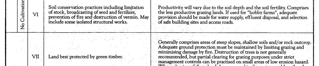
31 ORANGE CITY COUNCIL 30 THE ORANGE RESOURCE RECOVERY AND Emery s table also shows two other land capability classes Mining and Urban land use and also deals with class subscripts used to further subdivide some capability classes. The information presented by Emery is contained in Appendix Land Capability Classification Introduction It should be noted that the DECC Land Capability mapping was carried out at a very different scale to that of the present study and in most cases the assessments were subjected to only limited field checking. As a consequence, there are often differing assessments that result from more detailed examination of relatively small project sites The DECC Mapping The 1: scale Land Capability map of the Molong map sheet area prepared by the former Soil Conservation Service of NSW [DECC, Parramatta - GIS ] shows the overall Project Site area to comprise Class III and Class IV land. Class III is land suitable for cropping on a rotational basis but requiring the use of structural soil conservation works such as graded banks, waterways and diversion banks, together with soil conservation practices such as conservation tillage and adequate crop rotation. Class IV is land capable of being regularly cultivated but suitable for grazing with occasional cultivation but requiring soil conservation practices such as pasture improvement, stock control, application of fertiliser and minimal cultivation for the establishment or reestablishment of permanent pasture Current Assessment After a stereoscopic interpretation of air photos of the Site and field assessments during the vegetation and soil survey [see Figure 4], it is evident that the mapped Class III lands are Class III land with the exception of the small stony hill in the northwest section of the Site. This hill is Class VI land. The areas mapped as Class IV land are only partly of this description as the main drainage line that runs through the northeastern section of the Site and the area of rocky slope in that same area are more suitably described as Class VI land. Class VI land is land not capable of being cultivated but suitable for grazing with limitation of stocking, broadcasting of seed and fertilizer, prevention of fire and destruction of vermin.
32 THE ORANGE RESOURCE RECOVERY AND 31 ORANGE CITY COUNCIL Figure 3 LAND CAPABILITY
33 ORANGE CITY COUNCIL 32 THE ORANGE RESOURCE RECOVERY AND 10.2 Agricultural Land Suitability Classification NSW Agriculture Assessment Information supplied by NSW Department of Primary Industries [Agriculture] at Dubbo [Mary Kovac, pers.comm.] indicates that the Department has classified the lands of the area around the Euchareena Road Site using its agricultural land suitability system. The maps showing the Euchreena Road Site indicate that it comprises entirely Class 3 land. Class 3 lands are grazing lands or those well suited to pasture improvement. These lands have a moderate productivity and may be cultivated or cropped in rotation with pasture although soil and environmental constraints [eg. erosion hazard and soil structure breakdown] limit productivity Field Assessment Field observations during the field studies at the Euchareena Road Site to indicate that the agricultural land suitability classification nominated by NSW Agriculture is correct for much of the Site i.e. the main part of the Site comprises Class 3 [agricultural land suitability] lands. However, the small stony hill in the northwest section of the Site and the drainage line and rocky slope in the northeastern section of the Site are more correctly classified as Class 4 land [Figure 4]. Class 4 land is land suitable for grazing but not for cultivation. Agriculture is based on native pastures or improved pastures established using minimum tillage techniques OVERVIEW Soils of the proposed Euchareena Road Site have been described and one soil mapping unit has been identified. The physical and chemical attributes of the soils within the Soils Study Area have been quantified through a combination of field assessment and laboratory testing and indicate: the soils are currently stable but have a generally moderate erodibility rating as determined using the laboratory data obtained from samples from the Soils Study Area in the SOILOSS computer model; the soils are non-saline; the topsoils are not dispersible, but some subsoils within the areas to be disturbed are moderately to very highly dispersible; the soils are generally highly structured and can be stripped and respread using scrapers or bulldozers;
34 THE ORANGE RESOURCE RECOVERY AND 33 ORANGE CITY COUNCIL Figure 4 AGRICULTURAL LAND SUITABILITY
35 ORANGE CITY COUNCIL 34 THE ORANGE RESOURCE RECOVERY AND the topsoil material should be stripped to 15cm depth and stockpiled; the subsoil material from 15cm to 75cm depth, or less if the mottled soil is reached, should be stockpiled separately; and all soils will be subject to structural degradation if worked when too moist. Stripping recommendations have been provided along with advice on stabilising the soil stockpiles in the period between stripping and respreading. It is recommended, wherever possible, that the use of soil stockpiles be avoided with material from areas being prepared for use being transferred direct to areas being rehabilitated. The pre-development land capability and land suitability of the Site has been determined. The bulk of the cleared land on the Euchareena Road Site is assessed to have a Class III land capability whereas the rocky hill and drainage line areas have a Class VI land capability. The agricultural land suitability of much of the Site is Class 3 with some Class 4 land. Adherence to the soil management guidelines contained in this report should allow the rehabilitated Euchareena Road Site lands to be protected with appropriate soil conservation measures, sown to improved pastures and used for grazing at the end of its proposed life ADDRESSING DIRECTOR-GENERAL'S REQUIREMENTS There are no specific soils-related issues noted in the Director-General's Requirements REFERENCES Cunningham, G.M., Higginson, F.R., Riddler, A.M.H. and Emery, K.A. [undated] Systems Used to Classify Rural Lands in New South Wales. Soil Conservation Service of NSW and NSW Department of Agriculture, Sydney. Dougall, B.M. [1950] The Effects of Open-Cut Coal Mining on Agricultural Land. J. Sci. Fd. Agric. 11: Elliott, G.L. and Veness, R.A. [1981] Selection of Topdressing Material for Rehabilitation of Disturbed Areas in the Hunter Valley. J. Soil Cons. NSW 37: Emery, K.A. [undated] Rural Land Capability Mapping, Scale 1: Soil Conservation Service of New South Wales, Sydney. [2005] of the proposed Hub Regional Resource Reprocessing Facility. Glendinning, J.S. [1990] Fertiliser Handbook. Incitec Ltd, Morningside. Hazelton, P.A. and Murphy, B.W. [Eds] [in press] What Do All the Numbers Mean? A Guide for the Interpretation of Soil Test Results. Department of Land and Water Conservation, Sydney and University of Technology, Sydney.
36 THE ORANGE RESOURCE RECOVERY AND 35 ORANGE CITY COUNCIL Hunter, F. and Currie, J.A. [1956] Structural Changes During Bulk Soil Storage. J. Soil Sci. 7: Isbell, R.F. [1996] The Australian Soil Classification. Australian Soil and Land Survey Handbook. CSIRO Publishing, Collingwood. Jacquier, D.W, McKenzie, N.J., Brown, K.L., Isbell, R.F. and Paine, T.A. [2001] The Australian Soil Classification An Interactive Key. Version 1.0. CSIRO Publishing, Melbourne. Jenkin, J.F., Elliott, G.L. and Veness, J.A. [1987] Soil Stockpiling, Profile Reconstruction and Crop Growth on Reconstituted Soils: Dartbrook, Hunter Valley, NSW. Australian Mining Industry Council, Proceedings of Environmental Workshop, Adelaide. King, D.P. [1998a] Soil Landscapes of the Forbes 1: Sheet. Report. Department of Land and Water Conservation, Sydney. King, D.P. [1998b] Soil Landscapes of the Forbes 1: Sheet. Map. Department of Land and Water Conservation, Sydney. Kovac, M. and Lawrie, J.A. [1990] Soil Landscapes of the Bathurst 1: Sheet. Report. Soil Conservation Service of NSW, Sydney. Kovac, M., Lawrie, J.A. and Murphy, B.W. [1989] - Soil Landscapes of the Bathurst 1: Sheet. Map. Soil Conservation Service of NSW, Sydney. Macbeth [1992] Munsell Soil Colour Charts Revised Edition. Macbeth Division of Kollmorgen Instruments Corporation, Newburgh, New York. McDonald, R.C., Isbell, R.F., Speight, J.G., Walker, J. and Hopkins, M.S. [1990] Australian Soil and Land Survey Field Handbook. Second edition. Inkata Press, Melbourne. Northcote, K.H. [1971] A Factual Key for the Recognition of Australian Soils. Rellim Technical Publications, Glenside. Renard, K.G., Foster, G.R., Weesies, G.A., McCool, D.K. and Yoder, D.C. [1993] Predicting Soil Erosion by Water: A Guide to Conservation Planning with the revised Universal Soil Loss Equation [RUSLE}. USDA Agriculture Handbook. Washington DC. Rosewell, C.J. [1993] SOILOSS, A Program to Assist in the Selection of Management Practices to Reduce Erosion. Second Edition. Department of Conservation and Land Management, Sydney. Rosewell, C.J. and Edwards, K. [1988] SOILOSS. A Program to Assist in the Selection of Management Practices to Reduce Erosion. Technical Handbook No. 11. Soil Conservation Service of NSW, Sydney. Wischmeier, W.H. and Smith, D.D. [1978] Predicting Rainfall Erosion Losses A Guide to Conservation Planning. Handbook 537, USDA, Washington DC. Geoff Cunningham B.Sc.Agr.[Hons], FAIAST. Managing Director and Principal Soil Scientist, Geoff Cunningham Natural Resource Consultants Pty. Ltd. 25 th May, 2009
37 ORANGE CITY COUNCIL 36 THE ORANGE RESOURCE RECOVERY AND This page has been intentionally left blank
38 THE ORANGE RESOURCE RECOVERY AND 37 ORANGE CITY COUNCIL APPENDICES (No. of pages excluding this page = 8) Appendix 1: Appendix 2: Appendix 3: Appendix 4: Description of Sample Pits Topsoil Stripping Suitability Key Basis of Land Capability Classification Glossary of Terms
39 ORANGE CITY COUNCIL 38 THE ORANGE RESOURCE RECOVERY AND This page has been intentionally left blank
40 THE ORANGE RESOURCE RECOVERY AND 39 ORANGE CITY COUNCIL APPENDIX 1 (No. of pages excluding this page = 4) Description of Sample Pits
41 ORANGE CITY COUNCIL 40 THE ORANGE RESOURCE RECOVERY AND [a] Profile 1 [location on upper slope / crest] Surface firm, surface stone absent 0-19 cm -light to medium clay; many roots; ph 6.0; reddish brown [5YR4/4] dry, dark reddish brown [5YR3/4] moist; highly pedal [100%], peds rough-faced, polyhedral, <5-10mm in size; firm consistence dry; clear to: cm - medium clay, roots common; ph 6.5, small rounded gravel present; reddish brown [2.5YR4/4] dry, dusky red [10R3/3] moist; highly pedal [100%], peds rough-faced, polyhedral, 5-10mm in size; strong consistence dry; clear to: cm - medium clay, many roots; manganese flecks; ph ; yellowish red [5YR5/6], strong brown [7.5YR4/6]; highly pedal [100%], peds rough-faced, polyhedral, 5-15mm in size; strong consistence dry; clear to: cm - medium clay, few roots; much manganese staining; ph ; strong brown [7.5YR5/5] dry, strong brown [7.5YR5/6] moist: highly pedal [100%], peds smooth-faced, polyhedral, 5-15mm in size, strong consistence dry; clear to: cm - medium to heavy clay; few roots; lime nodules present; manganese stains; ph , weathered stones present, mottled; 90% strong brown [7.5YR5/6] dry, strong brown [7.5YR4/6] moist; 10% brown [10YR5/3] dry, yellowish brown [10YR5/4] moist; highly pedal [100%], peds rough- / smooth-faced, polyhedral, 5-10mm in size, very strong consistence dry; clear to: cm - weathering rock; few roots [b] Profile 2 [location upper slope] Surface loose, surface stone absent, 0-13 cm - clay loam to light clay; many roots; ph 5.0; reddish brown [5YR4/4 dry], dark reddish brown [5YR3/3] moist; highly pedal [100%], peds rough-faced, polyhedral, 5-15 mm in size, weak to firm consistence dry; diffuse to: cm - medium to heavy clay; many roots; ph 6.0; yellowish red [5YR4/6] dry, dark reddish brown [2.5YR3/4] moist; highly pedal [100%], peds rough-faced, polyhedral, 5-20mm in size; firm consistence dry; diffuse to: cm - light to medium clay; few roots; ph 8.0; strong brown [7.5YR5/6] dry, strong brown [7.5YR4/6] with flecks of red [10R4/4] moist; highly pedal [100%], peds rough-faced, polyhedral, 5-20mm in size; very firm to strong consistence dry; diffuse to: cm - medium to heavy clay; few roots; stains and small nodules of manganese; ph 9.0; much small gravel present; dark yellowish brown [10YR4/6] dry, dark yellowish brown [10YR4/4] moist, highly pedal [100%], peds smooth-faced, polyhedral to platy, 5-20mm in size; very firm to strong consistence dry; diffuse to: cm - heavy clay; few roots; much manganese staining; ph 9.0, weathered stones and some gravel to 2cm present; mottled; 70% yellowish brown [10YR5/6], yellowish brown [10YR5/4] moist; 30% light yellowish brown [2.5Y6/3] dry, light brownish grey [2.5Y6/2] moist; highly pedal [100%], peds smooth-faced, polyhedral, 5-10mm in size; strong consistence dry; diffuse to: cm - weathered rock; few roots; much manganese staining
42 THE ORANGE RESOURCE RECOVERY AND 41 ORANGE CITY COUNCIL [c] Profile 3 [location upper slope] Surface firm, surface stone absent 0-12 cm - clay loam to light clay; many roots; ph 6.0; reddish brown [5YR4/4] dry, dark reddish brown [2.5YR3/3] moist; highly pedal [100%], peds rough-faced, polyhedral, 5-15mm in size; firm consistence dry; diffuse to: cm - medium clay; many roots; ph 7.5; small gravel present; red [2.5YR4/6] dry, dusky red [10R3/4] moist; highly pedal [100%], peds rough- /smooth-faced, polyhedral, 5-15mm in size; firm to very firm consistence dry, clear to: cm - medium to heavy clay; few roots; much manganese staining and nodules; ph 7.5; small gravel present; yellowish red [5YR5/6] dry and moist, highly pedal [100%], peds roughfaced, polyhedral, <5-15mm in size; strong consistence dry; clear to: cm - medium to heavy clay; few roots; much manganese staining and nodules to15mm; ph 8.0; strong brown [7.5YR5/6] dry and moist; highly pedal [100%]; peds roughfaced, polyhedral, 5-10mm in size; strong consistence dry; clear to: cm - heavy clay; few roots; much manganese staining and nodules to 4mm, ph 8.0, weathered rock; mottled; 60% reddish yellow [7.5YR6/6] dry, strong brown [7.5YR5/6] moist; 40% [pinkish grey [7.5YR7/2] dry and moist, highly pedal [100%], peds rough- / smooth-faced, polyhedral, 5-10mm in size; strong consistence dry [d] Profile 4 [location crest] Surface firm, surface stone present in small amounts, stones to 20cm 0-14 cm - clay loam; many roots; ph ; yellowish red [5YR4/6] dry, dark reddish brown [5YR3/3] moist; highly pedal [100%], peds rough-faced, polyhedral, <5-15mm in size; firm consistence dry; abrupt to: cm - light clay; many roots; small manganese nodules; ph 6.0; yellowish red [5YR4/6] dry, reddish brown [5YR4/4] moist; highly pedal [100%], peds rough-faced, polyhedral, 5-15mm in size; firm consistence dry; diffuse to: cm - medium to heavy clay; few roots; manganese stains present; ph 7.5; strong brown [7.5YR4/6] dry and moist; highly pedal [100%], peds rough- / smooth-faced, polyhedral, 5-10mm in size; firm to very firm consistence dry; diffuse to: cm - medium to heavy clay; few roots; manganese stains present; ph 5.5; mottled; 95% strong brown [7.5YR5/6] dry, dark yellowish brown [10YR4/6] moist; 5% red [2.5YR4/6] dry and moist; highly pedal [100%], peds rough- / smooth-faced, polyhedral, <5-10mm in size; firm consistence dry; diffuse to: cm - heavy clay; few roots; manganese stains common; ph 6.0; some angular gravel present; mottled; 80% yellowish brown [10YR5/6] dry, dark yellowish brown [10YR4/6] moist; 10% red [2.5YR4/6] dry, reddish brown [2.5YR4/4] moist; 10% pinkish grey [7.5YR6/2] dry and moist; highly pedal [100%], peds smooth-faced, polyhedral, <5-15mm in size; very firm consistence dry; clear to: cm - heavy clay; few roots; manganese stains present; ph 6.0; mottled; 80% strong brown [7.5YR5/8] dry, strong brown [7.5YR5/6] moist, 10% pale brown [10YR6/3] dry, light
43 ORANGE CITY COUNCIL 42 THE ORANGE RESOURCE RECOVERY AND brownish grey [2.5Y6/2] moist; 10% red [2.5YR4/6] dry, reddish brown [2.5YR4/4] moist; highly pedal [100%], peds smooth-faced, polyhedral, 5-20mm in size; strong consistence dry [e] Profile 5 [location midslope / depression] Surface hardsetting, surface stone absent 0-16 cm - fine sandy clay loam; many roots; ph ; brown [7.5YR4/4] dry, dark reddish brown [5YR3/3] moist; moderately pedal [70%], peds rough-faced, polyhedral, 5-10mm in size; strong consistence dry; abrupt to: cm - medium heavy clay; many roots; manganese stains; ph 6.0; irregular stones to 8cm present; reddish brown [5YR4/4] dry and moist; highly pedal [100%], peds rough- / smooth-faced, polyhedral, 5-20mm in size; strong consistence dry; clear to: cm - medium heavy clay; roots few; lime nodules to 15mm; ph 8.0; small gravel present; strong brown [7.5YR5/6 dry], strong brown [7.5YR4/6] moist; highly pedal [100%], peds smooth-faced, polyhedral, 5-20mm in size; strong consistence dry; clear to: cm - medium heavy clay; few roots; lime nodule present; ph 9.0; stones present; mottled; 50% red [10R4/6] dry, red [10R5/6] moist; 50% strong brown [7.5YR4/6] dry and moist; highly pedal [100%], peds smooth-faced, polyhedral / platy, 5-20mm in size; very strong consistence dry; clear to: cm - heavy clay; few roots; large nodules of lime to 25mm; manganese stains; ph 9.0; gravel present; mottled; 45% red [10R4/6] dry, and moist; 45% yellowish brown [10YR5/6] dry, dark yellowish brown [10YR4/6] moist; 10% light brownish grey [10YR6/2] dry, greyish brown [10YR5/2] moist; highly pedal, [100%], peds smooth-faced, polyhedral, 5-15mm in size; firm to very firm consistence dry; clear to: cm - medium heavy clay; roots absent; large nodules of lime to 25mm; ph ; mottled; 90% red [10R5/8] dry, red [10R4/8] moist; 10% strong brown [7.5YR5/6] dry and moist; highly pedal [100%], peds smooth, polyhedral, 5-15mm in size; weak to firm consistence dry. [f] Profile 6 [location upper slope] Surface firm, surface stone absent 0-13 cm - silty clay; many roots; ph ; some stones to 10cm; brown [7.5YR4/4 dry, dark brown [7.5YR3/3] moist; highly pedal [100%], peds rough-faced, polyhedral, 5-15mm in size; firm to very firm consistence dry, abrupt to: cm - medium to heavy clay; roots common; ph 7.0; angular stones 4cm x 2cm in size present; reddish brown [2.5YR4/4] dry, dark reddish brown [2.5YR3/3] moist; highly pedal [100%], peds smooth-faced, polyhedral, 5-20mm in size; strong consistence dry; clear to: cm - medium to heavy clay; few roots; ph 7.5; angular stones 2cm x 2cm present; reddish brown [5YR4/3] dry, dark reddish brown [5YR3/3] moist, highly pedal [100%], peds rough- / smooth-faced, polyhedral, 5-10mm in size; strong consistence dry; abrupt to: cm - medium clay; few roots; many lime nodules; ph 7.5; weathered stones present; reddish brown [ 5YR5/4] with flecks of yellow [10YR7/6] dry, reddish brown [5YR4/4] with lesser flecks of dark yellowish brown [10YR4/6] moist; highly pedal [100%], peds rough-faced, polyhedral, 5-15mm in size; firm consistence dry; clear to:-
44 THE ORANGE RESOURCE RECOVERY AND 43 ORANGE CITY COUNCIL cm - gritty medium clay; few roots; lime coating on stones; ph 9.0; mainly talc-like rock; brownish yellow [10YR6/6] with brown [7.5YR4/3] in old root channels dry, strong brown [7.5YR4/6] with dark brown [7.5YR3/2] in old root channels moist; massive [g] Profile 7 [location crest] Surface firm, surface stone absent 0-17 cm - silty clay; many roots; ph 5.5; reddish brown [5YR4/4] dry, dusky red [2.5YR3/3] moist; highly pedal [100%]; peds rough-faced, polyhedral, <5-15mm in size; firm consistence dry, abrupt to: cm- sticky light clay; many roots; ph 6.0; yellowish red [5YR5/6] dry, dark red [2.5YR4/6] moist; highly pedal [100%], peds rough-faced, polyhedral, <5-15mm in size; very firm consistence when dry; clear to: cm - medium to heavy clay; roots common; much manganese staining; ph 7.5; strong brown [7.5YR5/6] dry, strong brown [7.5YR4/6] moist; highly pedal [100%], peds rough-faced, polyhedral, 5-15mm in size; strong consistence dry; clear to: cm - medium to heavy clay; few roots; much manganese staining; ph 7.5; odd stone present; mottled; 80% yellowish brown [10YR5/6] dry, yellowish brown [10YR5/4] moist, 20% red [10R4/6] dry, weak red [10R4/4] moist; highly pedal [100%], peds rough-faced, polyhedral, <5-10mm in size; strong consistence dry; diffuse to: cm - heavy clay; few roots; manganese stains and nodules; ph 8.0; floaters and angular stones present; mottled; 90% strong brown [7.5YR5/6] dry, strong brown [7.5YR5/8] moist; 10% light grey [10YR7/2] dry, light brownish grey [10YR6/2] moist; highly pedal [100%]; peds rough- / smooth-faced, polyhedral, <5-10mm in size; strong consistence dry; diffuse to: cm - medium to heavy clay; manganese stains present; ph 8.0; stones present; mottled; 50% red [10R5/6] dry and moist, 50% yellowish brown [10YR5/4] dry, dark yellowish brown [10YR4/4] moist; highly pedal [100%], peds rough-faced, polyhedral, 5-15mm in size; strong consistence dry [h] Profile 8 [location upper slope] Surface firm, surface stone absent 0-10 cm - fine sandy clay loam; many roots; ph 6.0; brown [7.5YR5/3] dry, dark brown [7.5YR3/2] moist; highly pedal [100%], peds rough- / smooth-faced, polyhedral, <5-10mm in size; firm consistence dry; abrupt to clear to: cm - medium clay; many roots; some flecks of manganese; ph 6.5; smooth/angular stones to 3cm present; brown [7.5YR4/3] dry and moist; highly pedal [100%], peds rough- / smooth-faced, polyhedral, 5-15mm in size; very firm to strong consistence dry; clear to: cm - sandy clay loam; few roots; manganese stains present; ph 7.5; mottled; 95% pink [7.5YR7/3] dry, light olive brown [2.5Y5/3] moist; 5% reddish yellow [7.5YR6/6] dry, strong brown [7.5YR4/6] moist; highly pedal [100%], peds rough- / smooth-faced, polyhedral, <5-15mm in size; strong consistence dry; diffuse to: cm - mainly rock; few roots
45 ORANGE CITY COUNCIL 44 THE ORANGE RESOURCE RECOVERY AND This page has been intentionally left blank
46 THE ORANGE RESOURCE RECOVERY AND 45 ORANGE CITY COUNCIL APPENDIX 2 (No. of pages excluding this page = 1) Topsoil Stripping Suitability Key [After Elliott and Veness, 1981]
47 ORANGE CITY COUNCIL 46 THE ORANGE RESOURCE RECOVERY AND
48 THE ORANGE RESOURCE RECOVERY AND 47 ORANGE CITY COUNCIL APPENDIX 3 (No. of pages excluding this page = 1) Basis of Land Capability Classification [After Emery, Undated]


49 ORANGE CITY COUNCIL 48 THE ORANGE RESOURCE RECOVERY AND
5 RESULTS FOR THE REJECT EMPLACEMENT AREA
 SPECIALIST CONSULTANT STUDIES 9b - 21 NARRABRI COAL OPERATIONS PTY LTD of the REA, BSA and Water Pipeline Report No. 674/17 5 RESULTS FOR THE REJECT EMPLACEMENT AREA 5.1 Introduction From the information
Muswellbrook Coal Company No.1 Open Cut Extension Soil Study
 Muswellbrook Coal Company No.1 Open Cut Extension Soil Study November 2001 Table of Contents 1. Introduction... 1 2. Methodology... 1 3. Description of Soil Units Observed... 2 3.1 Yellow Duplex Soils
2018 Iowa FFA Soil Judging CDE Exam 1. Landscape positions characterizes the location of the soil on the landscape and identifies potential risks.
 2018 Iowa FFA Soil Judging CDE Exam 1. Landscape positions characterizes the location of the soil on the landscape and identifies potential risks. Which landscape position is considered the floodplain
Topoclimate Southland Soil Technical Data Sheet No Waiau
 This Technical Data Sheet describes the typical average properties of the specified soil. It is essentially a summary of information obtained from one or more profiles of this soil that were examined and
Topoclimate Southland Soil Technical Data Sheet No. 8. Sobig
 This Technical Data Sheet describes the typical average properties of the specified soil. It is essentially a summary of information obtained from one or more profiles of this soil that were examined and
Horner-McLaughlin Woods: Soil Types
 Horner-McLaughlin Woods: Soil Types Not present at HMW Adrian Muck Conover Loam 0-4% Slopes Houghton Muck Miami Loam 2-6% Slopes Miami Loam 6-12% Slopes Miami Loam 12-18% Slopes t 0 0.125 0.25 Miles Mary
PHYSICAL CHAtlACTERISTICS REPORT FOR THE PROPOSED SAND AND GRAVEL SITE AT MANOR FARM, UFFINGTON
 PHYSICAL CHAtlACTERISTICS REPORT FOR THE PROPOSED SAND AND GRAVEL SITE AT MANOR FARM, UFFINGTON Introduction Following the" request for detailed information on the physical characteristics of soil at Manor
2014 Iowa FFA Soil Judging CDE Exam
 2014 Iowa FFA Soil Judging CDE Exam 1. Landscape position is one aspect of evaluating the surface features of a certain tract of land. Identifying the correct landscape position will indicate: a. If the
Examining soils in the field. Examining soils in the field. Environment Agency thinksoils examining soils in the field
 Examining soils in the field thinksoils Examining soils in the field Environment Agency thinksoils examining soils in the field 31 Examining soils in the field 32 Environment Agency thinksoils examining
Topoclimate Southland Soil Technical Data Sheet No. 11. Pukemutu
 This Technical Data Sheet describes the typical average properties of the specified soil. It is essentially a summary of information obtained from one or more profiles of this soil that were examined and
Iowa FFA Soil Career Development Event 2008
 Iowa FFA Soil Career Development Event 2008 1. In Iowa, corn suitability ratings for soil mapping units specifies a. natural weather conditions b. surface and subsurface drainage installed where needed
IOWA FFA STATE SOILS CDE SATURDAY, OCTOBER 13, 2007 AMES, IOWA
 IOWA FFA STATE SOILS CDE SATURDAY, OCTOBER 13, 2007 AMES, IOWA 1. Moderately sloping has what percent slope: a. 9-14% b. 2-5% c. 5-9% d. over 14% 2. Which of the following horizons is the loose underlying
2017 Iowa FFA Soil Judging CDE Exam
 2017 Iowa FFA Soil Judging CDE Exam 1. Landscape positions vary in soil composition and makeup. What landscape position would be characterized by having strata and lenses of different textures in the profile:
Appendix 22 Soils and Land Capability
 Appendix 22 Soils and Land Capability March 2009 March 2009 Table of Contents Page No. 1. INTRODUCTION... 1 2. SOIL PROFILING AND MAPPING... 2 2.1 Soil Survey Methodology... 2 2.2 Soil Landscapes... 3
Topoclimate Southland Soil Technical Data Sheet No. 76. Mossburn
 This Technical Data Sheet describes the typical average properties of the specified soil. It is essentially a summary of information obtained from one or more profiles of this soil that were examined and
2011 Wisconsin Envirothon Soils and Land Use Exam
 2011 Wisconsin Envirothon Soils and Land Use Exam USE THE OCONTO COUNTY SOIL SURVEY TO ANSWER QUESTIONS 1-4 The Pensaukee River Wetland Complex is a mixture of state (Pensaukee Wildlife Area) and privately
PROPOSED OPEN CAST COAL SITE SEPTEMBER 1992
 AGRICULTURAL LAND CLASSIFICATION AND STATEMENT OF PHYSICAL CHARACTERISTICS SKIERS SPRING, HOYLAND, SOUTH YORKSHIRE PROPOSED OPEN CAST COAL SITE SEPTEMBER 1992 ADAS LEEDS STATUTORY GROUP Job No. 98/92 MAFF
2016 Area 3 Envirothon Muskingum County Soils Test ANSWER KEY
 2016 Area 3 Envirothon Muskingum County Soils Test ANSWER KEY 1. The majority of the bedrock in Muskingum County is. a. sedimentary bedrock b. glacial bedrock c. igneous bedrock d. metamorphic bedrock
STATEMENT OF PHYSICAL CHARACTERISTICS AND AGRICULTURAL LAND CLASSIFICATION
 STATEMENT OF PHYSICAL CHARACTERISTICS AND AGRICULTURAL LAND CLASSIFICATION BIRKWOOD FARM, ALTOFTS WEST YORKSHIRE Proposed Opencast Extraction of Clay and coal ADAS January 1990 Leeds Regional Office File
SITE TOPSOIL & FINISH GRADING
 CITY OF BRAMPTON LANDSCAPE SPECIFICATIONS SECTION 02911-1 PART 1 GENERAL 1.1 Related Work.1 Section 02311 Site Grading.2 Section 02315 Excavating, Trenching, & Backfilling.3 Section 02906 Planting of Trees,
AGRICULTURAL LAND CLASSIFICATION AND STATEMENT OF PHYSICAL CHARACTERISTICS
 AGRICULTURAL LAND CLASSIFICATION AND STATEMENT OF PHYSICAL CHARACTERISTICS DALE PIT FARM. HATFIELD VOODHOUSE PROPOSED EXTRACTION OF SAND AHD GRAVEL ADAS April 1989 Leeds Regional office File Ref: 2FCS
2012 FINAL SOILS AREA 2 Envirothon Questions Answer KEY
 2012 FINAL SOILS AREA 2 Envirothon Questions Answer KEY Questions 1-6 to be answered at the soil pit: 1. Soil scientists categorize soils by drainage classes. What is the drainage class of the soil at
Topoclimate Southland Soil Technical Data Sheet No. 23. Waikiwi
 This Technical Data Sheet describes the typical average properties of the specified soil. It is essentially a summary of information obtained from one or more profiles of this soil that were examined and
SOIL CHARACTERIZATION USING DIAGNOSTIC PROPERTIES
 SOIL CHARACTERIZATION USING DIAGNOSTIC PROPERTIES The following are the characters of the pedologically important properties used in categorizing soils: SOIL CHARACTERIZATION Soil Profile Description:
Learning Objectives Part 1. Chapter 4 Soil Physical Properties. Soil Physical Properties. Color. Physical properties part 1
 Learning Objectives Part 1 Chapter 4 Soil Physical Properties Know what color tells you about a soil Describe the concept of soil texture and its importance Use the textural triangle to determine a soil
Land Capability Classifications
 Land Capability Classifications Unit: Soil Science Problem Area: Basic Principles of Soil Science Student Learning Objectives. Instruction in this lesson should result in students achieving the following
Loam: About 40% sand, 40% silt, 20% clay. Mixture of pore sizes to balance water retention and aeration. Considered the best soil for growing crops.
 Soil Characteristics Soil is formed from a combination of two Primary sources: Weathering of Parent Rock ( ) = material introduced by plants, animals, and decomposers Minor sources: Nutrients incorporated
THE TENNESSEE VEGETABLE GARDEN
 THE BACKYARD SERIES BACKYARD VEGETABLES W 346-A THE TENNESSEE VEGETABLE GARDEN SITE SELECTION AND SOIL TESTING Natalie Bumgarner, Assistant Professor and UT Extension Residential and Consumer Horticulture
EDULABZ. Ans. (b) 7. The soft, porous layer with a good water-retaining capacity forms the
 7. The soft, porous layer with a good water-retaining capacity forms the") 3 SOIL I. Multiple choice questions: Tick ( ) the correct choice. 1. The process of soil formation is called (a) conservation (b) weathering (c) erosion (d) none Ans. (b) 2. Soil profile consists of (a)
3 SOIL I. Multiple choice questions: Tick ( ) the correct choice. 1. The process of soil formation is called (a) conservation (b) weathering (c) erosion (d) none Ans. (b) 2. Soil profile consists of (a)
AGRICULTURAL LAND CLASSIFICATION AND SOIL PHYSICAL CHARACTERISTICS LAND NEAR SHIRE HILL FARM SAFFRON WALDEN ESSEX
 AGRICULTURAL LAND CLASSIFICATION AND SOIL PHYSICAL CHARACTERISTICS LAND NEAR SHIRE HILL FARM SAFFRON WALDEN ESSEX AGRICULTURAL LAND CLASSIFICATION (ALC) AND SOIL PHYSICAL CHARACTERISTICS LAND NEAR SHIRE
STATEMENT OF PHYSICAL CHARACTERISTICS AND AGRICULTURAL LAND CLASSIFICATION WITTON PARK, COUNTY DURHAM PROPOSED QUARRY EXTENSION DECEMBER 1992

1. Position (2 pts.) 2. Parent Material (2 pts.) 3. Slope Characteristics (2 pts.) 4. Surface Stoniness or Rockiness (2 pts.)
 2. Parent Material (2 pts.) 3. Slope Characteristics (2 pts.) 4. Surface Stoniness or Rockiness (2 pts.)") Maryland Envirothon SOILS Exam Guidance Information (revised 2017) Objective: To test students' knowledge and awareness of basic soil science and its application in wise land-use planning and therefore
Maryland Envirothon SOILS Exam Guidance Information (revised 2017) Objective: To test students' knowledge and awareness of basic soil science and its application in wise land-use planning and therefore
2016 Iowa FFA Soils Evaluation CDE Exam
 2016 Iowa FFA Soils Evaluation CDE Exam 1. Which of the following is true regarding soil horizons? a. A horizon is darker in color and has more organic matter b. B horizon is darker in color and has more
Unearthing problem soils in the Lachlan Valley
 Vol 24, No 1, page 32 February-March, 2003 The Australian Cottongrower Unearthing problem soils in the Lachlan Valley By Edward Cay and Stephen Cattle, The University of Sydney and Australian Cotton CRC
SOIL DATA: Avondale. in Allen, TX. This information was taken from NRCS web soil survey of Collin County, Texas.
 SOIL DATA: Avondale in Allen, TX This information was taken from NRCS web soil survey of Collin County, Texas. United States Department of Agriculture Soil Conservation Service in cooperation with Texas
The entire site supports grass on which sheep had been grazing recently.
 PHYSICAL CHARACTERISTICS REPORT FOR LAND AT HORSEHAY A^ Agricultural Land Classification of approximately 14 hectares of land to the southwest of Horsehay was undertaken in November 1989. The site lies
STATE TAX COMMISSION OF MISSOURI ASSESSOR MANUAL
 STATE TAX COMMISSION OF MISSOURI ASSESSOR MANUAL CHAPTER: REVISION DATE: 10/1/2008 Page 1 of 18 7.3 The purpose of this section of the Assessor s Manual is to supplement the State Tax Commission s published
27/01/2017. This event is being run by SAC Consulting. What is Soil?
 This event is being run by SAC Consulting What is Soil? 1 Soil Texture It describes the physical composition of the soil % of sand, silt and clay Refers to the mineral fragments of the soil only water
Mature basalt volcanic soils
 MANAGING NORTHLAND SOILS Mature basalt volcanic soils 8.1.2 Soil types in this group Kerikeri friable clay (KE) Kerikeri friable clay with large boulders (KEb) Matarau friable clay (MC, MCH*) Matarau friable
Unit II Soil Management
 Unit II Soil Management Lesson 2: Using Soil Survey Manuals Soil survey manuals provide useful information for grassland management. Soil scientists evaluate the soil for chemical and physical properties,
SOIL SURVEY OF PORTIONS 81 AND 82 OFTHE FARM VAALBANK 512JQ, NEAR MAGALIESBURG, SOUTH-WEST OF PRETORIA
 REPORT For Newtown Landscape Architects SOIL SURVEY OF PORTIONS 81 AND 82 OFTHE FARM VAALBANK 512JQ, NEAR MAGALIESBURG, SOUTH-WEST OF PRETORIA By N.M. Mushia, D.G. Paterson and S.D. Mkula Report Number
Soil Maps for Production Agriculture. Jarrod O. Miller, Extension Agronomist
 Soil Maps for Production Agriculture Jarrod O. Miller, Extension Agronomist Origination of Soil Mapping Originally mapped by Division of Soils Federal Bureau of Soils Soil Conservation Service (SCS) started
Pits 1 & 3 Questions. 7. Subsurface: Texture (5 pts) A. Coarse B. Moderately course C. Medium D. Fine E. Very Fine
 A. Coarse B. Moderately course C. Medium D. Fine E. Very Fine") Minnesota Soils Scorecard Questions for Pits 1-4 Scantron # 105481 Use your soils scorecard to fill out the answers on your scantron Bubble in the front side of the sheet for Pit 1 (# 1-45) and Pit 2 (#51-95)
Minnesota Soils Scorecard Questions for Pits 1-4 Scantron # 105481 Use your soils scorecard to fill out the answers on your scantron Bubble in the front side of the sheet for Pit 1 (# 1-45) and Pit 2 (#51-95)
SECTION PLANTING SOIL for SOIL CELLS. This specification defines material and performance requirements for soils which are to be used
 This specification defines material and performance requirements for soils which are to be used within the Silva Cell system. The SPECIFICATION EDITOR must select the type of soil appropriate to each particular
Soils and Land Use Test
 SOIL PROPERTIES Total Score /50 1) List two of the five main functions of soil. (2 points) Habitat for organisms, Engineering medium, Filters and stores water, Anchor for plants, Cycles nutrients 2) Small
Eco new farmers. Module 2 Soil and Nutrient Cycling. Section 1 Soils and soil fertility
 Eco new farmers Module 2 Soil and Nutrient Cycling Section 1 Soils and soil fertility Module 2 Soil and Nutrient Cycling Section 1 - Soils and soil fertility www.econewfarmers.eu 1. Introduction You will
Soil Physical Properties
 Soil Physical Properties ESRM 311 SEFS 507 Some examples of mineral soil development eg, Rock Weathering Types of Weathering Physical/Mechanical Chemical Biological Photo by D Vogt CO 2 + H 2 O H 2 CO
GUIDELINE SPECIFICATIONS FOR SOIL MEDIA IN BIORETENTION SYSTEMS
 GUIDELINE SPECIFICATIONS FOR SOIL MEDIA IN BIORETENTION SYSTEMS The following guideline specifications for soil media in bioretention systems have been prepared on behalf of the Facility for Advancing
DO YOU KNOW YOUR SOILS? (Rev. 10/11)
") DO YOU KNOW YOUR SOILS? (Rev. 10/11) Circle all the correct answers. 1. What is the layer normally present on the surface of the soil in cropped fields? a. O c. Ap e. B g. R b. A d. E f. C 2. Available
DO YOU KNOW YOUR SOILS? (Rev. 10/11) Circle all the correct answers. 1. What is the layer normally present on the surface of the soil in cropped fields? a. O c. Ap e. B g. R b. A d. E f. C 2. Available
Soils and the Environment. A Summary of RI Envirothon Study Materials Compiled by Sally Paul
 Soils and the Environment A Summary of RI Envirothon Study Materials Compiled by Sally Paul Why Soils Food and water resources Disposing of waste Support for human structures Growing timber and fibers
4/23/2018. Soil John Wiley & Sons, Inc. All rights reserved. Lecture 14
 Lecture 14 Soil Lecture 14 1. The Soil System 2. Soil Properties and Major Soil Types 3. Environmental Problems Related to Soil 4. Soil Conservation and Regeneration 1 The Soil System Soil Uppermost layer
Historic soils of NSW
 Historic soils of NSW This project was initiated by the NSW branch of the Australian Society of Soil Science (ASSSI) for the Sydney 2004 Supersoil conference but not completed until after the conference.
The Nature of Soil Soil Conservation Sustainable Ag.
 Chapter 6 & 7 The Nature of Soil Soil Conservation Sustainable Ag. Climate Soil Forming Factors Parent material Organisms Topography Time Value of Soil Soil is under appreciated Condition of soil affects
AGRICULTURAL LAND CLASSIFICATION AND STATEMENT OF PHYSICAL CHARACTERISTICS
 AGRICULTURAL LAND CLASSIFICATION AND STATEMENT OF PHYSICAL CHARACTERISTICS SEGHILL, NORTHUMBERLAND PROPOSED VASTE DISPOSAL SITE ADAS January 1989 Leeds Regional Office REF: 3/89 2FCS 4191 lds.rpg3.seghill
Soil Geography Notes JC-Learn. JC-Learn. Geography Notes Soil. 1 P a g e
 JC-Learn Geography Notes Soil 1 P a g e Soil Soil is the thin covering of loose material that makes up the outermost layer of our planet. It is a living thing and a rich natural resource. Plants need soil
1 Describe the concept of soil texture and its importance. 2 Determine the texture of a soil sample.
 Interest Approach Provide students with various samples of soil. One sample should be nearly all sand, one nearly all clay, and one nearly all silt. Ask students to determine how the samples differ. Would
Agricultural Land Classification and Statement of Physical Characteristics Higbfield Farm Whitley Bridge North Yorkshire October 1996
 Agricultural Land Classification and Statement of Physical Characteristics Higbfield Farm Whitley Bridge North Yorkshire October 1996 Resource Planning Team ADAS Reference: 82/96 Leeds Statutory Group
Soil Horizons cont. Oa- highly decomposed Oi-undecomposed
 Soils Soil Basics Soil Horizons Soil Horizons cont. O Horizon: Or organic layer Organic layer of decomposing plant and animal tissue. Wooded upland areas have thin O horizons Wetlands may have thick O
LAB 12: Soils. Name School. Patrich Physical Geography Lab 1
 Name School LAB 12: Soils Soil is a mixture of weathered rock & organic matter that usually covers bedrock (solid rock that underlies all soil). Both chemical & mechanical processes are involved in the
Soil Survey and Land Resource Assessment
 Karuah East Pty Ltd FINAL Soil Survey and Land Resource Assessment Karuah East Quarry Project July 2011 HQP05-002 Table of Contents TABLE OF CONTENTS 1.0 INTRODUCTION... 1 1.1 BACKGROUND... 1 1.2 PROJECT
Soil testing Page 1. Contrary to what is widely believed, the colour of the soil reveals very little about its fertility.
 Soil testing Page 1 Soil The Basics Soil is the uppermost surface of the earth, which has been slowly transformed by decomposition due to the effects of weather, vegetation and human activities. The parent
Do Now: From which materials do you think soil is made? Are all soils the same? Think of some ways that they are different?
 Do Now: From which materials do you think soil is made? Are all soils the same? Think of some ways that they are different? Basics Soil is a major component of the biosphere It contains solids, liquids
York Potash Project Mine, MTS and MHF Environmental Statement, Part 2 Chapter: 16 Land Use and Soils Appendix 16.5 Outline Soil Management Plan
 York Potash Project Mine, MTS and MHF Environmental Statement, Part 2 Chapter: 16 Land Use and Soils Appendix 16.5 Outline Soil Management Plan Document title: Status: Draft Report Date: 21 August 2014
ATTACHMENT A BIORETENTION SOIL SPECIFICATION
 1.00 BIORETENTION SOIL ATTACHMENT A BIORETENTION SOIL SPECIFICATION Bioretention soil shall achieve an initial infiltration rate of at least 8-inch per hour nor more than 20 inches per hour in situ and
MAFF Ministry of Ifinil Agriculture Rsheries and Food
 MAFF Ministry of Ifinil Agriculture Rsheries and Food STATEMENT OF PHYSICAL CHARACTERISTICS AND AGRICULTURAL LAND CLASSIFICATION SHILBOTTLE COLLIERY RECLAMATION SCHEME NORTHUMBERLAND DECEMBER 1994 ADAS
SUMMARY. alcholnie.doc\ih\jk
 SUMMARY A detailed Statement of Physical Characteristics and Agricultural Land Classification survey of ha of land at Stainton ("Holme Hall Quarry Extension") was carried out in September 1994. At the
DIRT! APES Laboratory Activity
 Name: Part I: Soil Texture DIRT! APES Laboratory Activity Can one determine the texture of soil by examining the particles found in a particular sample? The purpose of this activity is to determine the
PHYSICAL CHARACTERISTICS REPORT INCORPORATING AGRICULTURAL LAND CLASSIFICATION LAND AT BOLE INGS, WESTBURTON, NOTTINGHAMSHIRE (SK805875)
") (krahs 2% I?5 PHYSICAL CHARACTERISTICS REPORT INCORPORATING AGRICULTURAL LAND CLASSIFICATION LAND AT BOLE INGS, WESTBURTON, NOTTINGHAMSHIRE (SK805875) 1.0 INTRODUCTION 1.1 The site, an area of 84.5 hectares,
(krahs 2% I?5 PHYSICAL CHARACTERISTICS REPORT INCORPORATING AGRICULTURAL LAND CLASSIFICATION LAND AT BOLE INGS, WESTBURTON, NOTTINGHAMSHIRE (SK805875) 1.0 INTRODUCTION 1.1 The site, an area of 84.5 hectares,
AGRICULTURAL USE & QUALITY OF LAND NEAR MINDALE HOUSE PRESTATYN. Report 762/1
 AGRICULTURAL USE & QUALITY OF LAND NEAR MINDALE HOUSE PRESTATYN Report 762/1 11 th April, 2012 AGRICULTURAL USE & QUALITY OF LAND NEAR MINDALE HOUSE PRESTATYN F W Heaven, BSc, MISoilSci Report 762/1 Ltd
AGRICULTURAL LAND CLASSIFICATION AND SOIL PHYSICAL CHARACTERISTICS BIRCH PIT, NEAR COLCHESTER ESSEX
 AGRICULTURAL LAND CLASSIFICATION AND SOIL PHYSICAL CHARACTERISTICS BIRCH PIT, NEAR COLCHESTER ESSEX AGRICULTURAL LAND CLASSIFICATION AND SOIL PHYSICAL CHARACTERISTICS SEMI-DETAILED SURVEY BIRCH PIT, NEAR
Section 1. Judging the soil pit (questions 1-4)
") CONNECTICUT ENVIROTHON 2009 SOILS QUESTIONS Please select the best response to the following questions. There are 25 questions; each question is worth 4 points. Section 1. Judging the soil pit (questions
CONNECTICUT ENVIROTHON 2009 SOILS QUESTIONS Please select the best response to the following questions. There are 25 questions; each question is worth 4 points. Section 1. Judging the soil pit (questions
Soil Notes. General Soil Information
 Soil Notes General Soil Information Definition Soil relatively thin surface layer of the Earth s crust consisting of mineral and organic matter that is affected by agents such as weather, wind, water,
Soil Colors, Texture & Structure
 Application Soil Colors, Texture & Structure Limiting conditions Soil color type/depth of system Bedrock type/depth of system Soil texture, structure, percolation rate size and type of system Sara Heger,
Team number Page 1 of Canon Envirothon Soils Station Test. Soils and Climate Change
 Team number Page 1 of 9 2006 Canon Envirothon Soils Station Test Soils and Climate Change There are many kinds of soil on the surface of the earth. The kind of soil that is present at a given location
Land Judging in West Virginia
 Guide 406R-LJ Revised 2017 Land Judging in West Virginia A program of WVU Extension Service 4-H and Agriculture and Natural Resources extension.wvu.edu/youth-family/youth-evaluation/landjudging Land Judging
CONNECTICUT ENVIROTHON 2012 SOILS QUESTIONS
 CONNECTICUT ENVIROTHON 2012 SOILS QUESTIONS Please select the best response to the following questions. There are 25 4 point questions. Many have more than one part. Good luck! Section 1: Judging the soil
Terminology & Soil Science. Andy Spetch
 Terminology & Soil Science Andy Spetch 1 Presentation Soil Profile Soil Structure Soil Texture Compaction Cation Exchange Capacity Soil ph Nutrients / Organic Matter / EC / PTE s 2 What is Soil: A blend
Soil Quality / Understanding Soil Health what are we missing?
 Soil Quality / Understanding Soil Health what are we missing? Soil Quality Test Kit Clarence Chavez Soil Scientist The USDA is an Equal Opportunity Provider and Employer Soils are not machines: It s an
AGRONOMY 255, 251, 270 SOIL DIFFERENCES
 Name AGRONOMY 255, 251, 270 SOIL DIFFERENCES Soils differ strikingly from each other. This week we illustrate the great differences and ask you to learn how they differ and to become skilled in describing
HUMBLEBURN OCCS, CRAGHEAD, COUNTY DURHAM SURVEY OF RESTORED LAND OCTOBER RPT Job Number: 73/97 MAFF Reference: EL LURET Job Number: ME3RTP
 HUMBLEBURN OCCS, CRAGHEAD, COUNTY DURHAM SURVEY OF RESTORED LAND OCTOBER 1997 Resource Planning Team Northern Region FRCA, Leeds RPT Job Number: 73/97 MAFF Reference: EL 10387 LURET Job Number: ME3RTP
5.1 Introduction to Soil Systems IB ESS Mrs. Page
 5.1 Introduction to Soil Systems IB ESS Mrs. Page 2015-2016 I Am Soil Thinking Routine: See, Think, Wonder Look at the following images. For each image write down what you see Then write down what you
BENGALLA Mining Company. Soils and Land Capability Impact Assessment
 BENGALLA Mining Company Soils and Land Capability Impact Assessment Soil and Land Capability Impact Assessment Continuation of Bengalla Mine July 2013 HAN05-001 Continuation of Bengalla Mine 1 Prepared
Soil Texture = %Sand, Silt & Clay in a soil.
 Soils Soil Texture = %Sand, Silt & Clay in a soil. Soil texture is the single most important physical property of the soil. Knowing the soil texture alone will provide information about: 1) water flow
SOIL SURVEY FOR PROPOSED WET ASH DISPOSAL FACILITY, HENDRINA POWER STATION, MPUMALANGA PROVINCE
 REPORT for Lidwala Environmental and Planning Servives by the INSTITUTE FOR SOIL CLIMATE AND WATER AGRICULTURAL RESEARCH COUNCIL SOIL SURVEY FOR PROPOSED WET ASH DISPOSAL FACILITY, HENDRINA POWER STATION,
B. Land capability subclass - DELETED Determine Land Capability Subclass according to the following rules. Mark all subclasses that apply.
 1 Indiana Soils: Evaluation and Conservation (ID-72, 7/01; rev8/08) Summary of rule changes D. P. Franzmeier and G. C. Steinhardt The changes in rules and the reasons for making them are summarized here.
Soil Resources. Soil Horizons
 Soil Resources Soil Uppermost layer of earth s crust that supports plants, animals and microbes Soil Forming Factors Parent Material Time Climate Organisms Topography Soil Composition Mineral Particles
Components of Soil. Humus: (a carbon sink) Dark brown or black color indicates high nitrogen content.
 Dark brown or black color indicates high nitrogen content.") Components of Soil Humus: (a carbon sink) Dark brown or black color indicates high nitrogen content. Inorganic Soil Components: Particle Size: Clay- Very fine Silt- Fine Sand- Medium Gravel- Large Discuss
Components of Soil Humus: (a carbon sink) Dark brown or black color indicates high nitrogen content. Inorganic Soil Components: Particle Size: Clay- Very fine Silt- Fine Sand- Medium Gravel- Large Discuss
The following general requirements will be met for all planter box installations:
 Greenville County Technical Specification for: WQ-25 PLANTER BOX 1.0 Planter Box 1.1 Description Planter boxes are designed to capture and temporarily store stormwater runoff. Planter Boxes are intended
 Cci
Cci APPENDIX. Soil and Land Capability Impact Assessment
 APPENDIX P P P FINAL Maules Creek Coal Project Soil and Land Capability Assessment November 2010 HAN17-001 P GSS Environmental TABLE OF CONTENTS 1.0 INTRODUCTION... 1 1.1 BACKGROUND... 1 1.2 PROJECT DESCRIPTION...
CB1 Moderately undulating landscape with slight gilgai (few inches) formation: broad ridge tops and upper slopes of moderately shallow grey cracking
 formation: broad ridge tops and upper slopes of moderately shallow grey cracking") CB1 Moderately undulating landscape with slight gilgai (few inches) formation: broad ridge tops and upper slopes of moderately shallow grey cracking clays (Ug5.22 and Ug5.23). Associated are: (i) some
CB1 Moderately undulating landscape with slight gilgai (few inches) formation: broad ridge tops and upper slopes of moderately shallow grey cracking clays (Ug5.22 and Ug5.23). Associated are: (i) some
Drainage & wet soil management. Dr Bill Cotching
 Drainage & wet soil management Dr Bill Cotching Rule No. 1 Rule No. 1 Design your drainage in the winter, install drains in the summer Rule No. 2 check the outfall Check the levels to ensure water will
2.1.4 Roof Downspout Rain Gardens
 2008 SWMM, 2010 Revision City of Tacoma 2.1.4 Roof Downspout Rain Gardens Purpose and Definition Bioretention areas are shallow stormwater retention facilities designed to mimic forested systems by controlling
Using Land Capability Classifications
 Lesson C7 2 Using Land Capability Classifications Unit C. Plant and Soil Science Problem Area 7. Soil Erosion and Land Management Lesson 2. Using Land Capability Classifications New Mexico Content Standard:
Vegetation Management
 Vegetation Management GENERAL CONSTRUCTION PRACTICE Best practice vegetation management involves giving appropriate consideration to the following issues. Not all the issues will be relevant on every site.
Soil characteristics that influence nitrogen and water management
 Section C Soil characteristics that influence nitrogen and water management Soil characteristics vary across the landscape Soils vary from one field to another, and often within the same field. Soil differences
Soil Management: the basis of sustainable agriculture
 Soil Management: the basis of sustainable agriculture FAB-465 Lecture 11 Lecture Outline Soil Formation Soil Structure/Texture Indicators of Soil Health or Fertility Soil Conservation Practices 1 Soil
Lesson 1: Recognizing the Characteristics of Soils and the Soil Requirements for Fruit and Nut Crops
 Lesson 1: Recognizing the Characteristics of Soils and the Soil Requirements for Fruit and Nut Crops 1 Mineral matter Organic matter Pore spaces Tilth Hygroscopic water Soil aeration 22 I. Soil is a layer
Assessing and Amending Your Garden Soil Craig Cogger, Soil Scientist Emeritus Washington State University Puyallup
 Assessing and Amending Your Garden Soil Craig Cogger, Soil Scientist Emeritus Washington State University Puyallup The soil is the great connector of our lives, the source and destination of all. - Wendell
In 1983, the town evacuated and purchased by government for $36 million
 1 2 3 4 5 6 7 8 9 Introduction to Environmental Geology, 5e Chapter 17 Soil and Environment Weathering: summary in haiku form Rocks brought to surface decompose to sediment and that's weathering. Case